


Languages
Pages
Legal

6
"
W
6
"
W
6
"
W
6
"
W
3
6
"
S
S
3
6
"
S
S
3
6
"
S
S
3
6
"
S
S
3
6
"
S
S
3
6
"
S
S
3
6
"
S
S
3
6
"
S
S
3
6
"
S
S
1
0
"
S
S
1
0
"
S
S
1
0
"
S
S
1
0
"
S
S
1
0
"
S
S
1
0
"
S
S
1
0
"
S
S
1
0
"
S
S
1
0
"
S
S
1
0
"
S
S
1
0
"
S
S
1
0
"
S
S
8
"
S
S
8
"
S
S
8
"
S
S
8
"
S
S
8
"
S
S
8
"
S
S
2
,0
6
5
S
Q
.F
T
.
C
O
M
M
E
R
C
E
-C
A
N
T
O
N
IN
V
E
S
T
O
R
S
, L
L
C
.
IN
S
T
. N
O
. 2
0
1
9
0
0
1
0
8
0
7
9
, O
.P
.R
.D
.C
.T
.
N: 6972459.41
E: 2498344.98
6
"
W
6
"
W
6
"
W
6
"
W
6
"
W
6
"
W
6
"
W
6
"
W
6
"
W
6
"
W
6
"
W
6
"
W
G
W
G
W
E
D
W
E
G
W
GG
G
G
S
GT
GT
GT
E
E
T
U
C
A
N
T
O
N
S
T
R
E
E
T
(1
0
0
' R
.O
.W
., F
O
R
M
E
R
L
Y
W
IL
L
IA
M
S
S
T
R
E
E
T
)
(V
O
L
. 1
2
1
, P
G
. 1
6
1
, D
.R
.D
.C
.T
.)
C
O
M
M
E
R
C
E
S
T
R
E
E
T
(8
0
' R
.O
.W
.)
(V
O
L
. 1
2
1
, P
G
. 1
6
1
, D
.R
.D
.C
.T
.)
(5
0
' R
.O
.W
.)
(F
O
R
M
E
R
L
Y
G
O
N
Z
A
L
E
S
S
T
R
E
E
T
)
(V
O
L
. 1
2
1
, P
G
. 1
6
1
, D
.R
.D
.C
.T
.)
PKF
TRACT 1, 8,947 SQ.FT.
COMMERCE-CANTON
INVESTORS LLC
INST. NO. 201400302330
O.P.R.D.C.T.
X
X
X
X
X
X
X
X
X
X
X
X
X
X
X
X
1/2" IRFC
"HENNESSEY"
(C.M.)
5/8" IRFC
"KHA"
5/8" IRFC "KHA"
(1/2" IRF N 1°17' W 1.6')
1/2"
IRF
IN
L
E
T
IN
L
E
T
IN
L
E
T
IN
L
E
T
IN
L
E
T
COVERED
AREA
ARTIFICIAL
TURF
GRAVEL
ASPHALT
PAVEMENT
ASPHALT
PAVEMENT
A
S
P
H
A
L
T
P
A
V
E
M
E
N
T
A
S
P
H
A
L
T
P
A
V
E
M
E
N
T
A
S
P
H
A
L
T
P
A
V
E
M
E
N
T
CONCRETE
PAVEMENT
COVERED AREA
(FORMER BUILDING)
O
H
E
O
H
E
O
H
E
O
H
E
O
H
E
O
H
E
O
H
E
O
H
E
O
H
E
O
H
E
O
H
E
O
H
E
O
H
E
O
H
E
O
H
E
O
H
E
O
H
E
METAL DRAIN
COVER
O
H
E
O
H
E
O
H
E
O
H
E
O
H
E
O
H
E
O
H
E
O
H
E
O
H
E
O
H
E
O
H
E
O
H
E
O
H
E
O
H
E
O
H
E
O
H
E
OH
E
O
H
E
O
H
E
O
H
E
O
H
E
O
H
E
O
H
E
O
H
E
O
H
E
O
H
E
O
H
E
C
O
N
C
R
E
T
E
F
A
C
A
D
E
ONE STORY
BRICK BUILDING
COVERED
AREA
COVERED
AREA
BILLBOARD
CATWALK
CHAIN LINK
FENCE
O
H
E
O
H
E
1/2" IRF
WATER
VAULT
COVERED
AREA
IN
L
E
T
C
O
N
C
R
E
T
E
S
ID
E
W
A
L
K
C
O
N
C
R
E
T
E
S
ID
E
W
A
L
K
C
H
A
IN
L
IN
K
F
E
N
C
E
A
S
P
H
A
L
T
P
A
V
E
M
E
N
T
ONE STORY
BRICK BUILDING
O
H
E
O
H
E
O
H
E
IN
L
E
T
IN
L
E
T
IN
L
E
T
ONE STORY BRICK BUILDING
1/2" IRF
(C.M.)
2
1/2" IRF
(C.M.)
3/4" IPF
CONCRETE
PAVEMENT
CONCRETE
PAVEMENT
CONCRETE
PAVEMENT
COVERED
AREA
P.O.B.
OH
E
OH
E
1/2" IRF
(C.M.)
PKF
(C.M.)
1/2" IRF (C.M.)
(XF N 14°28' W 5.0')
DUMPSTER
AREA
G
A
T
E
G
A
T
E
G
A
T
E
C
O
V
E
R
E
D
A
R
E
A
GRAVEL
GRAVEL
1
X
X
87507
87508
87509
87510
87511
87512
87513
87514
87515
87516
87517
87518
87519
87520
87521
87522
87523
87524
87525
87526
87527
8
7
5
2
8
8
7
5
2
9
8
7
5
3
0
8
7
5
3
1
87532
87533
8
7
5
3
4
87535
87536
87537
87538
87539
87540
87541
LOT 1, BLOCK 6/849
0.5797 ACRES
25,251 SQ. FT.
LOT 2, BLOCK 6/849
1.6362 ACRES
71,272 SQ. FT.
S
7
5
°
2
9
'1
0
"
W
6
4
.2
2
'
ONE STORY
BRICK BUILDING
X
X
X
X
X
X
X
X
X
X
X
X
X
X
X
X
DART
BENCH
ADVERTISEMENT
KIOSK
5/8" IRF
(C.M.)
O
H
E
O
H
E
O
H
E
O
H
E
O
H
E
X
X
X
X
X
X
X
T
R
U
N
K
S
T
R
E
E
T
(
V
A
R
I
A
B
L
E
W
I
D
T
H
R
.
O
.
W
.
,
V
O
L
.
7
5
5
,
P
G
.
3
8
7
,
D
.
R
.
D
.
C
.
T
.
)
5
0
'
5
0
'
1
0
0
'
4
0
.0
'
4
0
.0
'
8
0
.0
'
4
0
.0
'
4
0
.0
'
8
0
.0
'
2
5
.0
'
5
0
.0
'
2
5
.0
'
2
5
.0
'
ASPHALT
PAVEMENT
A
S
P
H
A
L
T
P
A
V
E
M
E
N
T
9
2
.4
'
ASPHALT
PAVEMENT
A
S
P
H
A
L
T
P
A
V
E
M
E
N
T
ADS
ADS
LOT 3
LOT 4
LOT 5
LOT 3
LOT 4
LOT 5
2
0
' A
L
L
E
Y
(V
O
L
. 1
2
1
, P
G
. 1
6
1
)
BLOCK 8A/201
CENTRAL SERVICE CENTER ADDITION
VOL. 77243, PG. 2777, D.R.D.C.T.
0
.
4
7
6
4
A
C
R
E
W
E
S
T
D
A
L
E
P
R
O
P
E
R
T
I
E
S
A
M
E
R
I
C
A
I
,
L
T
D
.
I
N
S
T
.
N
O
.
2
0
1
1
0
0
0
9
3
5
7
0
O
.
P
.
R
.
D
.
C
.
T
.
0
.
2
5
8
6
A
C
R
E
W
E
S
T
D
A
L
E
P
R
O
P
E
R
T
I
E
S
A
M
E
R
I
C
A
I
,
L
T
D
.
,
I
N
S
T
.
N
O
.
2
0
1
1
0
0
0
9
3
5
7
0
O
.
P
.
R
.
D
.
C
.
T
.
D
A
L
L
A
S
A
R
E
A
R
A
P
I
D
T
R
A
N
S
I
T
V
O
L
.
8
8
0
8
3
,
P
G
.
4
9
0
5
D
.
R
.
D
.
C
.
T
.
BLOCK
5/849
O
L
D
B
L
O
C
K
L
I
N
E
D
E
E
D
L
IN
E
1
,0
7
1
S
Q
.F
T
.
W
E
S
T
D
A
L
E
P
R
O
P
E
R
T
IE
S
A
M
E
R
IC
A
I, L
T
D
.
IN
S
T
. N
O
. 2
0
1
8
0
0
1
1
4
3
7
3
O
.P
.R
.D
.C
.T
.
1
,6
3
6
S
Q
.F
T
., W
E
S
T
D
A
L
E
F
U
T
U
R
A
L
O
F
T
S
, L
T
D
.
IN
S
T
. N
O
. 2
0
1
9
0
0
1
0
8
0
8
1
, O
.P
.R
.D
.C
.T
.
1
,0
4
3
S
Q
.F
T
. W
E
S
T
D
A
L
E
P
R
O
P
E
R
T
IE
S
A
M
E
R
IC
A
1
, L
T
D
.
IN
S
T
. N
O
. 2
0
1
9
0
0
1
0
8
0
8
0
, O
.P
.R
.D
.C
.T
.
D
E
E
D
L
IN
E
D
E
E
D
L
IN
E
DEED
LINE
5
0
'
5
1
.3
4
'
1
1
0
.0
0
'
1
1
0
.0
0
'
5
0
.0
0
'
5
0
.0
0
'
T
R
U
N
K
S
T
R
E
E
T
(
V
A
R
I
A
B
L
E
W
I
D
T
H
R
.
O
.
W
.
,
B
Y
U
S
E
A
N
D
O
C
C
U
P
A
T
I
O
N
)
T
R
U
N
K
S
T
R
E
E
T
(
V
A
R
I
A
B
L
E
W
I
D
T
H
R
.
O
.
W
.
,
B
Y
U
S
E
A
N
D
O
C
C
U
P
A
T
I
O
N
)
35,138.38 SQ.FT.
WESTDALE PROPERTIES
AMERICA I, LTD.
VOL. 2000167, PG. 2156
D.R.D.C.T.
2
7
8
.
4
'
1
7
5
.5
'
5
0
'
5
0
'
5
0
'
5
0
'
2
9
.5
'
6
0
'
2
5
0
.
5
'
LOT 5
LOT 6
LOT 7
LOT 8
LOT 9
LOT 10
LOT 1, BLOCK 829
PAN AMERICAN
CAPITAL ADDITION
VOL. 96250, PG. 2247
D.R.D.C.T.
BLOCK 3/848
BLOCK 2/848
LOT 8
LOT 9
LOT 10
J. BOPP SR.
HOMESTEAD
SUBDIVISION
VOL. 121, PG. 161
D.R.D.C.T.
8
3
2
.8
1
'
5
0
'
5
0
'
1
0
0
'
LOT 8
LOT 9
LOT 10
LOT 7
5
0
.0
0
'
5
0
.0
0
'
5
0
.0
0
'
5
0
.0
0
'
5
0
.0
0
'
5
0
.0
0
'
1
1
0
.0
0
'
1
1
0
.0
0
'
1
1
0
.0
0
'
1
1
0
.0
0
'
LOT 2
2
5
.0
'
5
0
.0
'
42' UTILITY EASEMENT
VOL. 77243, PG. 2777,
D.R.D.C.T.
3
9
8
.
5
0
'
T
R
U
N
K
S
T
R
E
E
T
(
V
A
R
I
A
B
L
E
W
I
D
T
H
R
.
O
.
W
.
,
V
O
L
.
2
,
P
G
.
1
9
6
)
1
8
5
.5
'
3
8
0
.
3
'
4
1
7
.
7
'
1
6
7
.2
'
1
0
"
W
1
0
"
W
1
0
"
W
1
0
"
W
1
0
"
W
1
0
"
W
1
0
"
W
2
7
8
.
4
'
1.2679 ACRES
WESTDALE PROPERTIES
AMERICA I
VOL. 96219, PG. 4958
BLOCK 7/828
HUGHES & SLAUGHTER
TRACT ADDITION
VOL. 2, PG. 196
M.R.D.C.T.
C
IT
Y
O
F
D
A
L
L
A
S
V
O
L
. 7
5
5
, P
G
. 3
8
7
, D
.R
.D
.C
.T
.
C
IT
Y
O
F
D
A
L
L
A
S
V
O
L
. 8
5
1
5
3
, P
G
. 3
3
4
7
, D
.R
.D
.C
.T
.
DETENTION AREA
EASEMENT
INST. NO. 201200315302
O.P.R.D.C.T.
C
IT
Y
O
F
D
A
L
L
A
S
V
O
L
. 3
0
8
3
, P
G
. 3
8
2
, D
.R
.D
.C
.T
.
LOT 1, BLOCK 6/828
SCHWARTZ-CANTON
ADDITION
INST. NO. 201200315302,
O.P.R.D.C.T.
5
0
.0
0
'
LOT 6
5
0
.0
0
'
2
0
' A
L
L
E
Y
(V
O
L
. 1
2
1
, P
G
. 1
6
1
)
9
3
.5
5
'
2
9
9
.7
7
'
2
.0
0
'
2
6
1
.
2
4
'
S14°28'42"E
110.00'
N75°29'10"E
43.69'
S
1
4
°
2
8
'4
2
"
E
1
3
0
.0
0
'
N14°28'42"W
240.00'
N
7
5
°
2
9
'1
0
"
E
3
5
6
.8
3
'
S
7
5
°
2
9
'1
0
"
W
4
6
7
.7
5
'
S43°27'04"E
37.09'
S42°55'07"W
24.73'
S
4
4
°
5
0
'
5
6
"
E
2
2
5
.
0
4
'
5,512 SQ.FT.
COMMERCE-CANTON
INVESTORS LLC
INST. NO. 201400302331
O.P.R.D.C.T.
TRACT 2, 8,247 SQ.FT.
COMMERCE-CANTON
INVESTORS LLC
INST. NO. 201400302330
O.P.R.D.C.T.
COVERED
AREA
COVERED
AREA
COVERED
AREA
COVERED
AREA
COVERED
AREA
TRACT II, 32,717 SQ.FT.
WESTDALE FUTURA LOFTS, LTD.,
INST. NO. 201000194221
O.P.R.D.C.T.
436 SQ.FT.
COMMERCE-CANTON INVESTORS, LLC.
INST. NO. 201900108079, O.P.R.D.C.T.
O
L
D
B
L
O
C
K
L
I
N
E
BLOCK 851
N: 6972574.56
E: 2497832.16
1
0
0
.0
0
'
1
0
0
.0
0
'
1
0
0
.0
0
'
5
0
.0
0
'
1
0
0
.0
0
'
J. BOPP SR.
HOMESTEAD
SUBDIVISION
VOL. 121, PG. 161
D.R.D.C.T.
1
0
0
.0
0
'
1
0
0
.0
0
'
1
0
0
.0
0
'
5
0
.0
0
'
5
0
.0
0
'
5
0
.0
0
'
5
0
.0
0
'
5
0
.0
0
'
2
2
0
.0
0
'
J. BOPP SR.
HOMESTEAD
SUBDIVISION
VOL. 121, PG. 161
D.R.D.C.T.
1
1
0
.0
0
'
1
1
0
.0
0
'
1
1
0
.0
0
'
1
1
0
.0
0
'
5
0
.0
0
'
5
0
.0
0
'
5
0
.0
0
'
5
0
.0
0
'
5
0
.0
0
'
5
0
.0
0
'
5
0
.0
0
'
5
0
.0
0
'
8
1
.5
5
'
2
7
5
.2
8
'
1
2
5
.2
4
'
C
IT
Y
O
F
D
A
L
L
A
S
V
O
L
. 7
7
2
4
3
, P
G
. 2
7
7
7
, D
.R
.D
.C
.T
.
C
IT
Y
O
F
D
A
L
L
A
S
V
O
L
. 7
5
5
, P
G
. 3
8
7
, D
.R
.D
.C
.T
.
5
5
'
2
5
1
'
3
8
'
1
8
7
'
5
0
.0
0
'
5
0
.0
0
'
5
0
.0
0
'
5
0
.0
0
'
5
0
.0
0
'
5
0
.0
0
'
3
4
2
.5
1
'
6
"
S
S
6
"
S
S
M
U
R
R
A
Y
S
T
R
E
E
T
S
1
2
"
W
1
2
"
W
1
2
"
W
1
2
"
W
1
2
"
W
1
2
"
W
1
2
"
W
1
2
"
W
1
2
"
W
1
2
"
W
1
2
"
W
1
2
"
W
1
2
"
W
1
2
"W
1
2
"
W
S
D
S
D
S
D
S
D
S
D
S
D
S
D
S
D
S
D
S
D
S
D
S
D
S
D
S
D
S
D
S
D
S
D
S
D
S
D
S
D
S
D
S
D
S
D
S
D
S
D
S
D
C
E
N
T
E
R
L
IN
E
C
E
N
T
E
R
L
IN
E
METAL
FENCE
"9" CUT
FOUND
2
5
0
.
5
'
2
2
0
.0
0
'
2
2
0
.0
0
'
2
2
0
.0
0
'
2
2
0
.0
0
'
4
6
1
462
463
4
6
2
4
6
3
4
6
3
4
6
4
4
6
4
4
6
4
464
4
6
0
4
5
9
459
4
6
1
4
6
2
4
6
3
4
6
4
4
6
0
4
5
8
4
5
9
4
6
1
4
6
2
4
6
3
4
6
1
4
6
0
4
6
1
4
6
3
4
6
2
Copyright © 2020
Kimley-Horn and Associates, Inc.
All rights reserved
PRELIMINARY PLAT
MURRAY-CANTON ADDITION
LOT 1 AND LOT 2, BLOCK 6/849
BEING 2.2159 ACRES SITUATED IN THE
JOHN GRIGSBY SURVEY
ABSTRACT NO. 495
CITY OF DALLAS, DALLAS COUNTY, TEXAS
CITY PLAN FILE NO. S190-138
DW
G N
AM
E: K
:\D
AL_S
UR
VE
Y\064552100-C
OM
ME
RC
E M
UR
RA
Y C
AN
TO
N\D
WG
\064552100-C
OM
ME
RC
E M
UR
RA
Y C
AN
TO
N P
P.D
WG
P
LO
TT
ED
B
YD
UN
N, S
TA
CY
5/8/2020 1:39 P
M LA
ST
S
AV
ED
5/8/2020 1:38 P
M
Scale Drawn by
SRD1" = 30'
Checked by Date Project No. Sheet No.
Tower, Suite 700, Dallas, Texas 75240
13455 Noel Road, Two Galleria Office Tel. No. (972) 770-1300
Fax No. (972) 239-3820FIRM # 10115500
DJD MAY 2020 064552100 1 OF 2
GRAPHIC SCALE IN FEET
0
30 15 30 60
1" = 30' @ 24X36
NORTH
E
L
M
M
A
I
N
IN
D
IA
N
A
H
A
L
L
W
A
L
T
O
N
O
A
K
L
A
N
D
C
R
O
W
D
U
S
C
A
N
T
O
N
T
A
Y
L
O
R
H
E
N
R
Y
H
I
C
K
O
R
Y
B
A
Y
L
O
R
C
O
M
M
E
R
C
E
C
O
M
M
E
R
C
EE
X
P
O
S
IT
IO
N
D
A
R
T
67
30
NOT TO SCALEVICINITY MAP
NORTH
SITE
EASEMENT LEGEND:
- ABANDONED ALLEY ORDINANCE NO. 31046, (SUBJECT TO RIGHT
OF REVERTER, EASEMENT RIGHTS RESERVED)
- WASTEWATER EASEMENT, INST. NO. 201900005021, O.P.R.D.C.T.
1
2
OWNER:
WESTDALE PROPERTIES AMERICA I, LTD.
2550 PACIFIC AVENUE, SUITE 1600
DALLAS, TX 75226
PH: 214-515-7000
CONTACT: JOSEPH G. BEARD
ENGINEER AND SURVEYOR:
KIMLEY-HORN AND ASSOC., INC.
13455 NOEL ROAD
TWO GALLERIA OFFICE TOWER, SUITE 700
DALLAS, TEXAS 75240
PH. (972) 770-13000
CONTACT: BRAD MOSS, P.E.
OWNER:
COMMERCE-CANTON INVESTORS LLC
3608 CARUTH BOULEVARD
DALLAS, TX 75225
PH: 214-252-1044
CONTACT: RICHARD FLATEN
OWNER:
WESTDALE FUTURA LOTFS, LTD.
2550 PACIFIC AVENUE, SUITE 1600
DALLAS, TX 75226
PH: 214-515-7000
CONTACT: JOSEPH G. BEARD
LEGEND:
ADS = 5/8" IRON ROD WITH 3-1/4" ALUMINUM DISK
STAMPED "MURRAY-CANTON - KHA" SET
C.M. = CONTROLLING MONUMENT
D.R.D.C.T. = DEED RECORDS, DALLAS COUNTY,
TEXAS
M.R.D.C.T. - MAP RECORDS, DALLAS COUNTY, TEXAS
INST. NO. = INSTRUMENT NUMBER
IRF = IRON ROD FOUND
PKF = PK NAIL FOUND
XF = "X" CUT IN CONCRETE FOUND
" 9 " = SQUARE CUT IN CONCRETE FOUND
O.P.R.D.C.T. = OFFICIAL PUBLIC RECORDS, DALLAS
COUNTY, TEXAS
P.O.B. = POINT OF BEGINNING
R.O.W. = RIGHT-OF-WAY
VOL. / PG. = VOLUME / PAGE
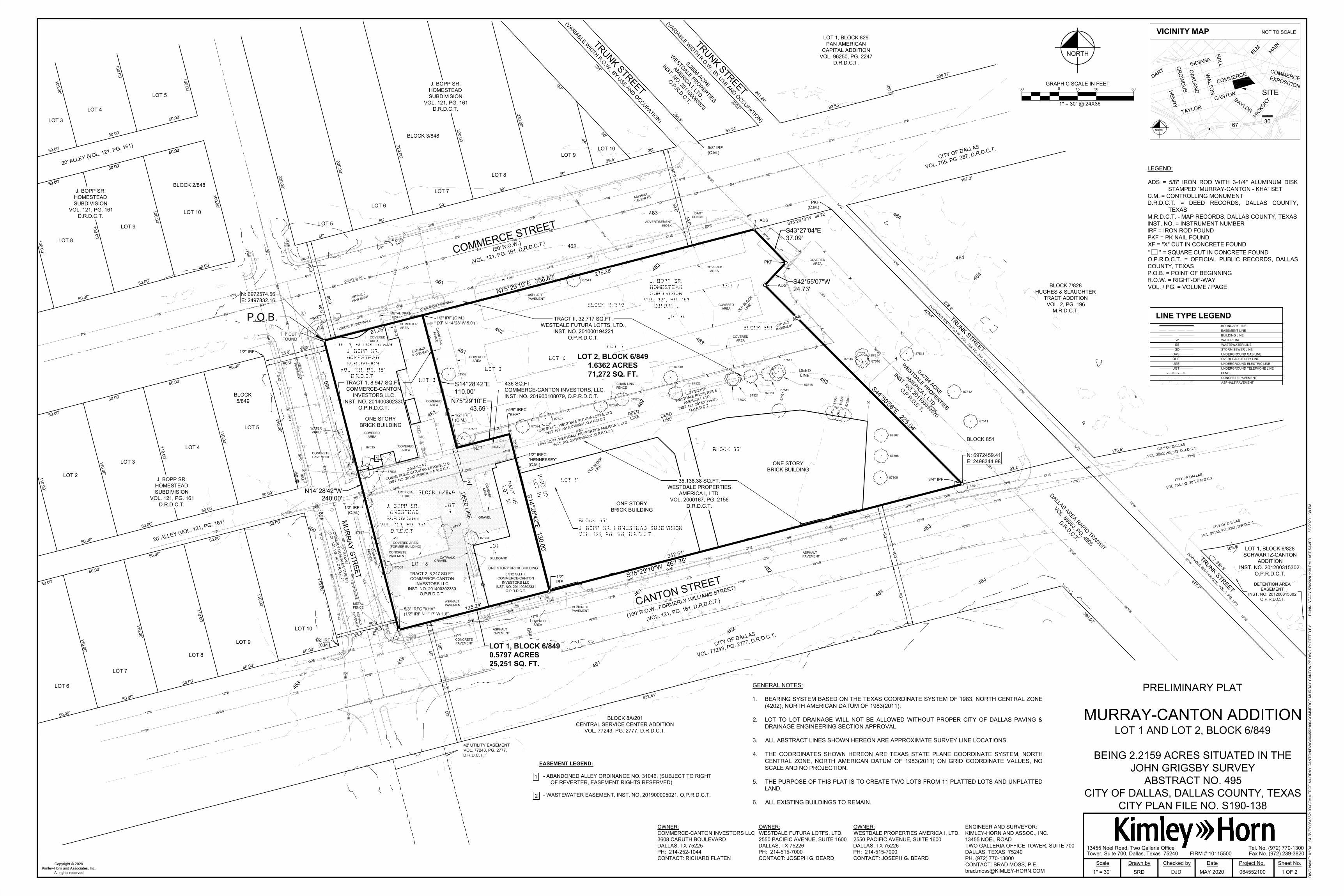
GENERAL NOTES:
1. BEARING SYSTEM BASED ON THE TEXAS COORDINATE SYSTEM OF 1983, NORTH CENTRAL ZONE
(4202), NORTH AMERICAN DATUM OF 1983(2011).
2. LOT TO LOT DRAINAGE WILL NOT BE ALLOWED WITHOUT PROPER CITY OF DALLAS PAVING &
DRAINAGE ENGINEERING SECTION APPROVAL.
3. ALL ABSTRACT LINES SHOWN HEREON ARE APPROXIMATE SURVEY LINE LOCATIONS.
4. THE COORDINATES SHOWN HEREON ARE TEXAS STATE PLANE COORDINATE SYSTEM, NORTH
CENTRAL ZONE, NORTH AMERICAN DATUM OF 1983(2011) ON GRID COORDINATE VALUES, NO
SCALE AND NO PROJECTION.
5. THE PURPOSE OF THIS PLAT IS TO CREATE TWO LOTS FROM 11 PLATTED LOTS AND UNPLATTED
LAND.
6. ALL EXISTING BUILDINGS TO REMAIN.
LINE TYPE LEGEND
BOUNDARY LINE
EASEMENT LINE
BUILDING LINE
WATER LINE
WASTEWATER LINE
STORM SEWER LINE
UNDERGROUND GAS LINE
OVERHEAD UTILITY LINE
UNDERGROUND ELECTRIC LINE
UNDERGROUND TELEPHONE LINE
FENCE
CONCRETE PAVEMENT
ASPHALT PAVEMENT
UGT
UGE
X X X X
W
SS
GAS
OHE
SD
TREE TABLE
NO.
87507
87508
87509
87510
87511
87512
87513
87514
87515
87516
87517
87518
87519
87520
87521
87522
87523
87524
87525
87526
87527
87528
87529
87530
87531
87532
87533
87534
87535
87536
87537
87538
87539
87540
87541
DBH
15"
17"
20"
18"
10"
10"
7"
10"
22"
13"
12"
14"
26"
11"
18"
12"
15"
21"
24"
27"
27"
7"
6"
5"
26"
26"
16"
21"
15"
8"
17"
12"
24"
26"
25"
NAME
BRADFORD PEAR
BRADFORD PEAR
BRADFORD PEAR
MULTI-TRUNK CREPE MYRTLE
MULTI-TRUNK CREPE MYRTLE
MULTI-TRUNK CREPE MYRTLE
MULTI-TRUNK CREPE MYRTLE
HACKBERRY
HACKBERRY
HACKBERRY
ASH
HACKBERRY
ELM
ELM
ELM
ELM
HACKBERRY
LIVE OAK
LIVE OAK
LIVE OAK
LIVE OAK
MULTI-TRUNK CREPE MYRTLE
MULTI-TRUNK CREPE MYRTLE
MULTI-TRUNK CREPE MYRTLE
ELM
LIVE OAK
ELM
ELM
ELM
ELM
HACKBERRY
HACKBERRY
LIVE OAK
LIVE OAK
LIVE OAK
SPECIES
PYRUS CALLERYANA
PYRUS CALLERYANA
PYRUS CALLERYANA
LAGERSTROEMIA INDICA
LAGERSTROEMIA INDICA
LAGERSTROEMIA INDICA
LAGERSTROEMIA INDICA
CELTIS
CELTIS
CELTIS
FRAXINUS
CELTIS
ULMUS
ULMUS
ULMUS
ULMUS
CELTIS
QUERCUS VIRGINIANA
QUERCUS VIRGINIANA
QUERCUS VIRGINIANA
QUERCUS VIRGINIANA
LAGERSTROEMIA INDICA
LAGERSTROEMIA INDICA
LAGERSTROEMIA INDICA
ULMUS
QUERCUS VIRGINIANA
ULMUS
ULMUS
ULMUS
ULMUS
CELTIS
CELTIS
QUERCUS VIRGINIANA
QUERCUS VIRGINIANA
QUERCUS VIRGINIANA
PRELIMINARY
THIS DOCUMENT SHALL
NOT BE RECORDED FOR
ANY PURPOSE AND
SHALL NOT BE USED OR
VIEWED OR RELIED
UPON AS A FINAL
SURVEY DOCUMENT
Copyright © 2020
Kimley-Horn and Associates, Inc.
All rights reserved
DW
G N
AM
E: K
:\D
AL_S
UR
VE
Y\064552100-C
OM
ME
RC
E M
UR
RA
Y C
AN
TO
N\D
WG
\064552100-C
OM
ME
RC
E M
UR
RA
Y C
AN
TO
N P
P.D
WG
P
LO
TT
ED
B
YD
UN
N, S
TA
CY
5/8/2020 1:39 P
M LA
ST
S
AV
ED
5/8/2020 1:38 P
M
Scale Drawn by
SRDN/A
Checked by Date Project No. Sheet No.
Tower, Suite 700, Dallas, Texas 75240
13455 Noel Road, Two Galleria Office Tel. No. (972) 770-1300
Fax No. (972) 239-3820FIRM # 10115500
DJD MAY 2020 064552100 2 OF 2
OWNER'S CERTIFICATE
STATE OF TEXAS §
COUNTY OF DALLAS §
WHEREAS COMMERCE-CANTON INVESTORS LLC, WESTDALE FUTURA LOFTS, LTD., and WESTDALE
PROPERTIES AMERICA I, LTD. are the owners of a tract of land situated in the John Grigsby Survey, Abstract
No. 495, City of Dallas Block 6/849 and Block 851; being all of a called 8,947 square foot tract of land described
as “Tract 1” and a called 8,247 square foot tract of land described as “Tract 2” in the Special Warranty Deed to
Commerce-Canton Investors LLC., recorded in Instrument No. 201400302330, Official Public Records of Dallas
County, Texas; all of a called 5,512 square foot tract of land described in the Special Warranty Deed to
Commerce-Canton Investors LLC., recorded in Instrument No. 201400302331, Official Public Records of Dallas
County, Texas; all of a 2,065 square foot tract and a 436 square foot tract of land described in the Deed Without
Warranty to Commerce-Canton Investors LLC., recorded in Instrument No. 201900108079, Official Public
Records of Dallas County, Texas; all of a called 32,717 square foot tract of land described as “Tract II” in the
Special Warranty Deed to Westdale Futura Lofts, Ltd., recorded in Instrument No. 201000194221, Official Public
Records of Dallas County, Texas; all of a called 1,636 square foot tract of land described in the Special Warranty
Deed to Westdale Futura Lofts, Ltd., recorded in Instrument No. 201900108081, Official Public Records of Dallas
County, Texas; all of a called 1,043 square foot tract of land described in the Special Warranty Deed to Westdale
Properties America 1, Ltd., recorded in Instrument No. 201900108080, Official Public Records of Dallas County,
Texas; all of a called 1,071 square foot tract of land described in the Special Warranty Deed to Westdale
Properties America I, Ltd., recorded in Instrument No. 201800114373, Official Public Records of Dallas County,
Texas; all of a called 35,138.38 square foot tract of land described in the Special Warranty Deed to Westdale
Properties America I, Ltd., recorded in Volume 2000167, Page 2156, Deed Records of Dallas County, Texas; said
tract also being all of Lots 1, 2, 3, 4, 5, 6, 7, 8, 9, part of 10, and 11, Block 6/849 of the J. Bopp Sr. Homestead
Subdivision, an addition to the City of Dallas, Texas according to the plat thereof recorded in Volume 121, Page
161, Deed Records of Dallas County, Texas; and being more particularly described as follows:
BEGINNING at a square cut found at the intersection of the southeast right-of-way line of Commerce Street (an
80-foot wide right-of-way, City of Dallas, Volume 121, Page 161, Deed Records of Dallas County, Texas) and the
northeast right-of-way line of Murray Street (a 50-foot wide right-of-way, formerly Gonzales Street, City of Dallas,
Volume 121, Page 161, Deed Records of Dallas County, Texas), at the northwest corner of said Lot 1 and at the
northwest corner of said 8,947 square foot tract;
THENCE with said southeast line of said Commerce Street, the northwest line of said Lots 1, 2, 3, 4, 5, 6, and 7 of
Block 6/469, and the northwest line of said 32,717 square foot tract, North 75°29'10" East, a distance
of 356.83 feet to a 5/8” iron rod with 3-1/4” aluminum cap stamped MURRAY-CANTON - KHA set at the
northernmost corner of said 32,717 square foot tract and the westernmost northwest corner of a called 0.4764
acre tract of land described in the Special Warranty Deed to Westdale Properties America I, Ltd., recorded in
Instrument No. 201100093570, Official Public Records of Dallas County, Texas;
THENCE departing said southeast right-of-way line of Commerce Street and with the southwest line of said
0.4764 acre tract, the northeast line of said 32,717 square foot tract and the northeast line of said 35,138.38
square foot tract, the following courses and distances:
South 43°27'04" East, a distance of 37.09 feet to a PK nail found for corner;
South 42°55'07" West, a distance of 24.73 feet to a 5/8” iron rod with 3-1/4” aluminum cap stamped
MURRAY-CANTON - KHA" set for corner;
South 44°50'56" East, a distance of 225.04 feet to a 3/4” iron pipe found for corner in the northwest
right-of-way line of Canton Street (a 100-foot wide right-of-way, formerly Williams Street, City of Dallas,
Volume 121, Page 161, Deed Records of Dallas County, Texas), at the easternmost corner of said 35,138.38
square foot tract and the southernmost corner of said 0.4764 acre tract;
THENCE with said northwest right-of-way line of Canton Street, the southeast line of said 35,138 square foot tract,
the southeast line of said 5,512 square foot tract, the southeast line of said 8,247 square foot tract, and the
southeast line of said Lot 8, Block 6/849, South 75°29'10" West, a distance of 467.75 feet to a 5/8" iron rod with
plastic cap stamped "KHA" found at the intersection of said northwest right-of-way line of Canton Street and the
northeast right-of-way line of Murray Street, at the southwest corner of said 8,247 square foot tract, and the
southwest corner of said Lot 8, Block 6/849; from said point, a 1/2” iron rod found bears North 1°17' West, a
distance of 1.6 feet;
THENCE with said northeast right-of-way line of Murray Street, the southwest line of said 8,247 square foot tract,
the southwest line of said 2,065 square foot tract, the southwest line of said 8,947 square foot tract, the southwest
lines of said Lot 1 and Lot 8, Block 6/849, North 14°28'42" West, a distance of 240.00 feet to the POINT OF
BEGINNING and containing 2.2159 acres or 96,524 square feet of land.
Bearing system based on the Texas Coordinate System of 1983, North Central Zone (4202), North American
Datum of 1983(2011).
OWNER'S DEDICATION
NOW THEREFORE, KNOW ALL MEN BY THESE PRESENTS:
That, COMMERCE-CANTON INVESTORS LLC, WESTDALE FUTURA LOFTS, LTD., and WESTDALE
PROPERTIES AMERICA I, LTD., acting by and through their duly authorized agents, do hereby adopt this plat,
designating the herein described property as MURRAY-CANTON ADDITION an addition to the City of Dallas,
Dallas County, Texas, and do hereby dedicate, in fee simple, to the public use forever any streets, alleys, and
floodway management areas shown thereon. The easements shown thereon are hereby reserved for the
purposes indicated. The utility and fire lane easements shall be open to the public, fire and police units, garbage
and rubbish collection agencies, and all public and private utilities for each particular use. The maintenance of
paving on the utility and fire lane easements is the responsibility of the property owner. No buildings, fences,
trees, shrubs, or other improvements or growths shall be constructed, reconstructed or placed upon, over or
across the easements as shown. Said easements being hereby reserved for the mutual use and accommodation
of all public utilities using or desiring to use same. All, and any public utility shall have the right to remove and
keep removed all or parts of any building, fences, trees, shrubs, or other improvements or growths which in any
way may endanger or interfere with the construction, maintenance or efficiency of its respective system on the
easements, and all public utilities shall at all times have the full right of ingress and egress to or from the said
easements for the purpose of constructing, reconstructing, inspecting, patrolling, maintaining and adding to or
removing all or parts of its respective systems without the necessity at any time of procuring the permission of
anyone. (Any public utility shall have the right of ingress and egress to private property for the purpose of reading
meters and any maintenance or service required or ordinarily performed by that utility).
Water main and wastewater easements shall also include additional area of working space for construction and
maintenance of the systems. Additional easement area is also conveyed for installation and maintenance of
manholes, cleanouts, fire hydrants, water services and wastewater services from the main to the curb or
pavement line, and description of such additional easements herein granted shall be determined by their location
as installed.
This plat approved subject to all platting ordinances, rules, regulations, and resolutions of the City of Dallas.
SURVEYOR’S STATEMENT
I, David J. De Weirdt, a Registered Professional Land Surveyor, licensed by the State of Texas, affirm that this
plat was prepared under my direct supervision, from recorded documentation, evidence collected on the ground
during field operations and other reliable documentation; and that this plat substantially complies with the Rules
and Regulations of the Texas Board of Professional Land Surveying, the City of Dallas Development Code
(Ordinance no. 19455, as amended) , and Texas Local Government Code, Chapter 212. I further affirm that
monumentation shown hereon was either found or placed in compliance with the City of Dallas Development
Code, Sec. 51A-8.617 (a)(b)(c)(d) & (e); and that the digital drawing file accompanying this plat is a precise
representation of this Signed Final Plat.
Dated this the __________ day of ___________________________, 2020.
_________________________________________________
DAVID J. DE WEIRDT
REGISTERED PROFESSIONAL
LAND SURVEYOR NO. 5066
KIMLEY-HORN AND ASSOC., INC.
13455 NOEL ROAD
TWO GALLERIA OFFICE TOWER
SUITE 700
DALLAS, TEXAS 75240
PH. (972) 770-1300
STATE OF TEXAS §
COUNTY OF DALLAS §
BEFORE ME, the undersigned, a Notary Public in and for the said County and State, on this day personally
appeared David J. De Weirdt known to me to be the person whose name is subscribed to the foregoing
instrument and acknowledged to me that he executed the same for the purpose therein expressed and under oath
stated that the statements in the foregoing certificate are true.
GIVEN UNDER MY HAND AND SEAL OF OFFICE this ____________ day of ____________________ 2020.
_______________________________________
Notary Public in and for the State of Texas
OWNER:
WESTDALE PROPERTIES AMERICA I, LTD.
2550 PACIFIC AVENUE, SUITE 1600
DALLAS, TX 75226
PH: 214-515-7000
CONTACT: JOSEPH G. BEARD
ENGINEER AND SURVEYOR:
KIMLEY-HORN AND ASSOC., INC.
13455 NOEL ROAD
TWO GALLERIA OFFICE TOWER, SUITE 700
DALLAS, TEXAS 75240
PH. (972) 770-13000
CONTACT: BRAD MOSS, P.E.
WITNESS, my hand at Dallas, Texas, this the ______ day of ______________, 2020.
WESTDALE PROPERTIES AMERICA I, LTD.,
a Texas limited partnership
By: JGB VENTURES I, LTD.,
a Texas limited partnership - General Partner
By: JGB HOLDINGS, INC.,
a Texas corporation - General Partner
____________________________________________
By: Joseph G. Beard, President
STATE OF TEXAS §
COUNTY OF DALLAS §
BEFORE ME, the undersigned, a Notary Public in and for the said County and State, on this day personally
appeared Joseph G. Beard, known to me to be the person whose name is subscribed to the foregoing instrument
and acknowledged to me that he executed the same for the purpose therein expressed and under oath stated that
the statements in the foregoing certificate are true.
GIVEN UNDER MY HAND AND SEAL OF OFFICE this _____ day of_________________ 2020.
_______________________________________
Notary Public in and for the State of Texas
OWNER:
COMMERCE-CANTON INVESTORS LLC
3608 CARUTH BOULEVARD
DALLAS, TX 75225
PH: 214-252-1044
CONTACT: RICHARD FLATEN
WITNESS, my hand at Dallas, Texas, this the ______ day of ______________, 2020.
COMMERCE-CANTON INVESTORS, LLC.,
a Texas limited liability company
____________________________________________
By: Richard L. Flaten Jr., Manager
STATE OF TEXAS §
COUNTY OF DALLAS §
BEFORE ME, the undersigned, a Notary Public in and for the said County and State, on this day personally
appeared Richard L. Flaten Jr., known to me to be the person whose name is subscribed to the foregoing
instrument and acknowledged to me that he executed the same for the purpose therein expressed and under oath
stated that the statements in the foregoing certificate are true.
GIVEN UNDER MY HAND AND SEAL OF OFFICE this _____ day of_________________ 2020.
_______________________________________
Notary Public in and for the State of Texas
WITNESS, my hand at Dallas, Texas, this the ______ day of ______________, 2020.
WESTDALE FUTURA LOFTS, LTD.,
a Texas limited partnership
By: JGB VENTURES I, LTD.,
a Texas limited partnership - General Partner
By: JGB HOLDINGS, INC.,
a Texas corporation - General Partner
____________________________________________
By: Joseph G. Beard, President
STATE OF TEXAS §
COUNTY OF DALLAS §
BEFORE ME, the undersigned, a Notary Public in and for the said County and State, on this day personally
appeared Joseph G. Beard, known to me to be the person whose name is subscribed to the foregoing instrument
and acknowledged to me that he executed the same for the purpose therein expressed and under oath stated that
the statements in the foregoing certificate are true.
GIVEN UNDER MY HAND AND SEAL OF OFFICE this _____ day of_________________ 2020.
_______________________________________
Notary Public in and for the State of Texas
OWNER:
WESTDALE FUTURA LOTFS, LTD.
2550 PACIFIC AVENUE, SUITE 1600
DALLAS, TX 75226
PH: 214-515-7000
CONTACT: JOSEPH G. BEARD
PRELIMINARY PLAT
MURRAY-CANTON ADDITION
LOT 1 AND LOT 2, BLOCK 6/849
BEING 2.2159 ACRES SITUATED IN THE
JOHN GRIGSBY SURVEY
ABSTRACT NO. 495
CITY OF DALLAS, DALLAS COUNTY, TEXAS
CITY PLAN FILE NO. S190-138
Top Related