


Languages
Pages
Legal


Follow the shorelineof Little Loch Shinthrough a pinewoodwith a fewsculptural surprisesalong the way. LittleLoch Shin was
formed in the 1950s after the Lairg Dam was built toraise the water levels of Loch Shin. The Broch andOrd Hill walks pass by the remains of much earlierconstruction work with hut circles, burial cairns, fieldclearance heaps and ancient banks over 2000 yearsold! The ascent to the top of the Ord is also worth itfor the spectacularviews over centralSutherland.
Both walks start outat the FerrycroftCountryside Centre,open April - Octoberwith its fascinatingaudio-visual displays,cafe and touristinformation.
Managed by ForestryCommissionScotland.
A community built log cabin welcomes you to thesetrails of which the Deer Park & Wild Wood trail,with it’s interactive information points, is a favourite.For a shorter walk, follow the Pine Marten trail andwatch out for Sika Deer which have spread into thesurrounding area from the original 19th centurydeer park. For fine views follow the Achness Burnuphill from the hotel.
The Cassley Trail passes by Rosehall’s MillenniumCairn, built by local people to mark the year 2000and containing a casket of their wishes. Near theriver, the remains of ancient brochs, built over two
Little Loch Shin 0.75 miles Easy(All-ability path) (red marker)Broch Walk 1.5 miles Easy (All-ability path) (green marker)Ord Hill 1.3 miles Moderate(blue marker)
Built in the 1830s,a 100ft statue ofthe first Duke ofSutherland looksover Golspie fromthe top of BenBhraggie (1300ft).Enjoy thestunning viewsand appreciate theefforts of thosebringing the statueup piece by piece– Lawson’s Wellwas built just forthem! OnFountain Roadanother 19th century water feature, designed by SirCharles Barry (architect of the Houses ofParliament), is dedicated to the Duchess of
Sutherland.
Golspie’s Big Burn is avery popular routethrough a hidden gorgecomplete with waterfall.Start at the north endof the village besideSutherland Stoneworks,or park at Backies andjoin the route mid-wayfor a shorter walkwhich is still steep inplaces. Spring flowers
Big Burn 1.5 miles Moderate Ben Bhraggie 3.75 miles Strenuous
4 Camore
The Scotspinewood withits richunderstory ofheather andblueberry mayprovide a havenfor birdlife now,but 2000 yearsago it must havebeen buzzing with human activity. The remains of 25hut circles have been uncovered here and suggest aonce-thriving community. Natural regeneration isencouraged within these woods which are managedunder continuous cover to ensure that trees arethinned or removed in small pockets to allow nativespecies to re-seed.
If you’re up for the challenge, why not have a go atthe Natural Play Features?
Managed by Forestry Commission Scotland.
Some 1700 acres of native woodland shroud ancientburial chambers, ruined farmsteads and traces ofvanished industries. The oakwoods above the DornochFirth once provided fuel for smelting iron and bark fortanning leather; now their steep shores hide otters andthe elusive wildcat. Around Loch Migdale, majesticScots pines are the legacy of 18th century estateforestry, designed to provide employment for tenantsduring the notorious Clearances. Swathes of youngbirch and pine mark logging activities by the CanadianForestry Corp during World War II, while openhilltops and valley wetlands add diversity to this richwoodland mosaic.
This route passes through varied woodlands to LochMigdale, then up the old coffin path to A’ Chraisg.Park in the lay-by 0.8miles along the Spinningdale –Migdale road. The marked entrance is 250m furtherup on the left.
Managed by Woodland Trust Scotland.
1 Ferry Wood & Ord Hill, Lairg
2 Big Burn & Ben Bhraggie
3 Balblair Woods, Loch Fleet
Balblair Trail 3.5 miles Easy
Blue Loop 2 miles Moderate
Much of this planted Scotspinewood is within the LochFleet National Nature Reservewhere scarce plants thriveadjacent to the woodland trails.This estuary provides rich feedingareas for hundreds of waterfowl,such as wigeon, greylag geese,oystercatcher and curlew, harbour
4 miles Moderate
6 Gearrchoille Community Wood,Ardgay
Yellow Walk 0.5 miles EasyRed Walk 0.2 miles Easy(All-ability path)
Part of the ancient Gearrchoille woodlands are nowowned and managed by the local community but theyhave played animportant part inArdgay’s social andeconomic historyfor generations -you can still seeparts of the olddrove roadrecorded by General Wade in 1730. There is alsoevidence of past coppicing and woodland pasture too.On foot from Oakwood Place at the south end ofArdgay, follow the fingerposts through the kissinggate and into the woods where yellow way-markersguide you around the circular walk. The path isuneven and can be muddy in places. Parking issignposted on the A836 0.5miles south of the Ardgaywar memorial. Join the circular walk from here via anall-ability path to the former curling pond.
Pick up a copy ofthe ‘Guide to Treesin the Gearrchoille’to learn more aboutthe species thatmake up the wood.Details of moth,amphibian and birdringing surveys areavailable on theGWCA website.
7 Carbisdale Trails
Yellow Trail 2.5 miles Moderate
8 Rosehall Trails
Pine Marten Trail 2 miles Easy (red marker) Deer Park & Wild Wood Trail 2.5 miles Moderate(yellow marker)Cassley Trail 2.5 miles Moderate(green marker)Achness Burn 1.5 miles Moderate(brown marker)
Discover...
East Sutherland’sTop 10 Woodland Walks
ancient oakshistoric battlefields
Iron Age
ancient brochs
Timeless pinewoodspast settlements
rich wildlife
Carbisdale Castle was completed in 1917 by theDuke of Sutherland’s widow who was deniedpermission to build within the Sutherland boundary.Undeterred, she built at Carbisdale which was atthat time in Ross-shire and the first place the trainpassed on leaving Sutherland - the clock tower hasfaces on only three sides so she didn’t have to giveSutherland the time of day!
The yellow trail climbs up through the woods to aviewpoint overlooking the site of the Duke ofMontrose’s last battle. In defeat, he was harried tothe west, captured and eventually executed. Theshortcut loop passes through mixed woodlanddominated by pine and a variety of maturebroadleaves. At View Rock you can look out overthe Kyle of Sutherland, the Inner Dornoch Firthand Bonar Bridge.
Carbisdale Castle is also a starting point for the Kyleof Sutherland Mountain Bike Trails.
Managed by Forestry Commission Scotland.
5 Ledmore & Migdale,Spinningdale
seals, osprey and the elusive otter too! It wasn’talways so tranquil though – in 1746 Scottish forcesloyal to the British government defeated a Jacobiteforce on this site just before the decisive Battle ofCulloden which ended Bonnie Prince Charlie'saspiration to become King. In the 19th Centuryseveral shipwrecks occurred and a tragic ferryaccident in the narrow crossing between Coul Linksand Littleferry ultimately led to building of theMound Causeway, a road across the estuary designedby the Scottish engineer, Thomas Telford, in 1816.The walk follows forest tracks and paths and may beuneven in places.
Managed by Scottish Natural Heritage, SutherlandEstates and Scottish Wildlife Trust.
thousand years ago, can also be found.
Managed by Forestry Commission Scotland inagreement with Rosehall and District Action Group.
9 Ravens Rock
Red Walk 0.75 miles Moderate (red marker)
If you are short on time but fancy an escape, comeand explore a mysterious wooded gorge! This walkfollows the Allt Mor burn, taking you through fairy-tale woodland furnished with a thick moss carpetand lichen-clad trees and outcrops - but keep an eyeout for a former woodland dweller! There are severalplaces to stop and soak up the atmosphere or the
views fromthe upperpart of thewalk.
Managed byForestryCommissionScotland.
Before you goSensible and appropriate footwear isrecommended for all paths. During periods ofrainfall and adverse weather, paths maybecome muddy or slippery so please take care.
All-ability paths offer prepared smooth andeven surfaces with no steps or steep inclinesand are suitable for wheeled buggies andmobility aid users. All other routes followtraffic-free forest roads, tracks and pathswhich may not be suitable for all users. If indoubt please check with the relevantwoodland manager.
From time to time, it may be necessary toclose sections of these walks so please takenote of any closures or warning notices.
This leaflet was prepared by Highland Birchwoodson behalf of East Sutherland Woodlands
Photography by Matt Dent, Nathan McLaughlan, Graeme Findlay,WTPL/Eleanor Garty, Highland Birchwoods and Iain Sarjeant.
This leaflet offers only a selection of the routesavailable in this area. Explore further and lookout for individual site leaflets, ask locally orcontact VisitScotland.
are in abundance in May and June but this route is atreat year-round.
Managed by Golspie Community Council. Moreinformation on walks in the Golspie area can befound in the locally available Golspie Walks booklet.
This project is being part-financed by the Scottish Government and the European Community Highland LEADER 2007 - 2013 Programme
Woodland Walks in
East Sutherland
10 Achany Trails
Riverside Walk 0.6 miles Easy(Blue marker)Salmon Leap (Shin Falls) 0.3miles Moderate(Black marker)Red Loop 0.25 miles Easy (All - ability path) Green Loop 1 mile Moderate
The River Shin twiststhrough Achany Glen,banked by riversidewoodlands which areamongst the richest inSutherland and hometo many protectedspecies. Between Apriland October, salmonleap up Shin Falls onthe return to theirupstream spawning grounds but the woodsthemselves put on a show all year round. In timesgone by, these woodlands were managed to produceuseful timber products, Forestry CommissionScotland is now developing a greenwood workshopalongside the trail.
All of the trails start at the Falls of Shin VisitorCentre, a popular local tourist attraction and café,with children’s play area and ample parking.
Managed by Forestry Commission Scotland.
Reproduced by Permission of Ordnance Survey onbehalf of HMSO.© Crown Copyright and database right [2010].Ordnance Survey Licence number [100021242]
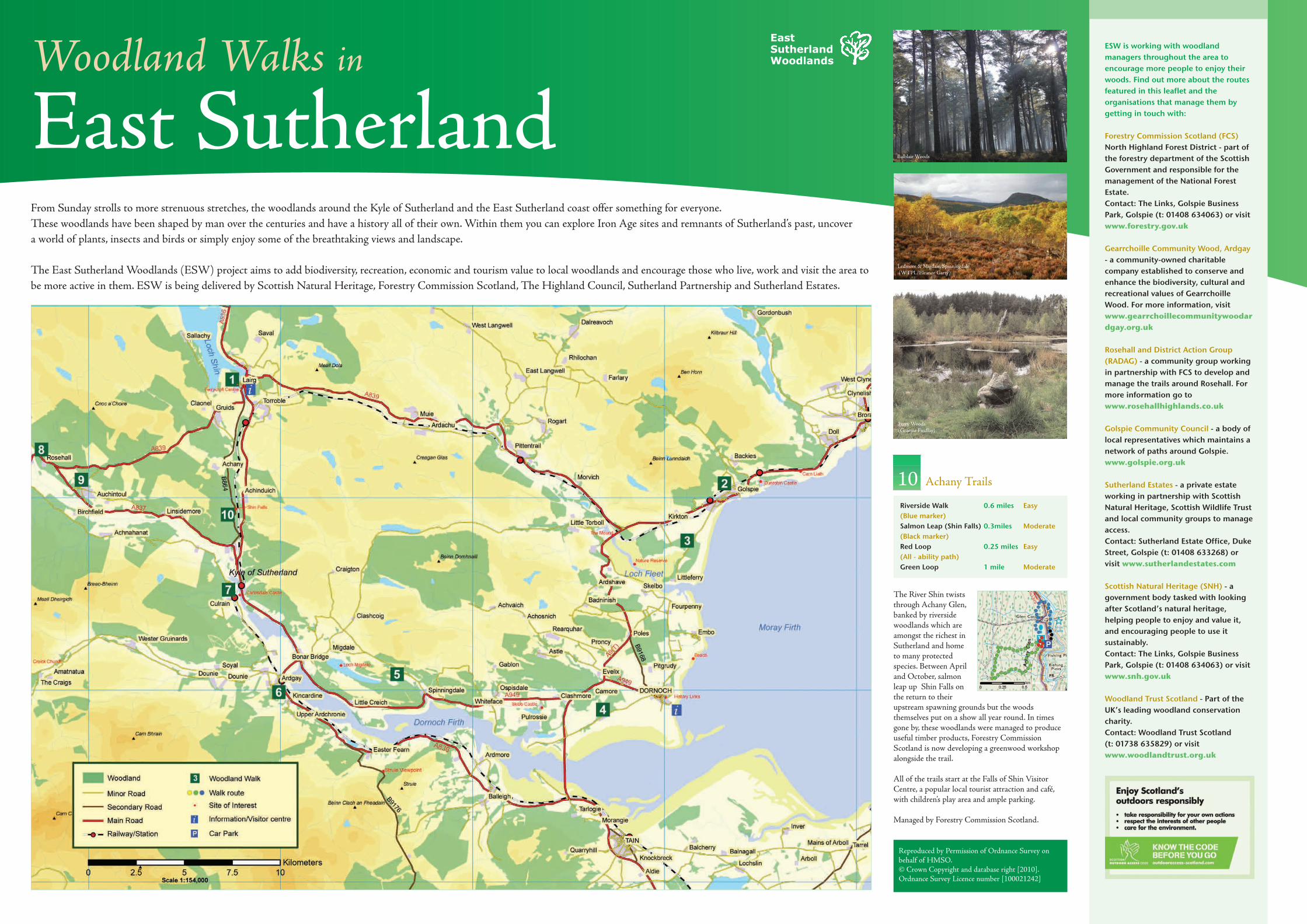
From Sunday strolls to more strenuous stretches, the woodlands around the Kyle of Sutherland and the East Sutherland coast offer something for everyone.These woodlands have been shaped by man over the centuries and have a history all of their own. Within them you can explore Iron Age sites and remnants of Sutherland’s past, uncover a world of plants, insects and birds or simply enjoy some of the breathtaking views and landscape.
The East Sutherland Woodlands (ESW) project aims to add biodiversity, recreation, economic and tourism value to local woodlands and encourage those who live, work and visit the area tobe more active in them. ESW is being delivered by Scottish Natural Heritage, Forestry Commission Scotland, The Highland Council, Sutherland Partnership and Sutherland Estates.
EastSutherland Woodlands
ESW is working with woodlandmanagers throughout the area toencourage more people to enjoy theirwoods. Find out more about the routesfeatured in this leaflet and theorganisations that manage them bygetting in touch with:
Forestry Commission Scotland (FCS)North Highland Forest District - part ofthe forestry department of the ScottishGovernment and responsible for themanagement of the National ForestEstate. Contact: The Links, Golspie BusinessPark, Golspie (t: 01408 634063) or visitwww.forestry.gov.uk
Gearrchoille Community Wood, Ardgay- a community-owned charitablecompany established to conserve andenhance the biodiversity, cultural andrecreational values of GearrchoilleWood. For more information, visitwww.gearrchoillecommunitywoodardgay.org.uk
Rosehall and District Action Group(RADAG) - a community group workingin partnership with FCS to develop andmanage the trails around Rosehall. Formore information go towww.rosehallhighlands.co.uk
Golspie Community Council - a body oflocal representatives which maintains anetwork of paths around Golspie.www.golspie.org.uk
Sutherland Estates - a private estateworking in partnership with ScottishNatural Heritage, Scottish Wildlife Trustand local community groups to manageaccess.Contact: Sutherland Estate Office, DukeStreet, Golspie (t: 01408 633268) orvisit www.sutherlandestates.com
Scottish Natural Heritage (SNH) - agovernment body tasked with lookingafter Scotland’s natural heritage,helping people to enjoy and value it,and encouraging people to use itsustainably. Contact: The Links, Golspie BusinessPark, Golspie (t: 01408 634063) or visitwww.snh.gov.uk
Woodland Trust Scotland - Part of theUK’s leading woodland conservationcharity. Contact: Woodland Trust Scotland (t: 01738 635829) or visitwww.woodlandtrust.org.uk
Balblair Woods
Ledmore & Migdale, Spinningdale(WTPL/Eleanor Garty)
Ferry Woods (Graeme Findlay)
Top Related