


Languages
Pages
Legal


Three Capes Track
Track, Accommodation, Gateway
and Jetty Construction
Tasman National Park,
Safety Cove State Reserve, Crown Land and
Titles 228905/1, 210148/1 and 159762/2
JUNE 2012
DEVELOPMENT APPLICATION


DEVELOPMENT APPLICATION - THREE CAPES TRACK
Track, Accommodation, Gateway and Jetty Construction
i
DEVELOPMENT APPLICATION to TASMAN
COUNCIL for the THREE CAPES TRACK
Tasman National Park, Safety Cove State Reserve,
Crown Land and Titles 228905/1, 210148/1 and
159762/2
JUNE 2012
Prepared by: Parks and Wildlife Service
Department of Primary Industries, Parks, Water and Environment
GPO Box 1751
Hobart TAS 7001
DEVELOPMENT APPLICATION - THREE CAPES TRACK
Track, Accommodation, Gateway and Jetty Construction
i
CONTENTS
1. INTRODUCTION .......................................................................................... 1
1.1 Project Overview .......................................................................................................... 1
2. PROPOSAL DETAILS .................................................................................... 2
2.1 Proponent ..................................................................................................................... 2
2.2 Proposal Scope ............................................................................................................ 2
2.3 Subject Land and Locality .......................................................................................... 2
2.3.1 Tasman National Park and Safety Cove State Reserve ........................................ 2
2.3.2 Crown Land ............................................................................................................ 3
2.3.3 Stormlea Road – Road Reserve ............................................................................ 3
2.3.4 Stormlea Road – Private Land ............................................................................... 3
2.3.5 Mt Raoul East - Private Land ................................................................................. 3
2.3.6 Fish Hawk Gully - Private Land .............................................................................. 4
2.3.7 Mansfield Plain – Road Reserve ............................................................................ 4
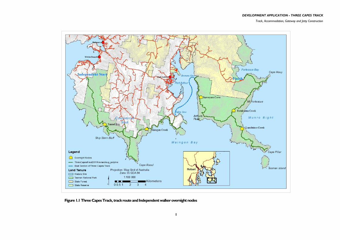
2.4 Gateways ...................................................................................................................... 5
2.4.1 Independent walk start - Noyes Road .................................................................... 5
2.4.2 Commercial walk start - Stormlea Road................................................................. 5
2.4.3 Transition point – Remarkable Cave – Safety Cove Road .................................... 6
2.4.4 Transition point – Safety Cove – Dog Bark Road .................................................. 6
2.4.5 Transition point – Denmans Cove .......................................................................... 6
2.4.6 Walk terminus - Fortescue Bay .............................................................................. 6
2.5 Jetties ............................................................................................................................ 6
2.6 The Track ...................................................................................................................... 7
2.7 Overnight nodes – independent walker accommodation ....................................... 9
2.7.1 Overview ................................................................................................................. 9

DEVELOPMENT APPLICATION - THREE CAPES TRACK
Track, Accommodation, Gateway and Jetty Construction
ii
2.7.2 Hut Design .............................................................................................................. 9
2.7.3 Geotechnical Investigations and Waste Water Disposal ..................................... 10
2.7.4 Design Criteria - Bushfire Protection .................................................................... 10
2.8 Fire Management ....................................................................................................... 13
2.9 Road and Air Traffic ................................................................................................... 14
2.9.1 Road Traffic .......................................................................................................... 14
2.9.2 Air Traffic .............................................................................................................. 15
3. TIMEFRAME FOR PROPOSED DEVELOPMENT ................................. 16
3.1 Prior to construction commencement .................................................................... 16
3.2 Construction phase ................................................................................................... 16
3.2.1 Working hours ...................................................................................................... 16
3.2.2 Public access ........................................................................................................ 16
3.2.3 Construction Environmental Management Plan (CEMP) .................................... 16
3.2.4 Inspections ........................................................................................................... 17
3.3 Commencement of operations ................................................................................. 17
4. EXPECTED ENVIRONMENTAL, SOCIAL AND ECONOMIC
EFFECTS 18
4.1 Environmental Effects and their Management ....................................................... 18
4.1.1 Geoheritage .......................................................................................................... 18
4.1.2 Flora...................................................................................................................... 19
4.1.3 Weeds .................................................................................................................. 21
4.1.4 Phytophthora ........................................................................................................ 22
4.1.5 Fauna ................................................................................................................... 23
4.1.6 Marine Environment ............................................................................................. 27
4.1.7 Aquatic Environment ............................................................................................ 28
4.1.8 Visual Impact ........................................................................................................ 29
4.1.9 Cultural and Historic Heritage .............................................................................. 30
DEVELOPMENT APPLICATION - THREE CAPES TRACK
Track, Accommodation, Gateway and Jetty Construction
iii
4.1.10 Hazardous Material .......................................................................................... 30
4.1.11 Waste ................................................................................................................ 31
4.1.12 Greenhouse Gas Emissions ............................................................................ 31
4.1.13 Climate Change ................................................................................................ 32
4.2 Socio-economic Impact ............................................................................................ 33
4.2.1 Economic Impact .................................................................................................. 33
4.2.2 Social Impact ........................................................................................................ 34
5. PLANNING CONSIDERATIONS ............................................................ 36
5.1 Summary of Whole of Project Approvals ................................................................ 36
5.1.1 Federal ................................................................................................................. 36
5.1.2 State ..................................................................................................................... 36
5.2 Tasman Planning Scheme ........................................................................................ 36
5.2.1 Tenor of the Planning Scheme ............................................................................. 36
5.2.2 Reservation of Land ............................................................................................. 38
5.2.3 Relevant Provisions within General Provisions (Part 7) ....................................... 39
5.2.4 Relevant Provisions within Special Provisions (Part 8) ........................................ 44
5.3 Consistency with Tasman Council policy ............................................................... 49
5.3.1 Tasman Council Strategic Plan 2011-2016 ......................................................... 49
5.3.2 Tasman Tourism Development Strategy 2011-2016 ........................................... 49
5.4 Consistency with Tasmanian Government policy ................................................. 49
5.4.1 State Policy on Water Quality Management 1997 ............................................... 49
5.4.2 State Coastal Policy 1996 .................................................................................... 49
5.4.3 Tourism Tasmania Strategic Plan 2010-2013...................................................... 51
5.5 Relevant Legislative Requirements ......................................................................... 51
5.5.1 Federal ................................................................................................................. 51
5.5.2 State ..................................................................................................................... 52
6. CONCLUSION ............................................................................................ 53

DEVELOPMENT APPLICATION - THREE CAPES TRACK
Track, Accommodation, Gateway and Jetty Construction
iv
7. REFERENCES ................................................................................................ 55
APPENDICES .................................................................................................................. 57
Appendix 1 – Concept Layout for Gateway sites ............................................................ 58
Appendix 2 – Typical Construction Details for Toilets ................................................... 59
Appendix 3 – Concept Plans for Jetty Construction ....................................................... 60
Appendix 4 – Three Capes Track Development Proposal and Environmental
Management Plan ...................................................................................................... 61
Appendix 5 – Typical Track Construction Details ........................................................... 62
Appendix 6 – Concept Plans for Overnight Nodes ......................................................... 63
Appendix 7 – Environmental Protection and Biodiversity Conservation Act - Decision
Notice .......................................................................................................................... 64

DEVELOPMENT APPLICATION - THREE CAPES TRACK
Track, Accommodation, Gateway and Jetty Construction
1
1. INTRODUCTION
1.1 Project Overview
The Three Capes Track is a proposal to establish a multi-day day iconic bushwalking experience, including
a water-based journey, featuring Cape Raoul, Cape Pillar and Cape Hauy on the Tasman Peninsula in
south-eastern Tasmania. The project, to be developed and implemented by the Tasmanian Parks and
Wildlife Service (PWS), a division of the Department of Primary Industries, Parks, Water and Environment
(DPIPWE), will require the construction of five overnight hut nodes, while the track will be completed
both through the upgrading of existing tracks and the development of new track. Walkers on the Three
Capes Track will walk from west to east commencing at White Beach and finishing at Fortescue Bay with a
boat journey between Safety Cove and Denmans Cove. The development is almost entirely within the
Tasman National Park with some minor components on Safety Cove State Reserve, Crown Land and
private land.
The proposal has arisen in response to investigations into the potential for an additional iconic multi-day
bushwalk in Tasmania to complement the Overland Track. Those investigations identified that demand
existed for a greater diversity of walking opportunities in the State. In particular, a demand for a multi-day,
moderately challenging, highly scenic walk with hut accommodation and a high standard of track and other
infrastructure. Consideration of a range of walking options concluded that the Tasman Peninsula offered
the best opportunity to develop a walk with these attributes and the Three Capes Track concept was
developed.
A key component of the proposal is the combination of two streams of users, independent walkers and
guided (or „commercial‟) walkers.
Independent walkers will constitute the majority (approximately 86%) of users. These walkers will
undertake a 5 night/6 day walk and will utilise public huts and associated infrastructure dedicated for use
for the Three Capes Track during the operating season of the walk (expected to be nominally 1
November to 30 April inclusive). The public huts will have a capacity to accommodate 48 people and up to
4 PWS staff. Walkers will be guaranteed a bed in each hut as they progress along the track through a fee
and booking system.
There will be a high level of information provided to walkers both prior to and during the walk. An
important feature of the operation of the track is the provision of hut wardens and dedicated track
rangers. The presence of these staff will ensure the efficient operation of the track and is an important
component of ensuring adequate levels of safety and the provision of a high level of support and
information to walkers.
Guided walkers will utilise private huts or standing camps, designed to accommodate up to 13 people (10
clients and 3 guides), which will be constructed and managed by a commercial operator. Commercial trips
will depart from the existing Cape Raoul track car park and will complete a 4 night/5 day walk.
Commercial accommodation nodes will be in the vicinity of the public huts but with some visual
separation. It is envisaged that in total the Three Capes Track will attract up to 10 000 walkers during the
operating season with a maximum of 61 walkers departing on any given day. The track route and
overnight hut node locations are shown in Figure 1.1 (p. 3).
A fee and booking system will operate during the operating season of the Three Capes Track, as currently
occurs for the Overland Track. The cost of undertaking the walk as an independent walker is projected to
be $200. The business model proposed for the Three Capes Track is for full operational cost recovery.
Operation of the track will include management of income from walker use and the commercial operation,
asset maintenance, managing the booking system, marketing and promotion, providing a presence on the

DEVELOPMENT APPLICATION - THREE CAPES TRACK
Track, Accommodation, Gateway and Jetty Construction
2
track through the employment of hut wardens and rangers and the provision of information and
interpretation. A commitment of 12.5 million dollars from the Commonwealth government and 12.8
million dollars from the State government has been made to the project. The commercial sector is
expected to contribute a further 7 to 8 million dollars to establish the commercial accommodation nodes,
walker transport including boat and bus transport and the associated operation of these enterprises. On
the Tasman Peninsula, the track is projected to generate spending of $3.1 million per year and the
creation of 70 jobs. At a State level, it is projected that the development of the Three Capes Track will
generate $19.7 million spending within Tasmania annually. It is also projected that at full operational
capacity it will create an additional 334 jobs in Tasmania.
The coastal scenery of the Tasman Peninsula, which includes the highest sea cliffs in Australia, favourable
weather and visitor infrastructure has led to the existing Tasman Trail being recognised as one of
Tasmania‟s great walks. The Three Capes Track proposal will build on this by providing a coherent, multi-
day bushwalking experience with a high standard of visitor infrastructure and experience.
DEVELOPMENT APPLICATION - THREE CAPES TRACK
Track, Accommodation, Gateway and Jetty Construction
1
Figure 1.1 Three Capes Track, track route and Independent walker overnight nodes

DEVELOPMENT APPLICATION - THREE CAPES TRACK
Track, Accommodation, Gateway and Jetty Construction
2
2. PROPOSAL DETAILS
2.1 Proponent
The proponent is the Department of Primary Industries, Parks Water and the Environment (DPIPWE), herein
referred to as „the Department‟ or DPIPWE. Implementation and operation of the Three Capes Track is the
responsibility of the Parks and Wildlife Service (PWS), a division of the Department.
The PWS manages 37% of Tasmania‟s land area in trust on behalf of all Tasmanians including nationally listed
heritage areas and World Heritage properties. The PWS is the sole Management Authority for the Tasman
National Park, within which the proposed action is almost completely contained. All actions of the PWS within
the national park are constrained by State statutory requirements regarding management of the values within
the park.
The construction and operation of the proposal and the implementation of all mitigation and management
measures will be the responsibility of the PWS.
2.2 Proposal Scope
As detailed in the Project Overview (Section 1.1), it is planned to offer two levels of experience: independent
walkers and guided walkers (also referred to as „commercial‟ walkers).
This Development Application seeks approval for the use of the land for a Tourist Operation, which entails the
construction of approximately 65 km of walking track, five overnight nodes for independent walkers, two
jetties and associated gateway infrastructure.
The development associated with the commercial accommodation nodes will be the subject of a separate
development application process, by the successful commercial operator. The commercial operator has not
been appointed, as this will only be decided following a formal Expression of Interest process which is
anticipated to be held in late 2012.
2.3 Subject Land and Locality
2.3.1 Tasman National Park and Safety Cove State Reserve
The proposal is almost entirely within the Tasman National Park and Safety Cove State Reserve. The Tasman
National Park consists of three separate parcels of land. The first occurs on the eastern side of the Forestier
Peninsula. The second extends from Pirates Bay south around to the eastern side of Port Arthur and includes
Tasman Island, Cape Pillar and Cape Hauy. The third section of the park extends from Safety Cove around to
Curio Bay and inland to Mt Spaulding and includes Cape Raoul. The proposal is sited only within these last two
sections. The national park has an area of 10 755 hectares, and extends generally to the low water mark and
includes adjacent offshore rocks and islands. Safety Cove State Reserve has an area of 16 hectares in a narrow
strip along the coast between Port Arthur Historic Site and Tasman National Park and extends to the low
water mark.
PWS have been managing the land as a National Park since 1999 and prior to that as a State Reserve since
1974. Current management is required to be in accordance with the objectives of the National Parks and
Reserves Management Act 2002, in particular the management objectives for national parks as set out in
Schedule 1 of the Act: being conservation of natural biological diversity, geological diversity and areas of
DEVELOPMENT APPLICATION - THREE CAPES TRACK
Track, Accommodation, Gateway and Jetty Construction
3
cultural significance; preservation of water quality and the natural, primitive and remote character of
wilderness areas; protection against fire, introduced species, diseases and soil erosion; and to encourage and
provide for tourism, recreational use and enjoyment consistent with the national park‟s natural and cultural
values. The management of the Tasman National Park has been in accordance with the Tasman National Park
Management Plan 2001 and the subsequent Tasman National Park and Reserves Management Plan 2011.
2.3.2 Crown Land
Jetty installations at Safety Cove and Denmans Cove will be partly on Crown Land below the high water mark
and within State waters. The remainder of these facilities will be within reserved land: the Safety Cove State
Reserve and/or the Tasman National Park at Safety Cove and the Tasman National Park at Denmans Cove.
2.3.3 Stormlea Road – Road Reserve
Infrastructure at the existing Cape Raoul track entry point will be added to the current facilities within the
road reserve (see Figure 2.1 below). This site, and the adjoining private land, is within the Rural General zone.
The Stormlea locality is characterised by open paddocks in undulating terrain, largely used for stock grazing.
There are a number of detached dwellings within sight of the carpark. To the south of the carpark is native
vegetation, along the unmade road reserve, on which the Cape Raoul/Shipsterns Bluff/Tunnel Bay walking track
leads walkers into the Tasman National Park.
2.3.4 Stormlea Road – Private Land
The Cape Raoul/Shipsterns Bluff/Tunnel Bay walking track which leads walkers into the Tasman National Park
has a section of approximately 60 metres length which crosses private land (Title 228905/1), in order to link
the track from the unmade road reserve to the national park. DPIPWE has an existing licence agreement with
the landowners. Contingent on development approval being granted, DPIPWE will seek to modify this to
become a long term lease.
This locality is characterised by Eucalyptus obliqua forest of 18-24m height. Due to the height and density of
vegetation, there are no distant views from the track.
2.3.5 Mt Raoul East - Private Land
East of Mount Raoul the track will traverse private land (Title 210148/1) to provide a minimum of 500 metres
separation from a white bellied sea eagle nest (see Figure 2.1 below). This site, and the adjoining private land to
the west, is within the Rural General zone, and is currently covered by native forest that is currently subject to
forestry activity. Adjoining land to the north, east and south is the Tasman National Park and this is also native forest
(Eucalyptus obliqua with broad-leaf shrubs of 20-30m height). Due to the height and density of vegetation, there
are no distant views from the track. The National Park is within the Public Purpose Zone (shown as National Parks
and Wildlife Service on Figure 2.1).
DPIPWE has an in-principle lease arrangement with the landowner to allow the track to be constructed across this
title which is expected to be signed when the land owner is next in Tasmania.

DEVELOPMENT APPLICATION - THREE CAPES TRACK
Track, Accommodation, Gateway and Jetty Construction
4
2.3.6 Fish Hawk Gully - Private Land
At Fish Hawk Gully, the track will either traverse private land (Title 159762/2) to avoid a steep and unstable section
of cliffs that may be difficult to build a track through (see Figure 2.2 below) or would be located within the
National Park below these cliffs. The private land is cleared land in the upper section, largely used for stock grazing,
while the lower elevations and steeper terrain are intact native vegetation. This private land is within the Coastal
Protection zone.
DPIPWE is currently attempting to negotiate a lease with the landowner to allow the track to be constructed across
this title and believes an arrangement can be reached. In the event that these negotiations are unsuccessful however,
then the route can be constructed entirely within the National Park, as indicated on Figure 2.2.
2.3.7 Mansfield Plain – Road Reserve
From the Maingon Bay blowhole near Remarkable Cave the track heads inland to Safety Cove. This route utilises an
unmade road reserve that runs in a north-south direction, and effectively links the southern shore of the Tasman
National Park to the Safety Cove State Reserve (see Figure 2.2 below). The road reserve that the track is proposed
to traverse, and adjacent private land, is within the Coastal Protection Zone, and is still largely intact native vegetation
with a few informal vehicle tracks crossing it.
Figure 2.1 Planning Zone detail, Stormlea Road and private block at Mt Raoul East

DEVELOPMENT APPLICATION - THREE CAPES TRACK
Track, Accommodation, Gateway and Jetty Construction
5
2.4 Gateways
2.4.1 Independent walk start - Noyes Road
This north-eastern corner of the national park is the main entry point for the Three Capes Track, and is accessed via
White Beach Road and then Noyes Road. All independent walkers will commence the walk from this point. This site
will include a car park, toilet, walker registration and information facilities.
The car park has indicative capacity for 35 standard sized vehicles (including two disabled spaces), three larger sized
vehicles (buses and campervans) and several bicycles. The layout is configured to direct vehicles to drive in a clockwise
direction through the site. The design allows for retention of a number of larger eucalypt trees, and understorey
vegetation, through a central „island‟ and several „peninsulas‟ to soften the overall appearance of the carpark.
Access to existing fire trails that lead along both the northern and western boundaries of the national park will be
restricted to authorised vehicles via the installation of boom gates that will be locked.
The concept site layout is provided as Appendix 1. Plans for the intended toilet size and configuration are provided as
Appendix 2.
2.4.2 Commercial walk start - Stormlea Road
Through seed funding provided by PWS and additional Council and Commonwealth funding, the Tasman Council
have upgraded the existing Cape Raoul, Tunnel Bay and Ship Stern Bluff car park which now allows for day parking of
approximately 19 vehicles.
Figure 2.2 Planning Zone detail, Fish Hawk Gully to Safety Cove

DEVELOPMENT APPLICATION - THREE CAPES TRACK
Track, Accommodation, Gateway and Jetty Construction
6
It is envisaged that the commercial walkers, accompanied by their guides, will be dropped at this car park by minibus.
As such it is anticipated they will not be occupying a space in the car park for longer than 15-30 mins and in fact may
not even require any parking space given they will effectively simply be unloading their passengers at the car park.
A toilet may be installed at this site to enhance the work recently done by the Tasman Council.
The concept site layout is provided as Appendix 1.
2.4.3 Transition point – Remarkable Cave – Safety Cove Road
Minimal infrastructure is proposed for the Remarkable Cave transition point. The track will cross Safety Cove Road
approximately 40 metres north-east of the road terminus at Remarkable Cave. There will be a Phytophthora
brushdown facility on the western side of the road. Signage indicating the Three Capes Track will be placed on both
sides of the road to direct walkers. The Three Capes Track will link with the Maingon Blowhole/Crescent Bay track,
which leaves the Remarkable Cave carpark, shortly after crossing the road.
A concept layout is provided as Appendix 1.
2.4.4 Transition point – Safety Cove – Dog Bark Road
Minimal infrastructure is proposed for the Safety Cove transition point. The jetty is described in section 2.4. After
leaving the road reserve, the track will traverse the terminus of Dog Bark Road, where a car park and turning circle
exists, before joining the Safety Cove State Reserve.
PWS may construct a toilet adjacent to the carpark, within either the crown land (that is partly used for Dog Bark
Road) or the Safety Cove State Reserve. The toilet will be a similar size to the facility proposed for Noyes Road and
Stormlea Road gateways (as per Appendix 2). Signage will direct walkers to the beach, and jetty area, which is
approximately 200m south east along the Safety Cove shoreline.
A concept layout is provided as Appendix 1 and concept jetty designs are provided as Appendix 3.
2.4.5 Transition point – Denmans Cove
Minimal infrastructure is proposed for the Denmans Cove transition point. The jetty is described in section 2.4. A
track will lead south from Denmans Cove, to the Surveyors Cove overnight node. Signage indicating distance and
approximate walking time to the overnight node and a Phytophthora brushdown facility will be located a short
distance from the jetty area.
A concept layout is provided as Appendix 1 and concept jetty designs are provided as Appendix 3.
2.4.6 Walk terminus - Fortescue Bay
Fortescue Bay will be the terminus of the Three Capes Track. The current day walk car park will be utilised as the
end point for the track. It is possible that some minor works may be required to improve the efficiency of this facility;
however no major upgrades are planned as part of the construction of the Three Capes Track.
2.5 Jetties
A fixed jetty or floating pontoon will be constructed at Safety Cove and a floating pontoon will be constructed
at Denmans Cove. The floating pontoon at Denmans Cove will be sited on the southern shore of the cove on
the rocky shoreline. The jetty at Safety Cove will be sited on the rocky shoreline in the south eastern corner
of the bay. If a toilet is installed at Safety Cove it will be constructed adjacent to the carpark. Concept jetty
designs, for both a fixed jetty and floating pontoon at Safety Cove, and a floating pontoon at Denmans Cove,
for both sites are provided as Appendix 3.

DEVELOPMENT APPLICATION - THREE CAPES TRACK
Track, Accommodation, Gateway and Jetty Construction
7
A decision on which type of landing facility will be installed at Safety Cove will be decided at a later date,
however PWS current preference is for the floating pontoon facility.
Due to the dynamic nature of the swell at Denmans Cove, the intended seasonality of use and the flexibility for
various vessel sizes (the commercial operation will be finalised post approval), PWS prefers the floating
pontoon jetty.
The floating pontoon landing facility will be comprised of a fixed timber walkway of approximately 9 metres
length above the mean sea level. An aluminium gangway of up to 12 metres length would connect the timber
walkway to the floating pontoons. The floating pontoons will be secured to regularly spaced piles in such a
way that they are anchored but still able to rise and fall with the tide and swell. This type of arrangement is
already successfully deployed in a variety of locations around Tasmania. The pontoons will be arranged to be
either perpendicular to the gangway or in an „L‟ arrangement so that one or two pontoons could also provide
some wave attenuation and allow a variety of berthing options. The sizing of the pontoons can be customised
according to the vessel size, but would be up to 20m long in total and approximately 1.5-2.4 m wide.
Construction of the new jetties will involve the installation of a small number of piles (approximately 8 -14 per
floating pontoon and 12-16 per jetty), suspended walkways, fender piles and possibly mooring dolphins. Piles
will be installed by means of barge either by impact pile driving or using „spun piles‟ (pile shafts are drilled into
the seabed). It is envisaged that the piles will be installed on the sand where possible so that walkways are fully
suspended over any fringing reef present. Piles in shallow water may be placed in concrete filled rock sockets
excavated into the seabed.
The jetty at Denmans Cove will only be available for the operation of the commercial operator to service the
Three Capes Track. The proposed floating pontoon system will allow the pontoons and gangway to be
removed by PWS outside of the booking season and reduce potential impacts to the natural values of the area
outside of the walking season.
On the basis of advice provided by a local commercial boat operator with over 20 years experience, PWS
expects that sea conditions could prevent safe disembarkation at Denmans Cove on 2 to 3 days per walking
season. In these instance walkers will be transported by road and will use the existing Stinking Bay – Denmans
Cove walking track which traverses State Forest.
All marine infrastructure associated with the landing facilities will be designed and constructed in accordance
with MAST requirements and relevant Australian Standards.
2.6 The Track
The track is to be constructed in such a way that will both protect and present the values of the area and
allow users to experience the „wildness‟ of the area and the features that are considered to underpin the
potential of the Three Capes Track to be Australia‟s premier coastal walk. Wherever possible the track route
will provide a variety of experiences such as changes in outlook, vegetation and grade.
The track is to be constructed where practicable to the upper requirements of Australian Standard 2156 Class
3 track standard, allowing for a high standard of walking experience. Meeting this standard is a key driver in
route selection, particularly in the gradients experienced along the route as the track will not exceed 8˚ for the
majority of its length.
A key quality of the track is that it is to be „mud free‟. This is an important aspect to reduce the potential
environmental impact of the track. The track will be designed to avoid water flow on the track surface under
normal conditions, with the track having a crossfall of 2-4% with side drains (as required), regular cross drains,
water bars and grade reversals. The track will generally be 0.9 m in width; although in technically difficult
sections it can be as narrow as 0.5 m, and in likely passing areas may be as wide as 1.2 m.

DEVELOPMENT APPLICATION - THREE CAPES TRACK
Track, Accommodation, Gateway and Jetty Construction
8
The track will be constructed using primarily gravel and stone and this will result in a high degree of fire
resilience. Materials will be delivered by helicopter. In some locations at prominent look out points or
where walkers are likely to stop and rest, a larger area may be constructed in order to accommodate
groups of walkers and to prevent environmental damage. The track route is described in detail on page
21 of the DPEMP (refer to Appendix 4).
The Three Capes Track will require the construction of approximately 60.3 km of track, consisting of
approximately 40.6 km of new track and upgrading of approximately 19.7 km of existing track. The track
will have a final footprint of approximately 6ha. A construction corridor of 2 m either side of the track
centreline, thus a total width of 4 m, has been allowed for. The construction corridor is considered
sufficient to allow for any machinery to turn around and the temporary lay down of construction
material. In some cases, for example due to topographical constraints, lay down areas may not be able to
be constrained within the construction corridor. In this instance, following approval from DPIPWE, lay
down of material will be within an 8 m corridor, except where particular mitigation measures for
biodiversity or other values apply. Lay down of material will generally not exceed 1-2 months.
The works are:
Construction of a predominantly Class 3 track (as per Australian Standard 2156.1 and 2156.2), of
an average 0.9 metre width, from the White Beach trailhead to the junction with the Cape Hauy
track using treated pine timber, concrete, gravel and rock, comprising the following track
construction types:
Benching (rock and gravel construction)
Low Benching
Low Benching - Double Edge
Medium Benching
Medium Benching Earth Batter
Heavy Benching
Heavy Benching Earth Batter
Rock – Medium Construction, and
Rock – Heavy Construction.
Stepping (rock and gravel, timber on ground, pre-cast concrete and elevated timber
construction)
Steps (10 degree)
Steps (15 degree)
Steps (20 degree)
Steps (25 degree)
Steps (30 degree)
Steps (35 degree)
Steps (40 degree)
Paving
Stone Pitching
Duckboard (low level timber plank walkway), Low Level Boardwalk, High Level
Boardwalk, and
Bridges (elevated timber or steel construction).
The following drawings are provided in Appendix 5:
Three Capes Track – P130330-CT-01 (Typical Track Construction – Benching Details)

DEVELOPMENT APPLICATION - THREE CAPES TRACK
Track, Accommodation, Gateway and Jetty Construction
9
Three Capes Track – P130330-CT-02 (Typical Track Construction – Steps Details)
Three Capes Track – P130330-CT-03 (Typical Track Construction – Drainage Features Details)
Three Capes Track – P130330-CT-04 (Typical Track Construction – Miscellaneous Track
Details)
Three Capes Track – P130330-CT-05 (Typical Track Construction – Staircase Details)
Class 3 Walking Track – PWS-STD020-01 (Standard Timber Bridge – Round/Pole Stringers)
Class 3 Walking Track – PWS-STD021-01 (Standard Treated Pine Bridge – Rectangular Sawn
Stringers)
Class 3 Walking Track – PWS-STD021-01 (Precast Concrete Treads – Details) Note: these
treads are shown as 1200mm wide but alternate designs with a tread width of 800-900mm may
also be prepared.
2.7 Overnight nodes – independent walker accommodation
2.7.1 Overview
For independent walkers, there are five overnight nodes proposed to be developed; two on the western side
of the route, Tunnel Bay and Maingon Creek, and three on the eastern side, Surveyors Cove, Lunchtime Creek
and Retakunna Creek (see Figure 1.1). The locations of the overnight nodes are described in detail in the
DPEMP (refer pages 33-40, provided as Appendix 4). The overnight nodes will contain the following facilities
for independent walkers: a communal kitchen and eating area, and bunk rooms for 48 walkers. Each node will
also have a rangers‟ hut for up to four staff, a maintenance store/workshop, external toilets, and a helipad.
For commercial walkers, up to four overnight nodes are proposed to be developed. At each node, a private
hut or standing camp that can accommodate 13 people will be sited, most likely within 1 km of each public
accommodation node, with the exception of Tunnel Bay, which will not require a private facility as their walk
starts at Stormlea Road and does not pass through Tunnel Bay.
The distance between the public and private facilities will vary from site to site, however at all sites there is
expected to be visual separation. The private huts or standing camps will be subject to a separate approval
process which will be the responsibility of the commercial operator.
There will not be any tent-based camping facilities provided at any of the overnight nodes. All infrastructure at
each node and the nodes and main walking track will be linked by constructed tracks of the same standard as
the Three Capes Track. Concept plans for all five sites are provided as Appendix 6.
2.7.2 Hut Design
The public and rangers huts and associated facilities are designed to minimise environmental impacts, and be
elegant, simple and relatively comfortable. The location of each building within the nodes and their floor plans
were informed by and are a response to detailed site analysis, consideration of natural values, how the
buildings would appear in the landscape, and to meet the desired experience identified by walkers surveyed in
the market research undertaken for the Three Capes Track Feasibility Study (PWS, 2007, pp. 28-30). The
configuration of each node is therefore different, although all share common elements.
Considered as basic forms, each node is an arrangement of building modules linked by external verandahs.
Each arrangement or plan is different as they are located to retain mature trees, maximise solar gain, provide
attractive views out from the site while also avoiding excessive visual impact and in response to the
topography and micro climate.
The modules are standardised to simplify construction and maximise off site prefabrication, and reduce costs.
Due to the more temperate coastal climate on the Tasman Peninsula than in the highlands locations where

DEVELOPMENT APPLICATION - THREE CAPES TRACK
Track, Accommodation, Gateway and Jetty Construction
10
PWS has existing walker huts, all buildings are proposed to be unheated. In accordance with the EPBC decision
notice, all windows are sloped at 20 degrees (downward) to minimise bird strike (refer Appendix 7).
The modules include details to maximise occupant protection during a bush fire. The plans create a mix of
sunny and shaded spaces sheltered from the wind that will encourage walkers to venture outside on good days
while providing protection from the elements on days of inclement weather. The indoor spaces maximise
natural light and ventilation. Materials are chosen to be light weight, low maintenance, bush fire resistant, and
attractive and the colours chosen are generally darker tones and the same or similar to those found at each
site.
Fire resistant rainwater tanks will store up to 147,580 litres, allowing for an average usage of 10 litres per
walker per day. This water is for drinking, hand-washing, cooking and cleaning and will be provided via a
central tap located above a gross pollutant trap/basket filter. A bag filtration system or a bio-filter trench will
provide secondary treatment. A dedicated 10,000 L water supply will also be provided for fire fighting.
Toilets will be located not more than 50 metres from the hut, and in as discrete a location as practical. Up to
4 closed circuit toilets (no discharge to ground) will be provided. Sewage will be treated using a system
accredited by Workplace Standards Tasmania, prior to off site disposal by licensed contractors in accordance
with State legislation.
Further detail on the overnight nodes is provided in the DPEMP (pages 27-32, provided as Appendix 4).
2.7.3 Geotechnical Investigations and Waste Water Disposal
Geotechnical assessments were conducted for all five overnight node locations. Detailed methodology and
results are provided in the individual reports for each overnight node which are appended to the DPEMP (as
Appendix H) and are also summarised on page 41 of the DPEMP. The scope of the geotechnical assessments
was to consider the capability of the land to support sustainable development without environmental harm or
undue risk to capital. The geotechnical assessments considered a range of risk scenarios including risk of land
instability, risk of inundation/flooding, risk of foundation failure and erosion risk. All sites were found to have
an overall geotechnical risk rating as „low‟.
The geotechnical investigation also considered the capacity of the sites to receive the expected waste water
inputs. Waste water inputs were modelled on a single grey water input source with a gross pollutant trap
basket filter and a secondary treatment consisting of either a bag filtration prior to in ground absorption or in
ground absorption in a bio-filter trench. Modelling of potential waste water indicates a potential peak load of
up to 104L per day. The investigation determined that all sites are suitable for the expected on site disposal of
waste water utilising primary separation, secondary filtration and in ground absorption.
In response to the geotechnical recommendations, all sites will be subject to a Soil and Water Management
Plan to protect soil and local surface water values.
2.7.4 Design Criteria - Bushfire Protection
Fire risk mitigation design and construction of the overnight node huts is based on the following guiding
principles:
Protection of human life is the key priority;
Huts may be required by walkers and management personnel as on site refuge areas during bushfire;
The use of passive design features to protect walkers, so as to reduce the level of active intervention
required;
Given the cost of construction and remote location the huts should be designed as far as is reasonably
possible to withstand the passage of bushfire; and
Bushfire protection planning and analysis is to be based on a Fire Danger Index (FDI) of 50.

DEVELOPMENT APPLICATION - THREE CAPES TRACK
Track, Accommodation, Gateway and Jetty Construction
11
The Australian Standard AS3959 Construction of buildings in bushfire prone areas has been utilised to
determine the appropriate level of protection for the huts. The fundamental elements that contribute towards
building protection is the combination of a Building Protection Zone (BPZ), which creates a separation
between the building and the hazard, and the building construction standard, which is a measured as the
Bushfire Attack Level (BAL) that a buildings construction is expected to withstand. Where the BPZ is reduced,
a higher construction standard, or higher BAL, will be required, while a lower construction standard will
require a more extensive BPZ. Within a BPZ, prescriptions for vegetation modification vary according to the
vegetation type. Those prescriptions are provided below in Table 2.1.
Vegetation Type Tree Layer Mid-storey Ground Layer Comment
Forests and woodlands Tree canopy to have >5 m separation
Lower limbs pruned
to 2 m
Remove rough barked species prior
to smooth barked
Not >3% of BPZ to be made up of mid storey plants
Any retained vegetation is to be as small isolated
and discontinuous plants or plant lumps
Grasses and ground cover plants are to be
<20 cm in height where within 5 m of buildings where it is to be <10 cm
high
Leaf litter to be l<2 cm deep
Only non-combustible
ground cover is to occur within 2 m of all combustible surfaces of
buildings
Small clumps of trees are acceptable
provided spacing between clump canopies > 5 m
Shrublands and
buttongrass
n/a
if trees are planted in the BPZ, then it needs to be in
accord with specification for
forests/woodlands
Not >3% of BPZ to
be made up of mid-storey plants
Any retained
vegetation is to be as small isolated
and discontinuous
plants or plant clumps
Grasses and
ground cover plants are to be <20 cm in height,
except where within 5 m of
buildings where it is to be <10 cm
high
Leaf litter to be <2 cm deep
Only non-combustible
ground cover is to occur within 2 m of all combustible surfaces of
buildings
BPZ distances and BAL‟s have been determined for each hut site and have been collated below in Table 2 .2.
The final layout of the BPZ will be further determined and fine-tuned on an individual site basis prior to
construction. A larger BPZ than that required for the corresponding BAL, for example, may allow for greater
retention of canopy trees. Radiant heat shields, such as low stone walls, may be considered. Shutters have been
recommended for Maingon Creek and Lunchtime Creek and all huts will have a stored water supply of at least
10,000 L with portable pump and hoses.
Table 2.1 BPZ prescriptions for vegetation types

DEVELOPMENT APPLICATION - THREE CAPES TRACK
Track, Accommodation, Gateway and Jetty Construction
12
Hut Direction
from hut Vegetation BPZ (m)
Recommended
BAL
Tunnel Bay West Forest 23 BAL 29
North Shrubland 19 BAL 29
East Shrubland 10 BAL 29
South Shrubland (over
short distance to
rock and water)
10 BAL 29
Maingon Creek North-east Forest 40 BAL 40
South-west Forest 40 BAL 40
North-west Forest 25 BAL 40
South-east Forest 30 BAL 40
Surveyors
Creek North Shrubland 22 BAL 19
East Shrubland 26 BAL 19
South Woodland 22 BAL 19
West Woodland 26 BAL 19
Lunchtime
Creek North-west Forest 34 BAL 29
North-east Forest 15 BAL 29
South-west Forest 30 BAL 29
South-east Forest 35 BAL 29
Retakunna
Creek North Woodland 20 BAL 19
East Woodland 15 BAL 19
South Shrubland 15 BAL 19
West Shrubland 23 BAL 19
Table 2.2 Overnight nodes BPZ requirements

DEVELOPMENT APPLICATION - THREE CAPES TRACK
Track, Accommodation, Gateway and Jetty Construction
13
2.8 Fire Management
The proposed operational season of the Three Capes Track (nominally November to April, but this may be
extended) largely overlaps the fire season for the area (September to March). The greatest risk of fire ignition
is from external ignition points. Areas of greatest risk are the White Beach area, Fortescue Road and State
Forest. The greatest risk to users of the Three Capes Track and to its infrastructure is from large bushfires
such as the 2003 fire which burned a considerable area within the national park. These fires are difficult to
control and can spread rapidly and can impact the route in multiple locations. Bushfire likelihood is assessed as
being high for the western section of the route and generally low for the eastern section.
Under most scenarios it is not expected that there will be the suppression resources available to provide a
rapid response to fires threatening the Three Capes Track. In most instances access will be a significant
restraint on response capacity. Under some fire scenarios, it is anticipated that no suppression resources will
reach the fire ground before the fire overruns some proportion of the route. Active suppression of the full fire
perimeter of larger fires is also highly unlikely. Therefore should a fire be predicted as having the potential to
become widespread then there is a high probability that it will impact the route at some time or other and
probably in multiple locations. Suppression capacity varies between mostly slow to moderate for the western
section of the route and is generally assessed as moderate for the eastern section.
There is both a direct and indirect risk from bushfire to Three Capes Track users including overnight walkers,
day walkers, PWS staff as well as emergency services personnel who may be assisting during an emergency
response. However, the likelihood of a fire occurring under adverse fire weather and burning over the Three
Capes Track is low. The likelihood of a fire catching walkers prior to them evacuating off-site or to suitable on
site Refuge Areas (as described below) is even lower. However, as the consequence of bushfire overrunning
walkers is serious injury or death the risks associated with such low probability events require mitigation in
order to reduce that risk as far as possible (Eco Logical Australia, p. 41, Appendix I within Appendix 4).
It is recognised that the bushfire risk for the Three Capes Track cannot be completely mitigated. The nature of
the vegetation and fire history clearly demonstrates that areas of the Three Capes Track route will burn
periodically in a bushfire. However, there are a number of measures that can be employed to significantly
reduce the risk of bushfire to users of the track. The key elements of the management of bushfire risk are:
Reduce the incidence of ignition by the elimination of all activities within the Three Capes Track
portion of the park that may result in accidental fire, fostering of good neighbour relations and to
prioritise ignition risk reduction directed to locations which have a history of fire ignitions;
Attacking fires while they are small and accessible to prevent fire impact on the Three Capes Track
and its users, with early detection of bushfires essential under adverse fire weather conditions;
Increase the distance off-Park that PWS staff are entitled to respond for the purpose of fire
suppression to three kilometres;
Use of limited and strategic prescribed burning; and
Employ measures which reduce the risk of Three Capes Track users, including staff, encountering a
bushfire. If Three Capes Track users are well prepared then the risk will be substantially lowered and
their chances of reaching suitable on site Refuge Areas prior to the arrival of a bushfire greatly
increased.
The proposed huts provide the primary on site Refuge Areas along the Three Capes Track. The huts are
proposed to be built to a standard capable of passively withstanding bushfire attack and providing refuge to
Three Capes Track users and PWS staff. An Emergency Response Plan has been developed on this basis.
Further details on the Emergency Response Plan and fire management are provided in Appendix 4 (the
DPEMP, pages 138-143 and in Appendix I of that document).

DEVELOPMENT APPLICATION - THREE CAPES TRACK
Track, Accommodation, Gateway and Jetty Construction
14
2.9 Road and Air Traffic
2.9.1 Road Traffic
The construction of the Three Capes Track will require additional road use, however its distribution will be
variable both spatially and temporally as the project progresses and it is not anticipated to result in significant
traffic increases measured against existing road usage across the region. Operation of the track will result in a
minor increase in traffic usage on a regular basis on a number of roads.
Based on a planned capacity of 10,000 walkers when fully operational, approximately 8600 independent
walkers will access the White Beach start point on Noyes Road over the proposed walking season, 1
November to 30 April. It is expected that a commercial bus service would provide transport to the start point
at White Beach and this would be encouraged by PWS. While it is not possible to accurately predict the
percentage of walkers that would use this service, based on PWS experiences in other areas where buses
currently service multi-day bushwalks, it is reasonable to surmise that it should be well patronised given the
length of the walk and the spatial separation between the start and end points.
In an attempt to quantify what may occur following the opening of the Three Capes Track, PWS have used the
following assumptions; a 50 per cent usage of a commercial bus service and a vehicle occupancy rate for the
remainder of walkers of two people per vehicle. On this basis the operation of the Three Capes Track would
result in 13 additional return vehicle trips per day over the extent of the season on White Beach Road and
Noyes Road. The additional traffic is not likely to have any impact on White Beach Road, which has a current
high season traffic volume estimated at 3000 vehicles per day. The projected traffic flow associated with the
Three Capes Track will increase the traffic flow on Noyes Road from the current estimate of 50 vehicles per
day to 63.
Tasman Council commissioned a consultant to prepare a Road Safety Audit of White Beach Road, Noyes Road
and Stormlea Road. The consultant considered expected future traffic that the Three Capes Track would
generate, and any improvements that might be required, but also improvements that would benefit other
vehicles using these roads.
The review was delivered in August 2011 and identified 14 issues on these roads, many of which were the
result of existing conditions. It also noted the Three Capes Track project is expected to only generate 4-5
extra cars per day along the White Beach and Noyes Roads for the initial years of operation and increase up
to 25 cars per day by the end of the first decade of operation. The consultant considered a mini-bus service
could reduce this to 10 cars per day which suggests that the assumptions made above by PWS are appropriate
given the figures PWS derived are effectively the same as those concluded by the Council‟s expert.
For Stormlea Road the impact was lower, with only one mini-bus return trip per day, for the commercial
walkers. As the current traffic volume has been estimated at 200 vehicles per day this increase is not
considered to be significant (Prodanovic, pp. 38, 2011).
As all walkers finish at Fortescue Bay an additional 14 return vehicle movements are estimated for the
Fortescue Road.
Additional traffic volumes will occur as a result of operational requirements and additional day visitation but
again it is very difficult to try and estimate what this quantum of increased traffic may actually be. Operational
traffic is likely to be in the order of one to two vehicle movements on the start and finish access roads per day.
Additional day walk traffic is most likely to be concentrated on Fortescue Road and Stormlea Road with some
additional traffic possible on Safety Cove Road should walks on the Three Capes Track from Remarkable Cave
be undertaken. Some additional traffic through White Beach resulting from day use might be expected.
DEVELOPMENT APPLICATION - THREE CAPES TRACK
Track, Accommodation, Gateway and Jetty Construction
15
2.9.2 Air Traffic
Due to the remoteness of the area the delivery of materials and equipment for construction will require the
use of helicopters. Temporary depots will be established for the stockpiling and airlifting of material. A spread
of depots will be utilised over the life of project. This will enable the most efficient delivery of material by
minimising flight times. The minimisation of flight times will also reduce the impact of helicopter noise. While a
depot is actively being utilised for construction it is expected that there will be up to three days per week
during which helicopter operations may be undertaken.
As the track is likely to be constructed in a number of concurrent locations and the overnight nodes will also
require helicopter operations, more than one depot may be active at any one time. Helicopter lifting
operations will be limited between the hours of 8:00 and 18:00 Monday to Saturday, although weekend
operations will be avoided as much as practicable.
The eastern section of the Three Capes Track can be constructed largely through the utilisation of depots in
State Forest abutting the national park and accessed via Fortescue Bay Road and therefore there will be no
flights in the vicinity of residences, accommodation or managed camp grounds. For the western section there
are a number of possible sites on private land close to the national park boundary that will enable helicopter
operations to avoid flight paths in proximity to residences. The majority of the helicopter operations required
for construction can therefore avoid direct impacts on private residences, accommodation and other public
facilities. It can be expected however, that even for operations distant from these locations, some noise may
be apparent depending on local conditions.
Helicopters will generally remain on site during air lift operations but will most likely arrive and depart from
Hobart between lifts and therefore some fly over of the region will occur. PWS estimates these flights will be
in the order of 4 to 6 return trips per week on average.
Following construction helicopters will be employed for the servicing of the huts and other operational
requirements. This includes the resupply of gas for cooking and the removal of waste from the overnight
nodes. It is estimated that up to four return flights may be required per annum per hut.

DEVELOPMENT APPLICATION - THREE CAPES TRACK
Track, Accommodation, Gateway and Jetty Construction
16
3. TIMEFRAME FOR PROPOSED DEVELOPMENT
3.1 Prior to construction commencement
PWS has finalised the route alignment and general locations for the overnight nodes. Environmental approvals
at both Commonwealth and State government level were granted in early 2012.
The project team is now focusing on preparing tender documentation for track construction on the eastern
side of the route (from Denmans Cove in the west to the junction with the recently completed Cape Hauy
Track upgrade in the east). These are intended for release in September 2012, with tenders for overnight node
construction expected to follow after. All contracts for construction of the track on the eastern side of the
route are expected to be awarded by December 2012 or early 2013.
3.2 Construction phase
Construction on the eastern side of the route is expected to commence in January 2013, with several teams of
contractors envisaged to be working in multiple locations. It is anticipated that construction on this side will be
completed by or before October 2015.
The tender process for the western side of the route (White Beach to Safety Cove) will be conducted
according to progress rates of construction on the eastern side. It is expected that construction on the
western side would be undertaken in two stages: with Stormlea Road to Safety Cove Road as the first stage,
and Noyes Road to Cape Raoul Track as the second stage.
3.2.1 Working hours
Work shall normally be carried out between the hours of 7am – 6pm. While work will normally be undertaken
during weekdays only, some weekend work may be necessary to meet construction deadlines. This is
particularly likely with hut sites that are in proximity to active eagle nests, where helicopter access will be
confined to outside the breeding season.
3.2.2 Public access
For safety reasons PWS expects to close sections of track and the hut sites to public access for the duration of
the construction period. For more popular tracks, such as Shipsterns Bluff and Cape Raoul, the closures may
be limited to days of helicopter operations.
3.2.3 Construction Environmental Management Plan (CEMP)
The Department will require appointed Contractors to develop, maintain and obtain PWS approval of a
Construction Environmental Management Plan (CEMP) to a standard which satisfies all relevant government
agencies.
a) As a minimum the CEMP must include, but not necessarily be limited to procedures for:
1) Environmental awareness and induction;
2) Management measures to reduce noise levels;
3) Dust control measures including monitoring, mitigation and remedial actions;
4) Storage and handling of dangerous goods;
5) Storage, maintenance and refuelling of construction plant and equipment;
6) Waste management and minimisation;
7) Detection, treatment and disposal of contaminated materials and water;

DEVELOPMENT APPLICATION - THREE CAPES TRACK
Track, Accommodation, Gateway and Jetty Construction
17
8) Water quality control measures and facilities;
9) Erosion and sediment control plans;
10) Hygiene prescriptions to prevent both introduction and spread of Phytophthora
cinnamomi and weeds;
11) Protection of aboriginal and historical cultural values;
12) Protection of ecological values (e.g. threatened flora and fauna), and
13) Incident response strategies for upset or emergency conditions.
3.2.4 Inspections
All track work is subject to inspection by the Department to ensure it accords with the Class 3 Australian
Standard.
Overnight node construction will be subject to inspection by a suitably qualified building inspector (either a
Department representative or consultant engaged for the task), and other necessary inspections will be
undertaken as required.
3.3 Commencement of operations
It is anticipated that the eastern side of the Three Capes Track will be opened for visitors in November 2015.
Walkers will be able to walk from Denmans Cove to Fortescue Bay, a distance of approximately 35km over
three nights and four days. Once this is operational, an estimation of when the remainder of the route will be
completed will be undertaken.
While preparatory work has been undertaken by PWS to establish the Business Enterprise that will manage
the track‟s operation, the final details are still being resolved. It is intended that staffing levels required to
manage the track will be in the order of two full-time staff and two seasonal staff per hut during the booking
season. Taking the scenario that the eastern side will be operational first, approximately nine staff would be
employed during the booking season, reducing to three staff in the off-season.
DEVELOPMENT APPLICATION - THREE CAPES TRACK
Track, Accommodation, Gateway and Jetty Construction
18
4. EXPECTED ENVIRONMENTAL, SOCIAL AND
ECONOMIC EFFECTS
4.1 Environmental Effects and their Management
4.1.1 Geoheritage
The Three Capes Track traverses an area with a diverse range of geomorphological features. The eastern or
Cape Pillar section of the track is dominated by an extensive dolerite plateau with a prominent coastal
escarpment with a few small peaks, in particular Mt Fortescue at nearly 500m elevation. The coastal
escarpment features columnar dolerite sea cliffs to 300m. The western or Cape Raoul section has a
contrasting topography, as it is more dissected, although the topography of Cape Raoul itself is similar to that
of Cape Pillar. The area contains a number of features of geoconservation significance. These are described in
full in Section 3.2.3 of the DPEMP. The majority of these are robust, landscape scale features; however wetland
features at Perdition Ponds and Cape Raoul are vulnerable to potential impacts from walkers and both sites
have been impacted through use of the existing tracks. The area surrounding the Maingon Blowhole is also
currently subject to erosion from walkers.
Given the level of erosion identified at Perdition Ponds and the risk of continued erosion, the conservation of
this feature requires the rerouting of the track and the cessation of its use as a camp site. The proposed
reroute of the Three Capes Track to the east will provide a route that completely bypasses this feature,
allowing for its rehabilitation and for natural processes to occur. Where the current track passes in proximity
to the wetlands on Cape Raoul, there is evidence of trampling and erosion of the wetland margins. The
upgrading of the track will assist in delineating the constructed track from its surrounds and the engineered
drainage requirements of the track standard will ensure unimpeded drainage. PWS believes that installing
interpretive signage in this area will help to further reduce the incidence of off track incursions. Transgressive
dunes identified in the Lunchtime Creek-Communication Hill-Tornado Ridge area contain a series of small
wetlands. The track will not have any direct impact on these features and the distance of the track route from
these features will be maximised within the constraints of the surveyed construction corridor. Where the
track passes in proximity to the Maingon Blowhole, a structure that bridges the blowhole may be installed that
will allow walkers to safely view this feature without impacting on its surrounds.
The integrity of the large or landscape scale geoheritage features traversed by the Three Capes Track, or
within which infrastructure is to be sited, will not be impacted by the proposal. The conservation of the
features associated with Perdition Ponds, Cape Raoul wetland and Maingon Blowhole will be enhanced through
the track reroute and upgrade while other smaller scale features such as the wetlands within the transgressive
dune systems will be avoided.
The high standard of track construction, particularly drainage control, the gradient controls on the track, the
use of imported material and appropriate erosion controls during construction will ensure that soils will be
protected. Rehabilitation of bypassed tracks and campsites and improvement of existing track lengths where
erosion is currently occurring will further contribute to the protection of soils as will the formulation and
adoption of Soil and Water Management Plans for each of the overnight node sites.
Conservation of geodiversity is a management objective of National Parks. The measures employed to ensure
the construction of the Three Capes Track meets this objective and have been endorsed through the RAA
approval for the proposal.
DEVELOPMENT APPLICATION - THREE CAPES TRACK
Track, Accommodation, Gateway and Jetty Construction
19
4.1.2 Flora
The vegetation of the Tasman National Park and surrounds is diverse and has significant conservation values.
The vegetation types present include coastal heaths, dune vegetation, wetlands, saltmarshes, dry and wet
sclerophyll forests and some small areas of sub alpine scrub and rainforest. Vegetation types are a reflection of
climate, topography, fire regime and biotic influences. Ecological surveys of the proposed track route and
overnight node locations have identified twenty one vegetation communities. Most of these communities are
common throughout the Tasman National Park and all are in good to excellent condition. Full descriptions of
the vegetation are provided in Appendix B of the DPEMP.
Impacts to vegetation as a result of the track construction will be constrained within a 4m wide corridor. Any
lay down of material or equipment and the passage of personnel will be constrained within this corridor unless
it is impractical to do so, in which case laydown areas must be within an 8 m corridor. Laydown of materials
outside of the 4 m corridor will require approval from the relevant DPIPWE staff. Storage time of materials on
the ground will generally be minimised to less than 2 months and geo textile fabric will be used under gravel
stockpiles that are not directly on the track surface. Vegetation clearance beyond the final track footprint will
be limited to the minimum required to safely and efficiently construct the track and to ensure that the track
meets the required standard. Clearance of larger trees and shrubs will be avoided and the capacity to micro-
site the track within the surveyed corridor will ensure that these will be retained, wherever practical,
throughout its length.
Bypassed lengths of existing track and campsites will be allowed to rehabilitate naturally following their closure
or will be actively rehabilitated as required.
Each BPZ will be surveyed in detail in consultation with a fire management consultant to allow for preference
to be given to the retention of mature treesand any other individual trees of significance.
At a community level the impact on individual vegetation communities and the species within them as a result
of construction of the track and overnight nodes will be negligible as the communities within the node sites
and traversed by the track are widespread throughout the Tasman National Park. Natural rehabilitation will
also result in a lesser footprint post construction. The application of the avoidance and mitigation strategies
will minimise the extent of vegetation clearance required.
The proposed track traverses three communities listed as threatened under Schedule 3A of the Nature
Conservation Act 2002:
1. The track passes through small patches of Eucalyptus globulus dry forest north of Fish Hawk Gully near
Maingon Heights.
2. A small patch of Eucalyptus viminalis – Eucalyptus globulus coastal forest and woodland community
occurs near the Remarkable Cave car park. The existing track to Maingon Blowhole passes through
this community.
3. The track on Cape Pillar passes through small patches of „Allocasuarina littoralis’ forest although this
community is actually dominated by A. crassa. This vegetation community is restricted to the Cape
Pillar area where it occurs in a number of forms related to the degree of shelter and soil fertility. This
community is of particular significance as it is dominated by a threatened species, A. crassa, which is
listed as „rare‟ under the Tasmanian Threatened Species Protection Act 1995.
The track will not result in any significant impact to the Eucalyptus globulus dry forest and woodland or the
Eucalyptus viminalis – Eucalyptus globulus coastal forest and woodland communities. It is likely that the route will
entirely bypass the Eucalyptus viminalis – Eucalyptus globulus coastal forest and woodland community near
Remarkable Cave. Where the proposed route passes through these communities the extent of track will be
flagged and personnel briefed on the need to avoid removal of tree species. This measure, in addition to the
general mitigation measures employed in relation to vegetation clearance will be sufficient to ensure that the
impact on these communities will be negligible.

DEVELOPMENT APPLICATION - THREE CAPES TRACK
Track, Accommodation, Gateway and Jetty Construction
20
The proposed reroute of the track on Cape Pillar to avoid Perdition Ponds and Hurricane Heath is required
both to protect the area of the ponds and to avoid the recognised high wind exposure on Hurricane Heath.
The current reroute is a revision from a previously proposed longer reroute that was considered to have an
unacceptable impact on the A. crassa community following the ecological survey. The revised reroute has been
chosen on the ground with the assistance of a suitably qualified ecologist and impact on the community
resulting from the revised reroute is not considered to be significant and on balance is justified by the
conservation and public safety outcomes achieved through the bypass of the current track route through
Perdition Ponds and Hurricane Heath. There is further opportunity to mitigate the impact on the community
through the ability to micro-site the track to minimise the impact to the community and to avoid larger
specimens of A. crassa in particular and through the application of restrictions on activities within the track
construction corridor (detailed on page 96 of the DPEMP).
Several populations of plant species listed under the Tasmanian Threatened Species Protection Act 1995 (TSPA)
or the Commonwealth Environment Protection and Biodiversity Conservation Act 1999 (EPBC) occur within the
vicinity of proposed route of the Three Capes Track. These are:
Euphrasia amphisysepala, shiny cliff-eyebright, (EPBC: Vulnerable, TSPA: rare): this annual or short
lived perennial species occurs on the rocky cliffs in the vicinity of Cape Hauy and Mt Fortescue.
Although no individuals were located it is assumed to persist in the areas from which it has previously
been recorded.
Euphrasia semipicta, peninsula eyebright, (EPBC: Endangered, TSPS: endangered): occurs as two
populations, on the existing track to Ship Stern Bluff and near the proposed new route across the
eastern end of the Ellarwey Valley. Records also place the species at Hurricane Heath and at Mansfield
Plains near Maingon Blowhole. As with Euphrasia amphisysepala, this species is assumed to persist in
sites from which it has been previously recorded.
Euphrasia sp. Bivouac Bay, masked cliff-eyebright, (EPBC: Endangered, TSPA: endangered): was
confirmed on the cliffs of Arthurs Peak, while two previous records place the species at Perdition
Ponds and Cape Pillar. As with the other Euphrasia species, this species is assumed to persist in sites
from which it has been previously recorded.
Prasophyllum apoxychilum, tapered leek-orchid, (EPBC: endangered, TSPA: endangered): a single
specimen was located from the Ellarwey Valley and two individuals were detected adjacent to the
existing track between the Cape Raoul-Ship Stern Bluff junction and Ship Stern Bluff.
Prasophyllum castaneum, chestnut leek-orchid, (EPBC: Critically Endangered, TSPA: endangered): a
single specimen was located from the Ellarwey Valley in the vicinity of the Prasophyllum apoxychilum
individual.
Prasophyllum pulchellum, pretty leek-orchid, (EPBC: Critically Endangered, TSPA: endangered): a record
for the species east of Crescent Mountain was not able to be confirmed but is assumed to be correct.
A population of the species occurs in the vicinity of the existing Cape Hauy track.
Allacasuarina crassa, capes sheoak, (EPBC: Critically Endangered, TSPA: endangered): this species is
endemic to Tasmania and its distribution is limited to Tasman Island and the wider Cape Pillar area,
where it is patchy but widespread, with a population estimate of over 100 000 mature individuals. It
may form monotypic scrubs in the prolonged absence of fire. Where it comprises the dominant
canopy species it forms the threatened vegetation community „Allocasuarina littoralis forest‟.
Cyathodes platystoma, tall cheeseberry, (EPBC: -, TSPA: rare): this species is widespread throughout
the proposed route and occurs in a range of vegetation types.
Deyeuxia densa, heathy bentgrass, (EPBC: Critically Endangered, TSPA endangered): this species occurs
in the vicinity of the proposed track between Denmans Cove and Arthurs Peak and between Arthurs
Peak and Crescent Mountain. The habitat at all sites consisted of dolerite rock outcrops or cliff edges.

DEVELOPMENT APPLICATION - THREE CAPES TRACK
Track, Accommodation, Gateway and Jetty Construction
21
Stellaria multiflora, rayless starwort), (EPBC: -, TSPA: rare): this species occurs on the slopes and
summit of Arthurs Peak, on the slopes of Crescent Mountain and at Ship Stern Bluff and along the
existing Ship Stern Bluff track.
Phyllangium divergens, wiry miterwort, (EPBC: -, TSPA: vulnerable): this species was observed on an
exposed rock plate to the west of the Surveyors Creek overnight node and is outside of the footprint
of the proposal.
The proposal will not result in disturbance to any EPBC listed species or any species listed as „vulnerable‟ or
„endangered‟ under the TSPA. Potential habitat in the vicinity of known or previously known populations of
threatened flora will be protected through the application of a number of restrictions on activities within the
track construction corridor (detailed on page 97-98 of the DPEMP).
Due to their widespread occurrence within their supporting habitat it will not be possible to avoid all
individuals of Cyathodes platystoma, Allocausarina crassa and Stellaria multiflora, all listed as „rare‟ under the TSPA,
and therefore a permit under the Act will be sought. No specific management measures beyond the general
mitigation measures in relation to flora are proposed for Stellaria multiflora. While some individuals may be
impacted, the populations will not be deleteriously affected as individuals will persist in the habitat while any
disturbance is likely to facilitate colonisation.
Both Cyathodes platystoma and Allocausarina crassa are readily identifiable and therefore individuals can be
avoided where ever possible. The majority of A. crassa individuals occur within the extent of the threatened
vegetation community where the track construction prescriptions detailed above will apply. Due to the limited
area of the footprint in relation to the overall distribution of these species and, in the case of Cyathodes
platystoma and Allocasuarina crassa, the opportunity to avoid individuals where possible, the impact on these
species is not considered to be significant.
Conservation of natural biological diversity is a management objective of National Parks, the measures
employed to ensure the construction of the Three Capes Track meets this objective in relation to flora have
been endorsed through the RAA approval for the proposal. The measures relating to EPBC listed flora have
been endorsed through the EPBC approval.
4.1.3 Weeds
The diversity of exotic plant species even from the existing well-worn walking tracks is notable for its virtual
absence. The immediate vicinity of the footprint of the proposed track does not support any significant
populations of species classified as Declared Weeds under the Weed Management Act 1999. A population of
the Declared Weed species Cirsium arvense (California thistle) occurs on the flood bank of the creek at Tunnel
Bay with some individuals of Cirsium vulgare (Scotch thistle) also present.
The following mitigation measures will be employed against the risk of the introduction of weeds through the
importation of material and equipment and through the passage of construction personnel:
Externally sourced material (rock and gravel) will be obtained from a source certified as „low risk‟ for
weed and disease contamination; and
All equipment will be cleaned before entering the national park and before being moved between
separate work sections utilising procedures developed in accordance with the Tasmanian Washdown
Guidelines for Weed and Disease Control: Machinery, Vehicles & Equipment - Edition 1.
A number of control measures will be implemented as part of the mitigation of the risk of Phytophthora as
detailed below. These measures, in particular the provision of washdown stations, will also provide additional
mitigation against the introduction and spread of weeds. The population of Californian Thistle (Cirsium arvensis)
and Scotch thistle (Cirsium vulgare) at Tunnel Bay will need to be controlled and DPIPWE will attempt to
eradicate it through the use of herbicides.

DEVELOPMENT APPLICATION - THREE CAPES TRACK
Track, Accommodation, Gateway and Jetty Construction
22
The PWS, in consultation with DPIPWE specialists, will conduct annual surveys for weeds along the track and
at the overnight nodes, including rehabilitated sections of pre-existing track and in other work areas for 2
years following completion of those works and subsequently on a five year minimum basis or as required.
Entry points for the Three Capes Track; White Beach, the current Cape Raoul start point at Stormlea Road,
Safety Cove, Denmans Cove and Fortescue Bay, are potential sources of weed introduction into the Tasman
National Park. These areas will be monitored for weed species on an annual basis.
Given the current status of weeds within the area of the proposal, the mitigation measures for construction
and subsequent operation of the Three Capes Track in combination with the commitment to ongoing
monitoring and eradication will minimise the risk of weed introductions along the Three Capes Track.
4.1.4 Phytophthora
There are a number of vegetation communities within the Tasman National Park and in the vicinity of the
proposed Three Capes Track route that are susceptible to Phytophthora cinnamomi due to the high proportion
of susceptible individual species. These are predominantly heathlands, buttongrass moorland and the
understorey of sclerophyllous woodlands and forests. The Three Capes Track passes through three highly
susceptible communities; coastal heath, wet heath and Eucalyptus amygdalina coastal forest and woodland.
Three other communities are considered to be of moderate or variable susceptibility; Eucalyptus tenuiramis
forest and woodland on dolerite, Eucalyptus obliqua dry forests and coastal scrub. There are 23 Phytophthora
records from the southern section of the Tasman National Park. Field surveys indicate that Phytophthora
occurs in most patches of moorland and coastal heathland, however its current impact is limited with healthy,
multi-aged specimens of susceptible species occurring within infected areas. The widespread nature of positive
Phytophthora cinnamomi samples collected from the park suggests that most highly susceptible vegetation
communities in the Tasman National Park are infected. Vegetation communities with low and moderate
susceptibility to Phytophthora can broadly be considered to be uninfected areas as well as some isolated highly
susceptible areas.
Mitigation measures for reducing the risk of further introduction and spread of Phytophthora within the
Tasman National Park as a result of the construction and operation of the Three Capes Track are based on
the recommendations provided in the Phytophthora Management Plan for the Tasman National Park (DPEMP
Appendix C). The management plan provides a management overview of the whole park while also
incorporating specific phytophthora management measures for the Three Capes Track.
Key aspects of those measures that relate to the construction phase of the Three Capes Track are:
The establishment of management zones with corresponding prescriptions for the uninfected and
infected areas of those zones, particularly in relation to movement between and across zones and the
direction of progress of track construction;
All equipment will be cleaned before entering the national park, before being moved between
separate work sections and before entering Phytophthora free areas utilising procedures developed in
accordance with the Tasmanian Washdown Guidelines for Weed and Disease Control: Machinery, Vehicles
& Equipment – Edition 1;
All materials will be sourced from certifiably „low risk‟ sites or quarries. Preferably quarries used to
source bedding material should be located in low susceptible areas;
All track construction and PWS staff and affiliated contractors will adhere to Phytophthora hygiene
practices when accessing the track construction site; and
Ensure P. cinnamomi hygiene specifications are written into contracts and monitor compliance.
The risk posed by the passage of walkers on the Three Capes Track, including access through side tracks, will
require ongoing management. The following measures are provided in the management plan:

DEVELOPMENT APPLICATION - THREE CAPES TRACK
Track, Accommodation, Gateway and Jetty Construction
23
Three Cape Track walkers will travel from west to east and other users will be encouraged to follow
this direction as management prescriptions have been derived accordingly;
The standard of track will ensure that where track route traverses wet or muddy low lying areas the
surface will be hardened and stabilised with either duckboard , top drains and gravel, or rock paving
to establish a „mud free‟ surface. This standard will in fact apply throughout the track length, the track
will not consist of any natural soil surface;
Hardened surfaces through infected areas should be of sufficient width to allow walkers to pass with
packs on. This will be achieved throughout the length of the track as it will be an average width of
0.9m;
Washdown points will be sited at strategic points along the track network. Washdown points will be
placed beyond the last site of P. cinnamomi infection on the walking track, at entrance points and will
also use effective topographic controls (e.g. creeks); and
Signage and interpretation will be provided in the pre-departure information pack, at the walker
check-in briefing and throughout the track system to educate users regarding the importance of
Phytophthora management.
Washdown points are proposed for the following locations:
White Beach start point;
Stormlea Road start point;
Tunnel Bay;
West of Remarkable Cave;
Safety Cove;
Denmans Cove;
Tornado Ridge;
Lunchtime Creek south of the overnight node; and
Fortescue Bay.
Following completion, the extent of the Three Capes Track and associated side tracks will be routinely
monitored for indications of Phytophthora. In addition a specific Phytophthora survey of the track will be
carried out periodically by suitably qualified personnel at least every 5 years.
The provision and application of a dedicated management plan for Phytophthora cinnamomi, the provision of 9
wash down stations and the construction of a mud free track of sufficient width to allow walkers to pass while
remaining on the track will ensure that the risk of additional spread of Phytophthora as a result of the
construction and operation of the Three Capes Track is minimised.
The measures employed to ensure the construction and operation of the Three Capes Track will not
adversely impact on the biological diversity of the Tasman National Park through the introduction and spread
of Phytophthora and weeds have been endorsed through the RAA and EPBC approvals for the proposal.
4.1.5 Fauna
The park and reserves contain a great diversity of terrestrial and marine mammal species with some species in
abundance. Bird life in the reserves is rich and varied, with the surrounding coastline providing habitat for many
sea and shore birds, including migratory species. The three species of Tasmanian land snakes and nine species
of lizards have been recorded in the park as well as six of the ten frog species occurring in Tasmania. No fauna
species, listed as threatened on the Tasmanian Threatened Species Protection Act 1995 or the Commonwealth
Environment Protection and Biodiversity Conservation Act 1999, were recorded from the study area of the
ecological survey conducted for the proposal. A number of species listed under the TSPA or EPBC are known
to occur in the immediate surrounds of the Three Capes Track and the area provides habitat that may support
other EPBCA and TSPA listed species.

DEVELOPMENT APPLICATION - THREE CAPES TRACK
Track, Accommodation, Gateway and Jetty Construction
24
The general mitigation measures for flora that relate to minimising the extent of disturbance also serve as a
mitigation measure for minimising the impact on fauna. In addition, while the clearance of trees for the track
construction is expected to be minimal, the ability to micro-site the track will allow for mature trees or those
that support hollows or old growth features to be avoided. While the overnight hut sites will require limited
tree removal, significant mature or hollow bearing trees will be avoided wherever practical. It is possible during
construction that dens or nests may be revealed that were not identified during the ecological surveys. In
order to ensure that dens and nests are properly identified, all contractors will undergo mandatory training
provided by the relevant DPIPWE specialists. In the event contractors discover what they suspect may be dens
or nests, then all work in the immediate vicinity will cease pending advice from DPIPWE specialists and this will
be a requirement of the CEMP. This mitigation measure in particular applies to, but is not limited to, the
following species: Tasmanian devil, spotted-tailed quoll, grey goshawk and eastern barred bandicoot.
While potential habitat is present in the area for several EPBC and TSPA listed species, including the
Tasmanian devil, Mt Mangana stag beetle, masked owl, spotted-tailed quoll, eastern barred bandicoot and swift
parrot, field surveys did not detect any evidence of these species within the footprint of the Three Capes
Track and it is reasonable to conclude that the small disturbance footprint either does not support the species
or is not critical to the persistence of the species in the area due to the widespread availability of suitable
habitat (EcoTAS, 2011). Any possible impact has been further reduced through the application of relevant
mitigation measures, in particular the retention of large trees.
The Eucalypus globulus forests of Fortescue Bay are recognised as foraging habitat for Lathamus discolor, swift
parrot, (EPBC: Endangered, TSPA: endangered). The area traversed by the Three Capes Track is within the
recognised core breeding range for the species (Swift Parrot Recovery Team 2001) and there is potential
nesting habitat within the broader area although foraging habitat is patchy.
In addition to the general mitigation measures the following additional mitigation measures are also proposed
to minimise the potential impact to swift parrot:
Avoid the loss of any trees in vegetation communities identified as providing potential foraging habitat
for swift parrot; and
Reduce the collision risk associated with the overnight nodes by incorporating the relevant
recommendations from Minimising the swift parrot collision threat (WWF-Australia 2008) into the
overnight node hut design criteria, namely:
o Any windows will be non-reflective, and installed so that they are angled in at their base to a
minimum of 20 degrees from vertical; and
o Windows will not be installed so that they meet on corners of the huts, or opposite one
another so that they present a clear line of sight from one side of the hut to the other (as
per Point 6 in Appendix 7).
A number of nests of Aquila audax subsp. fleayi, wedge-tailed eagle, (EPBC: Endangered, TSPA: endangered) and
Haliaeetus leucogaster, white-bellied sea eagle, (EPBC: Migratory, TSPA: vulnerable) have been identified both in
the general area and in proximity to the proposed track route and consequently the entire area consists of
foraging habitat for both species, although the white-bellied sea eagle is likely to forage predominantly in the
coastal environment. Known nest locations are shown in Figures 4.1 and 4.2 below.

DEVELOPMENT APPLICATION - THREE CAPES TRACK
Track, Accommodation, Gateway and Jetty Construction
25
In Tasmania protocols have been developed that prevent heavy disturbance within 500m or 1 km line of sight
of an eagle nest during the breeding season. The breeding season is currently accepted as 1 August to 31
January (FPA 2009), although it is recognised that this period may vary between breeding pairs and between
years.
These protocols were developed in response to the impact of forestry operations on eagles and have become
standard prescriptions enforceable for forestry operations that are subject to the Forest Practices Act 1985
following recommendations from raptor specialists in the Department of Primary Industry, Parks, Water and
Environment‟s (DPIPWE) Threatened Species Section.
These protocols form the basis for the regulation of other activities likely to produce similar levels of
disturbance. In the absence of any other established guidelines these protocols are therefore considered to be
the most appropriate mitigation measure for the Three Capes Track for construction activities and the use of
helicopters.
Figure 4.1 Locations of eagle nests in proximity to the Three Capes Track, western section.

DEVELOPMENT APPLICATION - THREE CAPES TRACK
Track, Accommodation, Gateway and Jetty Construction
26
During the breeding season, no helicopter operations will occur within 1 km of any active nest. Construction
will not be undertaken within 500m or 1 km line of sight of any active nests during the breeding season. No
hut accommodation will be constructed within 500m of an eagles nest except for Tunnel Bay which will be
beyond 450 m.
All known existing nest sites will be subject to annual productivity monitoring by a suitably qualified individual
and areas where nests were previously known from but are no longer present due to natural causes will also
be included in this annual survey which will ensure the information of eagles remains current. The survey will
include monitoring of control nests beyond the potential influence of the Three Capes Track. The monitoring
will consist primarily of an annual aerial survey but be supplemented by occasional ground observation as
determined necessary by DPIPWE specialists.
Figure 4.2 Locations of eagle nests in proximity to the Three Capes Track, eastern section.

DEVELOPMENT APPLICATION - THREE CAPES TRACK
Track, Accommodation, Gateway and Jetty Construction
27
Both species, particularly white-bellied sea eagles, sometimes nest within 200m in line-of-sight of buildings
being used by people and both species may tolerate use of walking and vehicular tracks within that scale of
distance suggesting the disturbance is regarded by the eagles as moderate/low. How those activities are
conducted in relation to the nest and attending eagles will determine the extent to which it will be tolerated by
eagles. If the activity is directed conspicuously at the nest and attending eagles it increases dramatically in
severity. This is especially important where the activity is above the nest; the higher it is in relation to the nest
the more disturbing it will be. If walkers are unable to direct attention at a nest the use of a walking track or
hut would constitute a low level of disturbance and is unlikely to impact on breeding success. Therefore line of
sight is a critical issue in the consideration of the impact of a walking track or hut site on eagle nests,
particularly within close proximity where a nest or an individual or pair of eagles might be visible near the nest
where line of sight exists. On this basis, the use of the Three Capes Track by bushwalkers is not likely to result
in reduced breeding success for eagles currently nesting in proximity to the track as there is no location on the
track where eagle nests can be subject to any significant direct disturbance. Line of sight maps for key nests are
shown in the DPEMP (page 112-13).
The application of accepted mitigation prescriptions for wedge-tailed eagle and white-bellied sea eagle nests
during construction and restrictions placed on helicopter flight paths will ensure that breeding success will not
be impacted through disturbance associated with the construction of the various components of the Three
Capes Track. The combination of topography and thick vegetation and significant rerouting of the track away
from specific nests will ensure that all the nests within proximity of the Three Capes Track will not be subject
to additional disturbance from walkers and it is considered that there is little risk that breeding success of
these nests will be effected by usage of the Three Capes Track and its associated overnight nodes. The ongoing
restriction of helicopter operations during the breeding season following construction provides further
effective mitigation against disturbance associated with the operation of the Three Capes Track.
Measures designed to mitigate the potential impact of the proposal on fauna have been endorsed through the
RAA approval and, where they relate to EPBC listed fauna such as eagles, through the EPBC approval.
4.1.6 Marine Environment
A number of marine mammal species of conservation significance, including species listed under either the
Commonwealth EPBC Act or the State TSPA are known from the wider marine environment in the Port
Arthur area. These species are sensitive to acoustic disturbance and therefore may be impacted by the jetty
construction. Disturbance from boat operations on Port Arthur or in the wider area has the potential to
impact on marine mammals through disruption of behaviour, displacement and avoidance of important habitat
The potential for acoustic impacts on marine biota will depend on the sound frequency and intensity,
continuity and duration of the disturbance, as well as the timing of the activity in relation to key breeding and
migratory seasons of sensitive species. At both Safety Cove and Denmans Cove, there is flexibility for
construction activities to occur outside the breeding and migratory seasons of sensitive species and every
effort will be made to avoid the peak migratory period for humpback and southern right whales of June to
September and the wider migratory period of May to November. Regardless of the timing of construction, the
application of acoustic disturbance mitigation guidelines will reduce the potential for acoustic disturbance to
impact on any marine mammal species. Where practical, „spun‟ piles that are drilled into the seabed will be
used in preference to impact pile driving as they cause less acoustic disturbance in comparison with impact pile
driving. A „soft start‟ technique will also be used at the beginning of each pile installation day to allow any
marine mammals or penguins that may be in the immediate area to leave before impact piling reaches full
energy. Employing a „soft start‟ technique will also benefit other mobile animals (e.g. shorebirds, fish, sharks)
which have the ability to move away before impact piling reaches full strength. Boat operators associated with
the Three Capes Track will be required to adhere to the Australian National Standards for Whale and Dolphin
Watching 2005.

DEVELOPMENT APPLICATION - THREE CAPES TRACK
Track, Accommodation, Gateway and Jetty Construction
28
Exotic marine pests can impact native communities through predation, competition and smothering of habitats.
If any vessels or equipment used during construction have been used at sites outside the study areas there is a
risk of introducing marine pests. Vessels that are usually based elsewhere may potentially bring new species to
the area via hull fouling or bilge/ballast discharges. Similarly, certain types of equipment that have not been
cleaned thoroughly may be vectors for the transport of exotic species.
Any barges or work vessels that are used in any aspect of the project will be subject to strict boat hygiene
measures, particularly for vessels that are not locally based. It will be ensured that the hulls of these vessels do
not support populations of fouling species, and that no bilge or ballast water is discharged from these vessels in
the vicinity of the construction area. Best practice guidelines have been developed under the National System
for the Prevention and Management of Marine Pest Incursions and these guidelines will be followed for vessels
involved with the development of the jetties at Denmans Cove and Safety Cove.
Wastes generated at the proposed site during construction will depend on the construction methodologies
used. There is potential for fuel or other construction fluids and wastes to enter the marine environment, with
subsequent degradation of water quality and marine and intertidal habitats. Waste will also be generated from
operational activities associated with construction. If barges are used during construction, there is potential for
fuel spillages or other boat wastes to be emitted at the site.
Waste management at the jetty sites during construction will be managed according to the Best Practice
Guidelines for Marine Waste Management, developed by the Australia and New Zealand Environment and
Conservation Council (ANZECC). Activities also need to comply with water quality guidelines (ANZECC
2000) and state legislation governing pollutant emission and Protected Environmental Values (PEVs). Any
vessels used for jetty construction will be required to adhere to the relevant hygiene prescriptions developed
under the National System for the Prevention and Management of Marine Pest Incursions.
4.1.7 Aquatic Environment
Within the area traversed by the Three Capes Track the only permanent streams are considered to be
Retakunna Creek, Lunchtime Creek, Tunnel Bay Creek and Denmans Creek. There are a number of small
watercourses that drain the elevated plateau of the Cape Pillar section of the track before descending steeply
to the coast. Similarly throughout the Cape Raoul section there are a number of small streams mostly draining
the near-coastal hills, although they are more dissected in nature and with a flatter morphology. Wetlands of
conservation significance are found at Perdition Ponds on Cape Pillar and on the extremity of Cape Raoul.
These systems are in near natural to natural condition. The aquatic environment within the Tasman National
Park is largely free of introduced pests, weeds and diseases.
During construction, erosion and sediment control measures will be employed throughout the length of the
track but will have particular importance in proximity to water courses and drainage lines. Erosion controls,
such as sediment traps and temporary drainage prior to the laying of the track surface will be installed prior to
construction. They will not be removed until the track section is completed and any rehabilitation is
completed. Rehabilitation will be completed as soon as possible following construction. Stockpiles of materials
will not be located in proximity to watercourses or drainage lines. A key mitigation measure to prevent
contamination of waterways by sediment running off the track surface is its standard of construction which is
designed to minimise water flow across the track surface.
The wetlands at Perdition Ponds have been avoided by a reroute to the east which will allow the existing track
and campsites to be rehabilitated preventing any further damage to this unique feature. The upgrading of the
track where it passes the margins of the wetlands at Cape Raoul will prevent further erosion and will allow
natural processes to occur. The track will not alter the hydrology of this wetland. Interpretative signage and
the track standard will help to prevent erosion caused by the incursion of walkers onto the wetlands.

DEVELOPMENT APPLICATION - THREE CAPES TRACK
Track, Accommodation, Gateway and Jetty Construction
29
4.1.8 Visual Impact
The landscape of the lower Tasman Peninsula can be thought of as a combination of three broad landscape
types. Overall the area consists of steep, isolated forested hills and foothills interplaying with some residential
development, grazing and some more intensive agriculture. The coast is visible from most high points. At the
scale of the Three Capes Track itself, the extended Cape Pillar area of the national park, and to a lesser extent
that of Cape Raoul, form a landscape natural in character, with a diverse mosaic of vegetation and topographic
features. A third distinctive landscape feature is the coastal margin with its spectacular sea cliffs and associated
features.
The natural landscape of the national park and associated coastal features are visible from a number of vantage
points on its margins, most notably from within the western side of Port Arthur, including the historic site, and
from Remarkable Cave. Conversely from within the park the surrounding residential, agricultural and forestry
landscape can be seen from some key vantage points and also in a more incidental manner. In general,
however, the combination of vegetation and topography combine to create a sense within the park largely of
the natural environment. In particular, views of prominent features such as the three capes themselves both
from within the park and from its margins provide a sense of a largely untouched landscape. Even within the
more narrow extent of the Cape Raoul section of the park the surrounding private land is not strongly visible.
The potential visual impact of the various components of the Three Capes Track has been considered from
four perspectives: visual impact of the track within Tasman National Park, visual impact of the track from
beyond the national park, visual impact of the overnight nodes and the visual impact from the Port Arthur
Historic Site. Key view points from within the park and external to the park were assessed, while viewshed
analysis was conducted on the hut sites where required. The potential impact on the landscape values of the
Port Arthur Historic Site was given particular consideration. The full visual assessment is available in the
DPEMP (Appendix 4, page 121).
Over its length the Three Capes Track is expected to be a generally more visible track than those tracks in
current use in the area due to its overall standard of construction. However the use of natural and geologically
compatible material for track construction and the use of cross slopes will reduce the visual impact of the
track. In addition, the thick vegetation and steep and varied topography will aid in reducing visual impact as is
evident for much of the current track network. Where there are expanses of low vegetation such as button
grass moorland the presence of the track is likely to be more apparent, however the generally flat nature of
these areas will mean that views of the track will be limited from along its length. In other areas the avoidance
of the fall line and the rehabilitation of eroded or poorly constrained track lengths may reduce the visual
impact of current tacks in the area.
Visual impact has been a key factor in consideration of the location and design of the overnight nodes. All the
materials for the hut construction will be selected to reduce visual impact and to be sensitive to the
environmental setting and, allowing for other constraints on site selection, all the final siting of the huts within
each general location will maximise any opportunity to use vegetation and topography to reduce any possible
visual impact.
The visual analysis demonstrates that the combination of steep and complex topography and dense vegetation
throughout much of the Tasman National Park restricts the number of vantage points that offer extensive
views over the proposed route of the Three Capes Track and the overnight node locations. The majority of
viewpoints look seaward, with views over the terrain often in the middle to far distance. Where there are
exceptions to this, for example from Arthurs Peak, the track is likely to be visible to some extent, although not
as extended sections. The visual impact of the track and overnight nodes both from within and beyond the
Tasman National Park is expected to be minimal.

DEVELOPMENT APPLICATION - THREE CAPES TRACK
Track, Accommodation, Gateway and Jetty Construction
30
4.1.9 Cultural and Historic Heritage
The Tasman Peninsula has been occupied by Aboriginal people for thousands of years. The presence
throughout the area of shell middens, stone quarries, rock shelters, art sites and stone artefacts is testament
to that occupation. These sites and artefacts occur within a wider cultural landscape that encompasses all the
elements of the natural environment and their cultural meaning. From this perspective the Tasman National
Park is of particular significance as the landscape is largely intact. Twenty three sites registered on the
Tasmania Aboriginal Site Index (TASI) are known from within one kilometre of the Three Capes Track. The
majority of these are stone artefact scatters or isolated artefacts. Six additional sites in proximity to the Three
Capes Track were located through the cultural heritage survey conducted for the proposal, consisting of four
isolated artefacts and two artefact scatters. Three previously recorded sites were also relocated. All these
sites are located along high coastal cliff top areas.
The proposal may have some impact on four Aboriginal sites as they occur within the track corridor. These
sites consist of isolated artefacts that have been assessed as having low archaeological significance. The
preferred option is to avoid these sites and ensure their protection through the use of buffer zones. Where
this might be precluded due to ecological or other considerations a permit to conceal will be sought under the
Aboriginal Relics Act 1975. An artefact scatter assessed as having medium to high archaeological significance is
currently subject to disturbance as it occurs in part within the existing track footprint. Avoidance of this site
through a track reroute is highly likely to lead to further disturbance to the site. The site will be subject to a
specific site management plan. Importantly it should be noted that the cultural significance of these sites can
only be determined by the Aboriginal community.
Due to a ban put in place by the Tasmanian Aboriginal community on engagement in cultural heritage
assessment, the cultural heritage ground survey was unable to be completed. Even where the survey was
completed, ground visibility was generally very poor. It is possible that for both surveyed and unsurveyed areas
of the Three Capes Track, artefacts of potential cultural (or historic) origin may be revealed as a result of
construction. Therefore an Unanticipated Discovery Protocol will be applied to manage this occurrence and to
ensure a timely and appropriate response.
The historical, or European, development of the Tasman Peninsula can be considered in terms of three broad
phases: pre-penal, a period of exploration, whaling and coastal use, penal and then the post-penal period of
forestry, fishing, agriculture and tourism. Two sites have been recorded from the vicinity of the Three Capes
Track: the signal stations on Mt Raoul and Mt Fortescue. Some remnants of both the Mt Fortescue and Mt
Raoul signal stations are likely to still be visible, however these sites are not within the Three Capes Track
corridor. A field survey recorded low level post-penal structures at Moonlight Ridge near Mt Spaulding and at
Denmans Cove. The proposal will not have any impact on historic heritage.
4.1.10 Hazardous Material
Construction of the track and overnight nodes will require the storage of fuels and oils for the operation of
machinery and generators. These substances pose a risk of environmental harm in addition to a risk of
explosion and/or fire if stored and handled incorrectly. Any storage of fuels and oils including those required
for refuelling machinery in the field, will require the establishment of a specific site for the purpose which
includes the installation of an approved fixed or temporary bunding system that complies with Australian
Standards. All fuel storage areas will require prior approval from PWS. The handling and storage of all fuels and
any other dangerous substances will be required to be in accordance with the Dangerous Substances (Safe
Handling) Act 2005 and the relevant Australian Standards.
All contractors will be required to submit to PWS for approval a Construction and Environmental
Management Plan (CEMP) that will include details on fuel and dangerous substances requirements and storage
and handling measures.

DEVELOPMENT APPLICATION - THREE CAPES TRACK
Track, Accommodation, Gateway and Jetty Construction
31
Each overnight node will require a gas storage facility established in accordance with relevant regulations and
standards and constructed by accredited personnel. Gas supplies, and hence cooktop facilities, will be closed
during the off season.
The ranger‟s facilities will include a lockable workshop with bunded area for bulk storage of cleaning products
and fuels. PWS will provide staff with appropriate training and PPE for the handling of these liquids, and general
maintenance tasks.
4.1.11 Waste
Construction of the track and overnight nodes is expected to produce some waste material. Waste material
has the potential to contaminate soils and watercourses and may have a visual impact. All waste will be stored
in an appropriate storage facility on site as soon as practicable both to avoid waste being left across the site
and to facilitate its removal.
The Department will make it a condition of all contracts that the track, temporary depots and hut
construction sites are kept clean of accumulating rubbish, discarded materials and debris by its regular removal
from the working area.
A high percentage of waste is likely to be wood waste produced during construction of the huts. The
production of wood waste, which is bulky and expensive to remove, will be minimised through a hut design
that will allow the use of pre-cut lengths and pre-fabricated materials. The handling of waste will be required to
be detailed in a CEMP for each overnight node site and track construction contract. Performance
requirements will require a final site clean up to the satisfaction of PWS prior to practical completion being
signed off.
Once operational, walkers will be informed of the Leave No Trace principles and be expected to carry out all
waste they generate, as well as encouraged to remove any litter they might find. Similarly PWS staff will
remove waste generated through its activities, although this is expected to be minimal, and largely comprised
of empty gas cylinders, fuel and cleaning containers.
4.1.12 Greenhouse Gas Emissions
Construction of the track and overnight nodes will result in the production of greenhouse gases through the
use of machinery and through the delivery of materials. The greatest proportion of greenhouse gases emitted
during construction will be from the use of helicopters to deliver materials for the track and overnight nodes.
In accordance with the aims and objectives of the Tasmanian Framework for Action on Climate Change full
consideration of any measures to reduce emissions will be undertaken throughout the life of the proposal.
Emissions from the use of helicopters can be minimised through the following measures;
The use of a spread of temporary material depots to enable the shortest possible flight times to be
achieved for any given section of track;
Ensure that the minimum quantity of material is used to achieve the track standard where ever
possible;
The use of pre-fabricated components for the huts to reduce loads and back loads of waste; and
Optimisation of delivery schedules, in particular the reduction of arrival and departure flights from
outside the region.
Post construction there will continue to be some limited use of helicopters for servicing the overnight nodes.
The minimisation of greenhouse gas emissions from this source will be an outcome of the need to minimise
operational flights in order to avoid unnecessary management costs for the track.

DEVELOPMENT APPLICATION - THREE CAPES TRACK
Track, Accommodation, Gateway and Jetty Construction
32
Another key area where greenhouse gas emissions can be reduced in the operation of the Three Capes Track
is in the design and construction of the overnight node huts. The huts will be insulated and constructed
according to passive solar design principles wherever possible. Therefore they will not be heated. The
provision of gas is for cooking only. Lighting in the communal area will be provided through the use of solar
power. All water needs will be captured on site. The design will aim to minimise maintenance and replacement
requirements and the huts will have a design lifespan of 75 years. Overall, operation of the track will have a
very low emissions profile, particularly in terms of the projected socio-economic benefits.
4.1.13 Climate Change
There are a number of implications of climate change projections for the operation of the Three Capes Track.
The three key long term planning issues are sea level rise, changes in the frequency of extreme events and
changes to rainfall patterns. Sea level rise poses a risk to the coastal infrastructure of the Three Capes Track
while changes to rainfall patterns may impact the ability of the water capture from the overnight nodes to
meet demand and the risk of high intensity events to infrastructure. Changes to the frequency of extreme
events have implications for risks to infrastructure and the safety and amenity of walkers and staff on the track.
A recent analysis of coastal vulnerability undertaken in the Clarence municipality (Water Research Laboratory
2009) adopted a „mid„ sea level rise scenario of 0.2 m (2050) to 0.5 (2100) and a „high„ scenario of 0.3 m (2050)
and 0.9 m (2100) based on reports published by the Intergovernmental Panel on Climate Change. The upper
range scenario has been adopted to guide the long term planning of the Three Capes Track.
Projected sea level rise will result in 1 in 100 year storm surge events becoming 1 in 50 up to 1 in 10 year
events by 2030. Soft shores such as Safety Cove may be vulnerable to recession and this coastline has been
identified as vulnerable to sea level rise. The jetties or landing facilities constructed for the Three Capes Track
will require an engineered capacity to both withstand and adapt to increased storm surge and sea level rise
over their design life. The positioning of the jetties on the rocky shore will avoid the erosion that may occur
on soft shorelines. The response of cobbled shorelines such as that found at Tunnel Bay is not fully understood
although they may provide some armouring (Sharples 2006). However the overnight node is sufficiently set
back, at nearly 200 m from the shoreline, and elevated to allow for recession of the shoreline as it has been
sited away from the floodplain of Tunnel Bay Creek.
The Climate Futures for Tasmania project (Grose et al. 2010) provides projections for key climate variables
within Tasmania to 2100. Rainfall is predicted to increase down the east coast in summer and autumn with a
slight reduction in winter and spring. Autumn is expected to experience the greatest magnitude of rainfall
variation against baseline trends. Overall most models predict an increase in annual rainfall for the Tasman
Peninsula. The current modelled changes to rainfall are not likely to have any insignificant implications for the
operation of the Three Capes Track over the long term.
Projections for the occurrence of extreme events in Tasmania for climate change projections under the
Climate Futures for Tasmania project (White et al. 2010) predict an increase in temperatures above 25 ˚C,
particularly in spring and autumn, and an increase in peak intensity rainfall events. For the Tasman Peninsula,
projected temperature increases are moderate in comparison with the rest of the state, while the increase in
intense rainfall events are most prominent for late summer, autumn and spring. For the Three Capes Track,
infrastructure such as bridges will require a design that allows for higher peak flows over the design life.
Bridges are already intended to be set back from current stream edges to prevent sediment inputs. Modest
increases in wind hazard are predicted across Tasmania. However, the highest increases are predicted for July
to October with lower speeds predicted for November to May. Wind hazard is currently dealt with in the
Emergency Management Plan. The key implication is increased track closures; however wind speed predictions
would not suggest that any potential increase in closures is likely to have a significant impact on the viability of
the operation of the track.

DEVELOPMENT APPLICATION - THREE CAPES TRACK
Track, Accommodation, Gateway and Jetty Construction
33
Provided that key infrastructure is designed to accommodate relevant projected changes in climate variables
over its life span, the Three Capes Track will not be adversely impacted by those changes. The majority of the
track is well above sea level and there is sufficient capacity to adapt the operation of the track over time to
projected climate change. While an increase in extreme weather events may have some impact on the track
operation, the exact magnitude of that impact is difficult to predict but is not likely to endanger the viability of
the operation.
4.2 Socio-economic Impact
4.2.1 Economic Impact
The Tasmanian Government has committed $12.8 million to the Three Capes Track project and the
Commonwealth Government has committed $12.5 million. The estimated total capital cost of the project is
$33 million, which includes an expected commercial investment component of up to $8 million. Construction
of the required elements of the proposal will provide significant employment opportunities and generate
increased levels of economic activity, observed in the first instance as direct payments or expenditures and
subsequent flow through to the supply chain, as well as increased levels of consumption due to higher
employment. The most important distributive consequences will be for the economy of the Tasman Peninsula.
Issues of probity prevent the expenditure of government funds through the contractual process to be limited
to individuals or entities from a particular area. However, it is likely that the Tasman Peninsula economy will be
the primary beneficiary of the construction expenditure through the competitive advantage offered by its
proximity both in terms of the direct provision of material, services and labour and in capturing secondary
expenditure such as accommodation, fuel and other goods and services.
The proposed charge for use of the track by independent walkers is $200 per person with a planned capacity
of approximately 8600 independent walkers per season. It is intended that this revenue (plus the commercial
licence fee) would be retained to cover the operational requirements of the Three Capes Track and therefore
result in the majority of the fees collected from the users of the track being spent within the Tasman Peninsula
on staffing, operational and maintenance costs associated with the Three Capes Track.
It is estimated that the total outlay of all walkers on the Three Capes Track on walk related items will be in
excess of $8.7 million annually, including track fees and the cost of the guided walk. The proportion spent in
the region is estimated at over $1 million dollars, which excludes the track fee and guided walk cost. In
addition it is estimated that a further $10.9 million per annum will be spent State wide on non-walk related
goods and services. The estimated overall total annual expenditure within Tasmania that can be attributed to
the Three Capes Track for 10,000 walkers is projected to be $19.7 million per annum while regionally that
figure is estimated at over $3 million.
The operation of the walk will require five permanent staff; an operations manager, business enterprise
manager, visitor information officer and two rangers/field officers. In addition, the following seasonal staff will
be required; ten track rangers (two shifts for each of the five overnight nodes), track workers based on need
and two visitor reception officers. The ten track rangers and two visitor reception officers are assumed to
work for six months each year, so these represent six equivalent full-time employees. Adding the five full-time
positions gives a total staff of 11 full-time equivalent employees, excluding the casual positions for track
workers. The two permanent rangers/field officers and all the seasonal staff are expected to primarily reside
within the Tasman Peninsula. This represents approximately seven full-time equivalent employees plus the
casual staff for track work.
There are likely to be further indirect benefits to the economy, in particular the regional economy, through
the operation of the Three Capes Track. The increased marketing and promotion of the Three Capes Track,

DEVELOPMENT APPLICATION - THREE CAPES TRACK
Track, Accommodation, Gateway and Jetty Construction
34
as well as the improved track surface and possible new day walk options are both likely to induce visitors to
extend their stay, or attract visitors who might not otherwise have visited the Tasman Peninsula. The Three
Capes Track will increase exposure for the region through media and marketing channels. In the same way as
the high national profile of the Port Arthur Historic Site creates an awareness of the history of the area, the
profile of the Three Capes Track will bring greater attention to the area‟s natural attributes at both a national
and international level.
Market research undertaken for the feasibility study indicates that a significant percentage of walkers
undertaking the Three Capes Track are likely to seek additional experiences in the area. While some of these
experiences are currently on offer, the degree to which this demand may be met will depend on the ability of
the region to capitalise on this potential.
Analysis undertaken on behalf of the Tourism Industry Council of Tasmania (KPMG 2010) estimated the
economic significance (gross output) of additional visitors seeking to experience some part of the Three Capes
Track to be between $12.9 million and $26.9 million per annum. The report concluded that the Three Capes
Track would make a significant and material difference to the Tasman Peninsula economy.
4.2.2 Social Impact
The construction and operation of the track is expected to result in an identifiable increase in expenditure and
employment in the region, an increase in visitor rates and exposure of the area as a tourism destination. It is
likely that the proposal will have a positive impact given the general community support of tourism in the
region. The unemployment rate in the Tasman Peninsula region (6.6% in June 2010) is consistently higher than
the rate for Tasmania (6.1% in June 2010). As such, the direct and indirect employment opportunities resulting
from the Three Capes Track will provide important social benefits on an ongoing basis.
Construction and operation is unlikely to have a significant impact on the social demographic of the region, as
a large importation of workers is not required and there will not be a significant demand on community
facilities or infrastructure. There is likely to be sufficient capacity within the region to meet the required supply
of labour and goods for the project without resulting in any negative social impact.
The Three Capes Track does represent a significant change to the level of infrastructure and management in
the southern portion of the Tasman National Park. Responses to the proposal in various forums clearly show
that some users of the park have a preference for a more „low key‟ experience with current track standards
and routes largely considered sufficient. For some community members, increased visitation and associated
traffic volume may be seen as a negative impact, although this may be offset by improved amenities and
facilities. It should be noted that direct visitation as a result of the Three Capes Track is capped and that this
level will most likely be reached over time. How indicative these views are of all users of the park is difficult to
determine, however for those that value the park in this way the Three Capes Track is likely to be seen as
having a negative impact. Similarly the provision of dedicated camp sites is also likely to be viewed as a negative
impact on the social value of the park by many of those that use the existing track network and who dislike the
imposition of any perceived regulation.
While some of the changes to the current use and experience of the park are likely to be viewed as a negative
social impact by some users, the Three Capes Track will result in changes that may equally be viewed in a
positive way by other users. The Three Capes Track will establish a multi-day walk that will take in many of
the features of the area. The availability of this opportunity may be seen as a positive outcome by some who
place a social value on the area and a new multi-day walk has broad support in the bushwalking community.
The Three Capes Track will also provide new day walk opportunities and the improved standard will both
decrease walking times on the current track network and will increase the range of walkers that are capable of
undertaking those walks. The increased access to the features of the area may contribute towards the social
values associated with the park.

DEVELOPMENT APPLICATION - THREE CAPES TRACK
Track, Accommodation, Gateway and Jetty Construction
35
In considering the socio-economic impact of the Three Capes Track it is important to consider that the life
span of the track and its operation is expected to be inter-generational and that the benefits and impacts need
to be considered in this context in addition to the more immediate consequences. The planned capacity of the
walk, and therefore its full economic benefit, will not occur in the first few years of operation, thereby allowing
time for the economy of the region to adjust to the opportunity it represents. The economic impact at the
state and regional level will begin to be realised immediately through the employment demands and
expenditure relating to construction and ongoing planning, while the operation of the walk will provide for
long term sustainable employment and expenditure, particularly in the Tasman region.

DEVELOPMENT APPLICATION - THREE CAPES TRACK
Track, Accommodation, Gateway and Jetty Construction
36
5. PLANNING CONSIDERATIONS
5.1 Summary of Whole of Project Approvals
5.1.1 Federal
In response to the potential for the proposal to impact on Matters of National Environmental Significance
listed under the Commonwealth Environment Protection and Biodiversity Conservation Act 1999 (EPBC Act), the
PWS referred the proposal to the Commonwealth for assessment under the EPBC Act. A decision was
provided to PWS by the Commonwealth on the 16 January 2012. The proposal was determined to be „not a
controlled action if undertaken in a particular manner‟ under Sections 75 and 77A of the EPBC Act (the EPBC
Act decision notice is provided as Appendix 7).
5.1.2 State
The proposal is almost entirely within reserved land, consisting of the Tasman National Park and the Safety
Cove State Reserve. Natural, cultural and aesthetic values within reserved land are protected under the
National Parks and Reserves Management Act 2002. The PWS has committed to using the Tasmanian Reserve
Management Code of Practice 2003 as the guidance document for activities within the Tasmanian reserve
system, including the development of new activities that may impact on these values. The Code requires a
systematic assessment of any proposed activity. In order to facilitate this, the PWS have developed the Reserve
Activity Assessment (RAA) process.
The RAA process tests whether proposed activities meet the requirements of legislation and relevant PWS
plans and policies (such as management plans, site plans etc). The process weighs the risks and benefits of a
proposed activity against the values of the reserve and its users and guides the PWS in deciding whether an
activity should proceed, proceed with conditions or not proceed. There are four levels of RAA assessment in
proportion to the scale or potential impact of a particular activity. The Three Capes Track is designated as a
Level 4 RAA requiring final approval of the proposal to be determined by the General Manager of the PWS.
The RAA process includes specialist input from within DPIPWE, and as the proposal is a Level 4 RAA, public
representations on the draft DPEMP were sought and these informed the final proposal submitted for
approval. The RAA was approved on 9 February 2012.
5.2 Tasman Planning Scheme
The Tasman Planning Scheme („the scheme‟) is a regulatory planning instrument, as per Part 3 of the Land Use
Planning and Approvals Act 1993. The scheme sets out the requirements that apply to new use and
development. Although the gazettal of the scheme predates the legislation (in that it is from 1979), it has been
amended since the legislation to incorporate relevant Planning Directives
5.2.1 Tenor of the Planning Scheme
Goal 1 - To protect and enhance areas of historic and scenic importance, in order to maintain and improve the quality
and character of the natural and built environment of the Peninsula.
Objectives A, B, D, E - H and J are considered most relevant to this proposal.
A detailed account of the expected environmental effects of the proposal is set out in Section 4.1,
however it is worth highlighting that the proposed route and overnight nodes have been surveyed by
ecologists for natural values. It was at this early stage that a number of re-alignments were made to

DEVELOPMENT APPLICATION - THREE CAPES TRACK
Track, Accommodation, Gateway and Jetty Construction
37
protect sites of geological significance, as well as threatened flora species and communities. Following
the submission of the EPBC referral and the DPEMP, Commonwealth and State government approvals
have been issued for the proposed development, subject to specified construction methods and
operational procedures.
It is acknowledged that the proposed development will result in development that is „ribbon-like‟
across the Peninsula; however it is the nature of any walking track that this is the case. PWS considers
that the sensitivity of track routing, the building design, siting and material selection, and the quality of
construction will achieve a harmonious balance between the built and natural environment.
Goal 2 - To develop the economic potential of the Tasman Peninsula to the extent that this development is consistent
with other generally accepted goals.
Objectives B through F are considered most relevant to this proposal.
The Tasman Tourism Development Strategy 2005-2008 recognised that continued focus on Port Arthur
would result in the Tasman Peninsula remaining a largely day-visit destination with a consequent
impact on the viability of businesses within the region. In order to attract overnight visitation, and
ongoing tourism investment in an increasingly competitive environment, the Tasman Peninsula must
impress on the market place that the region is worth visiting for more than one day. One facet of
such a marketing initiative is to highlight that the Peninsula is strong in natural as well as cultural
heritage experiences (Red Inca et al, 2005: p. 2).
Following on from that, the Tasman Tourism Development Strategy 2011-2016 acknowledges the
importance of the region‟s magnificent coastal seascapes but that historic heritage still underpins the
Tasman brand. The completion of the Three Capes Track was recognised as providing great potential
to enhance the region‟s nature-based offerings (Lebski et al, p. 19, 2011).
Market analysis undertaken prior to the Strategy‟s development suggested that although visitors to
the region are highly interested in natural attractions, the region has not been able to position its
undoubted wealth in natural experiences as a key attribute and driver of visitation. The Strategy found
that visitors to the region‟s natural sites are particularly impressed by the seascape, the unusual
geology along the coast, and the cliff views (Red Inca et al, 2005: pp. 7 and 16).
The Three Capes Track proposal has arisen partly to deliver on the findings and recommendations
from the Tourism Strategy, but more as a strategic response to offer a supplement to the popular
Overland Track experience which is approaching capacity.
A detailed account of the expected economic effects of the proposal is set out in Section 4.2.1,
however it is worth highlighting that the estimated total spend for the Tasman Region is $3.1m per
year (Syneca Consulting , p.1, 2008 - provided as Appendix K in Appendix 4) . Furthermore, it is
estimated that the contribution to gross regional product for the three years of construction of the
3CT will be $8,176,556 (taking the „worst case‟ construction cost estimates from the feasibility study)
and the estimated employment growth is 55 jobs generated within each of the three years of
construction. Given the Tasman Peninsula‟s unemployment rate is higher than the state average, the
increased range and number of employment opportunities resulting from the Three Capes Track will
be of benefit to the region on an ongoing basis.

DEVELOPMENT APPLICATION - THREE CAPES TRACK
Track, Accommodation, Gateway and Jetty Construction
38
Goal 3 - To improve the standard of services and facilities for the use of residents and visitors.
All but one of the objectives underpinning this goal are not relevant to the proposed development.
The objective that is relevant is that of maintaining an adequate standard of recreational and cultural
facilities to meet the demands of residents and visitors.
While the standard of much of the walking tracks which are to become the Three Capes Track can be
considered „adequate‟, this project seeks to create Australia‟s premier coastal bushwalk. By the
Australian Standard for walking tracks, this walk will be a Class 3 standard, which is higher than the
current Class 4 standard which most of these tracks are.
The focus of PWS is not simply on the standard of the surface, but delivering a walking experience
that is „iconic‟ – showcasing the best of the Tasman Peninsula‟s scenery. In doing this, the walk is
expected to garner significant media interest, which in turn will attract increased visitation by
interstate and overseas visitors. It will also provide a greatly improved recreational asset for the local
community, with approximately 40.6 km of new walking tracks as result of this proposal.
5.2.2 Reservation of Land
Classification of Reservations (2.2)
Land that historically was reserved as Nature Reserve, State Reserve at the time of the scheme
coming into force (1979) has since become the Tasman National Park. The national park, as well as
the Safety Cove State Reserve, is designated as “Public Purposes”.
Restrictions on Reservations (2.3)
2.3.1 No person shall construct a building or carry out any work upon any piece of land reserved by this
Scheme other than for the purposes prescribed under Section 2.2 for such land.
The proposed development is for a walking track, overnight nodes and associated gateway
infrastructure for public recreation. This is entirely consistent with the “Public Purpose” designation
set out under Section 2.2.
2.3.2 No land reserved under this scheme shall be spoiled or wasted so as to destroy or impair its use for the
purposes for which it is reserved.
The management objectives for national parks provided in Schedule 1 of the National Parks and
Reserves Management Act 2002, as below.
(a) to conserve natural biological diversity;
(b) to conserve geological diversity;
(c) to preserve the quality of water and protect catchments;
(d) to conserve sites or areas of cultural significance;
(e) to encourage education based on the purposes of reservation and the natural or cultural values
of the national park, or both;
(f) to encourage research, particularly that which furthers the purposes of reservation;
(g) to protect the national park against, and rehabilitate the national park following, adverse
impacts such as those of fire, introduced species, diseases and soil erosion on the national park’s
natural and cultural values and on assets within and adjacent to the national park;

DEVELOPMENT APPLICATION - THREE CAPES TRACK
Track, Accommodation, Gateway and Jetty Construction
39
(h) to encourage and provide for tourism, recreational use and enjoyment consistent with the
conservation of the national park’s natural and cultural values;
(i) to encourage cooperative management programs with Aboriginal people in areas of significance
to them in a manner consistent with the purposes of reservation and the other management
objectives; and
(j) to preserve the natural, primitive and remote character of wilderness areas.
The management objectives for state reserves are provided in Schedule 1 of the National Parks and
Reserves Management Act 2002, as below.
(a) to conserve natural biological diversity;
(b) to conserve geological diversity;
(c) to preserve the quality of water and protect catchments;
(d) to conserve sites or areas of cultural significance;
(e) to encourage cooperative management programs with Aboriginal people in areas of significance
to them in a manner consistent with the purposes of reservation and the other management
objectives;
(f) to encourage education based on the purposes of reservation and the natural or cultural values
of the State reserve, or both;
(g) to encourage research, particularly that which furthers the purposes of reservation;
(h) to protect the State reserve against, and rehabilitate the State reserve following, adverse
impacts such as those of fire, introduced species, diseases and soil erosion on the State reserve’s
natural and cultural values and on assets within and adjacent to the State reserve;
(i) to encourage tourism, recreational use and enjoyment consistent with the conservation of the
State reserve’s natural and cultural values.
The information provided in Section 4.1 (Environmental Effects and their Management) addresses
these points in considerable detail. In summary, PWS considers that the measures put in place
through the Commonwealth and State environmental approval processes will not spoil or waste so as
to destroy or impair the land for the purpose for which it has been reserved. While there has been
some contention as to the appropriateness of the scale of the proposed development within the
National Park and State Reserve this is largely subjective and PWS considers the project meets the
objective to encourage and provide for tourism and recreation consistent with the national park or
reserve values.
Clauses 2.3.3 – 2.3.7 were not considered relevant to this proposal.
5.2.3 Relevant Provisions within General Provisions (Part 7)
Building Setback (7.6)
In accordance with the provision, all development associated with the overnight nodes (huts, toilets)
will be located more than 50 metres from a State Highway and 30 metres from a sealed, gravel or
other road.
The development of gateway infrastructure will not meet this provision. By necessity, this
infrastructure is best placed within 30 metres of the road that leads to it. The most relevant example
is the three proposed toilets. For these to be used and maintained, they need to be either adjacent
the carpark or a short walk from it. This shorter setback is considered appropriate for the building
type and its purpose. It is also a situation that occurs numerous times within the Council area, with
many Council managed toilet facilities immediately adjacent to roads.

DEVELOPMENT APPLICATION - THREE CAPES TRACK
Track, Accommodation, Gateway and Jetty Construction
40
Height of Buildings (7.7)
All buildings associated with the overnight nodes will be one storey height. All buildings will be slightly
elevated on posts although in the majority of instances the height will be less than one metre above
natural ground level. Surveyed elevations and dimensions for all five sites are provided in Appendix 6.
The one exception to this is the Maingon Creek overnight node (the 2nd of 5 nodes), where the
natural topography of the area will result in several corners of the communal area and sleeping
quarters being several metres above natural ground level. This location is not visible from adjacent
private property, nor will it be readily visible along the proposed route once more than 50 metres
distant. While the hut could potentially be visible from Mt Brown or from boats on the sea (Maingon
Bay), it would be viewed as part of a larger panorama. From these vantage points and at this scale, it
would be very difficult to sight the buildings, as the narrowest elevation is presented to that vista.
As discussed in Section 4.1.8, all the materials for the overnight node construction will be selected to
reduce visual impact and to be sensitive to the environmental setting, while meeting the requirements
of the Building Code and Australian Standard (AS 3959) - Construction of buildings in bushfire prone
areas. Allowing for other constraints on site selection, the final siting of the huts will maximise any
opportunity to use vegetation and topography to reduce any possible visual impact.
The requirements for vegetation modification within the Bushfire Protection Zones (BPZ), as set out
in the Australian Standard (AS 3959) - Construction of buildings in bushfire prone areas (and provided in
Table 2.1), will often prevent using vegetation to screen the buildings, when viewed at ground level.
For instance, while large trees can be retained, their lower limbs up to 2m above natural ground level
need to be removed and there must be a 5m gap between tree canopies. Furthermore, within the
BPZ, no more than 3 percent of the area is to comprise mid-storey plants. Any grasses and ground
cover plants are to be lower than 20cm, except within 5m of the buildings, where they must be lower
than 10cm. No plants are allowed within 2m of combustible surfaces of buildings.
However to try and mitigate the impact of the BPZ clearance PWS have planned that within each
overnight accommodation node, only two or three (of the five or six) buildings are designated as on
site refuge areas. While all buildings within each node will be built to withstand the recommended
BAL for that node, the buildings that are designated as on site refuge areas will have the additional
protection of fire rated walls on elevations that are closer than 6m to another building. In practical
terms, this measure prevents these buildings being ignited by adjacent buildings.
Building Materials and Colours (7.8)
The exact materials will be subject to final design specification, however based on the restricted
choices of external cladding in the Australian Standard (AS 3959) - Construction of buildings in bushfire
prone areas, and the practical limitations of having to fly in all materials, it is likely to be a combination
of the following:
Fibre-cement sheeting
Bushfire-resisting timber
Bushfire-resisting glazing
Corrosion resistant steel, bronze or aluminium poles, sheets, mesh or perforated sheets (for
structural support to verandahs, underfloor spaces, window and door screens, weather-stripping and
ventilation louvres)The exact colours will be subject to final design specification, however it is
anticipated that the colour scheme for external cladding and fixtures will be muted tones that will
blend with the bush when viewed from a distance. These are likely to be comprised of the following:
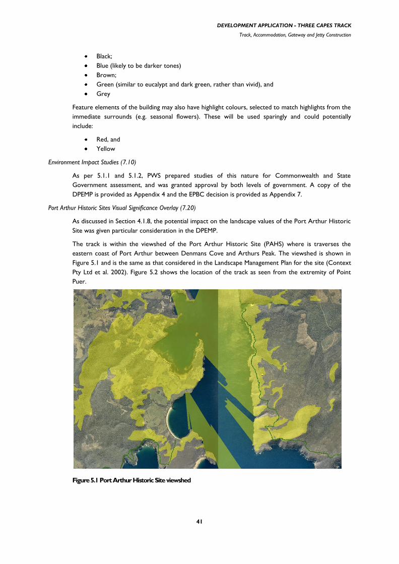
DEVELOPMENT APPLICATION - THREE CAPES TRACK
Track, Accommodation, Gateway and Jetty Construction
41
Black;
Blue (likely to be darker tones)
Brown;
Green (similar to eucalypt and dark green, rather than vivid), and
Grey
Feature elements of the building may also have highlight colours, selected to match highlights from the
immediate surrounds (e.g. seasonal flowers). These will be used sparingly and could potentially
include:
Red, and
Yellow
Environment Impact Studies (7.10)
As per 5.1.1 and 5.1.2, PWS prepared studies of this nature for Commonwealth and State
Government assessment, and was granted approval by both levels of government. A copy of the
DPEMP is provided as Appendix 4 and the EPBC decision is provided as Appendix 7.
Port Arthur Historic Sites Visual Significance Overlay (7.20)
As discussed in Section 4.1.8, the potential impact on the landscape values of the Port Arthur Historic
Site was given particular consideration in the DPEMP.
The track is within the viewshed of the Port Arthur Historic Site (PAHS) where is traverses the
eastern coast of Port Arthur between Denmans Cove and Arthurs Peak. The viewshed is shown in
Figure 5.1 and is the same as that considered in the Landscape Management Plan for the site (Context
Pty Ltd et al. 2002). Figure 5.2 shows the location of the track as seen from the extremity of Point
Puer.
Figure 5.1 Port Arthur Historic Site viewshed

DEVELOPMENT APPLICATION - THREE CAPES TRACK
Track, Accommodation, Gateway and Jetty Construction
42
Figure 5.2 Ortho-rectified image of the track route viewed from Point Puer
Plate 5.3 View from Port Arthur Historic Site
Plate 5.4 Coastline opposite Point Puer, the Three Capes Track traverses the upper heights across the extent of the
view

DEVELOPMENT APPLICATION - THREE CAPES TRACK
Track, Accommodation, Gateway and Jetty Construction
43
Plate 5.5 View towards the Cape Hauy track from Fortescue Bay, the track traverses the extent of the view field
from the lower right
The key viewpoint is from Port Arthur itself, although viewpoints from Point Puer must also be
considered. From Port Arthur the view across to the eastern shore is restricted by Point Puer and
the Isle of the Dead (Plate 5.3). The view field takes in the Three Capes Track where it traverses
above the coastline south from Denmans Cove with the track route beyond Surveyors Cove
considerably less apparent. The distance suggests that walkers will not be readily visible while the
small footprint of the track, benched profile and the use of geologically compatible material in
combination with the thick vegetation also strongly suggest that the track will not be visible. The track
is highly unlikely to alter the landscape values of the site.
From the extremity of Point Puer the track route is considerable closer in view as shown in Plate 5.4.
However, for the same reasons stated above, even from this closer point the track and walkers using
the track are highly unlikely to be visible. The vegetation shown above in Plate 5.4 is typical of the
track route throughout the entire traverse within the viewshed. By comparison, Plate 5.5 shows a
view traversed by the upgraded Cape Hauy track, including sections recently constructed during a
track upgrade as seen from the beach at Fortescue Bay, a considerably shorter distance than the view
point in Plate 5.4.

DEVELOPMENT APPLICATION - THREE CAPES TRACK
Track, Accommodation, Gateway and Jetty Construction
44
5.2.4 Relevant Provisions within Special Provisions (Part 8)
Use Class
Before proceeding with the Special Provisions for each zone, PWS has considered which of the possible uses
that the proposal could be potentially classed. While there were none that were a perfect fit, the proposed
Three Capes track appears to best match the definition of Tourist Operation which:
means a development specifically for tourist purposes, and includes such developments as wildlife parks, host
farms, country clubs, outdoor historical or bush displays and the like; but excludes all tourist developments
classified under other Use Classes in Schedule 3, except as an ancillary development to this Use Class as
provided under Clause 3.4.
The other tourist developments classified under Schedule 3 are Hotel, Motel, and Restaurant. PWS considers
that none of these are applicable to the proposed development, which essentially comprises a walking track,
five overnight accommodation nodes and associated gateway infrastructure. The use definition of „Public
Recreation‟, while normally appropriate for a walking track on public land, specifically refers to such use being
„normally open to the public free of charge‟. As the business model for the Three Capes Track is based on a
facility fee for overnight walkers, and all visitors require a valid National Park Pass to enter the Tasman
National Park, PWS considered it does not fit this classification for use.
General Rural Zone (8.11)
8.11.1 The intent of this zone is to retain land for agricultural purposes, maintain the general rural character, allow
some smaller lots, but discourage inappropriate development.
PWS acknowledges that the use of land within the General Rural Zone for “Tourist Operation” is a
consent use (referred to in Schedule 3 and Part 3 as Class A - „prohibited unless Council grants
permission‟).
While the proposed use of land is not an agricultural purpose the affected land is not presently used
for agriculture. In both instances the land is covered with native vegetation. Therefore, the proposed
use is not removing agricultural land from production nor is it considered to detract from the current
general character, as the sites‟ character is more akin to the adjacent national park than a rural
character.
Clauses 8.11.2 – 8.11.5 relate to subdivision and are therefore not considered relevant to the
proposed development.
Coastal Protection Zone (8.13)
8.13.1 The intent of this zone is to retain land for agricultural purposes and maintain the rural character and high
scenic quality of the coastal landscape.
PWS acknowledges that the use of land within the Coastal Protection Zone for “Tourist Operation”
is a consent use (referred to in Schedule 3 and Part 3 as Class A - „prohibited unless Council grants
permission‟).
While the proposed use of land is not an agricultural purpose the affected land is not presently used
for agriculture and is covered with native vegetation. Therefore, the proposed use is not removing
agricultural land from production nor is it considered to detract from the current general character,
as the sites‟ character is more akin to the adjacent national park than a rural character.
The proposed use of the land for a “Tourist Operation” utilises a surveyed road reserve between
Maingon Blowhole and the southern end of Dog Bark Road, with no further subdivision required.
Clauses 8.13.2 – 8.11.3 relate to subdivision and are therefore not considered relevant to the
proposed development.

DEVELOPMENT APPLICATION - THREE CAPES TRACK
Track, Accommodation, Gateway and Jetty Construction
45
Clause 8.13.4 relates to land clearing on Sympathy Point which is beyond the site of the proposed
development, and therefore not considered relevant.
8.13.5 Notwithstanding clause 8.13.4 nothing shall prevent land clearing on 50% of the area of any allotment within
l00m of the high water level mark, or for the purposes of No. 11 In Schedule 4 of this Scheme.
Four metres is the maximum width of vegetation clearing anticipated for the construction of the
walking track through the Coastal Protection Zone, which is well within the bounds of this provision.
8.13.6 In determining whether or not to grant a permit Council shall have regard to:-
(i) the value of the natural vegetation to be removed;
(ii) any alternative means of locating buildings or work in order to conserve the natural vegetation of the area;
(iii) any other matters which the Council considers to be in the interest of the conservation and enhancement
of the character of the area for its natural beauty;
and may impose any condition on the permit as it considers necessary.
The response to this clause is encapsulated in the response to Clause 8.13.7 (below)
8.13.7 In respect of any application for the permission of the Council, for the use or development of any land for a
purpose referred to with the letter "A" in schedule 3 to part 3, the Council shall have regard to:
(i) the need to protect the natural environment and landscape character;
(ii) the need for any proposed buildings or works to harmonise with the environment;
(iii) the impact of the proposed development on adjacent land use activities;
(iv) any other aspects that the Council considers important;
(v) the environment implications of the development as provided in Appendix 2;
and may impose such appropriate conditions on a permit as it deems fit.
As part of the preparation for the DPEMP, an ecological survey of the proposed track corridor was
undertaken by qualified ecologists based on both desktop and on-ground assessments. There are
previous records for one flora species of National environmental significance within Mansfield Plain,
namely Euphrasia semipicta (pp. 42, 89 of Appendix B in Appendix 4). However there is only one
record within the track corridor. This record is from 1970 with an stated accuracy of +/- 500 m and
the location recorded within the Natural Values Atlas (a comprehensive database on Tasmania‟s
natural values, managed by DPIPWE - www.naturalvaluesatlas.tas.gov.au ) situates the record on the
private land to the east of the unmade road reserve, approximately 10 metres from the proposed
track route (refer Figures 5.1and 5.2, below). While the ecologists found no sign of this species, or
any other species of State or Commonwealth significance along the road reserve, their report noted:
“The first two sites are located between Maingon Blowhole and Dog Bark Road (on Mansfield
Plains), one of which represents the type locality for the species (Figures 24 & 58 –replicated as
Figures 5.1 and 5.2, below). Repeated attempts to re-locate the species from this general location
and surrounds have been unsuccessful (Wendy Potts, Threatened Species Section, DPIPWE pers.
comm.). Two attempts were made to detect the species from within the study area as part of the
present assessments, which were also unsuccessful. The precise location of the species at these sites
is not known so it is uncertain whether the disturbance corridor of the proposed 3CT will actually
disturb the sites.”
and

DEVELOPMENT APPLICATION - THREE CAPES TRACK
Track, Accommodation, Gateway and Jetty Construction
46
“it is reasonable to conclude that Euphrasia semipicta is not likely to be extinct at the listed sites;
rather that due to the lack of disturbance (both the sites along the Cape Hauy track support dense
scrub – Plates 25-28, and the site at Mansfield Plain is relatively dense wet heathland – Plates 29-
30) the species is temporarily absent. It is possible that disturbance from track works will present
itself as an appropriate event to stimulate growth from seeds stored in the soil seed bank. This poses
a dilemma because while the proposed track works are likely to be beneficial (or at least not
detrimental), in the absence of a precise location of a population it is difficult to develop site-specific
management prescriptions.”
(Appendix B of Appendix 4 - ECOtas, p. 90, 2011)
As such, the ecologists recommended:
In the absence of a known population and relatively imprecise data on the original sites of collection,
the following is recommended for all populations of Euphrasia semipicta previously recorded near
tracks:
assume the locations of the records are accurate as indicated by the database precision codes
and assign a nominal radius of 50 m to the sites;
the buffer zones should be appropriately flagged prior to the commencement of works and all
personnel advised of the management restrictions within the buffer zones;
undertake track works within a 4 m corridor (i.e. 2 m either side from the centre point of the
existing track), minimising disturbance to the vegetation on the track verges to that required to
meet the minimum track design standard;
any slashed vegetation should not be placed along the track verge within the nominal buffer
zone and should preferentially be placed further along the existing track verge;
no gravel, rock or other materials should be stockpiled within the nominal buffer zone, and
should preferentially be placed further along the existing or new track verge;
the disturbance to the understorey and soil within 5 m either side of the track within the
nominal buffer zone should be minimised i.e. track workers should “park” themselves,
equipment (e.g. power barrows, day packs, etc.) outside the nominal buffer zone.
(Appendix B of Appendix 4 - EcoTAS, p. 90, 2011)
PWS considers that the use of the land for “Tourist Operation” is unlikely to have a negative impact
on the adjacent land uses and while there are previous records of an EPBC flora species known from
around the area proposed for the track, despite repeats attempts to relocate this species it currently
appears to be absent.
However PWS acknowledge it may still exist in the area and as such commit to the consultants
recommendations for track construction in the area around Mansfield Plain. In addition, as some areas
of Mansfield Plain are subject to regular inundation, the track consultant that PWS engaged
recommended two sections of duckboard (a form of timber boardwalk, refer Appendix 5 for details)
and this will further aid to reduce the potential impact on these sites as the duckboard would be laid
in areas adjacent to the historic records and is a form of track type that can be installed with very
minor disturbance to the surrounding environment.
In relation to the Safety Cove transition point, the proposed toilet facility will be a similar size to the
facility proposed for Noyes Road and Stormlea Road gateways (as per Appendix 2) with low-key
signage directing walkers to the beach, and jetty. As such, PWS considers that there will only be
minimal impacts to the surrounding environment and landscape.

DEVELOPMENT APPLICATION - THREE CAPES TRACK
Track, Accommodation, Gateway and Jetty Construction
47
Figure 5.1 Vegetation, threatened species and weed mapping Sections 13, 14 (Remarkable Cave to Maingon
Blowhole to Dog Bark Road area)
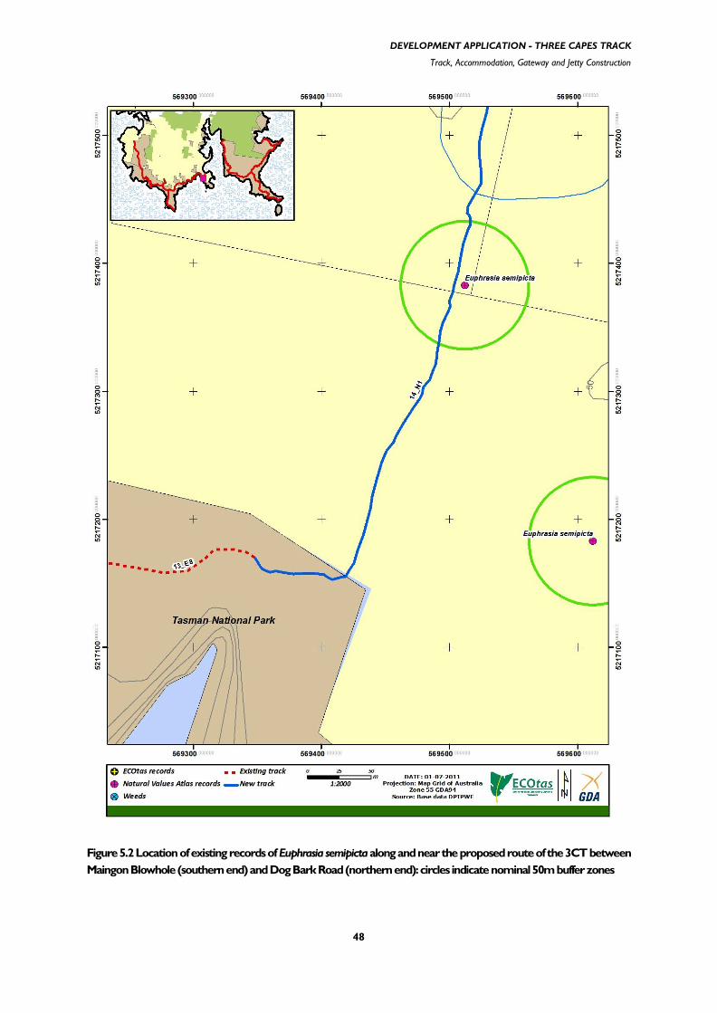
DEVELOPMENT APPLICATION - THREE CAPES TRACK
Track, Accommodation, Gateway and Jetty Construction
48
Figure 5.2 Location of existing records of Euphrasia semipicta along and near the proposed route of the 3CT between
Maingon Blowhole (southern end) and Dog Bark Road (northern end): circles indicate nominal 50m buffer zones

DEVELOPMENT APPLICATION - THREE CAPES TRACK
Track, Accommodation, Gateway and Jetty Construction
49
5.3 Consistency with Tasman Council policy
5.3.1 Tasman Council Strategic Plan 2011-2016
It is noted that the Strategic Plan is based on extensive community consultation with the Tasman community,
elected members of Council and advice provided by the officers of Council (Tasman Council, p. 2, 2011).
The Plan has six strategic themes:
Infrastructure
Development
Heritage
Lifestyle
Community
Organisation
Tourism falls within the second theme of Development, with the stated aim to: „increase the number and
yield from visitors to the municipality‟. Actions to support this include working with other State
organisations, such as DPIPWE, and implementing the 2011-16 Tasman Tourism Development Strategy. In
the community survey 88 per cent of respondents felt that „attracting new industries and business to
municipality‟ was the most important issue for the region‟s economic and cultural development (Tasman
Council, pp.13, 19, 2011).
Also within the second theme of Development is Business, with the stated aims to: „increase the number,
sustainability and diversity of businesses in the Tasman municipality‟ and „increase employment within the
municipality‟. Actions to support this include „facilitate and be actively involved in the development of
new business opportunities‟ (Tasman Council, p.20, 2011).
As such, PWS considers that the proposed development is consistent with both the Council and
community‟s values and ambitions for the future development of their region.
5.3.2 Tasman Tourism Development Strategy 2011-2016
The Strategy acknowledges the importance of the region‟s magnificent coastal seascapes but that historic
heritage still underpins the Tasman brand. The coastal precinct is incomplete and requires further resources to
establish it as a significant visitor experience. The completion of the Three Capes Track was recognised as
providing great potential to enhance the region‟s nature-based offerings (Lebski et al, p. 19, 2011).
5.4 Consistency with Tasmanian Government policy
5.4.1 State Policy on Water Quality Management 1997
This policy applies to surface, coastal and groundwaters within the areas traversed by the Three Capes Track.
The proposal will comply with the purpose and objectives of the Policy. In addition the proposal will be
required to comply with the Protected Environmental Values provided in the Tasman National Park
Management Plan 2011 as required by the Policy.
5.4.2 State Coastal Policy 1996
The State Coastal Policy is to facilitate the conservation of intrinsic assets, values and processes of the coastal
area and the sustainable use or development of the coast.

DEVELOPMENT APPLICATION - THREE CAPES TRACK
Track, Accommodation, Gateway and Jetty Construction
50
The coastal zone, as defined in the policy and supporting legislation, refers to State waters and to all land to a
distance of one kilometre inland from the high-water mark. Therefore, a majority of the proposed route, and
overnight nodes at Tunnel Bay, Maingon Creek, Surveyors Cove and Lunchtime Creek are within the coastal
zone.
Three main principles guide Tasmania's State Coastal Policy:
Natural and cultural values of the coast shall be protected.
The coast shall be used and developed in a sustainable manner.
Integrated management and protection of the coastal zone is a shared responsibility
Within the general consideration of the first principle, protection of natural and cultural values, there are 17
supporting clauses. The proposal is considered to satisfy all these clauses, as supported by the detail on the
management of environmental effects, as provided in section 4.1. Of particular relevance is clause 1.4.2 which
deals with development on actively mobile landforms. In this regards PWS intends to either consolidate or re-
align several sections of existing tracks which are currently eroding or unsustainably sited. Tracks no longer in
use will be actively rehabilitated. Examples include the former vehicle track leading south-east from Tunnel Bay
to Shipstern Bluff and several sections of the walking track from Remarkable Cave to Maingon Blowhole.
Having particular regard to the second principle, of sustainable development, there are four clauses that
specifically focus on tourism, and each is addressed below:
2.3.1 Tourism use and development in the coastal zone, including visitor accommodation and other facilities, will be
directed to suitable locations based on the objectives, principles and outcomes of this Policy and subject to planning
controls.
As outlined in section 4.1, the proposal has been through a comprehensive planning process to
determine the most suitable locations for the track, overnight nodes and any other infrastructure. It is
worth noting that of the four overnight nodes that are technically within the coastal zone, direct
access to the water‟s edge is only readily achievable at Tunnel Bay.
2.3.2. Tourism development proposals in the coastal zone will be subject to environmental impact assessment as
required by State legislation including a water safety assessment to indicate the level and type of lifesaving facilities and
personnel required to protect people.
As mentioned in section 5.1.2, the DPEMP formed the principal document to satisfy the state
environmental approval process, and the RAA (the formal process) was approved on 9 February
2012.
Despite the coastal zone definition resulting in a majority of the proposed route, and overnight nodes
at Tunnel Bay, Maingon Creek, Surveyors Cove and Lunchtime Creek being within the zone, it is
important to note that steep cliffs characterise much of the coastline along the route. This means that
direct access to the water‟s edge is likely to only be achievable in five locations:
Tunnel Bay
Shipstern Bluff
Safety Cove
Denmans Cove
Fortescue Bay
Indirect access is also achievable at Crescent Bay, which is a continuation of the track leading from
Remarkable Cave to Maingon Blowhole (at which point the Three Capes Track turns north east to
traverse the road reserve to Safety Cove).
It should also be noted that PWS currently has access roads or tracks to all of those sites but
Denmans Cove.

DEVELOPMENT APPLICATION - THREE CAPES TRACK
Track, Accommodation, Gateway and Jetty Construction
51
PWS has a Visitor Risk Management Policy which is based on contemporary risk management, and
accords with Australian Standard 4360:2004. This has established a framework for the identification,
assessment and control of risks, which involves five steps:
Establish context (determining the recreational setting and acceptable risk level)
Identfy hazards
Analyse and evaluate risks
Treat risks
Monitor and review
Treatment of risks would typically involve placement of hazard signage with icons and text to indicate
the hazard (e.g. dangerous undertow). The jetty/floating pontoon structures will be fitted with the
regulatory requirement of life ring/s however there would not be any capacity for provision of
lifesaving personnel.
2.3.3. Opportunities for tourism development will be identified wherever strategic planning occurs for the coastal zone
or any part of it.
The opportunity for the development of the Three Capes Track was identified through the
amendment of the Tasman National Park and Reserves Management Plan 2011.
2.3.4. Tourism development will be located where there is environmental capacity and where it does not significantly
conflict with the natural and aesthetic qualities of the coastal zone.
As outlined in sections 4.1 and 5.1 the proposal has received environmental approvals from the
Commonwealth and State governments. These approvals include management controls that will
minimise the environmental footprint of the proposed development both during the construction and
operation.
The Department, as manager of a considerable portion of the State‟s coastal zone, already does and
will continue to abide by the third principle, which addresses shared management responsibility.
5.4.3 Tourism Tasmania Strategic Plan 2010-2013
The Plan notes the continued increase in environmental consciousness among visitors, with growing numbers
of travellers seeking „responsible‟ tourism options. It also notes the longer „active‟ lifespan making adventure
holidays more accessible to all age groups (Tourism Tasmania, p. 4, 2010).
The plan is supported by an action plan with five goals, of which the third is considered most relevant: „to
foster the supply of tourism products and experiences‟ Two of the priorities underpinning this were the
„development of authentic and quality products and experience‟ and „improve tourism infrastructure and
encourage investment‟ (Tourism Tasmania, p. 20, 2010). As such, the proponent considers that the proposed
development is consistent with both the general intent of the Strategic Plan, and would significantly contribute
to delivery of Goal 3 for the State‟s tourism industry.
5.5 Relevant Legislative Requirements
5.5.1 Federal
The construction and operation of the Three Capes Track is required to be in accordance with the decision
provided under the EPBC Act, as previously mentioned in Section 5.1.1 (refer to Appendix 7 for a copy of the
decision notice).

DEVELOPMENT APPLICATION - THREE CAPES TRACK
Track, Accommodation, Gateway and Jetty Construction
52
5.5.2 State
The National Parks and Reserves Management Act 2002 governs the management of reserved land in Tasmania. It
provides for the establishment of a managing authority with respect to the management of reserved land and
defines the powers and obligations of that authority. Approval of the managing authority through the RAA
process addresses the fundamental statutory State obligation as it demonstrates that the proposal is consistent
with the management objectives of the reserved land as set out in Schedule 1 of the Act.
The Act requires that Management Plans be established for national parks. The Tasman National Park and
Reserves Management Plan 2001 has under gone an amendment process to primarily allow for the Three
Capes Track. That process required an independent assessment by the Tasmanian Planning Commission
(formerly the Resource Planning and Development Commission) and included the consideration of public
submissions. The amended Management Plan (Tasman National Park and Reserves Management Plan 2011) has
been approved by the Governor of Tasmania and is now the statutory management plan for the park and
reserves.
Some elements of the proposal will be implemented on Crown Land. Consequently, in accordance with the
Crown Lands Act 1976, PWS will seek a lease for any areas of Crown land required, from the relevant delegated
authority within Crown Land Services, Department of Primary Industries, Parks, Water and Environment
(DPIPWE).
There are a number of flora species listed under the Tasmanian Threatened Species Protection Act 1995 that are
widespread throughout some areas of the proposed route. It is an offence to knowingly take or disturb listed
species and therefore a permit under the Act will be required for the three listed plant species that will be
impacted by the proposal.
Under the Aboriginal Relics Act 1975, Aboriginal relics are defined as: „any place, site or object made or created
by, or bearing the signs of the activities of the original inhabitants of Australia, or descendants of such
inhabitants‟. All relics are protected and must be declared if found and provision for protection made. A permit
will be required if the relics are to be disturbed in any way. A permit under the Act is likely to be required to
either conceal or relocate artefacts at several sites within the footprint of the track.
The PWS has been provided with advice from the Forest Practices Authority that it accepts the Tasman
National Park and Reserves Management Plan 2011 as a „Vegetation Management Agreement‟ within the
meaning of the Forest Practices Regulations 2007 and hence the vegetation clearance required for the overnight
accommodation and track construction will not be required to be in accordance with a certified Forest
Practices Plan.

DEVELOPMENT APPLICATION - THREE CAPES TRACK
Track, Accommodation, Gateway and Jetty Construction
53
6. CONCLUSION
The Three Capes Track proposal aims to establish an iconic hut based bushwalking experience by linking the
outstanding natural features of the Tasman Peninsula in a coherent multi day experience with a high standard
of infrastructure and operational support.
A key feature of the proposal is the provision of a track built to a Class 3 Australian standard. This standard of
track will provide a walking experience that will contribute significantly to the appeal of the walk as well as
providing significant environmental benefits over the existing tracks in the Park. Walkers will be able to
undertake an extended walk of over 60 km with a „dry boot‟ standard, a feature that is likely to attract walkers
from a wider cross section than existing overnight walks throughout much of temperate Australia. The linking
of the two main sections of the Three Capes Track by boat will contribute towards the unique qualities of the
experience.
Further enhancing the appeal of the walk is the provision of hut accommodation within the five overnight
nodes. The high standard of design of the huts, the high level of facilities provided and an emphasis on
principles of sustainability is another key element in achieving the aim of the proposal. In particular the
provision of separate sleeping quarters, external decking, mattresses and gas cooking will ensure that the
Three Capes Track offers a unique walking experience in Tasmania and Australia.
The Tasmanian Government has committed $12.8 million to the Three Capes Track project and the
Commonwealth Government has committed $12.5 million with an expected additional private investment of
up to $8 million for the provision of water and land based transport and a guided (commercial) walking
experience. The construction of the Three Capes Track will provide significant employment and economic
opportunities at both the State and regional level. The value of this investment needs to be seen in the context
of the inter-generational lifespan of the proposal.
The operation of the Three Capes Track will continue to generate direct economic activity and employment
into the foreseeable future. The business model will ensure that the economic contribution at the regional and
State level of the operation of the Three Capes Track will be sustainable and therefore the long term return
on the capital investment will be significant. Beyond the operation of the Three Capes Track itself, the
proposal is likely to generate considerable economic opportunity, particularly at the regional level. By linking
the natural features of the area in a high quality experience, the Three Capes Track will raise the profile of the
natural environment of the Tasman region and therefore meet a key objective required to ensure ongoing
sustainable economic activity in the Tasman region.
The proposal will improve the current recreational opportunities within the Tasman National Park. All the
existing day and overnight walks will continue to be available to any person who holds a current parks pass.
These walks will continue to be available throughout the entire year and may be walked in any direction.
Camping on Cape Pillar and Mt Fortescue will be restricted to three dedicated campsites; however PWS
considers this change is required and will improve the environmental management of the area by reducing the
impact of unrestricted camping.
The potential environmental impacts of the proposal have been thoroughly investigated. The proposal has a
limited footprint and the environmental investigations have identified that the potential impact of the proposal
on the natural values within the footprint and in the wider area is either not significant or can be effectively
mitigated and managed. The application of the mitigation measures detailed in the DPEMP (Appendix 4) will
ensure that the construction and operation of the Three Capes Track is compatible with the national park
management objectives under the Act.
Given the benefits that are expected to be derived from the proposal over the long term and the extent to
which the proposal provides a significant additional recreational opportunity to park users, the limited residual
impacts of the proposal are considered to be acceptable.

DEVELOPMENT APPLICATION - THREE CAPES TRACK
Track, Accommodation, Gateway and Jetty Construction
54
The Three Capes Track will add to the diversity of recreational experiences available within the extent of
Tasmania„s parks and reserves and will further raise the profile of Tasmania„s unique and diverse environment.
In closing, the Parks and Wildlife Service considers that the proposal for an iconic walking experience of world
class standard is therefore worthy of Council‟s consent.

DEVELOPMENT APPLICATION - THREE CAPES TRACK
Track, Accommodation, Gateway and Jetty Construction
55
7. REFERENCES
ANZECC (2000) Australian and New Zealand guidelines for fresh and marine water quality. National Water
Quality Management Strategy. Australian and New Zealand Environment and Conservation Council, and
Agriculture and Resource Management Council of Australia and New Zealand
Bureau of Meteorology (2011) Climate statistics for Australian Sites – Tasmania
<http://www.bom.gov.au/climate/averages/tables/ca_tas_names.shtml>. Accessed 10 March 2011.
Context Pty Ltd, Urban Initiatives Pty Ltd and Helen Doyle (2002) Port Arthur Historic Site Landscape
Management Plan, prepared for the Port Arthur Historic Site Management Authority, August 2002, Context
Pty Ltd, Brunswick, Vic.
Department of Sustainability, Environment, Water, Population and Communities (2011b) Australian National
Guidelines for Whale and Dolphin Watching 2005. http://www.environment.gov.au/coasts/publications/whale-
watching-guidelines-2005.html accessed 9 November 2011.
DPIW. (2008). Conservation of Freshwater Ecosystem Values (CFEV) Project Technical Report. Conservation
of Freshwater Ecosystem Values Program, Department of Primary Industries and Water, Hobart, Tasmania.
ECOtas (2011) Ecological Assessment of Proposed Three Capes Track, Tasman Peninsula. Report by
Environmental Consulting Options Tasmania (ECOtas) for Parks and Wildlife Service, Tasmania, 29 August
2011.
Grose MR, Barnes-Keoghan I, Corney SP, White CJ, Holz GK, Bennett JB, Gaynor SM and Bindoff NL 2010,
Climate Futures for Tasmania: general climate impacts technical report, Antarctic Climate & Ecosystems
Cooperative Research Centre, Hobart, Tasmania.
KPMG (2010) Three Capes Track, Economic Impact of Additional Day Walk Visitors, report for the Tourism
Industry Council of Tasmania.
NRM South (2010) Keeping it Clean: A Tasmanian field hygiene manual to prevent the spread of freshwater
pests and pathogens, March 2010, NRM South, Hobart.
Parks and Wildlife Service, Forestry Tasmania and Department of Primary Industries, Water and the
Environment (2003). Tasmanian Reserve Management Code of Practice. Department of Tourism, Parks,
Heritage and the Arts, Hobart.
Parks and Wildlife Service (2006) draft Tasman National Park, Pirates Bay State Reserve and Eaglehawk Neck
Historic Site Fire Management Plan, draft version 2, November 2006. Department of Tourism, Parks, Heritage
and the Arts, Hobart.
Parks and Wildlife Service (2007) Three Capes Track, Tasman National Park, Feasibility Study. Department of
Tourism, Arts and the Environment.
Parks and Wildlife Service (2011) Tasman National Park and Reserves Management Plan 2011. Department of
Primary Industries, Water and Environment, Hobart.
DEVELOPMENT APPLICATION - THREE CAPES TRACK
Track, Accommodation, Gateway and Jetty Construction
56
Prodanovic, M. (2011) Road Safety Review, White Beach Road-Noyes Road and Stormlea Road for Proposed
Three Capes Walking Track Development, Tasman Municipality. August 2011.
Red Inca, SCA Marketing and SEMF (2005) Tasman Tourist Development Strategy 2005-2008.
Tasman Council (2011) Tasman Council Strategic Plan 2011-2016. Tasman Council.
Threatened Species Section (2008). Listing Statement Allocasuarina crassa. Department of Primary Industries,
Parks, Water and Environment, Tasmania.
Sarah Lebski and Associates, Adam Sadler Consultants and John Wadsley (2011) Tasman Tourism
Development Strategy 2011-2016, Final Report January 2011.
Sharples, C., 2006: Indicative Mapping of Tasmanian Coastal Vulnerability to Climate Change and Sea-Level
Rise: Explanatory Report (Second Edition); Consultant Report to Department of Primary Industries & Water,
Tasmania, 173 pp., plus accompanying electronic (GIS) maps.
Swift Parrot Recovery Team (2001). Swift Parrot Recovery Plan. Department of Primary Industries, Water and
Environment, Hobart.
Syenca Consulting (2008) Economic Impact Analysis for Three Capes Track, Tasman National Park, final
Report, 4 April 2008.
Tourism Tasmania (2010), Tourism Tasmania Strategic Plan 2010-2013, Hobart.
Water Research Laboratory (2009) Climate change impacts on Clarence coastal areas – Final Report, Clarence
City Council.
White CJ, Grose MR, Corney SP, Bennett JC, Holz GK, Sanabria LA, McInnes KL, Cechet RP, Gaynor SM &
Bindoff NL 2010, Climate Futures for Tasmania: extreme events technical report, Antarctic Climate and
Ecosystems Cooperative Research Centre, Hobart, Tasmania.
WWF-Australia (2008) Minimising the collision threat to swift parrot. WWF-Australia.

DEVELOPMENT APPLICATION - THREE CAPES TRACK
Track, Accommodation, Gateway and Jetty Construction
57
APPENDICES

DEVELOPMENT APPLICATION - THREE CAPES TRACK
Track, Accommodation, Gateway and Jetty Construction
58
Appendix 1 – Concept Layout for Gateway sites
Independent walk start - Noyes Road carpark
Remarkable Cave (Safety Cove Road)
Safety Cove (Dog Bark Road)
Denmans Cove

DEVELOPMENT APPLICATION - THREE CAPES TRACK
Track, Accommodation, Gateway and Jetty Construction
59
Appendix 2 – Typical Construction Details for Toilets
Twin pedestal – typical elevations
Twin pedestal – site plan and ramp detail

DEVELOPMENT APPLICATION - THREE CAPES TRACK
Track, Accommodation, Gateway and Jetty Construction
60
Appendix 3 – Concept Plans for Jetty Construction
Safety Cove (Dog Bark Road)
Denmans Cove

DEVELOPMENT APPLICATION - THREE CAPES TRACK
Track, Accommodation, Gateway and Jetty Construction
61
Appendix 4 – Three Capes Track Development Proposal and
Environmental Management Plan
Provided as a separately bound document, with separately bound appendices

DEVELOPMENT APPLICATION - THREE CAPES TRACK
Track, Accommodation, Gateway and Jetty Construction
62
Appendix 5 – Typical Track Construction Details
Three Capes Track – P130330-CT-01 (Typical Track Construction – Benching Details)
Three Capes Track – P130330-CT-02 (Typical Track Construction – Steps Details)
Three Capes Track – P130330-CT-03 (Typical Track Construction – Drainage Features Details)
Three Capes Track – P130330-CT-04 (Typical Track Construction – Miscellaneous Track
Details)
Three Capes Track – P130330-CT-05 (Typical Track Construction – Staircase Details)
Class 3 Walking Track – PWS-STD020-01 (Standard Timber Bridge – Round/Pole Stringers)
Class 3 Walking Track – PWS-STD021-01 (Standard Treated Pine Bridge – Rectangular Sawn
Stringers)
Class 3 Walking Track – PWS-STD021-01 (Precast Concrete Treads – Details)
Note: these treads are shown as 1200mm wide but alternate designs with a tread width
of 800-900mm may also be prepared

DEVELOPMENT APPLICATION - THREE CAPES TRACK
Track, Accommodation, Gateway and Jetty Construction
63
Appendix 6 – Concept Plans for Overnight Nodes
Cover Page (Dwg No 1142_01)
Tunnel Bay (Dwg No 1142_02 and 03)
Maingon Creek (Dwg No 1142_04, 05, 06 and 17)
Surveyors Cove (Dwg No 1142_07, 08 and 09)
Lunchtime Creek (Dwg No 1142_10 and 11)
Retakunna Creek (Dwg No 1142_12 and 13)
Typical Communal Area (Dwg No 1142_14)
Typical Ranger Area (Dwg No 1142_15)
Typical Sleeping Area (Dwg No 1142_16)

DEVELOPMENT APPLICATION - THREE CAPES TRACK
Track, Accommodation, Gateway and Jetty Construction
64
Appendix 7 – Environmental Protection and Biodiversity Conservation
Act - Decision Notice
FOR MORE INFORMATION CONTACT:
Ben Clark
Planning Officer (Three Capes Track)
Parks and Wildlife Service
GPO Box 1751
Hobart Tasmania 7001
P (03) 6233 2548
Top Related