


Languages
Pages
Legal


The Rolling Mill at Slitting Mill Introduction The site lies on the North side of the Rising Brook valley just below Dutton’s Pool (now called the Horns Pool) close to the Horns pub, SK0297017090. The mills of the Rising Brook valley were many, with various uses including: oil; corn; paper; rolling and slitting mills. In addition there were various furnaces, forges and glass houses, together with charcoal burners.
Figure 1: Rising Brook Valley

History The site the Stoke-on-Trent Museum Archaeology Society (SOTMAS) was asked to help with was an area immediately south of Dutton’s Pool. This was thought to be the location of a rolling mill, but the history of the site is slightly confused. It is possible that the information which follows may need to be revised as new research is undertaken. Early references to forges and furnaces in the valley start in the mid 16th century. The first reference to our site appears in 1796, when it was decided to divert the route of the stream with a leat which would run to our site. Also a shell for a new slitting mill was to be erected. This was introduced by a partnership which included Samuel Hopkins and Edward Barker. By 16th October 1799 the mill appears to be erected but now the tenant is named as Edward Barker. At this time Edward Barker is running a successful tin plate manufactory business in the valley. It is not clear exactly when or if the mill ever ran as a slitting mill, but by 1799 it is being referred to as a rolling mill. It is known that the leat was built by 1803 and the Dutton’s Pool was dug in or about 1807. If the rolling mill was worked before 1807, then perhaps water from the leat was directed straight onto the water wheel.
Edward Barker had been the iron master behind the development of the site but by 1817 his empire had collapsed. A description of the site being sold in 1817 states: “The freehold Rolling Mill and pool lately built on the brook above Lord Curzon’s pleasure grounds had a 16.5 feet head and a powerful stream of water, the wheel was close ladled, 18.5 feet high and 7 feet wide. The mill had been used for rolling sheet iron.” It is unclear if the mill was used after 1817. Certainly maps including one of 1823 show no evidence of a mill on the site.
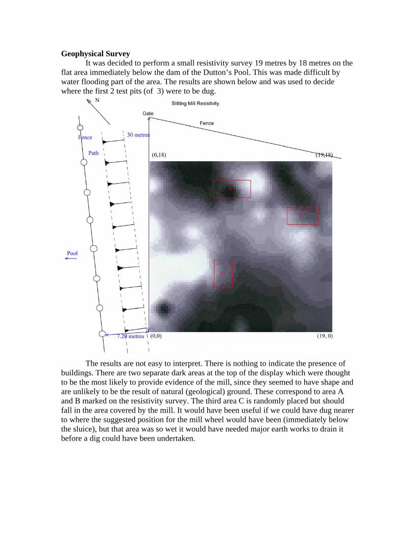
Geophysical Survey It was decided to perform a small resistivity survey 19 metres by 18 metres on the flat area immediately below the dam of the Dutton’s Pool. This was made difficult by water flooding part of the area. The results are shown below and was used to decide where the first 2 test pits (of 3) were to be dug.
The results are not easy to interpret. There is nothing to indicate the presence of buildings. There are two separate dark areas at the top of the display which were thought to be the most likely to provide evidence of the mill, since they seemed to have shape and are unlikely to be the result of natural (geological) ground. These correspond to area A and B marked on the resistivity survey. The third area C is randomly placed but should fall in the area covered by the mill. It would have been useful if we could have dug nearer to where the suggested position for the mill wheel would have been (immediately below the sluice), but that area was so wet it would have needed major earth works to drain it before a dig could have been undertaken.

Resistivity in progress.

Excavation of October 2011 As indicated on the resistivity survey three areas were selected for excavation. Each of the areas is described below. None of the areas was taken down to natural for the reasons described under each area. Area A (coordinates (7,14) to (11,16)) The top layer of the area had been compressed by the bulldozer, used to clear the lane which passes close to the site. This produced a very compact stoney layer on the surface with several layers of compressed soil and turf below. This gave way to the natural upper layer, a sandy silty grey compact material (this was the typical upper layer [context SMR11 1] of all three areas). Context SMR11 1 appears to be redeposited material with quite a wide range of dates. There is a single shard of pottery from the early 18th century. However, the bulk of the material dates from the late 18th century to the early 20th century. This upper layer was about 60 cms. in depth. Context SMR11 3 is composed of a dark mixture of clinker and coal of varying compaction. It appeared to have a loose mixture interspersed with hard compacted layers. Repeatedly we thought we had reached a floor or working surface only to find that this gave way to more loose material. The dating evidence seems to suggest this build up of material was in the mid 18th to mid 19th century. No structural features were seen. We took the area down carefully to about 1 metre 20 cms. below ground surface. Before closing the excavation we spaded down a further 30 cms without any change in the material.
Area A under excavation.

Area B (coordinates (15,11) to (18,13)) The upper layer was a sandy silty grey compact material (context SMR11 1). Here this layer was 10 to 20 cms. in depth. It was very difficult to make any impression in the underlying layer (context SMR11 2). This was composed of layers of slag and clinker, some of it fused into a mass. At one point there was a partial band of silica sand. The small amount of pottery in this layer was consistent, all of it being pancheons or mixing bowls probably from the late 18th century. The material seems to be consistent with the waste from a furnace or forge. This area was extremely difficult to dig. The area taken down was narrowed to a spade width, but we didn’t get to the bottom of the context and stopped at about a metre down.

Area B showing the band of silica sand (context SMR11 2)

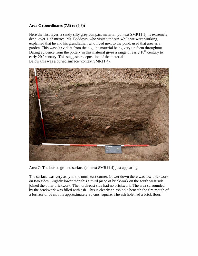
Area C (coordinates (7,5) to (9,8)) Here the first layer, a sandy silty grey compact material (context SMR11 1), is extremely deep, over 1.27 metres. Mr. Beddows, who visited the site while we were working, explained that he and his grandfather, who lived next to the pond, used that area as a garden. This wasn’t evident from the dig, the material being very uniform throughout. Dating evidence from the pottery in this material gives a range of early 18th century to early 20th century. This suggests redeposition of the material. Below this was a buried surface (context SMR11 4).
Area C: The buried ground surface (context SMR11 4) just appearing. The surface was very ashy to the north east corner. Lower down there was low brickwork on two sides. Slightly lower than this a third piece of brickwork on the south west side joined the other brickwork. The north-east side had no brickwork. The area surrounded by the brickwork was filled with ash. This is clearly an ash hole beneath the fire mouth of a furnace or oven. It is approximately 90 cms. square. The ash hole had a brick floor.

Area C: Ash hole just appearing.


Conclusions The whole area was covered with a varying thickness of grey silty sandy material which was quite compact. This was probably dumped here after clearing either the bottom of the pond or the leat. It is not clear if this was a single event or an accumulation of repeated episodes. There wasn’t any clear layering in the deposit even where it was at its thickest (1.27 metres). This is likely to have occurred in the early 20th century. Area A seems to be an area where clinker, coal, ash and metallic flakes from the rolling mill were dumped. Area B has proved to be problematic. At first we thought it may be an early iron smelting site. However the dating evidence from pottery in the lower excavated levels suggests a late 18th century date. Area C is perhaps the most interesting area. It is clear that there is a deeply buried working surface. This could easily be the floor of the mill. The feature we came down on to suggests there is a furnace near the centre of the area which could have been used for the mill. Acknowledgements We are indebted to the owner of the area Mr. Kevin Boam for allowing us to do this investigation. The members of the Staffordshire Industrial Archaeology Society, particularly Jim Causer, Roger Francis, Jim and Anne Andrews and members of the Landor Society, have encouraged and helped us in many ways. Jim Causer has freely given all the information about the site he has painstakingly gleaned.

Pottery report Area A context SMR11 1 TYPE Number Date (Century) Details Trailed Slip Ware 1 Early 18th Cream Ware 1 Late 18th – Early 19th Hand Painted Black Glaze 10 Late 18th – Early 19th Red Ware 1 Late 18th – Early 19th Mottled Ware 2 Late 18th – Early 19th Salt Glazed Stone Ware 1 Mid 19th Nottingham Rouletted Industrial Slip Ware 2 Mid 19th Mocha Cream Ware 6 Mid 19th Jug, spout, saucer Blue transfer printed 7 Late 19th White Salt Glaze 1 Early 20th Jam pot Yellow Ware 1 Early 20th White Ware 3 Early 20th Basin, dish feathered edge Cream Ware 2 Early 20th Bowl; Colander White Ware Misc. 59 20th Banded Ware 2 Early – Mid 20th Blue/White; Green/White Tobacco Pipe stems 3 Late 19th Tile 3 ? Drainage Pipe 1 ? Other finds: Slate; Glass; Wire; Clinker. Area A context SMR11 3 TYPE Number Date (Century) Details Slip Ware 2 Mid 18th Rim; Combed Mottled Ware 1 Mid 18th Black Glaze 2 Mid 18th Cream Ware 1 Mid 19th Blue transfer printed 1 Late 19th Butter Dish Tile 3 ? Other finds: Slag.

Area B context SMR11 1 TYPE Number Date (Century) Details Slip Ware 1 Early 18th Press Moulded Dish Mottled Ware 1 Mid 18th Black Glaze 1 Mid 18th Black Glaze 1 Early 19th Cream Ware 19 Mid 19th Industrial Slip Ware 1 Mid 19th Mocha Salt Glazed Stone Ware 1 Mid 19th Nottingham White Ware 1 Mid 19th – Late 19th Feathered Edge White Ware 7 Late 19th – Early 20th Blue transfer printed 2 Late 19th – Early 20th White Salt Glaze 1 Early 20th Jam pot Banded Ware 1 Early – Mid 20th Blue/White Tobacco Pipe 2 Late 18th 1 bowl; 1 stem Other finds: Lead; Glass (including part of pop bottle); Chair castor; Clinker throughout the context. Area B context SMR11 2 TYPE Number Date (Century) Details Black Glaze 11 Late 18th Tile 3 ? Other finds: Silica sand; Clinker throughout the context.
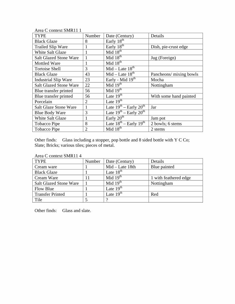
Area C context SMR11 1 TYPE Number Date (Century) Details Black Glaze 8 Early 18th Trailed Slip Ware 1 Early 18th Dish, pie-crust edge White Salt Glaze 1 Mid 18th Salt Glazed Stone Ware 1 Mid 18th Jug (Foreign) Mottled Ware 1 Mid 18th Tortoise Shell 3 Mid – Late 18th Black Glaze 43 Mid – Late 18th Pancheons/ mixing bowls Industrial Slip Ware 23 Early - Mid 19th Mocha Salt Glazed Stone Ware 22 Mid 19th Nottingham Blue transfer printed 56 Mid 19th Blue transfer printed 56 Late 19th With some hand painted Porcelain 2 Late 19th Salt Glaze Stone Ware 1 Late 19th – Early 20th Jar Blue Body Ware 3 Late 19th – Early 20th White Salt Glaze 1 Early 20th Jam pot Tobacco Pipe 8 Late 18th – Early 19th 2 bowls; 6 stems Tobacco Pipe 2 Mid 18th 2 stems Other finds: Glass including a stopper, pop bottle and 8 sided bottle with Y C Co; Slate; Bricks; various tiles; pieces of metal. Area C context SMR11 4 TYPE Number Date (Century) Details Cream ware 1 Mid – Late 18th Blue painted Black Glaze 1 Late 18th Cream Ware 11 Mid 19th 1 with feathered edge Salt Glazed Stone Ware 1 Mid 19th Nottingham Flow Blue 1 Late 19th Transfer Printed 1 Late 19th Red Tile 5 ? Other finds: Glass and slate.

Pancheons and mixing bowls (mid to late 18th century)

Transfer Printed wares (early to late 19th century).

Transfer printed wares (early to late 19th century)

A variety of wares from context SMR11 1.

Pipes from context SMR11 1.
Top Related