


Languages
Pages
Legal


1
THE PALMS PLAN OF
DEVELOPMENT
Variation Request under Section 43 and 50(3) of the Planning Act
2016 to vary the effect of the CairnsPlan Planning Scheme
Prepared for:
PPNQ Developments Pty Ltd
October 2020
APPENDIX NO. 1 - APPROVED PLANS & DOCUMENTS
1
Separate Attachment to Clause No. 1 - Planning and Environment Committee 11 November 2020

2
Contents
Contents .................................................................................................................................................. 2
1. Introduction .................................................................................................................................... 3
1.1 The Palms Structure Plan Objectives ........................................................................................... 3
2. Using The Palms Plan of Development ........................................................................................... 5
2.1 Relationship to the Cairns Regional Council Planning Scheme .................................................... 5
2.2 Categories of Assessment ............................................................................................................ 5
2.3 Assessment Benchmarks .............................................................................................................. 5
2.4 Interpretation ............................................................................................................................... 6
Figures
Figure 1 The Palms Structure Plan
Figure 2 The Palms Precinct Plan
Annexures
Annexure A The Palms Tables of Assessment
Annexure B The Palms Development Code
2
Separate Attachment to Clause No. 1 - Planning and Environment Committee 11 November 2020

3
1. Introduction
The Palms Plan of Development is intended to transform the existing Paradise Palms golf course site
into a world-class mixed-use community comprising a high-quality residential estate, tourist/holiday
park, retirement village, school, vibrant village hub and significant recreation and natural spaces.
The development is set amongst an abundance of natural vegetation, creek corridors and existing
landscaped grounds and includes magnificent views to the Macalister Ranges to the west. These
existing features have shaped the layout of the Structure Plan, and their retention and capitalisation
is central to the vision for the project, which is to create a connected community, framed by nature.
The retention of the existing golf clubhouse also forms an important part of the overall vision for the
project, creating an opportunity for a vibrant village hub where residents, tourists and visitors alike
can come together to connect. The clubhouse is a significant, iconic structure which has been greatly
underutilised for many years and the establishment of a world-class tourist/holiday park alongside
this building is considered to represent an opportunity to utilise it for administration and check-in
functions, dining, entertainment and other associated functions, as well as local-scale retail and
community facilities to service surrounding residents and visitors of the tourist/holiday park.
1.1 The Palms Structure Plan Objectives
The Palms Structure Plan is included as Figure 1.
The Structure Plan identifies a series of precincts across the site as follows:
• Precinct 1 – The Palms Tourist Accommodation Precinct
• Precinct 2 – The Palms Village Precinct
• Precinct 3 – The Palms Low Density Residential Precinct
• Precinct 4 – The Palms Low-Medium Density Residential Precinct
• Precinct 5 – The Palms Open Space Precinct
The Structure Plan:
1. Represents an appropriate form of development across the site which retains and celebrates
the significant natural waterway and vegetation corridors through the site.
2. Provides opportunities for a high level of pedestrian connectivity through open space linkages
across the site, connecting a series of park nodes to form a unique open space network that
becomes an asset to existing and future residents and the broader community in general.
3. Provides for residential areas with a high level of amenity, framed by natural features,
comprising detached dwellings-only over the majority of the site, particularly adjacent to
existing residential dwellings.
4. Provides opportunities for medium density residential options and community facilities in
appropriately-located areas, away from existing residential dwellings and in close proximity
to public transport and the proposed village hub.
5. Provides opportunities for a vibrant village hub that will capitalise on the existing clubhouse
building and cater for locals, tourists and visitors.
6. Provides opportunities for low-scale tourist accommodation to support the reinvigoration of
the existing clubhouse building and support the local tourism industry by creating a new
landmark tourist/holiday park which capitalises on the growing demand for family-orientated
tourist park accommodation.
3
Separate Attachment to Clause No. 1 - Planning and Environment Committee 11 November 2020

4
7. Accommodates a link road through the site from the existing Paradise Palms Drive roundabout
to Moore Road to enable the efficient movement of traffic throughout the site.
4
Separate Attachment to Clause No. 1 - Planning and Environment Committee 11 November 2020

5
2. Using The Palms Plan of Development
2.1 Relationship to the Cairns Regional Council Planning Scheme
The Palms Plan of Development applies to land located at the Captain Cook Highway, Paradise Palms
Drive and Moore Road, Kewarra Beach, as identified on The Palms Structure Plan.
References within The Palms Plan of Development to the “CRC Planning Scheme” are references to
the CairnsPlan 2016 v1.3, or any subsequent Planning Scheme in effect for the Cairns Regional Council
local government area as at the date a future development application is made in respect of land to
which the Variation Approval applies.
The Palms Plan of Development is a Variation Approval which varies the effect of the CRC Planning
Scheme for development of the land to which the approval applies for the life of the approval or until
development is completed.
The provisions of this Variation Approval are to be read and applied in conjunction with the CRC
Planning Scheme.
The Variation Approval provides for the assessment of future and ongoing development of the subject
land generally reflective of:
• The Palms Structure Plan as Figure 1;
• The Palms Precinct Plan included as Figure 2; and
• The Palms Development Code included as Annexure B.
The Palms Plan of Development:
• Defines the development intent for the land beyond the broad intent of the Planning Scheme
and the principles under which this will be achieved;
• States the category of assessment for development on the land where reflective of The Palms
Structure Plan; and
• Sets the assessment benchmarks for assessment of future development on the subject land.
Development is to be assessed against The Palms Plan of Development and the CRC Planning Scheme.
To the extent of any inconsistencies, The Palms Plan of Development prevails over the CRC Planning
Scheme.
2.2 Categories of Assessment
The Palms Plan of Development applies to all development on land identified on The Palms Structure
Plan and The Palms Precinct Plan. Tables of Assessment which identify the relevant categories of
assessment for development within the various precincts shown on The Palms Structure Plan and The
Palms Precinct Plan are included as Annexure A.
2.3 Assessment Benchmarks
The Palms Plan of Development includes a range of development provisions within The Palms
Development Code (included as Annexure B). These provisions apply in addition to any relevant
5
Separate Attachment to Clause No. 1 - Planning and Environment Committee 11 November 2020

6
assessment benchmarks contained within the CRC Planning Scheme and prevail over the CRC Planning
Scheme assessment benchmarks to the extent of any inconsistencies
2.4 Interpretation
The table below identifies how terminology used within The Palms Plan of Development is intended
to be used interchangeably with corresponding terminology within version 1.3 of the CRC Planning
Scheme:
The Palms Plan of Development CairnsPlan
Low Density Residential Precinct Low Density Residential Zone
Low-Medium Density Residential Precinct Low-Medium Density Residential Zone
Tourist Accommodation Precinct Tourist Accommodation Zone
Village Precinct Neighbourhood Centre Zone
Protected Vegetation* Biodiversity Area / Significant Environment Area*
For example, when assessing development against codes contained within the CRC Planning Scheme,
the Low Density Residential Precinct of The Palms Plan of Development is taken to be the Low Density
Residential Zone of the CRC Planning Scheme, and the Village Precinct of The Palms Plan of
Development is taken to be the Neighbourhood Centre Zone under the CRC Planning Scheme.
For the purpose of assessing any future development applications for land to which the Variation
Approval applies, a reference to the Low Density Residential Zone within an Overlay, Land Use or
Development Code of the CRC Planning Scheme (or equivalent terminology adopted in any future
version of the CRC Planning Scheme) is taken to be a reference to The Palms Low Density Residential
Precinct.
* Protected Vegetation mapped on the Structure Plan and Precinct Plan of The Palms Plan of
Development is taken to be a Biodiversity Area for the purpose of the Natural Areas Overlay Code
under the CRC Planning Scheme, and replaces the Significant Environment Area on the Natural Areas
Overlay mapping.
A reference to a sensitive land use within The Palms Plan of Development is a reference to those land
uses defined as a Sensitive Land Use per Schedule 1 within version 1.3 of the CRC Planning Scheme.
A reference to land zoned for a sensitive land use within The Palms Plan of Development is a
reference to Residential Zones so defined per Schedule 1 within version 1.3 of the CRC Planning
Scheme. Unless an alternate definition is provided for within The Palms Plan of Development, terms
are defined by reference to Schedule 1 of the CRC Planning Scheme.
6
Separate Attachment to Clause No. 1 - Planning and Environment Committee 11 November 2020

7
Figure 1
The Palms Structure Plan
7
Separate Attachment to Clause No. 1 - Planning and Environment Committee 11 November 2020

THE PALMS, CAIRNSSTRUCTURE PLAN 1:2500 @ A1
DATE: 23.10.2020JOB NO: P0001586DWG NO: SP-01REV: 16
LEGEND:
SITE BOUNDARY
EXISTING ROADS
EXISTING BRIDGES
PROPOSED ROADS
BUFFER AREA
PRIMARY PARK NODE
INDICATIVE PEDESTRIAN NETWORK
SCHOOL SITE
CONTROLLED ACCESS POINTS
SETBACK/BUFFER AS PER PLAN OF DEVELOPMENT
TOP OF BANK
10m TOP OF BANK BUFFER
POSSIBLE 5m TOP OF BANK BUFFER
INDICATIVE WATERWAY CENTRELINE
OPEN SPACE PRECINCT
PROTECTED VEGETATION SUB-PRECINCT
PARK NODE SUB-PRECINCT
LOW DENSITY RESIDENTIAL PRECINCT
LOW-MEDIUM DENSITY RESIDENTIAL PRECINCT
VILLAGE PRECINCT
TOURIST ACCOMMODATION PRECINCT
CAPTAIN
COOK
HIGHWAY
MOORE ROAD
PARADISE PALMS
DRIVE
8
Separate Attachment to Clause No. 1 - Planning and Environment Committee 11 November 2020

8
Figure 2
The Palms Precinct Plan
9
Separate Attachment to Clause No. 1 - Planning and Environment Committee 11 November 2020

THE PALMS, CAIRNSPRECINCT PLAN 1:2500 @ A1
DATE: 23.10.2020JOB NO: P0001586DWG NO: PP-01REV: 6
LEGEND:
SITE BOUNDARY..................................................................................95.7ha
EXISTING ROADS
PROPOSED ROADS
TOTAL OPEN SPACE PRECINCT....................................................33.4ha
OPEN SPACE PRECINCT (GENERAL).....................................13.9ha
PROTECTED VEGETATION SUB-PRECINCT........................18.2ha
PARK NODE SUB-PRECINCT........................................................1.3ha
LOW DENSITY RESIDENTIAL PRECINCT...................................33.2ha
LOW-MEDIUM DENSITY RESIDENTIAL PRECINCT..................9.9ha
VILLAGE PRECINCT...............................................................................4.1ha
TOURIST ACCOMMODATION PRECINCT....................................15.1ha
CAPTAIN
COOK
HIGHWAY
MOORE ROAD
PARADISE PALMS
DRIVE
10
Separate Attachment to Clause No. 1 - Planning and Environment Committee 11 November 2020
9
Annexure A
The Palms Tables of Assessment
11
Separate Attachment to Clause No. 1 - Planning and Environment Committee 11 November 2020
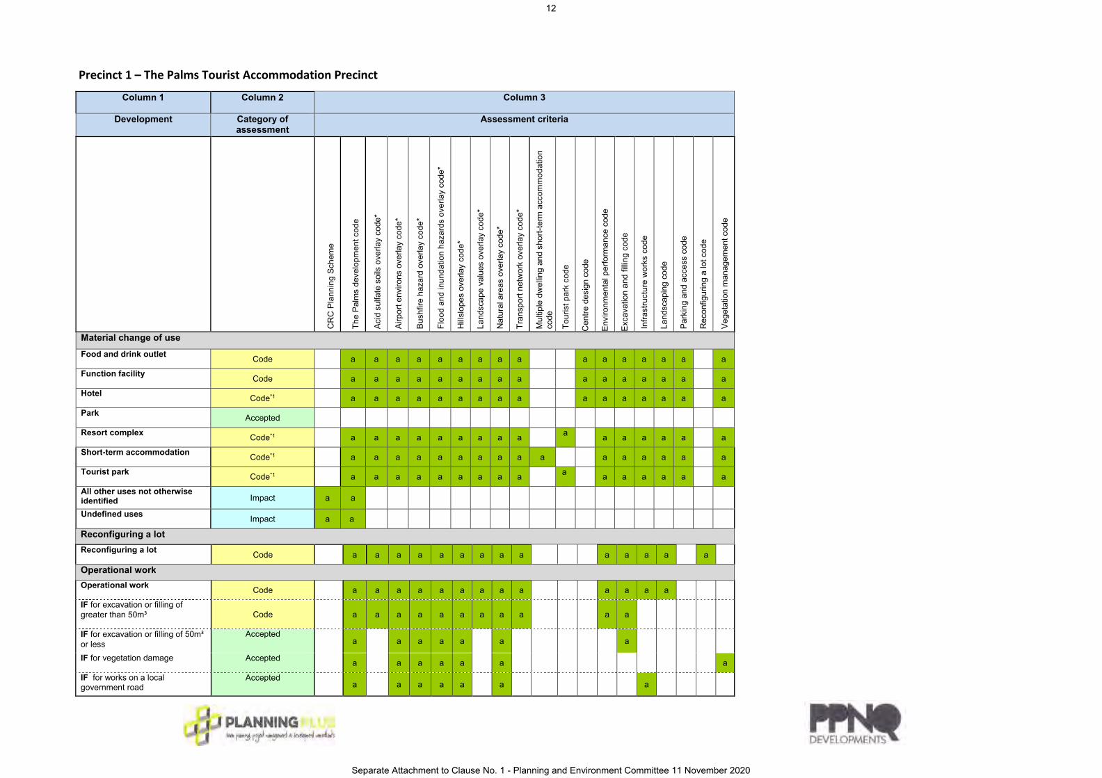
Precinct 1 – The Palms Tourist Accommodation Precinct
Column 1 Column 2
Column 3
Development Category of assessment
Assessment criteria
CR
C P
lann
ing
Sche
me
The
Pal
ms
deve
lopm
ent c
ode
Aci
d su
lfate
soi
ls o
verla
y co
de*
Airp
ort e
nviro
ns o
verla
y co
de*
Bus
hfire
haz
ard
over
lay
code
*
Flo
od a
nd in
unda
tion
haza
rds
over
lay
code
*
Hills
lope
s ov
erla
y co
de*
Lan
dsca
pe v
alue
s ov
erla
y co
de*
Nat
ural
are
as o
verla
y co
de*
Tra
nspo
rt ne
twor
k ov
erla
y co
de*
Mul
tiple
dw
ellin
g an
d sh
ort-t
erm
acc
omm
odat
ion
c
ode
Tou
rist p
ark
code
C
entre
des
ign
code
Envi
ronm
enta
l per
form
ance
cod
e
Exca
vatio
n an
d fil
ling
code
Infra
stru
ctur
e w
orks
cod
e
Lan
dsca
ping
cod
e
Par
king
and
acc
ess
code
Rec
onfig
urin
g a
lot c
ode
Veg
etat
ion
man
agem
ent c
ode
Material change of use
Food and drink outlet Code a a a a a a a a a
a a a a a a a
Function facility Code a a a a a a a a a
a a a a a a a
Hotel Code*1 a a a a a a a a a a a a a a a a
Park Accepted
Resort complex Code*1 a a a a a a a a a a a a a a a a
Short-term accommodation Code*1 a a a a a a a a a a a a a a a a
Tourist park Code*1 a a a a a a a a a
a a a a a a a
All other uses not otherwise identified Impact a a
Undefined uses Impact a a
Reconfiguring a lot
Reconfiguring a lot Code a a a a a a a a a
a a a a a
Operational work
Operational work Code a a a a a a a a a
a a a a
IF for excavation or filling of greater than 50m³ Code a a a a a a a a a
a a
IF for excavation or filling of 50m³ or less
Accepted a a a a a a
a
IF for vegetation damage Accepted a a a a a a
a
IF for works on a local government road
Accepted a a a a a a
a
12
Separate Attachment to Clause No. 1 - Planning and Environment Committee 11 November 2020

Building work
Minor building work Accepted a a a a a
a a
Building work Accepted a a a a a
a a
* Applicable overlay codes are identified by reference to the overlay maps contained in Schedule 2 of the CRC Planning Scheme.
*1 if not more than 2 storeys in height above existing ground level. If greater than 2 storeys, the level of assessment is Impact and the CRC Planning Scheme is an Assessment Criteria.
13
Separate Attachment to Clause No. 1 - Planning and Environment Committee 11 November 2020

Precinct 2 – The Palms Village Precinct
Column 1 Column 2 Column 3 Development Category of
assessment Assessment criteria
CR
C P
lann
ing
Sche
me
The
Pal
ms
deve
lopm
ent c
ode
Aci
d su
lfate
soi
ls o
verla
y co
de*
Airp
ort e
nviro
ns o
verla
y co
de*
Bus
hfire
haz
ard
over
lay
code
*
Flo
od a
nd in
unda
tion
haza
rds
over
lay
code
*
Hills
lope
s ov
erla
y co
de*
Lan
dsca
pe v
alue
s ov
erla
y co
de*
Nat
ural
are
as o
verla
y co
de*
Tra
nspo
rt ne
twor
k ov
erla
y co
de*
Chi
ld c
are
cent
re c
ode
Com
mun
ity a
ctiv
ities
cod
e
Mar
ket c
ode
Mul
tiple
dw
ellin
g an
d sh
ort-t
erm
acc
omm
odat
ion
c
ode
T our
ist p
ark
code
R
oom
ing
acco
mm
odat
ion
code
Spo
rt an
d re
crea
tion
activ
ities
cod
e
Sal
es o
ffice
cod
e
Vet
erin
ary
serv
ices
cod
e
Cen
tre d
esig
n co
de
Env
ironm
enta
l per
form
ance
cod
e
Exc
avat
ion
and
fillin
g co
de
Infra
stru
ctur
e w
orks
cod
e
Lan
dsca
ping
cod
e
Par
king
and
acc
ess
code
Rec
onfig
urin
g a
lot c
ode
Veg
etat
ion
man
agem
ent c
ode
Material change of use Child care centre Code a a a a a a a a a a
a a a a a a a
Community use Code a a a a a a a a a a a a a a a a a
IF contained within an existing building Accepted a a a a a a a a a a a a a
Club Code a a a a a a a a a a a a a a a a a
Club (small scale) Code a a a a a a a a a a a a a a IF contained within an existing building
Accepted a a a a a a a a a a a
Educational establishment Code a a a a a a a a a
a a a a a a
Food and drink outlet Code a a a a a a a a a
a a a a a a a
IF contained within an existing building Accepted a a a a a a a a a a a a
Function facility Code a a a a a a a a a
a a a a a a a
Health care services Code a a a a a a a a a
a a a a a a a
IF contained within an existing building Accepted a a a a a a a a a a a a
Hotel Code*1 a a a a a a a a a
a a a a a a a
Indoor sport and recreation Code a a a a a a a a a a a a a a a a IF contained within an existing building
Accepted a a a a a a
a a a a a a
Market Code a a a a a a a a a a
a a a a a a
Multiple dwelling Code*1 a a a a a a a a a a a a a a a a
14
Separate Attachment to Clause No. 1 - Planning and Environment Committee 11 November 2020

Office Code a a a a a a a a a
a a a a a a a
IF contained within an existing building Accepted a a a a a a a a a a a a
Outdoor sport and recreation Code a a a a a a a a a
a a a a a a a
Park Accepted
Place of worship Code a a a a a a a a a a a a a a a a
Resort complex Code*1 a a a a a a a a a a a a a a a a a
Rooming accommodation Code*1 a a a a a a a a a
a a a a a a a
Sales office Accepted a a a a a a a a a a a a a
Shop Code a a a a a a a a a
a a a a a a a
IF contained within an existing building Accepted a a a a a a a a a a a a
Shopping centre Impact a a
IF contained within an existing building and the GFA of the shopping centre is less than 500m²
Code a a a a a a a a a
a a a a a a a
Short-term accommodation Code*1 a a a a a a a a a a
a a a a a a
Tourist attraction Code*2 a a a a a a a a a a a a a a a
Tourist park Code a a a a a a a a a a a a a a a a
Veterinary services Code a a a a a a a a a a a a a a a a
IF contained within an existing building Accepted a a a a a a a a a a a a
All other uses not otherwise identified Impact a a
Undefined uses Impact a a
Reconfiguring a lot Reconfiguring a lot Code a a a a a a a a a
a a a a a
Operational work Operational work Code a a a a a a a a a
a a a a
IF for excavation or filling of greater than 50m³ Code a a a a a a a a a
a a
IF for excavation or filling of 50m³ or less Accepted a a a a a a
a
IF for vegetation damage Accepted a a a a a a
a
IF for works on a local government road
Accepted a a a a a a
a
Building work Minor building work Accepted a a a a a
a a
15
Separate Attachment to Clause No. 1 - Planning and Environment Committee 11 November 2020

Building work Accepted a a a a a
a a
* Applicable overlay codes are identified by reference to the overlay maps contained in Schedule 2 of the CRC Planning Scheme.
*1 if not more than 2 storeys in height above existing ground level. If greater than 2 storeys, the level of assessment is Impact and the CRC Planning Scheme is an Assessment Criteria. *2 if not more than 17m in height above existing ground level OR more than 2ha in total area. If greater than 17m in height or 2ha in area, the level of assessment is Impact and the CRC Planning Scheme is an Assessment Criteria.
16
Separate Attachment to Clause No. 1 - Planning and Environment Committee 11 November 2020

Precinct 3 – The Palms Low Density Residential Precinct
Column 1
Column 2 Column 3
Development Category of assessment
Assessment criteria
CR
C P
lann
ing
Sche
me
The
Pal
ms
deve
lopm
ent c
ode
Aci
d su
lfate
soi
ls o
verla
y co
de*
Airp
ort e
nviro
ns o
verla
y co
de*
Bus
hfire
haz
ard
over
lay
code
*
Flo
od a
nd in
unda
tion
haza
rds
over
lay
code
*
Hills
lope
s ov
erla
y co
de*
Lan
dsca
pe v
alue
s ov
erla
y co
de*
Nat
ural
are
as o
verla
y co
de*
Tra
nspo
rt ne
twor
k ov
erla
y co
de*
Dua
l occ
upan
cy c
ode
Dw
ellin
g ho
use
code
Hom
e ba
sed
busi
ness
cod
e
Sal
es o
ffice
cod
e
Env
ironm
enta
l per
form
ance
cod
e
Exc
avat
ion
and
fillin
g co
de
Infra
stru
ctur
e w
orks
cod
e
Lan
dsca
ping
cod
e
Par
king
and
acc
ess
code
Rec
onfig
urin
g a
lot c
ode
Veg
etat
ion
man
agem
ent c
ode
Material change of use Dual occupancy Accepted a a a a a a a a a a a
IF on a lot less than 800m² Code a a a a a a a a a a a Dwelling house Accepted a a a a a a a a a a a Home based business Accepted a a a a a a a a a a a a Park Accepted Sales office Accepted a a a a a a a a a a a a a All other uses not otherwise identified Impact a a
Undefined uses Impact a a Reconfiguring a lot Reconfiguring a lot Code a a a a a a a a a a a a a a Operational work Operational work Code a a a a a a a a a a a a a IF for excavation or filling of greater than 50m³
Code a a a a a a a a a a a
IF for excavation or filling of 50m³ or less
Accepted a a a a a a a
IF for vegetation damage Accepted a a a a a a a IF for works on a local government road
Accepted a a a a a a a
Building work Minor building work Accepted a a a a a a a Building work Accepted a a a a a a a
17
Separate Attachment to Clause No. 1 - Planning and Environment Committee 11 November 2020

* Applicable overlay codes are identified by reference to the overlay maps contained in Schedule 2 of the CRC Planning Scheme.
18
Separate Attachment to Clause No. 1 - Planning and Environment Committee 11 November 2020

Precinct 4 – The Palms Low-Medium Density Residential Precinct
Column 1 Column 2
Column 3
Development Category of assessment
Assessment criteria
CR
C P
lan
nin
g S
che
me
Th
e P
alm
s d
evel
op
me
nt c
ode
Aci
d s
ulfa
te s
oils
ove
rlay
co
de*
Air
po
rt e
nvi
rons
ove
rlay
code
*
Bu
shfir
e h
aza
rd o
verla
y co
de*
Flo
od a
nd in
un
dat
ion
haz
ard
s o
verla
y co
de
*
Hill
slo
pes
ove
rlay
cod
e*
La
nds
cap
e v
alu
es
ove
rlay
cod
e*
Na
tura
l are
as o
verla
y co
de
*
Tra
nsp
ort
ne
two
rk o
verla
y co
de
*
Ch
ild c
are
cen
tre
co
de
Co
mm
un
ity a
ctiv
itie
s co
de
Du
al o
ccu
pa
ncy
cod
e
Dw
elli
ng h
ouse
cod
e
Ho
me
ba
sed
bu
sin
ess
code
Mu
ltip
le d
wel
ling
an
d s
ho
rt-t
erm
a
cco
mm
od
atio
n c
od
e
Re
loca
tabl
e h
om
e p
ark
an
d t
ouri
st p
ark
cod
e
Re
tire
me
nt f
aci
lity
an
d r
esi
den
tial c
are
f
aci
lity
cod
e
Sa
les
offi
ce c
ode
En
viro
nm
en
tal p
erf
orm
anc
e c
od
e
Exc
ava
tion
an
d fi
lling
cod
e
In
fras
truc
ture
wo
rks
cod
e
La
nds
cap
ing
co
de
Pa
rkin
g a
nd
acc
ess
co
de
Re
conf
igu
ring
a lo
t co
de
Ve
ge
tatio
n m
an
age
me
nt c
od
e
Material change of use
Child care centre Code a a a a a a a a a a a a a a a a
Club (small scale) Code a a a a a a a a a a a a a a a
Dual occupancy Accepted a a a a a a a a a a a
Dwelling house Accepted a a a a a a a a a a a
Educational establishment
Code a a a
a a a a a
a a a a a a
Home based business Accepted a a a a a a a a a a a a
Multiple dwelling Code*1 a a a a a a a a a a a a a a a a
Park Accepted
Relocatable home park Code*1 a a a a a a a a a a a a a a a a
Residential care facility Code*1 a a a a a a a a a
a a a a a a a
Retirement facility Code*1 a a a a a a a a a
a a a a a a a
Sales office Accepted a a a a a a a a a a a a
All other uses not otherwise identified Impact a a
Undefined uses Impact a a
Reconfiguring a lot
Reconfiguring a lot Code a a a a a a a a a a a a a
Operational work
Operational work Code a a a a a a a a a a a a
IF for excavation or filling of greater than 50m³ Code a a
a a a a a a a
a
IF for excavation or filling of 50m³ or less Accepted a
a a a a a
19
Separate Attachment to Clause No. 1 - Planning and Environment Committee 11 November 2020

IF for vegetation damage Accepted a a a a a a a
IF for works on a local government road
Accepted a
a a a a a
a
Building work
Minor building work Accepted a a a a a a
Building work Accepted a a a a a a
* Applicable overlay codes are identified by reference to the overlay maps contained in Schedule 2 of the CRC Planning Scheme.
*1 if not more than 4 storeys in height above existing ground level. If greater than
4 storeys, the level of assessment is Impact and the CRC Planning Scheme is an Assessment Criteria.
20
Separate Attachment to Clause No. 1 - Planning and Environment Committee 11 November 2020

Precinct 5 – The Palms Open Space Precinct
Column 1
Column 2
Column 3
Development Category of assessment
Assessment criteria
CR
C P
lann
ing
Sche
me
The
Pal
ms
deve
lopm
ent c
ode
Aci
d su
lfate
soi
ls o
verla
y co
de*
Airp
ort e
nviro
ns o
verla
y co
de*
Bus
hfire
haz
ard
over
lay
code
*
Flo
od a
nd in
unda
tion
haza
rds
over
lay
code
*
Hills
lope
s ov
erla
y co
de*
Lan
dsca
pe v
alue
s ov
erla
y co
de*
Nat
ural
are
as o
verla
y co
de*
Tra
nspo
rt ne
twor
k ov
erla
y co
de*
Car
etak
ers
acco
mm
odat
ion
code
Com
mun
ity a
ctiv
ities
cod
e
Mar
ket c
ode
Spo
rt an
d re
crea
tion
activ
ities
cod
e
Env
ironm
enta
l per
form
ance
cod
e
Exc
avat
ion
and
fillin
g co
de
Infra
stru
ctur
e w
orks
cod
e
Lan
dsca
ping
cod
e
Par
king
and
acc
ess
code
Rec
onfig
urin
g a
lot c
ode
Veg
etat
ion
man
agem
ent c
ode
Material change of use
Caretaker’s accommodation Code a a a a a a a a a a a a a a a
Club (small scale) Accepted a a a a a a a a a a a a a a
Community Use Accepted a a a a a a a a a a a a a
Environment facility Accepted a a a a a a a a a a a a
Market Code a a a a a a a a a a a a a a a a
Outdoor sport and recreation Accepted a a a a a a a a a a a a a
Park Accepted
All other uses not otherwise identified Impact a a
Undefined uses Impact a a
Reconfiguring a lot
Reconfiguring a lot Code a a a a a a a a a a a a a a a a
Operational work
Operational work Code a a a a a a a a a a a a a
IF for excavation or filling of greater than 50m³ Code a a
a a a a a a a a a
IF for excavation or filling of 50m³ or less Accepted a
a a a a a a
IF for vegetation damage Accepted a a a a a a a
IF for works on a local government road
Accepted a
a a a a a a
21
Separate Attachment to Clause No. 1 - Planning and Environment Committee 11 November 2020

Building work
Minor building work Accepted a a a a a a a
Building work Accepted a a a a a a a
* Applicable overlay codes are identified by reference to the overlay maps contained in Schedule 2 of the CRC Planning Scheme.
22
Separate Attachment to Clause No. 1 - Planning and Environment Committee 11 November 2020

10
Annexure B
The Palms Development Code
23
Separate Attachment to Clause No. 1 - Planning and Environment Committee 11 November 2020

The Palms Development Code
Application
This Code applies to assessing development on land identified within The Palms Structure Plan and The Palms Precinct Plan.
Purpose
The purpose of the code is to facilitate a mixed-use community comprising a high-quality residential estate, tourist/holiday park, retirement village, school, vibrant village
hub and significant recreation and natural spaces.
The purpose of the Code will be achieved through the following overall outcomes:
(1) Development of the site generally reflects The Palms Structure Plan and The Palms Precinct Plan, providing certainty for residents, Council, the community and other
stakeholders as the development progresses.
(2) Development of the site reflects the purpose and overall outcomes sought for the individual precincts outlined below.
Precinct 1 – The Palms Tourist Accommodation Precinct
(1) The purpose of The Palms Tourist Accommodation Precinct is to provide for short-term accommodation, supported by services and facilities in locations where
impacts to surrounding residents are minimised.
(2) The purpose of the Code will be achieved through the following overall outcomes:
(a) short-term accommodation is provided at a scale and density that services tourists;
(b) development has a maximum height of not more than 2 storeys above existing ground level;
(c) development achieves a maximum of 550 accommodation sites across the whole of the Precinct;
(d) development achieves variety in the provision of short term accommodation across the whole of the Precinct;
(e) development provides a high level of amenity taking into account impacts such as traffic, noise, dust, odour, and lighting;
(f) development provides a high level of visual amenity, incorporating tropical architectural elements and building design features;
(g) development reflects and responds to the natural features and constraints of the land; and
(h) recreational areas and appropriate infrastructure to support the short-term accommodation are provided.
24
Separate Attachment to Clause No. 1 - Planning and Environment Committee 11 November 2020

Note: for the purpose of (c), an accommodation site includes a tent site or a motorhome/caravan site or a cabin/unit with 1 or more bedrooms.
Precinct 2 – The Palms Village Precinct
(1) The purpose of The Palms Village Precinct is to provide for a vibrant village hub which provides services for the adjacent Tourist Accommodation Precinct and local
community.
(2) The purpose of the code will be achieved through the following overall outcomes:
(a) A range of facilities and services are established to complement adjacent tourist accommodation, and service the local community; and
(b) Retail facilities are limited in scale so as not to impact the established hierarchy of centres.
Precinct 3 – The Palms Low Density Residential Precinct
(2) The purpose of The Palms Low Density Residential Precinct is to provide for predominantly dwelling houses supported by community uses and small-scale services and
facilities that cater for local residents.
(3) The purpose of the code will be achieved through the following overall outcomes:
(a) development achieves a maximum of 330 lots across the whole of the Precinct;
(b) development achieves an average lot size of not less than 600m2 across the whole of the Precinct;
(c) predominantly detached dwelling houses with a maximum height of not more than 2 storeys above existing ground level are established;
(d) a high level of residential amenity is maintained, having regard to traffic, noise, dust, odour, lighting and other locally specific impacts;
(e) development reflects and responds to the natural features and constraints of the land;
(f) community facilities, open space and recreational areas and appropriate infrastructure that supports only the needs of the local community (i.e. those
residential properties located on the western side of the Captain Cook Highway and within a 2km radius of Precinct 2 – The Palms Village Precinct) are
provided, or maintained;
(g) development that adjoins a sensitive land use is provided with a visual buffer to the sensitive land use; and
(h) development for a dual occupancy as an alternate form of housing occurs only where located on a lot with a minimum area of 600m2 and located where such
development does not dominate the streetscape.
25
Separate Attachment to Clause No. 1 - Planning and Environment Committee 11 November 2020

Note: for the purpose of (a), a lot does not include a common property lot that is part of a community title scheme
Precinct 4 – The Palms Low-Medium Density Residential Precinct
(1) The purpose of The Palms Low-Medium Density Residential Precinct is to provide for a range and mix of dwelling types including dwelling houses and multiple
dwellings supported by community uses that cater for local residents.
(2) The purpose of the code will be achieved through the following overall outcomes:
(a) a range of accommodation activities are provided on a range of lot sizes;
(b) development has a maximum height of not more than 4 storeys above existing ground level;
(c) a high level of residential amenity is maintained, having regard to traffic, noise, dust, odour, lighting and other locally specific impacts;
(d) a mixed residential density and character is achieved;
(e) development reflects and responds to the natural features and constraints of the land;
(f) community and education facilities, open space and recreational areas and appropriate infrastructure to support the needs of the local community are
provided, or maintained; and
(g) non-residential uses are established where they serve only the local community (i.e. those residential properties located on the western side of the Captain
Cook Highway and within a 2km radius of Precinct 2 – The Palms Village Precinct) and do not significantly adversely impact the residential amenity of the area.
Precinct 5 – The Palms Open Space Precinct
(1) The purpose of The Palms Open Space Precinct is to protect, enhance and celebrate the significant natural features of the site to provide for unique local, district and
regional scale open spaces that serve the recreational needs of a wide range of residents and visitors.
Where required to meet community needs, development may include shelters, amenity facilities, picnic tables, playgrounds and infrastructure to support safe access
and essential management.
(2) The purpose of the code will be achieved through the following overall outcomes:
(a) open space is accessible to the community for a range of outdoor activities;
(b) a range of functional and accessible open spaces, including local scale parks and linear corridors are available for the use and enjoyment of the community;
(c) structures and buildings such as shelters, amenity facilities, picnic tables and playgrounds are provided and natural building materials such as timber and stone
are used where possible;
26
Separate Attachment to Clause No. 1 - Planning and Environment Committee 11 November 2020

(d) existing pathway networks are maintained where possible and augmented with new pathways to provide a high level of connectivity both within and external
to the site to create a significant, safe public walking and cycling trail, generally as shown on The Palms Structure Plan;
(e) existing waterway corridors which are degraded are revegetated and rehabilitated utilising appropriate methodology;
(f) open space areas are planned and designed to enhance community liveability and scenic amenity; and
(g) development reflects and responds to the natural features and constraints of the land and protects and enhances ecological outcomes.
Sub-Precinct 5a – Park Nodes
(1) In addition to the outcomes listed under item (2) above, the overall outcomes sought for the sub-precinct are:
(a) the highest intensity of facilities are provided within the Park Nodes, including but not limited to nature play playgrounds, workout/fitness equipment,
BBQ’s and shelters. The Primary Park Node becomes the primary focus of these nodes and includes a higher level of facilities than the other nodes; and
(b) flat and useable multi-purpose spaces are provided.
Sub-Precinct 5b – Protected Vegetation
(1) In addition to the outcomes listed under item (2) above, the overall outcomes sought for the sub-precinct are:
(a) Protected Vegetation areas are left in a natural state and no development occurs.
(b) Protected Vegetation areas are protected under appropriate tenure arrangements, being either transferred as public land or placed under Environmental
Covenant if remaining in private freehold.
27
Separate Attachment to Clause No. 1 - Planning and Environment Committee 11 November 2020

Criteria for assessment
Part A - Criteria for self-assessable and assessable development
The Palms Precinct Code – self-assessable and assessable development
Performance outcomes Acceptable outcomes Applicant response
For accepted and assessable development
Height
PO1
The height of all buildings and structures is in keeping
with the character and amenity of the area, and with the
overall outcomes for the precinct.
Note – A visual impact assessment will be required
where a proposed development exceeds the height
stated in AO1.1. Planning scheme policy – Landscape
values provides guidance on undertaking a visual impact
assessment.
AO1.1
The maximum height of buildings and structures are as
follows:
Precinct 1 - The Palms Tourist Accommodation
Precinct
Not more than 8.5 metres and 2 storeys in height,
except where located within 50 metres of an existing
sensitive land use or land zoned for that purpose, in
which case not more than 6 metres and 1 storey in
height.
Precinct 2 - The Palms Village Precinct
Not more than 15 metres and 4 storeys in height.
Precinct 3 – The Palms Low Density Residential
Precinct
Not more than 8.5 metres and 2 storeys in height,
except where adjoining an existing sensitive land use
or land zoned for that purpose, in which case 6 metres
and 1 storey in height.
Precinct 4 – The Palms Low-Medium Density
Residential Precinct
Not more than 15 metres and 4 storeys in height.
Precinct 5 – The Palms Open Space Precinct
Not more than 8.5 metres in height.
28
Separate Attachment to Clause No. 1 - Planning and Environment Committee 11 November 2020

Performance outcomes Acceptable outcomes Applicant response
Site coverage
PO2
The site coverage of all buildings and structures is in
keeping with the character and amenity of the area.
AO2.1
The site coverage is not more than 50%.
Setbacks
29
Separate Attachment to Clause No. 1 - Planning and Environment Committee 11 November 2020

PO3
Buildings and structures are set back to:
(a) maintain the character of the area;
(b) achieve separation from neighbouring buildings
and frontages.
AO3.1
Precinct 1 - The Palms Tourist Accommodation
Precinct
Buildings and structures are setback not less than 20
metres from the boundary where adjoining an existing
sensitive land use or land zoned for that purpose. In
all other cases, no acceptable outcomes are provided.
Precinct 2 - The Palms Village Precinct
Buildings and structures are setback not less than 4m
from the boundary where adjoining an existing
sensitive land use or land zoned for that purpose. In
all other cases, no acceptable outcomes are provided.
Precinct 3 – The Palms Low Density Residential
Precinct
Where development adjoins The Woods Estate,
buildings and structures are setback not less than 20m
from a common boundary with land forming part of
The Woods Estate.
In all other cases, buildings and structures, except an
inground swimming pool or a single Class 10 building
not exceeding 3 metres in height, are setback not less
than 10 metres from a boundary adjoining an existing
sensitive land use or land zoned for that purpose.
Precinct 4 – The Palms Low-Medium Density
Residential Precinct
No acceptable outcomes are provided.
Precinct 5 – The Palms Open Space Precinct
Buildings and structures are set back not less than 6
metres from all boundaries.
30
Separate Attachment to Clause No. 1 - Planning and Environment Committee 11 November 2020
Performance outcomes Acceptable outcomes Applicant response
Note: “The Woods Estate” refers to land at 136 – 166
Moore Road, Kewarra Beach and more particularly
described as Lots 0 – 26 on SP207030.
Visual Buffer
31
Separate Attachment to Clause No. 1 - Planning and Environment Committee 11 November 2020

PO4
Development minimises visual impacts on immediately-
adjoining existing residential land uses.
AO4.1
Precinct 1 - The Palms Tourist Accommodation
Precinct
A minimum 7 metre wide landscaped buffer strip is
established and maintained adjacent to the lot
boundary where adjoining an existing sensitive land
use or land zoned for that purpose. Vegetation to be
established within the buffer is to have a mature
height of at least 6 metres.
Precinct 2 - The Palms Village Precinct
No acceptable outcomes are provided.
Precinct 3 – The Palms Low Density Residential
Precinct
A minimum 3 metre wide landscaped buffer strip is
established and placed within a Covenant adjacent to
the lot boundary where adjoining an existing sensitive
land use or land zoned for that purpose. Vegetation to
be established within the covenant is to have a mature
height of at least 5 metres.
Along the south-western site boundary adjacent to
‘The Woods Estate’, existing vegetation is to be
retained within a minimum 15 metre wide
Environmental Covenant.
Precinct 4 – The Palms Low-Medium Density
Residential Precinct
No acceptable outcomes are provided.
Precinct 5 – The Palms open Space Precinct
No acceptable outcomes are provided.
32
Separate Attachment to Clause No. 1 - Planning and Environment Committee 11 November 2020

Performance outcomes Acceptable outcomes Applicant response
Note: “The Woods Estate” refers to land at 136 – 166
Moore Road, Kewarra Beach and more particularly
described as Lots 0 – 26 on SP207030.
For assessable development
Uses and other development
PO5
Development generally reflects The Palms Structure
Plan, The Palms Precinct Plan, the purpose and overall
outcomes sought for The Palms Precinct Code and the
overall outcomes sought for the relevant precinct.
AO5.1
No acceptable outcomes are provided.
PO6
Non-residential uses that serve only the local community
are established in appropriate locations and subject to
detailed development requirements including:
(a) being located in highly accessible locations;
(b) their proximity with other similar uses;
(c) providing for the identified convenience needs of
only the local community;
(d) not impacting on the role and function of the
hierarchy of centres within the region;
(e) resulting in positive economic and social benefits for
the local community;
(f) small scale extensions to existing non-residential
uses occur in Precinct 2 – The Palms Village Precinct
where such extension does not compromise the
efficiency and effectiveness of an existing centre
zone.
Note – local community comprises those residential
properties located on the western side of the Captain
AO6.1
No acceptable outcomes are provided.
33
Separate Attachment to Clause No. 1 - Planning and Environment Committee 11 November 2020

Performance outcomes Acceptable outcomes Applicant response
Cook Highway and within a 2km radius of Precinct 2 –
The Palms Village Precinct.
Site constraints
PO7
Development is located, designed, operated and
managed to respond to the characteristics, features and
constraints of the site and its surrounds.
Note – Planning scheme policy – Site assessments
provides guidance on identifying the characteristics,
features and constraints of a site and its surrounds.
AO7.1
No acceptable outcomes are provided.
Amenity
PO8
Development does not adversely affect the tropical,
tourist and residential character and amenity of the area
in terms of traffic, noise, dust, odour, lighting or other
physical or environmental impacts.
AO8.1
No acceptable outcomes are provided.
34
Separate Attachment to Clause No. 1 - Planning and Environment Committee 11 November 2020
Performance outcomes Acceptable outcomes Applicant response
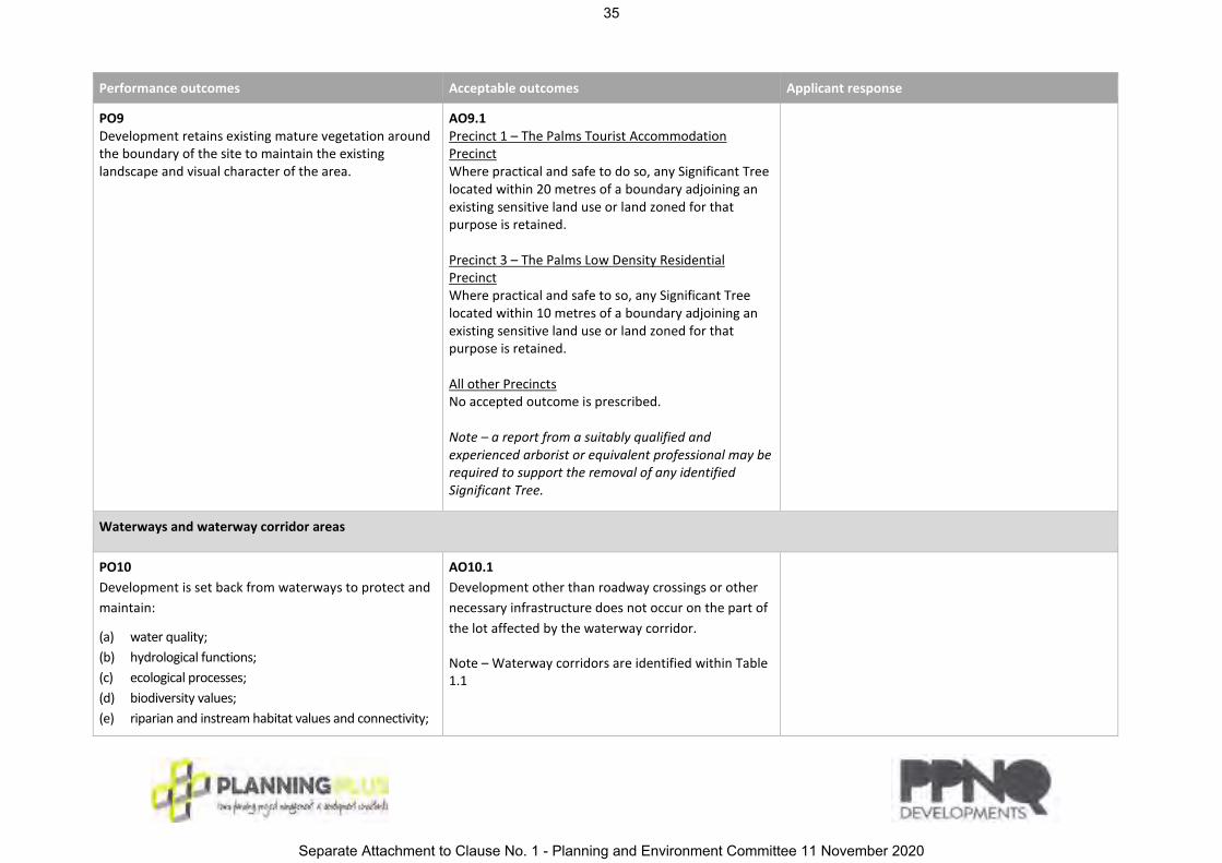
PO9
Development retains existing mature vegetation around
the boundary of the site to maintain the existing
landscape and visual character of the area.
AO9.1
Precinct 1 – The Palms Tourist Accommodation
Precinct
Where practical and safe to do so, any Significant Tree
located within 20 metres of a boundary adjoining an
existing sensitive land use or land zoned for that
purpose is retained.
Precinct 3 – The Palms Low Density Residential
Precinct
Where practical and safe to so, any Significant Tree
located within 10 metres of a boundary adjoining an
existing sensitive land use or land zoned for that
purpose is retained.
All other Precincts
No accepted outcome is prescribed.
Note – a report from a suitably qualified and
experienced arborist or equivalent professional may be
required to support the removal of any identified
Significant Tree.
Waterways and waterway corridor areas
PO10
Development is set back from waterways to protect and
maintain:
(a) water quality;
(b) hydrological functions;
(c) ecological processes;
(d) biodiversity values;
(e) riparian and instream habitat values and connectivity;
AO10.1
Development other than roadway crossings or other
necessary infrastructure does not occur on the part of
the lot affected by the waterway corridor.
Note – Waterway corridors are identified within Table
1.1
35
Separate Attachment to Clause No. 1 - Planning and Environment Committee 11 November 2020

Performance outcomes Acceptable outcomes Applicant response
(f) instream migration
PO11
Waterways and waterway corridors are protected, and
degraded areas are restored and waterways and
waterway corridors transferred to public ownership.
AO11.1
Degraded sections of waterways and waterway
corridors are revegetated with endemic plant species
in patterns and densities which emulate the natural
state of waterway corridors within the area, other
than where CPTED considerations dictate a different
landscape treatment.
Protected vegetation buffer areas
PO12
Development in buffer areas does not have any firebreak or
safety buffer requirements.
AO12.1
Development in buffer areas is limited to public open
space, roads, driveways, fences and underground
infrastructure.
AO12.2
Buffer areas which are located on private land are
placed under Environmental Covenant requiring
development to be limited to driveways, fences or
underground infrastructure.
Reconfiguring a lot
PO13
Lots have areas and dimensions that:
(a) are consistent with the purpose and overall
outcomes of the applicable precinct;
AO13.1
Lots comply with the lot reconfiguration outcomes in
Table 1.2
AO13.2
Development within Precinct 3 – The Palms Low
Density Residential Precinct achieves an average lot
size of 600m2.
36
Separate Attachment to Clause No. 1 - Planning and Environment Committee 11 November 2020

Performance outcomes Acceptable outcomes Applicant response
(b) can accommodate land uses that are consistent
with the purpose and overall outcomes of the
applicable precinct;
(c) are generally rectangular in shape.
Additional requirements for Precinct 5 – The Palms Open Space Precinct
PO14
Car parking areas are set back from the boundaries of
the site to ensure that they do not dominate the open
space character of the site.
AO14.1
Car parking areas are set back:
(a) 2 metres from the road frontage/s of the site;
(b) 6 metres from side and rear boundaries.
PO15
Setbacks to car parking areas are landscaped to enhance
the amenity of the site and to provide a buffer to
adjacent residential land, residential uses and other
sensitive sites.
AO15.1
The setback between the road frontage/s and the car
parking area is landscaped in accordance with the
Landscaping code.
AO15.2
The setback between the boundary with land included
in a Residential zone and the car parking area is
landscaped in accordance with the Landscaping code
to provide a buffer to the residential land.
Note – Refer to the definition of Residential zones
contained in Schedule 1 of the CRC Planning Scheme.
PO16
Development for outdoor sport and recreation does not
adversely affect the amenity of the area.
AO16.1
Development for outdoor sport and recreation does
not include sports field lighting.
PO17
A safe and active off-street pathway network is provided
to connect the various Park Nodes and provide a high
level of accessibility and activation to open spaces across
the site for residents and visitors.
AO17.1
An off-street pathway network is established generally
as shown on The Palms Structure Plan which:
(a) is designed in accordance with CPTED principles;
37
Separate Attachment to Clause No. 1 - Planning and Environment Committee 11 November 2020

Performance outcomes Acceptable outcomes Applicant response
(b) includes signage to provide a high level of legibility
and way-finding; and
(c) includes facilities such as workout/fitness stations,
interpretive signage and waterway viewing decks
where appropriate.
Table 1.1 – Widths of waterway corridors for waterways
Waterway corridor width
Typically 10 metres, measured perpendicular from the top of the high bank. 5m from top of bank may be acceptable where corridor is currently devoid of vegetation and
revegetation will occur.
Table 1.2 – Lot reconfiguration outcomes
Precinct Minimum lot sizes Minimum width and dimension1
Precinct 1 - The Palms Tourist
Accommodation
No acceptable outcomes are
provided.
No acceptable outcomes are
provided.
Precinct 2 – The Palms Village No acceptable outcomes are
provided.
No acceptable outcomes are
provided.
38
Separate Attachment to Clause No. 1 - Planning and Environment Committee 11 November 2020

Precinct Minimum lot sizes Minimum width and dimension1
Precinct 3 - The Palms Low
Density Residential
450m2 *1 12m*2
Precinct 4 - The Palms Low-
Medium Density Residential
450m2 *1
or
350m2 *1 (where compliant with
the small residential lot
provisions of the CRC Planning
Scheme Reconfiguring a Lot
Code)
12m*2
Precinct 5 – The Palms Open
Space Precinct
No acceptable outcomes are
provided.
No acceptable outcomes are
provided.
*1 Minimum lot size excludes any access handle forming part of the lot.
*2 This is the minimum width of the lot measured at any point and the minimum dimension of any boundary. This excludes access strips.
39
Separate Attachment to Clause No. 1 - Planning and Environment Committee 11 November 2020

RA29-N
Page 1 of 13
Far North Queensland regional officeGround Floor, Cnr Grafton and Hartley Street, CairnsPO Box 2358, Cairns QLD 4870
Our reference: 1907-12384 SRAYour reference: 8/30/277Applicant reference: 19-02
Chief Executive OfficerCairns Regional CouncilPO Box 359Cairns Qld [email protected]
Attention: Ian-Elliot Smith
Dear Si/Madam
Changed SARA response—Paradise Palms Drive, Kewarra Beach (Given under section 28 of the Development Assessment Rules)
On 25 June 2020 the State Assessment and Referral Agency (SARA) received representations from the applicant requesting SARA change its referral agency response. SARA has considered the representations and now provides this changed referral agency response which replaces the response dated 31 March 2020.
ResponseOutcome: Changed referral agency response – with conditions.
Date of response:
Conditions: The changed conditions in Attachment 1 must be attached to any development approval.
Advice: Advice to the applicant is in Attachment 2.
Reasons: The reasons for the referral agency response are in Attachment 3.
Development details
Description: Preliminary approval that includes a variation request
Material change of use for Variation Request to Vary the Effect of the Planning Scheme for Use Rights in Accordance with The Palms Development Code
SARA role: Referral Agency
APPENDIX NO. 2 - REFERRAL AGENCY REQUIREMENTS
40
Separate Attachment to Clause No. 1 - Planning and Environment Committee 11 November 2020
1907-12384 SRA
State Assessment and Referral Agency Page 2 of 13
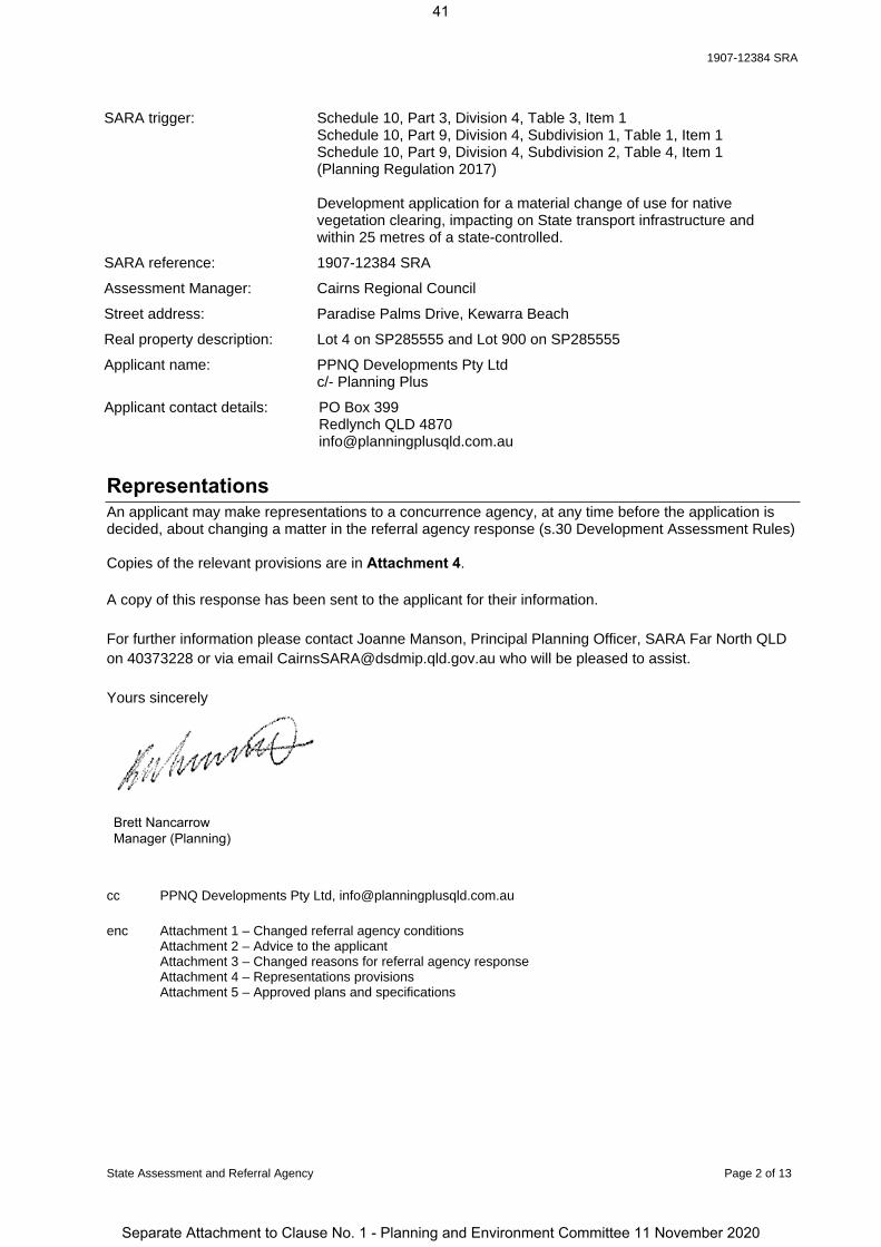
SARA trigger: Schedule 10, Part 3, Division 4, Table 3, Item 1 Schedule 10, Part 9, Division 4, Subdivision 1, Table 1, Item 1 Schedule 10, Part 9, Division 4, Subdivision 2, Table 4, Item 1 (Planning Regulation 2017)
Development application for a material change of use for native vegetation clearing, impacting on State transport infrastructure and within 25 metres of a state-controlled.
SARA reference: 1907-12384 SRA
Assessment Manager: Cairns Regional Council
Street address: Paradise Palms Drive, Kewarra Beach
Real property description: Lot 4 on SP285555 and Lot 900 on SP285555
Applicant name: PPNQ Developments Pty Ltdc/- Planning Plus
Applicant contact details: PO Box 399Redlynch QLD [email protected]
RepresentationsAn applicant may make representations to a concurrence agency, at any time before the application is decided, about changing a matter in the referral agency response (s.30 Development Assessment Rules)
Copies of the relevant provisions are in Attachment 4.
A copy of this response has been sent to the applicant for their information.
For further information please contact Joanne Manson, Principal Planning Officer, SARA Far North QLD on 40373228 or via email [email protected] who will be pleased to assist.
Yours sincerely
cc PPNQ Developments Pty Ltd, [email protected]
enc Attachment 1 – Changed referral agency conditionsAttachment 2 – Advice to the applicant Attachment 3 – Changed reasons for referral agency response Attachment 4 – Representations provisionsAttachment 5 – Approved plans and specifications
Brett NancarrowManager (Planning)
41
Separate Attachment to Clause No. 1 - Planning and Environment Committee 11 November 2020

1907-12384 SRA
State Assessment and Referral Agency Page 3 of 13
Attachment 1— Changed referral agency conditions (Under section 56(1)(b)(i) of the Planning Act 2016 the following conditions must be attached to any development approval relating to this application) (Copies of the plans and specifications referenced below are found at Attachment 5)
No. Conditions Condition timing
Material change of use
Schedule 10, Part 3, Division 4, Table 3, Item 1 – Native vegetation clearing —The chief executive administering the Planning Act 2016 nominates the Director-General of the Department of Natural Resources, Mines and Energy to be the enforcement authority for the development to which this development approval relates for the administration and enforcement of any matter relating to the following conditions:
1. No clearing of vegetation is to occur within areas identified as Area A (A1 – A12) as shown on the:
Technical Agency Response Plan (TARP) 1907-12384 SRA, Sheets 1 to 5 dated 16 March 2020.
Attachment to Technical Agency Response Plan 1907-12384 SRA Derived Reference Points for GPS, Pages 1 to 12.
At all times
2. No built structure, other than for fences, roads, or underground services, is to be established, constructed or located within areas identified as Area B (B1 – B10) as shown on the:
Technical Agency Response Plan (TARP) 1907-12384 SRA, Sheets 1 to 5 dated 16 March 2020.
Attachment to Technical Agency Response Plan 1907-12384 SRA Derived Reference Points for GPS, Pages 1 to 12.
At all times
3. (a) No lot boundaries are to be located in or within 10 six metres of areas identified as Area A (A1 – A912) and Area C (C1 – C32 35) and 10 metres of areas identified as Area A(A10 – A12) and Area C (C33 – C35) as shown on the: Technical Agency Response Plan (TARP) 1907-12384 SRA,
Sheets 1 to 5 dated 16 March 2020.
Attachment to Technical Agency Response Plan 1907-12384 SRA Derived Reference Points for GPS, Pages 1 to 12.
(b) No clearing of vegetation within Area A (A1 – A12) and Area C (C1 – C35) is permitted for the purpose of providing vehicular access and fire/vegetation management activities.
(a) and (b) At all times
4. Any person(s) engaged or employed to carry out the clearing of vegetation under this development approval must be provided with a full copy of this development approval, and must be made aware of the full extent of clearing authorised by this development approval.
Prior to clearing
5. (a) All areas identified as Area C (C1 – C35) as shown on the Technical Agency Response Plan (TARP) 1907-12384 SRA Sheets 1 to 5 dated 16 March 2020 must be legally secured, by attaining a declaration under section 19F of the Vegetation Management Act 1999.
(b) As part of the declaration, a management plan must be prepared
(a) and (b) Prior to any operational works occurring
42
Separate Attachment to Clause No. 1 - Planning and Environment Committee 11 November 2020

1907-12384 SRA
State Assessment and Referral Agency Page 4 of 13
by a suitably qualified person. The management plan must demonstrate how Area C (C1 – C35) will be restored and managed such that each area:
i. can be classified as remnant vegetation, as defined in the Schedule of the Vegetation Management Act 1999; and
ii. is consistent with the regional ecosystem descriptions for the identified areas based on Biodiversity status of pre-clearing regional ecosystems – Queensland version 11, 14/12/2018.
(c) Undertake all vegetation restoration works and management requirements in accordance with the management plan.
(d) No infrastructure, other than existing underground services, is to be located with Area C (C1 – C35) as shown on the Technical Agency Response Plan (TARP) 1907-12384 SRA, Sheets 1 to 5 dated 16 March 2020.
No clearing of vegetation other than clearing required in order to achieve the revegetation purposes of the Vegetation Management Plan is to occur with areas identified as Area C (C1-C35) as shown on the Technical Agency Response Plan (TARP) 1907-12384 SRA, Sheets 1 to 5 dated 16 March 2020
(b) and (d) and (e) At all times
6. Prepare an erosion and sediment control plan for development adjacent the stream order 2 watercourse drainage feature in the south west corner of the site near Moore Road:
a) The plan must be prepared by a suitably qualified professional and recommend erosion and sediment control measures to ensure:
i. Bank stability by protecting against bank erosion; andii. Water quality by filtering sediments, nutrients and
other pollutants. b) Submit, for information purposes only, a copy of the Erosion
and Sediment Control Plan mentioned at part (a) of this condition to:
Vegetation ManagementDepartment of Natural Resources, Mines and EnergyAddress: PO Box 5318, Townsville Qld 4810Email: [email protected]
c) Implement and maintain all required measures identified within the plan mentioned at part (a) of this condition.
(a) and (b) prior to clearing commencing
(c) for the duration of the clearing
Schedule 10, Part 9, Division 4, Subdivision 1, Table 1, Item 1 - Development impacting on State transport infrastructure and Schedule 10, Part 9, Division 4, Subdivision 2, Table 4, Item 1 - Material change of use near a State transport corridor — The chief executive administering the Planning Act 2016 nominates the Director-General of the Department of Transport and Main Roads to be the enforcement authority for the development to which this development approval relates for the administration and enforcement of any matter relating to the following conditions:
7. (a) Road works comprising of the following works are required at:
(i) Captain Cook Highway / Paradise Palm Drive intersection: all right turn traffic movements at the Captain Cook
Highway / Paradise Palm Drive intersection must be permanently closed and removed.
(a)(i) and (ii) Prior to the commencement of use or the sealing of the first plan of subdivision.
43
Separate Attachment to Clause No. 1 - Planning and Environment Committee 11 November 2020

1907-12384 SRA
State Assessment and Referral Agency Page 5 of 13
(ii) Captain Cook Highway / Discovery Drive / Poolwood Road roundabout: a second circulating traffic lane is to be constructed at the
roundabout from Discovery Drive to Poolwood Road, including revised line-marking in the existing Discovery Drive left-turn lane to allow for all movements and the inside lane to allow for right turn movements only.
(iii) Captain Cook Highway / Discovery Drive / Poolwood Road roundabout: implement Upgrade 8 as per Cardno further issue
response dated 10 December 2019 with the following additions: o ramp metering the eastern approach of Discovery
Drive; ando queue detectors on all legs with distances approved by
TMR at the time of the works. extend the existing Discovery Drive left-turn lane a
hundred and sixty meters (160m) and include revised line-marking in the existing Discovery Drive left-turn lane to allow for all movements.
install slip / bypass lanes between:o Captain Cook Highway (south) & Discovery Drive for
80m;o Captain Cook Highway (north) & Poolwood Road for
70m; ando Poolwood Road and the Captain Cook Highway
(south) for 40m.
(b) The road works at:(i) Captain Cook Highway / Discovery Drive / Poolwood Road
roundabout; and (ii) Captain Cook Highway / Paradise Palm Drive intersection must be designed and constructed in accordance with Road Planning and Design Manual, 2nd edition, Department of Transport and Main Roads, 2016
(a)(iii) Prior to:
the commencement of any use; and/or
the sealing of a plan of subdivision;
which has an estimated cumulative traffic rate of 400 vph in the AM peak using the traffic generation rates adopted in table 1.2 in Cardno further issue response dated 10 December 2019, with all other assumptions as per Cardno Traffic Impact Assessment dated 1 October 2019.
(b) At the time of design and construction of the road works.
8. Direct access is not permitted between the Captain Cook Highway and Lot 4 on SP285555.
At all times
9. (a) Construct a 4.2 metre noise barrier generally in accordance with the Recommendation and Conclusions of the Road Traffic Noise Assessment, prepared by Dedicated Acoustics, dated 15/10/2019 in the location shown in Figure 4.3: Assessed noise barrier locations.
(b) The noise barrier must be designed in accordance with:
(i) the Department of Transport and Main Roads' Road Traffic Noise Management Code of Practice, Volume 1, Chapters 6 and 7;
(ii) Specification MRTS04 (General Earthworks), MRTS1515 Noise Fence) and MRTS16 (General Requirements Landscape and Revegetation Works); and
(iii) Standard Drawing Road Manual, Part 13, Number SD1606.
(c) RPEQ certification must be provided to [email protected] within the Department of Transport and Main Roads, confirming that the
(a) and (b) Prior to:
the commencement of use; or
submitting the Plan of Survey to the local government for approval creating lots
adjacent to or with 25m of the Captain Cook Highway and to be maintained at all times.
(c ) Upon completion of the construction of the
44
Separate Attachment to Clause No. 1 - Planning and Environment Committee 11 November 2020

1907-12384 SRA
State Assessment and Referral Agency Page 6 of 13
development has been designed and constructed in accordance with parts (a) and (b) of this condition.
noise barrier
10. (a) Stormwater management of the development must ensure no worsening or actionable nuisance to the Captain Cook Highway corridor.
(b) Any works on the land must not:(i) create any new discharge points for stormwater runoff onto the
state-controlled road;(ii) (ii) interfere with and/or cause damage to the existing
stormwater drainage on the state-controlled road; (iii) (iii) surcharge any existing culvert or drain on the state-
controlled road;(iv) (iv) reduce the quality of stormwater discharge onto the state-
controlled road.
(c) RPEQ certification with supporting documentation must be provided to [email protected] within the Department of Transport and Main Roads, confirming that the development has been designed and constructed in accordance with parts (a) and (b) of this condition.
(a)and (b)At all times
(c)Prior to the commencement of use.
11. The applicant must provide a safe, direct and convenient pedestrian pathway network and crossing point of Paradise Palms Drive from the development to the bus indent bays as shown on Regular Stop Indented Bay-Northbound, prepared by Cardno, dated 3 September 2019, drawing number CEB06784-SK03, revision A.
Prior to:(a) the
commencement of use of 200 dwellings or a tourist park; or
(b) submitting the Plan of Survey to the local government for approval for the 200th residential lot.
12. (a) The applicant must provide indented bus bays along Paradise Palms Drive, as shown on Regular Stop Indented Bay-Northbound, prepared by Cardno, dated 3 September 2019, drawing number CEB06784-SK03, revision A.
(b) The bus indent bays must be in accordance with the Disability Standards for Accessible Public Transport 2002 made under subsection 31(1) of the Disability Discrimination Act 1992 and include the following components in accordance with the Department of Transport and Main Roads’ TransLink Public Transport Infrastructure Manual 2015:i. An indent bay for a single unit rigid bus of 12.5m in length in
accordance with Section 5.6.3.1 – ‘Bus stop length requirements’, ‘Table 5.7: Minimum bus stop length requirements’, and Table 5.4: ‘Bus stop arrangements - Indented bus bay’ of Chapter 5 – ‘Bus stop infrastructure’; in particular, a minimum bus bay width of 3m (excluding cycle lanes), bus bay length of 15m, taper in of 21m (1:7 kerb) and taper out of 15m (1:5 kerb).
(c) RPEQ certification must be provided to the Program Delivery and Operations Unit, Far North Region
Prior to:(a) the
commencement of use of 200 dwellings or a tourist park; or
(b) submitting the Plan of Survey to the local government for approval for the 200th residential lot.
(c ) Upon completion of the construction of the bus bays
45
Separate Attachment to Clause No. 1 - Planning and Environment Committee 11 November 2020

1907-12384 SRA
State Assessment and Referral Agency Page 7 of 13
([email protected]) within the Department of Transport and Main Roads, confirming that the development has been constructed in accordance with parts (a) and (b) of this condition.
13. The ‘potential future bus route’ shown on The Palms Overall Masterplan, prepared by Urbis, dated 1 July 2019, drawing number MP-01, revision 5 (as amended in red) must be designed and constructed to accommodate a single unit rigid bus of 12.5m in length in accordance with the following:
Department of Transport and Main Roads Road Planning and Design Manual, 2nd Edition, Volume 3 – Guide to Road Design (March 2016);
Department of Transport and Main Roads Supplement to Austroads Guide to Road Design (Parts 3, 4-4C and 6);
Austroads Guide to Road Design (Parts 3, 4-4C and 6); Department of Transport and Main Roads Queensland Manual of
Uniform Traffic Control Devices, Part 13 Local Area Traffic Management (March 2018); and
Chapter 2 - Planning and Design, Section 2.3.2 Bus Route Infrastructure (page 6) of the Department of Transport and Main Roads Public Transport Infrastructure Manual 2015.
At the time of design and construction of the internal access road (future bus route) for each applicable stage of the development.
46
Separate Attachment to Clause No. 1 - Planning and Environment Committee 11 November 2020

1907-12384 SRA
State Assessment and Referral Agency Page 8 of 13
Attachment 2—Advice to the applicant
General advice1. Terms and phrases used in this document are defined in the Planning Act 2016 its regulation or
the State Development Assessment Provisions (SDAP) [v2.5]. If a word remains undefined it has its ordinary meaning.
2. Despite this development approval, other permits or approvals may be required for the clearing of vegetation. To determine if the proposed clearing requires other approvals under other local, State or federals laws go to www.qld.gov.au (search ‘vegetation clearing requirements’).
3. The State of Queensland publishes technical descriptions (http://www.qld.gov.au/environment/plants-animals/plants/ecosystems/technical-descriptions/) which provide a detailed description of the normal range in structure and floristic composition of remnant regional ecosystems and their component vegetation communities. They should be used in conjunction with the fields from the Regional Ecosystem Description Database (REDD) (http://www.qld.gov.au/environment/plants-animals/plants/ecosystems/download/) for a normal description of the regional ecosystem. Please note that the site does include high risk areas under the Protected Plants Flora Survey Trigger Map.
4. Clearing of vegetation has the potential to disturb the roots of the trees of proposed retained vegetation thereby resulting in the death of trees not approved to be cleared under this development approval. It is recommended clearing and excavation activities be undertaken in accordance with the ‘Australian Standards for the Protection of Trees on Development Sites (AS4970-2009)’ to avoid any consequential unauthorised clearing.
5. The subject lots contains areas mapped as Category R on the Regulated Vegetation Management map. Clearing vegetation within these areas must be exempt clearing work under schedule 21 of the Planning Regulation 2017 or undertaken in accordance with an Accepted Development Vegetation Clearing Code. Clearing of vegetation with Category R areas has not been assessed as part of the application.
6. To request an electronic file of the Derived Points (Attached to Plan: 1907-12384 SRA) as contained in this technical agency response, email a request to the Department of Natural Resources, Mines and Energy (DNRME) at [email protected] and include application reference (1907-12384 SRA).
7. Advertising advice should be obtained from the Department of Transport and Main Roads (DTMR) if the development intends to erect, alter or operate an advertising sign or another advertising device that would be visible from a state-controlled road, and beyond the boundaries of the state-controlled road, and reasonably likely to create a traffic hazard for the state-controlled road. Note: DTMR has powers under section 139 of the Transport Operations (Road Use Management - Accreditation and Other Provisions) Regulation 2015 to require removal or modification of an advertising sign and/for a device which is deemed that it creates a danger to traffic
Further development permits required8. An application for a Road Corridor Permit is required for any ancillary works and
encroachments on a state-controlled road. Under section 50(2) and Schedule 6 of the Transport Infrastructure Act 1994 (TIA) and Part 5 and Schedule 1 of the Transport
47
Separate Attachment to Clause No. 1 - Planning and Environment Committee 11 November 2020
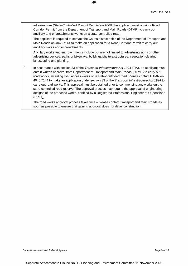
1907-12384 SRA
State Assessment and Referral Agency Page 9 of 13
Infrastructure (State-Controlled Roads) Regulation 2006, the applicant must obtain a Road Corridor Permit from the Department of Transport and Main Roads (DTMR) to carry out ancillary and encroachments works on a state-controlled road. The applicant is required to contact the Cairns district office of the Department of Transport and Main Roads on 4045 7144 to make an application for a Road Corridor Permit to carry out ancillary works and encroachments.Ancillary works and encroachments include but are not limited to advertising signs or other advertising devices, paths or bikeways, buildings/shelters/structures, vegetation clearing, landscaping and planting.
9. In accordance with section 33 of the Transport Infrastructure Act 1994 (TIA), an applicant must obtain written approval from Department of Transport and Main Roads (DTMR) to carry out road works, including road access works on a state-controlled road. Please contact DTMR on 4045 7144 to make an application under section 33 of the Transport Infrastructure Act 1994 to carry out road works. This approval must be obtained prior to commencing any works on the state-controlled road reserve. The approval process may require the approval of engineering designs of the proposed works, certified by a Registered Professional Engineer of Queensland (RPEQ).The road works approval process takes time – please contact Transport and Main Roads as soon as possible to ensure that gaining approval does not delay construction.
48
Separate Attachment to Clause No. 1 - Planning and Environment Committee 11 November 2020

1907-12384 SRA
State Assessment and Referral Agency Page 10 of 13
Attachment 3— Changed reasons for referral agency response(Given under section 56(7) of the Planning Act 2016)
The reasons for the department’s decision are:
The development application is seeking preliminary approval for a material change of use which includes a variation request for use rights associated with “The Palms Plan of Development”.
The proposed development includes a residential estate, tourist/holiday park, public open space and recreation areas, community facilities and various commercial and entertainment uses within and around the existing Paradise Palms Golf Couse clubhouse building.
Vehicle access to the proposed development is from Paradise Palms Drive and Discovery Drive via Captain Cook Highway, a state-controlled road. A new internal access road is proposed through the development that will provide further access to the residential component of the development.
The proposed development will be increasing traffic via the Captain Cook Highway / Discovery Drive / Poolwood Road roundabout and via the Captain Cook Highway Paradise Palms T-intersection.
Vehicle movements at the Captain Cook Highway / Paradise Palms Drive intersection are restricted to a left-in / left-out movements.
Additional road works at the Captain Cook Highway / Discovery Drive / Poolwood Road roundabout are required to ensure that the roundabout can operate within the acceptable performance thresholds.
The proposed development will be increasing stormwater and drainage run-off via Deep Creek at the Captain Cook Highway culverts.
The proposed development involves noise sensitive uses and the premises is affected by the transport noise corridor for the Captain Cook Highway. A noise barrier is proposed to mitigate against transport corridor noise.
The proposed development is designed to provide for future public passenger transport.
Written evidence submitted by the Queensland Fire and Emergency Services which supports the setback for lot boundaries to six metres for areas East of the Paradise Palms Drive and north of Moore Road (Area A and Area C as shown on the Technical Agency Response Plan) for the provision of a fire/ vegetation maintenance trails.
The proposed development will result in 3.352 hectares of Category B regulated vegetation and proposes like for like revegetation areas that will balance the impact of native vegetation clearing. Impacts on regulated vegetation have been avoided and minimised where possible.
The department carried out an assessment of the development application against State code 1, State 6 and State code 16 and found that, with conditions, the proposed development:
avoids clearing, or where avoidance is not reasonably possible, minimises clearing to conserve vegetation, avoids land degradation, avoids the loss of biodiversity and maintains ecological processes
provides revegetation areas adjacent to endangered regional ecosystems, primarily along watercourse drainage features, which will provide greater connectivity through the site and into the greater landscape. The proposed revegetation areas over time would ensure that the structure and function of the regional ecosystems within the landscape are maintained.
does not create a safety hazard for users of a state-controlled road or compromise the structural integrity of state-controlled roads, road transport infrastructure or road works
does not result in a worsening of the physical condition or operating performance of state-
49
Separate Attachment to Clause No. 1 - Planning and Environment Committee 11 November 2020

1907-12384 SRA
State Assessment and Referral Agency Page 11 of 13
controlled roads and the state transport network
does not compromise the state’s ability to maintain and operate state-controlled roads, or significantly increase the cost to maintain and operate state-controlled roads
ensures the community is protected from significant adverse impacts resulting from environmental emissions generated by vehicles using the state-controlled road
does not result in a worsening of the physical condition or operating performance of the state transport network
does not compromise the state’s ability to cost-effectively construct, operate and maintain state transport infrastructure; and
provides public passenger transport infrastructure to enable the development to be serviced by public passenger transport.
Material used in the assessment of the application:
The development application material and submitted plans Information request response Advice notice responses Make representations request Planning Act 2016 Planning Regulation 2017 The State Development Assessment Provisions (version [2.5]), as published by the department The Development Assessment Rules SARA DA Mapping system State Planning Policy mapping system
50
Separate Attachment to Clause No. 1 - Planning and Environment Committee 11 November 2020
1907-12384 SRA
State Assessment and Referral Agency Page 12 of 13
Attachment 4—Change representation provisions(page left intentionally blank – attached separately)
51
Separate Attachment to Clause No. 1 - Planning and Environment Committee 11 November 2020

1907-12384 SRA
State Assessment and Referral Agency Page 13 of 13
Attachment 5—Approved plans and specifications(page left intentionally blank – attached separately)
52
Separate Attachment to Clause No. 1 - Planning and Environment Committee 11 November 2020
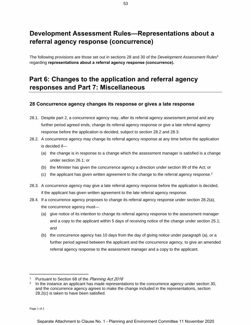
Page 1 of 2
Development Assessment Rules—Representations about a referral agency response (concurrence)
The following provisions are those set out in sections 28 and 30 of the Development Assessment Rules1 regarding representations about a referral agency response (concurrence).
Part 6: Changes to the application and referral agency responses and Part 7: Miscellaneous
28 Concurrence agency changes its response or gives a late response
28.1. Despite part 2, a concurrence agency may, after its referral agency assessment period and any
further period agreed ends, change its referral agency response or give a late referral agency
response before the application is decided, subject to section 28.2 and 28.3.
28.2. A concurrence agency may change its referral agency response at any time before the application
is decided if—
(a) the change is in response to a change which the assessment manager is satisfied is a change
under section 26.1; or
(b) the Minister has given the concurrence agency a direction under section 99 of the Act; or
(c) the applicant has given written agreement to the change to the referral agency response.2
28.3. A concurrence agency may give a late referral agency response before the application is decided,
if the applicant has given written agreement to the late referral agency response.
28.4. If a concurrence agency proposes to change its referral agency response under section 28.2(a),
the concurrence agency must—
(a) give notice of its intention to change its referral agency response to the assessment manager
and a copy to the applicant within 5 days of receiving notice of the change under section 25.1;
and
(b) the concurrence agency has 10 days from the day of giving notice under paragraph (a), or a
further period agreed between the applicant and the concurrence agency, to give an amended
referral agency response to the assessment manager and a copy to the applicant.
1 Pursuant to Section 68 of the Planning Act 2016 2 In the instance an applicant has made representations to the concurrence agency under section 30,
and the concurrence agency agrees to make the change included in the representations, section 28.2(c) is taken to have been satisfied.
53
Separate Attachment to Clause No. 1 - Planning and Environment Committee 11 November 2020

Page 2 of 2
30 Representations about a referral agency response
30.1. An applicant may make representations to a concurrence agency at any time before the application
is decided, about changing a matter in the referral agency response.3
3 An applicant may elect, under section 32, to stop the assessment manager’s decision period in which to take this action. If a concurrence agency wishes to amend their response in relation to representations made under this section, they must do so in accordance with section 28.
54
Separate Attachment to Clause No. 1 - Planning and Environment Committee 11 November 2020

Sheet 2
Sheet 3
Sheet 5
Sheet 4
4SP285555
900SP285555
900SP285555
900SP285555
4SP285555
A2
A3
A5A7
A8A9
A10
A11
A12
B2
B3B4
C4
MOORE ROADROAD
CAPTAINCOOK HIGHW
AY
POOLWO
ODRO
AD
42RP741332
359SP284235
1NR7336
76NR7762
1SP214836
164SP202267
41RP741332 69
SP256612
BRP800876
25AP19345
Derived Reference PointsProjection: GDA 1994 MGA Zone 55
Datum: GDA 1994All GPS points continue sequentially
when labels are missing
TARP1907-12384 SRA
Sheet 1 of 5
Version: 1
Date: 16 March 2020Region: NORTHDepartment: DNRMEPrepared by: SAK - j5580
Compiled from: DCDB, RVM & NRMO Notes on FileFile Reference: eDOCS: 082/0003405
LOCAL GOVT: Cairns RegionalLOCALITY OF Kewarra Beach
eLVAS Case ID: 2019/003395
Plan of Area A (Parts A1 - A12), Area B (Parts B1 - B10),Area C (Parts C1 - C35) in Lot 4 on Plan SP285555, andLot 900 on Plan SP285555
Technical Agency Response Plan
This plan must be read in conjunctionwith Decision Notice 1907-12384 SRA
The property boundaries shown on this plan are APPROXIMATE ONLY.They are NOT an accurate representation of the legal boundaries.
Note: Derived Reference Points are provided to assist in the locationof area boundaries. Responsibility for locating these boundaries liessolely with the landholder and delegated contractor(s).
Datum: GDA 1994Projection: GDA 1994 MGA Zone 55
0 110 220 330 440 550m
1:6 000 @ A3 size
X = stream order 1 or 2Y = stream order 3 or 4Z = stream order 5
X
1
Note: This is a colour plan and should only be reproduced in colour.
A
Derived Reference Points for GPS(see Attachment to plan)(Area start points shown only)
Subject Lot(s)
Area A (Parts A1 - A12)
Area B (Parts B1 - B10)
Area C (Parts C1 - C35)
Watercourses and drainage features
LEGEND
55
Separate Attachment to Clause No. 1 - Planning and Environment Committee 11 November 2020

A
A
A
A
A
A
AA
A
A
A
A
568
634
1263
1350
1359
1381
1385
1391
1396
1979
1997
2002
X
X
WATERVIEW CLOSE
PARADISE PA
LMS DRIVE
30GTP70326
1SP210221
6SP210221
42RP741332
225NR7107
7SP210221
LSP210221
GSP210221
18GTP70326
52GTP101946
5SP210221
OSP210221
00000SP219936
0SP219936
63GTP70363
13RP741332
41RP741332
9SP2102218
SP21022117
GTP70326
900SP285555
4SP285555
4SP285555A11
A12
B4
B5B6
B7
B8
B9
B10
C33
C34
C35
Derived Reference PointsProjection: GDA 1994 MGA Zone 55
Datum: GDA 1994All GPS points continue sequentially
when labels are missing
TARP1907-12384 SRA
Sheet 2 of 5
Version: 1
Date: 16 March 2020Region: NORTHDepartment: DNRMEPrepared by: SAK - j5580
Compiled from: DCDB, RVM & NRMO Notes on FileFile Reference: eDOCS: 082/0003405
LOCAL GOVT: Cairns RegionalLOCALITY OF Kewarra Beach
eLVAS Case ID: 2019/003395
Plan of Area A (Parts A1 - A12), Area B (Parts B1 - B10),Area C (Parts C1 - C35) in Lot 4 on Plan SP285555, andLot 900 on Plan SP285555
Technical Agency Response Plan
This plan must be read in conjunctionwith Decision Notice 1907-12384 SRA
The property boundaries shown on this plan are APPROXIMATE ONLY.They are NOT an accurate representation of the legal boundaries.
Note: Derived Reference Points are provided to assist in the locationof area boundaries. Responsibility for locating these boundaries liessolely with the landholder and delegated contractor(s).
Datum: GDA 1994Projection: GDA 1994 MGA Zone 55
0 30 60 90 120 150m
1:2 000 @ A3 size
X = stream order 1 or 2Y = stream order 3 or 4Z = stream order 5
X
Note: This is a colour plan and should only be reproduced in colour.
A
Derived Reference Points for GPS(see Attachment to plan)(Area start points shown only)
Subject Lot(s)
Area A (Parts A1 - A12)
Area B (Parts B1 - B10)
Area C (Parts C1 - C35)
Watercourses and drainage features
LEGEND1
56
Separate Attachment to Clause No. 1 - Planning and Environment Committee 11 November 2020

AA
A
A
A
A
A A
A
A
A
A
135242
269
550
816
1565
1619
1798
1848
1894
1959
1963
X
X
X
X
X
X
ALLE
NBY
CLO
SE12
SP279555
19SP279555
18SP284235
359SP284235
20SP279555
13SP279555
15SP279555
999SP105747
25AP19345
0SP212600
900SP285555
900SP285555
4SP285555
4SP285555
A5
A6
A7
A9
A10
C14
C15
C19
C21
C25
C31
C32
B3
B4
C24
Derived Reference PointsProjection: GDA 1994 MGA Zone 55
Datum: GDA 1994All GPS points continue sequentially
when labels are missing
TARP1907-12384 SRA
Sheet 3 of 5
Version: 1
Date: 16 March 2020Region: NORTHDepartment: DNRMEPrepared by: SAK - j5580
Compiled from: DCDB, RVM & NRMO Notes on FileFile Reference: eDOCS: 082/0003405
LOCAL GOVT: Cairns RegionalLOCALITY OF Kewarra Beach
eLVAS Case ID: 2019/003395
Plan of Area A (Parts A1 - A12), Area B (Parts B1 - B10),Area C (Parts C1 - C35) in Lot 4 on Plan SP285555, andLot 900 on Plan SP285555
Technical Agency Response Plan
This plan must be read in conjunctionwith Decision Notice 1907-12384 SRA
The property boundaries shown on this plan are APPROXIMATE ONLY.They are NOT an accurate representation of the legal boundaries.
Note: Derived Reference Points are provided to assist in the locationof area boundaries. Responsibility for locating these boundaries liessolely with the landholder and delegated contractor(s).
Datum: GDA 1994Projection: GDA 1994 MGA Zone 55
0 30 60 90 120 150m
1:2 000 @ A3 size
X = stream order 1 or 2Y = stream order 3 or 4Z = stream order 5
X
Note: This is a colour plan and should only be reproduced in colour.
A
Derived Reference Points for GPS(see Attachment to plan)(Area start points shown only)
Subject Lot(s)
Area A (Parts A1 - A12)
Area B (Parts B1 - B10)
Area C (Parts C1 - C35)
Watercourses and drainage features
LEGEND1
57
Separate Attachment to Clause No. 1 - Planning and Environment Committee 11 November 2020

A
A
A
A
A A
A
A
A
A
A
A
A
A
A
A
A
A
A
A
369
424
1499
1504
1525 1541
1551
1561
1763
1768
1780
1841
1862
1879
1888
1905
19141921
1929
1945
CAPTAIN COOK HIGHWAY
25GTP70343
23GTP70343
1NR7336
21GTP70343
22GTP70343
DRP800878
BRP800876
29GTP70343
X
X
Y
Y
Y
X
4SP285555
A8
B3
C8
C9
C10C11
C12
C13
C16C17C18
C20 C22
C23
C24
C26
C27 C28
C29 C30
A9
C19C19
Derived Reference PointsProjection: GDA 1994 MGA Zone 55
Datum: GDA 1994All GPS points continue sequentially
when labels are missing
TARP1907-12384 SRA
Sheet 4 of 5
Version: 1
Date: 16 March 2020Region: NORTHDepartment: DNRMEPrepared by: SAK - j5580
Compiled from: DCDB, RVM & NRMO Notes on FileFile Reference: eDOCS: 082/0003405
LOCAL GOVT: Cairns RegionalLOCALITY OF Kewarra Beach
eLVAS Case ID: 2019/003395
Plan of Area A (Parts A1 - A12), Area B (Parts B1 - B10),Area C (Parts C1 - C35) in Lot 4 on Plan SP285555, andLot 900 on Plan SP285555
Technical Agency Response Plan
This plan must be read in conjunctionwith Decision Notice 1907-12384 SRA
The property boundaries shown on this plan are APPROXIMATE ONLY.They are NOT an accurate representation of the legal boundaries.
Note: Derived Reference Points are provided to assist in the locationof area boundaries. Responsibility for locating these boundaries liessolely with the landholder and delegated contractor(s).
Datum: GDA 1994Projection: GDA 1994 MGA Zone 55
0 30 60 90 120 150m
1:2 000 @ A3 size
X = stream order 1 or 2Y = stream order 3 or 4Z = stream order 5
X
Note: This is a colour plan and should only be reproduced in colour.
A
Derived Reference Points for GPS(see Attachment to plan)(Area start points shown only)
Subject Lot(s)
Area A (Parts A1 - A12)
Area B (Parts B1 - B10)
Area C (Parts C1 - C35)
Watercourses and drainage features
LEGEND1
58
Separate Attachment to Clause No. 1 - Planning and Environment Committee 11 November 2020
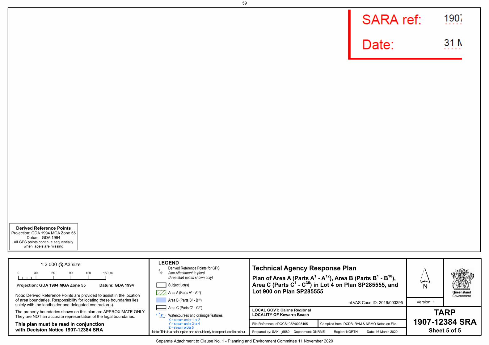
A
A
A
A
A
A
A
A
A
A
AAA
1
6
54
113
680
689
1404
1419
14271437
14731484
1488
MOORE ROAD LANTAN
A PLACE
CSP207017
13GTP70345
0GTP70345
6RP812259
1RP910518
0SP212600
25GTP70344
76NR7762
24GTP70344
242SP295176
12GTP70345
0SP207030
30GTP104041
00000SP212600
X
X
X
X
4SP285555
A1A2
A3
A4
B1
B2
C1
C2C3
C4 C5
C6C7
B3
A5
A7
C15
B3
Derived Reference PointsProjection: GDA 1994 MGA Zone 55
Datum: GDA 1994All GPS points continue sequentially
when labels are missing
TARP1907-12384 SRA
Sheet 5 of 5
Version: 1
Date: 16 March 2020Region: NORTHDepartment: DNRMEPrepared by: SAK - j5580
Compiled from: DCDB, RVM & NRMO Notes on FileFile Reference: eDOCS: 082/0003405
LOCAL GOVT: Cairns RegionalLOCALITY OF Kewarra Beach
eLVAS Case ID: 2019/003395
Plan of Area A (Parts A1 - A12), Area B (Parts B1 - B10),Area C (Parts C1 - C35) in Lot 4 on Plan SP285555, andLot 900 on Plan SP285555
Technical Agency Response Plan
This plan must be read in conjunctionwith Decision Notice 1907-12384 SRA
The property boundaries shown on this plan are APPROXIMATE ONLY.They are NOT an accurate representation of the legal boundaries.
Note: Derived Reference Points are provided to assist in the locationof area boundaries. Responsibility for locating these boundaries liessolely with the landholder and delegated contractor(s).
Datum: GDA 1994Projection: GDA 1994 MGA Zone 55
0 30 60 90 120 150m
1:2 000 @ A3 size
X = stream order 1 or 2Y = stream order 3 or 4Z = stream order 5
X
Note: This is a colour plan and should only be reproduced in colour.
A
Derived Reference Points for GPS(see Attachment to plan)(Area start points shown only)
Subject Lot(s)
Area A (Parts A1 - A12)
Area B (Parts B1 - B10)
Area C (Parts C1 - C35)
Watercourses and drainage features
LEGEND1
59
Separate Attachment to Clause No. 1 - Planning and Environment Committee 11 November 2020
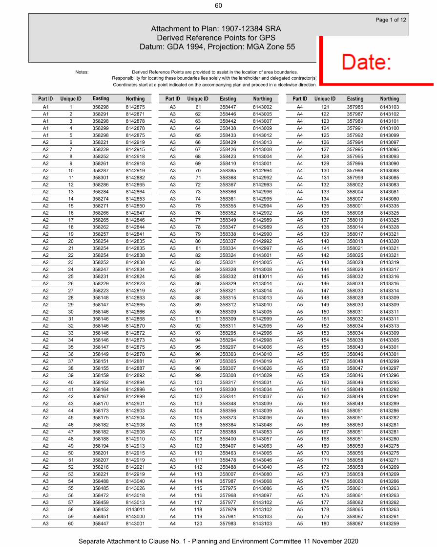
A1 1 358298 8142875A1 2 358291 8142871A1 3 358298 8142878A1 4 358299 8142878A1 5 358298 8142875A2 6 358221 8142919A2 7 358229 8142915A2 8 358252 8142918A2 9 358261 8142918A2 10 358287 8142919A2 11 358301 8142882A2 12 358286 8142865A2 13 358284 8142864A2 14 358274 8142853A2 15 358271 8142850A2 16 358266 8142847A2 17 358265 8142846A2 18 358262 8142844A2 19 358257 8142841A2 20 358254 8142835A2 21 358254 8142835A2 22 358254 8142838A2 23 358252 8142838A2 24 358247 8142834A2 25 358231 8142824A2 26 358229 8142823A2 27 358223 8142819A2 28 358148 8142863A2 29 358147 8142865A2 30 358146 8142866A2 31 358146 8142868A2 32 358146 8142870A2 33 358146 8142872A2 34 358146 8142873A2 35 358147 8142875A2 36 358149 8142878A2 37 358151 8142881A2 38 358155 8142887A2 39 358159 8142892A2 40 358162 8142894A2 41 358164 8142896A2 42 358167 8142899A2 43 358170 8142901A2 44 358173 8142903A2 45 358175 8142904A2 46 358182 8142908A2 47 358182 8142908A2 48 358188 8142910A2 49 358194 8142913A2 50 358201 8142915A2 51 358207 8142919A2 52 358216 8142921A2 53 358221 8142919A3 54 358488 8143040A3 55 358485 8143026A3 56 358472 8143018A3 57 358459 8143013A3 58 358452 8143011A3 59 358451 8143000A3 60 358447 8143001
A3 61 358447 8143002A3 62 358446 8143005A3 63 358442 8143007A3 64 358438 8143009A3 65 358433 8143012A3 66 358429 8143013A3 67 358426 8143008A3 68 358423 8143004A3 69 358410 8143001A3 70 358385 8142994A3 71 358368 8142992A3 72 358367 8142993A3 73 358366 8142996A3 74 358361 8142995A3 75 358355 8142994A3 76 358352 8142992A3 77 358349 8142989A3 78 358347 8142989A3 79 358338 8142990A3 80 358337 8142992A3 81 358334 8142997A3 82 358324 8143001A3 83 358321 8143005A3 84 358328 8143008A3 85 358332 8143011A3 86 358329 8143014A3 87 358321 8143014A3 88 358315 8143013A3 89 358312 8143010A3 90 358309 8143005A3 91 358309 8142999A3 92 358311 8142995A3 93 358295 8142996A3 94 358294 8142998A3 95 358297 8143006A3 96 358303 8143010A3 97 358305 8143019A3 98 358307 8143026A3 99 358308 8143029A3 100 358317 8143031A3 101 358330 8143034A3 102 358341 8143037A3 103 358348 8143039A3 104 358356 8143039A3 105 358373 8143036A3 106 358384 8143048A3 107 358388 8143053A3 108 358400 8143057A3 109 358407 8143063A3 110 358463 8143065A3 111 358478 8143046A3 112 358488 8143040A4 113 358007 8143080A4 114 357987 8143068A4 115 357975 8143086A4 116 357968 8143097A4 117 357977 8143102A4 118 357979 8143102A4 119 357981 8143103A4 120 357983 8143103
A4 121 357985 8143103A4 122 357987 8143102A4 123 357989 8143101A4 124 357991 8143100A4 125 357992 8143099A4 126 357994 8143097A4 127 357995 8143095A4 128 357995 8143093A4 129 357996 8143090A4 130 357998 8143088A4 131 357999 8143085A4 132 358002 8143083A4 133 358004 8143081A4 134 358007 8143080A5 135 358001 8143335A5 136 358008 8143325A5 137 358010 8143325A5 138 358014 8143328A5 139 358017 8143321A5 140 358018 8143320A5 141 358021 8143321A5 142 358025 8143321A5 143 358028 8143319A5 144 358029 8143317A5 145 358032 8143316A5 146 358033 8143316A5 147 358030 8143314A5 148 358028 8143309A5 149 358030 8143309A5 150 358031 8143311A5 151 358032 8143311A5 152 358034 8143313A5 153 358034 8143309A5 154 358038 8143305A5 155 358043 8143301A5 156 358046 8143301A5 157 358048 8143299A5 158 358047 8143297A5 159 358046 8143296A5 160 358046 8143295A5 161 358049 8143292A5 162 358049 8143291A5 163 358049 8143289A5 164 358051 8143286A5 165 358051 8143282A5 166 358050 8143281A5 167 358051 8143281A5 168 358051 8143280A5 169 358053 8143275A5 170 358056 8143275A5 171 358058 8143271A5 172 358058 8143269A5 173 358058 8143269A5 174 358060 8143266A5 175 358061 8143263A5 176 358061 8143263A5 177 358062 8143262A5 178 358065 8143263A5 179 358067 8143261A5 180 358067 8143259
Attachment to Plan: 1907-12384 SRA Derived Reference Points for GPS
Datum: GDA 1994, Projection: MGA Zone 55
Page 1 of 12
Unique ID EastingPart ID Northing
Responsibility for locating these boundaries lies solely with the landholder and delegated contractor(s).Coordinates start at a point indicated on the accompanying plan and proceed in a clockwise direction.
Notes:
Part ID Unique ID Northing Unique ID EastingPart ID Northing
Derived Reference Points are provided to assist in the location of area boundaries.
Easting
60
Separate Attachment to Clause No. 1 - Planning and Environment Committee 11 November 2020

A5 181 358066 8143255A5 182 358068 8143255A5 183 358069 8143255A5 184 358073 8143255A5 185 358075 8143252A5 186 358075 8143251A5 187 358077 8143245A5 188 358081 8143227A5 189 358081 8143226A5 190 358081 8143225A5 191 358080 8143217A5 192 358079 8143205A5 193 358074 8143190A5 194 358074 8143171A5 195 358064 8143158A5 196 358059 8143140A5 197 358058 8143122A5 198 358058 8143111A5 199 358027 8143092A5 200 358025 8143099A5 201 358025 8143100A5 202 358023 8143104A5 203 358022 8143107A5 204 358022 8143107A5 205 358022 8143109A5 206 358023 8143109A5 207 358023 8143110A5 208 358024 8143119A5 209 358024 8143120A5 210 358026 8143136A5 211 358020 8143143A5 212 358019 8143157A5 213 358020 8143165A5 214 358020 8143188A5 215 358020 8143191A5 216 358019 8143194A5 217 358012 8143223A5 218 358009 8143242A5 219 358001 8143254A5 220 358001 8143255A5 221 358000 8143257A5 222 357998 8143259A5 223 357992 8143268A5 224 357988 8143275A5 225 357977 8143283A5 226 357974 8143285A5 227 357974 8143286A5 228 357966 8143295A5 229 357961 8143298A5 230 357959 8143300A5 231 357956 8143303A5 232 357954 8143305A5 233 357953 8143307A5 234 357954 8143308A5 235 357945 8143325A5 236 357949 8143326A5 237 357973 8143328A5 238 357993 8143329A5 239 357992 8143334A5 240 357997 8143335
A5 241 358001 8143335A6 242 358112 8143329A6 243 358116 8143323A6 244 358116 8143312A6 245 358099 8143301A6 246 358086 8143302A6 247 358082 8143307A6 248 358080 8143307A6 249 358079 8143309A6 250 358077 8143311A6 251 358075 8143317A6 252 358075 8143321A6 253 358073 8143323A6 254 358072 8143325A6 255 358071 8143324A6 256 358069 8143324A6 257 358066 8143325A6 258 358066 8143327A6 259 358066 8143327A6 260 358065 8143331A6 261 358066 8143335A6 262 358070 8143340A6 263 358079 8143341A6 264 358080 8143341A6 265 358083 8143346A6 266 358086 8143343A6 267 358112 8143329A6 268 358112 8143329A7 269 357870 8143352A7 270 357875 8143348A7 271 357875 8143348A7 272 357879 8143343A7 273 357880 8143338A7 274 357885 8143336A7 275 357889 8143332A7 276 357894 8143328A7 277 357901 8143329A7 278 357903 8143325A7 279 357904 8143320A7 280 357904 8143320A7 281 357910 8143318A7 282 357915 8143314A7 283 357919 8143312A7 284 357921 8143310A7 285 357925 8143305A7 286 357927 8143296A7 287 357933 8143288A7 288 357936 8143282A7 289 357940 8143277A7 290 357945 8143273A7 291 357951 8143265A7 292 357954 8143262A7 293 357957 8143261A7 294 357954 8143254A7 295 357958 8143250A7 296 357961 8143247A7 297 357965 8143240A7 298 357966 8143234A7 299 357969 8143225A7 300 357967 8143220
A7 301 357968 8143214A7 302 357973 8143207A7 303 357967 8143202A7 304 357967 8143201A7 305 357968 8143201A7 306 357967 8143197A7 307 357970 8143195A7 308 357971 8143193A7 309 357974 8143191A7 310 357977 8143186A7 311 357981 8143175A7 312 357982 8143169A7 313 357988 8143167A7 314 357990 8143160A7 315 357987 8143152A7 316 357991 8143148A7 317 357989 8143144A7 318 357988 8143139A7 319 357988 8143132A7 320 357990 8143128A7 321 357994 8143125A7 322 357998 8143122A7 323 357998 8143119A7 324 357997 8143117A7 325 357995 8143109A7 326 357995 8143108A7 327 357994 8143104A7 328 358001 8143101A7 329 358005 8143095A7 330 358007 8143090A7 331 358008 8143086A7 332 358009 8143085A7 333 358012 8143083A7 334 358009 8143084A7 335 358007 8143085A7 336 358005 8143086A7 337 358003 8143088A7 338 358001 8143090A7 339 358000 8143092A7 340 357999 8143094A7 341 357998 8143097A7 342 357997 8143099A7 343 357995 8143102A7 344 357993 8143103A7 345 357991 8143105A7 346 357988 8143106A7 347 357986 8143107A7 348 357983 8143107A7 349 357980 8143107A7 350 357978 8143106A7 351 357975 8143105A7 352 357966 8143100A7 353 357946 8143130A7 354 357934 8143168A7 355 357907 8143257A7 356 357887 8143286A7 357 357883 8143285A7 358 357883 8143285A7 359 357866 8143279A7 360 357846 8143273
Attachment to Plan: 1907-12384 SRA Derived Reference Points for GPS
Datum: GDA 1994, Projection: MGA Zone 55
Page 2 of 12
Unique ID EastingPart ID Northing
Responsibility for locating these boundaries lies solely with the landholder and delegated contractor(s).Coordinates start at a point indicated on the accompanying plan and proceed in a clockwise direction.
Notes:
Part ID Unique ID Northing Unique ID EastingPart ID Northing
Derived Reference Points are provided to assist in the location of area boundaries.
Easting
61
Separate Attachment to Clause No. 1 - Planning and Environment Committee 11 November 2020

A7 361 357850 8143304A7 362 357828 8143306A7 363 357830 8143315A7 364 357842 8143325A7 365 357854 8143336A7 366 357861 8143347A7 367 357867 8143353A7 368 357870 8143352A8 369 358629 8143509A8 370 358630 8143479A8 371 358630 8143479A8 372 358627 8143472A8 373 358623 8143471A8 374 358617 8143470A8 375 358608 8143472A8 376 358595 8143469A8 377 358582 8143467A8 378 358578 8143464A8 379 358574 8143454A8 380 358571 8143443A8 381 358564 8143438A8 382 358559 8143433A8 383 358547 8143429A8 384 358533 8143422A8 385 358525 8143410A8 386 358505 8143408A8 387 358481 8143420A8 388 358482 8143431A8 389 358482 8143433A8 390 358483 8143441A8 391 358482 8143442A8 392 358477 8143440A8 393 358467 8143439A8 394 358459 8143436A8 395 358448 8143435A8 396 358434 8143446A8 397 358436 8143452A8 398 358446 8143459A8 399 358460 8143468A8 400 358471 8143469A8 401 358473 8143475A8 402 358476 8143485A8 403 358478 8143490A8 404 358479 8143492A8 405 358482 8143496A8 406 358491 8143495A8 407 358498 8143496A8 408 358506 8143497A8 409 358515 8143493A8 410 358517 8143491A8 411 358531 8143487A8 412 358541 8143494A8 413 358546 8143507A8 414 358568 8143513A8 415 358581 8143513A8 416 358583 8143511A8 417 358587 8143507A8 418 358595 8143503A8 419 358604 8143506A8 420 358620 8143515
A8 421 358625 8143515A8 422 358629 8143511A8 423 358629 8143509A9 424 358259 8143322A9 425 358274 8143319A9 426 358279 8143323A9 427 358289 8143323A9 428 358298 8143331A9 429 358294 8143332A9 430 358322 8143338A9 431 358338 8143344A9 432 358341 8143342A9 433 358345 8143326A9 434 358338 8143322A9 435 358338 8143318A9 436 358351 8143307A9 437 358371 8143298A9 438 358404 8143316A9 439 358407 8143327A9 440 358415 8143340A9 441 358435 8143351A9 442 358449 8143356A9 443 358453 8143349A9 444 358442 8143337A9 445 358437 8143327A9 446 358439 8143319A9 447 358430 8143303A9 448 358423 8143300A9 449 358421 8143288A9 450 358412 8143277A9 451 358399 8143279A9 452 358392 8143278A9 453 358393 8143272A9 454 358388 8143264A9 455 358366 8143248A9 456 358369 8143239A9 457 358369 8143237A9 458 358369 8143237A9 459 358369 8143234A9 460 358361 8143228A9 461 358356 8143223A9 462 358356 8143216A9 463 358349 8143211A9 464 358342 8143212A9 465 358330 8143218A9 466 358303 8143232A9 467 358301 8143241A9 468 358304 8143247A9 469 358309 8143255A9 470 358309 8143263A9 471 358306 8143272A9 472 358281 8143276A9 473 358281 8143276A9 474 358272 8143274A9 475 358256 8143271A9 476 358249 8143276A9 477 358242 8143280A9 478 358227 8143291A9 479 358223 8143288A9 480 358220 8143286
A9 481 358219 8143285A9 482 358216 8143290A9 483 358205 8143294A9 484 358198 8143295A9 485 358194 8143298A9 486 358188 8143304A9 487 358181 8143308A9 488 358180 8143312A9 489 358174 8143315A9 490 358169 8143318A9 491 358169 8143319A9 492 358167 8143320A9 493 358166 8143320A9 494 358166 8143320A9 495 358158 8143325A9 496 358144 8143338A9 497 358135 8143347A9 498 358127 8143353A9 499 358119 8143387A9 500 358105 8143402A9 501 358100 8143406A9 502 358098 8143409A9 503 358086 8143415A9 504 358071 8143424A9 505 358067 8143442A9 506 358061 8143445A9 507 358061 8143448A9 508 358060 8143456A9 509 358062 8143460A9 510 358068 8143469A9 511 358056 8143474A9 512 358055 8143475A9 513 358039 8143490A9 514 358040 8143494A9 515 358034 8143500A9 516 358025 8143514A9 517 358022 8143520A9 518 358023 8143526A9 519 358017 8143533A9 520 358017 8143534A9 521 358020 8143550A9 522 358023 8143565A9 523 358028 8143565A9 524 358045 8143557A9 525 358046 8143553A9 526 358049 8143541A9 527 358074 8143520A9 528 358074 8143515A9 529 358091 8143508A9 530 358110 8143502A9 531 358130 8143483A9 532 358134 8143475A9 533 358132 8143454A9 534 358130 8143451A9 535 358157 8143426A9 536 358176 8143415A9 537 358184 8143403A9 538 358187 8143394A9 539 358191 8143384A9 540 358203 8143380
Attachment to Plan: 1907-12384 SRA Derived Reference Points for GPS
Datum: GDA 1994, Projection: MGA Zone 55
Page 3 of 12
Unique ID EastingPart ID Northing
Responsibility for locating these boundaries lies solely with the landholder and delegated contractor(s).Coordinates start at a point indicated on the accompanying plan and proceed in a clockwise direction.
Notes:
Part ID Unique ID Northing Unique ID EastingPart ID Northing
Derived Reference Points are provided to assist in the location of area boundaries.
Easting
62
Separate Attachment to Clause No. 1 - Planning and Environment Committee 11 November 2020
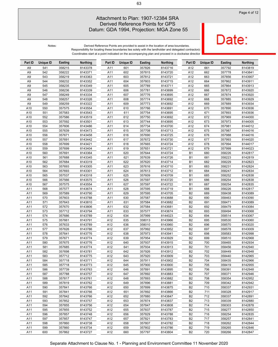
A9 541 358215 8143378A9 542 358222 8143371A9 543 358219 8143363A9 544 358232 8143352A9 545 358235 8143349A9 546 358236 8143339A9 547 358249 8143334A9 548 358257 8143326A9 549 358259 8143322
A10 550 357575 8143554A10 551 357583 8143543A10 552 357586 8143519A10 553 357592 8143501A10 554 357606 8143486A10 555 357639 8143473A10 556 357671 8143458A10 557 357691 8143442A10 558 357699 8143421A10 559 357699 8143404A10 560 357691 8143364A10 561 357688 8143345A10 562 357684 8143319A10 563 357693 8143305A10 564 357693 8143301A10 565 357537 8143318A10 566 357566 8143575A10 567 357575 8143554A11 568 357577 8143674A11 569 357589 8143790A11 570 357603 8143788A11 571 357643 8143810A11 572 357670 8143806A11 573 357712 8143794A11 574 357686 8143789A11 575 357661 8143791A11 576 357633 8143789A11 577 357626 8143786A11 578 357641 8143776A11 579 357671 8143774A11 580 357675 8143776A11 581 357685 8143774A11 582 357698 8143781A11 583 357712 8143775A11 584 357718 8143771A11 585 357718 8143773A11 586 357739 8143763A11 587 357788 8143757A11 588 357817 8143761A11 589 357819 8143762A11 590 357841 8143766A11 591 357841 8143766A11 592 357842 8143766A11 593 357852 8143757A11 594 357855 8143756A11 595 357855 8143752A11 596 357857 8143748A11 597 357857 8143747A11 598 357860 8143738A11 599 357860 8143734A11 600 357862 8143727
A11 601 357826 8143716A11 602 357815 8143720A11 603 357812 8143721A11 604 357803 8143715A11 605 357789 8143711A11 606 357781 8143699A11 607 357776 8143695A11 608 357774 8143692A11 609 357773 8143692A11 610 357766 8143691A11 611 357754 8143695A11 612 357750 8143692A11 613 357744 8143695A11 614 357734 8143700A11 615 357708 8143713A11 616 357690 8143725A11 617 357672 8143730A11 618 357665 8143724A11 619 357651 8143721A11 620 357644 8143724A11 621 357639 8143726A11 622 357620 8143714A11 623 357616 8143710A11 624 357613 8143712A11 625 357609 8143709A11 626 357597 8143720A11 627 357597 8143722A11 628 357595 8143719A11 629 357595 8143705A11 630 357587 8143688A11 631 357584 8143682A11 632 357584 8143681A11 633 357577 8143674A12 634 357999 8144023A12 635 358013 8143966A12 636 358010 8143960A12 637 357992 8143952A12 638 357973 8143941A12 639 357954 8143929A12 640 357937 8143915A12 641 357934 8143913A12 642 357926 8143912A12 643 357920 8143909A12 644 357911 8143902A12 645 357900 8143900A12 646 357891 8143895A12 647 357892 8143883A12 648 357893 8143882A12 649 357896 8143881A12 650 357899 8143875A12 651 357892 8143866A12 652 357880 8143847A12 653 357874 8143837A12 654 357847 8143808A12 655 357837 8143787A12 656 357829 8143788A12 657 357821 8143783A12 658 357807 8143782A12 659 357802 8143786A12 660 357797 8143804
A12 661 357792 8143819A12 662 357778 8143841A12 663 357856 8143907A12 664 357862 8143911A12 665 357864 8143913A12 666 357872 8143920A12 667 357874 8143920A12 668 357885 8143929A12 669 357889 8143934A12 670 357890 8143936A12 671 357893 8143936A12 672 357969 8144000A12 673 357973 8144005A12 674 357981 8144012A12 675 357987 8144016A12 676 357988 8144016A12 677 357993 8144020A12 678 357994 8144017A12 679 357999 8144023B1 680 358226 8142817B1 681 358223 8142819B1 682 358229 8142823B1 683 358231 8142824B1 684 358247 8142834B1 685 358252 8142838B1 686 358254 8142838B1 687 358254 8142835B1 688 358226 8142817B2 689 358438 8143089B2 690 358463 8143090B2 691 358471 8143089B2 692 358479 8143084B2 693 358494 8143068B2 694 358514 8143067B2 695 358530 8143060B2 696 358570 8143020B2 697 358578 8143009B2 698 358583 8142998B2 699 358510 8142968B2 700 358465 8142934B2 701 358456 8142940B2 702 358449 8142948B2 703 358440 8142965B2 704 358435 8142966B2 705 358419 8142955B2 706 358391 8142948B2 707 358371 8142946B2 708 358354 8142952B2 709 358342 8142942B2 710 358337 8142931B2 711 358328 8142917B2 712 358337 8142891B2 713 358339 8142880B2 714 358303 8142878B2 715 358277 8142850B2 716 358254 8142835B2 717 358257 8142841B2 718 358262 8142844B2 719 358265 8142846B2 720 358266 8142847
Attachment to Plan: 1907-12384 SRA Derived Reference Points for GPS
Datum: GDA 1994, Projection: MGA Zone 55
Page 4 of 12
Unique ID EastingPart ID Northing
Responsibility for locating these boundaries lies solely with the landholder and delegated contractor(s).Coordinates start at a point indicated on the accompanying plan and proceed in a clockwise direction.
Notes:
Part ID Unique ID Northing Unique ID EastingPart ID Northing
Derived Reference Points are provided to assist in the location of area boundaries.
Easting
63
Separate Attachment to Clause No. 1 - Planning and Environment Committee 11 November 2020

B2 721 358271 8142850B2 722 358274 8142853B2 723 358284 8142864B2 724 358286 8142865B2 725 358301 8142882B2 726 358287 8142919B2 727 358289 8142919B2 728 358288 8142925B2 729 358291 8142933B2 730 358294 8142936B2 731 358300 8142943B2 732 358263 8142966B2 733 358259 8142958B2 734 358207 8142919B2 735 358201 8142915B2 736 358194 8142913B2 737 358188 8142910B2 738 358182 8142908B2 739 358182 8142908B2 740 358175 8142904B2 741 358173 8142903B2 742 358170 8142901B2 743 358167 8142899B2 744 358164 8142896B2 745 358162 8142894B2 746 358159 8142892B2 747 358155 8142887B2 748 358151 8142881B2 749 358149 8142878B2 750 358147 8142875B2 751 358146 8142873B2 752 358146 8142872B2 753 358146 8142870B2 754 358146 8142868B2 755 358146 8142866B2 756 358147 8142865B2 757 358148 8142863B2 758 358099 8142892B2 759 358118 8142895B2 760 358108 8142912B2 761 358122 8142929B2 762 358137 8142942B2 763 358149 8142950B2 764 358178 8142964B2 765 358190 8142971B2 766 358205 8142976B2 767 358217 8142985B2 768 358225 8142989B2 769 358251 8143034B2 770 358273 8143058B2 771 358305 8143076B2 772 358322 8143081B2 773 358350 8143094B2 774 358390 8143107B2 775 358406 8143108B2 776 358418 8143105B2 777 358428 8143098B2 778 358438 8143089B2 779 358267 8142974B2 780 358301 8142951
B2 781 358307 8142955B2 782 358314 8142958B2 783 358315 8142960B2 784 358349 8142989B2 785 358368 8142992B2 786 358385 8142994B2 787 358410 8143001B2 788 358423 8143004B2 789 358447 8143001B2 790 358451 8143000B2 791 358455 8143001B2 792 358504 8142971B2 793 358533 8142983B2 794 358499 8143018B2 795 358488 8143040B2 796 358467 8143059B2 797 358463 8143065B2 798 358407 8143063B2 799 358389 8143058B2 800 358359 8143048B2 801 358341 8143037B2 802 358330 8143034B2 803 358317 8143031B2 804 358308 8143029B2 805 358308 8143028B2 806 358300 8143024B2 807 358294 8143018B2 808 358287 8143010B2 809 358271 8142982B2 810 358267 8142974B2 811 358298 8142878B2 812 358291 8142871B2 813 358298 8142875B2 814 358299 8142878B2 815 358298 8142878B3 816 358091 8143566B3 817 358100 8143548B3 818 358103 8143533B3 819 358123 8143525B3 820 358130 8143519B3 821 358134 8143512B3 822 358143 8143503B3 823 358152 8143499B3 824 358172 8143485B3 825 358178 8143479B3 826 358205 8143439B3 827 358278 8143370B3 828 358298 8143365B3 829 358308 8143361B3 830 358355 8143376B3 831 358362 8143376B3 832 358410 8143368B3 833 358425 8143376B3 834 358442 8143382B3 835 358449 8143383B3 836 358457 8143381B3 837 358447 8143389B3 838 358432 8143397B3 839 358422 8143408B3 840 358416 8143421
B3 841 358415 8143433B3 842 358411 8143441B3 843 358411 8143449B3 844 358416 8143462B3 845 358422 8143470B3 846 358424 8143478B3 847 358429 8143487B3 848 358451 8143508B3 849 358464 8143514B3 850 358471 8143519B3 851 358480 8143521B3 852 358491 8143521B3 853 358508 8143525B3 854 358516 8143530B3 855 358540 8143536B3 856 358549 8143542B3 857 358562 8143545B3 858 358590 8143546B3 859 358601 8143544B3 860 358608 8143558B3 861 358618 8143567B3 862 358638 8143578B3 863 358652 8143581B3 864 358669 8143581B3 865 358689 8143575B3 866 358701 8143568B3 867 358711 8143558B3 868 358718 8143547B3 869 358721 8143537B3 870 358722 8143521B3 871 358723 8143493B3 872 358721 8143483B3 873 358717 8143474B3 874 358710 8143462B3 875 358702 8143455B3 876 358679 8143442B3 877 358666 8143437B3 878 358656 8143436B3 879 358646 8143437B3 880 358629 8143444B3 881 358623 8143441B3 882 358619 8143423B3 883 358614 8143414B3 884 358608 8143406B3 885 358589 8143390B3 886 358569 8143381B3 887 358557 8143368B3 888 358542 8143360B3 889 358529 8143357B3 890 358511 8143358B3 891 358501 8143361B3 892 358465 8143377B3 893 358471 8143371B3 894 358477 8143360B3 895 358480 8143349B3 896 358477 8143339B3 897 358463 8143307B3 898 358438 8143270B3 899 358432 8143253B3 900 358426 8143244
Attachment to Plan: 1907-12384 SRA Derived Reference Points for GPS
Datum: GDA 1994, Projection: MGA Zone 55
Page 5 of 12
Unique ID EastingPart ID Northing
Responsibility for locating these boundaries lies solely with the landholder and delegated contractor(s).Coordinates start at a point indicated on the accompanying plan and proceed in a clockwise direction.
Notes:
Part ID Unique ID Northing Unique ID EastingPart ID Northing
Derived Reference Points are provided to assist in the location of area boundaries.
Easting
64
Separate Attachment to Clause No. 1 - Planning and Environment Committee 11 November 2020

B3 901 358424 8143231B3 902 358418 8143220B3 903 358391 8143189B3 904 358368 8143172B3 905 358354 8143168B3 906 358339 8143168B3 907 358328 8143170B3 908 358315 8143176B3 909 358304 8143185B3 910 358297 8143197B3 911 358263 8143218B3 912 358256 8143226B3 913 358250 8143235B3 914 358226 8143246B3 915 358219 8143251B3 916 358214 8143259B3 917 358206 8143262B3 918 358199 8143268B3 919 358191 8143269B3 920 358185 8143271B3 921 358168 8143285B3 922 358150 8143285B3 923 358130 8143273B3 924 358119 8143268B3 925 358106 8143259B3 926 358115 8143227B3 927 358112 8143201B3 928 358108 8143187B3 929 358111 8143176B3 930 358111 8143163B3 931 358108 8143153B3 932 358099 8143141B3 933 358089 8143113B3 934 358084 8143105B3 935 358081 8143098B3 936 358075 8143091B3 937 358053 8143077B3 938 358048 8143069B3 939 358042 8143063B3 940 358018 8143049B3 941 357999 8143050B3 942 357987 8143068B3 943 358007 8143080B3 944 358004 8143081B3 945 358002 8143083B3 946 357999 8143085B3 947 357998 8143088B3 948 357996 8143090B3 949 357995 8143093B3 950 357995 8143095B3 951 357994 8143097B3 952 357992 8143099B3 953 357991 8143100B3 954 357989 8143101B3 955 357987 8143102B3 956 357985 8143103B3 957 357983 8143103B3 958 357981 8143103B3 959 357979 8143102B3 960 357977 8143102
B3 961 357968 8143097B3 962 357966 8143100B3 963 357975 8143105B3 964 357978 8143106B3 965 357980 8143107B3 966 357983 8143107B3 967 357986 8143107B3 968 357988 8143106B3 969 357991 8143105B3 970 357993 8143103B3 971 357995 8143102B3 972 357997 8143099B3 973 357998 8143097B3 974 357999 8143094B3 975 358000 8143092B3 976 358001 8143090B3 977 358003 8143088B3 978 358005 8143086B3 979 358007 8143085B3 980 358009 8143084B3 981 358012 8143083B3 982 358027 8143092B3 983 358058 8143111B3 984 358058 8143122B3 985 358059 8143140B3 986 358064 8143158B3 987 358074 8143171B3 988 358074 8143190B3 989 358079 8143205B3 990 358080 8143217B3 991 358081 8143225B3 992 358081 8143226B3 993 358081 8143227B3 994 358077 8143245B3 995 358075 8143251B3 996 358075 8143252B3 997 358073 8143255B3 998 358069 8143255B3 999 358068 8143255B3 1000 358066 8143255B3 1001 358067 8143259B3 1002 358067 8143261B3 1003 358065 8143280B3 1004 358079 8143289B3 1005 358050 8143336B3 1006 358019 8143331B3 1007 358006 8143332B3 1008 358001 8143334B3 1009 358001 8143335B3 1010 358000 8143335B3 1011 357995 8143337B3 1012 357973 8143340B3 1013 357965 8143336B3 1014 357954 8143335B3 1015 357946 8143331B3 1016 357943 8143331B3 1017 357936 8143333B3 1018 357929 8143332B3 1019 357924 8143329B3 1020 357875 8143348
B3 1021 357875 8143348B3 1022 357870 8143352B3 1023 357867 8143353B3 1024 357861 8143347B3 1025 357854 8143336B3 1026 357842 8143325B3 1027 357830 8143315B3 1028 357828 8143306B3 1029 357820 8143307B3 1030 357816 8143318B3 1031 357814 8143330B3 1032 357812 8143343B3 1033 357828 8143357B3 1034 357836 8143369B3 1035 357845 8143378B3 1036 357852 8143382B3 1037 357860 8143385B3 1038 357879 8143384B3 1039 357901 8143374B3 1040 357909 8143372B3 1041 357924 8143367B3 1042 357941 8143368B3 1043 357972 8143375B3 1044 358002 8143370B3 1045 358022 8143364B3 1046 358041 8143367B3 1047 358050 8143366B3 1048 358063 8143375B3 1049 358041 8143390B3 1050 358032 8143401B3 1051 358028 8143412B3 1052 358020 8143447B3 1053 358009 8143467B3 1054 357985 8143496B3 1055 357980 8143508B3 1056 357972 8143520B3 1057 357967 8143533B3 1058 357966 8143544B3 1059 357966 8143568B3 1060 357970 8143582B3 1061 357975 8143592B3 1062 357981 8143599B3 1063 357991 8143605B3 1064 357999 8143608B3 1065 358010 8143610B3 1066 358037 8143609B3 1067 358047 8143605B3 1068 358072 8143592B3 1069 358080 8143584B3 1070 358091 8143566B3 1071 358110 8143397B3 1072 358119 8143387B3 1073 358122 8143376B3 1074 358117 8143383B3 1075 358113 8143387B3 1076 358108 8143392B3 1077 358113 8143369B3 1078 358113 8143368B3 1079 358106 8143364B3 1080 358086 8143354
Attachment to Plan: 1907-12384 SRA Derived Reference Points for GPS
Datum: GDA 1994, Projection: MGA Zone 55
Page 6 of 12
Unique ID EastingPart ID Northing
Responsibility for locating these boundaries lies solely with the landholder and delegated contractor(s).Coordinates start at a point indicated on the accompanying plan and proceed in a clockwise direction.
Notes:
Part ID Unique ID Northing Unique ID EastingPart ID Northing
Derived Reference Points are provided to assist in the location of area boundaries.
Easting
65
Separate Attachment to Clause No. 1 - Planning and Environment Committee 11 November 2020

B3 1081 358064 8143341B3 1082 358057 8143336B3 1083 358084 8143292B3 1084 358090 8143296B3 1085 358088 8143298B3 1086 358086 8143302B3 1087 358099 8143301B3 1088 358116 8143312B3 1089 358116 8143323B3 1090 358122 8143315B3 1091 358137 8143325B3 1092 358158 8143325B3 1093 358166 8143320B3 1094 358166 8143320B3 1095 358167 8143320B3 1096 358169 8143319B3 1097 358169 8143318B3 1098 358174 8143315B3 1099 358180 8143312B3 1100 358181 8143308B3 1101 358188 8143304B3 1102 358194 8143298B3 1103 358198 8143295B3 1104 358205 8143294B3 1105 358216 8143290B3 1106 358219 8143285B3 1107 358256 8143271B3 1108 358285 8143247B3 1109 358295 8143259B3 1110 358296 8143261B3 1111 358298 8143264B3 1112 358298 8143265B3 1113 358298 8143265B3 1114 358298 8143265B3 1115 358298 8143266B3 1116 358298 8143266B3 1117 358297 8143266B3 1118 358297 8143266B3 1119 358297 8143266B3 1120 358294 8143267B3 1121 358291 8143268B3 1122 358287 8143270B3 1123 358284 8143270B3 1124 358278 8143271B3 1125 358272 8143272B3 1126 358263 8143272B3 1127 358272 8143274B3 1128 358281 8143276B3 1129 358281 8143276B3 1130 358303 8143272B3 1131 358303 8143269B3 1132 358302 8143266B3 1133 358301 8143262B3 1134 358300 8143259B3 1135 358298 8143256B3 1136 358288 8143244B3 1137 358303 8143232B3 1138 358330 8143218B3 1139 358342 8143212B3 1140 358349 8143211
B3 1141 358356 8143216B3 1142 358369 8143234B3 1143 358412 8143277B3 1144 358421 8143288B3 1145 358430 8143303B3 1146 358439 8143319B3 1147 358453 8143349B3 1148 358449 8143356B3 1149 358435 8143351B3 1150 358415 8143340B3 1151 358359 8143351B3 1152 358338 8143344B3 1153 358322 8143338B3 1154 358294 8143332B3 1155 358256 8143340B3 1156 358222 8143371B3 1157 358215 8143378B3 1158 358176 8143415B3 1159 358134 8143475B3 1160 358130 8143483B3 1161 358110 8143502B3 1162 358091 8143508B3 1163 358074 8143515B3 1164 358074 8143520B3 1165 358046 8143553B3 1166 358045 8143557B3 1167 358028 8143565B3 1168 358023 8143565B3 1169 358010 8143565B3 1170 358010 8143565B3 1171 358010 8143548B3 1172 358010 8143544B3 1173 358012 8143540B3 1174 358015 8143535B3 1175 358018 8143530B3 1176 358022 8143525B3 1177 358023 8143524B3 1178 358022 8143520B3 1179 358025 8143514B3 1180 358034 8143500B3 1181 358040 8143494B3 1182 358039 8143490B3 1183 358046 8143484B3 1184 358046 8143483B3 1185 358051 8143475B3 1186 358056 8143467B3 1187 358061 8143458B3 1188 358060 8143456B3 1189 358061 8143448B3 1190 358061 8143445B3 1191 358067 8143442B3 1192 358071 8143424B3 1193 358083 8143417B3 1194 358083 8143416B3 1195 358088 8143412B3 1196 358092 8143409B3 1197 358099 8143404B3 1198 358105 8143401B3 1199 358110 8143397B3 1200 358571 8143443
B3 1201 358571 8143445B3 1202 358616 8143470B3 1203 358617 8143470B3 1204 358623 8143471B3 1205 358627 8143472B3 1206 358630 8143479B3 1207 358630 8143479B3 1208 358630 8143481B3 1209 358634 8143483B3 1210 358642 8143486B3 1211 358648 8143489B3 1212 358650 8143490B3 1213 358651 8143492B3 1214 358651 8143493B3 1215 358651 8143505B3 1216 358652 8143511B3 1217 358653 8143516B3 1218 358653 8143521B3 1219 358653 8143527B3 1220 358625 8143515B3 1221 358620 8143515B3 1222 358581 8143513B3 1223 358568 8143513B3 1224 358546 8143507B3 1225 358506 8143497B3 1226 358498 8143496B3 1227 358491 8143495B3 1228 358482 8143496B3 1229 358479 8143492B3 1230 358446 8143459B3 1231 358436 8143452B3 1232 358434 8143446B3 1233 358448 8143435B3 1234 358455 8143432B3 1235 358459 8143433B3 1236 358465 8143432B3 1237 358470 8143430B3 1238 358478 8143425B3 1239 358481 8143424B3 1240 358481 8143424B3 1241 358481 8143420B3 1242 358505 8143408B3 1243 358525 8143410B3 1244 358533 8143422B3 1245 358547 8143429B3 1246 358559 8143433B3 1247 358564 8143438B3 1248 358571 8143443B3 1249 358656 8143493B3 1250 358656 8143489B3 1251 358670 8143497B3 1252 358670 8143518B3 1253 358669 8143527B3 1254 358658 8143529B3 1255 358658 8143529B3 1256 358657 8143521B3 1257 358657 8143516B3 1258 358656 8143512B3 1259 358656 8143509B3 1260 358657 8143505
Attachment to Plan: 1907-12384 SRA Derived Reference Points for GPS
Datum: GDA 1994, Projection: MGA Zone 55
Page 7 of 12
Unique ID EastingPart ID Northing
Responsibility for locating these boundaries lies solely with the landholder and delegated contractor(s).Coordinates start at a point indicated on the accompanying plan and proceed in a clockwise direction.
Notes:
Part ID Unique ID Northing Unique ID EastingPart ID Northing
Derived Reference Points are provided to assist in the location of area boundaries.
Easting
66
Separate Attachment to Clause No. 1 - Planning and Environment Committee 11 November 2020

B3 1261 358656 8143493B3 1262 358656 8143493B4 1263 357860 8143738B4 1264 357878 8143681B4 1265 357864 8143677B4 1266 357851 8143676B4 1267 357839 8143679B4 1268 357825 8143686B4 1269 357819 8143685B4 1270 357813 8143676B4 1271 357801 8143670B4 1272 357794 8143659B4 1273 357784 8143652B4 1274 357769 8143646B4 1275 357750 8143644B4 1276 357731 8143648B4 1277 357721 8143654B4 1278 357713 8143662B4 1279 357697 8143665B4 1280 357675 8143677B4 1281 357644 8143676B4 1282 357633 8143652B4 1283 357620 8143634B4 1284 357625 8143618B4 1285 357625 8143581B4 1286 357635 8143564B4 1287 357638 8143547B4 1288 357642 8143534B4 1289 357669 8143523B4 1290 357684 8143512B4 1291 357699 8143496B4 1292 357706 8143483B4 1293 357719 8143473B4 1294 357726 8143465B4 1295 357739 8143434B4 1296 357741 8143424B4 1297 357740 8143398B4 1298 357728 8143331B4 1299 357719 8143338B4 1300 357707 8143343B4 1301 357693 8143342B4 1302 357693 8143305B4 1303 357684 8143319B4 1304 357688 8143345B4 1305 357691 8143364B4 1306 357699 8143404B4 1307 357699 8143421B4 1308 357691 8143442B4 1309 357671 8143458B4 1310 357639 8143473B4 1311 357606 8143486B4 1312 357592 8143501B4 1313 357586 8143519B4 1314 357583 8143543B4 1315 357575 8143554B4 1316 357566 8143575B4 1317 357577 8143674B4 1318 357584 8143681B4 1319 357584 8143682B4 1320 357587 8143688
B4 1321 357595 8143705B4 1322 357595 8143719B4 1323 357597 8143722B4 1324 357597 8143720B4 1325 357609 8143709B4 1326 357613 8143712B4 1327 357616 8143710B4 1328 357620 8143714B4 1329 357639 8143726B4 1330 357644 8143724B4 1331 357651 8143721B4 1332 357665 8143724B4 1333 357672 8143730B4 1334 357690 8143725B4 1335 357708 8143713B4 1336 357734 8143700B4 1337 357744 8143695B4 1338 357750 8143692B4 1339 357754 8143695B4 1340 357766 8143691B4 1341 357773 8143692B4 1342 357774 8143692B4 1343 357803 8143706B4 1344 357816 8143712B4 1345 357825 8143716B4 1346 357826 8143716B4 1347 357862 8143727B4 1348 357860 8143734B4 1349 357860 8143738B5 1350 357856 8143756B5 1351 357857 8143748B5 1352 357855 8143752B5 1353 357855 8143756B5 1354 357852 8143757B5 1355 357842 8143766B5 1356 357841 8143766B5 1357 357843 8143771B5 1358 357856 8143756B6 1359 357751 8143781B6 1360 357781 8143780B6 1361 357786 8143758B6 1362 357819 8143762B6 1363 357817 8143761B6 1364 357788 8143757B6 1365 357739 8143763B6 1366 357718 8143773B6 1367 357718 8143771B6 1368 357712 8143775B6 1369 357698 8143781B6 1370 357685 8143774B6 1371 357675 8143776B6 1372 357671 8143774B6 1373 357641 8143776B6 1374 357626 8143786B6 1375 357633 8143789B6 1376 357661 8143791B6 1377 357686 8143789B6 1378 357712 8143794B6 1379 357729 8143790B6 1380 357751 8143781
B7 1381 357862 8143911B7 1382 357856 8143907B7 1383 357864 8143913B7 1384 357862 8143911B8 1385 357885 8143929B8 1386 357874 8143920B8 1387 357872 8143920B8 1388 357877 8143925B8 1389 357889 8143934B8 1390 357885 8143929B9 1391 357893 8143936B9 1392 357890 8143936B9 1393 357973 8144005B9 1394 357969 8144000B9 1395 357893 8143936B10 1396 357999 8144023B10 1397 357994 8144017B10 1398 357993 8144020B10 1399 357988 8144016B10 1400 357987 8144016B10 1401 357981 8144012B10 1402 357998 8144027B10 1403 357999 8144023C1 1404 358288 8142925C1 1405 358289 8142919C1 1406 358287 8142919C1 1407 358261 8142918C1 1408 358252 8142918C1 1409 358229 8142915C1 1410 358221 8142919C1 1411 358216 8142921C1 1412 358207 8142919C1 1413 358259 8142958C1 1414 358263 8142966C1 1415 358300 8142943C1 1416 358294 8142936C1 1417 358291 8142933C1 1418 358288 8142925C2 1419 358349 8142989C2 1420 358352 8142992C2 1421 358355 8142994C2 1422 358361 8142995C2 1423 358366 8142996C2 1424 358367 8142993C2 1425 358368 8142992C2 1426 358349 8142989C3 1427 358447 8143002C3 1428 358447 8143001C3 1429 358423 8143004C3 1430 358426 8143008C3 1431 358429 8143013C3 1432 358433 8143012C3 1433 358438 8143009C3 1434 358442 8143007C3 1435 358446 8143005C3 1436 358447 8143002C4 1437 358349 8142989C4 1438 358315 8142960C4 1439 358314 8142958C4 1440 358307 8142955
Attachment to Plan: 1907-12384 SRA Derived Reference Points for GPS
Datum: GDA 1994, Projection: MGA Zone 55
Page 8 of 12
Unique ID EastingPart ID Northing
Responsibility for locating these boundaries lies solely with the landholder and delegated contractor(s).Coordinates start at a point indicated on the accompanying plan and proceed in a clockwise direction.
Notes:
Part ID Unique ID Northing Unique ID EastingPart ID Northing
Derived Reference Points are provided to assist in the location of area boundaries.
Easting
67
Separate Attachment to Clause No. 1 - Planning and Environment Committee 11 November 2020

C4 1441 358301 8142951C4 1442 358267 8142974C4 1443 358271 8142982C4 1444 358287 8143010C4 1445 358294 8143018C4 1446 358300 8143024C4 1447 358308 8143028C4 1448 358307 8143026C4 1449 358306 8143021C4 1450 358305 8143019C4 1451 358303 8143010C4 1452 358297 8143006C4 1453 358294 8142998C4 1454 358295 8142996C4 1455 358311 8142995C4 1456 358309 8142999C4 1457 358309 8143005C4 1458 358312 8143010C4 1459 358313 8143010C4 1460 358315 8143013C4 1461 358321 8143014C4 1462 358329 8143014C4 1463 358332 8143011C4 1464 358328 8143008C4 1465 358321 8143005C4 1466 358324 8143001C4 1467 358334 8142997C4 1468 358334 8142996C4 1469 358337 8142992C4 1470 358338 8142990C4 1471 358347 8142989C4 1472 358349 8142989C5 1473 358488 8143040C5 1474 358499 8143018C5 1475 358533 8142983C5 1476 358504 8142971C5 1477 358455 8143001C5 1478 358451 8143000C5 1479 358452 8143011C5 1480 358459 8143013C5 1481 358472 8143018C5 1482 358485 8143026C5 1483 358488 8143040C6 1484 358488 8143040C6 1485 358478 8143046C6 1486 358467 8143059C6 1487 358488 8143040C7 1488 358373 8143036C7 1489 358356 8143039C7 1490 358348 8143039C7 1491 358341 8143037C7 1492 358359 8143048C7 1493 358389 8143058C7 1494 358407 8143063C7 1495 358400 8143057C7 1496 358388 8143053C7 1497 358384 8143048C7 1498 358373 8143036C8 1499 358369 8143234C8 1500 358356 8143216
C8 1501 358356 8143223C8 1502 358361 8143228C8 1503 358369 8143234C9 1504 358256 8143271C9 1505 358263 8143272C9 1506 358272 8143272C9 1507 358278 8143271C9 1508 358284 8143270C9 1509 358287 8143270C9 1510 358291 8143268C9 1511 358294 8143267C9 1512 358297 8143266C9 1513 358297 8143266C9 1514 358297 8143266C9 1515 358298 8143266C9 1516 358298 8143266C9 1517 358298 8143265C9 1518 358298 8143265C9 1519 358298 8143265C9 1520 358298 8143264C9 1521 358296 8143261C9 1522 358295 8143259C9 1523 358285 8143247C9 1524 358256 8143271
C10 1525 358303 8143232C10 1526 358288 8143244C10 1527 358298 8143256C10 1528 358300 8143259C10 1529 358301 8143262C10 1530 358302 8143266C10 1531 358303 8143269C10 1532 358303 8143272C10 1533 358306 8143272C10 1534 358308 8143267C10 1535 358309 8143263C10 1536 358309 8143255C10 1537 358304 8143247C10 1538 358304 8143246C10 1539 358301 8143241C10 1540 358303 8143232C11 1541 358369 8143234C11 1542 358369 8143237C11 1543 358369 8143239C11 1544 358366 8143248C11 1545 358388 8143264C11 1546 358393 8143272C11 1547 358392 8143278C11 1548 358399 8143279C11 1549 358412 8143277C11 1550 358369 8143234C12 1551 358220 8143286C12 1552 358222 8143287C12 1553 358223 8143288C12 1554 358227 8143291C12 1555 358242 8143280C12 1556 358244 8143279C12 1557 358249 8143276C12 1558 358256 8143271C12 1559 358219 8143285C12 1560 358220 8143286
C13 1561 358430 8143303C13 1562 358421 8143288C13 1563 358423 8143300C13 1564 358430 8143303C14 1565 358050 8143336C14 1566 358079 8143289C14 1567 358065 8143280C14 1568 358067 8143261C14 1569 358065 8143263C14 1570 358062 8143262C14 1571 358061 8143263C14 1572 358061 8143263C14 1573 358060 8143266C14 1574 358058 8143268C14 1575 358058 8143269C14 1576 358058 8143269C14 1577 358058 8143271C14 1578 358056 8143275C14 1579 358053 8143275C14 1580 358051 8143280C14 1581 358051 8143281C14 1582 358050 8143281C14 1583 358051 8143282C14 1584 358051 8143286C14 1585 358049 8143289C14 1586 358049 8143291C14 1587 358049 8143292C14 1588 358046 8143295C14 1589 358046 8143296C14 1590 358047 8143297C14 1591 358048 8143299C14 1592 358046 8143301C14 1593 358043 8143301C14 1594 358043 8143301C14 1595 358038 8143305C14 1596 358034 8143309C14 1597 358034 8143313C14 1598 358032 8143311C14 1599 358031 8143311C14 1600 358030 8143310C14 1601 358030 8143309C14 1602 358028 8143309C14 1603 358030 8143314C14 1604 358033 8143316C14 1605 358032 8143316C14 1606 358029 8143317C14 1607 358028 8143319C14 1608 358025 8143321C14 1609 358021 8143321C14 1610 358018 8143320C14 1611 358017 8143321C14 1612 358014 8143328C14 1613 358010 8143325C14 1614 358008 8143325C14 1615 358001 8143334C14 1616 358006 8143332C14 1617 358019 8143331C14 1618 358050 8143336C15 1619 357875 8143348C15 1620 357924 8143329
Attachment to Plan: 1907-12384 SRA Derived Reference Points for GPS
Datum: GDA 1994, Projection: MGA Zone 55
Page 9 of 12
Unique ID EastingPart ID Northing
Responsibility for locating these boundaries lies solely with the landholder and delegated contractor(s).Coordinates start at a point indicated on the accompanying plan and proceed in a clockwise direction.
Notes:
Part ID Unique ID Northing Unique ID EastingPart ID Northing
Derived Reference Points are provided to assist in the location of area boundaries.
Easting
68
Separate Attachment to Clause No. 1 - Planning and Environment Committee 11 November 2020

C15 1621 357929 8143332C15 1622 357936 8143333C15 1623 357943 8143331C15 1624 357946 8143331C15 1625 357954 8143335C15 1626 357965 8143336C15 1627 357973 8143340C15 1628 357995 8143337C15 1629 358000 8143335C15 1630 357997 8143335C15 1631 357992 8143334C15 1632 357993 8143329C15 1633 357976 8143328C15 1634 357973 8143328C15 1635 357969 8143327C15 1636 357949 8143326C15 1637 357945 8143325C15 1638 357954 8143308C15 1639 357953 8143307C15 1640 357954 8143305C15 1641 357956 8143303C15 1642 357959 8143300C15 1643 357961 8143298C15 1644 357966 8143295C15 1645 357974 8143286C15 1646 357974 8143285C15 1647 357975 8143284C15 1648 357977 8143283C15 1649 357979 8143281C15 1650 357988 8143275C15 1651 357992 8143268C15 1652 357998 8143259C15 1653 358000 8143257C15 1654 358001 8143255C15 1655 358001 8143254C15 1656 358007 8143245C15 1657 358009 8143242C15 1658 358009 8143240C15 1659 358012 8143223C15 1660 358014 8143215C15 1661 358019 8143194C15 1662 358020 8143191C15 1663 358020 8143188C15 1664 358020 8143180C15 1665 358020 8143165C15 1666 358020 8143165C15 1667 358019 8143157C15 1668 358020 8143151C15 1669 358020 8143143C15 1670 358026 8143136C15 1671 358025 8143127C15 1672 358024 8143120C15 1673 358024 8143119C15 1674 358023 8143113C15 1675 358023 8143110C15 1676 358023 8143109C15 1677 358022 8143109C15 1678 358022 8143107C15 1679 358022 8143107C15 1680 358023 8143105
C15 1681 358023 8143104C15 1682 358025 8143100C15 1683 358025 8143099C15 1684 358027 8143092C15 1685 358012 8143083C15 1686 358009 8143085C15 1687 358008 8143086C15 1688 358007 8143090C15 1689 358005 8143095C15 1690 358001 8143101C15 1691 357994 8143104C15 1692 357995 8143107C15 1693 357995 8143108C15 1694 357995 8143109C15 1695 357997 8143117C15 1696 357998 8143119C15 1697 357998 8143122C15 1698 357998 8143122C15 1699 357998 8143122C15 1700 357994 8143125C15 1701 357990 8143128C15 1702 357989 8143131C15 1703 357988 8143132C15 1704 357988 8143139C15 1705 357989 8143144C15 1706 357990 8143146C15 1707 357991 8143148C15 1708 357988 8143151C15 1709 357987 8143152C15 1710 357987 8143153C15 1711 357990 8143160C15 1712 357988 8143167C15 1713 357983 8143169C15 1714 357982 8143169C15 1715 357981 8143175C15 1716 357977 8143186C15 1717 357974 8143191C15 1718 357974 8143191C15 1719 357971 8143193C15 1720 357970 8143195C15 1721 357968 8143196C15 1722 357967 8143197C15 1723 357968 8143200C15 1724 357968 8143201C15 1725 357967 8143201C15 1726 357967 8143202C15 1727 357969 8143203C15 1728 357973 8143207C15 1729 357968 8143214C15 1730 357967 8143220C15 1731 357969 8143225C15 1732 357966 8143234C15 1733 357965 8143240C15 1734 357961 8143247C15 1735 357958 8143250C15 1736 357954 8143254C15 1737 357957 8143261C15 1738 357954 8143262C15 1739 357951 8143265C15 1740 357945 8143273
C15 1741 357943 8143274C15 1742 357940 8143277C15 1743 357936 8143282C15 1744 357933 8143288C15 1745 357927 8143296C15 1746 357925 8143305C15 1747 357921 8143310C15 1748 357919 8143312C15 1749 357915 8143314C15 1750 357915 8143314C15 1751 357910 8143318C15 1752 357905 8143320C15 1753 357904 8143320C15 1754 357904 8143320C15 1755 357903 8143325C15 1756 357901 8143329C15 1757 357894 8143328C15 1758 357889 8143332C15 1759 357885 8143336C15 1760 357880 8143338C15 1761 357879 8143343C15 1762 357875 8143348C16 1763 358453 8143349C16 1764 358439 8143319C16 1765 358437 8143327C16 1766 358442 8143337C16 1767 358453 8143349C17 1768 358371 8143298C17 1769 358351 8143307C17 1770 358338 8143318C17 1771 358338 8143322C17 1772 358345 8143326C17 1773 358341 8143342C17 1774 358338 8143344C17 1775 358359 8143351C17 1776 358415 8143340C17 1777 358407 8143327C17 1778 358404 8143316C17 1779 358371 8143298C18 1780 358296 8143329C18 1781 358289 8143323C18 1782 358279 8143323C18 1783 358274 8143319C18 1784 358259 8143322C18 1785 358257 8143326C18 1786 358249 8143334C18 1787 358236 8143339C18 1788 358235 8143349C18 1789 358232 8143352C18 1790 358223 8143360C18 1791 358219 8143363C18 1792 358222 8143371C18 1793 358256 8143340C18 1794 358294 8143332C18 1795 358295 8143331C18 1796 358298 8143331C18 1797 358296 8143329C19 1798 358135 8143347C19 1799 358140 8143342C19 1800 358144 8143338
Attachment to Plan: 1907-12384 SRA Derived Reference Points for GPS
Datum: GDA 1994, Projection: MGA Zone 55
Page 10 of 12
Unique ID EastingPart ID Northing
Responsibility for locating these boundaries lies solely with the landholder and delegated contractor(s).Coordinates start at a point indicated on the accompanying plan and proceed in a clockwise direction.
Notes:
Part ID Unique ID Northing Unique ID EastingPart ID Northing
Derived Reference Points are provided to assist in the location of area boundaries.
Easting
69
Separate Attachment to Clause No. 1 - Planning and Environment Committee 11 November 2020
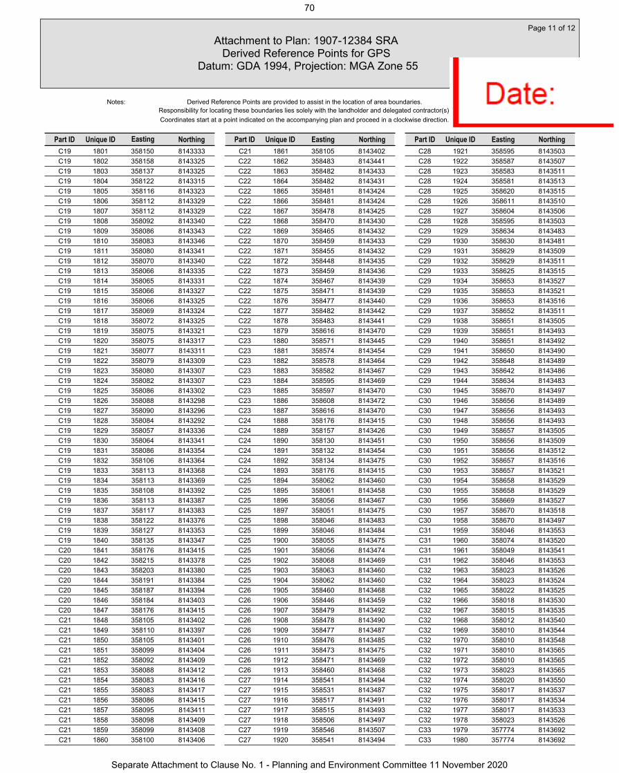
C19 1801 358150 8143333C19 1802 358158 8143325C19 1803 358137 8143325C19 1804 358122 8143315C19 1805 358116 8143323C19 1806 358112 8143329C19 1807 358112 8143329C19 1808 358092 8143340C19 1809 358086 8143343C19 1810 358083 8143346C19 1811 358080 8143341C19 1812 358070 8143340C19 1813 358066 8143335C19 1814 358065 8143331C19 1815 358066 8143327C19 1816 358066 8143325C19 1817 358069 8143324C19 1818 358072 8143325C19 1819 358075 8143321C19 1820 358075 8143317C19 1821 358077 8143311C19 1822 358079 8143309C19 1823 358080 8143307C19 1824 358082 8143307C19 1825 358086 8143302C19 1826 358088 8143298C19 1827 358090 8143296C19 1828 358084 8143292C19 1829 358057 8143336C19 1830 358064 8143341C19 1831 358086 8143354C19 1832 358106 8143364C19 1833 358113 8143368C19 1834 358113 8143369C19 1835 358108 8143392C19 1836 358113 8143387C19 1837 358117 8143383C19 1838 358122 8143376C19 1839 358127 8143353C19 1840 358135 8143347C20 1841 358176 8143415C20 1842 358215 8143378C20 1843 358203 8143380C20 1844 358191 8143384C20 1845 358187 8143394C20 1846 358184 8143403C20 1847 358176 8143415C21 1848 358105 8143402C21 1849 358110 8143397C21 1850 358105 8143401C21 1851 358099 8143404C21 1852 358092 8143409C21 1853 358088 8143412C21 1854 358083 8143416C21 1855 358083 8143417C21 1856 358086 8143415C21 1857 358095 8143411C21 1858 358098 8143409C21 1859 358099 8143408C21 1860 358100 8143406
C21 1861 358105 8143402C22 1862 358483 8143441C22 1863 358482 8143433C22 1864 358482 8143431C22 1865 358481 8143424C22 1866 358481 8143424C22 1867 358478 8143425C22 1868 358470 8143430C22 1869 358465 8143432C22 1870 358459 8143433C22 1871 358455 8143432C22 1872 358448 8143435C22 1873 358459 8143436C22 1874 358467 8143439C22 1875 358471 8143439C22 1876 358477 8143440C22 1877 358482 8143442C22 1878 358483 8143441C23 1879 358616 8143470C23 1880 358571 8143445C23 1881 358574 8143454C23 1882 358578 8143464C23 1883 358582 8143467C23 1884 358595 8143469C23 1885 358597 8143470C23 1886 358608 8143472C23 1887 358616 8143470C24 1888 358176 8143415C24 1889 358157 8143426C24 1890 358130 8143451C24 1891 358132 8143454C24 1892 358134 8143475C24 1893 358176 8143415C25 1894 358062 8143460C25 1895 358061 8143458C25 1896 358056 8143467C25 1897 358051 8143475C25 1898 358046 8143483C25 1899 358046 8143484C25 1900 358055 8143475C25 1901 358056 8143474C25 1902 358068 8143469C25 1903 358063 8143460C25 1904 358062 8143460C26 1905 358460 8143468C26 1906 358446 8143459C26 1907 358479 8143492C26 1908 358478 8143490C26 1909 358477 8143487C26 1910 358476 8143485C26 1911 358473 8143475C26 1912 358471 8143469C26 1913 358460 8143468C27 1914 358541 8143494C27 1915 358531 8143487C27 1916 358517 8143491C27 1917 358515 8143493C27 1918 358506 8143497C27 1919 358546 8143507C27 1920 358541 8143494
C28 1921 358595 8143503C28 1922 358587 8143507C28 1923 358583 8143511C28 1924 358581 8143513C28 1925 358620 8143515C28 1926 358611 8143510C28 1927 358604 8143506C28 1928 358595 8143503C29 1929 358634 8143483C29 1930 358630 8143481C29 1931 358629 8143509C29 1932 358629 8143511C29 1933 358625 8143515C29 1934 358653 8143527C29 1935 358653 8143521C29 1936 358653 8143516C29 1937 358652 8143511C29 1938 358651 8143505C29 1939 358651 8143493C29 1940 358651 8143492C29 1941 358650 8143490C29 1942 358648 8143489C29 1943 358642 8143486C29 1944 358634 8143483C30 1945 358670 8143497C30 1946 358656 8143489C30 1947 358656 8143493C30 1948 358656 8143493C30 1949 358657 8143505C30 1950 358656 8143509C30 1951 358656 8143512C30 1952 358657 8143516C30 1953 358657 8143521C30 1954 358658 8143529C30 1955 358658 8143529C30 1956 358669 8143527C30 1957 358670 8143518C30 1958 358670 8143497C31 1959 358046 8143553C31 1960 358074 8143520C31 1961 358049 8143541C31 1962 358046 8143553C32 1963 358023 8143526C32 1964 358023 8143524C32 1965 358022 8143525C32 1966 358018 8143530C32 1967 358015 8143535C32 1968 358012 8143540C32 1969 358010 8143544C32 1970 358010 8143548C32 1971 358010 8143565C32 1972 358010 8143565C32 1973 358023 8143565C32 1974 358020 8143550C32 1975 358017 8143537C32 1976 358017 8143534C32 1977 358017 8143533C32 1978 358023 8143526C33 1979 357774 8143692C33 1980 357774 8143692
Attachment to Plan: 1907-12384 SRA Derived Reference Points for GPS
Datum: GDA 1994, Projection: MGA Zone 55
Page 11 of 12
Unique ID EastingPart ID Northing
Responsibility for locating these boundaries lies solely with the landholder and delegated contractor(s).Coordinates start at a point indicated on the accompanying plan and proceed in a clockwise direction.
Notes:
Part ID Unique ID Northing Unique ID EastingPart ID Northing
Derived Reference Points are provided to assist in the location of area boundaries.
Easting
70
Separate Attachment to Clause No. 1 - Planning and Environment Committee 11 November 2020

C33 1981 357774 8143693C33 1982 357776 8143695C33 1983 357781 8143699C33 1984 357789 8143711C33 1985 357795 8143713C33 1986 357803 8143715C33 1987 357809 8143719C33 1988 357812 8143721C33 1989 357813 8143720C33 1990 357815 8143720C33 1991 357820 8143718C33 1992 357826 8143716C33 1993 357825 8143716C33 1994 357816 8143712C33 1995 357803 8143706C33 1996 357774 8143692C34 1997 357836 8143785C34 1998 357821 8143783C34 1999 357829 8143788C34 2000 357837 8143787C34 2001 357836 8143785C35 2002 357905 8143884C35 2003 357899 8143875C35 2004 357896 8143881C35 2005 357893 8143882C35 2006 357892 8143883C35 2007 357892 8143883C35 2008 357891 8143895C35 2009 357900 8143900C35 2010 357911 8143902C35 2011 357920 8143909C35 2012 357926 8143912C35 2013 357934 8143913C35 2014 357920 8143900C35 2015 357905 8143884
Attachment to Plan: 1907-12384 SRA Derived Reference Points for GPS
Datum: GDA 1994, Projection: MGA Zone 55
Page 12 of 12
Unique ID EastingPart ID Northing
Responsibility for locating these boundaries lies solely with the landholder and delegated contractor(s).Coordinates start at a point indicated on the accompanying plan and proceed in a clockwise direction.
Notes:
Part ID Unique ID Northing Unique ID EastingPart ID Northing
Derived Reference Points are provided to assist in the location of area boundaries.
Easting
71
Separate Attachment to Clause No. 1 - Planning and Environment Committee 11 November 2020

NORTH
2.5
.522.5 1.5 1
0
SCALE 1:250 @ A3
5 7.5 10 12.5m
Planning PlusParadise Palms DevelopmentPublic Transport ProposalRegular Stop Indented Bay - Northbound
R.Woods 03/09/2019 1:250
CEB06784 - SK03 A
CONCEPT ONLY
© Cardno LimitedAll Rights Reserved.
This document is produced by Cardno Limitedsolely for the benefit of and use by the clientin accordance with the terms of the retainer.
Cardno Limited does not and shall notassume any responsibility or liability
whatsoever to any third party arising out ofany use or reliance by third party on the
content of this document.
®
SizeScale
Drawing Number Revision
CAD
File:
\\aub
necfs
05\tn
t$\Cu
rrent
Jobs
\CEB
0678
4 - C
airns
Par
adise
Palm
s Upd
ate\A
CAD\
CEB0
6784
- SK
03_S
K04 -
A.D
WG
DateA3
Drawn
Imagery supplied by nearmap, September 2019
Cardno (Qld) Pty Ltd | ABN 57 051 074 992Level 11, 515 St Paul’s Terrace
Fortitude Valley, QLD 4006Tel: 07 3369 9822 Fax: 07 3369 9722
Web: www.cardno.com.au
10m from
non-signalised crossing
20m from
non-signalised crossing
15m25m21m
21m25m15m
72
Separate Attachment to Clause No. 1 - Planning and Environment Committee 11 November 2020

1
2
3
4
5
6
7
89
10
10
11
12
13
16
18
17
NOTES:
1 Retention of the clubhouse and existing facilities to create a key village hub
2 Potential commercial opportunity opposite the clubhouse or used as a childcare facility
3 Retention of existing trees on main entry road. Also acts as a drainage outlet for the tourist park
4 Tourist park co-located with existing clubhouse facilities. Includes a water-play area
5 Key intersection to residential precincts and open space
6 Noise mounding along the eastern boundary as a buffer to Captain Cook Highway
7 Bridge crossing into residential pocket
8 Retain existing trees where possible and establish a 2m-wide vegetated buffer
9 Exclusive pocket of premium residential
10 Central park location for majority of residents, surrounding by protected vegetation
11 Pocket of premium residential with left-in left-out access off Moore Road
12 Primary entrance into the estate
13 Retirement precinct backing onto the Macalister Range
14 Proposed dog park location
15 Interpretive rainforest walk
16 Potential trailhead for mountain walking tracks
17 Potential pedestrian underpass/link to beach
18 Extensive internal pathway network that follows thenatural corridors and connects open spaces
STATISTICS:
Total Site Area 95.7ha
Net Residential Developable Area 23.9ha
Total Number of Lots = 395
Average lot size = 606m²
Retirement 6.6ha
Commercial / Childcare 0.3ha
Tourist Park (inc. Clubhouse) 14.2ha
Open Space Corridors 37.1ha
Part Lot 900 SP285555 1.6ha
Road Reserve 12.0ha MOORE ROAD
PARADISE PALMS DRIVE
CAPTAIN COOK HIGHWAY
14
15
LEGEND:
Site boundary
4m wide landscape buffer (adjoining tourist park)
2m wide landscape buffer (adjoining residential)
Proposed Tourist Park
Proposed Retirement
Proposed Footpaths
Existing Footpaths
1:2500 @ A1
DATE: 01.07.2019JOB NO: P0001586DWG NO: MP-01REV: 5
THE PALMSOVERALL MASTERPLAN
Copyright by Urbis Pty Ltd. This drawing or parts thereof may not be reproduced for any purpose or used for another project without the consent of Urbis. The plan must not be used for ordering, supply or installation and no relevance should be placed on this plan for any financial dealing of the land. This plan is conceptual and is for discussion purposes only and subject to further detail study, Council approval, engineering input, and survey. Cadastral boundaries, areas and dimensions are approximate only. Written figured dimensions shall take preference to scaled dimensions.
73
Separate Attachment to Clause No. 1 - Planning and Environment Committee 11 November 2020

74
Separate Attachment to Clause No. 1 - Planning and Environment Committee 11 November 2020

Have you seen our fact sheets? See the ‘considerations when developing around electricity infrastructure’ section of our website
www.ergon.com.au/referralagency
06 September 2019
Cairns Regional CouncilPO Box 359Cairns QLD 4870
Attention: Claire Anderson; Nicole TsakissirisVia email: [email protected]
Cc PPNQ Developments Pty Ltdc/- Planning Plus QLDPO Box 399Redlynch QLD 4870
Attention: Evan YelavichVia email: [email protected]
Dear Curtis,
Referral Agency Response – Preliminary Approval including a variation request to vary the effect of the CairnsPlan Planning Scheme for use rights in accordance with The Palms Development Code at 4L Captain Cook Highway, Kewarra Beach (Lot 4 on SP85555 & Lot 900 on SP285555) Applicant Ref: 19-02/000924 Council Ref: 9522/2019 Our Ref: HBD 6739345
We refer to the abovementioned Development Application, which has been referredto Ergon Energy pursuant to section 54(1) of the Planning Act 2016.
In accordance with Schedule 10, Part 9, Division 2 of the Planning Regulation 2017,the application has been assessed against the purposes of the Electricity Act 1994and Electrical Safety Act 2002. This notice is provided in accordance with section56 of the Planning Act 2016.
Should the Assessment Manager decide to approve the proposed variation request,as an Advice Agency for the Development Application, Ergon Energy requests thatthe Assessment Manager imposes the conditions enclosed with this notice.
The Applicant is advised that any future works in the vicinity of Ergon Energy assetsare to be carried out in accordance with the Electricity Entity Requirements:Working Near Overhead and Underground Electric Lines. This guideline can beaccessed via the following link: https://www.ergon.com.au/network/safety/industry-safety/ electricity-entity-requirements.
APPENDIX NO. 2 - REFERRAL AGENCY REQUIREMENTS75
Separate Attachment to Clause No. 1 - Planning and Environment Committee 11 November 2020

Have you seen our fact sheets? See the ‘considerations when developing around electricity infrastructure’ section of our website
www.ergon.com.au/referralagency
Page 2
The Applicant is further advised that this response does not constitute approval for connection to Ergon Energy’s assets. Should you require further information regarding this matter, please feel free to contact the undersigned on (07) 3664 5097 or email [email protected]. Yours faithfully,
Benjamin Freese Town Planner
76
Separate Attachment to Clause No. 1 - Planning and Environment Committee 11 November 2020

Have you seen our fact sheets? See the ‘considerations when developing around electricity infrastructure’ section of our website
www.ergon.com.au/referralagency
Page 3
CONDITION TIMING
1. The development is to be carried out in accordance with the plans and documents identified in the table below. Any changes to these plans or documents should be resubmitted to Ergon Energy for further review and comment:
Approved Plans
Title Plan Number Issue Date
The Palms Overall Masterplan
MP-01 Rev. 5 01.07.2019
The Palms Precinct Plan
01 - 15.05.2019
The Palms Plan of Development Annexure A – Tables of Assessment
- - June 2019
To be maintained
2. The conditions of any easements in favour of Ergon Energy must be maintained at all times.
To be maintained
3. An easement in favour of Ergon Energy is to be registered over the existing padmount substation (ID SS5527) and underground 22kV cable connection to Moore Road.
The easement is to be registered in accordance with Ergon Energy’s standard easement conditions (dealing number 710384570). Required dimensions of the easement are as follows:
- Minimum width of 2 metres on either side of the centreline of the underground cable (total width of 4 metres); and
- Minimum area of 6 metres x 4 metres around the padmount substation.
The easement must be registered prior to the earlier of the following occurring:
(i) The making of any related development application over the premises; or
(ii) The commencement of any use of premises in accordance with the approved Plan of Development.
As stated
77
Separate Attachment to Clause No. 1 - Planning and Environment Committee 11 November 2020

APPENDIX 3: PRO-FORMA SUBMISSION EXAMPLES & PETITION
Pro-Forma Example 1
78
Separate Attachment to Clause No. 1 - Planning and Environment Committee 11 November 2020

79
Separate Attachment to Clause No. 1 - Planning and Environment Committee 11 November 2020

Pro-Forma Example 2
80
Separate Attachment to Clause No. 1 - Planning and Environment Committee 11 November 2020

81
Separate Attachment to Clause No. 1 - Planning and Environment Committee 11 November 2020

82
Separate Attachment to Clause No. 1 - Planning and Environment Committee 11 November 2020
83
Separate Attachment to Clause No. 1 - Planning and Environment Committee 11 November 2020

84
Separate Attachment to Clause No. 1 - Planning and Environment Committee 11 November 2020

Example of Petition:
85
Separate Attachment to Clause No. 1 - Planning and Environment Committee 11 November 2020

APPENDIX 4: SUPPORTING INFORMATION SP285555
Illustrated ‘The Palms Masterplan’
86
Separate Attachment to Clause No. 1 - Planning and Environment Committee 11 November 2020

87
Separate Attachment to Clause No. 1 - Planning and Environment Committee 11 November 2020
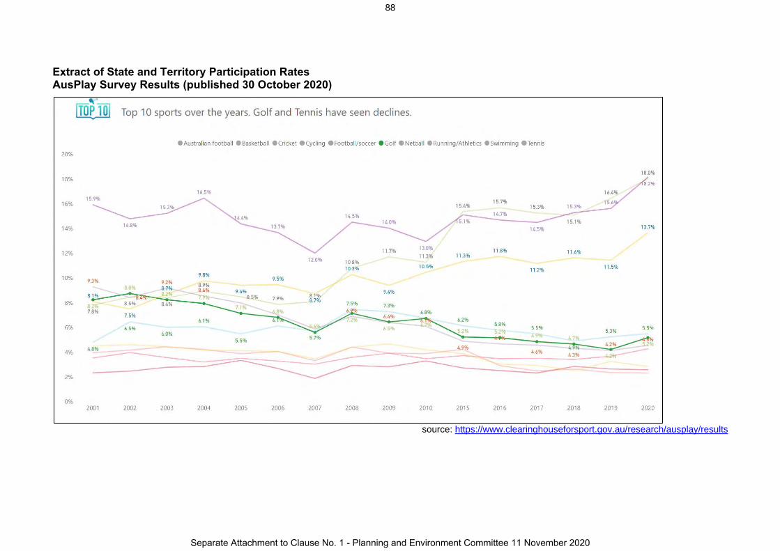
Extract of State and Territory Participation Rates AusPlay Survey Results (published 30 October 2020)
source: https://www.clearinghouseforsport.gov.au/research/ausplay/results
88
Separate Attachment to Clause No. 1 - Planning and Environment Committee 11 November 2020
Top Related