


Languages
Pages
Legal

Author Kate Helliwell TZF141 Science Report
[1]
Tanzania Forest Research Programme
Utende Village, Mafia Island, Tanzania
TZF Phase 141 Science Report
1
tst January – 24
th March 2014
Author: Kate Helliwell

Author Kate Helliwell TZF141 Science Report
[2]
Staff Members
Name Position
Kate Helliwell (KH) Principal Investigator (PI)
Author Kate Helliwell TZF141 Science Report
[3]
TZF 141 Science Report
Contents
1. Introduction to TZF.................................................................................................5
1.1 Area Overview....................................................................................................................5
1.2 Mafia Island coastal forests................................................................................................6
1.3 Frontier Tanzania Forest Programme (TZF)......................................................................7
2. Training.................................................................................................................................8
2.1 Briefing……………………………………………………………………………..........8
2.2 Science Lectures................................................................................................................8
2.3 Field work training............................................................................................................9
2.4 BTEC……………………………………………………………..………………..….....9
3. Research Work Program.........................................................................................9
3.1 Survey areas………………………………………………………………………….........9
3.2 Bird Surveys: Avian abundance and species diversity in different habitats around
Utende village ........................................................................................................................14
3.1.1 Introduction.......................................................................................................14
3.1.2 Methods............................................................................................................15
3.1.3 Results...............................................................................................................15
3.1.4 Discussion and Recommendations...................................................................19
3.3 Butterfly presence in different habitats around Utende to monitor ecological health of
fragmented habitats.................................................................................................................20
3.3.1 Introduction.......................................................................................................20
3.3.2 Methods............................................................................................................20
3.3.3 Results...............................................................................................................21
3.3.4 Discussion and Recommendations...................................................................23
3.4 Expansion of the species list of reptiles, insects and amphibians on Mafia Island with the
aid of pitfall trapping and active searches..............................................................................23
3.4.1 Introduction......................................................................................................23
3.4.2 Methods............................................................................................................24
3.4.3 Results..............................................................................................................25
3.4.4 Discussion and Recommendations...................................................................25
.
3.5 Wild Cats; Camera Trapping to the presence of a wild cat “fungo” around Utende and
surrounding area.....................................................................................................................25
3.5.1 Introduction......................................................................................................25
3.5.2 Methods............................................................................................................25
3.5.3 Results..............................................................................................................26
3.5.4 Discussion and Recommendations...................................................................27
3.6 New Species.....................................................................................................................27

Author Kate Helliwell TZF141 Science Report
[4]
4. Project Direction........................................................................................................................28
4.1 Proposed educational work programme for next phase................................................28
4.2 Contribution of future work...........................................................................................28
5. References……………………………………………………………………………………...29
6. Appendices................................................................................................................................31
6.1 Data sheets…………………………………………………………....……………….31
6.2 Species List………………………………………………………....…………………31

Author Kate Helliwell TZF141 Science Report
[5]
1. Introduction
The coastal forests of Eastern Africa, particularly those found in Tanzania, are recognized as
important hotspots for biodiversity (Myers et al., 2000). These regions are vital as they contain the
vast majority of Africa’s endemic species, with a considerable amount of these found in Tanzania,
neighbouring Kenya and Mozambique (Mittermeier et al., 1998).
Tanzanian coastal forests are fragmented, small and surrounded by poor communities that heavily
depend on these areas for land and forest resources. Burgess and Clarke (2000) argue that even
though these coastal forests are of a significant cultural and traditional value for local communities,
they are not being adequately managed by the relevant government authorities and international
conservation institutions.
Forests in Tanzania cover an approximate area of 42 million ha, which is about half the total land
area of the country, with the other half being occupied by rough grazing lands. The forested areas
consist mostly of natural Miombo woodlands which are areas, dominated by the genera Brachestegia
and Julbernedia and are also populated with a variety of animal species (Makundi and Okiting Ati,
1995). The remaining forest area is composed of a small expanse of closed forest, mangrove forest
and human-grown plantations. Given the notable levels of fragmentation in these forests, habitat loss
is threatening endemic species, making them more vulnerable to extinction. The main threats to
habitats in this region are the expansion of agricultural land, timber extraction and charcoal
production, all of these factors are exacerbated by weak governmental management and community
input (Iddi, 1997).
Coastal forests of Tanzania are distributed through six regions of the mainland covering 17 districts
and Unguja and Pemba in Zanzibar. The coastal forests cover a total of 333,412 ha of which 263,932
ha are Central Government Forest Reserves (79.2%) and 66,950 ha (20.0%) are under public control.
An additional 2,530 ha (0.8%) belongs to Game Reserves/National Parks (Kaale, 2004). Ngusaru
and his colleagues (2001) argue that degradation is occurring in both government forest reserves and
in forests located on public land. Furthermore, there has been an observable decline over the past
two decades in the government’s ability to police forest reserves, chiefly those located on mainland
Tanzania. This is due to a reduction in man power and funding, which is also causing a severe
decline in coastal forests.
1.1 Area Overview
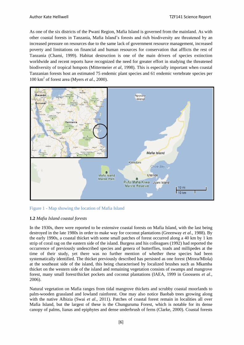
The Frontier Tanzania Forest Research Programme (TZF) is located on Mafia Island off the coast of
mainland Tanzania, East Africa (see Figure 1). Mafia Island is one of the Tanzanian Spice Islands,
together with Unguja and Pemba. It is centrally located in a group of 15 small sandstone and coral
rag islands in the Indian Ocean, with a total land area of 394 km2. Mafia is the largest of these,
measuring approximately 50km in length by 15km across at its widest point.
Much of Mafia’s coastline and surrounding sea areas are part of the Mafia Island Marine Park
(MIMP), which extends predominantly across the South-East corner of the island and covers an area
of 822 km2 (Goossens et al., 2006). The marine park envelopes some of the 15 islands in the
archipelago, several of which are inhabited with a total estimated population of 41,000 as of 2002
(Caplan, 2011). The people living on this archipelago are mostly smallholder farmers that are
involved in mixed farming and fishing. The main agricultural practices include plantations of
coconuts, cassava, rice, pigeon pea, pineapples, cashew and mango trees (Goossens et al., 2006).
Author Kate Helliwell TZF141 Science Report
[6]
As one of the six districts of the Pwani Region, Mafia Island is governed from the mainland. As with
other coastal forests in Tanzania, Mafia Island’s forests and rich biodiversity are threatened by an
increased pressure on resources due to the same lack of government resource management, increased
poverty and limitations on financial and human resources for conservation that afflicts the rest of
Tanzania (Chami, 1999). Habitat destruction is one of the main drivers of species extinction
worldwide and recent reports have recognized the need for greater effort in studying the threatened
biodiversity of tropical hotspots (Mittermeier et al, 1998). This is especially important when coastal
Tanzanian forests host an estimated 75 endemic plant species and 61 endemic vertebrate species per
100 km2 of forest area (Myers et al., 2000).
Figure 1 - Map showing the location of Mafia Island
1.2 Mafia Island coastal forests
In the 1930s, there were reported to be extensive coastal forests on Mafia Island, with the last being
destroyed in the late 1980s in order to make way for coconut plantations (Greenway et al., 1988). By
the early 1990s, a coastal thicket with some small patches of forest occurred along a 40 km by 1 km
strip of coral rag on the eastern side of the island. Burgess and his colleagues (1992) had reported the
occurrence of previously undescribed species and genera of butterflies, toads and millipedes at the
time of their study, yet there was no further mention of whether these species had been
systematically identified. The thicket previously described has persisted as one forest (Mrora/Mlola)
at the southeast side of the island, this being characterised by localized brushes such as Mkamba
thicket on the western side of the island and remaining vegetation consists of swamps and mangrove
forest, many small forest/thicket pockets and coconut plantations (IAEA, 1999 in Goossens et al.,
2006).
Natural vegetation on Mafia ranges from tidal mangrove thickets and scrubby coastal moorlands to
palm-wooden grassland and lowland rainforest. One may also notice Baobab trees growing along
with the native Albizia (Swai et al., 2011). Patches of coastal forest remain in localities all over
Mafia Island, but the largest of these is the Chunguruma Forest, which is notable for its dense
canopy of palms, lianas and epiphytes and dense underbrush of ferns (Clarke, 2000). Coastal forests
Author Kate Helliwell TZF141 Science Report
[7]
are also important habitats for several faunal species. Closed canopy coastal forests provide a
suitable ecosystem for numerous endemic plant and animal species (Luoga, 2000). Clarke explains
how the forests are already known to house 43 avifaunal species, 3 species of mammal, 29
herpetofaunal species (24 reptiles and 5 amphibians) and numerous invertebrates including 86
described species of molluscs and 75 described species of insects.
1.3 Frontier Tanzania Forest Programme (TZF)
With the closure of the Frontier TZS project in the Kilombero Valley at the end of phase 123, the
equipment from TZS was transported to Mafia with the aim of setting up a terrestrial research
programme to run alongside TZM.
Although there is coastal forest present on the Mafia archipelago (predominantly along the eastern
coast of the islands of Mafia and Juani), access to this forest was limited due to transport costs and
lack of RA’s during the phase. Access to the forest has been granted and the research proposal drawn
up by Frontier is currently being reviewed by Mafia Island Marine Park (MIMP) who should be
giving feedback very soon. The current plan looks at the project starting after the rainy season
between May/June dependant on staff and RA numbers. Most work during this phase was instead
focussed on expanding the species list and developing projects in and around Utende Village.
KH has continued using various terrestrial biodiversity survey methods, including the construction
of drift fences and pitfall traps, camera trapping and point counts for birds. A species inventory of all
successfully identified terrestrial vertebrates (photographed wherever possible) during the phase and
was compiled as part of a baseline survey of vertebrate biodiversity in the area surrounding Utende.
This has been added to the previous species inventory collated during phases 124, 131,132 and 133.
The butterfly surveying has continued which is contributing to the list of known invertebrate species
on the island.
The RA MT has returned to the TZF project and is continuing his camera trapping to find presence
of possible wild cats “fungo” in the area (Serval (Felis serval), or Genet (Genetta genetta). His
BTEC will focus on this subject. Many locals have answered questionnaires regarding the rumoured
wild cat or ‘fungo’ in the area, strengthening links between local communities and Frontier. The
environmental awareness days with the children of Utende have also been a great success.
As part of TZF’s ongoing work to build up the Tanzania Forest Programme, staff on site have been
making lectures and presentations for all RA’s working on the project, data sheets, species ID lists,
investigating possible survey sites and researching species of interest, including Sengi and Fungo. In
addition to the above, TZF staff have been developing new survey programmes and continuing those
established in phase 132, the methodologies for which are given below and developing relations with
local conservation organisations and lodges, which has allowed us enter to previously inaccessible
areas. The TZF staff have been provided with transport to a new Savannah site by Meremeta (a local
lodge owner) and have strengthened relationships with individuals who have useful local knowledge,
such as Mr. Kirobo Saiidi, Mr. Ramadhani Mohammed and Mr. Hassan Bakari, the contact details of
whom are listed below for future project staff to use.
During phase 131, 132, 133 and 141 TZF staff attended several meetings with representatives from
Mafia Island Marine Park (MIMP) and Mafia Island District Council to discuss beginning terrestrial
research in Mlola Forest, which lies on the east coast of Mafia Island, as well as the coastal forest on
Juani Island. The southern part of Mlola Forest falls under the jurisdiction of MIMP, as does the
forest on Juani, while the northern section of Mlola Forest is under the District Council’s
jurisdiction.
Both MIMP and the District Council have expressed significant interest in allowing and assisting
TZF to conduct research on their land to carry out a biodiversity risk assessment, given that
disturbance in the forest due to illegal human activity is a recurring problem.

Author Kate Helliwell TZF141 Science Report
[8]
After a reconnaissance trip to Jibondo in phase 133, locals at MIMP have informed Frontier that the
locals of Jibondo are not interested in having Frontier conduct research. If this was a project that
Frontier wants to further; liaisons would have to occur and relations built with locals before any
research could occur.
2. Training
2.1 Briefing sessions
All briefings on health and safety, medical issues, TZF project history, phase aims and objectives,
safety and security on camp and life on camp were given after deployment (during the first few days
of each month) as listed in (Table 1).
Table 1. Briefing sessions conducted during phase 141.
Briefing session Presenter
Health & Safety KH
Medical brief KH
Introduction to TZF project KH
Camp life and duties KH
2.2 Science lectures
During 141 more lectures were developed and the previous lectures revised in order to add updates.
Table 2. Science lectures revised in 141
Science Lectures
Introduction to Tanzania Forest
Programme
Survey Related Health and Safety
Survey Techniques and Methods
Marine Turtle Conservation
Bat Lecture
Mlola Forest ecological importance

Author Kate Helliwell TZF141 Science Report
[9]
2.3. Field work Training
During phase 141 there has been a focus on establishing specific projects, with the limited number of
people on the project; the focus has been on avian populations, wild cats and butterflies with further
interests in reptile species on the island. The training sessions are ready to be given as and when
RA’S arrive on the project.
Table.3 Training sessions to be given to new volunteers.
2.4 BTEC
Matt Tantons (MT): The presence of wild cat ‘fungo’ on Mafia island BTEC 10 week Diploma
(Mentor: KH)
3. Research Work Program
3.1 Survey areas
Training sessions Presenter
Training in bird identification KH
Training in butterfly canopy trapping
and Identification
KH
BTEC Mentor Meetings KH
Training in field applications of GPS KH
Training in amphibian and reptile
identification
KH
Training in the conduct of social
studies: questionnaires and interviews
KH
Training in the use of specialist field
equipment
KH
Training in survey techniques KH
Scale : 10km approx..
Author Kate Helliwell TZF141 Science Report
[10]
Fig 2. Map of Mafia Island showing location of remnant forest, Mafia Island Marine park
boundaries. (http://www.tanzaniayachts.com/about-mafia.shtml) edited by KH
All project related survey sites are around Utende
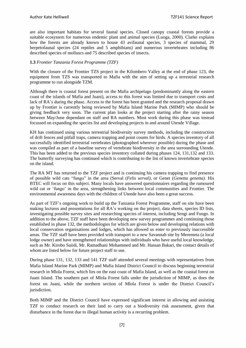
Samango Forest
GPS coordinates: (S 0758684, E 03944507, S 0758749, E 03944173)
Fig. 4 Forest site
Located outside the Marine park gates is a small area of fragmented forest approx. 15min walk from
the Camp. Two areas are currently surveyed; one for bird point counts and another for butterfly
sweep netting. The surrounding land is used for cultivation, lodges and housing, some disturbance is
present due to these activities. See Fig 11 for site locations.
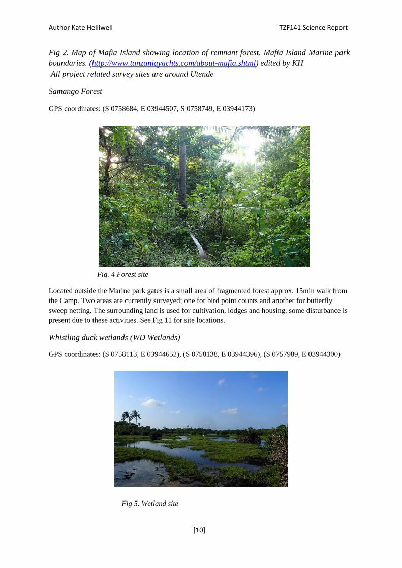
Whistling duck wetlands (WD Wetlands)
GPS coordinates: (S 0758113, E 03944652), (S 0758138, E 03944396), (S 0757989, E 03944300)
Fig 5. Wetland site
Author Kate Helliwell TZF141 Science Report
[11]
An area next to rice paddies, a site with a high abundance of avian species; the site is an open long
stretch of land surrounded by paddies, mangroves and scrubland. During the wet season the site is
less accessible due to waterlogging.
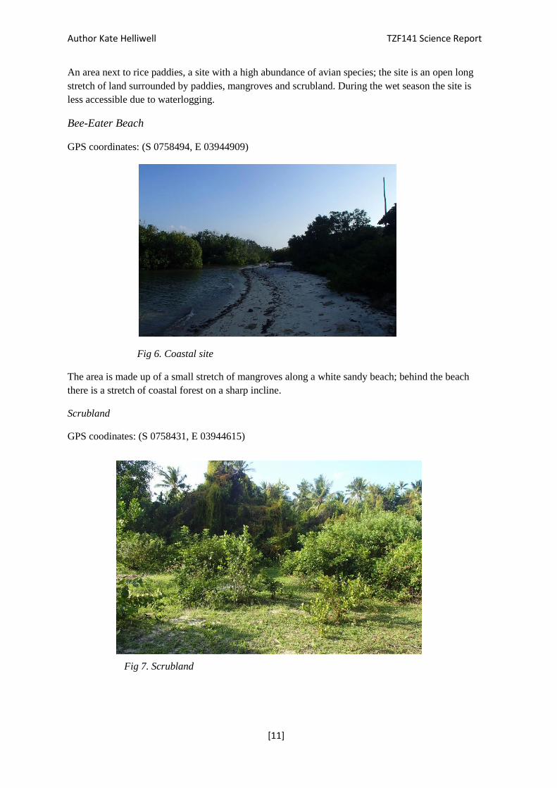
Bee-Eater Beach
GPS coordinates: (S 0758494, E 03944909)
Fig 6. Coastal site
The area is made up of a small stretch of mangroves along a white sandy beach; behind the beach
there is a stretch of coastal forest on a sharp incline.
Scrubland
GPS coodinates: (S 0758431, E 03944615)
Fig 7. Scrubland

Author Kate Helliwell TZF141 Science Report
[12]
A site used for pitfall traps; there is a lot of logging and coconut harvesting around here as well as
being a passage for the mariners returning home from the beach, so equipment placed here needs to
be well disguised. Site also used for butterfly sweep netting.
Frog ponds
GPS coordinates: (S 0758023, E 03944820)
Fig.8 Pond site
Another area near to the wetlands but accessed through the scrubland. An area of scrubland is
present on one side and dense mangroves on the other. During the wet season this area is less
accessible due to waterlogging.
Hermit Park
GPS coordinates: (S 0758478, E 03944803)
Fig 9. MIMP
Author Kate Helliwell TZF141 Science Report
[13]
This is the area inside of the marine park’s office area; a safe place to set up pitfall traps and
Sherman traps if given permission. It is a hot spot for Seychelles flying fruit bats and raptors.
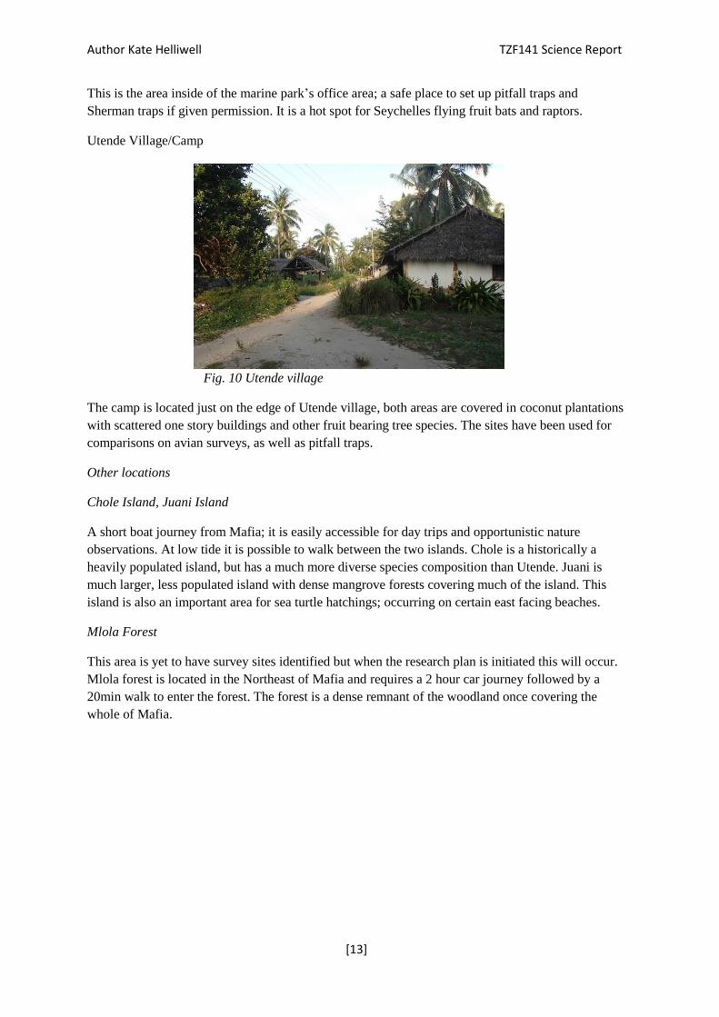
Utende Village/Camp
Fig. 10 Utende village
The camp is located just on the edge of Utende village, both areas are covered in coconut plantations
with scattered one story buildings and other fruit bearing tree species. The sites have been used for
comparisons on avian surveys, as well as pitfall traps.
Other locations
Chole Island, Juani Island
A short boat journey from Mafia; it is easily accessible for day trips and opportunistic nature
observations. At low tide it is possible to walk between the two islands. Chole is a historically a
heavily populated island, but has a much more diverse species composition than Utende. Juani is
much larger, less populated island with dense mangrove forests covering much of the island. This
island is also an important area for sea turtle hatchings; occurring on certain east facing beaches.
Mlola Forest
This area is yet to have survey sites identified but when the research plan is initiated this will occur.
Mlola forest is located in the Northeast of Mafia and requires a 2 hour car journey followed by a
20min walk to enter the forest. The forest is a dense remnant of the woodland once covering the
whole of Mafia.
Author Kate Helliwell TZF141 Science Report
[14]
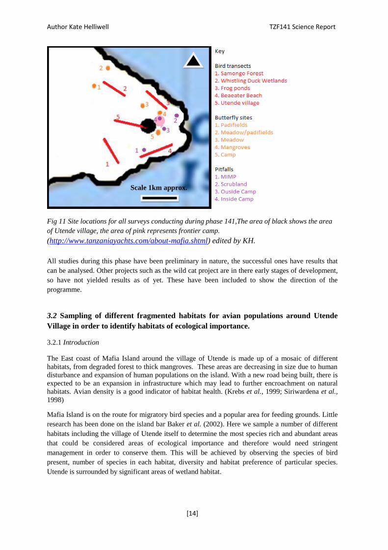
Fig 11 Site locations for all surveys conducting during phase 141,The area of black shows the area
of Utende village, the area of pink represents frontier camp.
(http://www.tanzaniayachts.com/about-mafia.shtml) edited by KH.
All studies during this phase have been preliminary in nature, the successful ones have results that
can be analysed. Other projects such as the wild cat project are in there early stages of development,
so have not yielded results as of yet. These have been included to show the direction of the
programme.
3.2 Sampling of different fragmented habitats for avian populations around Utende
Village in order to identify habitats of ecological importance.
3.2.1 Introduction
The East coast of Mafia Island around the village of Utende is made up of a mosaic of different
habitats, from degraded forest to thick mangroves. These areas are decreasing in size due to human
disturbance and expansion of human populations on the island. With a new road being built, there is
expected to be an expansion in infrastructure which may lead to further encroachment on natural
habitats. Avian density is a good indicator of habitat health. (Krebs et al., 1999; Siriwardena et al.,
1998)
Mafia Island is on the route for migratory bird species and a popular area for feeding grounds. Little
research has been done on the island bar Baker et al. (2002). Here we sample a number of different
habitats including the village of Utende itself to determine the most species rich and abundant areas
that could be considered areas of ecological importance and therefore would need stringent
management in order to conserve them. This will be achieved by observing the species of bird
present, number of species in each habitat, diversity and habitat preference of particular species.
Utende is surrounded by significant areas of wetland habitat.
Scale 1km approx.

Author Kate Helliwell TZF141 Science Report
[15]
3.2.2. Methods and Materials
GPS device
Notepad
Binoculars
Bird identification book
The sample method used to survey avian species were bird point counts. Previous literature from
phases 134 favoured this method which is the reason for continuation of point counts to keep to
previous protocol.(Fanning and Webb, 2013) Five locations were sampled; Samango Forest, Bee-
eater Beach, Frog Ponds, Whistling Duck Wetlands, and Utende village. Sites were visited 4 times
each over a period of 2 months between February and March. Surveys were undertaken by KH and
MT only. Surveys were weather dependant, if heavy rain occurred before the start time the survey
was terminated. Trial surveys at dusk were initially conducted with little success; these were later
discontinued favouring dawn surveys. Start times were standardised to 6.30-40am on survey days.
Transects were 200m long, with 5 intervals (0 m, 50 m, 100 m, 150 m and 200 m), a GPS device was
used to measure distance between points. Any birds seen between points were listed under extra
observations, as were any birds recorded during the first 3 minutes after arriving at a site. After the
initial settling period, 10 minutes of survey time was performed at each point, recording any birds
that were either heard or seen and the distance from observer recorded e.g.; less than 25m, less than
50m; birds further than 50 m were not recorded in order to standardise the area surveyed, in addition
these birds are also harder to ID (see data collection sheet Appendix 7.1). Weather conditions, GPS
location and tides were also recorded to account for variation within sites.
A Shannon Diversity index was calculated for each site, the standard error of these was also
calculated, as well as species richness and abundance, Results were tested statistically using General
Linear Model (GLM) to see if location had a significant effect on Shannon diversity index. A chi-
square test was performed, which compares the model’s residual deviance against the normal
distribution, to see if the GLM is best test for these factors. If the result is significant then we can
reject the null hypothesis in favour of the hypothesis that location has a significant effect on Shannon
diversity index, this was repeated for species richness, and abundance.
Null hypothesis: There will be no significant difference between species
richness/diversity/abundance/ across locations.
Alternative Hypothesis: There will be a significant difference between species
richness/diversity/abundance across locations.
3.2.3 Results
Twenty surveys were conducted over the phase, distributed equally between sites making for
comparable data sets. A total of 2041 birds were recorded, made up of 63 species, some of which,
such as African Pigmy Goose (Nettapus auritus) had never been recorded on Mafia Island to date.
The Shannon-Wiener index was calculated to analyse diversity, taking account of evenness and
abundance of species within sites. The results show little variation with regards to diversity index,
however all values are high for each site (Fig 12).

Author Kate Helliwell TZF141 Science Report
[16]
0
0.5
1
1.5
2
2.5
3
3.5
F rogPonds Beeeater Beach Utende Village Wetlands Samongo Forest
Shan
no
n W
ea
ver
Ind
ex
valu
e
Site
Shannon's Index comapred across all sites
Fig. 12: Bar Graph the showing differences between sites for the diversity index, Standard error
bars present
The standard error bars show there is more variance about the mean in Frog Ponds and Bee-eater
beach than in other habitats. Looking at weather conditions over the period of surveys, weather has
varied slightly, with an increase in rain towards the end of the study. No obvious trends can be seen
in weather effecting richness, abundance or diversity. See appendix 6.1
A GLM for Shannon-Wiener Index result of p=0.021 for WD Wetlands was generated, meaning we
can reject the null hypothesis for the wetlands as this site differs significantly from the others
studied. However, the chi-square analysis results in p=0.051, meaning we can accept the null
hypothesis suggesting the GLM is not the favoured model to test Shannon wiener index.
Fig 13: Box plot showing median, upper quartile, lower quartile, and maximmum and minimun
values of Species Richness at each site.
When the species richness was compared to other sites (Fig 13). The WD wetlands and Frog Ponds
had the highest species richness. The results of the GLM show that species richness of the wetlands
site is significantly higher than other locations (p<0.001). The chi-square test had a very significant
result of p<0.001, so the null hypothesis can be rejected. For the effect of location on species

Author Kate Helliwell TZF141 Science Report
[17]
richness, the GLM was a good test of the factors from the chi squared results. The species richness
of the sites differ signifcantly from one another, the wetlands being largely responsible for this
difference.
Fig 15. Box plot showing median, upper quartile, lower quartile, and maximmum and minimun
values of Abundance at each site.
The box plot shows that both the Wetlands and Utende village sites have the highest abundance of
individuals. The results of the chi-square test (p=0.038) means that the null hypothesis can be
rejected, favouring the alternative hypothesis that abundance differs significantly across locations.
The WD Wetlands is the location influencing this result, (p=0.045) meaning the abundance of
individuals at this location differs significantly from the other sites. Utende village has the lowest
species richness, but a high abundance of individuals; when looking at the species composition, two
species; the Village weaver (Ploceus subaureus) and House crow (Corvus splendens) dominate, with
relatively higher proportions (Fig 21) and overall abundance compared to other species.
Habitat preference
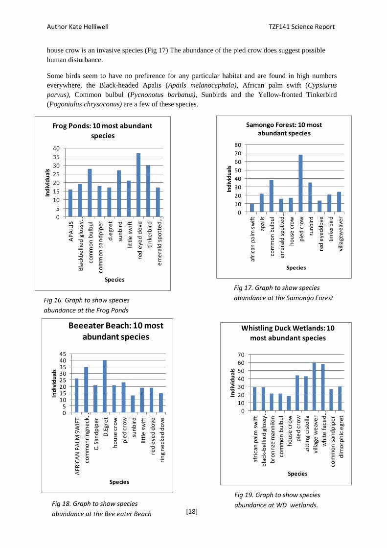
The 10 most abundant species in each habitat have been plotted on Fig. 16-20 below to compare
species presence and absence in each habitat. On Bee-eater beach the most abundant species are the
Dimorphic egret (Egretta Dimorpha) and Common ringed plover (Charadrius hiaticula), both are
waders, the plover is a flocking bird so is only seen in large groups; hence the large amount
recorded.
Frog ponds is an interesting site as none of the scavengers such as Crows or Weavers are found in
high numbers here, suggesting the area has had less anthropogenic disturbance (Fig 16). This site
also hosts many Dove species.
The species in highest abundance at WD Wetlands are the Village weaver and White-faced whistling
duck (Dendrocygna viduata) one of which is a scavenger, suggesting human disturbance. The
Whistling duck has not been found in any other habitat, suggesting the wetlands are its preferred
habitat. The Zitting cisticolla (Cisticola juncidis) is also not found in any other habitat other than
Frog ponds, suggesting this bird likes inland wetlands as well. The Samongo Forest is dominated by
Pied crows (Corvus albus) relative to other species. The pied crow is native to Africa whereas the
Author Kate Helliwell TZF141 Science Report
[18]
0
5
10
15
20
25
30
35
40
AP
AIL
IS
Bla
ckb
elli
ed
glo
ssy…
com
mo
n b
ulb
ul
com
mo
n s
an
dp
iper
d.e
gre
t
sun
bir
d
littl
e s
wif
t
red
eye
d d
ove
tin
kerb
ird
em
era
ld s
po
tte
d…
Ind
ivid
ual
s
Species
Frog Ponds: 10 most abundant species
0
10
20
30
40
50
60
70
80
afri
can
pa
lm s
wif
t
apa
lis
com
mo
n b
ulb
ul
em
era
ld s
po
tte
d…
ho
use
cro
w
pie
d c
row
sun
bir
d
red
eye
dd
ove
tin
kerb
ird
villa
gew
eav
er
Ind
ivid
ual
s
Species
Samongo Forest: 10 most abundant species
010203040506070
afri
can
pal
m s
wif
t
bla
ck-b
elli
ed
glo
ssy
…
bro
nn
ze m
ann
ikin
com
mo
n b
ulb
ul
ho
use
cro
w
pie
d c
row
zitt
ing
cist
olla
villa
ge w
eav
er
wh
ite
fac
ed
…
com
mo
n s
and
pip
er
dim
orp
hic
egr
et
Ind
ivid
ual
s
Species
Whistling Duck Wetlands: 10 most abundant species
05
1015202530354045
AFR
ICA
N P
ALM
SW
IFT
com
mo
nri
ngn
eck
…
C. S
and
pip
er
D.E
gre
t
ho
use
cro
w
pie
d c
row
sun
bir
d
littl
e s
wif
t
red
eye
d d
ove
rin
g n
eck
ed
do
ve
Ind
ivid
ual
s
Species
Beeeater Beach: 10 most abundant species
house crow is an invasive species (Fig 17) The abundance of the pied crow does suggest possible
human disturbance.
Some birds seem to have no preference for any particular habitat and are found in high numbers
everywhere, the Black-headed Apalis (Apails melanocephala), African palm swift (Cypsiurus
parvus), Common bulbul (Pycnonotus barbatus), Sunbirds and the Yellow-fronted Tinkerbird
(Pogoniulus chrysoconus) are a few of these species.
Fig 19. Graph to show species
abundance at WD wetlands. Fig 18. Graph to show species
abundance at the Bee eater Beach
Fig 16. Graph to show species
abundance at the Frog Ponds
Fig 17. Graph to show species
abundance at the Samongo Forest
Author Kate Helliwell TZF141 Science Report
[19]
3.2.4 Discussion
The results of the Shannon Index suggest that all sites have relatively high species abundance and
evenness. However the variability of standard errors (Fig 12) in Frog ponds and Bee-eater beach
suggest these two sites differ from the other survey sites in species composition and consistency.
This could be due to presence of migratory birds that come and go or they might be classed as
corridors between habitats, so all traffic does not stop in the habitat.
Wetlands are known for their diversity of bird species and are hot spots for wildlife across the world,
this could account for richness, abundance and the diversity index being significantly different to
other sites. (Weller, 1999) This site seems to be an important feeding ground for water birds, such as
the White-faced whistling ducks and Zitting cisticolla that have selected this environment over
others (Fig 16-20).
With regards to Utende village; the abundance of individuals was relatively higher than expected but
the species richness relatively small in comparison. This could be explained by the two scavenger
species found in high proportions (Fig 2). These birds live in flocks and are very well adapted to
living in manmade habitats.
Samongo Forest was similar in species richness to that of Utende village, as well as the bird species
present (Fig 17, 20). Previous studies show that Corvid abundance is a sign of habitat fragmentation
and have found higher abundance of such species in areas of cultivation than forested areas.
(Andren, 1992) The forest site suffers from a lot of human disturbance that may explain its similarity
to Utende village. A less disturbed forest area would be a useful comparison for future studies.
The Frog ponds had a relatively low number of scavenger species compared to other sites; this could
be due to being the furthest site from Utende village. Scavengers are known to live in human
habitats, so this would be a reasonable explanation. The high species richness could also be due to
lack of human interference, although grazing and mangrove harvesting still occur in the area.
020406080
100120140160180200
apa
lis
bla
ck b
elli
ed
…
bro
nze
ma
nn
ikin
com
mo
n b
ulb
ul
ho
use
cro
w
pie
d c
row
sun
bir
d
villa
ge w
eav
er
tin
kerb
ird
wh
ite
do
ve
Ind
ivid
ual
s
Species
UtendeViilage: Ten most
abundant species
Fig 20. Graph to show species
abundance at Utende village site.
Author Kate Helliwell TZF141 Science Report
[20]
The abundance of all birds increased as the study continued across most locations. The change from
a hot, dry winter to a humid, wetter summer could account for the increase in abundance of
individuals at certain sites. For instance, the wetlands became more waterlogged as the study
progressed, which could have led to an increase in food for the birds. A look at the vegetation and
other fauna in future studies could explain this variation over time.
Surveyors inability to identify certain bird calls of more conspicuous species will have led to error in
early surveys, which will account for bias in species recording where surveyors were less
experienced. To account for this error; in future, surveyors should undertake more thorough training
of bird calls before undertaking further studies.
In conclusion, the sites of most interest seem to be Whistling Duck Wetlands for the abundance and
species richness present here; and Frog Ponds due to the lack of scavenger species and high species
richness. A study of vegetation composition would also help to account for some species present.
The site of least interest is Utende village as expected; however the area still hosts a number of
species, the majority of birds are human-adapted species that do not risk habitat loss. Bee-eater
beach hosts many migratory birds; many of them are the same as species found at the wetlands and
ponds, making it another interesting site. Samongo Forest is already relatively degraded; therefore
this site would be a good comparison to a primary forest habitat.
The next phase will focus on the 3 habitats with the highest abundance of species and individuals.
The same methods will be used to monitor changes throughout the year. If the project moves to
Mlola forest, Samongo Forest would be used as a comparison site.
3.3 Butterfly presence in different habitats around Utende indicating ecological health of
fragmented habitats
3.3.1 Introduction
There are 1583 known species of butterfly in Tanzania at present, 134 of which are known to be
endemic (Kielland, 2009). Butterflies are recognised as an important ecological indicator species and
are often used by biologists to assess the value of individual forests (Gowda et al., 2011; Burgess
and Clarke, 2000). Butterflies are pollinators of flowering plants, their larvae feed on forest
vegetation allowing alternative flora to break through and they are also prey for larger forest
dwelling organisms. Knowledge of a species’ preferences, habits and species interrelationships can
provide an overview of ecosystem health of the flora and fauna likely to be supported by the
invertebrates (Kielland, 2009). Furthermore, it is known that industries such as logging and
agriculture directly affect the range of butterfly species, allowing them to be used to identify early
deterioration of habitats (Pollard and Yates, 1994).
3.3.2 Methods
Nigel Venter’s Butterfly trap
Nigel Venter’s traps have been baited using over-ripened banana mixed with yeast and sugar, placed
in the Frontier camp and on the neighbouring field for one week; checked twice daily with the bait
replaced during this check, traps were hung 0.5m from the ground off branches.

Author Kate Helliwell TZF141 Science Report
[21]
Sweep netting for butterflies
Materials
Butterfly sweep nets (2)
Glass specimen jars
Callipers
Camera
GSP device
Note pad
Surveys were carried out at selected sites both known and unknown for species presence around the
village of Utende. These sites include: Paddy fields, Meadow, Mangrove/scrubland and areas of
fragmented forest. Survey lengths varied between 30-40 minutes and were undertaken during the
morning between 10-11am when species are known to be most active. The nets were moved around
in a figure of eight motion to catch butterflies. Once a butterfly was caught; the species was carefully
put into a jar, measured for wing span, wing length (from tip to apex) and abdomen length, it was
then photographed to be identidied back at camp if the species was unknown. At each site, the
weather conditions and GPS locations were recorded. The more experienced surveyors recorded
observational data in the field.
Results were tested statistically using General Linear Model (GLM) to see if location had a
significant effect on abundance of Butterflies. A chi-square test was carried out, which compares the
model’s residual deviance against the normal distribution to see if the GLM model is a good fit to
test these factors. If the result is significant then we can reject the null hypothesis in favour of the
hypothesis that location has a significant effect on abundance, this was repeated for species richness,
and Shannon diversity index species composition.
Species composition was measured by numbering each species and using GLM and chi-square to
test whether species present at each site differed significantly.
Null hypothesis: There is no significant difference between species richness abundance, Shannon
diversity index or species composition across locations.
Alternative hypothesis: There is a significant difference between species richness abundance,
Shannon diversity and species composition index across locations.
3.3.3 Results
The study is currently ongoing, 14 new species have been identified over the study period, the
majority of which are endemic the Tanzania. It is already evident that some of the study sites have
higher species richness than others, for instance the forest and paddy fields have high species
richness and abundance for all individuals. (Fig 22)

Author Kate Helliwell TZF141 Science Report
[22]
Fig21: Box plot showing median, upper quartile, lower quartile, and maximmum and minimun
values of Species richness each site.
The results of the GLM for species richness were significant between locations; with mangroves
having significantly lower richness than others p=(0.0130); favouring the alternative hypothesis
that species richness does differ between locations. The chi-squared (p<0.0001) was highly
significant, favouring the GLM model .The mangroves have the lowest species richness overall.
Fig 22. Box plot showing median, upper quartile, lower quartile, and maximmum and minimun
values of Species Composition at each site.
The results of the GLM for species composition came out with a significant result between
locations; with mangroves having significantly more species than the others (p=0.00311); favouring
the alternate hypothesis. The chi-square analysis was also significant, meaning we can accept the
GLM model; that the location does effect species composition (p=0.0106). The box plot Fig 22
shows that the Forest has the highest spread of species, followed closely by the Meadows and Paddy
fields. The number of species present at the mangroves is different to other locations as well as the
composition.
The GLM and chi-square results for abundance and Shannon-Weaver index were both insignificant,
meaning we can accept the null hypothesis that the factors do not differ between locations.
Author Kate Helliwell TZF141 Science Report
[23]
3.3.4 Discussion and Recommendations
From current data; it can be concluded that the sites differ on both variables of richness seen from
Fig 22. Looking at the mangroves, it is interesting to note that their low numbers of species were
found in high numbers, many of these species were found in other habitats, but in much lower
abundance. This suggests the area could be a niche for certain species that can live in harsher
conditions.
The forest seems to be an area that attracts a diverse number of species, indicating that it is a healthy
environment for wildlife and should therefore be conserved. Forests are known for having high
species richness in comparison to other habitats so this was to be expected. (Burgess and Clarke,
2000) Currently some of this forest is used for cultivation of cassava, a potato-like vegetable
common in Tanzania and is experiencing human disturbance. If further studies were conducted here
to produce a significant data set, this could be used as a management instigator to increase protection
of the forest.
With regards to errors, a bias may occur due to some butterflies being easier to catch as their flight
pattern or speed meant they were in the right location, this is why observations should also be taken,
(refer to methods)
The proposed research for the next phase will continue to survey a range of habitats around the area
of Utende, eventually extending to areas further afield such as Mlola forest and the neighbouring
islands.
3.4 Expansion of the species list of reptiles, and amphibians, on Mafia Island with the aid of
pitfall trapping and active searches.
3.4.1 Introduction
Herpetofauna species are on the decline worldwide due to factors such as loss of habitat, water
contamination, global climate change and the chytrid fungus that devastates populations of
amphibians worldwide. (Alford and Richards, 1999; Stuart et al., 2004; Pounds et al., 2004; Gower
et al., 2012) This decline has led to much research being conducted in order to develop management
schemes and aid in their conservation efforts. Much work has been conducted over the last decade in
Tanzania, especially in the mountainous areas such as the Nguru Mountains in east Tanzania. Where
high endemism has been found and hotspots for biological diversity have been discovered. This
research has led to the area being recognized as an ecologically important area of Tanzania.
(Menegon et al., 2008) Less thorough research has been conducted on the coastal forests of
Tanzania, this research is lacking in consistency and far from complete. (Burgess et al., 2000) A
study on Mafia Island could fill in this knowledge gap and may reveal endemic species. The
majority of species of reptiles and amphibians can be found in waterlogged areas, they make up a
relatively large amount of terrestrial biomass in forests and prey on insect populations, stabilising
forest ecosystems. A decline in any predator can upset the balance of an ecosystem, favouring
species that in large numbers may cause detrimental effects on the habitat. This is evident with large
predators but could also affect smaller predators. (Ripple and Beschta, 2012) A study on species
presence on Mafia could reveal species endemism, especially in areas such as Mlola forest, a
relatively untouched area of forest.
Author Kate Helliwell TZF141 Science Report
[24]
3.4.2 Methods
Setting traps
Pitfall Trapping
Buckets x3
Drift fence
Duct tape string
Trowel/shovel
Machete
Sampling traps
Sample specimen bags
Ruler
Camera
Gloves for handling specimens species keys
Four drift fences (10m long) were placed in different locations, each consisting of 3 buckets (a total
of 12 buckets, 3 per transect) for 12 days at a time. Traps were checked once daily, at dawn. Four
habitats were surveys in this way: MIMP, Scrubland, Inside camp, Outside camp. See GPS
coordinates in Appendix 6.1. All species present were recorded and released, using correct handling
procedures.
For different phylum measurements were recorded; although all species were recorded, the main
focus was the herpetofauna
Reptiles: Using Vernier callipers to record body length (nose to tip of tail), body width (at widest
part), tail length, head length, head width and for lizards leg length (knee to longest toe). Specimens
have also been weighed and photos taken where immediate identification was not possible.
Arthropods: Recording family of individuals. We have taken a particular interest in millipedes as
they are said to be the most endemic of all species (Burgess et al., 2000). We have taken records of
individual identifying features including length, width, patterning and photographs where possible.
Crustaceans: In each case we measured Shell species and hermit crab species for shell width (at
widest point), length, primary leg length, length of largest claw as well as the terminal segment of
this limb (pincer). From these we can estimate individual size; for some individuals; leg, claw and
pincer measurements were not attainable due to species shyness.
Amphibians: Photographs of new species were taken to assist with ID as well as measurements
(Knee to longest toe, body length, width)
Active Searches
This was complimented with active searches along the transect over an area 25 m wide. Active
searches were undertaken twice for each site.

Author Kate Helliwell TZF141 Science Report
[25]
3.4.3 Results
Over 82 individuals across all phyla were recorded over a two week period. Some individuals were
not identifiable due to lack of ID resources. The site location of MIMP had a high catch rate of
crustaceans in comparison to other species. No analysis has been done as the data is deficient due to
the survey being in its early stages.
3.4.4 Discussion and Recommendations
We were successful in discovering the presence of species previously unknown to be on Mafia and
found the two techniques complemented one another.
In terms of habitats, the area at the Marine Park has a higher number of crustacean catches than other
sites. Wet areas seem to have been the most successful areas so far. Surveys will continue with the
hope of setting up a project in Mlola forest using similar methods, as it is suspected that there is
higher biological diversity in this forest. If the study were to reveal species endemism or ecological
hotspots, this could lead to increased legislation to better manage the habitats on Mafia.
3.5 Wild Cats; Camera Trapping to discover the presence of a wild cat “fungo” around Utende
and surrounding area.
3.5.1 Introduction
The Island of Mafia is set off the coast of Tanzania in the Indian Ocean. Not a lot is known about the
terrestrial fauna that inhabit the island. There have been reports of a medium sized cat-like mammal
around the village of Utende. A project of this kind has never been conducted on Mafia Island.
Although projects in other locations have yielded positive results using similar methods (Anile et al.,
2009; Kilshaw and Macdonald, 2011). As forests become more fragmented and greater habitat loss
occurs, the likelihood of the presence of such a species dramatically declines. If the project were to
successfully identify the so called ‘fungo’; further studies could then be conducted to monitor its
presence over time and location to help to conserve the habitat it exists within. A preliminary survey
was conducted to help narrow the scope of a full study. This involved interviewing local residents
and asking them to describe the target if they had seen it. The results of the preliminary survey
suggest that the target is cat-like, nocturnal and spotted. With the preliminary survey, a first-hand
sighting, considering known distribution and habitat (Kingdom, 1997), the list of possible species
has been narrowed to the Serval (Felis serval), the Genet (Genetta genetta) or a similar felid. This
survey is intended to investigate and identify this elusive species with the interviews of locals to
source locations for camera trapping devices to be set.
3.5.2 Methods
Sighting Surveys
In order to maximise the chances of capturing a wild cat in our camera trap survey we carried out
questionnaires with local people to utilise the wealth of local knowledge. A set of questions was
agreed. Questionnaires began with an introduction to who we were and what we were doing,
followed by a quick section on who they were (where they were from, profession, age...) and ending
in a series of neutrally phrased questions. These questions ran through whether the individual had
seen a large cat and if so where, a description, frequency of sightings, how far away they were, time
of day and whether they knew of anybody else that had seen one. Finally a selection of pictures was

Author Kate Helliwell TZF141 Science Report
[26]
Fig 23. An example of a camera trap in the
field.
shown to the interviewee and they were asked to select the one that best resembles there
observations (4 pictures were used; a Domestic cat, a Wild cat (Felis sylvestris), a Serval cat and a
Common Genet). Translation of this list was performed by Rama Mohammad, a local contact, who
also accompanied us.
Camera Trapping
The location of camera trap placement will be determined by the results of the interviews. Only 4
camera traps are available for this study, so the 4 most promising sites will be selected and surveyed
for the duration. The majority of survey sites will be focused around the village of Utende.
All selected sites will be within walking distance of the Frontier Tanzania camp and as such no
special transport will be required. As the survey will take place in and around a settlement it is likely
that ideal camera trap locations will be on private land. All steps will be taken to determine if the
land is owned and to receive permission if that is
the case.
Camera traps will be deployed every evening
before sunset and retrieved every morning after
sunrise. There are two main reasons for this. The
first being that a preliminary study suggested
that the target species was most active during
this time as is in line with activity patterns of
(F. serval) and (G. genetta). The second reason
is security; even though the camera traps are
contained within a metal housing and secured in
place with security cables they are to be placed
along trains that are used by both wildlife and
locals and are at risk of theft.
The traps will be set at the eye level of the
suspected wild cat, approximately 50 cm above
the ground. In order to calculate the size of the
animal photographed, a 1 m pole will be placed
within camera shot of the traps with tape at different heights marked up the pole. To standardize the
location, markings will be made at the trees with
traps attached so that the traps are secured in the
same placed every day. Any possible sitings will
be recorded, the height measured and identification to species level made if possible. Fig 23 is an
example of how the traps are set.
Traps are digital and have an infra-red light that detects changes in heat, this acts as a motion sensor,
so any individual moving in front of the camera will be detected as having a different temperature to
its background and a photograph will be taken. These sensors work best at night when the
background temperature is lower.
3.5.3 Results
Interviews are currently being conducted, the results of which will lead to site selection. So far many
locals have mentioned that they have seen the so called “fungo”, the consensus is that the cat is
Author Kate Helliwell TZF141 Science Report
[27]
nocturnal and can be seen at night in forested areas. Some local farmers say that the cat preys on
chickens and destroys agricultural land. No results have been collected from camera traps as of yet.
3.5.4 Discussion and Recommendations
If the presence of a “fungo” was documented on Mafia Island, this could be used as a flagship
species for further conservation effort. Much of the habitat around Utende is becoming more and
more fragmented, potential niches of these suspected forest-dwelling species may be decreasing,
meaning these animals are being pushed further into the small forests. If a population survey was
done on this species, we could monitor the cat’s presence over time to account for decline or
increase and set controls on agricultural activities in certain areas to account for habitat loss. For
instance; buffer zones could be introduced around forested area to reduce the decline of forests
(Gascon et al., 2000).
3.5 New Species
Avifauna
African pigmy gouse Nettapus auritus
Burchels Coucal Centropus burchelli
Crab plover Dromas ardeola
Lepidotera
Short barred sapphire lolaus aemulus aemulus
Common Joker Byblia ilithyia
Gold banded forester Euphhaedra neophron neophron
False dotted boarder belenois thsa thysa
Tree nymph Sallya Rosa
Sapphire Lolaus silas
Cream striped owl cyligram malatona
Common hottentot skipper Gegenes niso
Forest queen Euxanthe wakefield
Novice Amauris ochleaochlea
Paul’s Buff Pentili pauli
White buff Teriomima subpuntata
Brown Play Boy Deudorix antalus
Natal acraea Acraea natalica
Author Kate Helliwell TZF141 Science Report
[28]
Myriapoda
African Red legged millipede Epibolus pulchripes
Amphibian
Reed frog Afrixalus sp
Reptiles
Boulengers Scrub Lizard Nucrus Boulengeri
Flap- necked Chameleon Chamaeleo Dilepis
4.0 Project Direction
4.1 Proposed educational work programme for next phase
Staff will continue to train new RAs in biodiversity survey techniques listed. Surveys will be carried
out on Reptiles, Birds and Butterflies, in and around Utende as well as further afield continually in
order to add to the species list for Mafia and to identify possible species of interest to develop a more
in-depth research programme. It will also aid in training and teaching of survey techniques to RA’s
to ensure correct procedures are followed when access to the forest is available.
4.2 Contributions of future work
MIMP and the District Council are both keen to have research conducted to assess biodiversity (and
any associated loss) in both disturbed and undisturbed sections of the forest, so that any adverse
effects of anthropogenic activity can be mitigated by working with the local community. As a project
of this nature will take time, it is hoped that a long term, ongoing study can be set up with MIMP
and the District Council to monitor the terrestrial flora and fauna within the forest on the
archipelago.
The results of any surveys carried out in the forest on Mafia can hopefully be used to work with
MIMP and the District Council to develop some form of ecotourism programme for the terrestrial
wildlife on the island. The “fungo” or wildcat could be a focus of ecotourism if hides were to be
erected in the forests where the cats were best seen. As very little terrestrial research has been done
on Mafia previously and most work has focussed on the marine biodiversity instead, a project of this
nature would provide a unique and important opportunity to learn more and raise awareness about
the terrestrial biodiversity in Mafia’s coastal forests.
Acknowledgments: Jen Freer, for her assistance with Statistical Analysis.
Matt Tantons for contributions to wild cat project and all areas of data
collection across projects and Alex Caldwell for editing.
Author Kate Helliwell TZF141 Science Report
[29]
5. References
Alford, R.A. & Richards, S. J. (1999): Global amphibian declines: a problem in applied ecology.
Annu. Rev. Ecol. Syst. 30: 133-165.
Andren, H (1992) Corvid Density and Nest Predation in Relation to Forest Fragmentation: A
Landscape Perspective. Ecology 73:794–804.
Anile .S, Bizzari. L. & Ragni. B (2009) Camera Trapping the European wildcat (felis silvestris
silvestris) in Sicily (Southern Italy: Preliminary results Hystrix It. J. Mamm. (n.s.) 20(1): 55-60
Burgess, N. & Clarke, G. (Eds.). (2000). Coastal Forests of Eastern Africa. IUCN, Gland,
Switzerland and Cambridge, UK.
Burgess, N. D., Mwasumbi, L. B., Hawthorne, W. J., Dickinson, A. & Doggett, R. A. (1992)
Prelimianry Assessment Of The Distribution, Status And Biological Importance Of Coastal Forests
In Tanzania. Biological Conservation, 62, pp. 205-218.
Caplan, P. (2011). Population and ethnicity. (http://mafia-islandtanzania.gold.ac.uk/population/),
accessed on the 29th January, 2013.(http://www.tanzaniayachts.com/about-mafia.shtml) accessed on
15th march 2014
Chami, F. A. (1999). The Early Iron Age On Mafia Island And Its Relationship With The Mainland.
Azania, 34, pp. 1-10.
Clarke, G.P. (2000). Climate and Climatic History. The Coastal Forests of Eastern Africa. IUCN
Publication Unit. pp. 47-67.
Fanning, E & Webb, E. (2013) Frontier Tanzania Forest Project 133 Science Report
Frontier Gap pp. 5-6.
Gascon. C, Williamson, B & G. A. B., da Fonseca (2000) Receding Forest Edges and Vanishing
Reserves Science: 288 (5470), 1356-1358. [DOI:10.1126/science.288.5470.1356
Gower, D. J, Doherty-Bone, T. M., Aberra, R. K., Mengistu, A, Schwaller, S., Menegon, M, de Sá,
Saber, S A. Cunningham, A. A, Loader, S. P.(2012) High prevalence of the amphibian chytrid
fungus (Batrachochytrium dendrobatidis) across multiple taxa and localities in the highlands of
Ethiopia The Herpetological Journal, Volume 22, Number 4, , pp. 225-233(9)
Goossens, B., Mbwambo, H., Msangi, A., Geysen, D. & Vreysen, M. (2006). Trypanosomosis
Prevalence In Cattle On Mafia Island (Tanzania). Veterinary Parasitology, 139, pp. 74-83.
Greenway, P. J., Rodgers, W. A., Wingfield, R. J. and Mwasumbi, L. B. (1988). The Vegetation Of
Mafia Island, Tanzania. Kirkia, 13, pp. 197-238.
Iddi, S. (1997). Eastern Arc Mountains and their National and Global Importance. Forest and
Beekeeping Division, Dar es Salaam, Tanzania.
Kaale, B. K. (2004). Review Of Trade Issues For Management Of Tanzania’s Coastal Forests.
Eastern Africa Coastal Forest Ecoregion (EACFE) Programme Development. Dar Es Salaam,
Tanzania.

Author Kate Helliwell TZF141 Science Report
[30]
Kingdom, J (1997). The Kingdom Field Guide To African Mammals. Christopher Helm, London,
UK.
Kilshaw, K. & Macdonald, D.W. (2011). The use of camera trapping as a method to survey for the
Scottish wildcat. Scottish Natural Heritage Commissioned Report No. 479.
Krebs. J, Wilson. J, Bradbury. R & Siriwardena G., (1999) “The second silent spring?”Nature, vol.
400, no. 6745, pp. 611–612,
Kilshaw, K. & Macdonald, D.W. (2011). The use of camera trapping as a method to survey for the
Scottish wildcat. Scottish Natural Heritage Commissioned Report No. 479.
Luoga, E. J. (2000). The Effects Of Human Disturbances On Diversity And Dynamics Of Eastern
Tanzania. Miombo absorescent species. pp. 114
Makundi, W. R. & Okiting Ati, A. (1995). Carbon Flows And Economic Evaluation Of Mitigation
Options In Tanzania’s Forest Sector. Biomass and Bioenergy, 8 (5), pp. 381- 393.
Menegon, M., Doggart, N., & Owen, N. (2008) The Nguru mountains of Tanzania, an outstanding
hotspot of herpetofaunal diversity Acta Herpetologica 3(2): 107-127,
Mittermeier, R.A., Myers, N., Thomsen, J.B., Fonseca, D.A. & Olivieri, S. (1998). Biodiversity
Hotspots And Major Tropical Wilderness Areas: Approaches To Setting Conservation Priorities.
Conservation Biology, 12, pp. 516-520.
Myers, N., Mittermeier, R. A., Mittermeier, C. G., da Fonseca, G. A. B. & Kent, J. (2000).
Biodiversity Hotspots For Conservation Priorities. Nature, 403, pp. 853 – 858.
Ngusaru, A.S., Tobey, J. & Luhikula, G. (2001). Tanzania State of the Coast 2001: People and the
Environment: Dar es Salaam.
Pounds, J. A., Bustamante, M. R., Coloma, L. A., Consuegra, J. A., Fogden, M. P. L., Foster, P. N.,
La Marca, E., Masters, K. L., Merino-Viteri, A., Puschendorf, R., Ron, S. R., Sanchez-Azofeifa, G.
A., Still, C. J., Young, B. E. (2006) Widespread amphibian extinctions from epidemic disease driven
by global warming. Nature 439:161-167.
Siriwardena, R. S, Baillie. T, Buckland. R. S, Fewster, T. G. Marchant, & Wilson J. D (1998),
Trends in the abundance of farmland birds: a quantitative comparison of smoothed Common Birds
Census indices, Journal of Applied Ecology, vol. 35, no. 1, pp. 24–43,
Ripple, W. J., Beschta, R. L. (2012) Large Predators Limit Herbivore Densities in Northern Forest
Ecosystems European Journal of Wildlife Research (Impact Factor: 1.36). 58(4).
DOI:10.1007/s10344-012-0623-5
Stuart, S. N., Chanson, J. S., Cox, N. A., Young, B. E., Rodrigues, A. S. L., Fischman, D. L., Waller,
R. W. (2004) Status and trends of amphibian declines and extinctions worldwide. Science 306: 1783-
1786.
Swai, G., Shirima, D. D., Makero, J., Emanuel, J., Yahaya, A. & Olrik, B. (2011). Identification Of
Flora And Fauna And Their Conservation Status: A Case Study Of Mafia Island ‘Coastal Forest
Mosaic’. Rufford Small Grants Foundation (RSG).

Author Kate Helliwell TZF141 Science Report
[31]
Weller. M. W. (1999) Wetland Birds: Habitat Resources and Conservation Implications, Cambridge
University Press, Great Britain, UK,
6. Appendices (Attached)
6.1 Data sets
6.2 Species List
Top Related