
![[XLS]himachal.nic.inhimachal.nic.in/WriteReadData/l892s/16_l892s/sirmour... · Web view4086 5/19/2017 13:08:28 5/19/2017 13:08:28 77.172203063965 31.103300094604 11 171001 2101200401](https://static.fdocuments.in/doc/165x107/5aeef98b7f8b9ac62b8cbf9a/xls-view4086-5192017-130828-5192017-130828-77172203063965-31103300094604.jpg)


Languages
Pages
Legal

SURVEY DUCUMENT OF DISTRICT KINNAUR
-1 - GEOLOGICAL WING
DEPARTMENT OF INDUSTRIES, UDYOG BHAVAN BEMLOE,
SHIMLA-171001 (H.P.)
SURVEY DOCUMENT IN RESPECT OF MINOR MINERALS DEPOSITS OF DISTRICT KINNAUR
ANY OBJECTIONS WITH RESPECT TO THE SURVEY DOCUMENT CAN BE SUBMITTED TO THE MINING OFFICE DISTRICT KINNAUR AT RECKONG PEO WITHIN 21 DAYS (w.e.f 8/12/2017 to 28/12/2017) OF IT’S PUBLICATION ON THE DISTRICT PORTAL .

SURVEY DUCUMENT OF DISTRICT KINNAUR
-2 - GEOLOGICAL WING
DEPARTMENT OF INDUSTRIES, UDYOG BHAVAN BEMLOE,
SHIMLA-171001 (H.P.)
1. Introduction
There is a common feeling amongst general public that mining activity in
river beds creates environmental pollution and damage to the public and private
property and to safeguard it, numbers of Petitions are being filed in the court of law
for justice. A similar Writ Petition No. 188/2001 was filed in Hon’ble High Court
during 2001 titled Jagjit Singh Dukhiya V/s State of H.P. pointing a very important
issue with respect to the mining operation in and upon the river beds of the State of
Himachal Pradesh especially the rivers flowing near the bridges because of vital
concern for the safety of the bridge structure. It was further stated in the petition
that indiscriminate mining in and upon river beds has been going on unchecked and
unregulated causing irreversible depletion as well as hazards and damage to the
ecology and environment, including the change of course by the river because of
the hazardous, unchecked and totally unregulated mining, as also, in the process
threatening the safety of bridges and other structures causing various related
problems. The Hon.ble High Court of Himachal Pradesh while passing the order on
16-12-2002 in the said Petition directed the State Government to constitute an
appropriate Committee of the Officers and experts of the State Government to
formulate the mining policy. The Govt. vide Notification Dated 16-1-2004
constituted a Committee under the Chairmanship of A.C.S. -cum -Secretary
Industries to the Govt. of Himachal Pradesh including members from other
Departments to formulate Policy and Guidelines for regulation and control of
SURVEY DUCUMENT OF DISTRICT KINNAUR
-3 - GEOLOGICAL WING
DEPARTMENT OF INDUSTRIES, UDYOG BHAVAN BEMLOE,
SHIMLA-171001 (H.P.)
mining operation in and upon the rivers/streams/khallas. Accordingly, River/Stream
Bed Mining Policy Guidelines for the State of H.P.-2004 was framed and notified
vide notification No. Ind.-II(E)2-1/2001 dated 28-2-2004 (published on 20-3-2004
in extra ordinary Gazette) incorporating guidelines to protect environment and
maintain ecological balance, to support an appropriate environment friendly
utilization of mineral resources of the River/Stream, their proper replenishments
and protection of private and Government property with following Principles and
Objectives:-
1.1 Principles:-
o River natural resources must be utilized for the benefit of the present and
future generation
o It is the responsibility of all sectors to maintain the river resources of the
State and to ensure that it is prudently managed and developed
o Awareness is essential to ensure the protection of natural resources of river
and their proper utilization and conservation
1.2 Objectives:-
To ensure
• Scientific and systematic mining
• Conservation of minerals
• Protection of environment and ecology
• Proper replenishment of river beds
• Proper protection of river banks
• Protection of soil erosion
• Protection of bridges and other structures of public utility and
• Checking of illegal mining
In the said policy guidelines, it was provided that District level river/stream
bed mining action plan shall be prepared according to 9.2 Strategy 2. The action
plan shall be based on a survey document of the existing river/stream bed mining in
each district and also to assess its direct and indirect benefits and identification of
the potential threats to the individual rivers/streams in the State.

SURVEY DUCUMENT OF DISTRICT KINNAUR
-4 - GEOLOGICAL WING
DEPARTMENT OF INDUSTRIES, UDYOG BHAVAN BEMLOE,
SHIMLA-171001 (H.P.)
This survey shall be conducted by Geological Wing, Department of Industries,
Himachal Pradesh and shall contain:-
a) District wise detail of Rivers/Streams/Khallas; and
b) District wise details of existing mining leases/ contracts in
river/stream/khalla beds
Based on this survey, the action plan shall divide the rivers/stream of the State
into the following two categories;-
a) Rivers/ Streams or the Rivers/Stream sections selected for extraction of
minor minerals
b) Rivers/ Streans or the Rivers/Stream sections prohibited for extraction of
minor minerals
Based on the action plan as mentioned above, mining leases/ contracts shall
be granted in accordance to the Himachal Pradesh Minor Mineral (Concession)
Revised Rules, 1971and also observing the River/Stream Bed Policy Guidelines for
the state of H.P. 2004. Accordingly, the survey report of the river beds/ parts of
river beds of District Kinnaur has been prepared. The rivers/streams were studied
based on the following parameters excluding the hill slope mining:-
a) Geomorphological studies
i) Place of origin
ii) Catchment area
iii) General profile of river stream
iv) Annual deposition factor
v) Replenishment
vi) Total potential of minor mineral in the river bed
b) Geological Studies
i) Lithology of catchment area
ii) Tectonics and structural behavior of rocks
c) Climatic parameters
i) Intensity of rainfall
ii) Climate zone
SURVEY DUCUMENT OF DISTRICT KINNAUR
-5 - GEOLOGICAL WING
DEPARTMENT OF INDUSTRIES, UDYOG BHAVAN BEMLOE,
SHIMLA-171001 (H.P.)
iii) Temperature variation
1.3 In addition following are the important guiding Geomorphological features
of rivers considered while recommending the river/ stream bed for
collection of minor minerals:-
• A stable river is able to constantly transport the flow of sediments produced
by water shed such that its dimensions ( width and depth) pattern and
vertical profile are maintained without aggrading ( building up) or degrading
( scouring down)
• The amount of boulders, cobbles, pebbles, and sand deposited in river bed
equals to the amount delivered to the river from catchment area and from
bank erosion minus amount transported downstream each year.
• It is compulsive nature for river to meander in their beds to and fro and
therefore they will have to be provided with adequate corridor for
meandering without let or hinderance. any attempt to diminish the width of
the corridor (Floodway) and curb their freedom to meander would prove
counter productive
• Erosion and deposition is law of nature. The river/stream has to complete its
geomorphological cycles from youth, mature to old age.
• River capturing is unavoidable.
• Fundamentally the lowest point of any stream is fixed by sea level
SURVEY DUCUMENT OF DISTRICT KINNAUR
-6 - GEOLOGICAL WING
DEPARTMENT OF INDUSTRIES, UDYOG BHAVAN BEMLOE,
SHIMLA-171001 (H.P.)
2. Overview of Mining Activity of District Kinnaur
The three types of minor mineral constituents such as sand, stone and bajri
are required for any type of construction apart from other material like cement and
steel. In earlier times, the houses/ buildings were constructed in form of small
dwellings with walls made up of mud plaster, stone and interlocking provided with
wooden frames and there were negligible commercial as well as developmental
activities resulting less demand of building material. However, with the passage of
time when the District was carved out during new vistas of developmental activities
were started. As such the demand of minor mineral in the District started an
increasing trend. The increase could be gauged from the fact that during year
2002-03 the royalty receipt on minor mineral was merely Rs. 0.42 crores which has
increased to Rs. 4.21 Crores in the year 2010-11. The quantity of minor mineral
consumption is a thermometer to assess the quantity of developmental activities
being undertaken in a particular area.
In order to meet the requirement of raw material for construction, the
extraction of sand, stone and bajri is being carried out exclusively from the river
beds. The demand of sand is mainly met through river borne sand whereas the
demand of bajri/grit is either met through river borne collection or through
manufactured grit by stone crushers. The demand of dressed or undressed stone is
met through the broken rock material from the hill slope. The local residents used to
lift gravel etc. from the river beds to meet out their bonafide requirement, however
after coming into being the Himachal Pradesh Minor Mineral Concession (Revised)
Rules, 1971, the mining was allowed in accordace to the rules. Presently in this
SURVEY DUCUMENT OF DISTRICT KINNAUR
-7 - GEOLOGICAL WING
DEPARTMENT OF INDUSTRIES, UDYOG BHAVAN BEMLOE,
SHIMLA-171001 (H.P.)
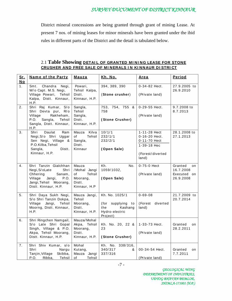
District mineral concessions are being granted through grant of mining Lease. At
present 7 nos. of mining leases for minor minerals have been granted under the ibid
rules in different parts of the District and the detail is tabulated below.
2.1 Table Showing DETAIL OF GRANTED MINING LEASE FOR STONE CRUSHER AND FREE SALE OF MINERALS IN KINNAUR DISTRICT
Sr. No
Name of the Party Mauza Kh. No. Area Period
1. Smt. Chandra Negi, W/o Capt. M.S. Negi, Village Powari, Tehsil Kalpa, Distt. Kinnaur, H.P.
Powari, Tehsil Kalpa, Distt. Kinnaur, H.P.
394, 389, 390 (Stone crusher)
0-34-82 Hect. (Private land)
27.9.2005 to 26.9.2010
2. Shri Raj Kumar, S/o Shri Devta pur, R/o Village Rakheham, P.O. Sangla, Tehsil Sangla, Distt. Kinnaur, H.P.
Sangla, Tehsil Sangla, Distt. Kinnaur, H.P.
753, 754, 755 & 758 (Stone Crusher)
0-29-55 Hect. (Private land)
9.7.2008 to 8.7.2013
3. Shri Daulat Ram Negi,S/o Shri Uggar Sen Negi, Village & P.O.Kilba,Tehsil Sangla, Distt. Kinnaur, H.P.
Mauza Kilva of Tehsil Sangla, Distt. Kinnaur
10/1/1 232/1/1 232/2/1 (Open Sale)
1-11-28 Hect 0-16-20 Hect. 0-11-70 Hect 1-39-18 Hec (Forest/diverted land)
28.1.2008 to 27.1.2013
4. Shri Tanzin Gialchhan Negi,S/oLate Shri Chhering Sanam, Village Jangi, P.O. Jangi,Tehsil Moorang, Distt. Kinnaur, H.P.
Mauza /Mohal Jangi of Tehsil Moorang, Distt. Kinnaur, H.P
Kh. No. 1059/1032, (Open Sale)
0-75-0 Hect (Private land)
Granted on 16.7.2008 Executed on 26.9.2008
5. Shri Daya Sukh Negi, S/o Shri Tanzin Dokpa, Village Jangi, Tehsil Moorng, Distt. Kinnaur, H.P.
Mauza Jangi, Tehsil Moorang, Distt. Kinnaur, H.P.
Kh. No. 1025/1 (for supplying to the Kashang Hydro-electric Project)
0-69-08 (Forest diverted land)
21.7.2009 to 20.7.2014
6. Shri Ringchen Namgail, S/o Late Shri Gopal Singh, Village & P.O. Akpa, Tehsil Moorang, Distt. Kinnaur, H.P.
Mauza/Mohal Akpa, Tehsil Moorang, Distt. Kinnaur, H.P.
Kh. No. 20, 22 & 23 (Stone Crusher)
1-33-73 Hect. (Private land)
Granted on 28.2.2011
7. Shri Shiv Kumar, s/o Shri Nargu Tanjin,Village Skibba, P.O. Ribba, Tehsil
Mohal Kutang, Mauza Jangi of Tehsil
Kh. No. 338/316, 340/317 & 337/316
00-34-54 Hect. (Private land)
Granted on 7.7.2011

SURVEY DUCUMENT OF DISTRICT KINNAUR
-8 - GEOLOGICAL WING
DEPARTMENT OF INDUSTRIES, UDYOG BHAVAN BEMLOE,
SHIMLA-171001 (H.P.)
Moorang, Distt. Kinnaur, H.P.
Moorang, Distt. Kinnaur, H.P.
(Open sale)
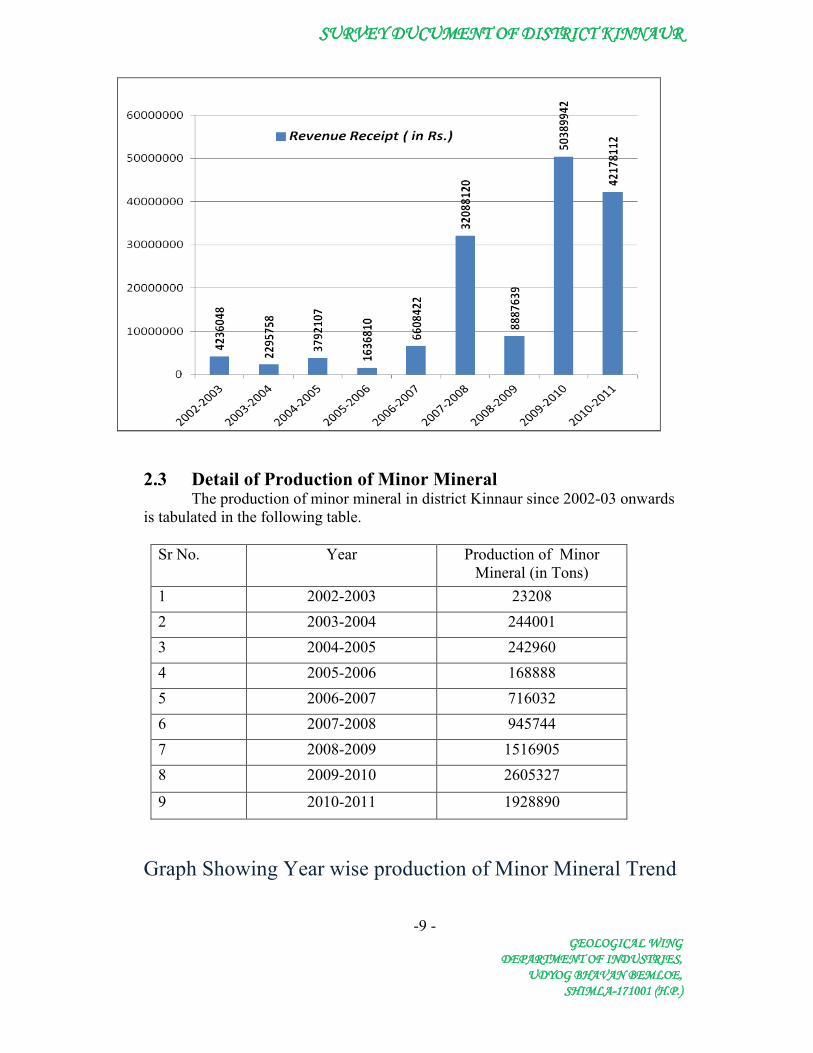
2.2 Detail of Royalty Received in district Kinnaur In Kinnaur District royalty received in respect minor minerals since 2002-03
onwards is given in the following table.
Sr No. Year Revenue Receipt ( in Rs. Lacs)
1 2002-2003 4236048 2 2003-2004 2295758 3 2004-2005 3792107 4 2005-2006 1636810 5 2006-2007 6608422 6 2007-2008 32088120 7 2008-2009 8887639 8 2009-2010 50389942 9 2010-2011 42178112
Table : Revenue Receipt in District Kinnaur.
Graph Showing Year wise Revenue Trend
SURVEY DUCUMENT OF DISTRICT KINNAUR
-9 -GEOLOGICAL WING
DEPARTMENT OF INDUSTRIES,UDYOG BHAVAN BEMLOE,
SHIMLA-171001 (H.P.)
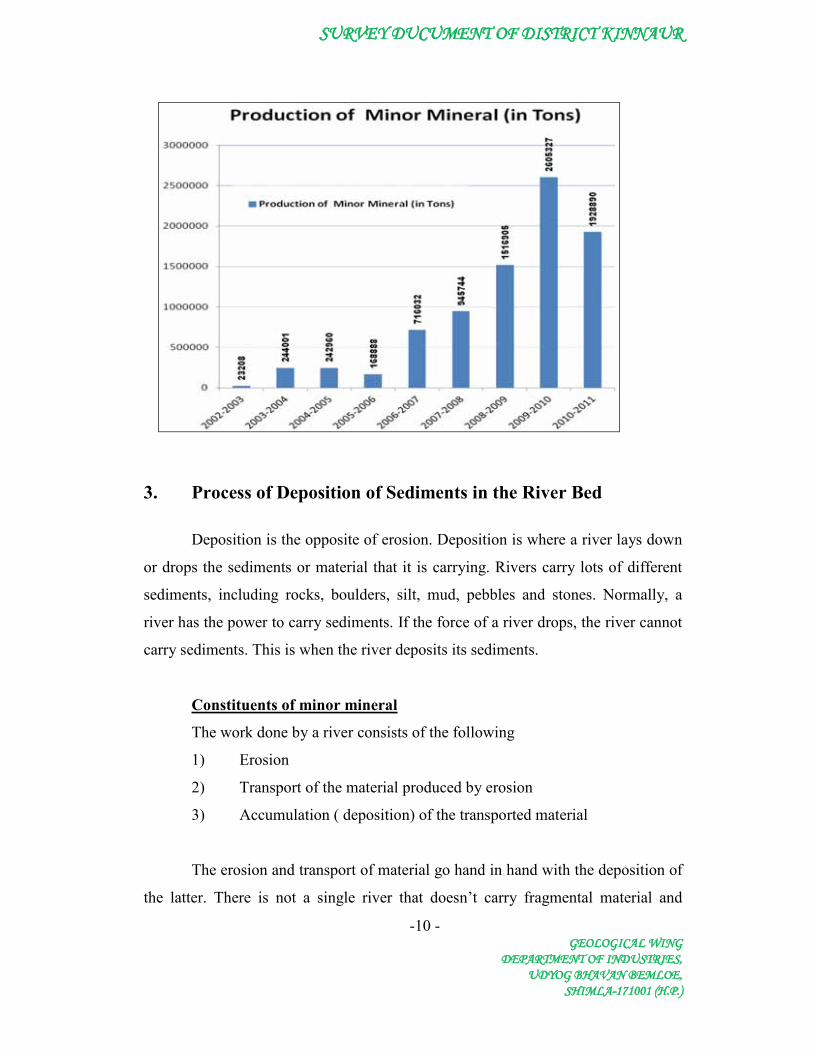
2.3 Detail of Production of Minor MineralThe production of minor mineral in district Kinnaur since 2002-03 onwards
is tabulated in the following table.
Sr No. Year Production of Minor Mineral (in Tons)
1 2002-2003 232082 2003-2004 2440013 2004-2005 2429604 2005-2006 1688885 2006-2007 7160326 2007-2008 9457447 2008-2009 15169058 2009-2010 2605327
9 2010-2011 1928890
Graph Showing Year wise production of Minor Mineral Trend
SURVEY DUCUMENT OF DISTRICT KINNAUR
-10 -GEOLOGICAL WING
DEPARTMENT OF INDUSTRIES,UDYOG BHAVAN BEMLOE,
SHIMLA-171001 (H.P.)
3. Process of Deposition of Sediments in the River Bed
Deposition is the opposite of erosion. Deposition is where a river lays down
or drops the sediments or material that it is carrying. Rivers carry lots of different
sediments, including rocks, boulders, silt, mud, pebbles and stones. Normally, a
river has the power to carry sediments. If the force of a river drops, the river cannot
carry sediments. This is when the river deposits its sediments.
1) Erosion
Constituents of minor mineral
The work done by a river consists of the following
2) Transport of the material produced by erosion
3) Accumulation ( deposition) of the transported material
The erosion and transport of material go hand in hand with the deposition of
the latter. There is not a single river that doesn’t carry fragmental material and

SURVEY DUCUMENT OF DISTRICT KINNAUR
-11 - GEOLOGICAL WING
DEPARTMENT OF INDUSTRIES, UDYOG BHAVAN BEMLOE,
SHIMLA-171001 (H.P.)
deposit it. Even at the early stages, in the development of a river, when the erosion
and transport definitely prevails over accumulation, the material carried by the river
is deposited in some of the sections. During youthful stage of the river, these
deposits are unstable and when the volume of water and stream velocity increases
(during flood), they may start moving again downstream. The load carried by a
stream includes the rock waste supplied to it by rain wash, surface creep, slumping
etc. by tributaries , external agents such as glaciers, wind, together with, acquired
by its own erosion work. The term load doesn’t specifically mean the maximum
amount of debris, that a sream could carry in a given set of conditions, that amount
is referred to as the transporting power or capacity of a river. The term load is
technically defined as the total weight of solid detritus transported in unit time. The
transporting capacity of a stream rises very rapidly as the discharge and the velocity
increases. Experiments show that with debris of mixed shapes and sizes, the
maximum load that can be carried is proportional to something between the third
and fourth power of the velocity. But the fragments of a given shape, the largest
size that can be moved ( not the actual mass of mixed debris) is proportional to the
sixth power of the velocity, provided of course that the depth of water is also
adequate for the purpose. As the velocity of a river is checked, the bed load s first to
come to rest with continued slackening of the flow, the larger ingredients of the
suspended load are dropped, followed succevily by finer and finer particles. When
the stream begins to flow more vigoursly, the finer materials are the first to move
again. A river begins to sort out its load or burden as soon as it receives it. The
proportion of fine to coarse amongst the deposited materials tend on average to
increase downstream, but there may be interruptions of this tendency because of
addition of coarse debris from tributataries or from landslides and steepening of the
banks.
Both discharge and load depend on the climate and geology( litholgy,
structure and relief) of the river basin concerned and both co-operate in carving out
the channels down.
General Geo-morphological Characteristics of Rivers/Streams

SURVEY DUCUMENT OF DISTRICT KINNAUR
-12 - GEOLOGICAL WING
DEPARTMENT OF INDUSTRIES, UDYOG BHAVAN BEMLOE,
SHIMLA-171001 (H.P.)
Transport of Sediment by Streams and Rivers The material transported by a stream can travel as:
1. Bed load 2. Suspended load 3. Dissolved load (salts, chemicals
Stream capacity
• Maximum quantity of solid material that a stream can carry • Related to velocity (discharge) • Higher after a rain (more sediment in water
Stream competence (or competency)
• Measure of the maximum size of particles the stream can transport • Predict erosive capabilities
Types of rivers or streams 1. Meandering These streams are very sinuous, and tend to migrate back and forth
across the floodplain (or meander), over time. The word "meander" comes from the
name of a sinuous river in Turkey, named the Menderes.
2. Braided These streams have lots of lenticular-shaped in-channel bars. The stream
channel bifurcates around these bars, and follows a pattern resembling braided hair.
Fluvial Geomorphology
Erosion is the set of all processes by which soil and rock are loosened and
moved downhill or downslope. The most important process of erosion is due to
running water. Erosion by running water acts in two basic forms: overland flow and
channel flow.
Splash Erosion
Most running water starts off as rain. Rain drops have diameters of between
0.5 to 7 mm and hit the ground at between 1 - 9 m/sec. The force of the impact

SURVEY DUCUMENT OF DISTRICT KINNAUR
-13 - GEOLOGICAL WING
DEPARTMENT OF INDUSTRIES, UDYOG BHAVAN BEMLOE,
SHIMLA-171001 (H.P.)
loosens material and throws it into the air. This is called splash erosion. In violent
thunderstorms over 200 tonnes/hectares can be disturbed. On a sloping surface, soil
is shifted downhill as grains are moved slightly greater distances downhill than
uphill. More importantly, however, it leads to a decrease in the permeability of the
surface due to openings being sealed by particles. There is therefore less infiltration
and an increase in overland flow
Overland Flow
Runoff starts as a broad sheet. The sheet exerts a drag force over the ground
surface and some weathered products may be removed. This is sheet erosion.
Generally, after traveling a short distance, small channels or rills are formed, which
coalesce into gullies, concentrating the erosive action.
The amount of erosion of a slope depends on the
• Length and steepness of the slope • Rainfall intensity • Permeability and structure of the surface • Amount of vegetation cover.
Channel Flow
Stream erosion is "the progressive removal of mineral matter from the
surfaces of a stream channel which itself may consist of bedrock or regolith"
(Strahler). Erosion will only occur when the stream has an excess of energy. In
mountainous streams, the rough channel walls may amount to 96% of the potential
energy of the stream. Some energy is also spent in transporting load previously
acquired. Erosion will result if the energy available > cohesion of particles.
The quantity of water passing through the channel is termed the discharge
(m2/sec) and is eqaul to the channel cross-sectional area (m2) times the average
stream velocity (m/sec).

SURVEY DUCUMENT OF DISTRICT KINNAUR
-14 - GEOLOGICAL WING
DEPARTMENT OF INDUSTRIES, UDYOG BHAVAN BEMLOE,
SHIMLA-171001 (H.P.)
The amount of sediment carried by the stream is called the stream load
(kg/m3).
Sub-processes of Erosion a. Hydraulic Action
- The force of the running water alone. This is very
important in weak alluvial deposits, especially in times of flood, when fast flowing;
turbulent water undermines the channel banks.
b. Abrasion,
- The scouring caused by the impact of rock particles that are being
transported. Abrasion features include plunge pools, potholes and chutes. Abrasion
is proportional to velocity2, so a three-fold increase in velocity leads to nine times
as much abrasion. The mutual erosion of two particles is known as attrition
c. Solution (Corrosion)
- Chemical reactions between ions in solution and exposed minerals.
It is particularly important in limestone areas or on beds of rock salt and gypsum,
but all common minerals are soluble to some extent.
Stream Velocity
Stream velocity can be estimated from Manning's equation
Where A = cross-sectional area, P = wetted perimeter, S = slope and
n = roughness coefficient. The value of n will vary from around 0.02 for a smooth
channel to 0.03 for rough gravel. Other factors such as surface irregularities,
changes in cross-section, obstructions, vegetation and degree of meandering will
also affect the roughness coefficient. In general, as you go downstream, the slope
decreases (lowers velocity) and n decreases (raises velocity). At any point along the
SURVEY DUCUMENT OF DISTRICT KINNAUR
-15 - GEOLOGICAL WING
DEPARTMENT OF INDUSTRIES, UDYOG BHAVAN BEMLOE,
SHIMLA-171001 (H.P.)
stream's course, an increase in the depth of the stream's channel (e.g. during floods)
will lead to an increase in A/P, with a consequent increase in velocity.
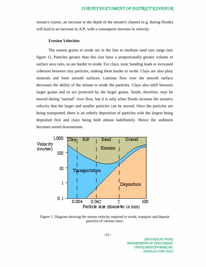
Erosion Velocities
The easiest grains to erode are in the fine to medium sand size range (see
figure 1). Particles greater than this size have a proportionally greater volume to
surface area ratio, so are harder to erode. For clays, ionic bonding leads to increased
cohesion between clay particles, making them harder to erode. Clays are also platy
minerals and form smooth surfaces. Laminar flow over the smooth surface
decreases the ability of the stream to erode the particles. Clays also infill between
larger grains and so are protected by the larger grains. Sands, therefore, may be
moved during "normal" river flow, but it is only when floods increase the stream's
velocity that the larger and smaller particles can be moved. Once the particles are
being transported, there is an orderly deposition of particles with the largest being
deposited first and clays being held almost indefinitely. Hence the sediment
becomes sorted downstream.
Figure 1. Diagram showing the stream velocity required to erode, transport and deposit particles of various sizes.

SURVEY DUCUMENT OF DISTRICT KINNAUR
-16 - GEOLOGICAL WING
DEPARTMENT OF INDUSTRIES, UDYOG BHAVAN BEMLOE,
SHIMLA-171001 (H.P.)
Transportation
The particles carried by streams is known as the stream load. Particles may
be carried by
• Floatation. Of very minor significance.
• Solution. Ions of dissolved minerals that may travel downstream
indefinitely. The most common are Na, Ca, K, Mg, Cl, SO4 and HCO3. One
estimate of U.S. rivers was that they carry 300 million tonnes of dissolved load each
year, and 250 million tonnes of solid load.
• Suspension. The temporary support of particles when turbulence is greater
than the settling velocity of the particle. Clay and silt are normally transported in
suspension, but sand may be carried this way in floods.
• Saltation. Intermittent "jumping" of grains that are lifted by turbulence, but
are too heavy to remain in suspension.
• Traction. The sliding or rolling of particles along the stream floor. Particles
moved in this way comprise the bed load. Bed load normally constitutes around 10%
of the solid load, but may be up to 50% during floods, when the major work of the
stream is done.
Transportation is aided by the buoyancy of water, eg. quartz grains are Å 2000
times the density of air, but only two and a half times that of water. Unequal velocities
at the top and bottom of boulders also assists transportation, as does steep gradients.
The total load of particles of all sizes that a stream can carry is known as its
capacity. It is proportional to discharge, which is proportional to velocity. A faster
flowing stream therefore has a higher capacity. If a stream's capacity is less than its
load, the stream cannot carry its load, so deposition occurs. If capacity exceeds load,
the stream has excess energy (gravitational, potential energy), so it can erode more
sediments. Streams switch back and forth from depositional to erosional agents,
depending on load vs. capacity. A stream can erode along one stretch and deposit along
another, since gradient and channel shape/size vary along the stream's course. Streams

SURVEY DUCUMENT OF DISTRICT KINNAUR
-17 - GEOLOGICAL WING
DEPARTMENT OF INDUSTRIES, UDYOG BHAVAN BEMLOE,
SHIMLA-171001 (H.P.)
can erode during periods of higher velocity or discharge (floods) and deposit during
periods of lower velocity or discharge. Anything that alters the sediment load delivered
to the channel or that alters the stream's capacity to carry that load will cause the
stream's gradient or channel geometry to change in response
The largest particle that a stream can transport is known as its competence.
Assuming that there is sufficient depth to cover the particles, then competence is
proportional to the square of velocity.
Deposition
Deposition will occur when a loss of energy results in a decrease in velocity.
This may be due to such things as declining gradient, a decrease in water volume,
an increase in cross-sectional area (particularly pools, lakes, and oceans), or by
local obstructions. An excessive load produced by increased erosion in the drainage
basin or tributary valleys, or from glaciofluvial outwash will also inevitably lead to
deposition. The accumulations of stream deposits are called alluvium
Note: There is a constant interaction between erosion, transportation and
deposition. During a flood, the bed of a stream at a particular point may be eroded,
but as the flood subsides the bed is filled again. Similarly, in different parts of the
stream, velocity differs and hence one part of the stream may be eroding its bank,
while on the opposite bank deposition is taking place.
Downstream Adjustments
Overall, despite some variations, effluent streams (those that receive water from the
water table) generally show the following changes downstream:
• discharge increases (due to more tributaries and a greater drainage area)
• total load increases (due to more tributaries and a greater drainage area)
• channel size increases (to cope with the increased discharge and load)

SURVEY DUCUMENT OF DISTRICT KINNAUR
-18 - GEOLOGICAL WING
DEPARTMENT OF INDUSTRIES, UDYOG BHAVAN BEMLOE,
SHIMLA-171001 (H.P.)
• particle size decreases (due to increased abrasion / attrition and changes in
velocity)
• the smoothness of the channel increases ( due to decreased particle size)
• gradient decreases
Stream velocity downstream is increased by the smoother channels, but decreased
by lower gradients. Under normal conditions, velocity is proportional to discharge0.1, so
there is a slight overall increase in the average velocity of the stream - despite the
appearance of faster flowing mountain streams at the headwaters. In such streams, the
amount of turbulence and associated eddies and backward flowing portions of the
streams means that the average velocity is lower than the smoother flowing waters
downstream. During floods, however, when the major work of the stream is done,
velocity is proportional to discharge0 (i.e. it is constant), so the increased velocity
associated with floods allows the erosion and transportation of a large range of particle
sizes throughout the drainage system.
It can be seen from these relationships that peak discharge conditions that occur
during floods are very important in determining the form of rivers and the features
associated with them, and not the "normal" river level.
These changes take place in an orderly manner and lead to a longitudinal profile
that is smooth and concave. This is known as a graded profile (see Figure 2 and
Chernicoff & Whitney, fig, 14-7, pg 438).
Figure 2. Long profile
of a graded stream, showing a regular change in gradient.
SURVEY DUCUMENT OF DISTRICT KINNAUR
-19 - GEOLOGICAL WING
DEPARTMENT OF INDUSTRIES, UDYOG BHAVAN BEMLOE,
SHIMLA-171001 (H.P.)
For a stream with an irregular profile, erosion will be more pronounced at places of
higher than normal gradient, such as at falls and rapids, and sedimentation will occur in
areas of low gradient, such as lakes. The "bumps" are therefore ironed out until the
graded profile is achieved.
Over geological time, providing that tectonic forces do not change the base level,
any stream, irrespective of length, discharge, and bedrock, will achieve such a state of
"dynamic equilibrium".
It is a "dynamic" system, as there is constant re-adjustment of the channel in
response to local variations in the volume, velocity and load, that leads to a local
balance between the sediment being transported and the energy available. That is, short
term changes of scour and fill may occur, but in the long term the gradient and velocity
are such that the available load can be transported without erosion or deposition
dominating in any particular place. Over geological time, erosion dominates and the
whole profile is lowered until a peneplain is developed close to base level. The base
level is the lowest level that a stream can erode its channel. A temporary base level
results from obstructions such as resistant outcrops, lakes, dams etc. that lead to
temporary sub-profiles.
An increase in base level will lead to aggradation, the built up of sediment on
valley floors and the development of thick deposits of alluvium.
A decrease in base level will lead to such things as nick points that migrate
upstream, alluvial terraces, valley in valley topography and entrenched meanders.
The rise in sea level from 18,000 to 10,000 years ago means that most present river
systems don't demonstrate ultimate base level control by modern sea level. Estuaries (in
streams with minor solid loads) and deltas (large loads) demonstrate adaptations to the
changed conditions.

SURVEY DUCUMENT OF DISTRICT KINNAUR
-20 - GEOLOGICAL WING
DEPARTMENT OF INDUSTRIES, UDYOG BHAVAN BEMLOE,
SHIMLA-171001 (H.P.)
Size
Rounded, Subrounded, Subangular
Fragment
Aggregate
256 mm-- 64 mm--- 4 mm--- 2 mm-- 1/16 mm-- 1/256 mm----
Boulder
“Rou
ndst
one”
Boulder gravel Boulder conglomerate
Cobble
Cobble gravel Cobble conglomerate
Pebble
Pebble gravel Pebble conglomerate
Granule
Granule gravel
Sand
Sand sandstone
Silt Silt Siltstone
clay Clay Shale
SURVEY DUCUMENT OF DISTRICT KINNAUR
-21 - GEOLOGICAL WING
DEPARTMENT OF INDUSTRIES, UDYOG BHAVAN BEMLOE,
SHIMLA-171001 (H.P.)
4. GENERAL PROFILE OF KINNAUR DISTRICT 4.1 General
Kinnaur is located in the north-eastern part of the Himachal Pradesh and is
situated between 31o05’05” to 32o05’15” north latitude and 77o45’00” to 79o00’35”
east longitude The district has a total area of 6401 sq. km. which cover 11.5 per cent
area of the state. The population density in the District is 11 persons per square
Kms. The District has the 58.36% of literacy rate.
Kinnaur is bounded on the east by the Ngari region of western Tibet; the
district is separated from the Tibet by the Zaskar mountains. The Dhaula Dhar
range of mountains forms its southern boundary and it separates Uttar Kashi district
of Uttar Pardesh and Rohru tahsil of Shimla district from it. Srikhand Dhar
separates the district from Kulu and Rampur regions in the west. In the north
Kinnaur district is separated from the Spiti region of Lahaul and Spiti district by the
rivers Spiti and Pare near the international boundary with Tibet.
Salient Features of the district Geographical Area - 6401 Sq. Km Total Population - 71,270 (2001 census) Number of Sub-Divisions - 3

SURVEY DUCUMENT OF DISTRICT KINNAUR
-22 - GEOLOGICAL WING
DEPARTMENT OF INDUSTRIES, UDYOG BHAVAN BEMLOE,
SHIMLA-171001 (H.P.)
1 Poo 2 Kalpa 3 Nichar
Number of Tehsils - 5
1 Kalpa 2 Nichar 3 Sangla 4 Pooh 5 Moorang
Number of C.D. Block - 3
1 Poo 2 Kalpa 3 Nichar
Number of Gram Panchayat - 65 Number of villages - 660 Total Population - 78334 (2001 census)
Density per Sq Km - 12

SURVEY DUCUMENT OF DISTRICT KINNAUR
-23 -GEOLOGICAL WING
DEPARTMENT OF INDUSTRIES,UDYOG BHAVAN BEMLOE,
SHIMLA-171001 (H.P.)
Administrative Map of District Kinnaur
4.2 Land Utilization PatternThe general land utilizationpattern of the District is as given below
Land Utilization Pattern of the District (in hects)Area Under Forest 48704Irrigated Area 14,964Unirrigated Area 32,073Culturable waste (including gauchar and groves) 72,568Area not available for cultivation 54,719

SURVEY DUCUMENT OF DISTRICT KINNAUR
-24 - GEOLOGICAL WING
DEPARTMENT OF INDUSTRIES, UDYOG BHAVAN BEMLOE,
SHIMLA-171001 (H.P.)
Map Showing Land Utilization in district Kinnaur
4.3 Forest The forests play a vital role in shaping the climatic condtions of the area.
The forests provide valuable timber, medicinal herbs, raw material for large and
small scale industries and also provide employment and play a vital role in
conserving the soil and ensure timely and sufficient rain.
In Kinnaur district forest type fall naturally into following three main
divisions;
(i) The moist zone forests are found on the left side of the Satluj valley with
northern exposure into Nichar. They comprise the Tranda range of forests.
The forest are particularily continous. From the river side at 3500 feet to
alpine pasture at 12000 feet on the right base consists of grass lands and
higher up are the forest belt. Along the side stream, the forest are well
developed and Pinus Longifolia, Pinus Wllichiana, Cedrus Deodara,
PicesSmithiana, Abies Pindro, Pinus Gordianaform a broad belt of forest
along with the side of Satluj valley and the side streams between the clif of
the gorge below the alpino pastures.. on the lower slope upto 5000 feet, Chir
pines occurs in pure form and higher up given way to Quercus incana and
Rhodeondron arboretum. On shelter ravine bank between 5000 to 12000 feet
Cedrus Deodara and Pinus Wallichiana form Interine forest, higher up form
7000 to 10000 feet Picea Samithiana with mixture of broad leaf species
predominate.
(ii) The dry zone is spread in middle Kinnaur where the deodar reaches its
optimum development and form large area of pure forest. It extends from
Nichar to Chini and also found in Sangla valley. At the lower levels pine
trees abound while in the higher tracts blue pine, spruce and silverfire trees
are found. Neozapines (Chilgoja) which produceedible nuts grow in this
zone are the only forest of neza in India bearing the Peer Panjal range.

SURVEY DUCUMENT OF DISTRICT KINNAUR
-25 - GEOLOGICAL WING
DEPARTMENT OF INDUSTRIES, UDYOG BHAVAN BEMLOE,
SHIMLA-171001 (H.P.)
(iii) The areid zone includes the parts adjoining to Tibetan border where the
deodar develops well only on cool aspects and comparatively at higher
elevation than else where. In this zone, the forests is consisting of rose dog
and dwarf bushes and vast barren, desolate and rocky areas are devoid of
tree cover.
The following various species of plants and forest trees are generally
found in the Kinnaur district;
Botanical Name Local Name Borboris Aristata Komal Borboris lycium Kashnala
Borboris potiolaris Karundu Botula utilis Bhojpatra
Capparis spinosa Bussar Cedsus Deodara Deodar
Clematis graveolens Bailen climbars Cotonoaster bacillaris Reesh
Colyrus Colurna Sheloi Dephno qleoides Agru
Elsholtzia Polystachya Pag Frazinus xarithoxyloides Thun
Ilex dipyrona Kaderu Indigfora gorardina Kathi
Juglana zogia Akharot Myraino africana Chitring
Pinus excelsa Kail Pinus girardiana Neoza Pinus longifolia chir
Prunus armeniaca Chuli Prunus padus Jamu
Prunus persixa Baimi, Aau Prunus puddum Phaja Pyrus communis Nashpati
Pyrus malus Seo Pyrus pashia Kainth
Rhus punjabensis Tittri Rhus syccedanca Sish Rumex lastatus Shrub
Rumex napalansis Shrub

SURVEY DUCUMENT OF DISTRICT KINNAUR
-26 - GEOLOGICAL WING
DEPARTMENT OF INDUSTRIES, UDYOG BHAVAN BEMLOE,
SHIMLA-171001 (H.P.)
Spiraoa eindbeana Kusht Spyringa embedi Shapar
Vibusnum cotinifotium Tustuskhatele
4.4 Fauna Nature has endowed the tract with various fauna due to considerable
variation in the elevation and climate. The following are the species of animals and
birds commonly found in the district:
Bharal Snow leopard Brown bear (Lal Bhalu or snow bear Upland hare Hill Fox (Lomri) White nosed weasel Common Jungle cat Yellow Bellied weasel
Porcupine Himalyan Wolf or chanku in local parlance
Common Europeonbat House hare Common Musk threw must rat (Chachmdor Chakor
Common etter udibilao Woodpecker Common rat Crow Common Indian rat or root rat Peasant Common House mouse Monal Dark brown lcat bat Hawk Flying fox Eagle Ghoral Dove Great Himalayan leaf nosed bat Pigeon Himalayan Langur Snow cock Himalayan black bear (Bhalu, Richh) Tragopan Himalayan thar Plash Himalayan Palm Civet Koklash Himalayan ibex Chakor Indian mountjack migrating (Jungle Bakri) Musk deer
Jackal (Gidhar, shial) Red dynx or caracal (Sinaghush) Large brown fluying squired Rhesus Monkey Leopard cat (Chita Bill) Serow Leopard or Panther (Tandwa) Small Tibetan grey fox Long eared rat

SURVEY DUCUMENT OF DISTRICT KINNAUR
-27 - GEOLOGICAL WING
DEPARTMENT OF INDUSTRIES, UDYOG BHAVAN BEMLOE,
SHIMLA-171001 (H.P.)
4.5 Agriculture
Kinnaur is predominantly an agriculture district. agricultural
Agriculture development in the hilly areas posse peculiar problems due to steep and
difficult terrain, small and scattered holdings, depleting fertility of soil by constant
erosion, the crop yield are vary low. The crop season is limited to only six, months
due to intensive cold and snow fall. However, the economy of the district is highly
agro-pastorage. Land holdings are generally small and scattered almost every
family has a piece of land. Soils generally consists of sand, sandy loam, clay loam,
stony and graval. Wheat, barley, maize, potato, vegetables and pulses are the main
corps of the district.
For the development of the district in the agricultural front, intensive
agriculture aiming at increasing the yield per unit of area is being given highest
priority by adopting various programmes/measures like seed distribution
programme of high yielding varieties, potato development scheme, control of pests
and diseases, development of vegetables and seed production programme, use of
improved implements, local manure resources, subsidy in fertilizers and soil
conservation.
The following are the main crops in the District;- • Wheat • Maize • Paddy • Oil seed • Pulses • Potato • Sugercane • Ginger • Vegitables (Peas, Tomato, Capsicum, Cabbage, Culiflower) • Spices (Peper and Coriander)
4.6 Horticulture The climate of Kinnaur district is very congenial for the
development of horticulture and apples in particular. With the introduction of
improved techniques, expertise in orchard growing and transportation facilities, the
production of fruits is also increasing year to year. Kinnaur district has a distinct
place in the country for its quality apples and temperate fruit like wall nuts,

SURVEY DUCUMENT OF DISTRICT KINNAUR
-28 - GEOLOGICAL WING
DEPARTMENT OF INDUSTRIES, UDYOG BHAVAN BEMLOE,
SHIMLA-171001 (H.P.)
almonds, chilgoza, raisin, apricot etc. The main commercial verities of apple grown
are Royal Delicious, Rich Red, Red Delicious and Golden Delicious which are
directly marketed to Chandigarh, Delhi, Madras, Calcutta and Bombay markets.
Ever since the creation of district, constant emphasis has been
always given on the Horticulture to boost up the traditional economy and
considerable strides have been made in this regard after the creation of the district.
The area under apples was 2,026 Hactares in 1980-81 which was increase to 4431
Hectare in 1991-92. While the production of the apple in the district has increased
from, 7151 tonns to 16530 tonns during the period. Total production of the fruits in
the district, which includes apples, nuts and dry fruit citrus fruits etc., was of 7812
tonnes in 1980-81 which has increase to 16879 tonnes during 1991-92.
Departmental be keeping stations are also functioning in the district
at Pounta, Bhabha, Kilva, Urni and Giabong which produced 900 kilograms of
honey during the year 1990-91.
Apple, Plum, Apricot, Chilgoza, Almonds are the important fruits grown in
the Kinnaur district.
4.7 Animal Husbandry
Livestock resources of the district consist of sheep and goats. Milch cattle
are very few and yield very little milk. With the exception of Chaura village,
buffaloes are conspicuous by their absence all over Kinnaur. Before the percolation
of modern developments in Kinnaur the wealth of the family used to be measured in
term of the sheep and goats the family had. Kannauras had the flourishing trade
with western Tibet and Ladakh until and beginning of sixties particularly in wool,
pashmina, goats and sheep through barter system.
The improvement of the bread of livestock the main concern of the
department of Animal Husbandry in the districts which has been taking a
considerable stride in the district. There were 18 veterinary Hospitals, 28 veterinary
dispensaries and 1 mobile veterinary dispensary in the district in 1991. Apart from
these, 31 artificial in semi nation centers were also functioning. Besides there are
SURVEY DUCUMENT OF DISTRICT KINNAUR
-29 - GEOLOGICAL WING
DEPARTMENT OF INDUSTRIES, UDYOG BHAVAN BEMLOE,
SHIMLA-171001 (H.P.)
poultry units at Tapri, Two Bull centers at Sangla, 1 Sheep breeding farm at
Karchham and a Yak breeding centre at Sangla. Cross breed Jersey Cow and
Marino breed of Sheep have become very popular among the progressive farmers.
One fodder development farm run by the Animal Husbandry department is
functioning Thang Karma. To solve the fodder problem the department is providing
improvement verity of fodder seeds like Lucerne, berseen, orchards grass and grass
roots to the farmers.
4.8 Fisheries
There is vast network of perennial rivers, streams and Khads in the district
and there is a great scope of the development of fish culture. The Himachal Pradesh
fisheries department has established a Trout farm at Sangla 1961-62 incubating the
Trout eggs which were brought here from Barot Fish Farm in Mandi district.

SURVEY DUCUMENT OF DISTRICT KINNAUR
-30 - GEOLOGICAL WING
DEPARTMENT OF INDUSTRIES, UDYOG BHAVAN BEMLOE,
SHIMLA-171001 (H.P.)
5. PHYSICAL ASPECTS 5.1 Boundaries:
Kinnaur is bounded on the east by the Ngari region of western Tibet;
the district is separated from the Tibet by the Zaskar mountains. The Dhaula
Dhar range of mountains forms its southern boundary and it separates Uttar
Kashi district of Uttar Pardesh and Rohru tehsil of Shimla district from it.
Srikhand Dhar separates the district from Kullu and Rampur regions in the
west. In the north Kinnaur district is separated from the Spiti region of
Lahaul and Spiti district by the rivers Spiti and Pare near the international
boundary with Tibet.
5.2 Physical Features:
The face of the district present high hills and low dales, with rapid
and rushing streams and streamlets and is marked by precipitous sky-high
mountains with their peaks perpetually covered with snow. The district is
almost equally divided by the main Sutlej valley. the river Sutlej enters the
district from Tibet in the north-east near the village of Namgia and leaves it
at the western end at Chaura near Wangtu bridge. The district situated at a
height between 1,220 and 3.050 meters above the sea level. River Sutlej
enters the district at an elevation of 3,050 meters and leaves it at an
elevation of 1,220 meters. There are three more or less parallel mountain
ranges: the Zaskar Mountains, the Great Himalaya and the Dhaula Dhar.
The crest of the Zaskar Mountains forms the eastern international boundary
of Kinnaur with Tibet: the great Himalaya extends from the north-west to
the south and the crest of the Dhaula Dhar constitutes the southern boundary
of Kinnaur at the south-eastern corner where the last two ranges merge. The
general elevations of the peaks on these mountains vary between 5,180 and
6,770 metres, and hence are covered with snow all the year round.
SURVEY DUCUMENT OF DISTRICT KINNAUR
-31 - GEOLOGICAL WING
DEPARTMENT OF INDUSTRIES, UDYOG BHAVAN BEMLOE,
SHIMLA-171001 (H.P.)
5.3 Climate:
Kinnaur, due to its geographical situation has a long winter from
October to may, the snowy season; and a short summer from June to
September. From April to May is spring and from September to October is
autumn. It has two district climatic zones-the wet and the arid. Only the area
south of the great Himalaya receives monsoon rains. This area roughly
covers Baspa valley and the lower reaches of the Sutlej valley. In the upper
reaches of the district the monsoon showers progressively decrease and one
can notice the beginning of the complete arid zone from the place called
Spilo at a distance of 255 kilometres from Shimla, situated at an elevation of
about 2,276 metres above the sea level. The vegetation above Kalpa rapidly
becomes sparser ultimately to remain only along the river. Along the valley
of the Sutlej as far east as Wangtu the rainfall does not greatly vary from
Shimla, but beyond Wangtu the difference is considerable. The rainfall
becomes gradually decreases as Shipki is approached so that the climate of
the upper Kinnaur is semi-arid. West of Wangtu, the Sutlej valley has an
annual rainfall of 175 centimeters. At Kiba, 16 kilometres east of Wangtu,
this drops to 107 centimetres and at Poo to 40 centimetres. In the lower
portion of Kinnaur, June is the warmest month and in the upper regions July
and August are the warmest months. From 2,500 to 3,000 metres there is a
favourable situation such as at Chango, Leo and Morong where the
temperature of July and August ranges from 20o to 23oC, the October
temperature is about from 13o C to 3o C, May and October have very low
relative humidity and are generally the brought months. Clouding is more
heavy, persistent and prolonged in the long winter season. There are strong
winds in the winter months.
SURVEY DUCUMENT OF DISTRICT KINNAUR
-32 -GEOLOGICAL WING
DEPARTMENT OF INDUSTRIES,UDYOG BHAVAN BEMLOE,
SHIMLA-171001 (H.P.)
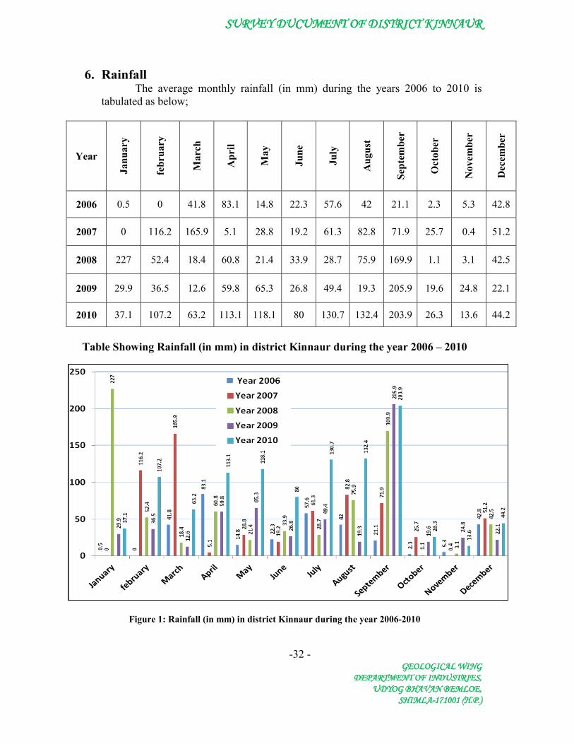
6. Rainfall The average monthly rainfall (in mm) during the years 2006 to 2010 is
tabulated as below;
Year
Janu
ary
febr
uary
Mar
ch
Apr
il
May
June
July
Aug
ust
Sept
embe
r
Oct
ober
Nov
embe
r
Dec
embe
r
2006 0.5 0 41.8 83.1 14.8 22.3 57.6 42 21.1 2.3 5.3 42.8
2007 0 116.2 165.9 5.1 28.8 19.2 61.3 82.8 71.9 25.7 0.4 51.2
2008 227 52.4 18.4 60.8 21.4 33.9 28.7 75.9 169.9 1.1 3.1 42.5
2009 29.9 36.5 12.6 59.8 65.3 26.8 49.4 19.3 205.9 19.6 24.8 22.1
2010 37.1 107.2 63.2 113.1 118.1 80 130.7 132.4 203.9 26.3 13.6 44.2
Table Showing Rainfall (in mm) in district Kinnaur during the year 2006 – 2010
Figure 1: Rainfall (in mm) in district Kinnaur during the year 2006-2010

SURVEY DUCUMENT OF DISTRICT KINNAUR
-33 - GEOLOGICAL WING
DEPARTMENT OF INDUSTRIES, UDYOG BHAVAN BEMLOE,
SHIMLA-171001 (H.P.)
7. Geology and Mineral Wealth of District Kinnaur
7.1 Geology:
Generalised stratigraphic Successions of the district is given in the following
table.
Period Formation
Recent-Sub recent- …… Soils
Triassic-Rhaetic …….. Limestone, Shales, Dolomite etc
Carbonaceous . . …….. Quartizite and limestones
Silurian ………… Coral Limestone and Quartzite
Late-Precambrian to Cambrian ………
Haimanta System-phyllites, quartzites, conglomerates, shales and slates.
Pre-Cambrian ………. Schists, gneisses, granites, quartizites (Vaikrita System)
SURVEY DUCUMENT OF DISTRICT KINNAUR
-34 - GEOLOGICAL WING
DEPARTMENT OF INDUSTRIES, UDYOG BHAVAN BEMLOE,
SHIMLA-171001 (H.P.)
According to the geological survey of India, the known geological formations in the district are as follows:
Between the boarder of Kinnaur and Shimla district and Jangi:
The geological formations exposed in this area have been named as Sarahan
Series. The Sarahan Series constitute schists and gneisses with granite and
pegmatite intrusions and basic rocks. The main type of schist is biotite schist,
quartz-muscovite schist and quartz- talc schist. These are intruded by basic
intrusions, which have been metamorphosed to amphibole schists. Gneises of the
Sarahan series are grey in color and medium to coarse grained in texture. They
frequently pass in the schist. Igneous rocks belong to three different periods of
intrusions. The rocks of the sarahan Series belong to pre-Cambrian period.
Between Jangi and Shipkila:
The rocks of this series have been designated to Jangi Series. It comprised
slates, carbonaceous slates, graphite phyllites, chlorite, phyllite, sand stone grading
into quartzite and thin bands of limestone. These formations range from pre-
Cambrian to Cambrian age.
Area North and West of Shipkila:
The formations exposed in this area belong to Ordovician, Silurian and
Carboniferous. The Ordovician and Devonian are represented be red quartzites and
grits, often underlain by conglomerates and passing upward into shales with bands
of limestone and dolomite. The limestone bands have yielded fossils of mollusks,
brachiopods, corals, gastropods and trilobites. The overlying rocks are known as
Muth-quartzite belongs to Devonian age. The Devonian is succeeded by great
development of limestone and dolomite belonging to Lower and Upper
Carboniferous and Permian system. The limestone, which are extensively crushed

SURVEY DUCUMENT OF DISTRICT KINNAUR
-35 - GEOLOGICAL WING
DEPARTMENT OF INDUSTRIES, UDYOG BHAVAN BEMLOE,
SHIMLA-171001 (H.P.)
and bracciated, vary from pure limestone and dolomite. These formations are rich in
fossils.
Geological Map of District Kinnaur

SURVEY DUCUMENT OF DISTRICT KINNAUR
-36 - GEOLOGICAL WING
DEPARTMENT OF INDUSTRIES, UDYOG BHAVAN BEMLOE,
SHIMLA-171001 (H.P.)
7.2 Mineral wealth in Kinnaur:
Building Stones:
Building stones are naturally occurring rocks of igneous, sedimentary or
metamorphic origin which are sufficiently consolidated to enable them to be cut or
shaped into blocks or slabs for use as walling, paving or roofing materials in the
construction of buildings and other structures. Stones suitable for building occur
throughout the geological column and have a worldwide distribution. Their
exploitation is limited where overburden or structural complexities make their
production uneconomic or where national or internationally designated
conservation or heritage sites preclude active quarrying. The principal rock types
used as building stone are limestone, sandstones, slates, quartzite, granites and river
born material. Building stone is also commonly referred to as 'Dimension Stone' in
many countries.
Important building stones which area mined in Kinnaur District are
sandstone, quartzite, slate, granite and river born material (Boulders, cobbles
etc).Sandstone is mainly used for domestic constructions and house wares.
Sandstone blocks are used for building constructions. Slate is mostly used for
roofing of houses providing traditional appearance and for paving of courtyards in
the district.
River born material:
The cobbles, pebbles, boulders and sand of the Newer Formation are the
important source of raw material for constructions and for running stone crushers in
the district. In Kinnaur district the river born material is found along the banks of
the streams and river where the velocity of the water decreases due to natural
barriers or where the tributaries join the main stream.
Beryl:
I. Pale blue beryl has been reported from the Wangtu bridge (310 32’: 78° 15’)
and for some distance up the Satluj and Shipki La (310 49’ : 780 45’) Pass.

SURVEY DUCUMENT OF DISTRICT KINNAUR
-37 - GEOLOGICAL WING
DEPARTMENT OF INDUSTRIES, UDYOG BHAVAN BEMLOE,
SHIMLA-171001 (H.P.)
II. Beryl associated with pegmatite has been reported from near Riuni village
(78004’20” : 31004’16”) and Nalgan Ghatti (31° 19’20” : 78° 12’15”).
III. Sporadic bluish coloured transluscent hexagonal crystals of beryl arenoticed
in the pegmatites intrusive into the schistose rocks of the Vaikrita Group in
Morang (31° 36’00': 78° 26’30') Tirung (31034’30' : 780 27’00') area.
IV. Greenish blue beryl is found in the pegmatite along its contact withthe
country rocks near Ribba (310 35’ 15' : 780 22’ 00”) and near the confluence
of Kashanj Khad and Satluj river.
V. Small crystals of beryl within pegmatite veins traversing the Rakcham
granite have been reported from the area between Pangi (310 36': 780 21')
and Akpa (31° 35’00” : 780 22’ 45”).
Clay:
I. China clay occurs as alteration product of granite, gneiss and pegmatite near
Lipa (31° 39': 780 24').
II. Lacustrine clays occur at Shalkar, Chango and Ganfa along the Spiti river.
Copper:
I. Malachite encrustations are reported in the Manchhap nala (31° 25’ 30”: 78°
33’ 30”) section.
II. Few specks of pyrite and chalcopyrite with malachite stains have been
noticed in quartz veins near Mangsula (31° 22' 30”:78° 30’ 30"). These
veins are more frequent near the Granite Batal Formation contact.
III. A few malachite stains have been noticed in the phyllites of the Batal
Formation near Lippa (31° 39’: 78° 38”).
IV. Two small old workings for copper are observed near Rangbar (31° 49’ :78°
24’) in the Ropa valley. It consists mainly of malachite and azurite coatings
along the joint planes and fissures of quartzite bands in the Kunzam La
Formation.

SURVEY DUCUMENT OF DISTRICT KINNAUR
-38 - GEOLOGICAL WING
DEPARTMENT OF INDUSTRIES, UDYOG BHAVAN BEMLOE,
SHIMLA-171001 (H.P.)
V. An old working of copper is reported near Sangnam (31° 47’: 78° 28’). 550
ppm Cu values have been obtained from here.
VI. Sparsely disseminated pyrite occurs in quartzites and phyllites north east of
Sangnam. In a nala north of Giabong, malachite and azurite stains are seen
in phyllites.
Fluorspar:
Rare occurrence of light green crystals of flourspar has been reported in the
pegmatite veins at Wangtu (310 32' : 780 04 ') bridge.
Galena:
I. Specks of galena have also been noticed along thin quartz veins in the
gneisses near Nalgan ghati (310 19' 20": 780 12’ 50”).
II. A few specks of galena are observed in a minor shear zone exposed east of
Alingdar (310 26' 30'; 780 38’30”).
Gold:
Small Quantity of Gold are obtained from sand bars along the Satluj River
between Morang ( 310 36’ N -78 028’ E) and Wangtu ( 310 32’ N -78 004’ E)
Gypsum:
Large deposits of gypsum occur associated with the Lipak Formation
between Liwa Thach (310 55’ : 780 30’) and Kapusa (32004:78034’) especially in
the Yulang Valley, north of Chango, and in the Yangthang (31053’: 780: 37’) area.
A small area around Shalkar (32000’:780 34’) was covered by detailed mapping and
reserves of 1.25 million tonnes were inferred upto 25m down depth extension. The
total in- situ reserves in this belt, however, may be over 100 million tonnes. Small
occurrences of gypsum are known from similar beds exposed near Tari Khango
Pass. The gypsum is mostly of alabaster type,soft, white, granular, with common
large pockets of anhydrite and small
SURVEY DUCUMENT OF DISTRICT KINNAUR
-39 - GEOLOGICAL WING
DEPARTMENT OF INDUSTRIES, UDYOG BHAVAN BEMLOE,
SHIMLA-171001 (H.P.)
selenite zones. It is considered to be of evaporitic origin. Thin bands of white
granular gypsum associated with the maroon shales of Yamranjha Formation occur
near Bayulkhona Thach (310 24’ : 780 40’).
Iron Ore:
Magnetite tuff are reported from Mangru La ( 310 22’ : 78030’) in which
small scale smelting had also been carried out. The magnetite occurs as profuse
disseminations as octahedral crystals in the Volcanogenic sediments which shows
very low grade metamorphic and are grouped with Kunzam La Foramtion.
Kyanite:
Kyanite blades measuring eight to 15cm in length in kyanite staurolite
schist have been reported from Morang (310 36'00” : 78026’ 30”)-Tirung (310 34’
30” : 780 27’ 00”) area.
Lithium:
The granite pegmatite veins intrusive into the rocks of Vaikrita Lipak
Formations in the Yangthang (31053’ :78037') area show 300- 1000 ppm Li values.
Mineral water:
At Changrizang (32° 03’: 78° 40') water flows at 46.5°C from seven or eight
small vents within a space of 20m. It is strongly charged with H2S and leaves saline
encrustations. Hot spring are also reported from Skiba, Thopan, Karcham, TapTi,
and Roura Thach.
Molybdenum:
Single, steel grey grain of molybdenite has been noticed in rocks near the
snout of Jabgya glacier.
Radioactive Minerals:
Anamolous radioactivity value is observed near Ropa village (31048 :
78026) where the black slates of the Batal Formation are exposed. The yellowish

SURVEY DUCUMENT OF DISTRICT KINNAUR
-40 - GEOLOGICAL WING
DEPARTMENT OF INDUSTRIES, UDYOG BHAVAN BEMLOE,
SHIMLA-171001 (H.P.)
encrustations along fracture planes in the Wangtu Granite are reported to be
carnotite.
Rock Phosphate:
In Kinnaur district black cherty nodules have been reported in the shale of
Kuling Formation contain 21% P2O5 . The phosphatic horizon is about 21 m thick
but percentage of nodule is very low.
Rubidium:
The pegmatite veins intrusive into the Carboniferous rocks in the Yangthang
(31° 53’: 78° 37’) area contain upto 350 ppm of rubidium.
Tourmaline:
Tourmaline has been reported in the pegmatite traversing the gneisses and
Granites around Rakchhan (310 23' :78026') and Chhitul (310 21’ :780 26’). In
Khokpea nala, a small lens of tourmaline rich graphite schist is exposed within the
Vaikrita Group. Similar concentration is noticed in quartzite about a kilometer
south east of Shangi (310 33’:78029’).
SURVEY DUCUMENT OF DISTRICT KINNAUR
-41 - GEOLOGICAL WING
DEPARTMENT OF INDUSTRIES, UDYOG BHAVAN BEMLOE,
SHIMLA-171001 (H.P.)
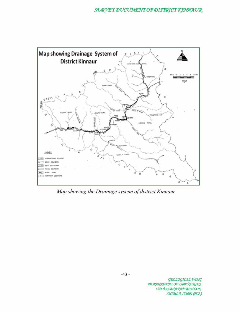
8. Drainage System
The general drainage pattern of the Rivers/ streams in the district is dendritic
pattern. All rivers/streams flowing in Kinnaur district are tributaties of Satluj River
catchment. The sources and the run along with other characteristics of the important
rivers and the streams draining various parts of Kinnaur are as follows:-
Sutlej :
Sutlej the principal river of the district arises in the Himalayas and has
plentiful perennial source of water. It enters Kinnaur district from the Tibetan
territory by a pass and reaches the boarder of Kullu. This river is called Shatarahu
in Sanskrit literature, Sutundri in vedic literature, Zaradros or Heisidrus in Greek,
Zungtee and Muksung in Tibetan as well as other being Sampoo, Sumudrung and
Sutoodra. It arises from the lake mansarover in the Tibetan hinglands and cuts the
Zanskar range at shipkila and enters district Kinnaur. The tributaries of the river
Sutlej in this district are the spiti river, the Ropa, the Taiti, the keshang, the
Mulgoon, the Yula, the wanger, the shorang and the Rupi on the right bank whereas
the Tirung, the Gyanthing, the baspa, the Duling and the Saoldung are its left bank
contributaries.
Spiti (Lee):
It is the second major river in the district. It has its source in the far-north on
the eastern slopes of the mountain ranges which run between Lahul and spiti.
Before meeting the Sutlej at the place called Khab, at an altitude of 2,589 meters,
Spiti is joined by many feeders which meet on both the banks. The Chaladokpo
(Left bank), the Yulang, the Lipak and the Tirasang (Right bank) are its main
tributaries.
The Baspa:
The Baspa river another feeder of Sutlej arises from Dhaula Dhar Mountain
ranges of Lower Himalayas and psses through valley bearing its name and meets
the Sutlej at Karchham, at an elevation of 5,945 feet, after a distance of 72
SURVEY DUCUMENT OF DISTRICT KINNAUR
-42 - GEOLOGICAL WING
DEPARTMENT OF INDUSTRIES, UDYOG BHAVAN BEMLOE,
SHIMLA-171001 (H.P.)
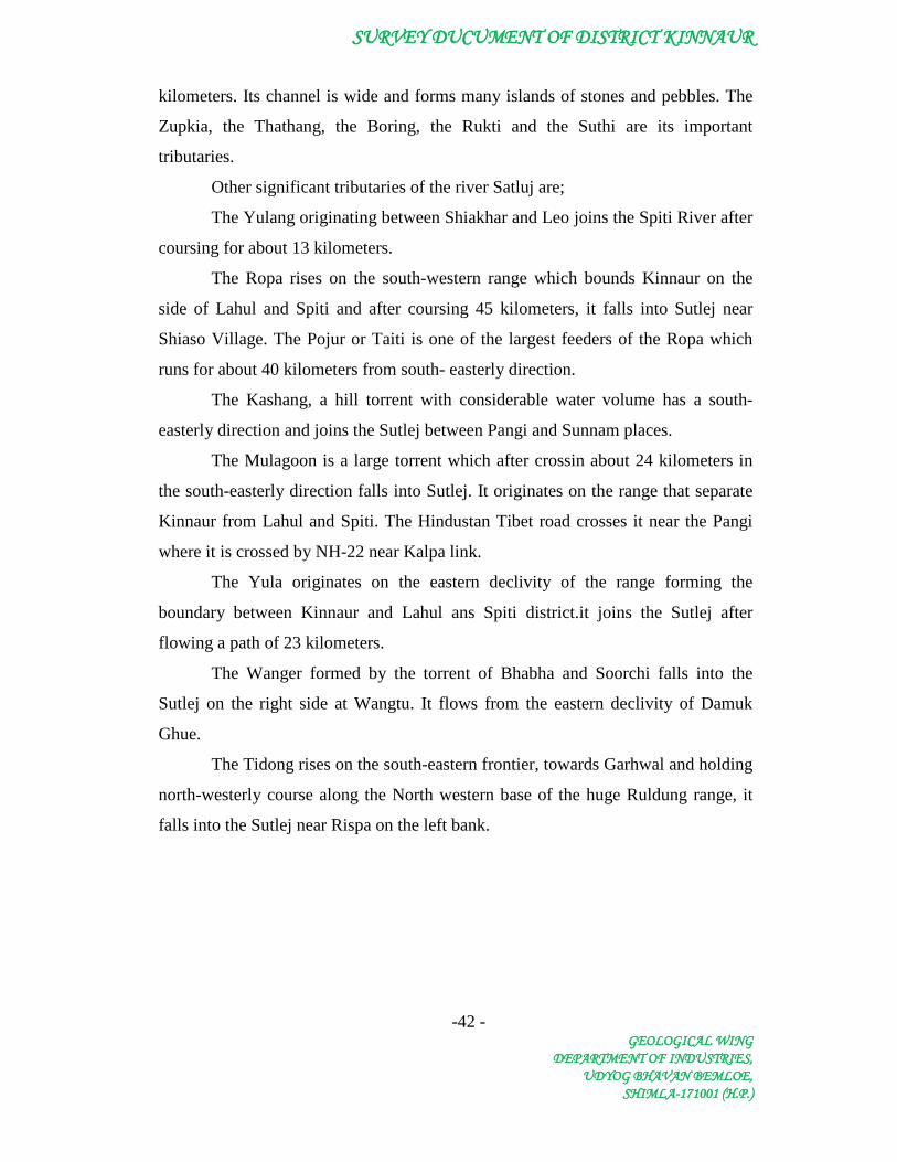
kilometers. Its channel is wide and forms many islands of stones and pebbles. The
Zupkia, the Thathang, the Boring, the Rukti and the Suthi are its important
tributaries.
Other significant tributaries of the river Satluj are;
The Yulang originating between Shiakhar and Leo joins the Spiti River after
coursing for about 13 kilometers.
The Ropa rises on the south-western range which bounds Kinnaur on the
side of Lahul and Spiti and after coursing 45 kilometers, it falls into Sutlej near
Shiaso Village. The Pojur or Taiti is one of the largest feeders of the Ropa which
runs for about 40 kilometers from south- easterly direction.
The Kashang, a hill torrent with considerable water volume has a south-
easterly direction and joins the Sutlej between Pangi and Sunnam places.
The Mulagoon is a large torrent which after crossin about 24 kilometers in
the south-easterly direction falls into Sutlej. It originates on the range that separate
Kinnaur from Lahul and Spiti. The Hindustan Tibet road crosses it near the Pangi
where it is crossed by NH-22 near Kalpa link.
The Yula originates on the eastern declivity of the range forming the
boundary between Kinnaur and Lahul ans Spiti district.it joins the Sutlej after
flowing a path of 23 kilometers.
The Wanger formed by the torrent of Bhabha and Soorchi falls into the
Sutlej on the right side at Wangtu. It flows from the eastern declivity of Damuk
Ghue.
The Tidong rises on the south-eastern frontier, towards Garhwal and holding
north-westerly course along the North western base of the huge Ruldung range, it
falls into the Sutlej near Rispa on the left bank.
SURVEY DUCUMENT OF DISTRICT KINNAUR
-43 -GEOLOGICAL WING
DEPARTMENT OF INDUSTRIES,UDYOG BHAVAN BEMLOE,
SHIMLA-171001 (H.P.)
Map showing the Drainage system of district Kinnaur

SURVEY DUCUMENT OF DISTRICT KINNAUR
-44 - GEOLOGICAL WING
DEPARTMENT OF INDUSTRIES, UDYOG BHAVAN BEMLOE,
SHIMLA-171001 (H.P.)
9. Methodology:
In order to identify the suitable mineral bearing deposits/quarries,
reconnaissance in district Kinnaur was carried out in the month of May 2011. On
the basis of observations made in the field total of 25 numbers of accessible
deposits/quarries were identified for the scientific excavation of the minor minerals
along the stream of the district.
The mineral potentials have been calculated based on field investigations
and geology of beds of the river/streams. It is also important to mention here that
there is a provision in the River/Stream Bed Mining Policy Guidelines where
collection of material upto a depth of one meter is allowed in a single season where
mineral concession have been granted. On the basis of field study it is noticed that
during flood season whole of the pits so excavated is completely filled up and as
such the excavated area is replenshed with new harvest of mineral. Mineral
constituents like boulder, river borne bajri, sand upto a depth of one metre are
considered as resource mineral. The specific gravity of each mineral constituent is
different. While calculating the mineral potential, the avrerage specific gravity is
taken as 2.25. The percentage of mineral constituents like boulder, river borne bajri,
sand are also varies for different river/stream. While calculating the mineral
potential the percentage of each mineral constituent is taken as, 35-40% for
Boulder, 30-35% for river born Bajri, 25-30% for sand and 5-10% for silt and clay.
The deposition in river beds is more pronounced during rainy season.
Although the quantum of deposition is varies, depending upon numbers of fectors
such as catchment lithology, discharge, river profile and geomorphology of the river
course. However there are certain geomorphological features developed in the river
beds such as channel bars, point bars etc. where annual deposition is much more
even two to three metres. The annual deposition of minor mineral in the different
river/stream beds has been calculated on the basis of field investigations and
geology of the catchment area of the river/streams. The rate of annual deposition of
minor mineral in the different river/stream beds of district Kinnaur varies from 9-10
cm.

SURVEY DUCUMENT OF DISTRICT KINNAUR
-45 - GEOLOGICAL WING
DEPARTMENT OF INDUSTRIES, UDYOG BHAVAN BEMLOE,
SHIMLA-171001 (H.P.)
10. Description of Quarries and Recommendations
10.1 Wangtu Quarry: On the left bank of the river Sutlej about 1.8 km upstream of
the Nathpa reservoir there is a deposit of river born material. The deposit is
comprises of river born material such as boulders, cobble, pebble, sand and clay.
This deposit is about 620 metres in length and about 30 metres in width.
Google Earth view of Wangtu Quarry
Minor Mineral Potential
As the stream cut its course through sky-scraping mountains which is the
prominent source of annual deposition in the river beds. During flood season, the
water carries heavy sediment load comprising gravels and sand which are deposited
along the bed of stream. The following mineral potentials have been calculated
based on the mineral constituent upto a depth of one metre. The annual deposition
of minor mineral in the river bed has been taken as annual deposition of 9-10 Cm.

SURVEY DUCUMENT OF DISTRICT KINNAUR
-46 - GEOLOGICAL WING
DEPARTMENT OF INDUSTRIES, UDYOG BHAVAN BEMLOE,
SHIMLA-171001 (H.P.)
Table Showing Minor Mineral Potential
Mineral Potential
Boulder (in MT)
River Born Bajri (in MT)
Sand (in MT)
Total Mineable Mineral Potential
(in MT) 18749 14582 8333 41664
Recommendation
It is evident from the above table that sufficient quantity of different sizes
of minor minerals are available upto depth of one metre in thequarry. It is therefore
recommended that mineral concession can be granted in this quarry.
10.2 Kilba Quarry:
On the left bank of the river Sutlej, downhill side of
village Kilba, there is a deposit of river born material. The deposits comprises of
materials, such as boulders, cobble, pebble, sand and clay. This deposit is about 820
metres in length and about 60 metres in width.
Minor Mineral Potential
As the stream cut its course through sky-scraping mountains which is the
prominent source of annual deposition in the river beds. During flood season, the
water carries heavy sediment load comprising gravels and sand which are deposited
along the bed of stream. The following mineral potentials have been calculated
based on the mineral constituent upto a depth of one metre. The annual deposition
of minor mineral in the river bed has been taken as annual deposition of 9-10 cm.

SURVEY DUCUMENT OF DISTRICT KINNAUR
-47 - GEOLOGICAL WING
DEPARTMENT OF INDUSTRIES, UDYOG BHAVAN BEMLOE,
SHIMLA-171001 (H.P.)
Google Earth view of Kilba Quarry
Table Showing Minor Mineral Potential
Mineral Potential
Boulder (in MT)
River Born Bajri (in MT)
Sand (in MT)
Total Mineable Mineral Potential
(in MT) 49594 38573 22042 110208
Recommendation
It is evident from the above table that sufficient quantity of different sizes
of minor minerals are available upto depth of one metre in thequarry. It is therefore
recommended that mineral concession can be granted in this quarry.

SURVEY DUCUMENT OF DISTRICT KINNAUR
-48 - GEOLOGICAL WING
DEPARTMENT OF INDUSTRIES, UDYOG BHAVAN BEMLOE,
SHIMLA-171001 (H.P.)
10.3 Shongtong Quarry:
On the right bank of the river Sutlej about 200 metres
upstream of the Shongtong village sufficient deposit of river born material is there.
The deposit is comprises of river born material such as boulders, cobble, pebble,
sand and clay. This deposit is about 260 metres in length and about 40 metres in
width.
Google Earth view of Shongtong Quarry
Minor Mineral Potential
As the stream cut its course through sky-scraping mountains which is the
prominent source of annual deposition in the river beds. During flood season, the
water carries heavy sediment load comprising gravels and sand which are deposited
along the bed of stream. The following mineral potentials have been calculated
based on the mineral constituent upto a depth of one metre. The annual deposition
of minor mineral in the river bed has been taken as annual deposition of 9-10 Cm.

SURVEY DUCUMENT OF DISTRICT KINNAUR
-49 - GEOLOGICAL WING
DEPARTMENT OF INDUSTRIES, UDYOG BHAVAN BEMLOE,
SHIMLA-171001 (H.P.)
Table Showing Minor Mineral Potential
Mineral Potential Boulder (in MT)
River Born Bajri (in MT)
Sand (in MT)
Total Mineable Mineral Potential
(in MT) 10483 8154 4659 23296
Recommendation It is evident from the above table that sufficient quantity of different sizes
of minor minerals are available upto depth of one metre in thequarry. It is therefore
recommended that mineral concession can be granted in this quarry.
10.4 Powari Quarry:
On the left bank of the river Sutlej downhillside of the
Powari village there is deposit of river born material. The deposit is comprises of
river born material such as boulders, cobble, pebble, sand and clay. This deposit is
about 490 metres in length and about 82 metres in width.
Google Earth view of Powari Quarry

SURVEY DUCUMENT OF DISTRICT KINNAUR
-50 - GEOLOGICAL WING
DEPARTMENT OF INDUSTRIES, UDYOG BHAVAN BEMLOE,
SHIMLA-171001 (H.P.)
Minor Mineral Potential
As the stream cut its course through sky-scraping mountains which is the
prominent source of annual deposition in the river beds. During flood season, the
water carries heavy sediment load comprising gravels and sand which are deposited
along the bed of stream. The following mineral potentials have been calculated
based on the mineral constituent upto a depth of one metre. The annual deposition
of minor mineral in the river bed has been taken as annual deposition of 9-10 Cm.
Table Showing Minor Mineral Potential
Mineral Potential
Boulder (in MT)
River Born Bajri (in MT)
Sand (in MT)
Total Mineable Mineral Potential
(in MT) 40501 31501 18001 90003
Recommendation
It is evident from the above table that sufficient quantity of different sizes
of minor minerals are available upto depth of one metre in thequarry. It is therefore
recommended that mineral concession can be granted in this quarry.
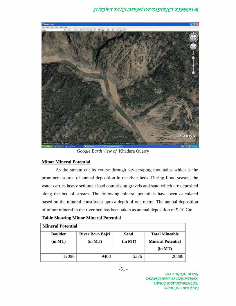
10.5 Khadura Quarry:
On the right bank of the river Sutlej downhill side of the Khadura village
sufficient deposit of river born material is there. The deposit is comprises of river
born material such as boulders, cobble, pebble, sand and clay. This deposit is about
240 metres in length and about 50 metres in width.
SURVEY DUCUMENT OF DISTRICT KINNAUR
-51 - GEOLOGICAL WING
DEPARTMENT OF INDUSTRIES, UDYOG BHAVAN BEMLOE,
SHIMLA-171001 (H.P.)
Google Earth view of Khadura Quarry
Minor Mineral Potential
As the stream cut its course through sky-scraping mountains which is the
prominent source of annual deposition in the river beds. During flood season, the
water carries heavy sediment load comprising gravels and sand which are deposited
along the bed of stream. The following mineral potentials have been calculated
based on the mineral constituent upto a depth of one metre. The annual deposition
of minor mineral in the river bed has been taken as annual deposition of 9-10 Cm.
Table Showing Minor Mineral Potential
Mineral Potential
Boulder
(in MT)
River Born Bajri
(in MT)
Sand
(in MT)
Total Mineable
Mineral Potential
(in MT)
12096 9408 5376 26880

SURVEY DUCUMENT OF DISTRICT KINNAUR
-52 - GEOLOGICAL WING
DEPARTMENT OF INDUSTRIES, UDYOG BHAVAN BEMLOE,
SHIMLA-171001 (H.P.)
Recommendation
It is evident from the above table that sufficient quantity of different sizes
of minor minerals are available upto depth of one metre in thequarry. It is therefore
recommended that mineral concession can be granted in this quarry.
10.6 Ribba Quarry:
On the right bank of the river Sutlej on the upstream side of
the confluence of Raldong Khad village sufficient deposit of river born material is
there. The deposit is comprises of river born material such as boulders, cobble,
pebble, sand and clay. This deposit is about 220 metres in length and about 60
metres in width.
Google Earth view of Ribba Quarry
SURVEY DUCUMENT OF DISTRICT KINNAUR
-53 - GEOLOGICAL WING
DEPARTMENT OF INDUSTRIES, UDYOG BHAVAN BEMLOE,
SHIMLA-171001 (H.P.)
Minor Mineral Potential
As the stream cut its course through sky-scraping mountains which is the
prominent source of annual deposition in the river beds. During flood season, the
water carries heavy sediment load comprising gravels and sand which are deposited
along the bed of stream. The following mineral potentials have been calculated
based on the mineral constituent upto a depth of one metre. The annual deposition
of minor mineral in the river bed has been taken as annual deposition of 9-10 Cm.
Table Showing Minor Mineral Potential
Mineral Potential
Boulder (in MT)
River Born Bajri (in MT)
Sand (in MT)
Total Mineable Mineral Potential
(in MT) 13306 10349 5914 29568
Recommendation
It is evident from the above table that sufficient quantity of different sizes of
minor minerals is available upto depth of one metre in thequarry. It is therefore
recommended that mineral concession can be granted in this quarry.
10.7 Skibba Quarry:
On the right bank of the river Sutlej about 200 metres of the
upstream of the Akpa bridge, sufficient deposit of river born material is there. The
deposit is comprises of river born material such as boulders, cobble, pebble, sand
and clay. This deposit is about 240 metres in length and about 120 metres in width.
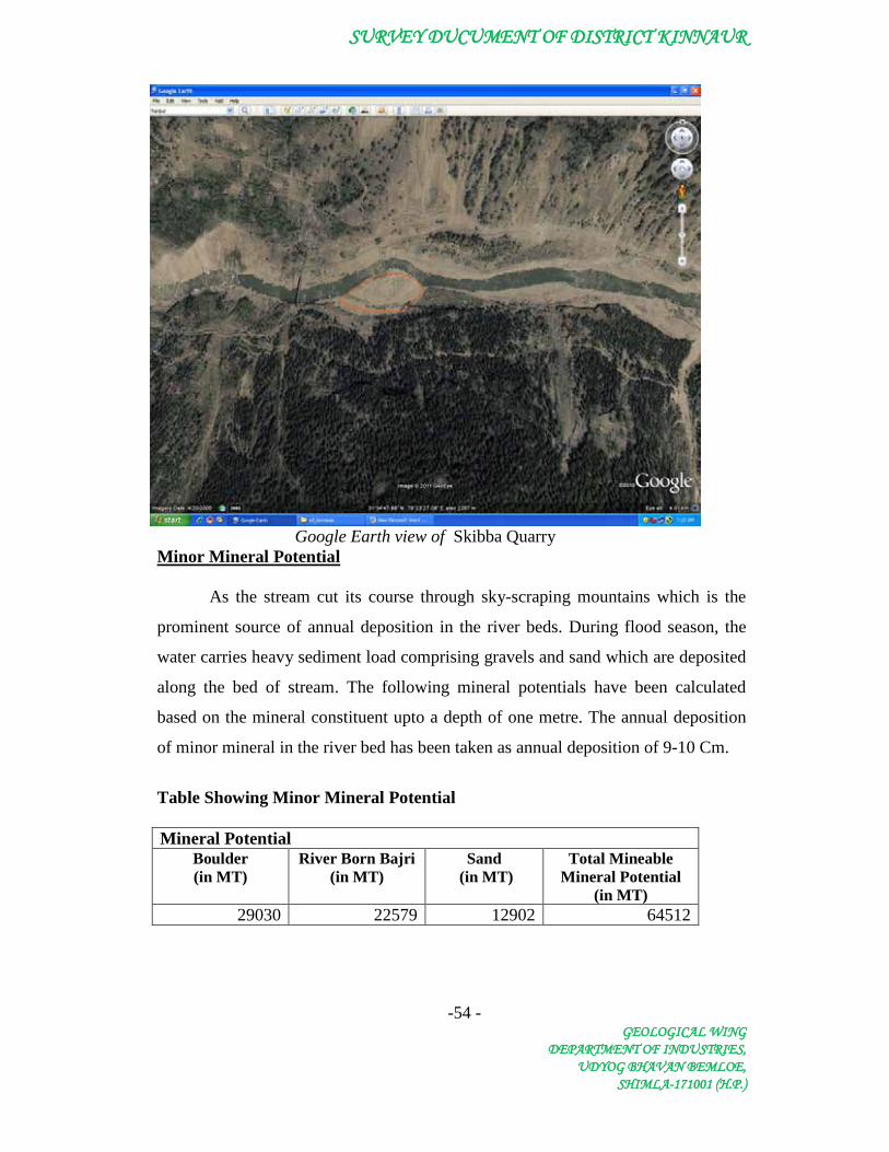
SURVEY DUCUMENT OF DISTRICT KINNAUR
-54 - GEOLOGICAL WING
DEPARTMENT OF INDUSTRIES, UDYOG BHAVAN BEMLOE,
SHIMLA-171001 (H.P.)
Google Earth view of Skibba Quarry
Minor Mineral Potential
As the stream cut its course through sky-scraping mountains which is the
prominent source of annual deposition in the river beds. During flood season, the
water carries heavy sediment load comprising gravels and sand which are deposited
along the bed of stream. The following mineral potentials have been calculated
based on the mineral constituent upto a depth of one metre. The annual deposition
of minor mineral in the river bed has been taken as annual deposition of 9-10 Cm.
Table Showing Minor Mineral Potential
Mineral Potential
Boulder (in MT)
River Born Bajri (in MT)
Sand (in MT)
Total Mineable Mineral Potential
(in MT) 29030 22579 12902 64512

SURVEY DUCUMENT OF DISTRICT KINNAUR
-55 - GEOLOGICAL WING
DEPARTMENT OF INDUSTRIES, UDYOG BHAVAN BEMLOE,
SHIMLA-171001 (H.P.)
Recommendation
It is evident from the above table that sufficient quantity of different sizes
of minor minerals are available upto depth of one metre in thequarry. It is therefore
recommended that mineral concession can be granted in this quarry.
10.8 Korti -A Quarry:
On the right bank of the river Sutlej about 2 km of the
upstream of the Akpa bridge sufficient deposit of river born material is there. The
deposit is comprises of river born material such as boulders, cobble, pebble, sand
and clay. This deposit is about 360 metres in length and about 80 metres in width.
Google Earth view of Korti Quarry A
Minor Mineral Potential
As the stream cut its course through sky-scraping mountains which is the
prominent source of annual deposition in the river beds. During flood season, the
water carries heavy sediment load comprising gravels and sand which are deposited
along the bed of stream. The following mineral potentials have been calculated

SURVEY DUCUMENT OF DISTRICT KINNAUR
-56 - GEOLOGICAL WING
DEPARTMENT OF INDUSTRIES, UDYOG BHAVAN BEMLOE,
SHIMLA-171001 (H.P.)
based on the mineral constituent upto a depth of one metre. The annual deposition
of minor mineral in the river bed has been taken as annual deposition of 9-10 Cm.
Table Showing Minor Mineral Potential Mineral Potential
Boulder (in MT)
River Born Bajri (in MT)
Sand (in MT)
Total Mineable Mineral Potential
(in MT) 29030 22579 12902 64512
Recommendation
It is evident from the above table that sufficient quantity of different sizes of minor minerals are available upto depth of one metre in thequarry. It is therefore recommended that mineral concession can be granted in this quarry.
10.9 Rispa Quarry: On the left bank of the river Sutlej and downhill side of the Rispa village sufficient deposit of river born material is there. The deposit is comprises of river born material such as boulders, cobble, pebble, sand and clay. This deposit is about 510 metres in length and about 100 metres in width.
Google Earth view of Rispa Quarry

SURVEY DUCUMENT OF DISTRICT KINNAUR
-57 - GEOLOGICAL WING
DEPARTMENT OF INDUSTRIES, UDYOG BHAVAN BEMLOE,
SHIMLA-171001 (H.P.)
Minor Mineral Potential
As the stream cut its course through sky-scraping mountains which is the prominent source of annual deposition in the river beds. During flood season, the water carries heavy sediment load comprising gravels and sand which are deposited along the bed of stream. The following mineral potentials have been calculated based on the mineral constituent upto a depth of one metre. The annual deposition of minor mineral in the river bed has been taken as annual deposition of 9-10 Cm.
Table Showing Minor Mineral Potential
Mineral Potential
Boulder (in MT)
River Born Bajri (in MT)
Sand (in MT)
Total Mineable Mineral Potential
(in MT) 51408 39984 22848 114240
Recommendation
It is evident from the above table that sufficient quantity of different sizes
of minor minerals are available upto depth of one metre in thequarry. It is therefore
recommended that mineral concession can be granted in this quarry.
10.10 Korti -B Quarry:
On the right bank of the river Sutlej about 2.5 km downstream of the
Moorang bridge sufficient deposit of river born material is there. The deposit is
comprises of river born material such as boulders, cobble, pebble, sand and clay.
This deposit is about 470 metres in length and about 120 metres in width.

SURVEY DUCUMENT OF DISTRICT KINNAUR
-58 - GEOLOGICAL WING
DEPARTMENT OF INDUSTRIES, UDYOG BHAVAN BEMLOE,
SHIMLA-171001 (H.P.)
Google Earth view of Korti Quarry B
Minor Mineral Potential
As the stream cut its course through sky-scraping mountains which is the
prominent source of annual deposition in the river beds. During flood season, the
water carries heavy sediment load comprising gravels and sand which are deposited
along the bed of stream. The following mineral potentials have been calculated
based on the mineral constituent upto a depth of one metre. The annual deposition
of minor mineral in the river bed has been taken as annual deposition of 9-10 Cm.
Table Showing Minor Mineral Potential
Mineral Potential Boulder (in MT)
River Born Bajri (in MT)
Sand (in MT)
Total Mineable Mineral Potential
(in MT) 56851 44218 25267 126336

SURVEY DUCUMENT OF DISTRICT KINNAUR
-59 - GEOLOGICAL WING
DEPARTMENT OF INDUSTRIES, UDYOG BHAVAN BEMLOE,
SHIMLA-171001 (H.P.)
Recommendation
It is evident from the above table that sufficient quantity of different sizes
of minor minerals are available upto depth of one metre in thequarry. It is therefore
recommended that mineral concession can be granted in this quarry.
10.11 Tirung Quarry:
On the left bank of the river Sutlej about 150 metres
downstream of the confluence of Tirung Khad sufficient deposit of river born
material is there. The deposit is comprises of river born material such as boulders,
cobble, pebble, sand and clay. This deposit is about 350 metres in length and about
35 metres in width.
Google Earth view of Tirung Quarry
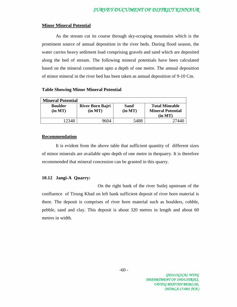
SURVEY DUCUMENT OF DISTRICT KINNAUR
-60 - GEOLOGICAL WING
DEPARTMENT OF INDUSTRIES, UDYOG BHAVAN BEMLOE,
SHIMLA-171001 (H.P.)
Minor Mineral Potential
As the stream cut its course through sky-scraping mountains which is the
prominent source of annual deposition in the river beds. During flood season, the
water carries heavy sediment load comprising gravels and sand which are deposited
along the bed of stream. The following mineral potentials have been calculated
based on the mineral constituent upto a depth of one metre. The annual deposition
of minor mineral in the river bed has been taken as annual deposition of 9-10 Cm.
Table Showing Minor Mineral Potential
Mineral Potential
Boulder (in MT)
River Born Bajri (in MT)
Sand (in MT)
Total Mineable Mineral Potential
(in MT) 12348 9604 5488 27440
Recommendation
It is evident from the above table that sufficient quantity of different sizes
of minor minerals are available upto depth of one metre in thequarry. It is therefore
recommended that mineral concession can be granted in this quarry.
10.12 Jangi-A Quarry:
On the right bank of the river Sutlej upstream of the
confluence of Tirung Khad on left bank sufficient deposit of river born material is
there. The deposit is comprises of river born material such as boulders, cobble,
pebble, sand and clay. This deposit is about 320 metres in length and about 60
metres in width.

SURVEY DUCUMENT OF DISTRICT KINNAUR
-61 - GEOLOGICAL WING
DEPARTMENT OF INDUSTRIES, UDYOG BHAVAN BEMLOE,
SHIMLA-171001 (H.P.)
Google Earth view of Jangi Quarry-A
Minor Mineral Potential
As the stream cut its course through sky-scraping mountains which is the prominent source of annual deposition in the river beds. During flood season, the water carries heavy sediment load comprising gravels and sand which are deposited along the bed of stream. The following mineral potentials have been calculated based on the mineral constituent upto a depth of one metre. The annual deposition of minor mineral in the river bed has been taken as annual deposition of 9-10 Cm.
Table Showing Minor Mineral Potential
Mineral Potential Boulder (in MT)
River Born Bajri (in MT)
Sand (in MT)
Total Mineable Mineral Potential
(in MT) 19354 15053 8602 43008
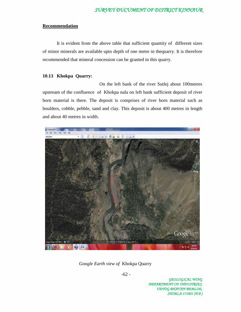
SURVEY DUCUMENT OF DISTRICT KINNAUR
-62 - GEOLOGICAL WING
DEPARTMENT OF INDUSTRIES, UDYOG BHAVAN BEMLOE,
SHIMLA-171001 (H.P.)
Recommendation
It is evident from the above table that sufficient quantity of different sizes
of minor minerals are available upto depth of one metre in thequarry. It is therefore
recommended that mineral concession can be granted in this quarry.
10.13 Khokpa Quarry:
On the left bank of the river Sutlej about 100metres
upstream of the confluence of Khokpa nala on left bank sufficient deposit of river
born material is there. The deposit is comprises of river born material such as
boulders, cobble, pebble, sand and clay. This deposit is about 400 metres in length
and about 40 metres in width.
Google Earth view of Khokpa Quarry

SURVEY DUCUMENT OF DISTRICT KINNAUR
-63 - GEOLOGICAL WING
DEPARTMENT OF INDUSTRIES, UDYOG BHAVAN BEMLOE,
SHIMLA-171001 (H.P.)
Minor Mineral Potential
As the stream cut its course through sky-scraping mountains which is the
prominent source of annual deposition in the river beds. During flood season, the
water carries heavy sediment load comprising gravels and sand which are deposited
along the bed of stream. The following mineral potentials have been calculated
based on the mineral constituent upto a depth of one metre. The annual deposition
of minor mineral in the river bed has been taken as annual deposition of 9-10 Cm.
Table Showing Minor Mineral Potential
Mineral Potential Boulder (in MT)
River Born Bajri (in MT)
Sand (in MT)
Total Mineable Mineral Potential
(in MT) 16128 12544 7168 35840
Recommendation
It is evident from the above table that sufficient quantity of different sizes
of minor minerals are available upto depth of one metre in thequarry. It is therefore
recommended that mineral concession can be granted in this quarry.
10.14 Jangi-B Quarry:
On the right bank of the river Sutlej about 500 metres
downstream of the Moorang bridge sufficient deposit of river born material is there.
The deposit is comprises of river born material such as boulders, cobble, pebble,
sand and clay. This deposit is about 520 metres in length and about 35 metres in
width.

SURVEY DUCUMENT OF DISTRICT KINNAUR
-64 - GEOLOGICAL WING
DEPARTMENT OF INDUSTRIES, UDYOG BHAVAN BEMLOE,
SHIMLA-171001 (H.P.)
Google Earth view of Jangi-B Quarry Minor Mineral Potential
As the stream cut its course through sky-scraping mountains which is the
prominent source of annual deposition in the river beds. During flood season, the
water carries heavy sediment load comprising gravels and sand which are deposited
along the bed of stream. The following mineral potentials have been calculated
based on the mineral constituent upto a depth of one metre. The annual deposition
of minor mineral in the river bed has been taken as annual deposition of 9-10 Cm.
Table Showing Minor Mineral Potential
Mineral Potential Boulder (in MT)
River Born Bajri (in MT)
Sand (in MT)
Total Mineable Mineral Potential
(in MT) 18346 14269 8154 40768
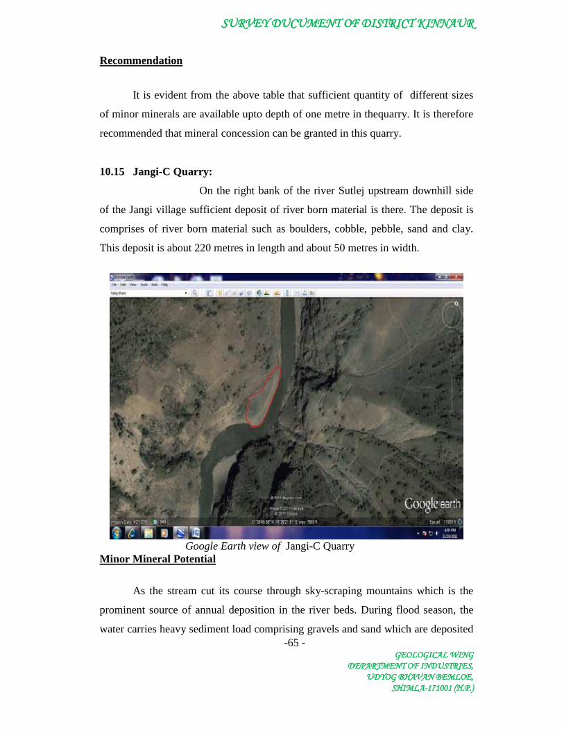
SURVEY DUCUMENT OF DISTRICT KINNAUR
-65 - GEOLOGICAL WING
DEPARTMENT OF INDUSTRIES, UDYOG BHAVAN BEMLOE,
SHIMLA-171001 (H.P.)
Recommendation
It is evident from the above table that sufficient quantity of different sizes
of minor minerals are available upto depth of one metre in thequarry. It is therefore
recommended that mineral concession can be granted in this quarry.
10.15 Jangi-C Quarry:
On the right bank of the river Sutlej upstream downhill side
of the Jangi village sufficient deposit of river born material is there. The deposit is
comprises of river born material such as boulders, cobble, pebble, sand and clay.
This deposit is about 220 metres in length and about 50 metres in width.
Google Earth view of Jangi-C Quarry
Minor Mineral Potential
As the stream cut its course through sky-scraping mountains which is the
prominent source of annual deposition in the river beds. During flood season, the
water carries heavy sediment load comprising gravels and sand which are deposited

SURVEY DUCUMENT OF DISTRICT KINNAUR
-66 - GEOLOGICAL WING
DEPARTMENT OF INDUSTRIES, UDYOG BHAVAN BEMLOE,
SHIMLA-171001 (H.P.)
along the bed of stream. The following mineral potentials have been calculated
based on the mineral constituent upto a depth of one metre. The annual deposition
of minor mineral in the river bed has been taken as annual deposition of 9-10 Cm.
Table Showing Minor Mineral Potential
Mineral Potential
Boulder (in MT)
River Born Bajri (in MT)
Sand (in MT)
Total Mineable Mineral Potential
(in MT) 11088 8624 4928 24640
Recommendation
It is evident from the above table that sufficient quantity of different sizes
of minor minerals are available upto depth of one metre in thequarry. It is therefore
recommended that mineral concession can be granted in this quarry.
10.16 Jangi-D Quarry:
On the right bank of the river Sutlej upstream of the Jaqngi-C
quarry sufficient deposit of river born material is there. The deposit is comprises of
river born material such as boulders, cobble, pebble, sand and clay. This deposit is
about 400 metres in length and about 50 metres in width.

SURVEY DUCUMENT OF DISTRICT KINNAUR
-67 - GEOLOGICAL WING
DEPARTMENT OF INDUSTRIES, UDYOG BHAVAN BEMLOE,
SHIMLA-171001 (H.P.)
Google Earth view of Jangi-D Quarry Minor Mineral Potential
As the stream cut its course through sky-scraping mountains which is the
prominent source of annual deposition in the river beds. During flood season, the
water carries heavy sediment load comprising gravels and sand which are deposited
along the bed of stream. The following mineral potentials have been calculated
based on the mineral constituent upto a depth of one metre. The annual deposition
of minor mineral in the river bed has been taken as annual deposition of 9-10 Cm.
Table Showing Minor Mineral Potential
Mineral Potential
Boulder (in MT)
River Born Bajri (in MT)
Sand (in MT)
Total Mineable Mineral Potential
(in MT) 20160 15680 8960 44800
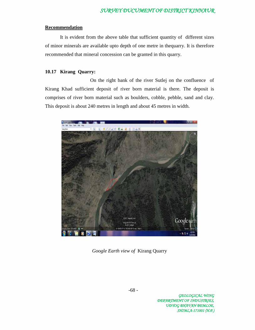
SURVEY DUCUMENT OF DISTRICT KINNAUR
-68 - GEOLOGICAL WING
DEPARTMENT OF INDUSTRIES, UDYOG BHAVAN BEMLOE,
SHIMLA-171001 (H.P.)
Recommendation
It is evident from the above table that sufficient quantity of different sizes
of minor minerals are available upto depth of one metre in thequarry. It is therefore
recommended that mineral concession can be granted in this quarry.
10.17 Kirang Quarry:
On the right bank of the river Sutlej on the confluence of
Kirang Khad sufficient deposit of river born material is there. The deposit is
comprises of river born material such as boulders, cobble, pebble, sand and clay.
This deposit is about 240 metres in length and about 45 metres in width.
Google Earth view of Kirang Quarry

SURVEY DUCUMENT OF DISTRICT KINNAUR
-69 - GEOLOGICAL WING
DEPARTMENT OF INDUSTRIES, UDYOG BHAVAN BEMLOE,
SHIMLA-171001 (H.P.)
Minor Mineral Potential
As the stream cut its course through sky-scraping mountains which is the
prominent source of annual deposition in the river beds. During flood season, the
water carries heavy sediment load comprising gravels and sand which are deposited
along the bed of stream. The following mineral potentials have been calculated
based on the mineral constituent upto a depth of one metre. The annual deposition
of minor mineral in the river bed has been taken as annual deposition of 9-10 Cm.
Table Showing Minor Mineral Potential
Mineral Potential
Boulder (in MT) River Born Bajri
(in MT)
Sand (in MT) Total Mineable
Mineral Potential
(in MT)
10886 8467 4838 21192
Recommendation
It is evident from the above table that sufficient quantity of different sizes
of minor minerals are available upto depth of one metre in thequarry. It is therefore
recommended that mineral concession can be granted in this quarry.
10.18 Spillow-A Quarry:
On the right bank of the river Sutlej about 1 km upstream of
the Kirang bridge sufficient deposit of river born material is there. The deposit is
comprises of river born material such as boulders, cobble, pebble, sand and clay.
This deposit is about 300 metres in length and about 60 metres in width.

SURVEY DUCUMENT OF DISTRICT KINNAUR
-70 - GEOLOGICAL WING
DEPARTMENT OF INDUSTRIES, UDYOG BHAVAN BEMLOE,
SHIMLA-171001 (H.P.)
Google Earth view of Spillow-A Quarry
Minor Mineral Potential
As the stream cut its course through sky-scraping mountains which is the
prominent source of annual deposition in the river beds. During flood season, the
water carries heavy sediment load comprising gravels and sand which are deposited
along the bed of stream. The following mineral potentials have been calculated
based on the mineral constituent upto a depth of one metre. The annual deposition
of minor mineral in the river bed has been taken as annual deposition of 9-10 Cm.
Table Showing Minor Mineral Potential
Mineral Potential
Boulder(in MT) River Born Bajri
(in MT)
Sand (in MT) Total Mineable
Mineral Potential
(in MT)
18144 14112 8064 40320
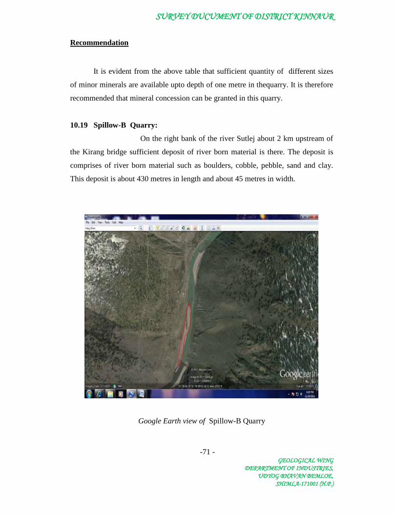
SURVEY DUCUMENT OF DISTRICT KINNAUR
-71 - GEOLOGICAL WING
DEPARTMENT OF INDUSTRIES, UDYOG BHAVAN BEMLOE,
SHIMLA-171001 (H.P.)
Recommendation
It is evident from the above table that sufficient quantity of different sizes
of minor minerals are available upto depth of one metre in thequarry. It is therefore
recommended that mineral concession can be granted in this quarry.
10.19 Spillow-B Quarry:
On the right bank of the river Sutlej about 2 km upstream of
the Kirang bridge sufficient deposit of river born material is there. The deposit is
comprises of river born material such as boulders, cobble, pebble, sand and clay.
This deposit is about 430 metres in length and about 45 metres in width.
Google Earth view of Spillow-B Quarry

SURVEY DUCUMENT OF DISTRICT KINNAUR
-72 - GEOLOGICAL WING
DEPARTMENT OF INDUSTRIES, UDYOG BHAVAN BEMLOE,
SHIMLA-171001 (H.P.)
Minor Mineral Potential
As the stream cut its course through sky-scraping mountains which is the
prominent source of annual deposition in the river beds. During flood season, the
water carries heavy sediment load comprising gravels and sand which are deposited
along the bed of stream. The following mineral potentials have been calculated
based on the mineral constituent upto a depth of one metre. The annual deposition
of minor mineral in the river bed has been taken as annual deposition of 9-10 Cm.
Table Showing Minor Mineral Potential
Mineral Potential
Boulder(in MT) River Born
Bajri (in MT)
Sand (in MT) Total Mineable
Mineral Potential
(in MT)
19505 15170 8669 43344
Recommendation
It is evident from the above table that sufficient quantity of different sizes
of minor minerals are available upto depth of one metre in thequarry. It is therefore
recommended that mineral concession can be granted in this quarry.
10.20 Spillow-C Quarry:
On the right bank of the river Sutlej downstream of the
confluence of Ropa Khad sufficient deposit of river born material is there. The
deposit is comprises of river born material such as boulders, cobble, pebble, sand
and clay. This deposit is about 250 metres in length and about 45 metres in width.
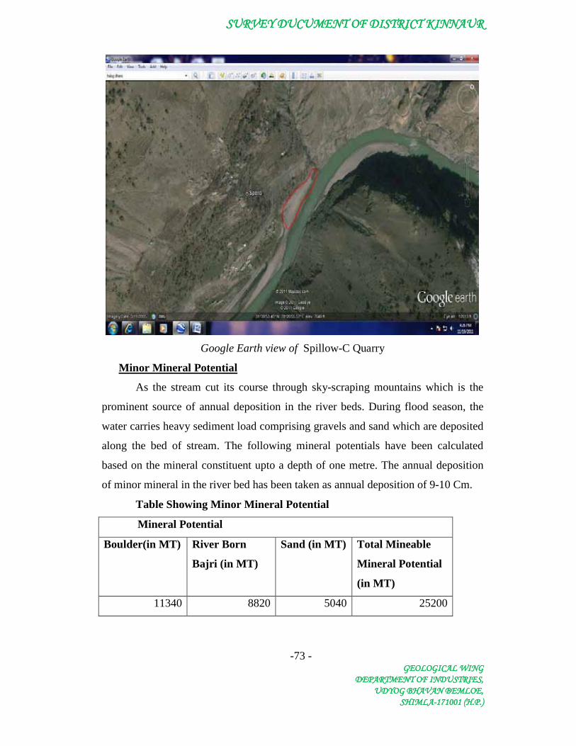
SURVEY DUCUMENT OF DISTRICT KINNAUR
-73 - GEOLOGICAL WING
DEPARTMENT OF INDUSTRIES, UDYOG BHAVAN BEMLOE,
SHIMLA-171001 (H.P.)
Google Earth view of Spillow-C Quarry
Minor Mineral Potential
As the stream cut its course through sky-scraping mountains which is the
prominent source of annual deposition in the river beds. During flood season, the
water carries heavy sediment load comprising gravels and sand which are deposited
along the bed of stream. The following mineral potentials have been calculated
based on the mineral constituent upto a depth of one metre. The annual deposition
of minor mineral in the river bed has been taken as annual deposition of 9-10 Cm.
Table Showing Minor Mineral Potential
Mineral Potential
Boulder(in MT) River Born
Bajri (in MT)
Sand (in MT) Total Mineable
Mineral Potential
(in MT)
11340 8820 5040 25200
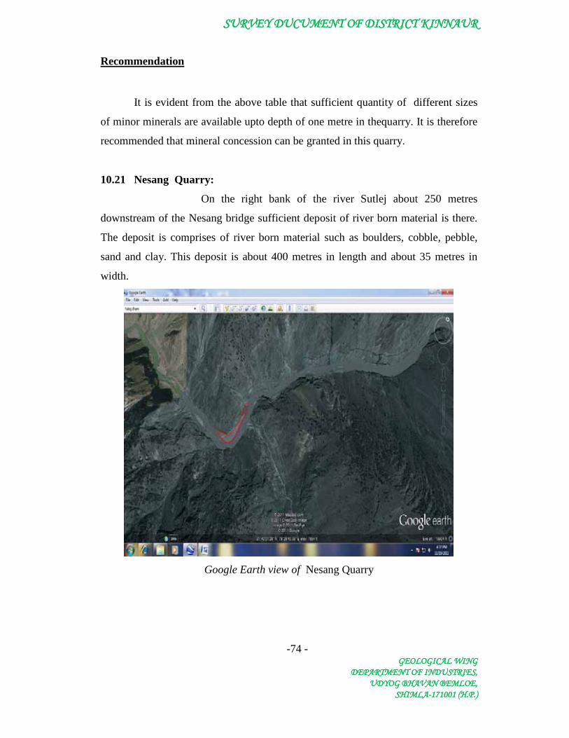
SURVEY DUCUMENT OF DISTRICT KINNAUR
-74 - GEOLOGICAL WING
DEPARTMENT OF INDUSTRIES, UDYOG BHAVAN BEMLOE,
SHIMLA-171001 (H.P.)
Recommendation
It is evident from the above table that sufficient quantity of different sizes
of minor minerals are available upto depth of one metre in thequarry. It is therefore
recommended that mineral concession can be granted in this quarry.
10.21 Nesang Quarry:
On the right bank of the river Sutlej about 250 metres
downstream of the Nesang bridge sufficient deposit of river born material is there.
The deposit is comprises of river born material such as boulders, cobble, pebble,
sand and clay. This deposit is about 400 metres in length and about 35 metres in
width.
Google Earth view of Nesang Quarry

SURVEY DUCUMENT OF DISTRICT KINNAUR
-75 - GEOLOGICAL WING
DEPARTMENT OF INDUSTRIES, UDYOG BHAVAN BEMLOE,
SHIMLA-171001 (H.P.)
Minor Mineral Potential
As the stream cut its course through sky-scraping mountains which is the
prominent source of annual deposition in the river beds. During flood season, the
water carries heavy sediment load comprising gravels and sand which are deposited
along the bed of stream. The following mineral potentials have been calculated
based on the mineral constituent upto a depth of one metre. The annual deposition
of minor mineral in the river bed has been taken as annual deposition of 9-10 Cm.
Table Showing Minor Mineral Potential
Mineral Potential
Boulder(in MT) River Born Bajri
(in MT)
Sand (in MT) Total Mineable
Mineral Potential
(in MT)
14112 10976 6272 31360
Recommendation
It is evident from the above table that sufficient quantity of different sizes
of minor minerals are available upto depth of one metre in thequarry. It is therefore
recommended that mineral concession can be granted in this quarry.
10.22 Giamul Quarry:
On the right bank of the river Sutlej about 500 metres
downstream of the confluence of the Shiaso Khad sufficient deposit of river born
material is there. The deposit is comprises of river born material such as boulders,
cobble, pebble, sand and clay. This deposit is about 250 metres in length and about
60 metres in width.

SURVEY DUCUMENT OF DISTRICT KINNAUR
-76 - GEOLOGICAL WING
DEPARTMENT OF INDUSTRIES, UDYOG BHAVAN BEMLOE,
SHIMLA-171001 (H.P.)
Google Earth view of Giamul Quarry
Minor Mineral Potential
As the stream cut its course through sky-scraping mountains which is the
prominent source of annual deposition in the river beds. During flood season, the
water carries heavy sediment load comprising gravels and sand which are deposited
along the bed of stream. The following mineral potentials have been calculated
based on the mineral constituent upto a depth of one metre. The annual deposition
of minor mineral in the river bed has been taken as annual deposition of 9-10 Cm.
Table Showing Minor Mineral Potential
Mineral Potential
Boulder(in MT) River Born Bajri
(in MT)
Sand (in MT) Total Mineable
Mineral Potential
(in MT)
15120 11760 6720 33600
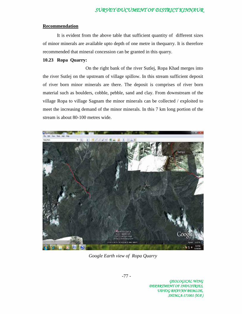
SURVEY DUCUMENT OF DISTRICT KINNAUR
-77 - GEOLOGICAL WING
DEPARTMENT OF INDUSTRIES, UDYOG BHAVAN BEMLOE,
SHIMLA-171001 (H.P.)
Recommendation
It is evident from the above table that sufficient quantity of different sizes
of minor minerals are available upto depth of one metre in thequarry. It is therefore
recommended that mineral concession can be granted in this quarry.
10.23 Ropa Quarry:
On the right bank of the river Sutlej, Ropa Khad merges into
the river Sutlej on the upstream of village spillow. In this stream sufficient deposit
of river born minor minerals are there. The deposit is comprises of river born
material such as boulders, cobble, pebble, sand and clay. From downstream of the
village Ropa to village Sagnam the minor minerals can be collected / exploited to
meet the increasing demand of the minor minerals. In this 7 km long portion of the
stream is about 80-100 metres wide.
Google Earth view of Ropa Quarry

SURVEY DUCUMENT OF DISTRICT KINNAUR
-78 - GEOLOGICAL WING
DEPARTMENT OF INDUSTRIES, UDYOG BHAVAN BEMLOE,
SHIMLA-171001 (H.P.)
Minor Mineral Potential
As the stream cut its course through sky-scraping mountains which is the
prominent source of annual deposition in the river beds. During flood season, the
water carries heavy sediment load comprising gravels and sand which are deposited
along the bed of stream. The following mineral potentials have been calculated
based on the mineral constituent upto a depth of one metre. The annual deposition
of minor mineral in the river bed has been taken as annual deposition of 9-10 Cm.
Table Showing Minor Mineral Potential
Mineral Potential
Boulder(in MT) River Born Bajri
(in MT)
Sand (in MT) Total Mineable
Mineral Potential
(in MT)
564480 439040 250880 1254400
Recommendation
It is evident from the above table that sufficient quantity of different sizes
of minor minerals are available upto depth of one metre in thequarry. It is therefore
recommended that mineral concession can be granted in this quarry.
10.24 Chango Quarry:
On the right bank of the river Sutlej, Spiti river merges into
the river Sutlej at Khab. In this stream only few deposit of minor minerals are there,
comprises of river born material such as boulders, cobble, pebble, sand and clay. On
the right bank of this stream, about 2 km downstream of the village Chango deposit
of about 340 metres long and 30 metres wide is an accessible deposit of minor
mineral.
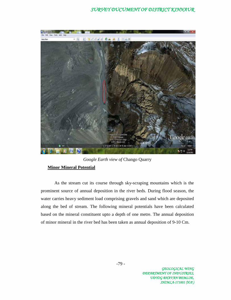
SURVEY DUCUMENT OF DISTRICT KINNAUR
-79 - GEOLOGICAL WING
DEPARTMENT OF INDUSTRIES, UDYOG BHAVAN BEMLOE,
SHIMLA-171001 (H.P.)
Google Earth view of Chango Quarry
Minor Mineral Potential
As the stream cut its course through sky-scraping mountains which is the
prominent source of annual deposition in the river beds. During flood season, the
water carries heavy sediment load comprising gravels and sand which are deposited
along the bed of stream. The following mineral potentials have been calculated
based on the mineral constituent upto a depth of one metre. The annual deposition
of minor mineral in the river bed has been taken as annual deposition of 9-10 Cm.

SURVEY DUCUMENT OF DISTRICT KINNAUR
-80 - GEOLOGICAL WING
DEPARTMENT OF INDUSTRIES, UDYOG BHAVAN BEMLOE,
SHIMLA-171001 (H.P.)
Table Showing Minor Mineral Potential
Mineral Potential
Boulder (in MT) River Born Bajri
(in MT)
Sand (in MT) Total Mineable
Mineral Potential
(in MT)
10282 7997 4570 22848
Recommendation
It is evident from the above table that sufficient quantity of different sizes
of minor minerals are available upto depth of one metre in thequarry. It is therefore
recommended that mineral concession can be granted in this quarry.
10.25 Shalkhar Quarry:
On the right bank of the river Sutlej, Spiti river merges into the river Sutlej
at Khab. In this stream only few deposit of minor minerals are there, comprises of
river born material such as boulders, cobble, pebble, sand and clay. On the left and
right bank of this stream, about 3 km downstream of the village Shalkhar deposit of
about 400 metres long and 60 metres wide is an accessible deposit of minor
mineral.
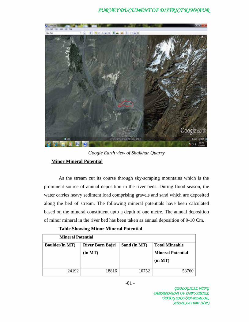
SURVEY DUCUMENT OF DISTRICT KINNAUR
-81 - GEOLOGICAL WING
DEPARTMENT OF INDUSTRIES, UDYOG BHAVAN BEMLOE,
SHIMLA-171001 (H.P.)
Google Earth view of Shalkhar Quarry
Minor Mineral Potential
As the stream cut its course through sky-scraping mountains which is the
prominent source of annual deposition in the river beds. During flood season, the
water carries heavy sediment load comprising gravels and sand which are deposited
along the bed of stream. The following mineral potentials have been calculated
based on the mineral constituent upto a depth of one metre. The annual deposition
of minor mineral in the river bed has been taken as annual deposition of 9-10 Cm.
Table Showing Minor Mineral Potential
Mineral Potential
Boulder(in MT) River Born Bajri
(in MT)
Sand (in MT) Total Mineable
Mineral Potential
(in MT)
24192 18816 10752 53760

SURVEY DUCUMENT OF DISTRICT KINNAUR
-82 - GEOLOGICAL WING
DEPARTMENT OF INDUSTRIES, UDYOG BHAVAN BEMLOE,
SHIMLA-171001 (H.P.)
Recommendation
It is evident from the above table that sufficient quantity of different sizes
of minor minerals are available upto depth of one metre in thequarry. It is therefore
recommended that mineral concession can be granted in this quarry.

SURVEY DUCUMENT OF DISTRICT KINNAUR
-83 - GEOLOGICAL WING
DEPARTMENT OF INDUSTRIES, UDYOG BHAVAN BEMLOE,
SHIMLA-171001 (H.P.)
11. Summary of Reccommendation
Sr. No. Name of Quarry Length Width Area 1 Wangtu 620 30 18600 2 Kilba 820 60 49200 3 Shongtong 260 40 10400 4 Powari 490 82 40180 5 Khadura 240 50 12000 6 Ribba 220 60 13200 7 Skibba 240 120 28800 8 Korti-A 360 80 28800 9 Rispa 510 100 51000
10 Korti-B 470 120 56400 11 Tirung 350 35 12250 12 Jangi-A 320 60 19200 13 Khokpa 400 40 16000 14 Jangi-B 520 35 18200 15 Jangi-C 220 50 11000 16 Jangi-D 400 50 20000 17 Kirang 240 45 10800 18 Spillow-A 300 60 18000 19 Spillow-B 430 45 19350 20 Spillow-c 250 45 11250 21 Nesang 400 35 14000 22 Giamul 250 60 15000 23 Ropa 7000 80 560000 24 Chango 340 30 10200 25 Shalkhar 400 60 24000
Table showing details of the quarries
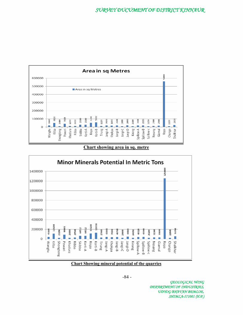
SURVEY DUCUMENT OF DISTRICT KINNAUR
-84 -GEOLOGICAL WING
DEPARTMENT OF INDUSTRIES,UDYOG BHAVAN BEMLOE,
SHIMLA-171001 (H.P.)
Chart showing area in sq. metre
Chart Showing mineral potential of the quarries
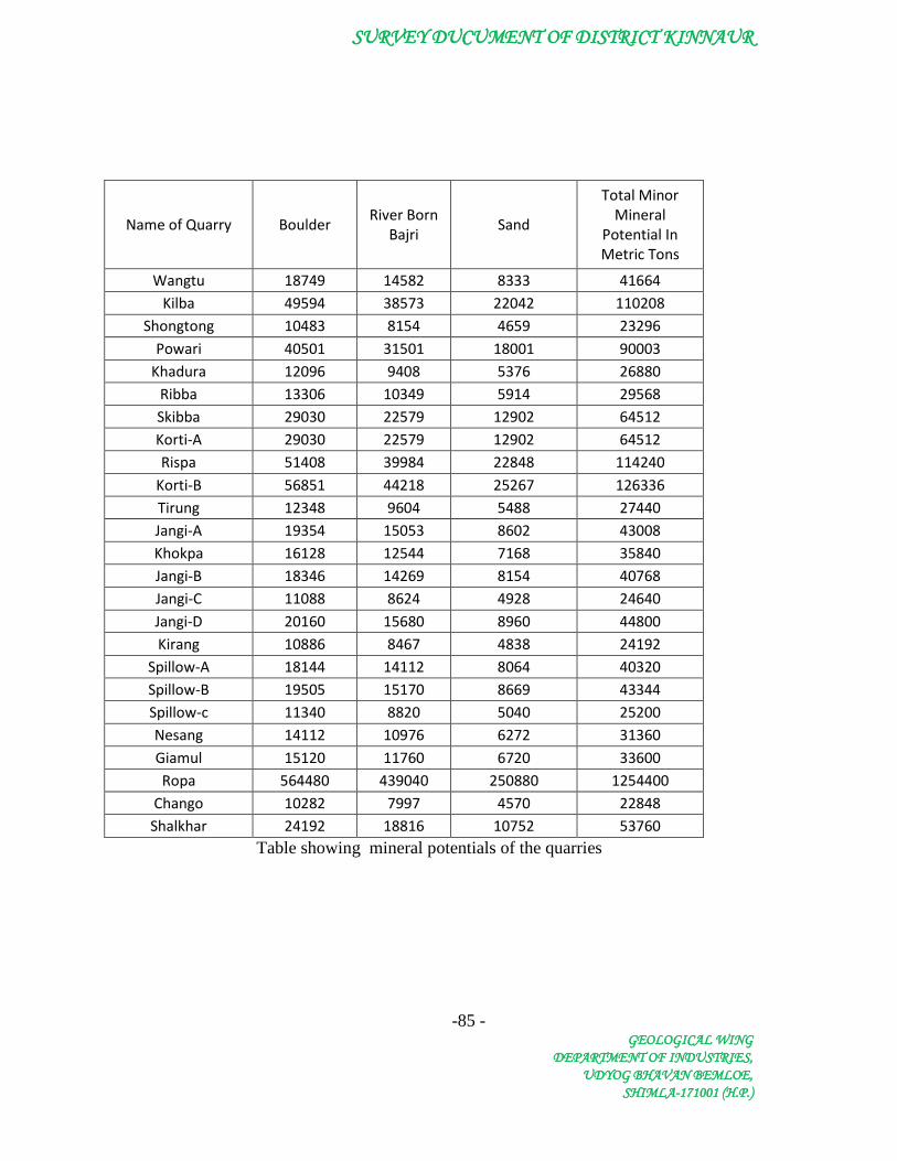
SURVEY DUCUMENT OF DISTRICT KINNAUR
-85 - GEOLOGICAL WING
DEPARTMENT OF INDUSTRIES, UDYOG BHAVAN BEMLOE,
SHIMLA-171001 (H.P.)
Name of Quarry Boulder River Born
Bajri Sand
Total Minor Mineral
Potential In Metric Tons
Wangtu 18749 14582 8333 41664 Kilba 49594 38573 22042 110208
Shongtong 10483 8154 4659 23296 Powari 40501 31501 18001 90003
Khadura 12096 9408 5376 26880 Ribba 13306 10349 5914 29568 Skibba 29030 22579 12902 64512 Korti-A 29030 22579 12902 64512 Rispa 51408 39984 22848 114240
Korti-B 56851 44218 25267 126336 Tirung 12348 9604 5488 27440 Jangi-A 19354 15053 8602 43008 Khokpa 16128 12544 7168 35840 Jangi-B 18346 14269 8154 40768 Jangi-C 11088 8624 4928 24640 Jangi-D 20160 15680 8960 44800 Kirang 10886 8467 4838 24192
Spillow-A 18144 14112 8064 40320 Spillow-B 19505 15170 8669 43344 Spillow-c 11340 8820 5040 25200 Nesang 14112 10976 6272 31360 Giamul 15120 11760 6720 33600 Ropa 564480 439040 250880 1254400
Chango 10282 7997 4570 22848 Shalkhar 24192 18816 10752 53760
Table showing mineral potentials of the quarries
Top Related