


Languages
Pages
Legal


1
2
3
4
ALLUVIUMMedium dense, moist, brown, silty SAND (SM), mediumgrained, with clay, mica flakes and fine gravel
Loose, moist, brown, poorly graded SAND with silt (SP-SM),coarse grained, with mica flakes and fine gravel
Medium dense, moist, brown, silty SAND (SM), coarsegrained, with fine gravel
TONALITE OF LA POSTALight yellowish brown with black and white crystals,phaneritic, coarse grained, completely weathered, extremelyweak rock. Breaks down to very dense, grayish brown, siltySAND (SM)
85
95
80
80
0927
75
09290942
66
09450959
72
1001
1008
52
10111029
1
WA(19), MC(10),DUW(118), LL(23),PI(4), CORR
MC(19)
WA(8), MC(18)
SA(12), MC(14)
26
10
6
70
1
2
3
4
D. Rector
Bentonite seal
Date(s)Drilled
DrillingMethod HQ-3
Inclination fromHorizontal/Bearing 90°
BoreholeCompletion
140 lbs/30" automatichammer
08/23/11
2332.4 ft (NAVD 88)
LoggedBy P. Balasubramanyam
Total DepthDrilled
CheckedBy
GroundwaterLevel
Drill RigType
Hammer Data
Burley 4500, Rig #2 Approx. SurfaceElevation
DrillingContractor
9.5 feet
Drill BitSize/TypeCoring
Crux
50.0 feet
CoordinateLocation (NAD 83)
Location
32.65724 -116.61765
Link 1, Section 8C
MATERIAL DESCRIPTIONLi
thol
ogy
Ele
vatio
n,
feet
SOILSAMPLES
Blo
ws/
foo
t
REMARKSAND
LAB TESTS
Dril
l Tim
e a
ndR
ate
(ft/h
r]
Num
ber
Dep
th,
feet
Num
ber
Typ
e
Fra
ctur
espe
r F
oot
Rec
over
y,%
R Q
D, %
Fra
ctur
eD
raw
ing
ROCK CORE
Box
No.
Run
No.
Project Location: San Diego and Imperial Counties, California
0
1
2
3
4
5
6
7
8
9
10
11
12
13
Project Number: 27661032
Project: Sunrise Powerlink Project
2332
2330
2328
2326
2324
2322
2320
Sheet 1 of 4
Log of Boring B-EP54-1R
epor
t: S
UN
RIS
E_C
OR
E L
OG
; F
ile: 2
7661
032
.GP
J;
9/1
/201
1
B-E
P54
-1

4
4
5
6
7
8
Grades to black and white (salt and pepper colored),completely to highly weathered, with some muscovite micaflakes. Breaks down to bluish gray, well-graded SANDwith silt (SW-SM)
Becomes very weak rock
Becomes extremely weak rock
Becomes very weak rock
Breaks down to dark gray, poorly graded SAND with silt(SP-SM)
Grades to highly weathered, weak to very weak rock, withfew muscovite mica flakes
With many mafic minerals
1: 45°, J, N, Fe, Sp, Pl, Sr
Becomes weak rock, breaks down to well-graded SAND(SW) with gravel
2: 55°, J, (set), N, Fe, Sp, Pl, Sr
Breaks down to poorly graded SAND with silt (SP-SM)
100
100
100
100
1111
22
22
300
10301040
50
10461053
75
10571101
60
1
2
SA(9), MC(16)
WA(6), MC(6)
SA(3), MC(5)
50/5"
50/5"
5
6
7
MATERIAL DESCRIPTION
Lith
olog
y
Ele
vatio
n,
feet
SOILSAMPLES
Blo
ws/
foo
t
REMARKSAND
LAB TESTS
Dril
l Tim
e a
ndR
ate
(ft/h
r]
Num
ber
Dep
th,
feet
Num
ber
Typ
e
Fra
ctur
espe
r F
oot
Rec
over
y,%
R Q
D, %
Fra
ctur
eD
raw
ing
ROCK CORE
Box
No.
Run
No.
Project Location: San Diego and Imperial Counties, California
13
14
15
16
17
18
19
20
21
22
23
24
25
26
27
28
29
Project Number: 27661032
Project: Sunrise Powerlink Project
2318
2316
2314
2312
2310
2308
2306
2304
Sheet 2 of 4
Log of Boring B-EP54-1R
epor
t: S
UN
RIS
E_C
OR
E L
OG
; F
ile: 2
7661
032
.GP
J;
9/1
/201
1
B-E
P54
-1

3
9
10
11
1: 35°, J, N, No, N, Pl, Sr2: 45°, J, N, No, N, Pl, Sr
Decrease in iron oxide staining to 5-10%
Grades to slightly weathered, strong rock, with 0-5% ironoxide staining
100
100
100 100
M
M
MM
112
11061110
75
11141021
60
10261130
15
2
UC8
MATERIAL DESCRIPTION
Lith
olog
y
Ele
vatio
n,
feet
SOILSAMPLES
Blo
ws/
foo
t
REMARKSAND
LAB TESTS
Dril
l Tim
e a
ndR
ate
(ft/h
r]
Num
ber
Dep
th,
feet
Num
ber
Typ
e
Fra
ctur
espe
r F
oot
Rec
over
y,%
R Q
D, %
Fra
ctur
eD
raw
ing
ROCK CORE
Box
No.
Run
No.
Project Location: San Diego and Imperial Counties, California
29
30
31
32
33
34
35
36
37
38
39
40
41
42
43
44
45
Project Number: 27661032
Project: Sunrise Powerlink Project
2302
2300
2298
2296
2294
2292
2290
2288
Sheet 3 of 4
Log of Boring B-EP54-1R
epor
t: S
UN
RIS
E_C
OR
E L
OG
; F
ile: 2
7661
032
.GP
J;
9/1
/201
1
B-E
P54
-1

12
Becomes very strong rock
Bottom of boring at 50 feet
100 100
11501210
9
1238
2
MATERIAL DESCRIPTION
Lith
olog
y
Ele
vatio
n,
feet
SOILSAMPLES
Blo
ws/
foo
t
REMARKSAND
LAB TESTS
Dril
l Tim
e a
ndR
ate
(ft/h
r]
Num
ber
Dep
th,
feet
Num
ber
Typ
e
Fra
ctur
espe
r F
oot
Rec
over
y,%
R Q
D, %
Fra
ctur
eD
raw
ing
ROCK CORE
Box
No.
Run
No.
Project Location: San Diego and Imperial Counties, California
45
46
47
48
49
50
51
52
53
54
55
56
57
58
59
60
61
Project Number: 27661032
Project: Sunrise Powerlink Project
2286
2284
2282
2280
2278
2276
2274
2272
Sheet 4 of 4
Log of Boring B-EP54-1R
epor
t: S
UN
RIS
E_C
OR
E L
OG
; F
ile: 2
7661
032
.GP
J;
9/1
/201
1
B-E
P54
-1

UNIFIED SOIL CLASSIFICATION Sieve Dia. %
No. mm Finer
3" 75.0 100.0
2" 50.0 100.0
1.5" 37.5 100.0
1" 25.0 100.0
3/4" 19.00 100.0
1/2" 12.50 100.0
3/8" 9.50 100.0
#4 4.75 99.6
#10 2.00 93.7
#20 0.850 72.3
#40 0.425 45.6
#60 0.250 28.9
#100 0.150 19.0
#140 0.106 14.9
#200 0.075 12.4
% Cobbles XX
0.4
87.212.4
D85
D60
D50
D30
D15
D10
Boring No. Sample No. Depth (ft) SYMBOL Wn (%) LL PI % 2 m Description and Classification Cu
B-EP54-1 4 10.8 14.2 NA NA NA Cc
PROJECT NAME: Sunrise PowerlinkPROJECT NUMBER: 27661032
% Gravel % Sand
Hyd
rom
eter
Ana
lysi
s
#N/A
% Fines
XXX
0.618
PARTICLE-SIZE DISTRIBUTION CURVES
0.259
Brown silty Sand (SM)
1.412
0.476
0.107
XXX
50 5 0.5 0.05 0.005
#2003" 2" 1" 3/4" 3/8" #4 #10 #20 #40 #60 #100
0
10
20
30
40
50
60
70
80
90
100
0.0010.010.1110100
PE
RC
EN
T P
AS
SIN
G B
Y W
EIG
HT
GRAIN SIZE IN MILLIMETERS
U. S. STANDARD SIEVE SIZES
COBBLES
GRAVEL SAND SILT AND CLAYCOARSE FINE COARSE FINEMEDIUM
HYDROMETER
Sieve Sunrise EP54-1 010 URS
UNIFIED SOIL CLASSIFICATION Sieve Dia. %
No. mm Finer
3" 75.0 100.0
2" 50.0 100.0
1.5" 37.5 100.0
1" 25.0 100.0
3/4" 19.00 100.0
1/2" 12.50 100.0
3/8" 9.50 100.0
#4 4.75 98.0
#10 2.00 87.0
#20 0.850 59.7
#40 0.425 37.1
#60 0.250 24.6
#100 0.150 16.3
#140 0.106 11.7
#200 0.075 8.7
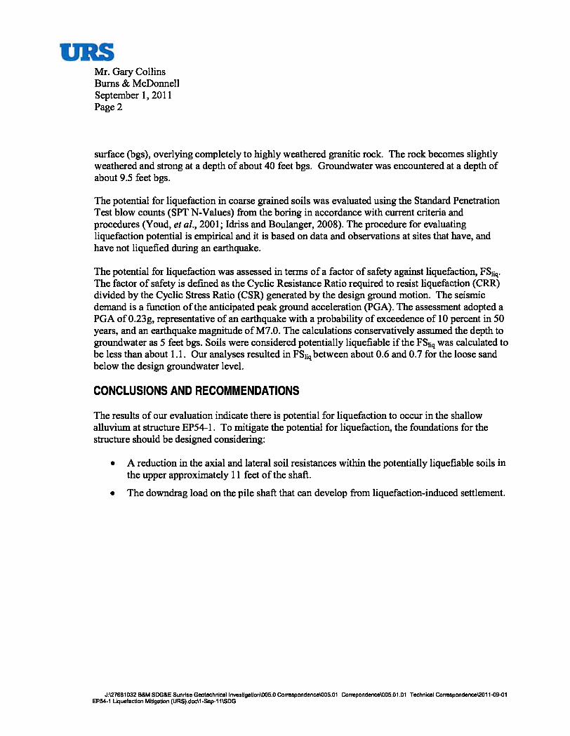
% Cobbles XX
2.0
89.38.7
D85
D60
D50
D30
D15
D10
Boring No. Sample No. Depth (ft) SYMBOL Wn (%) LL PI % 2 m Description and Classification Cu
B-EP54-1 5 15.8 15.8 NA NA NA Cc
PROJECT NAME: Sunrise PowerlinkPROJECT NUMBER: 27661032
% Gravel % Sand
Hyd
rom
eter
Ana
lysi
s
0.087
% Fines
1.3
0.858
PARTICLE-SIZE DISTRIBUTION CURVES
0.314
Bluish gray well-graded Sand with silt (SW-SM)
1.878
0.631
0.136
9.8
50 5 0.5 0.05 0.005
#2003" 2" 1" 3/4" 3/8" #4 #10 #20 #40 #60 #100
0
10
20
30
40
50
60
70
80
90
100
0.0010.010.1110100
PE
RC
EN
T P
AS
SIN
G B
Y W
EIG
HT
GRAIN SIZE IN MILLIMETERS
U. S. STANDARD SIEVE SIZES
COBBLES
GRAVEL SAND SILT AND CLAYCOARSE FINE COARSE FINEMEDIUM
HYDROMETER
Sieve Sunrise EP54-1 015 URS
UNIFIED SOIL CLASSIFICATION Sieve Dia. %
No. mm Finer
3" 75.0 100.0
2" 50.0 100.0
1.5" 37.5 100.0
1" 25.0 100.0
3/4" 19.00 100.0
1/2" 12.50 96.1
3/8" 9.50 87.5
#4 4.75 74.7
#10 2.00 53.1
#20 0.850 32.7
#40 0.425 19.3
#60 0.250 11.8
#100 0.150 7.0
#140 0.106 4.8
#200 0.075 3.4
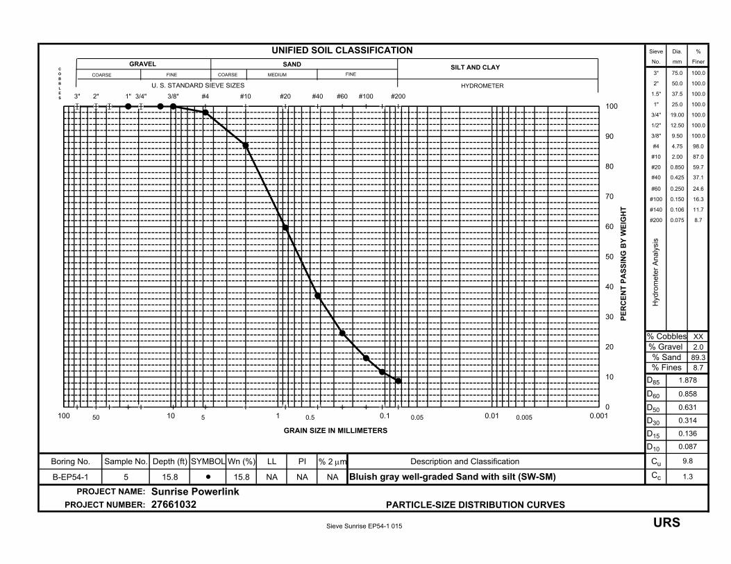
% Cobbles XX
25.3
71.33.4
D85
D60
D50
D30
D15
D10
Boring No. Sample No. Depth (ft) SYMBOL Wn (%) LL PI % 2 m Description and Classification Cu
B-EP54-1 7 26.0 4.7 NA NA NA Cc
PROJECT NAME: Sunrise PowerlinkPROJECT NUMBER: 27661032
% Gravel % Sand
Hyd
rom
eter
Ana
lysi
s
0.206
% Fines
1.0
2.637
PARTICLE-SIZE DISTRIBUTION CURVES
0.739
Dark gray well-graded Sand with gravel (SW)
8.297
1.756
0.314
12.8
50 5 0.5 0.05 0.005
#2003" 2" 1" 3/4" 3/8" #4 #10 #20 #40 #60 #100
0
10
20
30
40
50
60
70
80
90
100
0.0010.010.1110100
PE
RC
EN
T P
AS
SIN
G B
Y W
EIG
HT
GRAIN SIZE IN MILLIMETERS
U. S. STANDARD SIEVE SIZES
COBBLES
GRAVEL SAND SILT AND CLAYCOARSE FINE COARSE FINEMEDIUM
HYDROMETER
Sieve Sunrise EP54-1 026 URS


Water Length Diameter Wet Unit Peak
Content (%) (in) (in) Weight (pcf) Stress (psi)
Project Name: Sunrise Powerlink
Project Number: 27661030
Boring Number: B-EP54-1 Depth (ft): 40.8
Description and/or Classification:
Failure Sketch
5.019 2.401
Bluish gray with black speckles Granite
0.2 174.6 6410
UNCONFINED COMPRESSION TEST
ASTM D7012
0.0
1000.0
2000.0
3000.0
4000.0
5000.0
6000.0
7000.0
0.0 0.5 1.0 1.5 2.0 2.5 3.0
Co
mp
ress
ive
Str
ess
(psi
)
Axial Strain (%)
SR-206 (4/99) (SNA) UCr Sunrise EP54-1 041 URS

CORROSIVITY TEST ANALYSIS
Project Number: Boring No.:
Project Name: Sample No.:
Project Engineer: Depth (ft):
Initial Visual Classification Symbol:
State of Specimen before Processing Set-Up Minus No. 8
x Passing soil through #8 sieve Water Content or ( )
x Moist State Container No. C3
Air Dried Mass Container + Wet Soil (g), M1 103.54
Oven Dried at 60 C Mass Container + Dry Soil (g), M2 101.79
Mass Container (g), M3 71.97
Water Content, w (%) 5.87
Resistivity Test: California Test Method 643 Mininum Resistence value: ohm-cm
Trial 1 Trial 2 Trial 3 Trial 4 Trial 5
Weight of Soil in bowl (g):
Weight of mixing bowl (g):
Wet weight of Soil (g):
Amount of water added (ml):
Soil Box + Wet Soil (g), M5
Weight of Soil Box (g), M6
Wt. of Wet Soil for test (g), M7
Volume of Soil Box (cm3)
Est. Saturation (%)
Resistivity Reading (ohm)
Resistence (ohm-cm)
Resistence = Soil Box Constant x Reading
pH Test : California Test Method 532 pH of slurry: 9.30
50g wet weight of soil mixed with 50 mL of de-ionized water. Temperature : 21.6 Celsius
Sulfate Content:
100g of soil mixed with 300 mL of de-ionized water. SO4 (ppm) :recorded mg of SO4 in sample, x, = mg
soil / water ratio, r, =
number of dilutions to obtain above value, d, = = mg/ L = ppmDilution Equation, d > 0; SO4 = (( x / 80 )* ( r 80 * 2 d - r 80 * 2(d-1) ) ) + r 80 * 2(d-1)
Chloride Content:
100g of soil mixed with 300 mL of de-ionized water. Cl- (ppm) :
mg/L of Cl- = ((A-B) x N x 35453) x 3A = mL of AgNO3 A=
B = 23 mL of the blank
N = 0.0493 N, normality of the titrant Cl- (mg/L) = A * 5 * 3
Tested By: Date: Checked By: TJO
Sunrise Powerlink
KG
MG 8/25/2011
75
5
21,000
27661032
239.01 266.66268.31264.42
B-EP54-1
0 20
21,000
259.07
123.95
135.12
79.2
7,300
123.95
115.06
79.2
5,3005,50075.716.4 79.6
not detected0
5,3005,5007,300 6,000
2.5
1
5,300
473.36
123.95
142.71
123.95
464.58
144.36
79.2 79.2
10 10
139.25 139.25
288.81 325.33 334.11
SM
139.25 139.25 139.25
428.06 446.31 455.14
3
307.06 315.89
10
79.2
64.46,000
60.1
123.95
140.47
SNA (2007) corrosivity Sunrise EP54-1 002.5 URS
Top Related