


Languages
Pages
Legal

Indonesian Journal of Geology, Vol. 8 No. 4 December 2013: 205-214
Stratigraphy and Tectonics of the East Ketungau Basin, West Kalimantan during Palaeogene
Stratigrafi dan Tektonika Cekungan Ketungau Timur, Kalimantan Barat selama Paleogen
Suyono
Centre for Geological Survey, Geological Agency, Ministry of Energy and Mineral ResourcesJln. Diponegoro No.57 Bandung, Indonesia
Corresponding Author: [email protected] received: October 24, 2013, revised: November 11, 2013, approved: December 12, 2013
Abstract
East Ketungau Basin is one of frontier basins in Indonesia. Some of these basins, especially those in eastern Indonesia, have been identified to possess potential of oil and gas. The existing publications of geological fieldworks and extensive exploration in the East Ketungau Basin are limited. The detailed sedimentological and biostratigraphical studies of the sedimentary succession will be used to reconstruct the tectonic and pal-aeogeographical history of the basin. The sedimentary Mandai Group consists of three facies such as mudstone facies, clean sand facies and alternation between thinly coal seam, coaly shale, and claystone facies. However, each facies characterizes depositional environment of barrier- island and associated strand-plain systems.
Keywords: East Ketungau Basin, Palaeogene, Mandai Group
Abstrak
Cekungan Ketungau Timur merupakan salah satu cekungan perbatasan di Indonesia yang beberapa di antaranya telah teridentifikasi memiliki potensi minyak dan gas, terutama di Indonesia bagian timur. Publikasi yang tersedia tentang penelitian geologi di lapangan dan eksplorasi ekstensif di Cekungan Ketungau Timur sampai saat ini masih terbatas. Penelitian sedimentologi dan biostratigrafi terperinci mengenai runtunan batuan sedimen akan digunakan untuk merekonstruksi sejarah tektonika dan paleogeografi cekungan tersebut. Sedimen Kelompok Mandai terdiri atas tiga fasies, yaitu fasies batulumpur, fasies pasir bersih, dan perselingan antara lapisan batubara tipis, serpih batubaraan, dan fasies batulempung. Namun, setiap fasies memiliki karakteristik lingkungan pengendapan barrierisland dan sistem asosiasi pantaidataran.
Kata kunci: Cekungan Ketungau Timur, Paleogen, Kelompok Mandai
Introduction
West Kalimantan is a frontier area for many natural resources of conventional and unconven-tional potential such as economic mineral, coal, and hydrocarbon especially in the Ketungau and Melawi Basins. Geologically, the northern part of West Kalimantan can be divided into several geological provinces, i.e. South China Sea Basin to the west and
northwest, Rajang Accretionary Prism to the north, and Schwaner Mountains to the south. The basin is bounded by the longitudes 112o 30’ to 114o and 0o to 1o North latitude (Figure1).
The subsequent rotational history of Kalimantan, concerning its relative position is still a matter of debate-interpretations including “no rotation” (Lee and Lawyer, 1995), “clockwise rotation” (Rangin et al., 1990), “counter clockwise rotation” (Haile
205

206 Indonesian Journal of Geology, Vol. 8 No. 4 December 2013: 205-214
et al., 1978; Hamilton, 1979; Hall, 1996; Charlton, 2000; and Tjia, 2012), and “mixed rotations” (Briais et al., 1993 in Hall, 1996). The recent publication by Tjia (2012) assumed that Kalimantan did not experience a progressive counter clockwise rotation during the Cenozoic, whereas the dynamics of the spreading of the South Sea China Basin, the strong west-verging Pacific Plate, the northward progres-sion of the Indian Ocean-Australian Plate, and pos-sibly extrusion of continental Southeast Asia appear
to have impacted the region differently at different times of the Cenozoic.
This paper will describe the geology, stratig-raphy, and tectonic setting of the East Ketungau Basin of the West Kalimantan region during Pal-aeogene, on the basis of detailed sedimentological and biostratigraphical data. All samples belonging to the East Ketungau Basin were collected during the Center of Geological Survey (PSG) fieldwork in 2009 and 2010.
0 100 km
Melawi RiverKayan River
Sintang
MELAWI BASIN
River
KALIMANTAN
BLOCK
Pontianak
Kapuas
SCHWANER MOUNTAIN
WESTKETUNGAUBASIN
EASTKETUNGAUBASIN
Serawak
Serawak
Accretionary Prism
KALIMANTAN
NORTHWEST
112 Eo
113 Eo
111 Eo
109 Eo
110 Eo
1 So
0o
1 No
2 No
Late Palaezoic granitoidsand metamorphic rock
Early and Late Cretaceousgranite
Melange zone
Belt of Early Cretaceousgranitoids
Fault
International Boundary
Large Tertiary instrusives
Alluvium
Pleistocene - Recent(fluviatile and lacustrine)
Tertiary(fluviatile to marginal marine basins)
Cretaceous (slope)
Jurassic - Cretaceous(marginal facies and turbidites)
LateTriassic(continental to shallow marine)
Legend:
Figure1. Location and regional geological map of the Melawi and Ketungau Basins (modified from Williams and Harahap, 1987).

207Stratigraphy and Tectonics of the East Ketungau Basin, West Kalimantan during Palaeogene (Suyono)
Methodology
Accomplishing the purpose of the study, specific geological investigation and laboratory analyses were carried out. Then, the study was focused on the strati-graphic analysis of each member of Mandai Group, with logging sections using geological compass and GPS. Basically, each facies of the Mandai Group was selected for a representative section, which was supported by collecting rock samples for laboratory analysis, such as pollen and foraminifera analysis, rock-eval pyrolysis, and GC-MS analysis in order to acquire ages and depositional environments in this basin. The paleontologic analysis was conducted at GSI paleontology laboratory, whilst the last two analyses were carried out at LEMIGAS labora-tory. Following standard procedures. The detailed sedimentological and biostratigraphical studies of the sedimentary succession led to the construction of an updated stratigraphy of the East Ketungau Basin.
Geological Outline
The palaeogeographic evolution of East Ke-tungau Basin between Late Cretaceous and Early Tertiary still remains to be debated, such as foreland basin (Pieters et al., 1993) and related subduction process (William and Harahap, 1987).
The author assumes that the East Ketungau Basin (or Mandai Basin) was formed by the colli-sion between the Schwaner Arc and Eurasian Plate during Late Cretaceous until Early Tertiary, and it is interpreted as a fore arc basin, whereas the Schwaner Mountains I - type granitoid belt is a magmatic arc. The Boyan melange is situated in the south and the Sarawak Accretionary Prism in the north (would be consistent with subduction). Pieters et al. (1993) named the clastic deposits that filled the Palaeogene sedimentary basins in eastern North West Kaliman-tan as the Mandai Group.
Fieldwork of the Mandai Group was carried out between 2009 and 2010 along Sebilit, Boyan, Mente-bah, and Semangut Rivers. Sandstone and mudstone facies in this area are gently dipping northward and unconformably overlay the Selangkai Group and other basement rocks in the Putussibau and border of the Sintang Quadrangles.
Stratigraphy and Tectonics
StratigraphyThe Mandai Group was firstly defined by Pieters
et al. (1993), comprising medium-to fine-grained sandstone, mudstone, siltstone, and locally coal seam which crop out in the Mandai River.
The recent fieldwork of the basin suggests that the Mandai Group sediments were divided into three facies, from lower to upper parts as mudstone facies, clean sandstone facies, and alternating sandstone and mudstone with locally coal seam.
In the upstream area of the Sebilit River, the East Ketungau Basin sediments are dominated by mudstone facies consisting of siltstone, fine-grained sandstone, and mudstone representing the lower part of the Mandai Group. Its exposure can also be found along the upstream area of the Boyan River, Mentebah, and road cuts between Sebilit and Boyan Rivers. A detailed stratigraphic section of the lower part of mudstone facies is characterized by an alter-nation of dark grey shallow marine, silty mudstone and very fine-grained well sorted sandstone (Figure 2a). Furthermore, the upper part of mudstone facies is dominated by parallel laminations of grey to red-dish siltstone and claystone with thin carbonaceous layers (Figure 2b). Generally, the mudstone facies has bedding dips between 15o - 33o to the north and northeast.
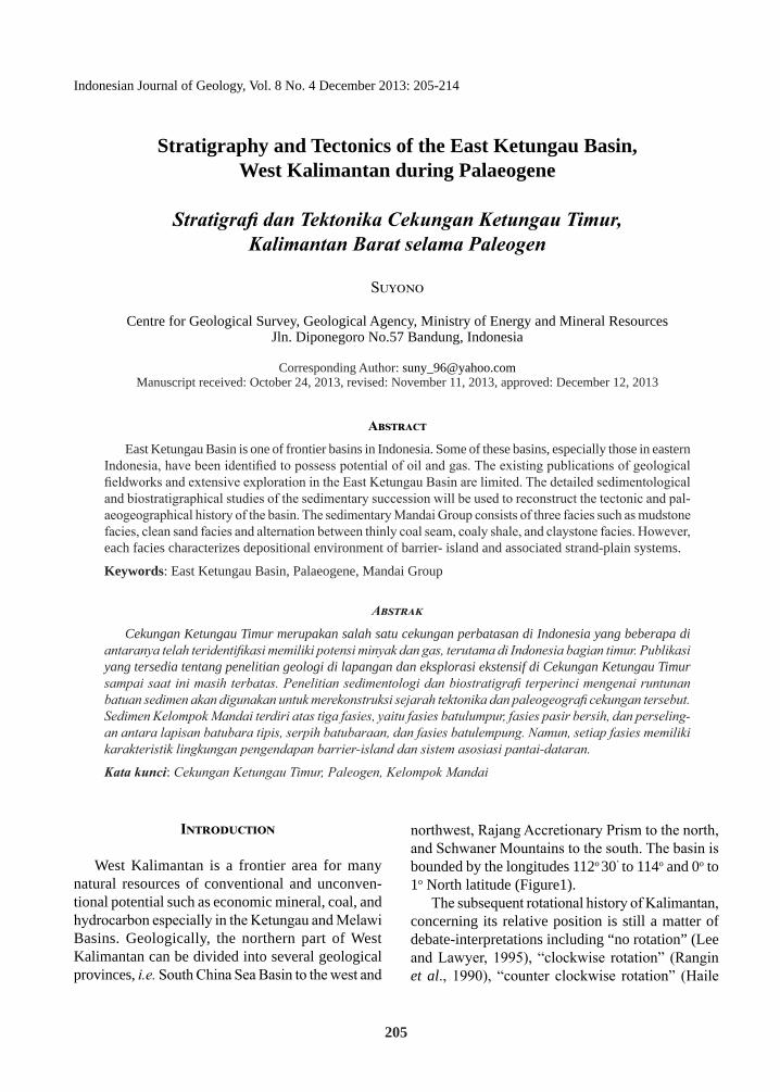
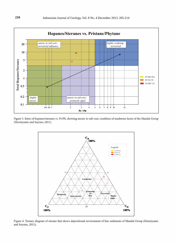
The analysis results of foraminifera,ichno fossil, and palinology (Table 1) supported by rock-eval py-rolysis and GC - MS mode results (Figures 3 and 4), tend to show a shallowest open marine-transitional-anoxic to sub-oxic lacustrine depositional environ-ment. This facies is approximately 150 m thick in the upstream area. The mudstone facies is correlated with Kantu Formation in the West Ketungau Basin.
The ‘clean sand’ facies is found in the middle part of the Palaeogene Mandai group sediments, characterized by white to brown quartz sandstone, medium- to coarse- grained well sorted sandstone showing massive and well bedded sandstone, with scour structure, cross stratification, and locally shows mudrapes. The sequence is well exposed in Boyan Rivers, Nangapayang Hill, and Mentebah Rivers. The lower part of clean sand facies is domi-nantly composed of cross-bedding ranging from 20- 30 cm representing a medium scale (Conybeare and

208 Indonesian Journal of Geology, Vol. 8 No. 4 December 2013: 205-214
Crook, 1986). This sand body (sand bar) is mainly formed in the upper part of the ‘clean sand’ facies. This facies conformably overlies the mudstone fa-cies and is correlated with Tutoop Sandstone in the West Ketungau Basin. The thickness of this sequence is around 150 m in Nangapayang Hill, Simpangsuruk Subregency.
Due to the occurrence of Rosalia and Skolithos ichnofossil (Table 1), the sequence was probably deposited as a barrier bar in a tidal environment. The direction of paleocurrent in the sandstone facies ia to northwest, north, and northeast directions. The source of clean sand facies (Figure 5) possibly is Schwaner granite and metamorphic basement from the Schwaner Mountain.
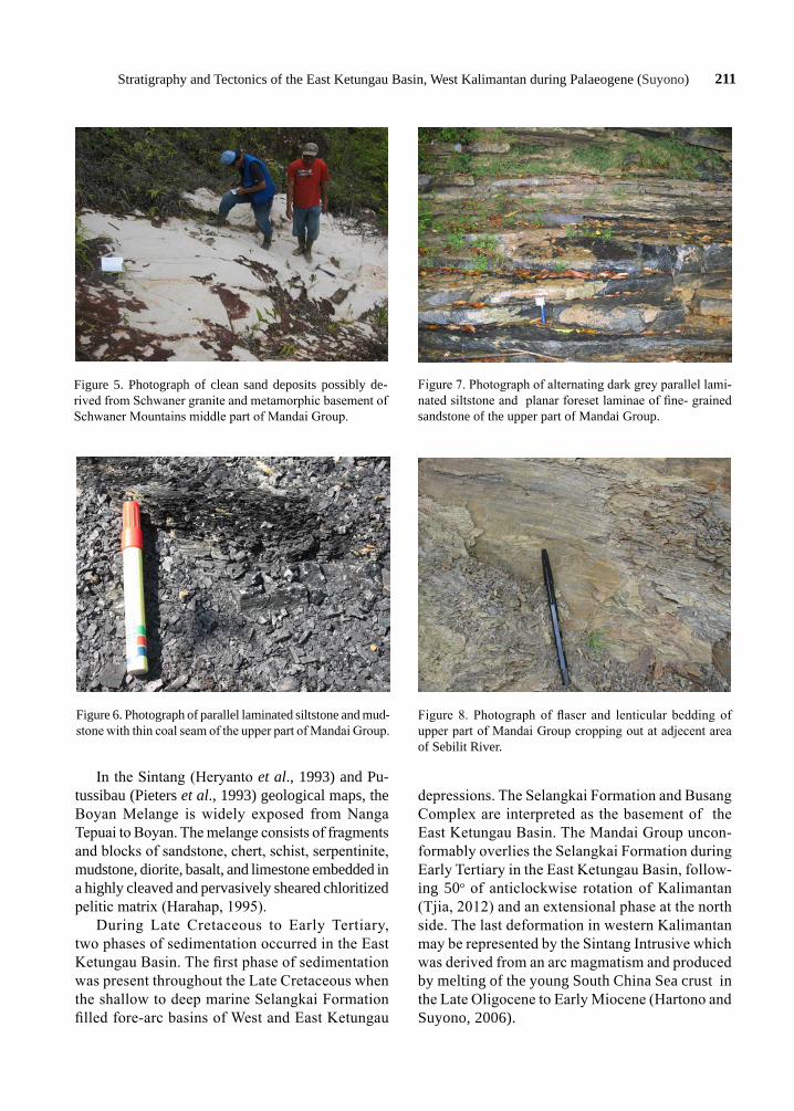
The alternating sandstone and mudstone with thin coal seams conformably overlies the ‘clean sand’ facies, and forms the upper part of the Pal-aeogene sediments of Mandai Groups. This facies is dominated by bedded medium- to fine- grained sandstones and in some areas it is also character-ized by the presence of siltstone and mudstone with parallel lamination and thin coal seams (Figure 6). The sequence is distributed along the downstream area of Boyan, Sebilit, and Mentebah Rivers, and in a low area nearby Nangasuruk region.
The stratigraphic section on the northern side of Sebilit and Boyan Rivers shows an alternating dark grey parallel laminated siltstone and planar foreset laminae of fine-grained sandstone in the lower part of this sequence (Figure 7). Additionally, the flaser and
lenticular beddings were also exposed in adjacent area of Sebilit Rivers (Figure 8). These sedimentary structures appear to have been formed particularly on tidal flats and in subtidal environments, where conditions of current flow or wave action causing sand depositions alternate with slack-water condi-tions when mud is deposited (Boggs, 2010). The depositional environment of these sequences is a tidal flat area from supratidal to intertidal zone. The sedimentary unit is correlated with the Ketungau Formation in West Ketungau Basin.
The upper sequence of this facies is predomi-nantly composed of alternating thin coal seam, coaly shale, and claystone. The sequence is exposed at a hill cut behind a local farm in Tanjung Harapan Village, Nangasuruk Subregency. Commonly, the dip of banded coal and coaly shale facies varies between 10o - 32o to the northeast. This section was interpreted as a marsh tidal flat until subtidal estuary environment with occasional low energy transport.
Tectonic EvolutionThe paleogeography of Western Indonesia dur-
ing Cretaceous - Early Tertiary (Figure 9) can be explained when the Schwaner granitoid Mountain and the highly deformed ophiolite and oceanic rocks as tectonic melange and broken formation from Sambas in the West to Mangkaliat in the East were formed due to westward subduction of South China Sea Plate beneath margin of Eurasian Plate.
Figure 2. Photograph of lower part of Mandai Group sediments. a. Alternating dark grey silty mudstone and very fine-grained well sorted sandstone. b. Parallel laminated grey to reddish grey siltstone and claystone with thin carbonaceous layers.
a b

209Stratigraphy and Tectonics of the East Ketungau Basin, West Kalimantan during Palaeogene (Suyono)
No
Loc
atio
nFo
ram
Polle
nIc
hno
foss
ilD
epos
ition
al
Env
iron
men
tPl
ankt
onic
Ben
thic
109
/MH
/08
Ilexp
olle
nite
sPo
doca
rpus
Pter
is ty
peVe
rruc
atos
pori
tes
Palm
aepo
lleni
tes
kutc
hens
isTr
icol
pori
tes
Spin
izon
ocol
pite
s ec
hina
tus
back
man
grov
e
209
/MH
/11
Avic
enni
a ty
pePs
ilate
trile
teVe
rruc
atos
pori
tes
Tric
olpo
rite
sTr
ipor
ites
man
grov
e
3D
owns
tream
Seb
ilit R
iver
s, sa
mpl
e co
de: 0
9/ N
O/ 1
71
Ret
icul
ate
polle
n6
Trile
te sp
ore
1 M
alva
ceae
1 G
rass
pol
len
Thal
asso
noid
es
Cyl
indr
ichn
us a
nd
Pala
eoph
ycus
Estu
ary
or in
ter t
idal
4U
pstre
am B
oyan
Riv
ers,
sam
ple
code
: 09
/MH
/06
Den
talin
a sp
., N
onio
n sp
., Le
ntic
ulin
a sp
., Re
ctog
land
ulin
a co
mat
ula,
Lag
ena
late
ralis
, Mar
ginu
lina
mar
ginu
loid
es,
Pseu
dono
dosa
ria
sp.,
Nod
osar
ia sp
., La
gena
gr
acill
ina,
Len
ticul
ina
sp.,
Ool
ina
glob
osa
Inne
r she
lf –
shal
low
m
iddl
e sh
elf
5Si
mpa
ng S
uruk
Cro
ssro
ad to
N
anga
paya
ng H
ill, s
ampl
e co
de: 1
0 N
O 3
0
Acar
inin
a so
ldad
oens
is (P
.5
P.9)
, G
lobi
geri
na v
elas
cone
nsis
(P.4
P.6
), M
oroz
ovel
la a
equa
(P.4
P.
6),
Plan
orot
alite
s pse
udom
enar
dii (
P.4)
, M
oroz
ovel
la a
ngul
ata
(P.3
P.
4).
Qui
nque
locu
lina
sp.,
Sigm
oilo
psis
sp.,
N
odos
aria
sp.,
Uvi
geri
na sp
., Te
xtul
aria
sp.,
Anom
alin
ella
sp.,
Amm
odis
cus s
p., L
agen
a sp
Rosa
lia, S
kolit
hos
Inne
r She
lf to
shal
low
est
open
mar
ine,
age
of t
his
faci
es is
late
pal
eoce
ne
(The
netia
n)
610
NO
27
Lage
na sp
, Qui
nque
locu
lina
sp.,
Sigm
oilo
psis
sp.,
Am
mod
iscu
s sp,
An
omal
inel
la sp
., da
n Ep
onid
es.,
Inne
r She
lf to
shal
low
est
open
mar
ine
Tabl
e 1.
Pal
eont
olog
y A
naly
sis o
f the
Mud
ston
e Fa
cies
of t
he M
anda
i Gro
up
210 Indonesian Journal of Geology, Vol. 8 No. 4 December 2013: 205-214
Figure 3. Ratio of hopanes/steranes vs. Pr/Ph, showing anoxic to sub-oxic condition of mudstone facies of the Mandai Group (Hermiyanto and Suyono, 2011).
Figure 4. Ternary diagram of sterane that shows depositional environment of fine sediments of Mandai Group (Hermiyanto and Suyono, 2011).
0.8 0.9 1 2 3 4 5 6 7 8 9 10 15
Pr / Ph
0.1
0.2
0.5
1
2
5
10
20 anoxic to sub-oxic:terrestrial influence
highly oxidising:terrestrial
highlyanoxic
anoxic to sub-oxic:primarily algal
Hopanes/Steranes vs. Pristane/Phytane
0.8 0.9 1 2 3 4 5 6 7 8 9 10 15
Pr / Ph
0.1
0.2
0.5
1
2
5
10
20 anoxic to sub-oxic:terrestrial influence
highly oxidising:terrestrial
highlyanoxic
anoxic to sub-oxic:primarily algal
09 MH 08A
09 NO 30
09 MH 11C
Tot
al H
opan
es/S
tera
nes
C27
100%
C29
100%
C28
100%
Lacustrine
C27
100%
C29
100%
C28
100%
Higherplant
TerrestrialEstuarine
OrBayOpen marine
Planktonic
C27
100%
C29
100%
C28
100%
50
5050
Legend:
09 MH 08A
09 NO 30
09 MH 11C
211Stratigraphy and Tectonics of the East Ketungau Basin, West Kalimantan during Palaeogene (Suyono)
In the Sintang (Heryanto et al., 1993) and Pu-tussibau (Pieters et al., 1993) geological maps, the Boyan Melange is widely exposed from Nanga Tepuai to Boyan. The melange consists of fragments and blocks of sandstone, chert, schist, serpentinite, mudstone, diorite, basalt, and limestone embedded in a highly cleaved and pervasively sheared chloritized pelitic matrix (Harahap, 1995).
During Late Cretaceous to Early Tertiary, two phases of sedimentation occurred in the East Ketungau Basin. The first phase of sedimentation was present throughout the Late Cretaceous when the shallow to deep marine Selangkai Formation filled fore-arc basins of West and East Ketungau
depressions. The Selangkai Formation and Busang Complex are interpreted as the basement of the East Ketungau Basin. The Mandai Group uncon-formably overlies the Selangkai Formation during Early Tertiary in the East Ketungau Basin, follow-ing 50o of anticlockwise rotation of Kalimantan (Tjia, 2012) and an extensional phase at the north side. The last deformation in western Kalimantan may be represented by the Sintang Intrusive which was derived from an arc magmatism and produced by melting of the young South China Sea crust in the Late Oligocene to Early Miocene (Hartono and Suyono, 2006).
Figure 5. Photograph of clean sand deposits possibly de-rived from Schwaner granite and metamorphic basement of Schwaner Mountains middle part of Mandai Group.
Figure 6. Photograph of parallel laminated siltstone and mud-stone with thin coal seam of the upper part of Mandai Group.
Figure 7. Photograph of alternating dark grey parallel lami-nated siltstone and planar foreset laminae of fine- grained sandstone of the upper part of Mandai Group.
Figure 8. Photograph of flaser and lenticular bedding of upper part of Mandai Group cropping out at adjecent area of Sebilit River.

212 Indonesian Journal of Geology, Vol. 8 No. 4 December 2013: 205-214
Discussion
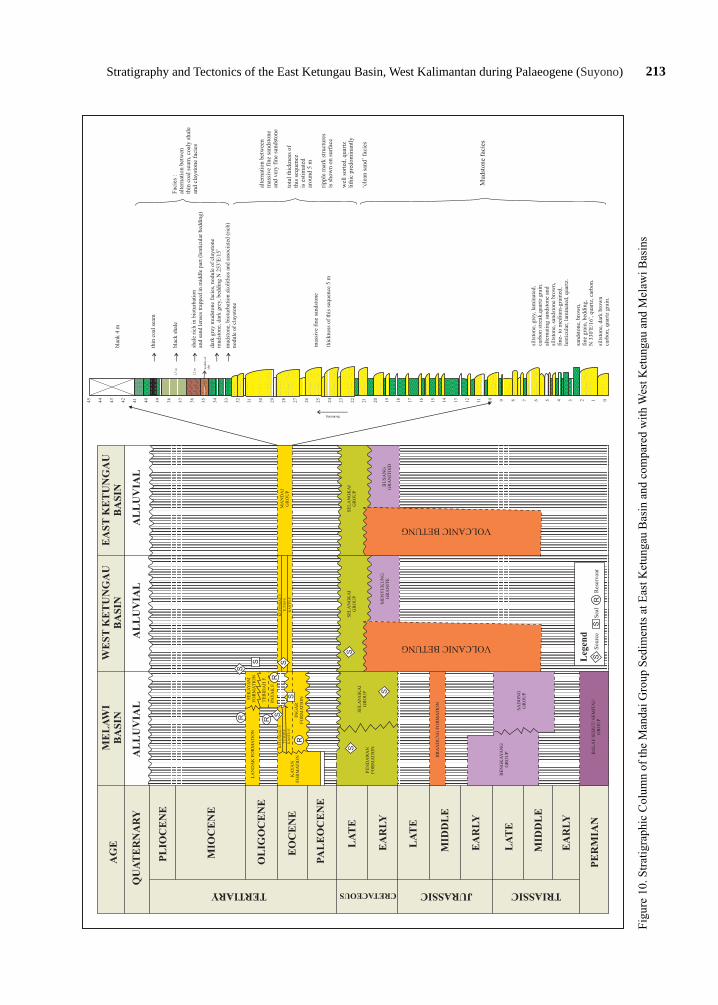
Based on present data, the stratigraphy and tectonic history of West Kalimantan from Early Cretaceous to Tertiary suggest the development of the East Ketungau Basin including West Ketungau and Melawi Basins started during the Palaeogene.
During the Palaeogene, the Kantu Formation, Tutoop Sandstone, and Ketungau Formation accu-mulated in the western part of the Ketungau Basin. During this period, the eastern part was predomi-nantly being filled by the deposition of the Mandai Group sediments with mudstone facies, ‘clean sand’
facies, and alternating sandstone and mudstone fa-cies with thin coal seams (Figure 10).
The Mandai Group sediments consist of three facies where each facies has a typical characteristic depositional environment of barrier- island and as-sociated strand-plain system. The three facies can be elaborated as follows:
The mudstone facies is typically parallel lami-nated grey to reddish siltstone and claystone with thin carbonaceous layers and alternation of dark grey shallow marine silty mudstone and very- fine grained well- sorted sandstone. The rock sequence which is rich in trace fossils, pollen, and foramin-
a EarlyCretaceous
10°N
10°S
10°
0°
0°
20°
b LateCretaceous
10°N
10°S
10°
0°
0°
20°
cEarlyTertiary
10°N
10°S
10°
0°
0°
20°Modem coastline
Modem coastline, unstable
Strike-slip fault inferred
Extensional area
Inferred compressional area
Crustal fragments of China and Indochina origin
Present day north
Yunan-Malay geosyncline
Active
Inactive
Inferred subduction zone
Southeast Asiamagmatic belt
Melange
East Ketungau Basin
Legend:
Figure 9. Paleogeographic recontructions showing a major N-W transform fault during the Late Cretaceous and Early Tertiary in NW Borneo (modified from Taylor and Hayes, 1983).
213Stratigraphy and Tectonics of the East Ketungau Basin, West Kalimantan during Palaeogene (Suyono)
Figu
re 1
0. S
tratig
raph
ic C
olum
n of
the
Man
dai G
roup
Sed
imen
ts a
t Eas
t Ket
unga
u B
asin
and
com
pare
d w
ith W
est K
etun
gau
and
Mel
awi B
asin
s
45 44 43 42 41 40 39 38 37 36 35 34 33 32 31 30 29 28 27 26 25 24 23 22 21 20 19 18 17 16 15 14 13 12 11 10 9 8 7 6 5 4 3 2 1 0
thickening
1,2
m nodu
le o
f cl
st
1,7
m
mud
ston
e, b
iotu
rbat
ion
skol
itho
s an
d as
soci
ated
(ri
ch)
no
dule
of
clay
ston
e
shal
e ri
ch i
n bi
otur
bati
onan
d sa
nd l
ense
s tr
appe
d in
mid
dle
part
(le
ntic
ular
bed
ding
)
blac
k sh
ale
blan
k 4
m
dark
gre
y m
udst
one
faci
es, n
odul
e of
cla
ysto
neo
om
udst
one,
dar
k gr
ey, b
eddi
ng N
253
E/1
5
thin
coa
l se
am
mas
sive
fin
e sa
ndst
one
thic
knes
s of
thi
s se
quen
ce 5
m
silt
ston
e, d
ark
brow
nca
rbon
, qua
rtz
grai
n.
silt
ston
e, g
rey,
lam
inat
ed,
carb
on s
trea
k,qu
artz
gra
in.
sand
ston
e, b
row
n,
fine
gra
in, be
ddin
g,
oo
N 3
30E
/16
, qu
artz
, ca
rbon
.
alte
rnat
ing
sand
ston
e an
dsi
ltst
one,
san
dsto
ne b
row
n,fi
ne-
to m
ediu
m-g
rain
ed,
lent
icul
ar, la
min
ated
, qu
artz
.
alte
rnat
ion
betw
een
mas
sive
fin
e sa
ndst
one
and
very
fin
e sa
ndst
one
tota
l th
ickn
ess
ofth
is s
eque
nce
is e
stim
ated
arou
nd 5
m
ripp
le m
ark
stru
ctur
esis
sho
wn
on s
urfa
ce
wel
l so
rted
, qua
rtz
lith
ic p
redo
min
antl
y
‘cle
an s
and’
fac
ies
Fac
ies
: al
tern
atio
n be
twen
thin
coa
l se
am, c
oaly
sha
le
and
clay
ston
e fa
cies
S
S
SR RR
SS
R
S
S
S
SS
R
Leg
end
Sou
rce
Sea
lR
eser
voar
AG
EM
EL
AW
IB
AS
INW
ES
T K
ET
UN
GA
UB
AS
INE
AS
T K
ET
UN
GA
UB
AS
IN
QU
AT
ER
NA
RY
AL
LU
VIA
LA
LL
UV
IAL
AL
LU
VIA
L
PL
IOC
EN
E
MIO
CE
NE
OL
IGO
CE
NE
EO
CE
NE
PA
LE
OC
EN
E
LA
TE
EA
RL
Y
LA
TE
EA
RL
Y
MID
DL
E
MID
DL
E
EA
RL
Y
LA
TE
PE
RM
IAN
TERTIARY CRETACEOUS JURASSIC TRIASSIC
LA
ND
AK
FO
RM
AT
ION
KA
YA
NF
OR
MA
TIO
N
SE
KA
YA
MF
OR
MA
TIO
N
TE
BID
AH
F.
PAY
AK
F.
KE
TU
NG
AU
F.
TU
TO
P F
.
KA
NT
U F
.
ING
AR
FO
RM
AT
ION
KE
TU
NG
AU
F.
TU
TO
P F
.
KA
NT
U F
.
PE
ND
AW
AN
FO
RM
AT
ION
SE
LA
NG
KA
IG
RO
UP
SE
LA
NG
KA
IG
RO
UP
BR
AN
DU
NG
FO
RM
AT
ION
BE
NG
KA
YA
NG
GR
OU
P
SA
DO
NG
GR
OU
P
BA
LA
I/ S
EB
UT
/ S
EM
ITA
UG
RO
UP
VOLCANIC BETUNG
VOLCANIC BETUNG
ME
NY
UK
UN
GG
RA
NIT
EB
US
AN
GG
RA
NIT
OID
SE
LA
NG
KA
IG
RO
UP
MA
ND
AI
GR
OU
P
Mud
ston
e fa
cies

214 Indonesian Journal of Geology, Vol. 8 No. 4 December 2013: 205-214
ifera, indicates a shallow open marine to a subtidal lagoon environment.
The ‘clean sand facies’ being the middle part of Mandai Group sediments is characterized by white to brown quartz sandstone, medium- to coarse-grained and well-sorted sandstone showing massive and well bedded sandstone, with scour structure, cross stratification, and locally mud drapes develops. This facies was deposited as a barrier bar sequence, in a tidal flat environment, exposed to wave-action and storm currents with occasional high energy transport.
The alternation between thin coal seam, coaly shale, and claystone facies forms the upper part of the Mandai Group sediments. This section is inter-preted as a marshy tidal flat up to subtidal lagoon environment with occasional low energy transport.
Conclusion
The East Ketungau Basin was formed from the Late Cretaceous to the Late Eocene, when the fore- arc sediments of the Selangkai Formation was fill-ing this basin. The Mandai Group sediments which consist of the mudstone facies in lower part, ‘clean sand’ facies in the middle, and alternating thin coal seam, coaly shale, and claystone facies as the upper part unconformably overlies the Selangkai Forma-tion. The three facies of this group suggest as barrier island deposits associated with a depositional strand plain system.
In addition, the stratigraphic succession of the East Ketungau Basin has similar characteristic and lithologic distribution as the West Ketungau Basin and Melawi Basin in the south. Those formations overly the Pre-Tertiary Selangkai Formation during Palaeogene.
Finally, seismic and other geophysical studies of the Gunung Menyukung area need to be carried out in order to correlate the stratigraphy between the West and East Ketungau Basins and the tectonic events of the Boyan and Lubuk Antu mélanges.
Acknowledgments---It would not have been possible to fin-ish this paper without the assistance of the working group responsible for the Indonesian Sedimentary Basin Atlas, Centre for Geological Survey (Pusat Survei Geologi) and reviewers of the Indonesian Journal of Geology. Thanks
are due to Dr. R. Sukhyar and Dr. Yunus Kusumabrata for a permission to publish this paper.
References
Boggs, Jr., S., 2010. Petrology of sedimentary rocks, Second Edition. Lambridge University Press, Cambridge, 612pp.
Charlton, T.R., 2000. Tertiary evolution of the eastern Indonesia collision complex. Journal of Asian Earth Sciences, 18, p.603-631.
Conybeare, C.E.B. and K.A.W. Crook., 1986. Manual of sedimentary structures. Bureau of Mineral Resources Australia Bulletin, 102, p.327.
Haile, N. S., 1978. ‘Reconnaissance palaeomagnetic results from Sulawesi, Indonesia and their bearing of the palaeogeographic reconstruction’. Tectonophysics, 46, p.77-85.
Hall, R., 1996. Reconstructing Cenozoic SE Asia. In: Hall, R. and Blundell, D.J., (Eds.), Tectonic evolution of Southeast Asia, Geological Society of London, p.153-184.
Hamilton, W. 1979. Tectonics of the Indonesian Region. U.S. Geological Survey Professional Paper, p.345-1078.
Harahap, B.H., 1995. The Boyan melange West Kalimantan, origin and tectonic environment. Bulletin of the Geological Research and Development Centre, Bandung.
Hartono, U. and Suyono, 2006. Identification of Adakite From The Sintang Intrusive in West Kalimantan. Journal of Geological Resources, 16, p.173-178.
Hermiyanto, G.M. and Suyono, 2011. Organic Geochemistry and Rock Eval Pyrolysis of Eocene fine Sediments, East Ketungau Basin, West Kalimantan. Indonesian Journal of Geology, p.95-104.
Heryanto, R., William, P.R., Harahap, B.H., and Pieters, P.E., 1993. Geology of the Sintang Sheet area, scale 1 : 250.000. Geological Research and Development Centre, Bandung.
Lee, Y. T. and Lawyer, A. L., 1995. Cenozoic plate reconstruction of Southeast Asia. Tectonophysics, 251, p.85-138.
Pieters, P.E., Surono, and Noya, Y., 1993. Geology of the Putussibau Sheet area, scale 1: 250.000. Geological Research and Development Centre, Bandung.
Rangin, C., Dahrin, Pubellier, R M., and the Tethys working group, 1990. A simple model for the tectonic evolution of Southeast Asia and Indonesia region for the past 43 m.y. Geology Society of France, 6, p.889-905.
Taylor, B. and Hayes, D.E., 1983. Origin and history of the South China Sea Basin. The tectonic and geologic evolution of southeast Asia Seas and island, part 2. In: Hayes, D.E. (Ed). Geophysical Monographs of American Geophysic Union, Washington, 27, p.23-56.
Tjia, H.D., 2012. The Paleo-Orientations of Northwestern Borneo and Adjacent South China Sea Basin. Indonesian Journal of Geology, 7, p.67-76.
Williams, P.R. and Harahap, B.H., 1987. Preliminary Geochemical and Age Data From Postsubduction Intrusive Rocks, Northwest Borneo. Australian Journal of Earth Sciences, 34, p. 405-415.
Top Related