


Languages
Pages
Legal


[64 2 80 4 2 :1 5 862 3 2 5 _1 ]
MELBOURNE: 292 Mt Alexander Road Ascot Vale VIC 3056 GEELONG: PO Box 8048 Newtown VIC 3220BRISBANE: Level 22, 127 Creek Street Brisbane QLD 4000 ADELAIDE: 22 Greenhill Road Wayville SA 5034
CANBERRA: PO Box 6067, O’Connor ACT 2602 SYDNEY: Level 5, 616 Harris Street, Ultimo, NSW, 2007www.ehpartners.com.au | (03) 9377 0100
Sta tem entofExpertEvidence:M itchella nd W hittlesea Pla nning Schem e A m endm entG C 28
D onnybrook / W oodstock PrecinctStructure Pla n
Prepared for:
Boral
May 2016
Ecology and H eritage Partners Pty Ltd
Aaron Organ
Statement of Expert Evidence: Mitchell and Whittlesea Planning Scheme Amendment GC28 2
DOCU M EN T CON TROL
As s es s m entStatement of Expert Evidence: Mitchell and Whittlesea Planning Scheme Amendment GC28
Donnybrook / Woodstock Precinct Structure Plan
O u rp roject nu m b er 8109
Rep ort au thor(s ) Aaron Organ (Director / Principal Ecologist)
Docu m ent review er Andrew Hill (Director / Principal Ecologist)
File nam e 8109_EHP_Donnybrook_WoodstockPSP_EWS_05052016.docx
Client Boral
Bioregions Victorian Volcanic Plain
CM A Port Philip and Westernport Catchment Management Authority
Cou ncil City of Whittlesea
Copyright © Ecology and Heritage Partners Pty Ltd
This document is subject to copyright and may only be used for the purposes forwhich it was commissioned. The use or copying of this document in whole orpart without the permission of Ecology and Heritage Partners Pty Ltd is aninfringement of copyright.
Disclaimer
Although Ecology and Heritage Partners Pty Ltd have taken all the necessarysteps to ensure that an accurate document has been prepared, the companyaccepts no liability for any damages or loss incurred as a result of reliance placedupon the report and its contents.
Statement of Expert Evidence: Mitchell and Whittlesea Planning Scheme Amendment GC28 3
1 AU TH OR’SEXPERTISE
This Statement of Expert Evidence has been prepared by Mr Aaron Organ, Director/ Principal Ecologist of
Ecology and Heritage Partners Pty Ltd, of 292 Mt Alexander Road, Ascot Vale, Victoria. It is based on the
findings of investigations by staff at Ecology and Heritage Partners Pty Ltd.
Aaron has over 21 years’ experience in the environmental field, including 16 years in an environmental
consultant capacity. Aaron has a broad working knowledge of flora and fauna throughout Victoria and has
either managed or played an important role in providing environmental advice on a number of large
infrastructure projects such as proposed pipelines, and road and rail developments, and numerous urban
development projects (residential, industrial and commercial).
He has also been a lead author and/ or co-author for over 450 project reports and has provided expert
advice to a range of private and government clients. Some of these projects include a large number of
proposed wind farms in Victoria, South Australia and Tasmania, long-term flora and fauna monitoring
throughout the Illawarra escarpment of New South Wales, and various residential developments across
Victoria (including many projects in north east Victoria). Aaron has provided expert advice and represented
clients at several Precinct Structure Plan panel hearings, including Truganina South, Wollert, Ballan Road,
Craigieburn R2 and 489-555 Robinsons Road South, Truganina.
2 AU TH OR’SSTATEM EN T
I, Aaron Organ of Ecology and Heritage Partners Pty Ltd, have prepared this Statement of Expert Evidence
pertaining to the ecological values and considerations in the Donnybrook / Woodstock PSP. The proceeding
statement is based on a literature review, a brief site assessment, and expert knowledge of the ecological
values within the PSP and broader northern Melbourne growth corridor.
I have made all the inquiries that l believe are desirable and appropriate and that no matters of significance
which l regard as relevant have to my knowledge been withheld from the Panel.
Statement of Expert Evidence: Mitchell and Whittlesea Planning Scheme Amendment GC28 4
3 IN TRODU CTIO N
3.1 Backgrou nd
I have been engaged by Boral to review several matters relating to Conservation Area 22 (CA22), designated
under the Biodiversity Conservation S trategy (BCS) for M elbourne’s Grow th Corridors (DEPI 2013a).
Conservation Area 22 is located within the proposed Donnybrook/Woodstock Precincts (Precinct Structure
Plans [PSPs] 1067 and 1096). Part of Conservation Area 22 is categorised as ‘open space’. It is understood
that the Victorian Department of Environment, Land, Water and Planning (DELWP) are resurveying land
categorised as open space, with the potential to reclassify land as developable.
We undertook surveys in the proposed conservation area on Boral’s land to document the ecological values
present and to provide responses against the specific criteria established for adjustment to the boundary of
designated conservation areas, as outlined in the ‘Guidancenote:Im plem enting theBiodiversity Conservation
S trategy forM elbourne’sGrow thCorridors’ (DELWP 2015).
This statement of evidence aims to assist the Panel through the provision of accurate information relating to
the key ecological considerations under Commonwealth [e.g. Environm ent P rotection and Biodiversity
Conservation Act 1999 (EPBC Act)] and State legislation that are present within the study area, with the
primary aim of adjusting the conservation boundary.
3.2 O b jectives
I have been instructed to undertake the following to inform the proposed adjustment to the conservation
area boundary:
1. A review of time-stamped vegetation data across the study area;
2. An assessment of the presence and extent of EPBC Act listed Grassy Eucalypt Woodland of
the Victorian Volcanic Plain (GEWVVP) ecological community;
3. Determination of the presence or absence of the EPBC Act-listed Matted Flax-lily Dianella
am oena, Curly Sedge Carex tasm anica, Adam’s Blown-grass L achnagrostisadam soniiand
Golden Sun Moth S ynem onplana; and,
4. Provision of advice relating to the specific criteria outlined in the BCS Guidance Note
(DELWP 2015) that pertain to the boundary adjustment of open space areas.
3.3 Stu dy Area
The study area is located 35 kilometres north of Melbourne’s Central Business District on Boral Land, within
the Donnybrook/Woodstock precincts (north of Donnybrook Road). CA22 covers an area of approximately
207 hectares.
The study area is approximately 23.43 hectares and is owned by Boral (Figure 1). A gas easement runs
through the western section of the site, in close proximity to Merri Creek. Conservation Area 34 (Growling
Grass Frog conservation) separates the north-western boundary of the study area from Merri Creek (Figure

Statement of Expert Evidence: Mitchell and Whittlesea Planning Scheme Amendment GC28 5
2). The study area forms part of the eastern section of CA22 which is categorised as ‘open space’ in the BCS
(DEPI 2013a) (p. 93) (see Table 1 below).
Open space is defined by the BCS as:
‘Areasthathavebeenzonedunsuitableforurbandevelopm ent,partly orprim arily forlandscapevalues
and w illbefurthersurveyed to determ inetheboundariesofareasrequired forbiodiversity protection’
(DEPI 2013a).
Figure 1. Location of the study area (red circle).
3.4 Des crip tion ofCons erv ation Areas 2 2
The following information relating to CA22 is documented within the BCS (DEPI 2013a):
‘T henorthern(Hum e,W hittleseaand M itchell)grow thcorridorhassignificantbiodiversity values,w ith
large num bersof rem nant R ed R iver Gum sscattered acrossthe landscape and the threatened
com m unitiesN aturalT em perateGrasslandandGrassy EucalyptW oodlandalsooccurring.
A num berofthreatened floraand faunaspeciesoccur.M erriCreekisam ajornorth-south biodiversity
corridorproviding im portanthabitatandconnectivity throughthegrow thcorridor.’ (p. 93, DEPI 2013a)

Statement of Expert Evidence: Mitchell and Whittlesea Planning Scheme Amendment GC28 6
Tab le 1 . Summary of ecological values: CA22, Bald Hill, Donnybrook (DEPI 2013a, p. 93)
Selection Criteria Matter as shown in BCS (DEPI 2013a)
Total area and boundary 207.18 hectares
Management Category Nature conservation (majority of site)
Open Space (eastern section containing predominantly scattered trees)
Key rationale for protection of area Protects high quality native grassland that contains a range of biodiversity values
of national significance within a practically manageable area
Biodiversity values of national significance
High quality Natural Temperate Grassland of Victorian Volcanic Plain (NTGVVP)
Grassy Eucalypt woodland
Matted Flax-lily population within high quality habitat
Curly Sedge population within high quality habitat
Adamson’s Blown-grass population (not confirmed recently)
Growling Grass Frog within high quality habitat
Grassland Earless dragon population (not confirmed recently)
High persistence habitat for Golden Sun Moth (population not confirmed)
Habitat for Striped Legless Lizard (population not confirmed)
Biodiversity values of state significance
Western (Basalt) Plains Grasslands Community
Western Basalt Plains (River Red Gum) Grassy Woodland Floristic Community 55-04
Matted Flax-lily
Curly Sedge
Adamson’s Blown-grass population (not confirmed recently)
Growling Grass Frog
Grassland Earless Dragon population (not confirmed recently)
Golden Sun Moth Habitat
Striped Legless Lizard habitat
Tough Surf-pea
Rye Beetle-grass (not confirmed)
Contribution of area to achievement of
conservation outcomes in the program
report
Contributes to ensuring functioning sustainable populations of Growling GrassFrog with connectivity between populations
Contributes to the target to protect 80 percent of GEWVVP within the 2010 UrbanGrowth Boundary
Contributes to ensuring no substantial negative change to known populations ofCurly Sedge
Statement of Expert Evidence: Mitchell and Whittlesea Planning Scheme Amendment GC28 7
Selection Criteria Matter as shown in BCS (DEPI 2013a)
Further actions
Protect conservation area through the following actions:
o Apply appropriate planning provisions to the land depending on thecircumstances (may include a Rural Conservation Zone, an EnvironmentalSignificance Overlay or another statutory mechanism) to be determined bythe State Minister for Planning
o Prepare conservation management plan and ensure planning provisions forimplementation and funding are in place
o Establish management agreements with landowners under section 69 of theConservation Forests and Lands Act 1987 and/or transfer land to Crownwhere an appropriate public land manager is available
3.5 Su m m ary ofO p inion
The proposed adjustment to CA22 meets the criteria outlined in the BCS application criteria for proposed
adjustments to the boundary of a conservation area, and therefore should the adjustment to the boundary
occur and the area subsequently developed, this will result in habitat compensation obligations totalling
approximately $441,731.92 9 (excl. GST). These funds can be directed into the purchase and management of
others areas within CA22 or conservation reserves set aside as part of the BCS.

Statement of Expert Evidence: Mitchell and Whittlesea Planning Scheme Amendment GC28 8
4 M ETH ODS
4 .1 N om enclatu re
Common and scientific names of vascular plants follow the Victorian Biodiversity Atlas (VBA) (DEPI 2014) and
the Census of Vascular Plants of Victoria (Walsh and Stajsic 2007). Vegetation community names follow
DELWP’s Ecological Vegetation Classes (EVC) benchmarks (DELWP 2015a). The names of aquatic and
terrestrial vertebrate and invertebrate fauna follow the VBA (DELWP 2015b).
4 .2 Backgrou nd Review
Relevant literature, online resources and numerous databases were reviewed to provide an assessment of
ecological values associated with the study area. The following information sources were reviewed:
The DELWP Biodiversity Interactive Map (DELWP 2016a) for the extent of historic and current
Ecological Vegetation Classes (EVCs) and time-stamped vegetation;
The Native Vegetation Information Management (NVIM) Tool (DELWP 2016b) for modelled
biodiversity data, including time-stamped remnant native vegetation;
The VBA (DELWP 2015b), Flora Information System (FIS) (Viridans 2013a) and Atlas of Victorian
Wildlife (AVW) (Viridans 2013b) for previously documented flora and fauna records within the
project locality;
The Commonwealth Department of the Environment (DoE) Protected Matters Search Tool (PMST)
for matters of National Environmental Significance (NES) protected under the EPBC Act (DoE 2016);
The DELWP Planning Maps Online to ascertain current zoning and environmental overlays (DELWP
2016d);
A review of the exhibited PSP;
Amendment GC28 documentation, including;
o exhibited planning scheme provisions
o exhibited zoning and overlay maps
o explanatory report
Guidance Note on Implementing the Biodiversity Conservation Strategy (working document
February 2015) (DELWP 2015c);
Aerial photography of the study area;
Relevant environmental legislation and policies; and,
Previous assessments undertaken by Ecology and Heritage Partners, including:
o Vegetation and Targeted Golden Sun Moth Survey Report, Donnybrook Road, Donnybrook,
Victoria (Ecology and Heritage Partners 2012).

Statement of Expert Evidence: Mitchell and Whittlesea Planning Scheme Amendment GC28 9
4 .3 As s es s m ent of the Pres ence of EPBC Act-lis ted EcologicalCom m u nities
Detailed site surveys were undertaken to assess the presence and extent of GEWVVP. As outlined in ‘Advice
to theM inisterfortheEnvironm ent,Heritageand theArtsfrom theT hreatened S peciesS cientificCom m ittee
(the Com m ittee) on Am endm ent to the list of T hreatened EcologicalCom m unitiesunder the EP BC Act’
(Threatened Species Scientific Committee 2008) several criteria are used to define whether remnant
vegetation qualifies as the EPBC Act-listed ecological community (as summarised in Table 2).
With reference to the desk-based assessment, a site assessment to locate and identify patches of GEWVVP
was undertaken on 14 January 2016 by qualified botanists.
Tab le 2 . Classification criteria for GEWVVP and NTGVVP under the EPBC Act (p. 7, TSSC 2008).
Criterion Donny b rook/W oods tock PSPs
Ecological Vegetation
Class
Presence of Plains Grassy Woodland (EVC 55_61) and Stony Knoll Shrubland (EVC 649) may indicate the
presence of GEWVVP
Bioregion The study area is located within the Victorian Volcanic Plain bioregion
Size of Patch The minimum patch size for the listed ecological community is 0.5 hectares
Species coverOne or more of the following native grass genera accounts for at least 50% of the perennial ground layer
cover: T hem eda, R ytidosperm a,Austrostipa, P oaand/or M icrolaena
Condition Thresholds
If native grasses
account for less
than 50% of the
perennial ground
layer cover, then
the patch is either:
A valuable wildflower site where at least 50% of the ground layer vegetative cover
is represented by native forbs (including geophytes) during spring-summer (i.e.
September to dryland February inclusive but noting that the ground layer may be
sparse in some situations); OR,
Not heavily invaded by perennial weeds such that perennial weeds comprise less
than 70% of the ground layer vegetative cover; OR,
If perennial weeds comprise more than 70% of the ground layer vegetative cover,
then the patch must have more than ten native perennial species per 100 m2
AND a density of at least three big trees per hectare. Big trees are defined here as
trees with at least 70 centimeters diameter at breast height (DBH) for eucalypts
and at least 40 cm DBH for non-eucalypt species.
Additional
Characteristics
The conservation value of a patch of the ecological community is enhanced if it shows any of the
following features:
• A high native plant species richness;
• Large patch size or connectivity with a large patch of remnant vegetation;
• Minimal weed invasion;
• Presence of threatened plant and/or animal species;
• Diversity of habitat e.g. Tree hollows, fallen logs, natural exposed rock outcrops.

Statement of Expert Evidence: Mitchell and Whittlesea Planning Scheme Amendment GC28 10
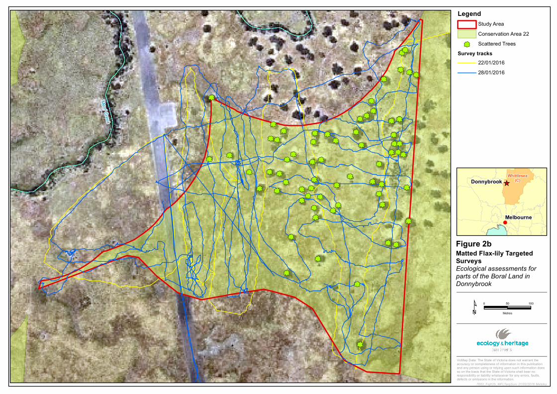
4 .4 Targeted Threatened Flora Su rvey s
Targeted Matted Flax-lily surveys were undertaken on 28 January 2016 by qualified botanists. As detailed in
the targeted survey methods for Matted Flax-lily in the Biodiversity Precinct Structure Planning Kit (DSE
2010), all potential habitat was surveyed using five metre transects, with the location of any plants detected
recorded with a GPS (Figure 2b).
Targeted surveys for Adamson’s Blown-grass L achnagrostisadam soniiand Curly Sedge Carex tasm anica
were also conducted on 8 February 2016.
4 .5 Targeted Golden Su n M oth Su rv ey s
Targeted surveys for threatened species (e.g. Golden Sun Moth) were also undertaken on 16 and 23
December 2015. Incidental records of any other EPBC Act-listed species were also documented. Targeted
survey methods for Golden Sub Moth followed the prescriptions provided in the S ignificant Im pact
GuidelinesfortheCritically EndangeredGoldenS unM oth (DEWHA 2009), specifically:
Surveys were conducted by ecologists experienced in the detection and identification of Golden Sun
Moth;
Surveys took place during the species’ flight season;
Surveys were undertaken during weather conditions suitable for detecting the species; and,
Surveys were conducted using 25 metre wide parallel transects with two observers.
Given the seasonal constraints (i.e. the latter part of the species flight period) the study area was surveyed
on two separate occasions (rather than the recommended four surveys), with one week between surveys.

Statement of Expert Evidence: Mitchell and Whittlesea Planning Scheme Amendment GC28 11
5 RESU LTS
5.1 Backgrou nd Review
A summary of the planning history and previous ecological surveys relating to the Boral landholding, and
more specifically the land comprising CA22 is provided below:
2009 – Land first identified for potential biodiversity purposes due to its location within the
‘Melbourne North’ Investigation area in 2009 as part of the Developing M elbourne’sN ew est
S ustainableCom m unities(DMNSC) investigation (otherwise known as the Program Report).
2012 – The (former) Growth Areas Authority (GAA) announced plans for the Northern Growth
Corridor.
May 2012 – Ecology and Heritage Partners was commissioned by Boral to undertake vegetation
mapping and two targeted surveys for Golden Sun Moth at Donnybrook Road, Donnybrook,
including CA22.
2013 – Management criteria listed specifically for Conservation Areas 22 and 34 in the BCS (DEPI
2013a)
February 2015 – Guidance N ote: Im plem enting the Biodiversity Conservation S trategy for
M elbourne’sGrow th Corridors(DELWP 2015) outlines specific criteria under which DELWP deems
native vegetation to be retained and exempted from habitat compensation obligations. It is stated
that conservation area boundary adjustments, such as those proposed for CA22, are required to be
approved by the Commonwealth Minister.
November 2015 – DELWP revises the boundary adjustment application criteria. Threshold amounts
of native vegetation or habitat for matters of NES no longer apply. Instead, “any land proposed to
be retained must contain, or be demonstrated as having potential for restoration to, a community or
habitat for a matters of NES”.
November 2015 – PSP exhibited for the Donnybrook/Woodstock precincts.
5.2 Previou s As s es s m ents
Previous time-stamping surveys undertaken across the study area recorded Stony Knoll Shrubland and Plains
Grassy Woodland (Ecology and Heritage Partners 2012). Nationally listed (EPBC Act) ecological communities
were not previously recorded, and are not detailed in the draft Donnybrook-Woodstock PSP.
5.3 Cu rrent Vegetation As s es s m ent
A total of 7.52 hectares of remnant native vegetation was recorded within the study area, comprising:
3.53 hectares of Plains Grassy Woodland (EVC 55);
0.42 hectares Plains Grassland (EVC 132_61); and,
3.57 hectares of Stony Knoll Shrubland (EVC 649)

Statement of Expert Evidence: Mitchell and Whittlesea Planning Scheme Amendment GC28 12
5.4 EPBCAct-lis ted EcologicalCom m u nities
5.4 .1 Condition thres holds and ex tent ofm ap p ed GEW VVP
Three patches, totalling 0.79 hectares, of the EPBC Act-listed GEWVVP were mapped within the study area
(Figure 2a). No other EVCs present in the study area meet the condition thresholds to constitute the EPBC
Act-listed GEWVVP, NTGVVP or Seasonal Herbaceous Wetlands (Freshwater) of the Temperate Lowland
Plains.
5.5 EPBCAct-lis ted Sp ecies
5.5.1 EPBCAct-lis ted flora
Matted Flax-lily, Curly Sedge, or Adamson’s Blown-grass were not detected within the study area during the
targeted surveys (Figure 2b, 2c).
Detection of Matted Flax-lily may have been suppressed due to the time of year the surveys were
undertaken and the lack of recent rainfall. For example, plants at a nearby reference site had ceased
flowering and aboveground shoots were difficult to locate. However, given the highly modified nature of the
vegetation, the high visibility across the site (i.e. open understorey, low biomass), the lack of high quality
stony rises, and the ongoing grazing pressure, Matted Flax-lily is expected have a low likelihood of
occurrence within the study area.
Curly Sedge typically grows in seasonally moist to waterlogged sites (Carter 2010; Leigh and Briggs 1992),
while Adamson’s Blown-grass is generally associated with slow moving creeks, swamps, flats, depressions or
drainage lines that are seasonally inundated or waterlogged (Murphy 2010; DPI 2011; Walsh 1994). The
quality of potential habitat within the study area for both of these species is very low, and it reasonable to
conclude that both species are unlikely to be present.
5.5.2 Golden Su n M oth
No Golden Sun Moths were detected during through targeted survey. The species has also not previously
been recorded within the study area (Ecology and Heritage Partners 2012). However, potential habitat is
present and one male individual was detected near Grants Road (approximately two kilometres south of the
study area) during the associated time-stamping assessment which informed the establishment of CA22
(Ecology and Heritage Partners 2012).
While Golden Sun Moths were observed flying on 23 December 2015 at other sites in northern Melbourne
(Tom Schmidt, Ecology and Heritage Partners, pers. comms.), their emergence during December was patchy
and unpredictable. Further, only two of the four surveys, required under the Biodiversity P recinctP lanning
Kit(DSE 2010) were undertaken due to the time in which we were engaged to commence the surveys.

Statement of Expert Evidence: Mitchell and Whittlesea Planning Scheme Amendment GC28 13
5.5.3 Other s ignificant flora and fau na s p ecies
Flora
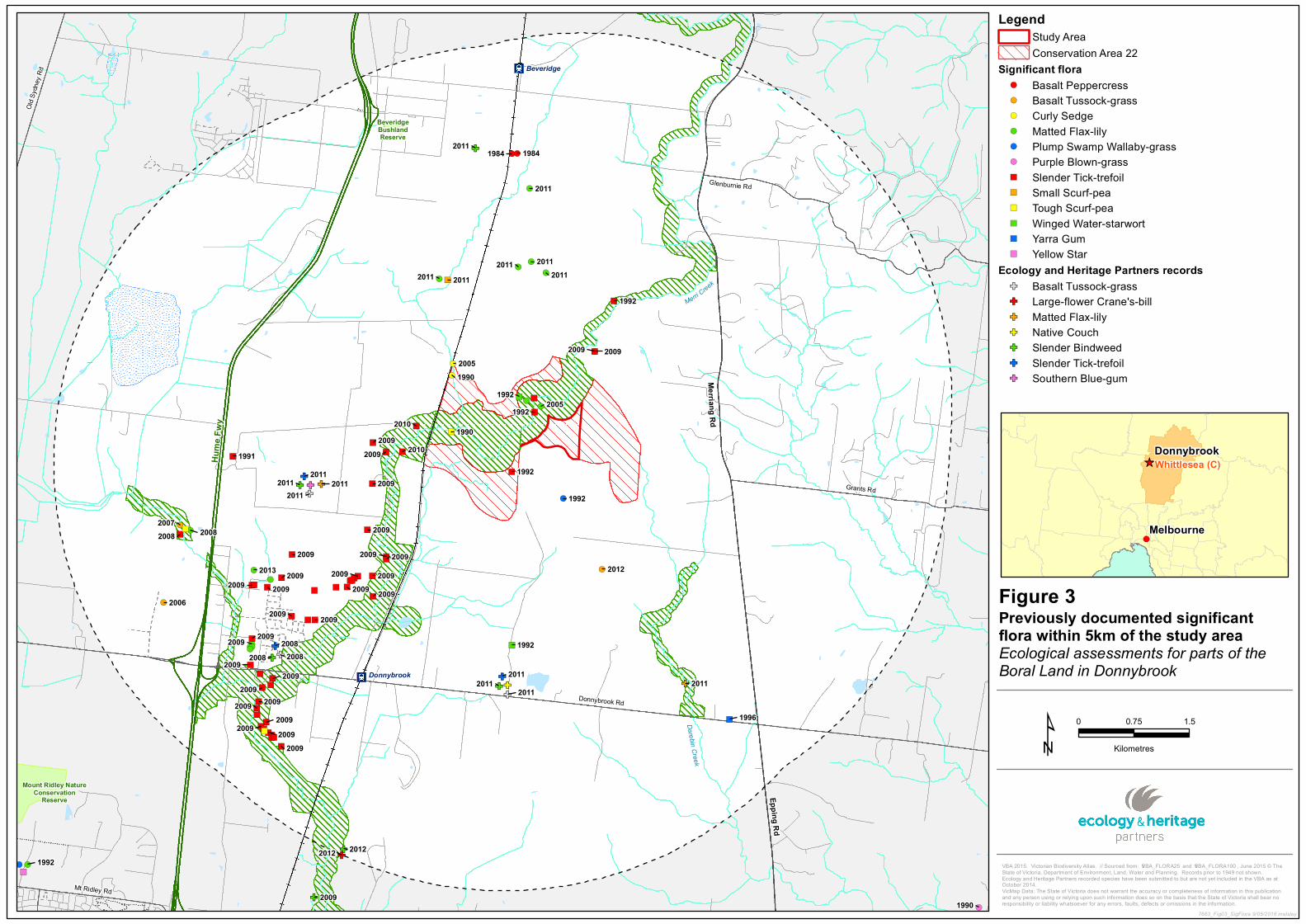
The VBA contained records of six nationally significant and 23 State significant flora species previously
recorded within 10 kilometres of the study area (DELWP 2016c) (Figure 3). The PMST nominated an
additional eight nationally significant species which have not been recorded in the locality but have the
potential to occur (DoE 2016).
Based on the modified nature of the study area, landscape context and the proximity of previous records,
significant flora species are no likely to occur within the study area.
Fauna
The VBA contained records of 13 nationally significant, 38 State significant and 13 regionally significant fauna
species previously recorded within 10 kilometres of the study area (DELWP 2015c) (Figure 4). The PMST
nominated an additional four nationally significant species which have not been recorded in the locality but
have the potential to occur (DoE 2016).
Based on the modified nature of the study area, landscape context and the proximity of previous records,
significant fauna species are not likely to occur within the study area as residents or visitors on a regular
basis.
5.6 Criteria to Adju s t the Bou ndaries ofCons erv ation Areas 2 2
The BCS states that the boundaries of CA22 may be reviewed at the precinct structure planning stage (DEPI
2013a; p.105). Boral have proposed an adjustment to the boundaries of CA22 that shifts the southern
boundary northward to legitimately increase the extent of the total developable land. Changes to the land
identified for conservation and its associated ecological values under this proposed adjustment are outlined
below (Table 3). A response to the specific criteria relating to the proposed adjustment of the boundary of
CA22 is also outlined (Table 4).
The Guidance Note states:
“ Foropenspacearea,theCom m onw ealth approvalsprovideflexibility fortheVictorianGovernm entto
m ake changesto the boundariesof[BCS] conservation areasto m axim ise theirdesign and function.
T hisallow sthe Victorian Governm ent to determ ine w hen changesare appropriate,including w hen
changesthatm ay im pactthesevaluesareacceptablebasedontheirnecessity” (p. 13, DELWP 2015)
While the Guidance note indicates that it is intended for the boundaries of CA22 not to change, other
conservation areas “generally categorised as open space” can be adjusted “provided that there is no net loss
of area” (p. 7, DELWP 2015).
Adjustment of the boundary for nature conservation and open space within CA22 must be considered and
endorsed by DELWP prior to referral to the Commonwealth Minister for approval.
Statement of Expert Evidence: Mitchell and Whittlesea Planning Scheme Amendment GC28 14
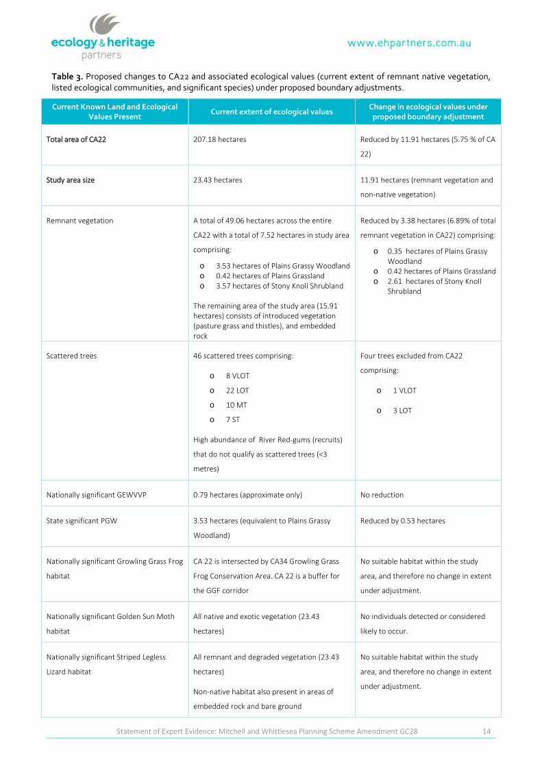
Tab le 3.Proposed changes to CA22 and associated ecological values (current extent of remnant native vegetation,listed ecological communities, and significant species) under proposed boundary adjustments.
Cu rrent Know n Land and EcologicalValu es Pres ent
Cu rrent ex tent ofecologicalvalu esChange in ecologicalvalu es u nder
p rop os ed b ou ndary adju s tm ent
Total area of CA22 207.18 hectares Reduced by 11.91 hectares (5.75 % of CA
22)
Study area size 23.43 hectares 11.91 hectares (remnant vegetation and
non-native vegetation)
Remnant vegetation A total of 49.06 hectares across the entire
CA22 with a total of 7.52 hectares in study area
comprising:
o 3.53 hectares of Plains Grassy Woodlando 0.42 hectares of Plains Grasslando 3.57 hectares of Stony Knoll Shrubland
The remaining area of the study area (15.91hectares) consists of introduced vegetation(pasture grass and thistles), and embeddedrock
Reduced by 3.38 hectares (6.89% of total
remnant vegetation in CA22) comprising:
o 0.35 hectares of Plains GrassyWoodland
o 0.42 hectares of Plains Grasslando 2.61 hectares of Stony Knoll
Shrubland
Scattered trees 46 scattered trees comprising:
o 8 VLOT
o 22 LOT
o 10 MT
o 7 ST
High abundance of River Red-gums (recruits)
that do not qualify as scattered trees (<3
metres)
Four trees excluded from CA22
comprising:
o 1 VLOT
o 3 LOT
Nationally significant GEWVVP 0.79 hectares (approximate only) No reduction
State significant PGW 3.53 hectares (equivalent to Plains Grassy
Woodland)
Reduced by 0.53 hectares
Nationally significant Growling Grass Frog
habitat
CA 22 is intersected by CA34 Growling Grass
Frog Conservation Area. CA 22 is a buffer for
the GGF corridor
No suitable habitat within the study
area, and therefore no change in extent
under adjustment.
Nationally significant Golden Sun Moth
habitat
All native and exotic vegetation (23.43
hectares)
No individuals detected or considered
likely to occur.
Nationally significant Striped Legless
Lizard habitat
All remnant and degraded vegetation (23.43
hectares)
Non-native habitat also present in areas of
embedded rock and bare ground
No suitable habitat within the study
area, and therefore no change in extent
under adjustment.

Statement of Expert Evidence: Mitchell and Whittlesea Planning Scheme Amendment GC28 15
Cu rrent Know n Land and EcologicalValu es Pres ent
Cu rrent ex tent ofecologicalvalu esChange in ecologicalvalu es u nder
p rop os ed b ou ndary adju s tm ent
Nationally significant Matted Flax-lily
habitat
All remnant and degraded vegetation (23.43
hectares)
No individuals detected or considered
likely to occur.
Nationally significant Adamson’s Blown-
grass habitat
Wet depressions (seasonal) No individuals detected or considered
likely to occur.
Nationally significant Curly Sedge habitat Wet depressions (seasonal) No individuals detected or considered
likely to occur.
Notes: GEW VVP - Grassy Eucalypt Woodland of the Victorian Volcanic Plain; and, W BP GW - Western Basalt Plains (River Red-gum)
Grassy Woodland as described by the FloraandFaunaGuaranteeAct1988 (FFG Act) Scientific Advisory Committee (2013). Ecological
values that are ‘Nationally significant’ are listed under the EPBC Act while ‘State significant’ ecological values are listed under the FFG
Act.
Statement of Expert Evidence: Mitchell and Whittlesea Planning Scheme Amendment GC28 16
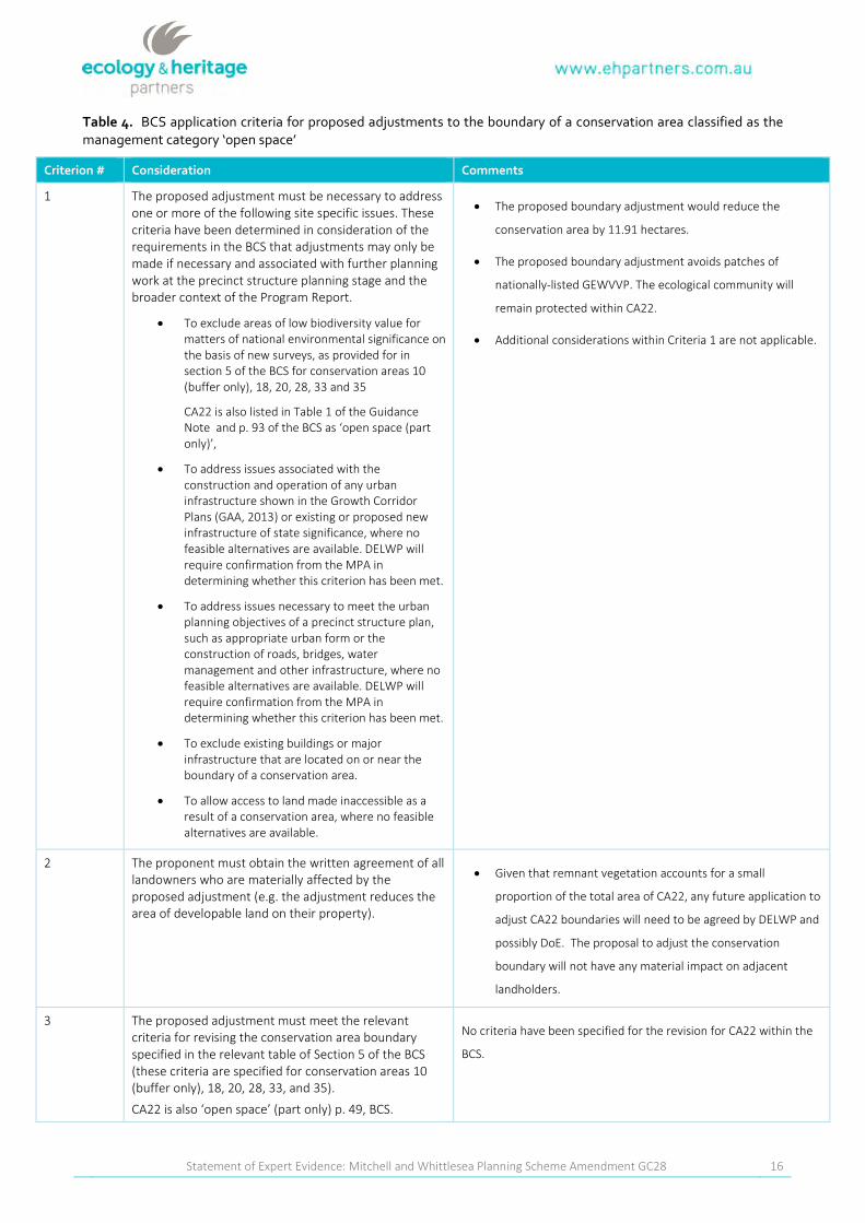
Tab le 4 . BCS application criteria for proposed adjustments to the boundary of a conservation area classified as themanagement category ‘open space’
Criterion # Cons ideration Com m ents
1 The proposed adjustment must be necessary to addressone or more of the following site specific issues. Thesecriteria have been determined in consideration of therequirements in the BCS that adjustments may only bemade if necessary and associated with further planningwork at the precinct structure planning stage and thebroader context of the Program Report.
To exclude areas of low biodiversity value formatters of national environmental significance onthe basis of new surveys, as provided for insection 5 of the BCS for conservation areas 10(buffer only), 18, 20, 28, 33 and 35
CA22 is also listed in Table 1 of the GuidanceNote and p. 93 of the BCS as ‘open space (partonly)’,
To address issues associated with theconstruction and operation of any urbaninfrastructure shown in the Growth CorridorPlans (GAA, 2013) or existing or proposed newinfrastructure of state significance, where nofeasible alternatives are available. DELWP willrequire confirmation from the MPA indetermining whether this criterion has been met.
To address issues necessary to meet the urbanplanning objectives of a precinct structure plan,such as appropriate urban form or theconstruction of roads, bridges, watermanagement and other infrastructure, where nofeasible alternatives are available. DELWP willrequire confirmation from the MPA indetermining whether this criterion has been met.
To exclude existing buildings or majorinfrastructure that are located on or near theboundary of a conservation area.
To allow access to land made inaccessible as aresult of a conservation area, where no feasiblealternatives are available.
The proposed boundary adjustment would reduce the
conservation area by 11.91 hectares.
The proposed boundary adjustment avoids patches of
nationally-listed GEWVVP. The ecological community will
remain protected within CA22.
Additional considerations within Criteria 1 are not applicable.
2 The proponent must obtain the written agreement of alllandowners who are materially affected by theproposed adjustment (e.g. the adjustment reduces thearea of developable land on their property).
Given that remnant vegetation accounts for a small
proportion of the total area of CA22, any future application to
adjust CA22 boundaries will need to be agreed by DELWP and
possibly DoE. The proposal to adjust the conservation
boundary will not have any material impact on adjacent
landholders.
3 The proposed adjustment must meet the relevantcriteria for revising the conservation area boundaryspecified in the relevant table of Section 5 of the BCS(these criteria are specified for conservation areas 10(buffer only), 18, 20, 28, 33, and 35).
CA22 is also ‘open space’ (part only) p. 49, BCS.
No criteria have been specified for the revision for CA22 within the
BCS.
Statement of Expert Evidence: Mitchell and Whittlesea Planning Scheme Amendment GC28 17
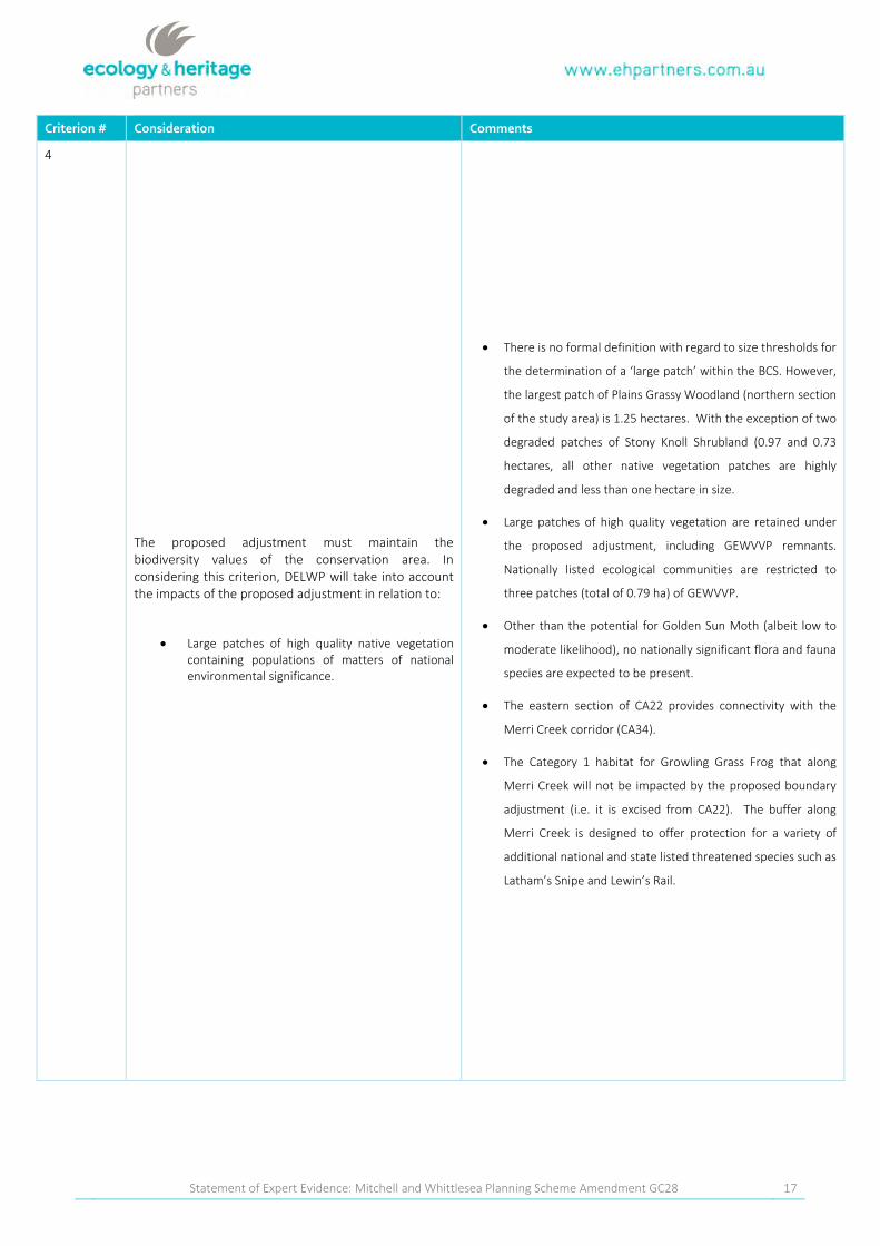
Criterion # Cons ideration Com m ents
4
The proposed adjustment must maintain thebiodiversity values of the conservation area. Inconsidering this criterion, DELWP will take into accountthe impacts of the proposed adjustment in relation to:
Large patches of high quality native vegetationcontaining populations of matters of nationalenvironmental significance.
There is no formal definition with regard to size thresholds for
the determination of a ‘large patch’ within the BCS. However,
the largest patch of Plains Grassy Woodland (northern section
of the study area) is 1.25 hectares. With the exception of two
degraded patches of Stony Knoll Shrubland (0.97 and 0.73
hectares, all other native vegetation patches are highly
degraded and less than one hectare in size.
Large patches of high quality vegetation are retained under
the proposed adjustment, including GEWVVP remnants.
Nationally listed ecological communities are restricted to
three patches (total of 0.79 ha) of GEWVVP.
Other than the potential for Golden Sun Moth (albeit low to
moderate likelihood), no nationally significant flora and fauna
species are expected to be present.
The eastern section of CA22 provides connectivity with the
Merri Creek corridor (CA34).
The Category 1 habitat for Growling Grass Frog that along
Merri Creek will not be impacted by the proposed boundary
adjustment (i.e. it is excised from CA22). The buffer along
Merri Creek is designed to offer protection for a variety of
additional national and state listed threatened species such as
Latham’s Snipe and Lewin’s Rail.

Statement of Expert Evidence: Mitchell and Whittlesea Planning Scheme Amendment GC28 18
Criterion # Cons ideration Com m ents
5The proposed adjustment should not result in a net loss in
the amount and quality of native vegetation or habitat for
matters of national environmental significance in the
conservation area. Where there are no feasible
alternatives to the proposed adjustment and a net loss
would occur, a net conservation gain elsewhere in the
Melbourne Strategic Assessment area in the amount and
quality of native vegetation and habitat for matters of
national environmental significance must be achieved.
The boundary adjustment will not result in a net loss in the amount
and quality of native vegetation or habitat for MNES within the
conservation area, given that less than 1% of the western section of
CA22 corresponds to an EPBC Act-listed community.
There is an opportunity to identify additional areas of GEWVVP
outside of the MSA area or on adjoining properties as part of the
proposal to adjust the conservation area boundary. In addition,
should the boundary amendment occur, habitat compensation
payments is likely to be required and these funds can be used to
acquire and manage other sites supporting ecological values.
Notes: BCS – Biodiversity Conservation Strategy; DoE – Commonwealth Department of the Environment; EPBC Act Environm ent
P rotection and Biodiversity Conservation Act 1999; GEWVVP - Grassy Eucalypt Woodland of the Victorian Volcanic Plain; GSM –
Golden Sun Moth; MNES Matter of National Environmental Significance; MSA – Melbourne Strategic Assessment
Statement of Expert Evidence: Mitchell and Whittlesea Planning Scheme Amendment GC28 19
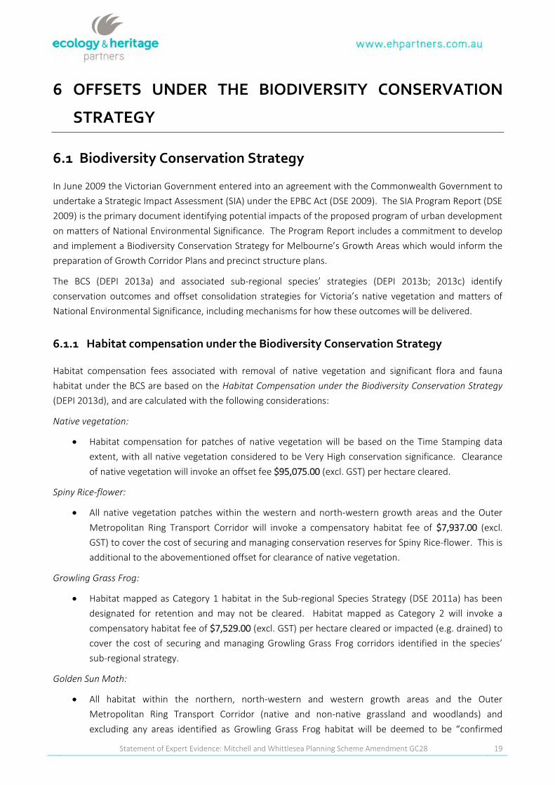
6 OFFSETS U N DER TH E BIODIVERSITY CON SERVATION
STRATEGY
6 .1 Biodivers ity Cons ervation Strategy
In June 2009 the Victorian Government entered into an agreement with the Commonwealth Government to
undertake a Strategic Impact Assessment (SIA) under the EPBC Act (DSE 2009). The SIA Program Report (DSE
2009) is the primary document identifying potential impacts of the proposed program of urban development
on matters of National Environmental Significance. The Program Report includes a commitment to develop
and implement a Biodiversity Conservation Strategy for Melbourne’s Growth Areas which would inform the
preparation of Growth Corridor Plans and precinct structure plans.
The BCS (DEPI 2013a) and associated sub-regional species’ strategies (DEPI 2013b; 2013c) identify
conservation outcomes and offset consolidation strategies for Victoria’s native vegetation and matters of
National Environmental Significance, including mechanisms for how these outcomes will be delivered.
6 .1 .1 H ab itat com p ens ation u nder the Biodiv ers ity Cons ervation Strategy
Habitat compensation fees associated with removal of native vegetation and significant flora and fauna
habitat under the BCS are based on the HabitatCom pensation undertheBiodiversity Conservation S trategy
(DEPI 2013d), and are calculated with the following considerations:
N ativevegetation:
Habitat compensation for patches of native vegetation will be based on the Time Stamping data
extent, with all native vegetation considered to be Very High conservation significance. Clearance
of native vegetation will invoke an offset fee $95,075.00 (excl. GST) per hectare cleared.
S piny R ice-flow er:
All native vegetation patches within the western and north-western growth areas and the Outer
Metropolitan Ring Transport Corridor will invoke a compensatory habitat fee of $7,937.00 (excl.
GST) to cover the cost of securing and managing conservation reserves for Spiny Rice-flower. This is
additional to the abovementioned offset for clearance of native vegetation.
Grow ling GrassFrog:
Habitat mapped as Category 1 habitat in the Sub-regional Species Strategy (DSE 2011a) has been
designated for retention and may not be cleared. Habitat mapped as Category 2 will invoke a
compensatory habitat fee of $7,529.00 (excl. GST) per hectare cleared or impacted (e.g. drained) to
cover the cost of securing and managing Growling Grass Frog corridors identified in the species’
sub-regional strategy.
GoldenS unM oth:
All habitat within the northern, north-western and western growth areas and the Outer
Metropolitan Ring Transport Corridor (native and non-native grassland and woodlands) and
excluding any areas identified as Growling Grass Frog habitat will be deemed to be “confirmed

Statement of Expert Evidence: Mitchell and Whittlesea Planning Scheme Amendment GC28 20
habitat”. However only non-native habitat will invoke a compensatory habitat fee as fees for native
habitat have been built in to the price of native vegetation habitat compensation. All non-native
habitat cleared will invoke a compensatory habitat fee of $7,914.00 (excl. GST) per hectare cleared.
O therConsiderations:
Fees listed above do not include potential additional costs associated with the salvage and translocation of
significant flora (e.g. Spiny Rice-flower).
6 .1 .2 H ab itat com p ens ation as s ociated w ith the dev elop m ent ofthe s tu dy area
Based on the offset rates per hectare outlined above, the total habitat compensation payment that may be
required as a result of the adjustment of CA 22 in the study area and the subsequent development of 23.43
hectares is outlined below (Table 5).
Tab le 5. Estimated habitat compensation fees required under the BCS if an adjustment of CA22 and development ofthis area occurs.
M atter ofN ES Totalarea p rop os ed to b e offs ets H ab itat com p ens ation am ou nt (ex cl.GST)
Native Vegetation 3.38 hectares X $95,075.00 per hectare (excl. GST) $321,353.50
Golden Sun Moth 8.53 hectares X $7,914.00 per hectare (excl. GST) $67,506.42
Scattered remnant trees Four trees X $13,218.00 per tree (excl. GST) $52,872.00
Total estimated habitat compensation amount $441,731.92
Note: A conservative estimate has been applied for non-native vegetation in that Golden Sun Moth ($7,914.00 per hectare) has been
used rather than Growling Grass Frog ($7,529.00 per hectare).

Statement of Expert Evidence: Mitchell and Whittlesea Planning Scheme Amendment GC28 21
7 CON CLU SION
The proposed boundary adjustment will lead to an 11.91 hectare reduction of CA22 (i.e. comprising both
remnant native vegetation and non-native vegetation). Of which, 3.38 hectares (6.89% of total remnant
vegetation in CA22) is proposed to be removed, comprising:
0.53 hectares of Plains Grassy Woodland;
0.42 hectares of Plains Grassland; and,
2.61 hectares of Stony Knoll Shrubland
Five trees are also present within the area proposed to be excluded from CA22. However, based on the
results of the detailed ecological investigations undertaken within the study area (in accordance with
DELWP’s survey requirements), the proposed adjustment to the CA22 boundary will not lead to the loss of
any habitat for EPBC Act-listed species and ecological communities (i.e. GEWVVP).
The proposed adjustment to CA22 meets the criteria outlined in the BCS application criteria for proposed
adjustments to the boundary of a conservation area (Table 4), and therefore should the adjustment to the
boundary occur and the area subsequently developed, this will result in habitat compensation obligations
totalling approximately $441,731.92 (excl. GST). These funds can be directed into the purchase and
management of others areas within CA22 or conservation reserves set aside as part of the BCS.

Statement of Expert Evidence: Mitchell and Whittlesea Planning Scheme Amendment GC28 22
REFEREN CES
Carter, O. 2010. National Recovery Plan for the Curly Sedge (Carex tasm anica). [Online}. East
Melbourne, Victoria: Department of Sustainability and Environment. Available from:
http://www.environment.gov.au/biodiversity/threatened/publication/recovery/carex-
tasmanic.html.
DELWP 2016a. Biodiversity Interactive Map [WWW Document]. URL
http://mapshare2.dse.vic.gov.au/MapShare2EXT/imf.jsp?site=bim. Victorian Department of
Environment, Land, Water and Planning.
DELWP 2016b. Native Vegetation Information Management Tool [WWW Document] URL
http://nvim.depi.vic.gov.au/ Victorian Department of Environment and Primary Industries.
DELWP 2016c. Victorian Biodiversity Atlas. Sourced from: “VBA_FLORA25” and “VBA_FLORA100”.
January 2016, Victorian Department of Environment, Land, Water and Planning.
DELWP 2016d. Planning Maps Online [www Document]. URL
http://services.land.vic.gov.au/landchannel/jsp/map/PlanningMapsIntro.
DELWP 2015. Guidance note:Im plem enting the Biodiversity Conservation S trategy forM elbourne’s
Grow th Corridors. W orking docum ent – February 2015,M elbourne S trategic Assessm ent.
Victorian Department of Environment, Land, Water and Planning.
DEPI 2013a. Biodiversity Conservation S trategy for M elbourne’sGrow th Corridors. Victorian
Government Department of Environment and Primary Industries, Melbourne, May 2013.
DEPI 2013b. S ub-R egionalS peciesS trategy for the Golden S un M oth. Victorian Government
Department of Environment and Primary Industries, Melbourne, May 2013.
DEPI 2013c. S ub-R egionalS peciesS trategy forthe Grow ling GrassFrog. Victorian Government
Department of Environment and Primary Industries, Melbourne, May 2013.
DEPI 2013d. Habitat Com pensation under the Biodiversity Conservation S trategy: M elbourne
S trategic Assessm ent. Victorian Government Department of Environment and Primary
Industries, Melbourne, August 2013.
DoE 2016. Protected Matters Search Tool: Interactive Map [WWW Document]. URL
http://www.environment.gov.au/arcgis-framework/apps/pmst/pmst.jsf. Federal Department
of Environment, Canberra.
DPI 2011. Victorian Resources Online- Adamson’s Blown-grass, Victoria Department of Primary
Industries. [Online]. Available from:
http://vro.dpi.vic.gov.au/dpi/vro/vrosite.nsf/pages/water_sss_adamsons_blown_grass.
DSE 2009. Delivering M elbourne’sN ew est S ustainable Com m unities.S trategic Im pact Assessm ent
R eport for the Environm ent P rotection and Biodiversity Conservation Act 1999. Victorian
Government Department of Sustainability and Environment, October 2009.
Statement of Expert Evidence: Mitchell and Whittlesea Planning Scheme Amendment GC28 23
DSE 2010. Biodiversity Precinct Structure Planning Kit. Victorian Government Department of
Sustainability and Environment, May 2010.
Ecology and Heritage Partners Pty Ltd 2012. Vegetation and Targeted Golden Sun Moth Survey
Report, Donnybrook Road, Donnybrook, Victoria. Unpublished report on behalf of Boral Property
Group.
Leigh. J.H & Briggs (Eds) 1992. Threatened Australian Plants. Overview and Case Studies. New South
Wales National Parks and Wildlife Service.
MPA 2015. Donnybrook/Woodstock Precinct Structure Plan. Metropolitan Planning Authority,
November 2015.
Murphy, A. 2010. National Recovery Plan for Adamson’s Blown-grass L achnagrostisadam sonii.
[Online]. Department of Sustainability and Environment, Melbourne, Victoria. Available from:
http://www.environment.gov.au/biodiversity/threatened/publications/recovery/lachnagrostis
-adamsonii.html
TSSC 2008. Advice to the Minister for the Environment, Heritage and the Arts from the Threatened
Species Scientific Committee (the Committee) on an Amendment to the List of Threatened
Ecological Communities under the Environm ent P rotection and Biodiversity Conservation Act
1999 (EP BC Act).Threatened Species Scientific Committee.
Viridans 2013a. Flora Information System. Viridans Biological Databases.
Viridans 2013b. Victorian Fauna Database. Viridans Biological Databases.
Walsh, N.G 1994. Poaceae. In: Walsh, N.G. & Entwisle, T.J, eds. Flora of Victoria. 2:356-327. Inkata
Press, Melbourne.

Statement of Expert Evidence: Mitchell and Whittlesea Planning Scheme Amendment GC28 24
8 REQU IRED IN FORM ATION
N am e and Addres s
This report has been prepared by Aaron Organ, Director of Ecology and Heritage Partners, 292 Mt
Alexander Road, Ascot Vale, Ph: (03) 9377 0100, [email protected]
Area ofEx p ertis e
Aaron Organ is an expert ecologist, with skills in all the major ecological environments of south-
eastern Australia. He has particular expertise in the workings of ecological systems, both under
natural conditions and when affected by unnatural disturbance regimes such as weed invasion and
impacts of development projects. He has also considerable experience in the application and
practical implementation of current Commonwealth and State environmental legislation and
Government Policy.
Ex p ertis e to m ake the Rep ort
Aaron Organ has considerable knowledge of the native flora and fauna throughout south eastern
Australia, including areas across western Victoria. A selection of past VCAT and Panel appearances
include:
2015: Statement of Expert Evidence: Amendment C187 to the Whittlesea Planning Scheme.
Wollert Precinct Structure Plan (PSP 1070) – (Panel).
2015: Yaringa Boat Harbour Expansion, Yaringa, Victoria – (Panel).
2015: Proposed residential development at 134-166 Aspinall Street, Golden Square, Victoria
– (VCAT).
2015: Amended Permit Associated with the use and development of the land for the
purpose of a Place of Worship – 171 – 197 Harkness Road, Melton West, Victoria – (VCAT).
2014: Proposed Development Plan Overlay and Planning Permit Applications for a Proposed
Residential Development at 370A Riddell Road, Sunbury, Victoria – (VCAT).
2014: Kilmore – Wallan Bypass – (Panel).
2014. Proposed residential development at 107 Gipps Street, Port Fairy (VCAT)
2014: NBN Fixed Wireless Telecommunications Facility at 49D Eddy Avenue, Mt Helen,
Victoria – Clayton Utz Lawyers (VCAT)
2014: Proposed residential development at 10 Fullarton Drive, Paynesville, Victoria – Hall &
Wilcox Pty Ltd (VCAT)
2014: Proposed residential development at 95 Wests Road, Langwarrin South – Planning
and Property Partners Pty Ltd (VCAT)
Statement of Expert Evidence: Mitchell and Whittlesea Planning Scheme Amendment GC28 25
2014: Amendment C101 to the Manningham Planning Scheme and Proposed Eastern Golf
Course Development Plan – Mirvac Doncaster Pty Ltd. (Panel)
2014: Princes Highway duplication, Winchelsea to Colac – HWL Ebsworth Lawyers Pty Ltd.
(Panel)
2014: Proposed Commercial Development, Federation Drive, Melton – Best Hooper Lawyers
Pty Ltd. (VCAT)
2013: Statement of Expert Evidence: 1 Hobbs Road Wyndham Vale, Victoria. Amendment
C171 - Ballan Road Precinct Structure Plan (PSP 40)
2013: Statement of Expert Evidence: Review of time stamped data for Amendment C172 -
Ballan Road, Wyndham Vale (PSP 92)
2013: Statement of Expert Evidence: 305-315 Craigieburn Road East, Wollert, Victoria.
Wollert Developments Pty Ltd. (VCAT)
2013: Proposed Planning Scheme Amendment C164 - 275 Racecourse Road, Sunbury –
Hume City Council (Panel)
2013: Western Highway Duplication - Section 3, Ararat to Stawell, Victoria – DLA Phillip Piper
(Panel).
2013: Cherry Tree Wind Farm – Maddocks Lawyers (VCAT).
2012: Western Highway Duplication - Section 2, Beaufort to Ararat, Victoria – DLA Phillip
Piper (Panel)
2012: Proposed Peninsula Link Freeway Service Centres, 83 Sages Road Baxter, Victoria –
Rigby Cook Lawyers Pty Ltd (VCAT)
2011: Western Highway Duplication - Section 1, Burrumbeet to Beaufort, Victoria – DLA
Phillip Fox (Panel)
2011: Old Warrandyte Road, flora and fauna review and Panel hearing, Donvale – Norton
Rose Australia Pty Ltd. (Panel)
2010: Marquands Road and Leakes Road (Lot 9), Truganina, Truganina South Precinct
Structure Plan – Stockland (Panel)
2010: Proposed Eastern Golf Course relocation to ‘Windsor Park’, 215–217 Victoria Road,
Yering, Victoria – for Best Hooper (VCAT)
2010: Truganina South Community Precinct Structure Plan – for Central Equity and Stockland
Limited (Panel)
2010: Craigieburn R2 Precinct Structure Plan – for Peet Limited (Panel)
2010: Proposed Mortlake Wind Farm – for Accionia Oceania Limited (Panel)
2009: Grenda Vehicle Storage Depot, Springvale Road, Keysborough - for Urbis Pty. Ltd.
(VCAT)
Statement of Expert Evidence: Mitchell and Whittlesea Planning Scheme Amendment GC28 26
2009: 1280 Boneo Road, Cape Schanck, development a proposed barn – for Hansen Planning
Services (VCAT)
2009: Melton Planning Scheme Amendment C65 – 489-555 Robinsons Road South Precinct
(Marksx Property), Truganina (Panel)
2008: Donald Mineral Sands Panel and associated works. Donald Mineral Sands project
(Panel)
2008: Amendment C88 to the Bass Coast Shire Planning Scheme - Silverleaves, Phillip Island
(Panel)
2008: Proposed medium density development located on the corner of 1587-1589 Point
Nepean Road and 1-1A Chatfield Avenue, Rosebud – for Fulcrum Town Planning Pty. Ltd.
(VCAT)
2008: Residential development at 2 Rowe Street, Alphington – for Rob Wignall Architects
(VCAT)
2008: Officer Service Centres, Officer – for Clayton UTZ Pty. Ltd. (VCAT)
2007: Anglesea Golf Club proposed Amendment C32 – for TGM Group Pty. Ltd. (Panel)
2007: Medium density housing at 2 Ramptons Road, Eltham – for Nillimbik Shire Council
(VCAT)
2007: Medium density unit development in Frankston (adjacent to Kananook Creek) – for
Gary Testro Lawyer (VCAT)
2007: Single dwelling development at 683 Great Ocean Road, Eastern Views, Victoria – for
SJB Planning Pty. Ltd (VCAT)
2006: Construction of a dwelling at 8 Charlotte Court, Warrandyte - for Glossop Town
Planning Pty. Ltd. (VCAT)
2005: Dollar Wind Farm, Gippsland – for Freehills Lawyers (Panel)
Author’s Declaration
I, Aaron Organ, have made all the inquiries that l believe are desirable and appropriate and that no
matters of significance which l regard as relevant have to my knowledge been withheld from the
tribunal.
---------------------------------------------------------------------------- Date: 09/05/2016

Donnybrook
Darebin Creek
Merri Creek
Hume
Fwy
Epping Rd
Mer r iang Rd
Donnybrook Rd
Glenburnie Rd
Grants Rd
Mount Ridley NatureConservation
Reserve
WOODSTOCK
KALKALLO
DONNYBROOK
WOLLERT
MICKLEHAM
CRAIGIEBURN
BEVERIDGE
EDENPARK
7663_Fig01_StudyArea 26/02/2016 MElsley
¹ 0 1,000500
Metres
Figure 1Location of the study areaEcological assessments forparts of the Boral Land inDonnybrook
VicMap Data: The State of Victoria does not warrant theaccuracy or completeness of information in this publicationand any person using or relying upon such information doesso on the basis that the State of Victoria shall bear noresponsibility or liability whatsoever for any errors, faults,defects or omissions in the information.
_̂
!(
Donnybrook
Melbourne
Whittlesea(C)
LegendStudy AreaConservation Area 22Growling Grass FrogConservation Area 34RailwayFreewayMajor RoadCollector RoadMinor RoadMinor WatercoursePermanent WaterbodyLand Subject to InundationParks and ReservesCrown Land
!
! !
!!! Localities

nm
nmnm
nm nm
nm
nm
nmnm
!(
nm
nm
nm
nm
nmnm
nm
nm
nmnm
nm
nm
nm
nm
nm
nm
nm
nmnm
nm
!(
!( !(
!(
nm
nm
nmnm
nm nm
nm
nm nmnm
nm
!(
nm
nm
nm
nm
nm
nm
nm
!(
!(
!(
!(
!(!(
!( !(!(
!(
!(
!(!(
!(
!(
Merri Creek
8109_Fig02a_EcoFeat_fr7663 9/05/2016 melsley
¹ 0 10050
Metres
Figure 2aEcological featuresEcological assessments forparts of the Boral Land inDonnybrook
VicMap Data: The State of Victoria does not warrant theaccuracy or completeness of information in this publicationand any person using or relying upon such information doesso on the basis that the State of Victoria shall bear noresponsibility or liability whatsoever for any errors, faults,defects or omissions in the information.
_̂
!(
Donnybrook
Melbourne
Whittlesea(C)
LegendStudy AreaConservation Area 22Growling Grass FrogConservation Area 34Proposed boundaryadjustment (11.91 ha)
nm Scattered Tree!( Large Old Tree in Patch
Ecological Vegetation ClassesPlains Grassy Woodland (55)Plains Grassland (132)Stony Knoll Shrubland (649)
EPBC Act listed vegetationcommunity
Grassy Eucalypt Woodlandof the Victorian VolcanicPlain
nm
nmnm
nm nm
nm
nm
nmnm
nm
nm
nm
nm
nm
nmnm
nm
nm
nmnm
nm
nm
nm
nm
nm
nm
nm
nmnm
nm
nm
nm nm
nm
nm
nm
nmnm
nm nm
nm
nm nmnm
nm
nm
nm
nm
nm
nm
nm
nm
nm
nm
nm
nm
nm
nmnm
nmnmnm
nm
nm
nmnm
nm
nm
Merri Creek
7663_Fig02b_MFLTargSurv 21/03/2016 Melsley
¹ 0 10050
Metres
Figure 2bMatted Flax-lily TargetedSurveysEcological assessments forparts of the Boral Land inDonnybrook
VicMap Data: The State of Victoria does not warrant theaccuracy or completeness of information in this publicationand any person using or relying upon such information doesso on the basis that the State of Victoria shall bear noresponsibility or liability whatsoever for any errors, faults,defects or omissions in the information.
_̂
!(
Donnybrook
Melbourne
Whittlesea(C)
LegendStudy AreaConservation Area 22
nm Scattered TreesSurvey tracks
22/01/201628/01/2016

Merri Creek
7663_Fig02c_CR_ABg_TargSurv 21/03/2016 Melsley
¹ 0 10050
Metres
Figure 2cCurly Sedge and AdamsonsBlown-grass TargetedSurveysEcological assessments forparts of the Boral Land inDonnybrook
VicMap Data: The State of Victoria does not warrant theaccuracy or completeness of information in this publicationand any person using or relying upon such information doesso on the basis that the State of Victoria shall bear noresponsibility or liability whatsoever for any errors, faults,defects or omissions in the information.
_̂
!(
Donnybrook
Melbourne
Whittlesea(C)
LegendStudy AreaConservation Area 22
Survey tracks08/02/2016
GFGFGF
GFGF
GF
GFGF
GFGF
GFGFGF
GF
GF
GFGF
!(!(
!(
!(
!(
!(
!(
!(
!(!(
!(!(
!(
!(!(
!(
!(
!(
!(!(!(!(
!(
!(
!(
!(
")
")
")
")
")
")
") ")")
")
")
")")
") ")")
") ") ")")")")")") ") ") ")")
")
") ")")
")
")")
")")")
")")")
")")")")")")")
")
")
")
")
")
")
")
")
")
Beveridge
Donnybrook
Merri Creek
Darebin Creek
Hume
Fwy
Epping Rd
Mer ri angR d
GlenburnieRd
Grants Rd
Mt Ridley Rd
Donnybrook Rd
Old Sydney Rd
BeveridgeBushlandReserve
Mount Ridley NatureConservation
Reserve
201120112011
2011
2011
20122012
20112011
20112011
2009
20082008
2008
1984 1984
2007
2012
2006
20051990
2011
2011201120112011
2009
2005
2008
2013
2009
1992
1992
1990
1992
2009
19922010
20092009 20101991
19922009
2008 2009
2009 2009 2009
2009 2009 20092009 2009 2009 2009
2009 20092009
20092009
200920092009
20092009 2009
2009
2011
1990
1992
1992
1996
7663_Fig03_SigFlora 9/05/2016 melsley
VBA 2015. Vic torian Biodiversity Atlas. // Sourc ed from : ‘VBA_FLORA25’ and ‘VBA_FLORA100’, June 2015 © T h eState of Vic toria, Departm ent of Environm ent, Land, Water and Planning. Rec ords prior to 1949 not sh ow n.Ec ology and Heritage Partners rec orded spec ies h ave been subm itted to but are not yet inc luded in th e VBA as atOc tober 2014.Vic Map Data: T h e State of Vic toria does not warrant th e ac c urac y or c om pleteness of inform ation in th is public ationand any person using or relying upon suc h inform ation does so on th e basis th at th e State of Vic toria sh all bear noresponsibility or liability w h atsoever for any errors, faults, defec ts or om issions in th e inform ation.
_̂
!(
Whittlesea (C)
Melbourne
Donnybrook
0 1.50.75
Kilom etres¹
Figure 3Previously documented significantflora within 5km of the study areaEcological assessments for parts of theBoral Land in Donnybrook
LegendStudy AreaConservation Area 22
Significant flora!( Basalt Pepperc ress!( Basalt T ussoc k -grass!( Curly Sedge!( Matted Flax -lily!( Plum p Swam p Wallaby-grass!( Purple Blow n-grass") Slender T ic k -trefoil") Sm all Sc urf-pea") T ough Sc urf-pea") Winged Water-starwort") Yarra Gum") Yellow Star
Ecology and Heritage Partners recordsGF Basalt T ussoc k -grassGF Large-flower Crane's-billGF Matted Flax -lilyGF Native Couc hGF Slender BindweedGF Slender T ic k -trefoilGF South ern Blue-gum

¥¦¥¦
¥¦¥¦
¥¦¥¦¥¦¥¦
!(
!(
!(!(
!(
!(
!(
!(
!(
!(
!(
!(
!(
!(
!(
!(
!(!(
!(
!(
!(
")
")")
")
")")
")
")
")
")
")
")
")
") ")") ")")")")")") ") ")")")")") ") ") ")")") ")") ") ")") ")")")") ")")")")") ")")")")")")
")
#*
#* #*
#*#*#*#*
#*#*#*
#*
#*#*#*
#*
#*
#*
#*#*
#* #*#*#*#*
#*#*
#*#*#*
#*#*#*#*
#*#* #*#* #*#*#*#*#* #*#*#*#*#*#*#*
#* #*#*#*#*#*#* #*
#*
#*#*
#*#*#*#*
#*#*#*#*#*#*
#*
#*#*
#*
#*
#* #*
#*#*
#*
#*#*
#*
#*
#*
#*
GF
GF
GF
GF
GF
GF
GF
GF
GF
GF
GF
GF GF
GF
GF
GF
GFkjkj
kj
kj
kjkj
kj
Beveridge
Donnybrook
Merri Creek
Darebin Creek
Hume
Fwy
Epping Rd
Mer ri angR d
Glenb urnieR d
Grants R d
Mt R id ley R d
Donnyb rook R d
Old Syd ney R d
BeveridgeBushland Reserve
Mount Ridley NatureConservation
Reserve
20122012
20122012
2012
1993
2005
199119941988
1994
1988
2007
1989
1988
1988
1991
1988
19911988
19731973
2005
1962
1991
19881988
1988
19881988
1991
1991
1991
1989
1983
1991
2008 20082008 2008
200820082008
2009
1988
1991 1991
200220022002
2002 2002
2002
200220022002
1995
1993
2003
20091988
2002 20022010
2010
2010
20102002200220022002
20092009
20022002 20092002 2002 20022006 20022006 2002
1993
20022006
2009 20022002
1991
1988
1991
19881989
1983
1991
1991
1991
1994
2002
1983
1983
1989
1990
1997
1962
1966
1962
1988
1976 1988
1988
19501990
1988
2007
19891995
1995
7663_Fig04_SigFauna 9/05/2016 melsley
VBA 2015. Victorian Biod iv ersity Atlas. // Sourced from : ‘VBA_FLOR A25’ and ‘VBA_FLOR A100’, June 2015 © Th eState of Victoria, Departm ent of Env ironm ent, Land , Water and Planning . R ecord s prior to 1949 not sh own.Ecolog y and Heritag e Partners recorded spec ies have b een sub m itted to b ut are not yet inc lud ed in th e VBA as atOctob er 2014.VicMap Data: Th e State of Victoria does not warrant the ac c uracy or com pleteness of inform ation in th is pub licationand any person using or relying upon suc h inform ation d oes so on the b asis that th e State of Victoria sh all b ear noresponsib ility or liab ility wh atsoever for any errors, faults, defects or om issions in th e inform ation.
_̂
!(
Whittlesea (C)
Melbourne
Donnybrook
0 1.50.75
Kilom etres¹
Figure 4Previously documented significantfauna within 5km of the study areaEcological assessments for parts of theBoral Land in Donnybrook
LegendStudyConservation Area
Significant fauna!( Australasian Bittern!( Australasian Shov eler!( Azure King fish er!( Bark ing Owl!( Blac k Falcon!( Blac k -eared Cuc k oo!( Blue-b illed Duc k!( Brown Toad let")Brown Treecreeper(south-eastern ssp.)
")Brush -tailedPh ascog ale
") Com m on Dunnart") Diam ond Firetail") Eastern Great Eg ret") Fat-tailed Dunnart") Frec k led Duc k") Golden Sun Moth
#*Grassland EarlessDrag on
#* Growling Grass Frog#* Hard h ead#* Latham 's Snipe#* Lewin's R ail#* Little Button-quail#* Mask ed Owl#* Musk Duc kGF Nank een Nig h t HeronGF Plains-wand ererGFR ed -c h ested Button-quail
GF R oyal Spoonb illGF Southern Toad letGF Spec k led Warb lerGF Spotted HarrierGF Striped Leg less Lizardkj Superb Parrotkj Swift Parrotkj Tussoc k Sk inkkjWh ite-throatedNeed letail
Ecology and HeritagePartners records
¥¦ Golden Sun Moth
Top Related