


Languages
Pages
Legal

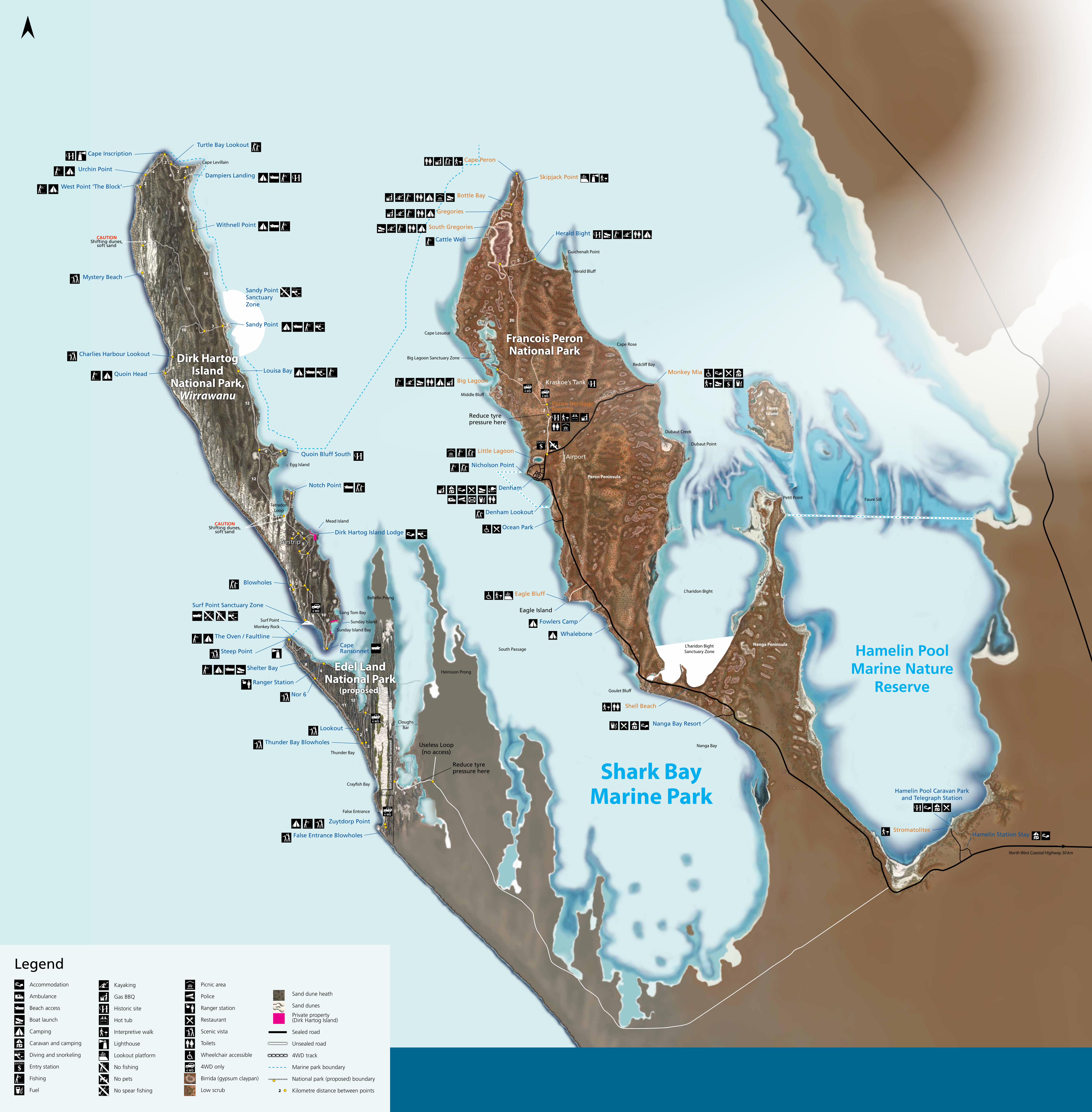
South Passage
The Oven / Faultline
Steep Point
Nor 6
Shelter Bay
Ranger Station
Lookout
Thunder Bay Blowholes
Thunder Bay
Crayfish Bay
False Entrance
Zuytdorp Point
False Entrance Blowholes
9
8
4
11
26
2 18
9
7
4
12
Cloughs Bar
Useless Loop (no access)
Heirisson Prong
Monkey Rock
Edel
Lan
d N
atio
nal P
ark
(pro
pose
d)
Shark Bay Marine Park
Surf Point
Surf Point Sanctuary Zone
Reduce tyre pressure here
Bellefin Prong
Cape Levillain
Cape Inscription
Dampiers Landing
West Point ‘The Block’
Urchin Point
Mystery Beach
Quoin Head
Charlies Harbour Lookout
Sandy Point
Sandy Point Sanctuary Zone
Louisa Bay
Withnell Point
Turtle Bay Lookout
Blowholes
Cape Ransonnet
Sunday Island Bay
Sunday Island
Long Tom Bay
Dirk Hartog Island Lodge
Mead Island
Airstrip
Notch Point
Tetradon Loop
Egg Island
Quoin Bluff South
CAUTIONShifting dunes,
soft sand
CAUTIONShifting dunes,
soft sand
10
5
5
2
3
2 1
3
31
4
12
4
12
7
4
103
19
14
4
9
2
4
2
2 2
9
4
Bottle Bay
Skipjack Point
Gregories
South Gregories
Cattle WellHerald Bight
Herald Bluff
Guichenalt Point
Big Lagoon
Cape Rose
Monkey MiaRedcliff Bay
Middle Bluff
Cape Lesueur
Little Lagoon
Nicholson Point
Denham
Ocean Park
Dubaut Point
Dubaut Creek
Airport
Monkey Mia Road
Sha
Rk Bay
Roa
d
Peron Peninsula
Big Lagoon Sanctuary Zone
Kraskoe’s Tank
Peron Heritage Precinct
Denham Lookout
Eagle Bluff
Eagle Island
Goulet Bluff
Nanga Bay
Shell Beach
L’haridon Bight Sanctuary Zone
Stromatolites
L’haridon Bight
Petit Point
Hamelin Pool Marine Nature
Reserve
Faure Sill
Nanga Bay Resort
Hamelin Pool Caravan Park and Telegraph Station
Fowlers Camp
Whalebone
Hamelin Station Stay
Faure Island
Nanga Peninsula
Reduce tyre pressure here
7
2
10
20
5
16
6
Cape Peron
Stay safe• Protectyourselffromthesun
• ItcanbehotinSharkBay,makesureyoudrink enough water to avoid dehydrating
• Beawareofcoastalcliffs–theymaybeundercut and unstable
• Beawareofstrongwindgustswhennearcliffs
• Alwaysswim,diveorsnorkelwithatleastone other person
• Wheninthewaterbeawareofboats
• Wheninthewaterbeawareofpotentiallydangerousmarinelife,includingsharks
• Beawareofstonefishwhenwadinginthewater (wear suitable footwear)
Visitor feesVisitor fees apply to parks and reserves. These fees help pay for maintaining roads and facilities. Enquire at the Department of ParksandWildlifeofficeinDenhamaboutpark passes (not valid for Monkey Mia Reserve).
Legendaccommodation
ambulance
Beach access
Boat launch
Camping
Caravan and camping
diving and snorkeling
entry station
Fishing
Fuel
kayaking
Gas BBQ
historic site
hot tub
interpretive walk
Lighthouse
Lookout platform
no fishing
no pets
no spear fishing 2
Picnic area
Police
Ranger station
Restaurant
Scenic vista
Toilets
Wheelchair accessible
4Wd only
Birrida (gypsum claypan)
Low scrub
Sand dune heath
Sand dunes
Private property (dirk hartog island)
Sealed road
Unsealed road
4Wd track
Marine park boundary
national park (proposed) boundary
kilometre distance between points
Dirk Hartog Island
National Park, Wirrawanu
Francois Peron National Park
Edel Land National Park
(proposed)
North West Coastal Highway 30 km
Top Related