


Languages
Pages
Legal

Scottish Mountain Bike Trails
ANGUS
www.ambta.info
Angus Mountain Bike Trails Association
ExplorE ThE TrAilS of ScoTlANd’S BirThplAcE
These maps have been created with thanks to the following organisations:
www.angusahead.com

Scottish Mountain Bike Trails: Angus
WElcoME To ANGUSThese route cards would not have been possible with out the hard work and dedication of AMBTA members, riders, volunteers, landowners and local business’ in the Angus area.
We love riding in Angus and to make sure this is a popular mountain biking location for years to come, and to keep our good relationship with local landowners and other path users, we ask you to follow the advice below:
• let other path users know you are coming as early as possible. We find a tinkle of our bell and a friendly greeting and smile help us all enjoy the paths together.
• Sometimes our fellow path users don’t hear us, so we slow down for them (sometimes even stop) and keep our patience (and our smiles!)
• remember its good to go fast when you can see what is ahead, but please take care and watch your speed on blind corners and dips.
• please take care near wildlife and leave the environment as you find it.
• if the route looks wet and fragile please go slowly (or walk) and try to stick to the line of the track.
• help land managers and others to work safely and effectively. respect requests for reasonable limitations on when and where you can go. See “route Specifics” on each card.
• The route description may change over time so please be flexible with your plans and be ready to use alternative routes.
• We would recommend you use an ordnance Survey map along with our route cards. This will help if you make a wrong turn!
• check the weather and make sure you have all the equipment you need for your day out. if you are in any doubt please pop into one of our cycle centres or checkout the AMBTA facebook page for some friendly advice!
•
diSclAiMEr: details current May 2012. Whilst AMBTA, dMBinS and Angus council have made every effort to ensure the accuracy of this information, they cannot be held responsible for any changes that may take place on the routes, nor for any accidents or injuries sustained whilst following the routes. cyclists and walkers must take personal responsibility for their own safety.iMAGES: front cover: Scott francis, Andy Mccandlish, Graeme Mclean, Glentrek

Scottish Mountain Bike Trails: ANGUSGlen iSla: RouTe no.1
Glen MaRkie, Glen iSla & The CaTeRan TRail 01Rou
Te n
o
STaRTinG PoinT(S)
SuMMaRY
MaX heiGhT GaineD
lenGTh
Freuchies Car Park, Kirkton of Glenisla, PH11 8PG
An intermediate (Blue) ride with a steady climb on forest roads. Has optional difficult (Red) sections on old cross country ski trails with great views.
466m
16/19km max
Contains Ordnance Survey data © Crown copyright and database 2012
© www.covertdirt.co.uk
www.angusahead.com

Scottish Mountain Bike Trails: ANGUS 01Rou
Te n
o
Glen MaRkie, Glen iSla & The CaTeRan TRail
For more information on mountain biking in angus:
www.angusahead.com www.ambta.info www.DMBinS.com
From Freuchies car park cycle up Glen Markie following the road to Glen Markie lodge - a big white building. Continue past the lodge in a nW direction to a gate on the main track. Continue downhill in a nW direction for around 1.5km and then uphill for another 1km to the “4 ways” junction. Take the SW track which is almost level in elevation west of the “Crock”.
Just before the trail starts downhill and beside an extensive area of clear fell, a track on the left which follows the treeline up towards the “Crock” indicates the start of two optional difficult (red) sections of trail.
ignoring this trail it’s downhill all the way from there but beware of a gate across the track near Tulloch. Continue downhill with loch Shandra on your right hand side until you come to a gate which is level with the end of the loch. Go through the gates and cycle past the southern edge of the loch until you reach a Boat shed. From there follow the “Cateran Trail” markers up and down hill before a steep pull up and then cycle Se for a distance before a 90 Degree right hand bend. Continue downhill in a Se direction emerging at the farm. Go through the farm for a short distance and turn left regaining the Glen Markie road to your starting place.
RouTe DeSCRiPTion
CYCle FRienDlY BuSineSSeS NEAR THIS TRAIL
hiGhlanD aDvenTuRe
WeST FReuChieS B&BGlenisla, PH11 8PGTel: 01575 582716 www.glenisla-westfreuchies.co.uk
Glenisla, PH11 8PE Tel. 01575 582238 www.highlandadventure.co.uk• Letotherpathusersknowyou
arecomingasearlyaspossible.• Pleasewatchyourspeed,especiallyon
blindcornersanddips.• Pleasetakeextracarenearwildlifeand
leavetheenvironmentasyoufindit.• Helplandmanagersandotherstowork
safelyandeffectively.See‘RouteSpecifics’.
• Theroutedescriptionandqualityofpathmaychangeovertimesopleaseremainflexiblewithyourplansandbereadytousealternativeroutes.CorrectattimeofprintMay2012.
• Checktheweatherforecastandensureyouhavealltheequipmentyouneedforyourroute.
• Ifyouareinanydoubtpleasepopintooneofourcyclecentresforadvice!
Route Specifics• Groundnestingbirds-pleasesticktothe
promotedtrail.• Thisisaworkingforest.
Pleasecheckbeforeridingroute.Forestoperationsatwww.forestry.gov.uk/taydistrict
• Pleasetakecaretoavoiddisturbinglivestockandbevigilantandcourteouswhileproceedingthroughfarmsandnearbuildings.
We love riding this route and to keep our good relationship with local landowners and other path users we ask you to follow the advice below:
DO THE RIDE THING
GleniSla hoTel & ReSTauRanTKirkton of Glenisla, PH11 8PHTel: 01575 582223 www.glenisla-hotel.com
© www.covertdirt.co.uk
© www.covertdirt.co.uk
CYClinG CenTReS IN ANGUS
anGuS Bike ChainFixing and fettling bikes for over 20 years. Large stock of cycles, accessories, spares and clothing to cater for your cycling needs. Route advice.29 Commerce St, arbroath, DD11 1naTel. 01241 875510 www.angusbikechain.co.uk
CYCle WoRlDQuality bikes for sale, vast clothing & footwear department, extensive route advice, fine coffee and friendly banter. Millfield Feus, arbroath, DD11 2QJ Tel. 01241 876034 www.cycle-world.co.uk
www.ambta.info
Angus Mountain Bike Trails Association
CoveRT DiRTBike hire, guided trips, coaching & skills development and route advice. Cycling Scotland GO MTB Registered CentreTel: 01241 890722 www.covertdirt.co.uk
GlenTRekBike hire, guided trips, coaching & development100 east high Street, Forfar, angus DD8 2eT Tel: 01307 469536www.glentrek.com

Scottish Mountain Bike Trails: ANGUSaRBRoaTh: RouTe no.2
aRBRoaTh, aRBiRloT, eThie WooDS & The CoaST 02Rou
Te n
o
STaRTinG PoinT(S)
SuMMaRY
MaX heiGhT GaineD
lenGTh
Harbour Carpark, Arbroath, DD11 1PS
A mostly flat intermediate (Blue) ride taking in small villages, woods and part of the Angus Coastal Path.
154m
24km max
© www.andymccandlish.com
Contains Ordnance Survey data © Crown copyright and database 2012
www.angusahead.com

Scottish Mountain Bike Trails: ANGUS 02Rou
Te n
o
aRBRoaTh, aRBiRloT, eThie WooDS & The CoaST
For more information on mountain biking in angus:
www.angusahead.com www.ambta.info www.DMBinS.com
From the harbour car park head west along the coast and the West links. hug the seawall until crossing the pedestrian bridge over the railway. Cross the a92 and take the path sign posted arbirlot. This path breaks out into fields before heading back into the trees through a gate. Crossing a bridge some steps lead up to the single track ride to arbirlot with its picturesque white water and bridge. Follow the B9127 east then follow the green footpath signs to Bankhead and Millfield Feus. head SW on the a933, again looking out for the footpath signs just after the industrial estate which will take you towards kirkton. at St. vigeans ride under the rail bridge, turning right onto the road. not far up the hill, turn left onto the track beside some cottages which runs parallel to the a92. at Bankfoot turn left onto the busy a92 cycling through Marywell before crossing and turning right at ethie Cottage and into ethie Woods. There are a wide variety of trails here so its worth exploring if you have the time. alternatively, continue east up the hill following the trail beside the fields taking you past kennels. Pass straight over the road onto the adjacent track to West Mains of auchmithie. Turn right onto the auchmithie road and then left at the next road junction. Follow the Blue Sustrans Cycling signs through Cliffburn and back down to the coast and the harbour.
RouTe DeSCRiPTion
CYCle FRienDlY BuSineSSeS NEAR THIS TRAIL
SuGaR & SPiCe TeaRooM
keSCoWeTh B&BHightrees at Cockhill, Arbroath, DD11 4RZTel: 01674 820747 www.kescoweth.co.uk
9-13 High Street, Arbroath Tel. 01241 437500www.sugarandspiceshop.co.uk• Letotherpathusersknowyou
arecomingasearlyaspossible.• Pleasewatchyourspeedespeciallyon
blindcornersanddips.• Pleasetakeextracarenearwildlifeand
leavetheenvironmentasyoufindit.• Helplandmanagersandotherstowork
safelyandeffectively.See‘RouteSpecifics’.
• Theroutedescriptionandqualityofpathmaychangeovertimesopleaseremainflexiblewithyourplansandbereadytousealternativeroutes.CorrectattimeofprintMay2012..
• Checktheweatherforecastandensureyouhavealltheequipmentyouneedforyourroute.
• Ifyouareinanydoubtpleasepopintooneofourcyclecentresforadvice!
Route Specifics• Busystretchesofroad,pleasetakecare
whencrossingandridingontheA92.• ThetrailtotheeastofEthieWoods
headingtoWestMainsofAuchmithiecanbecomeovergrownandimpassableduringtheheightofsummer.
• Pleasesticktotherecommended route.
We love riding this route and to keep our good relationship with local landowners and other path users we ask you to follow the advice below:
DO THE RIDE THING
BalnaBReChan loDGe B&BInverkeilor, By ArbroathTel: 01241 830462 www.balnabrechan.co.uk
© www.andymccandlish.com
© www.andymccandlish.com
CYClinG CenTReS IN ANGUS
anGuS Bike ChainFixing and fettling bikes for over 20 years. Large stock of cycles, accessories, spares and clothing to cater for your cycling needs. Route advice.29 Commerce St, arbroath, DD11 1naTel. 01241 875510 www.angusbikechain.co.uk
CYCle WoRlDQuality bikes for sale, vast clothing & footwear department, extensive route advice, fine coffee and friendly banter. Millfield Feus, arbroath, DD11 2QJ Tel. 01241 876034 www.cycle-world.co.uk
www.ambta.info
Angus Mountain Bike Trails Association
CoveRT DiRTBike hire, guided trips, coaching & skills development and route advice. Cycling Scotland GO MTB Registered CentreTel: 01241 890722 www.covertdirt.co.uk
GlenTRekBike hire, guided trips, coaching & development100 east high Street, Forfar, angus DD8 2eT Tel: 01307 469536www.glentrek.com

Scottish Mountain Bike Trails: ANGUSGlen eSk: RouTe no.3
Glen eSk, TaRFSiDe & The BaDalaiR 03Rou
Te n
o
STaRTinG PoinT(S)
SuMMaRY
MaX heiGhT GaineD
lenGTh
Tarfside Carpark, Glen Esk
An exposed difficult (Red) hillside route in Glen Esk with outstanding views of Loch Lee and Glen Mark.
402m
14.5km max
© Glentrek
Contains Ordnance Survey data © Crown copyright and database 2012
www.angusahead.com

Scottish Mountain Bike Trails: ANGUS 03Rou
Te n
o
Glen eSk, TaRFSiDe & The BaDalaiR
For more information on mountain biking in angus:
www.angusahead.com www.ambta.info www.DMBinS.com
Park at Tarfside car park where there are toilets and a campsite. head east out of the car park over the bridge and straight ahead off the main road and on to a good track. Follow this for just over 2 km until you are approaching the farm ‘Westbank’. Take the less obvious straight ahead route keeping to the north of the farm buildings rather than veering left down through the farm. Continue through a gate sign posted ‘invermark’ to the road.
The climb uphill past auchronie farm is fairly steep but has outstanding views of loch lee and Glen Mark to enjoy.
it’s easy to miss the track at the top of the hill in the heather where you need to turn sharp right. Follow a southeast direction for a short distance before contouring round the hill to Badalair. Then it’s downhill all the way!
note : There is an electric fence on the track around 1.5 km up from auchronie and another at the bottom of the steeper downhill section from Badalair.
on the downhill, when you reach some ruins, the track takes a sharp right which isn’t obvious (don’t go straight ahead).
RouTe DeSCRiPTion
CYCle FRienDlY BuSineSSeS NEAR THIS TRAIL
The ReTReaT Folk MuSeuM & viSiToR CenTReThe Glenesk Retreat, Tarfside, DD9 7YT Tel. 01356 648070www.gleneskretreat.co.uk
• Letotherpathusersknowyouarecomingasearlyaspossible.
• Pleasewatchyourspeed,especiallyonblindcornersanddips.
• Pleasetakeextracarenearwildlifeandleavetheenvironmentasyoufindit.
• Helplandmanagersandotherstoworksafelyandeffectively.See‘RouteSpecifics’.
• Theroutedescriptionandqualityofpathmaychangeovertimesopleaseremainflexiblewithyourplansandbereadytousealternativeroutes.CorrectattimeofprintMay2012.
• Checktheweatherforecastandensureyouhavealltheequipmentyouneedforyourroute.
• Ifyouareinanydoubtpleasepopintooneofourcyclecentresforadvice!
Route Specifics• Thisisanexposedhillsiderouteand
youshouldbesuitablyequippedandprepared.
• Pleasesticktotherecommended route.• RefreshmentsavailableatTheRetreat,
2kmdownGlenesk,backtowardsEdzell.
We love riding this route and to keep our good relationship with local landowners and other path users we ask you to follow the advice below:
DO THE RIDE THINGDoune houSe B&B22-24 High Street, Edzell, DD9 7TATel: 01356 648201 www.dounehouse-edzell.co.uk
© Glentrek
PanMuRe aRMS hoTel52 High Street, Edzell, DD9 7TATel: 01356 648950 www.panmurearmshotel.co.uk
JaCkDaWS neST SelF CaTeRinGHallhill, Edzell, DD9 7XTTel: 01356 648286
CYClinG CenTReS IN ANGUS
anGuS Bike ChainFixing and fettling bikes for over 20 years. Large stock of cycles, accessories, spares and clothing to cater for your cycling needs. Route advice.29 Commerce St, arbroath, DD11 1naTel. 01241 875510 www.angusbikechain.co.uk
CYCle WoRlDQuality bikes for sale, vast clothing & footwear department, extensive route advice, fine coffee and friendly banter. Millfield Feus, arbroath, DD11 2QJ Tel. 01241 876034 www.cycle-world.co.uk
www.ambta.info
Angus Mountain Bike Trails Association
CoveRT DiRTBike hire, guided trips, coaching & skills development and route advice. Cycling Scotland GO MTB Registered CentreTel: 01241 890722 www.covertdirt.co.uk
GlenTRekBike hire, guided trips,coaching & development100 east high Street, Forfar, angus DD8 2eT Tel: 01307 469536www.glentrek.com

Scottish Mountain Bike Trails: ANGUSGlen Doll: RouTe no.4
Glen Doll & JoCkS RoaD 04Rou
Te n
o
STaRTinG PoinT(S)
SuMMaRY
MaX heiGhT GaineD
lenGTh
Forestry Commission car park, Glen Doll
A forest road climb beside the White Water followed by a rough intermediate (Blue) descent down Jocks Road.
210m
8km max
© Glentrek
Contains Ordnance Survey data © Crown copyright and database 2012
www.angusahead.com

Scottish Mountain Bike Trails: ANGUS 04Rou
Te n
o
Glen Doll & JoCkS RoaD
For more information on mountain biking in angus:
www.angusahead.com www.ambta.info www.DMBinS.com
Park at The Forestry Commission car park in Glen Doll, north west of Clova, at the end of the single track road.
head west from the car park, passing the Ranger Station and continue west keeping the river on your left hand side. Pass over a bridge, continue on the forest road with the White Water now on your right. This turns eventually into a path which continues beside the river until reaching the bridge at the top of Glen Doll.
Catch your breath here and enjoy the spectacular views up the glen (keep a look out for deer!) before heading into the trees and descending down Jocks Road. at times this can be a bone shaking (intermediate) challenge. This will eventually exit back onto the forest road and you can retrace your tracks back to the car park.
RouTe DeSCRiPTion
CYCle FRienDlY BuSineSSeS NEAR THIS TRAIL
The Glen Clova hoTel, loDGeS, ReSTauRanT
Glen Clova, DD8 4QS Tel. 01575 550350www.clova.com
• Letotherpathusersknowyouarecomingasearlyaspossible.
• Pleasewatchyourspeedespeciallyonblindcornersanddips.
• Pleasetakeextracarenearwildlifeandleavetheenvironmentasyoufindit.
• Helplandmanagersandotherstoworksafelyandeffectively.See‘RouteSpecifics’.
• Theroutedescriptionandqualityofpathmaychangeovertimesopleaseremainflexiblewithyourplansandbereadytousealternativeroutes.CorrectattimeofprintMay2012.
• Checktheweatherforecastandensureyouhavealltheequipmentyouneedforyourroute.
• Ifyouareinanydoubtpleasepopintooneofourcyclecentresforadvice!
Route Specifics• Thisisanexposedhillsiderouteand
youshouldbesuitablyequippedandprepared.
• Thisisaworkingforest.PleasechecktheForestryCommissionwebsiteforanyaccessissuesinthearea.
• Popintotherangersstationatthecarparkforadvice.
• Parkingchargesapply.Remembertotakechange!
We love riding this route and to keep our good relationship with local landowners and other path users we ask you to follow the advice below:
DO THE RIDE THINGThe BoThY - SelF CaTeRinG
Clach na Brain, Glen Clova, DD8 4QUTel: 01575 540330 www.clachie.com
© Glentrek
CRePTo B&B
1 Kinnordy Place, Kirriemuir, DD8 4JWTel: 01575 572746
PuRGavie FaRM B&B
Lintrathen, Kirriemuir, DD8 5HZTel: 01575 560213
CYClinG CenTReS IN ANGUS
anGuS Bike ChainFixing and fettling bikes for over 20 years. Large stock of cycles, accessories, spares and clothing to cater for your cycling needs. Route advice.29 Commerce St, arbroath, DD11 1naTel. 01241 875510 www.angusbikechain.co.uk
CYCle WoRlDQuality bikes for sale, vast clothing & footwear department, extensive route advice, fine coffee and friendly banter. Millfield Feus, arbroath, DD11 2QJ Tel. 01241 876034 www.cycle-world.co.uk
www.ambta.info
Angus Mountain Bike Trails Association
CoveRT DiRTBike hire, guided trips, coaching & skills development and route advice. Cycling Scotland GO MTB Registered CentreTel: 01241 890722 www.covertdirt.co.uk
GlenTRekBike hire, guided trips, coaching & development100 east high Street, Forfar, angus DD8 2eT Tel: 01307 469536www.glentrek.com

Scottish Mountain Bike Trails: ANGUSBReChin: RouTe no.5
BReChin & BuRGhill WooDS CiRCuiT 05Rou
Te n
o
STaRTinG PoinT(S)
SuMMaRY
MaX heiGhT GaineD
lenGTh
Brechin Business Park, West Road, Brechin, DD9 6RJ
A ride through forest and town with a short leg burning climb. Has the option of a difficult (Red) or intermediate (Blue) descent.
210m
12km max
©www.covertdirt.co.uk
Contains Ordnance Survey data © Crown copyright and database 2012
www.angusahead.com
Scottish Mountain Bike Trails: ANGUS 05Rou
Te n
o
BReChin & BuRGhill WooDS CiRCuiT
For more information on mountain biking in angus:
www.angusahead.com www.ambta.info www.DMBinS.com
From Brechin Business Park, cross the road and take the track sign posted for Brechin equestrian Centre. Turn left at the track crossroads and continue until turning right at the junction with the road.
Continue downhill on the road, crossing the bridge and turning right onto the sign posted footpath shortly after. Start the short sharp climb up to Burghill Woods.
after briefly rejoining the road the path veers left. Continue uphill keeping the large satellite dishes on your right and you will eventually rejoin the road.
at this point there is the option of taking a fast, difficult (Red) graded descent in the forest by taking the trail which is hidden behind the second layby along the road.
alternatively, descend down the road turning right at the junction. Take the sign posted footpath on your left and continue down until you meet with the road. Crossing the road, proceed down the track opposite, turning left behind the houses at the bottom. at the junction with the road, turn right over the bridge and follow the road round as it hugs the river bank. Continue nW past the leisure centre and follow the road through the centre of Brechin, following the signposts for the a90 and Dundee. at the junction with the B9134, cycle along the signposted footpath back to the start or continue on and visit Brechin Castle Centre for a well deserved cuppa and slice of cake!
RouTe DeSCRiPTion
CYCle FRienDlY BuSineSSeS NEAR THIS TRAIL
BReChin CaSTle CenTRe
Haughmuir, Brechin, DD9 6RL Tel. 01356 626813www.brechincastlecentre.co.uk
• Letotherpathusersknowyouarecomingasearlyaspossible.
• Pleasewatchyourspeedespeciallyonblindcornersanddips.
• Pleasetakeextracarenearwildlifeandleavetheenvironmentasyoufindit.
• Helplandmanagersandotherstoworksafelyandeffectively.See‘RouteSpecifics’.
• Theroutedescriptionandqualityofpathmaychangeovertimesopleaseremainflexiblewithyourplansandbereadytousealternativeroutes.CorrectattimeofprintMay2012.
• Checktheweatherforecastandensureyouhavealltheequipmentyouneedforyourroute.
• Ifyouareinanydoubtpleasepopintooneofourcyclecentresforadvice!
Route Specifics• Thisisaworkingforestwithground
nestingbirds.Pleaseobeyallsignsandanyinstructionsfromestateworkers
• Stretchesofbusyroad.Pleasetakecare.
We love riding this route and to keep our good relationship with local landowners and other path users we ask you to follow the advice below:
DO THE RIDE THING
noRTheRn hoTel
2 Clerk Street, Brechin, DD9 6LETel: 01356 625400 www.northern-hotel.co.uk
© www.covertdirt.co.uk
GReenDen holiDaY leTS
Farnell By Brechin, DD9 6TSTel: 01356 625 354www.parkersgreenden.com
© www.covertdirt.co.uk
CYClinG CenTReS IN ANGUS
anGuS Bike ChainFixing and fettling bikes for over 20 years. Large stock of cycles, accessories, spares and clothing to cater for your cycling needs. Route advice.29 Commerce St, arbroath, DD11 1naTel. 01241 875510 www.angusbikechain.co.uk
CYCle WoRlDQuality bikes for sale, vast clothing & footwear department, extensive route advice, fine coffee and friendly banter. Millfield Feus, arbroath, DD11 2QJ Tel. 01241 876034 www.cycle-world.co.uk
www.ambta.info
Angus Mountain Bike Trails Association
CoveRT DiRTBike hire, guided trips, coaching & skills development and route advice. Cycling Scotland GO MTB Registered CentreTel: 01241 890722 www.covertdirt.co.uk
GlenTRekBike hire, guided trips, coaching & development100 east high Street, Forfar, angus DD8 2eT Tel: 01307 469536www.glentrek.com

Scottish Mountain Bike Trails: ANGUSBiRkhill/MuiRheaD: RouTe no.6
BaCkMuiR WooDS 06Rou
Te n
o
STaRTinG PoinT(S)
SuMMaRY
MaX heiGhT GaineD
lenGTh
Backmuir Woods car park
An easy (green) loop with the option of testing your skills over some stony and rooty difficult (red) trails.
58m
4km max
Contains Ordnance Survey data © Crown copyright and database 2012
www.angusahead.com

Scottish Mountain Bike Trails: ANGUS 06Rou
Te n
o
BaCkMuiR WooDS For more information on mountain biking in angus:
www.angusahead.com www.ambta.info www.DMBinS.com
a beautiful view over the Tay with a really easy (green) loop which should be suitable for all abilities including young children, even on balance bikes. a great place to start your mountain biking journey. option to test your ability on some technically difficult (red) but not steep trail.
There are two starting points:
For the easy (green) loop, cycle from the village and look for the entrance across from the Medical Centre. Follow the built trail around the forest.
For the more difficult (Red) loop, start at the Backmuir Woods car park and follow the trails around the perimeter of the woods. Please note this is a popular route for walkers so be sure they hear you coming with a friendly hello or tinkle of the bell. Be ready to stop if necessary.
Can be easily linked with Templeton Woods & Camperdown Park route cards from Dundee Route Cards for a series of loops. www.DMBinS.com/tayside-fife
RouTe DeSCRiPTion
CYCle FRienDlY BuSineSSeS NEAR THIS TRAIL
The PeaR TRee ReSTauRanT
Burnhead Farm, Auchterhouse, Dundee, DD3 0QN Tel. 01382 320476www.peartreerestaurant.co.uk
• Letotherpathusersknowyouarecomingasearlyaspossible.
• Pleasewatchyourspeedespeciallyonblindcornersanddips.
• Pleasetakeextracarenearwildlifeandleavetheenvironmentasyoufindit.
• Helplandmanagersandotherstoworksafelyandeffectively.See‘RouteSpecifics’.
• Theroutedescriptionandqualityofpathmaychangeovertimesopleaseremainflexiblewithyourplansandbereadytousealternativeroutes.CorrectattimeofprintMay2012.
• Checktheweatherforecastandensureyouhavealltheequipmentyouneedforyourroute.
• Ifyouareinanydoubtpleasepopintooneofourcyclecentresforadvice!
Route Specifics• Popularrouteforwalkers• Formoreinformationonthewoods,and
itswildlifeandhistory,pleasevisitwww.woodlandtrust.org.uk
We love riding this route and to keep our good relationship with local landowners and other path users we ask you to follow the advice below:
DO THE RIDE THING
The BiRkhill inn
124 Coupar Angus Road, Birkhill, Dundee Tel: 01382 581297www.birkhill-inn.com
CYClinG CenTReS IN ANGUS
anGuS Bike ChainFixing and fettling bikes for over 20 years. Large stock of cycles, accessories, spares and clothing to cater for your cycling needs. Route advice.29 Commerce St, arbroath, DD11 1naTel. 01241 875510 www.angusbikechain.co.uk
CYCle WoRlDQuality bikes for sale, vast clothing & footwear department, extensive route advice, fine coffee and friendly banter. Millfield Feus, arbroath, DD11 2QJ Tel. 01241 876034 www.cycle-world.co.uk
www.ambta.info
Angus Mountain Bike Trails Association
CoveRT DiRTBike hire, guided trips, coaching & skills development and route advice. Cycling Scotland GO MTB Registered CentreTel: 01241 890722 www.covertdirt.co.uk
GlenTRekBike hire, guided trips, coaching & development100 east high Street, Forfar, angus DD8 2eT Tel: 01307 469536www.glentrek.com
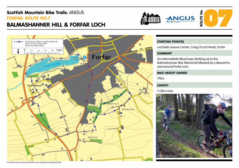
Scottish Mountain Bike Trails: ANGUSFoRFaR: RouTe no.7
BalMaShanneR hill & FoRFaR loCh 07Rou
Te n
o
STaRTinG PoinT(S)
SuMMaRY
MaX heiGhT GaineD
lenGTh
Lochside Leisure Centre, Craig O’Loch Road, Forfar
An intermediate (blue) loop climbing up to the Balmashanner War Memorial followed by a descent to and around Forfar Loch.
170m
11.5km max
Contains Ordnance Survey data © Crown copyright and database 2012
©www.covertdirt.co.uk
www.angusahead.com

Scottish Mountain Bike Trails: ANGUS 07Rou
Te n
o
BalMaShanneR hill &FoRFaR loCh
For more information on mountain biking in angus:
www.angusahead.com www.ambta.info www.DMBinS.com
Starting at The lochside leisure Centre car park, follow the Dundee loan Road (a926) turning left onto the Dundee Road (a932). Follow this for 1km and turn left at the footpath up the hill opposite Westfield loan. Pass the quarry on your left and at the top turn left and follow the main path up to the war memorial at the top of Balmashanner hill. Continue on this path until you reach the shelter where the path turns left downhill. keep your eyes out for the singletrack at this point which leads you down onto lour Road. at this point, turn right up the hill and take the next minor road on your right.
at the bend in the road, go through the gate and onto the track which goes behind the War Memorial. This takes you back to the top of the quarry. Turn left and follow the main footpath until it turns right steeply downhill. at this point take the path straight ahead through the wall and follow the path skirting the perimeter of the fields and finally down to the Dundee Road. Turn right, taking care crossing the road, and then turn immediately left onto the track. at the bridge which crosses the a92, turn right and follow the track adjacent to the motorway which descends down through a copse of trees and finally through a farm. at the roundabout for the a92 turn right, heading back to Forfar. Behind the angus Council offices at orchardbank, turn left onto the footpath. Follow this down to Forfar loch, turning left and making your way round the path and road back to your starting point.
RouTe DeSCRiPTion
CYCle FRienDlY BuSineSSeS NEAR THIS TRAIL
WM SaDDleR anD SonS
Baker and Tearoom 35 East High Street, Forfar, DD8 2EL Tel. 01307 463282
• Letotherpathusersknowyouarecomingasearlyaspossible.
• Pleasewatchyourspeedespeciallyonblindcornersanddips.
• Pleasetakeextracarenearwildlifeandleavetheenvironmentasyoufindit.
• Helplandmanagersandotherstoworksafelyandeffectively.See‘RouteSpecifics’.
• Theroutedescriptionandqualityofpathmaychangeovertimesopleaseremainflexiblewithyourplansandbereadytousealternativeroutes.CorrectattimeofprintMay2012.
• Checktheweatherforecastandensureyouhavealltheequipmentyouneedforyourroute.
• Ifyouareinanydoubtpleasepopintooneofourcyclecentresforadvice!
Route Specifics• Popularrouteforwalkers• Partofthisroutebordersagricultural
landandcroppedfields.Pleaserespectandobeyallsignsandinstructionsfromlandmanagers.
We love riding this route and to keep our good relationship with local landowners and other path users we ask you to follow the advice below:
DO THE RIDE THING
The ouTDooR SToRe
99 East High Street, Town Centre, Forfar DD8 2EQTel: 01307 465 471
neWTon FaRMhouSe
Bed & Breakfast or Self CateringInverarity, Forfar, DD8 2JUTel: 01307 820229
©www.covertdirt.co.uk
©www.covertdirt.co.uk
CYClinG CenTReS IN ANGUS
anGuS Bike ChainFixing and fettling bikes for over 20 years. Large stock of cycles, accessories, spares and clothing to cater for your cycling needs. Route advice.29 Commerce St, arbroath, DD11 1naTel. 01241 875510 www.angusbikechain.co.uk
CYCle WoRlDQuality bikes for sale, vast clothing & footwear department, extensive route advice, fine coffee and friendly banter. Millfield Feus, arbroath, DD11 2QJ Tel. 01241 876034 www.cycle-world.co.uk
www.ambta.info
Angus Mountain Bike Trails Association
CoveRT DiRTBike hire, guided trips, coaching & skills development and route advice. Cycling Scotland GO MTB Registered CentreTel: 01241 890722 www.covertdirt.co.uk
GlenTRekBike hire, guided trips, coaching & development100 east high Street, Forfar, angus DD8 2eT Tel: 01307 469536www.glentrek.com

©Dave Boffey
Scottish Mountain Bike Trails: ANGUSGlen Doll: RouTe no.8
Glen Doll, loCh MuiCk & The CaPel MounTh 08Rou
Te n
o
STaRTinG PoinT(S)
SuMMaRY
MaX heiGhT GaineD
lenGTh
Forestry Commission car park, Glen Doll
An epic, expert (black), true wilderness ride with testing climbs and an incredible descent to finish.
885m
24.5km max
Contains Ordnance Survey data © Crown copyright and database 2012
www.angusahead.com

Scottish Mountain Bike Trails: ANGUS 08Rou
Te n
o
Glen Doll, loCh MuiCk & The CaPel MounTh
For more information on mountain biking in angus:
www.angusahead.com www.ambta.info www.DMBinS.com
This is an exposed hillside route which should only be attempted by experienced Mountain Bikers. expect to carry your bike in some places.
From the Forestry Commission car park at Glen Doll, proceed out onto the road you came in on. after the bridge turn left through the gate and onto the land rover track. Stay on this track, passing through a gate, and pass round the ne side of Moulzie. keeping the river to your left, follow the footpath along the bank crossing at the footbridge. Follow the rough track up towards Bachnagairn where you will inevitably, at some point, have to carry the bike up to the footbridge.
From the footbridge, the climb becomes increasingly difficult before eventually leveling out. The main trail turns east and shortly after some sheds, an inviting piece of single track beckons. however continue on the main track for a fast descent down “The Streak of lightning” which finishes up on the shore of loch Muick. Continue ne along the side of the loch before turning right and starting the climb up the Capel Mounth. The track eventually levels off and continues to roll across the top of the hills for around 3km until the track peters out and the start of the single track descent begins. This eventually jettisons you out onto the track to Moulzie. Turn right as if going to do another loop but this time hang left onto a footpath, cross the bridge and then take the trail back on the opposite side of the river to the picnic benches and car park.
RouTe DeSCRiPTion
CYCle FRienDlY BuSineSSeS NEAR THIS TRAIL
• Letotherpathusersknowyouarecomingasearlyaspossible.
• Pleasewatchyourspeedespeciallyonblindcornersanddips.
• Pleasetakeextracarenearwildlifeandleavetheenvironmentasyoufindit.
• Helplandmanagersandotherstoworksafelyandeffectively.See‘RouteSpecifics’.
• Theroutedescriptionandqualityofpathmaychangeovertimesopleaseremainflexiblewithyourplansandbereadytousealternativeroutes.CorrectattimeofprintMay2012.
• Checktheweatherforecastandensureyouhavealltheequipmentyouneedforyourroute.
• Ifyouareinanydoubtpleasepopintooneofourcyclecentresforadvice!
Route Specifics• PleasechecktheForestryCommission
websiteforanyaccessissuesinthearea.• Popintotherangersstationatthecar
parkforadvice.• Parkingchargesapply.• ToavoiderosionoftheCapelMounth
pleaseavoidridingthispathinwetweather.
We love riding this route and to keep our good relationship with local landowners and other path users we ask you to follow the advice below:
DO THE RIDE THING
©www.covertdirt.co.uk
The Glen Clova hoTel, loDGeS, ReSTauRanT
Glen Clova, DD8 4QS Tel. 01575 550350www.clova.com
The BoThY - SelF CaTeRinG
Clach na Brain, Glen Clova, DD8 4QUTel: 01575 540330 www.clachie.com
CRePTo B&B
1 Kinnordy Place, Kirriemuir, DD8 4JWTel: 01575 572746
CYClinG CenTReS IN ANGUS
anGuS Bike ChainFixing and fettling bikes for over 20 years. Large stock of cycles, accessories, spares and clothing to cater for your cycling needs. Route advice.29 Commerce St, arbroath, DD11 1naTel. 01241 875510 www.angusbikechain.co.uk
CYCle WoRlDQuality bikes for sale, vast clothing & footwear department, extensive route advice, fine coffee and friendly banter. Millfield Feus, arbroath, DD11 2QJ Tel. 01241 876034 www.cycle-world.co.uk
www.ambta.info
Angus Mountain Bike Trails Association
CoveRT DiRTBike hire, guided trips, coaching & skills development and route advice. Cycling Scotland GO MTB Registered CentreTel: 01241 890722 www.covertdirt.co.uk
GlenTRekBike hire, guided trips, coaching & development100 east high Street, Forfar, angus DD8 2eT Tel: 01307 469536www.glentrek.com

©www.covertdirt.co.uk
Scottish Mountain Bike Trails: ANGUSkiRRieMuiR: RouTe no.9
CaDDaM WooDS & loCh oF kinnoRDY 09Rou
Te n
o
STaRTinG PoinT(S)
SuMMaRY
MaX heiGhT GaineD
lenGTh
Layby beside Caddam Woods on the B955
A mostly flat easy (green) circuit with the opportunity to explore further trails in Caddam Woods.
40m
8km max
Contains Ordnance Survey data © Crown copyright and database 2012
www.angusahead.com

Scottish Mountain Bike Trails: ANGUS 09Rou
Te n
o
CaDDaM WooDS & loCh oF kinnoRDY
For more information on mountain biking in angus:
www.angusahead.com www.ambta.info www.DMBinS.com
This is an easy (green) mostly flat route which has the option of a smaller loop which is suitable for younger children and balance bikes.
Starting at the layby at Caddam Woods, take the path sign posted Causewayend and proceed around the woods in an anti-clockwise direction (you have the option at this point of shortening the route by doing a full circuit of the woods). at the junction of the road at Causewayend, turn right continuing past the entrance to kinnordy Farm and turn left at the next road junction. Continue along this road until you meet with the footpath signed for kinnordy loch. The track down to the loch is quite steep so younger or more inexperienced riders might want to walk this part. at the bottom of the hill follow the trail left, watching out for the small rooty and boggy section close to the pond. This area can be quite boggy so in wet conditions we advise you to dismount and walk to avoid path erosion. Continuing on, ignore the footbridge on your right and follow the path until it meets with the road. Turn left and follow the road round back to the starting point and Caddam Woods.
RouTe DeSCRiPTionCYClinG CenTReS IN ANGUS
CYCle FRienDlY BuSineSSeS NEAR THIS TRAIL
• Letotherpathusersknowyouarecomingasearlyaspossible.
• Pleasewatchyourspeedespeciallyonblindcornersanddips.
• Pleasetakeextracarenearwildlifeandleavetheenvironmentasyoufindit.
• Helplandmanagersandotherstoworksafelyandeffectively.See‘RouteSpecifics’.
• Theroutedescriptionandqualityofpathmaychangeovertimesopleaseremainflexiblewithyourplansandbereadytousealternativeroutes.CorrectattimeofprintMay2012.
• Checktheweatherforecastandensureyouhavealltheequipmentyouneedforyourroute.
• Ifyouareinanydoubtpleasepopintooneofourcyclecentresforadvice!
Route Specifics• Thisisapopularlocalwalkingroute.
Pleasebecourteoustoallotherpathusers.
• Givepeopleplentyofwarningyouarecomingandbewaryofdogsofftheleash.
• WhilecyclingontheroadremembertocomplywithTheHighwayCode.
We love riding this route and to keep our good relationship with local landowners and other path users we ask you to follow the advice below:
DO THE RIDE THING
anGuS Bike ChainFixing and fettling bikes for over 20 years. Large stock of cycles, accessories, spares and clothing to cater for your cycling needs. Route advice.29 Commerce St, arbroath, DD11 1naTel. 01241 875510 www.angusbikechain.co.uk
CYCle WoRlDQuality bikes for sale, vast clothing & footwear department, extensive route advice, fine coffee and friendly banter. Millfield Feus, arbroath, DD11 2QJ Tel. 01241 876034 www.cycle-world.co.uk
CRePTo B&B1 Kinnordy Place, Kirriemuir, DD8 4JWTel: 01575 572746 www.ambta.info
Angus Mountain Bike Trails Association
©www.covertdirt.co.uk
©www.covertdirt.co.uk
WeaveR’S CoTTaGe SelF CaTeRinG
19 Henry Street, Kirriemuir, DD8 5DLTel: 01575 572085
PuRGavie FaRM B&BLintrathen, Kirriemuir, DD8 5HZTel: 01575 560213
CoveRT DiRTBike hire, guided trips, coaching & skills development and route advice. Cycling Scotland GO MTB Registered CentreTel: 01241 890722 www.covertdirt.co.uk
GlenTRekBike hire, guided trips,coaching & development100 east high Street, Forfar, angus DD8 2eT Tel: 01307 469536www.glentrek.com

©Glentrek
Scottish Mountain Bike Trails: ANGUSMonTRoSe: RouTe no.10
MonTRoSe, hillSiDe & noRThWaTeR BRiDGe 10Rou
Te n
o
STaRTinG PoinT(S)
SuMMaRY
MaX heiGhT GaineD
lenGTh
Broomfield BMX Track Car Park, Montrose
An easy (green) route using a new cycle track on an old railway line and sections of road. Includes the spectacular Northwater Bridge.
60m
14km max
Contains Ordnance Survey data © Crown copyright and database 2012
www.angusahead.com

Scottish Mountain Bike Trails: ANGUS 10Rou
Te n
o
MonTRoSe, hillSiDe & noRThWaTeR BRiDGe
For more information on mountain biking in angus:
www.angusahead.com www.ambta.info www.DMBinS.com
From Broomfield BMX track car park, cycle up Broomfield Road to the industrial estate. Follow cycle route under a92 Bridge through Borrowfield until barriers. Turn left onto newhame Road, passing school and then turn right and go under rail bridge via a metal walkway. Follow this farm road until Dubton Cottages and turn left along road. after around 500m turn uphill past West Mains of hedderwick to road junction at hillhead of hedderwick. Turn right onto main road then after 250m turn left into Rosemount estate. The estate has some new paths and some small downhill sections can be found. emerge out of the estate at grid 702613. From here head down into the hillside village. Cross the main a937 passing the hillside hotel and follow this road out past the old distillery. emerge on the a92 and turn left towards the northwater Road Bridge. Cross the bridge and then take a sharp right hand turn towards “St. Cyrus Beach”. The new Montrose cycle route then starts from here, crossing the spectacular north Water Rail Bridge. Continue along this new cycle route which is well defined and marked. This route follows the old Railway line before emerging at the aerodrome. Continue on this route to get back to the starting point.
RouTe DeSCRiPTionCYClinG CenTReS IN ANGUS
CYCle FRienDlY BuSineSSeS NEAR THIS TRAIL
• Letotherpathusersknowyouarecomingasearlyaspossible.
• Pleasewatchyourspeedespeciallyonblindcornersanddips.
• Pleasetakeextracarenearwildlifeandleavetheenvironmentasyoufindit.
• Helplandmanagersandotherstoworksafelyandeffectively.See‘RouteSpecifics’.
• Theroutedescriptionandqualityofpathmaychangeovertimesopleaseremainflexiblewithyourplansandbereadytousealternativeroutes.CorrectattimeofprintMay2012.
• Checktheweatherforecastandensureyouhavealltheequipmentyouneedforyourroute.
• Ifyouareinanydoubtpleasepopintooneofourcyclecentresforadvice!
Route Specifics• Thisisapopularlocalwalkingroute.
Pleasebecourteoustoallotherpathusers.
• Givepeopleplentyofwarningyouarecomingandbewaryofdogsofftheleash.
• WhilecyclingontheroadremembertocomplywithTheHighwayCode.
We love riding this route and to keep our good relationship with local landowners and other path users we ask you to follow the advice below:
DO THE RIDE THING
anGuS Bike ChainFixing and fettling bikes for over 20 years. Large stock of cycles, accessories, spares and clothing to cater for your cycling needs. Route advice.29 Commerce St, arbroath, DD11 1naTel. 01241 875510 www.angusbikechain.co.uk
CYCle WoRlDQuality bikes for sale, vast clothing & footwear department, extensive route advice, fine coffee and friendly banter. Millfield Feus, arbroath, DD11 2QJ Tel. 01241 876034 www.cycle-world.co.uk
The haven BeD & BReakFaST
8 Lower Hall Street, Montrose, DD10 8JW Tel: 01674 677741 www.thehaven-montrose.co.uk
www.ambta.info
Angus Mountain Bike Trails Association
©Glentrek
©Glentrek
PaRk hoTel
61 John Street, Montrose, DD10 8RJTel: 01674 663400 www.parkmontrose.com
oaklanDS GueST houSe
10 Rossie Island Road, Montrose, DD10 9NNTel: 01674 672018
CoveRT DiRTBike hire, guided trips, coaching & skills development and route advice. Cycling Scotland GO MTB Registered CentreTel: 01241 890722 www.covertdirt.co.uk
GlenTRekBike hire, guided trips, coaching & development100 east high Street, Forfar, angus DD8 2eT Tel: 01307 469536www.glentrek.com

© Sean Stone
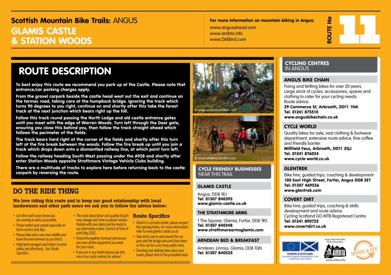
Scottish Mountain Bike Trails: ANGUSGlaMiS: RouTe no.11
GlaMiS CaSTle & STaTion WooDS 11Rou
Te n
o
STaRTinG PoinT(S)
SuMMaRY
MaX heiGhT GaineD
lenGTh
Glamis Castle, Glamis, DD8 1RJ
An intermediate (blue) route exploring the Glamis estate and surrounding woodland.
80m
6.3km max
Contains Ordnance Survey data © Crown copyright and database 2012
www.angusahead.com
Scottish Mountain Bike Trails: ANGUS 11Rou
Te n
o
GlaMiS CaSTle& STaTion WooDS
For more information on mountain biking in angus:
www.angusahead.com www.ambta.info www.DMBinS.com
To best enjoy this route we recommend you park up at the Castle. Please note that entrance/car parking charges apply.
From the gravel carpark beside the castle head west out the exit and continue on the tarmac road, taking care at the humpback bridge. ignoring the track which turns 90 degrees to you right, continue on and shortly after this take the forest track at the next junction which bears right up the hill.
Follow this track round passing the north lodge and old castle entrance gates until you meet with the edge of Warren Woods. Turn left through the Deer gate, ensuring you close this behind you, then follow the track straight ahead which follows the perimeter of the fields.
The track bears hard right at the corner of the fields and shortly after this turn left at the fire break between the woods. Follow the fire break up until you join a track which drops down onto a dismantled railway line, at which point turn left.
Follow the railway heading South West passing under the a928 and shortly after enter Station Woods opposite Strathmore vintage vehicle Clubs building.
There are a multitude of tracks to explore here before returning back to the castle carpark by reversing the route.
RouTe DeSCRiPTionCYClinG CenTReS IN ANGUS
CYCle FRienDlY BuSineSSeS NEAR THIS TRAIL
• Letotherpathusersknowyouarecomingasearlyaspossible.
• Pleasewatchyourspeedespeciallyonblindcornersanddips.
• Pleasetakeextracarenearwildlifeandleavetheenvironmentasyoufindit.
• Helplandmanagersandotherstoworksafelyandeffectively.See‘RouteSpecifics’.
• Theroutedescriptionandqualityofpathmaychangeovertimesopleaseremainflexiblewithyourplansandbereadytousealternativeroutes.CorrectattimeofprintMay2012..
• Checktheweatherforecastandensureyouhavealltheequipmentyouneedforyourroute.
• Ifyouareinanydoubtpleasepopintooneofourcyclecentresforadvice!
Route Specifics• Glamisisaprivateestate,pleaserespect
theopeningtimes.Formoreinformationrefertowww.glamis-castle.co.uk
• Takeextracareinandaroundthecarparkandthebridgeareaandslowdownasthiscanbeaverybusypublicarea.
• Shootingandstalkingtakesplaceyearround,pleasesticktothepromotedroute.
We love riding this route and to keep our good relationship with local landowners and other path users we ask you to follow the advice below:
DO THE RIDE THING
anGuS Bike ChainFixing and fettling bikes for over 20 years. Large stock of cycles, accessories, spares and clothing to cater for your cycling needs. Route advice.29 Commerce St, arbroath, DD11 1naTel. 01241 875510 www.angusbikechain.co.uk
CYCle WoRlDQuality bikes for sale, vast clothing & footwear department, extensive route advice, fine coffee and friendly banter. Millfield Feus, arbroath, DD11 2QJ Tel. 01241 876034 www.cycle-world.co.uk
aRnDean BeD & BReakFaST
Arndean, Linross, Glamis, DD8 1QNTel: 01307 840535
www.ambta.info
Angus Mountain Bike Trails Association
© www.andymccandlish.com
© www.andymccandlish.com
The STRaThMoRe aRMS
1 The Square, Glamis, Forfar, DD8 1RSTel: 01307 840248 www.strathmorearmsglamis.com
GlaMiS CaSTle
Angus, DD8 1RJTel: 01307 840393www.glamis-castle.co.uk
CoveRT DiRTBike hire, guided trips, coaching & skills development and route advice. Cycling Scotland GO MTB Registered CentreTel: 01241 890722 www.covertdirt.co.uk
GlenTRekBike hire, guided trips, coaching & development100 east high Street, Forfar, angus DD8 2eT Tel: 01307 469536www.glentrek.com
Top Related