


Languages
Pages
Legal


T: +61 8 9327 0300 E: [email protected] W: searcherseismic.com
Environment Plan Summary
Dunnart
2D Marine Seismic Survey

2
Document Status Version Purpose of Document Orig Review Review
Date Format Review
Release Approval
Issue Date
Draft A Draft for Internal Review AndLim (RPS) GreTer (RPS) 30.04.15
Rev 0 Final for Submission AndLim (RPS) GreTer (RPS) 05.05.15 SN (RPS) 06.05.15 P Miller 06.05.15
Rev 1 Final for Submission GreTer (RPS) TamAl-H (RPS) 15.05.15 SN (RPS) 19.05.15 P Miller

Contents
Acronyms and Abbreviations..................................................................................................................... 3
1.0 Introduction ..................................................................................................................................... 5
2.0 Location of the Activity ................................................................................................................... 6
3.0 Description of the Receiving Environment .................................................................................. 8
3.1 Physical Environment ................................................................................................................. 8
3.2 Marine Reserves, Parks and Protected Areas ......................................................................... 8
3.2.1 Commonwealth Marine Reserves ........................................................................................ 8
3.2.2 State Marine Protected Areas ............................................................................................... 8
3.3 Biological Environment .............................................................................................................. 9
3.4 Socio-economic Environment ................................................................................................. 10
3.4.1 Heritage ................................................................................................................................. 10
3.4.2 Commercial Fisheries ........................................................................................................... 10
3.4.3 Recreational Fishing and Tourism ...................................................................................... 11
3.4.4 Commercial Shipping ........................................................................................................... 11
3.4.5 Petroleum Exploration and Infrastructure........................................................................ 11
4.0 Description of the Activity ............................................................................................................ 12
4.1 Survey Vessel ............................................................................................................................. 12
4.2 Seismic Data Acquisition .......................................................................................................... 12
4.3 Timing of the Activity ................................................................................................................ 13
5.0 Environmental Impacts and Risks .............................................................................................. 14
6.0 Environmental Performance Outcomes, Standards and Measurement Criteria................. 19
6.1 Environmental Performance Outcomes ................................................................................ 19
6.2 Performance Standards ........................................................................................................... 19
6.3 Measurement Criteria .............................................................................................................. 20
7.0 Oil Pollution Emergency Response Arrangements .................................................................. 33
7.1 Level 1 Spill ................................................................................................................................ 33
7.2 Level 2 Spill ................................................................................................................................ 34
7.3 Prioritisation of Sensitivities in the Area of Interest ............................................................ 35
8.0 Stakeholder Consultation ............................................................................................................ 36
9.0 Contact Details .............................................................................................................................. 40
10.0 References ..................................................................................................................................... 41

2
Tables
Table 2-1: Coordinates of the Dunnart 2D Marine Seismic Survey Operational Area (GDA94) ..................................................................................................................... 6
Table 5-1: Risk Assessment Summary for Routine and Non-routine Operations .......... 15
Table 6-1: Summary of Environmental Performance Outcomes, Performance Standards and Measurement Criteria ................................................................ 21
Table 6-2: Summary of Parameters Monitored during the Dunnart 2D MSS EP ............ 31
Table 7-1: Level 1 Spill Notifications ..................................................................................... 34
Table 7-2: Level 2 Spill Notifications ..................................................................................... 34
Table 8-1: Relevant Stakeholders Consulted ....................................................................... 36
Table 8-2: Summary of Key Stakeholder Concerns and Issues ......................................... 37
Table 8-3: Activity Specific Notification Summary ............................................................... 39
Figures
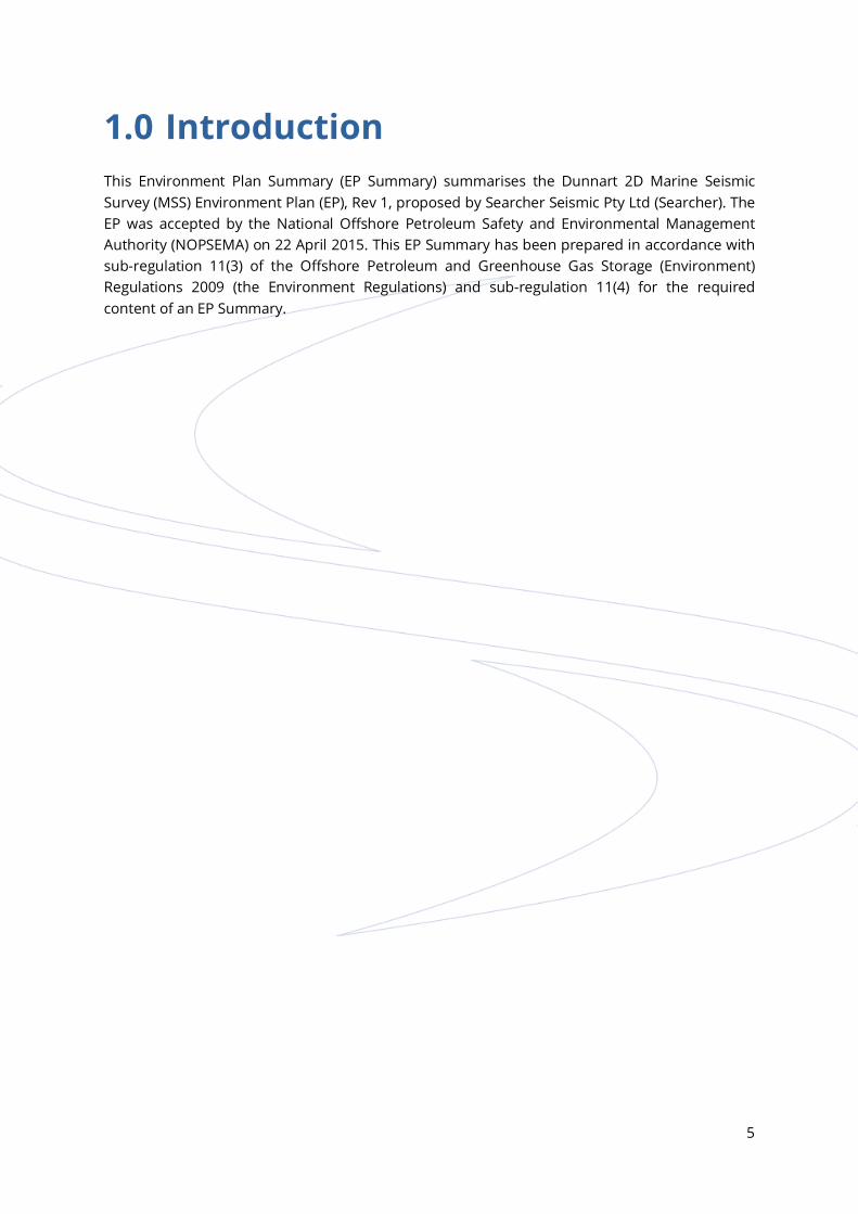
Figure 2-1: Location of the Dunnart 2D Marine Seismic Survey (MSS) ................................ 7
Figure 3-1: Tagged Pygmy Blue Whale Studies (Double et al. 2014) – 1: Number of Pygmy Blue Whales per 100 km2 Grid Square, 2: Measure of Occupancy per 100 km2 Grid Square (A: Indonesia; B: Ningaloo Reef; C: Perth Canyon/Naturaliste Plateau; D: Subtropical Frontal Zone) ............................. 10
3
Acronyms and Abbreviations Acronym or Abbreviation Description
AFMA Australian Fisheries Management Authority
AHO Australian Hydrographic Office (Service)
ALARP As Low As Reasonably Practicable
AMSA Australian Maritime Safety Authority
AQIS Australian Quarantine and Inspection Service
ARPA Automatic Radar Plotting Aid
BIA Biologically Important Area
BOD Biological Oxygen Demand
CET Core Emergency Team
CFA Commonwealth Fisheries Association
DoF Department of Fisheries
DotE Department of the Environment
EP Environment Plan
EPBC Act Environment Protection and Biodiversity Conservation Act 1999
FRC Fast Rescue Craft
GMP Garbage Management Plan
IAPP Certificate International Air Pollution Prevention Certificate
IMS Introduced Marine Species
IOPP Certificate International Oil Pollution Prevention Certificate
ISO International Organization for Standardization
ISPP Certificate International Sewage Pollution Prevention Certificate
MARPOL International Convention for the Prevention of Pollution from Ships
MFO Marine Fauna Observer
MGO Marine Gas Oil
MSDS Material Safety Data Sheet
MSS Marine Seismic Survey
NEBA Net Environmental Benefit Analysis
NOPSEMA National Offshore Petroleum Safety and Environmental Management Authority
NOPTA National Offshore Petroleum Titles Administrator
NOX Nitrogen oxides
NWMR North West Marine Region
OIW Oil in Water
POLREP Oil Pollution Reports
PPA Pearl Producers Association
PTS Permanent Threshold Shift
RCC AMSA Response Coordination Centre

4
Acronym or Abbreviation Description
RPS RPS Environment and Planning Pty Ltd
SEA Survey Environmental Advisor
Searcher Searcher Seismic Pty Ltd
SOLAS Safety of Life at Sea
SOPEP Shipboard Oil Pollution Emergency Plan
SOX Sulfur oxides
TTS Temporary threshold shift
WA Western Australia
WAFIC Western Australian Fishing Industry Council
5
1.0 Introduction This Environment Plan Summary (EP Summary) summarises the Dunnart 2D Marine Seismic Survey (MSS) Environment Plan (EP), Rev 1, proposed by Searcher Seismic Pty Ltd (Searcher). The EP was accepted by the National Offshore Petroleum Safety and Environmental Management Authority (NOPSEMA) on 22 April 2015. This EP Summary has been prepared in accordance with sub-regulation 11(3) of the Offshore Petroleum and Greenhouse Gas Storage (Environment) Regulations 2009 (the Environment Regulations) and sub-regulation 11(4) for the required content of an EP Summary.

6
2.0 Location of the Activity The Dunnart 2D MSS will take place across 11 permit areas within Commonwealth waters in the Carnarvon Basin and Dampier Sub-basin. The survey area referred to as the “operational area” is the physical area used for data acquisition, sail line run outs, soft start procedures, streamer deployment, maintenance and recovery and vessel manoeuvring. Note that:
seismic acquisition is planned to be restricted to the lines depicted on the map (Figure 2-1)
that the acoustic source will be powered down on turns
for turns of a duration longer than two hours the source will be shut down
the source will not be operated in the Montebello Marine Reserve.
There are no islands or emergent land within the operational area. At its nearest point, the operational area lies approximately 65 km north of Barrow Island and 150 km north-east of Karratha on the Western Australian coast. The operational area covers an area of 17,999 km2 and is located within waters depths between 20 m (over Rankin Bank) and 1,600 m. Seismic data will not be acquired over, or in close proximity, to Rankin Bank, with the seismic vessel to remain outside a 5 km buffer zone around Rankin Bank at all times when survey equipment is deployed. The operational area for the Dunnart 2D MSS is bounded by the coordinates provided in Table 2-1 and shown on Figure 2-1.
Table 2-1: Coordinates of the Dunnart 2D Marine Seismic Survey Operational Area (GDA94)
Point ID Latitude (Dd) Longitude (Dd) Latitude (DMS) Longitude (DMS)
A -19.080895 114.164906 19°4ʹ51.222"S 114°9ʹ53.662"E
B -19.080895 115.720201 19°4ʹ51.222"S 115°43ʹ12.724"E
C -20.076874 115.720201 20°4ʹ36.746"S 115°43ʹ12.724"E
D -20.076874 114.164906 20°4ʹ36.746"S 114°9ʹ53.662"E
Note: Dd = decimal degrees; DMS = decimal minutes and seconds.
"
"
"
"
"
"
"
"
"
"
"
"
"
"
"
"
"
"
"
"
"
"
"
W E S T E R N A U S T R A L I AW E S T E R N A U S T R A L I A
ONSLOW
DAMPIER
EXMOUTH
KARRATHA
RANKIN BANK
CAPE THOUIN
LONG ISLAND
GLOMAR SHOAL
CAPE PRESTON
PORT HEDLAND
AIRLIE ISLAND
BARROW ISLAND
NINGALOO COAST
MUIRON ISLANDS
DELAMBRE ISLANDROSEMARY ISLAND
NORTH WEST CAPE
LOWENDAL ISLANDS
SERRURIER ISLAND
THEVENARD ISLAND
BURRUP PENNINSULA
MONTEBELLO ISLANDS
DAMPIER ARCHIPELAGO
WA-472-P
WA-473-P
WA-467-P
WA-390-P
W 15-14
WA-36-L
WA-418-P
WA-500-P
WA-383-P
W 13-8
EP 491
WA-348-P
EP 490
WA-465-P
WA-374-P
WA-483-P
W 15-8
WA-387-P
WA-335-P
W 14-17
WA-499-P
WA-392-P
TP/8
WA-351-P
WA-437-P
WA-404-P
WA-390-P L
WA-347-P
WA-268-P
EP 483
W 13-16
W 14-10
WA-346-P
WA-474-P
WA-469-P
W 14-6
WA-37-L
WA-1-R
TL/1
WA-374-P LA WA-42-R
WA-461-P
WA-346-P
WA-433-P
WA-475-P
TP/7
WA-39-L
WA-40-L
WA-478-P
WA-268-P
WA-470-P
WA-468-P
TL/4
WA-476-P
W 14-7
W 15-9
WA-456-P
STP-EPA-121
WA-268-P
WA-452-P
WA-486-P
WA-455-P
W 14-12
WA-507-P
TP/27
W 13-15
WA-34-L
WA-497-P
WA-359-P
WA-430-P
WA-409-P
W 14-15
TL/2
WA-1-L
WA-3-L
WA-5-L
WA-24-R
WA-53-R
WA-346-P LT
W 14-14
WA-351-P
WA-271-P
WA-389-P
WA-463-P
WA-255-P
WA-49-L
WA-42-L
WA-25-L
WA-192-P
WA-2-L
TL/8
WA-3-L O
TL/5
WA-360-P
WA-271-P
WA-389-P
WA-271-P
WA-361-P
L 10
W 15-16
WA-10-L
WA-47-L
TL/6
TL/7
TL/2
WA-383-P LP
WA-33-R
WA-15-R
WA-22-R
TP/7
TP/7
TR/1
WA-4-L
WA-457-P
WA-191-P
WA-358-P
WA-7-R
WA-5-R
WA-320-P
W 14-9
W 14-13
W 13-17
W 14-22
WA-13-L
WA-28-LWA-32-L
WA-14-L
WA-17-L
WA-29-L
TR/6
WA-51-R
WA-268-P LYWA-346-P LS
WA-428-P
WA-214-P
WA-330-P
WA-356-P
WA-202-P
WA-360-P
WA-374-P
WA-412-P
WA-458-P
WA-448-P
WA-323-P
R 3
R 5
WA-54-L F W 15-6
EP 441
W 15-12
WA-51-R O
WA-1-P
WA-54-L FL
W 14-18
WA-11-L
WA-15-L
WA-46-L
WA-35-L
WA-48-L
WA-346-P LJ
WA-36-R
WA-38-R
WA-389-P
TP/8
TP/7
WA-387-P
TR/4
WA-255-P
WA-350-P
TL/10
WA-202-P LWA-383-P L
WA-374-P LE
STP-EPA-122
W 15-7
EP 424WA-155-P (1)
Esri, DeLorme, GEBCO, NOAA NGDC, and other contributors
Figure 2-1Location of the Dunnart 2D Marine Seismic Survey (MSS)0 25 50 75 10012.5
km
°Job Number : N1501201Doc Number: 022Date: 01.05.15
Created by: MRSource: Searcher 2014
LEGENDSeismic Survey LinesOperational Area3 NM State Waters Limit (Geoscience Australia, 2014)12 NM Territorial Sea Limit (Geoscience Australia, 2014)Offshore Permit Areas (GPInfo, December 2014)
38 Station Street, Subiaco | T +61 8 92111111 | F +61 8 92111122 |www.rpsgroup.com.au
Scale: 1:1,600,000 @ A3 GCS GDA 1994
"
"
"
"
"
"
"
"
""
"
"
"
"
"
W E S T E R N A U S T R A L I AW E S T E R N A U S T R A L I A
DERBY
NEWMAN
BROOME
DAMPIER
EXMOUTH
KARRATHA
CORAL BAY
SHARK BAYCARNARVON
ECO BEACH
RED BLUFF
BARROW ISLAND
NINGALOO COAST
EIGHTY MILE BEACH
OVERVIEW MAP

8
3.0 Description of the Receiving Environment
3.1 Physical Environment
The operational area is situated in the North West Marine Region (NWMR), which covers an area of tropical and sub-tropical waters from shallow continental shelf area (<200 m deep) to deep abyssal plains in excess of 5,000 m water depth.
3.2 Marine Reserves, Parks and Protected Areas
The following description of marine reserves, parks and protected areas can be seen in the context of the location of seismic acquisition:
seismic acquisition is planned to be restricted to the lines depicted on the map (Figure 2-1)
the acoustic source will be powered down on turns
for turns of a duration longer than two hours the source will be shut down
the source will not be operated in any marine protected area including the Montebello Marine Reserve.
3.2.1 Commonwealth Marine Reserves The NWMR includes 16 Commonwealth Marine Reserves, four of which are in the vicinity of the Dunnart 2D MSS operational area, including:
Ningaloo Marine Reserve Montebello Marine Reserve Dampier Marine Reserve Gascoyne Marine Reserve.
The closest of these reserves is the Montebello Marine Reserve, with the south-eastern corner of the operational area overlapping the northern section of the marine reserve. The Dampier Marine Reserve is 120 km from the operational area and is unlikely to be affected by the Dunnart 2D MSS.
3.2.2 State Marine Protected Areas There are three Western Australian state-protected marine areas in the region of the Dunnart 2D MSS and two proposed state management areas, including:
Barrow Island Marine Park and Marine Management Area Montebello Islands Marine Park Ningaloo Marine Park and Muiron Islands Marine Management Area proposed Dampier Archipelago Marine Park proposed Regnard Marine Management Area.

9
These protected areas are a significant distance from the Dunnart 2D MSS operational area with the closest (Montebello Islands Marine Park) lying 24 km to the south of the operational area.
There is to be no firing of airguns within marine reserves, parks or protected areas during the Dunnart 2D MSS.
3.3 Biological Environment
The NWMR is dominated by soft sediment habitats (sand and muddy substrata) with occasional patches of coarser (gravel, rubbles, cobbles, boulders and rocky outcrops) sediments. Benthic fauna is generally sparse and of low density and dominated by echinoderms, crustaceans, sponges, gorgonians, hydrozoans and soft corals. However, the NWMR also has significant areas of hard substrate along terraces of the middle and outer shelf that support dense, species-rich epifaunal assemblages that provide important habitat for demersal fishes (Wilson 2013).
The Environment Protection and Biodiversity Conservation Act 1999 (EPBC Act) Protected Matters Search of the Dunnart 2D MSS operational area indicates 56 listed marine species could occur within the operational area. Twelve species are considered threatened and 18 listed as migratory. Listed Marine/Threatened/Migratory species include:
two bird species 35 fish species (from two families – Syngnathidae and Solenostomidae) 20 reptile species (five turtles and 15 sea snake species) 20 six whales and other cetaceans five shark species and one ray.
The operational area overlaps portions of three biologically important areas (BIAs). These include inter-nesting areas for flatback turtles, migration routes for humpback and pygmy blue whales and breeding areas for wedge-tailed shearwaters. The Dunnart 2D MSS has been scheduled to occur outside of the flatback turtle nesting season, outside the northward migration period for humpback whales (July) and outside the expected breeding period of wedge-tailed shearwaters.
The Dunnart 2D MSS operational area lies outside the areas of high pygmy blue whale occupancy and in an area where low numbers were observed (from one to two individuals) (Double et al. 2014) (Figure 3-1). Therefore, although the timing of the survey is during the northward migration, it is unlikely that significant numbers of individuals will be encountered in the operational area during their transit between breeding and feeding grounds.

10
1 2
Figure 3-1: Tagged Pygmy Blue Whale Studies (Double et al. 2014) – 1: Number of Pygmy Blue Whales per 100 km2 Grid Square, 2: Measure of Occupancy per 100 km2 Grid Square (A: Indonesia; B: Ningaloo Reef; C: Perth Canyon/Naturaliste Plateau; D: Subtropical Frontal Zone)
3.4 Socio-economic Environment
3.4.1 Heritage There are no known cultural or Indigenous heritage values or issues for the waters and seabed within or immediately adjacent to, the Dunnart 2D MSS operational area.
There are no listed heritage sites within the Dunnart 2D MSS operational area. Similarly, there are no listed historic places within the vicinity of the operational area.
There are no historic shipwrecks listed on the Australian National Shipwrecks Database within the Dunnart 2D MSS operational area.
3.4.2 Commercial Fisheries There are five Commonwealth managed fisheries and eight state managed fisheries in the vicinity of the Dunnart 2D MSS operational area.
Commonwealth managed fisheries in the vicinity of the operational area include:
Western Tuna and Billfish Fishery North-west Slope Trawl Fishery Southern Bluefin Tuna Fishery Western Deepwater Trawl Fishery Western Skipjack Fishery.
State managed fisheries in the vicinity of the operational area include:

11
Beche-de-mer Fishery Onslow Prawn Managed Fishery Mackerel Managed Fishery Marine Aquarium Fish Managed Fishery Pearl Oyster Managed Fishery Pilbara Demersal Scalefish Fisheries Specimen Shell Managed Fishery West Coast Deep Sea Crustacean Managed Fishery.
3.4.3 Recreational Fishing and Tourism Recreational fishing and marine and nature-based tourism is popular in the NWMR, generally concentrated in nearshore coastal waters adjacent to population centres. Given the distance offshore of the Dunnart 2D MSS operational area recreational fishing and tourism activities are likely to be of very low intensity.
3.4.4 Commercial Shipping A search was undertaken of the AMSA Ship Reporting website (AMSA 2014) covering the period between April and May 2014. Consultation with this dataset indicates that the Dunnart 2D MSS may encounter medium to heavy shipping traffic of commercial vessels, especially near existing oil and gas infrastructure, throughout the duration of the survey. Access agreements will be agreed with oil and gas providers, tail buoys will be clearly marked, appropriate lighting, navigation and communication to be maintained at all times and compliance with the Navigation Act 2012, Marine Orders part 30 and SOLAS Convention. In addition, AMSA and the AHO RCC will be notified of survey details two weeks prior to mobilisation for promulgation of the Notice to Mariners.
3.4.5 Petroleum Exploration and Infrastructure The Dunnart 2D MSS will acquire seismic data in the permit area WA 500P and adjacent permits, with associated activities (i.e. soft starts, run-outs and turns) within a larger operational area which will run across adjacent blocks. There are no operating platforms within the Dunnart 2D MSS operational area.

12
4.0 Description of the Activity The scope of the EP covers 2D seismic data acquisition activities within the Dunnart 2D MSS operational area, which include a series of survey lines, vessel turns at the end of each survey line, streamer deployment, maintenance and recovery and vessel manoeuvring. The EP does not cover transit of the survey vessel to and from the operational area, or from port to the operational area.
4.1 Survey Vessel
The BGP Explorer is a specifically designed seismic vessel that has all the necessary certification/ registration and is fully compliant with all relevant requirements for a vessel of this size and purpose in accordance with MARPOL (1973/78), the International Convention for the Prevention of Pollution from Ships 1973 and Safety of Life at Sea (SOLAS).
The vessel has implemented and tested the Shipboard Oil Pollution Emergency Plan (SOPEP), in accordance with Regulation 37 of Annex 1 of MARPOL. The vessel carries a maximum number of 49 people.
The BGP Explorer proposes to use a Marine Gas Oil (MGO) fuel and does not utilise heavy fuel oil.
Helicopter transfers of crew and vessel refuelling at sea will not occur as the length of the survey is approximately five days. The deployment of a support vessel will not be undertaken for this survey. The survey vessel is equipped with a fast rescue craft (FRC).
4.2 Seismic Data Acquisition
The BGP Explorer will traverse a series of predetermined sail lines, at a pre-determined speed. There are eight seismic lines with a total length of 499 km. Average line length is 62.4 km. As the vessel travels along the survey lines, a series of acoustic pulses, generated by an airgun array, will be directed down through the water column and seabed.
At the end of each survey line, the vessel will turn with a sufficiently large arc to avoid letting the streamer sink to a depth where there is a risk of entanglement with seabed features. The seismic source will be powered down to the lowest power setting when not collecting data (i.e. on line turns) and will fire a single airgun for line turns of less than two hours duration. For longer line turns in excess of two hours, the source will be shut down and soft start procedures will be followed once the vessel reaches the next new line.
The seismic array will comprise a single streamer, with a maximum length of 8 km. The streamer will be towed at a depth of 15 m, and the seismic source (airgun) towed at a depth of 6 m (+/- 0.5 m). The airguns within the array will be fired with a shot point interval of 18.75 m.
The streamer will be solid core or gel-filled. The streamer will have tail buoys for visibility and location of each streamer end. The tail buoys will be fitted with turtle guards to prevent entanglement of large marine fauna between the tail buoy and the streamer. The streamer will also be fitted with a self-inflating buoy, which will return it to the surface if it sinks below a pre-determined water depth. The maximum acquisition speed will be between four and five knots.

13
4.3 Timing of the Activity
The Dunnart 2D MSS is scheduled to occur over five days between late April and the end of May 2015. The survey has been scheduled to minimise potential conflict with other users and sensitive marine fauna without compromising survey objectives. Should the timing of the survey be significantly altered by survey vessel availability, operational constraints, stakeholder inputs or prevailing weather conditions, then Searcher will provide stakeholders with additional information detailing the revised schedule.
14
5.0 Environmental Impacts and Risks An environmental risk assessment was undertaken to understand and manage the environmental risks associated with the Dunnart 2D MSS to a level that Searcher considered acceptable and ALARP. An evaluation of environmental impacts and risks in relation to the Dunnart 2D MSS was carried out in accordance with the methodology and principles described in the following standards and procedures:
International Organization for Standardization (ISO) 31000:2009 – Risk management – Principles and guidelines
Standards Australia AS 203:2012, Managing environment-related risk
Searcher Risk and Hazard Management Procedure HSE-PRO-01 (Searcher 2014).
The risk assessment summary is shown in Table 5-1.

15
Table 5-1: Risk Assessment Summary for Routine and Non-routine Operations
Risk Potential Impacts Inherent Risk Controls Residual Risk Likelihood Consequence Risk Likelihood Consequence Risk
Risks from Routine Operations Introduced marine species through biofouling or ballast water
Competition, predation or displacement of native species
Alteration of natural ecological processes
Introduction of pathogens with the potential to impact on human and/or ecological health
Reduction and/or competition with commercial fish and aquaculture species
Increased maintenance of vessels and marine infrastructure.
Possible Moderate Acceptable No planned ballast water exchanges, but if required ballast water exchange will not occur within 12 NM of land. Adherence the Australian Ballast Water Management Requirements (AQIS 2008): As a minimum, all vessels mobilised from outside of Australia must undertake ballast water exchange > 50 NM from
land and >200 m water depth Ballast water exchange records maintained.
Rare Minor Acceptable
No discharge of ballast water (unless in an emergency). Searcher will use freshwater ballast on board the BGP Explorer, which inhibits the survival of marine species. Adherence with National Biofouling Management Guidance for the Petroleum Production and Exploration Industry (Commonwealth of Australia 2009): Biofouling Record Book kept outlining marine fouling management actions Biofouling risk assessment shows low risk of IMS presence prior to entry into Australian waters Recent hull inspections have been undertaken – January and February 2015. The vessel hull/niches, internal sea water
systems and all submersible equipment were found to be free of IMS of concern. Vessel hull and niches were also thoroughly cleaned prior to antifouling coating applied.
Vessel has a certified recent (January 2015) anti-fouling coating on the hull and coating is in sound condition. Any biofouling observed during the survey that could be considered a potential IMS to be reported to AQIS and treated in accordance with AQIS instructions (e.g. killed with a biocide). Routine cleaning and inspection of all wet equipment (e.g. airgun array, streamer, workboats) as required during the activity, consistent with the requirements of the National Biofouling Management Guidance for the Petroleum Production and Exploration Industry (Commonwealth of Australia 2009).
Interference with other marine users
Temporary displacement of other users from the area of the operational area.
Possible Moderate Acceptable Vessel to maintain appropriate lighting, navigation and communication at all times to inform other users of the position and intentions of the survey vessel, in compliance with the Navigation Act 2012 and Chapter 5 of the International Convention for the Safety of Life at Sea (SOLAS) Convention.
Unlikely Minor Acceptable
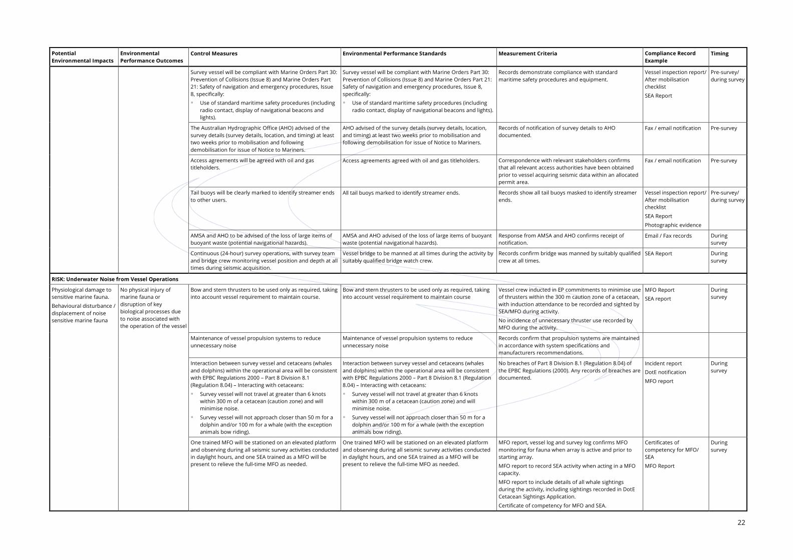
The AMSA RCC will be notified of the seismic vessel movements prior to mobilisation so that AMSA RCC ensures that navigation Auscoast warnings can be issued and kept up to date. A 1 km radius exclusion zone from the centre of Hess Australia’s mooring array will be applied and entered into the BGP Explorer’s navigation system as an obstruction or no-go zone. Survey vessel will be compliant with Marine Orders Part 30: Prevention of Collisions (Issue 8) and Marine Orders Part 21: Safety of navigation and emergency procedures (Issue 8) specifically: Use of standard maritime safety procedures (including radio contact, display of navigational beacons and lights). The Australian Hydrographic Office (AHO) advised of the survey details (survey location, timing) at least two weeks prior to mobilisation and following demobilisation for issue of Notice to Mariners. Access agreements will be agreed with oil and gas titleholders. Tail buoys will be clearly marked to identify streamer ends to other users. AMSA and AHO to be advised of the loss of large items of buoyant waste and lost equipment (potential navigational hazards). Continuous (24 hour) survey operations, with survey team and bridge crew monitoring vessel position and depth at all times during seismic acquisition
Underwater noise from vessel operations
Impacts to marine fauna, including: Physical injury to auditory
tissues or other air-filled organs Hearing loss; temporary
threshold shift (TTS) or permanent threshold shift (PTS)
Direct behavioural effects through disturbance or displacement and consequent disruption of natural behaviours or processes, e.g. migration, resting, calving
Indirect behavioural effects by impairing/masking the ability to navigate, find food or communicate or by affecting the distribution or abundance of prey species.
Possible Minor Acceptable Bow and stern thrusters to be used only as required, taking into account vessel requirement to maintain course. Unlikely Minor Acceptable Maintenance of vessel propulsion systems to reduce unnecessary noise. Interaction between survey vessel and cetaceans (whales and dolphins) within the operational area will be consistent with EPBC Regulations 2000 – Part 8 Division 8.1 (Regulation 8.04) – Interacting with cetaceans: Survey vessel will not travel at greater than 6 knots within 300 m of a cetacean (caution zone), and will minimise noise. Survey vessel will not approach closer than 50 m for a dolphin and/or 100 m for a whale (with the exception animals
bow riding). One trained MFO will be stationed on an elevated platform and observing during all seismic survey activities conducted in daylight hours, and one SEA trained as a MFO will be present to relieve the full-time MFO as needed. Compliance and cetacean sighting reports will be completed and provided to NOPSEMA / DotE.

16
Risk Potential Impacts Inherent Risk Controls Residual Risk Likelihood Consequence Risk Likelihood Consequence Risk
Underwater noise from operation of seismic source
Impacts to marine fauna, including: Physical injury to auditory
tissues or other air-filled organs Hearing loss; temporary
threshold shift (TTS) or permanent threshold shift (PTS)
Direct behavioural effects through disturbance or displacement and consequent disruption of natural behaviours or processes, e.g. migration, resting, calving
Indirect behavioural effects by impairing/masking the ability to navigate, find food or communicate or by affecting the distribution or abundance of prey species.
Possible Major Tolerable Smallest practicable seismic array size will be used, including minimising the number of sub-arrays. Unlikely Serious Acceptable Operating parameters of seismic source will be at the minimum required for data acquisition in the operational area. Seismic airgun array designed to direct sound energy downwards and reduce horizontal spreading; this will reduce horizontal sound propagation. Vessel operations will adhere to EPBC Policy Statement 2.1 and Part A management measures. The precaution zones for the survey will be as follows: observation zone: 3+ km horizontal radius from the acoustic source low power zone: 2 km horizontal radius from the acoustic source shut-down zone: 500 m horizontal radius from the acoustic source. Survey to be conducted in deep offshore Commonwealth waters away from important areas for marine fauna (nesting/ breeding, foraging, calving). One trained MFO will be stationed on an elevated platform and observing during all seismic survey activities conducted in daylight hours, and one SEA trained as a MFO will be present to relieve the full-time MFO as needed. Soft start procedures can only resume after the whale or whale shark has moved outside the low-power zone, or when 30 minutes have elapsed since the last sighting. If the whale or whale shark enters the “low power zone” (2 km) the source will be powered down to the lowest possible setting; and if it enters the “shut-down zone” (<500 m) the acoustic source will be shut down completely. At night or at other times of low-visibility, start-up of the seismic source will occur: providing that there have not been three or more whale / whale shark instigated power-down or shut-down situations
during the preceding 24 hour period if operations were not previously underway during the preceding 24 hours, the vessel has been in the vicinity
(approximately 10 km) of the proposed start-up position for at least two hours (under good visibility conditions) within the preceding 24 hour period and no whales / whale sharks have been sighted.
In the event that three shutdowns for whales occur within 24 hours and within the same general area (10 km radius), if operationally feasible, survey activities within that area will be suspended and the vessel relocated to an alternate area, where standard pre-start up observations will be conducted prior to recommencement of activities. Avoid concurrent seismic surveys by other operators, with time share operations implemented if required. Compliance and cetacean sighting reports will be completed and provided to the NOPSEMA / DotE. Vessel crew are inducted in their responsibilities as required regarding vessel / marine fauna interactions.
Sewage / grey water and putrescible wastes
Localised nutrient enrichment of surrounding waters in offshore open ocean waters
An increase in biological oxygen demand (bod)
Localised increases in turbidity of surrounding waters.
Possible Minor Acceptable Compliance with MARPOL 73/78 Annex IV (sewage) and Annex V (garbage), (as applied in Australia under Commonwealth Protection of the Sea (Prevention of Pollution from Ships) Act 1983)); and AMSA Marine Orders – Part 96: Marine Pollution Prevention – Sewage, as required by vessel class: all sewage, grey water and putrescible waste holding tanks are to be fully operational prior to survey commencement operational on-board sewage treatment plant approved by the International Maritime Organisation (IMO) a valid International Sewage Pollution Prevention Certificate (ISPP).
Unlikely Minor Acceptable
Survey vessel has a garbage management plan (GMP) compliant with the requirements of MARPOL 73/78 Annex V and Protection of the Sea (Prevention of Pollution from Ships) Act 1983. All sewage/grey water and putrescibles wastes generated during the activity will be stored on board the vessel in holding tanks and disposed of onshore by a licensed waste contractor. Biodegradable wash down detergents will be used. All putrescible wastes (e.g. galley waste) to be retained on board during the activity. Vessels will use an organic waste macerator or incinerator compliant with MARPOL Annex V. Induction of survey crew includes waste management and vessel GMP.
Deck drainage (including bilge water)
Potential localised and temporary acute toxic effects on marine biota
Possible Minor Acceptable Compliance with MARPOL 73/78 Annex I (as applied in Australia under Commonwealth Protection of the Sea (Prevention of Pollution from Ships) Act 1983)); and AMSA Marine Orders - Part 91 Marine Pollution Prevention – Oil): oil content of any discharged water to be <15 ppm bilge water contaminated with hydrocarbons must be contained and disposed of onshore, except if the oil content of
the effluent without dilution does not exceed 15 ppm or an IMO approved oil/water separator (as required by vessel class) is used to treat the bilge water.
Unlikely Minor Acceptable
The vessel must not be stationary when undertaking discharge and oil in water (OIW) separator shut off value must be maintained and operational. Deck drains in place with drain scuppers in place and scupper plugs available. Appropriate spill kits for the nature and volume of the chemicals on board will be made available on each vessel and will be located in the vicinity of oil / chemical stores and hydraulic deck equipment. All spills and leaks are recorded and investigated to prevent reoccurrence.

17
Risk Potential Impacts Inherent Risk Controls Residual Risk Likelihood Consequence Risk Likelihood Consequence Risk
Artificial light spill
Altered behaviour of light sensitive fauna.
Unlikely Minor Acceptable Vessel to maintain appropriate lighting at all times, in compliance with the Navigation Act 2012 and Chapter 5 of the SOLAS Convention.
Unlikely Minor Acceptable
External lights directed onto deck / work areas. Atmospheric emissions
Minor deterioration of local and regional air quality due to emission of pollutants such as NOX and SOX.
Rare Minor Acceptable Compliance with MARPOL 73/78 Annex VI as applied in Australia under Commonwealth Protection of the Sea (Prevention of Pollution from Ships) Act 1983 and Marine Order – Part 97 (Part IIID Marine Pollution Prevention – Air Pollution), where applicable to vessel class including: Regulation 6: Vessels will hold a valid International Air Pollution Prevention (IAPP) Certificate Regulation 13: Allowable NOx emission from diesel engines Regulation 14: The sulfur content of any fuel oil used on board ships shall not exceed 3.5% by mass.
Rare Minor Acceptable
Use of MGO grade fuel. All engines to be well maintained in accordance with manufacturers’ specifications
Risks from Non-routine Operations Seabed disturbance (loss of equipment / dropped objects overboard)
Displacement of the activities by commercial fishers to avoid lost equipment
Collision / entanglement of vessels with loss equipment.
Possible Minor Acceptable Operational procedures will be in place on board the seismic vessel for deployment and retrieval of towed equipment. Rare Minor Acceptable Streamer cleaned when bio-fouling presents a significant risk to streamer integrity. Redundant propulsion to be available during the survey so the vessel and all in-sea equipment positions are known at all times. Any lost equipment will be recovered where safe and practicable to do so. Redundant tow point on streamer to retain streamer in the event of primary attachment failure. Buoys (including GPS transponder, lights) and automatic recovery devices attached to streamer to bring the equipment to the surface if lost accidentally. Vessel to be operated by suitably qualified and experienced crew. Encounters with marine archaeological resources/wrecks are recorded and reported to the WA Maritime Museum in accordance with the Historic Shipwrecks Act 1976.
Oily wastes / chemical spills
Temporary localised decline in water quality in the immediate vicinity of the discharge
Temporary toxicity to marine flora and fauna.
Rare Minor Acceptable Compliance with MARPOL 73/78 Annex I (as applied in Australia under Commonwealth Protection of the Sea (Prevention of Pollution from Ships) Act 1983 and AMSA Marine Orders - Part 91 Marine Pollution Prevention – Oil): current SOPEP in place survey vessels hold a valid IOPP Certificate, where required, under vessel class.
Rare Minor Acceptable
Solid or gel filled (no fluid filled) streamer to be used. Oil content of any discharged water to be <15 ppm in accordance with MARPOL 73/78 Annex I and the Protection of the Sea (Prevention of Pollution from Ships) Act 1983 –Section 9. Any hydrocarbon storage above deck must have at least one barrier (i.e. form of bunding) to contain and prevent deck spills entering the marine environment. This can include containment lips on deck (primary bunding) and/or secondary containment measures (bunding, containment pallet, transport packs, absorbent pad barriers) in place. Equipment located on deck utilising hydrocarbons (e.g. cranes, winches or other hydraulic equipment) will have as a minimum primary bunding (i.e. deck edge lips or up-stands) to prevent loss of hydrocarbons to the marine environment. Deck drains in place with drain scuppers in place and scupper plugs available. Spills from fixed equipment, such as engines and generators, are enclosed and spills captured via bilges that drain via the OIW separator. Minor oil/lubricant spills will be mopped up immediately with absorbent materials that will be disposed of onshore as hazardous waste in accordance with the vessel SOPEP. Vessel crew are inducted in their responsibilities under the SOPEP. Spill response bins/kits available on board to clean up small spills (<80 L) and are maintained and located in close proximity to hydrocarbon storage areas and deck areas for use to contain and recover deck spills.
Loss of solid hazardous and non-hazardous wastes
Potential injury to fauna if disposed overboard (e.g. ingestion of plastics or entanglement). Potential navigational hazard and/ or damage to other marine users. Potential localised reduction in water quality in the immediate vicinity
Rare Minor Acceptable Compliance with MARPOL 73/78 Annex V as applied in Australia Protection of the Sea (Prevention of Pollution from Ships) Act 1983 (Part IIIB, Division 2, Section 26D). MARPOL Regulation 10.2: Vessel WMP (or equivalent e.g. GMP) must contain as a minimum: Waste handling equipment, waste storage containers, and spill response equipment appropriate to the type and
volume of waste will be provided at waste storage areas. All hazardous wastes will be segregated prior to onshore disposal. Regulation 10.3: Vessels >400 tonnes (or certified for >15 persons on board) will have a Garbage Record Book.
Rare Minor Acceptable
All non-hazardous and hazardous solid wastes generated offshore are to be returned to shore for disposal by a licensed waste management contractor. Any accidental release of significant wastes to the marine environment will be recovered where safe and practicable to do so. AMSA and AHO to be advised of the loss of large items of buoyant waste (potential navigational hazards). Induction of survey crew includes waste management and vessel GMP. Good housekeeping practices for waste storage/ handling in accordance with vessel GMP. Hazardous wastes materials will be handled and stored in accordance with the corresponding MSDS.

18
Risk Potential Impacts Inherent Risk Controls Residual Risk Likelihood Consequence Risk Likelihood Consequence Risk
Vessel collision / equipment entanglement with marine fauna
Injury to marine fauna
Death of marine fauna.
Possible Moderate Acceptable Interaction between survey vessel and cetaceans (whales and dolphins) within the operational area will be consistent with EPBC Regulations 2000 – Part 8 Division 8.1 (Regulation 8.04) – Interacting with cetaceans:
Survey vessel will not travel at greater than 6 knots within 300 m of a cetacean (caution zone), and will minimise noise.
Survey vessel will not approach closer than 50 m for a dolphin and/or 100 m for a whale (with the exception animals bow riding).
Unlikely Moderate Acceptable
Soft start procedures will be conducted prior to acquisition commencing. This will encourage noise sensitive marine fauna to move away from the vessel, reducing the likelihood of collision or entanglement.
MFO to maintain watch for marine fauna any time the seismic source is active, with observed fauna to be avoided if possible. The SEA will also be trained as a MFO and can assist in marine fauna observations as required.
Guards to be fitted to streamer tail buoys to reduce the likelihood of turtle entanglement.
Slow speed of vessel during seismic acquisition (4 to 5 knots).
Redundant tow point on streamer to retain streamer in the event of primary attachment failure.
Buoys (including GPS transponder, lights) and automatic recovery devices attached to streamer to facilitate recovery in the event of loss.
Continuous (24 hour) survey operations, with survey team and bridge crew monitoring vessel position and depth at all times during seismic acquisition.
Vessel crew are inducted in their responsibilities as required regarding vessel / marine fauna interactions.
All entangled marine fauna recovered to the vessel will be returned to the sea as quickly as practicable.
Oil spill Acute toxicity to marine and intertidal biota from toxic (typically volatile, low molecular weight hydrocarbons such as aromatics) resulting in injury or death
Chronic toxicity to marine and intertidal biota from persistent hydrocarbon fractions
Physical disturbance (e.g. smothering, blocking of gills) to marine and intertidal biota resulting in injury or death
Displacement of other users (e.g. commercial fishing) due to spill or spill response activities
Indirect impacts from spill response.
Rare Major Tolerable Compliance with MARPOL 73/78 Annex I (as applied in Australia under Commonwealth Protection of the Sea (Prevention of Pollution from Ships) Act 1983)); and AMSA Marine Orders - Part 91 Marine Pollution Prevention – Oil):
current SOPEP in place
survey vessels hold a valid IOPP Certificate, where required, under vessel class.
Rare Serious Acceptable
The vessel will have the ability to implement the vessel SOPEP and OPEP immediately in the event of a spill. The SOPEP and OPEP will be available to relevant crew members in the event of an oil spill.
Survey vessel will be compliant with Marine Orders Part 30: Prevention of Collisions (Issue 8) and Marine Orders Part 21: Safety of navigation and emergency procedures, Issue 8, specifically:
use of standard maritime safety procedures (including radio contact, display of navigational beacons and lights).
The AHO advised of the survey details (survey details, location, and timing) at least two weeks prior to mobilisation and following demobilisation for issue of Notice to Mariners.
The AMSA RCC is notified of the seismic vessel movements prior to mobilisation so that AMSA RCC ensures that navigation Auscoast warnings can be issued and kept up to date.
Responsibilities of survey crew to the OPEP and SOPEP is included as part of the project induction.
No refuelling during the activity.
All fuel tanks can be isolated and contents transferred between them.
Seismic survey activities to be undertaken only during suitable weather conditions as defined in the adverse weather procedures.
Vessel to maintain appropriate lighting, navigation and communication at all times to inform other users of the position and intentions of the survey vessel, in compliance with the Navigation Act 2012 and Chapter 5 of the SOLAS Convention.
Equipment located on deck utilising hydrocarbons (e.g. cranes, winches or other hydraulic equipment) will be maintained to reduce risk of loss of hydrocarbon containment to the marine environment.
Searcher will use light MGO to fuel the vessel engines in place of heavier oil to reduce the environmental risk
Continuous (24 hour) survey operations, with survey team and bridge crew monitoring vessel position and depth at all times during seismic acquisition.
Three Automatic Radar Plotting Aid (APRA) radars on board with collision alarm and maintained in good working order.
Searcher will ensure adequate forms of financial assurance in place to meet the cost of spill response and rehabilitation.
Undertake NEBA of spill response strategies in conjunction with AMSA (if required).
Safe storage and disposal of clean up materials.

19
6.0 Environmental Performance Outcomes, Standards and Measurement Criteria
Regulation 4 of the OPGGS(E) Regulations provides definitions for the following:
Environmental performance relates to the performance of a titleholder in relation to the environmental performance outcomes and standards mentioned in an EP.
Environmental performance outcome is a measurable level of performance required for the management of environmental aspects of an activity to ensure that environmental impacts and risks will be of an acceptable level.
Environmental performance standard is a statement of the performance required of a control measure.
Searcher’s overall environmental performance outcome for the Dunnart 2D MSS is to identify and assess environmental risks and implement control measures to reduce all risks to ALARP. Specific environmental performance outcomes, standards and measurement criteria for each aspect of the activity that has the potential to cause adverse environmental impact are detailed in Table 6-1. Environmental performance will be measured and reported against these standards and measurement criteria as part of Searcher’s commitment to continuous improvement of environmental, health and safety performance.
Searcher will maintain a Compliance Register for the Dunnart 2D MSS, which will serve as an audit tool for activities to evaluate compliance with the survey EP’s environmental performance standards and measurement criteria. The register will be sufficiently detailed to allow the Regulator (NOPSEMA) to determine whether an environmental performance standard is being met, including documenting non-conformances and corrective actions.
6.1 Environmental Performance Outcomes
The environmental performance outcomes for each of the identified risks assessed are presented in Table 6-1.
6.2 Performance Standards
The Dunnart 2D MSS will be conducted in accordance with industry best practice, in compliance with relevant national and international guidelines and survey specific standards as described in Table 6-1.

20
6.3 Measurement Criteria
The measurement criteria relevant to each aspect of the activity are summarised in Table 6-1. The Compliance Register will document all measurement criteria for each of the performance standards specified within the EP (Table 6-1). The register will also document the form of compliance (e.g. survey reports, vessel inspection reports), the responsible person(s) and frequency of recording compliance.

21
Table 6-1: Summary of Environmental Performance Outcomes, Performance Standards and Measurement Criteria
Potential Environmental Impacts
Environmental Performance Outcomes
Control Measures Environmental Performance Standards Measurement Criteria Compliance Record Example
Timing
Routine Operations
RISK: Introduced Marine Species through Biofouling or Ballast Water
Loss of biological diversity, competition/ predation or displacement of native species due to introduced marine species (IMS)
Minimise the risk of introducing or spreading exotic marine organisms
Adherence the Australian Ballast Water Management Requirements (AQIS 2008):
As a minimum, all vessels mobilised from outside of Australia must undertake ballast water exchange >50 NM from land and >200 m water depth
Ballast water exchange records maintained.
No discharge of ballast water unless in an emergency
Searcher will use freshwater ballast on board the BGP Explorer, which inhibits the survival of marine species.
Vessels mobilised from outside of Australia must undertake ballast water exchange >50 NM from land and >200 m water depth.
Vessel inspection report details place of mobilisation of vessel and last location of operation prior to the survey.
Ballast water exchange records show no ballast water exchange.
Vessel inspection report
Ballast Water Record Book/Summary
SEA Report
Pre-survey/ during survey
No planned ballast water exchanges, but if required ballast water exchange will not occur within 12 NM of land.
No recorded occurrence of a ballast water exchange during the survey (with the exception of an exchange to maintain the stability of the vessel in an emergency).
Vessel Log
Ballast water exchange records
SEA Report
During survey
Adherence with National Biofouling Management Guidance for the Petroleum Production and Exploration Industry (Commonwealth of Australia 2009):
Biofouling Record Book kept outlining marine fouling management actions
Biofouling risk assessment shows low risk of IMS presence prior to entry into Australian waters
Recent hull inspections have been undertaken – January and February 2015. The vessel hull/niches, internal sea water systems and all submersible equipment were found to be free of IMS of concern. Vessel hull and niches were also thoroughly cleaned prior to antifouling coating applied.
Adherence with National Biofouling Management Guidance for the Petroleum Production and Exploration Industry (Commonwealth of Australia 2009):
Biofouling Record Book kept outlining marine fouling management actions
Biofouling risk assessment shows low risk of IMS presence prior to entry into Australian waters
Recent hull inspection prior to mobilisation (if required).
Vessel inspection report confirms compliance with National Biofouling Management Guidance for the Petroleum Production and Exploration Industry (Commonwealth of Australia 2009), including:
sighting Biofouling Record Book and confirms it is current
sighting risk assessment and confirms low risk
confirms hull free of IMS.
evidence / records show submersible equipment inspected and found free of biofouling prior to commencing the activity
Vessel inspection report and biofouling risk assessment
Biofouling Record Book
Photographic evidence
SEA Report
Pre-survey/ during survey
Vessel has a certified recent (January 2015) anti-fouling coating on the hull and coating is in sound condition.
Hull anti-fouling coating to be current and in sound condition.
Vessel to have current anti-fouling coating certificate from recognised third party.
Anti-fouling coating certificate
Pre-survey
Any biofouling observed during the survey that could be considered a potential IMS to be reported to AQIS and treated in accordance with AQIS instructions (e.g. killed with a biocide).
If any biofouling is observed during the survey that could be considered a potential IMS, this is reported to AQIS for treatment advice, which must be implemented.
Records show any biofouling is observed during the survey that could be considered a potential IMS is reported to AQIS.
Fax / email notification
SEA Report
Biofouling Record Book
During survey
Routine cleaning and inspection of all wet equipment (e.g. airgun array, streamer, workboats) as required during the activity, consistent with the requirements of the National Biofouling Management Guidance for the Petroleum Production and Exploration Industry (Commonwealth of Australia 2009).
All in-field equipment when retrieved to the seismic survey vessel will be inspected regularly and cleaned if deemed necessary to remove biofouling.
Records and evidence of routine cleaning and inspection of all wet equipment.
SEA Report
Photographic evidence
During survey
RISK: Interference with Other Marine Users
Interference with or displacement of commercial fishing / shipping / recreational / industry activities
No significant interruption or disturbance to another user of the marine environment
Vessel to maintain appropriate lighting, navigation and communication at all times to inform other users of the position and intentions of the survey vessel, in compliance with the Navigation Act 2012 and Chapter 5 of the International Convention for the Safety of Life at Sea (SOLAS) Convention.
Vessel to maintain appropriate lighting, navigation and communication at all times to inform other users of the position and intentions of the survey vessel, in compliance with the Navigation Act 2012 and Chapter 5 of the SOLAS Convention.
No records of failure to comply with requirements for appropriate navigation, lighting and communication during survey, in accordance with the Navigation Act 2012 and Chapter 5 of the SOLAS Convention.
Any records of failure to comply are documented.
SEA Report
Photo evidence
During survey
The AMSA RCC will be notified of the seismic vessel movements prior to mobilisation so that AMSA RCC ensures that navigation Auscoast warnings can be issued and kept up to date.
AMSA RCC is notified of the seismic vessel movements prior to mobilisation.
Records of notification to AMSA RCC of the survey vessel movements.
Fax / email notification Pre-survey
A 1 km radius exclusion zone from the centre of Hess Australia’s mooring array will be applied and entered into the BGP Explorer’s navigation system as an obstruction or no-go zone.
A 1 km radius exclusion zone from the centre of Hess Australia’s mooring array will be applied and entered into the BGP Explorer’s navigation system as an obstruction or no-go zone.
Record of exclusion zone provided by Searcher to the BGP Explorer.
Record of exclusion zone implemented by the BGP Explorer’s during the survey.
Fax / email notification
SEA Report
Pre-survey During survey
22
Potential Environmental Impacts
Environmental Performance Outcomes
Control Measures Environmental Performance Standards Measurement Criteria Compliance Record Example
Timing
Survey vessel will be compliant with Marine Orders Part 30: Prevention of Collisions (Issue 8) and Marine Orders Part 21: Safety of navigation and emergency procedures, Issue 8, specifically:
Use of standard maritime safety procedures (including radio contact, display of navigational beacons and lights).
Records demonstrate compliance with standard maritime safety procedures and equipment.
Vessel inspection report/ After mobilisation checklist
SEA Report
Pre-survey/ during survey
The Australian Hydrographic Office (AHO) advised of the survey details (survey details, location, and timing) at least two weeks prior to mobilisation and following demobilisation for issue of Notice to Mariners.
AHO advised of the survey details (survey details, location, and timing) at least two weeks prior to mobilisation and following demobilisation for issue of Notice to Mariners.
Records of notification of survey details to AHO documented.
Fax / email notification Pre-survey
Access agreements will be agreed with oil and gas titleholders.
Access agreements agreed with oil and gas titleholders. Correspondence with relevant stakeholders confirms that all relevant access authorities have been obtained prior to vessel acquiring seismic data within an allocated permit area.
Fax / email notification Pre-survey
Tail buoys will be clearly marked to identify streamer ends to other users.
All tail buoys marked to identify streamer ends. Records show all tail buoys masked to identify streamer ends.
Vessel inspection report/ After mobilisation checklist
SEA Report
Photographic evidence
Pre-survey/ during survey
AMSA and AHO to be advised of the loss of large items of buoyant waste (potential navigational hazards).
AMSA and AHO advised of the loss of large items of buoyant waste (potential navigational hazards).
Response from AMSA and AHO confirms receipt of notification.
Email / Fax records During survey
Continuous (24-hour) survey operations, with survey team and bridge crew monitoring vessel position and depth at all times during seismic acquisition.
Vessel bridge to be manned at all times during the activity by suitably qualified bridge watch crew.
Records confirm bridge was manned by suitably qualified crew at all times.
SEA Report During survey
RISK: Underwater Noise from Vessel Operations
Physiological damage to sensitive marine fauna.
Behavioural disturbance / displacement of noise sensitive marine fauna
No physical injury of marine fauna or disruption of key biological processes due to noise associated with the operation of the vessel
Bow and stern thrusters to be used only as required, taking into account vessel requirement to maintain course.
Bow and stern thrusters to be used only as required, taking into account vessel requirement to maintain course
Vessel crew inducted in EP commitments to minimise use of thrusters within the 300 m caution zone of a cetacean, with induction attendance to be recorded and sighted by SEA/MFO during activity.
No incidence of unnecessary thruster use recorded by MFO during the activity.
MFO Report
SEA report
During survey
Maintenance of vessel propulsion systems to reduce unnecessary noise
Maintenance of vessel propulsion systems to reduce unnecessary noise
Records confirm that propulsion systems are maintained in accordance with system specifications and manufacturers recommendations.
Interaction between survey vessel and cetaceans (whales and dolphins) within the operational area will be consistent with EPBC Regulations 2000 – Part 8 Division 8.1 (Regulation 8.04) – Interacting with cetaceans:
Survey vessel will not travel at greater than 6 knots within 300 m of a cetacean (caution zone) and will minimise noise.
Survey vessel will not approach closer than 50 m for a dolphin and/or 100 m for a whale (with the exception animals bow riding).
No breaches of Part 8 Division 8.1 (Regulation 8.04) of the EPBC Regulations (2000). Any records of breaches are documented.
Incident report
DotE notification
MFO report
During survey
One trained MFO will be stationed on an elevated platform and observing during all seismic survey activities conducted in daylight hours, and one SEA trained as a MFO will be present to relieve the full-time MFO as needed.
One trained MFO will be stationed on an elevated platform and observing during all seismic survey activities conducted in daylight hours, and one SEA trained as a MFO will be present to relieve the full-time MFO as needed.
MFO report, vessel log and survey log confirms MFO monitoring for fauna when array is active and prior to starting array.
MFO report to record SEA activity when acting in a MFO capacity.
MFO report to include details of all whale sightings during the activity, including sightings recorded in DotE Cetacean Sightings Application.
Certificate of competency for MFO and SEA.
Certificates of competency for MFO/ SEA
MFO Report
During survey

23
Potential Environmental Impacts
Environmental Performance Outcomes
Control Measures Environmental Performance Standards Measurement Criteria Compliance Record Example
Timing
RISK: Underwater Noise from Operation of Seismic Source
Physiological damage to sensitive marine fauna.
Behavioural disturbance / displacement of noise sensitive marine fauna
No physical injury of marine receptors or disruption of key biological processes due to noise associated with the operation of the seismic source
Operating parameters of the seismic source, including array size and number of sub-arrays will be the minimum required for data acquisition in the operational area.
Operating parameters of the seismic source, including array size and number of sub-arrays will be the minimum required for data acquisition in the operational area.
The seismic source operating parameters and minimum airgun array size/number required is determined by modelling the energy level required to image the subsurface geology at the geological target depth adequately and comparing with a range of available array volumes to meet the minimum requirements best.
Source modelling Survey planning
Seismic airgun array designed to direct sound energy downwards and reduce horizontal spreading; this will reduce sound propagation into neighbouring areas.
Array configuration designed to reduce horizontal spreading Modelling of airgun signature and array configuration demonstrates directivity of seismic source in the vertical.
Source modelling Survey planning
Vessel operations will adhere to EPBC Policy Statement 2.1 and Part A management measures. The precaution zones for the survey will be as follows:
observation zone: 3+ km horizontal radius from the acoustic source
low power zone: 2 km horizontal radius from the acoustic source
shut-down zone: 500 m horizontal radius from the acoustic source.
Vessel operations will adhere to EPBC Policy Statement 2.1 and precaution zones as follows:
observation zone – 3 km
low power zone – 2 km
shut-down zone – 500 m.
MFO report confirms application of correct precaution zones.
MFO Report
SEA Report
During survey
Survey to be conducted in deep offshore Commonwealth waters away from important areas for marine fauna (nesting/breeding, foraging, calving).
Survey to be conducted in deep offshore Commonwealth waters away from important areas for marine fauna (nesting/breeding, foraging, calving).
MFO / SEA reports confirm survey conducted away from important areas for marine fauna (nesting/breeding, foraging, and calving).
MFO Report
SEA Report
During survey
One trained MFO will be stationed on an elevated platform and observing during all seismic survey activities conducted in daylight hours, and one SEA trained as a MFO will be present to relieve the full-time MFO as needed.
One trained MFO will be stationed on an elevated platform and observing during all seismic survey activities conducted in daylight hours, and one SEA trained as a MFO will be present to relieve the full-time MFO as needed.
MFO report confirms MFO monitoring for fauna when array is active and prior to starting array. MFO report to record SEA activity when acting in a MFO capacity.
MFO report to include appendix detailing all whale sightings during the activity, including sightings recorded in DotE Cetacean Sightings Application.
Certificate of competency for MFO and SEA.
MFO Report
SEA Report
During survey
If the whale or whale shark enters the “low power zone” (2 km) the source will be powered down to the lowest possible setting; and if it enters the “shut-down zone” (<500 m) the acoustic source will be shut down completely.
If the whale or whale shark enters the “low power zone” (2 km) the source will be powered down to the lowest possible setting; and if it enters the ‘shut-down zone” (<500 m) the acoustic source will be shut down completely.
MFO report confirms suitably trained MFO on board and observing for fauna during seismic acquisition.
MFO Report
SEA Report
During survey
Soft start procedures can only resume after the whale or whale shark has moved outside the low-power zone, or when 30 minutes has elapsed since the last sighting.
Soft start procedures can only resume after the whale or whale shark has moved outside the low power zone, or when 30 minutes have elapsed since the last sighting.
MFO report confirms that, in the event of a whale (or whale shark) being sighted within the “low-power zone” the seismic energy source was powered down (or shut down entirely) if the whale or whale shark was observed within the ‘shut-down zone”.
MFO Report
SEA Report
During survey
At night or at other times of low-visibility, start-up of the seismic source will occur:
providing that there have not been three or more whale /whale shark instigated power-down or shut-down situations during the preceding 24 hour period
if operations were not previously underway during the preceding 24 hours, the vessel has been in the vicinity (approximately 10 km) of the proposed start-up position for at least two hours (under good visibility conditions) within the preceding 24-hour period, and no whales / whale sharks have been sighted.
At night or at other times of low-visibility, start-up of the seismic source will occur:
providing that there have not been three or more whale/ whale shark instigated power-down or shut-down situations during the preceding 24 hour period
if operations were not previously underway during the preceding 24 hours, the vessel has been in the vicinity (approximately 10 km) of the proposed start-up position for at least two hours (under good visibility conditions) within the preceding 24-hour period, and no whales / whale sharks have been sighted.
MFO report confirms power down when not collecting data or undertaking soft start procedures.
MFO Report
SEA Report
During survey
In the event that three shutdowns for whales occur within 24 hours and within the same general area (10 km radius), if operationally feasible, survey activities within that area will be suspended and the vessel relocated to an alternate area, where standard pre-start up observations will be conducted prior to recommencement of activities.
In the event that three shutdowns for whales occur within 24 hours and within the same general area (10 km radius), if operationally feasible, survey activities within that area will be suspended and the vessel relocated to an alternate area, where standard pre-start up observations will be conducted prior to recommencement of activities.
MFO report and vessel log confirms that, in the event of three whale-instigated shutdowns within 24 hours within a 10 km radius, the survey activities have been suspended (if operationally feasible) within that area and moved to a survey location away from whales.
MFO Report
SEA Report
During survey

24
Potential Environmental Impacts
Environmental Performance Outcomes
Control Measures Environmental Performance Standards Measurement Criteria Compliance Record Example
Timing
Avoid concurrent seismic surveys by other operators, with time share operations implemented if required.
In the event of concurrent seismic surveys in proximity to the operational area, time-sharing arrangements implemented as required.
Records detail communications and arrangements for time sharing (if required).
SEA Report
Consultation records
Pre-survey/ during survey
Compliance and cetacean sighting reports will be completed and provided to the NOPSEMA / DotE.
MFO report and cetacean sighting records to be completed and provided to NOPSEMA / DotE.
Activity close-out report to contain a copy of the MFO report.
Inspection of correspondence with DotE to confirm MFO report and sightings records have been provided following completion of the activity.
MFO Report
SEA Report
Activity close-out report
Fax/emails with DotE
Pre-survey/ during survey
Vessel crew are inducted in their responsibilities as required regarding vessel / marine fauna interactions.
Vessel crew are inducted in their responsibilities as required regarding vessel / marine fauna interactions.
Records show that the project induction includes responsibilities of survey crew regarding marine fauna interactions.
SEA Report
Induction record
Pre-survey/ during survey
RISK: Sewage / Grey Water and Putrescible Wastes
Adverse effects on marine biota due to localised nutrient enrichment
No discharge of untreated grey water / sewage within 12 NM of nearest land
No discharge of treated grey water / sewage within 3 NM of nearest land.
No disposal of macerated food wastes within 3 NM of nearest land
No disposal of unmacerated food wastes within 12 NM of nearest land.
Compliance with MARPOL 73/78 Annex IV (sewage) and Annex V (garbage), (as applied in Australia under Commonwealth Protection of the Sea (Prevention of Pollution from Ships) Act 1983) and AMSA Marine Orders – Part 96: Marine Pollution Prevention – Sewage, as required by vessel class:
all sewage, grey water and putrescible waste holding tanks are to be fully operational prior to survey commencement.
operational on-board sewage treatment plant approved by the International Maritime Organization (IMO).
a valid International Sewage Pollution Prevention Certificate (ISPP).
Compliance with MARPOL 73/78 (as applied in Australia under Commonwealth Protection of the Sea (Prevention of Pollution from Ships) Act 1983) and AMSA Marine Orders – Part 96: Marine Pollution Prevention – Sewage, as required by vessel class:
all sewage, grey water and putrescible waste holding tanks are to be fully operational prior to survey commencement.
operational on-board sewage treatment plant approved by the International Maritime Organization (IMO).
a valid International Sewage Pollution Prevention Certificate (ISPP).
Records demonstrate that the survey vessel sewage, grey water and putrescible waste holding tanks are fully operational prior to survey.
Maintenance records demonstrate regular maintenance undertaken of on board STP.
Vessel inspection report
Photographic evidence
SEA Report
Pre-survey/ during survey
Records demonstrate the survey vessel has an IMO approved sewage treatment plant on board.
Vessel inspection report Pre-survey
Records demonstrate the survey vessel holds a valid ISPP certificate, as required by vessel class.
ISPP Certificate Pre-survey
Records of any non-compliance with MARPOL are documented; and corrective actions identified and undertaken.
Incident reports During survey
Survey vessel has a garbage management plan (GMP) (or equivalent e.g. waste management plan (WMP)), compliant with the requirements of MARPOL 73/78 Annex V, and Protection of the Sea (Prevention of Pollution from Ships) Act 1983.
Survey vessel has a GMP, compliant with the requirements of MARPOL 73/78 Annex V, and Protection of the Sea (Prevention of Pollution from Ships) Act 1983.
Records demonstrate the survey vessel has a GMP compliant with MARPOL.
Vessel GMP Pre-survey
All sewage / grey water and putrescible wastes generated during the activity will be stored on board the vessel in holding tanks and disposed of onshore by a licensed waste contractor.
All sewage / grey water and putrescible wastes generated during the activity will be stored on board the vessel in holding tanks and disposed of onshore by a licensed waste contractor.
Records demonstrate no discharge of sewage / grey water and putrescible wastes during the survey and disposed of onshore by a licensed waste contractor.
Records of any non-compliance with MARPOL are documented; and corrective actions identified and undertaken.
SEA Report
Waste manifest / records
During survey
Biodegradable wash down detergents will be used. Biodegradable detergents to be used. Vessel inspection confirms that detergents on board are biodegradable and stores log shows biodegradable products selected.
SEA Report
After inspection checklist
Photographic evidence
During survey
Vessels will use an organic waste macerator or incinerator compliant with MARPOL Annex V.
Vessels will use an organic waste macerator or incinerator compliant with MARPOL Annex V.
Records show food scraps macerated in an organic waste macerator or incinerator compliant with MARPOL Annex V.
Incident reports
SEA Report
During survey
Induction of survey crew includes waste management and vessel GMP.
All survey crew are inducted in waste management procedures and GMP.
Vessel induction confirms that survey crew are inducted in waste management procedures and GMP.
SEA Report
Induction record
Pre-survey/ during survey
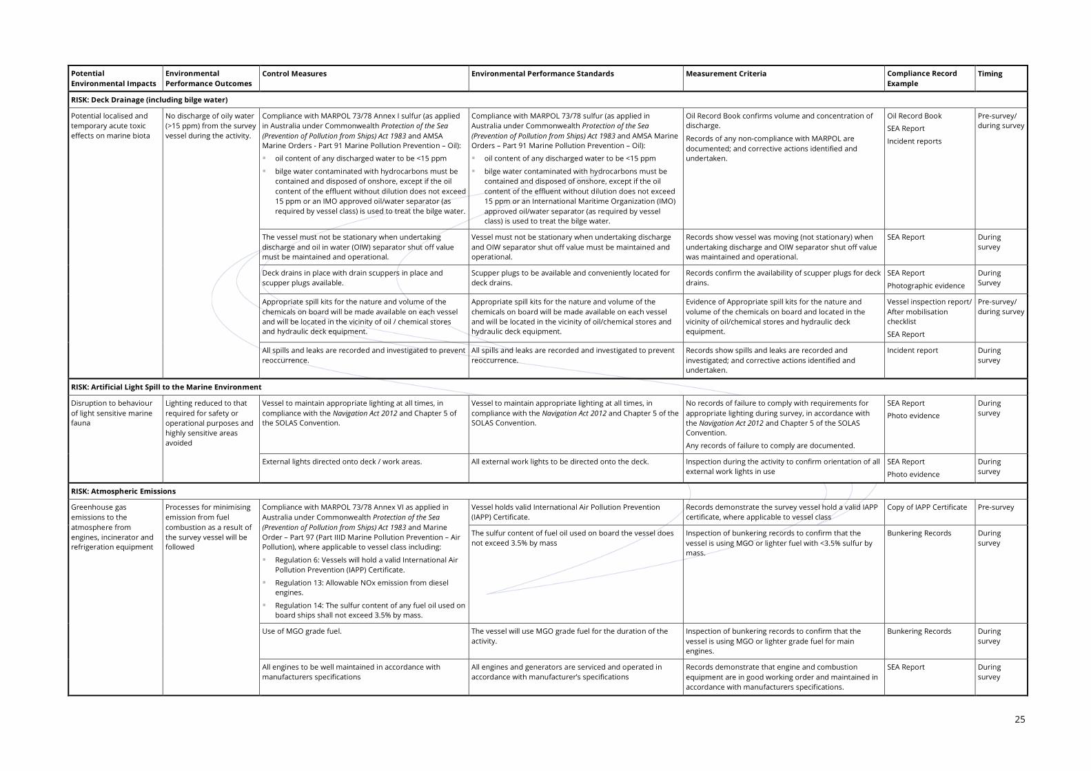
25
Potential Environmental Impacts
Environmental Performance Outcomes
Control Measures Environmental Performance Standards Measurement Criteria Compliance Record Example
Timing
RISK: Deck Drainage (including bilge water)
Potential localised and temporary acute toxic effects on marine biota
No discharge of oily water (>15 ppm) from the survey vessel during the activity.
Compliance with MARPOL 73/78 Annex I sulfur (as applied in Australia under Commonwealth Protection of the Sea (Prevention of Pollution from Ships) Act 1983 and AMSA Marine Orders - Part 91 Marine Pollution Prevention – Oil):
oil content of any discharged water to be <15 ppm
bilge water contaminated with hydrocarbons must be contained and disposed of onshore, except if the oil content of the effluent without dilution does not exceed 15 ppm or an IMO approved oil/water separator (as required by vessel class) is used to treat the bilge water.
Compliance with MARPOL 73/78 sulfur (as applied in Australia under Commonwealth Protection of the Sea (Prevention of Pollution from Ships) Act 1983 and AMSA Marine Orders – Part 91 Marine Pollution Prevention – Oil):
oil content of any discharged water to be <15 ppm
bilge water contaminated with hydrocarbons must be contained and disposed of onshore, except if the oil content of the effluent without dilution does not exceed 15 ppm or an International Maritime Organization (IMO) approved oil/water separator (as required by vessel class) is used to treat the bilge water.
Oil Record Book confirms volume and concentration of discharge.
Records of any non-compliance with MARPOL are documented; and corrective actions identified and undertaken.
Oil Record Book
SEA Report
Incident reports
Pre-survey/ during survey
The vessel must not be stationary when undertaking discharge and oil in water (OIW) separator shut off value must be maintained and operational.
Vessel must not be stationary when undertaking discharge and OIW separator shut off value must be maintained and operational.
Records show vessel was moving (not stationary) when undertaking discharge and OIW separator shut off value was maintained and operational.
SEA Report During survey
Deck drains in place with drain scuppers in place and scupper plugs available.
Scupper plugs to be available and conveniently located for deck drains.
Records confirm the availability of scupper plugs for deck drains.
SEA Report
Photographic evidence
During Survey
Appropriate spill kits for the nature and volume of the chemicals on board will be made available on each vessel and will be located in the vicinity of oil / chemical stores and hydraulic deck equipment.
Appropriate spill kits for the nature and volume of the chemicals on board will be made available on each vessel and will be located in the vicinity of oil/chemical stores and hydraulic deck equipment.
Evidence of Appropriate spill kits for the nature and volume of the chemicals on board and located in the vicinity of oil/chemical stores and hydraulic deck equipment.
Vessel inspection report/ After mobilisation checklist
SEA Report
Pre-survey/ during survey
All spills and leaks are recorded and investigated to prevent reoccurrence.
All spills and leaks are recorded and investigated to prevent reoccurrence.
Records show spills and leaks are recorded and investigated; and corrective actions identified and undertaken.
Incident report During survey
RISK: Artificial Light Spill to the Marine Environment
Disruption to behaviour of light sensitive marine fauna
Lighting reduced to that required for safety or operational purposes and highly sensitive areas avoided
Vessel to maintain appropriate lighting at all times, in compliance with the Navigation Act 2012 and Chapter 5 of the SOLAS Convention.
Vessel to maintain appropriate lighting at all times, in compliance with the Navigation Act 2012 and Chapter 5 of the SOLAS Convention.
No records of failure to comply with requirements for appropriate lighting during survey, in accordance with the Navigation Act 2012 and Chapter 5 of the SOLAS Convention.
Any records of failure to comply are documented.
SEA Report
Photo evidence
During survey
External lights directed onto deck / work areas. All external work lights to be directed onto the deck. Inspection during the activity to confirm orientation of all external work lights in use
SEA Report
Photo evidence
During survey
RISK: Atmospheric Emissions
Greenhouse gas emissions to the atmosphere from engines, incinerator and refrigeration equipment
Processes for minimising emission from fuel combustion as a result of the survey vessel will be followed
Compliance with MARPOL 73/78 Annex VI as applied in Australia under Commonwealth Protection of the Sea (Prevention of Pollution from Ships) Act 1983 and Marine Order – Part 97 (Part IIID Marine Pollution Prevention – Air Pollution), where applicable to vessel class including:
Regulation 6: Vessels will hold a valid International Air Pollution Prevention (IAPP) Certificate.
Regulation 13: Allowable NOx emission from diesel engines.
Regulation 14: The sulfur content of any fuel oil used on board ships shall not exceed 3.5% by mass.
Vessel holds valid International Air Pollution Prevention (IAPP) Certificate.
Records demonstrate the survey vessel hold a valid IAPP certificate, where applicable to vessel class
Copy of IAPP Certificate Pre-survey
The sulfur content of fuel oil used on board the vessel does not exceed 3.5% by mass
Inspection of bunkering records to confirm that the vessel is using MGO or lighter fuel with <3.5% sulfur by mass.
Bunkering Records During survey
Use of MGO grade fuel. The vessel will use MGO grade fuel for the duration of the activity.
Inspection of bunkering records to confirm that the vessel is using MGO or lighter grade fuel for main engines.
Bunkering Records During survey
All engines to be well maintained in accordance with manufacturers specifications
All engines and generators are serviced and operated in accordance with manufacturer’s specifications
Records demonstrate that engine and combustion equipment are in good working order and maintained in accordance with manufacturers specifications.
SEA Report During survey
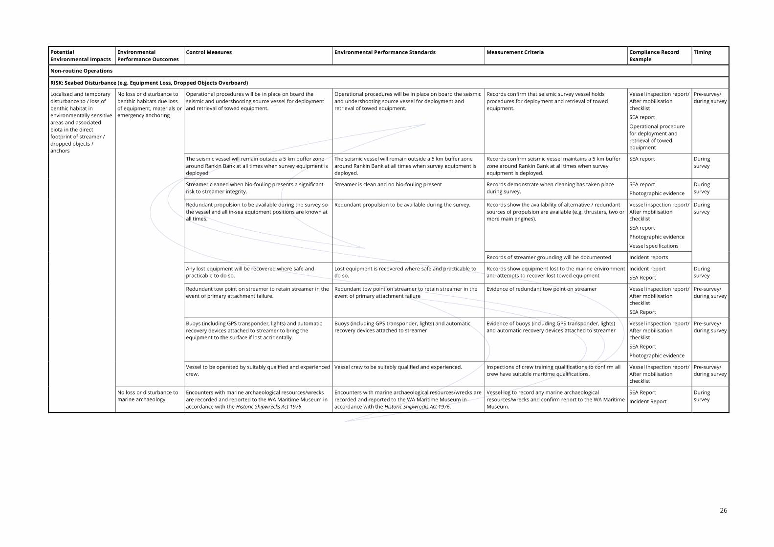
26
Potential Environmental Impacts
Environmental Performance Outcomes
Control Measures Environmental Performance Standards Measurement Criteria Compliance Record Example
Timing
Non-routine Operations
RISK: Seabed Disturbance (e.g. Equipment Loss, Dropped Objects Overboard)
Localised and temporary disturbance to / loss of benthic habitat in environmentally sensitive areas and associated biota in the direct footprint of streamer / dropped objects / anchors
No loss or disturbance to benthic habitats due loss of equipment, materials or emergency anchoring
Operational procedures will be in place on board the seismic and undershooting source vessel for deployment and retrieval of towed equipment.
Operational procedures will be in place on board the seismic and undershooting source vessel for deployment and retrieval of towed equipment.
Records confirm that seismic survey vessel holds procedures for deployment and retrieval of towed equipment.
Vessel inspection report/ After mobilisation checklist
SEA report
Operational procedure for deployment and retrieval of towed equipment
Pre-survey/ during survey
The seismic vessel will remain outside a 5 km buffer zone around Rankin Bank at all times when survey equipment is deployed.
The seismic vessel will remain outside a 5 km buffer zone around Rankin Bank at all times when survey equipment is deployed.
Records confirm seismic vessel maintains a 5 km buffer zone around Rankin Bank at all times when survey equipment is deployed.
SEA report During survey
Streamer cleaned when bio-fouling presents a significant risk to streamer integrity.
Streamer is clean and no bio-fouling present Records demonstrate when cleaning has taken place during survey.
SEA report
Photographic evidence
During survey
Redundant propulsion to be available during the survey so the vessel and all in-sea equipment positions are known at all times.
Redundant propulsion to be available during the survey. Records show the availability of alternative / redundant sources of propulsion are available (e.g. thrusters, two or more main engines).
Vessel inspection report/ After mobilisation checklist
SEA report
Photographic evidence
Vessel specifications
During survey
Records of streamer grounding will be documented Incident reports
Any lost equipment will be recovered where safe and practicable to do so.
Lost equipment is recovered where safe and practicable to do so.
Records show equipment lost to the marine environment and attempts to recover lost towed equipment
Incident report
SEA Report
During survey
Redundant tow point on streamer to retain streamer in the event of primary attachment failure.
Redundant tow point on streamer to retain streamer in the event of primary attachment failure
Evidence of redundant tow point on streamer Vessel inspection report/ After mobilisation checklist
SEA Report
Pre-survey/ during survey
Buoys (including GPS transponder, lights) and automatic recovery devices attached to streamer to bring the equipment to the surface if lost accidentally.
Buoys (including GPS transponder, lights) and automatic recovery devices attached to streamer
Evidence of buoys (including GPS transponder, lights) and automatic recovery devices attached to streamer
Vessel inspection report/ After mobilisation checklist
SEA Report
Photographic evidence
Pre-survey/ during survey
Vessel to be operated by suitably qualified and experienced crew.
Vessel crew to be suitably qualified and experienced. Inspections of crew training qualifications to confirm all crew have suitable maritime qualifications.
Vessel inspection report/ After mobilisation checklist
Pre-survey/ during survey
No loss or disturbance to marine archaeology
Encounters with marine archaeological resources/wrecks are recorded and reported to the WA Maritime Museum in accordance with the Historic Shipwrecks Act 1976.
Encounters with marine archaeological resources/wrecks are recorded and reported to the WA Maritime Museum in accordance with the Historic Shipwrecks Act 1976.
Vessel log to record any marine archaeological resources/wrecks and confirm report to the WA Maritime Museum.
SEA Report
Incident Report
During survey

27
Potential Environmental Impacts
Environmental Performance Outcomes
Control Measures Environmental Performance Standards Measurement Criteria Compliance Record Example
Timing
RISK: Oily Wastes / Chemical Spills
Potential localised and temporary acute toxic effects on the marine flora and fauna
No loss of chemicals or discharge of oily wastes (>15 ppm) to the marine environment
Compliance with MARPOL 73/78 Annex I sulfur (as applied in Australia under Commonwealth Protection of the Sea (Prevention of Pollution from Ships) Act 1983 and AMSA Marine Orders – Part 91 Marine Pollution Prevention – Oil):
current SOPEP in place.
survey vessels hold a valid IOPP Certificate, where required, under vessel class.
Compliance with MARPOL 73/78 Annex I and the Protection of the Sea (Prevention of Pollution from Ships) Act 1983) and AMSA Marine Orders – Part 91 Marine Pollution Prevention – Oil:
current SOPEP in place.
survey vessels hold a valid IOPP Certificate, where required, under vessel class.
Records demonstrate the SOPEP is in place on the vessel SOPEP Pre-survey/ during survey
Records demonstrate the survey vessel hold an IOPP certificate, if required under vessel class
IOPP certificate Pre-survey
Records demonstrate that SOPEP drills have taken place SOPEP drill records During survey
Solid or gel filled (no fluid filled) streamer to be used Solid or gel filled streamer to be used for every survey; no streamer fluid on board
Vessel inspection confirms that streamer to be used are solid state or gel filled streamer
Vessel inspection report/ After mobilisation checklist
SEA Report
Pre-survey
Oil content of any discharged water to be <15 ppm in accordance with MARPOL 73/78 Annex I and the Protection of the Sea (Prevention of Pollution from Ships) Act 1983 – Section 9.
Oil content of any discharged water to be is <15 ppm in accordance with MARPOL 73/78 Annex I and the Protection of the Sea (Prevention of Pollution from Ships) Act 1983 – Section 9 and is recorded in the Oil Record Book (or similar)
Oil Record Book confirms volume and concentration of discharge.
Oil Record Book
SEA Report
Pre-survey/ during survey
Any hydrocarbon storage above deck must have at least one barrier (i.e. form of bunding) to contain and prevent deck spills entering the marine environment. This can include containment lips on deck (primary bunding) and/or secondary containment measures (bunding, containment pallet, transport packs, absorbent pad barriers) in place.
Any hydrocarbon storage above deck must have at least one barrier (i.e. form of bunding) to contain and prevent deck spills entering the marine environment.
Records / evidence demonstrate that hydrocarbon storage is designed and maintained to prevent and contain deck spills entering the marine environment.
Vessel inspection report/ After mobilisation checklist
SEA Report
Photographic evidence
Pre-survey/ during survey
Equipment located on deck utilising hydrocarbons (e.g. cranes, winches or other hydraulic equipment) will have as a minimum primary bunding (i.e. deck edge lips or up-stands) to prevent loss of hydrocarbons to the marine environment.
Equipment located on deck utilising hydrocarbons (e.g. cranes, winches or other hydraulic equipment) will have as a minimum primary bunding (i.e. deck edge lips or up-stands)
Records demonstrate that equipment located on deck utilising hydrocarbons has as a minimum primary bunding
Vessel inspection report/ After mobilisation checklist
SEA Report
Photographic evidence
Pre-survey/ during survey
Deck drains in place with drain scuppers in place and scupper plugs available.
Scupper plugs to be available and conveniently located for deck drains.
Records confirm the availability of scupper plugs for deck drains.
SEA Report
Photographic evidence
During survey
Spills from fixed equipment, such as engines and generators, are enclosed and spills captured via bilges that drain via the OIW separator.
All oily water from machinery spaces to be collected in bilge and treated prior to discharge.
Records confirm oily water from machinery spaces collects in bilges and is treated with OIW separator prior to discharge.
SEA Report During survey
Vessel crew are inducted in their responsibilities under the SOPEP.
Vessel crew are inducted in their responsibilities under the SOPEP.
Records show that the project induction includes responsibilities of survey crew under the SOPEP
SEA Report
Induction record
Pre-survey/ during survey
Spill response bins/kits available on board to clean up small spills (<80 L) and are maintained and located in close proximity to hydrocarbon storage areas and deck areas for use to contain and recover deck spills.
Spill response bins/kits available on board to clean up small spills (<80 L) and are maintained and located in close proximity to hydrocarbon storage areas and deck areas
Records demonstrate that spill response bins/kits are appropriately located and stocked
Vessel inspection report/ After mobilisation checklist
SEA Report
Photographic evidence
Pre-survey/ during survey
Minor oil/lubricant spills will be mopped up immediately with absorbent materials that will be disposed of onshore as hazardous waste in accordance with the vessel SOPEP.
Minor oil/lubricant spills will be mopped up immediately with absorbent materials that will be disposed of onshore as hazardous waste in accordance with the vessel SOPEP.
Records show that response measures for minor oil/lubricant spills were carried out in accordance with the SOPEP, and contaminated clean-up wastes stored on board prior to onshore disposal at a licensed waste management facility.
SEA Report
Incident reports
During survey
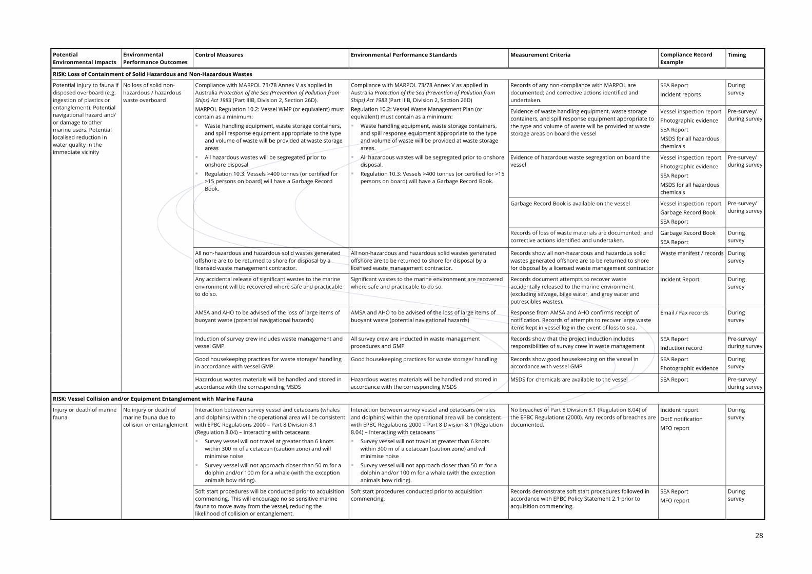
28
Potential Environmental Impacts
Environmental Performance Outcomes
Control Measures Environmental Performance Standards Measurement Criteria Compliance Record Example
Timing
RISK: Loss of Containment of Solid Hazardous and Non-Hazardous Wastes
Potential injury to fauna if disposed overboard (e.g. ingestion of plastics or entanglement). Potential navigational hazard and/ or damage to other marine users. Potential localised reduction in water quality in the immediate vicinity
No loss of solid non-hazardous / hazardous waste overboard
Compliance with MARPOL 73/78 Annex V as applied in Australia Protection of the Sea (Prevention of Pollution from Ships) Act 1983 (Part IIIB, Division 2, Section 26D).
MARPOL Regulation 10.2: Vessel WMP (or equivalent) must contain as a minimum:
Waste handling equipment, waste storage containers, and spill response equipment appropriate to the type and volume of waste will be provided at waste storage areas
All hazardous wastes will be segregated prior to onshore disposal
Regulation 10.3: Vessels >400 tonnes (or certified for >15 persons on board) will have a Garbage Record Book.
Compliance with MARPOL 73/78 Annex V as applied in Australia Protection of the Sea (Prevention of Pollution from Ships) Act 1983 (Part IIIB, Division 2, Section 26D)
Regulation 10.2: Vessel Waste Management Plan (or equivalent) must contain as a minimum:
Waste handling equipment, waste storage containers, and spill response equipment appropriate to the type and volume of waste will be provided at waste storage areas.
All hazardous wastes will be segregated prior to onshore disposal.
Regulation 10.3: Vessels >400 tonnes (or certified for >15 persons on board) will have a Garbage Record Book.
Records of any non-compliance with MARPOL are documented; and corrective actions identified and undertaken.
SEA Report
Incident reports
During survey
Evidence of waste handling equipment, waste storage containers, and spill response equipment appropriate to the type and volume of waste will be provided at waste storage areas on board the vessel
Vessel inspection report
Photographic evidence
SEA Report
MSDS for all hazardous chemicals
Pre-survey/ during survey
Evidence of hazardous waste segregation on board the vessel
Vessel inspection report
Photographic evidence
SEA Report
MSDS for all hazardous chemicals
Pre-survey/ during survey
Garbage Record Book is available on the vessel Vessel inspection report
Garbage Record Book
SEA Report
Pre-survey/ during survey
Records of loss of waste materials are documented; and corrective actions identified and undertaken.
Garbage Record Book
SEA Report
During survey
All non-hazardous and hazardous solid wastes generated offshore are to be returned to shore for disposal by a licensed waste management contractor.
All non-hazardous and hazardous solid wastes generated offshore are to be returned to shore for disposal by a licensed waste management contractor.
Records show all non-hazardous and hazardous solid wastes generated offshore are to be returned to shore for disposal by a licensed waste management contractor
Waste manifest / records During survey
Any accidental release of significant wastes to the marine environment will be recovered where safe and practicable to do so.
Significant wastes to the marine environment are recovered where safe and practicable to do so.
Records document attempts to recover waste accidentally released to the marine environment (excluding sewage, bilge water, and grey water and putrescibles wastes).
Incident Report During survey
AMSA and AHO to be advised of the loss of large items of buoyant waste (potential navigational hazards)
AMSA and AHO to be advised of the loss of large items of buoyant waste (potential navigational hazards)
Response from AMSA and AHO confirms receipt of notification. Records of attempts to recover large waste items kept in vessel log in the event of loss to sea.
Email / Fax records During survey
Induction of survey crew includes waste management and vessel GMP
All survey crew are inducted in waste management procedures and GMP
Records show that the project induction includes responsibilities of survey crew in waste management
SEA Report
Induction record
Pre-survey/ during survey
Good housekeeping practices for waste storage/ handling in accordance with vessel GMP
Good housekeeping practices for waste storage/ handling Records show good housekeeping on the vessel in accordance with vessel GMP
SEA Report
Photographic evidence
During survey
Hazardous wastes materials will be handled and stored in accordance with the corresponding MSDS
Hazardous wastes materials will be handled and stored in accordance with the corresponding MSDS
MSDS for chemicals are available to the vessel SEA Report Pre-survey/ during survey
RISK: Vessel Collision and/or Equipment Entanglement with Marine Fauna
Injury or death of marine fauna
No injury or death of marine fauna due to collision or entanglement
Interaction between survey vessel and cetaceans (whales and dolphins) within the operational area will be consistent with EPBC Regulations 2000 – Part 8 Division 8.1 (Regulation 8.04) – Interacting with cetaceans
Survey vessel will not travel at greater than 6 knots within 300 m of a cetacean (caution zone) and will minimise noise
Survey vessel will not approach closer than 50 m for a dolphin and/or 100 m for a whale (with the exception animals bow riding).
No breaches of Part 8 Division 8.1 (Regulation 8.04) of the EPBC Regulations (2000). Any records of breaches are documented.
Incident report
DotE notification
MFO report
During survey
Soft start procedures will be conducted prior to acquisition commencing. This will encourage noise sensitive marine fauna to move away from the vessel, reducing the likelihood of collision or entanglement.
Soft start procedures conducted prior to acquisition commencing.
Records demonstrate soft start procedures followed in accordance with EPBC Policy Statement 2.1 prior to acquisition commencing.
SEA Report
MFO report
During survey

29
Potential Environmental Impacts
Environmental Performance Outcomes
Control Measures Environmental Performance Standards Measurement Criteria Compliance Record Example
Timing
MFO to maintain watch for marine fauna any time the seismic source is active, with observed fauna to be avoided if possible. The SEA will also be trained as a MFO and can assist in marine fauna observations as required.
One MFO will be stationed on an elevated platform and observing during all seismic survey activities conducted in daylight hours. The SEA will also be trained as a MFO and can assist in marine fauna observations as required.
Records demonstrate one MFO present during activity and marine fauna observations undertaken. The SEA will also be trained as a MFO and can assist in marine fauna observations as required.
Certificates of competency for MFOs.
MFO Report
SEA Report
During survey
Guards to be fitted to streamer tail buoys to reduce the likelihood of turtle entanglement.
Guards to be fitted to streamer tail buoys to reduce the likelihood of turtle entanglement
Evidence that turtle guards are fitted to streamer tail buoys
Vessel inspection report/ After mobilisation checklist SEA Report
Photographic evidence
Pre-survey/ during survey
Slow speed of vessel during seismic acquisition (4 to 5 knots).
Vessel speed during acquisition not to routinely exceed 5 knots.
Review of vessel / survey logs to confirm vessel speed did not regularly exceed 5 knots.
SEA Report
MFO report
During survey
Redundant tow point on streamer to retain streamer in the event of primary attachment failure.
Redundant tow point on streamer to retain streamer in the event of primary attachment failure
Evidence that redundant tow point on streamer to retain streamer in the event of primary attachment failure.
Vessel inspection report/ After mobilisation checklist SEA Report
Photographic evidence
Pre-survey/ during survey
Buoys (including GPS transponder, lights) and automatic recovery devices attached to streamer to facilitate recovery in the event of loss.
Buoys (including GPS transponder, lights) and automatic recovery devices attached to streamer to facilitate recovery in the event of loss
Evidence that Buoys (including GPS transponder, lights) and automatic recovery devices are attached to streamer
Vessel inspection report/ After mobilisation checklist SEA Rep
Photographic evidence
Pre-survey/ during survey
Continuous (24 hour) survey operations, with survey team and bridge crew monitoring vessel position and depth at all times during seismic acquisition
Vessel bridge to be manned at all times during the activity by suitably qualified bridge watch crew
Records confirm bridge was manned by suitably qualified crew at all times.
SEA report During survey
Vessel crew are inducted in their responsibilities as required regarding vessel / marine fauna interactions.
Vessel crew are inducted in their responsibilities as required regarding vessel / marine fauna interactions.
Records show that the project induction includes responsibilities of survey crew regarding marine fauna interactions.
SEA Report
Induction record
Pre-survey/ during survey
All entangled marine fauna recovered to the vessel will be returned to the sea as quickly as practicable.
All entangled marine fauna recovered to the vessel will be returned to the sea as quickly as practicable.
MFO report confirms that any marine life recovered with wet equipment was recorded and then quickly returned to the ocean.
SEA Report
MFO Report
During survey
RISK: Oil Spills (from Vessel Collision Resulting in Fuel Tank Rupture and Oil (Diesel) Spill of 58 m3)
Acute/chronic toxic effects on marine life from surface, dissolved and entrained diesel
No oil spills in sensitive marine environments during the activity.
Spill response arrangements to minimise impacts to the environment implemented in accordance with the vessel SOPEP and OPEP in this EP.
Compliance with MARPOL 73/78 Annex I sulfur (as applied in Australia under Commonwealth Protection of the Sea (Prevention of Pollution from Ships) Act 1983 and AMSA Marine Orders - Part 91 Marine Pollution Prevention – Oil):
current SOPEP in place
survey vessels hold a valid IOPP Certificate, where required, under vessel class.
Compliance with MARPOL 73/78 Annex I and the Protection of the Sea (Prevention of Pollution from Ships) Act 1983) and AMSA Marine Orders - Part 91 Marine Pollution Prevention – Oil):
current SOPEP in place
survey vessels hold a valid IOPP Certificate, where required, under vessel class.
Records demonstrate the SOPEP is in place on the vessel SOPEP Pre-survey/ during survey
Records demonstrate the survey vessel hold an IOPP certificate, if required under vessel class
IOPP certificate Pre-survey
The vessel will have the ability to implement the vessel SOPEP and OPEP immediately in the event of a spill. The SOPEP and OPEP will be available to relevant crew members in the event of an oil spill.
The SOPEP and OPEP are approved, tested (emergency response drills) and available to relevant persons on the vessel.
Records demonstrate the SOPEP and OPEP are approved, tested and available to relevant persons on the vessel.
SOPEP
OPEP
Pre-survey/ during survey
Records demonstrate that SOPEP/OPEP drills have taken place.
SOPEP / OPEP drill records
During survey
Survey vessel will be compliant with Marine Orders Part 30: Prevention of Collisions (Issue 8) and Marine Orders Part 21: Safety of navigation and emergency procedures, Issue 8, specifically:
use of standard maritime safety procedures (including radio contact, display of navigational beacons and lights).
Records demonstrate compliance with standard maritime safety procedures and equipment.
SEA Report
Vessel inspection report/ After mobilisation checklist
Pre-survey/ during survey
The AHO advised of the survey details (survey details, location, timing) at least two weeks prior to mobilisation and following demobilisation for issue of Notice to Mariners
AHO advised of the survey details (survey details, location, timing) at least two weeks prior to mobilisation and following demobilisation for issue of Notice to Mariners
Records of notification of survey details to AHO documented
Fax / email notification Pre-survey
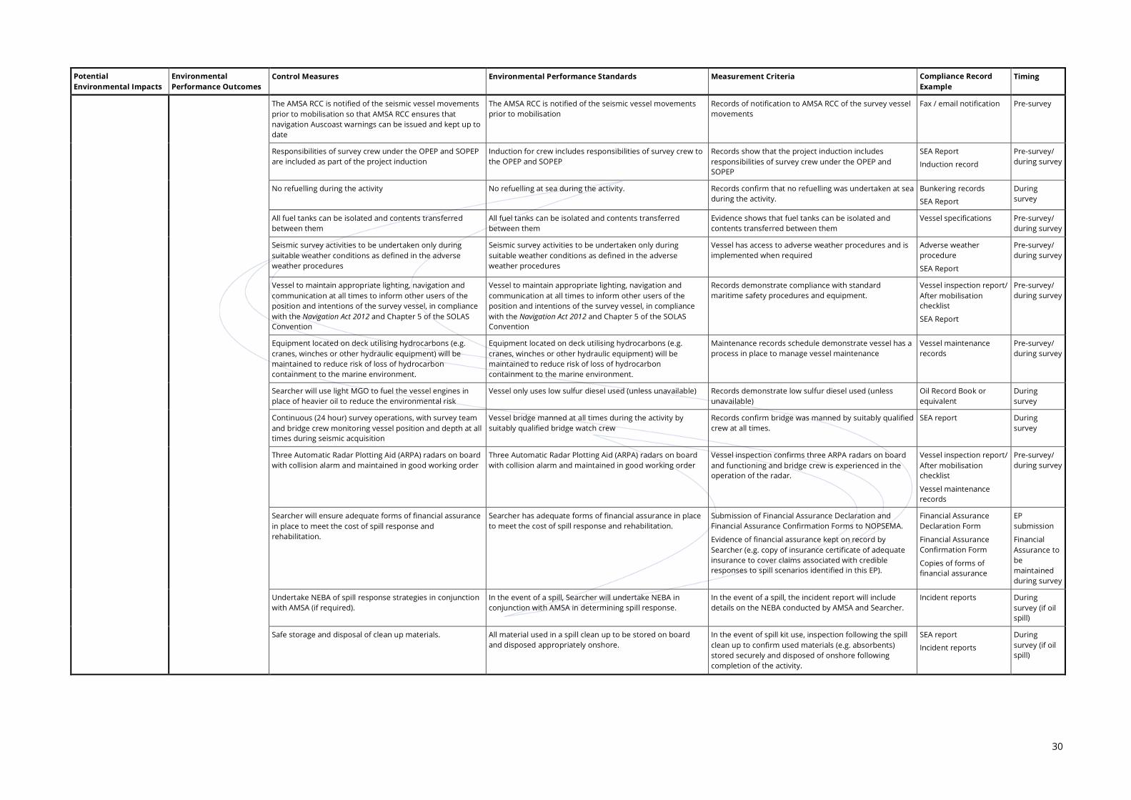
30
Potential Environmental Impacts
Environmental Performance Outcomes
Control Measures Environmental Performance Standards Measurement Criteria Compliance Record Example
Timing
The AMSA RCC is notified of the seismic vessel movements prior to mobilisation so that AMSA RCC ensures that navigation Auscoast warnings can be issued and kept up to date
The AMSA RCC is notified of the seismic vessel movements prior to mobilisation
Records of notification to AMSA RCC of the survey vessel movements
Fax / email notification Pre-survey
Responsibilities of survey crew under the OPEP and SOPEP are included as part of the project induction
Induction for crew includes responsibilities of survey crew to the OPEP and SOPEP
Records show that the project induction includes responsibilities of survey crew under the OPEP and SOPEP
SEA Report
Induction record
Pre-survey/ during survey
No refuelling during the activity No refuelling at sea during the activity. Records confirm that no refuelling was undertaken at sea during the activity.
Bunkering records
SEA Report
During survey
All fuel tanks can be isolated and contents transferred between them
All fuel tanks can be isolated and contents transferred between them
Evidence shows that fuel tanks can be isolated and contents transferred between them
Vessel specifications Pre-survey/ during survey
Seismic survey activities to be undertaken only during suitable weather conditions as defined in the adverse weather procedures
Seismic survey activities to be undertaken only during suitable weather conditions as defined in the adverse weather procedures
Vessel has access to adverse weather procedures and is implemented when required
Adverse weather procedure
SEA Report
Pre-survey/ during survey
Vessel to maintain appropriate lighting, navigation and communication at all times to inform other users of the position and intentions of the survey vessel, in compliance with the Navigation Act 2012 and Chapter 5 of the SOLAS Convention
Vessel to maintain appropriate lighting, navigation and communication at all times to inform other users of the position and intentions of the survey vessel, in compliance with the Navigation Act 2012 and Chapter 5 of the SOLAS Convention
Records demonstrate compliance with standard maritime safety procedures and equipment.
Vessel inspection report/ After mobilisation checklist
SEA Report
Pre-survey/ during survey
Equipment located on deck utilising hydrocarbons (e.g. cranes, winches or other hydraulic equipment) will be maintained to reduce risk of loss of hydrocarbon containment to the marine environment.
Equipment located on deck utilising hydrocarbons (e.g. cranes, winches or other hydraulic equipment) will be maintained to reduce risk of loss of hydrocarbon containment to the marine environment.
Maintenance records schedule demonstrate vessel has a process in place to manage vessel maintenance
Vessel maintenance records
Pre-survey/ during survey
Searcher will use light MGO to fuel the vessel engines in place of heavier oil to reduce the environmental risk
Vessel only uses low sulfur diesel used (unless unavailable) Records demonstrate low sulfur diesel used (unless unavailable)
Oil Record Book or equivalent
During survey
Continuous (24 hour) survey operations, with survey team and bridge crew monitoring vessel position and depth at all times during seismic acquisition
Vessel bridge manned at all times during the activity by suitably qualified bridge watch crew
Records confirm bridge was manned by suitably qualified crew at all times.
SEA report During survey
Three Automatic Radar Plotting Aid (ARPA) radars on board with collision alarm and maintained in good working order
Three Automatic Radar Plotting Aid (ARPA) radars on board with collision alarm and maintained in good working order
Vessel inspection confirms three ARPA radars on board and functioning and bridge crew is experienced in the operation of the radar.
Vessel inspection report/ After mobilisation checklist
Vessel maintenance records
Pre-survey/ during survey
Searcher will ensure adequate forms of financial assurance in place to meet the cost of spill response and rehabilitation.
Searcher has adequate forms of financial assurance in place to meet the cost of spill response and rehabilitation.
Submission of Financial Assurance Declaration and Financial Assurance Confirmation Forms to NOPSEMA.
Evidence of financial assurance kept on record by Searcher (e.g. copy of insurance certificate of adequate insurance to cover claims associated with credible responses to spill scenarios identified in this EP).
Financial Assurance Declaration Form
Financial Assurance Confirmation Form
Copies of forms of financial assurance
EP submission
Financial Assurance to be maintained during survey
Undertake NEBA of spill response strategies in conjunction with AMSA (if required).
In the event of a spill, Searcher will undertake NEBA in conjunction with AMSA in determining spill response.
In the event of a spill, the incident report will include details on the NEBA conducted by AMSA and Searcher.
Incident reports During survey (if oil spill)
Safe storage and disposal of clean up materials. All material used in a spill clean up to be stored on board and disposed appropriately onshore.
In the event of spill kit use, inspection following the spill clean up to confirm used materials (e.g. absorbents) stored securely and disposed of onshore following completion of the activity.
SEA report
Incident reports
During survey (if oil spill)

31
Searcher will monitor the performance of the environmental control measures during the activity. Monitoring and the associated records (including any identified non-conformances) will be sufficiently detailed as to allow the Regulator to determine whether the environmental performance outcomes and performance standards detailed in Table 6-1 are being achieved. Each control measure will be monitored using Searcher’s Compliance Register. A summary of the parameters to be monitored is provided in Table 6-2.
Table 6-2: Summary of Parameters Monitored during the Dunnart 2D MSS EP
Parameters Commitment Record Responsibility
Presence of Marine Organisms on Hull or in Ballast Water
Biofouling Vessel hull and submersible equipment to be free from biofouling prior to and during the survey.
Vessel inspection report / Pre-mobilisation checklist
Photographic evidence
Biofouling Record Book
Vessel documentation observed by the SEA
Vessel Master
Searcher QC Representative
SEA
Ballast water exchange
No ballast water exchange during survey,
OR
In the event of an emergency, ballast water discharge > 12 NM from nearest land.
Ballast Water Record Book / Summary
Vessel documentation observed by the SEA
Vessel Master
SEA
Light and Underwater Noise Emissions
Noise from seismic source
Seismic data acquisition carried out in accordance with EPBC Policy Statement 2.1 as described in Table 6-1, including marine fauna observations, soft starts, etc.
MFO Report
SEA report
Incident report
DotE reporting forms
MFO
SEA
Artificial light spill
Vessel to maintain appropriate lighting with external lights directed onto deck / work areas.
Vessel documentation observed by the SEA
Photo evidence
SEA
Routine Discharges to Sea
Sewage / grey water discharge
Compliance with MARPOL 73/78 regarding sewage / grey water discharges (if discharged treated sewage >3 NM of nearest land; and untreated sewage >12 NM of nearest land).
Vessel GMP
Vessel documentation observed by the SEA
Waste manifest
Incident reports
Vessel Master
SEA
Putrescible wastes
Compliance with MARPOL 73/78 regarding putrescibles discharges (if discharged, unmacerated wastes >3 NM of nearest land; and unmacerated >12 NM of nearest land).
Garbage Record Book
Vessel GMP
Vessel documentation observed by the SEA
Waste manifest
Incident reports
Vessel Master
SEA
Deck drainage (oily water, bilge water discharges)
Compliance with MARPOL 73/78 regarding oil content of discharge water (<15 ppm).
Oil Record Book
Vessel documentation observed by the SEA
Incident reports
Vessel Master
SEA

32
Parameters Commitment Record Responsibility
Release of Pollutants from Vessel Engines and Machinery
Vessel emissions
MGO diesel fuel used during survey. Bunkering records
Vessel documentation observed by the SEA
Vessel Master
SEA
Loss of Containment of Oily Wastes / Chemicals and Solid Hazardous / Non-hazardous Wastes
Oily wastes / chemicals
Small oil spills on deck
Compliance with MARPOL 73/78 regarding oil content of discharge water (<15 ppm).
Hydrocarbons / chemicals stored on deck and equipment using hydrocarbons are adequately bunded.
Vessel documentation observed by the SEA
MSDS data sheets
SOPEP
Incident reports
Vessel Master
SEA
Solid hazardous and non-hazardous wastes
Compliance with MARPOL 73/78 for a vessel waste management, including segregation of hazardous wastes and spill response equipment appropriate to the type and volume of waste will be provided at waste storage areas.
Garbage Record Book
Vessel documentation observed by the SEA
MSDS data sheets
Incident reports
Vessel Master
SEA
Marine Fauna Interaction
Cetacean and whale shark sightings
Adherence to Part 8 EPBC Regulations regarding distance of vessel from cetaceans.
MFO and SEA Reports
MFO and SEA certificates of competency
MFO
SEA
Details required on the Whale and Dolphin Sighting Reports (DotE).
MFO Report containing sighting records
MFO
Record of visual checks undertaken before the deployment of equipment and actions taken if whale sightings within 3 km of vessel during seismic data acquisition.
Daily log of survey acquisition by SEA.
MFO Report containing sighting records
SEA Report
MFO
SEA
Vessel Party Chief
Oil Spills
Oil spills resulting in partial / total loss of fuel tank contents
Operational and Scientific Monitoring Program (OSMP) to be implemented in the event that the OPEP requires monitoring to be undertaken and as directed by AMSA (Combat Agency).
OPEP (SOPEP for smaller spills)
SEA Report
Incident Reports
AMSA
Searcher Operations Manager
Vessel Master
WA DoT (if spill affects state waters)
Financial Assurance
Financial assurance – level of costs / expenses / liability and form of assurance
Ongoing compliance in demonstrating an acceptable level and form of financial assurance for the Dunnart 2D MSS.
Financial Assurance Declaration Form and Financial Assurance Confirmation Form.
Forms of Assurance and method of calculating the appropriate level of financial assurance can be made available on request.
Searcher Director
Searcher Operations Manager
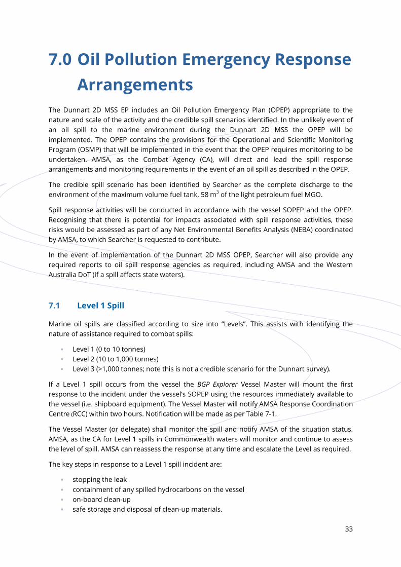
33
7.0 Oil Pollution Emergency Response Arrangements
The Dunnart 2D MSS EP includes an Oil Pollution Emergency Plan (OPEP) appropriate to the nature and scale of the activity and the credible spill scenarios identified. In the unlikely event of an oil spill to the marine environment during the Dunnart 2D MSS the OPEP will be implemented. The OPEP contains the provisions for the Operational and Scientific Monitoring Program (OSMP) that will be implemented in the event that the OPEP requires monitoring to be undertaken. AMSA, as the Combat Agency (CA), will direct and lead the spill response arrangements and monitoring requirements in the event of an oil spill as described in the OPEP.
The credible spill scenario has been identified by Searcher as the complete discharge to the environment of the maximum volume fuel tank, 58 m3 of the light petroleum fuel MGO.
Spill response activities will be conducted in accordance with the vessel SOPEP and the OPEP. Recognising that there is potential for impacts associated with spill response activities, these risks would be assessed as part of any Net Environmental Benefits Analysis (NEBA) coordinated by AMSA, to which Searcher is requested to contribute.
In the event of implementation of the Dunnart 2D MSS OPEP, Searcher will also provide any required reports to oil spill response agencies as required, including AMSA and the Western Australia DoT (if a spill affects state waters).
7.1 Level 1 Spill
Marine oil spills are classified according to size into “Levels”. This assists with identifying the nature of assistance required to combat spills:
Level 1 (0 to 10 tonnes) Level 2 (10 to 1,000 tonnes) Level 3 (>1,000 tonnes; note this is not a credible scenario for the Dunnart survey).
If a Level 1 spill occurs from the vessel the BGP Explorer Vessel Master will mount the first response to the incident under the vessel’s SOPEP using the resources immediately available to the vessel (i.e. shipboard equipment). The Vessel Master will notify AMSA Response Coordination Centre (RCC) within two hours. Notification will be made as per Table 7-1.
The Vessel Master (or delegate) shall monitor the spill and notify AMSA of the situation status. AMSA, as the CA for Level 1 spills in Commonwealth waters will monitor and continue to assess the level of spill. AMSA can reassess the response at any time and escalate the Level as required.
The key steps in response to a Level 1 spill incident are:
stopping the leak containment of any spilled hydrocarbons on the vessel on-board clean-up safe storage and disposal of clean-up materials.

34
Table 7-1: Level 1 Spill Notifications
Notification Communication Timing Contact Number
Searcher QC / HSE Representative
Verbally Immediately On board vessel
AMSA
Response Coordination Centre (RCC)
Verbally Within two hours Free call: 1 800 641 792
POLREP As soon as practicable following verbal notification
Using POLREP form
NOPSEMA
Incident notification office
Verbally notify NOPSEMA for hydrocarbon spills >80 L.
Within two hours Telephone: (08) 6461 7090
Provide a written NOPSEMA Incident Report Form as soon as practicable (no later than three days after notification) (cc to NOPTA and DMP)
Within three days Using NOPSEMA Reportable Report Form
For spills less than 80 litres (L), NOPSEMA should be notified by the fifteenth day of the following month using the NOPSEMA Recordable Report Form.
7.2 Level 2 Spill
The BGP Explorer Vessel Master is responsible for notification and reporting (via POLREP contained in the SOPEP). All spills greater than 10 tonnes into the marine environment are to be reported to the AMSA (RCC) within two hours to enable their activation as the designated CA.
Once the vessel has transmitted an initial report, the BGP Explorer Vessel Master then notifies the vessel’s Core Emergency Team (CET), who will then initiate the vessel’s Emergency Response Plan. Further reports will be sent at regular intervals by the CET to keep relevant parties (AMSA, survey vessel, NOPSEMA, etc.) informed. The CET also provides updates to affected stakeholders. The on-board Vessel Party Chief is responsible for advising the Searcher Quality Control Representative of the spill incident. Searcher is then responsible for notifying NOPSEMA.
Table 7-2: Level 2 Spill Notifications
Notification Communication Timing Contact Number
Searcher QC / HSE Representative
Verbally Immediately On board vessel
AMSA
Response Coordination Centre (RCC)
Verbally Within two hours Free call: 1 800 641 792
POLREP As soon as practicable following verbal notification
Using POLREP form
NOPSEMA
Incident notification office
Verbally notify NOPSEMA for hydrocarbon spills >80 L
Within two hours Telephone: 08 6461 7090
Provide a written NOPSEMA Incident Report Form as soon as practicable (no later than three days after notification) (cc to NOPTA)
Within three days Using NOPSEMA Incident Report Form

35
Notification Communication Timing Contact Number
WA Department of Transport (WA DoT)
WA DoT Duty Manager
Verbally Within two hours of incident having been identified if there is potential for impact to WA state waters.
Telephone: 08 9480 9924
National Offshore Petroleum Titles Administrator (NOPTA)
Verbally or written summary Next working day Telephone: 08 6424 5300
7.3 Prioritisation of Sensitivities in the Area of Interest
Protection priorities within the spill Area of Interest (AoI) for the Dunnart 2D MSS, in accordance with the NATPLAN’s protection priority hierarchy, are:
Priority 1: Human Health and Safety Protection
– BGP Explorer vessel personnel – other marine users (merchant shipping, oil and gas and fishing vessels) – staff at facilities (oil and gas, aquaculture)
Priority 2: Protection of habitat and cultural resources
– reefs, islands, beaches, mangroves – protected areas
Priority 3: Rare and/or endangered fauna protection
– whales (pygmy blue and humpback whales) – whale sharks – marine turtles – marine birds – dugongs
Priority 4: Commercial resources
– commercial fisheries and aquaculture stock – oil and gas – tourism and game fishing.
Accordingly, the following oil-spill response priorities (objectives) have been identified for the BGP Explorer:
Remove marine users from areas that present a safety hazard.
Prevent exposure to oil of critical habitats and threatened species that may transit the operational area.
Prevent commercial fisheries and aquaculture exposure (equipment and catch) in proximity to the operational area.
Advise tourism operators.

36
8.0 Stakeholder Consultation Searcher identified relevant stakeholders by considering their interests and activities that occur within or around the Dunnart 2D MSS operational area, taking into account the survey activities, timing and potential environmental impacts (Table 8-1).
To meet and address Searcher’s obligations required under the OPGGS (E) Regulations, Searcher has developed an ongoing, iterative consultation process in relation to activities carried out under the Dunnart 2D MSS EP. This process is a tiered system that provides for:
stakeholder mapping to identify relevant persons in relation to the scope of the Dunnart 2D MSS
initial consultation with all identified stakeholders during preparation of the Dunnart 2D MSS EP which included provision of an information sheet describing the nature and scale of the proposed activity
an unbiased merit assessment of stakeholder objections or claims raised during the initial consultation, including
– provision of responses to stakeholders addressing their objections or claims
a second round of consultation where a response has not been received and/or acknowledged by a stakeholder
a framework for ongoing consultation.
Table 8-1: Relevant Stakeholders Consulted
Commonwealth Government
Australian Customs and Border Protection Service (Coast Watch)
Australian Fisheries Management Authority (AFMA)
Australian Hydrographic Office (AHO) Australian Maritime Safety Authority (AMSA)
Commonwealth Marine Reserves Branch (DotE) Department of Agriculture and ABARES (Fisheries)
Department of Communications Department of Defence
Department of Foreign Affairs and Trade Department of Industry and Science
Department of the Environment (EPBC Act) National Native title Tribunal
National Offshore Petroleum Titles Administrator (NOPTA)
Western Australian Government
Department of Fisheries (DoF) (WA) State Member for Pilbara
Commonwealth Fishing Industry Groups and Associations
A. Raptis and Sons Austral Fisheries Pty Ltd
Australian Council of Prawn Fisheries Australian Recreational Fishing Foundation
Australian Southern Bluefin Tuna Industry Association Commonwealth Fisheries Association (CFA)
JAMACLAN Marine Services (representing Commonwealth Trawl operators including Westmore Seafoods)

37
Western Australian Licenced Fishers
Beche De Mer Fishery Onslow Prawn Fishery
Mackerel Fishery Specimen Shell Fishery
Pilbara Trap, Trawl & Line Fishery West Coast Deep Sea Crustacean Fishery
Marine Aquarium Fishery Developing Crab Fishery
Western Australian Fishing Industry Groups and Associations
Exmouth Game Fishing Club Pearl Producers Association (PPA)
Western Australian Fishing Industry Council (WAFIC) Western Australian Northern Trawl Owners Association (WANTOA)
Western Australian Seafoods Westmore Seafoods (Australia Bay Seafoods)
Sports Clubs, Tourism and Charter Operators
Arrow Pearl Co. – pearl producer and vessel provider North Star Cruises Australia
Montebello Island Safaris Oceanus Sports Fishing Charters
Pilbara Sea Charters (Point Samson)
Petroleum Permit Operators
Apache Julimar Pty Ltd Chevron Australia Pty Ltd
Exmouth Exploration Pty Ltd Finder Exploration Pty Ltd
Hess Australia Pty Ltd MEO Australia Ltd
Octanex N.L. Santos Pty Ltd
Woodside Petroleum Ltd
A summary of key stakeholder concerns and actions undertaken to address stakeholder stated concerns during the consultation process is provided in Table 8-2.
Table 8-2: Summary of Key Stakeholder Concerns and Issues
Stakeholder Key Concerns and Issues Merit and Action Taken
Commonwealth Government
Australian Fisheries Management Authority (AFMA)
Advised Searcher to consult with the stakeholders associated with all identified fisheries in the area.
Searcher contacted fisheries and fisher stakeholders as requested. No specific issues identified by AFMA.
Australian Maritime Safety Authority (AMSA)
AMSA provided details of vessel traffic information in the vicinity of the operational area and requirements (e.g. collision prevention measures, lights, day shapes) were provided.
AMSA’s RCC is to be contacted via email before commencing operations.
Searcher has included AMSA shipping traffic data in the EP for the period of the survey with risks addressed in the risk assessment.
Searcher will contact AMSA RCC for Australian coastal waters broadcasts before operations commence.
Commonwealth Marine Reserves Branch (DotE)
DotE noted the proximity of the operational area to the Montebello Commonwealth Marine Reserve.
Potential impacts to marine reserves have been assessed in the EP.
No seismic operations to occur within marine parks or reserves.

38
Stakeholder Key Concerns and Issues Merit and Action Taken
Western Australian Government
Department of Fisheries (DoF)
Consultation: consult with WAFIC, Recfishwest, the Pearl Producers Association and individual licensed fishers. Request that Searcher identifies full range of mitigation strategies in the EP. Requests that Searcher uses minimum required acoustic energy. Requests further information on specific dates and exclusion zones.
Fish Spawning: Searcher to include mitigation strategies for minimising impact on fish activities and spawning.
Biosecurity: Searcher is required to minimise the risk of translocating pests and diseases by cleaning vessel hulls, sea chests and niche areas before each voyage.
Initial consultation has been completed with the 11 WA state fisheries identified by DoF.
Searcher will use minimum required acoustic capacity for the survey to minimise impacts to fish stocks, larvae and all other noise-sensitive marine biota.
Biofouling issues have been addressed in the EP in relation to controlling IMS. The risk of introducing IMS is considered low as the BGP Explorer and seismic equipment will be working in WA waters immediately prior to the Dunnart 2D MSS.
Prior to entry into Australian waters, the BGP Explorer was inspected by a Western Australian DoF approved Invasive Marine Species Inspector.
Non-government
Telstra (submarine cables in the Perth Protection Zone)
Advised that Telstra may have assets within the Dunnart Operational Area and would like to be informed of significant changes to the initial consultation information.
Searcher responded to inform Telstra that they will be kept informed in the event of any significant changes from that previously supplied on the information describing the activity.
Petroleum Permit Operators
Hess Australia Pty Ltd.
Advised Searcher of a subsurface mooring (~13 m below sea surface) within the operational area.
Searcher have incorporate coordinates of the subsurface mooring into forward planning of the Dunnart 2D MSS.
Relevant persons are encouraged to provide comment to Searcher at any time, with Searcher committed to ongoing consultation prior to and during the Dunnart 2D MSS. In the event that a relevant person presents an objection or claim, either prior to or during the activity, Searcher will assess the merit of the objection/claim provided by relevant person and, where deemed necessary, will implement additional control measures to ensure all impacts and risks are managed to ALARP and acceptable.
Searcher will facilitate ongoing consultation through the following mechanisms:
encouraging stakeholders to provide feedback at any time during the Dunnart 2D MSS
providing sufficient information on the Searcher website to allow relevant persons to make an informed assessment of the Dunnart 2D MSS and its impacts to their functions, interests and activities
provide a number of mechanisms by which relevant persons can provide feedback, including
– a website portal link that is available through the duration of the Dunnart 2D MSS, including a linked feedback form
– written correspondence.

39
As part of the consultation process, Searcher will provide notification to a number of relevant persons prior to, during and following completion of the Dunnart 2D MSS, as summarised below (Table 8-3).
Table 8-3: Activity Specific Notification Summary
Relevant Person Notification Type Notification Timing
AHO Notification of intention to commence activity (to be included in Notice to Mariners)
At least 14 days prior to commencing the activity
AMSA RCC Routine reports of vessel position Daily reports to be provided
Notification of completion of an activity Within 10 days of completing the activity
AMSA (emergency response division)
Notification of intention to commence an activity At least 10 days prior to commencing the activity
Notification of completion of an activity Within 10 days of completing the activity
Notification of Level I or Level II oil spill (refer to OPEP) Immediately (refer to OPEP)
NOPSEMA Notification of intention to commence an activity At least 10 days prior to commencing the activity
Notification of completion of an activity Within 10 days of completing the activity
Close-out report at completion of activity Within 2 months of completing the activity
Reportable incident report Oral notification – as soon as practicable (within two hours of Searcher becoming aware of incident)
Written notification – as soon as practicable (within three days of Searcher becoming aware of incident)
Recordable incident report. No later than 15 days following the end of a calendar month
40
9.0 Contact Details The details of Searcher’s nominated liaison person are:
Paul Miller Operations Manager Searcher Seismic Pty Ltd Level 1, 15 Rheola Street WEST PERTH, WA 6005
Telephone: +61 8 9327 0330 Mobile: +61 (0) 499 488 800 Fax: +61 8 9327 0301 Email: [email protected]

41
10.0 References AMSA. 2014. Vessel tracking data. Australian Maritime Safety Authority, Canberra.
Australian Quarantine and Inspection Service. 2008. Australian Ballast Water Management Requirements, Version 4. Department of Agriculture, Fisheries and Forrestry Commonwealth of Australia, Canberra.
Commonwealth of Australia. 2009. National biofouling management guidance for the petroleum production and exploration industry. Commonwealth of Australia, Canberra.
Double, M.C., Andrews-Goff, V., Curt, K., Jenner, S., Jenner, M.N., Laverick, S.M., Branch, T.A. and Gales, N.J. 2014. Migratory movements of pygmy blue whales (Balaenoptera musculus brevicauda) between Australia and Indonesia as revealed by satellite telemetry. PLoS one 9(4): e93578.
Searcher Seismic. 2014. Health, safety and environment management system procedure: Risk and hazard management.
Wilson, B. 2013. The Biogeography of the Australian North West Shelf: Environmental Change and Life’s Response. Western Australian Museum, Perth.

42
Top Related