


![· PDF fileuDÞê!Apo osoo ue 'VS ep seJopo!oqoJ4 sououopuru son êluesê]d 01 ê]qos 'JOUO|UO 040D9d p ue sopopues ... opoe!e pp pnuv uold p ue uoÁnpu! as onb pop!loug 01 uoo](https://static.fdocuments.in/doc/165x107/5a8579637f8b9afc5d8c6aa6/apo-osoo-ue-vs-ep-sejopooqoj4-sououopuru-son-luesd-01-qos-jououo-040d9d-p.jpg)


Languages
Pages
Legal

Fischer Boulevard
Bou
y P
lace
Garfield Avenue
Bay
Ave
nue
Win
dsor
Ave
nue
Bel
l Stree
t
Nevil le Street
Meredith Drive
Dov
e Stree
t
4th
Ave
nue
Aud
ubon
Driv
e
Hazelwood R
oad
Lil lie Road
Coolidge Avenue
New Jersey AvenueBash Road
Bea
chvi
ew D
rive
Lloyd Road
Gray R
oad
Rai
der W
ay
Fairvie
w D
rive
Ove
rlook
Driv
e
6th
Ave
nue
Marshall R
oad
Ma
tso
Drive
Minturn R
oad
Mar
itim
e D
rive
Del
awar
e A
venu
e
Thistle Avenue
Linden Road
Littl
e Leag
ue World
Cham
pions
Boul
evard
Nnp
Oca
en
ic D
rive
Eaglehurst Road
Ham
ilton Drive
Bay S
hore
Drive
Salem Drive
Bermuda DriveThom
as A M
athis B
ridge
Wes
t Driv
e
Grover R
oad
Gold
en Driv
e
Ve
ed
er
Ave
nu
e
Ped
die
Stree
t
Mar
tin R
oad
Fischer Boulevard
Dov
e Stree
t
37
70
27
Prim
ary
Dire
ctio
nS
eco
nd
ary
Dire
ctio
n
22
33
689
2
Interstate
Route
US Route
NJ Route
County
Road
Interchange
Number
Grade
Separated
Interchange
Traffic
Signal
Traffic
Monitoring
Sites
Road
Underpass
Road
Overpass
WIM
AVC
VOL
Un
its in
mile
s
Primary
Direction
Secondary
Direction
287
ROUTE 571 (South to North)
SRI = 00000571__
Mile Posts: 0.000 - 2.000
13
61
35
8
Date last inventoried: October 2012
Page C
reate
d: M
arc
h, 2
019
-1.0 0.0 1.0 2.0
Begin
Rt. 5
71 M
P=
0.0
0
Toms River Twp, Ocean Co
Toms River Twp, Ocean Co
(0.9
6)
ST
RE
AM
(0.0
0)
(0.0
5) A
DA
MS
AV
EN
UE
(0.0
9) V
ICT
OR
AV
E
(0.1
5) S
EC
ON
D A
VE
MA
DIS
ON
AV
E
37
37
(0.1
9) G
LA
SG
OW
AV
E
LIS
BO
N A
VE
(0.2
5) 4
TH
AV
E
(0.3
0) T
HIS
TLE
AV
E
(0.3
5) 6
TH
AV
E
(0.4
0) B
EA
CH
VIE
W D
R
(0.4
6) O
CE
AN
IC D
R
AV
EN
UE
WIN
DS
OR
(0.5
0)
VE
ED
ER
AV
E
(0.6
6)
(0.9
8) G
OLD
EN
DR
DR
IVE
(1.0
4) M
AT
SO
(1.0
9) H
ER
RIN
G D
R
(1.1
6) F
RA
NC
IS D
R
DE
LA
WA
RE
AV
E
(1.2
0)
(1.2
6) B
ALF
RE
Y D
R
(1.3
0) F
RA
NC
IS D
R
CO
TT
ON
WO
OD
DR
(1.3
8)
BA
Y A
VE
(1.4
5)
LIN
DE
N R
D
(1.6
1)
TO
SH
OP
PIN
G C
TR
(1.6
7) W
AR
RE
N S
T
(1.7
3) C
OO
LID
GE
AV
E
NE
VIL
LE
ST
(1.7
7)
RO
SS
ST
(1.9
6)
549S
27
70
Street Name Fischer Boulevard Bay Avenue
Jurisdiction County
Functional Class Urban Principal Arterial Urban Minor Arterial
Federal Aid - NHS Sy NHS STP
Control Section
Speed Limit 40 45 40
Number of Lanes 2 4 2 4 3 2
Med. Type Curbed None Unprotected None
Med. Width 10 0 14 0
Pavement 24 60 24 60 48 26
Shoulder 6 8 4 8 0 6
Traffic Volume 12,760 (2018)
Traffic Sta. ID 6-4-464
Structure No.
Enlarged Views
Pavement 24 24
Shoulder 6 2
Number of Lanes 2 2
Speed Limit 40 45
Street NameFischer Boulevard Fischer Boulevard

Bay Avenue
Oak A
venue
Bell Street
India
n H
ill Road
Va
ug
hn
Ave
nu
e
Hoo
pe
r A
ven
ue
Derry Drive
Goose Creek Road
Dove Street
Audubon Driv
e Kill
arn
ey D
rive
Tw
in O
aks R
oa
d
Gilm
ore
Isl
and R
oad
Kild
are
Drive
Shawnee Drive
Heritage W
ay
Woodberry Drive
Ald
en
Driv
e
Red
wood D
rive
Nort
h B
ay A
ve
nu
e
Bartle
tt Pla
ce
Federal Way
Ced
ar
Gro
ve
Roa
d
Tu
dor D
rive
Bo
xeld
er
Dri
ve
Dun
ed
in S
tree
tC
on
gre
ss S
tree
t
Mold
e Court
Sh
eila D
rive
Rid
ge
Dri
ve
Roxbury Lane
Ryan Run
Oa
k G
len
Roa
d
Hazelwood Road
Gle
n O
ak S
tre
et
Samatha W
ay
Tunesbrook Drive
High Meadow D
rive
Avon Court
Bay Avenue
Hoo
pe
r A
ven
ue
94
20549
18
62722
Prim
ary
Dire
ctio
nS
eco
nd
ary
Dire
ctio
n
22
33
689
2
Interstate
Route
US Route
NJ Route
County
Road
Interchange
Number
Grade
Separated
Interchange
Traffic
Signal
Traffic
Monitoring
Sites
Road
Underpass
Road
Overpass
WIM
AVC
VOL
Un
its in
mile
s
Primary
Direction
Secondary
Direction
287
ROUTE 571 (South to North)
SRI = 00000571__
Mile Posts: 2.000 - 5.000
13
61
35
9
Date last inventoried: October 2012
Page C
reate
d: M
arc
h, 2
019
2.0 3.0 4.0 5.0
Toms River Twp, Ocean Co
Toms River Twp, Ocean Co
(4.7
2)
ST
RE
AM
(2.0
6) D
UN
ED
IN S
T
(2.0
9) N
EB
RA
SK
A A
VE
NE
W J
ER
SE
Y A
VE
CO
NG
RE
SS
ST
(2.2
0)
AV
EN
UE
VA
UG
HN
(2.3
8)
TU
NE
SB
RO
OK
DR
(2.6
9)
N T
UN
ES
BR
OO
K D
R
BR
IAR
AV
E
(2.7
9)
ST
JO
SE
PH
PL
(2.8
5) T
AN
GLE
WO
OD
RD
(2.9
0) G
LE
N O
AK
ST
CO
NT
EM
PO
DR
(3.0
1)
RID
GE
DR
(3.1
1)
RO
AD
TW
IN O
AK
S
(3.1
9)
RO
AD
CE
DA
R G
RO
VE
(3.3
7)
RO
AD
(3.4
7) IN
DIA
N H
ILL
(3.5
5) A
LD
EN
DR
(3.5
7) L
ES
TE
R R
D
(3.6
0) B
OW
RD
(3.6
8) O
AK
AV
E
BR
OO
KS
IDE
DR
(3.8
1)
627 22
20 94
EN
TR
AN
CE
(4.0
5)
TO
MA
LL
HO
OP
ER
(4.2
3)
AV
EN
UE
EN
T T
O C
OR
P
(4.4
1)
549
549
FR
OM
TE
NN
IS C
TS
(4.5
1)
N B
AY
AV
E
(4.6
7)
AS
HLE
Y P
L
(4.8
1)
18
Street Name Bay Avenue
Jurisdiction County
Functional Class Urban Minor Arterial
Federal Aid - NHS Sy STP
Control Section
Speed Limit 40 45
Number of Lanes 2 4 2 4 2 4 3
Med. Type None Curbed None
Med. Width 0 VAR 0
Pavement 26 60 26 48 26 48 36
Shoulder 6 0 10 4 0 4 0 6 4
Traffic Volume 19,577 (2017) 13,093 (2016) 25,856 (2017)
Traffic Sta. ID 6-4-465 91545 6-4-466
Structure No. 1507015
Enlarged Views
Pavement 26
Shoulder 2 0 4
Number of Lanes 2
Speed Limit 40 45
Street Name Bay Avenue

GSPGSP
Whitesvil le R
oad
Bay Avenue
Lake
wood
Road
India
n Hea
d Road
Marc D
rive
Hilltop D
rive
Dallas D
riveO
ld F
reehold
Road
Ridgeway Road
Fox Glove R
un
Ga
rden
Sta
te P
ark
wa
y
Cla
yton A
venue
Lila
c D
rive
Patrician D
riveColonial D
rive
Bey Lea Road
Green D
rive
Colu
mb
ine C
ir
Bra
nch
Dri
ve
Gladstone A
venue
Raym
ond
Ave
nu
e
Le
aw
ood
Ave
nu
e
Westo
n Driv
e
Aster Drive
Me
nlo
w C
ou
rt
Sm
oke
Ris
e L
an
e
Tu
lip P
lace
Wingate C
ourt
Sunflower Lane
Petunia W
ay South
Ga
rden
Sta
te P
ark
wa
y
Lake
wood
Road
Lake
wood
Road
Westo
n Driv
e
9
166
527
623
56
6
Prim
ary
Dire
ctio
nS
eco
nd
ary
Dire
ctio
n
22
33
689
2
Interstate
Route
US Route
NJ Route
County
Road
Interchange
Number
Grade
Separated
Interchange
Traffic
Signal
Traffic
Monitoring
Sites
Road
Underpass
Road
Overpass
WIM
AVC
VOL
Un
its in
mile
s
Primary
Direction
Secondary
Direction
287
ROUTE 571 (South to North)
SRI = 00000571__
Mile Posts: 5.000 - 6.640
13
61
36
0
Date last inventoried: October 2012
Page C
reate
d: M
arc
h, 2
019
5.0 6.0 7.0 8.0
MP
6.6
4 =
Begin
Coin
c. W
ith R
t. 527 M
P 4
.10
MP
6.6
4-7
.40 S
ee R
t. 527 M
P 4
.10-4
.81
Toms River Twp, Ocean Co
Toms River Twp, Ocean Co
(6.5
9)
ST
RE
AM
RO
AD
OLD
FR
EE
HO
LD
(5.2
1)
CY
PR
ES
S P
OIN
T D
R
(5.4
5)
OA
KM
ON
T D
R
(5.5
8)
INT
ER
ME
DIA
TE
WA
Y
(5.7
3)
623
623
(5.8
1) W
AV
E C
RE
ST
CT
(5.8
9) H
ILLG
RA
SS
CT
DU
GA
N L
N
(6.0
1)
GA
RD
EN
STA
TE
(6.0
4)
PA
RK
WA
Y
RO
AD
LA
KE
WO
OD
(6.1
9)
(6.2
7) R
AM
P T
O U
S 9
GR
EE
N S
T(6
.34) T
O S
HO
PP
ING
CT
R
OA
K R
IDG
E P
KW
Y
(6.4
6)
WH
ITE
SV
ILLE
RD
(6.6
4)
GA
RD
EN
IA W
AY
9
9 6 527
Street Name Bay Avenue Bey Lea Road Indian Head Road
Jurisdiction County
Functional Class Urban Minor Arterial
Federal Aid - NHS Sy STP
Control Section
Speed Limit 45 40
Number of Lanes 3 2 4
Med. Type None Painted/Unprotected None
Med. Width 0 10 0
Pavement 36 26 60
Shoulder 4 0 2
Traffic Volume 20,414 (2016)
Traffic Sta. ID 6-4-467
Structure No. 360844N360844S
Enlarged Views
Pavement 26
Shoulder 4
Number of Lanes 2
Speed Limit 45
Street Name Bay Avenue Bay Lea Road

GSPGSP
Whitesvil le R
oad
Bay Avenue
Lake
wood
Road
India
n Hea
d Road
Marc D
rive
Hilltop D
rive
Dallas D
riveO
ld F
reehold
Road
Ridgeway Road
Fox Glove R
un
Ga
rden
Sta
te P
ark
wa
y
Cla
yton A
venue
Lila
c D
rive
Patrician D
riveColonial D
rive
Bey Lea Road
Green D
rive
Colu
mb
ine C
ir
Bra
nch
Dri
ve
Gladstone A
venue
Raym
ond
Ave
nu
e
Le
aw
ood
Ave
nu
e
Westo
n Driv
e
Aster Drive
Me
nlo
w C
ou
rt
Sm
oke
Ris
e L
an
e
Tu
lip P
lace
Wingate C
ourt
Sunflower Lane
Petunia W
ay South
Ga
rden
Sta
te P
ark
wa
y
Lake
wood
Road
Lake
wood
Road
Westo
n Driv
e
9
166
527
623
56
6
Prim
ary
Dire
ctio
nS
eco
nd
ary
Dire
ctio
n
22
33
689
2
Interstate
Route
US Route
NJ Route
County
Road
Interchange
Number
Grade
Separated
Interchange
Traffic
Signal
Traffic
Monitoring
Sites
Road
Underpass
Road
Overpass
WIM
AVC
VOL
Un
its in
mile
s
Primary
Direction
Secondary
Direction
287
ROUTE 571 (South to North)
SRI = 00000571__
Mile Posts: 7.400 - 8.000
13
61
36
0
Date last inventoried: October 2012
Page C
reate
d: M
arc
h, 2
019
5.0 6.0 7.0 8.0
MP
7.4
0 =
End C
oin
c W
ith R
t. 527 M
P 4
.81
(7.5
4)
Toms River, Oce. Co.
(7.5
4)Toms River,
Oce. Co.
(7.5
4)
Manchester Twp, Ocean Co
(7.5
4) Manchester Twp, Ocean Co
(7.5
4)
TO
MS
RIV
ER(7
.40)
TO
CA
MP
GR
OU
ND
S
(7.8
3)
PR
IVA
TE
RD
(7.9
1)
(7.9
7) 1
0T
H A
VE
527
Street Name Ridgeway Road
Jurisdiction County
Functional Class Urban Minor Arterial
Federal Aid - NHS Sy STP
Control Section
Speed Limit 40
Number of Lanes 4
Med. Type None
Med. Width 0
Pavement 48
Shoulder 4 1
Traffic Volume 17,680 (2016)
Traffic Sta. ID 91532
Structure No. 1507002
Enlarged Views
Pavement
Shoulder
Number of Lanes
Speed Limit
Street Name
Ridgeway Road
Wilbur Avenue
Beacon Street
Oak Knoll Drive
Johnson Avenue
Ett
y C
ou
rt
Lake D
rive
Spruce Drive
To
rry A
ve
nu
e
Tenth
Ave
nue
Fa
irfield
Str
ee
t
7th
Ave
nue
Ric
hm
on
d A
ven
ue
Ren
ais
sa
nce D
rive
Bre
ntw
oo
d A
ven
ue
Cle
ars
trea
m C
ou
rt
Clover Way
Esse
x R
oa
d
Pa
tric
ia C
ou
rt
Ste
ve
ns W
ay
Sh
ori
n W
ay
Ric
ha
rd D
rive
Ma
ple
woo
d S
tre
et
Tenth
Ave
nue 70
8
10
Prim
ary
Dire
ctio
nS
eco
nd
ary
Dire
ctio
n
22
33
689
2
Interstate
Route
US Route
NJ Route
County
Road
Interchange
Number
Grade
Separated
Interchange
Traffic
Signal
Traffic
Monitoring
Sites
Road
Underpass
Road
Overpass
WIM
AVC
VOL
Un
its in
mile
s
Primary
Direction
Secondary
Direction
287
ROUTE 571 (South to North)
SRI = 00000571__
Mile Posts: 8.000 - 11.000
13
61
36
1
Date last inventoried: October 2012
Page C
reate
d: M
arc
h, 2
019
8.0 9.0 10.0 11.0
Manchester Twp, Ocean Co
Manchester Twp, Ocean Co
(10.4
9)
ST
RE
AM
RIV
ER
WO
OD
CT
(8.0
5)
CO
MM
ON
WE
ALT
H B
LV
D
(8.2
0)
CE
DA
R G
LE
N R
D
ST
RE
ET
BE
AC
ON
(8.5
5)
(8.5
9) L
OC
KH
AR
T S
T
(8.6
4) S
EM
INO
LE
ST
(8.6
9) A
LB
ER
TA
ST
ST
RE
ET
(8.7
4) F
AIR
FIE
LD
MA
PLE
WO
OD
ST
(8.8
5)
EN
T T
O P
AR
K
(8.9
1)
PA
TR
ICIA
CT
(9.0
6)
TH
ER
ES
A W
AY
(9.0
7)
ES
SE
X R
D
(9.2
2)
CE
DA
R D
R
(9.3
7)
RIC
HA
RD
DR
(9.5
5)
UN
NA
ME
D R
D
(9.6
7)
HA
RR
IET
AV
E
(9.7
9)
LE
ISU
RE
RID
GE
RD
(9.8
7)
RIC
HM
ON
D A
VE
(9.9
4)
(9.9
9) W
AS
HIN
GT
ON
AV
E
(10.0
7)
BR
EN
TW
OO
D A
VE
(10.1
2)
RE
NA
ISS
AN
CE
DR
(10.4
3)
CA
BIN
BR
OO
K C
R
(10.7
2)
NIC
KO
LE
TT
I AV
E
(10.7
6)
ET
TY
CT
(10.9
4)
(11.0
0) T
OR
RY
AV
E
8 10 70
70
Street Name Ridgeway Road
Jurisdiction County
Functional Class Urban Minor Arterial
Federal Aid - NHS Sy STP
Control Section
Speed Limit 40 50
Number of Lanes 4 2
Med. Type None
Med. Width 0
Pavement 48 24
Shoulder 1 12
Traffic Volume 17,565 (2018) 13,987 (2016)
Traffic Sta. ID 6-4-468 6-4-469
Structure No.
Enlarged Views
Pavement
Shoulder
Number of Lanes
Speed Limit
Street Name
Ridgeway Road
Whitecomb Road
Cen
ter
Str
ee
t
Qu
arr
y R
oa
d Ma
ria S
tre
et
Dallas D
rive
Ridg
ew
ay B
oule
vard
Vo
lan
te R
oad
Ett
y C
ou
rt
Rid
ge
wa
y B
ou
levard
547
6
6
Prim
ary
Dire
ctio
nS
eco
nd
ary
Dire
ctio
n
22
33
689
2
Interstate
Route
US Route
NJ Route
County
Road
Interchange
Number
Grade
Separated
Interchange
Traffic
Signal
Traffic
Monitoring
Sites
Road
Underpass
Road
Overpass
WIM
AVC
VOL
Un
its in
mile
s
Primary
Direction
Secondary
Direction
287
ROUTE 571 (South to North)
SRI = 00000571__
Mile Posts: 11.000 - 14.000
13
61
36
2
Date last inventoried: October 2012
Page C
reate
d: M
arc
h, 2
019
11.0 12.0 13.0 14.0
(12.4
7)
Manchester Twp, Ocean Co
(12.4
7)Manchester Twp, Ocean Co
(12.4
7)
Jackson Twp, Ocean Co
(12.4
7) Jackson Twp, Ocean Co
(11.0
7)
R.R
.
(13.6
9)
ST
RE
AM
(11.0
0) T
OR
RY
AV
E(1
1.0
5) V
OLA
NT
E R
D
(11.1
2) Q
UA
RR
Y R
D
RID
GE
WA
Y P
AR
K
(11.5
0)
RID
GE
WA
Y B
LV
D
(11.5
7)
PH
EA
SA
NT
AV
E
(11.6
4)
RID
GE
WA
Y B
LV
D
(11.7
6)
(12.1
1)
HA
NG
AR
AV
E
(12.3
6)
WH
ITE
CO
MB
RD
(12.9
3)
(13.1
2) L
UX
UR
Y C
IR
(13.1
4) C
OLE
MA
N W
AY
(13.1
7) L
UX
UR
Y C
IR
(13.2
3) M
AR
IA S
T
(13.2
5) C
AR
MIN
E P
L(1
3.2
7) S
ILV
IA L
N(1
3.2
9) A
NT
HO
NY
WA
Y
DA
LLA
S D
R
(13.4
9)
6
6 547
547
Street Name Ridgeway Road
Jurisdiction County
Functional Class Urban Minor Arterial
Federal Aid - NHS Sy STP
Control Section
Speed Limit 50
Number of Lanes 2
Med. Type None
Med. Width 0
Pavement 24
Shoulder 12 4 8 4
Traffic Volume 14,624 (2017)
Traffic Sta. ID 6-4-408
Structure No.
Enlarged Views
Pavement
Shoulder
Number of Lanes
Speed Limit
Street Name

Toms River Road
Lakehurst Avenue
Bo
wm
an
Ro
ad
Mille
r Ave
nu
e
Savannah Road
South Stump Tavern Road
Ollie
Bro
oke
Road
Okjin Court
Hom
este
ad
Ro
ad
42
52
Prim
ary
Dire
ctio
nS
eco
nd
ary
Dire
ctio
n
22
33
689
2
Interstate
Route
US Route
NJ Route
County
Road
Interchange
Number
Grade
Separated
Interchange
Traffic
Signal
Traffic
Monitoring
Sites
Road
Underpass
Road
Overpass
WIM
AVC
VOL
Un
its in
mile
s
Primary
Direction
Secondary
Direction
287
ROUTE 571 (South to North)
SRI = 00000571__
Mile Posts: 14.000 - 17.000
13
61
36
3
Date last inventoried: October 2012
Page C
reate
d: M
arc
h, 2
019
14.0 15.0 16.0 17.0
Jackson Twp, Ocean Co
Jackson Twp, Ocean Co
(14.1
4)
ST
RE
AM
(14.5
2)
ST
RE
AM
(15.7
9)
ST
RE
AM
(16.7
1)
ST
RE
AM
LA
KE
HU
RS
T A
VE
(14.0
9)
HIG
H B
RID
GE
RD
(15.4
3)
LA
KE
HU
RS
T A
VE
(16.0
7)
BO
WM
AN
RD
(16.3
3)
ST
UM
P R
D(1
6.4
2)
52
42
Street Name Ridgeway Road
Toms River Road
Jurisdiction County
Functional Class Urban Minor Arterial
Federal Aid - NHS Sy STP
Control Section
Speed Limit 50
Number of Lanes 2
Med. Type None
Med. Width 0
Pavement 24 36 24
Shoulder 4 6 4 2
Traffic Volume
Traffic Sta. ID
Structure No.
Enlarged Views
Pavement
Shoulder
Number of Lanes
Speed Limit
Street Name

Toms River Road
Cassvil le Road
Perrineville
Road
Paul
Road
Park Avenue
Free
hold
Roa
d
West
Vete
ran
s H
igh
wa
y
Sa
van
na
h R
oa
d
Con
or
Roa
d
Aid
an
La
ne
Pushkin Road
Crescent Avenue
Be
nz L
an
e
Syd
or A
venue
Ric
ci`
s D
rive
Go
etz
La
ne
Kindling Way
Th
om
pso
n B
ridg
e R
oad
Zin
ia S
tree
t
Pe
ach
tree
Str
ee
tPe
lica
n L
an
e
Fro
ntie
r La
ne
Sergey Road
Spring Street
Osprey Place
An
dre
ws R
oad
Sa
van
na
h R
oa
d
528
638
46
Prim
ary
Dire
ctio
nS
eco
nd
ary
Dire
ctio
n
22
33
689
2
Interstate
Route
US Route
NJ Route
County
Road
Interchange
Number
Grade
Separated
Interchange
Traffic
Signal
Traffic
Monitoring
Sites
Road
Underpass
Road
Overpass
WIM
AVC
VOL
Un
its in
mile
s
Primary
Direction
Secondary
Direction
287
ROUTE 571 (South to North)
SRI = 00000571__
Mile Posts: 17.000 - 20.000
13
61
36
4
Date last inventoried: October 2012
Page C
reate
d: M
arc
h, 2
019
17.0 18.0 19.0 20.0
Jackson Twp, Ocean Co
Jackson Twp, Ocean Co
(19.4
7)
ST
RE
AM
SA
VA
NN
AH
RD
(17.2
0)
GO
ET
Z L
N
(17.6
1)
BE
NZ
LN
(17.8
6)
OS
PR
EY
PL
(17.9
1)
OS
PR
EY
PL
(18.0
3)
KIN
DLIN
G W
AY
(18.1
1)
AID
AN
LN
(18.2
1)
TA
LL O
AK
S D
R
(18.3
3) P
ELIC
AN
LN
(18.3
5) F
RO
NT
IER
LN
PA
UL R
D
(18.5
1)
SY
DO
R A
VE
(18.7
0)
PE
RC
HU
K L
N
(18.8
2)
W V
ET
ER
AN
S
(19.0
2)
HIG
HW
AY
CE
ME
TE
RY
LN
(19.1
0)
PE
AC
HT
RE
E S
T
(19.1
7)
SE
RG
EY
RD
(19.2
2)
(19.2
5) R
ICC
I'S D
R
(19.3
4) C
ON
OR
RD
(19.5
1) T
HO
MP
SO
N R
D
FR
EE
HO
LD
RD
CA
SS
VIL
LE
PE
RR
INE
VIL
LE
RD
(19.5
5)
(20.0
0) A
ND
RE
WS
RD
528
528 46 638638
Street Name Toms River Road Cassville Road
Jurisdiction County
Functional Class Urban Minor Arterial
Federal Aid - NHS Sy STP
Control Section
Speed Limit 50 40 50
Number of Lanes 2
Med. Type None
Med. Width 0
Pavement 24
Shoulder 2 4
Traffic Volume 10,713 (2017) 10,921 (2017)
Traffic Sta. ID 6-4-470 6-4-471
Structure No. 1511029
Enlarged Views
Pavement
Shoulder
Number of Lanes
Speed Limit
Street Name

Cassvil le Road
Anders
on R
oad
Win
terb
err
y B
ou
leva
rd
Ree
d R
oad
Crescent Avenue
Butto
nwood
Driv
e
Oa
kw
oo
d A
ven
ue
Perrineville
Road
Ab
be
y R
oa
d
Che
rry Stre
et
Hen
ry Stree
t
Asp
en
Co
urt
Leesville R
oad
Mill Pond Road
West
Co
mm
od
ore
Bo
ule
va
rd
Grover Court
Ag
ostin
a D
rive
An
ita D
rive
Jason Court
Fagans RunPersimmon Drive
Banyan Court
Hop
kin
s P
lace
Beech CourtA
ndre
ws R
oad
Che
rry S
treet
526
34
Prim
ary
Dire
ctio
nS
eco
nd
ary
Dire
ctio
n
22
33
689
2
Interstate
Route
US Route
NJ Route
County
Road
Interchange
Number
Grade
Separated
Interchange
Traffic
Signal
Traffic
Monitoring
Sites
Road
Underpass
Road
Overpass
WIM
AVC
VOL
Un
its in
mile
s
Primary
Direction
Secondary
Direction
287
ROUTE 571 (South to North)
SRI = 00000571__
Mile Posts: 20.000 - 22.870
13
61
36
5
Date last inventoried: October 2012
Page C
reate
d: M
arc
h, 2
019
20.0 21.0 22.0 23.0
MP
22.8
7 =
Begin
Coin
c. W
ith R
t. 526 M
P 1
9.4
9
MP
22.8
7-2
4.3
5 S
ee R
t. 526 M
P 1
9.4
9-2
0.9
6
Jackson Twp, Ocean Co
Jackson Twp, Ocean Co
(20.8
6)
ST
RE
AM
(21.1
7)
Main
Bra
nch T
om
s R
iver
(20.0
0) A
ND
RE
WS
RD
CO
SY
LN
(20.2
9)
OA
KW
OO
D A
VE
GR
EE
N T
RE
E D
R
(20.7
3)
RE
ED
RD
(21.1
6)
RO
DR
IGU
EZ
LN
(21.4
0)
LE
ES
VIL
E R
D(2
1.5
4)
BU
TT
ON
WO
OD
DR
(21.6
0)
AN
ITA
DR
(21.6
8)
WIN
TE
RB
ER
RY
BLV
D
(21.8
8)
BIT
TE
RS
WE
ET
DR
(22.0
9)
PA
TT
ER
SO
N R
DA
ND
ER
SO
N R
D(2
2.3
0)
AB
BE
Y R
D
(22.7
2)
HO
PK
INS
PL
(22.8
3)
W C
OM
MO
DO
RE
BLV
D
(22.8
7)
34 526
Street Name Cassville Road
Jurisdiction County
Functional Class Urban Minor Arterial
Federal Aid - NHS Sy STP
Control Section
Speed Limit 50 35 50
Number of Lanes 2
Med. Type None
Med. Width 0
Pavement 24
Shoulder 4 12
Traffic Volume 12,128 (2018)
Traffic Sta. ID 6-4-472
Structure No. 1511018
Enlarged Views
Pavement
Shoulder
Number of Lanes
Speed Limit
Street Name
Millstone Road
Mo
nm
ou
th R
oa
d
Sta
ge
Co
ach R
oa
d
Anderson Road
Burnt Tavern Road
Carrs
Ta
ve
rn R
oa
d
Fawn Way
Pa
tters
on L
an
e
Sq
ua
n R
oad
Jam
es
J H
oward
Inte
rsta
te H
ighw
ay
Tre
nto
n-L
akew
ood R
oad
Pain
t Is
land S
prin
g R
oad
Fillmore Road
Ap
ple
ga
te R
oa
d
Hoo
pe
r Co
urt
Laurel Court
Millstone Road
Trento
n-Lakew
ood Road
§̈¦195
526
537
524
Prim
ary
Dire
ctio
nS
eco
nd
ary
Dire
ctio
n
22
33
689
2
Interstate
Route
US Route
NJ Route
County
Road
Interchange
Number
Grade
Separated
Interchange
Traffic
Signal
Traffic
Monitoring
Sites
Road
Underpass
Road
Overpass
WIM
AVC
VOL
Un
its in
mile
s
Primary
Direction
Secondary
Direction
287
ROUTE 571 (South to North)
SRI = 00000571__
Mile Posts: 24.350 - 25.630
13
61
36
6
Date last inventoried: October 2012
Page C
reate
d: M
arc
h, 2
019
23.0 24.0 25.0 26.0
MP
24.3
5 =
End C
oin
c W
ith R
t. 526 M
P 2
0.9
6
MP
25.6
3 =
Begin
Coin
c. W
ith R
t. 524 M
P 1
5.8
4
MP
25.6
3-2
6.7
3 S
ee R
t. 524 M
P 1
5.8
4-1
4.7
4
Millstone Twp, Monmouth Co
Millstone Twp, Monmouth Co(2
4.3
5)
(24.3
7) P
AT
TE
RS
ON
LN
CA
RR
S T
AV
ER
N
(24.5
5)
RO
AD
PA
RK
ER
CT
(24.7
1)
AP
PLE
GA
TE
RD
(24.8
3)
KIM
BE
RLY
CT
(25.0
0)
IVIN
S L
N
(25.3
6)
PA
INT
RO
AD
CLA
RK
SB
UR
G
(25.6
3)
ISLA
ND
SP
RIN
G R
D
526
524
524
Street Name Millstone Road
Jurisdiction County
Functional Class Urban Major Collector
Federal Aid - NHS Sy STP
Control Section
Speed Limit 40 45
Number of Lanes 2
Med. Type None
Med. Width 0
Pavement 24
Shoulder 4 2
Traffic Volume 6,409 (2017)
Traffic Sta. ID 6-9-436
Structure No.
Enlarged Views
Pavement
Shoulder
Number of Lanes
Speed Limit
Street Name
Rising Sun Tavern Road
Lake Drive
Stage Coach Road
Ag
ress R
oa
d
Rochdale
Road
Farm Lane
Mitchell R
oad
Cla
rksb
urg
Ro
ad
Spring Road Tamara Drive
Homestead LaneCotrell Drive
Pheasant Run
Bowm
an Court M
ou
nta
invie
w C
ou
rt
Ced
ar C
ou
rt
Pine Drive
Hartshorne Drive
Brown Street
Sp
ruce
La
ne
So
uth
Va
lley R
oa
d
524
Prim
ary
Dire
ctio
nS
eco
nd
ary
Dire
ctio
n
22
33
689
2
Interstate
Route
US Route
NJ Route
County
Road
Interchange
Number
Grade
Separated
Interchange
Traffic
Signal
Traffic
Monitoring
Sites
Road
Underpass
Road
Overpass
WIM
AVC
VOL
Un
its in
mile
s
Primary
Direction
Secondary
Direction
287
ROUTE 571 (South to North)
SRI = 00000571__
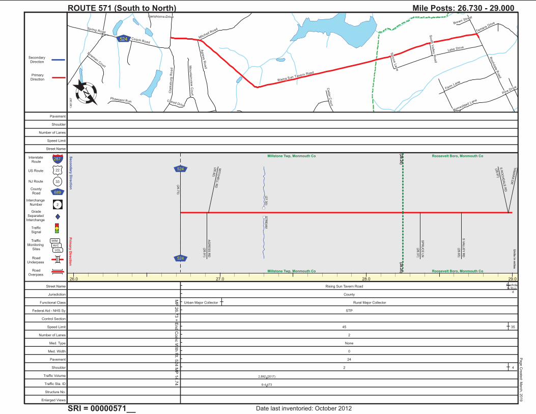
Mile Posts: 26.730 - 29.000
13
61
36
7
Date last inventoried: October 2012
Page C
reate
d: M
arc
h, 2
019
26.0 27.0 28.0 29.0
MP
26.7
3 =
End C
oin
c W
ith R
t. 524 M
P 1
4.7
4
(28.2
5)
Millstone Twp, Monmouth Co
(28.2
5)Millstone Twp, Monmouth Co
(28.2
5)
Roosevelt Boro, Monmouth Co
(28.2
5) Roosevelt Boro, Monmouth Co
(27.3
0)
ST
RE
AM
(26.7
3)
AG
RE
SS
RD
(26.9
1)
MIT
CH
ELL R
D(2
6.9
2)
SP
RU
CE
LN
(28.3
7)
S V
ALLE
Y R
D
(28.6
5)
TA
MA
RA
DR
S R
OC
HD
ALE
RD
(28.9
7)
524
524
Street Name Rising Sun Tavern Road Rochda le Roa
dJurisdiction County
Functional Class Urban Major Collector Rural Major Collector
Federal Aid - NHS Sy STP
Control Section
Speed Limit 45 35
Number of Lanes 2
Med. Type None
Med. Width 0
Pavement 24
Shoulder 2 4
Traffic Volume 2,892 (2017)
Traffic Sta. ID 6-4-473
Structure No.
Enlarged Views
Pavement
Shoulder
Number of Lanes
Speed Limit
Street Name

Roc
hdale R
oad
Nurk
o R
oad
Win
dso
r R
oad
Lake Driv
e
Dis
bro
wh
ill R
oa
d
Rising Sun T
avern R
oad
Farm L
ane
Tamara D
rive
Pin
e D
rive
North Valley Road
Osc
ar D
rive
Feldsher
Deb
ow
Dri
ve
Brow
n Stre
et
Spru
ce La
ne
Prim
ary
Dire
ctio
nS
eco
nd
ary
Dire
ctio
n
22
33
689
2
Interstate
Route
US Route
NJ Route
County
Road
Interchange
Number
Grade
Separated
Interchange
Traffic
Signal
Traffic
Monitoring
Sites
Road
Underpass
Road
Overpass
WIM
AVC
VOL
Un
its in
mile
s
Primary
Direction
Secondary
Direction
287
ROUTE 571 (South to North)
SRI = 00000571__
Mile Posts: 29.000 - 32.000
13
61
36
8
Date last inventoried: October 2012
Page C
reate
d: M
arc
h, 2
019
29.0 30.0 31.0 32.0
(30.4
7)
Roosevelt Boro, Monmouth Co
(30.3
4)Roosevelt Boro, Monmouth Co
(30.3
4)
(31.2
1)Millstone Twp, Monmouth Co
(30.4
7)
(31.2
1)
Millstone Twp, Monmouth Co
(31.2
1)
East Windsor Twp, Mercer Co
(31.2
1) East Windsor Twp, Mercer Co
(29.1
3)
ST
RE
AM
(29.5
4)
ST
RE
AM
(29.6
9)
ST
RE
AM
(29.8
7)
ST
RE
AM
LA
KE
DR
(29.0
6)
FA
RM
LN
(29.2
7)
HO
ME
ST
EA
D L
NP
INE
DR
(29.4
3)
(29.5
8) O
SC
AR
DR
NU
RK
O R
D
(30.0
7)
WIN
DS
OR
(30.5
8)
RO
AD
FE
LS
HE
R R
D
(31.7
7)
1
Street Name Rochdale Road
Jurisdiction County
Functional Class Rural Major Collector Urban Major Collector Rural Major Collector
Federal Aid - NHS Sy STP
Control Section
Speed Limit 35
Number of Lanes 2
Med. Type None
Med. Width 0
Pavement 24
Shoulder 4 1 2
Traffic Volume 4,191 (2016) 3,601 (2018)
Traffic Sta. ID 6-4-474 5-4-436
Structure No.
Enlarged Views
Pavement
Shoulder
Number of Lanes
Speed Limit
Street Name

I-9
5
US
130
NJ
33
Rochdale Road
Disbrow Hill Road
Dutch Neck Road
Milfo
rd R
oa
d
Old
Yo
rk R
oad
Oak C
reek Road
Hickory Corner Road
Airport Road
Dorc
heste
r D
rive
La
ke
Driv
e
Bu
tch
er R
oa
d
Stockton Street
Twin Rivers DriveNorth
Dis
bro
w R
oa
d
Merc
er S
treet
Franklin Street
Brook Tree Road
Oxford Drive
Ba
ttleg
roun
d R
oad
Disbrowhill Road
Ward Street
Woodland Drive
Wiltshire D
rive
Village Road East
Morrison Avenue
Princess Court
Van Hise Drive
Deb
bie
La
ne
Daniel
Maple Stream Road
Ced
arv
ille
Ro
ad
Lenshin Lane
Nnp
Main
Str
eet
Va
ug
hn
Cou
rt
Cedar Lane
Abington Road
Oak Cre
ek Cir
Van Gogh Drive
Doe C
ourt
I-9
5
NJ
33
US
130
US
130
NJ 33
I-9
5I-
95
N JTPTURNPIKE95
§̈¦95 130
33
133
539
619
539
Prim
ary
Dire
ctio
nS
eco
nd
ary
Dire
ctio
n
22
33
689
2
Interstate
Route
US Route
NJ Route
County
Road
Interchange
Number
Grade
Separated
Interchange
Traffic
Signal
Traffic
Monitoring
Sites
Road
Underpass
Road
Overpass
WIM
AVC
VOL
Un
its in
mile
s
Primary
Direction
Secondary
Direction
287
ROUTE 571 (South to North)
SRI = 00000571__
Mile Posts: 32.000 - 33.990
13
61
36
9
Date last inventoried: October 2012
Page C
reate
d: M
arc
h, 2
019
32.0 33.0 34.0 35.0
MP
34.3
6-3
4.4
2 S
ee N
J 3
3 M
P 1
4.1
5-1
4.2
1
MP
33.9
9-3
4.3
6 S
ee R
t. 539 M
P 5
1.5
5-5
1.9
2
(33.6
0)
East Windsor Twp, Mercer Co
(33.6
0)East Windsor Twp, Mercer Co
(33.6
0)
Hightstown Boro, Mercer Co
(33.6
0) Hightstown Boro, Mercer Co
(32.4
4)
ET
RA
LA
KE
(33.5
5)
BR
OF
PE
DD
IE L
AK
E
SO
UT
H S
T
(32.1
4)
DIS
BR
OW
HIL
L R
D(3
2.3
6)
MIL
FO
RD
RD
(32.5
5)
CE
DA
RV
ILLE
RD
(32.7
4)
PH
ILY
ET
DR
(33.1
1)
TU
RN
PIK
EN
EW
JE
RS
EY
(33.2
4)
WA
RD
ST
(33.3
5)
TO
ME
AD
OW
LA
KE
S
(33.7
0)
(33.7
7) J
OH
N P
LA
NT
DR
(33.8
1) J
OH
N P
LA
NT
DR
TO
PE
DD
IE S
CH
OO
L
(33.8
6)
OR
CH
AR
D A
VE
(33.9
0)
ST
RE
ET
MA
IN
(33.9
9)
95
95
539
539
Street Name Rochdale Road
Jurisdiction County
Functional Class Rural Major Collector Urban Major Collector Urban Minor Arterial
Federal Aid - NHS Sy STP
Control Section
Speed Limit 35 40
Number of Lanes 2
Med. Type None
Med. Width 0
Pavement 24
Shoulder 2
Traffic Volume 3,904 (2017) 3,578 (2016) 3,041 (2018) 3,960 (2016)
Traffic Sta. ID 5-4-437 5-4-438 121115 91119
Structure No. M067080 1108641
Enlarged Views
Pavement
Shoulder
Number of Lanes
Speed Limit
Street Name
I-9
5
US
130
NJ
33
Rochdale Road
Disbrow Hill Road
Dutch Neck Road
Milfo
rd R
oa
d
Old
Yo
rk R
oad
Oak C
reek Road
Hickory Corner Road
Airport Road
Dorc
heste
r D
rive
La
ke
Driv
e
Bu
tch
er R
oa
d
Stockton Street
Twin Rivers DriveNorth
Dis
bro
w R
oa
d
Merc
er S
treet
Franklin Street
Brook Tree Road
Oxford Drive
Ba
ttleg
roun
d R
oad
Disbrowhill Road
Ward Street
Woodland Drive
Wiltshire D
rive
Village Road East
Morrison Avenue
Princess Court
Van Hise Drive
Deb
bie
La
ne
Daniel
Maple Stream Road
Ced
arv
ille
Ro
ad
Lenshin Lane
Nnp
Main
Str
eet
Va
ug
hn
Cou
rt
Cedar Lane
Abington Road
Oak Cre
ek Cir
Van Gogh Drive
Doe C
ourt
I-9
5
NJ
33
US
130
US
130
NJ 33
I-9
5I-
95
N JTPTURNPIKE95
§̈¦95 130
33
133
539
619
539
Prim
ary
Dire
ctio
nS
eco
nd
ary
Dire
ctio
n
22
33
689
2
Interstate
Route
US Route
NJ Route
County
Road
Interchange
Number
Grade
Separated
Interchange
Traffic
Signal
Traffic
Monitoring
Sites
Road
Underpass
Road
Overpass
WIM
AVC
VOL
Un
its in
mile
s
Primary
Direction
Secondary
Direction
287
ROUTE 571 (South to North)
SRI = 00000571__
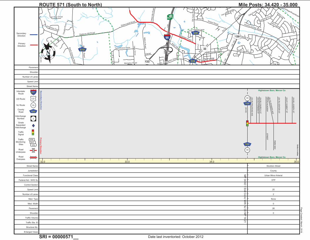
Mile Posts: 34.420 - 35.000
13
61
36
9
Date last inventoried: October 2012
Page C
reate
d: M
arc
h, 2
019
32.0 33.0 34.0 35.0
MP
34.4
2 =
End C
oin
c W
ith N
J 3
3 M
P 1
4.2
1
Hightstown Boro, Mercer Co
Hightstown Boro, Mercer Co
(34.4
2)
(34.4
6) R
AIL
RO
AD
AV
E
(34.5
3) F
OR
MA
N S
T
(34.5
6) C
HU
RC
H S
T
(34.6
4) A
CA
DE
MY
ST
RE
ET
(34.7
3) R
OG
ER
S A
VE
PA
RK
WA
Y
(34.7
8) C
EN
TE
R S
T
(34.8
7) S
UM
MIT
ST
(34.9
5) J
OS
EP
H S
T
33
539
33
539
Street Name Stockton Street
Jurisdiction County
Functional Class Urban Minor Arterial
Federal Aid - NHS Sy STP
Control Section
Speed Limit 25
Number of Lanes 2
Med. Type None
Med. Width 0
Pavement 28
Shoulder 0
Traffic Volume
Traffic Sta. ID
Structure No.
Enlarged Views
Pavement
Shoulder
Number of Lanes
Speed Limit
Street Name
Hightstown Road
US
130
On
e M
ile R
oa
d
Old
Tre
nto
n R
oad
Oa
k L
ane
So
uth
fie
ld R
oad
Dut
chneck
Roa
d
Win
dso
r C
ente
r D
rive Nnp
Stockton Street
Wyndmoor Drive
Millsto
ne R
oad
La
nn
ing
Bo
ule
va
rd
Hag
em
ou
nt
US
130
130
133
535
Prim
ary
Dire
ctio
nS
eco
nd
ary
Dire
ctio
n
22
33
689
2
Interstate
Route
US Route
NJ Route
County
Road
Interchange
Number
Grade
Separated
Interchange
Traffic
Signal
Traffic
Monitoring
Sites
Road
Underpass
Road
Overpass
WIM
AVC
VOL
Un
its in
mile
s
Primary
Direction
Secondary
Direction
287
ROUTE 571 (South to North)
SRI = 00000571__
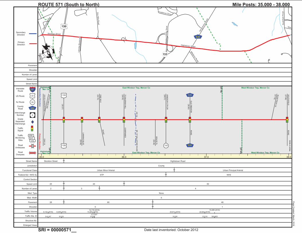
Mile Posts: 35.000 - 38.000
13
61
37
0
Date last inventoried: October 2012
Page C
reate
d: M
arc
h, 2
019
35.0 36.0 37.0 38.0
(35.1
1)
Hightstown, Mer. Co.
(35.1
1)Hightstown,
Mer. Co.
(35.1
1)
(37.1
9)
East Windsor Twp, Mercer Co
(35.1
1)
(37.4
3)East Windsor Twp, Mercer Co
(37.1
9)
West Windsor Twp, Mercer Co
(37.4
3) West Windsor Twp, Mercer Co
(36.1
4)
BR
. OF
MIL
LS
TO
NE
RIV
ER
DU
TC
H N
EC
K R
D
OA
K L
N(3
5.0
2) H
AR
RO
N A
VE
(35.2
7)
LA
NN
ING
BLV
D
(35.4
9)
ON
E M
ILE
(35.7
0)
RO
AD
TO
McG
RA
W H
ILL
(36.0
0)
CO
MP
AN
IES B
RA
CE
PL
(36.3
8)
WIN
DS
OR
CT
R D
R
(36.5
1)
RO
AD
OLD
TR
EN
TO
N
(36.8
0)
McG
ET
RIC
K L
N(3
7.7
9)
SO
UT
HF
IELD
(37.9
8)
RO
AD
130
130
133 535
535
Street Name Stockton Street Hightstown Road
Jurisdiction County
Functional Class Urban Minor Arterial Urban Principal Arterial
Federal Aid - NHS Sy STP NHS
Control Section
Speed Limit 25 45 50
Number of Lanes 2 3 4
Med. Type None
Med. Width 0
Pavement 28 60 48
Shoulder 0 1
Traffic Volume 8,142 (2018) 8,459 (2016) 13,267 (2016)14,718 (2016)
25,611 (2016) 22,624 (2018)19,289 (2016)
Traffic Sta. ID 5-6-167 91120 911085-7-007
91109 121116 5t5c905
Structure No.
Enlarged Views
Pavement
Shoulder
Number of Lanes
Speed Limit
Street Name
Hightstown Road
Nnp
South
field
Road
Cla
rksvill
e R
oa
d
North
Mil l R
oad
Rabbit H
ill Road
Wallace
Ro
ad
Suffolk Lane
Haverford R
oad
Prio
ry R
oa
d
Harris R
oad
Davenport Drive
Gle
ngarry
Way
Sco
tt Aven
ueLanw
in Boulevard
Landing Lane
Norchester Drive
Cra
nbury
Road
Berk
shire D
rive
Hendrickson Drive
Reve
re C
ourt
Sher
bro
oke
DriveSarah D
rive
Westbrook Boulevard
West Kincaid Drive
Abington Lane
New Edinburg Road
Piedmont D
rive
Braemar Drive
Roseland Court
Cartwright Dr West
Woo
dla
nd C
ou
rt
Kinder Court
64
638
607
615
526
Prim
ary
Dire
ctio
nS
eco
nd
ary
Dire
ctio
n
22
33
689
2
Interstate
Route
US Route
NJ Route
County
Road
Interchange
Number
Grade
Separated
Interchange
Traffic
Signal
Traffic
Monitoring
Sites
Road
Underpass
Road
Overpass
WIM
AVC
VOL
Un
its in
mile
s
Primary
Direction
Secondary
Direction
287
ROUTE 571 (South to North)
SRI = 00000571__
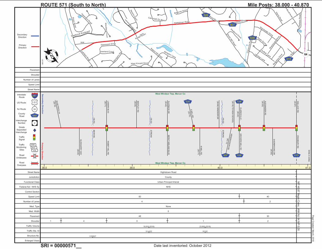
Mile Posts: 38.000 - 40.870
13
61
37
1
Date last inventoried: October 2012
Page C
reate
d: M
arc
h, 2
019
38.0 39.0 40.0 41.0
MP
40.8
7 B
egin
Coin
c. W
ith N
J 6
4 M
P 0
.00
West Windsor Twp, Mercer Co
West Windsor Twp, Mercer Co
(38.5
5)
BE
AR
BK
.
(39.2
0)
ST
RE
AM
(40.0
2)
ST
RE
AM
McG
ET
RIC
K L
N
(38.1
9)
GLE
NG
AR
RY
WA
Y
(38.4
0)
LA
NW
IN B
LV
D
(38.7
1)
RA
BB
IT H
ILL R
D
BE
NT
LE
Y R
D
(39.0
5)
BE
RN
T M
IDLA
ND
BLV
DS
LA
YB
AC
K D
R
(39.4
0)
S M
ILL R
D
(39.7
0)
N M
ILL R
D
(39.7
7)
(39.9
9) W
IND
SO
R D
R
HE
ND
RIC
KS
ON
RD
(40.1
3)
(40.1
6) T
O H
IGH
SC
HO
OL
CLA
RK
SV
ILLE
-
(40.2
2)
GR
OV
ER
S M
ILL R
D
ALE
XA
ND
ER
RD
(40.5
0)
SH
ER
BR
OO
KE
DR
(40.6
0)
WA
LLA
CE
RD
(40.8
7)
CR
AN
BU
RY
RD
526
607
638
638 615
Street Name Hightstown Road
Jurisdiction County
Functional Class Urban Principal Arterial
Federal Aid - NHS Sy NHS
Control Section
Speed Limit 50 40
Number of Lanes 4 2
Med. Type None
Med. Width 0
Pavement 48 30
Shoulder 1 4 0 1 2
Traffic Volume 19,916 (2016) 23,903 (2016)
Traffic Sta. ID 5-3-022 91132
Structure No. 1107627
Enlarged Views
Pavement
Shoulder
Number of Lanes
Speed Limit
Street Name
Washington Road
Fa
cu
lty R
oa
d
Nassa
u S
tree
t
Herb
ert H
igh
wa
y
Varsity Avenue
Murray Place
Fisher Place
Mather Avenue
Pro
sp
ect
Ave
nu
e
Ivy L
an
e
Fieldstone Road
Weste
rn W
ay
Will
iam
Str
ee
t
Pa
rk P
lace
Hightstown Road
Walla
ce
Ro
ad
Chestnut Street
Fa
irvie
w A
ve
nu
e
Herb
ert H
igh
wa
y
Fisher Place27
64
Prim
ary
Dire
ctio
nS
eco
nd
ary
Dire
ctio
n
22
33
689
2
Interstate
Route
US Route
NJ Route
County
Road
Interchange
Number
Grade
Separated
Interchange
Traffic
Signal
Traffic
Monitoring
Sites
Road
Underpass
Road
Overpass
WIM
AVC
VOL
Un
its in
mile
s
Primary
Direction
Secondary
Direction
287
ROUTE 571 (South to North)
SRI = 00000571__
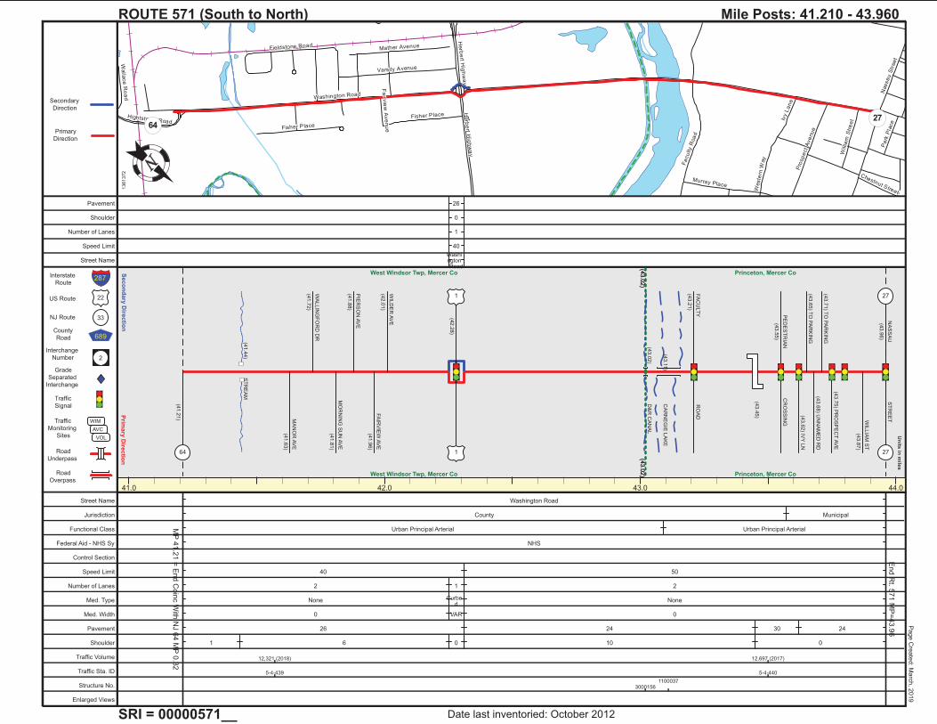
Mile Posts: 41.210 - 43.960
13
61
37
2
Date last inventoried: October 2012
Page C
reate
d: M
arc
h, 2
019
41.0 42.0 43.0 44.0
MP
41.2
1 =
End C
oin
c W
ith N
J 6
4 M
P 0
.32
End R
t. 571 M
P=
43.9
6
(43.0
2)
West Windsor Twp, Mercer Co
(43.0
2)West Windsor Twp, Mercer Co
(43.0
2)
Princeton, Mercer Co
(43.0
2) Princeton, Mercer Co
(41.4
4)
ST
RE
AM
(43.0
2)
D&
R C
AN
AL
(43.1
1)
CA
RN
EG
IE L
AK
E
(43.4
5)
(41.2
1) M
AN
OR
AV
E
(41.6
3)
WA
LLIN
GF
OR
D D
R
(41.7
2)
MO
RN
ING
SU
N A
VE
(41.8
1)
PIE
RS
ON
AV
E
(41.8
8)
FA
IRV
IEW
AV
E
(41.9
6)
WIL
DE
R A
VE
(42.0
1)
64
(42.2
8)
1
1
FA
CU
LT
Y
(43.2
1)
RO
AD
PE
DE
ST
RIA
N
(43.5
5)
CR
OS
SIN
G
(43.6
2) IV
Y L
N
(43.6
5) T
O P
AR
KIN
G
(43.6
8) U
NN
AM
ED
RD
(43.7
1) T
O P
AR
KIN
G
(43.7
5) P
RO
SP
EC
T A
VE
WIL
LIA
M S
T
(43.8
7)
NA
SS
AU
(43.9
6)
ST
RE
ET
27
27
Street Name Washington Road
Jurisdiction County Municipal
Functional Class Urban Principal Arterial Urban Principal Arterial
Federal Aid - NHS Sy NHS
Control Section
Speed Limit 40 50
Number of Lanes 2 1 2
Med. Type None Curbe d
None
Med. Width 0 VAR 0
Pavement 26 24 30 24
Shoulder 1 6 0 10 0
Traffic Volume 12,321 (2018) 12,697 (2017)
Traffic Sta. ID 5-4-439 5-4-440
Structure No. 30001561100037
Enlarged Views
Pavement 26
Shoulder 0
Number of Lanes 1
Speed Limit 40
Street NameWashi ngton Road
Top Related