


Languages
Pages
Legal


U.S. DEPARTMENT OF THE INTERIOR NATIONAL PARK SERVICE
RECORD OF DECISION
RESTORATION OF THE MARIPOSA GROVE OF GIANT SEQUOIAS
FINAL ENVIRONMENTAL IMPACT STATEMENT
Yosemite National Park, California
INTRODUCTION
The National Park Service (NPS) at Yosemite National Park has prepared this Record of Decision for the
Restoration of the Mariposa Grove of Giant Sequoias Final Environmental Impact Statement (Mariposa
Grove/FEIS). This document includes a brief description of the project background and objectives, a
statement of the decision and discussion of the basis for the decision, a summary of the other
alternatives considered, a description of the environmentally preferred alternative, a description of the
measures that will be implemented to minimize or avoid environmental harm (including a Statement
of Finding for Wetlands), and an overview of public involvement and agency consultation.
In addition, pursuant to NPS Management Policies, the park manager’s determination of no impairment
of park resources and values is attached.
BACKGROUND
In 1864, the U.S. Congress passed landmark legislation granting Yosemite Valley and the Mariposa Grove
of Big Trees to the State of California. The statute decreed that both Yosemite Valley and the Mariposa
Grove of Big Trees were set aside “… for public use, resort, and recreation; [and] shall be inalienable for
all time.” Protection of Mariposa Grove was crucial at that time, as logging was ongoing in other giant
sequoia groves in California. Mariposa Grove was incorporated into Yosemite National Park in 1906.
The Mariposa Grove of Giant Sequoias supports about 500 mature giant sequoia trees. It is the largest of
three giant sequoia groves within Yosemite National Park, containing 86 percent of the park’s mapped
adult giant sequoias. The NPS estimates that more than one million visitors visit the Mariposa Grove
annually. The giant sequoia ecosystem provides habitat for a variety of wildlife including the Pacific
fisher, a candidate species for federal listing under the Endangered Species Act. There is a rich cultural
history in the Mariposa Grove area including pre-contact and historic-era archeological resources,
several historic properties either listed or eligible for listing on the National Register of Historic Places,
American Indian traditional cultural resources, and the adult giant sequoia trees. The museum building
was constructed circa 1930 near the former site of a cabin originally constructed in 1864 by Galen Clark,
the first government-appointed guardian of the Mariposa Grove of Big Trees. The Mariposa Grove of
Giant Sequoias and its varied flora and fauna and natural topographic prominences (e.g., Wawona
Point), along with certain of the archeological sites, also represent traditional cultural resources of
importance to traditionally associated American Indian tribes and groups.
The NPS developed the Mariposa Grove/FEIS in response to conditions in the Mariposa Grove area
(including the South Entrance to Yosemite National Park) that adversely affect the ecological health of
the Grove and diminish the quality of the visitor experience. Current conditions adversely affecting the
ecological health of the Grove include the following:

Roads, trails, and other infrastructure disrupt the natural hydrologic functioning of the Grove.
Buildings and infrastructure concentrated in the lower Grove area encroach on individual giant sequoias and their roots, and reduce habitat for giant sequoia propagation.
Ongoing foot and vehicle traffic throughout the Grove is damaging giant sequoia trunks, compacting soils, and exposing shallow giant sequoia roots, potentially making the trees less resilient and more susceptible to external stressors.
The deteriorated water distribution system through the Grove is leaking thousands of gallons of chlorinated water per day, and may be affecting shallow hydrology and local vegetation.
Current conditions diminishing the quality of the visitor experience include the following:
Current wayfinding and orientation information is not sufficient for visitors upon arrival at the Grove and while on trails within the Grove.
Poor road conditions cause seasonal closures, limit vehicle types, and are a safety concern for visitors and park employees.
The Grove parking lot often fills to capacity early in the day, forcing temporary closures of the lot and Mariposa Grove Road, and causing visitor frustration as they are redirected to limited overflow parking at South Entrance or to Wawona to await a shuttle to return to the Grove.
Shuttles from Wawona to the Grove are often full when they arrive at the South Entrance shuttle stop, limiting boarding there and increasing visitor wait times.
Trails and facilities in and around the Grove need improvements to reduce grades and/or increase connectivity to provide better universal accessibility.
Operation of the commercial tram within the Grove creates vehicle/pedestrian conflicts along the loop road, and intrudes on the experience of pedestrian visitors seeking to enjoy the majestic setting and natural soundscapes, particularly in the upper, more remote areas of the Grove.
The vault toilets in the lower Grove area are inadequate and not fully accessible, and are the source of nuisance odors that detract from the Grove experience.
The historic comfort station and the associated septic system and leach field in the upper Grove area should address water-use efficiency and maintainability goals.
Historic features at Wawona Point, including the masonry overlook wall, steps, and railing, are in disrepair and require repairs to meet current standards.
DECISION (Selected Action)
Upon consideration of the concerns and issues raised during the conservation planning and
environmental impact analysis process, with due consideration for all public comments received during
scoping as well as review of the Draft EIS, and in light of applicable laws, regulations, and NPS guidance,
the NPS has selected Alternative 2, South Entrance Hub for implementation. Alternative 2 was identified
as the park’s Preferred Alternative in the October 2013 Mariposa Grove/FEIS. The Selected Action is
substantially the same as described for Alternative 2 in the Final EIS. The Selected Alternative includes
the following components that will be implemented as staffing and funding allow.

Remove Existing Parking from the Lower Grove Area and Restore Giant Sequoia and Wetland Habitat
The NPS will remove the existing lower Grove parking lot and restore giant sequoia and wetland habitat
in the lower and upper Grove areas. This will entail removing asphalt, decompacting soils, recontouring
topography, and revegetating the site with local native plants. By removing non-essential buildings and
infrastructure; protecting the roots of giant sequoias from the impacts of roads, trails, and foot traffic;
removing impediments to natural surface and subsurface water flow; the NPS can effectively preserve,
protect, and restore the ecosystem of the Mariposa Grove.
Improve Hydrology Related to Roads
Hydrologic flows through the Mariposa Grove area are a primary process that sustains the giant sequoia
trees and associated wetlands. Existing drainage culverts will be repaired or replaced, and roads and
trails within the Grove will be graded or outsloped, where appropriate, to promote unimpeded sheet
flow and infiltration of snowmelt and rainwater. These improvements will reduce channelization and
erosion, and correct flow barriers that divert water within the Grove and the Grove watershed. Routine
inspection and maintenance will be required to keep culverts clear of debris and sediment.
Remove Gift Shop from Lower Grove Area
The existing concessioner-operated gift shop and the associated diesel-powered generator will be
removed from the lower Grove area. The gift shop building intrudes into the natural setting of the
Mariposa Grove, and the generator is a source of noise and air pollution.
Reconfigure the South Entrance as a Transit Hub and Contact Area
Parking at the South Entrance will expand from 20 spaces to a total of 295 standard, oversize, accessible,
and shuttle/bus parking spaces. The parking lot at South Entrance will replace the 115 parking spaces
removed from the lower Grove area as well as over 100 parking spaces currently used for the shuttle in
the vicinity of the Wawona store. Parking capacity estimates will accommodate existing levels of
visitation at the Grove.
A shuttle bus boarding and tour bus transfer area will facilitate visitor use of the park shuttle service to
travel to the lower Grove area. New visitor services will be provided, including visitor information and
educational and other sales items.
Provide Pedestrian Access from South Entrance to Mariposa Grove
The segment of the abandoned Washburn Road alignment from the South Entrance to the Mariposa
Grove Road picnic area will be rehabilitated as a pedestrian trail. At least two foot-trail bridges will be
constructed to cross streams. A new trail will be constructed in the segment from the picnic area to the
lower Grove area.
Remove Tram Operations
The concessioner-operated commercial tram staging area and tram operations will be removed from
Mariposa Grove. The current tram ticketing and turn-around area in the lower Grove area will be
repurposed to a small transit node to accommodate shuttle and school bus loading and unloading, and
accessible parking for placarded private vehicles.

Adjust Shuttle Service and Traffic Control
The shuttle service to the Grove will continue to operate between the South Entrance and the lower
Grove area. A separate, limited-schedule shuttle will connect visitors staying at Wawona (including
visitors at the hotel and campground), with the South Entrance area where they will be able to catch the
shuttle to the Grove. Outside of normal shuttle hours and during the shoulder seasons when the
shuttles are not running, visitors will be provided vehicular access to the lower Grove area (in the transit
turn-around) or the picnic area along Mariposa Grove Road where parking for a combined total of 50-80
vehicles will be available. The potential for early morning as well as late-day use of the spaces will be
contingent upon the hours of shuttle operation. Only placarded or service vehicles will be provided
access to the Grizzly Giant during normal shuttle hours of operation. Traffic control during periods of
heavy visitation (typically the summer, weekends and on holidays) will continue. Road closures because
of snow conditions in the winter will continue.
Adjust Commercial Bus Tours
Commercial buses will stop at the South Entrance for visitor orientation, restrooms, and transfer to
shuttles. Depending on facility capacity and shuttle operations, buses less than 40 feet long may drop off
passengers in the lower Grove area and park at the South Entrance. In the future, the NPS may need to
institute a permit reservation system for commercial tour buses, if demand exceeds the capacity of the
septic system or commercial bus parking spaces.
Convert the Upper Grove Loop Road to a Pedestrian Trail
The southern portion of the currently paved historic loop road will be converted to a pedestrian trail.
This portion of the loop has a remarkable density of giant sequoias and will be an exceptional pedestrian
pathway. Many giant sequoias grow within close proximity to the pavement and as the trees expand in
diameter, the width of the road becomes too narrow for vehicles to traverse without impacting their
roots and trunks.
Convert the Upper Portion of Mariposa Grove Road to a Hardened Pedestrian Trail
The segment of the Mariposa Grove Road extending from the Grizzly Giant to Wawona Point will be
converted into a hardened trail, but occasional use by service vehicles will be allowed, including those
needing access to maintain the telecommunications equipment located at Wawona Point
Extend Footbridge
An existing pedestrian bridge in the vicinity of the Fallen Monarch will be removed and replaced with an
extended footbridge to reduce impacts on the wetland.
Improve Universal Accessibility
Integrated, universally accessible [compliant with Architectural Barriers Act Accessibility Standards
(ABAAS) ] transportation hubs/nodes, parking spaces, comfort stations, interpretive signs and displays,
and trails at the South Entrance Station and lower Grove area will allow park visitors with a greater
range of physical abilities to experience and enjoy the Mariposa Grove. Visitors with vehicles displaying
accessible parking placards or NPS vehicles will drive through the lower Grove area to the Grizzly Giant.
Several pullouts will allow these visitors to stop and view individual sequoias or groups of sequoias.
Accessible parking spaces will be available at the lower Grove area and the Grizzly Giant for visitors with

accessible parking placards, and the existing vault toilet near the road will be relocated to the Grizzly
Giant parking area. The shuttle originating at the South Entrance will continue to be available to visitors
with limited mobility.
Accessibility improvements (consistent with ABAAS) will be made to the approach to the existing South
Entrance comfort station, which is a contributing feature of the eligible South Entrance Historic District.
Any alterations will be designed to meet the U.S. Secretary of the Interior’s standards for rehabilitation
of historic properties.
Additional accessible trails are proposed in the lower Grove area will allow visitors the opportunity to
enjoy the beauty and tranquility of Yosemite’s giant sequoia forest that does not currently exist. An
accessible trail will be created in the ecologically restored lower Grove area that will include boardwalks
with benches and viewpoints. The accessible trail system will enable all visitors to move beyond the
vicinity of the parking and shuttle boarding area and into the Grove. Visitors could experience the
beauty of the giant sequoias, including the Fallen Monarch, wetlands, streams, and wildlife at their own
pace and in a more natural setting than is currently accessible.
Another, similarly accessible trail will be built connecting a small nearby accessible parking area to the
Grizzly Giant. It will include portions of a previously abandoned trail and existing trails. This trail will
extend past the Grizzly Giant to the California Tunnel Tree, and then beyond to an open overlook on an
adjacent ridge. The overlook will offer visitors a glimpse of the landscape context of the Grove and the
forest, wetlands and streams that comprise the habitat of the giant sequoias. A trail leading to the
adjacent Sierra National Forest is also located at the Grizzly Giant trailhead where the new accessible
parking spaces will be located. A potential accessible trail extension could start here, and wind through
forest, past a massive granite outcrop, to a small wetland within the park boundary.
Rehabilitate Wawona Point
The historic features at Wawona Point will be rehabilitated. Wawona Point provides a scenic vista of the
western edge of the park and the South Fork Merced River valley, stretching toward the Sierra Nevada
foothills and the Central Valley beyond. Historic rehabilitation will include repair of rock work, steps,
paths, and railings, and removal of remnant asphalt pavement in what formerly was a parking area at
the summit. Ecological restoration activities will include revegetation of denuded areas and where
pavement is removed.
Reconstruct the Wawona Road/Mariposa Grove Road Intersection
The intersection of Wawona Road and Mariposa Grove Road will be reconstructed and possibly
realigned if traffic conditions warrant. The NPS will consider an option for a roundabout in this area if
the recent kiosk improvements at the South Entrance do not adequately address congestion for visitors
coming into the South Entrance from Fish Camp. The roundabout would be optimally located for the site
conditions and roadway requirements, and will accommodate the existing type and volume of traffic
using the intersection. Realignment of the intersection is intended to reduce risk of collisions, better
accommodate larger vehicles, increase the intersection’s vehicle traffic capacity, improve clarity of
wayfinding and travel directions for visitors, reduce traffic congestion at the intersection, and improve
working conditions for NPS staff.

Realign the Road at the Entrance to the Grove
The road at the entrance to the Grove could be realigned to enhance restoration efforts and straighten
the existing tight curve near the giant sequoias in the vicinity of the Three Sentinels. This work will likely
be completed in conjunction with the resurfacing of the Mariposa Grove Road between South Entrance
and the Grove. The crossing over the creek (e.g., box culvert or bridge) would be relocated to improve
safety, control erosion of the drainage channel, and avoid giant sequoias.
Modify Water Supply System
The leaking water distribution piping will be repaired or replaced. The pipeline is leaking chlorinated
water, and may be affecting local hydrology and vegetation. A 400-ft. segment of the distribution piping
that runs in the Rattlesnake Creek drainage will be decommissioned (removed or pipe-burst) and
replaced under the road to Wawona Point. The water treatment and storage units in the upper Grove
area will be relocated in the vicinity of the intersection of the loop road and the road to Wawona Point.
Repurpose the Museum Building
The museum building will remain, however, its function as a primary interpretive facility for the Grove
will be moved to the new transit hub location at the South Entrance. The museum building may be
repurposed as a group hiker’s shelter, meeting room, or other compatible use.
Improve Orientation and Wayfinding
Additional signage will be provided where needed to provide clearer orientation and direction to visitors
upon arrival at the South Entrance and within the Mariposa Grove.
Improve Visitor Education and Interpretation
Additional interpretive wayside, orientation, and informational exhibits and a visitor contact station will
be provided to better educate Mariposa Grove visitors. Interpretation will include historic and cultural
uses in the Grove and American Indian traditional cultural resources and practices.
Improve Structure and Utility Sustainability
For relocated facilities, actions will be undertaken in accordance with the National Park Service Guiding
Principles of Sustainable Design (1993) and A Sense of Place – Design Guidelines for Yosemite National
Park (2012). These principles include the orientation of buildings to optimize seasonal solar exposures
and to minimize the effects of prevailing winds, design that incorporates the use of natural ventilation,
energy-efficient lighting, and the installation of energy- and water-efficient fixtures and utilities.
Monitor Project Success
A monitoring plan will be developed prior to project implementation to define the target forest
condition and metrics for evaluating the success of restoration efforts as well as defining targeted
conditions for the visitor experience.
OTHER ALTERNATIVES CONSIDERED
Alternative 1, No Action

This alternative would continue current management into the future, with no changes to existing
facilities, transportation systems, or services. Maintenance and operation of existing facilities such as
the parking lot in the lower Grove area and concessioner-provided commercial services including the
commercial tram and gift shop would continue.
Alternative 3, Grizzly Giant Hub
Alternative 3 would relocate public parking and visitor information services from the lower Grove area
to a location in proximity to the Grizzly Giant, but outside the extent of giant sequoia habitat. The
existing road, gift shop, parking area, and commercial tram staging would be removed from the lower
Grove area to allow for comprehensive restoration of wetland and giant sequoia habitat. Tram
operations would be eliminated within the Grove. A new road would be constructed around the lower
Grove area to the new Grizzly Giant visitor parking area.
Alternative 4, South Entrance Hub with Modified Commercial Tram Service
Alternative 4 would be similar to Alternative 2, but under this alternative, the commercial tram staging
area would be moved to South Entrance, and commercial tram operations would continue between the
South Entrance and the vicinity of the museum building in the upper Grove area.
PRELIMINARY OPTIONS CONSIDERED BUT DISMISSED
The Council on Environmental Quality guidelines for implementing the National Environmental Policy
Act (NEPA) requires federal agencies to analyze all “reasonable” alternatives that substantially meet the
purpose and need for the proposed action. Under NEPA, an alternative may be eliminated from detailed
study for the following reasons [40 CFR 1504.14 (a)]:
“Technical or economic infeasibility;” the inability to meet project objectives or resolve need for the project in a cost-efficient manner
Duplication of other less environmentally damaging alternatives
Conflicts with an up-to-date valid plan, statement of purpose and significance, or other policy; therefore would require a major change in that plan or policy to implement
Environmental impacts too great
The following alternatives or actions were considered during the alternatives development phase of the
conservation planning process, but were not carried forward for full environmental impact analysis
because they met one or more of the above criteria.
Lower Grove Area Hub
This alternative was developed to explore low-cost changes that could make a significant difference in
resolving the major issues at the Mariposa Grove. In this alternative, the commercial tram would be
removed, the Mariposa Grove parking lot would have a smaller footprint, and modest giant sequoia
habitat restoration could be achieved in the lower Grove area that would improve existing conditions.
An accessible trail could be constructed, and restroom accessibility at the lower Grove area could be
greatly improved. This conceptual alternative had an accessible viewpoint overlooking the Grizzly Giant,
but no accessible trails. The primary arrival point and contact area for visitors would have remained in
the lower Grove area, and access and parking would remain fragmented at the Grove, South Entrance,

and Wawona. The alternative, though offering some restoration opportunities, did not adequately
address the purpose and need components of addressing the sustained overflow parking problems at
South Entrance and the subsequent adverse impact on visitor access times and visitor experience. In
addition, lower Grove area buildings and infrastructure that are currently adversely impacting giant
sequoias as well as other sensitive resources such as wetlands would have remained under this
alternative. Because this alternative did not adequately meet the project purpose and need, it was
dismissed from further analysis.
South Entrance Hub, Complete Commercial Tram Road Removal, Relocate Wawona Point Communications Equipment
This alternative was developed to provide extensive giant sequoia habitat restoration by completely
removing and restoring the existing commercial tram/service road from the lower Grove area to
Wawona Point, including the upper Grove area loop road. Other aspects of this alternative were
essentially the same as the Alternative 2, South Entrance Hub. To eliminate the service road, the NPS
would have had to relocate the communications tower recently installed at Wawona Point. The location
of the Wawona Point communications tower is a critical component of the park-wide communications
network. The tower requires periodic maintenance (e.g., refueling) throughout the year, and therefore
must be accessible via a roadway for service vehicles.
The park reviewed possible sites for tower relocation, but the only suitable alternate location lies within
designated wilderness, and relocation costs would be prohibitive, possibly exceeding several million
dollars. The project team also considered alternate power supply for the Wawona Point equipment, but
determined that new power transmission lines would cross designated wilderness, solar panels would
be unreliable in the winter due to snow cover, and delivery of propane via other transportation modes
(e.g., helicopter) during winter months would require extensive site preparation and would be expensive
and unreliable during inclement weather. Because the communications tower and the current fueling
system could not reasonably be relocated or replaced, the “full” restoration benefits envisioned in this
alternative could not be realized, and the alternative ended up being nearly identical to Alternative 2,
South Entrance Hub. Therefore, this alternative was dismissed from further analysis. Under the retained
action alternatives, the road to Wawona Point would be converted into a hardened trail and maintained
for occasional vehicular use until the telecommunications tower becomes obsolete due to technological
advances, after which more permeable trail surfaces may be explored.
Studhorse Parking
NPS considered adding supplemental parking at the Studhorse parking area located on Wawona Road
between Wawona and the South Entrance, to support visitation at the Mariposa Grove. However, the
area’s proximity to designated wilderness and topographic constraints made a new large parking lot
infeasible in the area. In addition, the South Entrance area, being in closer proximity to the Grove,
provides more logical centralized placement for Grove visitor parking. Therefore, this area was
dismissed as a possible parking component of the alternatives, and was not evaluated further.
Sierra National Forest Parking
NPS considered collaborating with the U.S. Department of Agriculture, Forest Service to create a
collection/parking hub and visitor contact area for Mariposa Grove in the Goat Meadow snow play area

on Sierra National Forest land, or using Sierra National Forest land for road access. Extensive issues with
road widening and fee collection were identified. Complications of planning and managing an out-of-
park site with multiple jurisdictions, and a desire to have parking and other visitor facilities closer to the
Grove and within the boundaries of the park led to the dismissal of this option.
New Parking at South Entrance West of Wawona Road
The NPS considered an option to develop new parking on the west side of Wawona Road, near the
Wawona Road/ Mariposa Grove Road intersection. Initial analysis indicated this option would be
problematic in terms of topography, visitor orientation, traffic flow, and pedestrian safety. The main
concerns were safety of entrances and exits on the Wawona Road curve, and safety for pedestrians
crossing the highway. A vehicle or pedestrian underpass beneath Wawona Road was considered to
mitigate some of the safety concerns, but the difficulty in maintaining efficient operations at the South
Entrance due to parking congestion coupled with the cost associated with a grade separation at this
location, led to dismissal of this alternative. Operational issues were also a concern, as the park service
rangers’ shooting range would be close to the proposed visitor parking. Parking on the east side of the
road is more intuitive for people going eastward from South Entrance to Mariposa Grove and allows for
a simpler transition for people entering the park from the south. This option also would displace the
existing septic system and leach field at South Entrance. The possibility of routing wastewater from
South Entrance to the Wawona treatment plant via a new sewer line that would be constructed along
Wawona Road also was considered. However, the 7-mile-long sewer line was determined to be cost-
prohibitive at an estimated cost of $12 million to $14 million, and this option was dismissed.
Oakhurst or Fish Camp Parking and Visitor Contact
The NPS considered developing a visitor contact area (and parking outside park boundaries in Fish Camp
or Oakhurst. Complexities with land and building ownership outside the park, and a desire to locate
visitor facilities for the Mariposa Grove closer to the Grove and within the boundaries of the park led to
the dismissal of this option.
BASIS FOR DECISION
After careful consideration of each alternative and its foreseeable environmental impacts, the expressed
purpose and need for federal action, and all public and agency comments, including comments on the
Restoration of the Mariposa Grove of Giant Sequoias Draft Environmental Impact Statement (Mariposa
Grove/Draft EIS), Alternative 2, has been selected for implementation. This alternative best complies
with NPS management policies, the legislated purposes of Mariposa Grove and Yosemite National Park,
and the statutory mission of the park to provide long-term protection of Yosemite National Park’s
resources and values while allowing for visitor use and visitor enjoyment.
The NPS has determined that the Selected Action will:
Restore the natural habitat of the giant sequoias, including restoration of wetlands by removing
unnecessary road and building infrastructure, improving water flow impacted by roads and
trails, and eliminating leaking chlorinated water from the water supply system
Protect the special status Pacific fisher by concentrating vehicles and visitor use away from
prime denning habitat and reducing private vehicle traffic on the Mariposa Grove Road

Improve universal access in the lower Grove area and at the Grizzly Giant by constructing a new
trail, providing additional parking, and improving restrooms
Provide a better opportunity for all visitors to experience the awe and beauty of the unique
natural setting by reducing vehicle and generator noise and exhaust fumes within giant sequoia
habitat
Restore the lower Grove area as a visitor destination in itself, rather than a staging area,
allowing a fulfilling giant sequoia grove experience for visitors with limited mobility and/or
time, and a better transition to the more remote parts of the Grove
Provide a variety of experiences for visitors by constructing a pedestrian trail from South
Entrance to the lower Grove area, an accessible trail in the lower Grove area, and wide trails
(converted from roads) in the upper Grove area
As documented in the final EIS, the following key factors support implementation of the Selected Action:
The environmental impact analyses demonstrate that the Selected Action will have short-term
impacts and some adverse effects, but will ultimately secure long-term benefits for Yosemite
National Park resources
The Selected Action has a high likelihood of achieving the expressed purpose, need, goals, and
objectives as articulated in the draft and final EIS
The Selected Action fulfills the vision for restoring park resources as described in the 1980
General Management Plan for Yosemite National Park
The Selected Action is fully compliant with NPS’s mission and policies, and other pertinent laws
and regulations, and in particular fosters the preservation of the park in a state of nature as set
forth in the 1916 Act
The Selected Action specifies all feasible and prudent measures to minimize environmental
harm
The Selected Action was crafted through several years of public involvement and agency
coordination, and is a reasonable and rational course of action supported by park partners,
researchers, and local communities
Undertaking the Selected Action will not impair park resources and values
ENVIRONMENTALLY PREFERRED ALTERNATIVE
In accordance with NPS Director’s Order 12: Conservation Planning, Environmental Impact Analysis, and
Decision-making and Council on Environmental Quality requirements, the NPS is required to identify the
“environmentally preferred alternative.” The environmentally preferred alternative is determined by
applying the criteria listed in NEPA Section 101(b). The Council on Environmental Quality (46 Federal
Register 18026-18038) states that the “environmentally preferable alternative is the alternative that
would promote the national environmental policy as expressed in NEPA’s Section 101.” Generally, the
environmentally preferred alternative is the alternative that causes the least damage to the biological
and physical environment and that best protects, preserves, and enhances historic, cultural, and natural
resources (46 Federal Register 18026 – 46 Federal Register 18038). Per Section 101 of NEPA, it is the
responsibility of the federal government to address the following goals:

(1) Fulfill the responsibilities of each generation as trustee of the environment for succeeding
generations.
All of the action alternatives would, to varying degrees, reduce development footprints within
the Mariposa Grove, restore hydrologic and ecological systems to more natural conditions, and
stabilize and/or rehabilitate cultural resources at South Entrance, the Grove, and Wawona Point.
The Selected Action best meets this goal because it will reduce developed area within sequoia
habitat; require the least new development outside sequoia habitat; implement substantial
restoration of wetlands and giant sequoia habitat; and better protect Pacific fishers from road
fatalities on the Mariposa Grove Road and within the Grove. The project will also improve the
soundscape throughout the Grove by eliminating most private vehicle parking in the lower
Grove area during peak-use periods and discontinuing operation of the commercial tram in the
upper Grove area. All of these actions will address visitor and operational services that are
adversely affecting giant sequoia habitat and will provide the best opportunity for sustaining the
long-term health of the Mariposa Grove.
(2) Assure for all visitors safe, healthful, productive, and aesthetically and culturally pleasing
surroundings.
All of the action alternatives would meet this goal. The Selected Action best fulfills this goal for
several of the reasons stated above, in conjunction with affording the best balance of more
efficient visitor transport via shuttle to and from the Grove and relocation of traffic- and
parking-related impacts outside of the Grove. The Selected Action provides universal access to a
quality giant sequoia grove experience in the lower Grove area while preserving a less
developed, more natural visitor experience in the upper Grove area through elimination of the
commercial tram operations and reducing the footprint of trails and roadways. Wayfinding signs
will be placed on the short section of road below the Grizzly Giant to encourage visitors to use
the pedestrian trail instead of the road. This will help separate pedestrians from vehicles with
accessible parking placards going to the Grizzly Giant. The Selected Action assures a safe and
aesthetically and culturally pleasing environment for all Mariposa Grove visitors.
(3) Attain the widest range of beneficial uses of the environment without degradation, risk to
health or safety, or other undesirable and unintended consequences.
The Selected Action will attain the widest range of beneficial uses of the environment while
minimizing further degradation of the sensitive giant sequoia environment, and managing risks
to visitor health and safety concerns by substantially reducing vehicle/pedestrian conflicts
within the Grove. All of the action alternatives would improve sanitary facilities, and reduce
current safety hazards associated with Grove traffic, shuttle stops, and parking. The Selected
Action will also improve visitor safety by separating hikers and pedestrians from roadway traffic,
eliminating the commercial tram service, and redesigning parking areas and shuttle stops,
thereby reducing vehicle/pedestrian conflicts currently associated with shared use of the in-
Grove parking lot and roadway. The road below the Grizzly Giant will be signed to encourage
visitors to use the pedestrian trail to help separate pedestrians from vehicles.

(4) Preserve important historic, cultural, and natural aspects of our national heritage, and maintain,
wherever possible, an environment which supports diversity, and variety of individual choice.
The Selected Action will best restore and preserve the giant sequoias of the Mariposa Grove,
which are important to our national heritage and the development of both state and national
park systems. The Selected Action and Alternative 3 would provide a better opportunity for
solitude in the upper Grove area with the removal of the tram and exclusion of private vehicles.
All of the action alternatives would avoid and/or minimize effects on historic and traditional
cultural aspects of the Grove and South Entrance areas; Alternative 3 would have the least
effect on the historic setting at South Entrance, but would most extensively disturb
archeological resources and alter historic circulation patterns within the Grove by constructing a
new road to a new visitor parking and information hub near the Grizzly Giant.
(5) Achieve a balance between population and resource use which will permit high standards of
living and a wide sharing of life’s amenities.
The Selected Action will reduce in-Grove infrastructure and best conserve energy by significantly
restricting private vehicle access to the Grove and eliminating open-air diesel-powered
generator use and commercial tram operations within the Grove. All action alternatives improve
accessibility to the Grove for visitors with limited mobility. The Selected Action offers the best
opportunity for expanding the range of visitor experiences by expanding accessible trail
opportunities in diverse areas in the lower Grove area and at the Grizzly Giant. The Selected
Action and Alternative 3 would provide a better opportunity for quiet, natural sounds, and
solitude in the upper Grove area with the removal of the tram and private vehicles and enhance
the quality of renewable resources and approach the maximum attainable recycling of
depletable resources.
All of the action alternatives would implement sustainable principles and technologies in
accordance with Guiding Principles of Sustainable Design (NPS 1993). These include recycling of
demolition debris to the extent practicable, using recycled materials in construction, repair or
replacement of inefficient systems, improved operational practices, and installation of energy-
and water-efficient features and utilities. The Selected Action represents the most efficient
management of depletable fossil fuels both by eliminating in-Grove tram operations, open-air
diesel-powered generators, and most private vehicle access during peak visitor season, and by
concentrating visitor and employee parking near a park entrance and implementing efficient
shuttle service using buses that operate on alternative fuels.
In summary, The Selected Action (Alternative 2) on balance best achieves these national environmental
policy goals, and therefore is identified as the environmentally preferred alternative.
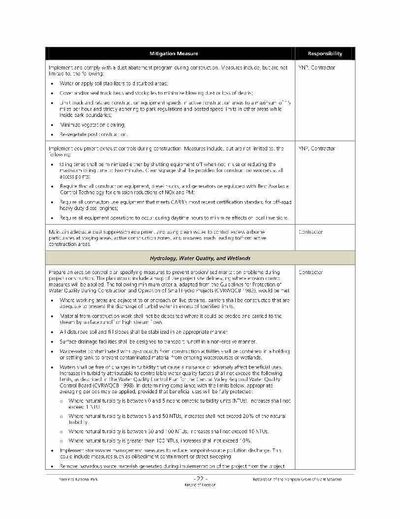
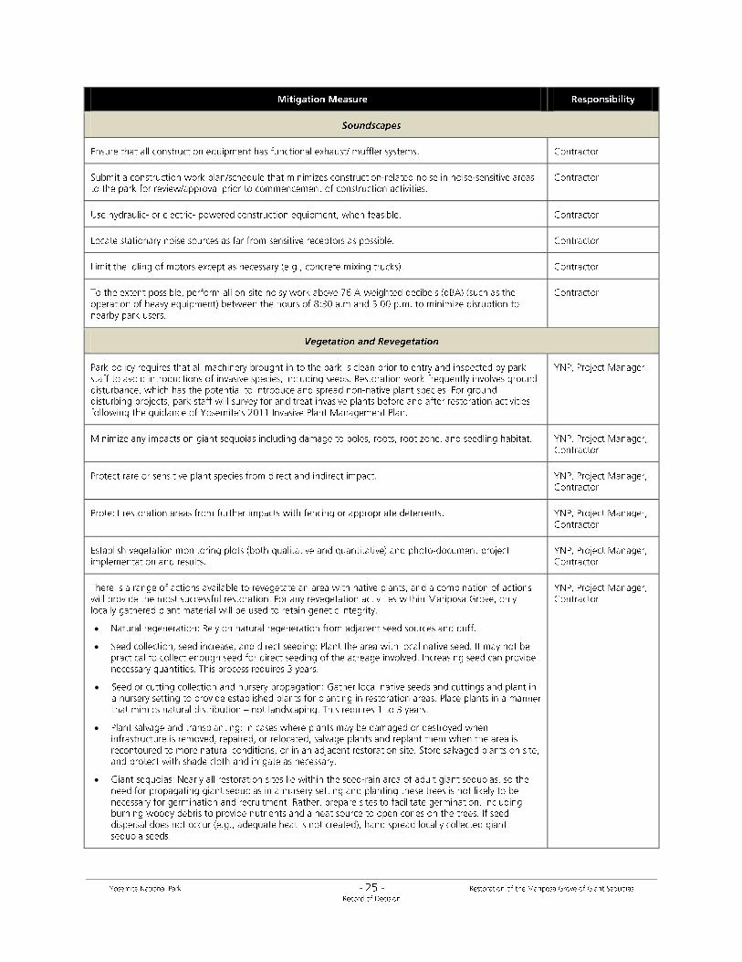
MEASURES TO MINIMIZE ENVIRONMENTAL HARM
The NPS places a strong emphasis on avoidance, minimization, and mitigation of adverse impacts under
NEPA, and adverse effects under the National Historic Preservation Act. To protect natural, cultural, and
social resources and the quality of the visitor experience, mitigation measures will be implemented as
part of the Selected Action as identified in Appendix A. Mitigation measures will occur prior to, during,
and after implementation of all proposed actions. In addition, mitigation measures identified through
consultation with the California State Historic Preservation Officer and traditionally associated American

Indian tribes and groups are identified in a project-specific Memorandum of Agreement, as required
under 36 CFR Part 800 (Appendix B).
Monitoring and enforcement programs will ensure proper and timely implementation of these
measures. The NPS will obtain necessary federal and state permits required to undertake the actions
described in the Selected Action and additional mitigation measures may be identified through those
processes.
PUBLIC INVOLVEMENT AND AGENCY COORDINATION
Project Scoping
The NPS conducted public scoping to understand the spectrum of concerns, interests, and issues to be
considered during the planning process for the Mariposa Grove/EIS. Public open houses took place in
Yosemite Valley on August 31, 2011, September 28, 2011, December 7, 2011, and January 25, 2012 to
inform interested parties about the proposed project and to solicit comments from members of the
public. Public scoping comments were accepted from August 31, 2011, through February 3, 2012. The
park also conducted a public site visit at the Mariposa Grove on October 14, 2011. Approximately 20
interested individuals attended.
The NPS accepted public comments by mail, fax, email, through the Planning, Environment, and Public
Comment (PEPC) website at http://www.parkplanning.nps.gov/mariposagrove, and on comment forms
available at public scoping meetings. During the public scoping period, the park received 43 letters from
41 individuals, one organization – the Sierra Club Yosemite Committee, and one business – the Yosemite
Sierra Visitors Bureau. Analysis of these letters identified 126 discrete substantive comments, from
which 15 general concern statements were generated. All comments received during the scoping period
were carefully read and considered, and are now part of the administrative record for this project.
Concerns which emerged during the public scoping period were largely associated with the ecology and
natural resources of the Grove, visitor use and experience, public health and safety, transportation,
soundscapes, and restroom facilities. The long-term sustainability and health of the Grove’s ecosystem,
along with the negative effect of current visitor amenities at the Grove were key issues raised in public
scoping. Commenters expressed concerns regarding the parking lot in the lower Grove area – it often
fills to capacity, forcing temporary closures of the parking lot, long shuttle rides and traffic congestion at
the South Entrance. Parking lot noise and traffic and vehicle operation on Grove roads also diminish the
visitor experience. Visitor accessibility was inadequate. Safety concerns regarding road configuration,
pedestrian crossings, and access at the South Entrance were also expressed in scoping comments.
Scoping comments addressed the diminished soundscape associated with noise from vehicle traffic and
tram audio presentations. Commenters were also critical of the condition of the existing vault toilets in
the lower Grove area. These comments were primary drivers informing preparation of the Draft EIS.
On June 27, 2012, the NPS shared results of the Choosing by Advantages workshop for the Mariposa Grove
plan with the public at the monthly open house in Yosemite Valley. Design drawings and scoring for each
preliminary alternative were presented, and input received led to the reconsideration of some
alternatives. During this period, internal and agency scoping was conducted in consultation with NPS
managers and staff, traditionally associated American Indian tribes and groups, affected state and federal
agencies, and local and state governments.
Public Review of the Restoration of the Mariposa Grove Draft Environmental Impact Statement
The Mariposa Grove/Draft EIS was available to the public, federal, state, and local agencies and
organizations for a 61-day public review period from March 8, 2013 through May 7, 2013. The U.S.
Environmental Protection Agency published its notice of filing and release of the Draft EIS on March 8,
2013 (the NPS notice of availability was published on March 14, 2013). Electronic copies of the Mariposa
Grove/Draft EIS were posted to the park’s website at www.nps.gov/yose/parkmgmt/mgrove.htm.
Approximately 70 printed copies and/or CDs of the document were distributed to individuals who
requested copies, as well as to congressional delegations, state and local elected officials, federal
agencies, traditionally associated American Indian tribes and groups, organizations and local businesses,
public libraries, and the news media. The NPS provided notice of the plan’s availability for public
comment via a press release distributed to a wide variety of news media, and announcements placed on
the park’s website and in online newsletters, printed newsletters, and local public libraries.
Park staff discussed the Mariposa Grove/Draft EIS via a public webinar on April 9, 2013. In addition, park
staff hosted public meetings on April 12, 2013 (at Tenaya Lodge in Fish Camp, California) and April 24,
2013 (at the Visitor Center Auditorium in Yosemite Valley, California). These two meetings consisted of
an open house, presentation, and an opportunity to discuss the plan with park staff members and to
provide comment.
Public comment letters were received through the PEPC website, by email, and by mail. During the 61-
day public comment period, the park received 335 public comment letters. Two comment letters were
from Federal agencies (U.S. Army Corps of Engineers and the U.S. Environmental Protection Agency
Region 9), one comment letter was from a state agency (California State Clearinghouse and Planning
Unit), five letters were from organizations (Extinction Witness, Central Sierra Environmental Resource
Center, National Parks and Conservation Association, Yosemite/Mariposa County Tourism Bureau,
Yosemite Sierra Visitors Bureau), one letter was from a business (Delaware North Companies Parks and
Resorts at Yosemite, Inc.), and the remainder originated from unaffiliated individuals. The U. S.
Environmental Protection Agency letter (dated May 3, 2013) rated the preferred Alternative (Alternative
2) as “Lack of Objections.” This rating can be summarized as no potential environmental impacts
requiring substantive changes to the proposal.
An analysis of all the combined responses identified 356 discrete comments, from which 68 general
concern statements were generated. The majority of comments received during the public comment
period were statements of support for Alternative 2 (Preferred alternative) (270 correspondences), or
statements of support for restoration efforts in Mariposa Grove (239 correspondences).
Correspondence also reflected concern about access to the upper Grove area for specific users including
people with disabilities, the elderly, or young children (24 correspondences). There were 17
correspondences that asked the National Park Service to consider transportation alternatives to the
current tram system in the upper Grove area.
On November 1, 2013 the U.S. Environmental Protection Agency published its notice of filing of the final
EIS in the Federal Register; initiating the minimum 30 days “no action” waiting period through December
2, 2013. The NPS Notice of Availability was published in the Federal Register on November 5, 2013.
Federal, State, & Tribal Consultation and Coordination
California State Office of Historic Preservation
The NPS is consulting with the California State Office of Historic Preservation under the four-step
process outlined in 36 CFR Part 800. The NPS will continue to consult with the State Historic
Preservation Officer (SHPO) through design and construction of the project as needed. As recommended
by the U.S. Army Corps of Engineers (USACE), the NPS will serve as the lead agency on behalf of the
USACE regarding future consultation with the SHPO regarding permits.
Cultural resources investigations and reports for the Mariposa Grove/EIS were conducted in accordance
with the Section 106 process under 36 CFR Part 800 “Protection of Historic Properties”, the regulations
that implement the National Historic Preservation Act. The NPS initiated consultation with the with a
letter sent on September 30, 2011. A site visit in October 2011 was conducted with the staff of the State
Office of Historic Preservation during the scoping period for the project. On April 11, 2012, the park sent
a letter requesting concurrence for a determination of ineligibility for four archeological sites in the
study area. On June 26, 2012 the park sent a letter requesting concurrence on the amendment to the
Mariposa Grove consensus determination of eligibility. On February 5, 2013, the NPS received a letter
from the California State Office of Historic Preservation concurring with the boundaries of the Area of
Potential Effects (APE); the recommended eligibilities, as well as agreement that historic properties have
been sufficiently identified. The NPS developed a Memorandum of Agreement (MOA) with the SHPO as
part of consultation for this project. The MOA provides the mechanism to resolve the adverse effects of
the Mariposa Grove/EIS and it completes the requirements of Section 106 of the National Historic
Preservation Act (16 U.S.C. Section 470f) and its implementing regulations (36 CFR 800) with regard to
this plan. A draft MOA was included as an appendix to the Mariposa Grove/Final EIS, and the final signed
MOA is included in this Record of Decision (Appendix B).
The Advisory Council on Historic Preservation
The Advisory Council on Historic Preservation (ACHP) was notified of the initiation of the project on
September 30, 2011. Per the ACHP’s November 12, 2011 correspondence, the park submitted follow-up
documentation consistent with 36 CFR §800.11(e) in October, 2013. On December 3, 2013, the ACHP
notified the park of their intention not to participate in the development of the project MOA.
American Indian Consultation
Yosemite National Park consults with seven traditionally associated American Indian tribes and groups
that have ancestral connections to Yosemite National Park: the American Indian Council of Mariposa
County, Inc. (aka Southern Sierra Miwuk Nation), Bishop Paiute Tribe, Bridgeport Indian Colony, Mono
Lake Kutzadikaa, North Fork Rancheria of Mono Indians of California, Picayune Rancheria of the
Chukchansi Indians, and the Tuolumne Band of Me-Wuk Indians. The NPS initiated consultation with
these American Indian tribes and groups in a letter dated October 19, 2011 (with a subsequent
correction letter dated November 28, 2011).
Tribal consultation for this project took place at a number of meetings and tribal site visits. In addition to
consultation meetings with individual tribal groups, all traditionally associated American Indian tribes
and groups were invited to:
An informational project scoping meeting on January 5, 2012. Representatives from the
American Indian Council of Mariposa County, Inc. and the Tuolumne Band of Me-Wuk Indians
attended.
A site visit to the Mariposa Grove on January 11, 2012. Representatives from the American
Indian Council of Mariposa County and the Tuolumne Band of Me-Wuk Indians attended.
A site visit on May 22, 2012. Representatives from the American Indian Council of Mariposa
County, the Tuolumne Band of Me-Wuk Indians, and the Picayune Rancheria of Chukchansi
Indians attended.
A site visit on April 2, 2013. Representatives from the American Indian Council of Mariposa
County, the Tuolumne Band of Me-Wuk Indians, and the North Fork Rancheria of Mono Indians
of California attended.
A site visit on July 10, 2013. Representatives from the American Indian Council of Mariposa
County, the Tuolumne Band of Me-Wuk Indians, the North Fork Rancheria of Mono Indians of
California, and the Picayune Rancheria of the Chukchansi Indians attended.
An All Tribes meeting in Lee Vining on July 12, 2013, which discussed the Mariposa Grove/EIS
among other projects. The American Indian Council of Mariposa County, Inc. (aka Southern
Sierra Miwuk Nation), Bishop Paiute Tribe, Mono Lake Kutzadikaa, North Fork Rancheria of
Mono Indians of California, Picayune Rancheria of the Chukchansi Indians, and the Tuolumne
Band of Me-Wuk Indians attended this meeting.
A consultation meeting on October 1, 2013. Representatives from the American Indian Council
of Mariposa County and the Picayune Rancheria of the Chukchansi Indians attended to discuss
tribal stipulations in the Memorandum of Agreement.
Throughout the tribal consultation process, associated American Indian tribes and groups brought
forward a range of issues, concerns, and proposed actions, including (but not limited to) the following:
Protect culturally significant archeological sites
Remove the gift shop and restore the area to protect archeological resources
Avoid removing black oaks
Avoid impacts on mature trees
Not shifting impacts of the Grove project into previously undisturbed areas
Consider elevated trails to minimize effects on giant sequoia roots
Retain access to Wawona Point for tribal traditional cultural practices
Enhance picnicking opportunities
Minimize impacts of restrooms in the lower Grove area (consider keeping vault toilets)
Provide opportunities for Native American youth to participate in project implementation
Reduce the scale of the parking lots to lessen impacts on resources by keeping shuttle operation
in Wawona
Include information about Native American connections to the Mariposa Grove in interpretive
components
The NPS worked with the American Indian tribes and groups to address these issues and concerns, and
strongly considered these issues and concerns throughout the development of the alternatives. Under
all alternatives, the gift shop would be carefully removed from the underlying archeological site in the
lower Grove area. Plans for developing a shuttle staging area in the lower Grove area were modified
between the draft and final EIS to ensure protection of archeological sites, California black oaks, and
other mature trees where feasible. Elevated trails (including boardwalks) are part of the design of all
new proposed accessible trails. Access to Wawona Point for tribal gatherings will continue. Trailside

interpretive components to emphasize Native American connections to the Mariposa Grove will be
focused within the sequoia grove. The NPS is actively pursuing opportunities to engage American Indian
youth in project implementation, particularly in ecological restoration activities and trail construction.
The NPS minimized the size of the South Entrance parking lot to the extent possible to meet the goals of
the plan. Alternatives 2 through 4 in the EIS do not retain the large shuttle operation from Wawona to
the Mariposa Grove, as proposed by some traditionally associated tribal groups. Rather, the shuttle
operation from Wawona will be substantially reduced as more parking becomes available closer to the
Grove at the South Entrance. The new parking at the South Entrance will reduce congestion and
roadside parking in Wawona and eliminate the need for backtracking (e.g., visitors driving to the Grove
from Yosemite Valley or the South Entrance, finding the lot at the Grove or the South Entrance full,
driving back to Wawona to park, then taking the shuttle back to the Grove).
The NPS will continue to consult with traditionally associated American Indian tribes and groups
throughout project design and implementation. The NPS developed a Memorandum of Agreement
(Appendix B) in consultation with the SHPO. The Memorandum of Agreement includes stipulations to
avoid, minimize and mitigate adverse effects to historic properties with traditional cultural and religious
significance to American Indian tribes. The NPS invited associated American Indian tribes and groups to
sign as concurring parties to the Memorandum of Agreement.
U.S. Fish and Wildlife Service
The Endangered Species Act of 1973, as amended (16 USC 1531 et seq.), requires federal agencies to
consult with the U.S. Fish and Wildlife Service (USFWS) to ensure that any action authorized, funded, or
carried out by the agency does not jeopardize the continued existence of listed species or critical
habitat. The NPS initially obtained a list of federally listed endangered and threatened species that may
be present in the South Entrance area and the Mariposa Grove from the USFWS on November 14, 2011,
and compared this list to park records. The list was updated regularly and used as the basis for the
special status species analysis in the EIS. On March 15, 2012, the park contacted the USFWS regarding
the candidate species Pacific fisher and Sierra Nevada red frog, and the timing of potential listing under
the Endangered Species Act. On May 3, 2012, the park entered into informal consultation with the
USFWS to develop appropriate mitigation measures and proactive habitat improvements. The NPS
provided the USFWS with a set of draft mitigation measures to protect the Pacific fisher on June 24,
2013. The USFWS concurred in a June 3, 2013 email that “it would be unlikely that the implementation
of alternative 2 of the Mariposa Grove of Giant Sequoias Draft Environmental Impact Statement would
result in adverse effects to fisher.” Should the Pacific fisher subsequently be proposed for listing or listed
under the Endangered Species Act during implementation of the Mariposa Grove project, the NPS will
continue conferencing or consultation with the USFWS as appropriate.
U.S. Army Corps of Engineers, Regulatory Board
The Clean Water Act (Public Law 92-500) requires federal land agencies to consult with the U.S. Army
Corps of Engineers (USACE) regarding wetlands located in or near proposed projects. The NPS is
consulting with the USACE regarding the Mariposa Grove/FEIS in accordance with Section 404 of the
Clean Water Act (33 U.S.C. 1344) and Section 10 (33 U.S.C. 403) of the Rivers and Harbors Act.
Under Section 404 of the Clean Water Act, permit approval is required for projects that may result in the
discharge of dredged or fill material into waters of the United States. This includes all navigable waters,
their tributaries, impoundments of these waters, and adjacent wetlands. Examples of Section 404

activities include infrastructure development, road fills, and riprap. Some actions proposed in the
Mariposa Grove/FEIS may require permits for the discharge of fill material. The NPS will obtain required
Section 404 permits prior to implementing any such actions.
Under Section 10 of the Rivers and Harbors Act, permit approval is required for the placement of
structures in or over, or work in or over, navigable waters of the United States which affects their
course, location, condition, or capacity. The NPS will ensure that all USACE permit approvals associated
with the Mariposa Grove/FEIS are in place prior to implementation.
The NPS provided a copy of the draft and final EIS to the USACE, and the USACE responded with a
comment letter on April 11, 2013, in support of the alternative that restores and protects the most
waters of the United States. The Selected Alternative (and Alternative 3) would restore the most waters
of the United States among the alternatives. Between the draft and final EIS, the NPS was able to reduce
potential impacts to wetlands associated with construction of the South Entrance transit hub from direct
impacts to indirect impacts. The NPS is working with USACE to ensure that wetland maps associated
with the Mariposa Grove/FEIS are verified per USACE standards prior to submittal of permit applications.
State Water Resources Control Board and Central Valley Regional Water Quality Control Board
The NPS works with state and local government agencies to maintain the highest possible water quality
standards and to take action to restore substandard waters as directed by NPS Management Policies
2006 and Director’s Order 84, Public Health (2004).
The State Water Resources Control Board (SWRCB) and the nine Regional Water Quality Control Boards
(RWQCBs) are the regulatory boards within California’s Environmental Protection Agency that derive
their authority from §401 of the Clean Water Act and Section 13020 of the California Water Code. The
SWRCB allocates rights to the use of surface water and, along with the regional boards, is charged with
protecting surface, ground, and coastal waters throughout the state. The RWQCB issues permits that
govern and restrict the amount of pollutants discharged into the ground or surface water, which
includes regulating storm water during construction activities. Under §401, every applicant for a federal
permit or license for any activity that may result in a discharge to a water body must obtain State Water
Quality Certification that the proposed activity will comply with state water quality standards.
Yosemite National Park is under the jurisdiction of Regional Board V, Central Valley, and obtains any
necessary permits and/or certifications for construction activities from that board. If required, the NPS
will file a Notice of Intent to discharge storm water and prepare and implement provisions of a Storm
Water Pollution Prevention Plan to control run-off from construction activities. The NPS provided a copy
of the Mariposa Grove draft and final EIS to the RWQCB, who in turn notified the NPS that they will
provide input as part of future permitting processes, as necessary.
NPS Water Resources Division
A Wetland Statement of Findings is a required component of this project, per NPS Director’s Order #77-
1: Wetland Protection, which establishes the policies, requirements, and standards for implementing
Executive Order 11990 (Protection of Wetlands); this analysis is required when an alternative proposed
for implementation could result in adverse impacts on wetlands.
The Draft and Final Mariposa Grove/EIS included a draft Wetland Statement of Finding for public review
(Appendix F in the Final EIS). NPS park staff worked with the NPS Water Resources Division to ensure
technical adequacy and Servicewide consistency of the Wetland Statement of Findings for the Mariposa


o
o
o
o


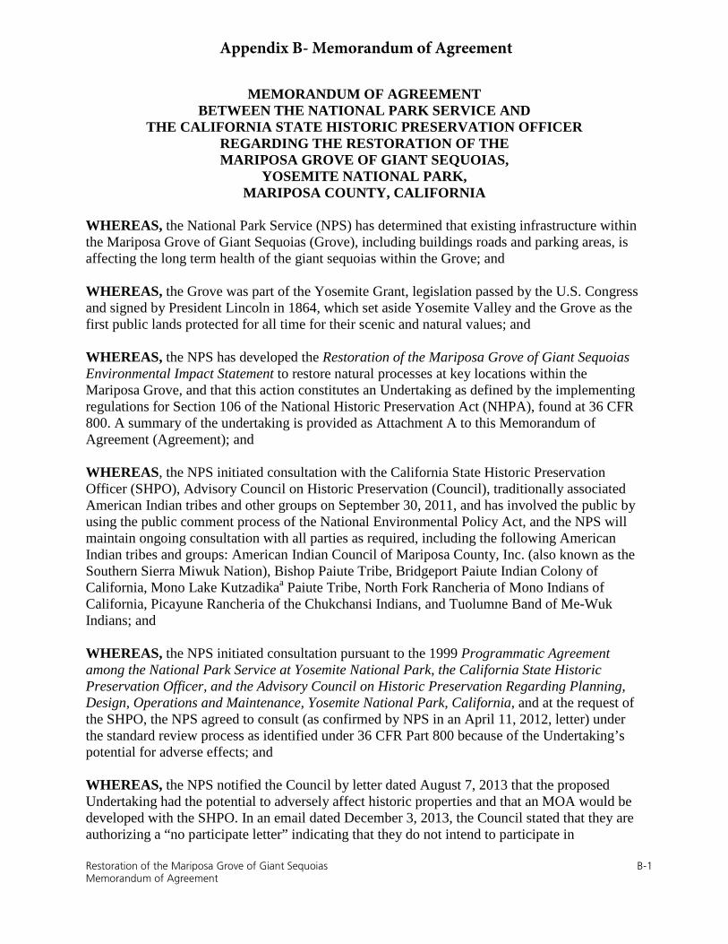
MEMORANDUM OF AGREEMENT BETWEEN THE NATIONAL PARK SERVICE AND
THE CALIFORNIA STATE HISTORIC PRESERVATION OFFICER REGARDING THE RESTORATION OF THE MARIPOSA GROVE OF GIANT SEQUOIAS,
YOSEMITE NATIONAL PARK, MARIPOSA COUNTY, CALIFORNIA
WHEREAS, the National Park Service (NPS) has determined that existing infrastructure within the Mariposa Grove of Giant Sequoias (Grove), including buildings roads and parking areas, is affecting the long term health of the giant sequoias within the Grove; and
WHEREAS, the Grove was part of the Yosemite Grant, legislation passed by the U.S. Congress and signed by President Lincoln in 1864, which set aside Yosemite Valley and the Grove as the first public lands protected for all time for their scenic and natural values; and
WHEREAS, the NPS has developed the Restoration of the Mariposa Grove of Giant Sequoias Environmental Impact Statement to restore natural processes at key locations within the Mariposa Grove, and that this action constitutes an Undertaking as defined by the implementing regulations for Section 106 of the National Historic Preservation Act (NHPA), found at 36 CFR 800. A summary of the undertaking is provided as Attachment A to this Memorandum of Agreement (Agreement); and
WHEREAS, the NPS initiated consultation with the California State Historic Preservation Officer (SHPO), Advisory Council on Historic Preservation (Council), traditionally associated American Indian tribes and other groups on September 30, 2011, and has involved the public by using the public comment process of the National Environmental Policy Act, and the NPS will maintain ongoing consultation with all parties as required, including the following American Indian tribes and groups: American Indian Council of Mariposa County, Inc. (also known as the Southern Sierra Miwuk Nation), Bishop Paiute Tribe, Bridgeport Paiute Indian Colony of California, Mono Lake Kutzadikaa Paiute Tribe, North Fork Rancheria of Mono Indians of California, Picayune Rancheria of the Chukchansi Indians, and Tuolumne Band of Me-Wuk Indians; and
WHEREAS, the NPS initiated consultation pursuant to the 1999 Programmatic Agreement among the National Park Service at Yosemite National Park, the California State Historic Preservation Officer, and the Advisory Council on Historic Preservation Regarding Planning, Design, Operations and Maintenance, Yosemite National Park, California, and at the request of the SHPO, the NPS agreed to consult (as confirmed by NPS in an April 11, 2012, letter) under the standard review process as identified under 36 CFR Part 800 because of the Undertaking’s potential for adverse effects; and
WHEREAS, the NPS notified the Council by letter dated August 7, 2013 that the proposed Undertaking had the potential to adversely affect historic properties and that an MOA would be developed with the SHPO. In an email dated December 3, 2013, the Council stated that they are authorizing a “no participate letter” indicating that they do not intend to participate in
Restoration of the Mariposa Grove of Giant Sequoias B-1 Memorandum of Agreement
Appendix B- Memorandum of Agreement

development of this Agreement. If any of the consulting parties contact the Council, the Council may provide technical advice and/or revisit this decision.
WHEREAS, the Area of Potential Effect (APE) was defined as the combined Mariposa Grove historic district and the South Entrance Station historic district, which includes the 4-square-mile area comprising the original 1864 Yosemite Grant, the Mariposa Grove Road, and the Mariposa Grove Archeological District (Attachment B of this Agreement provides a map that shows the extent of the APE including associated trails, roads, parking lots, and buildings); and
WHEREAS, the Mariposa Grove Museum was listed in the National Register of Historic Places in 1978; the Mariposa Grove Archeological District was listed in 1980; the SHPO concurred with the NPS that both the Mariposa Grove and the South Entrance Station were eligible for listing in the National Register of Historic Places in 2004; and the Mariposa Grove determination of eligibility was amended to include the Mariposa Grove Road between the South Entrance and the Grove in 2013; and
WHEREAS, through consultation, the NPS and SHPO agree that the Undertaking will constitute an adverse effect to the Mariposa Grove historic district as a result of the effects of the proposed actions to the historic road and trail system within the Grove; and
WHEREAS, the NPS and SHPO agree that the Undertaking will adversely affect archeological resources as a result of the construction of parking areas near the South Entrance Station and Grove picnic area and potentially adversely affect archeological resources in the lower Grove area; and
WHEREAS, the NPS and SHPO agree that the Undertaking will adversely affect resources of importance to traditionally associated American Indian tribes and groups; and
WHEREAS, this Agreement provides the mechanism to resolve the adverse effects of the Undertaking and complete any and all requirements of Section 106 of the National Historic Preservation Act (16 U.S.C. Section 470f) and its implementing regulations, 36 CFR 800, with regard to any activities relating to the Undertaking.
NOW, THEREFORE, the NPS and SHPO agree that the Undertaking shall be implemented in accordance with the following stipulations to take into account the effect of the Undertaking on historic properties, American Indian traditional cultural resources, and archeological resources and that these stipulations shall govern the Undertaking until this Agreement expires.
STIPULATIONS
The NPS shall implement the following stipulations:
I. Stipulations for Mitigation Measures to resolve the adverse effects of the Undertaking
A. Update of National Register of Historic Places Nominations and Determinations of Eligibility
Restoration of the Mariposa Grove of Giant Sequoias B-2 Memorandum of Agreement

1. Nomination Updates for the Mariposa Grove Archeological District. Within threeyears of completion of the Undertaking, the NPS shall prepare an amendment to theMariposa Grove Archeological District National Register nomination to update thenomination with currently available information, incorporate tribal culturalperspectives, complete ethno-historic research, and reflect any changes to the districtresulting from the Undertaking. The NPS shall submit the amendment to associatedAmerican Indian tribes and groups and the SHPO for review and comment (30-dayreview period, or additional time as requested). Within six months of the receipt ofthe comments, the NPS shall address the comments and forward the amendment tothe Keeper of the National Register.
2. National Register Nomination for the Mariposa Grove of Giant Sequoias.Within three years of completion of the Undertaking associated with the proposedrestoration of the Grove, the NPS shall prepare a National Register Nomination forthe Mariposa Grove historic district that includes changes resulting from theUndertaking. The NPS shall submit the draft nomination to the SHPO and associatedAmerican Indian tribes and groups for review and concurrence before forwarding tothe Keeper of the National Register of Historic Places. The NPS shall explore thefeasibility of combining the historic and archeological nominations into one historicdistrict.
3. Determination of Eligibility (DOE) Update for the Historic Districts Affected.Within three years of completion of the Undertaking associated with the proposedconstruction of a roundabout at the South Entrance Station, the NPS shall update theSouth Entrance Historic District Cultural Landscape Inventory to reflect changes tothe district resulting from the Undertaking. The NPS shall submit the amendment toSHPO for review and concurrence.
B. Additional Measures to Address Tribal Cultural Values
1. Tribal Cultural Monitors. Actions involving ground disturbance within or adjacentto the boundaries of known ethnographic resources (including archeological sites)shall be conducted with a tribal monitor present to ensure that archeological datarecovery, restoration, or construction actions do not adversely affect resources withreligious or cultural significance.
2. Youth Engagement. The NPS shall pursue opportunities to engage tribal youth in theimplementation of the Mariposa Grove restoration project. Such engagement mayinclude participation in activities such as trail construction and ecological restoration.
3. Collaboration with Tribal Native Plant Nursery. The NPS shall collaborate withthe Tuolumne Band of Me-wuk Indians Four Seasons Native Plant Nursery toproduce native plant materials for use in ecological restoration activities.
4. Traditional Cultural Activities. The NPS shall provide an opportunity fortraditionally associated tribes and groups to perform traditional cultural activities atsite CA-MRP-660/H prior to the commencement of construction activities.
Restoration of the Mariposa Grove of Giant Sequoias B-3 Memorandum of Agreement

5. Protection of Culturally Significant California Black Oaks. The NPS shall ensureprotection of California black oaks in the immediate vicinity of CA-MRP-661/H andthe forested loop/island north of the site.
C. Archeological Resources Treatments
1. Archeological Data Recovery Excavations. The NPS shall conduct archeologicaldata recovery excavations at CA-MRP-660/H, and possibly at -661/H dependingupon final project design. These excavations shall incorporate measures to protecttribal cultural values. Excavations shall conform to standard archeologicalpreservation practices as specified in the Secretary of the Interior’s Standards forTreatment of Archeological and Historic Properties, and NPS guidance formanagement and treatment of archeological resources. The research design(s) for datarecovery shall be consistent with the Yosemite Archeological Synthesis and ResearchDesign and other current direction. NPS shall submit research design(s) and draftreport(s) of findings for review by SHPO, traditionally associated tribes and groups,and professional peers within the agency. NPS shall submit copies of final reports toSHPO and traditionally associated tribes and groups, and incorporate digital versionsof the reports into the Yosemite Digital Science Library. All resultant records, data,and archeological materials shall be archived into the Yosemite Museum Collectionsconsistent with NPS standards for archeological materials and data.
2. Archeological Construction Monitoring
a. Minor Ground Disturbance. Actions involving minor ground disturbancewithin or adjacent to the boundaries of known archeological sites shall beconducted with an archeological monitor present to ensure that restoration orconstruction actions do not result in unanticipated damage to archeologicalresources.
b. Moderate To Severe Ground Disturbance. Management actions involvingmoderate to severe ground disturbance (e.g., trail reroutes; formalization ofsocial trails; excavations for subsurface utilities; removal of abandonedinfrastructure and/or facilities; construction of buildings, structures, parkinglots, and roads; topographic recontouring; decompaction and plant salvage;and actions that may focus visitor use at areas with sensitive surfaceresources) within or adjacent to the boundaries of known archeological sitesshall be preceded by intensive surface survey and/or controlled subsurfacetesting.
c. American Indian resource monitoring shall be conducted pursuant toStipulation I.B.1 of this Agreement.
3. Inadvertent Discoveries
a. In the event that either cultural resources are discovered, or historic propertiesare inadvertently affected, during implementation of the undertaking which
Restoration of the Mariposa Grove of Giant Sequoias B-4 Memorandum of Agreement

has been duly considered under the terms of this Agreement, the NPS shall submit written notification describing the circumstances of the discovery to the SHPO within two working days (e.g., letter or email notification).
b. The NPS shall train all members of restoration and construction teams inrecognizing and proper handling of inadvertent discovery of archaeologicalresources. Training shall inform personnel about the types of archeologicalmaterials that are likely present in the specific project area, how to identifyarcheological materials, and the procedures for contacting the appropriateparties in the event that archeological materials are encountered duringrestoration or construction activities. If buried archeological resources such asflaked stone or groundstone, historic debris, building foundations, middensoils or human bone are inadvertently discovered during ground-disturbingactivities, work shall stop in that area and within a 100-foot radius of the finduntil a qualified archeologist can assess the significance of the find.
c. Inadvertent discoveries shall be treated in accordance with 36 CFR 800.13(Protection of Historic Properties: Post-review discoveries). The archeologicalresource shall be assessed for its eligibility for listing on the National Registerin consultation with the SHPO and representatives of traditionally associatedAmerican Indian tribes and groups, and a determination of the project effectson the site shall be made. If the site will be adversely affected, a treatmentplan shall also be prepared as needed during the assessment of the site’ssignificance. Assessment of inadvertent discoveries may require archeologicalexcavations and/or archival research to determine resource significance.Treatment plans shall be developed in consultation with the SHPO andtraditionally associated tribes and groups and will evaluate avoidance, projectredesign, and data recovery alternatives before outlining actions proposed toresolve adverse effects.
d. If human skeletal remains are encountered, protocols under federal and statelaw shall apply. All work shall stop in the vicinity of the discovery, and thefind shall be secured and protected in place. The Park Law EnforcementOfficer, county coroner, Park NAGPRA Coordinator, and Park Archeologistshall be notified immediately. If analysis determines that the remains areAmerican Indian, and that no further coroner investigation of the cause ofdeath is required, the coroner will then be required to contact the NAHC(pursuant to Section 7050.5[c] of the California Health and Safety Code). Theremains shall also be treated in accordance with the Native American GravesProtection and Repatriation Regulations at 43 CFR 10.4 (Inadvertentdiscoveries).
D. Other Documentation
1. Photo-documentation. Prior to implementing any construction, deconstruction, orremoval aspects of this Undertaking, the NPS shall photo-document those portions ofthe Mariposa Grove and South Entrance historic districts that will be directly affected
Restoration of the Mariposa Grove of Giant Sequoias B-5 Memorandum of Agreement

by the undertaking. Photo-documentation shall entail:
a. 35 mm negatives (photos do not need to be from a large format camera),
b. Photo captions or narratives are not required, however information regardingtime, photographer, etc. shall be recorded and submitted. Locations shall be abrief description with GPS coordinates, UTM CONUS 1984, zone 11N,
c. Two full sets of photos on 5”x7” archival paper are required; additional printsand contact sheets are not required. Prints and negatives shall be placed inarchival polyester photograph/negative sleeves,
d. Two copies of photos on archival DVD-R or CD-R. Photos files shall beeither RAW or uncompressed TIFF format, PC compatible, a minimumresolution of 2000 dpi on a 5”x7” sized file,
e. Photos shall be taken by a professional photographer with experience instructures or built landscape documentation or an NPS employee withprofessional photography experience or training in historic preservation, and
f. Photo documentation shall be of sufficient detail so that a similar structuremay be reconstructed to appear similar in the future. At least one photoshowing the broader surrounding context of each structure is required.
2. Archeological documentation. Archeological documentation shall follow the Stateof California Historic Resource recording format.
3. Completion Reporting. Within three years of the completion of the Undertaking, theNPS shall complete the following:
a. Completion Report. Documentation shall consist of a completion reportnoting methods, contributing resource documentation, and detailed State ofCalifornia historic resource records for archeological sites. Photographicdocumentation of archeological sites shall follow standards for State ofCalifornia Historical Records. Information shall also be entered into the NPSList of Classified Structures and Cultural Landscapes Inventory databases as ameans of tracking changes to contributing elements of the historic districts.
b. Submission of products. Five copies of the Completion Report, thenegatives, prints, and associated records, shall be prepared according to NPSarchival standards as specified by Yosemite Archives. Image files should be aminimum of 1200 dpi at 8”x10” size in RAW format. Three copies shall beaccessioned into the Yosemite Museum Collections. The NPS shall send twoarchival copies and one digital copy of documentation to SHPO for theirrecords and distribution to the California Historical Resources InformationSystem. Yosemite National Park shall file a copy of the Completion Report inthe Yosemite Archives.
Restoration of the Mariposa Grove of Giant Sequoias B-6 Memorandum of Agreement

c. Digital copies of products. A digital copy of all materials produced for thisproject shall be included in the archival materials accessioned into theYosemite Museum Collections, and incorporated into the Yosemite DigitalScience Library.
E. Salvage During field documentation efforts, the Yosemite historical architect, historical landscape architect, curator and/or preservation specialist shall identify any architectural or masonry elements, objects, and materials proposed for removal or demolition that may be reused in rehabilitating similar historic structures or landscapes, or that may be suitable for accessioning into the Yosemite Museum Collection.
F. Interpretation NPS shall prepare interpretive materials pertaining to cultural, historical, and archeological resources. Interpretive materials shall be developed in conjunction with ongoing consultation with Yosemite’s traditionally associated American Indian Tribes and groups. Interpretation shall include information related to American Indian traditional cultural resources and archeological resources within the Mariposa Grove and South Entrance historic districts and the Mariposa Grove Archeological District. The history of timber operations in the vicinity of the South Entrance Station shall also be addressed through waysides and other interpretive media and include interpretation of extant features such as logging machinery, structural remnants of the logging operation and remnant trees utilized in support of the logging operation. The history of Chinese involvement in Washburn Family operations, especially road construction, shall be incorporated into interpretive components along the Washburn Wagon Road.
G. Site Clean-up and Materials and Features to be Left in Place
1. Historic Road Surfacing. Where historic road surfacing is modified, the overallroadway prism (extending from the base of the road fill to the inboard edge of theroad) shall be retained so that extent of the road as historic feature is still intact.Exceptions include those portions of the road that will be slightly modified/regradedto restore sheet flow of storm water along the uphill side of the roads.
2. Drainage Ditches. In instances where drainage ditches divert water away from thesequoias, the ditches will be modified to restore the natural flow of storm water to thesequoias. In such instances, the extent of the fill slope along the roads will be retainedbut the cut slope portions will be modified in support of restoring natural hydrologicfunctions.
II. Standards and Special Conditions
A. DefinitionsThe definitions provided at 36 CFR 800.16 are applicable throughout this Agreement.
B. Project Standards The standards, guidelines, regulations, and codes cited below shall be followed in
Restoration of the Mariposa Grove of Giant Sequoias B-7 Memorandum of Agreement

execution of the Undertaking:
1. Professional qualification standards. All historic preservation activitiesimplemented pursuant to this Agreement shall be carried out by or under the directsupervision of individuals meeting the Secretary of Interior’s ProfessionalQualifications Standards (48 FR 44738-39) for the discipline appropriate to theactivity.
2. Standards for inventory, evaluation, registration, and documentation. Anyinventory, evaluation, registration, or documentation of historic properties completedas per this Agreement shall conform to the Secretary of the Interior’s Standards andGuidelines for Archeology and Historic Preservation (48 FR 44716-44740) and toapplicable guidelines and conventions established by NPS and SHPO.
3. Treatment standards. Any work on historic buildings, structures, and sites shall usethe Secretary of the Interior’s Standards and Guidelines for the Treatment of HistoricProperties.
4. Curation standards. If applicable, curation of materials and records resulting fromactions stipulated by this Agreement shall be in accordance with 36 CFR 79. Suchmaterials and records shall be curated by NPS to the extent permitted by sections5097.98 and 5097.991 of the California Public Resources Code.
5. Disclosure of archeological site information. The signatories to this Agreementacknowledge that historic properties covered by this Agreement are subject to theprovisions of section 304 of the National Historic Preservation Act, as amended, andsection 6254.10 of the California Government Code (Public Records Act), relating tothe disclosure of archeological site information. All actions and documentationprescribed by this Agreement must be consistent with these sections.
C. Discoveries and Unanticipated Effects If the NPS encounters a previously unidentified property that may be eligible for the National Register during the Undertaking, or if it appears that a known historic property will be affected in an unanticipated manner, the NPS and SHPO shall follow these procedures:
1. When unanticipated properties are found.
a. The NPS shall halt activities in the vicinity of the previously unidentifiedproperty and take all reasonable measures to avoid or minimize harm to theproperty.
b. The NPS shall notify the SHPO within two (2) working days of the discoveryand provide SHPO with a written assessment via electronic mail. Theassessment shall evaluate the National Register eligibility of the property anddescribe actions proposed to resolve any potential adverse effects.
Restoration of the Mariposa Grove of Giant Sequoias B-8 Memorandum of Agreement

2. SHPO’s recommendation regarding eligibility and proposed actions.
a. The SHPO will respond to the NPS within two (2) working days of thenotification via electronic mail.
b. The NPS shall take into account the SHPO’s recommendations regardingNational Register eligibility and proposed actions and take appropriate action.The NPS shall submit report of the actions to the SHPO within 30-days, orwithin additional time as requested.
III. Administrative Stipulations
A. Amendments Either signatory party may propose amendments to this Agreement. If a signatory proposes an amendment, the other party will consult on its appropriateness pursuant to 36 CFR 800.6(c)(7) and (8). This Agreement may be amended only upon the written agreement of both signatories. The amended Agreement will take effect on the date it is executed by both signatories.
B. Termination The following process will be followed to terminate this Agreement:
1. Proposed termination. A signatory party can propose termination of this Agreementin writing to the other signatory, explaining the reasons for proposing termination.The signatories will consult for 30 days to seek alternatives to termination.
2. Amendment in lieu of termination. If the consultation results in an agreement on analternative to termination, the signatories will proceed to amend this Agreement inaccordance with Stipulation III.A.
3. Failure to agree. If consultation does not result in agreement on an alternative totermination, the party proposing termination may terminate this Agreement bypromptly notifying the other party in writing. Such termination will remove all forceand effect from this Agreement.
4. Process to terminate. Should this Agreement be terminated, the NPS will consultwith SHPO to develop a new agreement in accordance with 36 CFR 800.14(b). Untiland unless a new agreement is executed for the Undertaking, NPS will consult withSHPO in accordance with 36 CFR 800.4 - 6.
C. Dispute Resolution Should any party to this Agreement object at any time to any actions proposed or the manner in which the terms of this Agreement are implemented, all work that is the subject of the dispute will stop until the dispute is resolved according to the procedures in this section and the NPS will consult with the objecting party(ies) to resolve the objection. If the NPS determines, within 30 days, that such objections(s) cannot be resolved, the NPS will:
Restoration of the Mariposa Grove of Giant Sequoias B-9 Memorandum of Agreement

1. Forward all documentation relevant to the dispute to the Council in accordance with36 CFR Section 800.2(b)(2). Upon receipt of adequate documentation, the Councilwill review and advise NPS on the resolution of the objection within 30 days. Anycomment provided by the Council, and all comments from the parties to theAgreement, will be taken into account by the NPS in reaching a final decisionregarding the dispute.
2. If the Council does not provide comments regarding the dispute within 30 days afterreceipt of adequate documentation, the NPS may render a decision regarding thedispute. In reaching its decision, the NPS will take into account all commentsregarding the dispute from the parties to the Agreement.
3. It is the NPS’s responsibility to carry out all other actions subject to the terms of thisAgreement that are not the subject of the dispute remain unchanged. The NPS willnotify all parties of its decision in writing before implementing that portion of theUndertaking subject to dispute under this stipulation. The NPS decision will be final.
D. Annual reporting requirement for this Agreement The park will submit an annual written report on the progress made toward the completion of the requirements of this Agreement and the Undertaking.
E. Duration of this Agreement Unless terminated pursuant to Stipulation III.B, the duration of this Agreement is ten (10) years from the date of its execution or until the Undertaking is complete, whichever is shorter.
F. Effective Date of this Agreement This Agreement will take effect on the date that it is executed by NPS and SHPO.
Restoration of the Mariposa Grove of Giant Sequoias B-10 Memorandum of Agreement

B-

CONCURRING PARTIES
For the American Indian Council of Mariposa County (Southern Sierra Miwuk):
Name Title Date
For the Bishop Paiute Tribe:
Name Title Date
For the Bridgeport Paiute Indian Colony:
Name Title Date
For the Mono Lake Kutzadikaa Paiute Tribe:
Name Title Date
For the North Fork Rancheria of Mono Indians:
Name Title Date
For the Picayune Rancheria of Chukchansi Indians:
Name Title Date
For the Tuolumne Band of Me-Wuk Indians:
Name Title Date
Restoration of the Mariposa Grove of Giant Sequoias 12 Memorandum of Agreement
B-

Attachment A – Description of the Undertaking as proposed in the Restoration of the Mariposa Grove of Giant Sequoias Final Environmental Impact Statement
Alternative 2, South Entrance Hub, the National Park Service’s Preferred Alternative, will remove the majority of visitor parking, commercial tram staging and operations, and the concessioner-operated gift shop from Mariposa Grove to allow for comprehensive restoration of wetlands, soundscape, and giant sequoia habitat. New visitor services for the South Entrance will include visitor information and educational and other sales items. Most parking will be relocated to a South Entrance transit hub. A limited number of parking spaces could be provided in the lower Grove area as well as at the picnic area adjacent to Mariposa Grove Road when the shuttle is not in operation. Vault toilets will be renovated or replaced, and accessible trails will be established in the ecologically restored lower Grove area and at the iconic Grizzly Giant. The abandoned historic Washburn Wagon Road alignment to the Grove will be cleared of vegetation and rehabilitated as a pedestrian path from South Entrance parking lot to the Mariposa Grove Road picnic area. Where the Washburn Wagon Road ends in the vicinity of the existing picnic area, a new trail will be constructed for the remaining distance to the lower portion of the Grove, including a pedestrian bridge across Rattlesnake Creek. An accessible trail will be constructed through the lower Grove area, and an accessible overlook to the Grizzly Giant will be provided. This alternative includes options for realigning the entrance to the Grove to enhance restoration efforts and straighten the existing tight curve near the giant sequoias in the vicinity of the Three Sentinels, which will include a new drainage crossing structure to protect giant sequoias in that area from erosion and from placement of roadway embankment over sensitive root zones. At the South Entrance, the intersection of Wawona Road and Mariposa Grove Road will be realigned to the west of its current location, and a roundabout will replace the current T-intersection, if necessary.
Restoration of the Mariposa Grove of Giant Sequoias A-1 Memorandum of Agreement
Appendix B-

Attachment B - Area of Potential Effect, Restoration of the Mariposa Grove of Giant Sequoias Final Environmental Impact Statement
Restoration of the Mariposa Grove of Giant Sequoias B-1 Memorandum of Agreement
Appendix B -
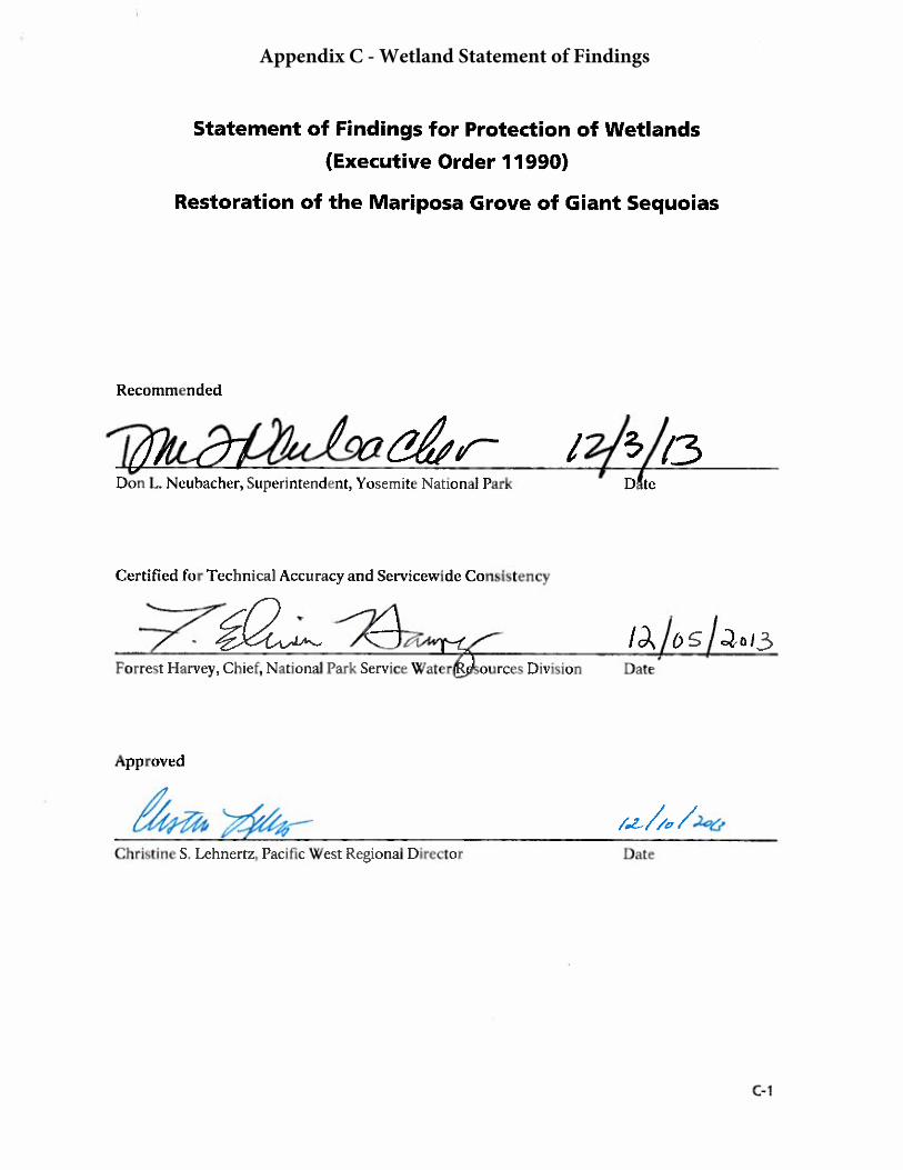
Appendix C - Wetland Statement of Findings

C-2
This page left blank intentionally
Appendix C: Statement of Findings for Protection of Wetlands
INTRODUCTION
The National Park Service (NPS) prepared the Restoration of the Mariposa Grove of Giant Sequoias Final Environmental Impact Statement (Final Mariposa Grove EIS) to restore habitat and natural processes critical to the long-term health of the Mariposa Grove ecosystem, including the giant sequoia trees, wetlands, and associated plant and wildlife communities. This Wetland Statement of Findings is a required component of the Record of Decision for an environmental impact statement, per NPS Director’s Order #77-1: Wetland Protection, which establishes the policies, requirements, and standards for implementing Executive Order 11990 (Protection of Wetlands). A separately identifiable Wetland Statement of Finding is required when an alternative selected for implementation would result in adverse impacts on wetlands. This Statement of Findings:
• Presents the rational for implementation of the proposed project with regard to wetlands,and documents the anticipated effects on wetland resources
• Describes the effects on wetland values associated with the Selected Action
• Provides a thorough description of mitigation measures
• Ensures “no net loss” of wetland functions or values
THE PURPOSE AND NEED FOR ACTION
The Mariposa Grove of Giant Sequoias (figure F-1) is one of the most significant natural and cultural resources in Yosemite National Park. The primary purpose of the proposed project is to restore degraded habitat and natural processes critical to the long-term health of the giant sequoias, wetlands, and associated plant and wildlife communities in the Mariposa Grove, and improve the overall experience for visitors to Mariposa Grove. The following existing conditions have a negative effect on the ecological health and historic context of the Mariposa Grove:
• Road, trails, and other infrastructure are disrupting the natural hydrologic functioning of theMariposa Grove
• Buildings and infrastructure are encroaching on individual giant sequoias and their roots,and reduce habitat for giant sequoia propagation
• Ongoing foot and vehicle traffic throughout the Mariposa Grove is damaging giant sequoiatrunks, compacting soils, and exposing shallow giant sequoia roots, potentially making thetrees less resilient and more susceptible to external stressors
• The risk of catastrophic fire remains high due to heavy fuel loading
In addition, current conditions diminish the quality of the visitor experience including:
• The road configuration at the South entrance to Yosemite is confusing and highly congestedduring periods of high use, creating safety concerns
• Frequent closures of the parking lot and road to the Mariposa Grove contribute to visitorfrustration
• Shuttles from Wawona are often full, limiting boarding and increasing wait times for visitors
• Way-finding is in need of improvement
• Trails and other infrastructure do not meet accessibility requirements
C-3

Appendix C: Statement of Findings for Protection of Wetlands
• Vault toilets are inadequate and not fully accessible, and are the source of nuisance odors
• Operation of the commercial tram throughout the Mariposa Grove createsvehicle/pedestrian conflicts and affects natural soundscapes throughout the Grove
• Historic features at Wawona Point are in disrepair
WETLANDS IN THE MARIPOSA GROVE AREA
Though the Mariposa Grove of Giant Sequoias occupies a small part of Yosemite National Park (less than 900 acres), the Mariposa Grove has exceptional ecological importance. Wetlands in the Grove form an almost continuous, dendritic network making up a significant portion (12.3%) of the Grove’s watershed (figure F-2). Wetlands in the Grove provide important hydrologic support for the Merced River watershed and provide hydrologic functions including aquifer recharge, storm runoff abatement, sediment retention, prevention of erosion through streambank stabilization, and stream/river temperature moderation.
The Mariposa Grove encompasses a great diversity of habitats, plants, and wildlife. The area includes a rich mosaic of old growth mixed conifer forest (with trees of all age classes, standing snags, and large downed trees), streams, wetlands, and a number of special status plant and wildlife species including the pacific fisher. The pacific fisher is a candidate for listing under the Federal Endangered Species Act and has a high likelihood of listing prior to project completion. Several fens, which have a limited distribution in the Sierra Nevada, are present. The location of the giant sequoias strongly links to the presence of wetlands. About 82% of giant sequoias are located within 200 feet of delineated wetlands (Kuhn 2011). This supports conclusions by Halpin (1995) on the importance of topographic flow accumulation, and further signifies the importance of soil water availability within the rooting zone for giant sequoia.
Wetland Extent
The NPS investigated and delineated wetlands in two areas: the Mariposa Grove (figure F-2), and near the park’s South Entrance (figure F-3)1. Specific wetland classes identified within the project area consist of riverine wetlands (rivers, creeks, and streams) and palustrine wetlands (shallow ponds, marshes, swamps, and sloughs). The Mariposa Grove encompasses 90.3 acres of palustrine forested wetland, 1.6 acres of palustrine scrub shrub wetland, 8.8 acres of palustrine emergent wetland, and 2.0 acres of riverine wetlands (NPS 2011a). The surrounding mountain slopes are gentle and incised by approximately 6.1 miles of perennial and 2.8 miles of seasonal streams. Wetlands are continuous along the dendritic network of perennial (6.1 miles) and seasonal (2.8 miles) streams that drain the project area. In and near the South Entrance, 1.4 acres of palustrine forested wetland were delineated (NPS 2011a).
1 A qualified wetland specialist with nine years’ experience as a wetland ecologist, nine additional years of experience as a botanist and restoration ecologist, a M.S. in restoration ecology, a professional certificate in wetland ecology, and U.S. Army Corps of Engineers wetland delineator training conducted the wetland delineation.
C-4

Appendix C: Statement of Findings for Protection of Wetlands
Figure F-1 – Mariposa Grove and South Entrance Vicinity Map (NPS 2011a)
C-5

Appendix C: Statement of Findings for Protection of Wetlands
Figure F-2 – Wetlands in and near the Mariposa Grove of Giant Sequoias (NPS 2011a)
C-6

Appendix C: Statement of Findings for Protection of Wetlands
Figure F-3 – Wetlands at the South Entrance to Yosemite National Park (NPS 2011a)
C-7
Appendix C: Statement of Findings for Protection of Wetlands
Existing Structures in Wetlands
The Mariposa Grove Road crosses through delineated wetland in the lower Grove at several areas where the road climbs toward the upper Grove, and in the upper Grove largely along the upper Grove loop. Roads, parking areas, trails, and visitor facilities are located near giant sequoias and within wetland and rare plant habitat throughout the project area. Infrastructure and visitor use may negatively affect wetland and stream hydrology and function, wetland and rare plant communities, and giant sequoias.
ALTERNATIVES CONSIDERED
To address the issues facing the Mariposa Grove and its visitors, and consistent with goals outlined in the 1980 General Management Plan for Yosemite National Park, the NPS developed a No Action Alternative and three action alternatives that include major actions to ecologically restore the Grove and improve visitor experience.
Many proposed actions are common to the action alternatives including ecological restoration, infrastructure removal or improvement, and actions to improve the visitor experience. These common actions include removal of the parking lot from the lower Grove area and subsequent ecological restoration of giant sequoia habitat; road and trail and culvert repair to improve hydrologic flows; hazardous fuel reduction treatments; repair/replacement of the leaking water distribution system; relocation of the water tank; and improvement of visitor orientation and accessibility. Other components vary among the three action alternatives.
Alternative 1
Alternative 1, No Action, serves as a baseline from which to compare the other alternatives. Alternative 1 would continue the current level of maintenance and operations at the Mariposa Grove of Giant Sequoias. Infrastructure would remain concentrated in the lower part of the Grove and the commercial operation of the tram would continue and the gift shop would remain. Access to Mariposa Grove would remain challenging for visitors during peak use periods. Renovation, rehabilitation, or upgrading of existing facilities to improve functionality and accessibility would occur as emergency actions in response to system failures, rather than as planned and coordinated actions. The current level of interpretation and orientation would stay the same, and utilities and comfort stations would not be upgraded. Stressors on the giant sequoias, wildlife, special status species, and other natural and cultural resources in the Grove and at South Entrance would remain in place, and the visitor experience likely would continue to deteriorate as demand to access and experience the Grove increasingly exceeds the capacity of the current infrastructure to accommodate the number of day-use visitors.
Selected Action (Alternative 2)
The Selected Action (Alternative 2 - South Entrance Hub), will remove the majority of visitor parking, commercial tram staging and operations, and the concessioner-operated gift shop from the Mariposa Grove to allow for comprehensive restoration of wetlands, soundscape, and giant sequoia habitat. Parking, shuttle facilities, and visitor services will be relocated to a South Entrance transit hub. Comfort stations will be renovated or replaced, and accessible trails will be established in the ecologically restored lower Grove area and at the iconic Grizzly Giant. The historic Washburn Trail from South Entrance will be extended as a pedestrian trail from its current terminus at the Mariposa Grove Road picnic area to the lower part of Mariposa Grove. The intersection of Mariposa Grove Road and Wawona Road at South Entrance will be realigned, and a roundabout would replace the current T-intersection to improve traffic flow, if necessary.
C-8

Appendix C: Statement of Findings for Protection of Wetlands
Under the Selected Action there will be a net gain of 1.00-acre of wetlands in highly valued giant sequoia habitat. To achieve these objectives there will be 0.37-acre of wetland impacts in lower value wetland habitat (Table F-1). Overall, there will be a 3.98-acre reduction of developed areas in the Grove. The reduction in development will form a natural buffer around wetlands and improve overall hydrologic flows throughout the Grove.
Alternative 3
Alternative 3, Grizzly Giant Hub, would relocate public parking and visitor services from the lower Grove areas to a location outside giant sequoia habitat in the vicinity of Grizzly Giant. This would include removing the lower Grove area parking lot, gift shop, and commercial tram staging area and operations to allow for comprehensive restoration of giant sequoia habitat, wetlands, and soundscapes. A new road segment with two bridges would be constructed to skirt the lower Grove, and the existing road to Grizzly Giant would be removed. Accessible trails would be constructed in the lower and mid-Grove areas, and comfort stations would be upgraded or replaced. The intersection at South Entrance would be reconstructed as a modified T-intersection to improve traffic flow. All toilets in the Grove would be vault toilets.
Under Alternative 3 there would be a net gain of 1.00-acre of wetlands in highly valued giant sequoia habitat. Overall, there would be a 5.75-acre reduction of developed areas in the Grove. The reduction in development would form a natural buffer around wetlands and improve overall hydrologic flows throughout the Grove. There would be little permanent wetland loss (<0.03-acre). To achieve this large area of restoration, a new road and pedestrian hub would be constructed (mostly outside of giant sequoia habitat). The new road would be constructed in prime fisher denning habitat, due to a lack of alternative locations (Table F-1).
Alternative 4
Alternative 4, South Entrance Hub with Modified Commercial Tram Service, would maintain the commercial tram operations for visitor access and enjoyment, but tram staging would be moved to a South Entrance Hub, similar to that described for the Selected Action, and the route and hours of operation would be reduced to provide a balance between visitor access and opportunities for quiet enjoyment and solitude in the upper part of the Grove. As in the Selected Action, the majority of public parking and visitor services would be relocated to the South Entrance. An accessible trail would be constructed through the lower Grove area, and an accessible overlook to the Grizzly Giant would be provided. The historic Washburn Trail from South Entrance would be extended to the Grove. The current T-intersection design of Mariposa Grove Road and Wawona Road at South Entrance would be retained.
Under Alternative 4, there would be a net gain of 0.77-acre of wetlands in highly valued giant sequoia habitat. To achieve these objectives there would be 0.37-acre of wetland impacts in lower value wetland habitat (Table F-1). Overall, there would be a 1.84-acre reduction of developed areas in the Grove. The reduction in development would form a natural buffer around wetlands and improve overall hydrologic flows throughout the Grove.
C-9

Appendix C: Statement of Findings for Protection of Wetlands
Table F-1. Summary of Restoration, including Wetlands, by Alternative
Alternative 1: No Action
The Selected Action (Alternative 2:
South Entrance Hub)
Alternative 3: Grizzly Giant Hub
Alternative 4: South Entrance with
Modified Commercial Tram
Service Wetland restoration
Lower Grove restoration Road narrowing/Trail conversion
TOTAL
N/A 0.85 acre 0.15 acre
1.00 acre
0.85 acre 0.15 acre
1.00 acre
0.75 acre 0.02 acre
0.77 acre Wetland impacts
Water tank relocation (artificial wetland) South Entrance wetland Roadside wetlands (artificial wetlands) Piers associated with boardwalk
TOTAL
N/A 0.10 acre
0.24 acre 0.02 acre
0.01 acre
0.37 acre
0.00 acre
0.00 acre 0.02 acre
0.01 acre
0.03 acre
0.10 acre
0.24 acre 0.02 acre
0.01 acre
0.37 acre Net change in development project-wide1
Net reduction of developed area within Grove New development at South Entrance New development at Grizzly Giant and bypass road
TOTAL
N/A
-3.98 acre
+4.72 acre
0.00 acre
0.74 acre addition of developed area projectwide
-5.75 acre
0.00 acre
6.25 acre
0.50 acre addition of developed area projectwide
-1.84 acre
+4.72 acre
0.00 acre
2.88 acre addition of developed area
Selection of the Preferred Alternative
The Selected Action of the Final Mariposa Grove EIS best meets the goals and objectives of the project, which include protection and enhancement of wetland resources. Under the Selected Action, the NPS will move the existing parking area out of the Mariposa Grove to a site near the South Entrance to Yosemite and restore a total of 1.0 acre of high value wetland within the Mariposa Grove. A shuttle will take visitors to the entrance of the Grove. Essentially, the Selected Action removes existing development from areas in the Mariposa Grove with high ecological value and moves parking to a site of lower ecological value due to its logging history and lack of giant sequoia habitat. While Alternative 3 would enable 1.0-acre of wetland restoration in giant sequoia habitat and result in no wetland impacts, it would require construction of a new bypass road and parking area in prime fisher denning habitat. Alternative 4 is similar to the Selected Action, but the commercial tram operation would remain along with associated vehicle/pedestrian conflicts and impacts on natural soundscapes throughout the Grove.
The Selected Action protects and enhances fisher habitat and has the lowest overall reduction of developed areas within the Mariposa Grove. In addition, the Selected Action best curtails vehicle traffic on the Mariposa Grove road and within the Grove, restores soundscapes by eliminating most private vehicle parking in the Grove, and discontinues operation of the fee-for-service commercial
1 excluding areas needed for new leach fields
C-10

Appendix C: Statement of Findings for Protection of Wetlands
tram. All these actions will best address visitor and operational services that are adversely affecting giant sequoia (e.g. impeded hydrology, soil compaction in root zones, bark removal and bole damage), and provide the best opportunity to sustain the Mariposa Grove for the enjoyment of future generations.
IMPACTS OF THE PROPOSED ACTION ON WETLANDS
Under the Selected Action, there will be a total of 0.13-acres of permanent wetland loss and 0.24-acre of indirect impacts on wetlands. Permanent impacts will be associated with relocation of a water tank (0.1-acre), reduction of artificial roadside wetlands that could dry up with road improvements (0.02-acre), and installation of piers associated with boardwalk construction (0.01-acre). Substantial indirect impacts on wetlands will be associated with construction of a parking lot at the South Entrance near a 0.24-acre wetland (Figure F-4 ).
Figure F-4 – Wetland at the South Entrance (0.24-acre)
Parking area construction at the South Entrance. Construction of a parking area will result in impacts to a 0.24-acre palustrine emergent wetland (Figure F-4). The forest surrounding the 0.24-acre wetland at the South Entrance was disturbed by past logging activities.
Between the Draft and the Final EIS, the NPS redesigned the transit hub near the South Entrance wetland to avoid direct impacts to the wetland. Although the new design will avoid direct impacts, it is expected that there will be substantial indirect impacts on the wetland areas due to modifications of flows that sustain the wetland and potential to reduce the value of the wetland for wildlife due to proximity to the parking area. The NPS will explore options to direct an appropriate volume of treated or filtered run-off from the proposed parking lot into the wetland to regain flows that otherwise may be redirected away from the wetland.
Wetland near the South Entrance Transit Hub
C-11

Appendix C: Statement of Findings for Protection of Wetlands
This wetland is dominated by grasses, sedges, and forbs, with scattered small trees and tree seedlings. Three of the six dominant vegetative species across all strata have a wetland indicator status assigned by the U.S. Fish and Wildlife Service. Ponderosa pine and Kentucky bluegrass (Poa pratensis) are rated facultative upland species, and the grass Muhlenbergia richardsonia is rated a facultative species. Three Carex spp., one Juncus sp., and one Epilobium sp. were dominant in places. The NPS did not identify these five plants to species-level because of the season, most species in these genera are found in wetlands at this elevation in Yosemite. The other dominant species, incense cedar, white fir, and sticky cinquefoil (Potentilla glandulosa) are not rated. Kentucky bluegrass and incense cedar commonly grow in wetlands in the park. Overall, the vegetation was determined to be hydrophytic. Soils had a redox dark surface, with common mottles in a dark matrix.
Wetland hydrology was not present at the time of the site visit, which took place after the first rain and snow events following a historically dry winter and summer. The NPS assumed that hydrology is present to sustain the wetland, which forms an opening in an otherwise continuous forest. Wetland hydrology indicators included the geomorphic position at a terrace at the foot of a mountain slope and the presence of reduced iron in the soil. Wetland hydrology was present in adjacent areas of similar vegetation and soils during a wetland delineation conducted in summer of the previous year.
While the site was disturbed in the past by logging, the position of this wetland as a forest opening could provide a small area of hunting habitat for owls. The wetland could provide browsing opportunities for deer and other herbivores, especially in late season, though additional browsing opportunities are common in the area.
Relocation of the water tank in the upper Mariposa Grove. Relocation of the water tank could dry up part of an artificial wetland associated with the tank overflow to prevent freezing (0.1- acre).
Artificial roadside wetlands resulting from berms and failed culverts. Some roadside wetlands are likely to dry up once flows are restored to natural patterns (< 0.02 acre). These artificial wetlands were created on previously dry (upland) as a result of human activities and are low-value wetlands.
Piers associated with the construction of boardwalks. There will be a small loss of wetlands (< 0.01-acre) as a result of installation of small piers to extend the existing footbridge in the lower Grove to protect the wetland from trampling impacts and replacement of drainage culverts to accommodate larger flows. These actions are designed for the purpose of public enjoyment and education, and wetland protection.
There will also be site-specific temporary impacts on wetlands during the construction phase. All wetlands will be protected using best management practices (see Attachment A). The removal of impervious surfaces associated with existing buildings could temporarily increase groundwater infiltration by exposing soils. A temporary change in surface runoff during construction will not be noticeable in the Mariposa Grove and will have a minimal effect on function or value of the wetlands in the Mariposa Grove.
The repair of leaking water pipes could have small local impacts on water tables, as it will eliminate unintended leakage. It is difficult to quantify or locate site-specific underground leaks in this complex and large system, but overall, replacement of water lines could contribute to localized minor decreases in water levels leading to restoration of natural water levels.
Beneficial wetland impacts. There will be 1.00-acre of wetland habitat gain due to ecological restoration activities in the lower Grove (figure F-5) and removal of trails and narrowing of roads in the upper Grove (figure F-6).
C-12
Appendix C: Statement of Findings for Protection of Wetlands
Figure F-5. Wetland Restoration proposed in the lower Grove under the Selected Action (Alternative 2) (0.85-acre)
C-13

Appendix C: Statement of Findings for Protection of Wetlands
Figure F-6. Wetland restoration proposed in the upper Grove under the Selected Action (Trail removal and road narrowing will restore 0.15-acre of wetland habitat)
Additionally, infrastructure and development will be removed from the Grove and subsequent ecological restoration will take place in natural areas outside of wetlands (3.93 acres, including wetland restoration). The principal values of this large wetland complex include important hydrologic support for the Mariposa Grove such as aquifer recharge, storm runoff abatement, sediment retention, prevention of erosion through streambank stabilization, and stream/river temperature moderation. Wetlands in this area are likely thousands of years old, and they encompass a great diversity of habitats, plants, and wildlife. The area supports quality habitat for the pacific fisher, a candidate for listing under the Federal Endangered Species Act with a high likelihood of listing prior to project completion. Prime denning habitat for the fisher includes and snags, multiple canopy layers, and few openings, conditions all found in the Mariposa Grove and confirmed by the presence of a nearby fisher den. The area supports a range of wetland types including several fens, which have a limited distribution in the Sierra Nevada. About 82% of giant sequoias in the Mariposa Grove are located within 200 feet of delineated wetlands (Kuhn 2011).
There will be substantial positive impacts to overall wetland functions in the Mariposa Grove. For example, removal of impermeable surfaces such as asphalt roads and trails will create natural buffers around existing and restored wetlands. Hydrologic connectivity (surface flow and shallow groundwater) will be restored by cleaning, repairing, and replacing dysfunctional culverts and
C-14

Appendix C: Statement of Findings for Protection of Wetlands
outsloping road trail surfaces. The watershed will be restored to a more natural configuration, infiltration in the Grove will increase, and stormwater runoff will decrease, resulting in beneficial impacts on surface water quality. Leaky water pipes in the upper Grove will be repaired and monitored. Repair of septic systems and leach fields will reduce the potential to introduce nutrients to shallow groundwater.
In the long term, removal of facilities and elimination of associated uses such as commercial tram service from the Mariposa Grove will protect and restore wetland habitat. Realignment of the Grove road northward out of the delineated wetland, and conversion of the original alignment to an accessible trail, will beneficially impact wetlands in that portion of the Grove. Closing the existing road in the Mariposa Grove will reduce operation activities and reduce the potential for inadvertent impacts on wetlands from trampling, although some recreational foot traffic in nearby wetlands will continue. Discharge of waterborne pollutants directly into wetland communities from road and parking areas will be reduced in the Mariposa Grove, but will increase at the South Entrance.
Cumulative Impacts
Cumulative effects to wetlands are based on analysis of past, present, and reasonably foreseeable future actions within the project area in combination with the potential effects of the proposed actions. Past, present, and reasonably foreseeable future actions affecting wetlands include implementation of the Merced Wild and Scenic River Comprehensive Management Plan, Merced River Ecological Restoration at Eagle Creek Project, Wawona Meadow Restoration, South Entrance Kiosk project, and fuel reduction projects on adjacent Forest Service land.
The South Entrance Kiosk project (Categorical Exclusion 39501) is of particular importance, as it takes place directly adjacent to the Mariposa Grove project, and wetland impacts associated with the kiosk project will be compensated as part of the Mariposa Grove project. The U.S. Army Corps of Engineers authorization for the kiosk replacement project under Section 404 of the Federal Clean Water Act requires the NPS to create 0.6 acre of similar wetlands as part of the Mariposa Grove project to mitigate impacts under the South Entrance Kiosk project (see Compensatory Mitigation Section).
Alternative 1 (No Action), in conjunction with past and future actions, would continue to contribute to adverse cumulative impacts on wetlands due to existing infrastructure in the lower Grove wetlands, continued diversion of water within the Grove, and existing erosion and channelization and resultant sedimentation. Alternatives 2, 3, and 4 in conjunction with past and future actions may contribute to temporary negligible or minor local adverse impacts to wetlands; however, there would be long-term major cumulative beneficial impacts from wetland habitat restoration.
COMPENSATORY MITIGATION
Ecological restoration within the Mariposa Grove under the Selected Alternative includes restoration of 1.00-acre of wetland restoration (figures F-5 and F-6). Following construction activities, artificial fill material will be removed and the area will be revegetated with appropriate wetland, riparian and upland native plant species. Ground surface treatment will include decompaction, salvaging top soil, seeding, and planting. Accepted erosion protection measures, including jute mesh and hydro mulch, may be used, if necessary, to prevent soil loss. The NPS will prepare a prescription for revegetating disturbed areas including riverbanks in construction specifications. This prescription will comply with the Yosemite Vegetation Management Plan (NPS 1997) and the Invasive Plant Management Plan (2008) and the Invasive Plant Management Plan Update (2011b). Park staff will conduct revegetation activities in disturbed sites immediately following construction to reduce the potential for non-native plant invasion. All plant materials will
C-15

Appendix C: Statement of Findings for Protection of Wetlands
be from genetic stock indigenous to Yosemite National Park, including trees, shrubs, and forbs salvaged from the construction site or by propagating container plants from seed or cuttings. Following restoration efforts, revegetated sites will be monitored to determine if revegetation efforts were successful and if additional remedial actions are necessary. Remedial actions could include the installation of erosion control structures, reseeding, and/or replanting the area, and controlling non-native plant species.
Avoidance of wetlands and adherence to mitigation measures described in the Draft Mariposa Grove EIS will minimize short-term impacts (listed below). Construction equipment staging areas will not be located adjacent to or within wetlands. Implementation of construction Best Management Practices will be employed to minimize impacts associated with erosion and sedimentation (Attachment A). Best Management Practices will include, but not be limited to, installation of silt fencing and sediment traps, application of water sprays to keep soil from becoming airborne, and revegetation of disturbed areas as soon as possible, where appropriate. The Selected Action will have a long-term major beneficial impacts on wetlands from the removal of facilities, decreases in vehicular traffic, and the restoration of natural surface and subsurface water flows throughout the Grove.
Compensation
There will be 0.37-acre of wetland habitat compensation required under The Selected Action of the Mariposa Grove project. Wetland impacts will be associated with:
• Relocation of a water tank (0.1-acre)
• Construction of a parking lot at the South Entrance (0.24-acre)
• Artificial roadside wetlands that could dry up with road improvements (0.02-acre)
• Piers associated with boardwalk construction (0.01-acre)
The compensation for wetland impacts from the Mariposa Grove project will be accommodated within the one acre of wetland restoration in the Mariposa Grove illustrated in figure F-5 and figure F-6. In addition, the NPS intends to count 0.6 acre of wetland restoration (out of the remaining 0.63-acre of wetland restoration in the Mariposa Grove) as mitigation specified required under a previous project, the South Entrance Station Kiosk Replacement project (Categorical Exclusion 39501).
The U.S. Army Corps of Engineers authorization for the previous kiosk replacement project under specifically notes:
In order to properly mitigate for the impacts to waters of the United States with the creation of this [kiosk replacement] project you shall create 0.6 acres of similar wetlands as part of the adjacent Mariposa Grove wetland restoration project by September 30, 2015. These 0.6 acres of wetlands shall be monitored for five years or until it is determined to be a success by our office having at least 75% absolute coverage of dominate by native vegetation. For this site to be considered successful it must function as a wetland on its own at full vegetative coverage for three consecutive years without human intervention.[Letter dated August 22, 2012 from the U.S. Army Corps of Engineers Regulatory Division to Supt. Don Neubacher, Yosemite National Park (SPK-2012-00685)
C-16

Appendix C: Statement of Findings for Protection of Wetlands
The Mariposa Grove project (Selected Action) and the South Entrance kiosk replacement project comprehensively require a total of 0.97 acre of wetland compensation. Wetland compensation will be accommodated within the 1.00 acre of wetland restoration within Mariposa Grove illustrated in figure F-5 and figure F-6.
WETLAND IMPACT ANALYSIS AND FUNCTIONAL ASSESSMENT
Indirect wetland impacts under the Selected Action of the Draft Mariposa Grove EIS will take place near the South Entrance to Yosemite National Park. Impacts will take place in a palustrine emergent wetland in a portion of the park that was logged prior to designation as part of a national park. The 0.24 acre wetland to be impacted near the proposed parking lot could provide a small area of hunting habitat for owls. The wetland could provide browsing opportunities for deer and other herbivores, especially in late season. Alternative browsing opportunities are common in the area.
Wetlands that will be restored will enhance a portion of a large, complex, very high-value wetland that encompasses 90.3 acres of palustrine forested wetland, 1.6 acres of palustrine scrub shrub wetland, 8.8 acres of palustrine emergent wetland, and 2.0 acres of riverine wetland. The restored 1.00-acre wetland will be primarily palustrine emergent wetland, but it will be adjacent to the mix of additional wetland types. The principal values of this large wetland complex are hydrologic support for Mariposa Grove including aquifer recharge, storm runoff abatement, sediment retention, prevention of erosion through streambank stabilization, and stream/river temperature moderation. The area has never been logged. The Mariposa Grove supports quality habitat for the pacific fisher, a candidate for listing under the Federal Endangered Species Act with a high likelihood of listing prior to project completion. Prime denning habitat for the fisher includes snags, multiple canopy layers, and few openings, conditions found in the Mariposa Grove and confirmed by the presence of a nearby fisher den. The area supports a range of wetland types including several fens, which have a limited distribution in the Sierra Nevada. About 82% of giant sequoias in the Mariposa Grove are located within 200 feet of delineated wetlands (Kuhn 2011).
Overall, there will be 0.24-acre of indirect wetland impacts and 0.13-acre of permanent wetland impacts in wetland areas of low-moderate value, and 1.00-acre of wetland restoration in a very high-value wetland. In addition to specific wetland restoration, there will be substantial positive impacts to overall wetland functions in the Mariposa Grove. About 3 acres of wetland buffer and surrounding habitat will be restored in addition to direct wetland habitat gain. For example, removal of impermeable surfaces such as asphalt roads and trails will create natural buffers around existing and restored wetlands. Hydrologic connectivity (surface flow and shallow groundwater) will be restored by cleaning, repairing, and replacing dysfunctional culverts and outsloping road and trail surfaces. Overall, there will be a long-term, major beneficial impact on wetlands as a result of the Selected Action in the Draft Mariposa Grove EIS.
COMPLIANCE
This document is required in order to comply with the National Park Service’s Director’s Order #77-1: Wetland Protection. Compliance with other agency regulations will be completed if appropriate for this project separately from this document. Separate compliance with other appropriate federal laws and regulations is required per NPS Director’s Order #77-1: Wetland Protection and Procedural Manual. For example, NPS activities that involve the discharge of dredged or fill material into wetlands or other waters of the United will comply with Sections 401 and 404 of the Clean Water act and Section 10 of the Rivers and Harbors Act. If appropriate, the NPS may also have to comply with the Fish and Wildlife Coordination Act; the Endangered Species Act; the National Historic Preservation Act; and other relevant laws and regulations governing actions in wetlands and other aquatic environments.
C-17

Appendix C: Statement of Findings for Protection of Wetlands
CONCLUSION
The Selected Action will restore 1.00-acre of wetlands in the Mariposa Grove. Construction activities will result in adverse impacts on 0.37- acre of wetlands. The NPS will explore options to direct an appropriate volume of treated or filtered run-off from the proposed parking lot into the wetland at the South Entrance to regain flows that otherwise may be redirected away from the wetland. The 0.37- acre of wetland impacts will be compensated with the ecological restoration of 1.00-acre of high-value wetlands in the core of the Mariposa Grove. The remaining 0.63-acre of wetland restored in the Grove will serve as compensation for 0.6-acre of impact to wetlands created by a separate project, already approved and in progress, which involves filling 0.6-acre of wetland for the construction of kiosks near the south entrance.
Individual permits with other federal and cooperating state and local agencies, for example under Clean Water Act Section 404 or 401, will be obtained or updated as appropriate prior to restoration or construction activities. There will be no change to the natural and cultural integrity of the park, or discernable effects to resource values identified in the 1980 Yosemite National Park General Management Plan (NPS 1980). The NPS finds the proposed action to be consistent with the policies and procedures of under Executive Order 11990 for the protection of wetlands and NPS Director’s Order #77-1: Wetland Protection, including the “no-net-loss of wetlands” policy.
REFERENCES
Central Valley Regional Water Quality Control Board (CVRWQCB). 1983. Guidelines for Protection of Water Quality During Construction and Operation of Small Hydro Projects.
_____. 1998. The Water Quality Control Plan (Basin Plan) for the California Regional Water Quality Control Board, Central Valley Region. Sacramento River Basin and San Joaquin River Basin. Fourth Edition.
Halpin, P.N. 1995. Forest pattern in the giant sequoia-mixed conifer forest of the Sierra Nevada. PhD Dissertation, Department of Environmental Sciences, University of Virginia. 276 pp.
Kuhn, B. 2011. Mariposa Grove Landscape Analysis. Yosemite National Park. Unpublished report.
National Park Service (NPS). 1980. Yosemite General Management Plan, Yosemite National Park, California.
_____. 1997. Vegetation Management Plan, Yosemite National Park, California
_____. 2008. Invasive Plant Management Plan, Yosemite National Park, California.
_____. 2011a. Draft Wetlands and Other Waters of the United States Delineated In and Near the Mariposa Grove of Giant Sequoias, Yosemite National Park, California.
_____. 2011b. Invasive Plant Management Plan Update, Yosemite National Park, California.
C-18
Appendix C: Statement of Findings for Protection of Wetlands
ATTACHMENT A BEST MANAGEMENT PRACTICES AND RESOURCE-SPECIFIC MITIGATION MEASURES
Best Management Practices and resource-specific mitigation measures will be implemented, as appropriate, prior to, during, and/or after construction.
Best Management Practices During Construction Activities
The NPS (and its contractors) will implement the following Best Management Practices, as appropriate, prior to, during, and/or after construction activities. Specific tasks will include, but are not limited to, the following:
• Prior to entry into the park, steam-clean heavy equipment to prevent importation of non-native plant species, tighten hydraulic fittings, ensure hydraulic hoses are in good conditionand replace if damaged, and repair all petroleum leaks. Implement compliance monitoring toensure the project remains within the parameters of National Environmental Policy Act andNational Historic Preservation Act compliance documents, USACE Section 404 permits, etc.Compliance monitoring will ensure adherence to mitigation measures and will includereporting protocols.
• Inspect the project to ensure that impacts stay within the parameters of the project area anddo not escalate beyond the scope of the environmental assessment, as well as to ensure thatthe project conforms with all applicable permits or project conditions. Store all constructionequipment within the delineated work limits. Confine work areas within creek channels tothe smallest area necessary.
• Provide a project orientation for all construction workers to increase their understandingand sensitivity to the challenges of the special environment in which they will be working.Ensure equipment allowed within the river channel is equipped with a hazardous spillcontainment kit. Ensure that personnel trained in the use of hazardous spill containment kitsare on site at all times during construction activities.
• A Storm Water Pollution Prevention Plan (SWPPP) shall be prepared by the constructioncontractor and implemented for construction activities to control surface run-off, reduceerosion, and prevent sedimentation from entering water bodies during construction. TheSWPPP shall be submitted for park review and approval prior to construction. Store allconstruction equipment within the delineated work limits.
• Supervisory construction personnel shall attend an Environmental Protection briefingprovided by the park prior to working on site. This briefing is designed to familiarize workerswith statutory and contractual environmental requirements and the recognition of andprotection measures for archeological sites, sensitive habitats, water resources, and wildlifehabitats. The park shall develop a Communications Strategy Plan to alert necessary NPS andconcessioner employees, residents, and visitors to pertinent elements of the constructionwork schedule.
• Develop an emergency notification plan that complies with park, federal, and staterequirements and allows contractors to properly notify park, federal, and/or state personnelin the event of an emergency during construction activities. This plan will addressnotification requirements related to fire, personnel, and/or visitor injury, releases of spilledmaterial, evacuation processes, etc. The emergency notification plan will be submitted to thepark for review/approval prior to commencement of construction activities.
C-19

Appendix C: Statement of Findings for Protection of Wetlands
• Notify utilities prior to construction activities. Identify locations of existing utilities prior toremoval activity to prevent damage to utilities. The Underground Services Alert and NPSmaintenance staff will be informed 72 hours prior to any ground disturbance. Construction-related activities will not proceed until the process of locating existing utilities is completed(water, wastewater, electric, communications, and telephone lines). An emergency responseplan will be required of the contractor.
• Avoid damage to natural surroundings in and around the work limits. Provide temporarybarriers to protect existing trees, plants, and root zones, if necessary, as determined byvegetation management staff. Trees and other vegetation shall not be removed, injured, ordestroyed without prior written approval. Ropes, cables, or fencing shall not be fastened totrees. All existing resource protection fencing (post and rope) shall be left in place andprotected from heavy equipment.
• Remove all tools, equipment, barricades, signs, surplus materials, and rubbish from theproject work limits upon project completion. Repair any asphalt surfaces that are damageddue to work on the project to original condition. Remove all debris from the project site,including all visible concrete, timber, and metal pieces. Grade disturbed areas and rake themsmooth to eliminate tire tracks and tripping hazards.
• Locate, contain, and stabilize excavated and stored materials within upland staging areas andprevent re-entry into wetland or aquatic habitats.
• Use approved siltation and sediment control devices appropriate to the situation in gradingareas to capture eroding soil before discharge to riparian channels.
• Delineate wetlands and apply protection measures during construction. Wetlands shall bedelineated by qualified NPS staff or certified wetland specialists and clearly marked prior towork. Perform activities in a cautious manner to prevent damage caused by equipment,erosion, siltation, etc.
Resource-Specific Mitigation Measures
Hydrology and Water Quality
Prepare an erosion control plan specifying measures to prevent erosion/sedimentation problems during project construction. Include a map of the project site delineating where erosion control measures will be applied. Include the following minimum criteria, adapted from the Guidelines for Protection of Water Quality During Construction and Operation of Small Hydro Projects (CVRWQCB 1983):
• Where working areas are adjacent to or encroach on live streams, barriers shall beconstructed that are adequate to prevent the discharge of turbid water in excess of specifiedlimits.
• Material from construction work shall not be deposited where it could be eroded and carriedto the stream by surface runoff or high stream flows.
• All disturbed soil and fill slopes shall be stabilized in an appropriate manner.
• Surface drainage facilities shall be designed to transport runoff in a non-erosive manner.
• Wastewater contaminated with by-products from construction activities shall be containedin a holding or settling tank to prevent contaminated material from entering watercourses orwetlands.
C-20

Appendix C: Statement of Findings for Protection of Wetlands
• Waters shall be free of changes in turbidity that cause a nuisance or adversely affectbeneficial uses. Increases in turbidity attributable to controllable water quality factors shallnot exceed the following limits, as described in The Water Quality Control Plan for theCentral Valley Regional Water Quality Control Board (CVRWQCB 1998). In determiningcompliance with the limits below, appropriate averaging periods may be applied, providedthat beneficial uses will be fully protected:
– Where natural turbidity is between 0 and 5 Nephelometric Turbidity Units (NTUs),increases shall not exceed 1 NTU.
– Where natural turbidity is between 5 and 50 NTUs, increases shall not exceed 20%.
– Where natural turbidity is between 50 and 100 NTUs, increases shall not exceed10 NTUs.
– Where natural turbidity is greater than 100 NTUs, increases shall not exceed 10%.
• Implement stormwater management measures to reduce nonpoint-source pollutiondischarge. This could include measures such as oil/sediment containment or street sweeping.
• Remove hazardous waste materials generated during implementation of the project from theproject site immediately.
• Dispose of volatile wastes and oils in approved containers for removal from the project siteto avoid contamination of soils, drainages, and watercourses. Keep absorbent pads, booms,and other materials onsite during projects that use heavy equipment to contain oil, hydraulicfluid, solvents, and hazardous materials spills.
• Final design and installation of site drainage improvements will be closely coordinated withthe park’s Resources Management and Science Division.
• Salvage hydric soils and use them as fill in wetland excavations to the maximum extentpossible. Minimize use of fill materials with high permeability in wetland areas to preventdevelopment of unnatural groundwater conduits.
• Incorporate trench plugs into new and abandoned utility corridors through wetland areaswhere required to prevent formation or continuation of groundwater conduits.
Vegetation
• The contractor will develop a Revegetation Plan in conjunction with the park’s ResourcesManagement and Science Division, to be approved prior to construction activities.
• Ensure that all earth-moving equipment and hand tools enter the park free of mud or seed-bearing material to prevent the introduction of non-native plants. The NPS will inspect allequipment prior to use on the project.
• Map and treat noxious weeds prior to construction. Certify all seeds and straw material asweed-free. Ensure that imported top-soil is weed-free. The NPS will approve sources ofimported fill material that will be used within the top 12 inches of the finished grade.Monitor and treat invasive plants for three years post-construction.
• Install temporary fencing (black silt fencing or orange construction fencing) around theentire project area to protect natural surroundings (including sensitive plants, trees, and rootzones) from damage. Avoid fastening ropes, cables, or fences to trees.
C-21

Appendix C: Statement of Findings for Protection of Wetlands
• Use native seed mix or seed-free mulch to minimize surface erosion and the introduction ofnoxious weeds.
• If special-status plant species are identified within the construction disturbance zone, inparticular within restoration and revegetation areas, avoid special-status plant populationsduring construction activities. If the project manager is unable to avoid adverse impacts torare plants, immediately contact the Park Botanist prior to work. Adverse impacts to theYosemite bog orchid, in particular, are not acceptable. The Park Botanist will work with theproject manager to mitigate unavoidable impacts to other special-status plants in the vicinity.
• If it is not feasible for construction activities to avoid special-status plant species (with theexception of the Yosemite bog orchid, which must be avoided), species conservationmeasures will be developed in coordination with Yosemite National Park natural resourcesstaff. Measures may include salvage of special-status plants for use in revegetating disturbedareas and transplantation of special-status plants wherever possible using methods andmonitoring identified in the revegetation plan, monitoring to ensure successful revegetation,protection of plantings, and replacement of unsuccessful plant materials if practicable.
• Provide proper and timely maintenance for vehicles and equipment used duringconstruction to reduce the potential for mechanical breakdowns.
• Use silt fencing at drainages to prevent construction materials from escaping work areas.
Wildlife
Based on available anecdotal and scientific evidence, 78 amphibian, reptile, mammal, and bird species occur in the Mariposa Grove and South Entrance project area. Of these 78 species, 17 are special status species, including 10 bird species (northern goshawk, golden eagle, peregrine falcon, bald eagle, long-eared owl, great gray owl, California spotted owl, Vaux's swift, olive-sided flycatcher, and yellow warbler) and 7 mammal species (pallid bat, Townsend's big-eared bat, spotted bat, western red bat, western mastiff bat, Sierra Nevada mountain beaver, and Pacific fisher).
Mitigation to Protect Key Habitat Features for Fishers, Bats, And Owls
• Schedule construction activities with seasonal consideration of wildlife lifecycles to minimizeimpacts during sensitive periods (i.e., after bird nesting seasons, when batsare neither hibernating nor have young, etc.
• Limit the effects of light and noise on adjacent habitat through controls on constructionequipment.
• In construction zones, conduct owl and bird surveys and bat acoustic surveys and installcarnivore cameras as needed to inform proper mitigation actions that will reduce impacts onwildlife.
• Avoid disturbing basal hollows (created by repeated fires), deep bark furrows, and cavitiesand crevices of tree crowns important for bats and other wildlife (Pierson et al. 2006).
Snags are an essential habitat element for the majority of special status species documented using the Mariposa Grove. Removal of snags may indirectly result in decreased rates of reproduction and increased rates of mortality for fishers (USDA Forest Service 2001), and spotted owls use cavities in snags for nesting and raising young. If hazard tree (snag) removal cannot be avoided:
C-22

Appendix C: Statement of Findings for Protection of Wetlands
• Remove snags only under consultation with the park biologist and park forester.
• A wildlife biologist should examine any trees and snags for nesting, denning, or roostingwildlife, or the potential for such use, prior to removal.
Mitigation to Protect Fisher Dens
Protect all known fisher natal (birthing) and maternal (kit rearing) den structures within Yosemite, and any den structures located in the future. This measure is particularly compelling because female fishers have been known to reuse past dens (i.e. same fisher returning to the same den the next season or another female using a den occupied by a different fisher from a previous season) (R. Sweitzer, pers. comm.).
• Protect verified fisher birthing and kit rearing dens from March 1 - June 30 with 700-acrebuffers consisting of the highest quality habitat (CWHR size 4 or greater and canopy closuregreater than 60%) in a compact arrangement surrounding the den site in the largest, mostcontiguous blocks available.
• For active dens, within this buffer, (1) enforce a night closure of any paved roads and (2) haltconstruction, restoration, fire management, or other disturbing activities until the cessationof denning season (June 30).
Mitigation Specific to the Pacific fisher
• Continue monitoring fishers in the park (in conjunction with fisher researchers working inand around Yosemite National Park) to establish whether fishers are actively foraging ordenning near the project area. Establish buffers to prevent disturbance around any activedens.
• Add wildlife crossing structures at riparian crossings near South Entrance and MariposaGrove along Wawona and Mariposa Grove roads as construction work is being conducted.
• Conduct fuels reduction activities outside of fisher denning season.
• Time construction and restoration activities to avoid the most sensitive time periods forfishers (i.e. during denning season (March 1 - June 30) and during juvenile dispersal (fromearly February onward)
• Adaptively manage for fishers through continued targeted surveys during key time periodsduring construction/restoration/fire management activities.
• Retain habitat features important to fishers including: large diameter black oaks, largediameter conifers, large diameter snags, large decayed logs, high canopy closure/multiplelayer canopy, and coarse woody debris on the ground, in areas with moderate to steep slopesand drainages with running and/or pooled water (Zielinski et al. 2004).
• Retain and recruit large-diameter (>11 inches diameter at breast height (DBH)) snags (Freel1991; Buskirk and Powell 1994) and large-diameter (>24 inches DBH) live conifer and oaktrees with decadence such as broken tops or cavities (Freel 1991).
• Maintain dense canopy cover (>60%) in the vicinity of large trees (Buskirk and Powell 1994).
• Retain and recruit large woody debris, including large-diameter (at least 15-inches DBH by15 feet long) downed logs (Freel 1991, Buskirk and Powell 1994) and complex structure nearthe ground (e.g., downed logs, large downed branches, root masses, live branches) (Buskirkand Powell 1994).
C-23

Appendix C: Statement of Findings for Protection of Wetlands
• Retain a mosaic of late-successional coniferous or mixed forests and perform fuel treatmentsin patches, allowing adequate dispersal habitat for fishers and avoiding creation of large,open areas that have no overstory or shrub cover.
• Identify additional protection measures as deemed necessary to avoid disturbance duringconstruction or restoration-related activities.
OWLS: Conduct surveys in the spring (beginning March 15) to determine if spotted owls are nesting or foraging in the vicinity of the construction/restoration area. If owls are present, the park construction project manager will work with park biologists to determine appropriate measures to avoid disturbance, such as no construction activities between 30 minutes before dusk and 30 minutes after dawn, and an approximate 1,250-foot buffer of no disturbance (light or noise) around nest trees from March 15 through August 31.
BATS: If a project targets any trees for removal during the winter, a biologist will survey for roosting bats the preceding fall (September and October). If the biologist suspects hibernation in a tree, do not remove that tree until mid-April to mid-May. If a project targets any trees for removal during the summer, a biologist should survey for roosting bats within one week prior to removal to determine if a bat maternal colony occurs in the tree.
The following are additional Best Management Practices from Appendix 2 of NPS Procedural Manual 77-1: Wetland Protection:
1. Effects on hydrology and fluvial processes: Action must have only negligible to minor, newadverse effects on site hydrology and fluvial processes, including flow, circulation, velocities,hydroperiods, water level fluctuations, sediment transport, channel morphology, and so on.Care must be taken to avoid any rutting caused by vehicles or equipment.
2. Effects on fauna: Action must have only negligible to minor, new adverse effects on normalmovement, migration, reproduction, or health of aquatic or terrestrial fauna, including at lowflow conditions.
3. Water quality protection and certification: Action is conducted so as to avoid degradingwater quality to the maximum extent practicable. Measures must be employed to prevent orcontrol spills of fuels, lubricants, or other contaminants from entering the waterway orwetland. Action is consistent with state water quality standards and Clean Water ActSection 401 certification requirements (check with appropriate state agency).
4. Erosion and siltation controls: Appropriate erosion and siltation controls must bemaintained during construction, and all exposed soil or fill material must be permanentlystabilized at the earliest practicable date.
5. Proper maintenance: Structure or fill must be properly maintained so as to avoid adverseimpacts on aquatic environments or public safety.
6. Heavy equipment use: Heavy equipment use in wetlands must be avoided if at all possible.Heavy equipment used in wetlands must be placed on mats, or other measures must be takento minimize soil and plant root disturbance and to preserve preconstruction elevations.
7. Stockpiling material: Whenever possible, excavated material must be placed on an uplandsite. However, when this is not feasible, temporary stockpiling of excavated material inwetlands must be placed on filter cloth, mats, or some other semipermeable surface, orcomparable measures must be taken to ensure that underlying wetland habitat is protected.The material must be stabilized with straw bales, filter cloth, or other appropriate means toprevent reentry into the waterway or wetland.
C-24

Appendix C: Statement of Findings for Protection of Wetlands
8. Removal of stockpiles and other temporary disturbances during construction:Temporary stockpiles in wetlands must be removed in their entirety as soon as practicable.Wetland areas temporarily disturbed by stockpiling or other activities during constructionmust be returned to their pre-existing elevations, and soil, hydrology, and native vegetationcommunities must be restored as soon as practicable.
9. Topsoil storage and reuse: Revegetation of disturbed soil areas should be facilitated bysalvaging and storing existing topsoil and reusing it in restoration efforts in accordance withNPS policies and guidance. Topsoil storage must be for as short a time as possible to preventloss of seed and root viability, loss of organic matter, and degradation of the soil microbialcommunity.
10. Native plants: Where plantings or seeding are required, native plant material must beobtained and used in accordance with NPS policies and guidance. Management techniquesmust be implemented to foster rapid development of target native plant communities and toeliminate invasion by exotic or other undesirable species.
11. Boardwalk elevations: Minimizing shade impacts, to the extent practicable, should be aconsideration in designing boardwalks and similar structures. (Placing a boardwalk at anelevation above the vegetation surface at least equal to the width of the boardwalk is one wayto minimize shading.)
12. Wild and Scenic Rivers: If the action qualifies as a water resources project pursuant toSection 7(a) of the Wild and Scenic Rivers Act, then appropriate project review anddocumentation requirements under Section 7(a) are required.
13. Endangered species: Action must not jeopardize the continued existence of a threatened orendangered species or a species proposed for such designation, including degradation ofcritical habitat (see NPS Management Policies 2006 and guidance on threatened andendangered species).
14. Historic properties: Action must not have adverse effects on historic properties listed oreligible for listing in the National Register of Historic Places.
Refer to the Restoration of the Mariposa Grove of Giant Sequoias Project Environmental Assessment Appendix B for a complete list of Standard Mitigation Measures and resource-specific mitigation measures applicable to the proposed action. The proposed action has been designed to avoid or mitigate harmful effects to wetlands.
C-25

Yosemite National Park - 1 - Determination of No Impairment Restoration Plan for Mariposa Grove of Giant Sequoias
DETERMINATION OF NO IMPAIRMENT
Restoration Plan for Mariposa Grove of Giant Sequoias
Yosemite National Park December 2013
Impairment Prohibition
The National Park Service (NPS) Management Policies 2006 (§ 1.4) requires analysis of potential effects to determine whether or not proposed actions would impair a park’s resources and values. The fundamental purpose of the national park system, established by the Organic Act and reaffirmed by the General Authorities Act, as amended, begins with a mandate to conserve park resources and values. NPS managers must always seek ways to avoid, or to minimize to the greatest degree practicable, adverse impacts on park resources and values. However, the laws do give NPS the management discretion to allow impacts on park resources and values when necessary and appropriate to fulfill the purposes of the park. That discretion is limited by the statutory requirement that the NPS must leave resources and values unimpaired unless a particular law directly and specifically provides otherwise.
The prohibited impairment is an impact that, in the professional judgment of the responsible NPS manager, would harm the integrity of park resources or values, including the opportunities that otherwise would be present for the enjoyment of those resources or values (NPS Management Policies 2006). Whether an impact meets this definition depends on the particular resources that would be affected; the severity, duration, and timing of the impact; the direct and indirect effects of the impact; and the cumulative effects of the impact in question and other past or planned future impacts.
An impact on any park resource or value may, but does not necessarily, constitute impairment. An impact would be more likely to constitute impairment to the extent that it affects a resource or value whose conservation is:
Necessary to fulfill specific purposes identified in the establishing legislation or proclamation
of the park, or
Key to the natural or cultural integrity of the park or to opportunities for enjoyment of the
park, or
Identified in the park’s general management plan or other relevant NPS planning documents
as being of significance.
An impact would be less likely to constitute impairment if it is an unavoidable result of an action necessary to preserve or restore the integrity of park resources or values and it cannot be further mitigated. Impairment may result from visitor activities; NPS administrative activities; or activities undertaken by concessioners, contractors, and others operating in the park. Impairment may also result from sources or activities outside the park.
An impact would be less likely to constitute impairment if it is an unavoidable result of an action necessary to preserve or restore the integrity of park resources or values and it cannot be further mitigated. An impact that may, but would not necessarily, lead to impairment may result from visitor activities; NPS administrative activities; or activities undertaken by concessioners, contractors, and others operating in the park. Impairment may also result from sources or activities outside the park.

Yosemite National Park - 2 - Determination of No Impairment Restoration Plan for Mariposa Grove of Giant Sequoias
The park resources and values that are subject to the no‐impairment standard include:
The parks scenery, natural and historic objects, wildlife, and the processes and conditions that
sustain them, including, to the extent present in the park: the ecological, biological, and physical
processes that created the park and continue to act upon it; scenic features; natural visibility,
both in daytime and at night; natural landscapes; natural soundscapes and smells; water and air
resources; soils; geological resources; paleontological resources; archeological resources;
cultural landscapes; ethnographic resources; historic and prehistoric sites, structures, and
objects; museum collections; and native plants and animals;
Appropriate opportunities to experience enjoyment of the above resources, to the extent that
can be done without impairing them;
The park’s role in contributing to the national dignity, the high public value and integrity, and
the superlative environmental quality of the national park system, and the benefit and
inspiration provided to the American people by the national park system; and
Any additional attributes encompassed by the specific values and purposes for which the park
was established. Description of Park Purpose and Significance
In 1864, the U.S. Congress passed landmark legislation granting the Yosemite Valley and the Mariposa Grove of Big Trees to the State of California (Act of June 30, 1864, 13 Stat., 325). Signed by President Lincoln, the statute decreed both Yosemite Valley and the Mariposa Grove of Big Trees to be set aside “… for public use, resort, and recreation; shall be inalienable for all time.” This was the first time Congress set aside public lands for the express purpose of preserving scenic and natural values.
The NPS Organic Act, passed by the U.S. Congress in 1916, provides fundamental management direction for all units of the National Park System. The Organic Act requires that NPS “shall promote and regulate the use of …national parks…by such means and measures as conform to the fundamental purpose of the said parks….which purpose is to conserve the scenery and natural and historic objects and the wildlife therein and to provide for the enjoyment of the same in such manner and by such means as will leave them unimpaired for the enjoyment of future generations.” Fragile ecosystems such as that of the giant sequoia warrant special care if the groves are to survive and thrive.
Congress amended the Organic Act with the 1970 General Authorities Act, which affirms that all of the nation’s parks—whether they include natural, cultural, or historic resources—are united under the mission, purpose, and protection of the Organic Act. The 1978 Redwood National Park Expansion Act also amended the Organic Act, re‐affirming the mandate and directing the NPS to manage park lands in a manner that would not degrade park values.
The management goals identified in the 1980 General Management Plan for the Mariposa Grove of Giant Sequoias include the following:
Retain the Grove as the primary park location for visitor enjoyment and interpretation of giant
sequoias
Provide only those visitor facilities consistent with preservation of the giant sequoia ecosystem,
and remove all other facilities not necessary for visitor enjoyment of the resource
Upgrade facilities to eliminate resource impacts and meet current standards

Yosemite National Park - 3 - Determination of No Impairment Restoration Plan for Mariposa Grove of Giant Sequoias
Impairment Determinations for the Selected Alternative
Impairment determinations are not necessary for visitor experience, socioeconomics, public health and safety, environmental justice, land use, and park operations, etc., because impairment findings pertain only park resources and values. These impact topics are not generally considered to be park resources or values according to the Organic Act, and cannot be impaired the same way that an action can impair park resources and values. Among the topics addressed in the Final EIS, those which are evaluated for impairment include vegetation, wildlife, wetlands, hydrology and water quality, and historic resources.
Vegetation
The Mariposa Grove of Giant Sequoias covers an area of approximately 222 hectares (550 acres), including most of the existing roads, trails, and facilities. The Mariposa Grove is the largest of the three groves of giant sequoia within Yosemite National Park. Giant sequoias occur in the giant sequoia/sugar pine alliance, which is one of three upland forest types in the Grove along with the white fir – Sierran mixed conifer alliance and California red fir associations. The giant sequoia/sugar pine alliance is dominated or co‐dominated by giant sequoia (Sequoiadendron giganteum). Associated tree species include sugar pine (Pinus lambertiana), Jeffrey pine (P. jeffreyi), white fir (Abies concolor), ponderosa pine (P. ponderosa), and incense cedar (Calocedrus decurrens). Two oak species, California black oak (Quercus kelloggii) and canyon live oak (Q. chrysolepsis), and Pacific dogwood (Cornus nuttallii) also occur in some locations. Pockets of shrub species include whitethorn ceanothus (Ceanothus cordulatus), greenleaf manzanita (Arctostaphylos patula), bush chinquapin (Chrysolepis sempervirens) and huckleberry oak (Q. vaccinifolia).
The implementation of the Selected Alternative will result in temporary adverse impacts on vegetation because of vegetation removal associated with the construction of new infrastructure at the South Entrance, the removal of existing buildings and infrastructure from the lower Grove area, and roadway improvements. The adverse impacts associated with new construction are generally outside of the Grove, and thus would impact vegetation that is considered to be less sensitive. Mitigation measures and best practices will be utilized as described in Appendix A.
Over the long term, there will be long‐term major beneficial impacts from the termination of commercial tram services and the removal of developed areas in the Grove that will result in 3.98‐acres of ecological restoration through the reduction of impervious surfaces within the Mariposa Grove. Restoration of hydrological flows will have long‐term beneficial impacts on vegetation within the Mariposa Grove. Second‐growth vegetation at the South Entrance will experience moderate long‐term adverse impacts from greater use and development of parking and other facilities.
Overall, because there will be beneficial effects on the giant sequoia ecosystem due to the removal of infrastructure within the Grove and active restoration efforts, and no permanent adverse impacts on vegetation outside of the Grove, the Selected Alternative will not result in impairment.
Wildlife
Wildlife in the Mariposa Grove and South Entrance area is diverse and abundant, reflecting the wide range of Yosemite National Park habitats. The nine vegetation associations that occur in the Mariposa Grove partly define the types of wildlife habitat. These habitat types include Sierran mixed conifer, white fir, montane hardwood conifer, montane hardwood, ponderosa, montane chaparral, wet meadow, barren, and Jeffrey pine. The mixed conifer hardwood habitat type of the project area adjacent to and surrounding the Mariposa Grove supports an especially rich diversity of wildlife species. The mixture and interface of vegetation types provide complex forest structure with numerous

Yosemite National Park - 4 - Determination of No Impairment Restoration Plan for Mariposa Grove of Giant Sequoias
ecological niches. The uniqueness of the Mariposa Grove supports a distinct assemblage of wildlife species.
Construction activities within the Mariposa Grove will result in some adverse impacts on wildlife due to changes to habitat, as described above under Vegetation. Beneficial impacts from restoration‐related activities will restore areas of wildlife habitat within the Mariposa Grove. Operation‐related adverse impacts on wildlife will be reduced in the Mariposa Grove as a result of changes in traffic and use patterns, but will increase at the South Entrance from increases in traffic and use patterns as a result of the new entrance facility.
Special‐status Plants and Animals
There are no federally listed threatened or endangered wildlife species in the Mariposa Grove project area, though a number of other special‐status plant and animal species are present, including the giant sequoia, California spotted owl (Strix occidentalis occidentalis), pallid bat (Antrozous pallidus), and the Pacific fisher (Martes pennanti) (a candidate for listing under the Endangered Species Act). Relocation of the transportation hub from the Mariposa Grove to the South Entrance will have a beneficial impact on the Pacific fisher, as visitor use and vehicles will be concentrated farther away from prime fisher denning habitat. Restoration actions proposed as part of the Selected Alternative will substantially increase the size and continuity of prime special‐status species habitat in the Mariposa Grove.
Overall, because there will be beneficial effects on wildlife and wildlife habitat due to the removal of infrastructure within the Grove and active restoration efforts, and most adverse impacts on habitat will be temporary and outside of the Grove, the Selected Alternative will not result in impairment of wildlife resources.
Wetlands
Wetlands are transitional areas between terrestrial and aquatic ecosystems, where water is usually at or near the soil surface. Wetlands have many distinguishing features, the most notable of which are the presence of standing water or soil saturation (for at least a portion of the growing season) and plants adapted to or tolerant of saturated soils. Wetlands are considered highly valued resources because they perform a variety of hydrological and ecological functions vital to ecosystem integrity.
Prior to construction of the road through the Mariposa Grove and the South Entrance areas, wetlands in this area formed what had been a continuous dendritic network. Currently, the Mariposa Grove Road fragments the former contiguous wetland, altering wetland hydrology and other functions. Incense cedar, white fir, giant sequoia, and other trees rooted in wetlands provide over 30 percent cover throughout most of the area’s wetlands, primarily in wide valleys where topography flattens out. Many wetlands have a thick understory of shrubs, such as western azalea (Rhododendron occidentalis) and red‐twig dogwood (Cornus sericea), forbs, and emergent vegetation. In these areas, soils are dark brown sandy loams along wetland edges, grading into deep black silt loams toward the wetland centers. Most wetland areas in the project area are saturated to the ground surface. Currently, infrastructure such as roads, parking areas, trails, and visitor facilities lies within some of the identified wetland areas, and may be negatively affecting wetland and stream hydrology and function. In addition, the leaking water supply pipeline from Biledo Spring in the Sierra National Forest loses an estimated 39,000 gallons of water per day within the Grove.
The Selected Alternative will have long‐term major beneficial impacts on wetlands due to the removal of facilities and subsequent ecological restoration on a total of 1.0‐ acre of high value wetlands in the

Yosemite National Park - 5 - Determination of No Impairment Restoration Plan for Mariposa Grove of Giant Sequoias
Mariposa Grove, reduction of vehicular traffic, and the improvement of water flows in the Grove that sustain wetlands. Construction activities will result in indirect impacts to a 0.24‐ acre wetland at the South Entrance. Adherence to mitigation measures described in the Record of Decision (see Appendix A and final Statement of Findings for Wetlands), and avoidance of wetlands where possible during final design will minimize or avoid short‐term impacts.
Most of the adverse effects on wetlands associated with implementation of the Selected Alternative are short‐term and can be effectively mitigated. Long‐term beneficial effects will result from ecological restoration activities and the reduction of vehicular traffic in the Grove. Therefore, there will be no impairment of wetland resources as a result of implementing the Selected Alternative.
Hydrology and Water Quality
Surface hydrology in the Mariposa Grove and South Entrance area includes approximately 6.1 miles of perennial and 2.8 miles of intermittent drainage channels, and the occurrence of small emergent palustrine forested wetlands along channel floodplain areas (NPS 2011f). Runoff from rain or snowmelt originating from the Mariposa Grove is intercepted by several creeks flowing generally southwest and eventually discharging to the South Fork of the Merced River.
The implementation of the Selected Alternative will result in construction‐related impacts that include minor but temporary increased pollutants in stormwater runoff discharged to surface water. Restoration‐related impacts will improve flow patterns and water quality. Operations‐related activities will have minor beneficial impact on water quality due to decreased vehicle use and removal of the tram fueling facilities from the Mariposa Grove, potentially offset by negligible adverse impacts from a potential new leach field at the lower Grove area and a larger leach field at the South Entrance. Overall, there will be a long‐term moderate beneficial impact on hydrology and water quality. Therefore, there will be no impairment on hydrology and water quality as a result of implementing the Selected Alternative.
Cultural Resources
The following historic districts are within the project area:
The Mariposa Grove historic district includes the approximately 4‐square‐mile area described in
the original 1864 Yosemite Grant. The historic district was recently expanded to include the
Mariposa Grove Road between the western grant boundary and the South Entrance historic
district (NPS 2004b, 2012c; California Office of Historic Preservation 2013). The Mariposa Grove
historic district also encompasses the Mariposa Grove Archeological District.
The South Entrance historic district includes “the cleared area for the housing unit on the north
side of Wawona Road and the area in the vicinity of the T‐shaped intersection of the Wawona
Road and the Mariposa Grove Road, sufficient to include the comfort station and check station”
(NPS 2004c).
The Mariposa Grove and the South Entrance Station historic districts were previously determined eligible for listing in the National Register (Hart 1975; NPS 2004b and 2004c), and the expansion of the Mariposa Grove district boundary to include Mariposa Grove Road received concurrence from the California State Historic Preservation Officer (SHPO) in February 2013. Additional information on the contributing elements of these districts, data sources, and references are provided in the final EIS.
Yosemite National Park - 6 - Determination of No Impairment Restoration Plan for Mariposa Grove of Giant Sequoias
The Mariposa Grove Museum, constructed in 1930 and rebuilt in 1980, is a one‐story log building situated in the upper Grove area within the Mariposa Grove historic district. The building was designed to mirror the design of the previous buildings at the site (Hart 1975, NPS 2004b). The museum was individually listed in the National Register in 1978 (NPS 2004b), and also is considered eligible as a contributor to the Mariposa Grove historic district under National Register Criteria A and C for its regional significance in the categories of exploration/settlement and social/humanitarian, and for its local significance in architecture. The periods of significance for this property are 1864, 1881, and 1930, which correlate to the years when major construction occurred (Hart 1975 and NPS 2004b).
The proposed ecological restoration and code‐compliance actions included in the Selected Alternative will adversely affect contributing elements of the Mariposa Grove and the South Entrance historic districts. The actions will have no adverse effect on the Mariposa Grove Museum.
If unabated, the following actions could constitute an adverse effect on the Mariposa Grove historic district:
Relocation of Mariposa Grove Road out of the wetland in the lower Grove area, removal of the road fill within the wetland, and installation of a new trail that is compliant with Architectural Barriers Act Accessibility Standards (ABAAS). The trail will minimize impacts on the wetland including the use of boardwalks, where needed.
Relocation of a smaller parking area and a comfort station, and creation of a shuttle turnaround area to the northeast of the existing bus parking area.
Engineered hydrology and roadway improvements that involve major road alignment shifts, such as straightening of the curve in Mariposa Grove Road near the Three Sentinels, and construction of a new road drainage‐crossing structure at the Three Sentinels.
Narrowing of historic roads to less than eight feet wide along the upper Grove loop road.
Eradication of road prisms for topographic and hydrological or wetlands restoration (e.g., at the Sentinels and in the lower Grove area wetlands).
In addition, construction of new facilities near the South Entrance will impact portions of two archaeological sites. One of those sites has been recommended as eligible for listing in the National Register, and the other site is assumed eligible until further evaluation occurs. About 1,100 feet of the historic Washburn Wagon Road will be removed during construction of parking facilities, and the remaining segment of the historic road will be rehabilitated as a pedestrian trail.
Adverse effects on cultural properties which could result from implementing this project have been resolved through consultation with the California SHPO in accordance with the National Historic Preservation Act implementing regulations at 36 CFR Part 800. Mitigation actions that were identified through consultation will be implemented through a project‐specific Memorandum of Agreement (MOA) that was developed collaboratively with the SHPO. The executed MOA is included with the Record of Decision.
The NPS notified the Advisory Council on Historic Preservation (Council) by letter dated August 7, 2013 that the Mariposa Grove/EIS had the potential to adversely affect historic properties and that an MOA would be developed with the SHPO. In an email dated December 3, 2013, the Council stated that they
were authorizing a “no participate letter” indicating that they did not intend to participate in development or review of the MOA.

Yosemite National Park - 7 - Determination of No Impairment Restoration Plan for Mariposa Grove of Giant Sequoias
If subsequently any of the consulting parties were to contact the Council, the Council may provide technical advice and/or revisit their decision.
Finding
All elements of the Selected Alternative are appropriate for accomplishing restoration of the Mariposa Grove of Giant Sequoias. There are no foreseeable impacts which could affect any park resource or value whose conservation is (1) necessary to fulfill specific purposes identified in the establishing legislation or proclamation of the park, (2) key to the natural or cultural integrity of the park or to opportunities for enjoyment of the park, or (3) identified in the 1980 General Management Plan for Yosemite or other relevant NPS planning documents as being of significance.
In conclusion, as guided by this analysis, good science and scholarship, advice from subject matter experts and others who have relevant knowledge and experience, and the results of public involvement activities, it is the Superintendent’s professional judgment that there will be no impairment of park resources and values from implementation of the Selected Alternative.
Top Related