


Languages
Pages
Legal

Prepared by: FB Environmental Associates
97A Exchange Street, Sui te 305
Port land, ME 04101
www.fbenvironmental .com
Moultonborough
N E W H A M P S H I R E
Natural
Resources
Inventory
Prepared for: Town of Moultonborough
6 Holland Street
Moultonborough, NH 03254

NATURAL RESOURCES INVENTORY | MOULTONBOROUGH, NEW HAMPSHIRE
ii
NATURAL RESOURCES INVENTORY
Town of
Moultonborough N E W H A M P S H I R E
December 2016
FB ENVIRONMENTAL ASSOCIATES
97A Exchange Street, Suite 305
Portland, ME 04101
www.fbenvironmental.com
– Formatting design by Laura Diemer –
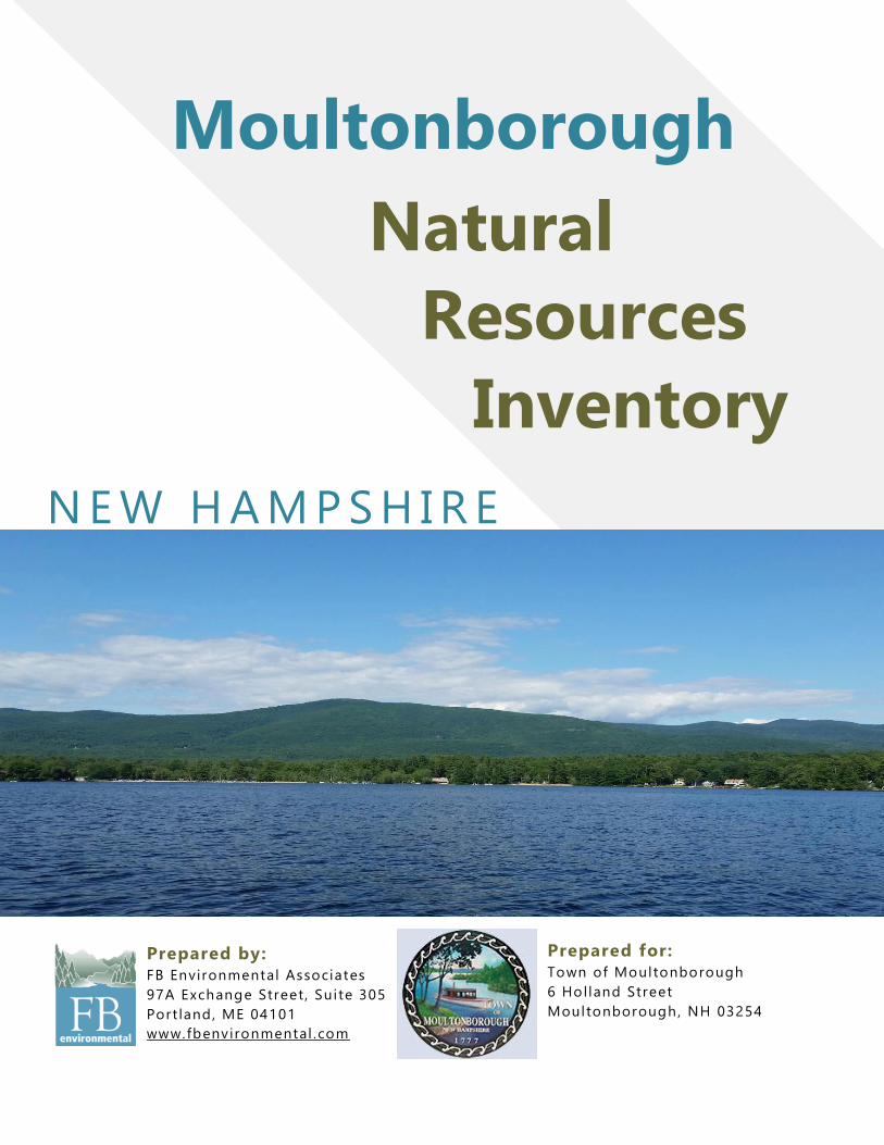
– Cover photo of Lake Winnipesaukee by FBE –
NATURAL RESOURCES INVENTORY | MOULTONBOROUGH, NEW HAMPSHIRE
iii
TABLE OF CONTENTS
Executive Summary ......................................................................................................................................... 5
1.0 Introduction ................................................................................................................................................ 7
1.1 Natural Resources Inventory Defined .................................................................................7
1.2 Rationale .............................................................................................................................7
2.0 Methods ...................................................................................................................................................... 8
2.1 General Methodolgy ............................................................................................................8
2.2 Disclaimer and Data Limitations ..........................................................................................8
3.0 Natural Resources ..................................................................................................................................... 9
3.1 Topography ....................................................................................................................... 10
3.2 Bedrock Geology ............................................................................................................... 10
3.3 Surficial Geology ............................................................................................................... 11
3.4 Soils of Special Importance ............................................................................................... 11
3.4.1 Forest Soils ................................................................................................................. 12
3.4.2 Agricultural Soils ......................................................................................................... 13
3.4.3 Poorly Drained Soils ................................................................................................... 15
3.5 Water Resources .............................................................................................................. 15
3.5.1 Major Watersheds....................................................................................................... 16
3.5.2 Lakes and Ponds ........................................................................................................ 16
3.5.3 Rivers and Streams .................................................................................................... 18
3.5.4 Aquifers ...................................................................................................................... 20
3.6 Wetlands ........................................................................................................................... 20
3.6.1 Vernal pools ................................................................................................................ 21
3.6.2 Prime Wetlands .......................................................................................................... 22
3.7 New Hampshire Wildlife Action Plan Habitat Types .......................................................... 23
3.7.1 Hemlock-Hardwood-Pine Forest ................................................................................. 24
3.7.2 Appalachian Oak-Pine Forest ..................................................................................... 24
3.7.3 Northern Hardwood-Conifer Forest............................................................................. 25
3.7.4 High-Elevation Spruce-Fir Forest................................................................................ 25
3.7.5 Grassland ................................................................................................................... 26
3.7.6 Rocky Ridge, Cliff and Talus ...................................................................................... 26
3.7.7 Temperate Swamp ..................................................................................................... 27
3.7.8 Wet Meadow/Shrub Wetland ...................................................................................... 27
3.7.9 Northern Swamp ......................................................................................................... 28
3.8 Wildlife Action Plan Habitat Ranks .................................................................................... 29
3.8.1 Utility of Habitat Rank Information .............................................................................. 30
NATURAL RESOURCES INVENTORY | MOULTONBOROUGH, NEW HAMPSHIRE
iv
3.8.2 A Primer on Habitat Connectivity ................................................................................ 30
3.9 Rare Plants & Animals and Exemplary Natural Commnunites .......................................... 31
3.10 Non-Native, Invasive Species ......................................................................................... 31
4.0 Priority Conservation Areas .................................................................................................................. 33
4.1 Moultonborough Neck Marsh ............................................................................................ 34
4.2 Moultonborough Neck ....................................................................................................... 36
4.3 Mud Pond .......................................................................................................................... 36
4.4 Moultonborough Bay ......................................................................................................... 36
4.5 Lee’s Pond ........................................................................................................................ 37
4.6 Cross Property .................................................................................................................. 37
4.7 Berry Pond ........................................................................................................................ 38
4.8 Balmoral ............................................................................................................................ 38
4.9 Shannon Brook ................................................................................................................. 39
5.0 Conservation Recommendations ........................................................................................................ 39
5.1 Considerations and Caveats ............................................................................................. 39
5.2 Recommendations for Land Preservation ......................................................................... 40
5.3 Recommendations for Local Land Use Planning .............................................................. 40
5.4 Prime Wetlands ................................................................................................................. 42
5.5 Vernal Pools ...................................................................................................................... 42
5.6 Residential / Landowner Stewardship and Public Education ............................................ 43
Appendix A. Maps ......................................................................................................................................... 47
Appendix B. Cowardin et al. (1979) Wetlands and Deepwater Habitats Classification ................ 61
Appendix C. Rare Wildlife and Plant Communities ............................................................................... 64
NATURAL RESOURCES INVENTORY | MOULTONBOROUGH, NEW HAMPSHIRE
5
EXECUTIVE SUMMARY This Natural Resource Inventory (NRI) report was prepared by FB Environmental (FBE) for the Moultonborough Conservation Commission with the intent to provide a detailed description and analysis of the town’s natural resources. It was developed to be useful to all municipal departments - not solely the Conservation Commission. It is clear from the results presented herein that Moultonborough possesses abundant and diverse natural resources that contribute significantly to both the ecological richness and health of the town, as well as socially to the community’s quality of life. This NRI is not and should not be viewed as a conservation plan of action. Rather, it is an encyclopedia of information based on the best currently available data, with a measure of interpretation and some initial recommendations about what is important to conserve. The NRI is a baseline characterization, and a beginning in what should be an ongoing process of updates and refinements. As part of the NRI process, FBE compiled and created relevant GIS shapefiles which provide a means to visualize and further analyze Moultonborough’s natural resources information. This report and its associated shapefiles provide Moultonborough with a tool to help guide future planning and conservation efforts throughout the town. Thirteen maps were created to illustrate the town’s natural resources and character. The maps depict topography, bedrock geology, forest soils, agricultural soils, hydric soils, major watersheds, water resources, wetlands, Wildlife Action Plan habitat types, Wildlife Action Plan habitat ranks, priority conservation areas, co-occurrence of natural resources, and buildable area. Moultonborough has experienced steady population growth and development since the 1960s. There are currently 14,100 acres of conserved land within the town. Much of this conserved land is in the higher-elevation portions of the town, namely the Ossipee Mountains and Red Hill. Conservation land is underrepresented in lower-elevation portions of the town, where development is most prominent. FBE in consultation with the Moultonborough Conservation Commission identified areas within the town having the highest natural resource values using numerous spatial datasets. Locations within town having the largest areas of high co-occurrence values were identified as “Priority Conservation Areas”. Nine contiguous priority conservation areas were identified in total: Moultonborough Neck Marsh, Moultonborough Neck, Mud Pond, Moultonborough Bay, Lee’s Pond, Cross Property, Berry Pond, Balmoral, and Shannon Brook. These Priority conservation areas represent lower-elevation portions of the town and encompass much of the town’s mapped wetlands and streams, in addition to areas mapped as part of New Hampshire Fish and Game Department’s Wildlife Action Plan as valuable habitat which are not already protected. In total, the nine Priority Conservation Areas cover approximately 5,174 acres (47%) of buildable land out of total 10,908 acres identified by the FBE’s 2015 build-out analysis.

NATURAL RESOURCES INVENTORY | MOULTONBOROUGH, NEW HAMPSHIRE
6
The greatest threat to the natural resources and ecology of Moultonborough is habitat loss/alteration resulting from poorly-planned development. It’s important to note however that preservation of entire Conservation Priority Areas is not feasible, nor do we recommend it. Much of the mapped areas are privately-owned lands that contribute, through taxes, to the economic stability of the town. Rather, a balanced approach to conservation and development which incorporates a suite of land use planning and conservation tools is recommended, as careful attention to growth in Moultonborough will help to ensure sound stewardship of the town’s natural resources.
NATURAL RESOURCES INVENTORY | MOULTONBOROUGH, NEW HAMPSHIRE
7
1.0 INTRODUCTION
1.1 NATURAL RESOURCES INVENTORY DEFINED
A natural resources inventory (NRI) is a document that identifies and describes important
naturally-occurring resources within a given locality via written descriptions of resources, maps,
and associated documentation of mapped data. A comprehensive NRI provides the basis for
land conservation planning and facilitates the incorporation of natural resources information into
local land-use planning and zoning. An NRI can be useful to (Stone, 2001):
Document current conditions so that changes over time can be assessed
Develop a Conservation Plan
Educate local officials and the public regarding a community’s natural resources
Initiate and support land protection efforts
Identify and protect important fish and wildlife habitat
Provide a basis for land use planning efforts
Develop or update the Natural Resources section of a town’s Master Plan
Preliminarily evaluate effects of proposed land use and zoning changes
Develop amendments to existing zoning ordinances
Screen development proposals An NRI is essentially a tool to help achieve some of the goals listed above. While an NRI is useful in the planning process, it is generally not suitable for site-specific issues. An NRI may be used as a screening tool, however, to identify areas where site-specific assessments may be required (Stone, 2001).
As new and revised information emerges, NRIs may need periodic updating and refining, but the
initial NRI provides a baseline for observing changes over time (Stone, 2001). Such is the case
with the Town of Moultonborough. An NRI was completed for the town almost ten years ago.
New data has since become available, and the Town contracted FBE to provide this updated
NRI report and associated spatial data (i.e., GIS shapefiles).
1.2 RATIONALE
In order to protect local natural resources, they must first be located and identified. Until an NRI
is conducted and the information is compiled, a given community will not have a clear picture of
where resources are located, which are significant to them, and why.
The future of a natural resource base is largely dependent on land use decisions made at the
local level. Communities frequently need to make decisions affecting natural resources, but very
often don’t have adequate information available to back those decisions. By identifying and
describing natural resources in a local setting, a natural resources inventory provides
communities with a strong foundation for more informed decision-making. It also encourages
participation in identifying and protecting natural resources important to the community, and
provides information that will support careful land use planning, voluntary land conservation, and
improved natural resource protection measures.

NATURAL RESOURCES INVENTORY | MOULTONBOROUGH, NEW HAMPSHIRE
8
Major accomplishments of an NRI are the creation and compilation of various maps and their
associated data tables and descriptions, and a means to provide a better understanding and
appreciation of the community’s natural resources (Stone, 2001).
2.0 METHODS
2.1 GENERAL METHODOLGY
This town-wide Natural Resources Inventory is based on the methodology outlined in Natural
Resources Inventories – A Guide for New Hampshire Communities and Conservation Groups
by the University of New Hampshire Cooperative Extension (Stone, 2001). The following
sections of this document describe the types and potential threats to the different natural
resources found in the Town of Moultonborough. Geographic Information System (GIS)-based
data and maps related to each resource are presented. For each natural resource type included
in this document, a description of the resource and its extent in the town is provided, as well as
any known and/or potential threats. Discussion of the important natural resources that should be
prioritized for long-term protection and recommendations for improving conservation and
protection measures for the identified resources are also provided. An accompanying map set is
presented in the report appendices (Appendix A).
2.2 DISCLAIMER AND DATA LIMITATIONS
Much of the data utilized in this NRI represent stock data sets obtained from the New
Hampshire Geographically Referenced Analysis and Information Transfer System (NH GRANIT)
database. Many of these data layers were created from remotely sensed data (e.g. aerial
photography, digital orthophotos, and satellite images) and large landscape-level mapping
projects (e.g. Soil Units). As a result, the data layers are intended to be viewed at certain scales
(generally 1:24,000/1:25,000) and have specific accuracy levels. NH GRANIT maintains a
continuing program to identify and correct errors in these data but make no claims as to the
validity or reliability or to any implied uses of these datasets. As a result, the data presented
herein should be used for planning purposes only. If greater data precision is required, this
inventory should be supplemented with field surveys or other on-the-ground methods of data
collection.
There may also be minor data discrepancies throughout this document due to the variety of
source materials and mapping standards used. The reader is encouraged to refer to the original
referenced sources if specific data inconsistencies need to be resolved.

NATURAL RESOURCES INVENTORY | MOULTONBOROUGH, NEW HAMPSHIRE
9
3.0 NATURAL RESOURCES The town of Moultonborough
encompasses 75 square miles in the
Lakes Region of central New Hampshire.
The town’s population was 4,044 at the
2010 census.
Moultonborough contains the northern
portion of Lake Winnipesaukee and is
bound by Sandwich, Tamworth, and
Ossipee to the north, Tuftonboro to the
east, and Gilford, Meredith, and Center
Harbor to the West.
Moultonborough is served by the east-
west State Route 25 which connects
Meredith and Plymouth to the west with
Ossipee, New Hampshire and Portland,
Maine to the east. NH Route 109
proceeds southeast towards Wolfeboro
and northwest to Sandwich.
Moultonborough is fortunate to have
within its boundaries a number of large
waterbodies, mountains, and other natural
resources. The natural beauty of
Moultonborough’s lakes and mountains
attract many visitors and seasonal
residents. As such, the town offers many recreational opportunities such as snowmobiling,
boating, hiking, and cycling.
The largest waterbody in Moultonborough is Moultonborough Bay, a part of Lake
Winnipesaukee, which is the largest lake in New Hampshire. Other waterbodies within the town
include Squam Lake, Wakondah Pond, Lake Kanasatka, Berry Pond, Garland Pond, Lees
Pond, and Shannon Pond.
Red Hill is in the northwest portion of the town. In the east is Mount Shaw (elevation 2,990 feet),
which is part of the Ossipee Mountains and the highest point in Moultonborough.
Figure 1. Moultonborough locator map.

NATURAL RESOURCES INVENTORY | MOULTONBOROUGH, NEW HAMPSHIRE
10
3.1 TOPOGRAPHY
Identifying the physical structure and
composition of a community’s natural
landscape is an important starting point
and context for evaluating its specific
natural resources. Topography provides
the basic conditions for understanding
how a landscape evolves into areas
valuable for specific natural functions
such as agriculture, forestry, hydrology,
and wildlife habitat, or cultural functions
such as scenic vistas.
Topography is also an important factor in
the assessment of suitability of
development or resource protection.
Higher points on the landscape are a
visual asset and as such, are vulnerable
to potentially unsightly development.
Moultonborough’s highest elevations are located in the northwestern and northeastern portions
of the town, Red Hill and the Ossipee Mountains, respectively. The highest point in the town is
2,990 feet above sea level, at the summit of Mount Shaw. Aside from the aforementioned
mountainous areas, the rest town has generally flat to moderately sloping topography,
dominated by low areas encompassing the town’s numerous lakes and ponds.
3.2 BEDROCK GEOLOGY
About 10,000 to 15,000 years ago, the
land area of New Hampshire emerged
from the last ice age. The melting and
receding ice caused dramatic changes in
the landscape. Mountains were rounded
off. Chunks of bedrock were picked up
and dragged for miles, then left behind as
the large glacial boulders now called
erratics.
The pattern of a general southwest to
northeast direction of the receding
glaciers of over 12,000 years ago can be
seen today in Moultonborough as well as
in most of New England (Billings, 1980).
This process formed the rivers, lakes, and
Topographical map of Moultonborough. See
Appendix A, Map 1.
Map depicting Moultonborough’s bedrock
geology. See Appendix A, Map 2.

NATURAL RESOURCES INVENTORY | MOULTONBOROUGH, NEW HAMPSHIRE
11
wetlands that we see today. The soil variations found throughout the Town of Moultonborough
exist because of the parent material (or bedrock) that lies beneath the surface and the deposits
of materials left by the retreating glaciers. These parent materials influence the land formations,
waterbodies, and vegetation occurring above them.
The bedrock underlying Moultonborough is of an igneous origin. Igneous rocks are formed from
the solidification of molten rock material. Intrusive igneous rocks (e.g., granite) crystallize below
the Earth’s surface. Extrusive igneous rocks (e.g., basalt, rhyolite) cooled quickly after erupting
to the surface.
The vast majority of the bedrock in Moultonborough is tonalite, which corresponds with the low,
relatively flat portions of the town. Higher elevation areas are containing different bedrock
material. Red Hill is composed of syenite, quartz syenite, and granite while the section of the
Ossipee Mountains within the town consists of rhyolite, basalt, and granite.
3.3 SURFICIAL GEOLOGY
Surficial geology describes the rocks and unconsolidated materials that lie between bedrock and
the ground surface. When the glaciers receded, the rock and debris frozen within the ice were
left behind in various formations, depending largely upon the speed at which the glacier
receded. These formations contain various sized particles and are classified by the shape of
formation, the thickness, and the type and size of particles found. Surficial geology is important
because the characteristics of materials below the earth’s surface influence the feasibility of
constructing buildings and roads (Goldthwait et al., 1951).
Materials deposited by running water typically consist of sand and gravel carried into low-lying
areas. These deposits formed the stratified drift aquifers (layered sand and gravel) now used for
large water withdrawals and productive domestic wells. Stratified drift aquifers have been
surveyed statewide by the USGS using drilling and data extrapolation methods (Mack and
Lawlor, 1992).
In addition to aquifers, surficial deposits commonly determine soil composition and therefore
may affect agricultural viability. Mapped data showing the surficial geology of Moultonborough
was not available to incorporate into this report. However sections 3.4 (Soils of Special
Importance) and 3.5 (Water Resources) provide more details on some of the natural resources
in Moultonborough that are influenced by the area’s surficial geology. Further details about NH
geology are available at http://des.nh.gov/organization/commissioner/gsu/ and
www.nhgeology.org.
3.4 SOILS OF SPECIAL IMPORTANCE
Soil is the unconsolidated mineral and organic matter on the immediate surface of the earth that
serves as a natural medium for the growth of plants. Understanding the nature and properties of
soils is critical to managing and conserving natural resources. Different soil types throughout the
town have developed from the interaction of several natural phenomena, including climate,
surficial geology, topography, and vegetation.

NATURAL RESOURCES INVENTORY | MOULTONBOROUGH, NEW HAMPSHIRE
12
The US Department of Agriculture’s Natural Resources Conservation Service (NRCS) studies
and inventories soil resources across the country. Soil surveys contain detailed soils maps, data
tables, and text narratives that assist in determining appropriate uses for the land. Soil surveys
also contain predictions of soil behavior for selected land uses and highlight limitations and
hazards inherent in the soil and the impact of selected land uses on the environment. The most
recently published edition of the Carroll County Soil Survey dates back to 1977.The data and
soils map for this inventory were derived from this 1977 survey.
The NRCS groups soils based on their capability to produce commonly cultivated crops and
pasture plants without deteriorating over a long period of time. These classifications are based
on numerous criteria that include, but are not limited to, the soil’s salinity, parent material,
capacity to hold moisture, potential for erosion, depth, and texture and structure, as well as local
climatic limitations (e.g. temperature and rainfall). These units are further sorted based on land
capability such as farmland, wetland, and forest soils. Soil classifications are designed to guide
choices in land use and soil management.
3.4.1 FOREST SOILS
For millions of years soils have provided
the foundation for trees and forests. Soil
is an important component of the forest
ecosystem as it helps regulate important
ecosystem processes, including nutrient
uptake, decomposition, and water
availability. Soils provide trees with
anchorage, water and nutrients. In turn,
trees as well as other plants and
vegetation, are an important factor in the
creation of new soil as leaves and other
vegetation rot and decompose (fao.org,
2016).
Forest soils are generally subjected to
fewer disturbances than agricultural soils
(e.g., they are not plowed), and the forest
floor is a unique feature to them. They
also typically do not receive external inputs (e.g., fertilizer, manure, herbicides, insecticides,
fungicides) and instead rely on their inherent soil nutrient cycling to support plant nutritional
needs (Perry and Amacher, 2007).
Disturbances to forest soils tend to be related primarily to timber harvesting. As with other
elements of the forest, soils tend to show the effects of disturbances for many years. Activities
and events including land use change, wildfire, drainage, and timber harvest, can greatly affect
soil characteristics, which in turn will affect forest productivity and health, including water quality
and quantity (Perry and Amacher, 2007).
Map depicting Moultonborough’s important forest
soils. See Appendix A, Map 3.
NATURAL RESOURCES INVENTORY | MOULTONBOROUGH, NEW HAMPSHIRE
13
The terrain features, topography, and soils that provide the foundation for today’s forests can be
traced to the action of glacial ice or melt water as the last glacier retreated northward. As a
result, there is considerable variability in soil types across the town. Most variability in tree
species and forest composition is due to differences in underlying soil type, available nutrients,
and moisture (Thorne and Sundquist, 2001).
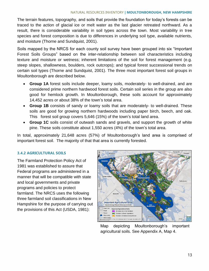
Soils mapped by the NRCS for each county soil survey have been grouped into six “Important
Forest Soils Groups” based on the inter-relationship between soil characteristics including
texture and moisture or wetness; inherent limitations of the soil for forest management (e.g.
steep slopes, shallowness, boulders, rock outcrops); and typical forest successional trends on
certain soil types (Thorne and Sundquist, 2001). The three most important forest soil groups in
Moultonborough are described below.
Group 1A forest soils include deeper, loamy soils, moderately- to well-drained, and are
considered prime northern hardwood forest soils. Certain soil series in the group are also
good for hemlock growth. In Moultonborough, these soils account for approximately
14,452 acres or about 38% of the town’s total area.
Group 1B consists of sandy or loamy soils that are moderately- to well-drained. These
soils are good for growing northern hardwoods including paper birch, beech, and oak.
This forest soil group covers 5,646 (15%) of the town’s total land area.
Group 1C soils consist of outwash sands and gravels, and support the growth of white
pine. These soils constitute about 1,550 acres (4%) of the town’s total area.
In total, approximately 21,648 acres (57%) of Moultonborough’s land area is comprised of
important forest soil. The majority of that that area is currently forested.
3.4.2 AGRICULTURAL SOILS
The Farmland Protection Policy Act of
1981 was established to assure that
Federal programs are administered in a
manner that will be compatible with state
and local governments and private
programs and policies to protect
farmland. The NRCS uses the following
three farmland soil classifications in New
Hampshire for the purpose of carrying out
the provisions of this Act (USDA, 1981):
Map depicting Moultonborough’s important
agricultural soils. See Appendix A, Map 4.

NATURAL RESOURCES INVENTORY | MOULTONBOROUGH, NEW HAMPSHIRE
14
Prime Agricultural Soils: Prime agricultural soils have sufficient available water capacity
to produce the commonly grown cultivated crops adapted to New Hampshire. They have
high nutrient availability, generally low slope and low landscape position, are not
frequently flooded, and contain less than 10% rock fragments in the top six inches. The
land may currently be in crops, pasture, or woodland; but not urbanized, built-up land, or
water areas. It must either be used for producing food or fiber, or be available for these
uses. In Moultonborough, these soils account for approximately 460 acres, about 1% of
the town’s total area.
Soils of Statewide Importance: Farmland of statewide importance is land, in addition to
prime and other unique farmlands, that is of statewide importance for the production of
food, feed, fiber, forage, and oilseed crops. The state government designates farmland of
statewide importance with the concurrence of the NRCS State Conservationist.
Generally, these farmlands include those areas that are nearly prime farmland and that
can economically produce high yields of crops when treated and managed according to
acceptable farming methods. These soils constitute about 760 acres, approximately2% of
the town’s total area.
Soils of Local Importance: Soils of local importance include soils that are not prime or
of statewide importance, but that have local significance for the production of food, feed,
fiber, forage and oilseed crops. These lands are designated by local agencies with the
concurrence of the NRCS State Conservationist, and may include tracts of land that have
been designated for agriculture uses by local ordinance. This is the predominant
agricultural soil group in Moultonborough with over 15,427 acres, about 40% of the
town’s total area.
In total, approximately 16,647 acres (43%) of Moultonborough’s land area is comprised of
agricultural soil. The highest concentrations of these soils are found in the lower elevation
sections of the town. Moultonborough’s best agricultural soils, prime agricultural soils, are
located sporadically in small patches throughout lower-elevation portions of the town.
NATURAL RESOURCES INVENTORY | MOULTONBOROUGH, NEW HAMPSHIRE
15
3.4.3 POORLY DRAINED SOILS
Soil drainage characteristics are based
on a soil's permeability - the ability of air
and water to move through it.
Permeability is influenced by the size,
shape, and continuity of pore spaces,
which is dependent on soil density,
structure, and texture. Texture is one of
the most important characteristics since it
influences many other properties of soil
such as irrigation needs, erosion
potential, and fertility. Soil texture
describes the proportionate distribution of
different sizes of mineral particles in a
soil, excluding organic matter.
Generally, sandy soils tend to be low in
organic matter content and fertility; low in
ability to retain moisture and nutrients; and well-drained and therefore well suited for road
foundations and building sites. Fine-textured soils are generally more fertile; contain more
organic matter; and are better able to retain moisture and nutrients. When soils areas fine-
textured as to be classified as clay they are somewhat difficult to manage for cultivation, and
have characteristics that adversely affect their suitability at building sites (particularly septic
systems and basements) and for road construction. NRCS classifies such soils as “hydric soils”.
These soils are frequently ponded or flooded for extended periods during the growing season,
and are generally not well drained. While these soils are located in lowland areas and
depressions throughout Moultonborough, the highest concentration of these soils is in the
central portion of the town. This part of Moultonborough has the lowest elevations, and
numerous wetlands. In total there are 4,543 mapped acres hydric soils in Moultonborough,
covering approximately 12% of the town.
3.5 WATER RESOURCES
Water resources including both surface waters and groundwater resources are some of a
community’s most valuable assets. Most drinking water sources – whether public or private –
depend on subsurface water in sand and gravel aquifers, or in bedrock. Surface waters offer
many recreational possibilities, and are key elements in the value of scenic resources.
Floodplains provide fertile farming soils, and are also valuable in attenuating damaging floods.
Wetlands are well-known to provide habitat for diverse array wildlife and to provide flood storage
and water filtering services. These aspects of Moultonborough’s water resources are discussed
below.
Map depicting Moultonborough’s hydric soils.
See Appendix A, Map 5.

NATURAL RESOURCES INVENTORY | MOULTONBOROUGH, NEW HAMPSHIRE
16
3.5.1 MAJOR WATERSHEDS
A watershed is the area of land where all
of the water that is on, over or under it
drains into a given stream, river, lake or
other water body. A watershed acts as a
funnel, collecting all water within a
drainage area and channeling it into
groundwater, a stream, river or lake, and
ultimately into the ocean. Watersheds are
land features that can be identified by
tracing a line along the highest elevations
between two areas on a map, often along
a ridgeline. Every piece of land is part of
a watershed; therefore, everything that
occurs on the land eventually has an
effect on the water flowing through that
watershed.
The majority of Moultonborough is within
the Lake Winnipesaukee drainage, which in the town has four subwatersheds: Moultonborough
Inlet, Center Harbor, Moultonborough Bay, and the Broads. The three other major watersheds in
the town are the Bearcamp River drainage, Ossipee Lake Drainage, and Squam River drainage.
Each of these is made up of smaller sub-watersheds.
3.5.2 LAKES AND PONDS
Lakes, ponds, and reservoirs are key
elements of aquatic ecosystems, and
provide valuable habitat for fish, wildlife,
and plants, as well as important
recreational opportunities including
swimming, boating, and fishing. Natural
lakes and artificially impounded reservoirs
may also serve as sources of drinking
water.
Moultonborough is home to numerous
lakes and ponds (Table 1), and contains
a portion of the largest waterbody in New
Hampshire, Lake Winnipesaukee, which
in total encompasses 71 square miles.
Collectively, lakes and ponds amount to
9,854 acres, approximately 21% of the
town’s total area.
Map depicting major watersheds in
Moultonborough. See Appendix A, Map 6.
Map depicting waterbodies, watercourses, and
stratified drift aquifers in Moultonborough. See
Appendix A, Map 7.

NATURAL RESOURCES INVENTORY | MOULTONBOROUGH, NEW HAMPSHIRE
17
Lakes follow a natural aging process whereby they become nutrient enriched and gradually fill
in. Under natural conditions, this aging process takes place over centuries. However, this
process can be greatly accelerated by human activities. Increases in nutrients, especially
phosphorus which tends to increase plant growth, which in turn impacts overall lake water
quality. Lakes are classified into three trophic classes based on measurements of chlorophyll
pigments, total phosphorus, and water clarity. These trophic classes provide an estimate of the
lake’s biological productivity, or the amount of living material supported within them, primarily in
the form of algae.
Oligotrophic lakes are the most pristine and are characterized by high water clarities, low
nutrient concentrations, low algae concentrations, minimal levels of aquatic plant weed growth,
and high dissolved oxygen concentrations near the lake bottom. Eutrophic lakes have low water
transparencies, high nutrient concentrations, high algae concentrations, large stands of aquatic
plants, and very low dissolved oxygen concentrations near the lake bottom. Mesotrophic lakes
have qualities between those of oligotrophic and eutrophic lakes. It is important to note,
however, that not all eutrophic lakes are so due to human activity. Shallow waterbodies with
forested watersheds with extensive wetlands, may be naturally eutrophic.
According to the NHDES Lake Trophic Surveys mapper, within Moultonborough Kanasatka
Lake, Squam Lake and Lake Winnipesaukee are classified as Oligotrophic. Berry Pond, Garland
Pond, and Wakondah Pond are mesotrophic, and Lees Pond, Meadow Brook Pond, and
Pickering Pond are eutrophic.
Moultonborough waterbodies support both warm water and cool water fisheries (Table 1).
Examples of cool water species in New Hampshire include brook trout (Salvelinus fontinalis),
rainbow trout (Oncorhynchus mykiss), lake trout (Salvelinus namaycush), lake whitefish
(Coregonus clupeaformis), and burbot (Lota lota). Examples of warm water species in New
Hampshire include smallmouth bass (Micropterus dolomieu) largemouth bass (Micropterus
salmoides), chain pickerel (Esox niger), horned pout (brown bullhead) (Ameiurus nebulosus)
black crappie (Pomoxis nigromaculatus), bluegill (Lepomis macrochirus) white perch (Morone
americana) and yellow perch (Perca flavescens).

NATURAL RESOURCES INVENTORY | MOULTONBOROUGH, NEW HAMPSHIRE
18
Table 1. Trophic status, elevation, size, depth, fishery type supported, and species occurring in named waterbodies within Moultonborough, NH. Game fish species are as follows: 1) rainbow trout; 2) salmon; 3) lake trout; 4) whitefish; 5) smallmouth bass; 6) largemouth bass; 7) chain pickerel; 8) horned pout, 9) white perch; 10) black crappie; 11) bluegill; 12) rock bass; 13) burbot (cusk), and 14) yellow perch.
Waterbody Name
NH DES Trophic Status*
Elev. (feet)
Total Acres
Acres in
Moult.
Max. Depth (feet)
Fishery Type
Game Fish Species Present*
Lake Kanasatka
Oligotrophic 158 358 358 33.94 warm/cool 5,6,7,8,9
Squam Lake Oligotrophic 170 6,791 1,321 127.15 coldwater 1,2,3,4,5,6,7,8,9,13
Lake Winnipesaukee
Oligotrophic 153 45,654 7,506 302.23 coldwater 1,2,3,4,5,6,7,8,9,10,11,12,13
Berry Pond Mesotrophic 171 82 82 13.73 warm/cool 6,7,8,14
Garland Pond Mesotrophic 160 102 102 17.85 warm/cool 7,8,14
Wakondah Pond
Mesotrophic 161 94 94 32.74 warm/cool 5,6,7,8,9,14
Lees Pond Eutrophic 154 154 154 21.86 warm/cool 5,6,7,10,11
Meadow Brook Pond (Ledgy Pond)
Eutrophic 155 38 38 8.52 warm/cool Info. not available
Pickering Pond Eutrophic 162 22 22 3.17 warm/cool Info. not available
Shannon Pond - 374 4 4 - warm/cool Info. not available
*Species lists obtained from New Hampshire Fish and Game Department’s (2009) New Hampshire Freshwater
Fishing Guide and from New Hampshire Fish and Game Department bathymetry maps.
3.5.3 RIVERS AND STREAMS
Moultonborough contains 78 miles of mapped rivers and streams. Some intermittent streams,
which carry water for only a portion of the year, are too small to be mapped and are not included
in the above estimate. The watercourses and their adjacent riparian corridors are important
habitat and travel corridors for the town’s terrestrial wildlife. In addition, many bird species are
attracted to water and the food sources that are located nearby. There are eleven named
watercourses in Moultonborough (Table 2) and numerous miles of additional unnamed streams
in the town.
The State of New Hampshire uses a stream order system to classify rivers and streams. Stream
order is a method for classifying the relative location of a stream reach within the larger river
system. Streams that have no branches are designated as first-order streams. When two first
order streams come together, they form a larger, second-order stream. When two second-order
streams come together, they form a larger, third-order stream, and so on (Figure 2).

NATURAL RESOURCES INVENTORY | MOULTONBOROUGH, NEW HAMPSHIRE
19
Fourth order and higher streams are protected
under the NH Comprehensive Shoreland
Protection Act. Headwater Streams (first-order
streams) that have a watershed area less than
one square mile are considered “primary”
headwater streams. The health of larger streams,
rivers, and other surface waters downstream in a
watershed depend in part upon an intact primary
headwater stream network. Headwater streams
are particularly important for maintaining water
quality due to the sheer number of miles they
represent in most watershed drainage systems.
In Moultonborough, headwater streams account
for 60% of total mapped stream miles (see Map 7 and Table 2). These areas contain especially
important natural resources and provide important habitat, which are vulnerable to degradation
by improper forestry practices and land use changes.
Table 2. Order, Length, and temperature class of named watercourses in Moultonborough, NH.
Watercourse Name Stream Order
Length in Moultonborough
(miles)
Temperature Class
Game Fish Species Present*
Cook Brook 1 0.76 coldwater Info. not available
Gulf Brook 1 1.43 coldwater Info. not available
Halfway Brook 1 5.06 coldwater Info. not available
Jackson Brook 2 0.36 coldwater Info. not
available
Lovell River 3 2.59 coldwater brook trout
Red Hill River 4 1.70 coldwater, warm/cool
Info. not available
Shannon Brook 2 7.73 coldwater brook trout
Skinner Brook 1/2 1.13 coldwater brook trout
South Brook 2 1.30 coldwater, warm/cool
Info. not available
Weed Brook 1/2/3 4.20 coldwater brook trout
White Brook 2 0.86 coldwater Info. not available
*Species list obtained from New Hampshire Fish and Game Department’s (2009) New Hampshire Freshwater
Fishing Guide.
The collective health and functioning of primary headwater streams have profound influences on
the quality and value of larger streams, rivers and lakes. The importance and benefits provided
by primary headwater streams include reduction of sediment delivery downstream, reduction in
nutrient loading (nitrogen and phosphorus), flood storage and control, and aquatic habitat.
Figure 2. Illustration of the stream order system used in
New Hampshire. Source: SUNY College of Environmental Science and Forestry. Fluvial Geomorphology Training Module, Section 4.viii, http://www.fgmorph.com/fg_4_8.php.
NATURAL RESOURCES INVENTORY | MOULTONBOROUGH, NEW HAMPSHIRE
20
Primary headwater streams and their adjacent vegetation provide areas for wildlife habitat and
add protection for fish and other animals living in the primary headwater streams and the larger
streams into which they feed (Ohio EPA, 2015).
Disruption of the hydrologic and biological processes of primary headwater streams takes a
cumulative toll on the health of the whole river system. Proper functioning of primary headwater
streams can help maintain base flow in larger streams in times of drought. They are a key
determinant in the overall condition of the river system (Ohio EPA, 2015).
3.5.4 AQUIFERS
An aquifer is a geologic unit or formation that contains a useable supply of water. A stratified
drift aquifer consists mainly of layers of sand and gravel, parts of which are saturated and can
yield water to wells or springs. In New Hampshire, stratified drift aquifers are the most
productive in supplying large-volume water needs such as public water supply wells (Medalie
and Moore, 1995). Based on GIS data obtained from NH GRANIT, Moultonborough contains
approximately 4,762 acres of stratified drift aquifer.
3.6 WETLANDS
Wetlands are an integral part of Moultonborough’s natural resources. They removing excess
nutrients and sediment from water, slow the flow of and store floodwaters, promote groundwater
infiltration, and provide habitat for a vast array of vegetation and wildlife. Wetlands also provide
recreational, educational, and research opportunities and add to the visual resources of the
town as well.
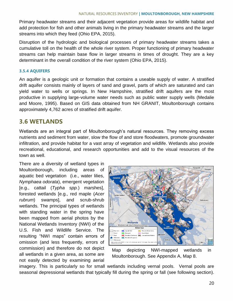
There are a diversity of wetland types in
Moultonborough, including areas of
aquatic bed vegetation (i.e., water lilies,
Nymphaea odorata), emergent vegetation
[e.g., cattail (Typha spp.) marshes],
forested wetlands [e.g., red maple (Acer
rubrum) swamps], and scrub-shrub
wetlands. The principal types of wetlands
with standing water in the spring have
been mapped from aerial photos by the
National Wetlands Inventory (NWI) of the
U.S. Fish and Wildlife Service. The
resulting “NWI maps” contain errors of
omission (and less frequently, errors of
commission) and therefore do not depict
all wetlands in a given area, as some are
not easily detected by examining aerial
imagery. This is particularly so for small wetlands including vernal pools. Vernal pools are
seasonal depressional wetlands that typically fill during the spring or fall (see following section).
Map depicting NWI-mapped wetlands in
Moultonborough. See Appendix A, Map 8.

NATURAL RESOURCES INVENTORY | MOULTONBOROUGH, NEW HAMPSHIRE
21
They are often small and under forest canopy which makes them difficult to detect on aerial
imagery. Therefore, it is likely that NWI maps underestimate of the amount of wetlands in
Moultonborough. While these inaccuracies are known to exist in NWI data, they nevertheless
are very useful in serving as a baseline reference to locate wetlands.
Moultonborough contains approximately 2,021 acres of mapped wetlands, representing
approximately 4% of the town’s total area (Table 3; Appendix A, Map 8). The vast majority of
these wetlands are situated outside of conserved lands.
Wetlands in the United States are typically classified using the Classification of Wetlands and
Deepwater Habitats of the United States (Cowardin et al., 1979). This water resource
classification system was developed by the United States Fish and Wildlife Service (USFWS)
and is commonly referred to as “Cowardin Classification” (Appendix B). The Cowardin
Classification is used to define wetlands and other aquatic resources by their landscape
position, cover type, and hydrologic regime. Special modifiers can be added that describe water
regime/chemistry, soil types, or disturbances. For the purpose of this document, wetlands are
grouped according to Cowardin System, Subsystem, and Class. Note however that in the
section below, wetlands appearing on New Hampshire Wildlife Action Plan (WAP) maps are
classified as one of five categories – Floodplain Forests, Northern Swamps, Temperate
Swamps, Peatlands, Marsh and Shrub Wetlands.
Table 3. Moultonborough, NH wetlands and associated Cowardin classifications.
Cowardin Classification Acres Percent Total Wetland Area
Palustrine emergent (PEM) 319 16
Palustrine forested broad-leaved deciduous (PFO1) 527 26
Palustrine forested needle-leaved evergreen (PFO4) 372 18
Palustrine forested (dead trees) (PFO5) 172 8
Palustrine scrub-shrub (PSS) 482 24
Palustrine unconsolidated bottom (PUB) 150 7
Total 2,021 100
3.6.1 VERNAL POOLS
Vernal pools are defined in Calhoun and Klemens (2002) as “...seasonal bodies of water that
attain maximum depths in spring or fall, and lack permanent surface water connections with
other wetlands or water bodies. Pools fill with snowmelt or runoff in the spring, although some
may be fed primarily by groundwater sources. The duration of surface flooding, known as
hydroperiod, varies depending upon the pool and the year; vernal pool hydroperiods range
along a continuum from less than 30 days to more than one year (Semlitsch 2000). Pools are
generally small in size (< 2 acres), with the extent of vegetation varying widely. They lack
established fish populations, usually as a result of periodic drying, and support communities
dominated by animals adapted to living in temporary, fishless pools. In the Region, they provide

NATURAL RESOURCES INVENTORY | MOULTONBOROUGH, NEW HAMPSHIRE
22
essential breeding habitat for one or more wildlife species including Ambystomatid salamanders
(Ambystoma spp., called “mole salamanders” because they live in burrows), wood frogs
(Lithobates sylvaticus), and fairy shrimp (Eubranchipus spp.).”
Vernal pools can either be stand-alone (referred to as “classic” vernal pools) or part of larger
wetland complexes (e.g., an area of pooled water in a large forested wetland). The pools and
their adjacent terrestrial habitat contribute significantly to the overall biodiversity of Northeastern
landscapes. They produce large quantities of frogs which serve as the base of the food chain.
Even though vernal pools are typically small in size, they provide numerous important functions
including flood water detention, aquifer recharge, nutrient cycling, and denitrification. However,
due to their small size and seasonality, vernal pools are often overlooked or discounted and are
therefore disproportionately impacted by development, notably suburban sprawl (Klemens et al.,
2012).
Vernal pools undoubtedly exist in Moultonborough. As of the writing of this report, however,
there have been no formal efforts to map vernal pools throughout the town. See section 5.0
Conservation Recommendations for information regarding mapping vernal pools in
Moultonborough.
3.6.2 PRIME WETLANDS
The following regarding Prime Wetlands is excerpted from NH Department of Environmental
Service’s Prime Wetlands in NH Communities webpage, available at:
http://des.nh.gov/organization/divisions/water/wetlands/prime_wetlands.htm.
Under RSA 482-A:15 and administrative rules Env-Wt 700, individual
municipalities may elect to designate wetlands as “prime-wetlands” if, after
thorough analysis, it is determined that high-quality wetlands are present.
Typically, a wetland receives this designation because of its large size, unspoiled
character and ability to sustain populations of rare or threatened plant and animal
species. Field and “desk top” data are used for the evaluation process.
After high-value wetlands are identified, the municipality holds a public hearing
before the residents of the community to vote on the designation. Once the
municipality approves the wetlands for designation as prime, the municipality
provides to the DES Wetlands Program a copy of the study and tax maps with
the designated prime wetlands identified. DES reviews the submission from the
municipality to ensure that it is complete and in accordance with Env-Wt 702.03.
Once the town's prime wetland submission is considered complete and
approved, DES will apply the law and rules that are applicable to any future
projects that are within the prime wetland or the 100 foot prime wetland buffer.
There are currently 33 towns in New Hampshire that have designated prime wetlands. This
designation provides a means by which these towns can provide additional protection to
wetlands that are particularly unique or sensitive to disturbance by restricting construction or
earthwork in or within 100 ft of these resources.

NATURAL RESOURCES INVENTORY | MOULTONBOROUGH, NEW HAMPSHIRE
23
3.7 NEW HAMPSHIRE WILDLIFE ACTION PLAN HABITAT TYPES
The New Hampshire Fish and Game
Department collaborated with partners in
the conservation community to create the
state's first Wildlife Action Plan (WAP),
completed in 2005. The plan, which was
mandated and funded by the federal
government through the State Wildlife
Grants program, provides New
Hampshire decision-makers with
important tools for restoring and
maintaining critical habitats and
populations of the state's species of
conservation and management concern.
The plan is a comprehensive wildlife
conservation strategy that examines the
health of wildlife populations and
prescribes specific actions to conserve
wildlife and associated vital habitat
before they become rare(r) and more costly to protect. The Wildlife Action Plan is the most
comprehensive wildlife assessment ever completed in New Hampshire. It was updated in 2015,
information from which is incorporated into this report.
The section below describes the habitat types present in Moultonborough as according to the
Wildlife Action Plan (Table 4; Appendix A, Map 9). It is important to note that the habitat features
developed by the Wildlife Action Plan and used in this study are predictive, and may not reflect
actual on-the-ground features. The reason for this is that the modeling processes used in the
Wildlife Action Plan draw on many natural resource factors – soils, slope, solar aspect,
vegetation, etc. – to identify those areas with high potential to harbor the types of habitats
mapped. In most cases, the natural communities indicative of the habitats will actually be found
in those locations; however, the exact extent and distribution of patches may not match existing
field conditions. Only careful field reconnaissance can determine the actual location and extent
of natural communities and habitat features. Note that habitat descriptions below are
excerpted directly from New Hampshire Fish and Game’s Habitat Types and Species
webpage: http://www.wildlife.state.nh.us/habitat/types.html.
Examination of the habitat type map illustrates that Moultonborough is primarily forested. In fact,
forests cover 80 percent of the State’s land area. Forest ecosystems provide for biological
diversity, natural communities, scenic landscapes, and recreational opportunities. Forests also
support the economy through the forest products industry in addition to a suite of ecosystem
services including clean air, clean water, and carbon storage (Morin et al., 2007).
Map depicting New Hampshire’s Wildlife Action
Plan Habitat Types in Moultonborough. See
Appendix A, Map 9.
NATURAL RESOURCES INVENTORY | MOULTONBOROUGH, NEW HAMPSHIRE
24
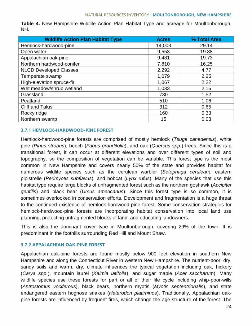
Table 4. New Hampshire Wildlife Action Plan Habitat Type and acreage for Moultonborough, NH.
Wildlife Action Plan Habitat Type Acres % Total Area
Hemlock-hardwood-pine 14,003 29.14
Open water 9,553 19.88
Appalachian oak-pine 9,481 19.73
Northern hardwood-conifer 7,810 16.25
NLCD Developed Classes 2,292 4.77
Temperate swamp 1,079 2.25
High-elevation spruce-fir 1,067 2.22
Wet meadow/shrub wetland 1,033 2.15
Grassland 730 1.52
Peatland 510 1.06
Cliff and Talus 312 0.65
Rocky ridge 160 0.33
Northern swamp 15 0.03
3.7.1 HEMLOCK-HARDWOOD-PINE FOREST
Hemlock-hardwood-pine forests are comprised of mostly hemlock (Tsuga canadensis), white
pine (Pinus strobus), beech (Fagus grandifolia), and oak (Quercus spp.) trees. Since this is a
transitional forest, it can occur at different elevations and over different types of soil and
topography, so the composition of vegetation can be variable. This forest type is the most
common in New Hampshire and covers nearly 50% of the state and provides habitat for
numerous wildlife species such as the cerulean warbler (Setophaga cerulean), eastern
pipistrelle (Perimyotis subflavus), and bobcat (Lynx rufus). Many of the species that use this
habitat type require large blocks of unfragmented forest such as the northern goshawk (Accipiter
gentilis) and black bear (Ursus americanus). Since this forest type is so common, it is
sometimes overlooked in conservation efforts. Development and fragmentation is a huge threat
to the continued existence of hemlock-hardwood-pine forest. Some conservation strategies for
hemlock-hardwood-pine forests are incorporating habitat conservation into local land use
planning, protecting unfragmented blocks of land, and educating landowners.
This is also the dominant cover type in Moultonborough, covering 29% of the town. It is
predominant in the foothills surrounding Red Hill and Mount Shaw.
3.7.2 APPALACHIAN OAK-PINE FOREST
Appalachian oak-pine forests are found mostly below 900 feet elevation in southern New
Hampshire and along the Connecticut River in western New Hampshire. The nutrient-poor, dry,
sandy soils and warm, dry, climate influences the typical vegetation including oak, hickory
(Carya spp.), mountain laurel (Kalmia latifolia), and sugar maple (Acer saccharum). Many
wildlife species use these forests for part or all of their life cycle including whip-poor-wills
(Antrostomus vociferous), black bears, northern myotis (Myotis septentrionalis), and state
endangered eastern hognose snakes (Heterodon platirhinos). Traditionally, Appalachian oak-
pine forests are influenced by frequent fires, which change the age structure of the forest. The

NATURAL RESOURCES INVENTORY | MOULTONBOROUGH, NEW HAMPSHIRE
25
diverse age and structure of the forest help to promote wildlife diversity. Intense development
pressure particularly in the southeast corner of New Hampshire has dramatically reduced
naturally occurring fires and increased fragmentation of this forest type. Incorporating habitat
conservation into local land use planning, protecting unfragmented blocks, and adopting
sustainable forestry are a few examples of conservation strategies for Appalachian oak-pine
forests.
This is the second most-dominant forest type in Moultonborough, covering 20% of the town’s
total area. It is present in the central and south-central low elevation areas of the town.
3.7.3 NORTHERN HARDWOOD-CONIFER FOREST
This habitat type is typically found between 1,400 and 2,500 feet in elevation and is usually
made up of hardwood trees such as American beech, sugar maple, yellow birch (Betula
alleghaniensis), and conifer trees such as eastern hemlock, white pine (Pinus strobus), and
balsam fir (Abies balsamea). Most of northern hardwood conifer habitat occurs in central and
northern New Hampshire. This transitional zone provides habitat for many wildlife species
including state threatened species: bald eagle (Haliaeetus leucocephalus), who nest and roost
near lakes and rivers, and peregrine falcons (Falco peregrinus) who nest on cliffs but hunt over
the forest. Other typical species in this habitat include ruffed grouse (Bonasa umbellus), wood
thrush (Hylocichla mustelina), and northern long-eared bat (Myotis septentrionalis).
Development pressure is heavy within some parts of this habitat type. Forest harvesting is
common in this habitat and if done sustainably produces the diversity of age classes and
species which is beneficial to wildlife. Forestry also has increased this type of habitat by
converting spruce-fir habitats to the more economically valuable northern hardwoods. Some
conservation strategies for northern hardwood conifer forests are incorporating the habitat into
local conservation planning, protecting unfragmented blocks of land, and advocating for the
adoption of sustainable forestry.
This forest type is present in Moultonborough at higher elevations in the vicinity of Mount Shaw.
3.7.4 HIGH-ELEVATION SPRUCE-FIR FOREST
High-elevation spruce-fir forests can be found between 2,500 and 3,500 feet in elevation on
upper mountain slopes and ridge tops. Harsh climatic extremes and highly erosive soils play a
significant role in determining the vegetative species found in this habitat type, which typically
includes red spruce (Picea rubens), balsam fir, and paper (Betula papyrifera) and yellow
birches. High-elevation spruce-fir forest has a very limited distribution in New Hampshire,
covering approximately 4% of the state's land area, and provides some of the last areas
relatively free of human disturbance. The wildlife species that are found in this habitat include
the federally threatened and state endangered Canada lynx (Lynx lynx) and the state threatened
American marten (Martes americana). Spruce grouse (Falcipennis canadensis) and Bicknell's
thrush (Catharus bicknelli) also use this habitat. Not only do the trees at this elevation have to
cope with the harsh climate, but they must also deal with the stress effects of acid deposition.
The high elevation also presents another potential threat: energy and communication
infrastructure. High elevation spruce-fir soils are also shallow, so forestry operations can easily
NATURAL RESOURCES INVENTORY | MOULTONBOROUGH, NEW HAMPSHIRE
26
damage the fragile soils. Conservation strategies for high-elevation spruce-fir forests include
habitat protection and examining potential wildlife habitat degradation from wind farm
construction.
The Wildlife Action Plan identifies 1,066 acres of high-elevation spruce-fir forest in
Moultonborough. All of it is found in the Ossipee Mountains.
3.7.5 GRASSLAND
There are 730 acres mapped as grassland in Moultonborough. Grasslands are comprised of
grasses, sedges, and wildflowers with little to no shrubs and trees. The most common grassland
habitats are airports, capped landfills, wet meadows, and agricultural fields such as hayfields,
pastures and fallow fields. Pre-colonial grasslands in New Hampshire were probably only
maintained by beaver (Castor canadensis) and fires started by lightning and Native Americans.
The numerous agricultural lands maintained by early European settlers provided ideal habitat for
some wildlife species that need grassland habitat. As these agricultural lands were abandoned,
these populations began to decline and are now on the state endangered list such as the
eastern hognose snake, northern harrier (Circus cyaneus), upland sandpiper (Bartramia
longicauda) and on the state threatened list such as the grasshopper sparrow (Ammodramus
savannarum). Other species also benefit from these open grass fields such as wood turtles
(Glyptemys insculpta) and numerous species of butterflies. Development and natural forest
succession have reduced grassland habitat in the state. Grasslands require maintenance and
must be mowed to prevent them from becoming shrublands or forests. Only 8% of NH
grasslands are currently under conservation easements. Reclaiming and maintaining grasslands
are two important conservation strategies for grassland habitats. Many grassland and potential
grassland habitat are on private land and landowners can help restore and conserve them.
Moultonborough contains 730 acres mapped as grasslands. The areas are not concentrated but
rather occur in patches throughout the town.
3.7.6 ROCKY RIDGE, CLIFF AND TALUS
Rocky ridges and talus slopes are two related but distinct habitats. Talus slopes, comprised of
loose or stable boulders and rocks, range from open, lichen covered talus "barrens" to closed-
canopy forested talus communities. Rocky ridges generally occur on outcrops and bedrock
ridges and summits below the alpine zone. Talus slopes and rocky ridges provide crucial habitat
for several rare wildlife species in New Hampshire, including bobcat, state endangered timber
rattlesnake (Crotalus horridus) and eastern small-footed bats (Myotis leibii), and state
threatened peregrine falcon. Due to the inaccessible nature of talus slopes, human impacts exist
primarily on the rocky ridge portion of this habitat, though some trails and other impacts are
found on talus. Some conservation strategies for rocky ridges and talus slopes are to limit trails
through high risk areas and monitoring indicator species for climate change.
Cliffs are steep, rocky outcrops greater than 65° in slope and 3 meters in height. They can be
low in elevation within a forest or higher in elevation and completely exposed such as the
historic location of The Old Man of the Mountain. Cliffs have sparse vegetation that is typically
NATURAL RESOURCES INVENTORY | MOULTONBOROUGH, NEW HAMPSHIRE
27
restricted to cracks and crevices where soil accumulates. Depending on the type of rock that
make up the cliff, different types of vegetation will grow there such as sheep laurel (Kalmia
angustifolia) on acidic cliffs and bulblet bladder fern (Cystopteris bulbifera) on calcareous cliffs.
Cliffs are used by several wildlife species including the state threatened peregrine falcon, state
endangered timber rattlesnake, bobcat, common raven (Corvus corax), and long-tailed shrew
(Sorex dispar). Although often viewed as isolated or inaccessible to people, the popularity of
cliffs and cliff tops as recreational destinations for hikers and rock climbers is rapidly increasing.
Another threat to the tops of these exposed habitats is energy and communication infrastructure
such as cell towers and wind turbines. Some conservation strategies for cliff habitat are
educating recreational users, habitat protection, and advising wind energy developers of
potentially negative impacts through regulation and policy.
There are 160 acres of rocky ridge mapped in Moultonborough. Most areas are found in
mountainous areas of the town.
3.7.7 TEMPERATE SWAMP
This habitat consists of forested wetlands found primarily in central and southern New
Hampshire. Temperate peat swamps are typically found in isolated or stagnant basins with
saturated, organic soils. The temperate swamps classification also includes the four known
Atlantic white cedar communities in New Hampshire, and the pitch pine‐ heath swamp, a rare
community usually associated with the Pine Barrens landscape. Most coastal conifer peat
swamps occur within 30 miles of the Atlantic coast. These wetlands provide a number of
functions such as flood control, pollutant filters, shoreline stabilization, sediment retention and
erosion control, food web productivity, wildlife habitat, recreation, and education. Threats to
temperate swamps include habitat degradation from insect pests such as the hemlock woolly
adelgid (Adelges tsugae), since hemlock is a common component of temperate swamps across
NH. Inputs of sedimentation, insecticides, and fertilizers are sources of pollution that threaten
temperate swamp habitats. Actions to conserve temperate swamps include supporting the
Division of Forests and Lands in the implementation of the hemlock woolly adelgid action plan,
and working with foresters to use Best Management Practices outlined in the document ‘Good
Forestry in the Granite State.’
The Wildlife Action Plan has mapped 1,079 acres of temperate swamp in Moultonborough.
They are situated in low-elevation areas of the town and are typically embedded in Appalachian
Oak-Pine Forest.
3.7.8 WET MEADOW/SHRUB WETLAND
Emergent marsh and shrub swamp systems have a broad range of flood regimes, sometimes
controlled by the presence or departure of beavers, but mostly controlled by groundwater. This
system, which is an important food source for many species, is often grouped into three broad
habitat categories: wet meadows, emergent marshes, and scrub-shrub wetlands. Marsh and
shrub wetlands filter pollutants, preventing them from getting into local streams, and help hold
water to reduce flooding. Many wildlife species use marsh and shrub wetlands including
common species like red-winged blackbirds (Agelaius phoeniceus), beavers, and painted turtles
NATURAL RESOURCES INVENTORY | MOULTONBOROUGH, NEW HAMPSHIRE
28
(Chrysemys picta). Marsh and shrub wetlands are also critically important for state endangered
Blanding's turtles (Emydoidea blandingii), New England cottontails (Sylvilagus transitionalis),
northern harriers, ringed boghaunters (Williamsonia lintneri), and sedge wrens (Cistothorus
platensis) plus state threatened spotted turtles (Clemmys guttata) and pied billed grebes
(Podilymbus podiceps). Development is a threat to these habitats mostly from driveways and
roads that fragment wetlands or change the flow of water. The loss of an upland habitat around
a marsh or shrub wetland also increases the amount of pollution and sedimentation threatening
the habitat. Another constant threat to marsh and shrub wetlands is invasive plants such as
purple loosestrife (Lythrum salicaria) and Japanese knotweed (Fallopia japonica) that compete
with native vegetation. Some conservation strategies for marsh and shrub wetlands are
restoration and protection of these important habitats. Many marsh and shrub wetlands are on
private land and landowners can help restore and conserve them.
The Wildlife Action Plan identifies 1,033 acres of wet meadow/shrub wetlands in
Moultonborough. The largest concentrations occur in the central portion of the town.
3.7.9 NORTHERN SWAMP
This habitat consists of forested wetlands found mainly in the northern half of the state, including
black spruce peat swamps and forest seeps. Black spruce (Picea mariana) peat swamps are
found in central and northern New Hampshire, typically in closed or stagnant basins with limited
drainage. These swamps have a forest or woodland structure, but often surround open
peatlands. Seeps occur where groundwater emerges at the soil surface and begins flowing into
a stream. Despite their small size, they support a distinctive suite of plant species, and have
value as wildlife habitat for some amphibians. Between 2004 and 2015, NH DES documented
approximately 950 acres of wetlands lost in New Hampshire through development activities.
Therefore, development of swamps, surrounding uplands, and impacts from fragmenting
features like roads are all threats to this habitat. Other threats include increased temperatures
that can cause changes in species composition, and eventual conversion to a different habitat
type. The best action we can take to conserve swamps is to delineate forested swamps in
northern New Hampshire, and add this information to the review process by the NH DES
Wetlands Bureau.
There are 15 acres of northern swamp mapped in Moultonborough. The largest is approximately
six acres located within Red Hill’s northern hardwood-conifer forest.
NATURAL RESOURCES INVENTORY | MOULTONBOROUGH, NEW HAMPSHIRE
29
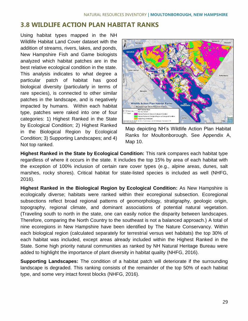
3.8 WILDLIFE ACTION PLAN HABITAT RANKS
Using habitat types mapped in the NH
Wildlife Habitat Land Cover dataset with the
addition of streams, rivers, lakes, and ponds,
New Hampshire Fish and Game biologists
analyzed which habitat patches are in the
best relative ecological condition in the state.
This analysis indicates to what degree a
particular patch of habitat has good
biological diversity (particularly in terms of
rare species), is connected to other similar
patches in the landscape, and is negatively
impacted by humans. Within each habitat
type, patches were raked into one of four
categories: 1) Highest Ranked in the State
by Ecological Condition; 2) Highest Ranked
in the Biological Region by Ecological
Condition; 3) Supporting Landscapes; and 4)
Not top ranked.
Highest Ranked in the State by Ecological Condition: This rank compares each habitat type
regardless of where it occurs in the state. It includes the top 15% by area of each habitat with
the exception of 100% inclusion of certain rare cover types (e.g., alpine areas, dunes, salt
marshes, rocky shores). Critical habitat for state-listed species is included as well (NHFG,
2016).
Highest Ranked in the Biological Region by Ecological Condition: As New Hampshire is
ecologically diverse; habitats were ranked within their ecoregional subsection. Ecoregional
subsections reflect broad regional patterns of geomorphology, stratigraphy, geologic origin,
topography, regional climate, and dominant associations of potential natural vegetation.
(Traveling south to north in the state, one can easily notice the disparity between landscapes.
Therefore, comparing the North Country to the southeast is not a balanced approach.) A total of
nine ecoregions in New Hampshire have been identified by The Nature Conservancy. Within
each biological region (calculated separately for terrestrial versus wet habitats) the top 30% of
each habitat was included, except areas already included within the Highest Ranked in the
State. Some high priority natural communities as ranked by NH Natural Heritage Bureau were
added to highlight the importance of plant diversity in habitat quality (NHFG, 2016).
Supporting Landscapes: The condition of a habitat patch will deteriorate if the surrounding
landscape is degraded. This ranking consists of the remainder of the top 50% of each habitat
type, and some very intact forest blocks (NHFG, 2016).
Map depicting NH’s Wildlife Action Plan Habitat
Ranks for Moultonborough. See Appendix A,
Map 10.

NATURAL RESOURCES INVENTORY | MOULTONBOROUGH, NEW HAMPSHIRE
30
3.8.1 UTILITY OF HABITAT RANK INFORMATION
A principal use of the Wildlife Action Plan Habitat Rank dataset is to prioritize parcels for land
protection. The data can be used in combination with other locally-collected information on
forest stand types, wildlife sightings, recreational trails, scenic views, water resources, etc. as
part of the decision-making process.
Another use is comprehensive conservation planning. For towns and conservation
organizations, taking a proactive approach and considering an entire geographic area prior to
making land-use decisions is critical. Wildlife habitat can enhance the character of a town,
provide protection from flooding, protect water resources, and provide educational opportunities.
Considering where the best habitat for those things are located in a given town/region, so that
both economic development and natural resources protection occur in the right places, is crucial
to the long-term quality of life in that particular area (NHFG, 2016).
3.8.2 A PRIMER ON HABITAT CONNECTIVITY
The major factor in the reduction and loss of biodiversity (i.e., plants, animals, and habitat types)
in the Northeast is fragmentation of habitat units into smaller, isolated sub-units. This is a
national phenomenon, discussed in detail by Johnson and Klemens (2005). To maintain native
biodiversity it is critical to ensure that remaining habitat areas are large enough to support viable
wildlife populations and that they’re arranged in a fashion that facilitates movement of animals
across the landscape (Miller et al., 2005).
To ensure that development is compatible with native species that are sensitive to development,
core habitat areas and corridors that connect them must be accommodated. In general, larger
core areas are better able to support viable wildlife populations than smaller ones. Connections
between core areas are of the utmost importance as they facilitate animal dispersal between
core areas thus enabling genetic exchange and preventing local species extirpations. These
connections are typically referred to as “corridors”. Note however that a corridor for wildlife is not
a narrow, linear green strip between core areas. Rather, a wildlife corridor is a broad swath of
habitat connecting core habitat areas. Corridors may not be as pristine as the core areas they
connect but they do provide secondary habitat and, most importantly, facilitate movement of
wildlife between core areas (Miller et al., 2005).
It is prudent to identify where the matrix of wildlife habitat and corridors occur on a given
landscape. It is insufficient to randomly protect small parcels of habitat across a region in hopes
that they’ll be beneficial to wildlife. Instead, it is best to discover where particular species occur
and incorporate the information into future land-use decisions (Miller et al. 2005).
The Priority Conservation Areas presented below are based largely on remote-sensed data.
Important areas within these areas can be further identified by gathering field-based information
on the distribution of development-sensitive wildlife throughout the town. An example of valuable
information that can be collected is the vernal pool surveys discussed in Section 5.5 below.

NATURAL RESOURCES INVENTORY | MOULTONBOROUGH, NEW HAMPSHIRE
31
3.9 RARE PLANTS & ANIMALS AND EXEMPLARY NATURAL
COMMNUNITES
Rare plant and animal species have been documented in Moultonborough; this information is
maintained by New Hampshire’s Division of Forests and Lands’ Natural Heritage Bureau, in
cooperation with the New Hampshire Fish & Game’s Non-Game and Endangered Wildlife
Program. Generalized information on the presence of these species and communities is
available from the Natural Heritage Bureau. According to the Bureau’s “Rare Plants, Rare
Animals and Exemplary Natural Communities in New Hampshire Towns” (NHB, 2013) the
species and natural communities/systems listed in Appendix C have been documented to exist
in Moultonborough. The specific locations of rare species and communities are not available for
this study due to data release policies of the NHB. As described above in Section 3.8,
information on rare species and communists has been incorporated into the Wildlife Action
Plan’s Habitat Rank.
3.10 NON-NATIVE, INVASIVE SPECIES
Aquatic plant species: Nine non-native, invasive aquatic plant species are known to exist in
New Hampshire waterbodies: variable milfoil (Myriophyllum herterophyllum), fanwort, (Cabomba
caroliniana), Eurasian water-milfoil (Myriophyllum spicatum), Brazillian elodea (Egeria densa),
curly-leaf pondweed (Potamogeton crispus), European naiad (Najas minor), water chestnut
(Trapa natans), purple loosestrife (Lythrum salicaria), and common reed (Phragmites australis).
These invasive aquatic plants pose a threat to the ecological, aesthetic, recreational, and
economic values of lakes and ponds (Luken & Thieret, 1997, Halstead, 2000, cited in NHDES,
2013). They accomplish this primarily through forming dense monocultures in the waterbodies
they infest. These infestations result in reduced overall species diversity in plant and animal
species, diminished water quality, reduced fishing and water recreation opportunities, and
reduced property values.
Variable milfoil became established in Moultonborough Bay in 1965, and is the longest standing
infestation in New Hampshire. The NH Department of Environmental Service (2013) states the
plants throughout the bay are mature and well-established, forming monocultures in many
areas, and generally widespread in others. The plant has flowered for a number of years in
some areas of the lake, which has produced substantial seed stock in the lake substrate that
could germinate and perpetuate growth for many years to come.
The Town of Moultonborough has been proactive in the effort to control milfoil in infested
waterbodies in town, including Moultonborough Bay. The town formed a special Milfoil
Committee that operates under the Conservation Commission. The group meets regularly to
discuss and strategize for milfoil control activities. The town has been successful in passing
warrant articles to allocate funds for milfoil control efforts in waterbodies infested within
Moultonborough town boundaries (NHDES, 2013).

NATURAL RESOURCES INVENTORY | MOULTONBOROUGH, NEW HAMPSHIRE
32
Terrestrial and wetland plant species: Non-native, invasive vegetation can have deleterious
effects on the ecology, scenic quality, and quality of public recreation in a given area. All three of
these attributes stand to be compromised by the unchecked spread of non-native, invasive
plants. Non-native, invasive plants out-compete native species, and with their loss so follows the
loss of their native pollinators and other dependent wildlife. Also, the seed and berry crops
produced by non-native invasives are in most cases less nutritious to birds than those produced
by native species. Climbing vines can be unsightly, as are dense thickets of non-native invasive
species, both of which are capable of rendering foot paths impassable
Disturbed areas, whether it is natural or resulting human activity are particularly susceptible to
the establishment and spread of invasive species. In riparian areas, combinations of frequent
ice and water scour, fertile floodplain soils, increased sunlight, and water transport of seeds and
plant fragments provide excellent conditions for non-native, invasive plants to establish, grow,
and spread.
Common non-native, invasive plant species which undoubtedly occur in Moultonborough include
Japanese knotweed (Fallopia japonica), glossy buckthorn (Frangula alnus), Asian bittersweet
(Celastrus orbiculatus), honeysuckle (Lonicera morrowii and L. tatarica), autumn olive (Elaegnus
umbellata), and multiflora rose (Rosa multiflora).
Invasive species pose a considerable threat in Moultonborough. Best management practices
require multiple approaches including inventory and mapping, control at ecologically important
or vulnerable sites, local policy, and regional partnerships. See Cygan’s (2011) New Hampshire
Guide to Upland Invasive Species for more information.
Insects: Several non-native, invasive insect species are known to occur in New Hampshire
including the emerald ash borer (Agrilus planipennis), hemlock wooly adelgid (Adelges tsugae),
elongate hemlock scale (Fiorinia externa), red pine scale (Matsucoccus resinosae), winter moth
(Operophtera brumata), and balsam wooly adelgid (Adelges piceae). Of these, only the hemlock
wooly adelgid has been documented in Moultonborough. For more information on non-native,
invasive insects, visit the NHBugs website at https://nhbugs.org/.

NATURAL RESOURCES INVENTORY | MOULTONBOROUGH, NEW HAMPSHIRE
33
4.0 PRIORITY CONSERVATION AREAS The original 2007 Moultonborough NRI
presented nine Priority Conservation
Areas. These areas represent areas of
the town with the highest natural resource
values and were identified using a co-
occurrence model developed by the New
Hampshire Fish and Game Department.
A co-occurrence analysis involves the
overlay of raster images in a GIS. The
raster images used in the original co-
occurrence analysis consisted of the town
as a surface divided into a regular grid of
cells. For each raster (e.g., wetlands,
agricultural soil), each cell containing a
given natural resource feature was
assigned a value of one. Individual raster
layers were then overlaid on top of one
another to determine which areas of the
town support the greatest number of
significant natural resources. NHFG has
since replaced this original co-occurrence
model with the New Hampshire Wildlife
Action Plan Habitat Ranks (discussed in
Section 3.8).
For this NRI update, an additional co-
occurrence model was created by
overlaying rasters depicting mapped
wetlands, areas ranked as greater than
zero according to the Wildlife Action Plan,
agricultural soil, hydric soil, aquifers,
streams (and the area 350’ on either side
of them), and areas identified as buildable
by the build-out analysis (FBE, 2015).
The recent analysis matches up well with
the conservation areas identified as part
of the original NRI. They have been made larger, however, in part to encompass areas ranked
by the Wildlife Action Plan.
Map showing Moultonborough’s Priority
Conservation Areas. See Appendix A, Map 11.
Map showing Moultonborough’s Priority
Conservation Areas overlaid on the results of the
co-occurrence model. See Appendix A, Map 12.
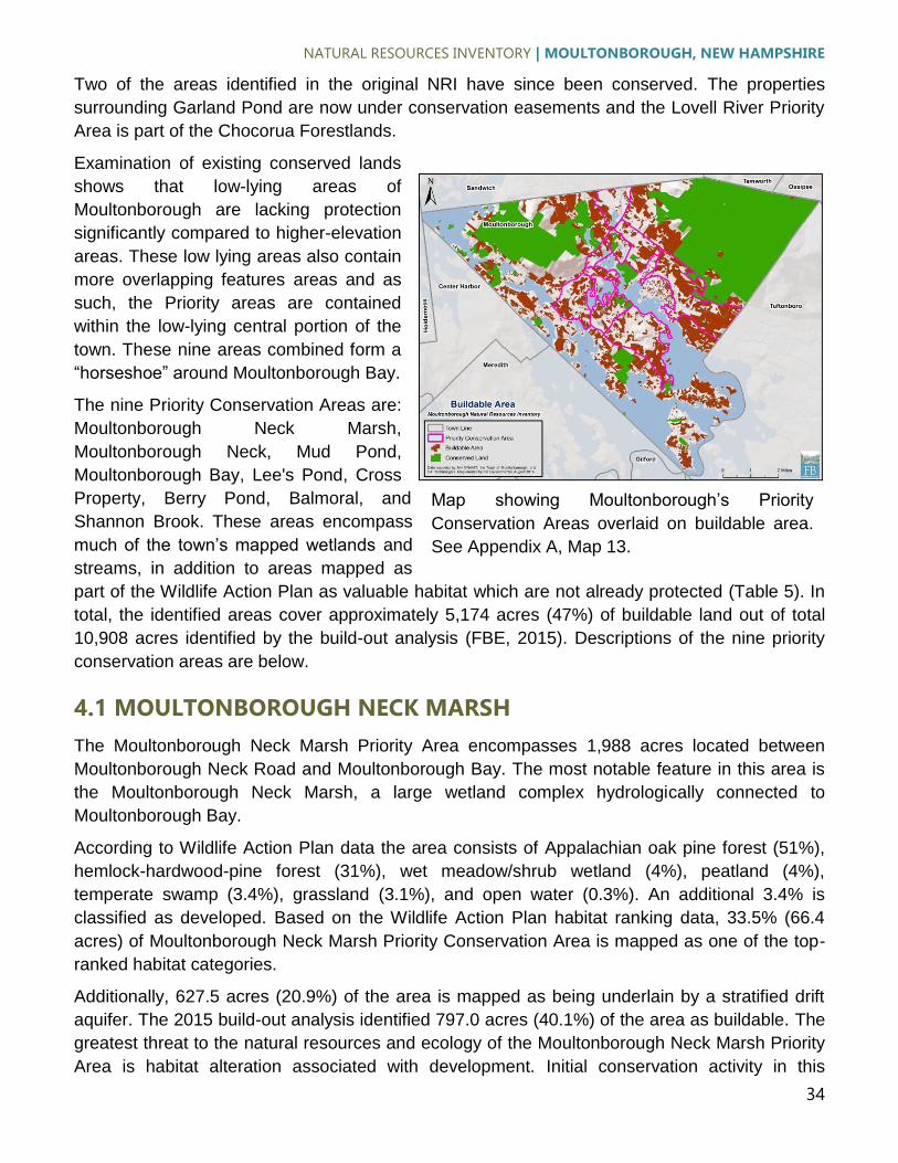
NATURAL RESOURCES INVENTORY | MOULTONBOROUGH, NEW HAMPSHIRE
34
Map showing Moultonborough’s Priority
Conservation Areas overlaid on buildable area.
See Appendix A, Map 13.
Two of the areas identified in the original NRI have since been conserved. The properties
surrounding Garland Pond are now under conservation easements and the Lovell River Priority
Area is part of the Chocorua Forestlands.
Examination of existing conserved lands
shows that low-lying areas of
Moultonborough are lacking protection
significantly compared to higher-elevation
areas. These low lying areas also contain
more overlapping features areas and as
such, the Priority areas are contained
within the low-lying central portion of the
town. These nine areas combined form a
“horseshoe” around Moultonborough Bay.
The nine Priority Conservation Areas are:
Moultonborough Neck Marsh,
Moultonborough Neck, Mud Pond,
Moultonborough Bay, Lee's Pond, Cross
Property, Berry Pond, Balmoral, and
Shannon Brook. These areas encompass
much of the town’s mapped wetlands and
streams, in addition to areas mapped as
part of the Wildlife Action Plan as valuable habitat which are not already protected (Table 5). In
total, the identified areas cover approximately 5,174 acres (47%) of buildable land out of total
10,908 acres identified by the build-out analysis (FBE, 2015). Descriptions of the nine priority
conservation areas are below.
4.1 MOULTONBOROUGH NECK MARSH
The Moultonborough Neck Marsh Priority Area encompasses 1,988 acres located between
Moultonborough Neck Road and Moultonborough Bay. The most notable feature in this area is
the Moultonborough Neck Marsh, a large wetland complex hydrologically connected to
Moultonborough Bay.
According to Wildlife Action Plan data the area consists of Appalachian oak pine forest (51%),
hemlock-hardwood-pine forest (31%), wet meadow/shrub wetland (4%), peatland (4%),
temperate swamp (3.4%), grassland (3.1%), and open water (0.3%). An additional 3.4% is
classified as developed. Based on the Wildlife Action Plan habitat ranking data, 33.5% (66.4
acres) of Moultonborough Neck Marsh Priority Conservation Area is mapped as one of the top-
ranked habitat categories.
Additionally, 627.5 acres (20.9%) of the area is mapped as being underlain by a stratified drift
aquifer. The 2015 build-out analysis identified 797.0 acres (40.1%) of the area as buildable. The
greatest threat to the natural resources and ecology of the Moultonborough Neck Marsh Priority
Area is habitat alteration associated with development. Initial conservation activity in this

NATURAL RESOURCES INVENTORY | MOULTONBOROUGH, NEW HAMPSHIRE
35
Table 5 Summary of New Hampshire Wildlife Action Plan Habitat Types and Habitat Ranks within Moultonborough’s nine Priority Conservation Areas. For Habitat Ranks 0 = Not
Ranked, 1 = Highest Ranked in State by Ecological Condition, 2 = Highest Ranked in the Biological Region by Ecological Condition, 3 = Supporting Landscapes.
Moultonborough
Neck Marsh Moultonborough
Neck Mud Pond
Moultonborough Bay
Lee's Pond Cross Property Berry Pond Balmoral Shannon Brook
Cover Type Acres Percent Acres Percent Acres Percent Acres Percent Acres Percent Acres Percent Acres Percent Acres Percent Acres Percent
Cover Type
Appalachian oak-pine 1,011 51% 453 58% 514 47% 246 88% 78 27% 29 7% 254 31% 180 20% 1,254 51%
Grassland 61 3% - 0% 50 5% 3 1% 2 1% 56 14% 25 3% 111 12% 100 4%
Hemlock-hardwood-pine 616 31% 79 10% 246 22% 11 4% 78 27% 212 52% 161 19% 375 42% 721 29%
NLCD Developed Classes 67 3% 23 3% 120 11% 5 2% 39 14% 42 10% 97 12% 77 9% 159 6%
Open water 6 0% 40 5% 2 0% 0 0% 38 13% 1 0% 51 6% 0 0% 1 0%
Peatland 79 4% 14 2% 30 3% 5 2% 6 2% 3 1% 166 20% - 0% 31 1%
Temperate swamp 67 3% 62 8% 43 4% 7 3% 8 3% 26 6% 35 4% 122 14% 133 5%
Wet meadow/shrub wetland 80 4% 115 15% 98 9% 4 1% 36 13% 41 10% 42 5% 29 3% 75 3%
Total 1,988 100% 787 100% 1,104 100% 281 100% 286 100% 410 100% 831 100% 894 100% 2,473 100%
Habitat Rank
0 1,322 66% 231 29% 635 58% 183 65% 212 74% 308 75% 414 50% 666 75% 971 39.3%
1 353 18% 246 31% 191 17% 88 31% 41 14% 31 8% 379 46% 44 5% 378 15.3%
2 37 2% 112 14% 60 5% 2 1% 18 6% 11 3% 7 1% 34 4% 103 4.2%
3 276 14% 199 25% 218 20% 8 3% 15 5% 60 15% 31 4% 149 17% 1020 41.2%
Total 1,988 0% 787 0% 1,104 0% 281 0% 286 0% 410 0% 831 0% 894 0% 2,473 0.0%

NATURAL RESOURCES INVENTORY | MOULTONBOROUGH, NEW HAMPSHIRE
36
area should be focused around Moultonborough Neck Marsh as it contains the greatest amount
of area mapped as one of the top-ranked habitat categories in the Wildlife Action Plan.
4.2 MOULTONBOROUGH NECK
Moultonborough Neck Priority Conservation Area is located between Moultonborough Neck
Road and Moultonborough Bay, just northwest of the Moultonborough Neck Marsh Priority Area.
As with the Moultonborough neck area, the Moultonborough Neck Priority Area also
encompasses a large wetland complex hydrologically connected to Moultonborough Bay.
In total the area encompasses 787.4 acres of which 57.6% is mapped as Appalachian oak-pine
forest, 10% as hemlock-hardwood-pine, 5.1% as open water, 1.8% as peatland, 7.9% as
temperate swamp, and 14.6 as wet meadow/shrub wetlands. An additional 2.9% is classified as
developed.
Based on the Wildlife Action Plan habitat ranking data, 70.7% of Moultonborough Neck Priority
Conservation Area is mapped as one of the top-ranked habitat categories. Stratified drift
aquifers comprise 22.5% (177.1 acres) of the priority conservation area. The 2015 build-out
analysis classified 258.3 acres (32.8%) as buildable.
The greatest threat to the natural resources and ecology of the Moultonborough Neck Priority
Area is habitat alteration associated with development. Conservation activity within this area
should be focused on areas mapped as one of the top-ranked habitat categories in the Wildlife
Action Plan.
4.3 MUD POND
The Mud Pond Priority Conservation Area encompasses 1,104.3 acres surrounding Mud Pond.
The pond’s outlet drains south into Salmon Meadow Cove. According to the Wildlife Action Plan
data, the area consists of Appalachian oak pine forest (46.6%), hemlock-hardwood-pine forest
(22.3%), wet meadow/shrub wetland (8.9%), grassland (4.5%), temperate swamp (3.9%),
peatland (2.7%), and open water (0.2%). An additional 10.9% is classified as developed.
Based on the Wildlife Action Plan habitat ranking data, 33.5% (66.4 acres) of the Mud Pond
Priority Conservation Area is mapped as one of the top-ranked habitat categories. Additionally,
469.0 acres (4.25%) of the area is mapped as being underlain by a stratified drift aquifer. The
2015 build-out analysis identified 499.7 acres (45.3%) of the area as buildable.
The greatest threat to the natural resources and ecology of the Mud Pond Priority Area is habitat
alteration associated with development. Conservation activity within this area should be focused
around Mud Pond and the wetland complexes in the northeastern portion of the area.
4.4 MOULTONBOROUGH BAY
The Moultonborough Bay Priority Conservation Area encompasses 280.5 acres located east of
Route 25 and West of the northern end of Moultonborough Bay. According to the Wildlife Action
Plan the area is comprised mostly of Appalachian oak pine forest (87.7%), hemlock-hardwood-

NATURAL RESOURCES INVENTORY | MOULTONBOROUGH, NEW HAMPSHIRE
37
pine forest (3.8%), temperate swamp (2.5%), peatland (1.8%), wet meadow/shrub wetland
(1.3%), grassland (1.1%), and open water (0.1%). An additional 1.6% is classified as developed.
Based on the Wildlife Action Plan habitat ranking data, 34.9% (97.8 acres) of Moultonborough
Bay Priority Conservation Area is mapped as one of the top-ranked habitat categories.
Additionally, 76.3 acres (27.2%) of the area is mapped as being underlain by a stratified drift
aquifer. The 2015 build-out analysis identified 136.1 acres (48.5%) of the area as buildable.
The greatest threat to the natural resources and ecology of the Moultonborough Bay Priority
Area is habitat alteration associated with development. Town parcel data shows this priority
area contains a few large tracts of land that could be targeted for possible land protection
efforts.
4.5 LEE’S POND
The Lee’s Pond Priority Conservation Area is 285.79 acres in size and is located north and west
of Lee’s Pond, just southeast of Route 25. According to the Wildlife Action Plan, the area
consists of Appalachian oak-pine forest (27.3%), hemlock-hardwood-pine forest (27.3%), open
water (13.4%), open water (13.4%), wet meadow/shrub wetland (12.6), temperate swamp
(2.9%), peatland (2.1%), and grassland (0.8%). An additional 13.7% is mapped as being
developed.
Based on the Wildlife Action Plan habitat ranking data, 25.9% (73.9 acres) of Lee’s Pond Priority
Conservation Area is mapped as one of the top-ranked habitat categories. Additionally, 76.3
acres (27.2%) of the area is mapped as being underlain by a stratified drift aquifer. The 2015
build-out analysis identified 95.8 acres (33.5%) of the area as buildable.
The greatest threat to the natural resources and ecology of the Lee’s Pond Priority Area is
habitat alteration associated with development. Conservation activity should be focused in the
vicinity of Lee’s Pond and the wetlands associated with it.
4.6 CROSS PROPERTY
The Cross Property Priority Conservation Area encompasses a 409.8 acre area which includes
an unnamed waterbody and a stretch of Halfway Brook, a tributary to Moultonborough Bay
which drains from the Ossipee Mountains and is one of the largest stream complexes in the
town. The area is bordered by Route 25, Lee Road, Lees Mill Road, and Blake Road. According
to the Wildlife Action Plan, the area is comprised of hemlock-hardwood-pine forest (51.8%),
grassland (13.7%), wet meadow/shrub wetland (10.0%), Appalachian oak-pine forest (7.2%),
temperate swamp (6.3%), peatland (0.6%), and open water (0.3%). An additional 10.2% is
mapped as being developed.
Based on the Wildlife Action Plan habitat ranking data, 25.0% (102.3 acres) of Cross Property
Priority Conservation Area is mapped as one of the top-ranked habitat categories. Additionally,
76.3 acres (27.2%) of the area is mapped as being underlain by a stratified drift aquifer. The
2015 build-out analysis identified 118.3 acres (28.9%) of the area as buildable.

NATURAL RESOURCES INVENTORY | MOULTONBOROUGH, NEW HAMPSHIRE
38
The greatest threat to the natural resources and ecology of the Cross Pond Priority Area is
habitat alteration associated with development. Conservation activity within this area should first
be focused around Halfway Brook, as the land bordering it is mapped as Highest Ranked in the
State by Ecological Condition in the Wildlife Action Plan.
4.7 BERRY POND
The Berry Pond Priority Conservation Area encompasses 831.3 acres and it includes Berry
Pond and a tributary to it, Weed Brook. The area is mapped as Appalachian oak-pine forest
(30.6%), peatland (20.0), hemlock-hardwood-pine forest (11.7%), open water 6.15%, wet
meadow/shrub wetland (5.02%), temperate swamp (4.2%), and grassland 2.95%. An additional
11.7% is mapped as being developed.
Based on the Wildlife Action Plan habitat ranking data, 50.2% (417.5 acres) of Berry Pond
Priority Conservation Area is mapped as one of the top-ranked habitat categories. Additionally,
351.8 acres (42.3%) of the area is mapped as being underlain by a stratified drift aquifer. The
2015 build-out analysis identified 183.4 acres (22.1%) of the area as buildable.
The greatest threat to the natural resources and ecology of the Berry Pond Priority Area is
habitat alteration associated with development. Conservation activity within this area should first
be focused around Weed Brook, as it and the land bordering it is mapped as Highest Ranked in
the State by Ecological Condition in the Wildlife Action Plan.
4.8 BALMORAL
The Balmoral Priority Area encompasses 893.7 acres located northeast of Moultonborough Bay
and southwest of the Governor Wentworth Highway. Present at the south end of this area is a
large wetland complex adjacent to Moultonborough Bay. Halfway Brook traverses this area.
The watercourse is a tributary to Moultonborough Bay which drains from the Ossipee Mountains
and is one of the largest stream complexes in the town.
The Balmoral Priority Area consists of hemlock-hardwood-pine forest (42.0%), Appalachian oak-
pine forest (20.1%), temperate swamp (13.7%), grassland (12.4%), and wet meadow/shrub
wetland (3.2%). An additional 8.6% is classified as developed.
Based on the Wildlife Action Plan habitat ranking data, 25.4% (227.3 acres) of Balmoral Priority
Conservation Area is mapped as one of the top-ranked habitat categories. Additionally, 568.1
acres (63.6%) of the area is mapped as being underlain by a stratified drift aquifer. The 2015
build-out analysis identified 331.1 acres (37.0%) of the area as buildable.
The greatest threat to the natural resources and ecology of the Balmoral Priority Area is habitat
alteration associated with development. Conservation activity within this area should first be
focused around Halfway Brook and the large wetland complex at the southern end of the priority
area.

NATURAL RESOURCES INVENTORY | MOULTONBOROUGH, NEW HAMPSHIRE
39
4.9 SHANNON BROOK
The Shannon Brook Priority Conservation Area is 2,473.5 acres in size and is located in-
between the Ossipee Mountains and Moultonborough Bay. The area is mapped as Appalachian
oak-pine forest (50.7%), hemlock-hardwood-pine forest (29.2%), temperate swamp (5.4%),
grassland (4.0%), wet meadow/shrub wetland (3.1%), and peatland (1.2%). An additional 6.4%
is mapped as being developed.
Based on the Wildlife Action Plan habitat ranking data, 60.7% (1,501.3 acres) of Shannon Brook
Priority Conservation Area is mapped as one of the top-ranked habitat categories. Additionally,
759.2 acres (30.7%) of the area is mapped as being underlain by a stratified drift aquifer. The
2015 build-out analysis identified 1,468.3 acres (59.4%) of the area as buildable.
The greatest threat to the natural resources and ecology of the Shannon Brook Priority Area is
habitat alteration associated with development. Conservation activity within this area should first
be focused around Shannon Brook as it and the land adjacent to it is mapped as one of the top-
ranked habitat categories in the Wildlife Action Plan.
5.0 CONSERVATION RECOMMENDATIONS A challenge that Moultonborough faces moving forward is how to achieve a better balance
between prudent economic growth, land ownership, and responsible stewardship of its natural
resources. A healthy functioning environment is often considered to be in opposition to
economic growth and human quality of life. This is a false dilemma. Clean air, clean water, and
ecosystem services provided by natural systems are essential to maintaining a high quality of
human life. If comminutes can disregard the oppositional model of environmental conservation
vs. human progress they can begin to have a broader discussion on how to achieve both
(Klemens et al. 2012).
The following section mentions some tools and techniques that can be used to achieve a
balance between development and conservation within Moultonborough. The recommendations
are in part adapted from Miller and Klemens (2004), Miller et al. (2005), Klemens et al. (2012),
and FBE (2016). Note that for information and recommendations regarding the water quality of
Moultonborough Bay Inlet, FBE is currently developing a comprehensive Watershed Restoration
Plan in cooperation with the Lake Winnipesaukee Association and the New Hampshire
Department of Environmental Services.
5.1 CONSIDERATIONS AND CAVEATS
Priority conservation areas are not being mapped solely for land preservation–. Preservation of
entire Conservation Priority Areas is not feasible, nor do we recommend it. Much of the mapped
areas are privately-owned lands that contribute, through taxes, to the economic stability of the
town. Rather, a balanced approach to conservation and development which incorporates a suite
of land use planning and conservation tools is recommended.

NATURAL RESOURCES INVENTORY | MOULTONBOROUGH, NEW HAMPSHIRE
40
Development and other land-use activities outside of the Conservation Priority Areas need to
remain mindful of environmental and land use issues–. Regardless of location, all development
proposals should receive careful review and consideration of potential environmental impacts.
Conservation opportunities may occur outside of the Priority Conservation Areas–. Small or
isolated areas outside of the Conservation Priority Areas may contain previously unknown
significant species or natural communities that have high conservation value.
5.2 RECOMMENDATIONS FOR LAND PRESERVATION
Attempt to add area via purchase or conservation easement to existing protected areas–. “The
whole is greater than the sum of the parts” applies here. Adding to existing protected areas
buffers those areas from externally-caused degradations (e.g., stormwater runoff, noise
pollution). Increasing the size of a given protected area also reduces “edge effects” which
include changes in vegetation structure and species composition, temperature, and predation
and parasitism levels, all of which can have deleterious effects on populations of area-sensitive
wildlife species. In Moultonborough, conserving land in the Shannon Brook Priority Conservation
Area could effectively increase the size of the Ossipee Mountain Preserve.
Partner with local and regional land trusts and other conservation organizations to conserve
land in Moultonborough–. Regional land trusts such as the Lakes Region Conservation Trust
and the New Hampshire Chapter of The Nature Conservancy can be instrumental in acquiring
land, holding conservation easements, and facilitating conservation projects.
5.3 RECOMMENDATIONS FOR LOCAL LAND USE PLANNING
Avoid large-lot zoning–. Increasing the size of buildable residential lots is considered by some
to be a “quick fix” to sprawl-type development. This change to zoning results in a development
pattern that appears to be “green”, with fewer houses and more trees visible. In reality, this
practice actually spreads the impacts of development across a larger area, destabilizing and
often eliminating local populations of wildlife that are sensitive to development (i.e., require
tracts of land absent of roads, driveways, houses, and lawns).
Increase building setbacks in shoreland zones–. The land adjacent to a lake, pond, river, or
stream, when left in its natural state, plays an important role in filtering runoff, shading streams
and rivers, protecting banks and shorelines, and reducing erosion. Some of the benchmark
standards that should be built into ordinances for protecting water quality within the shoreland
zone include: mandatory setbacks for primary structures, mandatory buffers between
development and the waterbody, and impervious cover restrictions.
Moultonborough’s required setback of 50 feet follows the State of New Hampshire’s minimum
requirement, as dictated by the State Water Quality Protection Act. Some towns in NH (e.g.,
neighboring Sandwich) go beyond the State minimum and require a setback of 100 feet. This
100-foot setback has proven to be very effective at protecting water quality (Merrell et al., 2013)
and it may therefore be prudent for Moultonborough to increase its setback distance.

NATURAL RESOURCES INVENTORY | MOULTONBOROUGH, NEW HAMPSHIRE
41
Consider novel types of development, including Traditional Neighborhood Design (TND)
and conservation subdivisions–. By clustering housing, it is possible to reduce the amount of
impact of associated infrastructure (e.g., roads) and to reduce the overall “footprint” of a given
development. Conservation subdivisions could be encouraged or mandated in conservation
priority areas, as this type of development has been shown to have less negative impact on
open space, wildlife and their habitat, and water quality than unlimited outward expansion of
low-density development into undeveloped areas (i.e., sprawl; Hawkins, 2014).
Moultonborough’s zoning ordinance does contain a provision for conservation subdivisions
(referred to as Multi-Family and Cluster Development in the ordinance). The town permits the
clustering of housing units for the preservation of open space, to promote more efficient use of
land, and to provide flexibility in subdivision design. The town does not require this type of
development to take place as a result of certain circumstances; however, the provision itself is
progressive in that it states that the total ground area occupied by buildings and parking areas
may not exceed 20% of the total ground area of the development. Note too that conservation
lands in these subdivisions should not only include steep slopes and wetlands, but also
developable land that connects these constrained features. It is also prudent to mandate that
conserved open space on one development parcel connect to the open space on another parcel
when possible.
Consider mandating low-impact development practices–. Low impact development (LID)
refers to a wide range of techniques specifically designed to limit the adverse effects that poorly
planned development can have on water quality. Some examples of LID techniques include
minimization and/or disconnection of impervious surfaces, development design that reduces the
rate and volume of runoff, and reduction of the pollutant loads within runoff. Common types of
techniques include, but are not limited to: curb-free roads, swales, bioretention cells, tree box
filters, infiltration trenches, rain barrels, and rain gardens. Moultonborough can help protect
water quality and wildlife habitat by mandating the use of LID in new and renovated
developments.
More information on LID techniques can be found on the Center for Watershed Protection’s
website: www.cwp.org and within the New Hampshire Homeowners Guide to Stormwater
Management available through NHDES:
www.des.state.nh.us/organization/commissioner/pip/publications/wd/documents/wd-11-11.pdf.
Amend the existing wetland regulations to better protect wetlands and the organisms
they support–. Wetlands, along with the terrestrial areas adjacent to them tend to be
biodiversity hotspots. Unfortunately, they are often not adequately protected in New Hampshire,
where wetlands below a certain size threshold are not regulated and those that are have
inadequate buffers. (Wetland regulations are typically written to protect water quality and rarely
include language to protect wildlife that require wetland areas.)
Moultonborough’s ordinance specifies a 50-foot setback from wetlands and that a naturally
vegetated buffer be maintained within 25 feet immediately adjacent to applicable wetlands.
Moultonborough’s ordinance also only applies to wetlands greater than 20,000 square feet (just

NATURAL RESOURCES INVENTORY | MOULTONBOROUGH, NEW HAMPSHIRE
42
less than ½ acre) in their entirety or wetlands of any size that are contiguous to a river, brook,
lake, or pond with certain other exemptions (e.g., manmade ditches, detention basins).
Moultonborough may wish to eliminate its wetland size requirement, or perhaps not disregard
setback requirements if a given small wetland is functioning as a vernal pool. Vernal pools are
typically very small in size, but can be enormously productive wetlands. For additional protection
of wetlands and their water quality, Moultonborough might wish to increase its wetland buffers,
in particular for wetlands that support a significant amount of pool-breeding wildlife.
Formally adopt and apply “Best Management Practices” and “Best Development
Practices” that can help to reduce impacts to biodiversity during both town-wide
planning and individual site review processes–. Examples of such manuals are Calhoun and
Klemens (2002) Best Development Practices Conserving Pool-Breeding Amphibians in
Residential and Commercial Developments in the Northeastern United States and Calhoun and
deMaynadier (2004) Forestry Management Guidelines for Vernal Pool Wildlife. Additional BMPs
from other organizations and agencies may also prove useful.
5.4 PRIME WETLANDS
As mentioned previously, there are currently 33 towns in New Hampshire that have designated
prime wetlands of which Moultonborough is not one. Prime Wetland designation provides a
means by which these towns can provide additional protection to wetlands that are particularly
unique or sensitive to disturbance by restricting construction or earthwork in or within 100 ft of
these resources.
While Prime designation does offer addional protection to a subset of wetlands within the town,
the Conservation Commission may wish to first spearhead a town-wide inventory of vernal pools
(see following section). Information obtained during the vernal pool inventory may be useful for
the Prime Wetland designation process should the town wish to pursue it in the future.
5.5 VERNAL POOLS
New Hampshire’s Nongame and Endangered Wildlife Program of New Hampshire Fish and
Game encourages citizens to document the locations of vernal pools using a downloadable form
and/or through their NH Wildlife Sightings website, a web tool for reporting wildlife observations
throughout the state. More information regarding documenting and reporting NH Vernal Pools
can be found in Identifying and documenting vernal pools in New Hampshire, (Marchand, 2016)
available at: http://www.wildlife.state.nh.us/nongame/vernal-pools.html.
While it likely NHFG may have some vernal pool information on file pertaining to
Moultonborough, it is recommended that vernal pools be formally documented throughout the
entire town. This does not need to be conducted by, nor is it likely economically feasible to hire
consultants to document pools throughout the entire town. Rather, the work could be carried out
by trained citizen scientists. This has been accomplished in numerous towns in Maine through
the Maine Municipal Vernal Pool Mapping Project. In addition to the financial advantages of

NATURAL RESOURCES INVENTORY | MOULTONBOROUGH, NEW HAMPSHIRE
43
using volunteers, engaging local citizenry also increases awareness of natural resources, instills
a sense of place and community pride, and encourages local control over quality of life through
participation in planning for the future (Morgan and Calhoun, 2012). More information regarding
the use of citizen scientists to map vernal pools can be found in in the Morgan and Calhoun’s
(2012) Maine Municipal Guide to Mapping and Conserving Vernal Pool Resources. The authors
mention that while the focus of their publication is to provide guidance to Maine municipalities,
their methodology is appropriate for any region interested in local, collaborative conservation
planning and is applicable at a variety of scales.
Lastly, Morgan and Calhoun (2012) mentions that interpretation of aerial photography is the best
available method for remotely identifying potential vernal pools at the municipal scale. While
aerial imagery is the “gold standard”, the use of LIDAR data is becoming increasingly common.
LiDAR is a form of remote sensing that uses laser light pulses to help reveal highly detailed
information about a landscape. While interpretation of aerial imagery involves the use of paired
9 x 9 inch stereo contact prints viewed under a mirror stereoscope or viewing digitized images in
3-D on a specialized computer screen, LIDAR requires the use of sophisticated computer
modeling. Sean MacFaden of the University of Vermont Spatial Analysis Lab has developed a
very accurate method of remotely sensing vernal pools with LIDAR data using Object-based
Image Analysis and eCognition software.
5.6 RESIDENTIAL / LANDOWNER STEWARDSHIP AND PUBLIC
EDUCATION
Promote the use of native plant species in Moultonborough–. Review of development
proposals should include the promotion of native plantings in landscaping plans. Educate the
public about invasive species through garden clubs and other civic groups.
Improve habitat diversity through land management–. Reducing lawns, mowing of fields,
planting of field edges, and creating small forest openings all provide opportunities for
increasing biodiversity on small as well as large parcels.
Encourage reduced fertilizer, pesticide, and herbicide use on town property as well as
private residential lawns–. These chemicals contribute to pollution of watercourses and
waterbodies through stormwater runoff.
Improve the condition and protection of riparian areas through education–. An education
program geared toward the importance of natural stream buffers and their restoration has an
important place in Moultonborough due to the presence of many headwater stream systems.

NATURAL RESOURCES INVENTORY | MOULTONBOROUGH, NEW HAMPSHIRE
44
References
Billings, M. 1980. The Geology of New Hampshire Part II: Bedrock Geology. The New
Hampshire State Planning and Development Commission.
Calhoun, A. J. K. and M. W. Klemens. 2002. Best development practices: conserving pool-
breeding amphibians in residential and commercial developments in the northeastern
United States. MCA Technical Paper No. 5, Metropolitan Conservation Alliance, Wildlife
Conservation Society, Bronx, New York.
Calhoun, A. J. K. and P. deMaynadier. 2004. Forestry habitat management guidelines for vernal
pool wildlife. MCA Technical Paper No. 6, Metropolitan Conservation Alliance, Wildlife
Conservation Society, Bronx, New York.
Cygan, D. 2011. New Hampshire Guide to Upland Invasive Species. New Hampshire
Department of Agriculture Markets and Food, Plant Industry Division. Available at
http://extension.unh.edu/resources/files/resource000988_rep1134.pdf.
Cowardin, L. M., V. Carter, F. C. Golet, E. T. LaRoe. 1979. Classification of wetlands and
deepwater habitats of the United States. U.S. Department of the Interior, Fish and Wildlife
Service, Washington, D.C. 131pp.
FB Environmental. 2016. Municipal Ordinance Review: Moultonborough and Sandwich, New
Hampshire.
FB Environmental. 2015. Town of Moultonborough Build-Out Analysis. Memo to Bruce
Woodruff, Moultonborough Town Planner from Kevin Ryan and Forrest Bell, FB
Environmental.
Food and Agriculture Organization of the United Nations. 2016. Forests and forest soils: an
essential contribution to agricultural production and global food security.
http://www.fao.org/soils-2015/news/news-detail/en/c/285569/. Accessed 21 September
2016.
Goldthwait, J. W., L Goldthwait and R.P. Goldthwait 1951. The Geology of New Hampshire. Part
I – Surficial Geology. New Hampshire State Planning and Development Commission.
Concord, NH.
Halstead, J. M., J. Michaud, S. Hallas-Burt, and J. P. Gibbs. 2003. An Hedonic Analysis of
Effects of a Nonative Invader (Myriophyllum heterophyllum) on New Hampshire (USA)
Lakefront Properties. Environmental Management. 32 (3): 391 – 398.
Johnson, E.A, and Klemens, M.W., editors. 2005. Nature in Fragments, the Legacy of Sprawl.
Columbia University Press.
Klemens, M. W., E. R. Davison, and B. K. Oko. 2012. Ridgefield Natural Resource Inventory.
Ridgefield Conservation Commission pp.1-112.
Luken, J. O. and J. W. Thieret. 1997. Assessment and Management of Plant Invasions.
Springer-Verlag, New York. 324 pages.

NATURAL RESOURCES INVENTORY | MOULTONBOROUGH, NEW HAMPSHIRE
45
Mack, Thomas J. and Sean M. Lawlor. 1992. Geohydrology and Water Quality of Stratified Drift
Aquifers in the Bellamy, Cocheco and Salmon Falls River Basins, Southeastern New
Hampshire. US Geological Survey Water-Resources Investigations Report 90-416.
Medalie, L. and R. B. Moore. 1995. Ground-water resources in New Hampshire: Stratified drift
aquifers. U.S. Geological Survey Water-Resources Investigations Report 95-4100.
Merrell, K., J. Deeds, M. Mitchell, and R. Bouchard. (2013). Determining if Maine’s Mandatory
Shoreland Zoning Act Standards are Effective at Protecting Aquatic Habitat. Joint study
conducted by the Vermont Department of Environmental Conservation and the Maine
Department of Environmental Protection available online at:
http://www.anr.state.vt.us/dec/waterq/lakes/docs/lp_mainezoning.pdf.
Miller, N. A. and M. W. Klemens. 2004. Croton-to-Highlands Biodiversity Plan: Balancing
development and the environment in the Hudson River Estuary Catchment. MCA
Technical Paper No. 7, Metropolitan Conservation Alliance, Wildlife Conservation
Society, Bronx, New York.
Miller, N. A., M. W. Klemens, and J. E. Schmitz. 2005. Southern Wallkill Biodiversity Plan:
Balancing development and the environment in the Hudson River Estuary Watershed.
MCA Technical Paper No. 8, Metropolitan Conservation Alliance, Wildlife Conservation
Society, Bronx, New York.
Morgan, D.E., and A.J.K. Calhoun. 2012. The Maine Municipal Guide to Mapping and
Conserving Vernal Pools. University of Maine, Sustainability Solutions Initiative, Orono,
ME.
Morin, R.S., C. J. Barnett, G.J. Brand, B.J., Butler, G.M. Domke, S. Francher, M.H. Hansen,
M.A., Hansen, M.A. Hatfield, C.M. Kurtz, W.K. Moser, C.H. Perry, R. Piva, R. Riemann,
and C.W. Woodall. 2007. New Hampshire’s Forests 2007. United States Department of
Agriculture, United States Forest Service.
New Hampshire Department of Environmental Services. 2013. Long-Term Variable Milfoil
Management Plan: Lake Winnipesaukee, Moultonborough, New Hampshire.
New Hampshire Fish and Game Department. 2016. The Highest Ranked Wildlife Habitat by
Ecological Condition webpage. Available at: http://www.wildlife.state.nh.us/wildlife/wap-
high-rank.html .
New Hampshire Fish and Game Department. 2015. New Hampshire Wildlife Action Plan: 2015
Revised Edition. Available at: http://www.wildlife.state.nh.us/wildlife/wap.html.
New Hampshire Fish and Game Department. 2009. Freshwater Fishing Guide.
http://www.wildlife.state.nh.us/fishing/publications.html.
New Hampshire Natural Heritage Bureau. 2013. Rare Plants, Rare Animals, and Exemplary
Natural Communities in New Hampshire Towns. Available at: http://www.nhdfl.org/about-
forests-and-lands/bureaus/natural-heritage-bureau/.
NATURAL RESOURCES INVENTORY | MOULTONBOROUGH, NEW HAMPSHIRE
46
NHSC, Inc. Environmental Consultants. 2007. Natural Resource Inventory: Town of
Moultonborough, Moultonborough, NH. (pdf on file with Moultonborough Conservation
Commission.)
Perry, C. H. and M. C. Amacher. 2007. Forest Soils. Section in Chapter 4. Forest Productivity
and Health in W. B. Smith, P. D. Miles, C. H. Perry, and S. A. Pugh (coordinators) Forest
Resources of the United States, 2007. Available at
www.fs.fed.us/nrs/pubs/gtr/gtr_wo78.pdf.
Semlitsch, R. D. 2000. Principles for management of aquatic-breeding amphibians. Journal of
Wildlife Management 64: 615-631.
State of Ohio Environmental Protection Agency. (2015). The Importance and Benefits of Primary
Headwater Streams. Retrieved from
www.epa.ohio.gov/portals/35/wqs/headwaters/HWH_import.pdf.
Stone, A. J. L. 2001. Natural Resources Inventories: A Guide for New Hampshire Communities
and Conservation Groups. UNH Cooperative Extension.
Thorne, Sarah and Dan Sundquist (2001). New Hampshire’s Vanishing Forests: Conversion,
Fragmentation and Parcelization Forests in the Granite State - Report of the New
Hampshire Forest Land Base Study, pp 25-26., Society for the Protection of New
Hampshire Forests. Concord, New Hampshire. April, 2001.

NATURAL RESOURCES INVENTORY | MOULTONBOROUGH, NEW HAMPSHIRE
47
APPENDIX A. MAPS

NATURAL RESOURCES INVENTORY | MOULTONBOROUGH, NEW HAMPSHIRE
48
MAP 1

NATURAL RESOURCES INVENTORY | MOULTONBOROUGH, NEW HAMPSHIRE
49
MAP 2

NATURAL RESOURCES INVENTORY | MOULTONBOROUGH, NEW HAMPSHIRE
50
MAP 3

NATURAL RESOURCES INVENTORY | MOULTONBOROUGH, NEW HAMPSHIRE
51
MAP 4

NATURAL RESOURCES INVENTORY | MOULTONBOROUGH, NEW HAMPSHIRE
52
MAP 5

NATURAL RESOURCES INVENTORY | MOULTONBOROUGH, NEW HAMPSHIRE
53
MAP 6

NATURAL RESOURCES INVENTORY | MOULTONBOROUGH, NEW HAMPSHIRE
54
MAP 7

NATURAL RESOURCES INVENTORY | MOULTONBOROUGH, NEW HAMPSHIRE
55
MAP 8
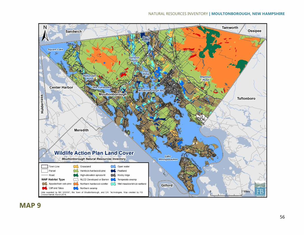
NATURAL RESOURCES INVENTORY | MOULTONBOROUGH, NEW HAMPSHIRE
56
MAP 9

NATURAL RESOURCES INVENTORY | MOULTONBOROUGH, NEW HAMPSHIRE
57
MAP 10

NATURAL RESOURCES INVENTORY | MOULTONBOROUGH, NEW HAMPSHIRE
58
MAP 11
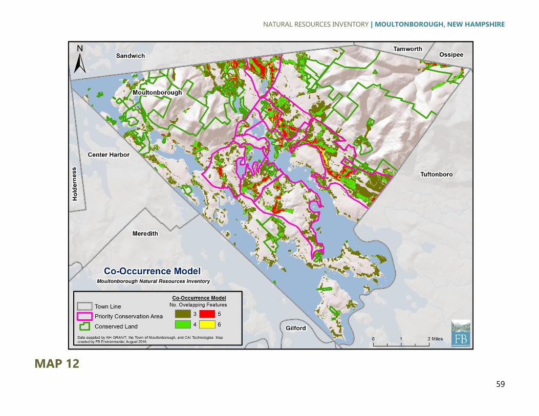
NATURAL RESOURCES INVENTORY | MOULTONBOROUGH, NEW HAMPSHIRE
59
MAP 12

NATURAL RESOURCES INVENTORY | MOULTONBOROUGH, NEW HAMPSHIRE
60
MAP 13

NATURAL RESOURCES INVENTORY | MOULTONBOROUGH, NEW HAMPSHIRE
61
APPENDIX B. COWARDIN ET AL. (1979)
WETLANDS AND DEEPWATER HABITATS
CLASSIFICATION

NATURAL RESOURCES INVENTORY | MOULTONBOROUGH, NEW HAMPSHIRE
62

NATURAL RESOURCES INVENTORY | MOULTONBOROUGH, NEW HAMPSHIRE
63

NATURAL RESOURCES INVENTORY | MOULTONBOROUGH, NEW HAMPSHIRE
64
APPENDIX C. RARE WILDLIFE AND PLANT
COMMUNITIES

NATURAL RESOURCES INVENTORY | MOULTONBOROUGH, NEW HAMPSHIRE
65

NATURAL RESOURCES INVENTORY | MOULTONBOROUGH, NEW HAMPSHIRE
66
Top Related