


Languages
Pages
Legal

For More InformationOregon Department of Forestry
Forest Grove District Office801 Gales Creek Road
Forest Grove, OR 97116(503) 357-2191
www.oregon.gov/ODF
Be Prepared• Letsomeoneknowyourplans• Lockyourvehicle• Readtrailheadsigns• Packplentyofwater
Protect the Forest• Stayondesignatedtrails• Sharethetrail• Packitin,packitout• Checkcurrentfireconditions
Gales Creek Trail
Gales Creek Trail
Pack
I t I n-Pack It
Out
Tilla
mook Forest
Tillamook State ForestT r a i l g u i D eReehers
Camp
Nehalem River
Cochran Road
Timber3 miles to Hwy 26
Round Top Road
3.4
Round Top Rd
Rice
Road
Tim
ber
Roa
d
Bell
Camp
Road
6.0
Storey Burn Road
Gal
es C
reek
Tra
il
GalesCreek
Storey
Burn
Tra
il
Gales Cre
ek Tr
ail
Rogers Rd
GalesCreek
StoreyBurn
Summit
0.8
2.5
2.3
2.0
32 miles toTillamook
MP35
MP37
MP39
32 miles toPortland
Gales Creek
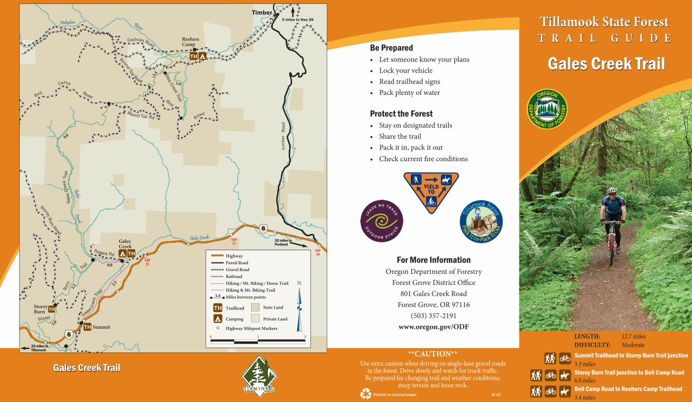
Miles between points
HighwayPaved Road
Hiking / Mt. Biking / Horse Trail Hiking & Mt. Biking Trail
Trailhead
Camping
1.4
Highway Milepost Markers
Gravel Road
Private Land
N
State Land
0 1 2
6
6
Railroad
Step Creek Trail
1.6
lengTh: 12.7 miles DiFFiculTy: ModerateSummit Trailhead to Storey Burn Trail junction 3.3 miles Storey Burn Trail junction to Bell Camp Road 6.0 miles Bell Camp Road to Reehers Camp Trailhead3.4 miles
**cauTiOn**Useextracautionwhendrivingonsingle-lanegravelroads
intheforest.Driveslowlyandwatchfortrucktraffic. Bepreparedforchangingtrailandweatherconditions,
steep terrain and loose rock. Printed on recycled paper 6/12

Riparian AreasForestriparianareasincludestreams,riversandthelandoneitherside.Theseareasareimportantduetothevarietyofplantsandanimalslivinginandnearthewater’sedge.Plantsgrowingnearstreambanksprovideerosioncontrol,filtersediment,stabilizebanksandcreateshade.TheOregonDepartmentofForestrymanagesriparianareastomaintainwaterqualityandfishhabitat.
wildlifehabitat.
At1.7milesfromBellCampRoadthetraillevelsoffinagroveofalders,crossesRoundTopRoadandintersectswiththePortofTillamookBayRailroadline.Thelast1.7milesweavethroughshaded,moistareasandcrossasmallstreambeforeemergingontoasideroad.FollowthistoCochranRoadandcontinueoverthebridgetopickupthefinal0.4miletoReehersCampTrailhead.
CheckouttheeasyStepCreekTrailnearReehersCampCampground.
Trailhead.Visitorswillenjoythisremote and scenic sectionoftheTillamookStateForest.Overthenexttwomilessectionsofthetrailare located on an overgrownroadgradeusedtohaultimberduringthesalvage operations followingtheTillamookBurn
fires.ItstaysclosetoGalesCreek,graduallygainingelevationandcrossingseveralsidecreeksthatofferviewsofsmallwaterfalls.Atthe3.0milepointthetrailmeetsalargelandslidecoveredwithathickgroveofyoungaldertrees.Thelandslideoccurredduringthewinterfloodof1996.Beyondtheslide,thetrailcontinuestoweavethroughtheforest,pullingawayfromGalesCreekinplacestocrosssmalltributarystreamsthatofferscenicviewsofsmallwaterfalls.Duringthedriestpartofthesummer,lookforsegmentsofthecreekthroughherethatdisappearundergroundandreappear100feetdownstream.Afterpassingthelastwaterfall,thetrailbeginstoclimbmoresteeplyasitpullsawayfromtheheadwatersofGalesCreekandmakesthe1.0mileascenttoBellCamp Road.
FromBellCampRoaditis3.4milestoReehersCamp.Watchforblack-taileddeergrazingonshrubs.Afterpassinganopenarea,visitorswillfindthemselvesinalandofsnags.Thesestandingdeadtreesarebothyoungandold.Thelarge,charredsnagsareoldsurvivorsoftheTillamookBurn,whiletheyoungertreesweretoppedwithasawtoprovideadditional
TRAIl InFoRMATIon
Tillamook Treasures
Trailhead AccessThistrailmaybereachedfromseveraltrailheads.HorsebackriderscanaccesstheGalesCreekTrailfromeitherReehersCampTrailheadorStoreyBurnTrailviaStoreyBurnTrailhead.ThereisnoequestrianaccessfromGalesCreekTrailhead.
Summit TrailheadTravelonHighway6tomilepost33.Thetrailheadislocatedonthenorthsideofthehighway.
Gales Creek TrailheadTravelonHighway6tomilepost35,andfollowthesignsonemiletoGalesCreekCampground.Pleasedrivewithcautiononthesingle-lanegravelroad.Thetrailheadislocatedontheleftbeforeenteringthecampground.
Reehers Camp TrailheadTravelonHighway6orHighway26totheTimberRoadjunction.FollowTimberRoadtothetownofTimber.TurnwestontoCochranRoadandtravel2.5milestothetrailheadjustpastReehersCampCampground.
Storey Burn TrailheadTravelonHighway6tomilepost33andturnnorthontoStoreyBurnRoad.FollowStoreyBurnRoad1.8milestothetrailheadsign,andtaketheshortspurroadtothelefttoreachthetrailhead.
About the TrailTheGalesCreekTrailis12.7milesfromSummitTrailheadtoReehersCampTrailhead.ThetrailmayalsobeaccessedfromGalesCreekandStoreyBurnTrailheads.HikersandmountainbikerscanenjoyalooptrailoptionbycombiningsectionsoftheGalesCreekTrailwiththeStoreyBurnTrail.
From Summit Trailhead to Gales Creek TrailheadThissectionisopentohikersandmountainbikers,andoffersamoderate2.5miledescenttoGalesCreekCampground.ThebeginningsectionoftraildropsintothecreekcanyonasitcrossestheslopeaboveLowDivideCreek.Thetrailwindsthroughayoungforestlushwithundergrowthevenafterthedriestsummer.MuchofthisareawasburnedbythefirstandlargestfireoftheTillamookBurnin1933,whichstartedeastofGalesCreekCampground.Inthespringandsummer,devil’sclub,ashrubwithgiantleavesandthornscoveringitsstem,linesthepath.Nearthecampground,visitorsmaychoosetogoleftdownhilltotheLowDivideLoopTrail,reachingtheGalesCreekTrailheadin0.1mile,orcontinuestraightandendonRogersRoadneartheday-usearea.Alongeitherroute,remnantsofarailroadtrestlethatextendedone-halfmileacrossthevalleyarepresent.Thetrestlesupportedtracksfortrainsthathauledburned,blackenedtreesduringthesalvageeffortafterthefiresthatoncedevastatedthisarea.
From Gales Creek Trailhead to Reehers Camp TrailheadHikersandmountainbikerswillfindthissectionoftrailbeginningatthewestendofthetrailheadnearthebridge.Forthefirst0.8mile,thetrailtraversesafern-coveredslopeaboveGalesCreek.Aftercrossingtwobridges,GalesCreekTrailmeetsStoreyBurnTrailwheretheusechangestoincludehorses.VisitorsmaychoosetocontinueonGalesCreekTrailtowardReehersCamp,orforaloopoptiontakeStoreyBurnTrail(seeStoreyBurnTrailGuide).
TheroutefromtheStoreyBurnTrailjunctionrunsnorth6.0milestoBellCampRoad,andcontinuesfromthereanother3.4milestoreachReehersCamp
Devil’s Club
Top Related