


Languages
Pages
Legal


PTOLEMY TIF 1225
Last saved 20/05/2008 10:50:00 1 of 24
PTOLEMY: 2016 Reference case supply inputs
Project note: 007 P:\P20\2079 Derby HMA\TEXT\REPORTS\Preliminary Stage
Report\007_2016Reference_v8.doc
Technical note:
Version Date By Reviewed
by
Authorised
(TN only)
Notes
1.0 11/04/08 Dunc Ying Jin Ying Jin Note prepared with permission, based on Technical Note 27
(version 8.0) from the 6C’s TIF Pump-Priming Project
1.1 INTRODUCTION
1.1.1 The 2016 Reference Case consists of an assumed package of transport schemes and interventions that are considered to be ‘most likely’ by the 6C’s TIF project in the period upto 2016. The transport measures included in this package have been derived by a process of extrapolation of past trends, interpretation of current policies and an expectation of a continuation of historic levels of funding availability.
1.1.2 The base year for PTOLEMY and the SATURN traffic models is 2006. Therefore the reference case includes all ‘most likely’ schemes between 2006 and 2016.
1.1.3 In this technical note, the schemes in the 2016 Reference Case are tabulated in turn, for each of the three cities (Derby, Leicester and Nottingham).
1.1.4 For each city and its surrounding areas, tables are included showing:
� Local authority highway schemes (major and minor).
� Car parking schemes (on and off street).
� PT infrastructure.
� Park and Ride schemes.
� Heavy rail schemes.
� Light rail schemes.
� Other transport initiatives, including Smarter Choice measures.
1.1.5 Following the tables for local authority schemes there is a table indicating Highways Agency schemes in the East Midlands Region
.

PTOLEMY TIF 1225
Last saved 20/05/2008 10:50:00 2 of 24
1.2 DERBY CITY AND DERBYSHIRE COUNTY SCHEMES
1.2.1 Local Authority Highway schemes
Table 1: Derby and Derbyshire Local Authority Highway Schemes
Ref Scheme Cost Description Impacts Status Plan Ref
D6 T12 A Development Link Road to open access to Chellaston Business Park (Local Plan EP1). Modelled in DATM 2016 South Derbyshire Reference Case Scenario
Scheme will provide some relief to the A514, particularly traffic that wants to get to and from Rolls Royce.
Diagram of scheme at T12.PDF
D7 Connecting Derby
£29 Million (2004)
Phases 2, 3A and 3B. Integrated scheme that includes a new single lane carriageway to complete the ring road, bus lanes and bus priorities.
Benefits for both general traffic and buses, as a result of reductions in journey times Also improved pedestrian and cycle accessibility. Comprises reductions in off-street parking from 803 spaces to 388.
Benefits (30yr) include:
• £25 million in accidents savings.
• £2.7 million bus user benefits in AM over 30 year period, £7.5 million in Peak.
• £109 million operating cost and time savings to private vehicle users.
AS_GEN_76LS_122AS_GEN_76[1].pdf
Siddals Rd bus link.pdf

PTOLEMY TIF 1225
Last saved 20/05/2008 10:50:00 3 of 24
1.2.2 Car Parking Schemes
Table 2: Derby Car Parking Schemes- off street
Ref Scheme Cost Description Impacts Status Figure / Plan Ref
Off-Street Parking Changes as a result of Connecting Derby and Westfield Development Changes in Off-Street Parking:
� Drewery Lane from 123 to 42
� Abbey Street from 159 to 195
� Little City from 219 to 32
� Sacheveral Street from 86 to 0
� Wilmot Street from 189 to 92
� Eagle Centre from 739 to 3040
� Coliseum from 127 to 0
2016 (2011)
DATS DRAFT Final Report v5
Table 3: Derby Car Parking Schemes- on street
Ref Scheme Cost Description Impacts Status Figure / Plan Ref
On-Street Parking Changes in Parking, resulting from Connecting Derby and Westfield Development:
� Osmaston Road loss of all spaces
� London Road loss of all spaces
� Burton Road loss of 31 spaces
� Sacheveral Street loss of 10 spaces
� Normanton Road loss of 24 spaces
� Leopold Street loss of 3 spaces
� Charnwood Street addition of 36 spaces
2016 (2011)
DATS DRAFT Final Report v5

PTOLEMY TIF 1225
Last saved 20/05/2008 10:50:00 4 of 24
1.2.3 PT Infrastructure
Table 4: Derby and Derbyshire road based PT infrastructure schemes
Ref Scheme Cost Description Impacts Document / Plan Ref
D1 Burton Road SITS1
£3.5 Million
Mixture of bus lane and signal priority measures on the approaches to the following:
• B5021 Hillsway/Burton Road including full signalisation of junction
• A5111/Burton Road
Traffic Neutral for general traffic Will achieve around 3 minute bus journey time saving inbound and outbound during weekday peaks
D2 Uttoxeter New Road SITS
£3 Million Based on Current Estimate
Mixture of bus lane and signal priority measures on the following links:
• Uttoxeter New Road/Uttoxeter Old Road Junction
• Westbound priority between A5111 and Utoxeter New Road/Uttoxeter Old Road Junction.
• Eastbound and westbound bus priority between new access point and A5111 Ring Road.
• Bus Priority to Uttoxeter Road/Corden Avenue
• Eastbound bus lane between Western and Cordon Avenue.
Traffic Neutral for general traffic Delays that could be removed through bus priority are estimated at around 5 minutes inbound and outbound.
See 1:50,000 plan reference plan.pdf
D3 A6 London Road SITS (Bus Priority Measures Only)
£3 Million Based on Current Estimate
Mixture of bus lane and signal priority measures on the following links:
• A5111 Ring Road Approaches
• London Road Bridge
• London Road to Midland Road.
Traffic Neutral for general traffic delays that could be removed through bus priority are estimated at around 9 minutes inbound and outbound.
See 1:50,000 plan reference plan.pdf
D4 A514 Osmaston Road SITS
£3 Million Based on Current Estimate
Mixture of bus lane and signal priority measures on the following links:
• Phase 1 Between Litchurch Lane & St. Reginald Street.
• Phase 2 Sinfin Avenue & A5111 Outer Ring Road.
Traffic Neutral for general traffic Delays that could be removed through bus priority are estimated at around 3.5 minutes inbound and outbound.
See 1:50,000 plan reference plan.pdf

PTOLEMY TIF 1225
Last saved 20/05/2008 10:50:00 5 of 24
1.2.4 Park and Ride schemes
Table 5: Derby and Derbyshire Park and Ride Schemes
Ref Scheme Cost Description Impacts Status Figure / Plan Ref
D5 Boulton Moor Park and Ride
£5 million Maintenance based on previous studies will be around £60,000 per annum
Construction of a 750 space car park. It is expected that a minimum level of infrastructure could be delivered through the LTP. This would be in the form of a gravel car park and limited facilities. Service frequency: 15 minutes Monday to Saturday; 30 minutes; evenings and Sunday. Journey time 15 minutes Operating Costs paid through S106 contributions. Fare based on current Park and Ride site £2.00 return paid on bus.
Estimated 6-9% interception rate of inbound traffic; depending on level of bus priority measures. Current Park and Ride charges are around £2.00 for a return bus fare.
2011 Figure2.1.doc E702-58-C_ParkRide.pdf ReferenceCase.pdf for route
Derby City Hospital P&R
350 spaces, 1 bus every 15 mins Mon-Fri 06:30 to 22:00, (06:30 to 19:00 weekend)
2009

PTOLEMY TIF 1225
Last saved 20/05/2008 10:50:00 6 of 24
1.2.5 Heavy Rail Schemes
Table 6: Derbyshire Heavy Rail Schemes
Ref Scheme Cost Description Impacts Status Document / Plan Ref
Rail service change
The hourly London-Sheffield service will operate as now; however, there will be off-peak calls at East Midlands Parkway and Luton Stations.
2016 (2011)
Stakeholder Briefing Document*
Rail service change
The existing hourly fast London-Nottingham service includes a train portion for Derby, with portions splitting and joining at Leicester. The Derby portion will call at Loughborough, East Midlands Parkway and Long Eaton.
2016 (2011)
Stakeholder Briefing Document*
Rail service change
The existing hourly Nottingham to London semi-fast service will operate as now, but with additional calls at East Midlands Parkway.
2016 (2011)
Stakeholder Briefing Document*
* Stakeholder Briefing Document – East Midlands Franchise (October, 2006), East Midlands Regional Assembly
1.2.6 Other local initiatives
Table 7: Other initiatives in Derby
Ref Scheme Cost Description Impacts Status Document / Plan Ref
Smart Measures
To Central areas of Derby. See Section 7

PTOLEMY TIF 1225
Last saved 20/05/2008 10:50:00 7 of 24
1.3 LEICESTER CITY AND LEICESTERSHIRE COUNTY SCHEMES
1.3.1 Local Authority Highway Schemes
Table 8: Leicester and Leicestershire Local Highway Infrastructure Schemes
Ref Scheme Cost Description Impacts Status Figure / Plan ref
18a B582 Narborough
Road - Whetstone
B582 between Narborough
Road and Whetstone and to the
Foxhunter Roundabout
Note: also included under
Leicester’s PT schemes
2489.03/a1/1/1
(2489_03_A1_1_1.pdf)
2489.04/H1/1/1 (paper only)
B582 Waste Transfer Access (2 lane
trafficSigs070521.pdf)
0010\M\22
(B582improved_0010_M_22.pdf and
B582 Improvements - 0010_M_22.pdf )
18b Narborough Road 50mph to 40mph Note: also included under
Leicester’s PT schemes
Loughborough Integrated Transport scheme
From Regional Funding Allocation Letter from the secretary of state
Melton Mowbray Bypass
From Regional Funding Allocation Letter from the secretary of state
Lutterworth Western From Regional Funding Allocation Letter from the secretary of state
Kegworth Bypass From Regional Funding Allocation Letter from the secretary of state

PTOLEMY TIF 1225
Last saved 20/05/2008 10:50:00 8 of 24
1.3.2 Car Parking
Table 9: Leicester- Car Parking
Ref Scheme Cost Description Impacts Status Figure / Plan Ref
Off-Street Parking
St Peters Lane car park (850 spaces) has been closed down.
St Peters Lane has been replaced by a new 2000 space car park for the expanded Shires shopping centre off Burgess Street.
2016 (2011) Leicester City Council (March, 2007)
1.3.3 PT Infrastructure
Table 10: Leicester and Leicestershire Road based PT Infrastructure Schemes
Ref Scheme Cost Description Impacts Status Figure / Plan Ref
10 Quality Bus
Corridors
Quality Bus Corridors within City boundary Leicestershire and Leicester
2016 DN and ref case
schemes
070907.doc
10a Saffron Lane
10b Melton Road
10c Humberstone
Road
From city boundary to city
centre
10d Aylestone Road
10e Groby Road
10f Welford Road
10g London Road
Capacity neutral achieving
7% improvement in JT over
2016 JT +10% fare
reduction equivalence

PTOLEMY TIF 1225
Last saved 20/05/2008 10:50:00 9 of 24
Ref Scheme Cost Description Impacts Status Figure / Plan Ref
10h Narborough
Road
11 Abbey Lane JT
improvements
16.8sec per vehicle from
Redhill circle/St Margerets
Way to Vaughan Way at the
Central Ring Road
12 SCOOT Improve Journey times on radial routes.
To be phased in
0.5% reduction in the
increase in JT journey time
to 2016.
13 New Link to
Soar Valley
Way to
Lutterworth
Road
L(--)129 (Sour Valley Link
Road.pdf) (NOTE: ignore the P&R
site on this drawing it is not to be
modelled)
14 Clock Tower
Resident
Parking
2.5 mile radius from area.
Will be phased in
90% of residential areas
within 2.5 miles of Clock
Tower covered by residents
car park schemes
Map of clock tower
Residents parking city 2half.doc
15 Employee
Travel Plans
See section 7 regarding SMART measures 90% of employees in CTZ
covered by travel plan
CTZ from CTZ.doc
16 School travel
plans
See section 7 regarding SMART measures 90% of state schools covered
by travel plan
Target
for 2011
completi
on

PTOLEMY TIF 1225
Last saved 20/05/2008 10:50:00 10 of 24
Ref Scheme Cost Description Impacts Status Figure / Plan Ref
18a B582
Improvement
B582 between Narborough Road and
Whetstone and to the Foxhunter
Roundabout
Note: also included under
Leics highway schemes
2489.03/a1/1/1
(2489_03_A1_1_1.pdf)
2489.04/H1/1/1 (paper only)
B582 Waste Transfer Access (2
lane trafficSigs070521.pdf)
0010\M\22
(B582improved_0010_M_22.pdf
andB582 Improvements -
0010_M_22.pdf )
18b 50mph to
40mph
Narborough
Road
Note: also included under Leics
highway schemes
19 Quality Bus
Corridors from
City boundary
into the county
Also assume that bus corridors in the
County are capacity neutral expected to
achieve 7% improvement in JT over
2016 JT + 10% fare reduction for quality.
Leicestershire and Leicester 2016
DN and ref case schemes
070907_received 10Sept07.doc
19a Saffron Lane Saffron Lane to B582 and beyond to Countesthorpe Rd. in Countesthorpe Rd. Along B582 to Launceston Rd up to A5199 Welford Rd to existing bus Lane on Welford Rd.
19b Melton Road Melton Rd to east Goscote
19c Humberstone
Road
Humberstone Rd to Station Rd in Thurnby

PTOLEMY TIF 1225
Last saved 20/05/2008 10:50:00 11 of 24
Ref Scheme Cost Description Impacts Status Figure / Plan Ref
19d Aylestone Road Aylestone Rd to Countesthorpe, Blaby, Glen Parva to City Broughton Astley, Cosby,Whetstone, Blaby, Glen Parva to City
19e Groby Road From Ratby, Groby and A50 to City Boundary
19f Welford Road Guthlaxton Way Roundabout to City
19g London Road Florence Wragg Way, Oadby to City
19h Narborough
Road
From Narborough Forest Rd to B4114 B4114 through Grove Park and Fosse Park to City From Enderby B582 to B4114 through Grove Park and Fosse Park to City
19i Hinckley Road Beggars Lane/A47 to City

PTOLEMY TIF 1225
Last saved 20/05/2008 10:50:00 12 of 24
1.3.4 Park and Ride Schemes
Table 11: Leicester and Leicestershire Park and RIde Schemes
Ref Scheme Cost Description Impacts Status Figure / Plan Ref
17a P&R Enderby, Current proposal is to install Intelligent
Bus Priority (IBP) at the traffic signal
controlled junctions along the corridor
to give bus priority/ journey time
reliability. Further investigation into the
proposed A47 bus lanes is pending
finalisation of proposals. Results
expected October ’07
1000 spaces
10 minute headway
2947/H1/1/1P (Enderby
PandR General Layout
PLANNING.PDF)
Bus route Corridor
Route.pdf.
A47 Bus Lanes
070725.pdf
17b P&R Birstall, Note: Birstall is in the 2016 do nothing
with a total of 350 parking spaces.
1000 spaces
10 minute headway
Developer funded Birstall PandR site Layout.pdf
Bus Route Report 04-04.Jpg
17c P&R Glenfied 1000 spaces
10 minute headway
Bus route Report 04-04.jpg
Layout: Report 04-01.jpg
and Report04-02.jpg
Description Report02-01.jpg
PTOLEMY TIF 1225
Last saved 20/05/2008 10:50:00 13 of 24
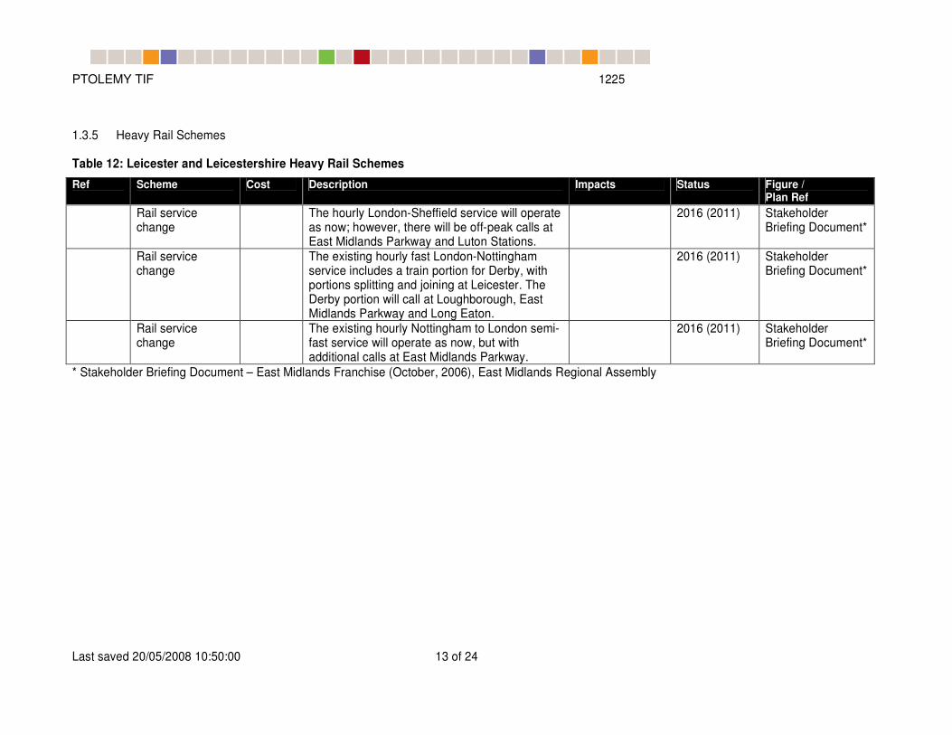
1.3.5 Heavy Rail Schemes
Table 12: Leicester and Leicestershire Heavy Rail Schemes
Ref Scheme Cost Description Impacts Status Figure / Plan Ref
Rail service change
The hourly London-Sheffield service will operate as now; however, there will be off-peak calls at East Midlands Parkway and Luton Stations.
2016 (2011) Stakeholder Briefing Document*
Rail service change
The existing hourly fast London-Nottingham service includes a train portion for Derby, with portions splitting and joining at Leicester. The Derby portion will call at Loughborough, East Midlands Parkway and Long Eaton.
2016 (2011) Stakeholder Briefing Document*
Rail service change
The existing hourly Nottingham to London semi-fast service will operate as now, but with additional calls at East Midlands Parkway.
2016 (2011) Stakeholder Briefing Document*
* Stakeholder Briefing Document – East Midlands Franchise (October, 2006), East Midlands Regional Assembly

PTOLEMY TIF 1225
Last saved 20/05/2008 10:50:00 14 of 24
1.4 NOTTINGHAM AND NOTTINGHAMSHIRE COUNTY SCHEMES
1.4.1 Local Authority Highway Schemes
Table 13: Nottingham and Nottinghamshire Major Highway Infrastructure schemes
Scheme Cost Description Impacts Status Figure / Plan Ref
N1 Ring Road Major £30 million Nottingham Ring Road Improvements
LTP ?
N2 Eastside Transport Strategy
£12 million Nottingham City Centre – (eastern) network improvements
Planned ?
N4 Gedling Transport Improvement Scheme
Completed
N5 Hucknall Inner Relief Route
Planned Notts
N6 Gedling Access Road In LDF as developer funded.
Local Plan Documants
Table 14: Nottingham and Nottinghamshire Minor Local Authority Highway Schemes
Ref Scheme Cost Description Impacts Status Figure / Plan Ref
N7 Cattle Market Road realignment
£4 million Minor impact in capacity. Not modelled in PTOLEMY
N8 Triumph Road £150k Minor impact in capacity. Not modelled in PTOLEMY
N9 Hucknall Road/Arnold Road and Hucknall Road/Kersall Drive junction improvements
£500k Proposed scheme (as shown in drawing) has two lanes on Hucknall Road on the southbound approach to the junction, with one lane permitting straight ahead and left turn movements and the other permitting straight ahead and right turn movements.
reference case n9-n13.doc Hucknall Road Junction - Feasibility drawing Option 2.pdf),
PTOLEMY TIF 1225
Last saved 20/05/2008 10:50:00 15 of 24
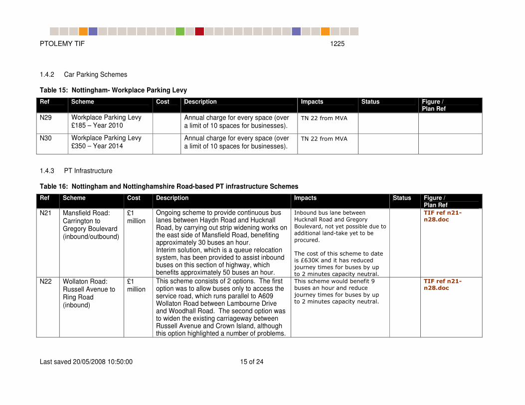
1.4.2 Car Parking Schemes
Table 15: Nottingham- Workplace Parking Levy
Ref Scheme Cost Description Impacts Status Figure / Plan Ref
N29 Workplace Parking Levy £185 – Year 2010
Annual charge for every space (over a limit of 10 spaces for businesses).
TN 22 from MVA
N30 Workplace Parking Levy £350 – Year 2014
Annual charge for every space (over a limit of 10 spaces for businesses).
TN 22 from MVA
1.4.3 PT Infrastructure
Table 16: Nottingham and Nottinghamshire Road-based PT infrastructure Schemes
Ref Scheme Cost Description Impacts Status Figure / Plan Ref
N21 Mansfield Road: Carrington to Gregory Boulevard (inbound/outbound)
£1 million
Ongoing scheme to provide continuous bus lanes between Haydn Road and Hucknall Road, by carrying out strip widening works on the east side of Mansfield Road, benefiting approximately 30 buses an hour. Interim solution, which is a queue relocation system, has been provided to assist inbound buses on this section of highway, which benefits approximately 50 buses an hour.
Inbound bus lane between Hucknall Road and Gregory
Boulevard, not yet possible due to additional land-take yet to be
procured.
The cost of this scheme to date is £630K and it has reduced
journey times for buses by up
to 2 minutes capacity neutral.
TIF ref n21-n28.doc
N22 Wollaton Road: Russell Avenue to Ring Road (inbound)
£1 million
This scheme consists of 2 options. The first option was to allow buses only to access the service road, which runs parallel to A609 Wollaton Road between Lambourne Drive and Woodhall Road. The second option was to widen the existing carriageway between Russell Avenue and Crown Island, although this option highlighted a number of problems.
This scheme would benefit 9 buses an hour and reduce
journey times for buses by up to 2 minutes capacity neutral.
TIF ref n21-n28.doc

PTOLEMY TIF 1225
Last saved 20/05/2008 10:50:00 16 of 24
Ref Scheme Cost Description Impacts Status Figure / Plan Ref
N23 Nottingham Road: approach to Ring Road (inbound/outbound)
£100k This scheme provides an outbound evening peak period bus lane on Nottingham Road between
North Gate and Ring Road. The bus lane does not require any significant civils works other
than signing and lining required for the bus lane
and associated parking restrictions.
It is unlikely that any bus priority could be provided on the inbound corridor due to the
width of the carriageway on Sherwood Rise.
The introduction of a peak period, outbound bus lane on Nottingham
Road would halve average bus journey times along this corridor -
an average journey time saving
of 1 minute, 21 seconds.
This scheme will benefit approximately 15 buses an hour
capacity neutral.
TIF ref n21-n28.doc
N24 Trent Bridge: Meadows Way/London Road approach (outbound)
£50k This scheme extends the existing bus lane on
Meadows Way outbound from a point opposite
Eugene Gardens to Ryehill Street. To enable the new bus lane to “tie in” with the existing
bus lane, it will be necessary to carry out some minor widening works on the east side
of Meadows Way.
Other bus priority measures to assist buses between Meadows Way and Trent Bridge are
likely to be introduced in the future.
This scheme will benefit over 50
buses an hour and is likely to
reduce journey times for buses by up to 2 minutes capacity
neutral
TIF ref n21-
n28.doc
N25 Derby Road – City Boundary to City Centre
£1 million
To provide inbound and outbound bus priority on Derby Road, between Priory and QMC.
The Scheme Identification Study carried out by AMScott in April 2004 identified 2 options.
The first option provides a partial bus lane, i.e. only provide the lane at those sections
which are 10m wide or more. The second option provides a full bus lane between the
two roundabouts, which involves road widening.
This scheme will benefit up to 30 buses an hour at peak times
and could save bus journey times by a maximum of 2.9
minutes.
The A52 (between Priory and QMC) is a Trunk Road.
Therefore any scheme that is introduced on this section of
road will need to have approval from the Highways Agency. At
the present, AMScott are
recommending that no action be taken thus impact on highway is
capacity neutral.
TIF ref n21-n28.doc
PTOLEMY TIF 1225
Last saved 20/05/2008 10:50:00 17 of 24
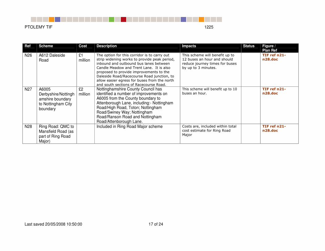
Ref Scheme Cost Description Impacts Status Figure / Plan Ref
N26 A612 Daleside Road
£1 million
The option for this corridor is to carry out strip widening works to provide peak period,
inbound and outbound bus lanes between Candle Meadow and Trent Lane. It is also
proposed to provide improvements to the
Daleside Road/Racecourse Road junction, to allow easier egress for buses from the north
and south sections of Racecourse Road.
This scheme will benefit up to 12 buses an hour and should
reduce journey times for buses by up to 3 minutes.
TIF ref n21-n28.doc
N27 A6005 Derbyshire/Nottinghamshire boundary to Nottingham City boundary
£2 million
Nottinghamshire County Council has identified a number of improvements on A6005 from the County boundary to Attenborough Lane, including:- Nottingham Road/High Road, Toton; Nottingham Road/Swiney Way; Nottingham Road/Ranson Road and Nottingham Road/Attenborough Lane.
This scheme will benefit up to 10 buses an hour.
TIF ref n21-n28.doc
N28 Ring Road: QMC to Mansfield Road (as part of Ring Road Major)
Included in Ring Road Major scheme Costs are, included within total cost estimate for Ring Road
Major
TIF ref n21-n28.doc
PTOLEMY TIF 1225
Last saved 20/05/2008 10:50:00 18 of 24
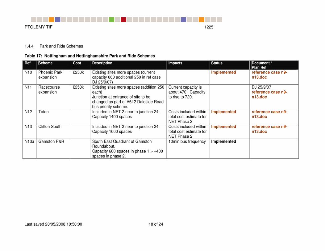
1.4.4 Park and Ride Schemes
Table 17: Nottingham and Nottinghamshire Park and Ride Schemes
Ref Scheme Cost Description Impacts Status Document / Plan Ref
N10 Phoenix Park expansion
£250k Existing sites more spaces (current capacity 660 additional 250 in ref case DJ 25/9/07)
Implemented reference case n9-n13.doc
N11 Racecourse expansion
£250k Existing sites more spaces (addition 250 each) Junction at entrance of site to be changed as part of A612 Daleside Road bus priority scheme.
Current capacity is about 470. Capacity to rise to 720.
DJ 25/9/07 reference case n9-n13.doc
N12 Toton Included in NET 2 near to junction 24. Capacity 1400 spaces
Costs included within total cost estimate for NET Phase 2
Implemented reference case n9-n13.doc
N13 Clifton South Included in NET 2 near to junction 24. Capacity 1000 spaces
Costs included within total cost estimate for NET Phase 2
Implemented reference case n9-n13.doc
N13a Gamston P&R South East Quadrant of Gamston Roundabout. Capacity 600 spaces in phase 1 > +400 spaces in phase 2.
10min bus frequency Implemented

PTOLEMY TIF 1225
Last saved 20/05/2008 10:50:00 19 of 24
1.4.5 Heavy rail Schemes
Table 18: Nottinghamshire Heavy Rail Schemes
Ref Scheme Cost Description Impacts Status Document /
Plan Ref
The East Midlands Parkway station
The East Midlands Parkway station is situated on the old Ratcliffe Power station adjacent to the A453, approximately 7km from Nottingham East Midlands Airport. Station access is via the proposed 1000 space car park.
2016 Department for Transport website
Rail service change
The hourly London-Sheffield service will operate as now; however, there will be off-peak calls at East Midlands Parkway and Luton Stations.
2016 (2011) Stakeholder Briefing Document*
Rail service change
The existing hourly fast London-Nottingham service includes a train portion for Derby, with portions splitting and joining at Leicester. The Derby portion will call at Loughborough, East Midlands Parkway and Long Eaton.
2016 (2011) Stakeholder Briefing Document*
Rail service change
Currently Central Trains are running the service from Nottingham to Sheffield, two out of seven that extends to Leeds. As proposed a new hourly service is coded to operate between Nottingham and Leeds via Longley Mill, Alfreton, Chesterfield, Dronfield, Dore, Sheffield, Barnsley and Wakefield Kirkgate, as outlined in the consultation document.
2016 (2011) Stakeholder Briefing Document* More information in NDS Press Release, issued to WSP by GNN Nottingham Press Office (2006).
* Stakeholder Briefing Document – East Midlands Franchise (October, 2006), East Midlands Regional Assembly

PTOLEMY TIF 1225
Last saved 20/05/2008 10:50:00 20 of 24
1.4.6 Light Rail Schemes
Table 19: Nottingham Light Rail Schemes
Ref Scheme Cost Description Impacts Status Document / Plan
Ref
N3 NET Phase II Phase 2 of the NET builds on the NET Line 1 scheme. Future tram services will serve the areas to the south and west of Nottingham. Two further P&R sites from junction 24 (Clifton) and 25 (Toten) of the M1 are coded (capacity of 1000 vehicles assumed).
The tram track
was coded as fully
segregated.
Approved by Central Government. Implemented by 2016
Information David Carter (MVA Consultancy)
1.4.7 Other Local Transport Initiatives
Ref Scheme Cost Description Impacts Status Document /
Plan Ref Smart
Measures To Central areas of Nottingham. See
Section 7

PTOLEMY TIF 1225
Last saved 20/05/2008 10:50:00 21 of 24
1.5 CENTRAL GOVERNMENT HIGHWAY SCHEMES
Table 20: Central Government Highway Schemes- Derbyshire, Leicestershire, Nottinghamshire
Ref Scheme Cost Description Impacts Status
D8 A38(T) Grade Separation
£77M Highways Agency scheme to grade Separation of the following junctions:
A61 Abbey Hill
A52 Markeaton Park
A5111 Kingsway
Significant benefits for traffic and bus journey times as a result of separating A38 traffic from local traffic movements.
Scheme is currently in the RFA. Included within DATM
A38/A50 Derby Highways Agency scheme to traffic signal the ‘Toyota’ roundabout in Derbyshire
Improve capacity and safety.
M1 J21 – 30 Widening
Highways Agency scheme to widen the motorway through Leicestershire, Nottinghamshire and Derbyshire
Improved strategic link between the
South, the Midlands and the North.
Includes provision for A6 Kegworth
Bypass
J25-J28 length is under construction (2009 completion). J21-J30 planned for 2012 (completion 2018).
A46 Newark -Widmerpool
Highways Agency’s scheme to dual the single carriageway (28km) length to the south of Newark.
Improved capacity and safety Route
links Lincoln and Newark to
Nottingham and Leicester.
Planned. North section open by 2014. South part two years after.
A453 Improvement J24 to A52
Highways Agency scheme to dual the single carriageway between the M1 (J24) and Nottingham.
Increased capacity, improved
reliability and safety and easier
maintenance.
Planned. Expected opening 2013.
A6096 Ilkeston-Awsworth Link Road
From Regional Funding Allocation letter from the Secretary of State
A46 Earl Shilton Bypass
From Regional Funding Allocation letter from the Secretary of State

PTOLEMY TIF 1225
Last saved 20/05/2008 10:50:00 22 of 24
1.6 SCHEME INFORMATION
Table 21: Reference Documents
TN18 Transport Planning Inputs to Model Based Scenario Testing
TN18_Transport_Planning_Inputs_V2 1 .doc
Concerns a number of transport planning tasks that need to be undertaken (or provisionally considered) prior to the commencement of the Scenario Testing Programme using the modelling system.
6C’s TIF: CONTENTS OF REFERENCE CASE 2016
6Cs TIF contents of reference case 2016 310807.doc
Early document summarising the schemes from PTOLEMY Appendix D1 to be included/excluded from the TIF 2016 Reference Case
PTOLEMY Appendix D1 Ptolemy App.D1 Summary_scenario_assumptionsv0.52_SavedChanges.doc
Chapter 5 provides details of the PTOLEMY future year scenarios for the original development reference case.
Letter from Secretary of State on the Regional Funding Allocation
Schemes identified to be included within the reference case are, schemes underway, approved schemes not yet underway and schemes which do not yet have approval but are likely to be approved
Derby 2016Reference Case\Derby\Reference.doc
007_007_2016_Reference_v1_AndyGibbard.doc
Summary of schemes and interventions in Derby
Revision by Andy Gibbard of Derby of the PN007
Leicester Leicestershire and Leicester 2016 DN and ref case schemes 070907_received 10Sept07 .doc
Summary of schemes and interventions in Leicester
Nottingham Reference case inputs for Greater Nottingham.doc
Summary of schemes and interventions in Nottingham

PTOLEMY TIF 1225
Last saved 20/05/2008 10:50:00 23 of 24
1.7 AN INITIAL PACKAGE OF SMARTER CHOICE MEASURES
1.7.1 An initial package of Smarter Choice measures with limited scope and implementation has been included with the 2016 Reference Case. Note that this does not include a full implementation of such measures which are to be considered in policy tests.
1.7.2
1.7.3 For the purposes of modelling in the 6Cs TIF Project, the implementation of the Smarter Measures within the Reference Case has been coded as a reduction in generalised cost of travel on walking/cycling, and PT modes, in the following way:
� journey to work to “central areas” in all three cities, as defined below: 2 minutes less in generalised travel time in the AM and inter-peak. In the PM peak, the same time reduction was assumed for trips originating from the central areas.
� journey to work (other destinations): 1 minute less in generalised travel time to represent workplace travel plans
� education trips: 2 minutes less in generalised travel time for all education journeys to represent universal school travel plans
� Other personal trips: 0.5 minutes less in generalised travel time to represent personalised travel plans etc.
1.7.4 The above values in generalised travel time reduction are considered in line with the Reference Case assumptions regarding implementation. A fuller implementation of the measures are tested as a policy scenario.
1.7.5 For the definition of the “Central areas” see Figure 1 to Figure 3 below.
Figure 1: Leicester: Central Transport Zone (CTZ) (left) and the matching PTOLEMY zones used for Smarter Choices implementation (right)

PTOLEMY TIF 1225
Last saved 20/05/2008 10:50:00 24 of 24
Figure 2: Nottingham: central areas used for Smarter Choices implementation
Figure 3: Derby central areas used for Smarter Choices implementation
Top Related