


Languages
Pages
Legal

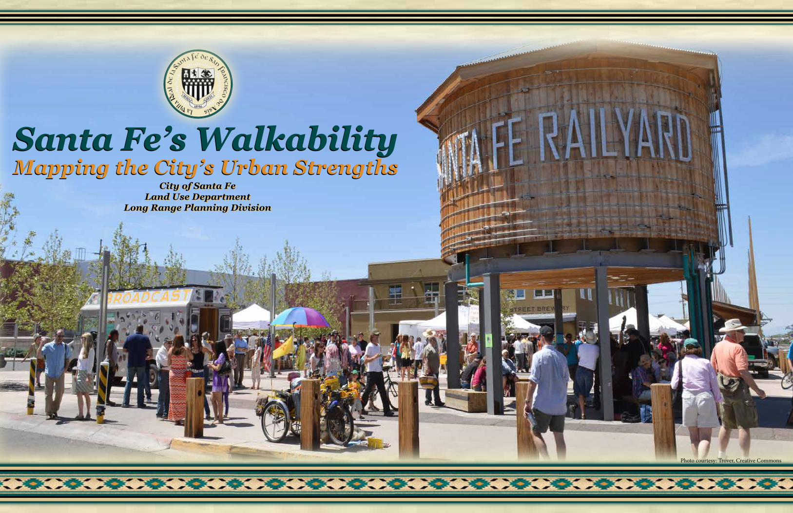
Photo courtesy: Trover, Creative Commons

i
Santa Fe’s WalkabilityMapping the City’s Urban Strengths
Lisa Martinez, Land Use Department DirectorReed Liming, Long Range Planning Division Director
Richard Macpherson, Senior PlannerDavid Barsanti, G.I.S. Analyst
Gil Martinez, Graphics Designer
July, 2017
Walk Score® is a registered trademark of Redfin Real Estate, Seattle, WA. A special thanks to Aleisha Jacobson at Redfin’s Walk Score® office.

Santa Fe is famed for its historic buildings and narrow streets. Visitors and residents value the historic part of the city for its walkability, reflecting how towns and cities felt to residents and visitors before the dominance of the automobile. Since World War II, however, much of Santa Fe has reflected land development patterns with more spread-out, suburban-style subdivisions and large commercial tracts with over-sized parking lots. This development trend is based on the car and reflects modern development patterns found in virtually every U.S. town and city.
Walkability
While Santa Feans may enjoy walking around their neighborhood and enjoy the area where they live, “walkability” as used in this report defines those areas in which residents are a relatively short walk from their homes to a destination such as a park, school or grocery store. This type of walkability is what usually distinguishes pre-World War II city development from post-war development patterns. Americans have become increasingly interested in reclaiming much of that walkability that has been lost over the decades and missing in new developments. As a result, there has been increased interest in determining how walkable a place is … whether old or new.
Recent studies have shown that many Americans are spending a larger part of their household budget on transportation in the form of cars, while housing costs have been increasing faster than paychecks and availability of well-paying jobs. As a result, many are feeling squeezed by the basic costs of daily living. Meanwhile, Americans are struggling with obesity and related health issues due, in part, to a lack of walking and adequate exercise. These are often cited as the more recent side effects of suburban land development patterns.
Measuring WalkabilityMeasuring walkability and understanding the “ingredients” that are needed to make a place more walkable has gained increasing interest. The following analysis shows those areas of Santa Fe that have the greatest levels of walkability as measured by the nearness (usually a 5-10 minute walk) of key daily needs and desires of residents, including: Schools, Parks, Grocery Stores, Restaurants, Errands, Shopping and Cultural Activities.
Walk Score® is a tool used to determine which parts of Santa Fe are the most walkable and therefore, from a planning standpoint, reflect the most efficient uses of land. These are neighborhoods and other residential areas that are within a relatively easy walk of the various destinations listed above. Many of these areas are known to residents based on personal experience, but when mapped, help to explain the city’s strengths (walkable and more efficient) and its weaknesses (car dependent and less efficient). It provides policy makers with a tool to determine what is in the best interest of the city’s future when it comes to reviewing and approving new land development proposals as well as where capital improvement funds, and how new facilities, might be optimized.
Santa Fe’s Walkability … Defining the City’s Urban Core
1

Very Walkable (most or all daily trips can be made on foot) – Santa Fe’s “Very Walkable” areas include:
• Downtown & Surrounding Neighborhoods – This includes some of the Downtown & Eastside Historic District, as well as the entire Don Gaspar and Westside-Guadalupe Historic Neighborhoods. “Very Walkable” areas also extend south to Cordova Road.
• St. Michael’s Drive Corridor – Both sides of St. Michael’s Drive between Cerrillos Road and Pacheco Street which closely aligns with the city’s Mid-Town LINC (local innovation corridor).
• Cerrillos Road Corridor / Area Neighborhoods – The residential areas on both sides of Cerrillos Road between Camino Carlos Rey and Richards Avenue.
• Airport Road – Includes a Small area between Jemez Road and Cerrillos Road along the south side of Airport Road.
Somewhat Walkable (some daily trips can be made on foot) – Santa Fe’s “Somewhat Walkable” areas include:
• Downtown & Surrounding Neighborhoods – As you move further away from the city’s historic core and close-in neighborhoods (for example, west side of Casa Solana) walkability remains but at a lower level, where only some of the daily trips can be conveniently made on foot.
• Cerrillos Road & Triangle Area (Casa Alegre, Casa Linda, San Mateo/2nd Street/Pacheco Street Area)
• St. Francis Drive Corridor (from Cordova to Zia Road) – On the east side of St. Francis including some of the Mateo Heights subdivision; as well as apartments and condominiums between Zia and Siring Roads.
• South St. Michael’s Drive Area (Plaza del Sur, South Ridge and Thomas Heights Neighborhoods)
• Camino Carlos Rey Neighborhoods (Bellamah, La Resolana, Vista del Sol)
• Airport Road / Southside Neighborhoods (Las Acequias, Vista Alegre Apts., Rancho Zia MHP)
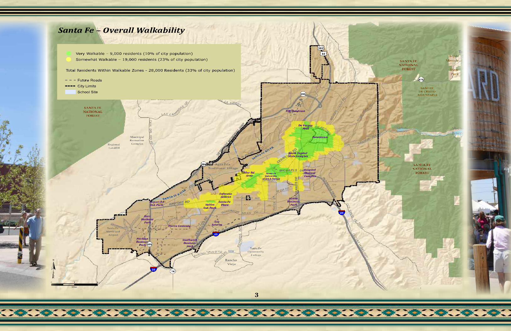
Santa Fe’s Overall Walkability
Santa Fe’s Overall Walkability Map shows the most walkable parts of Santa Fe, when all destinations for the seven categories with the separate Walk Score® measurements are combined. The map shows two primary zones of walkability, “Very Walkable” (walk scores® of 70-100) and “Somewhat Walkable” (walk scores® of 50-69).
Walkability by Destination
The following series of maps shows walkability (or, “walkshed”) within Santa Fe based on the specific destination that people travel to daily: schools, parks, restaurants, shopping, grocery stores, daily errands and cultural activities. The walkshed color (zone) shows the area surrounding a destination that is within a 5-10 minute walk. Ideally, these walksheds would include as many homes, apartments and residents as possible.
2
BARR IO LACAN AD A
CAN AD AAN CHA
CAN D ELERO
CASAALEG RE
CASALIN D A
CASASO LA NA
CERR O D ELSO L
CIELOLU MBR E
CO LO N IAPR ISMA
CO LO RE SDE L SO L
CO UN TRY C LUBESTATE S
DE VAR G ASHEIG HTS
ESTAN CIAPR IMERA
FAIR WAYVILLAG E
HYDE PARKESTATE S
IND IANRID GE
LA VI LLASERE NA
LA SACEQ U IAS
CO TTO NW OO D VILLAG E
LA SESTAN CIAS
LA SLO MAS
LO S C ERR OSCO LO RA DO S
MATE OHGTS
MIRACE RRO S
MON TESERE NO
NAVAAD E
PARKPLAZAPU EB LO S
DE RO DE O R D
RAN CHODE LALU N A
REMU D ARID GE
SAN TA FEESTAT E S
SAN TA FESU MMIT
SIER RA DE LNO RTE
SILVERA DO
SO L YLO MAS
TO WN A NDCO UN TRY
VILLACABA LLE RO
VILLASO NATA
VISTA DE LPR AD O
VISTA DE LSO L
VISTAEN CAN TAD A
VISTAGR AN DE
VISTA PR IMERA
VISTAVERD E
LA RE SO LAN A
BELLAMAH
TIE RRA REAL
CO UN TRY CLUB
GA RD EN S
RIVER SID E
PU EB LO S DE L SO L
WILD ER NE SS GATE
Rancho Viejo
Santa Fe Community
College
Regional Landfill
Municipal Recreation
Complex
Las Campanas
SANTA FE NATIONAL
FOREST
SANTA FE NATIONAL
FOREST
SANTA FE NATIONAL
FOREST
SANGRE DE CRISTO
MOUNTAINS
McClure Reservoir
Nichols Reservoir
Santa Fe Municipal
Airport
SANTA FE R IVER
SANTA FE RIVER
Agua Fria Traditional Village
Hyde Memorial
State Park
WALAMEDA
ST
OLDSANTA
FE TRAI L
SIRINGO RD
AIRPORT RD
RUFINA ST
ST MICHAELS DR
RODEO RD
GOVERNOR MILES RD
JA
GUAR DR
CANYONRD
HYDEPA
RK
RD
OLD LAS VEGAS HWY
CAJADE L
RIORD
PASEO DE PERALTA
RICH
ARD
SAV
E
CAMINOLA TIERRA
AGUAFRIA
ST
YUC C
AST
LAS C A M PANAS
DR
CERR
ILLOS
RD
CERRILLOS RD
ST F
RANC
IS D
R
VETERANS M
EMORIAL H
WY
OLD PECOS TRAIL
BISH
OPS
LODG
E RD
RA NCHO VIEJO BLVD
AVENIDA DEL SUR
W ZIA RD
25
25
25
599
599
599
475
285
84
14
To Santa Fe Ski Basin
De Vargas Mall
Downtown
South Capitol State Complex
Siler Rd Area
Rodeo Business
Park
Zafarano District
Santa Fe PlaceValdes
Ind. Park
LasSoleras
Southwest Business
Park
Pavilion Business
Park
Hart Business
Park
Airport RdInd. Park
Hospital Medical Complex
Tierra Contenta
NW Quadrant
Santa Fe University
of Art & Design
Copyright:© 2014 Esri
0 1 2
Miles
Santa Fe – Overall Walkability
Very Walkable – 9,000 residents (10% of city population)
Somewhat Walkable – 19,000 residents (23% of city population)
Total Residents Within Walkable Zones - 28,000 Residents (33% of city population)
Future Roads
City Limits
School Site
3

SchoolsSanta Fe’s various elementary, middle and high schools may contain the best coverage of walkability of the various destinations within Santa Fe (see map) due to the fact that schools (especially elementary schools) are often placed in or near the center of larger neighborhoods and master-planned communities. As a result, schools often have a fairly even geographic distribution. The reason why schools show varying walk scores, or no walk score, is due to “Block Length” and “Intersection Distance” as measured by Walk Score®. Schools surrounded by, or near, neighborhoods with shorter block lengths and shorter intersection distances have higher scores in the vicinity.
BARR IO LACAN AD A
CAN AD AAN CHA
CAN D ELERO
CASAALEG RE
CASALIN D A
CASASO LA NA
CERR O D ELSO L
CIELOLU MBR E
CO LO N IAPR ISMA
CO LO RE SDE L SO L
CO UN TRY C LUBESTATE S
DE VAR G ASHEIG HTS
ESTAN CIAPR IMERA
FAIR WAYVILLAG E
HYDE PARKESTATE S
IND IANRID GE
LA VI LLASERE NA
LA SACEQ U IAS
CO TTO NW OO D VILLAG E
LA SESTAN CIAS
LA SLO MAS
LO S C ERR OSCO LO RA DO S
MATE OHGTS
MIRACE RRO S
MON TESERE NO
NAVAAD E
PARKPLAZAPU EB LO S
DE RO DE O R D
RAN CHODE LALU N A
REMU D ARID GE
SAN TA FEESTAT E S
SAN TA FESU MMIT
SIER RA DE LNO RTE
SILVERA DO
SO L YLO MAS
TO WN A NDCO UN TRY
VILLACABA LLE RO
VILLASO NATA
VISTA DE LPR AD O
VISTA DE LSO L
VISTAEN CAN TAD A
VISTAGR AN DE
VISTA PR IMERA
VISTAVERD E
LA RE SO LAN A
BELLAMAH
TIE RRA REAL
CO UN TRY CLUB
GA RD EN S
RIVER SID E
PU EB LO S DE L SO L
WILD ER NE SS GATE
Rancho Viejo
Santa Fe Community
College
Regional Landfill
Municipal Recreation
Complex
Las Campanas
SANTA FE NATIONAL
FOREST
SANTA FE NATIONAL
FOREST
SANTA FE NATIONAL
FOREST
SANGRE DE CRISTO
MOUNTAINS
McClure Reservoir
Nichols Reservoir
Santa Fe Municipal
Airport
SANTA FE R IVER
SANTA FE RIVER
Agua Fria Traditional Village
Hyde Memorial
State Park
WALAMEDA
ST
OLD
SANTA
FE TRAI L
SIRINGO RD
AIRPORT RD
RUFINA STST MICHAELS DR
RODEO RD
GOVERNOR MILES RD
JA
GUAR DR
CANYONRD
HYDE
PA
RK
RD
OLD LAS VEGAS HWY
CAJADE L
RIO
RD
PASEO DE PERALTA
RIC
HAR
DS
AVE
CAMINOLA TIERRA
AGUAFRIA
ST
YUC
CAST
LAS C A M PAN
AS
DR
CERR
ILLO
S RD
CERRILLOS RD
ST F
RANC
IS D
R
VETE
RANS MEM
ORIAL H
WY
OLD PECOS TRAIL
BISH
OPS
LODG
E RD
RA NCHO VIEJO BLVD
AVENIDA DEL SUR
W ZIA RD
25
25
25
599
599
599
475
285
84
14
To Santa Fe Ski Basin
De Vargas Mall
Downtown
South Capitol State Complex
Siler Rd Area
Rodeo Business
Park
Zafarano District
Santa Fe PlaceValdes
Ind. Park
LasSoleras
Southwest Business
Park
Pavilion Business
Park
Hart Business
Park
Airport RdInd. Park
Hospital Medical Complex
Tierra Contenta
NW Quadrant
Santa Fe University
of Art & Design
Copyright:© 2014 Esri
0 1 2
Miles
Santa Fe – Schools Walkability
Very Walkable (27,000 residents, 32% of city population)
Somewhat Walkable (21,500 residents, 26% of city population)Total Residents Within Walkable Zones – 48,500 residents (58% of city population)
Future Roads
City Limits
School Site
City Schools
4

ParksSanta Fe’s various city parks contain more dispersed walkability coverage in the city and serve about half the city’s residents (47,000) within a reasonable walking distance. This is similar to the size of population within reasonable walking distance of the city’s schools, but somewhat less. Neighborhoods with some of the strongest walkability to various city parks include: westside neighborhoods – Casa Solana, Barrio La Cañada and Casa Alegre; Southside neighborhoods – Bellamah and Candelero as well as the historic neighborhoods on the south and east side of downtown.
BARRIO LACANADA
CANADAANCHA
CANDELERO
CASAALEG RE
CASALINDA
CASASO LANA
CERRO DELSO L
CIELOLUMBRE
COLONIAPRISMA
COLORESDEL SO L
COU NTRY CLUBESTATES
DE VARGASHEIGHTS
ESTANCIAPRIMERA
FAIRWAYVILLAGE
HYD E PARKESTATES
IND IANRIDGE
LA VILLASERENA
LASACEQUIAS
COTTONWOOD VILLAGE
LASESTANCIAS
LASLOMAS
LOS CERROSCOLORADOS
MATEOHGTS
MIRACERRO S
MONTESERENO
NAVAADE
PARKPLAZAPUEBLOS
DE RODEO RD
RANCHODE LALUNA
REMU DARIDGE
SANTA FEESTATES
SANTA FESU MMIT
SIERRA DELNORTE
SILVERADO
SO L YLOMAS
TOWN ANDCOU NTRY
VILLACABALLERO
VILLASO NATA
VISTA DELPRAD O
VISTA DELSO L
VISTAENCANTADA
VISTAGRAND E
VISTA PRIMERA
VISTAVERDE
LA RESOLANA
BELLAMAH
TIERRA REAL
COU NTRY CLUB
GARDENS
RIVERSIDE
PUEBLOS DEL SO L
WILDERNESS GATE
Rancho Viejo
Santa Fe Community
College
Regional Landfill
Municipal Recreation Complex
Las Campanas
SANTA FE NATIONAL
FOREST
SANTA FE NATIONAL
FOREST
SANTA FE NATIONAL
FOREST
SANGRE DE CRISTO
MOUNTAINS
McClure Reservoir
Nichols Reservoir
Santa Fe Municipal
Airport
SANTA FE R IVER
SANTA FE RIVER
Agua Fria Traditional Village
Hyde Memorial
State Park
WALAMEDA
ST
OLD
SANTA
FE TRA IL
SIRINGO RD
AIRPORT RD
RUFINA ST
ST MICHAELS DR
RODEO RD
GOVERNOR MILES RD
JA
GUAR DR
CANYONRD
HYDE
PA
RK
RD
OLD LAS VEGAS HW
Y
CAJA
DE L
RIORD
PASEO DE PERALTA
RIC
HA R
DS
AVE
CAMIN OLA TIERRA
AGUAFRIA
ST
YUCC
AST
LAS C A M PAN
AS
DR
CERR
ILLO
S RD
CERRILLOS RD
ST F
RANC
IS D
R
VETE
RANS MEM
ORIAL
HWY
OLD PECOS TRAIL
BISH
OPS
LODG
E RD
RA NCHO VIEJO BLVD
AVENIDA DEL SUR
W ZIA RD
25
25
25
599
599
599
475
285
84
14
To Santa Fe Ski Basin
De Vargas Mall
Downtown
South Capitol State Complex
Siler Rd Area
Rodeo Business
Park
Zafarano District
Santa Fe PlaceValdes
Ind. Park
LasSoleras
Southwest Business
Park
Pavilion Business
Park
Hart Business
Park
Airport RdInd. Park
Hospital Medical Complex
Tierra Contenta
NW Quadrant
Santa Fe University
of Art & Design
Copyright:© 2014 Esri
0 1 2
Miles
Santa Fe - Parks Walkability
Very Walkable - (31,000 Residents, 37% of City Population)
Somewhat Walkable - (16,000 Redidents, 19% of City Population)
Total Residents Within Walkable Zones – 47,000 residents (56% of city population)
Future Roads
City Limits
School Site
City Parks
5

Grocery StoresGrocery stores are often limited to major roads where large national chains locate for easiest access by the greatest number of cars. In these cases, walkability is achieved by the proximity of residential areas and neighborhoods often on the same side of the largest roadway, as pedestrian crossings of these roadways is seen as less safe and therefore not attempted as often. The neighborhoods surrounding downtown as well as those on both sides of Cerrillos, St. Francis and St. Michaels Drive, enjoy good walkability to grocery stores.
BARR IO LACAN AD A
CAN AD AAN CHA
CAN D ELERO
CASAALEG RE
CASALIN D A
CASASO LA NA
CERR O D ELSO L
CIELOLU MBR E
CO LO N IAPR ISMA
CO LO RE SDE L SO L
CO UN TRY C LUBESTATE S
DE VAR G ASHEIG HTS
ESTAN CIAPR IMERA
FAIR WAYVILLAG E
HYDE PARKESTATE S
IND IANRID GE
LA VI LLASERE NA
LA SACEQ U IAS
CO TTO NW OO D VILLAG E
LA SESTAN CIAS
LA SLO MAS
LO S C ERR OSCO LO RA DO S
MATE OHGTS
MIRACE RRO S
MON TESERE NO
NAVAAD E
PARKPLAZAPU EB LO S
DE RO DE O R D
RAN CHODE LALU N A
REMU D ARID GE
SAN TA FEESTAT E S
SAN TA FESU MMIT
SIER RA DE LNO RTE
SILVERA DO
SO L YLO MAS
TO WN A NDCO UN TRY
VILLACABA LLE RO
VILLASO NATA
VISTA DE LPR AD O
VISTA DE LSO L
VISTAEN CAN TAD A
VISTAGR AN DE
VISTA PR IMERA
VISTAVERD E
LA RE SO LAN A
BELLAMAH
TIE RRA REAL
CO UN TRY CLUB
GA RD EN S
RIVER SID E
PU EB LO S DE L SO L
WILD ER NE SS GATE
Rancho Viejo
Santa Fe Community
College
Regional Landfill
Municipal Recreation
Complex
Las Campanas
SANTA FE NATIONAL
FOREST
SANTA FE NATIONAL
FOREST
SANTA FE NATIONAL
FOREST
SANGRE DE CRISTO
MOUNTAINS
McClure Reservoir
Nichols Reservoir
Santa Fe Municipal
Airport
SANTA FE R IVER
SANTA FE RIVER
Agua Fria Traditional Village
Hyde Memorial
State Park
WALAMEDA
ST
OLD
SANTA
FE TRAI L
SIRINGO RD
AIRPORT RD
RUFINA STST MICHAELS DR
RODEO RD
GOVERNOR MILES RD
JA
GUAR DR
CANYONRD
HYDE
PA
RK
RD
OLD LAS VEGAS HWY
CAJADE L
RIO
RD
PASEO DE PERALTA
RIC
HAR
DS
AVE
CAMINOLA TIERRA
AGUAFRIA
ST
YUC
CAST
LAS C A M PAN
AS
DR
CERR
ILLO
S RD
CERRILLOS RD
ST F
RANC
IS D
R
VETE
RANS MEM
ORIAL H
WY
OLD PECOS TRAIL
BISH
OPS
LODG
E RD
RA NCHO VIEJO BLVD
AVENIDA DEL SUR
W ZIA RD
25
25
25
599
599
599
475
285
84
14
To Santa Fe Ski Basin
De Vargas Mall
Downtown
South Capitol State Complex
Siler Rd Area
Rodeo Business
Park
Zafarano District
Santa Fe PlaceValdes
Ind. Park
LasSoleras
Southwest Business
Park
Pavilion Business
Park
Hart Business
Park
Airport RdInd. Park
Hospital Medical Complex
Tierra Contenta
NW Quadrant
Santa Fe University
of Art & Design
Copyright:© 2014 Esri
0 1 2
Miles
Santa Fe - Grocery Store Walkability
Very Walkable – 26,000 residents (31% of city population)
Somewhat Walkable – 9,000 residents (11% of city population)
Total Residents Within Walkable Zones - 35,000 residents (42% of city population)
Future Roads
City Limits
School Site
6

RestaurantsDining out in America has become a daily routine and a much bigger part of the American household budget during recent decades. Many restaurants, like grocery stores, are located along or very near major roadways, but there are areas such as Canyon Road that contain restaurants in walkable locations for those living in the Downtown & Eastside Historic District. Downtown and the surrounding area also contain many restaurants that may serve a large visitor and tourist population, but are also walkable from residential areas immediately surrounding Downtown.
BARR IO LACAN AD A
CAN AD AAN CHA
CAN D ELERO
CASAALEG RE
CASALIN D A
CASASO LA NA
CERR O D ELSO L
CIELOLU MBR E
CO LO N IAPR ISMA
CO LO RE SDE L SO L
CO UN TRY C LUBESTATE S
DE VAR G ASHEIG HTS
ESTAN CIAPR IMERA
FAIR WAYVILLAG E
HYDE PARKESTATE S
IND IANRID GE
LA VI LLASERE NA
LA SACEQ U IAS
CO TTO NW OO D VILLAG E
LA SESTAN CIAS
LA SLO MAS
LO S C ERR OSCO LO RA DO S
MATE OHGTS
MIRACE RRO S
MON TESERE NO
NAVAAD E
PARKPLAZAPU EB LO S
DE RO DE O R D
RAN CHODE LALU N A
REMU D ARID GE
SAN TA FEESTAT E S
SAN TA FESU MMIT
SIER RA DE LNO RTE
SILVERA DO
SO L YLO MAS
TO WN A NDCO UN TRY
VILLACABA LLE RO
VILLASO NATA
VISTA DE LPR AD O
VISTA DE LSO L
VISTAEN CAN TAD A
VISTAGR AN DE
VISTA PR IMERA
VISTAVERD E
LA RE SO LAN A
BELLAMAH
TIE RRA REAL
CO UN TRY CLUB
GA RD EN S
RIVER SID E
PU EB LO S DE L SO L
WILD ER NE SS GATE
Rancho Viejo
Santa Fe Community
College
Regional Landfill
Municipal Recreation
Complex
Las Campanas
SANTA FE NATIONAL
FOREST
SANTA FE NATIONAL
FOREST
SANTA FE NATIONAL
FOREST
SANGRE DE CRISTO
MOUNTAINS
McClure Reservoir
Nichols Reservoir
Santa Fe Municipal
Airport
SANTA FE R IVER
SANTA FE RIVER
Agua Fria Traditional Village
Hyde Memorial
State Park
WALAMEDA
ST
OLD
SANTA
FE TRAI L
SIRINGO RD
AIRPORT RD
RUFINA STST MICHAELS DR
RODEO RD
GOVERNOR MILES RD
JA
GUAR DR
CANYONRD
HYDE
PA
RK
RD
OLD LAS VEGAS HWY
CAJADE L
RIO
RD
PASEO DE PERALTA
RIC
HAR
DS
AVE
CAMINOLA TIERRA
AGUAFRIA
ST
YUC
CAST
LAS C A M PAN
AS
DR
CERR
ILLO
S RD
CERRILLOS RD
ST F
RANC
IS D
R
VETE
RANS MEM
ORIAL H
WY
OLD PECOS TRAIL
BISH
OPS
LODG
E RD
RA NCHO VIEJO BLVD
AVENIDA DEL SUR
W ZIA RD
25
25
25
599
599
599
475
285
84
14
To Santa Fe Ski Basin
De Vargas Mall
Downtown
South Capitol State Complex
Siler Rd Area
Rodeo Business
Park
Zafarano District
Santa Fe PlaceValdes
Ind. Park
LasSoleras
Southwest Business
Park
Pavilion Business
Park
Hart Business
Park
Airport RdInd. Park
Hospital Medical Complex
Tierra Contenta
NW Quadrant
Santa Fe University
of Art & Design
Copyright:© 2014 Esri
0 1 2
Miles
Santa Fe - Restaurants Walkability
Very Walkable – 12,000 residents (14% of city population)
Somewhat Walkable – 19,000 residents (23% of city population)
Total Residents Within Walkable Zones - 31,000 Residents (37% of city population)
Future Roads
City Limits
School Site
7
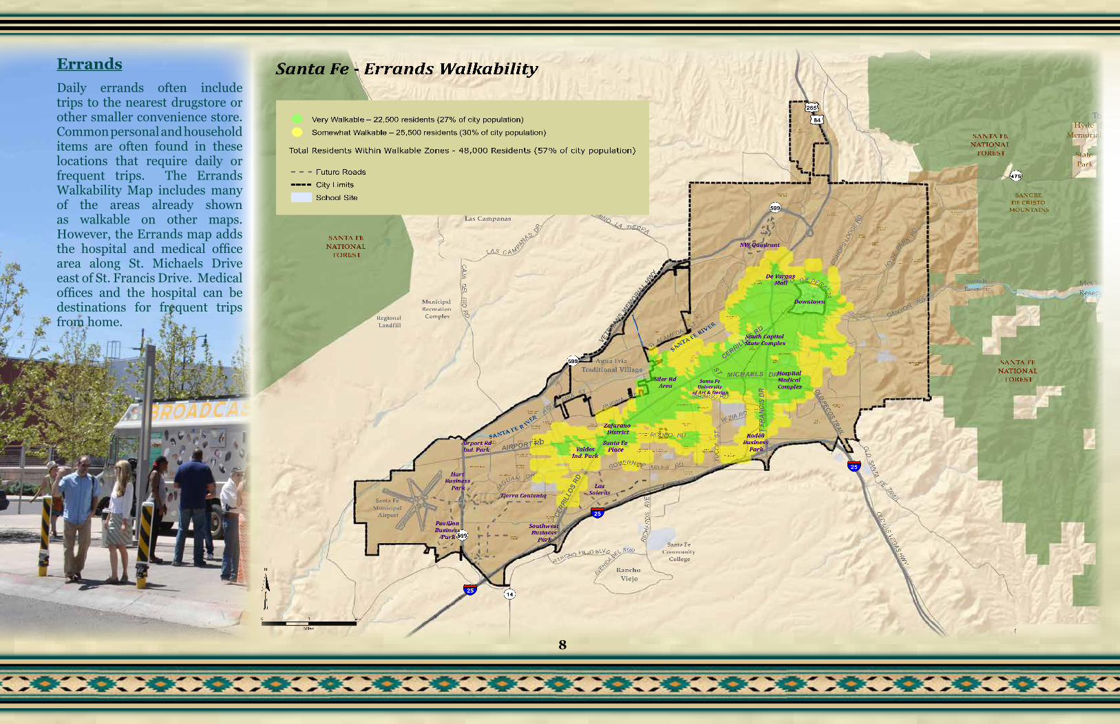
ErrandsDaily errands often include trips to the nearest drugstore or other smaller convenience store. Common personal and household items are often found in these locations that require daily or frequent trips. The Errands Walkability Map includes many of the areas already shown as walkable on other maps. However, the Errands map adds the hospital and medical office area along St. Michaels Drive east of St. Francis Drive. Medical offices and the hospital can be destinations for frequent trips from home.
BARR IO LACAN AD A
CAN AD AAN CHA
CAN D ELERO
CAS AALEG RE
CAS ALIN D A
CAS ASO LAN A
CERR O D E LSO L
CIELOLU MBR E
CO LO N IAPR ISMA
CO LO RE SDE L S OL
CO UN TRY CLU BESTATE S
DE VA RG ASHEIG HTS
ESTAN CIAPR IMERA
FAI RWAYVILLAG E
HYDE PAR KESTATE S
IND IA NRID GE
LA V ILLASER EN A
LA SACEQ U IAS
CO TTO N WOO D VILLAG E
LA SESTAN CIAS
LA SLO MAS
LO S CERR O SCO LO RA D OS
MATE OHGTS
MIRAC ERR OS
MON TESER EN O
NAVAAD E
PARKPLA ZAPU EB LOS
DE RO DE O R D
RAN CHODE LALU N A
REMU D ARID GE
SAN TA F EESTATE S
SAN TA F ESU MMIT
SIER RA D ELNO RTE
SILVER AD O
SO L YLO MAS
TO WN A N DCO UN TRY
VILLACABA LLE RO
VILLASO NATA
VISTA DE LPR AD O
VISTA DE LSO L
VISTAEN CAN TA DA
VISTAGR AN DE
VISTA PRIMER A
VISTAVERD E
LA R ESO LAN A
BELLAMA H
TIE RRA REAL
CO UN TRY CLUB
GA RD EN S
RIVE RSID E
PU EB LOS DE L S OL
WILDE RN ESS GATE
Rancho Viejo
Santa Fe Community
College
Regional Landfill
Municipal Recreation
Complex
Las Campanas
SANTA FE NATIONAL
FOREST
SANTA FE NATIONAL
FOREST
SANTA FE NATIONAL
FOREST
SANGRE DE CRISTO
MOUNTAINS
McClure Reservoir
Nichols Reservoir
Santa Fe Municipal
Airport
SANTA FE R IVER
SANTA FE RIVER
Agua Fria Traditional Village
Hyde Memorial
State Park
WALAMEDA
ST
OLD
SANTA
FE TRAI L
SIRINGO RD
AIRPORT RD
RUFINA STST MICHAELS DR
RODEO RD
GOVERNOR MILES RD
JA
GUAR DR
CANYONRD
HYDE
PA
RK
RD
OLD LAS VEGAS HWY
CAJADE L
RIO
RD
PASEO DE PERALTA
RIC
HAR
DS
AVE
CAMINOLA TIERRA
AGUAFRIA
ST
YUC C
AST
LAS C A M PAN
AS
DR
CERR
ILLO
S RD
CERRILLOS RD
ST F
RANC
IS D
R
VETE
RANS MEM
ORIAL H
WY
OLD PECOS TRAIL
BISH
OPS
LODG
E RD
RA NCHO VIEJO BLVD
AVENIDA DEL SUR
W ZIA RD
§̈¦25
§̈¦25
§̈¦25
¬«599
¬«599
¬«599
¬«475
£¤285
£¤84
¬«14
To Santa Fe Ski Basin
De Vargas Mall
Downtown
South Capitol State Complex
Siler Rd Area
Rodeo Business
Park
Zafarano District
Santa Fe PlaceValdes
Ind. Park
LasSoleras
Southwest Business
Park
Pavilion Business
Park
Hart Business
Park
Airport RdInd. Park
Hospital Medical Complex
Tierra Contenta
NW Quadrant
Santa Fe University
of Art & Design
Copyright:© 2014 Esri
0 1 2
Miles
¥
Santa Fe - Errands Walkability
Very Walkable – 22,500 residents (27% of city population)
Somewhat Walkable – 25,500 residents (30% of city population)
Total Residents Within Walkable Zones - 48,000 Residents (57% of city population)
Future Roads
City Limits
School Site
8
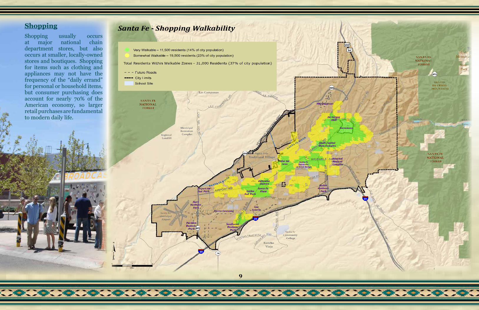
ShoppingShopping usually occurs at major national chain department stores, but also occurs at smaller, locally-owned stores and boutiques. Shopping for items such as clothing and appliances may not have the frequency of the “daily errand” for personal or household items, but consumer purchasing does account for nearly 70% of the American economy, so larger retail purchases are fundamental to modern daily life.
BARR IO LACAN AD A
CAN AD AAN CHA
CAN D ELERO
CAS AALEG RE
CAS ALIN D A
CAS ASO LAN A
CERR O D E LSO L
CIELOLU MBR E
CO LO N IAPR ISMA
CO LO RE SDE L S OL
CO UN TRY CLU BESTATE S
DE VA RG ASHEIG HTS
ESTAN CIAPR IMERA
FAI RWAYVILLAG E
HYDE PAR KESTATE S
IND IA NRID GE
LA V ILLASER EN A
LA SACEQ U IAS
CO TTO N WOO D VILLAG E
LA SESTAN CIAS
LA SLO MAS
LO S CERR O SCO LO RA D OS
MATE OHGTS
MIRAC ERR OS
MON TESER EN O
NAVAAD E
PARKPLA ZAPU EB LOS
DE RO DE O R D
RAN CHODE LALU N A
REMU D ARID GE
SAN TA F EESTATE S
SAN TA F ESU MMIT
SIER RA D ELNO RTE
SILVER AD O
SO L YLO MAS
TO WN A N DCO UN TRY
VILLACABA LLE RO
VILLASO NATA
VISTA DE LPR AD O
VISTA DE LSO L
VISTAEN CAN TA DA
VISTAGR AN DE
VISTA PRIMER A
VISTAVERD E
LA R ESO LAN A
BELLAMA H
TIE RRA REAL
CO UN TRY CLUB
GA RD EN S
RIVE RSID E
PU EB LOS DE L S OL
WILDE RN ESS GATE
Rancho Viejo
Santa Fe Community
College
Regional Landfill
Municipal Recreation
Complex
Las Campanas
SANTA FE NATIONAL
FOREST
SANTA FE NATIONAL
FOREST
SANTA FE NATIONAL
FOREST
SANGRE DE CRISTO
MOUNTAINS
McClure Reservoir
Nichols Reservoir
Santa Fe Municipal
Airport
SANTA FE R IVER
SANTA FE RIVER
Agua Fria Traditional Village
Hyde Memorial
State Park
WALAMEDA
ST
OLD
SANTA
FE TRAI L
SIRINGO RD
AIRPORT RD
RUFINA ST
ST MICHAELS DR
RODEO RD
GOVERNOR MILES RD
JA
GUAR DR
CANYONRD
HYDE
PA
RK
RD
OLD LAS VEGAS HWY
CAJADE L
RIO
RD
PASEO DE PERALTA
RIC
HAR
DS
AVE
CAMINOLA TIERRA
AGUAFRIA
ST
YUC C
AST
LAS C A M PAN
AS
DR
CERR
ILLO
S RD
CERRILLOS RD
ST F
RANC
IS D
R
VETE
RANS MEM
ORIAL H
WY
OLD PECOS TRAIL
BISH
OPS
LODG
E RD
RA NCHO VIEJO BLVD
AVENIDA DEL SUR
W ZIA RD
§̈¦25
§̈¦25
§̈¦25
¬«599
¬«599
¬«599
¬«475
£¤285
£¤84
¬«14
To Santa Fe Ski Basin
De Vargas Mall
Downtown
South Capitol State Complex
Siler Rd Area
Rodeo Business
Park
Zafarano District
Santa Fe PlaceValdes
Ind. Park
LasSoleras
Southwest Business
Park
Pavilion Business
Park
Hart Business
Park
Airport RdInd. Park
Hospital Medical Complex
Tierra Contenta
NW Quadrant
Santa Fe University
of Art & Design
Copyright:© 2014 Esri
0 1 2
Miles
¥
Santa Fe - Shopping Walkability
Very Walkable – 11,500 residents (14% of city population)
Somewhat Walkable – 19,500 residents (23% of city population)
Total Residents Within Walkable Zones - 31,000 Residents (37% of city population)
Future Roads
City Limits
School Site
9

Cultural ActivitiesEntertainment in its various forms (theaters, art galleries, museums, sport venues, etc.) plays a significant role in the life of our cities. The degree to which they can be put in close proximity to residential areas allows for greater walkability and less car dependency for their use.
The Southside Library in Tierra Contenta and the Regal Cinemas in the Zafarano District are the centers of walkable areas beyond the Downtown and St. Michaels Drive areas.
BARRIO LACANADA
CANADAANCHA
CANDELERO
CASAALEG RE
CASALINDA
CASASO LANA
CERRO DELSO L
CIELOLUMBRE
COLONIAPRISMA
COLORESDEL SO L
COU NTRY CLUBESTATES
DE VARGASHEIGHTS
ESTANCIAPRIMERA
FAIRWAYVILLAGE
HYD E PARKESTATES
IND IANRIDGE
LA VILLASERENA
LASACEQUIAS
COTTONWOOD VILLAGE
LASESTANCIAS
LASLOMAS
LOS CERROSCOLORADOS
MATEOHGTS
MIRACERRO S
MONTESERENO
NAVAADE
PARKPLAZAPUEBLOS
DE RODEO RD
RANCHODE LALUNA
REMU DARIDGE
SANTA FEESTATES
SANTA FESU MMIT
SIERRA DELNORTE
SILVERADO
SO L YLOMAS
TOWN ANDCOU NTRY
VILLACABALLERO
VILLASO NATA
VISTA DELPRAD O
VISTA DELSO L
VISTAENCANTADA
VISTAGRAND E
VISTA PRIMERA
VISTAVERDE
LA RESOLANA
BELLAMAH
TIERRA REAL
COU NTRY CLUB
GARDENS
RIVERSIDE
PUEBLOS DEL SO L
WILDERNESS GATE
Rancho Viejo
Santa Fe Community
College
Regional Landfill
Municipal Recreation Complex
Las Campanas
SANTA FE NATIONAL
FOREST
SANTA FE NATIONAL
FOREST
SANTA FE NATIONAL
FOREST
SANGRE DE CRISTO
MOUNTAINS
McClure Reservoir
Nichols Reservoir
Santa Fe Municipal
Airport
SANTA FE R IVER
SANTA FE RIVER
Agua Fria Traditional Village
Hyde Memorial
State Park
WALAMEDA
ST
OLD
SANTA
FE TRA IL
SIRINGO RD
AIRPORT RD
RUFINA ST
ST MICHAELS DR
RODEO RD
GOVERNOR MILES RD
JA
GUAR DR
CANYONRD
HYDE
PA
RK
RD
OLD LAS VEGAS HW
Y
CAJA
DE L
RIORD
PASEO DE PERALTA
RIC
HA R
DS
AVE
CAMIN OLA TIERRA
AGUAFRIA
ST
YUCC
AST
LAS C A M PAN
AS
DR
CERR
ILLO
S RD
CERRILLOS RD
ST F
RANC
IS D
R
VETE
RANS MEM
ORIAL
HWY
OLD PECOS TRAIL
BISH
OPS
LODG
E RD
RA NCHO VIEJO BLVD
AVENIDA DEL SUR
W ZIA RD
25
25
25
599
599
599
475
285
84
14
To Santa Fe Ski Basin
De Vargas Mall
Downtown
South Capitol State Complex
Siler Rd Area
Rodeo Business
Park
Zafarano District
Santa Fe PlaceValdes
Ind. Park
LasSoleras
Southwest Business
Park
Pavilion Business
Park
Hart Business
Park
Airport RdInd. Park
Hospital Medical Complex
Tierra Contenta
NW Quadrant
Santa Fe University
of Art & Design
Copyright:© 2014 Esri
0 1 2
Miles
Santa Fe - Cultural Activities Walkability
Very Walkable – 10,000 residents (12% of city population)
Somewhat Walkable – 8,000 residents (10% of city population)
Total Residents Within Walkable Zones – 18,000 residents (22% of city population)
Future Roads
City Limits
School Site
10

Santa Fe’s Walkability – Conclusions
While Santa Feans throughout the city may enjoy walking around their neighborhood and may thoroughly enjoy the area where they live, “walkability” as used in this report defines those areas in which residents are just a relatively short walk from their homes to a destination such as a park, school, grocery store, etc. Still, many residential areas appear to be car-dependent. Attempting to retro-fit many or all neighborhoods and residential areas into “walkable zones” is not the goal of this report, nor should it be a guiding goal of the city government. Often, a walkable zone is created only by a confluence of a number of factors: Higher residential density, one or more major roadways bisecting or bordering an area and previously established centers of activity.
There are no quick solutions to adding areas or neighborhoods to those that already enjoy some level of walkability as shown on the maps in this report. Simply adding higher density infill residential development to an existing developed part of the city does not guarantee that an area, not currently in a walkable zone, will suddenly become walkable. However, the city can actively work to achieve the following:
1. Master-Planned Areas – Encourage and ensure that newly developing large master-planned areas (i.e. Tierra Contenta, Las Soleras) are “walkable”by requiring higher-density residential and commercial development throughout the master-planned areas as construction occurs.
2. Existing Walkable Zones –Improve and enhance those areas that are already “walkable” by focusing capital improvements in the public realm (i.e. streets, sidewalks, crosswalk striping, parks and other pedestrian enhancements) that strengthen already defined walkable zones.
The Overall Walkability map shows the city’s urban core, or to use a human anatomy analogy … central nervous system. If cities are the drivers of American culture and the economy, then walkable zones within a city can be considered the core of a city’s culture and economy. The city should use the Overall Walkability Map to continually focus efforts to improve all aspects of the public realm which includes attention and improvements to parks and streetscapes in the walkable zones as experienced by pedestrians; not to the exclusion of other parts of the city, but to enhance and build on the city’s areas of urban/walkable strengths.
While master-planned areas are generally laid out, financed and built by private developers, the city can require densities, parks, street networks and streetscapes that will create the foundation for new walkable areas as the city expands. Concurrently, the city can be ensuring that a substantial part of its own capital improvement planning and budgets are being used to help improve those already existing walkable zones.
11
Top Related