


Languages
Pages
Legal

15Area E Urban Release Development Code2011 V.2.0
PART 02 SUBDIVISION
2.1 Vision for Area E and DA Requirements2.2 Urban Footprint & Design Principles2.3 Design Principle 1 - Environment2.4 Design Principle 2 - Landscape Character and Views2.5 Design Principle 3 - Landforming2.6 Design Principle 4 - Road Layout Traffic and Transport2.7 Design Principle 5 - Open Space2.8 Design Principle 6 - Dwelling and Allotment Mix2.9 Design Principle 7 - Urban Design, Streetscape and Public Domain2.10 Design Principle 8 - Solar orientation2.11 Design Principle 9 - Hazards and Resilience2.12 Design Principle 10 - Infrastructure

16Area E Urban Release Development Code2011 V.2.0
2.1 - Vision for Area E
“The vision for Area E is to create opportunities for a high quality suburban and village lifestyle that recognises its contextual relationship to both the site and the landscape character of the Tweed by providing a sense of place, community, environmental stewardship, as well as accessibility to all urban services including a range of open space opportunities and the provision of water, sewer and road infrastructure.”
Best Practice Design and Sustainability
The overall concept for Area E is to produce a high quality residential development and village centre area, which offers a range of housing types and community services, and maximises the opportunities provided by the topography.
The aim is to create a suburban environment that respects the natural landform, while creating a modern look and feel built around a distinctive character and design and reflecting best practice new urban development.
Street layout and allotment configuration will incorporate best practice subdivision design, which is based on principles of good site design and orientation to achieve optimum solar access, capture prevailing breezes and the fantastic views afforded from various vantage points around the site. The residential densities and lot layout minimise urban sprawl and provide the flexibility to develop a range of site and climatically appropriate housing types to meet a range of affordability and lifestyle demands.

17Area E Urban Release Development Code2011 V.2.0
Health and Wellbeing
Each of the residential precincts is bounded by and connected to a network of well-designed public open spaces which ensures walkable distances to a variety of recreation spaces.
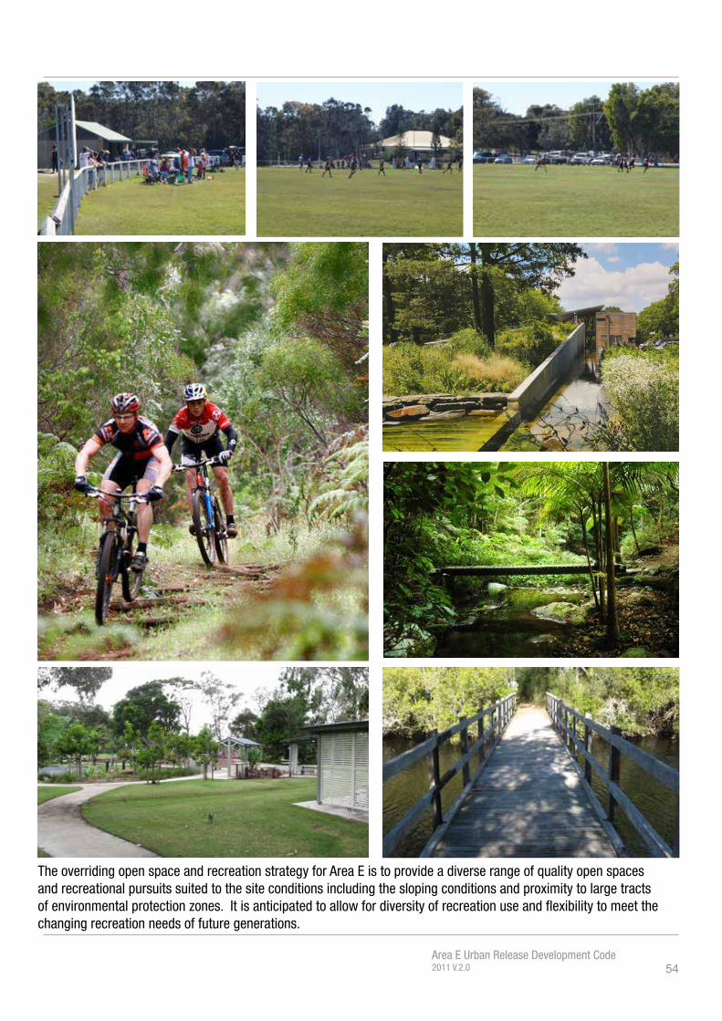
The open space and recreation strategy for Area E provides a diverse range of quality open spaces and recreational pursuits suited to the site conditions, including the sloping conditions and proximity to large tracts of environmentally protected lands. These areas also provide visual relief to the hardest edges of the built environment.
The sloping site conditions allow diversity in the way recreational space is provided by encouraging additional non-traditional uses like mountain bike trails and community gardens within defined casual and structured open space. Open space areas defined within the structure plan and resultant master plans should ensure that scenic views and elevated areas are generally maintained for the benefit of the broader community and provide flexibility to meet the changing recreation needs of future generations.
Whilst much of the site is sloping, it is important where possible, to ensure that the residential and open space areas have high levels of pedestrian walkability to community facilities, open space and other public spaces, through well designed and accessible pedestrian pathways, cycleways and walking trails.
Creating a Sense of Place
The village centre will serve as the primary meeting place and activity hub within the estate, through well designed commercial and retail spaces co-located with housing and public open space, improving the quality and activity of the public domain and enriching the experience of the community.
The village centre presents as a ‘high street’ with integrated car parking, vehicular and pedestrian circulation and public domain improvements at a local village scale and character. The development of key sites should demonstrate a high standard of coastal hinterland architecture and urban design, provide a built form character which embraces the public domain and provide landmark developments for the Area E community.
The village centre and surrounding residential area is supported by a strong private and public transport network which connects and integrates Area E to surrounding localities.
Together these attributes will create a sense of place, foster community spirit and develop a sustainable community with strong social wellbeing and livability.
PART 02 SUBDIVISION

18Area E Urban Release Development Code2011 V.2.0

19Area E Urban Release Development Code2011 V.2.0
Subdivision Development Application Checklist
Beyond the requirements contained within Section A5 and other applicable documents, the following information is to be submitted with any Development Application for subdivision:
5 Flora and Fauna assessment/s 5 A Wetland Restoration Plan and Habitat Restoration Plan for all land zoned
Environmental Protection 5 Visual impact assessment 5 Plans and site sections that demonstrate design measures employed which
minimise bulk earthworks over the site 5 Accurately represented and documented detail of all proposed site works
including cut, fill, benching and retaining walls 5 Landforming plans detailing the location, management and final placement of
Class 6 Soils 5 Any application seeking development consent prior to the construction of
Broadwater Parkway, must be accompanied by a traffic study demonstrating the ability for the proposal to be accommodated by existing or alternative proposed road networks to the satisfaction of Council.
5 Density Projection Plan including a breakdown and schedule of differing allotment sizes
5 Structural System Plan (plan and schedule) to demonstrate the nexus between slope, allotment size and appropriate dwelling type.
5 Public Domain Plan 5 Soil Stability and Site Investigations 5 Site Audit Statement (SAS) certifying the land is suitable for the proposed use.
PART 02 SUBDIVISION

20Area E Urban Release Development Code2011 V.2.0
Figu
re 2
.1-
Urba
n Fo
otpr
int C
ontro
ls

21Area E Urban Release Development Code2011 V.2.0
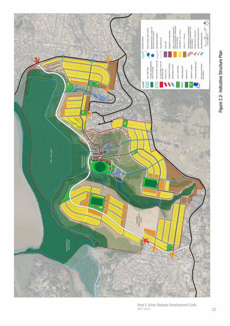
2.2 - Urban Footprint & Design Principles
In order to realise the Vision for Area E, this Code contains a detailed Urban Footprint, followed by a series of Design Principles, applicable to the various stages of development that Area E will contain. These Design Principles are integrated and should be read in conjunction with each other to ensure holistic high quality outcomes for the site.
The Urban Footprint for Area E is detailed within Figure 2.1 and has been derived from the following methodology.
In total, Area E comprises 296ha of land, comprising a mixture of Urban, Special Uses and Environmental Protection. In establishing an urban footprint for development, the land identified for environmental protection is removed, in keeping with the Vision of this Code. Whilst these tracts of land may still be modified by development, as is allowable under the Tweed LEP, the intent of this Code is to rehabilitate and protect these areas. Accordingly, development is not supported within the environmental protection zones/areas by this Code, except for opportunities to improve its condition, maintenance and enjoyment.
After removing environmental protection areas from the urban footprint, the next highest order constraint is land that is identified as possessing a combination of greater than 18 degrees slope and identified as ‘Bushland’. It is acknowledged by this Code that portions of the identified land may be minor in size and significance and can be incorporated within a wider urban development concept, however, these tracts of land also comprise a significant portion of the site’s landscape and visual character, and accordingly their retention or enhancement is of importance. The Urban Footprint displayed within Figure 2.1 details the tracts of land possessing these attributes which may be considered for sensitive urban development where it can be demonstrated that the development satisfactorily addresses the Design Principles of this Code. Council may also consider urban development in these areas that is vital for the implementation of the Code, i.e. essential infrastructure.
The final determinative constraint informing the urban footprint is land mapped as bushland. Whilst not normally a prohibitive constraint, in order to achieve the vision and design principles of the Code, it is considered critical to retain the majority of this land for its visual quality, urban relief and to integrate with wildlife corridors. As with above, where bushland is fragmented and can be incorporated within a wider urban development concept, the urban footprint has been modified accordingly.
It is critical to acknowledge that the above constraints are not exhaustive of the constraints that apply to the site. Additional constraints such as flooding, acid sulphate soils, soil stability, slope and bushfire prone land for instance have the capacity to influence the type, style and scale of development. Further discussion on these matters is contained throughout this Code.
PART 02 SUBDIVISION
22Area E Urban Release Development Code2011 V.2.0
Figu
re 2
.2-
Indi
cativ
e St
ruct
ure
Plan

23Area E Urban Release Development Code2011 V.2.0
Objectives
• Achieve the orderly and efficient use of land.• Achieve a landscape character strategy that urban development within Area E
should be compact settlements interspersed within the dominating landscape composition of wetland, vegetated valleys, vegetated escarpment and ridgelines.
• Promote high quality development that integrates the Design Principles of this Code.
• Promote an urban release area of design excellence.
Development Control
1. Development within the identified urban footprint must address the design principles of this Code, as well as Council’s other applicable policy instruments, standards and guidelines within a subdivision development application.
2. In addition to Development Control 1, development of land identified as Topographically Constrained are encouraged to consult with Council planners throughout the design and application preparation process.
3. This Code does not support urban development outside the urban footprint unless for critical/essential infrastructure.
PART 02 SUBDIVISION

24Area E Urban Release Development Code2011 V.2.0
Figu
re 2
.3 -
Env
ironm
enta
l Attr
ibut
es
Wild
life
Corr
idor
s

25Area E Urban Release Development Code2011 V.2.0
2.3 - Design Principle 1: Environment
Vision
To facilitate the preservation and enhancement / rehabilitation of environmental zones providing management for the conservation of threatened and endangered species. This includes the maintenance of open drainage networks as land of environmental quality where possible, preservation of native bush land vegetation and recognition of areas high environmental amenity value. Ensure that proposed uses adjacent to environmental protection zones do not have significant adverse impacts.
Preserve
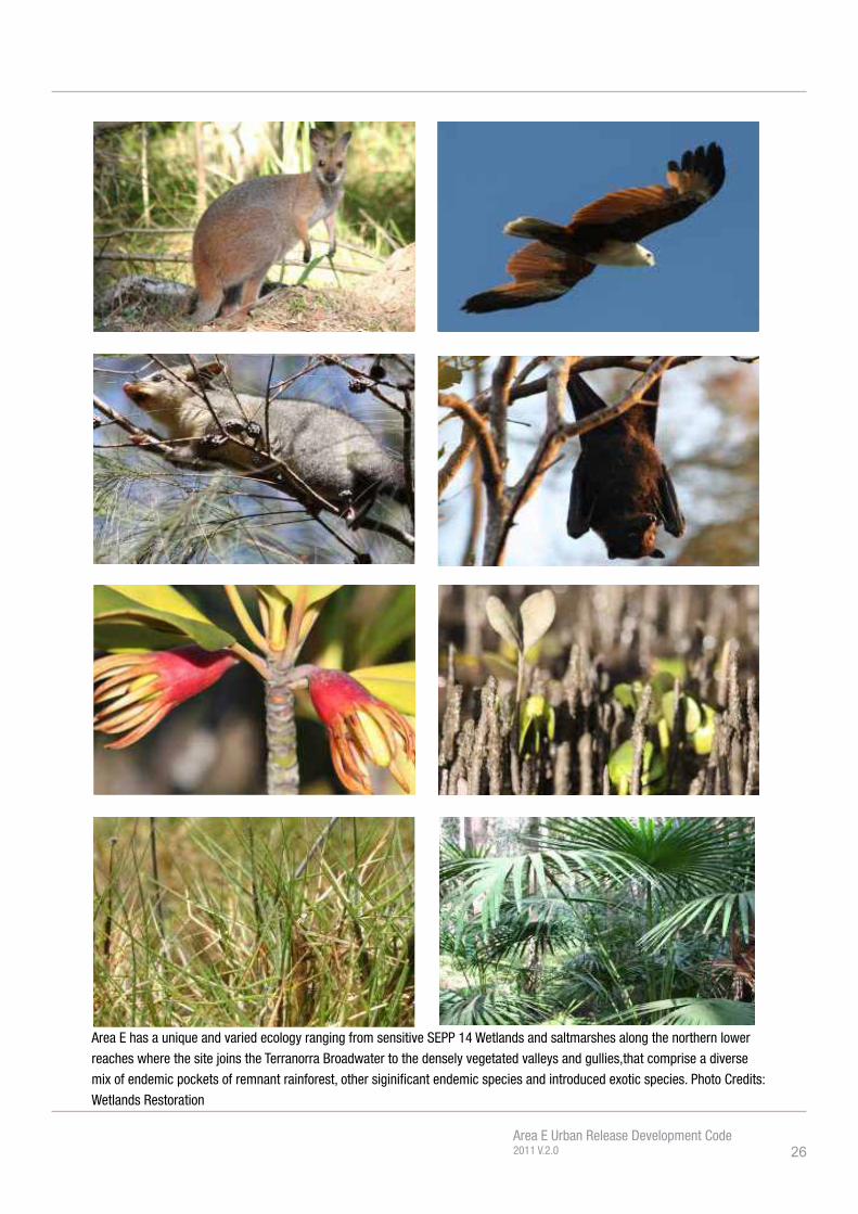
Whilst large tracts of the environmental land has been cleared in the past, environmental surveying has identified a number of endangered ecological communities (EECs), both within land currently identified for Environmental Protection, and within urban zoned land. As part of the preparation of individal development applications, flora and fauna assessments will be required to identify the presence of land of high environmental quality, suitable buffering and ongoing management. Urban development within land identified as Environmental Protection is strongly discouraged by this Code, as indicated by the Urban Footprint illustrated in Figure 2.1.
Enhance
Area E comprises a number of deep, vegetated valleys and bush-clad slopes, forming an important part of its landscape and visual character. As part of the future subdivision and development of Area E development must incorporate design features to not only maintain these visual characteristics, but link with adjoining ecology and wildlife corridors. Development proponents must explore methods to provide visual ‘breaks’ to the built form by way of suitably vegetated corridors permeating throughout Area E. Figure 2.3 provides examples of green corridors that must be investigated within future applications both for their environmental and urban design/visual value.
Rehabilitate
It is required as part of the future subdivision and development of Area E that areas of the Environmental Protection Zone are restored and rehabilitated. The rehabilition of environmental land will provide an important buffer to the Terranora Broadwater and State Environmental Planning Policy No. 14 Wetland, particularly during the construction phase of the urban release area, as well as improving the amenity of the area. As discussed in other areas of this Code the desired road pattern is to include road interfaces with natural areas rather than private land tenure, allowing an improved public interface with these areas, easier management and rehabilitation.
PART 02 SUBDIVISION
26Area E Urban Release Development Code2011 V.2.0
Area E has a unique and varied ecology ranging from sensitive SEPP 14 Wetlands and saltmarshes along the northern lower
reaches where the site joins the Terranorra Broadwater to the densely vegetated valleys and gullies,that comprise a diverse
mix of endemic pockets of remnant rainforest, other siginificant endemic species and introduced exotic species. Photo Credits:
Wetlands Restoration

27Area E Urban Release Development Code2011 V.2.0
Objectives• The environmental lands, natural watercourses and other natural systems are
protected and retained.• To preserve and protect land of high ecological significance from urban
development.• To encourage the enhancement of land with high environmental qualities.• To provide for the rehabilitation and enhancement of degraded habitat and
ensure that comprehensive rehabilitation plans form part of any future development applications or masterplans.
• To provide for the protection and improvement of existing hydrological conditions in Terranora Broadwater.
• To provide a natural growth boundary to residential development and visual relief for the proposed urban environment.
• To integrate localised ‘green belts’ into the urban footprint.• To create additional wildlife corridors. • To embody urban development within a park-like setting.
Development Control
The following information is to be submitted with any Development Application for subdivision:
5 Flora and Fauna assessments will be required to identify the presence of land of high environmental quality, suitable buffering and ongoing management.
5 A Wetland Restoration Plan and Habitat Restoration Plan must be prepared to Council’s satisfaction for all land zoned for Environmental Protection.
1. Demonstrate that the environmental protection areas are retained and protected, that existing wildlife corridors and vegetative links have been maintained, and links identified within Figure 2.3 established. These links could be continous tracts of vegetation, or where they traverse urban areas, a strong linking canopy of native street trees.;
2. Demonstrate suitable buffering and ongoing management of land possessing high environmental quality;
3. Demonstrate that an adequate buffer of at least 20m (which may include the road reserve) is retained around the edge of the environmental protection area;
4. Demonstrate the works identified within the Council approved Wetland Restoration Plan and Habitat Restoration Plan that the development will be responsible for and the intended method of addressing the works required;
5. Demonstrate that any wetland on the land will be restored and managed to the consent authority’s satisfaction to restore freshwater wetland values and minimise breeding habitat for saltwater mosquitoes and biting midges.
PART 02 SUBDIVISION
Note - It is acknowledged that land requiring restoration works is in fragmented ownership. To this extent, Council is open to discussion with applicants regarding delivery methods for the restoration work identified to ensure equitable distribution across the landowners and development of Area E. The developer will be responsible for the restoration works of the area of environmental protection to Council’s satisfaction. Should environmental areas be dedicated to Council in any subdivision or other development, Council may enter into an agreement for a maintenance period and contribution prior to handover and all restoration works must be completed to Council’s satisfaction.

28Area E Urban Release Development Code2011 V.2.0
View - Looking South West from Mahers Lane Precinct
View - Looking north from Mahers Lane Precinct
View - Looking east towards Fraser Drive
View - Looking north from Fraser Drive
29Area E Urban Release Development Code2011 V.2.0
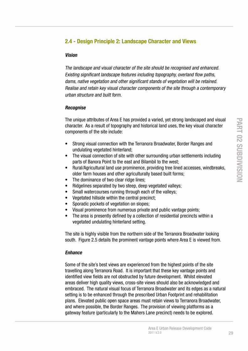
2.4 - Design Principle 2: Landscape Character and Views
Vision
The landscape and visual character of the site should be recognised and enhanced. Existing significant landscape features including topography, overland flow paths, dams, native vegetation and other significant stands of vegetation will be retained. Realise and retain key visual character components of the site through a contemporary urban structure and built form.
Recognise
The unique attributes of Area E has provided a varied, yet strong landscaped and visual character. As a result of topography and historical land uses, the key visual character components of the site include:
• Strong visual connection with the Terranora Broadwater, Border Ranges and undulating vegetated hinterland;
• The visual connection of site with other surrounding urban settlements including parts of Banora Point to the east and Bilambil to the west;
• Rural/Agricultural land use prominence, providing tree lined accesses, windbreaks, older farm houses and other agriculturally based built forms;
• The dominance of two clear ridge lines;• Ridgelines separated by two steep, deep vegetated valleys; • Small watercourses running through each of the valleys; • Vegetated hillside within the central precinct; • Sporadic pockets of vegetation on slopes;• Visual prominence from numerous private and public vantage points; • The area is presently defined by a collection of residential precincts within a
vegetated undulating hinterland setting.
The site is highly visible from the northern side of the Terranora Broadwater looking south. Figure 2.5 details the prominent vantage points where Area E is viewed from.
Enhance
Some of the site’s best views are experienced from the highest points of the site travelling along Terranora Road. It is important that these key vantage points and identified view fields are not obstructed by future development. Whilst elevated areas deliver high quality views, cross-site views should also be acknowledged and embraced. The natural visual focus of Terranora Broadwater and its edges as a natural setting is to be enhanced through the prescribed Urban Footprint and rehabilitation plans. Elevated public open space areas must retain views to Terranora Broadwater, and where possible, the Border Ranges. The provision of viewing platforms as a gateway feature (particularly to the Mahers Lane precinct) needs to be explored.
PART 02 SUBDIVISION

30Area E Urban Release Development Code2011 V.2.0
Figure 2.4 - Views out of Area E and Internal Views
1 2 3

31Area E Urban Release Development Code2011 V.2.0
Objectives
• Maintain the integrity of ridge lines, valleys and natural topographic features as an important part of the localities character.
• Promote subdivision design which reduces the need for benching and significant cut and fill.
• To ensure site modifications, retaining walls and engineered elements do not adversely impact on the streetscape, or precincts character.
• The watercourses and vegetated drainage lines running through the site provide excellent visual, recreational, educational and environmental preservation opportunities and are to be integrated with opportunity for pedestrian links between.
• Realise and retain key visual character components of the site through a contemporary urban structure and built form.
• Provide view sharing and maintenance of view fields.• Maintain important regional and local views.• Preserve the visual amenity of and within the site.• The identification and retention of green breaks, important feature trees /
stands of trees and important view fields.
Development Control
The following information is to be submitted with any Development Application for subdivision:
5 Visual impact assessment
1. Any proposal must detail consistency with the visual strategies detailed above in the format of a visual impact assessment as part of any subdivision development application. The visual analysis should address:• key vantage points both into and out of the Area E site as identified within
this plan;• provide visualisations of subdivision pattern and indicative built form by
way of 3D photo montage from key surrounding vantage points around the site (refer to Fig 2.5), as well as from key cross site vantage points. All visualisations are to be provided at an appropriate scale for meaningful assessment. Montages should illustrate a representation of indicative built form including particularly roof materials and colour.
2. Any proposal must not obstruct the key view lines as identified in the identified 5 key views illustrated at Figure 2.5 and demonstrate the subdivision design enables future development of lots that can preserve the key view lines.
3. Any proposal must demonstrate that the undulating and vegetated valley character is maintained as an important part of the sites visual character in terms of regional inward views.
PART 02 SUBDIVISION

32Area E Urban Release Development Code2011 V.2.0
Figure 2.5 - Visual Catchment of Area E and Key Public Vantage Points
1.
2.
3.
4.
5.
33Area E Urban Release Development Code2011 V.2.0
4. Achieve the outcomes of the Tweed Scenic Landscape Strategy.5. Any proposal must identify remnant vegetation across the site including
existing paddock windbreaks and seek to retain or interpret these important elements of the sites visual character. Suggested means of embodying these components include adapting existing vegetated wind break lines as street trees, to create more visually attractive streetscapes; maintain the presence of existing mature trees to assist in visually defining the identified character zones and preserving ecological habitat.
6. Any proposal must demonstrate a building design and structural system which reduces the need for benching and significant cut and fill thereby maintaining the topographic integrity and visual character of the site.
7. Identification and retention of significant vegetation (including non-native species) that contribute significantly to the landscape character of the locality.
8. Significant landscape features including overland flow paths, dams, native vegetation and other significant stands of vegetation are to be identified and retained in any development application.
PART 02 SUBDIVISION

34Area E Urban Release Development Code2011 V.2.0
This is a panoramic view looking south from Champagne Drive
in the Vintage Lakes subdivision. Maintaining the visual and
landscape character of the site, experienced from within the site
as well as from surrounding residential areas and various vantage
points around the Terranora Broadwater, is an important landscape
character consideration when preparing masterplans for the various
precincts.
It is important to recognize that whilst there are significant outbound
views, the site is also highly visible from vantage points all around
the Terranorra Broadwater. By looking back into the site we are also
able to understand some of the key elements which define the sites
visual and landscape character.
Existing built form also forms part of the view field. Integration of
the existing built form, on larger lots (Market Parade) as a positive
response to visual character with dwellings ‘sitting within’ the
landscape, with surrounding vegetation and landscape almost
obscuring it. This is contrasted by the bright orange roofs in bottom
left corner which dominate the view field due to the absense
of integrated landscaping of an appropriate scale which is not
appropriate for the Area E site.
View 01 - Champagne Drive
View 01 - Applies to all Areas of Area E
1.
View Analysis
Existing View Retain and enhance this middle band of vegetation. Community title building roofs within predominantly landscaped backdrop.
Wetland vegetation forms foreground
Existing built form within Market Parade / Parkes Lane integrates well with landscape. This is to be replicated across all developable areas in Area E.
Vegetation forms ‘green fingers’ running up ridgelines, gullies and valleys.
Wetland vegetation

35Area E Urban Release Development Code2011 V.2.0
View Characteristics
• The low area waters edge and wetland vegetation up to about
10m high.
• The vegetated valleys or green fingers climb up the sites two
main valleys.
• Large tracts of bushland vegetation, some native some exotic
including camphor laurel.
• Open undualting paddocks which are each divided and
indispersed by these green breaks and green fingers which
divides the site into clear pockets or precincts.
• The varied ridgeline climbing to the highest point around
sunnycrest subdivision, stand of Norfolk Island trees which are
a regional marker or landmark.
Controls
1. Reproduction of this image as a photomontage to demonstrate
how the following characteristics are achieved:
• Retain strong middle band of vegetation (acceptable to
see roofs of community title and topographically sensitive
development dispersed within). Although much of this
vegetation is exotic species, the preservation of the canopy
and ‘greening’ of th Area E site is an important part of the
visual character;
• Retain the integrity of the ridgeline by limiting building height;
• Retain the integrity of the paddock ‘green windbreak’ lines
through the establishment of street trees;
• Retain vegetation running up gullies / valley and other pockets
of bushalnd / vegetation;
• Developable area to be interspersed and framed by vegetated
foreground, middle landscaped band and vegetated gullies;
• No red, terracotta, white or blue roofs; and
• Acceptable to see the tops of buildings within the village centre
just above wetland vegetation line.
PART 02 SUBDIVISION
Top of buildings in village centre.
Middle band of vegetation forms a strong green backdrop to village centre location.
Open paddock areas defined by tree lined fences and vegetation to steeper inclines.
Norfolk Pines on top of the ridge are a regional landmark.
Wetland vegetation
Retain and enhance this middle band of vegetation. Community title building roofs within predominantly landscape backdrop.
Retain vegetated ridge lines and gulliesEstablish strong pattern of street trees.
Retain and enhance this middle band of vegetation.

36Area E Urban Release Development Code2011 V.2.0
This is a view taken from the bottom of Fraser Drive looking south
towards the ridge slope at the end of Parkes Lane/Market Parade,
across the top of where the proposed village centre would be, to the
vegetated middle band and Terranora Road ridgeline beyond.
Taken from the busy intersection of Fraser and Leisure Drive, this
view offers a long vista back towards the Area E site which is
visually prominent and provides a green peri-agricultural backdrop
including large tracts of vegetation in the foreground, vegetation
running up the gullies and existing paddock windbreaks and
fenceline delineations.
Given the visual prominence of the Area E site from this location,
future development will also be highly visible from this location. As
such it is important to retain and enhance the key charactersitcs
of the existing view, that is providing a green backdrop where
vegetation, street trees, tree lined ridge dominate the view field.
Development whilst visible should be contained within the existing
open paddock areas, broken up by a strong pattern of street trees
which replicate the existing pattern of paddock wind break trees.
View 02 - Fraser Drive Looking South
View 02 - Applies to the ridge at the end of Market Parade and across the open paddock area below Terranorra Road.
2.
Existing View
Paddock treed windbreaks.
Open paddock. Existing pockets of vegetation forming middle ‘green band’.
Tree lined ridgeline.
Development is visible through vegetation.

37Area E Urban Release Development Code2011 V.2.0
View Characteristics
• Area E from the end of the Market parade ridge line across
to the open paddock area below Terranorra Road forms the
backdrop to this busy intersection of Fraser and Leisure Drive.
• The view composition consists of fore (wetland and
eucalyptus stands), mid and background stands of vegetation.
The layering of the pockets of vegetation, and vegetated
paddock windbreaks with open paddock in between which
define the existing visual character.
• Vegetation which extends up the valley’s and gullies which
read as ‘green fingers’.
• Open undualting paddocks which are each divided and
indispersed by green windbreaks which run along and
perpendicular to contours.
Controls
1. As part of a development application for the subdivision of
this land a photomonmtage from this view must be prepared
to demonstrate how the following characteristics are
achieved:
• retain strong middle band of vegetation (acceptable to
see roofs of community title and topographically sensitive
development dispersed within). Although much of this
vegetation is exotic species, the preservation of the canopy
and ‘greening’ of th Area E site is an important part of the
visual character;
• Retain the integrity of the ridgeline by limiting building height;
• Retain the integrity of the paddock ‘green windbreak’ lines
through the establishment of street trees;
• Retain vegetation running up gullies / valley and other
pockets of bushalnd / vegetation including the stand of
eucalyptus trees at the toe of the ridgeline;
• Developable area to be interspersed and framed by vegetated
foreground, middle landscaped band and valley’s gullies; and
• No red, terracotta, white or blue roofs. Use colours which
have low levels of reflectivity and glare. As such choose
neutral greens, browns and grey tones which is more related
to the natural landscape.
View Analysis
PART 02 SUBDIVISION
Ridgeline
Dark green denotes the top of wetland vegetation, the middle band of vegetation and stand of eucalyptus at the toe of the Market Parade ridge. Retain and enhance the predominance of the vegetation through this ‘middle band’ of the site.
Blue colour denotes profile of the tree lined ridgeline. No future development to permeate the existing profile.
Establish strong pattern of street trees.
Beige colour denotes developable area.

38Area E Urban Release Development Code2011 V.2.0
This is a panoramic view taken from Terranorra Road looking north
over the Area E Site towards the Terranorra Broadwater and beyond
to Tweed Heads and Coolangatta.
It is likely that as a stage of subdivision development the land in
the foreground of the view will be subsequently developed for
residential purposes. Whilst it is likely that the future allotments will
gain access from internal roads (rather than directly off Terranorra
Road), it is important to restrict the building height in this area to
avoid obscuring this important uninterupted panoramic view.
All future development should be of a height as to not project into
the sweeping view taking in Terranorra Broadwater, the Gold Coast
in the distance and Tweed Heads to the left. Development should
generally be kept to the height of the existing vegetation.
View 03 - Terranorra Road Looking North
View 03 - Applies to the undeveloped allotments which directly adjoin Terranorra Road. (see shaded area above)
3.
Existing View
Long uninterrupted views of the wetland, Terranorra Broadwater, Pacific Ocean and beyond must not be obstructed by development of the site when viewed from Terranorra Road

39Area E Urban Release Development Code2011 V.2.0
View Characteristics
• Panoramic regional views which take in Terranorra
Broadwater, Tweed Heads, Coolangatta, Pacific Ocean and
beyond to Gold Coast and South Stradbroke Island;
• The vegetated wetalnd areas on the southern edge of the
Terranorra Broadwater;
• Large tracts of bushland vegetation extending up ridgelines
and valleys;
• Foreground highlevel vegetation which piece the primary
view field.
Controls
1. Parecls of land which will potentially impact on this view field
are required to prepare a photomontage to demonstrate how
the following characteristics are achieved:
• Longviews of the wetland, Terranorra Broadwater, Pacific
Ocean and beyond must not be obstructed by development
of the site when viewed from Terranorra Road. Development
must be below dotted white line (RL 125 AHD).
• Mid views should comprise vegetation piercing the longview
and soften future built form.
• Foreground views will include the futue development, with
views and vegetation between built form.
• No red, terracotta, white or blue roofs. Use colours which
have low levels of reflectivity and glare. As such choose
neutral greens, browns and grey tones which is more related
to the natural landscape.
Beige colour denotes developable area;
Longviews of the wetland, Terranorra Broadwater, Pacific Ocean and beyond must not be obstructed by development of the site when viewed from Terranorra Road. Development below dotted line.
Mid views should comprise vegetation piercing the longview and soften future built form
Foreground views will include the future development
View Analysis
PART 02 SUBDIVISION

40Area E Urban Release Development Code2011 V.2.0
This is a panoramic view taken from Fraser Drive looking north over
the Area E Site towards the Terranorra Broadwater and beyond to
Tweed Heads and Bilambil heights with the Border ranges beyond.
This is a significant view experienced primarily from the motor
vehicle heading north along Fraser Drive where the broader region
is revealed. The composition of the view includes the rolling
landform and vegetation of Area E in the foreground, the Terranorra
Broadwater in the mid ground, and the Border ranges and other
regional ridgelines to the north in the background.
It is likely that as a stage of subdivision development the land in
the foreground of the view will be subsequently developed for
residential purposes. Whilst it is likely that the future allotments will
gain access from internal roads (rather than directly off Fraser Drive)
it is important to restrict the building height in this area to avoid
obscuring this important uninterupted panoramic view.
All future development should be of a height as to not project into
the sweeping view taking in Terranorra Broadwater, the Gold Coast
in the distance and Tweed Heads to the left.
This area has also been identified for a landscape buffer treatment
to obscur the rear fences of the future allotments and avoid
a continous band of fence dominating the view. As such the
landscape buffer needs to be layered in height. Low level shrubs
and ground covers to obscur the fence along with more significant
tree species which will grow up to form a canopy along the western
side of Fraser Drive, but still allowing a view through and beyond.
View 04 - Fraser Drive Looking North
View 04 - Applies to the allotments which directly back onto Terranorra Road. (see shaded area above)
Existing View
Redline denotes limit of development height;
Longviews of the wetland, Terranorra Broadwater and Border Ranges must not be obstructed by development of the site when viewed from Fraser Road.
Ridgeline at the end of Parkes Lane to have strong tree canopy running along its length (to its potential intersection with Broadwater Parkway)
4.
41Area E Urban Release Development Code2011 V.2.0
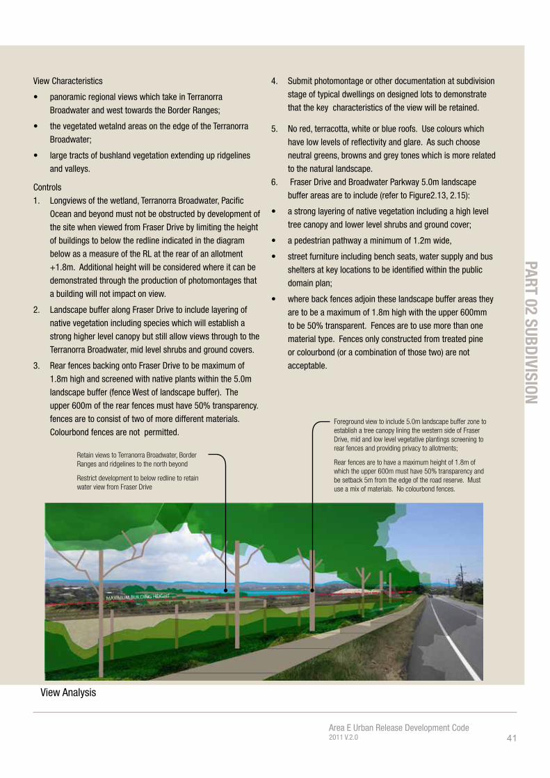
View Characteristics
• panoramic regional views which take in Terranorra
Broadwater and west towards the Border Ranges;
• the vegetated wetalnd areas on the edge of the Terranorra
Broadwater;
• large tracts of bushland vegetation extending up ridgelines
and valleys.
Controls
1. Longviews of the wetland, Terranorra Broadwater, Pacific
Ocean and beyond must not be obstructed by development of
the site when viewed from Fraser Drive by limiting the height
of buildings to below the redline indicated in the diagram
below as a measure of the RL at the rear of an allotment
+1.8m. Additional height will be considered where it can be
demonstrated through the production of photomontages that
a building will not impact on view.
2. Landscape buffer along Fraser Drive to include layering of
native vegetation including species which will establish a
strong higher level canopy but still allow views through to the
Terranorra Broadwater, mid level shrubs and ground covers.
3. Rear fences backing onto Fraser Drive to be maximum of
1.8m high and screened with native plants within the 5.0m
landscape buffer (fence West of landscape buffer). The
upper 600m of the rear fences must have 50% transparency.
fences are to consist of two of more different materials.
Colourbond fences are not permitted.
4. Submit photomontage or other documentation at subdivision
stage of typical dwellings on designed lots to demonstrate
that the key characteristics of the view will be retained.
5. No red, terracotta, white or blue roofs. Use colours which
have low levels of reflectivity and glare. As such choose
neutral greens, browns and grey tones which is more related
to the natural landscape.
6. Fraser Drive and Broadwater Parkway 5.0m landscape
buffer areas are to include (refer to Figure2.13, 2.15):
• a strong layering of native vegetation including a high level
tree canopy and lower level shrubs and ground cover;
• a pedestrian pathway a minimum of 1.2m wide,
• street furniture including bench seats, water supply and bus
shelters at key locations to be identified within the public
domain plan;
• where back fences adjoin these landscape buffer areas they
are to be a maximum of 1.8m high with the upper 600mm
to be 50% transparent. Fences are to use more than one
material type. Fences only constructed from treated pine
or colourbond (or a combination of those two) are not
acceptable.
View Analysis
Retain views to Terranorra Broadwater, Border Ranges and ridgelines to the north beyond
Restrict development to below redline to retain water view from Fraser Drive
Foreground view to include 5.0m landscape buffer zone to establish a tree canopy lining the western side of Fraser Drive, mid and low level vegetative plantings screening to rear fences and providing privacy to allotments;
Rear fences are to have a maximum height of 1.8m of which the upper 600m must have 50% transparency and be setback 5m from the edge of the road reserve. Must use a mix of materials. No colourbond fences.
PART 02 SUBDIVISION

42Area E Urban Release Development Code2011 V.2.0
Figu
re 2
.6 -
Env
ironm
enta
l Con
stra
ints
and
Slo
pe o
ver 1
8 de
gree
s

43Area E Urban Release Development Code2011 V.2.0
2.5 Design Principle 3: Landforming
Vision
Maintaining the integrity, intrinsic landscape and visual character of the undulating landscape by reducing bulk earth works and site benching is the primary objective of land forming over Area E. Future development over the site should pursue the underlying approach that development should be built to sloping site conditions rather than reconfiguring the sloping site to accommodate a building.
ReduceLandforming and bulk earthworks is anticipated as part of the infrastructure provision and land subdivision of Area E. In this regard, a strong design focus must be employed to ensure built works reflect the site conditions, as opposed to excessively modifying the site to suit the built form. Changes in site elevation are to be absorbed within the built form, enabling the retention of an organic undulation of the site outside of the built form footprint. Site benching resulting in elevation changes being undertaken at the property boundary is strongly discouraged and will not be supported beyond the prescriptive provisions contained within Section A5 of the Tweed Development Control Plan - Subdivisions Manual. Site benching is not to adversely impact on the streetscape.
To best address the landforming Vision and Objectives of this Code, subdivision applications will be required to detail building envelopes on each lot demonstrating their capability to provide a compliant building design. The building envelopes provided should also identify the likely construction method needed (or methods to be avoided) in future building design and clearly articulate the lot interface levels.
As part of the overall bulk earthworks strategy there is a preference, where possible, to utilise the stone located on the site as an incorporated component of any retaining walls pursued, particularly retaining walls that are visible from public vantage points. Although it is understood that this stone would not be suitable for structural elements of retaining walls, their retention as a decorative feature further embodies current site attributes into the contemporary urban form.
26% (73 ha) of the Shire’s mapped Special Use (horticulture) Class 6 land (mostly krasnozem soils) is located within Area E. The Carool soil landscape is the most important agricultural land found within the Terranora area and as such the retention of this soil to viably and actively be used in the future is to be retained. Landforming plans are to identify Class 6 soils, detail how the soils will be managed throughout the landforming process and placed post landforming in order for these soils to continue to be productive. Class 6 soils should preferably be placed within a public space to better facilitate community gardens to be pursued.
PART 02 SUBDIVISION
This part is to be read in conjunction with the criteria and provisions set out within Tweed DCP Section A5 – Subdivision Manual where this plan does not make specific reference to a control covering the same matter.

44Area E Urban Release Development Code2011 V.2.0
2.7 - Subdivision design is to be sympathetic to the sloping site, rather than bench the site to make flat allotments
GOOD AIR FLOW BETWEEN LOTS
NATURAL GROUND LEVEL
NATURAL GROUND LEVEL
AIR FLOW IMPEDED BY RETAINING WALLS
LIMITED OPPORTUNITY FOR SIDE BOUNDARY LANDSCAPE
GOOD OPPORTUNITY FOR SIDE BOUNDARY LANDSCAPE
GROUND WATER PRESSURE ON RETAINING WALL
LEVEL CHANGE AT SIDE BOUNDARY WITH RETAINING WALL
LEVEL CHANGE WITHIN BUILDING DESIGN
GARAGE TO LOWER LEVEL WITH LIVING SPACE AND BALCONY ABOVEVARYING ROOF FORM PROVIDES GOOD INTERNAL VOLUME
HOUSE DESIGNED ALL ON ONE LEVEL, LITTLE VARIATION IN ROOF FORM
MORE NATURAL APPEARANCE TO STREETSCAPE
MORE INTERESTING BUILDING FORMS WHICH STEP WITH LANDFORM
RESULTS IN ENGINEERED STREETSCAPE DOMINATED BY RETAINING WALLS & FENCES
MORE HOMOGENOUS SLAB ON GROUND BUILT FORM
MORE CUT AND FILL
SID
E B
OU
ND
AR
Y
SID
E B
OU
ND
AR
Y
SID
E B
OU
ND
AR
Y
LESS CUT AND FILL
OVERSHADOWING BY RETAINING WALLS AND FENCES
HOUSE DESIGN FAILS TO CAPTURE VIEW, BREEZE & SUNLIGHT
UPPER LEVEL BALCONY TO CAPTURES VIEW, BREEZE & SUNLIGHT
BREEZE
VIEW
NO VIEW
SIDE SLOPE BENCHING
STEPPING BUILDING FORM
P
O

45Area E Urban Release Development Code2011 V.2.0
Objectives
• Maintaining and respecting the landform – buildings and civil works are to be designed to landform rather than landform designed to buildings and civil works;
• Maintain the integrity of ridge lines, valleys and natural topographic features as an important part of the locality’s character;
• Promote subdivision, building design and structural systems which reduce the need for benching and significant cut and fill;
• Understand the design relationship of slope to appropriate construction types to minimise cut and fill and respond to upslope, down slope, side slope and combination slope with appropriate design consideration
• Adopt an overall bulk earthworks strategy that includes:• subdivision design which reduces the need for benching and significant
cut and fill;• to limit modification of site levels at boundaries to maintain amenity to
adjoining properties;• to ensure site modifications, retaining walls and engineered elements do
not adversely impact on the streetscape character;• ensure that fencing on top of retaining walls does not adversely impact
amenity of neighbouring properties or de-stablise retaining walls;• where possible, the use of the stone found on the site should be
incorporated into the retaining walls, although it is understood that this stone would not be suitable for structural elements of retaining walls.
Development Control
The following information is to be submitted with any Development Application for subdivision:
5 Plans displaying compliance with the development controls outlined in the Tweed Development Control Plan Section A5 - Subdivisions Manual, including but not restricted to Part A 5.4.4 Physical Constraints, A 5.4.5 Environmental Constraints, A 5.4.6 Landforming including Table A 5-3.
5 Plans and site sections that demonstrate design measures employed which minimise bulk earthworks over the site.
5 Accurately represented and documented detail of all proposed site works including cut, fill, benching and retaining walls.
5 Landforming plans are to detail the location, management and final placement of Class 6 Soils in order to preserve and productively utilise this soil.
1. Maintain the integrity of ridge lines, valleys and natural topographic features as an important part of the locality’s character;
2. Batters and retaining walls are not permitted for the purpose of creating terraced lots, as per DCP A5;
3. Demonstrate the preservation and future productive use of Class 6 soil.
PART 02 SUBDIVISION
Note: Any noncompliance with Council’s Subdivision Manual and associated specifications must be clearly depicted on engineering plans for the development, with a report outlining the justification for any proposed variations for Council assessment.
Variations must demonstrate an improved urban design and/or environmental outcome and how the overall objectives and design principles are met.

46Area E Urban Release Development Code2011 V.2.0
Figu
re 2
.8 -
Dia
gram
mat
ic R
oad
Netw
ork

47Area E Urban Release Development Code2011 V.2.0
2.6 - Design Principle 4: Road Layout, Traffic and Transport
Vision
The Broadwater Parkway is to be reinforced as the key neighbourhood connector road. Roads to generally follow the contours of the site and a north-south; east west orientation to maximise opportunity for best solar orientation. The orthogonal street pattern enhances through connections, legibility and regular shaped lots rather than curvilinear streets and cul-de-sacs. Streets which run north south are to take advantage of long views towards the Terranorra Broadwater, whilst the remaining streets are encouraged to terminate with a green or landmark vista.
Key Neighbourhood Connector - Broadwater Parkway
Broadwater Parkway is identified as the primary road for Area E, linking Mahers Lane/Terranora Road in the west to Fraser Drive in the east and providing the northern extent of the urban development. Located predominately within the urban zoned land, Broadwater Parkway provides a buffer between urban development and environmental land to the north, also enabling a ‘green’ journey through Area E. Broadwater Parkway also provides the ‘spine’ which each of the development precincts anchor off, and presents the logical primary public transport route for Area E.
The intended alignment of Broadwater Parkway is depicted within Figure 2.9 (a & b) of this Code. This Code acknowledges that alternative routes may be considered however, any other routes investigated by developers of Area E will need to demonstrate that the alternate route provides an improved environmental and planning outcome when compared to the structure plan alignment. Note: Council does not support an alignment through land zoned for environmental protection unless it can be demonstrated that no other alignment can be feasibly provided.
Broadwater Parkway and necessary connector roads are required to be constructed and dedicated for all future subdivisions within Area E, unless a traffic study is submitted to Council’s satisfaction demonstrating that an alternate permanent road access can cater for the ultimate development of the area. Developer contribution credits may be available under an Area E Contribution Plan, or alternate funding agreement for Broadwater Parkway land dedication and construction. Council will utilise its best efforts to ensure the provision of Broadwater Parkway in an orderly manner.
Road Layout
Road layouts pursued must seek to work with the topography of the land, be clear and legible and provide for regular shaped lots. The primary, or long street of the block should follow the contour, whilst the secondary, or short street of the block should be perpendicular to the contour.
PART 02 SUBDIVISION
This part is to be read inconjunction with the criteria and provisions set out within Tweed DCP Section A5 – Subdivision Manual where this plan does not make specific reference to a control covering the same matter.

48Area E Urban Release Development Code2011 V.2.0
G:\_
AU
TOC
AD
DR
AW
ING
S\N
ICR
\PR
OPO
SED
SU
BD
IVIS
ION
- R
OA
D\A
REA
E R
OA
D D
ESIG
N_A
LS_R
EVIS
ED A
LIG
NM
ENT2
.DW
G
N.R
.
AH
D
OR
IGIN
AL
ISSU
EA
A4N
.R.
ISSU
EA
MEN
DM
ENT
DET
AIL
SIN
ITIA
LSD
ATE
VER
TIC
AL
DA
TUM
HO
RIZ
ON
TAL
DA
TUM
CH
ECK
EDD
RA
WN
DES
IGN
EDD
ESIG
NSU
RVE
YR
EDU
CTI
ON
RA
TIO
NO
.N
O.
DA
TE
DA
TE
NO
TE: F
ULL
SIZ
E O
N O
RIG
INA
L A
1.
PLA
N T
ITLE
:
PRO
JEC
T:D
RA
WIN
G N
UM
BER
:
AC
AD
FIL
E N
o
DES
IGN
EN
GIN
EER
CH
ECK
OFF
ICER
MG
AC
O-O
RD
S A
DO
PTED
PM NE
THIS
SH
EET
MA
Y B
E R
EDU
CED
SHEE
T
OF
S
HEE
TS
ISSU
E
MU
RW
ILLU
MB
AH
NSW
248
4.TU
MB
ULG
UM
RO
AD
,C
OU
NC
IL O
FFIC
ES
ww
w.tw
eed.
nsw
.gov
.au
WEB
SITE
PHO
NE
02
6670
2400
FAX
02
6672
7513
100
MM
4020
3050
MM
100
200
150
MM
MM
250
MM
DES
IGN
UN
IT
MM
12N
.R.
T.S.
C.
AR
EA
'E',
TER
RA
NO
RA
AE
RIA
L P
HO
TOP
RE
LIM
. CO
NC
EP
T C
ON
NE
CTO
R R
OA
D9/
2011
9/20
11
10/2
010
AN
D P
RO
PO
SE
D A
LIG
NM
EN
T (1
OF
2)
FRASER DR
BR
IDG
E
BR
IDG
EB
RID
GE
SP
OR
TS F
IELD
S
PR
OP
OS
ED
RO
AD
PR
OP
OS
ED
RO
AD
SE
PP
14
BO
UN
DA
RY
AN
D 1
00m
BU
FFE
R
ZON
E 7
(A)
PLA
NA
3 S
CA
LE 1
:400
0
AM
END
ED R
OA
D A
LIG
NM
ENT
N.R
.B
9/20
11A
MEN
DED
SC
OPE
, ALI
GN
MEN
T A
ND
DET
AIL
N.R
.C
9/20
11
BC
Figu
re 2
.9(a
)-Br
oadw
ater
Par
kway
Alig
nmen
t

49Area E Urban Release Development Code2011 V.2.0
Street legibility is to be enhanced through clear visual cues and a highly permeable layout for both vehicles, and pedestrians. A grid pattern that rationally respects the topography of the land should be pursued as the primary method of street layout. Cul-de-sacs are generally discouraged within Area E, unless they are resultant of topographical constraints, in which case, compliance with Council’s Subdivision Manual must be obtained.
The road layout is to reflect and buffer urban development from environmental land and hazards by forming the boundary between urban development to environmental land, (including informal open space such as wildlife corridors and significant overland flow paths). A road layout that avoids a private interface to environmental land and green corridors will assist in ongoing maintenance, retains public access to environmental land or informal open space as well as provide high levels of amenity to pedestrians and road users.
Access points beyond Broadwater ParkwayArea E development should seek to integrate with the wider residential fabric of the locality. The creation of a logical street network that acknowledges and respects its wider context and contributes to improved connectivity and accessibly is encouraged. This Code does not enable direct vehicular access to Terranora Road outside of the current access provided by Mahers Lane.
Objectives
• As well as providing access for vehicles, streets and roads are to be pedestrian safe and friendly environments.
• Integrate the principles of WSUD into street and open space design;• Progressively implement the construction of Broadwater Parkway, the primary
road for the Area E Urban Release Area. • The design of Broadwater Parkway is to create a sense of place through a range
of public domain treatments and address pedestrian movement and comfort, efficient vehicle movement, and establish a key entry statement and journey to the overall character and appearance Area E.
• A road layout and design that provides integration between the existing urban fabric, particularly to the East and West, for an efficient bus transport option. Suitable locations and attractive bus shelter designs should be determined to further encourage this sustainable mode of transport.
• A road network and layout that establishes a clear and legible configuration contributing to way finding and establishing a strong streetscape character in terms of carriage widths, verge, street trees and implementation of water sensitive urban design principles.
• Adequate integrated bicycle facilities (parking and on/off street routes). Particular consideration should be given to providing East-West links throughout Area E that traverse the same contour, or provide minimal transition in elevation to further encourage this healthy and sustainable form of transport.
PART 02 SUBDIVISION
50Area E Urban Release Development Code2011 V.2.0
G:\_
AU
TOC
AD
DR
AW
ING
S\N
ICR
\PR
OPO
SED
SU
BD
IVIS
ION
- R
OA
D\A
REA
E R
OA
D D
ESIG
N_A
LS_R
EVIS
ED A
LIG
NM
ENT2
.DW
G
OR
IGIN
AL
ISSU
EN
.R.
AH
D
AA5
N.R
.
ISSU
EA
MEN
DM
ENT
DET
AIL
SIN
ITIA
LSD
ATE
VER
TIC
AL
DA
TUM
HO
RIZ
ON
TAL
DA
TUM
CH
ECK
EDD
RA
WN
DES
IGN
EDD
ESIG
NSU
RVE
YR
EDU
CTI
ON
RA
TIO
NO
.N
O.
DA
TE
DA
TE
NO
TE: F
ULL
SIZ
E O
N O
RIG
INA
L A
1.
PLA
N T
ITLE
:
PRO
JEC
T:D
RA
WIN
G N
UM
BER
:
AC
AD
FIL
E N
o
DES
IGN
EN
GIN
EER
CH
ECK
OFF
ICER
MG
AC
O-O
RD
S A
DO
PTED
PM NE
THIS
SH
EET
MA
Y B
E R
EDU
CED
SHEE
T
OF
S
HEE
TS
ISSU
E
MU
RW
ILLU
MB
AH
NSW
248
4.TU
MB
ULG
UM
RO
AD
,C
OU
NC
IL O
FFIC
ES
ww
w.tw
eed.
nsw
.gov
.au
WEB
SITE
PHO
NE
02
6670
2400
FAX
02
6672
7513
100
MM
4020
3050
MM
100
200
150
MM
MM
250
MM
DES
IGN
UN
IT
MM
12N
.R.
T.S.
C.
AR
EA
'E',
TER
RA
NO
RA
PR
ELI
M. C
ON
CE
PT
CO
NN
EC
TOR
RO
AD
9/20
119/
2011
10/2
010
AE
RIA
L P
HO
TOA
ND
PR
OP
OS
ED
ALI
GN
ME
NT
(2 O
F 2)
MAH
ERS
LAN
E
TERRANORA RD
SP
OR
TS F
IELD
S
PLA
NA
3 S
CA
LE 1
:400
0
AM
END
ED R
OA
D A
LIG
NM
ENT
N.R
.B
9/20
11A
MEN
DED
SC
OPE
, ALI
GN
MEN
T A
ND
DET
AIL
N.R
.C
9/20
11
BC
Figu
re 2
.9(b
) -Br
oadw
ater
Par
kway
Alig
nmen
t (M
aher
s La
ne)

51Area E Urban Release Development Code2011 V.2.0
• Encourage convenient and safe pedestrian access to all facilities whether it is for work or recreational purposes via a comprehensive pedestrian network.
• Ensure that there is sufficient road capacity to support future traffic growth and that the existing intersection methods of control are adequate to accommodate future traffic levels.
• Encourage that the access between residential areas and the village centre is as direct and convenient as possible and avoids unnecessary circuitous routes.
Development Control
The following information is to be submitted with any Development Application for subdivision:
5 Traffic Study
1. Any application seeking development consent prior to the construction of Broadwater Parkway, must be accompanied by a traffic study demonstrating the ability for the proposal to be accommodated by existing or alternative proposed road networks to the satisfaction of Council.
2. A Traffic Study is to be submitted with any development application should the application depart from the external connections or increase the dwelling targets specified within this Code.
3. Applicants must investigate any changes to public transport services in consultation with the local public transport provider and ensure those changes are incorporated. As part of a development application, a route suitable for a bus shall be designed for in terms of suitable pavement widths and appropriate bus stop locations.
4. Demonstrate how the road layout compliments the topography of the land through a road layout detailing the primary, or long street of the block following the contour, whilst the secondary, or short street of the block positioned perpendicular to the contour.
5. Demonstrate how the road layout is clear and legible, provides long views towards the Terranorra Broadwater, and other green or landmark vistas, and provides for regular shaped lots.
6. Ensure that a road forms the edge to the natural and environmental protection areas providing a public interface to the buffers and areas of environmental protection and avoid the rear of properties to directly back onto buffer areas and areas of environmental protection.
7. The design of Broadwater Parkway is to include a range of public domain treatments and address pedestrian movement and comfort, efficient vehicle movement, and establish a key entry statement and journey to the overall character and appearance Area E.
8. Suitable locations and attractive bus shelter designs should be determined to further encourage this sustainable mode of transport.
PART 02 SUBDIVISION
Note: As a condition of development consent, an applicant may be required to dedicate any part of a site affected by proposed roads, road widening and pedestrian pathways at no cost to Council.
The developer will be responsible for the construction of new roads to Council’s standards.
The developers will be responsible for upgrading and associated traffic management measures of existing roads where the development creates a need for the upgrading or traffic management measure.

52Area E Urban Release Development Code2011 V.2.0
Figu
re 2
.10
- Op
en S
pace

53Area E Urban Release Development Code2011 V.2.0
PART 02 SUBDIVISION
2.7 - Design Principle 5: Open Space
Vision
Integration of a variety of open space opportunities including mix of structured and more informal opportunities. The open space network should be created to link key destinations such as the village centre, residential precincts, structured open space, vantage points and community facilities. These could be positioned within existing drainage lines, environmental areas and bush land corridors and environmental protection areas creating ecological links integrated through the settlement. Consider alternate forms of recreation including a cycling criterion track and mountain biking trails more suited to the sloping site conditions. Also consider the integration of environmental interpretative walks within and adjoining environmental zones.
Integrate
The Open Space Plan detailed within Figure 2.10 displays the provision of structured open space in the following configurations:
• Approximately 4.17ha (gross) of structured open space within the Village Centre by way of one oval shaped playing field.
• 2.89ha (gross) by way of a singular full sized playing field in the central precinct (southern/southwestern area).
• 2.09ha (gross) by way of a singular full sized playing field in the western precinct.
Both structured and casual open space must integrate strongly with the built form through increased densities, building design and in the case of the village centre, variety of land uses. Tracts of open space of elevated land should be pursued to enable public retention of the sites iconic views. These larger open space areas should form part of a wider open space network, including utilising overland flow paths, green breaks and wildlife corridors as informal open space areas. Further informal landscape buffer areas having been identified along the length of Broadwater Parkway, with particular opportunity for embellishments where the Broadwater Parkway is intersected by the village main street forming a green buffer or entry statement into the village centre. With a preference for retaining overland flow paths through the village centre presents opportunity to become a feature of the village centres public domain.
Variety and Alternate Uses
The wider catchment of South Tweed Heads, Banora Point, Terranora and Bilambil currently possesses a wide variety of formalised sports and recreational activities, including facilities for rugby league, soccer, hockey and tennis.
This part is to be read inconjunction with the criteria and provisions set out within Tweed DCP Section A5 – Subdivision Manual where this plan does not make specific reference to a control covering the same matter.
54Area E Urban Release Development Code2011 V.2.0
The overriding open space and recreation strategy for Area E is to provide a diverse range of quality open spaces and recreational pursuits suited to the site conditions including the sloping conditions and proximity to large tracts of environmental protection zones. It is anticipated to allow for diversity of recreation use and flexibility to meet the changing recreation needs of future generations.

55Area E Urban Release Development Code2011 V.2.0
Area E is uniquely positioned to investigate and promote further diversity for active users, accordingly Council is open to applicants investigating a variety of alternative structured and casual open space uses that can be accommodated within Area E and that provide the land area required for open space, or avoid the need for a cash contribution. Investigations into alternate forms of open space provision should seek to harness the attributes of the site. Examples of potential sport facilities include road and mountain biking facilities, walking/running trails. In keeping with the landforming principles/aims of the Code, sport facilities that embody a smaller, or, a series of smaller footprints, or not requiring a flat surface should also be considered. These may include BMX or skateboarding facilities or potentially off-leash dog parks. Areas identified for alternate forms of open space to Council’s satisfaction may not require strict compliance with the minimum dimension or grade requirements of Section A5 - Subdivision Manual of the Tweed Development Control Plan, however there would need to be exceptional circumstances demonstrated in these instances. Where compliance with Section A5 is unobtainable or would otherwise limit the ability to provide suitable alternative structured open space facilities the applicant is required to demonstrate, to Council’s satisfaction, any practical measures for the on-going management of the land to be dedicated. This may require submission of a site specific management plan or trigger the need for a bond, financial (on-going maintenance) contribution, or similar.
Of note, though the possibility of joint use of vegetated areas and areas of scenic quality for recreational use may be present, open space is not the prime use and must not be considered as such. Scenic and environmental values often conflict with recreational uses that may lead to the degradation of these areas. Whilst Council encourages investigations into the delivery of alternate forms, uses and facilities for public open space and integrating the natural and built environment, it must not come at the expense of the environmental qualities of the Area E Urban Release Area.
As identified previously in this Code, the Carool soil landscape is the most important agricultural land found within the Terranora area. Community gardens in this locality will provide a linkage to the historical land-use (i.e. agriculture) whilst benefiting from the fertile red soils of the area, providing a cultural community node, education and contributing to food security.
Community gardens that are established adjacent to other community facilities contribute to the concept of a community hub, so site selection should consider proximity to existing infrastructure including toilets, parking, undercover areas and potable water. The provision of community gardening plots within these areas needs to be strengthened within plans of management within each of these open space areas.
Note: Should community members wish to explore the possibility of establishing a community garden they are encouraged to contact Council for further details. Community gardens pursued within Area E will not require the specific provision of car parking, or payment of Section 94 developer contributions.
PART 02 SUBDIVISION

56Area E Urban Release Development Code2011 V.2.0
57Area E Urban Release Development Code2011 V.2.0
PART 02 SUBDIVISION
Off-site
Only where Council is satisfied that structured open space cannot reasonably be provided in the format and quantum required under Section A5 will the off-site provision of open space be considered. Off-site open space will need to be provided as an equivalent rate or greater than prescribed within Section A5. Pursuing off-site open space will require the applicant to identify a site based on a needs and suitability assessment and demonstrate, to Council’s satisfaction, certainty in its availability and feasibility. As a general rule, to demonstrate the availability and feasibility of any intended land, planning approvals for that use and appropriate ownership agreements will need to be in place. A Voluntary Planning Agreement will likely be required for this process.
Objectives
• Ensure a mix of active and passive open space to service the community;• To integrate road layout with open space and pedestrian / cycle paths to
achieve good access, connectivity and site permeability;• The primary role of the open space is to ensure that the passive and
active recreation needs of the proposed community are met. However, the open space is also expected to provide visual relief to the urban environment and to be designed to contribute towards an overall identity and a new ‘sense of place’ for the community (responsive to the unimproved nature and vistas characteristic of the undeveloped site);
• The design of the individual open spaces and overall network is to facilitate use by the community. Open space should incorporate design aspects of safety, accessibility, activity (through embellishments) and utility (e.g. slope, dimensions). The network in the area should acknowledge its role in the ‘bigger system’ by building upon and connecting to open spaces in surrounding areas;
• Ensure a diverse range of quality open spaces is anticipated to allow for diversity of recreation use and flexibility to meet the changing recreation needs of future generations;
• Ensure the provision of a structured open space facility within the Area E Urban Release Area;
• Encourage the delivery of alternate forms, uses and facilities for public open space;
• Provide a series of well designed public open spaces that contributes to the identity, amenity and wellbeing of the community;
• Provide open space that is conveniently and safely accessible to users, particularly pedestrians and cyclists;
• Ensure green linkages are provided through the residential precincts to connect the open space system into the greater (external) network;
58Area E Urban Release Development Code2011 V.2.0
Road Verge Community Garden Plots provide an active use to an otherwise under utilised part of the street. This amounts to a significant amount of land considering Area E’s linear road length of some 10km.
Road Verge Community Garden PlotCommunity gardens contributes to health and well-being, positive social interaction, community development, environmental education and local food security.

59Area E Urban Release Development Code2011 V.2.0
• The open space areas are designed to ensure that land is not fragmented by physical barriers preventing use by those that it intends to service, including inhibited groups such as the frail;
• To ensure that open space areas comprise suitable dimensions, quality of land and are unencumbered by hazards;
• Provide opportunity for community gardens;
Development Control
1. Structured open space is to be provided as detailed within Figure 2.10, specifically:• 4.17ha (gross) of structured open space within the Village Centre by way of
one playing field. • 2.89ha (gross) by way of a singular full sized playing field in the central
precinct (southern/southwestern area)• 2.09ha (gross) by way of a singular full sized playing field in the western
precinct.2. Large open space areas and smaller pocket parks as nominated on the
structure plan should be a combination of active and embellished structured and casual open space including community gardens to assist in wider use by the future community. Detail design of each of these parks and open space areas including details of embellishments including lighting, paths ways, viewing platforms, park furniture, landscaping, play equipment, shelters, bbqs and picnic areas are to be lodged with applications that include open space land;
3. Subdivision design shall integrate walking and cycling paths connecting to the key open space area, residential precincts with the village centre and surrounding urban fabric. There is opportunity to include pathways through the environmental protection area to traverse the steep topography as well as provide educative interpretive environmental trails;
4. Open space areas are to be surrounded by a public interface (predominately roadways) and an adjacent ring of medium density development where row houses, terrace houses, courtyard houses, zero side setback houses, duplex, triplex and other medium density typologies are incorporated;
5. Open space and public domain plans prepared are to allocate areas for the purpose of urban agriculture and community gardens, enabling them to be pursued by interested community members;
6. In the event of a development application detailing that a structured open space requirement cannot be accommodated within the Area E release site, the applicant shall demonstrate:• Investigations undertaken into providing open space as detailed within this
Code;• How the alternate proposal will properly service the needs of the release
area.
Note: Open space is to be located, designed and embellished in accordance with the development standards of the Tweed Development Control Plan 2008 Section A5 - Subdivision Manual, including, but not limited to, Development Design Specification D14 Landscaping and Public Space.
Council may resolve to change the order of dedication for structured open space to match future development patterns and priorities. Developer contributions, land dedication, or works in kind will be applicable for development with a nexus to the provision of open space.
PART 02 SUBDIVISION
60Area E Urban Release Development Code2011 V.2.0
Figure 2.11 - Precinct Areas
Table 2.1 - Residential Density Targets
Housing / Lot Type Mahers Lane
PrecinctCentral Precinct Fraser Drive Precinct Total
Transitional and Large Lot Residential (Lots >800m2 or 1200m2 for Transitional)
8 60 47 115
Suburban Lot Residential (Lots between 450 – 800m2 at a general rate of 1 dwelling per 650m2 of site area)
428 265 229 922
Small Lot and Medium Density (Lots between 250 – 450m2 and medium density development at a general rate of 1 unit per 333m2 of site area)
174 58 55 287
Neighbourhood Planning Housing 0 (* but could be in lieu of some suburban lots on western facing slope)
114 32 146
Shop-Top & Village Centre Residential 0 120 0 120
Total 610 617 363 1590
61Area E Urban Release Development Code2011 V.2.0
2.8 - Design Principle 6: Dwelling and Allotment Mix
Vision
Subdivision design to include a range of lot sizes accommodating a range of building typologies. Emphasis on working with the landform, thereby accommodating appropriate building types on appropriate parts of the site to reduce bulk earth works. Accommodation types should include a mix of allotment sizes, integrated and multi-unit development opportunities, topographically sensitive development, housing for aged care and shop top housing within the village centre.
Lot Sizes
A range of lot sizes is required within Area E to reflect the topography, medium density opportunities and interface/transitional areas with existing development. As displayed within Figure 2.12, lots that interface with the existing development of Market Parade and Parkes Lane are to be a larger lot size, commensurate with adjoining lots. Whilst not affecting the minimum lot size, large lot residential fronting Terranora Road are to incorporate a setback for all dwellings and ancillary structures to:
• protect and improve the capacity, efficiency and safety of Terranora Road,• to prevent development that would detract from the visual quality and
experience gained by users of Terranora Road, and to, • prevent or reduce the potential impact of traffic noise on development adjacent
to Terranora Road.
This Code also provides opportunities to incorporate small lot housing surrounding areas of public open space and other landscaped corridors. Whilst the Code identifies that small lot housing has a minimum lot size of 250m2, it is acknowledged that at present the Tweed Local Environmental Plan details a minimum lot size for Torrens Title subdivision of 450m2 (although smaller lots can be created through other means of subdivision). In this regard, interested landowners will need to undertake a Planning Proposal with Tweed Shire Council to amend the Tweed LEP.
Dwelling and Lot Mix
Area E shall provide a variety in housing and lot types. Housing opportunities that result in a higher density (such as row housing, small lot housing etc) should be pursued adjoining areas of open space for green/wildlife corridors or within
PART 02 SUBDIVISION

62Area E Urban Release Development Code2011 V.2.0
Figu
re2.
12- T
rans
ition
al Z
one
and
Buffe
rs D
iagr
am

63Area E Urban Release Development Code2011 V.2.0
the village centre. Opportunities outside these areas should be made for single dwelling houses on a range of lot sizes, with dual occupancy development able to be ‘peppered’ throughout. As discussed above, reduced dwelling densities are to be provided within Large Lot or Transitional areas. Table 2.1 provides a breakdown to the required mixture of dwelling types throughout Area E.
Objectives
• To provide for a range of lot sizes and medium density integrated sites which will provide a broader range of housing types, sizes and housing choice for future occupants.
Development Controls
The following information is to be submitted with any Development Application for subdivision:
5 Density Projection Plan
1. Prepare a Density Projection Plan, including a breakdown on plan and ancillary schedules of differing allotment sizes including but not limited to transition lots (greater than 1,200m2), large lots (greater than 800m2), suburban blocks (450-1000m2), small lots (<450m2), courtyard house lots, zero setback lots, semi attached lots.
2. Satisfy the density yield targets identified within Table 2.1 of this Code. Where these yields can not be met, justification for the departure or variation is required. Significantly sloping land or development costs in isolation would not constitute appropriate justification. Density and yield offsets around different parts of the precinct will be considered.
3. Demonstrate the nomination (through a plan and ancillary schedule) the dwelling type and appropriate or likely structural system/s nominated to each individual lot to demonstrate the nexus between slope, allotment size and appropriate dwelling type. Note: Structural categories could include: single slab on ground, split or raft slab, hybrid slab and post and beam, post and beam construction and pole construction.
4. Allocation of transition allotments (minimum lot size of 1200m2) to interface areas where Area E adjoins existing large lot areas. These interfaces have been identified on Figure 2.12.
5. Any architectural guidelines formed as part of a subdivision application must embody the objectives and design principles and development controls within the residential section of this plan or provide suitable design based justification as to why variations from these objectives, principles and controls is sought.
PART 02 SUBDIVISION

64Area E Urban Release Development Code2011 V.2.0
2mSE
TBA
CK
4mSE
TBA
CK
2mSE
TBA
CK
4mSE
TBA
CK
C LC L
CA
RP
OR
T
CA
RP
OR
T
DE
CK
DE
CK
GA
RA
GE
DE
CK
DE
CK
DW
ELL
ING
DW
ELL
ING
RE
AR
DE
EP
SO
IL Z
ON
E
IND
ICAT
IVE
SUB
UR
BA
N S
TREE
T SE
CTI
ON
IND
ICAT
IVE
SUB
UR
BA
N S
TREE
T PL
AN
RE
AR
DE
EP
SO
IL Z
ON
E
RE
AR
DE
EP
SO
IL Z
ON
ER
EA
R D
EE
P S
OIL
ZO
NE
DW
ELL
ING
DW
ELL
ING
DE
CK
Path
STORE
On street parking
On street parking
Roa
d se
ctio
n to
co
unci
ls s
peci
ficat
ion
DE
CKP
OO
L
On
dow
nslo
pe b
lock
s co
unci
l will
co
nsid
er 2
.0m
set
back
whe
re
adeq
uate
car
par
king
can
be
prov
ided
Enc
oura
ge u
se o
f lan
dsca
ping
rath
er
than
fenc
e to
del
inea
te fr
ont
boun
dary
Nat
ive
stre
et tr
ees
plan
ted
in th
e ve
rge
requ
ired
as p
art o
f su
bdiv
isio
n ap
plic
atio
ns
Inte
grat
e st
orag
e ar
eas
with
in
carp
ort d
esig
n
Car
por
t roo
f for
m a
nd m
ater
ials
to b
e co
nsis
tent
with
the
hous
e, o
pen
on
3-si
des
(scr
eeni
ng u
p to
1.2
m o
n re
turn
el
evat
ions
per
mitt
ed )
and
no g
arag
e do
ors.
Incl
ude
gene
rous
dec
k (3
.0m
wid
e m
in) t
o ta
ke a
dvan
tage
of v
iew
s,
bree
ze a
nd im
prov
e st
reet
add
ress
. In
corp
orat
e su
nsha
de s
cree
ns to
de
cks,
par
ticul
arly
thos
e fa
cing
no
rth a
nd w
est
On
upsl
ope
bloc
ks a
im to
ac
hiev
e a
leve
l tra
nsiti
on
betw
een
livin
g sp
ace
and
rear
yar
d.
On
upsl
ope
bloc
ks, c
once
al g
arag
es b
elow
a
proj
ectin
g de
ck
Max
imum
of 1
.2m
hig
h fro
nt fe
nce.
Use
a v
arie
ty o
f m
ater
ials
and
inte
grat
e w
ith la
ndsc
apin
g. T
he re
turn
of
sid
e fe
nces
are
to b
e se
t bac
k 1.
0m b
ehin
d th
e fro
nt
build
ing
line.
The
retu
rn o
f sid
e fe
nces
are
to b
e se
t bac
k 1.
0m b
ehin
d th
e fro
nt
build
ing
line.
1.0m
Figu
re 2
.13-
Indi
cativ
e St
reet
Sec
tion

65Area E Urban Release Development Code2011 V.2.0
Figu
re 2
.13-
Indi
cativ
e St
reet
Sec
tion
2.9 - Design Principle 7: Urban Design, Streetscape & Public Domain
Vision
The village centre, main street, overland flow paths and open space areas are to form the focus for public domain embellishments within Area E. The overriding strategy is to progressively implement a range of public domain and infrastructure improvements in the village centre that address the key issues of pedestrian movement and comfort, parking and efficient vehicle movement, and improvements to the overall character and appearance of the village centre and suburban areas.
Objectives
• Public domain areas both within the village centre and residential areas are embellished to a high standard and reinforce the landscape character of the locality.
• Public domain areas are safe and accessible to all users.
Development Controls
The following information is to be submitted with any Development Application for subdivision: 5 Public Domain Plan.
1. Prepare a public domain plan for the open space areas, including but not limited to:• a sustainable landscape concept which relates to street tree plantings, drainage
corridors, buffer areas, casual open space and public domain areas. Street trees are to be nominated within the street verge of every street and relate to the street pattern hierarchy. The street trees are to be positioned in a location were they are unlikey to conflict with the location of future driveways;
• Application of Water Sensitve Urban Design Principles to the streets, casual open space and drainage corridors where possible;
• The inclusion of street plans and sections (one for each different street typology) illustrating relationship between allotments (illustrate indicative front of buildings adjoining streets), verge and street tree plantings, street lighting, pavement, footpaths and any other embellishments;
• Inclusion of an entry feature or gateway markers that embody the history/character of the Terranora locality;
• Mahers Lane (South) - is to incorporate a landscaped feature combining native plants, local stone and incorporate a bus shelter including bike parking and water supply;
• Mahers Lane (North) - is to be embellished with a viewing platform and picnic shelters with bbq facilities;
• Broadwater Parkway (East) - is to incorporate a landscaped feature combining native plants, local stone and incorporate a bus shelter with bike parking and water supply;
• Market Parade (Corner Park) - is to be embellished with a viewing platform and picnic shelters with bbq facilities; and
• Display the interrelationship with the Design Principles contained within this Code.
PART 02 SUBDIVISION

66Area E Urban Release Development Code2011 V.2.0
Figu
re 2
.14-
Indi
cativ
e St
reet
Tre
e Pl
antin
g Hi
erar
chy

67Area E Urban Release Development Code2011 V.2.0
Figure 2.15- Landscape Buffers
PART 02 SUBDIVISION

68Area E Urban Release Development Code2011 V.2.0
EUROBODALLA RESIDENTIAL DESIGN CODE
23
• Aim for east-west streets within 30degrees south and 20 degrees north oftrue east.
Land Uses and Densities
• Concentrate smaller lots on north slopesor adjacent to lightly treed open space.
• Locate larger lots, non-residential uses orpublic open space where solar access ispoor.
Lot Layout
• Where streets are within the acceptableorientation range use rectangular lots.
• Locate as many long lot boundaries aspossible within the ideal orientationrange.
• Where the street is not within theorientation range use skewed lots.
• Locate the narrowest lots on the northside of east-west streets. Lots on thesouth side of east-west streets need tobe wider to accommodate vehicleaccess.
• Lots on south facing slopes need moreopen space to the north to protect solaraccess.
EUROBODALLA RESIDENTIAL DESIGN CODE
15
2.2 Land
2.2.1 Layout
Objectives
⇒ To provide an access network that minimises reliance on private motorvehicles
⇒ To respond to the historical pattern of subdivision in the locality, thetopography of the land and the carrying capacity of the land
⇒ To have regard to important vistas, views and natural assets⇒ To provide connectivity with adjoining land so that adjoining vacant land can
be developed in an orderly and economic manner⇒ To create a clear urban structure containing special places and safe streets
encouraging community interaction⇒ To offer access to user-friendly open spaces⇒ To facilitate homes and gardens for comfortable and productive living⇒ To retain the character of existing areas, and create and maintain a sense of
place⇒ To assist the protection of vulnerable vegetation and environmentally sensitive
land⇒ To enable a range of housing types to be built in a variety of residential
densities⇒ To maximise scenic and amenity values of the coastline and heritage
conservation areas
Allotment layout diagram from AMCORD 1995
Orientation diagram from AMCORD 1995 Orientation diagram from Eurobodella Residential Design Code
Allotment layout diagram from Eurobodella Residential Design Code
PO
69Area E Urban Release Development Code2011 V.2.0
2.10 - Design Principle 8: Solar Orientation for Lots
Vision
The orientation of lots for good solar outcomes is one of the key considerations when designing subdivisions to maximise energy efficiency. Improved solar outcomes is enhanced through a combination of both efficient subdivision design practice, foresight as to where primary activity areas of the lot will be positioned and by a sound built form response to individual allotments.
Maximise Energy Efficiency
Subdivision design and buildings are to be responsive to the climatic conditions of the site including solar path, solar exposure / shading, prevailing breezes, appropriate materials, internal and external living area configurations. Industry practice and recognised solar orientation guidelines advocate a best range of orientation within 20 and 30 degrees of a N-S or E-W (Amcord, 1997, p275).
Housing lots with an east-west orientation, provide a significant opportunity for a northerly aspect over all if not the majority of lots to the rear, integrating with outdoor rooms to capture the elevated views afforded from the site. In addition, east-west lots enjoy an improved flexibility in design to achieve higher levels of solar access within and around a building. North-south lot orientation will need to have greater regard to design as greater number of lots will have reduced levels of solar access generally and more specifically to the rear of the lot (the more traditional ‘backyard’ configuration). Consideration will need to be given to marrying living areas and solar access whilst still achieving the various Design Principles outlined within this Code.
Objectives
• Encourage subdivision design which maximises opportunity for good solar orientation and access to prevailing breezes in terms of street layout and lot configuration;
• Encourage buildings which respond to the natural environment and climatic condition of the location;
Development Controls
1. Demonstrate by way of diagrams and or plans how 75% of all new lots (80% aspirational) to meet the AMCORD optimum solar orientation guidelines of being oriented between 20-30 degrees of N/S or E/W; or demonstration that a resultant built form or building envelope on the lots can be sited within these orientation paramters.
2. Any subdivision development application shall avoid cul-de-sacs and road alignments which result in irregular shaped lots. The inclusion of cul-de-sacs may be considered in topographically constrained areas.
PART 02 SUBDIVISION

70Area E Urban Release Development Code2011 V.2.0
Figu
re 2
.16
- Co
nstra
ints
Floo
ding
Bush
fire
Pron
e
Acid
Sul
fate
Soi
lsSo
il St
abili
ty

71Area E Urban Release Development Code2011 V.2.0
PART 02 SUBDIVISION
2.11 - Design Principle 9: Hazards and Resilience
Vision
Appropriate design consideration and planning for the various site constraints including flooding, storm water runoff, land slip, acid sulfate soils and other hazards is imperative to ensure future resilience.
Objectives
• Ensure that development is appropriately designed to accommodate for potential climate change impacts.
• Ensure that any soil contamination is identified and suitably mitigated prior to the development of Area E.
• Provide only suitable development and landuses within land identified as affected by a Probable Maximum Flood.
• Minimise the disturbance of acid sulfate soils.• Provide a subdivision layout that responds to and manages bushfire hazards. • Incorporate design elements and urban buffers, such as lot size and
orientation, perimeter roads or overland drainage reserves, to enable the maintenance of existing vegetation and provide adequate separation of residential landuses from any hazard.
• Ensure areas identified as ‘currently unsuitable’ are excluded from development for urban purposes or other purposes that are sensitive to soil stability.
Development Controls
The following information is to be submitted with any Development Application for subdivision:
5 Detail of all site investigations (including underground and site boring) to provide adequate information to prepare designs and assess construction methods.
5 Detail of all necessary geotechnical investigation and analysis to ensure that the subdivision and all works associated with the subdivision are stable and will not be subject to subsidence, landslip, mass movement or significant erosion in the short and long term.
5 A Site Audit Statement (SAS) certifying the land is suitable for the proposed use. The SAS is to be prepared by an Environmental Protection Agency Accredited Contaminated Site Auditor under the provisions of the Contaminated Land Management Act, whom is to be engaged to oversee the contamination investigation and any necessary remediation of the site.
1. Required Asset Protection Zones must not be provided on public land (with the exception of roads) and are to be incorporated within development allotments.
This part is to be read inconjunction with the criteria and provisions set out within Tweed DCP Section A3 – Development of Flood Liable Landl where this Code does not make specific reference or controls.

72Area E Urban Release Development Code2011 V.2.0
Figure 2.17 - Existing Infrastructure
Figure 2.18 - Area E Conceptual Water and Sewer Reticulation Strategy

73Area E Urban Release Development Code2011 V.2.0
2.12 - Design Principle 10: Infrastructure
Vision
Progressively implement the design and construction of essential services for Area E and ensure coordinated and efficient delivery.
Water
Funding for the water supply strategy for Area E was not included in the current Development Servicing Plan and is not included in Local Government Act, Section 64 charges for subdivisions. Accordingly development of the water supply assets must be funded or provided by the developer. No land can be developed until suitable water supply is provided.
The strategy adopted in the LES still stands as the preferred option being, a 3ML reservoir located at the highest possible point (not below 125m AHD) adjoining Mahers Lane with a supply main from the existing trunk main along the northern edge of the development area via a pump station located near the northern end of Mahers Lane. Water from this reservoir would serve parts of Area E below RL 105m AHD.
The site needs to have a top water level of approximately RL 130m AHD and a base level of about RL 123.5m AHD. An area of approximately 40m by 60m in the south-west corner of Lot 1 DP 216360 presents Council’s current preferred location.
The area above 105m AHD will be serviced by Rayles Lane – Large Reservoir. The reticulation system developed across Area E would require to include suitable distribution mains including a significant main in the proposed Broadwater Parkway.
An alternate strategy that would permit development to begin at the eastern end of Area E is to provide a reservoir adjacent to the existing Chambers Reservoir.
Figure 2.18 also identifies a second reservoir site located further north on Mahers Lane. This reservoir is required for the development of the water supply trunk conveyancing system to provide more storage in the North Tumbulgum section of the system.
Investigations to date have identified a site with a top water level of RL 104.7m AHD in the Mahers Lane area as Council’s preferred option, namely the north-east corner of Lot 1 DP706332, however, as acknowledged within Figure 2.18, a ‘band’ of potential sites is identified. The essential criteria for the site is that the site be approximately 50m by 50m with the base level able to be established at approximately RL 97.5m AHD.
PART 02 SUBDIVISION
Note: For further information on water and sewer infrastructure, interested parties are encouraged to contact Council’s Water Unit.
74Area E Urban Release Development Code2011 V.2.0
As the construction of this reservoir and associated trunk mains is a part of the trunk conveyancing system, it will be included in the next revision of the Water Supply Development Servicing Plan and hence will be funded by contributions levied under Section 64 of the Local Government Act.
Wastewater
A sewerage strategy for Area E was developed in the Banora Point Sewerage Strategy Study (September 1999). This strategy provides for a new regional sewer pump station to be constructed within Area E. Flow from the Terranora Village sub-regional pump station (SPS3033) will be intercepted and re-pumped through a new 375 diameter sewer rising main (SRM) direct to the Banora Point Wastewater Treatment Plant, unloading the existing SPS3018 Fraser Drive. Recent analysis has shown that:• The estimated inflow to SPS3018 has increased over that anticipated when the 1999
Strategy was prepared.• The disused 150 diameter SRM was placed in service some years ago to reduce the
effect of the additional load.• The existing SPS3018 is performing below the estimated peak wet weather flow.• SPS3018 cannot be satisfactorily upgraded to adequately cope with the estimated
interim inflow on the existing site.• The corridor expected to contain the new 375 diameter SRM already has two active
mains and it is considered that no additional mains should be constructed in that corridor other than the proposed 375 diameter main.
Accordingly, further investigation of staging options is required to determine a suitable interim strategy to enable development to proceed.
Stormwater
Each development precinct must establish a lawful point of discharge in accordance with DCP Section A5 – Subdivision Manual. This may require acquisition of easements over downstream private land. The acquisition by Council of key conveyance paths within Lot 227 is included in the Area E Section 94 Developer Contribution Plan. The design of stormwater drainage systems must take into consideration the applicable tailwater levels. If downstream conveyance paths (i.e. open drains) cannot be maintained in perpetuity due to environmental constraints, the drainage design must assume loss of cross sectional capacity and therefore a more conservative tailwater level.
Electricity
In addition to Council’s standard Subdivision Manual provisions regarding provision of electricity, Essential Energy requires the provision of a 66kV powerline corridor through Area E, connecting the Terranora and Tweed Heads South substations. Development will

75Area E Urban Release Development Code2011 V.2.0
need to be mindful of Essential Energy’s requirements and consultation with Essential Energy is encouraged. Provision should be made for the 66kV powerline to be provided underground throughout Area E.
Telecommunications
In accordance with the Federal Government’s National Broadband Network (NBN) initiatives, a fibre ready, pit and pipe network (including trenching, design and third party certification) to NBN CO’s Specifications, to allow for the installation of Fibre To The Home (FTTH) broadband services is to be provided throughout Area E. Objectives
• Progressively implement the design and construction of essential services for Area E and ensure coordinated and efficient delivery.
• Convey external catchment flows safely through the site;• Preserve existing catchment boundaries and utilise existing water courses and gully
lines for conveyance where practical and environmentally sustainable;• Provision of minor and major stormwater collection and conveyance systems for the
development land;• Provision of stormwater quality control devices to meet Council’s stormwater quality
objectives in accordance with Development Design Specification D7 – Stormwater Quality;
• Provision of stormwater detention / retention devices and level spreaders to ensure that stormwater discharge from the development does not create significant adverse impacts on receiving water bodies, wetlands and environmental land.
Development Controls
The following information is to be submitted with any Development Application for subdivision:
5 Water Servicing Plan 5 Sewer Servicing Plan 5 Stormwater Management Plan 5 Erosion and Sediment Control Plan (ESCP)
1. Any proposal must comply with the Demand Management Strategy adopted by Council employing minimum sized rainwater tanks and connected roof areas as well as reduced infiltration gravity sewers and other measures to reduce demand on water supply and load on wastewater systems.
2. Land affected by potential water infrastructure, as depicted in Figure 2.18, shall not be used for any other purpose than for water supply infrastructure unless Council specifically determines that the land is no longer required for that purpose.
3. Demonstrate the location of a fibre ready, pit and pipe network (including trenching, design and third party certification) to NBN CO’s Specifications, to allow for the installation of Fibre To The Home (FTTH) broadband services.
4. Demonstrate the presence of a lawful point of discharge.
This part is to be read inconjunction with the criteria and provisions set out within Tweed DCP Section A5 – Subdivision Manual where this plan does not make specific reference or controls.
PART 02 SUBDIVISION

76Area E Urban Release Development Code2011 V.2.0
Top Related