


Languages
Pages
Legal


Online resources for Online resources for georeferencinggeoreferencinghttp://herpnet.org/Gazetteer/GeorefResources.htmhttp://herpnet.org/Gazetteer/GeorefResources.htm
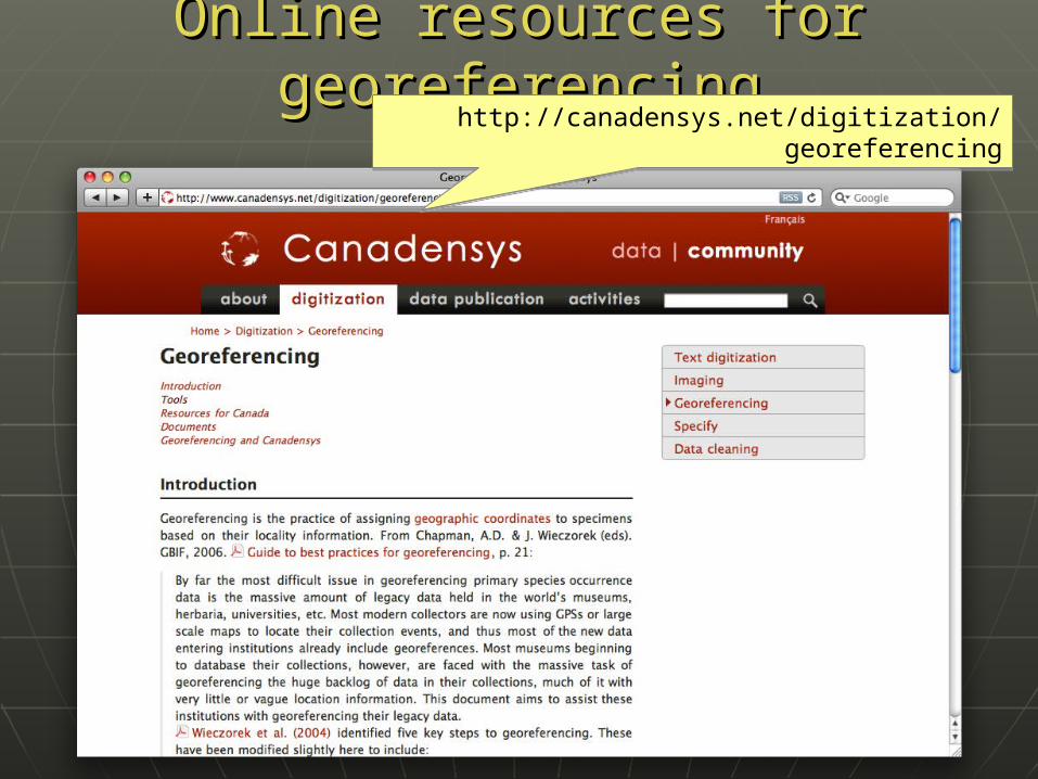
Online resources for Online resources for georeferencinggeoreferencing
http://canadensys.net/digitization/georeferencing
http://canadensys.net/digitization/georeferencing
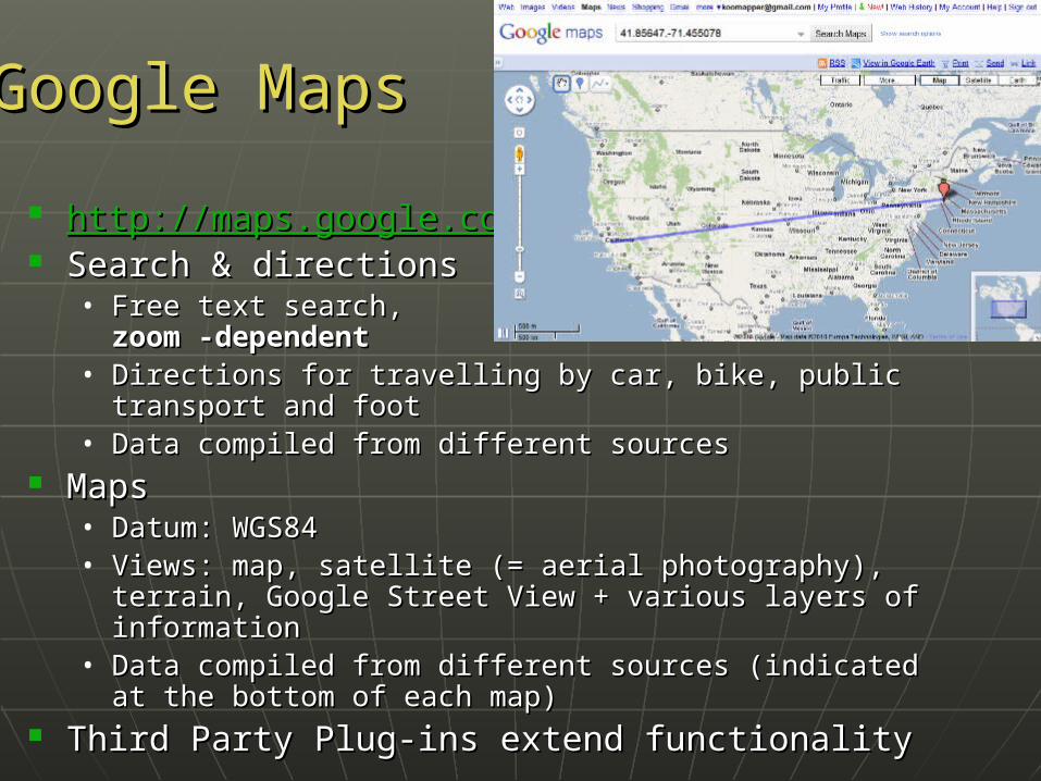
Google MapsGoogle Maps
http://http://maps.google.commaps.google.com Search & directionsSearch & directions
• Free text search, Free text search, zoom -dependentzoom -dependent
• Directions for travelling by car, bike, public transport Directions for travelling by car, bike, public transport and footand foot
• Data compiled from different sourcesData compiled from different sources MapsMaps
• Datum: WGS84Datum: WGS84• Views: map, satellite (= aerial photography), terrain, Views: map, satellite (= aerial photography), terrain,
Google Street View + various layers of informationGoogle Street View + various layers of information• Data compiled from different sources (indicated at the Data compiled from different sources (indicated at the
bottom of each map)bottom of each map) Third Party Plug-ins extend functionalityThird Party Plug-ins extend functionality

Search now with suggestionsSearch now with suggestions
Google Maps - Google Maps - SearchingSearching

MapsMaps SatelliteSatellite
Terrain (under ‘More’)Terrain (under ‘More’) Earth (plug-in required)Earth (plug-in required)
Google Maps - ViewingGoogle Maps - Viewing

Google Maps – Street ViewGoogle Maps – Street View
Street ViewStreet View

Google Maps – Street ViewGoogle Maps – Street View
I collected hereI collected here

Google Maps – Getting Google Maps – Getting coordinatescoordinates
Requires additional widgets or plug-ins• Activate LatLng MarkerLatLng Marker in Google Maps Labs• Install a mapplet like GPS LocationGPS Location or
Position FinderPosition Finder in ‘My Maps > Browse the directory’. Now deprecated!
• Use Canadensys LatLong CrosshairsLatLong Crosshairs bookmarklet: http://www.canadensys.net/georeferencing
Use Distance Measurement ToolDistance Measurement Tool to measure extent
Use My MapsMy Maps to save markers, create maps, share with others (including kml import)

Google Maps – Getting Google Maps – Getting coordinatescoordinates
Google Maps LabsGoogle Maps Labs
LatLng MarkerRight-click and‘Drop LatLng Marker’(activate in ‘Labs’ first)
LatLng MarkerRight-click and‘Drop LatLng Marker’(activate in ‘Labs’ first)

Canadensys bookmarkletClick to toggleCanadensys bookmarkletClick to toggle
CrosshairsPan map to change positionClick to get coordinates
CrosshairsPan map to change positionClick to get coordinates
Google Maps – Getting Google Maps – Getting coordinatescoordinates

Distance Measurement Tool(activate in ‘Labs’ first)Distance Measurement Tool(activate in ‘Labs’ first)
Google Maps – Measuring Google Maps – Measuring extentextent

http://http://earth.google.comearth.google.com 3D globe 3D globe desktopdesktop application application Same data as Google MapsSame data as Google Maps
• Datum: WGS84Datum: WGS84• No Map or Terrain viewNo Map or Terrain view
Similar functionalities as Google MapsSimilar functionalities as Google Maps• Search more limited than Google Maps (no Search more limited than Google Maps (no
suggestions)suggestions)• Right-click and choose ‘Get Info’ for coordinatesRight-click and choose ‘Get Info’ for coordinates• Use ruler to measure extentUse ruler to measure extent• Several coordinate formatsSeveral coordinate formats• Numerous information layers (format: kml)Numerous information layers (format: kml)
Google EarthGoogle Earth

http://http://mapper.acme.commapper.acme.com// Google Maps interfaceGoogle Maps interface
• Datum: WGS84 (& NAD27)Datum: WGS84 (& NAD27)• Map, satellite, hybrid and terrainMap, satellite, hybrid and terrain• Topo, DOQ, NEXRAD and MapnikTopo, DOQ, NEXRAD and Mapnik• Free text search Free text search not Zoom level-not Zoom level-
dependent dependent • Markers cannot be moved, but new markers Markers cannot be moved, but new markers
can be placed at crosshairs (click ‘Mark’)can be placed at crosshairs (click ‘Mark’)• Several coordinate formats for each marker + Several coordinate formats for each marker +
heading and distance from crosshairsheading and distance from crosshairs• Saves all markers automaticallySaves all markers automatically
AcmeMapperAcmeMapper

EarthToolsEarthTools
http://http://www.earthtools.orgwww.earthtools.org//
Worldwide gazetteer for Worldwide gazetteer for citiescitiesand and townstowns
Google Map basemapsGoogle Map basemaps Great for Great for hard to find localitieshard to find localities, ,
especially outside USespecially outside US• Datum: WGS84Datum: WGS84• Search with country or worldwideSearch with country or worldwide• Provides DMS, DD, UTM coordinatesProvides DMS, DD, UTM coordinates• Includes contours (but spotty coverage)Includes contours (but spotty coverage)
Example: Qandahar or Kandahar, AFExample: Qandahar or Kandahar, AF

GEOnet Names Server (GNS)GEOnet Names Server (GNS) http://earth-http://earth-info.nga.mil/gns/htmlinfo.nga.mil/gns/html// Worldwide dataWorldwide data from NGA and from NGA and
US BGNUS BGN• NIMA = National Imagery andNIMA = National Imagery and
Mapping AgencyMapping Agency• Datum: WGS84Datum: WGS84• Degrees minutes seconds,Degrees minutes seconds,
precision to nearest minuteprecision to nearest minute• Feature typeFeature type• Used as a source for many gazetteersUsed as a source for many gazetteers
For For US dataUS data, use Geographic Names Information , use Geographic Names Information System (GNIS): System (GNIS): http://http://geonames.usgs.gov/pls/gnispublicgeonames.usgs.gov/pls/gnispublic//

Geographical Name Search Service Geographical Name Search Service (GNSS)(GNSS)
http://gnss.nrcan.gc.ca/gnss-srt/searchName.http://gnss.nrcan.gc.ca/gnss-srt/searchName.jspjsp
Canadian dataCanadian data by the Canadian by the CanadianGeographical Names ServiceGeographical Names Service(CGNS)(CGNS)• Datum: NAD83Datum: NAD83• Degrees minutes seconds andDegrees minutes seconds and
decimal degreesdecimal degrees• Feature typeFeature type
Full Canadian Geographical Names datasets Full Canadian Geographical Names datasets can be downloaded from GeoBase: can be downloaded from GeoBase: http://http://www.geobase.cawww.geobase.ca//

Falling RainFalling Rain http://http://www.fallingrain.comwww.fallingrain.com Worldwide gazetteer for Worldwide gazetteer for citiescities
and and townstowns Great for Great for hard to find localitieshard to find localities,,
especially outside USespecially outside US• Datum: WGS84Datum: WGS84• Degrees minutes (seconds), based on NIMADegrees minutes (seconds), based on NIMA• Browse to find locality (Browse to find locality (no searchno search))• Provides hierarchy, alternative names, topo maps, Provides hierarchy, alternative names, topo maps,
altitude, weather information and location of nearby altitude, weather information and location of nearby towns in nautical miles (nm). towns in nautical miles (nm). Tip: Use Google/Chromey to translate nm into km.Tip: Use Google/Chromey to translate nm into km.
Example: Qaryeh-ye Gol`alam, Velayat-e Lowgar, AFExample: Qaryeh-ye Gol`alam, Velayat-e Lowgar, AF You can also check against Statoids: You can also check against Statoids: http://http://
www.statoids.comwww.statoids.com//

Getty Thesaurus of Geographic Names Getty Thesaurus of Geographic Names (TGN)(TGN)
http://www.getty.edu/research/conducting_research/http://www.getty.edu/research/conducting_research/vocabularies/tgn/vocabularies/tgn/
Worldwide gazetteer byWorldwide gazetteer byThe GettyThe Getty
Useful for finding Useful for finding alternativealternativeand and old namesold names• Feature typesFeature types• Geographical hierarchyGeographical hierarchy• Coordinates only to minutes (or not at all)!Coordinates only to minutes (or not at all)!
Use recent name and search in Google MapsUse recent name and search in Google Maps Example: Big Apple, inhabited place, United StatesExample: Big Apple, inhabited place, United States

FuzzyG – JRC Fuzzy GazetteerFuzzyG – JRC Fuzzy Gazetteer http://http://dma.jrc.it/services/fuzzygdma.jrc.it/services/fuzzyg// Worldwide gazetteer Worldwide gazetteer
designed for bad spelling!designed for bad spelling! Useful for finding Useful for finding alternative, alternative,
doubtful spelling,doubtful spelling, old namesold names• Feature typesFeature types• By continentBy continent• Coordinates only to minutes (or not at all)!Coordinates only to minutes (or not at all)!
Use recent name and search in Google MapsUse recent name and search in Google Maps Example: Narobi, AfricaExample: Narobi, Africa

UTM & MTMUTM & MTM UTM = Universal Transverse MercatorUTM = Universal Transverse Mercator
• Divides earth in 60 UTM zones = 6 degrees per zoneDivides earth in 60 UTM zones = 6 degrees per zone• Datum: WGS84 and othersDatum: WGS84 and others• Notation: Zone Easting Northing = 17N 630084 Notation: Zone Easting Northing = 17N 630084
48334384833438• Zone includes hemisphere (17N) or latitude band Zone includes hemisphere (17N) or latitude band
(17T): MGRS(17T): MGRS• Default extent: 30m (if recorded with GPS receiver)Default extent: 30m (if recorded with GPS receiver)• http://http://www.dmap.co.uk/utmworld.htmwww.dmap.co.uk/utmworld.htm• UTM Calculator: UTM Calculator: http://bit.ly/bdxn37http://bit.ly/bdxn37
MTM = Modified Tranverse MercatorMTM = Modified Tranverse Mercator• Used in Used in CanadaCanada: zones are 3 degrees, different codes, : zones are 3 degrees, different codes,
false easting and scale, etc.false easting and scale, etc.• UTM/MTM Calculator: http://bit.ly/utmmtmUTM/MTM Calculator: http://bit.ly/utmmtm

UTM – 17T 630084 4833438 (CN Tower in UTM – 17T 630084 4833438 (CN Tower in Toronto) Toronto)
Georeferencing workshop - Online resources - 2010.06.05 21
Central meridian= 500,000mfalse easting
Central meridian= 500,000mfalse easting
Equator = 0m northingEquator = 0m northing
Equator = 10,000,000mfalse northing forSouthern Hemisphere
Equator = 10,000,000mfalse northing forSouthern Hemisphere
130084m east ofcentral meridian130084m east ofcentral meridian
4833438m northof equator4833438m northof equator

Public Land Survey System Public Land Survey System (PLSS)(PLSS)
Mainly used in the US West, Midwest and some Mainly used in the US West, Midwest and some Southern states in early surveys Southern states in early surveys
System of System of Township-Range-SectionTownship-Range-Section (TRS): (TRS):T13N-R14E-S15, Arizona, Coconino CountyT13N-R14E-S15, Arizona, Coconino County
Graphical Locator: Graphical Locator: http://http://www.esg.montana.edu/glwww.esg.montana.edu/gl//• Translates TRS in decimal degreesTranslates TRS in decimal degrees• Datum: NAD27Datum: NAD27
Determine state and meridian (BLM):Determine state and meridian (BLM):http://http://bit.ly/bSouTwbit.ly/bSouTw
For extents: For extents: http://manisnet.org/GeorefGuide.htmlhttp://manisnet.org/GeorefGuide.html

GPS Visualizer: GPS Visualizer: http://http://www.gpsvisualizer.comwww.gpsvisualizer.com//• Use to translate a file with coordinates into kml or a Use to translate a file with coordinates into kml or a
picturepicture• Similar: http://www.simplemappr.net/ for publicationsSimilar: http://www.simplemappr.net/ for publications
GeoLocate: http://www.museum.tulane.edu/geolocate/GeoLocate: http://www.museum.tulane.edu/geolocate/• Georeferencing desktop and web applicationGeoreferencing desktop and web application• Useful for roads and rivers (US only)Useful for roads and rivers (US only)
Statoids: http://www.statoids.com/Statoids: http://www.statoids.com/• Information about administrative divisions (provinces, Information about administrative divisions (provinces,
counties) and their history, area, population, codes, counties) and their history, area, population, codes, etc.etc.
• No coordinates!No coordinates!• Similar: CIA World Factbook http://bit.ly/dDtT1iSimilar: CIA World Factbook http://bit.ly/dDtT1i
See http://herpnet.org for more…See http://herpnet.org for more…
Other ResourcesOther Resources
Top Related