


Languages
Pages
Legal


NINILCHIK UNIT
APPROVAL, IN PART, OF THE FIRST EXPANSION OF THE FALLS CREEK PARTICIPATING AREA
Findings and Decision of the Director of the Division of Oil and Gas
Under a Delegation of Authority from the Commissioner of the State of Alaska
Department of Natural Resources
May 16, 2017

Ninilchik Unit – First Expansion of Falls Creek Participating Area 2
Contents
I. INTRODUCTION AND DECISION SUMMARY .............................................................................. 3
II. APPLICATION AND LEASE SUMMARY ........................................................................................ 3
III. DISCUSSION OF DECISION CRITERIA .......................................................................................... 7
A. Decision Criteria considered under 11 AAC 83.303(b) ................................................................ 7
1. Environmental Costs and Benefits ........................................................................................ 7
2. Geologic and Engineering Characteristics and Prior Exploration and Development Activities of the Proposed Falls Creek Participating Area.................................................... 8
3. Plans of Development ......................................................................................................... 11
4. The Economic Costs and Benefits to the State and Other Relevant Factors ....................... 11
B. Decision Criteria considered under 11 AAC 83.303(a) .............................................................. 12
1. Promote the Conservation of All Natural Resources .......................................................... 12
2. The Prevention of Economic and Physical Waste .............................................................. 13
3. The Protection of All Parties of Interest, Including the State ............................................. 13
IV. FINDINGS AND DECISION ............................................................................................................. 14
A. The Conservation of All Natural Resources ............................................................................... 14
B. The Prevention of Economic and Physical Waste ...................................................................... 14
C. The Protection of All Parties in Interest, Including the State...................................................... 14
V. Attachments ........................................................................................................................................ 17
Attachment 1 Ninilchik Unit Falls Creek Participating Area Proposed Expansion Exhibit C Description of lands within the proposed Expansion participating area ..................................... 18
Attachment 2 Ninilchik Unit Falls Creek Participating Area Proposed Expansion Exhibit D Map of proposed participating area ......................................................................................................... 30
Attachment 3 Ninilchik Unit Falls Creek Participating Area: Draft Exhibit C of Approved FCPA (Land Descriptions) .................................................................................................................... 32
Attachment 4 Approved Ninilchik Unit Falls Creek Participating Area: Draft Exhibit D of Approved FCPA (FCPA Map) .................................................................................................................... 43

Ninilchik Unit – First Expansion of Falls Creek Participating Area 3
I. INTRODUCTION AND DECISION SUMMARY
On November 2, 2016, Hilcorp Alaska, LLC. (Hilcorp), as Ninilchik Unit (NU) Operator, applied to expand the Ninilchik Unit and Falls Creek Participating Area (FCPA) (Application). On March 2, 2017, the Department of Natural Resources (DNR), Division of Oil and Gas (Division) approved the second expansion of the NU effective November 2, 2016. The unit expansion decision expanded the NU to include an additional 40 acres bringing the total unit acreage to 25,909 acres. The FCPA expansion was not addressed in the unit expansion decision. Hilcorp proposed to expand the FCPA from 988.7 to 1,512.87 acres in the Application.
A participating area “must be expanded to include acreage reasonably estimated through use of geological, geophysical, or engineering data to be capable of producing or contributing to the production of hydrocarbons in paying quantities, and must be contracted to exclude acreage reasonably proven through the use of geological, geophysical, and engineering data to be incapable of producing hydrocarbons in paying quantities, subject to approval by the commissioner.” 11 AAC 83.351(c).
Hilcorp submitted confidential and public information in support of the Application. The Application proposed to expand the FCPA to areas where presence of hydrocarbons is unlikely. The Division proposed a modified FCPA incorporating areas based on differing methodology. Hilcorp later concurred with the FCPA expansion area and methodology proposed by the Division. A review and analysis of the confidential geological, geophysical, and engineering data indicate that the acreage approved for inclusion in the FCPA is producing or contributing to production of hydrocarbons in paying quantities, or is reasonably estimated to be capable of producing or contributing to production of hydrocarbons in paying quantities.
The Division finds that the expansion of the FCPA, as revised, promotes conservation of all natural resources, promotes the prevention of economic and physical waste, and provides for the protection of all parties of interest, including the State. AS 38.05.180(p); 11 AAC 83.303. I approve Hilcorp’s Application, in part, under the terms and conditions of Section IV.3.C. The effective date of the expansion of the FCPA is April 1, 2017.
II. APPLICATION AND LEASE SUMMARY
The NU is a unit on the east side of Cook Inlet comprised mostly of onshore and offshore lands of the State of Alaska. The NU also consists of onshore federal, Cook Inlet Region Inc., University of Alaska, and private patent fee lands. The NU was approved effective October 30, 2001, and it was originally operated by Marathon Oil Company (Marathon). On June 30, 2003, the Division approved the First Expansion of the Ninilchik Unit which included the BLM-managed Falls Creek Unit area. The BLM approved the termination of the Falls Creek Unit Agreement concurrently with the expansion of the NU to include the Falls Creek Unit area. The June 30, 2003 decision also formed the NU’s three participating areas (PA) – Susan Dionne, Grassim Oskolkoff, and Falls Creek. The PAs were approved based on geophysical data and commitments by Marathon to drill wells in each PA or a contraction of each PA area would
Ninilchik Unit – First Expansion of Falls Creek Participating Area 4
occur. Marathon satisfied the well commitments and contraction of the PAs did not occur at that time.
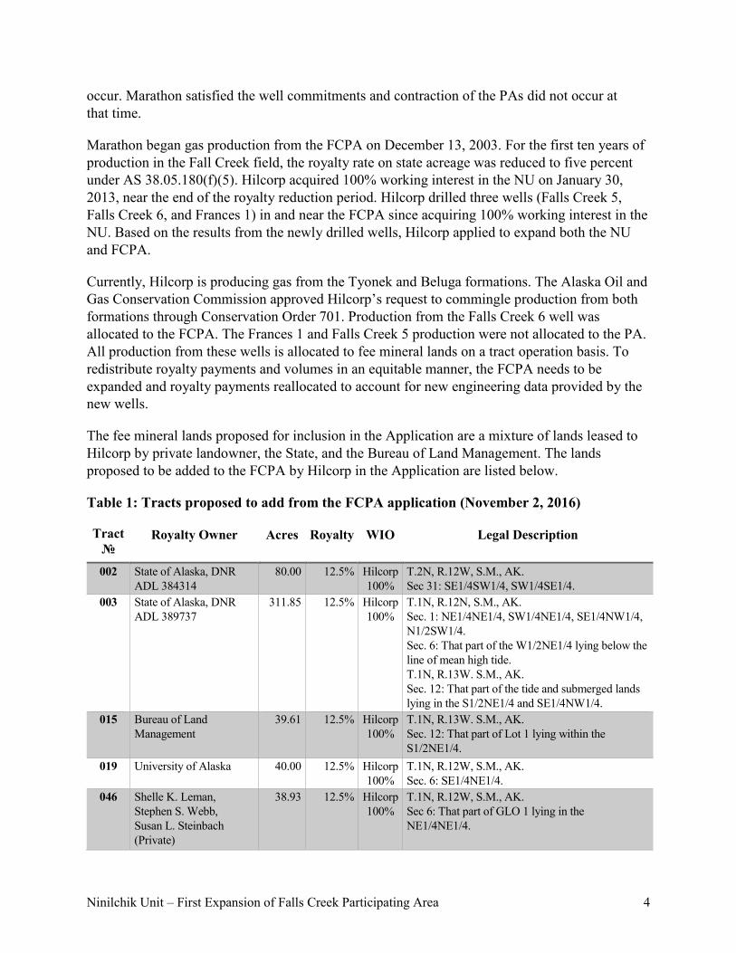
Marathon began gas production from the FCPA on December 13, 2003. For the first ten years of production in the Fall Creek field, the royalty rate on state acreage was reduced to five percent under AS 38.05.180(f)(5). Hilcorp acquired 100% working interest in the NU on January 30, 2013, near the end of the royalty reduction period. Hilcorp drilled three wells (Falls Creek 5, Falls Creek 6, and Frances 1) in and near the FCPA since acquiring 100% working interest in the NU. Based on the results from the newly drilled wells, Hilcorp applied to expand both the NU and FCPA.
Currently, Hilcorp is producing gas from the Tyonek and Beluga formations. The Alaska Oil and Gas Conservation Commission approved Hilcorp’s request to commingle production from both formations through Conservation Order 701. Production from the Falls Creek 6 well was allocated to the FCPA. The Frances 1 and Falls Creek 5 production were not allocated to the PA. All production from these wells is allocated to fee mineral lands on a tract operation basis. To redistribute royalty payments and volumes in an equitable manner, the FCPA needs to be expanded and royalty payments reallocated to account for new engineering data provided by the new wells.
The fee mineral lands proposed for inclusion in the Application are a mixture of lands leased to Hilcorp by private landowner, the State, and the Bureau of Land Management. The lands proposed to be added to the FCPA by Hilcorp in the Application are listed below.
Table 1: Tracts proposed to add from the FCPA application (November 2, 2016)
Tract №
Royalty Owner Acres Royalty WIO Legal Description
002 State of Alaska, DNR ADL 384314
80.00 12.5% Hilcorp 100%
T.2N, R.12W, S.M., AK. Sec 31: SE1/4SW1/4, SW1/4SE1/4.
003 State of Alaska, DNR ADL 389737
311.85 12.5% Hilcorp 100%
T.1N, R.12N, S.M., AK. Sec. 1: NE1/4NE1/4, SW1/4NE1/4, SE1/4NW1/4, N1/2SW1/4. Sec. 6: That part of the W1/2NE1/4 lying below the line of mean high tide. T.1N, R.13W. S.M., AK. Sec. 12: That part of the tide and submerged lands lying in the S1/2NE1/4 and SE1/4NW1/4.
015 Bureau of Land Management
39.61 12.5% Hilcorp 100%
T.1N, R.13W. S.M., AK. Sec. 12: That part of Lot 1 lying within the S1/2NE1/4.
019 University of Alaska 40.00 12.5% Hilcorp 100%
T.1N, R.12W, S.M., AK. Sec. 6: SE1/4NE1/4.
046 Shelle K. Leman, Stephen S. Webb, Susan L. Steinbach (Private)
38.93 12.5% Hilcorp 100%
T.1N, R.12W, S.M., AK. Sec 6: That part of GLO 1 lying in the NE1/4NE1/4.

Ninilchik Unit – First Expansion of Falls Creek Participating Area 5
Tract №
Royalty Owner Acres Royalty WIO Legal Description
051 E.W Vanderbilt (Margaret Vanderbilt Living Trust) (Private)
0.91 12.5% Hilcorp 100%
T.1N, R.12W, S.M., AK. Sec. 6: That portion of the north 165’ of the N1/2SE1/4 lying west of the Sterling Highway.
052 Harold A. and Marguerite M. Pederson (Private)
58.00 12.5% Hilcorp 100%
T.1N, R.12W, S.M., AK. Sec. 6: That part of N1/2SE1/4 lying east of Sterling Highway.
053 Harold Lee and Diane R. Pederson (Private)
21.09 12.5% Hilcorp 100%
T.1N, R.12W, S.M., AK. Sec. 6: That part of N1/2SE1/4 lying west of the Sterling Highway, less and except the north 165’ and that portion of the Sterling Highway Right-of-Way lying within the N1/2SE1/4.
056 Charles Weyhaupt, David Weyhaupt, James Reinhardt, Thomas Weyhaupt, Norma Jeanne Nichols, Walter G. Williams (Private)
30.901 12.5% Hilcorp 100%
T.1N, R.12W, S.M., AK. Sec. 6: SW1/4SE1/4, less and except Block 2, Lots 1 and 8, and Block 5, Lot 1 of Clammer’s Haven Subdivision, Plat 76-62.
059 Charles Weyhaupt, David Weyhaupt, James Reinhardt, Thomas Weyhaupt, Jens H. and Anneline Hansen, Veray H. Matthews (Private)
2.937 12.5% Hilcorp 100%
T.1N, R.12W, S.M., AK. Sec. 6: Block 2, Lot 1 of Clammer’s Haven Subdivision, Plat 76-62.
060 John Stallone Jr, Charles Weyhaupt, David Weyhaupt, James Reinhardt, Thomas Weyhaupt (Private)
2.904 12.5% Hilcorp 100%
T.1N, R.12W, S.M., AK. Sec. 6: Block 2, Lot 8 of Clammer’s Haven Subdivision, Plat 76-62.
061 Dennis Hedman, Charles Weyhaupt, David Weyhaupt, James Reinhardt, Thomas Weyhaupt (Private)
3.258 12.5% Hilcorp 100%
T.1N, R.12W, S.M., AK. Sec. 6: Block 5, Lot 1 of Clammer’s Haven Subdivision, Plat 76-62.
066 Emil and Frances Bartolowits (Private)
114.864 12.5% Hilcorp 100%
T. 1N, R. 12W, S.M., AK. Sec. 7: Government Lot 1 and 2 and the NE1/4NW1/4, less and except Lots 7, 9, 10, 12, 14, and 15 of Falls Creek Ridge 1978 Subdivision (Plat #H78-23 replatted #H78-71), a part of government Lot 2, and a portion of the NW1/4NE1/4 lying west of the centerline of the Sterling Highway.
067 James A. and Teresa L. Wilson (Private)
4.03 12.5% Hilcorp 100%
T. 1N, R. 12W, S.M., AK. Sec. 7: Lots 7 and 10 of Falls Creek Ridge Subdivision (Plat #H78-23 replatted #H78-71), a part of government Lot 2.

Ninilchik Unit – First Expansion of Falls Creek Participating Area 6
Tract №
Royalty Owner Acres Royalty WIO Legal Description
068 Richard S. Bartolowits (Private)
4.028 12.5% Hilcorp 100%
T. 1N, R. 12W, S.M., AK. Sec. 7: Lots 9 and 12 of Falls Creek Ridge Subdivision (Plat #H78-23 replatted #H78-71), a part of government Lot 2.
069 Paul D. and LaRue A. Bartolowits (Private)
2.082 12.5% Hilcorp 100%
T. 1N, R. 12W, S.M., AK. Sec. 7: Lot 14 of Falls Creek Ridge Subdivision (Plat #H78-23 replatted #H78-71), a part of government Lot 2.
070 Paul D. and LaRue A. Bartolowits (Private)
2.026 12.5% Hilcorp 100%
T. 1N, R. 12W, S.M., AK. Sec. 7: Lots 15 of Falls Creek Ridge Subdivision (Plat #H78-23 replatted #H78-71), a part of government Lot 2.
229 Penelope J Maize (Private)
24.740 12.5% Hilcorp 100%
T. 1N, R. 12W, S.M., AK. Sec. 7: A portion of the NW1/4NE1/4 lying east of the centerline of the Sterling Highway; more particularly described as Celia Subdivision, Plat No. 94-46, and all minerals underlying dedicated roads within the subdivision, excluding Tracts C-1A and C-1B of the Celia Subdivision, Addition #2, Plat No. 2012-53.
230 James C. Kruse and Linda C. Kruse (Private)
3.854 12.5% Hilcorp 100%
T. 1N, R.12W, S.M., AK. Sec. 7: Tracts C-1A and C-1B of Celia Subdivision, Addition #2, Plat No. 2012-53.
Hilcorp proposed to exclude the following portion of the State of Alaska’s unit tract number 3 from the FCPA.
Table 2: Tract proposed to contract from the FCPA Application (November 2, 2016)
Tract №
Royalty Owner Acres Royalty WIO Description
003 State of Alaska, DNR ADL 389737
120.0 12.5% Hilcorp 100%
T.1N, R13W, S.M., AK. Sec. 11: E/2NE/4 Sec. 12: SW/4NW/4
Because Hilcorp’s application included unit expansion, the Division provided public notice in accordance with 11 AAC 83.311. The Division issued a public notice for the unit and participating area expansion application on December 5, 2016 and published a public notice in the Alaska Dispatch News and Peninsula Clarion on December 3, 2016. Copies of the Application and the public notice were provided to interested parties. The Division provided public notice to, among others, the Alaska Department of Environmental Conservation, the Kenai Peninsula Borough, the City of Kenai, the Village of Tyonek, the Salamatof Native Association, Cook Inlet Region, Incorporated, the Soldotna Postmaster, and the radio station KDLL in Kenai. The notice was also published on the State of Alaska Public Notice website and

Ninilchik Unit – First Expansion of Falls Creek Participating Area 7
the Division’s website. The public notices invited interested parties and members of the public to submit comments by January 4, 2017.
The Division received four comments during the public notice period. Three of the comments were solicited by private mineral interest owners in or near the Ninilchik Unit – Dorothy Wallner, Stephen Webb, and Donald Shaw. The fourth comment was received from Paul Craig, manager of PLC, LLC and advocate for MH2, LLC., both limited liability companies hold overriding royalty interest in state oil and gas lease ADL 384314. The comments were all written regarding the proposed boundaries of the Falls Creek PA rather than the unit expansion portion of the Application, thus the comments are addressed in this decision instead of the separate March 2, 2017 unit expansion decision. The methodology for determining the boundary of the FCPA is directed by geologic, geophysical, and engineering data from public and confidential sources. Section III.A.2 of this decision describes the methodology used to determine the FCPA boundary. The comments pertaining to FCPA boundaries are addressed through the discussion in Section III.A.2 on how the FCPA boundaries were developed.
III. DISCUSSION OF DECISION CRITERIA
The DNR Commissioner (Commissioner) reviews applications related to units, including participating area formations, expansions and contractions, under 11 AAC 83.303–11 AAC 83.395. By memorandum dated September 30, 1999, the Commissioner approved a revision of Department Order 003 and delegated this authority to the Division Director. The Division’s review of the Application is based on the criteria set out in 11 AAC 83.303 (a) and (b). A discussion of the subsection (b) criteria, as they apply to the Application, is set out directly below, followed by a discussion of the subsection (a) criteria. Analysis and discussion of subsection (b) requirements precedes and supports findings under subsection (a).
A participating area “must be expanded to include acreage reasonably estimated through use of geological, geophysical, or engineering data to be capable of producing or contributing to the production of hydrocarbons in paying quantities, and must be contracted to exclude acreage reasonably proven through the use of geological, geophysical, and engineering data to be incapable of producing hydrocarbons in paying quantities, subject to approval by the commissioner.” 11 AAC 83.351(c).
A. Decision Criteria considered under 11 AAC 83.303(b)
1. Environmental Costs and Benefits
Approval of the FCPA expansion has no direct environmental impact. This decision is an administrative action and does not authorize any on-the-ground activity. The Unit Operator must obtain approval of a plan of operations from the State and permits from various agencies on State leases before drilling a well or wells or initiating development activities to produce reservoirs within the unit area. 11 AAC 83.346. Potential effects on the environment are analyzed when permits to conduct exploration or development in the unit area are reviewed. Hilcorp has obtained the required permits for the current FCPA wells and is operating under an approved

Ninilchik Unit – First Expansion of Falls Creek Participating Area 8
plan of operations and plan of development. The DNR considers environmental issues during the lease sale process and the unit plan of operations approval process.
2. Geologic and Engineering Characteristics and Prior Exploration and Development Activities of the Proposed Falls Creek Participating Area
a) Drilling history
The Falls Creek gas field was discovered during drilling of the Falls Creek 1 (FC1) well in April 1961 by Standard Oil Company of California (Socal). FC1 penetrated the Beluga, Tyonek, Hemlock, and West Foreland Formations and reached total depth in the West Foreland Formation. Trace oil shows were present in the Hemlock and West Foreland Formations. Strong gas shows were present in the Beluga and Tyonek Formations. Socal performed five drill stem tests within the Beluga and Tyonek Formations; the best result was a Tyonek sandstone that produced a moderate amount of gas with no water. The resource, however, was deemed uneconomic and development did not proceed. However, the Falls Creek Unit was formed around the acreage believed to have the highest gas development potential.
During the ensuing 35 years following drilling of FC1, only two more wells were drilled in the area. Both wells were drilled just outside the Falls Creek Unit boundary and both were dry holes. In 1973, the Falls Creek 43-06 (FC43-06) well was drilled by Socal about 3,500 ft east of FC1. Well logs indicated no significant productive zones were present and therefore the well was not flow tested. This well is approximately 170 ft structurally lower than the FC1 well. The Corea Creek Federal 1 (CC1) well, located approximately 5,000 ft southwest of FC1, was drilled in 1996 by Marathon Oil Company (MOC). This well flow tested six intervals and produced very small amounts of gas with significant influxes of water. This well is approximately 220 ft structurally lower than the FC1 well. FC43-06 and CC1 are important control points that help define limits to the east and southwest boundaries of the Falls Creek Participating Area (FCPA).
Between 2001 and 2004, MOC drilled three directional wells from the FC1 well pad to begin producing the Falls Creek gas accumulation. Falls Creek 1RD (FC1RD) was the first of these three to be drilled. It was a sidetrack well out of the FC1 well bore and came onto production in September 2003. Since that time, it has remained the strongest gas producer in the field. FC1 was plugged and abandoned following completion of FC1RD. Falls Creek 3 (FC3) and Falls Creek 4 (FC4) were drilled to targets approximately 3,000 ft due west of FC1. FC3 appears to be 20 ft structurally higher than FC1. This indicates that the crest of the structure may extend further to the west-southwest. These three wells remained the only gas producers in the field until Hilcorp took ownership in 2013.
Hilcorp drilled Frances 1 (FR1) in late 2013 to a target approximately 3,000 ft southeast of FC1. The primary target for this well was oil in the Hemlock and West Foreland Formations with a secondary gas target in the Tyonek “G” sands. The Hemlock and West Foreland Formations yielded only minor oil shows; however, three productive gas intervals were encountered in the Tyonek Formation. Although approximately 140 ft structurally lower than FC1, this well remains a strong gas producer. Falls Creek 5 (FC5) was drilled in 2014 to approximately 2,700 ft south of

Ninilchik Unit – First Expansion of Falls Creek Participating Area 9
FC1. This well is approximately 110 ft structurally lower than FC1. Although FC5 has produced far less gas since completion than FC1, both wells confirm the Falls Creek gas accumulation extends south of the existing FCPA boundary.
Hilcorp’s most recent drilling in the Falls Creek area was the Falls Creek 6 (FC6) well, completed in late-2014. FC6 was drilled to a target approximately 2,800 ft north of FC1 and is situated approximately 40 ft structurally lower than FC1. This well was completed in nine intervals within the Beluga and Tyonek Formations. Although the Tyonek Formation completions were not productive and the overall production rates in this well are the lowest in the Falls Creek field, FC6 does confirm the Falls Creek gas accumulation, within the Beluga Formation, extends into the northern portion of the existing FCPA.
b) Geologic overview
The Falls Creek gas accumulation defines the northernmost field on the Ninilchik structure, located in the south-central portion of the Cook Inlet basin. The Ninilchik structure is a thrust-cored fold that is part of a major thrust-faulted trend that runs from the Starichkof (Cosmopolitan) structure north to the Kenai Gas Field. The Ninilchik structure is approximately 24 miles long and four miles wide and straddles the coastline. However, the productive gas accumulations appear to be concentrated on the crest of the structure along a ten-mile swath between Ninilchik and Clam Gulch.
Faults play an important role in the distribution of Ninilchik structure gas accumulations. The thrust fault at the core of the fold is the largest feature in the Ninilchik structure. This fault runs parallel to the axis of the anticline and dips to the southeast. It is sometimes referred to as the bounding fault since it marks the northwest limit for Ninilchik structure gas accumulations. There are also numerous near-vertical faults oriented perpendicular to the bounding fault. These perpendicular faults divide the Ninilchik anticline into discrete blocks, some of which contain isolated gas accumulations.
The depositional environment for the Beluga and Tyonek Formations is non-marine fluvial with a mix of braided and meandering rivers and streams. The extreme variability in sand thickness of the disconnected sand bodies is typical of fluvial depositional environments. Cook Inlet reservoir sands in the Beluga and Tyonek Formations typically have high clay contents which can adversely affect porosity and permeability and make log analysis difficult.
The structural complexities associated with a large thrust belt, such as the Ninilchik structure, and the unpredictable nature of fluvial depositional environments in general make traditional reservoir evaluation methods challenging in the Falls Creek area. Seismic data, though instrumental in identifying prospective structural traps, have proven to be unreliable in the Ninilchik area and other areas in Cook Inlet for detailed subsurface mapping of the internal architecture and outer limits of producing gas accumulations.
Ninilchik Unit – First Expansion of Falls Creek Participating Area 10
c) Allocation methodology
For this determination, the operator proposed a Falls Creek PA boundary based on the Lowest Known Gas (LKG) method. This was determined by depth mapping each productive interval and interpreting an LKG contour, or polygon, for each productive interval. The operator chose to use only the existing wells in generating the depth maps and not use the seismic data. The composite outer limit of all the LKG polygons was considered the productive area. The final PA boundary was then derived from this composite polygon and the final tract factors were based on surface area.
However, the Division had issues with the results. The resulting PA boundary included the two dry holes in the area, the FC43-06 and the CC1 wells, as well as the steep structural rollover in the northwest portion of the unit. The Division agreed with the operator in not using the seismic data in this determination but disagreed with the inclusion of these areas which are very likely unproductive. The Division felt it was necessary to further simplify the approach to address these issues and the circle and tangent method was chosen.
The circle and tangent method defines the gas depletion area based on the cumulative outer boundary of multiple overlapping circles, each having a radius of 1,500 ft and centered along the well bore wherever it is open to reservoir production. This cumulative outer boundary is further defined by drawing tangent lines connecting the outermost circle perimeters to create one encompassing boundary of maximum area. This area is referred to as the maximum convex hull. The resultant gas depletion area is an appropriate compromise that is large enough to accommodate the estimated ultimate recovery of the field, while also honoring the results of FC43-06 and CC1 (dry-hole wells) and the steep structural rollover to the northwest.
The determination of tract factors is based on surface area. The surface area technique has been used in most Cook Inlet fields and some fields located on the North Slope. It is usually employed in fields where the uncertainties about the distribution of oil or gas are high. This occurs when available well and seismic data cannot adequately yield high-confidence interpretations of the subsurface.
The Division’s decision to use a 1,500 ft radius circle for each open interval was based on the available data for this field and its historical experience with other gas developments within Beluga and Tyonek Formations in Cook Inlet. Uncertainty regarding true net pay thicknesses and the limited number of measured reservoir pressures available for analysis is typical given the mixed lithology of these formations.
To determine tract factors the maximum convex hull boundary was projected to the surface. Each section of land was divided into 40-acre quarter-quarter section aliquot parts. A fifty-percent rule was applied to each aliquot, meaning the maximum convex hull area must cover at least fifty-percent of each aliquot for that aliquot to be included in the PA. The fifty-percent rule has typically been used in Alaska when using surface area as the basis for allocations because not applying this correction will over-allocate the periphery of the field. The PA boundary was defined by including only the aliquots meeting the fifty-percent rule as described above. Tract

Ninilchik Unit – First Expansion of Falls Creek Participating Area 11
factors were then calculated by taking the ratio of the surface area covered by each PA tract divided by the surface area of the entire PA. The FCPA boundary established through this method is the most equitable approach with the available data.
3. Plans of Development
The most recent drilling in the Falls Creek area occurred during the 2014 Plan of Development (POD) period when Hilcorp drilled the FC5, FC6, and FR1 wells. Hilcorp’s 2016 NU POD was approved by the Division on April 21, 2016. During the 2016 POD period, Hilcorp did not propose drilling activities in the northern portion of the unit where the PA expansion is proposed. Hilcorp constructed the Kalotsa pad near the Susan-Dionne PA and drilled the Kalotsa 1 and 2 wells during the 2016 POD period. The 2017 POD proposes drilling the Kalotsa 3 and 4 wells in the Susan-Dionne PA. Hilcorp is evaluating future rig workover projects and plans to add compression to enhance production at the Frances pad. Hilcorp has not provided plans for drilling in or near the FCPA.
4. The Economic Costs and Benefits to the State and Other Relevant Factors
The expanded FCPA will continue to provide economic benefits to the State through royalty and tax payments on gas production. Increased drilling and production near the FCPA will provide increased financial benefits to private royalty landowners previously within the FCPA and those landowners included in the FCPA through this decision. The delineation and development drilling in the Ninilchik Unit is resulting in high-paying jobs for Alaskans and further assessment of state oil and gas resources.
The decision that formed the FCPA required allocation redetermination of all gas production retrospective to the date of first production if future revisions to the PA occurred. The decision also mandated that “any imbalances created by the retroactive adjustments of the FCPA tract participation schedule will be made from production of Unitized Substances from the FCPA after the effective date of the revised tract participation schedule.” This provision was included to ensure the royalty owners within the PA would be correctly allocated past production upon future drilling and production.
The State has been over-allocated production from the original FCPA since the date of first production to the effective date of this decision. The expansion of the FCPA reduces the State’s tract participation in the FCPA from approximately 84.6% to 62.6%. Tract allocation for PAs within the NU is determined by surface acreage, which is a long-established methodology for equitable allocation of gas reservoirs in the Cook Inlet. Each tract’s allocation of gas is determined by dividing the acreage of a PA tract by the total acreage of the PA.
The State has been under-allocated production from the FR1 and FC5 wells. These recently-drilled wells were not previously in the FCPA and the State has not received any allocation of their production. Royalty on these wells have been paid exclusively to the private fee land owners holding interest in the land from where the wells are producing. Thus, the State will be allocated production on these two wells per the allocation schedule approved in this decision.

Ninilchik Unit – First Expansion of Falls Creek Participating Area 12
The method used to ascertain the net adjustment to royalties due to the State incorporates several factors to ensure an equitable outcome. Total royalty-bearing production from the FCPA for the September 2003 through March 2017 period is re-allocated based on the new tract factors set forth through this decision. Hilcorp will provide the Division with a revised division of interest upon issuance of this decision. For each month, the royalty payment due to the State under the new tract factors is calculated as the product of (i) the State’s allocated share of production, (ii) the weighted average of royalty in value per thousand cubic feet (mcf) of gas for the FCPA and (iii) the royalty rate. Production on State acreage from the FCPA was subject to a reduced royalty rate of five percent from September 2003 to September 2013 under AS 38.05.180(f)(5). The total royalty overpayment is determined as the difference between total royalty payments to the State from Marathon, Unocal, and Hilcorp made under the previous allocation schedule percentage (≈84.6%) and the new allocation schedule percentage (≈62.6%).
The expansion of the FCPA also brings unallocated production from the FR1 and FC5 wells into the FCPA. The State is due the new allocation schedule percentage of production (≈62.6%) from both wells since their date of first production. The FR1 and FC5 wells began producing in July 2014 and March 2014, respectively. For each month, the royalty payment due to the State under the new tract factors is calculated as the product of (i) the State’s allocated share of production, (ii) the weighted average royalty in value per mcf of gas for the FCPA and (iii) the standard royalty rate of 12.5% found on the leases. This underpayment of royalty amount is then reduced by the amount of royalty overpaid to the State to reach the net adjustment to royalties due to the State. An adjustment to State royalties will be made from gas produced from the FCPA during the month of April 2017. Hilcorp will make a one-time net adjustment amount in the FCPA royalty reports (A1 Forms) for the April 2017 production month, which are due by May 31, 2017.
The delineation drilling performed in and near the FCPA has provided greater certainty to the extent of the gas reservoir and PA boundary. The initial FCPA boundaries were based on minimal well control and seismic data. Future PA expansion or contraction at the FCPA will be reallocated on a prospective basis. As opposed to retrospective reallocation, prospective reallocation redistributes production from newly-drilled wells to PA tract participant back to the date of a well’s first production rather than the date of the FCPA first production. The prospective approach to reallocation provides allocation to new PA tracts based on new wells drilled. Payments to current royalty owners will be more consistent upon expansion of the PA without the unit operator potentially withholding payment to reallocate. Finally, FCPA royalty reports will be resubmitted to the State for a more precise reallocation. The benefits of these factors and greater certainty of the FCPA boundaries make prospective reallocation an equitable approach to protecting all parties.
B. Decision Criteria considered under 11 AAC 83.303(a)
1. Promote the Conservation of All Natural Resources
The unitization of oil and gas reservoirs and the expansion and contraction of participating areas within unit areas to develop hydrocarbon-bearing reservoirs are well-accepted means of

Ninilchik Unit – First Expansion of Falls Creek Participating Area 13
hydrocarbon conservation. Expansion and contraction of a participating area within an existing unit, with development occurring under the terms of a unit agreement, promotes efficient evaluation and development of the State’s oil and gas, and minimizes impacts to the area’s cultural, biological, and environmental resources.
2. The Prevention of Economic and Physical Waste
Approval of the Application will prevent economic and physical waste because the approval will allocate production revenue under the approved FCPA tract allocations, equitably allocating production revenues among the tracts. Approval of the expanded FCPA will not result in economic waste given the current well spacing, market demand, and anticipated production rates. Annual approval of the NU development activities as described in future PODs must also provide for the prevention of economic and physical waste.
The FCPA lies within the Beluga/Tyonek Gas Pool and operates under the terms of Alaska Oil and Gas Conservation Commission’s Conservation Order 701 and 701A. The Conservation Orders allow Hilcorp to commingle gas production from the Beluga and Tyonek Formations. Commingled production from these formations prevents economic waste and allows Hilcorp to maximize recovery through minimizing costs and drilling of additional wells. Additionally, the production of hydrocarbons through the existing production and processing facilities reduces the environmental impact of the additional production. Using existing facilities will avoid unnecessary duplication of development efforts on and beneath the surface.
3. The Protection of All Parties of Interest, Including the State
A participating area “must be expanded to include acreage reasonably estimated through use of geological, geophysical, or engineering data to be capable of producing or contributing to the production of hydrocarbons in paying quantities and must be contracted to exclude acreage reasonably proven through the use of geological, geophysical, and engineering data to be incapable of producing hydrocarbons in paying quantities, subject to approval by the commissioner.” 11 AAC 83.351(c).
The Division reviewed confidential geophysical, geological and engineering data and interpretations submitted by Hilcorp to determine the acreage proposed for inclusion in the revised FCPA. The Division provided an alternative methodology, the circle and tangent method, which defines the FCPA by drainage from producing perforations in the Falls Creek wells and FR1 well. This methodology expanded the FCPA to include tracts reasonably estimated to be capable of producing hydrocarbons in paying quantities. Historically, the DNR has often employed the circle and tangent methodology in situations where reservoirs are not well delineated to define gas reservoir participating areas. The aim is to protect all parties by including only tracts reasonably estimated to be capable of producing hydrocarbons in paying quantities. Extending beyond what would be “reasonably estimated” would unfairly dilute the tract participation of parties with tracts within the FCPA. Conversely, extending the FCPA only to tracts where gas is known to be produced would fail to consider drainage area from producing wells. The expanded FCPA includes quarter-quarter sections within a 1,500-foot radius of the

Ninilchik Unit – First Expansion of Falls Creek Participating Area 14
portion of the well bores open to production within the proven Tyonek and Beluga reservoirs. Only quarter-quarter sections where fifty percent or more of the reservoir is observed were included in the FCPA.
As part of re-evaluating the PA boundaries, the DNR methodology shows a quarter-quarter section containing three unit tracts, included at formation of the FCPA, will be contracted from the FCPA. A portion of unit tract 46 in T.1N, R.12W, Seward Meridian has been allocated production since the formation of the FCPA. Royalty payments will cease for royalty owners of tract 46; Hilcorp will not attempt to recover past overpayments of royalties made to the royalty owner of tract 46. Additionally, portions of unit tracts 3 and 188 in T.1N, R.12W, Seward Meridian will also be contracted from the FCPA. Unit tract 3 and 188 are both state oil and gas leases which will reduce royalty payments to the State.
IV. FINDINGS AND DECISION
A. The Conservation of All Natural Resources
1. Revision of the FCPA will provide for continued development of the participating area under the NU Agreement and will maximize the efficient recovery of oil and gas and minimize the adverse impacts on the surface and other resources, including hydrocarbons, gravel, sand, water, wetlands, and valuable habitat.
B. The Prevention of Economic and Physical Waste
1. Hilcorp submitted geological, geophysical, and engineering data to the Division in support of the Application, as revised. Division technical staff determined that the expanded FCPA area, as revised, is “reasonably estimated” to be capable of producing or contributing to production in paying quantities.
2. The available geological, geophysical and engineering data justify including the lands described in Section III.A.2. of this decision.
3. The production of hydrocarbons through the existing production and processing facilities reduces the environmental impact of the additional production. Using existing facilities will avoid unnecessary duplication of development efforts on and beneath the surface.
C. The Protection of All Parties in Interest, Including the State
1. The economic, geological, geophysical, and engineering data that Hilcorp provided reasonably justify the inclusion of the acreage into the revised FCPA under the terms of the applicable regulations governing formation, expansion, and operation of oil and gas units and participating areas (11 AAC 83.301–11 AAC 83.395) and the terms and conditions under which these lands were leased from the State. With input from the State, Hilcorp has submitted an acceptable methodology for establishing the expanded boundaries of the FCPA.

Ninilchik Unit – First Expansion of Falls Creek Participating Area 15
2. The NU tracts, with legal descriptions, added to the FCPA are listed in the table below.
Table 3: Tracts added to the original FCPA
Tract №
Royalty Owner Acres Royalty WIO Legal Description
051 E.W Vanderbilt (Margaret Vanderbilt Living Trust) (Private)
0.91 12.5% Hilcorp 100%
T.1N, R.12W, S.M., AK. Sec. 6: That portion of the north 165’ of the N1/2SE1/4 lying west of the Sterling Highway.
052 Harold A. and Marguerite M. Pederson (Private)
58.00 12.5% Hilcorp 100%
T.1N, R.12W, S.M., AK. Sec. 6: That part of N1/2SE1/4 lying east of Sterling Highway.
053 Harold Lee and Diane R. Pederson (Private)
21.09 12.5% Hilcorp 100%
T.1N, R.12W, S.M., AK. Sec. 6: That part of N1/2SE1/4 lying west of the Sterling Highway, less and except the north 165’ and that portion of the Sterling Highway Right-of-Way lying within the N1/2SE1/4.
056 Charles Weyhaupt, David Weyhaupt, James Reinhardt, Thomas Weyhaupt, Norma Jeanne Nichols, Walter G. Williams (Private)
30.901 12.5% Hilcorp 100%
T.1N, R.12W, S.M., AK. Sec. 6: SW1/4SE1/4, less and except Block 2, Lots 1 and 8, and Block 5, Lot 1 of Clammer’s Haven Subdivision, Plat 76-62.
059 Charles Weyhaupt, David Weyhaupt, James Reinhardt, Thomas Weyhaupt, Jens H. and Anneline Hansen, Veray H. Matthews (Private)
2.937 12.5% Hilcorp 100%
T.1N, R.12W, S.M., AK. Sec. 6: Block 2, Lot 1 of Clammer’s Haven Subdivision, Plat 76-62.
060 John Stallone Jr, Charles Weyhaupt, David Weyhaupt, James Reinhardt, Thomas Weyhaupt (Private)
2.904 12.5% Hilcorp 100%
T.1N, R.12W, S.M., AK. Sec. 6: Block 2, Lot 8 of Clammer’s Haven Subdivision, Plat 76-62.
061 Dennis Hedman, Charles Weyhaupt, David Weyhaupt, James Reinhardt, Thomas Weyhaupt (Private)
3.258 12.5% Hilcorp 100%
T.1N, R.12W, S.M., AK. Sec. 6: Block 5, Lot 1 of Clammer’s Haven Subdivision, Plat 76-62.
066 Emil and Frances Bartolowits (Private)
114.864 12.5% Hilcorp 100%
T. 1N, R. 12W, S.M., AK. Sec. 7: Government Lot 1 and 2 and the NE1/4NW1/4, less and except Lots 7, 9, 10, 12, 14, and 15 of Falls Creek Ridge 1978 Subdivision (Plat #H78-23 replatted #H78-71), a part of government Lot 2, and a portion of the NW1/4NE1/4 lying west of the centerline of the Sterling Highway.

Ninilchik Unit – First Expansion of Falls Creek Participating Area 16
Tract №
Royalty Owner Acres Royalty WIO Legal Description
188 State of Alaska ADL 590
524.450 12.5% Hilcorp 100%
T.1N, R.12W, S.M., AK.
229 Penelope J Maize (Private)
24.740 12.5% Hilcorp 100%
T. 1N, R. 12W, S.M., AK. Sec. 7: A portion of the NW1/4NE1/4 lying east of the centerline of the Sterling Highway; more particularly described as Celia Subdivision, Plat No. 94-46, and all minerals underlying dedicated roads within the subdivision, excluding Tracts C-1A and C-1B of the Celia Subdivision, Addition #2, Plat No. 2012-53.
230 James C. Kruse and Linda C. Kruse (Private)
3.854 12.5% Hilcorp 100%
T. 1N, R.12W, S.M., AK. Sec. 7: Tracts C-1A and C-1B of Celia Subdivision, Addition #2, Plat No. 2012-53.
3. The redefining of the FCPA resulted in the contraction of the three unit tracts from the FCPA. The tracts contracted from the FCPA are listed in Table 4 below.
Table 4: Tracts contracted from the original FCPA
Tract №
Royalty Owner Acres Royalty WIO Description
003 State of Alaska, DNR ADL 389737
266.80 12.5% Hilcorp 100%
T.1N, R13W, S.M., AK. Sec. 1: SW/4SW/4 Sec. 11: E/2NE/4 Sec. 12: W/2NW/4 T.1N, R.12W, S.M., AK. Sec. 6: That part of the NW/4NE/4 lying below the line of mean high tide
046 Shelle K. Leman, Stephen S. Webb, Susan L. Steinbach (Private)
10.44 12.5% Hilcorp 100%
T.1N, R.12W, S.M., AK. Sec 6: That part of the GLO Lot 1 lying within the W/2NE/4.
188 State of Alaska, DNR ADL 590
40.00 12.5% Hilcorp 100%
T.1N, R.13W, S.M., AK. Sec. 12: NE/4NW/4
4. Hilcorp will submit revised Ninilchik Unit exhibits C and D for the FCPA within 30 days of the issuance of this decision. Hilcorp will submit a finalized division of interest for approval by the Division with 15 days of issuance of this decision.
5. Attachment 1 and 2 of this decision provides Hilcorp’s proposed FCPA exhibits C and D submitted on November 2, 2016. Attachment 3 depicts the draft exhibit C of the FCPA approved through this decision.

6. The reallocation of the FCPA royalties is retrospective to the first day of FCP Aproduction. This reallocation methodology results in a net underpayment of royalties tothe State. Hilcorp will make an adjustment for this underpayment in their royalty reports(Al Forms) filed with the State for the April 2017 production month, due by May 31,2017. Hilcorp should contact the Royalty Accounting Manager for the proper method ofreporting the net adjustment amount on the April 2017 FCPA royalty report (Al Form).A prospective reallocation will be applied to future expansion of the FCPA.
7. Hilcorp will be solely responsible for reallocating royalty payments to private landownersunderpaid after the FCP A expansion. The State will not be held liable for royaltypayments to any past Ninilchik Unit operators or lessees regarding overpaymentsidentified in this decision.
For the reasons discussed in this Findings and Decision, I hereby approve the FCPA expansion and contraction retroactively effective to April 1, 201 7.
A person affected by this decision may appeal it, in accordance with 11 AAC 02. Any appeal must be received within 20 calendar days after the date of "issuance" of this decision, as defined in 11 AAC 02.040(c) and (d) and may be mailed or delivered to Andrew Mack, Commissioner, Department of Natural Resources, 550 W. 7th Avenue, Suite 1400, Anchorage, Alaska 99501; faxed to 1-907-269-8918, or sent by electronic mail to [email protected]. This decision takes effect immediately. An eligible person must first appeal this decision in accordance with 11 AAC 02 before appealing this decision to Superior Court. A copy of 11 AAC 02 may be obtained from any regional information office of the Department of Natural Resources.
6U-.JkJAJ_ Chantal Walsh, Director Division of Oil and Gas
V. Attachments
iv{ CU-1 .) 0:J r <)_o l 1 Dates..J
1. Ninilchik Unit Falls Creek Participating Area Proposed Expansion Exhibit CDescription of lands within the proposed Expansion participating area (November 2,2016)
2. Ninilchik Unit Falls Creek Participating Area Proposed Expansion Exhibit DMap of proposed participating area (November 2, 2016)
3. Approved Ninilchik Unit Falls Creek Participating Area: Draft Exhibit C of ApprovedFCP A (Land descriptions)
4. Approved Ninilchik Unit Falls Creek Participating Area: Draft Exhibit D of ApprovedFCPA (FCPA Map)
Ninilchik Unit - First Expansion of Falls Creek Participating Area 17
Ninilchik Unit – First Expansion of Falls Creek Participating Area 18
Attachment 1 Ninilchik Unit Falls Creek Participating Area
Proposed Expansion Exhibit C Description of lands within the proposed Expansion participating area
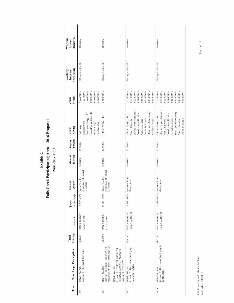
002
80.0
000
T2N
-R12
W, S
.M.
Sect
ion
31:
SE/4
SW/4
, SW
/4SE
/45.
2879
660%
Stat
e of
Ala
ska,
D
epar
tmen
t of N
atur
al
Res
ourc
es
12.5
00%
1030
487
3843
14H
AK
#A
DL
#10
0.00
%Pa
ul C
raig
2.46
6670
%W
illia
m W
ebb
1.33
3330
%C
ook
Inle
t Ene
rgy,
LLC
1.00
0000
%D
onke
l Oil
and
Gas
LLC
0.50
0000
%Je
ssic
a C
raig
0.10
0000
%H
ea S
un K
im0.
1000
00%
Hilc
orp
Ala
ska,
LLC
100.
00%
003
311.
8500
T1N
-R12
W, S
.M.
Sect
ion
6: T
hat p
art o
f the
W/2
NE/
4 ly
ing
belo
w th
e lin
e of
mea
n hi
gh ti
de
T1N
-R13
W, S
.M.
Sect
ion
1:
NE/
4NE/
4, S
W/4
NE/
4,
SE/4
NW
/4, N
/2SW
/4, S
W/4
SW/4
;Se
ctio
n 12
: N
W/4
NW
/4
20.6
1315
30%
Stat
e of
Ala
ska,
D
epar
tmen
t of N
atur
al
Res
ourc
es
12.5
00%
1034
385
3897
37H
AK
#A
DL
#10
0.00
%H
ilcor
p A
lask
a, L
LC6.
5000
00%
Hilc
orp
Ala
ska,
LLC
100.
00%
015
39.6
100
T1N
-R13
W, S
.M.
Sect
ion
12:
That
par
t of L
ot 1
lyin
g w
ithin
the
S/2N
E/4
2.61
8204
0%B
urea
u of
Lan
d M
anag
emen
t12
.500
%10
3493
4A
-024
399
HA
K #
AK
A #
100.
00%
Hilc
orp
Ala
ska,
LLC
3.25
0000
%A
nn L
. Edw
ards
0.35
0000
%C
harle
s Del
aney
Eal
and
II0.
3500
00%
Dor
othy
Ann
e D
edric
k0.
1000
00%
Alin
a L.
Men
dez
0.05
0000
%D
ustin
D. E
alan
d0.
0500
00%
Mar
y Ly
nne
Moe
llerin
g0.
0500
00%
Kev
in M
acIn
tosh
0.05
0000
%
Hilc
orp
Ala
ska,
LLC
100.
00%
015A
10.2
300
T1N
-13W
, S.M
.Se
ctio
n 12
: Th
at p
art o
f Lot
1 ly
ing
in
the
NE/
4NE/
4
0.67
6199
0%B
urea
u of
Lan
d M
anag
emen
t12
.500
%10
3493
4A
-024
399
HA
K #
AK
A #
100.
00%
Hilc
orp
Ala
ska,
LLC
3.25
0000
%C
harle
s Del
aney
Eal
and
II0.
3500
00%
Ann
L. E
dwar
ds0.
3500
00%
Dor
othy
Ann
e D
edric
k0.
1000
00%
Kev
in M
acIn
tosh
0.05
0000
%M
ary
Lynn
e M
oelle
ring
0.05
0000
%A
lina
L. M
ende
z0.
0500
00%
Dus
tin D
. Eal
and
0.05
0000
%
Hilc
orp
Ala
ska,
LLC
100.
00%
Last
Upd
ate:
9/1
5/20
16Pa
ge 1
of
10Fa
lls C
reek
Pro
posa
l 201
6 PA
Exh
ibit
C

019
40.0
000
T1N
-R12
W, S
.MSe
ctio
n 6:
SE/
4NE/
42.
6439
830%
Uni
vers
ity o
f Ala
ska
12.5
00%
1033
481
Nin
ilchi
k Tr
act #
2
HA
K #
UA
#10
0.00
%H
ilcor
p A
lask
a, L
LC10
0.00
%
046
49.3
600
T1N
-R12
W, S
.M.
Sect
ion
6:
Lot
s 1 th
ru 7
, inc
lusi
ve, o
f th
e W
ebb
Trac
ts 1
974
Subd
ivis
ion,
Pla
t 74
-172
4, in
clud
ing
all m
iner
als
unde
rlyin
g de
dica
ted
road
s with
in th
e su
bdiv
isio
n
3.26
2675
0%Sh
elle
K. L
eman
12.5
00%
1031
633
HA
K #
33.3
3%
Step
hen
S. W
ebb
12.5
00%
1031
633
HA
K #
33.3
3%
Susa
n L.
Ste
inba
ch12
.500
%10
3163
3H
AK
#33
.33%
Hilc
orp
Ala
ska,
LLC
100.
00%
048
2.67
00T1
N-R
12W
, S.M
.Se
ctio
n 6:
Tra
ct #
1 of
Ude
lhov
en
Subd
ivis
ion
(Pla
t #H
77-7
0), a
par
t of
gove
rnm
ent L
ot 2
0.17
6486
0%B
rigitt
e Th
ebau
t12
.500
%10
3491
2H
AK
#16
.67%
Joan
n St
eik
12.5
00%
1034
912
HA
K #
16.6
7%
Shirl
ey J.
Cox
12.5
00%
1034
912
HA
K #
16.6
7%
Ann
Mar
ie D
avis
12.5
00%
1034
912
HA
K #
8.33
%
Daw
n M
. Dut
ton
12.5
00%
1034
912
HA
K #
8.33
%
Jenn
ifer L
inan
n
Wie
ders
pohn
12.5
00%
1034
912
HA
K #
8.33
%
Jess
e U
delh
oven
12.5
00%
1034
912
HA
K #
8.33
%
Sand
ra K
. Ude
lhov
en-
Tayl
or12
.500
%10
3491
2H
AK
#8.
33%
Han
na K
oger
Ude
lhov
en12
.500
%10
3491
2H
AK
#4.
17%
Mira
nda
Mar
ilyn
Ude
lhov
en12
.500
%10
3491
2H
AK
#4.
17%
Hilc
orp
Ala
ska,
LLC
100.
00%
Last
Upd
ate:
9/1
5/20
16Pa
ge 2
of
10Fa
lls C
reek
Pro
posa
l 201
6 PA
Exh
ibit
C

049
29.9
500
T1N
-R12
W, S
.M.
Sect
ion
6: T
ract
s 2, 3
, 5, 6
and
7 o
f U
delh
oven
Sub
divi
sion
(Pla
t #H
77-7
0),
a pa
rt of
gov
ernm
ent L
ot 2
, les
s tha
t pa
rt of
Tra
cts 2
and
3 ly
ing
outs
ide
the
SW/4
NE/
4 an
d al
so a
ny m
iner
al ri
ghts
ly
ing
unde
r the
road
bed
of th
e St
erlin
g H
ighw
ay ri
ght o
f way
pas
sing
thro
ugh
GLO
Lot
2
1.97
9682
0%Ja
mes
Ude
lhov
en12
.500
%10
3491
2H
AK
#25
.00%
Brig
itte
Theb
aut
12.5
00%
1034
912
HA
K #
16.6
7%
Joan
n St
eik
12.5
00%
1034
912
HA
K #
16.6
7%
Shirl
ey J.
Cox
12.5
00%
1034
912
HA
K #
16.6
7%
Ann
Mar
ie D
avis
12.5
00%
1034
912
HA
K #
4.17
%
Daw
n M
. Dut
ton
12.5
00%
1034
912
HA
K #
4.17
%
Jenn
ifer L
inan
n
Wie
ders
pohn
12.5
00%
1034
912
HA
K #
4.17
%
Jess
e U
delh
oven
12.5
00%
1034
912
HA
K #
4.17
%
Sand
ra K
. Ude
lhov
en-
Tayl
or12
.500
%10
3491
2H
AK
#4.
17%
Han
na K
oger
Ude
lhov
en12
.500
%10
3491
2H
AK
#2.
08%
Mira
nda
Mar
ilyn
Ude
lhov
en12
.500
%10
3491
2H
AK
#2.
08%
Hilc
orp
Ala
ska,
LLC
6.50
0000
%H
ilcor
p A
lask
a, L
LC10
0.00
%
Last
Upd
ate:
9/1
5/20
16Pa
ge 3
of
10Fa
lls C
reek
Pro
posa
l 201
6 PA
Exh
ibit
C

049A
2.00
00T1
N-R
12W
, S.M
.Se
ctio
n 6:
Tha
t par
t of T
ract
s 2 a
nd 3
ly
ing
outs
ide
the
SW/4
NE/
4
0.13
2199
0%Ja
mes
Ude
lhov
en12
.500
%10
3491
2H
AK
#25
.00%
Brig
itte
Theb
aut
12.5
00%
1034
912
HA
K #
16.6
7%
Joan
n St
eik
12.5
00%
1034
912
HA
K #
16.6
7%
Shirl
ey J.
Cox
12.5
00%
1034
912
HA
K #
16.6
7%
Ann
Mar
ie D
avis
12.5
00%
1034
912
HA
K #
4.17
%
Daw
n M
. Dut
ton
12.5
00%
1034
912
HA
K #
4.17
%
Jenn
ifer L
inan
n
Wie
ders
pohn
12.5
00%
1034
912
HA
K #
4.17
%
Jess
e U
delh
oven
12.5
00%
1034
912
HA
K #
4.17
%
Sand
ra K
. Ude
lhov
en-
Tayl
or12
.500
%10
3491
2H
AK
#4.
17%
Han
na K
oger
Ude
lhov
en12
.500
%10
3491
2H
AK
#2.
08%
Mira
nda
Mar
ilyn
Ude
lhov
en12
.500
%10
3491
2H
AK
#2.
08%
Hilc
orp
Ala
ska,
LLC
100.
00%
050
3.62
00T1
N-R
12W
, S.M
.Se
ctio
n 6:
Tha
t par
t of T
ract
4 o
f U
delh
oven
Sub
divi
sion
lyin
g w
ithin
the
SW/4
NE/
4
0.23
9280
0%Je
nnife
r Lin
ann
W
iede
rspo
hn12
.500
%10
3491
2H
AK
#50
.00%
Brig
itte
Theb
aut
12.5
00%
1034
912
HA
K #
16.6
7%
Joan
n St
eik
12.5
00%
1034
912
HA
K #
16.6
7%
Shirl
ey J.
Cox
12.5
00%
1034
912
HA
K #
16.6
7%
Hilc
orp
Ala
ska,
LLC
6.50
0000
%H
ilcor
p A
lask
a, L
LC10
0.00
%
050A
2.67
00T1
N-R
12W
, S.M
.Se
ctio
n 6:
Tha
t par
t of T
ract
4 o
f U
delh
oven
Sub
divi
sion
lyin
g ou
tsid
e th
e SW
/4N
E/4
0.17
6486
0%Je
nnife
r Lin
ann
W
iede
rspo
hn12
.500
%10
3491
2H
AK
#50
.00%
Brig
itte
Theb
aut
12.5
00%
1034
912
HA
K #
16.6
7%
Joan
n St
eik
12.5
00%
1034
912
HA
K #
16.6
7%
Shirl
ey J.
Cox
12.5
00%
1034
912
HA
K #
16.6
7%
Hilc
orp
Ala
ska,
LLC
3.25
0000
%H
ilcor
p A
lask
a, L
LC10
0.00
%
Last
Upd
ate:
9/1
5/20
16Pa
ge 4
of
10Fa
lls C
reek
Pro
posa
l 201
6 PA
Exh
ibit
C

051
0.91
00T1
N-R
12W
, S.M
.Se
ctio
n 6:
Tha
t por
tion
of th
e no
rth
165'
of t
he N
/2SE
/4 l
ying
wes
t of t
he
Ster
ling
Hig
hway
0.06
0151
0%E.
W. V
ande
rbilt
(M
arga
ret V
ande
rbilt
Lv
g Tr
ust)
12.5
00%
1034
850
HA
K #
100.
00%
Hilc
orp
Ala
ska,
LLC
6.50
0000
%H
ilcor
p A
lask
a, L
LC10
0.00
%
051A
2.34
00T1
N-R
12W
, S.M
.Se
ctio
n 6:
The
Nor
th 1
65' o
f GLO
Lot
30.
1546
730%
E. W
. Van
derb
ilt
(Mar
gare
t Van
derb
ilt
Lvg
Trus
t)
12.5
00%
1034
850
HA
K #
100.
00%
Hilc
orp
Ala
ska,
LLC
3.25
0000
%H
ilcor
p A
lask
a, L
LC10
0.00
%
052
58.0
000
T1N
-R12
W, S
.M.
Sect
ion
6: T
hat p
art o
f N/2
SE/4
lyin
g ea
st o
f Ste
rling
Hig
hway
3.83
3775
0%H
arol
d A
. and
M
argu
erite
M. P
eder
son
12.5
00%
1033
560
HA
K #
100.
00%
Hilc
orp
Ala
ska,
LLC
100.
00%
053
21.0
900
T1N
-R12
W, S
.M.
Sect
ion
6: T
hat p
art o
f N/2
SE/4
lyin
g w
est o
f the
Ste
rling
Hig
hway
, les
s and
ex
cept
the
north
165
feet
and
that
po
rtion
of t
he S
terli
ng H
ighw
ay R
ight
-of
-Way
lyin
g w
ithin
the
N/2
SE/4
1.39
4040
0%H
arol
d Le
e an
d D
iane
R.
Pede
rson
12.5
00%
1034
913
HA
K #
100.
00%
Hilc
orp
Ala
ska,
LLC
6.50
0000
%H
ilcor
p A
lask
a, L
LC10
0.00
%
053A
28.9
000
T1N
-R12
W, S
.M.
Sect
ion
6: L
ot 3
exc
ept t
he N
orth
165
' th
ereo
f
1.91
0278
0%H
arol
d Le
e an
d D
iane
R.
Pede
rson
12.5
00%
1034
913
HA
K #
100.
00%
Hilc
orp
Ala
ska,
LLC
3.25
0000
%H
ilcor
p A
lask
a, L
LC10
0.00
%
056
30.9
010
T1N
-R12
W, S
.M.
Sect
ion
6: S
W/4
SE/4
, les
s and
exc
ept
Blo
ck 2
, Lot
s 1 a
nd 8
, and
Blo
ck 5
, Lot
1
of C
lam
mer
's H
aven
Sub
divi
sion
, Pl
at 7
6-62
2.04
2543
0%C
harle
s Wey
haup
t12
.500
%10
3491
1H
AK
#18
.75%
Dav
id W
eyha
upt
12.5
00%
1034
911
HA
K #
18.7
5%
Jam
es R
einh
ardt
12.5
00%
1034
911
HA
K #
18.7
5%
Thom
as W
eyha
upt
12.5
00%
1034
911
HA
K #
18.7
5%
Nor
ma
Jean
ne N
icho
ls12
.500
%10
3491
1H
AK
#16
.67%
Wal
ter G
. Will
iam
s12
.500
%10
3491
1H
AK
#8.
33%
Hilc
orp
Ala
ska,
LLC
6.50
0000
%H
ilcor
p A
lask
a, L
LC10
0.00
%
Last
Upd
ate:
9/1
5/20
16Pa
ge 5
of
10Fa
lls C
reek
Pro
posa
l 201
6 PA
Exh
ibit
C

059
2.93
70T1
N-R
12W
, S.M
.Se
ctio
n 6:
Blo
ck 2
, Lot
1 o
f Cla
mm
er's
Hav
en S
ubdi
visi
on, P
lat 7
6-62
0.19
4135
0%C
harle
s Wey
haup
t12
.500
%10
3491
1H
AK
#18
.75%
Dav
id W
eyha
upt
12.5
00%
1034
911
HA
K #
18.7
5%
Jam
es R
einh
ardt
12.5
00%
1034
911
HA
K #
18.7
5%
Thom
as W
eyha
upt
12.5
00%
1034
911
HA
K #
18.7
5%
Jens
H. a
nd A
nnel
ine
Han
sen
12.5
00%
1034
911
HA
K #
12.5
0%
Ver
ay H
. Mat
thew
s12
.500
%10
3491
1H
AK
#12
.50%
Hilc
orp
Ala
ska,
LLC
6.50
0000
%H
ilcor
p A
lask
a, L
LC10
0.00
%
060
2.90
40T1
N-R
12W
, S.M
.Se
ctio
n 6:
Blo
ck 2
, Lot
8 o
f Cla
mm
er's
Hav
en S
ubdi
visi
on, P
lat 6
-62
0.19
1953
0%Jo
hn S
tallo
ne, J
r.12
.500
%10
3491
1H
AK
#25
.00%
Cha
rles W
eyha
upt
12.5
00%
1034
911
HA
K #
18.7
5%
Dav
id W
eyha
upt
12.5
00%
1034
911
HA
K #
18.7
5%
Jam
es R
einh
ardt
12.5
00%
1034
911
HA
K #
18.7
5%
Thom
as W
eyha
upt
12.5
00%
1034
911
HA
K #
18.7
5%
Hilc
orp
Ala
ska,
LLC
6.50
0000
%H
ilcor
p A
lask
a, L
LC10
0.00
%
061
3.25
80T1
N-R
12W
, S.M
.Se
ctio
n 6:
Blo
ck 5
, Lot
1 o
f Cla
mm
er's
Hav
en S
ubdi
visi
on, P
lat 7
6-62
0.21
5352
0%D
enni
s Hed
man
12.5
00%
1034
911
HA
K #
25.0
0%
Cha
rles W
eyha
upt
12.5
00%
1034
911
HA
K #
18.7
5%
Dav
id W
eyha
upt
12.5
00%
1034
911
HA
K #
18.7
5%
Jam
es R
einh
ardt
12.5
00%
1034
911
HA
K #
18.7
5%
Thom
as W
eyha
upt
12.5
00%
1034
911
HA
K #
18.7
5%
Hilc
orp
Ala
ska,
LLC
6.50
0000
%H
ilcor
p A
lask
a, L
LC10
0.00
%
Last
Upd
ate:
9/1
5/20
16Pa
ge 6
of
10Fa
lls C
reek
Pro
posa
l 201
6 PA
Exh
ibit
C

062
34.9
880
T1N
-R12
W, S
.M.
Sect
ion
6: T
hat p
art o
f gov
ernm
ent L
ot
4 ly
ing
in th
e SE
/4SW
/4, l
ess B
lock
1,
Lot 9
and
less
Blo
ck 2
, Lot
s 3 a
nd 4
of
Cla
mm
er's
Hav
en A
dd'n
No.
1
Subd
ivis
ion,
Pla
t H-7
8-25
; B
lock
2,
Lots
5 a
nd 6
and
any
inte
rest
in ro
ad
way
s and
eas
emen
ts d
edic
ated
to p
ublic
us
e in
the
Cla
mm
er's
Hav
en A
dd’n
No.
1
Subd
ivis
ion,
Pla
t78-
25
2.31
2692
0%C
harle
s Wey
haup
t12
.500
%10
3491
1H
AK
#18
.75%
Dav
id W
eyha
upt
12.5
00%
1034
911
HA
K #
18.7
5%
Jam
es R
einh
ardt
12.5
00%
1034
911
HA
K #
18.7
5%
Thom
as W
eyha
upt
12.5
00%
1034
911
HA
K #
18.7
5%
Nor
ma
Jean
ne N
icho
ls12
.500
%10
3491
1H
AK
#16
.67%
Wal
ter G
. Will
iam
s12
.500
%10
3491
1H
AK
#8.
33%
Hilc
orp
Ala
ska,
LLC
6.50
0000
%H
ilcor
p A
lask
a, L
LC10
0.00
%
062A
12.1
100
T1N
-R12
W, S
.M.
Sec
6: T
hose
par
ts o
f Cla
mm
ers H
aven
A
dditi
on N
o.1
(pla
t H-7
8-25
), de
scrib
ed
as a
ll of
Blo
ck 1
, Lot
2 a
nd th
ose
parts
of
Blo
ck 1
, Lo
t 4 ly
ing
outs
ide
the
SE/4
SW/4
AN
D th
ose
parts
of B
lock
2,
Lot 1
lyin
g ou
tsid
e th
e SE
/4SW
/4 a
nd
all m
iner
als u
nder
lyin
g de
dica
ted
road
s an
d ea
sem
ents
lyin
g ou
tsid
e th
e SE
/4SW
/4 (a
par
t of G
LO L
ot 4
)
0.80
0466
0%C
harle
s Wey
haup
t12
.500
%10
3491
1H
AK
#18
.75%
Dav
id W
eyha
upt
12.5
00%
1034
911
HA
K #
18.7
5%
Jam
es R
einh
ardt
12.5
00%
1034
911
HA
K #
18.7
5%
Thom
as W
eyha
upt
12.5
00%
1034
911
HA
K #
18.7
5%
Nor
ma
Jean
ne N
icho
ls12
.500
%10
3491
1H
AK
#16
.67%
Wal
ter G
. Will
iam
s12
.500
%10
3491
1H
AK
#8.
33%
Hilc
orp
Ala
ska,
LLC
3.25
0000
%H
ilcor
p A
lask
a, L
LC10
0.00
%
062B
4.46
10T1
N-R
12W
, S.M
.Se
c 6:
Tho
se p
arts
of C
lam
mer
s Hav
en
Add
ition
No.
1 (p
lat H
-78-
25),
desc
ribed
as
all
of B
lock
1, L
ot 1
(a
part
of G
LO
Lot 4
)
0.29
4870
0%Ed
war
d C
. and
Myo
ng
C. G
reen
e12
.500
%10
3491
1H
AK
#25
.00%
Cha
rles W
eyha
upt
12.5
00%
1034
911
HA
K #
18.7
5%
Dav
id W
eyha
upt
12.5
00%
1034
911
HA
K #
18.7
5%
Jam
es R
einh
ardt
12.5
00%
1034
911
HA
K #
18.7
5%
Thom
as W
eyha
upt
12.5
00%
1034
911
HA
K #
18.7
5%
Hilc
orp
Ala
ska,
LLC
3.25
0000
%H
ilcor
p A
lask
a, L
LC10
0.00
%
Last
Upd
ate:
9/1
5/20
16Pa
ge 7
of
10Fa
lls C
reek
Pro
posa
l 201
6 PA
Exh
ibit
C

062C
2.99
20T1
N-R
12W
, S.M
.Se
c 6:
Tho
se p
arts
of C
lam
mer
's H
aven
A
dditi
on N
o.1
(pla
t H-7
8-25
), de
scrib
ed
as a
ll of
Blo
ck 1
, Lot
3 (a
par
t of G
LO
Lot 4
)
0.19
7770
0%K
eith
C. a
nd F
lora
D.
Love
joy
12.5
00%
1034
911
HA
K #
25.0
0%
Cha
rles W
eyha
upt
12.5
00%
1034
911
HA
K #
18.7
5%
Dav
id W
eyha
upt
12.5
00%
1034
911
HA
K #
18.7
5%
Jam
es R
einh
ardt
12.5
00%
1034
911
HA
K #
18.7
5%
Thom
as W
eyha
upt
12.5
00%
1034
911
HA
K #
18.7
5%
Hilc
orp
Ala
ska,
LLC
3.25
0000
%H
ilcor
p A
lask
a, L
LC10
0.00
%
063
1.69
90T1
N-R
12W
,S.M
.Se
ctio
n 6:
Tha
t par
t of G
over
nmen
t Lot
4
mor
e pa
rticu
larly
des
crib
ed a
s Blo
ck
2, L
ot 4
of C
lam
mer
s Hav
en A
dditi
on
No.
1, a
s pla
tted
in p
lat #
H-7
8-25
0.11
2303
0%M
icha
el a
nd M
arjo
rie
Bar
ry12
.500
%10
3491
1H
AK
#25
.00%
Cha
rles W
eyha
upt
12.5
00%
1034
911
HA
K #
18.7
5%
Dav
id W
eyha
upt
12.5
00%
1034
911
HA
K #
18.7
5%
Jam
es R
einh
ardt
12.5
00%
1034
911
HA
K #
18.7
5%
Thom
as W
eyha
upt
12.5
00%
1034
911
HA
K #
18.7
5%
Hilc
orp
Ala
ska,
LLC
6.50
0000
%H
ilcor
p A
lask
a, L
LC10
0.00
%
064
1.74
10T1
N-R
12W
, S.M
.Se
ctio
n 6:
Tha
t par
t of G
over
nmen
t Lot
4
mor
e pa
rticu
larly
des
crib
ed a
s Blo
ck
2, L
ot 3
of C
lam
mer
's H
aven
Add
ition
N
o. 1
, as p
latte
d in
pla
t # H
-78-
25
0.11
5079
0%M
icha
el a
nd M
arjo
rie
Bar
ry12
.500
%10
3491
1H
AK
#25
.00%
Cha
rles W
eyha
upt
12.5
00%
1034
911
HA
K #
18.7
5%
Dav
id W
eyha
upt
12.5
00%
1034
911
HA
K #
18.7
5%
Jam
es R
einh
ardt
12.5
00%
1034
911
HA
K #
18.7
5%
Thom
as W
eyha
upt
12.5
00%
1034
911
HA
K #
18.7
5%
Hilc
orp
Ala
ska,
LLC
6.50
0000
%H
ilcor
p A
lask
a, L
LC10
0.00
%
Last
Upd
ate:
9/1
5/20
16Pa
ge 8
of
10Fa
lls C
reek
Pro
posa
l 201
6 PA
Exh
ibit
C
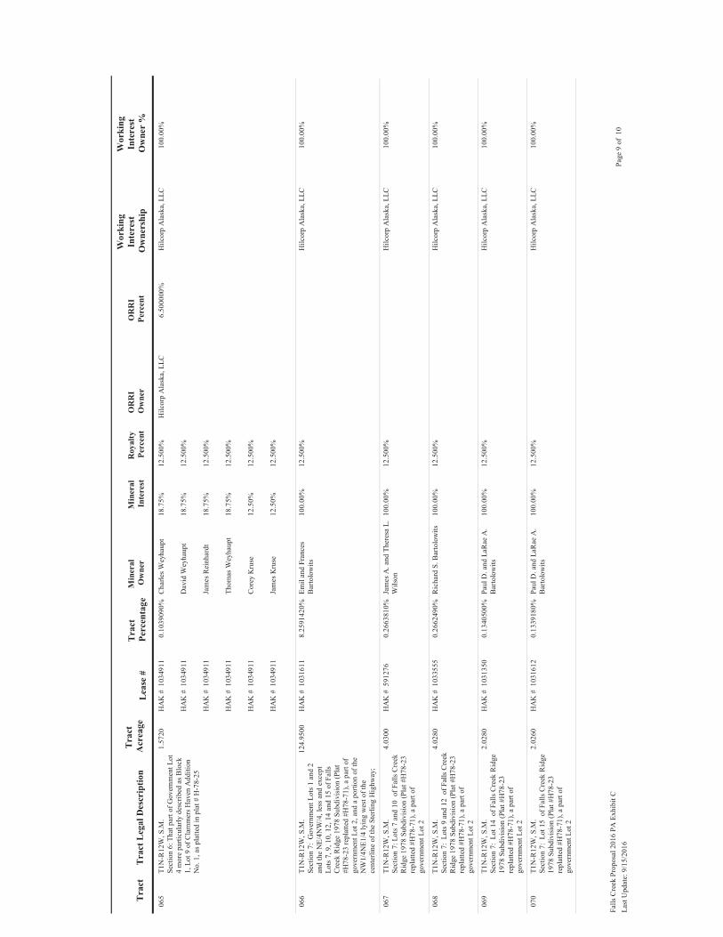
065
1.57
20T1
N-R
12W
, S.M
.Se
ctio
n 6:
Tha
t par
t of G
over
nmen
t Lot
4
mor
e pa
rticu
larly
des
crib
ed a
s Blo
ck
1, L
ot 9
of C
lam
mer
s Hav
en A
dditi
on
No.
1, a
s pla
tted
in p
lat #
H-7
8-25
0.10
3909
0%C
harle
s Wey
haup
t12
.500
%10
3491
1H
AK
#18
.75%
Dav
id W
eyha
upt
12.5
00%
1034
911
HA
K #
18.7
5%
Jam
es R
einh
ardt
12.5
00%
1034
911
HA
K #
18.7
5%
Thom
as W
eyha
upt
12.5
00%
1034
911
HA
K #
18.7
5%
Cor
ey K
ruse
12.5
00%
1034
911
HA
K #
12.5
0%
Jam
es K
ruse
12.5
00%
1034
911
HA
K #
12.5
0%
Hilc
orp
Ala
ska,
LLC
6.50
0000
%H
ilcor
p A
lask
a, L
LC10
0.00
%
066
124.
9500
T1N
-R12
W, S
.M.
Sect
ion
7: G
over
nmen
t Lot
s 1 a
nd 2
an
d th
e N
E/4N
W/4
, les
s and
exc
ept
Lots
7, 9
, 10,
12,
14
and
15 o
f Fal
ls C
reek
Rid
ge 1
978
Subd
ivis
ion
(Pla
t #H
78-2
3 re
plat
ted
#H78
-71)
, a p
art o
f go
vern
men
t Lot
2, a
nd a
por
tion
of th
e N
W1/
4NE1
/4 ly
ing
wes
t of t
he
cent
erlin
e of
the
Ster
ling
Hig
hway
;
8.25
9142
0%Em
il an
d Fr
ance
s B
arto
low
its12
.500
%10
3161
1H
AK
#10
0.00
%H
ilcor
p A
lask
a, L
LC10
0.00
%
067
4.03
00T1
N-R
12W
, S.M
.Se
ctio
n 7:
Lot
s 7 a
nd 1
0 o
f Fal
ls C
reek
R
idge
197
8 Su
bdiv
isio
n (P
lat #
H78
-23
repl
atte
d #H
78-7
1), a
par
t of
gove
rnm
ent L
ot 2
0.26
6381
0%Ja
mes
A. a
nd T
here
sa L
. W
ilson
12.5
00%
5912
76H
AK
#10
0.00
%H
ilcor
p A
lask
a, L
LC10
0.00
%
068
4.02
80T1
N-R
12W
, S.M
.Se
ctio
n 7:
Lot
s 9 a
nd 1
2 o
f Fal
ls C
reek
R
idge
197
8 Su
bdiv
isio
n (P
lat #
H78
-23
repl
atte
d #H
78-7
1), a
par
t of
gove
rnm
ent L
ot 2
0.26
6249
0%R
icha
rd S
. Bar
tolo
wits
12.5
00%
1033
555
HA
K #
100.
00%
Hilc
orp
Ala
ska,
LLC
100.
00%
069
2.02
80T1
N-R
12W
, S.M
.Se
ctio
n 7:
Lot
14
of F
alls
Cre
ek R
idge
19
78 S
ubdi
visi
on (P
lat #
H78
-23
repl
atte
d #H
78-7
1), a
par
t of
gove
rnm
ent L
ot 2
0.13
4050
0%Pa
ul D
. and
LaR
ae A
. B
arto
low
its12
.500
%10
3135
0H
AK
#10
0.00
%H
ilcor
p A
lask
a, L
LC10
0.00
%
070
2.02
60T1
N-R
12W
, S.M
.Se
ctio
n 7:
Lot
15
of F
alls
Cre
ek R
idge
19
78 S
ubdi
visi
on (P
lat #
H78
-23
repl
atte
d #H
78-7
1), a
par
t of
gove
rnm
ent L
ot 2
0.13
3918
0%Pa
ul D
. and
LaR
ae A
. B
arto
low
its12
.500
%10
3161
2H
AK
#10
0.00
%H
ilcor
p A
lask
a, L
LC10
0.00
%
Last
Upd
ate:
9/1
5/20
16Pa
ge 9
of
10Fa
lls C
reek
Pro
posa
l 201
6 PA
Exh
ibit
C

188
564.
4500
T1N
-R13
W, S
.M.
Sec.
1:
SE/
4NE/
4, S
E/4,
SE
/4SW
/4
Sec.
12:
NE/
4NW
/4, N
/2N
E/4,
exc
ept
that
par
t lyi
ng a
bove
the
line
of m
ean
high
tide
; T1
N-R
12W
, S.M
.Se
c. 6
: W
/2 e
xcep
t tha
t par
t lyi
ng
abov
e th
e lin
e of
mea
n hi
gh ti
de
37.3
0990
60%
Stat
e of
Ala
ska,
D
epar
tmen
t of N
atur
al
Res
ourc
es
12.5
00%
1034
384
590
HA
K #
AD
L #
100.
00%
Hilc
orp
Ala
ska,
LLC
3.25
0000
%H
ilcor
p A
lask
a, L
LC10
0.00
%
229
24.7
400
T1N
-R12
W, S
.M.
Sect
ion
7: A
por
tion
of th
e N
W1/
4NE1
/4 ly
ing
east
of t
he
cent
erlin
e of
the
Ster
ling
Hig
hway
; m
ore
parti
cula
rly d
escr
ibed
as C
elia
Su
bdiv
isio
n, P
lat N
o. 9
4-46
, and
all
min
eral
s und
erly
ing
dedi
cate
d ro
ads
with
in th
e su
bdiv
isio
n, e
xclu
ding
Tra
cts
C-1
A a
nd C
-1B
of t
he C
elia
Su
bdiv
isio
n, A
dditi
on #
2, P
lat N
o.
2012
-53
1.63
5304
0%Pe
nelo
pe J.
Mai
ze12
.500
%59
1260
HA
K #
100.
00%
Hilc
orp
Ala
ska,
LLC
100.
00%
230
3.85
40T1
N-R
12W
, S.M
.Se
ctio
n 7:
Tr
acts
C-1
A a
nd C
-1B
of
Cel
ia S
ubdi
visi
on, A
dditi
on #
2, P
lat
No.
201
2-53
0.25
4748
0%Ja
mes
C. K
ruse
and
Li
nda
C. K
ruse
12.5
00%
5912
36H
AK
#10
0.00
%H
ilcor
p A
lask
a, L
LC10
0.00
%
1,51
2.86
90.
0000
%U
ncom
mitt
ed10
0.00
0000
%H
ilcor
p A
lask
a, L
LC10
0.00
00%
Last
Upd
ate:
9/1
5/20
16Pa
ge 1
0 of
10
Falls
Cre
ek P
ropo
sal 2
016
PA E
xhib
it C

Proposed Falls Creek Participating AreaNinilchik Unit
Effective October 1, 2016
Falls Creek PA Exhibit CLast Update: 8/30/2016
RECAPITULATION BY LAND CATEGORIES:
LAND OWNERSHIP ACRESPERCENTAGE OF PA
.State of Alaska Lands 956.300 63.211025%Federal Lands 49.840 3.294403%Patented Fee Lands 506.729 33.494572%
TOTAL: 1,512.869 100.000000%
Ninilchik Unit – First Expansion of Falls Creek Participating Area 30
Attachment 2 Ninilchik Unit Falls Creek Participating Area
Proposed Expansion Exhibit D Map of proposed participating area

3
15A
48
4950
A
51A 53
A
62
62A
63
65
188
49A
50
62B62
C
64
46
3
353
5251
56
59 60
61
3
66
6768
229
230
70 69
2
19
153
3236
31
16
5
12
78
35
112
S002
N01
3W
S002
N01
2W
S001
N01
3WS0
01N
012W
Map
Dat
e: 1
1/2/
2016
E0
1,30
02,
600 Fe
et
Uni
t Tra
cts
Prop
osed
Fal
ls C
reek
PA
Prop
osed
Nin
ilchi
k U
nit B
ound
ary
Stat
e Pl
ane
Zone
4 N
AD
192
7 (fe
et)
Nin
ilchi
k U
nit
Map
Ove
rvie
wEx
hibi
t DN
inilc
hik
Uni
tPr
opos
ed F
alls
Cre
ekPa
rtic
ipat
ing
Are
a
Ninilchik Unit – First Expansion of Falls Creek Participating Area 31

Ninilchik Unit – First Expansion of Falls Creek Participating Area 32
Attachment 3 Ninilchik Unit Falls Creek Participating Area:
Draft Exhibit C of Approved FCPA (Land Descriptions)

003
43.7
600
T1N
-R12
W, S
.M.
Sect
ion
6: T
hat p
art o
f the
SW
/4N
E/4
lyin
g be
low
the
line
of m
ean
high
tide
T1N
-R13
W, S
.M.
Sect
ion
1:
NE/
4SW
/4
4.82
1066
0%St
ate
of A
lask
a,
Dep
artm
ent o
f Nat
ural
R
esou
rces
12.5
00%
1034
385
3897
37H
AK
#A
DL
#10
0.00
%H
ilcor
p A
lask
a, L
LC6.
5000
00%
Hilc
orp
Ala
ska,
LLC
100.
0000
0%
015A
10.2
300
T1N
-13W
, S.M
.Se
ctio
n 12
: Th
at p
art o
f Lot
1
lyin
g in
the
NE/
4NE/
4
1.12
7045
0%B
urea
u of
Lan
d M
anag
emen
t12
.500
%10
3493
4A
-024
399
HA
K #
AK
A #
100.
00%
Mar
y Ly
nne
Moe
llerin
g0.0
5000
0%K
evin
Mac
Into
sh0.
0500
00%
Hilc
orp
Ala
ska,
LLC
3.25
0000
%D
ustin
D. E
alan
d0.
0500
00%
Dor
othy
Ann
e D
edric
k0.
1000
00%
Cha
rles D
elan
ey E
alan
d II0.
3500
00%
Ann
L. E
dwar
ds0.
3500
00%
Alin
a L.
Men
dez
0.05
0000
%
Hilc
orp
Ala
ska,
LLC
100.
0000
0%
Page
1 o
f 10
Falls
Cre
ek P
ropo
sal 2
016
PA E
xhib
it C
Upd
ated
: 3/3
0/20
17
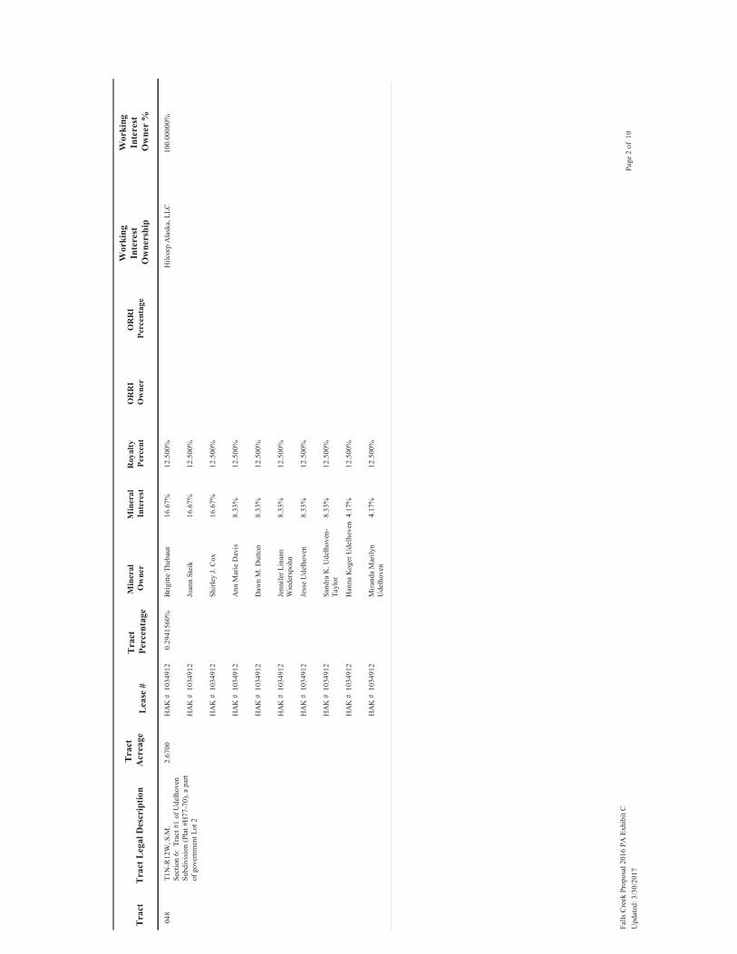
048
2.67
00T1
N-R
12W
, S.M
.Se
ctio
n 6:
Tra
ct #
1 of
Ude
lhov
en
Subd
ivis
ion
(Pla
t #H
77-7
0), a
par
t of
gov
ernm
ent L
ot 2
0.29
4156
0%B
rigitt
e Th
ebau
t12
.500
%10
3491
2H
AK
#16
.67%
Joan
n St
eik
12.5
00%
1034
912
HA
K #
16.6
7%
Shirl
ey J.
Cox
12.5
00%
1034
912
HA
K #
16.6
7%
Ann
Mar
ie D
avis
12.5
00%
1034
912
HA
K #
8.33
%
Daw
n M
. Dut
ton
12.5
00%
1034
912
HA
K #
8.33
%
Jenn
ifer L
inan
n
Wie
ders
pohn
12.5
00%
1034
912
HA
K #
8.33
%
Jess
e U
delh
oven
12.5
00%
1034
912
HA
K #
8.33
%
Sand
ra K
. Ude
lhov
en-
Tayl
or12
.500
%10
3491
2H
AK
#8.
33%
Han
na K
oger
Ude
lhov
en12
.500
%10
3491
2H
AK
#4.
17%
Mira
nda
Mar
ilyn
Ude
lhov
en12
.500
%10
3491
2H
AK
#4.
17%
Hilc
orp
Ala
ska,
LLC
100.
0000
0%
Page
2 o
f 10
Falls
Cre
ek P
ropo
sal 2
016
PA E
xhib
it C
Upd
ated
: 3/3
0/20
17

049
29.9
500
T1N
-R12
W, S
.M.
Sect
ion
6: T
ract
s 2, 3
, 5, 6
and
7 o
f U
delh
oven
Sub
divi
sion
(Pla
t #H
77-
70),
a pa
rt of
gov
ernm
ent L
ot 2
, les
s th
at p
art o
f Tra
cts 2
and
3 ly
ing
outs
ide
the
SW/4
NE/
4 an
d al
so a
ny
min
eral
righ
ts ly
ing
unde
r the
ro
adbe
d of
the
Ster
ling
Hig
hway
rig
ht o
f way
pas
sing
thro
ugh
GLO
Lo
t 2
3.29
9610
0%Ja
mes
Ude
lhov
en12
.500
%10
3491
2H
AK
#25
.00%
Brig
itte
Theb
aut
12.5
00%
1034
912
HA
K #
16.6
7%
Joan
n St
eik
12.5
00%
1034
912
HA
K #
16.6
7%
Shirl
ey J.
Cox
12.5
00%
1034
912
HA
K #
16.6
7%
Ann
Mar
ie D
avis
12.5
00%
1034
912
HA
K #
4.17
%
Daw
n M
. Dut
ton
12.5
00%
1034
912
HA
K #
4.17
%
Jenn
ifer L
inan
n
Wie
ders
pohn
12.5
00%
1034
912
HA
K #
4.17
%
Jess
e U
delh
oven
12.5
00%
1034
912
HA
K #
4.17
%
Sand
ra K
. Ude
lhov
en-
Tayl
or12
.500
%10
3491
2H
AK
#4.
17%
Han
na K
oger
Ude
lhov
en12
.500
%10
3491
2H
AK
#2.
08%
Mira
nda
Mar
ilyn
Ude
lhov
en12
.500
%10
3491
2H
AK
#2.
08%
Hilc
orp
Ala
ska,
LLC
6.50
0000
%H
ilcor
p A
lask
a, L
LC10
0.00
000%
Page
3 o
f 10
Falls
Cre
ek P
ropo
sal 2
016
PA E
xhib
it C
Upd
ated
: 3/3
0/20
17
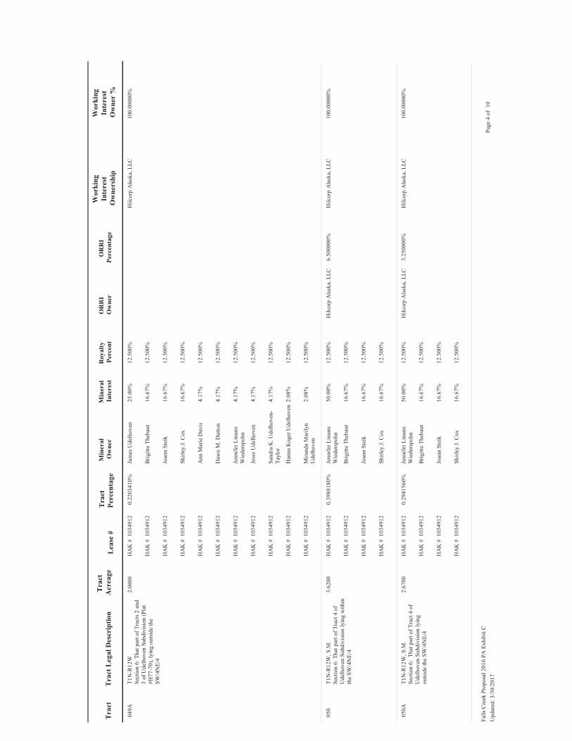
049A
2.00
00T1
N-R
12W
Sect
ion
6: T
hat p
art o
f Tra
cts 2
and
3
of U
delh
oven
Sub
divi
sion
(Pla
t #H
77-7
0), l
ying
out
side
the
SW/4
NE/
4
0.22
0341
0%Ja
mes
Ude
lhov
en12
.500
%10
3491
2H
AK
#25
.00%
Brig
itte
Theb
aut
12.5
00%
1034
912
HA
K #
16.6
7%
Joan
n St
eik
12.5
00%
1034
912
HA
K #
16.6
7%
Shirl
ey J.
Cox
12.5
00%
1034
912
HA
K #
16.6
7%
Ann
Mar
ie D
avis
12.5
00%
1034
912
HA
K #
4.17
%
Daw
n M
. Dut
ton
12.5
00%
1034
912
HA
K #
4.17
%
Jenn
ifer L
inan
n
Wie
ders
pohn
12.5
00%
1034
912
HA
K #
4.17
%
Jess
e U
delh
oven
12.5
00%
1034
912
HA
K #
4.17
%
Sand
ra K
. Ude
lhov
en-
Tayl
or12
.500
%10
3491
2H
AK
#4.
17%
Han
na K
oger
Ude
lhov
en12
.500
%10
3491
2H
AK
#2.
08%
Mira
nda
Mar
ilyn
Ude
lhov
en12
.500
%10
3491
2H
AK
#2.
08%
Hilc
orp
Ala
ska,
LLC
100.
0000
0%
050
3.62
00T1
N-R
12W
, S.M
.Se
ctio
n 6:
Tha
t par
t of T
ract
4 o
f U
delh
oven
Sub
divi
sion
lyin
g w
ithin
th
e SW
/4N
E/4
0.39
8818
0%Je
nnife
r Lin
ann
W
iede
rspo
hn12
.500
%10
3491
2H
AK
#50
.00%
Brig
itte
Theb
aut
12.5
00%
1034
912
HA
K #
16.6
7%
Joan
n St
eik
12.5
00%
1034
912
HA
K #
16.6
7%
Shirl
ey J.
Cox
12.5
00%
1034
912
HA
K #
16.6
7%
Hilc
orp
Ala
ska,
LLC
6.50
0000
%H
ilcor
p A
lask
a, L
LC10
0.00
000%
050A
2.67
00T1
N-R
12W
, S.M
.Se
ctio
n 6:
Tha
t par
t of T
ract
4 o
f U
delh
oven
Sub
divi
sion
lyin
g ou
tsid
e th
e SW
/4N
E/4
0.29
4156
0%Je
nnife
r Lin
ann
W
iede
rspo
hn12
.500
%10
3491
2H
AK
#50
.00%
Brig
itte
Theb
aut
12.5
00%
1034
912
HA
K #
16.6
7%
Joan
n St
eik
12.5
00%
1034
912
HA
K #
16.6
7%
Shirl
ey J.
Cox
12.5
00%
1034
912
HA
K #
16.6
7%
Hilc
orp
Ala
ska,
LLC
3.25
0000
%H
ilcor
p A
lask
a, L
LC10
0.00
000%
Page
4 o
f 10
Falls
Cre
ek P
ropo
sal 2
016
PA E
xhib
it C
Upd
ated
: 3/3
0/20
17

051
0.91
00T1
N-R
12W
, S.M
.Se
ctio
n 6:
Tha
t por
tion
of th
e no
rth
165'
of t
he N
/2SE
/4 l
ying
wes
t of
the
Ster
ling
Hig
hway
0.10
0255
0%Ja
n El
aine
Van
derb
ilt
Rev
ocab
le T
rust
, dtd
N
ov 2
006
12.5
00%
1034
850
HA
K #
33.3
3%
Dia
na L
. Kna
uf T
rust
, dt
d M
ay 9
, 200
312
.500
%10
3485
0H
AK
#33
.33%
Lind
a K
err
12.5
00%
1034
850
HA
K #
33.3
3%
Hilc
orp
Ala
ska,
LLC
6.50
0000
%H
ilcor
p A
lask
a, L
LC10
0.00
000%
051A
2.34
00T1
N-R
12W
, S.M
.Se
ctio
n 6:
The
Nor
th 1
65' o
f GLO
Lo
t 3
0.25
7799
0%Ja
n El
aine
Van
derb
ilt
Rev
ocab
le T
rust
, dtd
N
ov 2
006
12.5
00%
1034
850
HA
K #
33.3
3%
Dia
na L
. Kna
uf T
rust
, dt
d M
ay 9
, 200
312
.500
%10
3485
0H
AK
#33
.33%
Lind
a K
err
12.5
00%
1034
850
HA
K #
33.3
3%
Hilc
orp
Ala
ska,
LLC
3.25
0000
%H
ilcor
p A
lask
a, L
LC10
0.00
000%
052
18.0
000
T1N
-R12
W, S
.M.
Sect
ion
6: T
hat p
art o
f NW
/4SE
/4
lyin
g ea
st o
f Ste
rling
Hig
hway
1.98
3071
0%H
arol
d A
. and
M
argu
erite
M. P
eder
son
12.5
00%
1033
560
HA
K #
100.
00%
Hilc
orp
Ala
ska,
LLC
100.
0000
0%
053
21.0
900
T1N
-R12
W, S
.M.
Sect
ion
6: T
hat p
art o
f N/2
SE/4
ly
ing
wes
t of t
he S
terli
ng H
ighw
ay,
less
and
exc
ept t
he n
orth
165
feet
an
d th
at p
ortio
n of
the
Ster
ling
Hig
hway
Rig
ht-o
f-W
ay ly
ing
with
in
the
N/2
SE/4
2.32
3498
0%H
arol
d Le
e an
d D
iane
R.
Pede
rson
12.5
00%
1034
913
HA
K #
100.
00%
Hilc
orp
Ala
ska,
LLC
6.50
0000
%H
ilcor
p A
lask
a, L
LC10
0.00
000%
053A
28.9
000
T1N
-R12
W, S
.M.
Sect
ion
6: L
ot 3
exc
ept t
he N
orth
16
5' th
ereo
f
3.18
3931
0%H
arol
d Le
e an
d D
iane
R.
Pede
rson
12.5
00%
1034
913
HA
K #
100.
00%
Hilc
orp
Ala
ska,
LLC
3.25
0000
%H
ilcor
p A
lask
a, L
LC10
0.00
000%
056
30.9
010
T1N
-R12
W, S
.M.
Sect
ion
6: S
W/4
SE/4
, les
s and
ex
cept
Blo
ck 2
, Lot
s 1 a
nd 8
, and
B
lock
5, L
ot 1
of C
lam
mer
's H
aven
Su
bdiv
isio
n, P
lat 7
6-62
3.40
4383
0%C
harle
s Wey
haup
t12
.500
%10
3491
1H
AK
#18
.75%
Dav
id W
eyha
upt
12.5
00%
1034
911
HA
K #
18.7
5%
Jam
es R
einh
ardt
12.5
00%
1034
911
HA
K #
18.7
5%
Thom
as W
eyha
upt
12.5
00%
1034
911
HA
K #
18.7
5%
Nor
ma
Jean
ne N
icho
ls12
.500
%10
3491
1H
AK
#16
.67%
Wal
ter G
. Will
iam
s12
.500
%10
3491
1H
AK
#8.
33%
Hilc
orp
Ala
ska,
LLC
6.50
0000
%H
ilcor
p A
lask
a, L
LC10
0.00
000%
Page
5 o
f 10
Falls
Cre
ek P
ropo
sal 2
016
PA E
xhib
it C
Upd
ated
: 3/3
0/20
17

059
2.93
70T1
N-R
12W
, S.M
.Se
ctio
n 6:
Blo
ck 2
, Lot
1 o
f C
lam
mer
's H
aven
Sub
divi
sion
, Pla
t 76
-62
0.32
3571
0%C
harle
s Wey
haup
t12
.500
%10
3491
1H
AK
#18
.75%
Dav
id W
eyha
upt
12.5
00%
1034
911
HA
K #
18.7
5%
Jam
es R
einh
ardt
12.5
00%
1034
911
HA
K #
18.7
5%
Thom
as W
eyha
upt
12.5
00%
1034
911
HA
K #
18.7
5%
Jens
H. a
nd A
nnel
ine
Han
sen
12.5
00%
1034
911
HA
K #
12.5
0%
Ver
ay H
. Mat
thew
s12
.500
%10
3491
1H
AK
#12
.50%
Hilc
orp
Ala
ska,
LLC
6.50
0000
%H
ilcor
p A
lask
a, L
LC10
0.00
000%
060
2.90
40T1
N-R
12W
, S.M
.Se
ctio
n 6:
Blo
ck 2
, Lot
8 o
f C
lam
mer
's H
aven
Sub
divi
sion
, Pla
t 6-
62
0.31
9936
0%Jo
hn S
tallo
ne, J
r.12
.500
%10
3491
1H
AK
#25
.00%
Cha
rles W
eyha
upt
12.5
00%
1034
911
HA
K #
18.7
5%
Dav
id W
eyha
upt
12.5
00%
1034
911
HA
K #
18.7
5%
Jam
es R
einh
ardt
12.5
00%
1034
911
HA
K #
18.7
5%
Thom
as W
eyha
upt
12.5
00%
1034
911
HA
K #
18.7
5%
Hilc
orp
Ala
ska,
LLC
6.50
0000
%H
ilcor
p A
lask
a, L
LC10
0.00
000%
061
3.25
80T1
N-R
12W
, S.M
.Se
ctio
n 6:
Blo
ck 5
, Lot
1 o
f C
lam
mer
's H
aven
Sub
divi
sion
, Pla
t 76
-62
0.35
8936
0%D
enni
s Hed
man
12.5
00%
1034
911
HA
K #
25.0
0%
Cha
rles W
eyha
upt
12.5
00%
1034
911
HA
K #
18.7
5%
Dav
id W
eyha
upt
12.5
00%
1034
911
HA
K #
18.7
5%
Jam
es R
einh
ardt
12.5
00%
1034
911
HA
K #
18.7
5%
Thom
as W
eyha
upt
12.5
00%
1034
911
HA
K #
18.7
5%
Hilc
orp
Ala
ska,
LLC
6.50
0000
%H
ilcor
p A
lask
a, L
LC10
0.00
000%
Page
6 o
f 10
Falls
Cre
ek P
ropo
sal 2
016
PA E
xhib
it C
Upd
ated
: 3/3
0/20
17

062
34.9
880
T1N
-R12
W, S
.M.
Sect
ion
6: T
hat p
art o
f gov
ernm
ent
Lot 4
lyin
g in
the
SE/4
SW/4
, les
s B
lock
1, L
ot 9
and
less
Blo
ck 2
, Lo
ts 3
and
4 o
f Cla
mm
er's
Hav
en
Add
'n N
o. 1
Sub
divi
sion
, Pla
t H-7
8-25
; B
lock
2, L
ots 5
and
6 a
nd a
ny
inte
rest
in ro
ad w
ays a
nd e
asem
ents
de
dica
ted
to p
ublic
use
in th
e C
lam
mer
's H
aven
Add
’n N
o. 1
Su
bdiv
isio
n, P
lat7
8-25
3.85
4650
0%C
harle
s Wey
haup
t12
.500
%10
3491
1H
AK
#18
.75%
Dav
id W
eyha
upt
12.5
00%
1034
911
HA
K #
18.7
5%
Jam
es R
einh
ardt
12.5
00%
1034
911
HA
K #
18.7
5%
Thom
as W
eyha
upt
12.5
00%
1034
911
HA
K #
18.7
5%
Nor
ma
Jean
ne N
icho
ls12
.500
%10
3491
1H
AK
#16
.67%
Wal
ter G
. Will
iam
s12
.500
%10
3491
1H
AK
#8.
33%
Hilc
orp
Ala
ska,
LLC
6.50
0000
%H
ilcor
p A
lask
a, L
LC10
0.00
000%
062A
12.1
100
T1N
-R12
W, S
.M.
Sec
6: T
hose
par
ts o
f Cla
mm
ers
Hav
en A
dditi
on N
o.1
(pla
t H-7
8-25
), de
scrib
ed a
s all
of B
lock
1, L
ot
2 an
d th
ose
parts
of B
lock
1 ,
Lot 4
ly
ing
outs
ide
the
SE/4
SW/4
AN
D
thos
e pa
rts o
f Blo
ck 2
, Lot
1 ly
ing
outs
ide
the
SE/4
SW/4
and
all
min
eral
s und
erly
ing
dedi
cate
d ro
ads
and
ease
men
ts ly
ing
outs
ide
the
SE/4
SW/4
(a p
art o
f GLO
Lot
4)
1.33
4166
0%C
harle
s Wey
haup
t12
.500
%10
3491
1H
AK
#18
.75%
Dav
id W
eyha
upt
12.5
00%
1034
911
HA
K #
18.7
5%
Jam
es R
einh
ardt
12.5
00%
1034
911
HA
K #
18.7
5%
Thom
as W
eyha
upt
12.5
00%
1034
911
HA
K #
18.7
5%
Nor
ma
Jean
ne N
icho
ls12
.500
%10
3491
1H
AK
#16
.67%
Wal
ter G
. Will
iam
s12
.500
%10
3491
1H
AK
#8.
33%
Hilc
orp
Ala
ska,
LLC
3.25
0000
%H
ilcor
p A
lask
a, L
LC10
0.00
000%
062B
4.46
10T1
N-R
12W
, S.M
.Se
c 6:
Tho
se p
arts
of C
lam
mer
s H
aven
Add
ition
No.
1 (p
lat H
-78-
25),
desc
ribed
as a
ll of
Blo
ck 1
, Lot
1
(a p
art o
f GLO
Lot
4)
0.49
1471
0%Ed
war
d C
. and
Myo
ng
C. G
reen
e12
.500
%10
3491
1H
AK
#25
.00%
Cha
rles W
eyha
upt
12.5
00%
1034
911
HA
K #
18.7
5%
Dav
id W
eyha
upt
12.5
00%
1034
911
HA
K #
18.7
5%
Jam
es R
einh
ardt
12.5
00%
1034
911
HA
K #
18.7
5%
Thom
as W
eyha
upt
12.5
00%
1034
911
HA
K #
18.7
5%
Hilc
orp
Ala
ska,
LLC
3.25
0000
%H
ilcor
p A
lask
a, L
LC10
0.00
000%
Page
7 o
f 10
Falls
Cre
ek P
ropo
sal 2
016
PA E
xhib
it C
Upd
ated
: 3/3
0/20
17

062C
2.99
20T1
N-R
12W
, S.M
.Se
c 6:
Tho
se p
arts
of C
lam
mer
's H
aven
Add
ition
No.
1 (p
lat H
-78-
25),
desc
ribed
as a
ll of
Blo
ck 1
, Lot
3
(a p
art o
f GLO
Lot
4)
0.32
9630
0%K
eith
C. a
nd F
lora
D.
Love
joy
12.5
00%
1034
911
HA
K #
25.0
0%
Cha
rles W
eyha
upt
12.5
00%
1034
911
HA
K #
18.7
5%
Dav
id W
eyha
upt
12.5
00%
1034
911
HA
K #
18.7
5%
Jam
es R
einh
ardt
12.5
00%
1034
911
HA
K #
18.7
5%
Thom
as W
eyha
upt
12.5
00%
1034
911
HA
K #
18.7
5%
Hilc
orp
Ala
ska,
LLC
3.25
0000
%H
ilcor
p A
lask
a, L
LC10
0.00
000%
063
1.69
90T1
N-R
12W
,S.M
.Se
ctio
n 6:
Tha
t par
t of G
over
nmen
t Lo
t 4 m
ore
parti
cula
rly d
escr
ibed
as
Blo
ck 2
, Lot
4 o
f Cla
mm
ers H
aven
A
dditi
on N
o. 1
, as p
latte
d in
pla
t #
H-7
8-25
0.18
7180
0%M
icha
el a
nd M
arjo
rie
Bar
ry12
.500
%10
3491
1H
AK
#25
.00%
Cha
rles W
eyha
upt
12.5
00%
1034
911
HA
K #
18.7
5%
Dav
id W
eyha
upt
12.5
00%
1034
911
HA
K #
18.7
5%
Jam
es R
einh
ardt
12.5
00%
1034
911
HA
K #
18.7
5%
Thom
as W
eyha
upt
12.5
00%
1034
911
HA
K #
18.7
5%
Hilc
orp
Ala
ska,
LLC
6.50
0000
%H
ilcor
p A
lask
a, L
LC10
0.00
000%
064
1.74
10T1
N-R
12W
, S.M
.Se
ctio
n 6:
Tha
t par
t of G
over
nmen
t Lo
t 4 m
ore
parti
cula
rly d
escr
ibed
as
Blo
ck 2
, Lot
3 o
f Cla
mm
er's
Hav
en
Add
ition
No.
1, a
s pla
tted
in p
lat #
H
-78-
25
0.19
1807
0%M
icha
el a
nd M
arjo
rie
Bar
ry12
.500
%10
3491
1H
AK
#25
.00%
Cha
rles W
eyha
upt
12.5
00%
1034
911
HA
K #
18.7
5%
Dav
id W
eyha
upt
12.5
00%
1034
911
HA
K #
18.7
5%
Jam
es R
einh
ardt
12.5
00%
1034
911
HA
K #
18.7
5%
Thom
as W
eyha
upt
12.5
00%
1034
911
HA
K #
18.7
5%
Hilc
orp
Ala
ska,
LLC
6.50
0000
%H
ilcor
p A
lask
a, L
LC10
0.00
000%
Page
8 o
f 10
Falls
Cre
ek P
ropo
sal 2
016
PA E
xhib
it C
Upd
ated
: 3/3
0/20
17
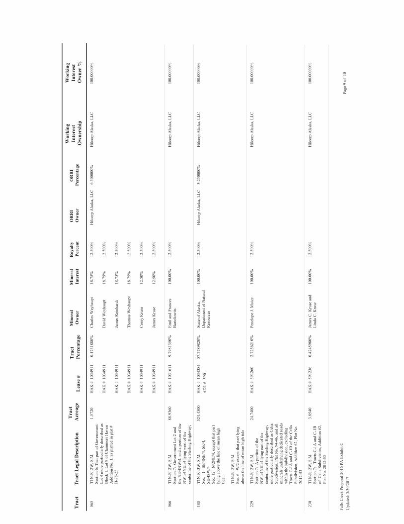
065
1.57
20T1
N-R
12W
, S.M
.Se
ctio
n 6:
Tha
t par
t of G
over
nmen
t Lo
t 4 m
ore
parti
cula
rly d
escr
ibed
as
Blo
ck 1
, Lot
9 o
f Cla
mm
ers H
aven
A
dditi
on N
o. 1
, as p
latte
d in
pla
t #
H-7
8-25
0.17
3188
0%C
harle
s Wey
haup
t12
.500
%10
3491
1H
AK
#18
.75%
Dav
id W
eyha
upt
12.5
00%
1034
911
HA
K #
18.7
5%
Jam
es R
einh
ardt
12.5
00%
1034
911
HA
K #
18.7
5%
Thom
as W
eyha
upt
12.5
00%
1034
911
HA
K #
18.7
5%
Cor
ey K
ruse
12.5
00%
1034
911
HA
K #
12.5
0%
Jam
es K
ruse
12.5
00%
1034
911
HA
K #
12.5
0%
Hilc
orp
Ala
ska,
LLC
6.50
0000
%H
ilcor
p A
lask
a, L
LC10
0.00
000%
066
88.9
360
T1N
-R12
W, S
.M.
Sect
ion
7: G
over
nmen
t Lot
2 a
nd
the
NE/
4NW
/4, a
nd a
por
tion
of th
e N
W1/
4NE1
/4 ly
ing
wes
t of t
he
cent
erlin
e of
the
Ster
ling
Hig
hway
;
9.79
8135
0%Em
il an
d Fr
ance
s B
arto
low
its12
.500
%10
3161
1H
AK
#10
0.00
%H
ilcor
p A
lask
a, L
LC10
0.00
000%
188
524.
4500
T1N
-R13
W, S
.M.
Sec.
1:
SE/
4NE/
4, S
E/4,
SE
/4SW
/4
Sec.
12:
N/2
NE/
4, e
xcep
t tha
t par
t ly
ing
abov
e th
e lin
e of
mea
n hi
gh
tide;
T1N
-R12
W, S
.M.
Sec.
6:
W/2
exc
ept t
hat p
art l
ying
ab
ove
the
line
of m
ean
high
tide
57.7
7898
20%
Stat
e of
Ala
ska,
D
epar
tmen
t of N
atur
al
Res
ourc
es
12.5
00%
1034
384
590
HA
K #
AD
L #
100.
00%
Hilc
orp
Ala
ska,
LLC
3.25
0000
%H
ilcor
p A
lask
a, L
LC10
0.00
000%
229
24.7
400
T1N
-R12
W, S
.M.
Sect
ion
7: A
por
tion
of th
e N
W1/
4NE1
/4 ly
ing
east
of t
he
cent
erlin
e of
the
Ster
ling
Hig
hway
; m
ore
parti
cula
rly d
escr
ibed
as C
elia
Su
bdiv
isio
n, P
lat N
o. 9
4-46
, and
all
min
eral
s und
erly
ing
dedi
cate
d ro
ads
with
in th
e su
bdiv
isio
n, e
xclu
ding
Tr
acts
C-1
A a
nd C
-1B
of t
he C
elia
Su
bdiv
isio
n, A
dditi
on #
2, P
lat N
o.
2012
-53
2.72
5621
0%Pe
nelo
pe J.
Mai
ze12
.500
%59
1260
HA
K #
100.
00%
Hilc
orp
Ala
ska,
LLC
100.
0000
0%
230
3.85
40T1
N-R
12W
, S.M
.Se
ctio
n 7:
Tr
acts
C-1
A a
nd C
-1B
of
Cel
ia S
ubdi
visi
on, A
dditi
on #
2,
Plat
No.
201
2-53
0.42
4598
0%Ja
mes
C. K
ruse
and
Li
nda
C. K
ruse
12.5
00%
5912
36H
AK
#10
0.00
%H
ilcor
p A
lask
a, L
LC10
0.00
000%
Page
9 o
f 10
Falls
Cre
ek P
ropo
sal 2
016
PA E
xhib
it C
Upd
ated
: 3/3
0/20
17

907.
683
0.00
0000
%U
ncom
mitt
ed10
0.00
0000
%H
ilcor
p A
lask
a, L
LC10
0.00
0000
%
Page
10
of 1
0Fa
lls C
reek
Pro
posa
l 201
6 PA
Exh
ibit
CU
pdat
ed: 3
/30/
2017
Ninilchik Unit – First Expansion of Falls Creek Participating Area 43
Attachment 4 Approved Ninilchik Unit Falls Creek Participating Area: Draft Exhibit D of Approved
FCPA (FCPA Map)

15A
48
4950
A
51A 53
A
62
62A
63
65
188
49A
50
62B62
C
64
353
5251
56
59 60 61
6622
9
230
3
3631
32
1
65
12
78
35
112
S002N013W
S002N012W
S001N013W
S001N012W
E0
1,30
02,
600 Fe
et
Uni
t Tra
cts
Prop
osed
Fal
ls C
reek
PA
Nin
ilchi
k U
nit B
ound
ary
Stat
e Pl
ane
Zone
4 N
AD 1
927
(feet
)
Nin
ilchi
k U
nit
Map
Ove
rvie
wEx
hibi
t DN
inilc
hik
Uni
tPr
opos
ed F
alls
Cre
ekPa
rtic
ipat
ing
Are
a
Ninilchik Unit – First Expansion of Falls Creek Participating Area 44
Top Related