


Languages
Pages
Legal

Detailed Island Risk Assessment in Maldives
Natural Hazard and Physical Vulnerability Assessment Report
(Final version)
Volume I: Executive Summary
DIRAM team
Disaster Risk Management Programme
UNDP Maldives
July 2008
2
Table of Contents
Abbreviations
Key Terminologies
List of Tables
List of Figures
Acknowledgement
A. Introduction
B. Key Findings
B.1 Natural Hazards
B.2 Environmental Vulnerability
B.3 Structural Vulnerability
C. Conclusions and Recommendations
C.1 Recommendations for Risk Reduction
C.2 Limitations of the Study
C.3 Recommendations for Future Study

3
Abbreviations
NDRP National Disaster Risk Profile
DIRAM Detailed Island Risk Assessment Maldives
DRM Disaster Risk Management
MEEW Ministry of Environment, Energy, and Water
MPND Ministry of Planning and National Development
MSL Mean Sea Level
PGA Peak Ground Acceleration
RMSI Risk Management Solution India
UNDP United Nations Development Programme
4
Key Terminologies
Consequences: The damages (full or partial), injuries, and losses of life, property, environment, and business that can be quantified by some unit of measure, often in economic or financial terms. It can be defined by the product of exposure and vulnerability or fragility.
Exposure: The number, types, qualities, and monetary values of various types of property or infrastructure and life that may be subject to an undesirable or injurious hazard event. Exposure is merely a quantification of what is at risk in the identified hazard zone.
Hazard: A spectrum of potentially damaging physical events, phenomena or human activities, which may cause the loss of life or injury, property damage, social and economic disruption or environmental degradation.
Hazard profile: A description of the physical characteristics of hazards and a determination of various descriptors including sources of threats, magnitude, duration, frequency, probability, extent and intensity field (spatial distribution of intensity).
Hazard zoning: A process to divide the jurisdiction into zones in terms of the characteristics of a given hazard, such as its intensity or magnitude, frequency, duration etc.
Intensity: A measure of the strength of a hazard event in terms of its damage potential.
Loss estimation: A calculation in monetary amounts of the potential damage to structures and contents, interruption of services, displacement of residents and businesses caused by a hazard. A loss estimation attempts to quantify the consequences of hazard events.
Magnitude: A measure of the strength of a hazard event, or how much energy is released. The magnitude (also referred to as intensity) of a given hazard event is usually determined using technical measures.
Probability: A statistical measure of the likelihood that a hazard event will occur.
Risk: The potential losses associated with a hazard or extreme event, defined in terms of expected probability or frequency and consequences (damage or losses). Natural risk is a function of natural hazard, exposure and vulnerability or fragility.

5
Risk profile: A description of the risks facing a given place within a given timeframe (e.g., short: 0-5 years or less, medium: 5-10 years, long term: 10 years or more), in terms of hazard event scenarios; potential losses, and the probability of occurrence. A more comprehensive risk may include impacts of risk, categorization of risks, relative priority of the risks, risk tolerance levels, linkages between different levels of risks, ways of measuring the risk (qualitative and quantitative), key risk areas/hotspots, risk reduction measures, capacity of the risk takers to do risk management, learning needs and tools, etc.
Vulnerability: The susceptibility to injury or damage from hazards, a synonym of “fragility”. It is a function of the prevalent hazards and the characteristics and quantity of resources or population exposed (or "at risk") to their effects. It is usually expressed as the damage ratio. Vulnerability can be estimated for individual structures, for specific sectors or for selected geographic areas, e.g., areas with the greatest development potential or already developed areas in hazardous zones. Vulnerability assessments are systematic examinations of building elements, facilities, population groups or components of the economy to identify features that are susceptible to damage from the effects of natural hazards.
6
List of Tables
Table 1 Hazard event scenarios for the studied islands
Table 2 Key geophysical characteristics of the surveyed islands
Table 3 Summary of the house vulnerability
Table 4 Summary of the houses at risk
Table 5 Critical facilities at risk
Table 6 Potential functioning impacts on key critical facilities of the studied islands
Table 7 Risk reduction options specific to the studied island
List of Figures
Figure 1 Relationship between hazard intensity and frequency of major natural hazards in the Maldives.
Figure 2 Latitudinal variations of major natural hazards across the Maldives.
Figure 3 Longitudinal variations of major natural hazards across the Maldives.
7
Acknowledgements
The team would like to acknowledge and sincerely thank the Government of
Maldives, particularly officials from the Ministry of Planning and National
Development, Ministry of Environment, Energy and Water, National Disaster
Management Center, Ministry of Atolls Development, Ministry of Fisheries,
Agricultural and Marine Resources, Ministry of Tourism, and Department of
Meteorology, who have supported this study and contributed in a substantive way
towards its completion. We are also thankful the atoll and island offices for their
full cooperation and help with the field survey. We also express our special
thanks to Mr. Mohamed Imad and Ms. Haifa Naeem, the Ministry of Planning and
National Development, for their full support and help with data collection and the
official arrangement of the field survey.
The study team would like to express its gratitude to the Disaster Risk
Management Team of UNDP Maldives, Ms. Rita Missal, Ms. Maria Gemma, Ms.
Fathmath Thasneem, and Umar Friky, for their full managerial and logistical
support in the project implementation.
We acknowledge the guidance and advice for methodological development
provided by Mr. Sanny Jegillos, Regional Coordinator, Mr. Pablo Torrealba, Risk
Reduction Specialist, Regional Center, UNDP Bangkok, and Mr. Glenn
Dolcemasco, Technical Advisor, UNEP Geneava.
The reports on Natural Hazard and Physical Vulnerability, composed of
Executive Summary, Methodological Description, and Detailed Island Reports,
were prepared by:
• Dr. Jianping Yan, Disaster Risk Management Specialist and Team Leader.
• Mr. Ahmed Shaig, Environmental Specialist.
• Mr. Mohamed Aslam, Natural Hazard Specialist.

8
A. Introduction
The entire report of the study is prepared and organized in four volumes:
Executive Summary, Approaches and Methodologies, Detailed Island Reports,
and Databases’ Technical Specifications.
This executive summary is the first of the four reports of the study and is
supposed to serve as a synthesis report of the study as well. It is to
comprehensively summarize the key findings of the detailed island risk
assessment in the Maldives and to explore their implications to island risk
reduction and Safe Island Strategy. Besides, the executive summary also
discusses possible applications of these findings to other islands with similar
features and the limitations of this study. At the end, the summary identifies the
working scope for future study in the context of detailed island risk assessment.
The executive summary is specifically designed for policy and decision makers
who want to have an overview of the risk situations on the investigated islands.
Therefore, it contains few technical elements. However, for those who want to
know details on the specific island or the methodologies used in the respective
surveys, such as land use planner, engineers and researchers, island officers,
etc., it is highly recommended to refer to Volume II that explains the concepts,
framework, processes and working procedures related to the respective
assessments, and Volume III that contains all 10 island reports organized by
island. Each island report is structured in terms of the risk assessment
components, i.e. natural hazards, environmental vulnerability, structural
vulnerability, economic vulnerability, and social vulnerability.
The key findings presented here cover the physical components of the study
only, i.e. natural hazard assessment, environmental vulnerability, and structural
vulnerability. At the point of the time when this report is finished, the social-
economic reports are still not ready.

9
B. Key findings
B.1 Natural hazards
Hazard assessment is to understand and characterize major natural hazards prevailing in the Maldives. The initial assessment of nationwide natural hazards was undertaken in 2005 by UNDP Maldives contracting to Risk Management Solutions India (RMSI) and the key findings of that exercise was presented in the report “Developing a Disaster Risk Profile of Maldives”. This study follows on from this initial assessment to more detailed island level assessments. The general methodology used in this study was based on assessing historical climate data, geological disturbance data, interviews with the elderly, historical documents and the National Disaster Risk Profile (NDRP) of the Maldives. The next few subsections summarize some key findings of the natural hazard assessment of this study.
Major natural hazards
The natural hazards prevailing in the Maldives can be classified into 4 categories:
• Geological hazards – i.e. earthquakes and coastal erosion;
• Meteorological hazard – i.e. tropical cyclones and storms, thunder storms, waterspouts, heavy rainfall, and drought;
• Hydrological hazards – i.e. floods induced by heavy rainfall, storm surges, swell waves, udha, and tsunamis;
• Climate-related hazards – i.e. accelerated sea level rise, sea surface temperature rise, changes in monsoon pattern.
Among those listed above, floods (induced by tsunamis, abnormal swell waves, and heavy rainfall), windstorms, droughts, and earthquake are counted as major natural hazards prevailing in the Maldives.
Tsunamis, with predicted maximum wave heights between 3.2 to 4.5 m above MSL, are the most destructive and devastating of the major natural hazards. For example, the tsunami of December 2004 led to the only known significant fatalities caused by natural hazards in the history of the Maldives and perhaps it is the only natural event at a disastrous level to the country. Tsunami waves

10
mainly approach to the Maldives from the east, most likely the Sumatran Ridge located off the west coast of Indonesia.
Following tsunami hazard, swell waves, storm surges, and Udhas may also cause severe impacts on many low-lying islands in the Maldives, with potential wave heights over 2.5 m above MSL. Overall, swell waves and storm surges are moderate intense, often linked to specific or series of atmospheric events which are more severe in intensity. In comparison with storm surges induced by storms swell waves are less predictable and can occur in fair weather due to its distant origin. Quite different from swell waves and storm surges, Udha refers to annual rise in the water surface on the coast during the SW monsoon season, causing limited coastal flooding with a water depth of less than 0.6 m. Udha is quite unique in the Maldives. However, it still remains unclear about the Udha’s origin.
The rest of natural hazards such as windstorms, rainfall and droughts, and earthquake are generally not severe, except that windstorms may occasionally cause severe destruction across the islands especially during localised storm activities. In most cases, heavy rainfall and droughts lead to temporary disruptions within the islands, but their impacts are rarely significant. Compared to the above mentioned hazards, earthquake hazards are only present in the southern atolls.
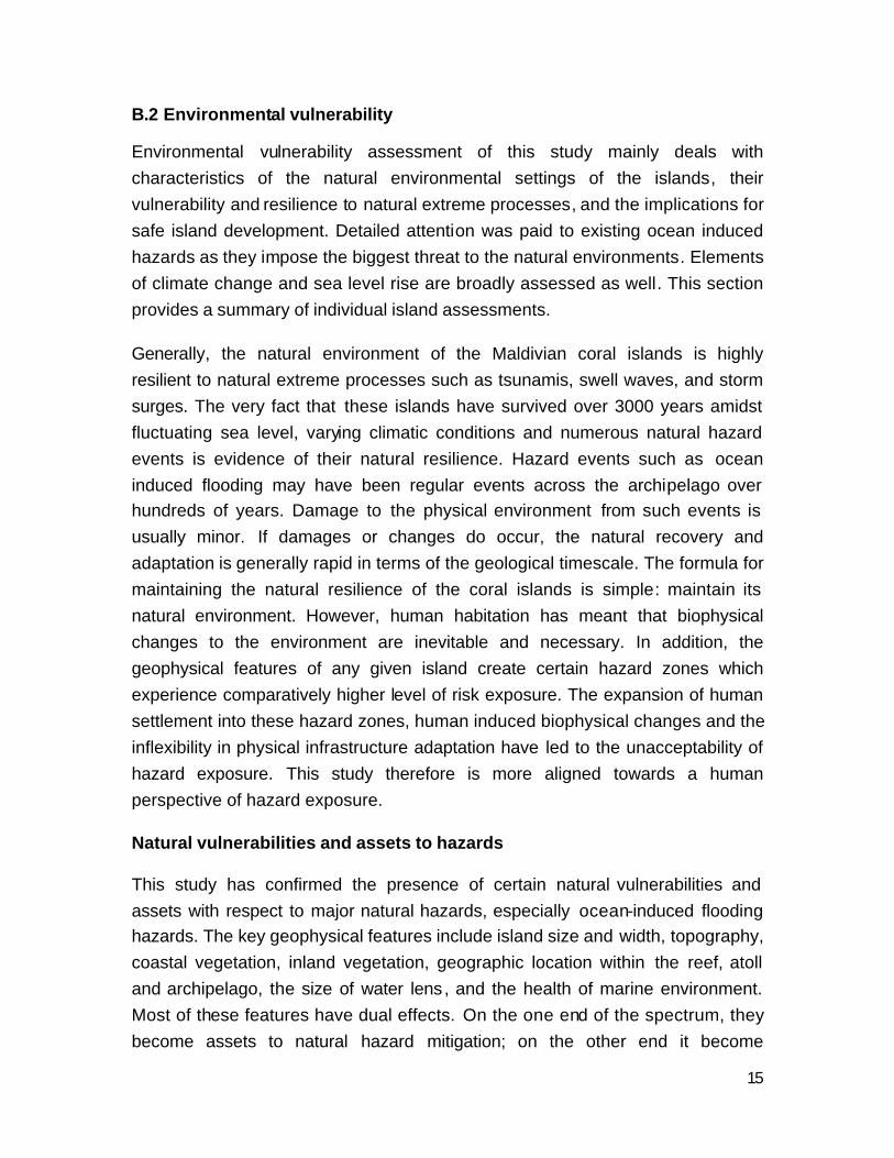
The general patterns of the major natural hazards prevailing in the Maldives can be well summarised in Figure 1.
Se
verit
y
Very high
Very low
Frequency of OccurenceVery low Very high
TSUNAMI
SWELL WAVES
EARTHQUAKE
HEAVY RAINFALL
WINDSTORM
UDHA
DROUGHT
STORM SURGE
11
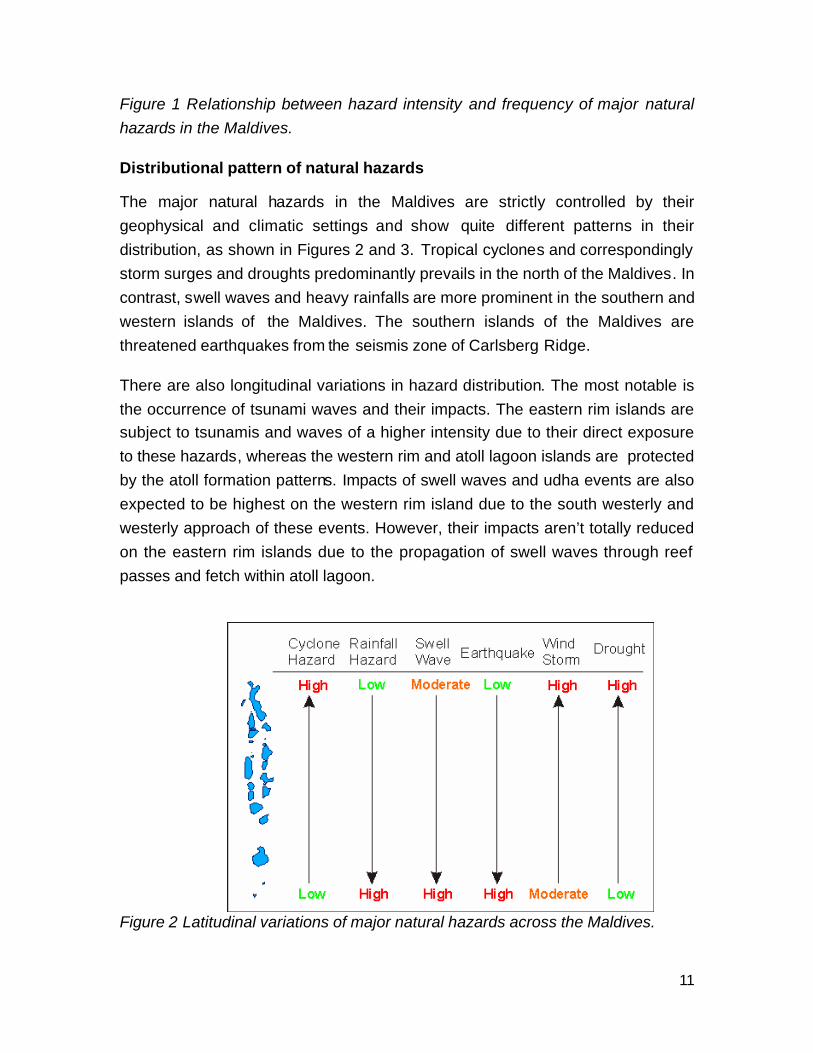
Figure 1 Relationship between hazard intensity and frequency of major natural hazards in the Maldives.
Distributional pattern of natural hazards
The major natural hazards in the Maldives are strictly controlled by their geophysical and climatic settings and show quite different patterns in their distribution, as shown in Figures 2 and 3. Tropical cyclones and correspondingly storm surges and droughts predominantly prevails in the north of the Maldives. In contrast, swell waves and heavy rainfalls are more prominent in the southern and western islands of the Maldives. The southern islands of the Maldives are threatened earthquakes from the seismis zone of Carlsberg Ridge.
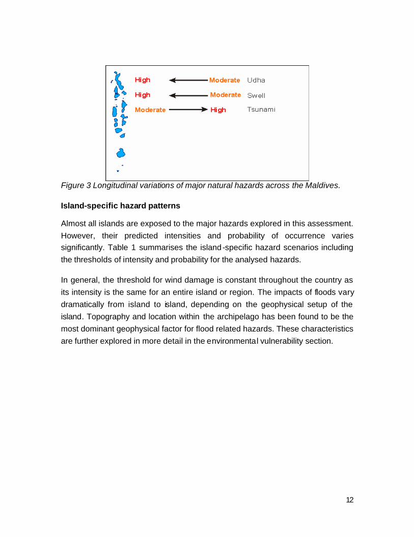
There are also longitudinal variations in hazard distribution. The most notable is the occurrence of tsunami waves and their impacts. The eastern rim islands are subject to tsunamis and waves of a higher intensity due to their direct exposure to these hazards, whereas the western rim and atoll lagoon islands are protected by the atoll formation patterns. Impacts of swell waves and udha events are also expected to be highest on the western rim island due to the south westerly and westerly approach of these events. However, their impacts aren’t totally reduced on the eastern rim islands due to the propagation of swell waves through reef passes and fetch within atoll lagoon.
Figure 2 Latitudinal variations of major natural hazards across the Maldives.
12
Figure 3 Longitudinal variations of major natural hazards across the Maldives.
Island-specific hazard patterns
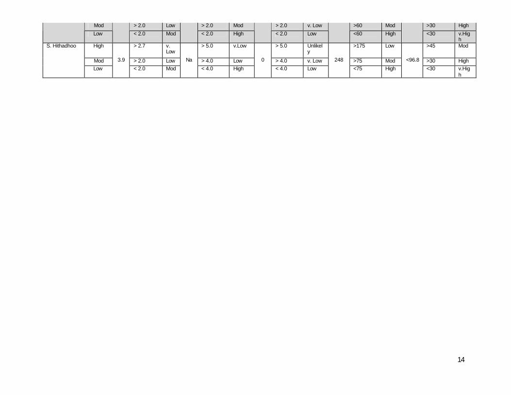
Almost all islands are exposed to the major hazards explored in this assessment. However, their predicted intensities and probability of occurrence varies significantly. Table 1 summarises the island-specific hazard scenarios including the thresholds of intensity and probability for the analysed hazards.
In general, the threshold for wind damage is constant throughout the country as its intensity is the same for an entire island or region. The impacts of floods vary dramatically from island to island, depending on the geophysical setup of the island. Topography and location within the archipelago has been found to be the most dominant geophysical factor for flood related hazards. These characteristics are further explored in more detail in the environmental vulnerability section.

13
Table 1 Hazard event scenarios for the studied islands. Tsunami Swell Waves Storm Surge/Tide Heavy Rainfall Strong Wind Island Intensit
y Max (m)
Threshold (m)
Prob
Max (m)
Threshold (m)
Prob. Max (m)
Threshold (m)
Prob. Max (mm)/ 24hr
Threshold (m)
Prob. Max (knts)
Threshold (m)
Prob.
High > 3.2 v. Low
> 3.0 Low > 3.0 v. Low >160 Low >45 Mod
Mod > 2.5 Low > 2.5 Mod > 2.5 Low >60 Mod >30 High
H.Dh Kulhudhuffushi
Low 5.2
< 2.5 Mod Na
< 2.3 High 2.9
< 2.3 Mod 176
<60 High 96.8
<30 v.High
High > 3.0 v. Low
> 3.0 Low > 3.0 v. Low >150 Low >45 Mod
Mod > 2.3 Low > 2.3 Mod > 2.3 Low >70 Mod >30 High
Sh. Funadhoo
Low 5.2
< 2.3 Mod Na
< 2.3 High 2.9
< 2.3 Mod 176
<70 High 96.8
<30 v.High
High > 3.0 v. Low
> 3.0 Low > 3.0 v. Low >175 Low >45 Mod
Mod > 2.3 Low > 2.3 Mod > 2.3 Low >60 Mod >30 High
K. Thulusdhoo
Low 5.2
< 2.3 Mod Na
< 2.3 High 2.23
< 2.3 Mod 176
<60 High 84.2
<30 v.High
High > 3.0 v. Low
> 3.0 Low > 3.0 v. Low >160 Low >45 Mod
Mod > 2.3 Low > 2.3 Mod > 2.3 Low >60 Mod >30 High
Dh. Kudahuvadhoo
Low 3.9
< 2.3 Mod Na
< 2.3 High 2.23
< 2.3 Mod 241
<60 High 69.6
<30 v.High
High > 4.1 v. Low
> 4.1 Unlikely
> 4.1 Unlikely
>175 Low >45 Mod
Mod > 3.4 Low > 3.4 v.Low > 3.4 Unlikely
>75 Mod >30 High
Th. Vilufushi
Low
5.2
< 3.4 Mod
Na
< 3.4 Mod
2.23
< 3.4 Low
241
<75 High
69.6
<30 v.High
High > 2.7 v. Low
> 2.7 v.Low > 2.7 Unlikely
>175 Low >45 Mod
Mod > 2.0 Low > 2.0 Low > 2.0 v. Low >60 Mod >30 High
L. Gan
Low
5.2
< 2.0 Mod
Na
< 2.0 Mod
2.23
< 2.0 Low
241
<60 High
55.9
<30 v.High
High > 2.7 v. Low
> 2.7 v.Low > 2.7 Unlikely
>175 Low >45 Mod
Mod > 2.0 Low > 2.0 Low > 2.0 v. Low >60 Mod >30 High
GA. Viligilli
Low
5.2
< 2.0 Mod
Na
< 2.0 Mod
0
< 2.0 Low
248
<60 High
<55.9
<30 v.High
High > 2.7 v. Low
> 2.7 Low > 2.7 Unlikely
>175 Low >45 Mod
Mod > 2.0 Low > 2.0 Mod > 2.0 v. Low >60 Mod >30 High
G.dh Thinadhoo
Low
3.2
< 2.0 Mod
Na
< 2.0 High
0
< 2.0 Low
248
<60 High
<96.8
<30 v.High
S. Feydhoo High 3.9
> 2.7 v. Low Na
> 2.7 Low 0
> 2.7 Unlikely 248
>175 Low <96.8
>45 Mod
14
Mod > 2.0 Low > 2.0 Mod > 2.0 v. Low >60 Mod >30 High
Low < 2.0 Mod < 2.0 High < 2.0 Low <60 High <30 v.High
High > 2.7 v. Low
> 5.0 v.Low > 5.0 Unlikely
>175 Low >45 Mod
Mod > 2.0 Low > 4.0 Low > 4.0 v. Low >75 Mod >30 High
S. Hithadhoo
Low
3.9
< 2.0 Mod
Na
< 4.0 High
0
< 4.0 Low
248
<75 High
<96.8
<30 v.High
15
B.2 Environmental vulnerability
Environmental vulnerability assessment of this study mainly deals with characteristics of the natural environmental settings of the islands, their vulnerability and resilience to natural extreme processes, and the implications for safe island development. Detailed attention was paid to existing ocean induced hazards as they impose the biggest threat to the natural environments. Elements of climate change and sea level rise are broadly assessed as well. This section provides a summary of individual island assessments.
Generally, the natural environment of the Maldivian coral islands is highly resilient to natural extreme processes such as tsunamis, swell waves, and storm surges. The very fact that these islands have survived over 3000 years amidst fluctuating sea level, varying climatic conditions and numerous natural hazard events is evidence of their natural resilience. Hazard events such as ocean induced flooding may have been regular events across the archipelago over hundreds of years. Damage to the physical environment from such events is usually minor. If damages or changes do occur, the natural recovery and adaptation is generally rapid in terms of the geological timescale. The formula for maintaining the natural resilience of the coral islands is simple: maintain its natural environment. However, human habitation has meant that biophysical changes to the environment are inevitable and necessary. In addition, the geophysical features of any given island create certain hazard zones which experience comparatively higher level of risk exposure. The expansion of human settlement into these hazard zones, human induced biophysical changes and the inflexibility in physical infrastructure adaptation have led to the unacceptability of hazard exposure. This study therefore is more aligned towards a human perspective of hazard exposure.
Natural vulnerabilities and assets to hazards
This study has confirmed the presence of certain natural vulnerabilities and assets with respect to major natural hazards, especially ocean-induced flooding hazards. The key geophysical features include island size and width, topography, coastal vegetation, inland vegetation, geographic location within the reef, atoll and archipelago, the size of water lens, and the health of marine environment. Most of these features have dual effects. On the one end of the spectrum, they become assets to natural hazard mitigation; on the other end it become
16
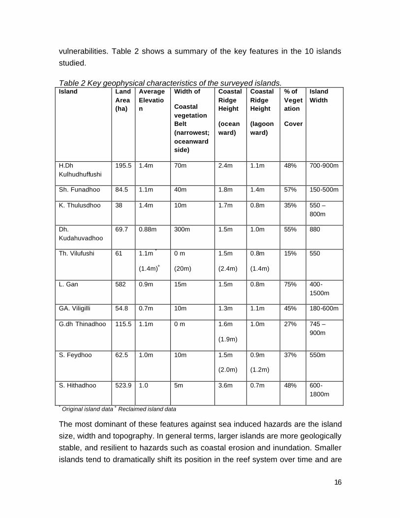
vulnerabilities. Table 2 shows a summary of the key features in the 10 islands studied.
Table 2 Key geophysical characteristics of the surveyed islands. Island Land
Area (ha)
Average Elevation
Width of
Coastal vegetation Belt (narrowest; oceanward side)
Coastal Ridge Height
(oceanward)
Coastal Ridge Height
(lagoonward)
% of Vegetation
Cover
Island Width
H.Dh Kulhudhuffushi
195.5 1.4m 70m 2.4m 1.1m 48% 700-900m
Sh. Funadhoo 84.5 1.1m 40m 1.8m 1.4m 57% 150-500m
K. Thulusdhoo 38 1.4m 10m 1.7m 0.8m 35% 550 – 800m
Dh. Kudahuvadhoo
69.7 0.88m 300m 1.5m 1.0m 55% 880
Th. Vilufushi 61 1.1m *
(1.4m)+
0 m
(20m)
1.5m
(2.4m)
0.8m
(1.4m)
15% 550
L. Gan 582 0.9m 15m 1.5m 0.8m 75% 400-1500m
GA. Viligilli 54.8 0.7m 10m 1.3m 1.1m 45% 180-600m
G.dh Thinadhoo 115.5 1.1m 0 m 1.6m
(1.9m)
1.0m 27% 745 – 900m
S. Feydhoo 62.5 1.0m 10m 1.5m
(2.0m)
0.9m
(1.2m)
37% 550m
S. Hithadhoo 523.9 1.0 5m 3.6m 0.7m 48% 600-1800m
* Original island data + Reclaimed island data
The most dominant of these features against sea induced hazards are the island size, width and topography. In general terms, larger islands are more geologically stable, and resilient to hazards such as coastal erosion and inundation. Smaller islands tend to dramatically shift its position in the reef system over time and are
17
more likely to be completely inundated during flooding events. Size itself may be misleading as width of the island is also crucial against flooding events. Certain gravity waves such as tsunamis and long distance storm waves have specific wave lengths and heights which could run up over land regardless of the island size. If the island is narrow and oriented parallel to the waves, such waves could completely inundate an island, while wider islands would restrict the extent of inundation from a similar wave. This pattern is partly evident in the difference in flooding between narrower islands such as L.Fonadhoo, Th. Vilufushi, GA. Viligilli and the larger islands such L.Gan and Dh. Kudahuvadhoo.
Island topography is one of the main natural vulnerabilities as well as the most efficient natural mitigation measures against flooding. Maldivian islands are generally low-lying with all the islands studied having average elevations below 1.5 m. The difference in resilience to flooding lies in the oceanward ridge height. The higher the ridge system the more resilient the island is to flooding events. Ridges are generally a response to high waves and storm activities, and vary geographically across the archipelago. The northern and southern atolls which are more exposed to storm events and monsoonal winds generally have higher ridges, while islands in the mid atolls which are less exposed do not have substantial ridges. The island size and width may be of little help during flooding events, if the oceanward ridges are substantially low. For example, flood waters during the tsunami of 2004 reached 1000 m inland in L.Gan where the ridge height is just 1.5 m, while tsunami waves failed to overtop the 2.4 m high ridge in H.Dh Kulhudhuffushi. While high ridges protect the oceanward side of the island, the lagoonward side, which are generally low lying (see Table 1), remain highly exposed. Island with high oceanward ridges are likely to be resilient to gravity waves and surges from the oceanward side but remain exposed to storm surges, seasonal surges (udha) and long distance storm waves approaching from the lagoonward side. Unfortunately. most settlements are located on the lagoonward coastline, exposing them to such flooding events.
The topographic profile within the island was also found to facilitate or prevent flood run-up. Usually, circular islands or large islands tend to fo rm depressions in the middle as island evolves over time (e.g. Dh. Kudahuvadhoo, K. Thuludhoo, L.Gan, and S.Hithadhoo). Some islands, especially narrow and elongated islands tend to have relic ridge systems within the island. Islands with low depressions without high ridge systems are more prone to flooding due to the inward sloping
18
gradient. Extensive flooding in L.Gan and GA. Viligilli is believed to be caused by such depressions and low ridges. Islands with inland relic ridge systems have a distinct advantage in controlling wave run-up as they form a barrier against further run-up. Examples of such systems are found in Dh.Kudahuvadhoo, K.Thuludhoo and G.Dh. Thinadhoo. In almost all islands studied, the extent of 2004 tsunami wave run-up is marked by a distinct change in topography. Unfortunately, the depressed areas make good agricultural land due to higher watertable and are often characterised by less salt tolerant vegetation species. At times of flooding widespread mortality is eminent especially amongst introduced species of such low areas. The island of GA. Viligilli lost 90% of its Mango and Bread fruit trees during the tsunami of 2004, all of which were incidentally located within low lying, former wetland areas. Settlements located within the depressed zones are also more likely to experience regular flooding during heavy rainfall. Islands in the south are particularly exposed to such flooding due to high rainfall and due to the presence of wetlands.
Coastal vegetation was also found to play an important role in reducing wave energy propagation on land. However, vegetation does not appear to restrict the extent of run-up, especially during the 2004 tsunami, since the entire wavelength was disposed regardless of the obstructions. The effects during storm surges are expected to be similar. A strong coastal vegetation belt is found to be ideal as natural mitigation measure when formed in high ridge system and with certain vegetation composition and density. Usually in inhabited islands, the undergrowth in coastal vegetation is cleared for aesthetic reasons. However it was found that undergrowth is a key element of a coastal vegetation belt in terms of reducing wave and wind energy.
Island location within the archipelago or within the atoll exposes them to different natural hazards. Islands on the eastern rim of atolls are more exposed to tsunamis while islands within the atoll and on the western side are comparatively less exposed. Islands in the south are more exposed to southwest monsoon related surges and long distance swells originating from the southern Indian Ocean. Islands in the north are more exposed to storm events and their impacts including storm surges and strong wind. Islands in the south are more exposed to rainfall related flooding due to high rainfall. Island on the eastern rim of open
19
atolls1 such as the northern atolls are exposed to south west monsoon related flooding due to wave activity and low elevation of lagoonward side.
Other geographic features which increase the resilience of islands include a large water lens and healthy marine environment.
Human-induced vulnerabilities
In addition to the natural environment vulnerabilities identified above, human- induced biophysical changes have led to further deterioration of the present natural vulnerabilities and introduction of new vulnerabilities. The most serious impacts appear to result from the alteration of topography and coastal environment, and from improper land use patterns. Alteration of topography involves land reclamation and road maintenance activities. As noted above, islands have natural variations in topography which facilitates drainage. Similarly the oceanward coastline retains natural defences against prevailing sea-induced hazards. Land reclamation towards the reef flat, especially on the oceanward side, alters the natural defensive mechanisms of the islands and the drainage systems. This is usually the result of poor land reclamation practices which at present do not consider their impacts on the natural features of an island. In the island of Thinadhoo, land was reclaimed close to the wave-broken zone without considering the natural elevation of ridges or the existing topography of the island. As a result, the reclaimed area is frequently flooded during the southwestern monsoon high tides (udha) and during heavy rainfall. Land reclamation towards wetlands often does not consider protecting the existing island topography and drainage systems. As a result, subsequent developments in the region are subject to frequent rainfall flooding as found in GA. Viligilli, G.Dh Thinadhoo, Hdh. Kulhudhuffushi, and S. Hithadhoo.
Alteration of coastal environment through development activities such as harbour construction, beach erosion mitigation, and land reclamation often alter the coastal processes operating around the island. Consequently, most islands undergo rapid transformation in coastal processes. In some cases, this leads to rapid coastal erosion and decrease in the natural adaptive capacity against natural hazards. Similarly, land use patterns in the islands have major impacts on
1 Defined as atolls with larger reef passes or Kanduolhi, allowing propagation of waves through the atoll
20
the natural defensive systems of an island. Land uses with negative impacts include the settlement encroachment into coastal vegetation belts, the subsequent removal of vegetation protection, and the alteration of the protective oceanward ridges. These areas should be considered buffer zones against natural hazards which are bound to be affected during hazard events. Development in this zone usually enhances the exposure of structures to natural hazards.
The removal of vegetation for settlement purposes is another factor that further exposes islands to natural hazards, such as wind storms. Strong vegetation cover minimises the impacts of strong winds. However, the demand for housing land leads to a gradual decline in vegetation cover across highly populated islands. Similarly, a gradual deterioration of the natural environment due to the human habitation is slowly reducing the natural resilience of the islands and its surroundings. The most critical of these are the deterioration of coral reefs around inhabited islands and salinisation of ground water due to over extraction.
Environmental impacts
As noted earlier, the natural environment of the Maldives is highly resilient to periodic natural hazards. However, significant impacts from hazard events are usually limited to vegetation and geomorphology. Vegetation is severely hit for introduced species such as crops and large fruit trees (e.g. mango and breadfruit). Natural processes tend to adapt these changes and recover rapidly, although vegetation regrowth of larger trees may be slow. Often, natural events have positive impacts on the environment with stronger defensive systems established due to the alteration of coastal geomorphology (e.g. the creation of coral ramparts in Sh.Funadhoo) and with the re-distribution of vegetation species and nutrients across the island. Such positive impacts, although small, provide long term benefits for the environment.
The environmental impacts from sea level rise are much more complicated to predict at this stage. There are two scenarios. First, if the sea level continues to rise as projected and the coral reef system keep up with the rising sea level and survive the rise in Sea Surface Temperatures then, the negative geological impacts are expected to be negligible. Second, if the sea level continues to rise as projected and the coral reefs fail to keep-up, then their could be substantial
21
changes to the land. The question whether the coral islands could adjust to the latter scenario may not be answered convincingly based on current research. However, it is clear that the highly, modified environments of islands studied here, stands to undergo substantial change or damage (even during the potential long-term geological adjustments), due to potential loss of land through erosion, increased inundations and salt water intrusion into water lens.
In summary, none of the islands in the Maldives is safe from natural hazards with high impacts they are facing. The natural environment of an island is highly resilient to the impacts from hazard events, but may not prevent or protect the islands from major hazard events. However, the probabilities of occurrence of such large scale hazards are low and perhaps unavoidable with any practical level of planning. The majority of present natural hazards facing the Maldives, however, can be avoided through natural resilience, proper land use, and artificial means. It is crucial that development activities in the Maldives be aligned to consider the precarious nature of coral islands and the impacts of natural hazards. The natural environment of the coral island has provided the best examples of mitigation measures through their defensive mechanisms. It’s important that these mechanisms be maintained and facilitated, where present. If artificial measures are required, replicating the natural systems perhaps may provide the most efficient defensive system for the Maldives.
B.3 Structural vulnerability
House vulnerability
Most vulnerable houses are found on Hithadhoo and Feydhoo Islands, followed
by Viligili, Thinadhoo, Kulhudhuffushi, and L. Gan. However, Feydhoo and Viligili
Island have the highest percentage of vulnerable houses, more than 20%; L.
Gan, Thinadhoo and Hithadhoo 10-20%; and Vulnerable houses on
Kulhudhufushi and Funadhoo Island account for less than 10% only.
The regionality of the house vulnerability is prominent. In the north, structural
factor dominates the house vulnerability. For example, the vulnerable houses
identified in Kulhudhuffushi and Funadhoo are without exemption due to their
22
weak structure. This implies that houses on these islands are well protected
against ocean-originated flooding and not exposed to road flooding. However,
from north to south, non-structural factors (i.e. protection and location) become
dominant. For example, L. Gan and Ga. Viligili in the middle of the Maldives, are
exposed to ocean-originated flooding either without proper protection or too close
to the shoreline in the ocean-originated flood-prone area. The weak structure of
the houses combined with their poor protection makes the houses of these
islands especially vulnerable to flooding events. In the south, islands such as
Thinadhoo, Hithadhoo, and Feydhoo, are less exposed to ocean-originated
flooding, but houses on these islands are extensively subject to household-wide
flooding, a human-induced flood due to the improper levelling of the road surface.
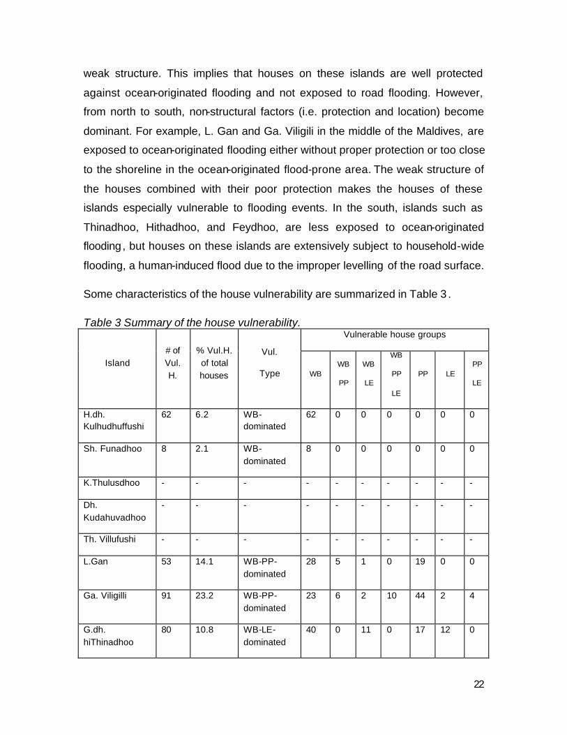
Some characteristics of the house vulnerability are summarized in Table 3 .
Table 3 Summary of the house vulnerability. Vulnerable house groups
Island # of Vul. H.
% Vul.H. of total houses
Vul.
Type WB WB
PP
WB
LE
WB
PP
LE
PP LE PP
LE
H.dh. Kulhudhuffushi
62 6.2 WB-dominated
62 0 0 0 0 0 0
Sh. Funadhoo 8 2.1 WB-dominated
8 0 0 0 0 0 0
K.Thulusdhoo - - - - - - - - - -
Dh. Kudahuvadhoo
- - - - - - - - - -
Th. Villufushi - - - - - - - - - -
L.Gan 53 14.1 WB-PP-dominated
28 5 1 0 19 0 0
Ga. Viligilli 91 23.2 WB-PP-dominated
23 6 2 10 44 2 4
G.dh. hiThinadhoo
80 10.8 WB-LE-dominated
40 0 11 0 17 12 0
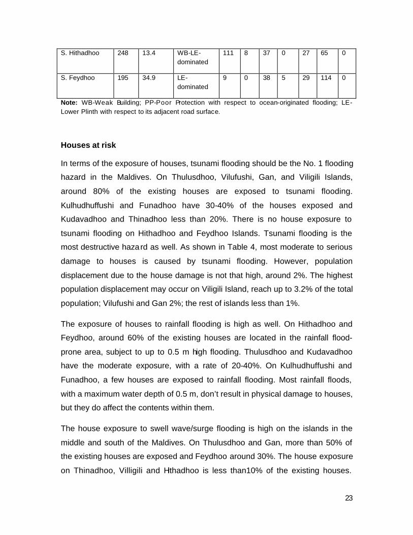
23
S. Hithadhoo 248 13.4 WB-LE-dominated
111 8 37 0 27 65 0
S. Feydhoo 195 34.9 LE-dominated
9 0 38 5 29 114 0
Note: WB-Weak Building; PP-Poor Protection with respect to ocean-originated flooding; LE-Lower Plinth with respect to its adjacent road surface.
Houses at risk
In terms of the exposure of houses, tsunami flooding should be the No. 1 flooding
hazard in the Maldives. On Thulusdhoo, Vilufushi, Gan, and Viligili Islands,
around 80% of the existing houses are exposed to tsunami flooding.
Kulhudhuffushi and Funadhoo have 30-40% of the houses exposed and
Kudavadhoo and Thinadhoo less than 20%. There is no house exposure to
tsunami flooding on Hithadhoo and Feydhoo Islands. Tsunami flooding is the
most destructive hazard as well. As shown in Table 4, most moderate to serious
damage to houses is caused by tsunami flooding. However, population
displacement due to the house damage is not that high, around 2%. The highest
population displacement may occur on Viligili Island, reach up to 3.2% of the total
population; Vilufushi and Gan 2%; the rest of islands less than 1%.
The exposure of houses to rainfall flooding is high as well. On Hithadhoo and
Feydhoo, around 60% of the existing houses are located in the rainfall flood-
prone area, subject to up to 0.5 m high flooding. Thulusdhoo and Kudavadhoo
have the moderate exposure, with a rate of 20-40%. On Kulhudhuffushi and
Funadhoo, a few houses are exposed to rainfall flooding. Most rainfall floods,
with a maximum water depth of 0.5 m, don’t result in physical damage to houses,
but they do affect the contents within them.
The house exposure to swell wave/surge flooding is high on the islands in the
middle and south of the Maldives. On Thulusdhoo and Gan, more than 50% of
the existing houses are exposed and Feydhoo around 30%. The house exposure
on Thinadhoo, Villigili and Hithadhoo is less than10% of the existing houses.
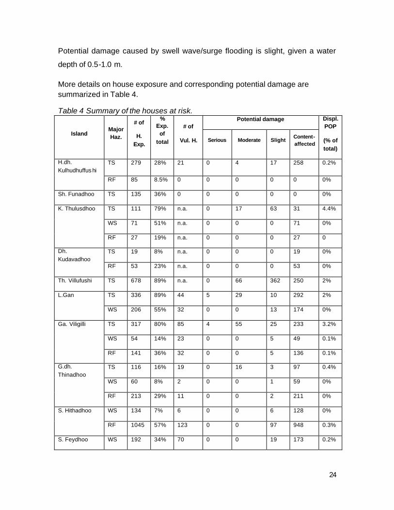
24
Potential damage caused by swell wave/surge flooding is slight, given a water
depth of 0.5-1.0 m.
More details on house exposure and corresponding potential damage are summarized in Table 4.
Table 4 Summary of the houses at risk. Potential damage
Island Major Haz.
# of
H. Exp.
% Exp.
of total
# of
Vul. H. Serious Moderate Slight Content- affected
Displ. POP
(% of total)
TS 279 28% 21 0 4 17 258 0.2% H.dh. Kulhudhuffus hi
RF 85 8.5% 0 0 0 0 0 0%
Sh. Funadhoo TS 135 36% 0 0 0 0 0 0%
TS 111 79% n.a. 0 17 63 31 4.4%
WS 71 51% n.a. 0 0 0 71 0%
K. Thulusdhoo
RF 27 19% n.a. 0 0 0 27 0
TS 19 8% n.a. 0 0 0 19 0% Dh. Kudavadhoo
RF 53 23% n.a. 0 0 0 53 0%
Th. Villufushi TS 678 89% n.a. 0 66 362 250 2%
TS 336 89% 44 5 29 10 292 2% L.Gan
WS 206 55% 32 0 0 13 174 0%
TS 317 80% 85 4 55 25 233 3.2%
WS 54 14% 23 0 0 5 49 0.1%
Ga. Viligilli
RF 141 36% 32 0 0 5 136 0.1%
TS 116 16% 19 0 16 3 97 0.4%
WS 60 8% 2 0 0 1 59 0%
G.dh. Thinadhoo
RF 213 29% 11 0 0 2 211 0%
WS 134 7% 6 0 0 6 128 0% S. Hithadhoo
RF 1045 57% 123 0 0 97 948 0.3%
S. Feydhoo WS 192 34% 70 0 0 19 173 0.2%
25
RF 341 61% 117 0 0 31 310 0.3%
Note: TS-Tsunami; WS-Wave/surge; RF-Rainfall.
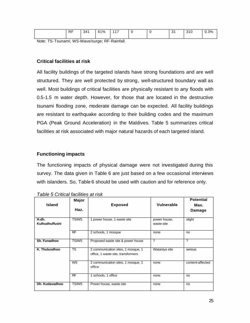
Critical facilities at risk
All facility buildings of the targeted islands have strong foundations and are well
structured. They are well protected by strong, well-structured boundary wall as
well. Most buildings of critical facilities are physically resistant to any floods with
0.5-1.5 m water depth. However, for those that are located in the destructive
tsunami flooding zone, moderate damage can be expected. All facility buildings
are resistant to earthquake according to their building codes and the maximum
PGA (Peak Ground Acceleration) in the Maldives. Table 5 summarizes critical
facilities at risk associated with major natural hazards of each targeted island.
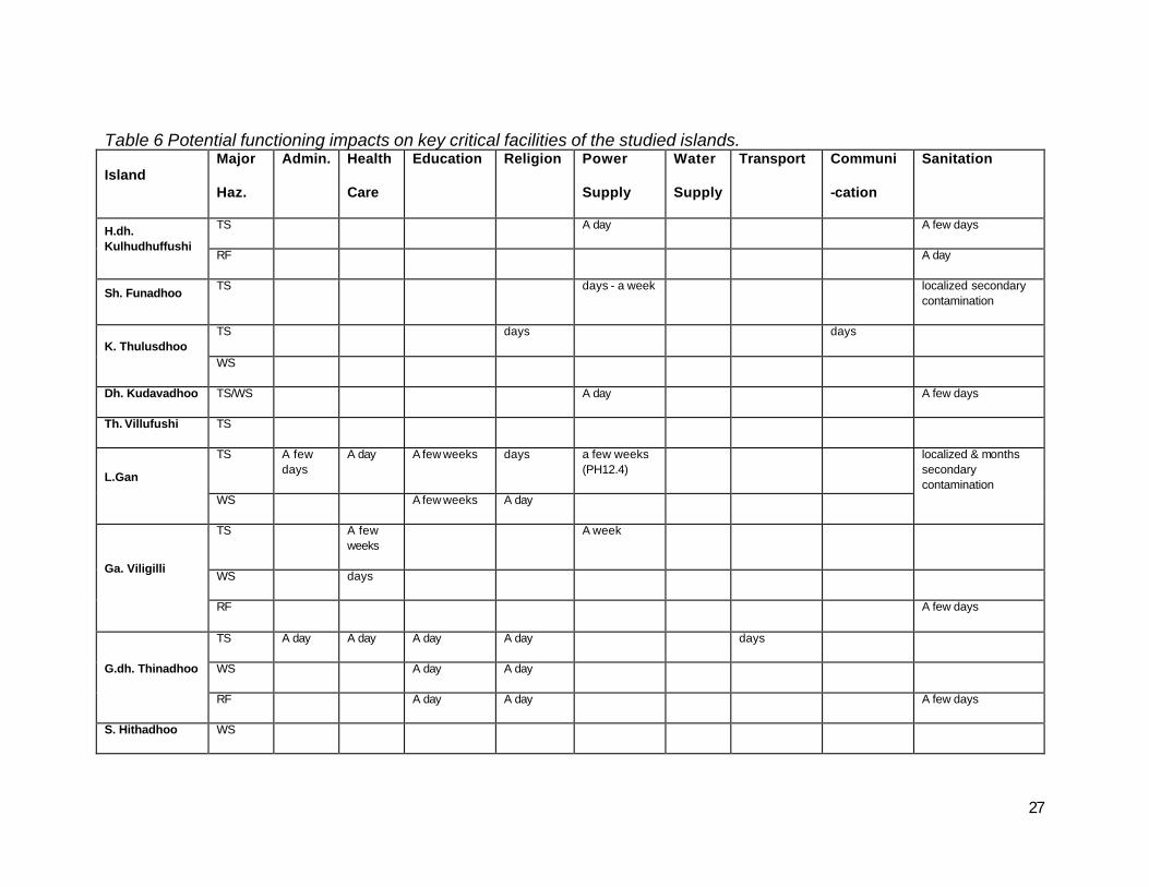
Functioning impacts
The functioning impacts of physical damage were not investigated during this
survey. The data given in Table 6 are just based on a few occasional interviews
with islanders. So, Table 6 should be used with caution and for reference only.
Table 5 Critical facilities at risk
Island Major
Haz. Exposed Vulnerable
Potential Max.
Damage
TS/WS 1 power house, 1 waste site power house, waste site
slight H.dh. Kulhudhuffushi
RF 2 schools, 1 mosque none no
Sh. Funadhoo TS/WS Proposed waste site & power house ? ?
TS 2 communication sites, 1 mosque, 1 office, 1 waste site, transformers
Wataniya site serious
WS 2 communication sites, 1 mosque, 1 office
none content-affected
K. Thulusdhoo
RF 1 schools, 1 office none no
Dh. Kudavadhoo TS/WS Power house, waste site none no
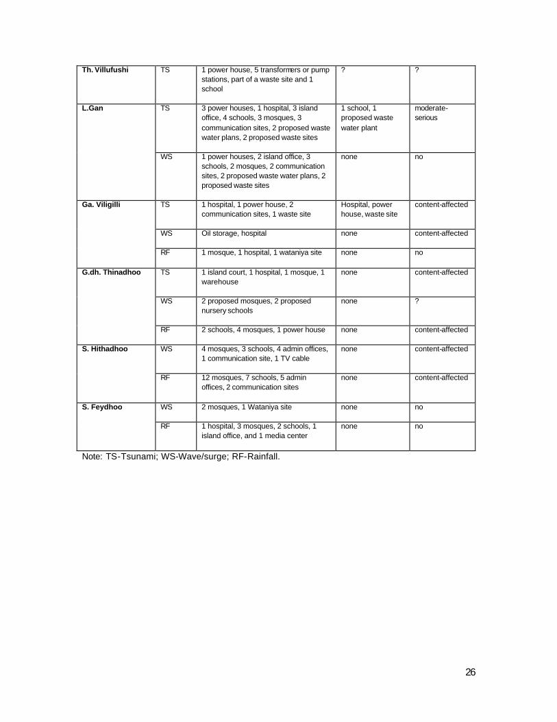
26
Th. Villufushi TS 1 power house, 5 transformers or pump stations, part of a waste site and 1 school
? ?
TS 3 power houses, 1 hospital, 3 island office, 4 schools, 3 mosques, 3 communication sites, 2 proposed waste water plans, 2 proposed waste sites
1 school, 1 proposed waste water plant
moderate-serious
L.Gan
WS 1 power houses, 2 island office, 3 schools, 2 mosques, 2 communication sites, 2 proposed waste water plans, 2 proposed waste sites
none no
TS 1 hospital, 1 power house, 2 communication sites, 1 waste site
Hospital, power house, waste site
content-affected
WS Oil storage, hospital none content-affected
Ga. Viligilli
RF 1 mosque, 1 hospital, 1 wataniya site none no
TS 1 island court, 1 hospital, 1 mosque, 1 warehouse
none content-affected
WS 2 proposed mosques, 2 proposed nursery schools
none ?
G.dh. Thinadhoo
RF 2 schools, 4 mosques, 1 power house none content-affected
WS 4 mosques, 3 schools, 4 admin offices, 1 communication site, 1 TV cable
none content-affected S. Hithadhoo
RF 12 mosques, 7 schools, 5 admin offices, 2 communication sites
none content-affected
WS 2 mosques, 1 Wataniya site none no S. Feydhoo
RF 1 hospital, 3 mosques, 2 schools, 1 island office, and 1 media center
none no
Note: TS-Tsunami; WS-Wave/surge; RF-Rainfall.
27
Table 6 Potential functioning impacts on key critical facilities of the studied islands.
Island Major
Haz.
Admin. Health
Care
Education Religion Power
Supply
Water
Supply
Transport Communi
-cation
Sanitation
TS A day A few days H.dh. Kulhudhuffushi
RF A day
Sh. Funadhoo TS days - a week localized secondary
contamination
TS days days K. Thulusdhoo
WS
Dh. Kudavadhoo TS/WS A day A few days
Th. Villufushi TS
TS A few days
A day A few weeks days a few weeks (PH12.4)
L.Gan
WS A few weeks A day
localized & months secondary contamination
TS A few weeks
A week
WS days Ga. Viligilli
RF A few days
TS A day A day A day A day days
WS A day A day G.dh. Thinadhoo
RF A day A day A few days
S. Hithadhoo WS
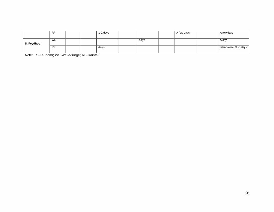
28
RF 1-2 days A few days A few days
WS days A day S. Feydhoo
RF days Island-wise, 3 -5 days
Note: TS-Tsunami; WS-Wave/surge; RF-Rainfall.
29
C. Conclusions and Recommendations
C.1 Recommendations for risk reduction
Natural hazard exposure
The current Safe Island Development Programme builds on the assumption that any island could be made safer using appropriate technology. The findings from this
report both supports the claim but challenges some of the ass umptions put in the current design of safe islands. It is recommended that the Safe Island Development
Programme be reviewed in light of the findings of this report. Particular attention should be given to the following findings:
• There are no geophysically-safe islands amongst the islands studied and it is
unlikely to find one in the Maldives due to the low elevation and small size of land . Each island has a maximum threshold level, especially for flood events,
above which an event could flood and cause biophysical, structural and socio-economic impacts along the entire island. Planning activities could target increasing this threshold level.
• All islands are generally exposed to natural hazards, but the degree of
exposure varies comparatively based on geophysical setup.
• It may be possible to control the impact of hazards for existing events using
engineering solutions. However, suitability of adopted solutions to slow onset hazards such as climate change is questionable especially in the coral island
environment.
• Safe Islands cannot be developed based on a standard set of designs such
as a constant ridge height and artificial topography. If engineering options are to be adapted, it should be designed to withstand a predicted severe intensity
event, if not a maximum predicted event specific to the island under consideration.
Environmental vulnerability
Recommendations for Safe Island development have been provided for each island in Volume three of this report. The generalised summary of key recommendations is as follows:
• Alterations to physical environment will have consequences for hazard exposure in any island. Current high impact development activities need to be
re-evaluated and streamlined to minimise impacts on hazard exposure. Land reclamation activities require urgent attention in this regard. The regulations
30
and best practices guide for reclamation needs to be established based on informed studies. Potential steps that can be considered include replicating
defensive features of natural environment such as proper topographic profiling, soil profiling, revegetation, drainage establishment and minimising
construction phase irreversible impacts on the environment.
• A number of vulnerabilities already exist on the surveyed islands. It is
important that the most critical environmental vulnerabilities be addressed within any safe island development programme. These include restoring terrestrial and marine environment, addressing negative affects of past improper reclamation activities and protecting exposed zones in the islands.
• Elements proposed in the present safe island development concept needs to be reviewed based on the findings of this study. Some elements require
further studies to determine the appropriateness but others should be reviewed immediately. These include the drainage zones, vegetation belt and
their proposed functions within the EPZ zone, and the concept of topographically raised evacuation zones. The vegetation zone needs to
reconsider their width, composition and timely introduction within the broad development programme. Constant height of ridges needs to be reviewed as
there are different wave regimes across different zones and locations in Maldives.
• Population consolidation increases the risk of exposure to hazards, if consolidation is taking place in a known vulnerable location and if mitigation measures are non-existent or inadequate. Consolidating population creates high density settlements which itself exposes more people in single location
should the hazard strike in that location. Evidence from other high density settlements show that development takes priority in such islands and hazard
risks are often ignored. It is therefore imperative that hazard mitigation is incorporated as an essential part of general land use planning within the
Population Consolidation Programme and not just Safe Island development programme.
Structural Vulnerability
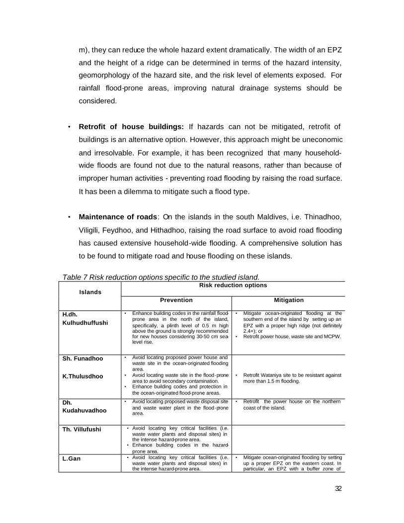
Some Island-specific options for risk reduction from the perspective of structural
vulnerability are summarized in Table 7 and briefly explained as follows:
31
• Location of key critical facilities (Land use planning): It is recommended to
avoid locating key critical facilities, such as hospital, power house, waste site,
storage, in the destructive hazard zone, because the failure of these key critical
facilities has community-wide adverse impacts and especially important to
emergency response and disaster relief.
• Enhancement of building codes: The enhancement of building codes may
differ from hazard zone to hazard zone. Options for ocean-originated floods, i.e.
tsunami and swell wave/surge inundation, should focus on strong building in the
destructive hazard zone, supplemented by strong boundary walls with
appropriate height and proper orientation of the buildings with respect to wave
propagation direction. In contrast, options for rainfall floods are strong
foundation with proper height. In terms of the potential sea level rise of 30-50
cm, a height of 0.5 m for house plinth level should be reasonable, in particular,
in the rainfall flood-prone areas that were originally reclaimed from wet lands.
• Protection and improvement of natural drainage systems: It is
recommended to avoid degrading natural drainage systems while constructing
critical infrastructure, such as road, harbour, etc. or reclaiming land from
wetlands. Improper leve lling of the road surface may cause unexpected flooding
to other areas that are not affected before. Two of the typical examples are the
road maintenance applied on the south islands of the Maldives and the harbour
construction. The former has resulted in household-wide flooding in its adjacent
households and the latter has made the loading and unloading area subjected
to flooding frequently due to the blockage of natural groundwater flow systems.
• Hazard mitigation: Under certain circumstances, hazard mitigation might be
one of the cost/effective options for risk reduction, in comparison with the costly
extensive retrofit of houses and critical facilities. For example, EPZ
(Environmental Protection Zone) proposed by the Safe Island Development
Programme is a good option for mitigating flooding induced by ocean-originated
hazards. Although EPZs may not significantly reduce the width of the
destructive tsunami zones (an area with an inundation depth of more than 1.5
32
m), they can reduce the whole hazard extent dramatically. The width of an EPZ
and the height of a ridge can be determined in terms of the hazard intensity,
geomorphology of the hazard site, and the risk level of elements exposed. For
rainfall flood-prone areas, improving natural drainage systems should be
considered.
• Retrofit of house buildings: If hazards can not be mitigated, retrofit of
buildings is an alternative option. However, this approach might be uneconomic
and irresolvable. For example, it has been recognized that many household-
wide floods are found not due to the natural reasons, rather than because of
improper human activities - preventing road flooding by raising the road surface.
It has been a dilemma to mitigate such a flood type.
• Maintenance of roads: On the islands in the south Maldives, i.e. Thinadhoo,
Viligili, Feydhoo, and Hithadhoo, raising the road surface to avoid road flooding
has caused extensive household-wide flooding. A comprehensive solution has
to be found to mitigate road and house flooding on these islands.
Table 7 Risk reduction options specific to the studied island.
Risk reduction options Islands
Prevention Mitigation
H.dh. Kulhudhuffushi
• Enhance building codes in the rainfall flood-prone area in the north of the island, specifically, a plinth level of 0.5 m high above the ground is strongly recommended for new houses considering 30-50 cm sea-level rise.
• Mitigate ocean-originated flooding at the southern end of the island by setting up an EPZ with a proper high ridge (not definitely 2.4+); or
• Retrofit power house, waste site and MCPW.
Sh. Funadhoo • Avoid locating proposed power house and waste site in the ocean-originated flooding area.
K.Thulusdhoo • Avoid locating waste site in the flood-prone area to avoid secondary contamination.
• Enhance building codes and protection in the ocean-originated flood-prone areas.
• Retrofit Wataniya site to be resistant against more than 1.5 m flooding.
Dh. Kudahuvadhoo
• Avoid locating proposed waste disposal site and waste water plant in the flood-prone area.
• Retrofit the power house on the northern coast of the island.
Th. Villufushi • Avoid locating key critical facilities (i.e. waste water plants and disposal sites) in the intense hazard-prone area.
• Enhance building codes in the hazard-prone area.
L.Gan • Avoid locating key critical facilities (i.e. waste water plants and disposal sites) in the intense hazard-prone area.
• Mitigate ocean-originated flooding by setting up a proper EPZ on the eastern coast. In particular, an EPZ with a buffer zone of
33
• Enhance building codes in the ocean-originated flood-prone area on the eastern coast.
proper width is required for the Mukurimagu coast;
• Retrofit the power house and school in the Mukurimagu division, if no proper EPZ is available along the Mukurimagu coast.
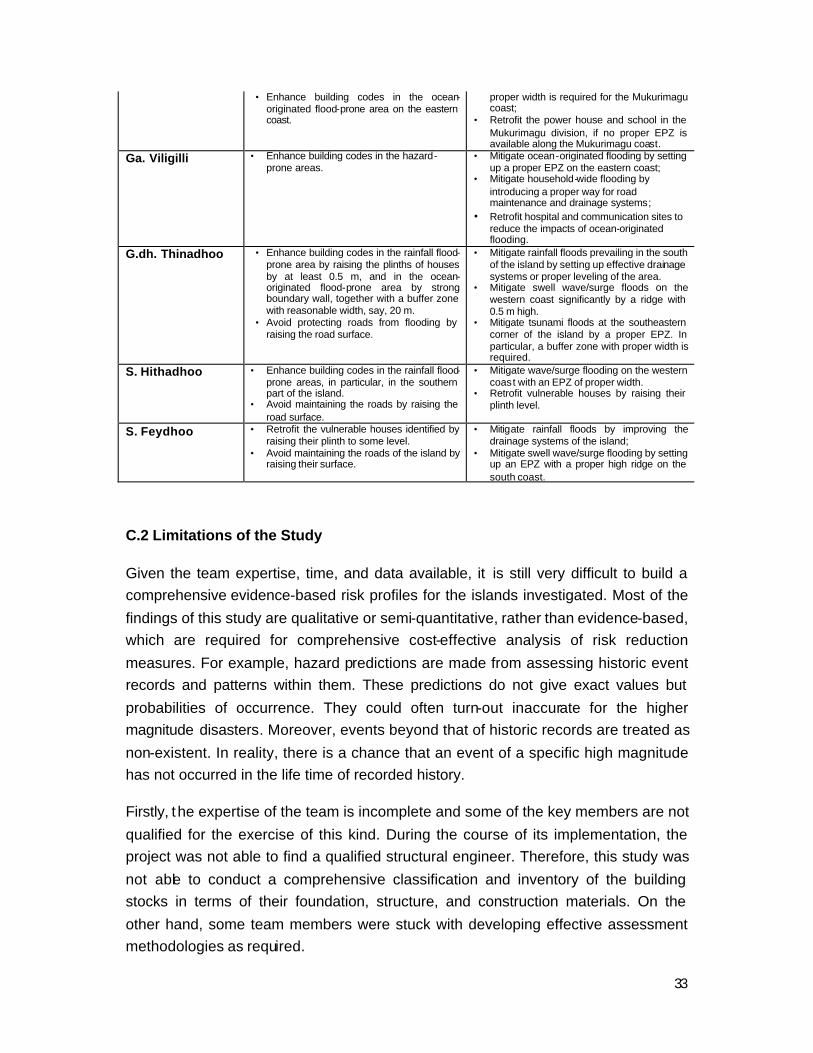
Ga. Viligilli • Enhance building codes in the hazard-prone areas.
• Mitigate ocean-originated flooding by setting up a proper EPZ on the eastern coast;
• Mitigate household-wide flooding by introducing a proper way for road maintenance and drainage systems;
• Retrofit hospital and communication sites to reduce the impacts of ocean-originated flooding.
G.dh. Thinadhoo • Enhance building codes in the rainfall flood-prone area by raising the plinths of houses by at least 0.5 m, and in the ocean-originated flood-prone area by strong boundary wall, together with a buffer zone with reasonable width, say, 20 m.
• Avoid protecting roads from flooding by raising the road surface.
• Mitigate rainfall floods prevailing in the south of the island by setting up effective drainage systems or proper leveling of the area.
• Mitigate swell wave/surge floods on the western coast significantly by a ridge with 0.5 m high.
• Mitigate tsunami floods at the southeastern corner of the island by a proper EPZ. In particular, a buffer zone with proper width is required.
S. Hithadhoo • Enhance building codes in the rainfall flood-prone areas, in particular, in the southern part of the island.
• Avoid maintaining the roads by raising the road surface.
• Mitigate wave/surge flooding on the western coast with an EPZ of proper width.
• Retrofit vulnerable houses by raising their plinth level.
S. Feydhoo • Retrofit the vulnerable houses identified by raising their plinth to some level.
• Avoid maintaining the roads of the island by raising their surface.
• Mitigate rainfall floods by improving the drainage systems of the island;
• Mitigate swell wave/surge flooding by setting up an EPZ with a proper high ridge on the south coast.
C.2 Limitations of the Study
Given the team expertise, time, and data available, it is still very difficult to build a comprehensive evidence-based risk profiles for the islands investigated. Most of the
findings of this study are qualitative or semi-quantitative, rather than evidence-based, which are required for comprehensive cost-effective analysis of risk reduction
measures. For example, hazard predictions are made from assessing historic event records and patterns within them. These predictions do not give exact values but
probabilities of occurrence. They could often turn-out inaccurate for the higher magnitude disasters. Moreover, events beyond that of historic records are treated as
non-existent. In reality, there is a chance that an event of a specific high magnitude has not occurred in the life time of recorded history.
Firstly, the expertise of the team is incomplete and some of the key members are not
qualified for the exercise of this kind. During the course of its implementation, the project was not able to find a qualified structural engineer. Therefore, this study was
not able to conduct a comprehensive classification and inventory of the building stocks in terms of their foundation, structure, and construction materials. On the
other hand, some team members were stuck with developing effective assessment methodologies as required.

34
Secondly, data availability limits to produce risk information with a high quality. Any information or prediction derived from natural hazard assessment is as good as the
data used. Unfortunately, Maldives lacks critical data such as long-term climatologic data and severe event data. Moreover, the project had difficulty acquiring available
meteorological data from the Department of Meteorology due to the newly introduced user-pays policy and the lack of resources to accommodate the high costs.
Climatologic data had to be interpolated using the given sparse information available or restricted to the short term observations acquired freely from third-parties.
Thirdly, the 4 -month time was insufficient for all the processes of risk assessment. In particular, this study was required to developing and testing the methodologies first
before the field survey. In fact, methodology development was one of the biggest barriers for the project to be smoothly implemented.
C.3 Recommendations for future study
This study has identified a practical methodology to understand and quantify the natural hazards faced by the proposed safe r islands or any inhabited island of
Maldives. This study is by no means the most comprehensive and a lot remain to be done in hazard science to underpin the risks facing Maldives. However, the
methodology and assessment framework presented in this study is a starting point and designed with flexibility to allow more detailed assessment such as numeric
modelling. There are several recommendations for future study as follows:
• Verification of the findings: Due to the limited data, many conclusions in the report were made based on authors’ empirical judgements. Therefore, further verification is required.
• Improvement of methodologies developed in this study: The DIRAM project has laid down some foundations, but further improvement and enhancement are required to make its framework and methodologies to be national-wide standards.
• Development of historic event loss database: Information on historic event losses is very crucial to understand the vulnerability of society, which provides a basis for building hazard intensity-damage functions of the country. In this study, historic hazard events have been systemically collected and need to be input into DesInventar database.
• Development of national data infrastructure for disaster risk reduction: Currently many useful data are scattered in different organizations with different formats. It is urgent and highly necessary to build a centralized data management mechanism within the national disaster risk management system. Building data infrastructure should be one of the key components in future DIRAM.

35
Top Related