


Languages
Pages
Legal


NOAA Fisheries, Pacific Islands RegionOverview, September 2004
National Marine Fisheries Service, NOAANational Marine Fisheries Service, NOAA
Pacific Islands Pacific Islands Science Center & Regional OfficeScience Center & Regional Office

NOAA Fisheries, Pacific Islands RegionOverview, September 2004
NOAA Fisheries Organizational Structure

NOAA Fisheries, Pacific Islands RegionOverview, September 2004
Geographic Area of Geographic Area of NOAA Fisheries Pacific Islands ResponsibilityNOAA Fisheries Pacific Islands Responsibility
Northwestern Hawaiian Islands
Guam
NorthernMarianaIslands Wake Island
Johnston IslandKingman ReefPalmyra Atoll
American Samoa
Howland andBaker Islands
Jarvis Island
Main Hawaiian Islands
Australia
NOAA Fisheries, Pacific Islands RegionOverview, September 2004
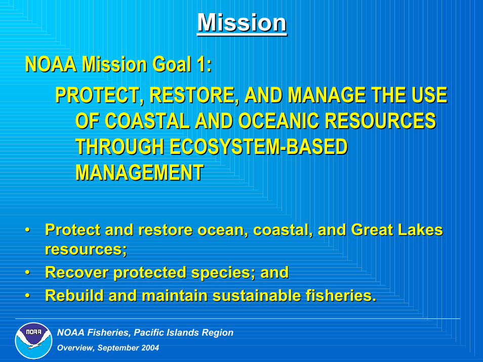
MissionMissionNOAA Mission Goal 1: NOAA Mission Goal 1:
PROTECT, RESTORE, AND MANAGE THE USE PROTECT, RESTORE, AND MANAGE THE USE OF COASTAL AND OCEANIC RESOURCES OF COASTAL AND OCEANIC RESOURCES THROUGH ECOSYSTEMTHROUGH ECOSYSTEM--BASED BASED MANAGEMENTMANAGEMENT
•• Protect and restore ocean, coastal, and Great Lakes Protect and restore ocean, coastal, and Great Lakes resources;resources;
•• Recover protected species; andRecover protected species; and•• Rebuild and maintain sustainable fisheries.Rebuild and maintain sustainable fisheries.

NOAA Fisheries, Pacific Islands RegionOverview, September 2004
Fishery Management PlansFishery Management Plans•• Pelagic speciesPelagic species
•• tunas, swordfish, billfish, sharks, etc.tunas, swordfish, billfish, sharks, etc.•• Northwestern Hawaiian IslandsNorthwestern Hawaiian Islands
–– BottomfishBottomfish•• snappers, groupers, jacks; seamount groundfishsnappers, groupers, jacks; seamount groundfish
–– LobsterLobster•• spiny and slipperspiny and slipper
•• Precious CoralsPrecious Corals•• Coral Reef EcosystemCoral Reef Ecosystem

NOAA Fisheries, Pacific Islands RegionOverview, September 2004
Regulatory BranchFisheries Information / Permits
Sustainable Fisheries
Protected Species
Protected Resources
Coral Reef ProgramsGIS
Habitat Conservation
Budget & PurchasingHuman ResourcesGrants ManagementInformation Technology
Operations, Mgmt & Information
American Samoa Field Office
International Fisheries Fishery Observer Program
Deputy Regional Administrator
Regional AdministratorPacific Islands Pacific Islands Regional OfficeRegional Office

NOAA Fisheries, Pacific Islands RegionOverview, September 2004
Programs. . .Programs. . .Programs. . .•• Sustainable FisheriesSustainable Fisheries
5 Fishery Management Plans5 Fishery Management Plans
•• Protected ResourcesProtected ResourcesFishery InteractionsFishery InteractionsMarine Mammals (Hawaiian Monk seal, whales, dolphins)Marine Mammals (Hawaiian Monk seal, whales, dolphins)Protected and Endangered Species (sea turtles)Protected and Endangered Species (sea turtles)
•• Habitat ConservationHabitat ConservationCoral Reef EcosystemCoral Reef EcosystemCoastal Zone ManagementCoastal Zone ManagementMarine Debris, Oil Pollution Act, Marine Invasive SpeciesMarine Debris, Oil Pollution Act, Marine Invasive Species
•• International FisheriesInternational Fisheries
NOAA Fisheries, Pacific Islands RegionOverview, September 2004
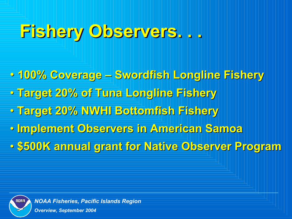
Fishery Observers. . .Fishery Observers. . .Fishery Observers. . .
•• 100% Coverage 100% Coverage –– Swordfish Longline FisherySwordfish Longline Fishery•• Target 20% of Tuna Longline Fishery Target 20% of Tuna Longline Fishery •• Target 20% NWHI Bottomfish FisheryTarget 20% NWHI Bottomfish Fishery•• Implement Observers in American SamoaImplement Observers in American Samoa•• $500K annual grant for Native Observer Program$500K annual grant for Native Observer Program

Pacific Islands Fisheries Pacific Islands Fisheries Science CenterScience Center

NOAA Fisheries, Pacific Islands RegionOverview, September 2004
NOAA Fisheries MissionNOAA Fisheries Mission
Stewardship of living marine Stewardship of living marine resources through scienceresources through science--
based conservation and based conservation and management and management and
the promotion of healthy the promotion of healthy ecosystemsecosystems
NOAA Fisheries, Pacific Islands RegionOverview, September 2004
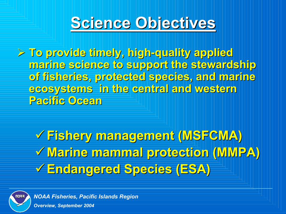
Science ObjectivesScience Objectives
To provide timely, highTo provide timely, high--quality applied quality applied marine science to support the stewardship marine science to support the stewardship of fisheries, protected species, and marine of fisheries, protected species, and marine ecosystems in the central and western ecosystems in the central and western Pacific OceanPacific Ocean
Fishery management (MSFCMA)Fishery management (MSFCMA)Marine mammal protection (MMPA)Marine mammal protection (MMPA)Endangered Species (ESA)Endangered Species (ESA)

NOAA Fisheries, Pacific Islands RegionOverview, September 2004
History of the PIFSCHistory of the PIFSC
Honolulu Laboratory established in 1948 as Pacific Honolulu Laboratory established in 1948 as Pacific Oceanic Fisheries Investigation (POFI)Oceanic Fisheries Investigation (POFI)
Main facility located at UH main campusMain facility located at UH main campusSmaller research facility with seawater capabilities Smaller research facility with seawater capabilities located dockside at Kewalo Basinlocated dockside at Kewalo BasinHonolulu Lab elevated to independent NOAA Fisheries Honolulu Lab elevated to independent NOAA Fisheries science center in 2003science center in 2003

NOAA Fisheries, Pacific Islands RegionOverview, September 2004
NOAA Ship NOAA Ship Oscar Elton SetteOscar Elton Sette243 annual allocation days: 243 annual allocation days:
FYFY--04: coral reefs (66), pelagics (56), 04: coral reefs (66), pelagics (56), lobster (28), protected species (46), and lobster (28), protected species (46), and benthic habitat (47)benthic habitat (47)
Chartered vessels: Chartered vessels: 300300--days for marine debris removal & days for marine debris removal &
lobster researchlobster research
Prior research platforms:Prior research platforms:Townsend Cromwell, Hugh M. Smith, Townsend Cromwell, Hugh M. Smith, Charles H. Gilbert, and Raymond B. Charles H. Gilbert, and Raymond B. ManningManning

NOAA Fisheries, Pacific Islands RegionOverview, September 2004
PIFSC Organization ChartPIFSC Organization Chart
PIFSC Director’s PIFSC Director’s OfficeOffice
OPERATIONS, MANAGEMENT& INFORMATION
FISHERY BIOLOGY & STOCK
ASSESSMENTECOSYSTEMS &
OCEANOGRAPHYFISHERY
MONITORING & SOCIO-ECONOMICS
PROTECTED SPECIES
CORAL REEF ECOSYSTEM

NOAA Fisheries, Pacific Islands RegionOverview, September 2004
Fibropapilloma
Protected Resources DivisionHawaiian monk seals & sea turtles
Population assessmentsEcological research Health & diseaseUnusual Mortality Event (UME)
Response Plan Stranding & Training
NOAA Fisheries, Pacific Islands RegionOverview, September 2004
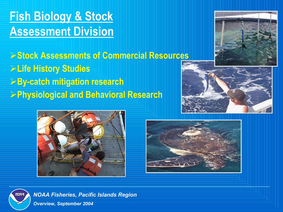
Fish Biology & Stock Assessment Division
Stock Assessments of Commercial ResourcesLife History StudiesBy-catch mitigation researchPhysiological and Behavioral Research

NOAA Fisheries, Pacific Islands RegionOverview, September 2004
Fisheries Monitoring & Socio-economic Division
HighHigh--quality and timely quality and timely commercial & recreational commercial & recreational fisheryfishery--dependent datadependent data
Western Pacific Fisheries Western Pacific Fisheries Information NetworkInformation Network
Economic research & analysisEconomic research & analysisSociological/cultural studiesSociological/cultural studies

NOAA Fisheries, Pacific Islands RegionOverview, September 2004
Coral Reefs Ecosystem DivisionEcological Assessment & MonitoringBenthic Habitat Characterization and MonitoringOceanographic MonitoringEcological InteractionsMarine Debris (122t removed in 2003)
NOAA Fisheries, Pacific Islands RegionOverview, September 2004
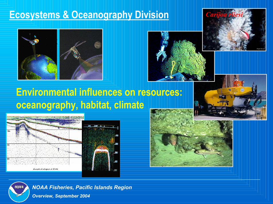
Carijoa riiesi
Environmental influences on resources: oceanography, habitat, climate
Ecosystems & Oceanography Division
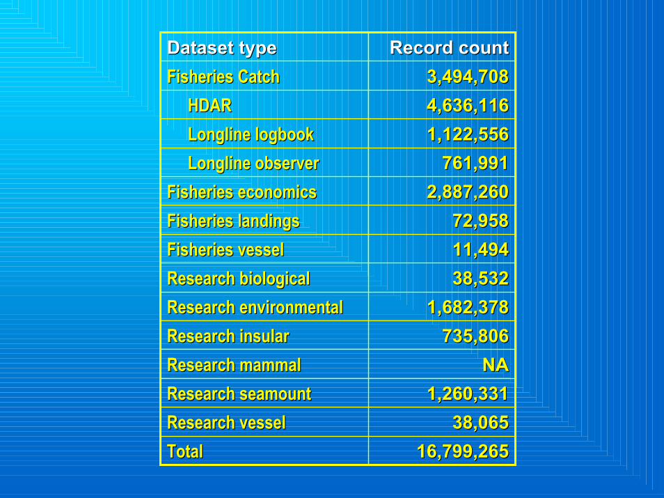
16,799,26516,799,265TotalTotal38,06538,065Research vesselResearch vessel
1,260,3311,260,331Research seamountResearch seamountNANAResearch mammalResearch mammal
735,806735,806Research insularResearch insular1,682,3781,682,378Research environmentalResearch environmental
38,53238,532Research biologicalResearch biological11,49411,494Fisheries vesselFisheries vessel72,95872,958Fisheries landingsFisheries landings
2,887,2602,887,260Fisheries economicsFisheries economics761,991761,991LonglineLongline observerobserver
1,122,5561,122,556LonglineLongline logbooklogbook4,636,1164,636,116HDARHDAR3,494,7083,494,708Fisheries CatchFisheries Catch
Record countRecord countDataset typeDataset type

CREIOS Observing SystemCREIOS Observing SystemSurface Moorings (telemetered)
CREWS Buoys - 7 SST Buoys - 14
Subsurface Moorings (archived)Ocean Data Platforms (ODP) - 5Wave & Tide Recorders (WTR) - 15Subsurface Temperature Recorders (STR) - 64Current Meters – 3/0
Shallow water CTD/Radiometer casts - fine scale Deepwater CTD/ADCP transects – course scaleDrifters (SVP) – 44, (APEX) - 6 Satellite Remote Sensing (developing Ocean Atlases*)
SST SSH (currents/eddited)Winds Ocean Color (chlorophyll, bleaching)
Surface Moorings (telemetered)CREWS Buoys - 7 SST Buoys - 14
Subsurface Moorings (archived)Ocean Data Platforms (ODP) - 5Wave & Tide Recorders (WTR) - 15Subsurface Temperature Recorders (STR) - 64Current Meters – 3/0
Shallow water CTD/Radiometer casts - fine scale Deepwater CTD/ADCP transects – course scaleDrifters (SVP) – 44, (APEX) - 6 Satellite Remote Sensing (developing Ocean Atlases*)
SST SSH (currents/eddited)Winds Ocean Color (chlorophyll, bleaching)

NOAA Fisheries, Pacific Islands RegionOverview, September 2004
Approach: Merging TechnologiesApproach: Merging Technologies‘Satellite Remote Sensing’‘Satellite Remote Sensing’
Provides Provides spatial coveragespatial coverage and and time time seriesseries of:of:
SST (AVHRR, GOES): physical SST (AVHRR, GOES): physical fronts/eddiesfronts/eddiesSea surface height (TOPEX): Sea surface height (TOPEX): currents/currents/mesoscalemesoscale variabilityvariabilityOcean color (Ocean color (SeaWiFSSeaWiFS): biological ): biological frontsfronts
Temporal: days to weeksTemporal: days to weeksHorizontal: 10Horizontal: 1033 mi mi

NOAA Fisheries, Pacific Islands RegionOverview, September 2004
NOAA ship Townsend Cromwell
In situ Shipboard surveys:
High resolution vertical structure of:High resolution vertical structure of:TemperatureTemperatureSalinitySalinityChlorophyllChlorophyllDissolved oxygenDissolved oxygenNutrients & accessory pigments Nutrients & accessory pigments Currents (ADCP)Currents (ADCP)
Influence of Influence of mesoscalemesoscale dynamic dynamic variability variability Horizontal resolution: 10Horizontal resolution: 102 2 mimi
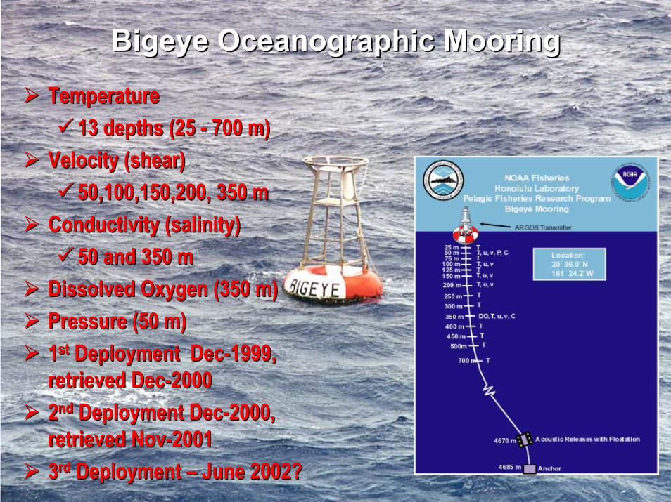
Bigeye Oceanographic MooringBigeye Oceanographic Mooring
TemperatureTemperature13 depths (25 13 depths (25 -- 700 m)700 m)
Velocity (shear)Velocity (shear)50,100,150,200, 350 m50,100,150,200, 350 m
Conductivity (salinity)Conductivity (salinity)50 and 350 m50 and 350 m
Dissolved Oxygen (350 m)Dissolved Oxygen (350 m)Pressure (50 m)Pressure (50 m)11stst Deployment DecDeployment Dec--1999, 1999, retrieved Decretrieved Dec--2000200022ndnd Deployment DecDeployment Dec--2000, 2000, retrieved Novretrieved Nov--2001200133rdrd Deployment Deployment –– June 2002?June 2002?

NOAA Fisheries, Pacific Islands RegionOverview, September 2004
Subtropical Frontal Zone surveysSubtropical Frontal Zone surveys8 longitudinal + 1 zonal 8 longitudinal + 1 zonal transects; range: 556transects; range: 556--1139 1139 km (300 km (300 –– 615 mi) long615 mi) longAprilApril--May, 1996May, 1996--2000 2000 (except one in March (except one in March 1997)1997)500 m CTD casts + rosette 500 m CTD casts + rosette mounted 10L mounted 10L NiskinNiskin bottles bottles 28 km (15 28 km (15 nminmi) ) stnstn. . resolutionresolutionOnly 2 of 8 transects Only 2 of 8 transects crossed both fronts (1997 crossed both fronts (1997 & 1998)& 1998)

NOAA Fisheries, Pacific Islands RegionOverview, September 2004
Topex altimetry – April-May 1997 In situ survey: 889 km
TZCF
DEPTH
LATITUDE
T
S
sig-t
Chl
N

NOAA Fisheries, Pacific Islands RegionOverview, September 2004
Considerable interannual variability in latitudinal position and intensity of the SSTF & STF; ca. 300 km shift in frontal positions between 1996-97 at 172°W and 1998-99 at 158°W.
141415
1515
1516
1616
17
18
19
9
20 21222223 23
131
14 14 1415151616
17
18
192021
2223
13
1414
15
16
16
17
17 17
18
18 181818
1919
1919
20
21
22
1314
15 151516 16
1617
1718
19
119
20
212223
13 13 114
14
15 15 15
16
17
1
1819
2020
21 2122
DEPTH
LATITUDE
Temperature (°C), 1996-2000
1996
1997
1998
1999
2000
SSTF
SSTF
STF
0.2
0.20.2 0.2 0.
0.2
0.2
0.2
0.4 0.40.4 0.40.4 0.4
0.4 0.40.4
0.40.40.60.6 0.6 0.6
0.60.6
LATITUDE
In situ chloropigment (mg/m3), 1996-2000
TCZF

NOAA Fisheries, Pacific Islands RegionOverview, September 2004
Satellite remote sensing of temperature (GOES-SST) and chlorophyll-a (SeaWiFS) for two Hawaiian eddies
In situ shipboard surveys
Chl-a from SeaWiFSGOES SSTGOES: geostationary, GOES: geostationary, ca. 1 image/hr, helped ca. 1 image/hr, helped w/ NRT & clouds … w/ NRT & clouds … eddies now predictableeddies now predictableLoretta first spun up in Loretta first spun up in May 1999May 1999Strongest in September Strongest in September 1999 (core SST=23.5°C) 1999 (core SST=23.5°C) … surface … surface ChlChlexpressionexpressionMikaleleMikalele spun up in Oct spun up in Oct 1999, short1999, short--livedlivedNov 1999 Nov 1999 ---- two two transects, 185 km (100 transects, 185 km (100 mi) longmi) long18 km 18 km stnstn. resolution. resolution1000 m CTD casts 1000 m CTD casts

NOAA Fisheries, Pacific Islands RegionOverview, September 2004
Vertical structure of temperature, chloropigments, and nutrients through the eddies
Upper ocean doming of isopleths Upper ocean doming of isopleths –– eddy eddy influenceinfluenceMagnitude of vertical displacement & Magnitude of vertical displacement & compression of isopleths more pronounced compression of isopleths more pronounced in mature eddyin mature eddyVertical distribution (Vertical distribution (chlchl, N+N) closely , N+N) closely tracked isothermstracked isothermsMaximum ADCP current velocities 70 Maximum ADCP current velocities 70 ((MikaleleMikalele) and 85 (Loretta) cm s) and 85 (Loretta) cm s--11
Nutrients (N+N) 3 to 15 fold higher than Nutrients (N+N) 3 to 15 fold higher than control control stnsstns..Modeled 1° production increased 65% in Modeled 1° production increased 65% in MikaleleMikalele, 2, 2--fold in Lorettafold in Loretta

NOAA Fisheries, Pacific Islands RegionOverview, September 2004
NOAA Fisheries, Pacific Islands RegionOverview, September 2004
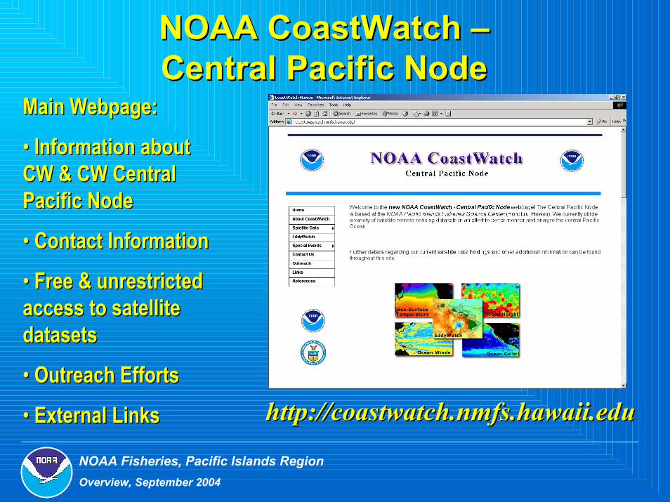
NOAA NOAA CoastWatchCoastWatch ––Central Pacific NodeCentral Pacific Node
Main Webpage:Main Webpage:
•• Information about Information about CW & CW Central CW & CW Central Pacific NodePacific Node
•• Contact InformationContact Information
•• Free & unrestricted Free & unrestricted access to satellite access to satellite datasetsdatasets
•• Outreach EffortsOutreach Efforts
•• External Links http://http://coastwatchcoastwatch..nmfsnmfs..hawaiihawaii..edueduExternal Links

NOAA Fisheries, Pacific Islands RegionOverview, September 2004
Satellite Products Currently Satellite Products Currently Supported by CoastWatchSupported by CoastWatch
1. Sea Surface Temperature:1. Sea Surface Temperature:• AVHRR HRPT/GAC• GOES
2. Sea Surface Height:2. Sea Surface Height:• TOPEX/Poseidon• Jason-1
3. Winds:3. Winds:• QuikSCAT
4. Ocean Color (Chlorophyll 4. Ocean Color (Chlorophyll aa):):• SeaWiFS• MODIS
5. Online Archive Containing 5. Online Archive Containing Historical DataHistorical Data

NOAA Fisheries, Pacific Islands RegionOverview, September 2004
Geographic CoverageGeographic Coverageof CoastWatch Productsof CoastWatch Products
• Most CW data sets are available for the entire Pacific• Accessible via the web in areas of “interest”

NOAA Fisheries, Pacific Islands RegionOverview, September 2004
CoastWatchCoastWatch Products Products -- Data Data HoldingsHoldings
•• AVISO (Ocean Altimetry) AVISO (Ocean Altimetry) –– 2.7 GB2.7 GB•• AVHRR AVHRR -- GAC (SST) GAC (SST) –– 29.5 GB29.5 GB•• GOES (SST) GOES (SST) –– 8.1 GB8.1 GB•• MODIS MODIS AquaAqua (Ocean Color) (Ocean Color) –– 8.9 GB8.9 GB•• MODIS MODIS TerraTerra (Ocean Color) (Ocean Color) –– 10.4 GB10.4 GB•• QuikSCATQuikSCAT (Surface Winds) (Surface Winds) –– 1.7 GB1.7 GB

NOAA Fisheries, Pacific Islands RegionOverview, September 2004
Sample AVHRR GACSample AVHRR GAC

NOAA Fisheries, Pacific Islands RegionOverview, September 2004
GOES SeaGOES Sea--Surface TemperatureSurface Temperature
• Data acquired by CoastWatch HQ
• Calibrated & Processed at CW Hawaii
• Updated 5 times/day
• Resolution ~0.05 deg.

NOAA Fisheries, Pacific Islands RegionOverview, September 2004
TOPEX/JasonTOPEX/Jason--1 Altimetry1 Altimetry
•• 0.25 Degree Resolution0.25 Degree Resolution
•• Weekly and monthly Weekly and monthly composites availablecomposites available
•• Data from:Data from:
TOPEX (1992TOPEX (1992--2002)2002)
JasonJason--1 (20021 (2002--Present)Present)
•• GeostrophicGeostrophic currents currents derived from this data setderived from this data set
•• Joint product provided by AVISO/JPLJoint product provided by AVISO/JPL
NOAA Fisheries, Pacific Islands RegionOverview, September 2004
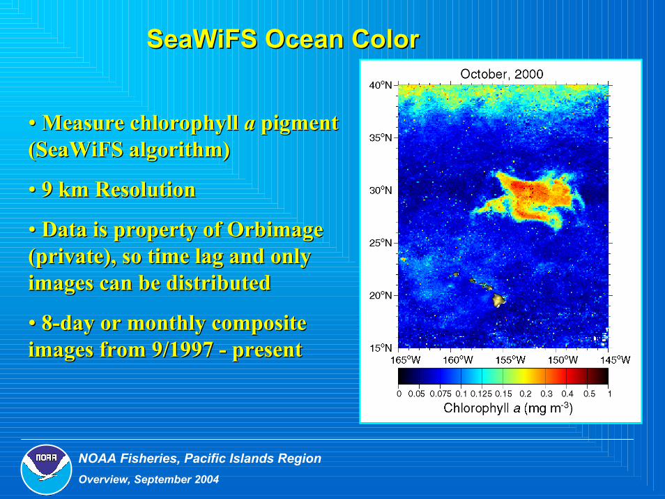
SeaWiFS Ocean ColorSeaWiFS Ocean Color
•• Measure chlorophyll Measure chlorophyll aa pigment pigment ((SeaWiFSSeaWiFS algorithm)algorithm)
•• 9 km Resolution9 km Resolution
•• Data is property of Data is property of OrbimageOrbimage(private), so time lag and only (private), so time lag and only images can be distributedimages can be distributed
•• 88--day or monthly composite day or monthly composite images from 9/1997 images from 9/1997 -- presentpresent
NOAA Fisheries, Pacific Islands RegionOverview, September 2004
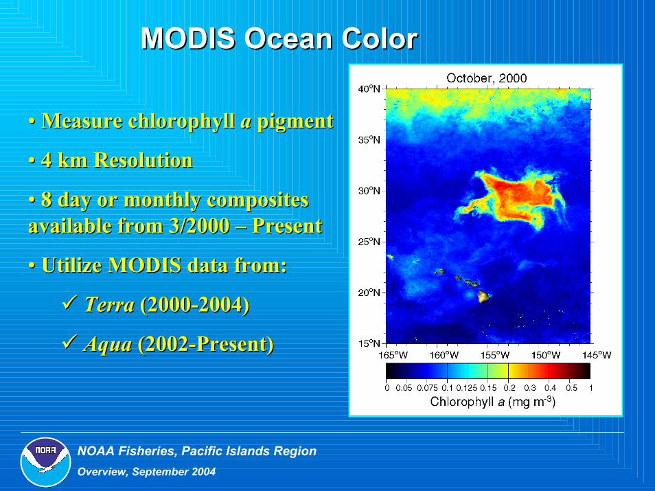
MODIS Ocean ColorMODIS Ocean Color
•• Measure chlorophyll Measure chlorophyll aa pigmentpigment
•• 4 km Resolution4 km Resolution
•• 8 day or monthly composites 8 day or monthly composites available from 3/2000 available from 3/2000 –– PresentPresent
•• Utilize MODIS data from:Utilize MODIS data from:
TerraTerra (2000(2000--2004)2004)
AquaAqua (2002(2002--Present)Present)

NOAA Fisheries, Pacific Islands RegionOverview, September 2004
QuikSCATQuikSCAT WindsWinds
•• Products include wind: speed, Products include wind: speed, stress and wind stress curlstress and wind stress curl
•• 0.5 degree resolution0.5 degree resolution
•• Weekly or monthly composites Weekly or monthly composites available from 8/1999 available from 8/1999 –– PresentPresent

NOAA Fisheries, Pacific Islands RegionOverview, September 2004
EddyWatchEddyWatchDaily updates of GOES SST focusing on Alenuihaha channel where cyclonic eddies are often observed
Daily image archives kept on website – public access
http://coastwatch.nmfs.hawaii.edu/EW/EWgoes.html

NOAA Fisheries, Pacific Islands RegionOverview, September 2004
Applications of Applications of CoastWatchCoastWatch ProductsProducts• Harmful algal bloomsHarmful algal blooms
•• Wave height & SSTWave height & SST
•• Hurricanes & WindsHurricanes & Winds
•• Fires (hotspots & smoke)Fires (hotspots & smoke)
••Marine debris accumulation Marine debris accumulation (endangered species & coral (endangered species & coral reefs)reefs)
•• Spills (hazardous materials)Spills (hazardous materials)
•• SAR (Search and Rescue) SAR (Search and Rescue)
•• Fisheries management &Fisheries management &
researchresearch
•• Marine mammal strandingMarine mammal stranding
•• Characterization of Characterization of
convergence/divergence zonesconvergence/divergence zones
•• Coral reef health monitoringCoral reef health monitoring
•• Support of research cruisesSupport of research cruises
•• OutreachOutreach
Top Related