


Languages
Pages
Legal

!!!!!!!!!!!!!!!!!!!!!!!!!!!!!!!!!!!!!!!!!!!!!!!!!!!!!!!!!!!!!!!!!!!!!!!!!!!!!!!!!!!!!!!!!!!!!!!!!!!!!!!!!!!!!!!!!!!!!!!!!!!!!!!!!!!!!!!!!!!!!!!!!!!!!!!!!!!!!!!!!!
!(!( !(
TOM
LAM
B W
ILD
LIFE
MA
NA
GEM
EN
T A
RE
A
H75P
N3-S12
N3-Wild-106
N3-Aqua-201
N3-Wild-105 N3-Aqua-121N3-Aqua-122N3-Aqua-122 125
* MAP SHEET FULLY WITHIN THE N3-LUSE-100 FEATURE
N3-LUse-100
Coordinate System: UTM Zone 14N NAD83Data Source: MB Hydro, ProvMB, NRCANDate Created: November 29, 2013
±
1:10,000
0 250 500125
Metres
Map 143
Bipole III Transmission ProjectConstruction Environmental Protection Plan
Construction Section N3Environmentally Sensitive Site Locations
DO
CU
ME
NT
PA
TH
: G
:\_G
IS_
PR
OJE
CT
_F
OLD
ER
\00_
HY
DR
O\1
114
4005
4_B
PII
I_E
PP
\AR
CM
AP
\ES
S_
N3
\BP
III_
CE
NV
PP
_N1N
2N3N
4C1S
EC
TIO
NB
AS
EM
AP
_MA
PB
OO
K_
BT
B_S
TAN
TE
C_2
0131
128A
.MX
D
ESS FeaturesWater!( Water Crossing
WildlifeBirds and Habitat
WildlifeBirds and Habitat
Land UseConservation
WaterGroundwater
Points of Access*!( Proposed Access Point
!( Major Stream Crossing
Abandoned Rail Crossing
Rail Crossing
") Transmission Line Crossing
Project Infrastructure
Proposed Access Route
Land Base
66 m Right of Way
BPIII Final Preferred Route
Angle Tower Locations
#
#
*Labels correspond to BPIII Access Management Database
Mining
! ! Transmission LineHighwayMajor RoadLocal RoadWinter RoadRailway (Operational)Railway (Discontinued)
Provincial Park

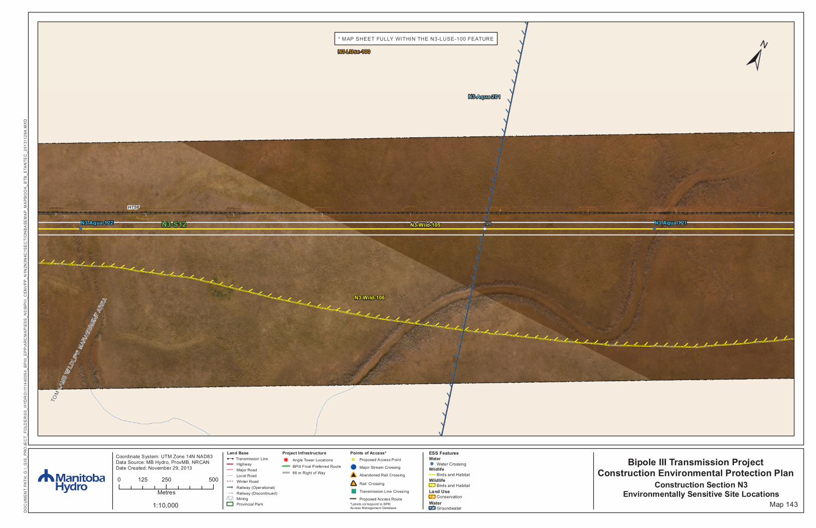
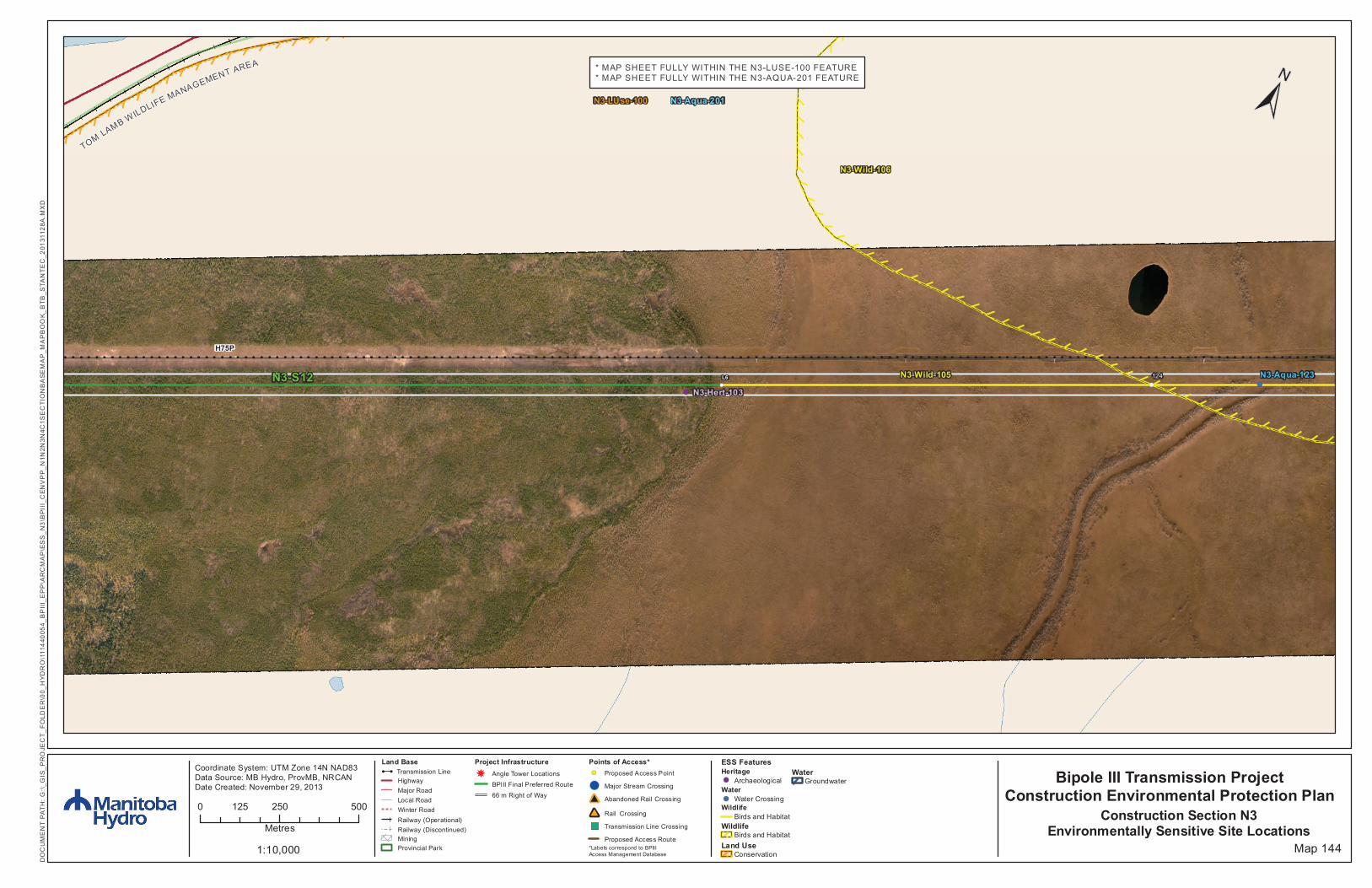
MAP NUMBER : 143
ESS Group : Birds and Habitat
Sec-Seg ID ESS ID ESS Name Location Start Stop UTM
Zone Distance
N3-S12 N3-Wild-105
Waterfowl and colonial bird sensitivity area, Little Frog Creek crossing, Frog Creek crossing
Site: L5 to L6 E-389510 N-5998393
E-399823 N-6003616 14N 11560m
Potential Effects:
Higher risk of wire collision, disturbance during breeding and nesting, risk of wire collision is localized to the right-of-way while construction disturbance can effect colonies up to 1000 meters away
Specific Mitigation:
Adhere to reduced risk timing windows for protection of birds (August 1- April 30) Maintain applicable setback during nesting and breeding timing window Conduct priority assessment for bird diverters and other measures prior to transmission line stringing Install bird diverters or other measures at high priority sites
ESS Group : Birds and Habitat
Sec-Seg ID ESS ID ESS Name Location Start Stop UTM Zone Distance
N3-S12 N3-Wild-106 Owls Site: 123 to 124 E-397963 N-6002674
E-390716 N-5999004 14N 8123m
Potential Effects: Potential disruption of nesting cavities and increased risk of bird wire collisions Specific Mitigation:
Adhere to reduced risk timing windows for protection of birds (August 1- April 30) Maintain setback during timing window Conduct priority assessment for bird diverters and other measures prior to transmission line stringing Install bird diverters or other measures at high priority sites
ESS Group : Water Crossing
Sec-Seg ID
ESS ID ESS Name Easting Northing UTM Zone
Channel Width
Wet Width
Fish Habitat Class
Habitat Sensitivity
N3-S12
N3-Aqua-121
Unnamed Headwater or Side Tributaries into Little Frog Creek
394105 6000720 14N 40m Dry No Fish Habitat Low
N3-S12
N3-Aqua-122
Unnamed Tributary into Little Frog Creek 391397 5999348 14N 32m Dry No Fish
Habitat Low
Potential Effects: Habitat loss & contamination from structure foundations & installations; increased erosion & sedimentation of streams; damage to stream banks; loss of riparian vegetation
Specific Mitigation:
Carry out construction activities on frozen ground to minimize surface damage, rutting and erosion Use existing trails, roads or cut lines whenever possible as access routes Identify and flag buffer areas prior to start of work Riparian Buffers shall be a minimum of 30m and increase in size based on slope of land entering waterway. Within
these buffers shrub and herbaceous understory veg will be maintained along with trees that do not violate MH Veg Clearance Requirements.
7m no machine zone will restrict equipment in close proximity to the waterbody except at the trail crossing. Adhere to Department of Fisheries and Oceans (DFO) Operational Statements for Temporary Stream Crossings, Ice
Bridges and Snow Fills, and Overhead Line Construction
ESS Group : Groundwater
Sec-Seg ID ESS ID ESS Name Location Start Stop UTM
Zone Distance
N3-S12 N3-Aqua-201 Aquifers vulnerable to contamination Site: 125 to 126 E-393304
N-6000315 E-386715 N-5996977 14N 7386m
Potential Effects: Potential groundwater contamination from a contingency event (e.g., spill) Specific Mitigation:
Marshaling yards will be located on upland sites where possible An Emergency Preparedness and Spill Response Plan will be developed and an emergency response spill kit will be
kept on-site at all times in case of fluid leaks or spills from machinery
MAP NUMBER : 143 cont’d
ESS Group : Conservation
Sec-Seg ID ESS ID ESS Name Location Start Stop UTM Zone Distance
N3-S12 N3-LUse-100 Tom Lamb WMA Site: 121 to 122 E-399755 N-6003581
E-386715 N-5996977 14N 14617m
Potential Effects: Potential disruption to resource use activities
Specific Mitigation:
Subject to permit conditions

This page is intentionally left blank.
!!!!!!!!!!!!!!!!!!!!!!!!!!!!!!!!!!!!!!!!!!!!!!!!!!!!!!!!!!!!!!!!!!!!!!!!!!!!!!!!!!!!!!!!!!!!!!!!!!!!!!!!!!!!!!!!!!!!!!!!!!!!!!!!!!!!!!!!!!!!!!!!!!!!!!!!!!!!!!!!!!
!(!(!(!(
H75P
N3-S12
N3-LUse-100
N3-Wild-106
N3-Wild-105 N3-Aqua-123N3-Aqua-123
N3-Hert-103
124L6
* MAP SHEET FULLY WITHIN THE N3-LUSE-100 FEATURE* MAP SHEET FULLY WITHIN THE N3-AQUA-201 FEATURE
N3-Aqua-201
TOMLAMB WILDLIFE MANAGEMENT AREA
Coordinate System: UTM Zone 14N NAD83Data Source: MB Hydro, ProvMB, NRCANDate Created: November 29, 2013
±
1:10,000
0 250 500125
Metres
Map 144
Bipole III Transmission ProjectConstruction Environmental Protection Plan
Construction Section N3Environmentally Sensitive Site Locations
DO
CU
ME
NT
PA
TH
: G
:\_G
IS_
PR
OJE
CT
_F
OLD
ER
\00_
HY
DR
O\1
114
4005
4_B
PII
I_E
PP
\AR
CM
AP
\ES
S_
N3
\BP
III_
CE
NV
PP
_N1N
2N3N
4C1S
EC
TIO
NB
AS
EM
AP
_MA
PB
OO
K_
BT
B_S
TAN
TE
C_2
0131
128A
.MX
D
ESS FeaturesHeritage!( Archaeological
Water!( Water Crossing
WildlifeBirds and Habitat
WildlifeBirds and Habitat
Land UseConservation
WaterGroundwater
Points of Access*!( Proposed Access Point
!( Major Stream Crossing
Abandoned Rail Crossing
Rail Crossing
") Transmission Line Crossing
Project Infrastructure
Proposed Access Route
Land Base
66 m Right of Way
BPIII Final Preferred Route
Angle Tower Locations
#
#
*Labels correspond to BPIII Access Management Database
Mining
! ! Transmission LineHighwayMajor RoadLocal RoadWinter RoadRailway (Operational)Railway (Discontinued)
Provincial Park
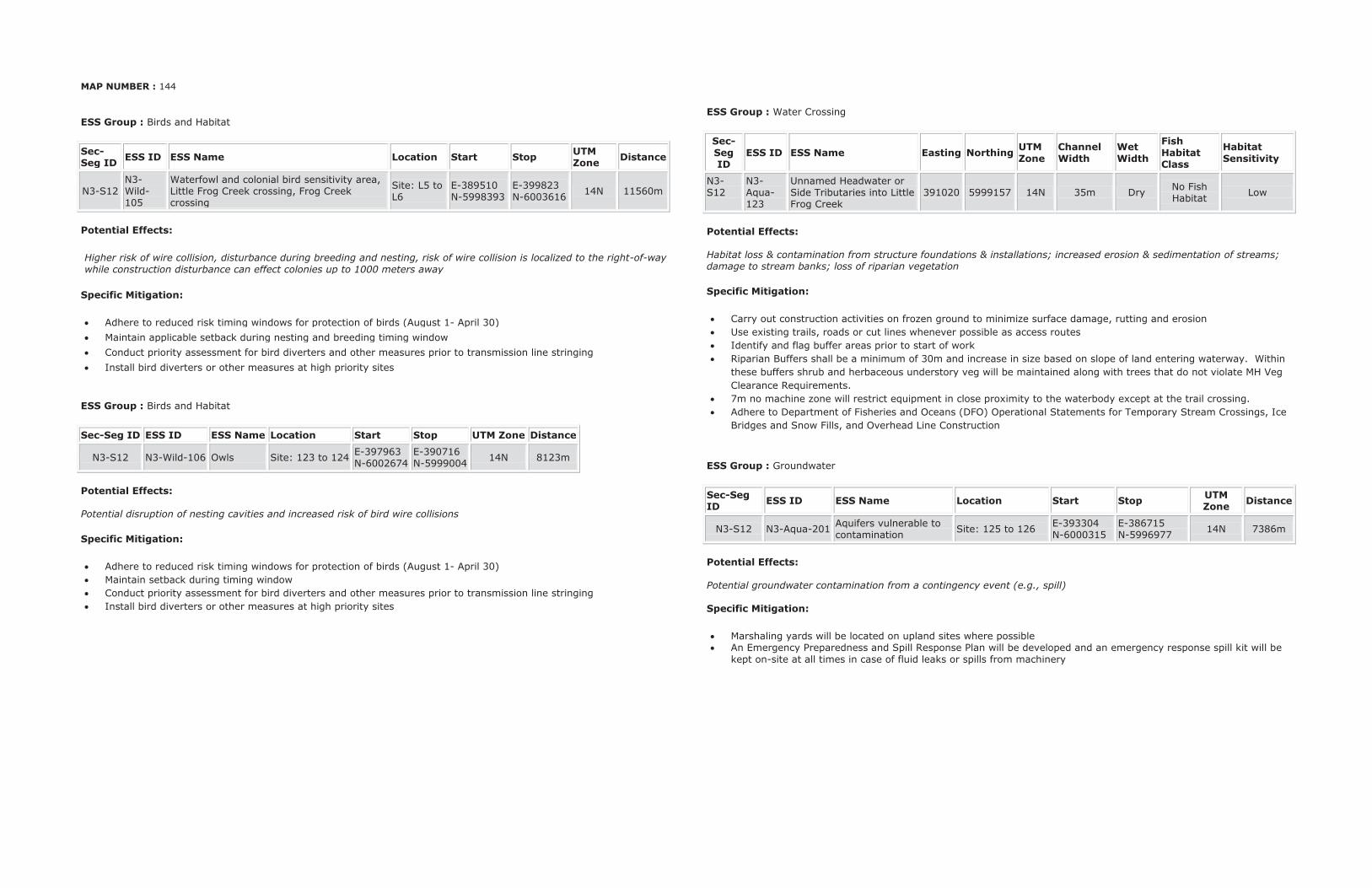
MAP NUMBER : 144
ESS Group : Birds and Habitat
Sec-Seg ID ESS ID ESS Name Location Start Stop UTM
Zone Distance
N3-S12 N3-Wild-105
Waterfowl and colonial bird sensitivity area, Little Frog Creek crossing, Frog Creek crossing
Site: L5 to L6
E-389510 N-5998393
E-399823 N-6003616 14N 11560m
Potential Effects:
Higher risk of wire collision, disturbance during breeding and nesting, risk of wire collision is localized to the right-of-way while construction disturbance can effect colonies up to 1000 meters away
Specific Mitigation:
Adhere to reduced risk timing windows for protection of birds (August 1- April 30) Maintain applicable setback during nesting and breeding timing window Conduct priority assessment for bird diverters and other measures prior to transmission line stringing Install bird diverters or other measures at high priority sites
ESS Group : Birds and Habitat
Sec-Seg ID ESS ID ESS Name Location Start Stop UTM Zone Distance
N3-S12 N3-Wild-106 Owls Site: 123 to 124 E-397963 N-6002674
E-390716 N-5999004 14N 8123m
Potential Effects: Potential disruption of nesting cavities and increased risk of bird wire collisions
Specific Mitigation:
Adhere to reduced risk timing windows for protection of birds (August 1- April 30) Maintain setback during timing window Conduct priority assessment for bird diverters and other measures prior to transmission line stringing Install bird diverters or other measures at high priority sites
ESS Group : Water Crossing
Sec-Seg ID
ESS ID ESS Name Easting Northing UTM Zone
Channel Width
Wet Width
Fish Habitat Class
Habitat Sensitivity
N3-S12
N3-Aqua-123
Unnamed Headwater or Side Tributaries into Little Frog Creek
391020 5999157 14N 35m Dry No Fish Habitat Low
Potential Effects: Habitat loss & contamination from structure foundations & installations; increased erosion & sedimentation of streams; damage to stream banks; loss of riparian vegetation
Specific Mitigation:
Carry out construction activities on frozen ground to minimize surface damage, rutting and erosion Use existing trails, roads or cut lines whenever possible as access routes Identify and flag buffer areas prior to start of work Riparian Buffers shall be a minimum of 30m and increase in size based on slope of land entering waterway. Within
these buffers shrub and herbaceous understory veg will be maintained along with trees that do not violate MH Veg Clearance Requirements.
7m no machine zone will restrict equipment in close proximity to the waterbody except at the trail crossing. Adhere to Department of Fisheries and Oceans (DFO) Operational Statements for Temporary Stream Crossings, Ice
Bridges and Snow Fills, and Overhead Line Construction
ESS Group : Groundwater
Sec-Seg ID ESS ID ESS Name Location Start Stop UTM
Zone Distance
N3-S12 N3-Aqua-201 Aquifers vulnerable to contamination Site: 125 to 126 E-393304
N-6000315 E-386715 N-5996977 14N 7386m
Potential Effects: Potential groundwater contamination from a contingency event (e.g., spill) Specific Mitigation:
Marshaling yards will be located on upland sites where possible An Emergency Preparedness and Spill Response Plan will be developed and an emergency response spill kit will be
kept on-site at all times in case of fluid leaks or spills from machinery
MAP NUMBER : 144 cont’d
ESS Group : Conservation
Sec-Seg ID ESS ID ESS Name Location Start Stop UTM Zone Distance
N3-S12 N3-LUse-100 Tom Lamb WMA Site: 121 to 122 E-399755 N-6003581
E-386715 N-5996977 14N 14617m
Potential Effects: Potential disruption to resource use activities
Specific Mitigation:
Subject to permit conditions
ESS Group : Archaeological
Sec-Seg ID ESS ID ESS Name Easting Northing UTM Zone
N3-S12 N3-Hert-103 Cormorant Lake Petroform Site 389419 5998319 14N Potential Effects: Potential disturbance to Heritage Resource
Specific Mitigation:
Carry out construction activities on frozen or dry ground to minimize surface damage, rutting and erosion Identify and flag prior to start of work Conduct site investigation with Archaeologist post clearing and prior to construction Minimize surface disturbance around the site to the extent possible Inspect excavated materials or surface disturbance for heritage resources and report any finds to Environmental
Inspector Implement additional mitigation from site investigation

This page is intentionally left blank.