


Languages
Pages
Legal

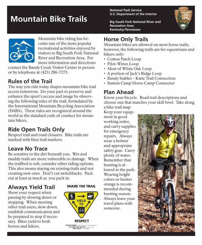
Mountain bike riding has be-come one of the more popular recreational activities enjoyed by visitors to Big South Fork National River and Recreation Area. For more information and directions
contact the Bandy Creek Visitor Center in person or by telephone at (423) 286-7275.
Rules of the Trail The way you ride today shapes mountain bike trail access tomorrow. Do your part to preserve and enhance the sport’s access and image by observ-ing the following rules of the trail, formulated by the International Mountain Bicycling Association (IMBA). These rules are recognized around the world as the standard code of conduct for moun-tain bikers.
Ride Open Trails OnlyRespect trail and road closures. Bike trails are marked with blue trail markers.
Leave No TraceBe sensitive to the dirt beneath you. Wet and muddy trails are more vulnerable to damage. When the trailbed is soft, consider other riding options. This also means staying on existing trails and not creating new ones. Don’t cut switchbacks. Pack out at least as much as you pack in.
Always Yield TrailShow your respect when passing by slowing down or stopping. When meeting other trail users, slow down, establish communication and be prepared to stop if neces-sary. Bikes yield to both horses and hikers.
Big South Fork National River and Recreation AreaKentucky/Tennessee
National Park ServiceU.S. Department of the Interior
Mountain Bike Trails
Horse Only TrailsMountain bikes are allowed on most horse trails; however, the following trails are for equestrians and hikers only:• Cotton Patch Loop• Pilot-Wines Loop• Most of White Oak Loop• A portion of Jack’s Ridge Loop• Bandy Stables – Katie Trail Connection• Station Camp Horse Camp Connector
Plan AheadKnow your bicycle. Read trail descriptions and choose one that matches your skill level. Take along a bike trail map.Keep your equip-ment in good working order, and carry supplies for emergency repairs. Always wear a helmet and appropriate safety gear. Carry plenty of water. Remember that hunting is al-lowed in the park. Wearing bright colors or hunter orange is recom-mended during hunting season. Always leave your travel plans with someone.
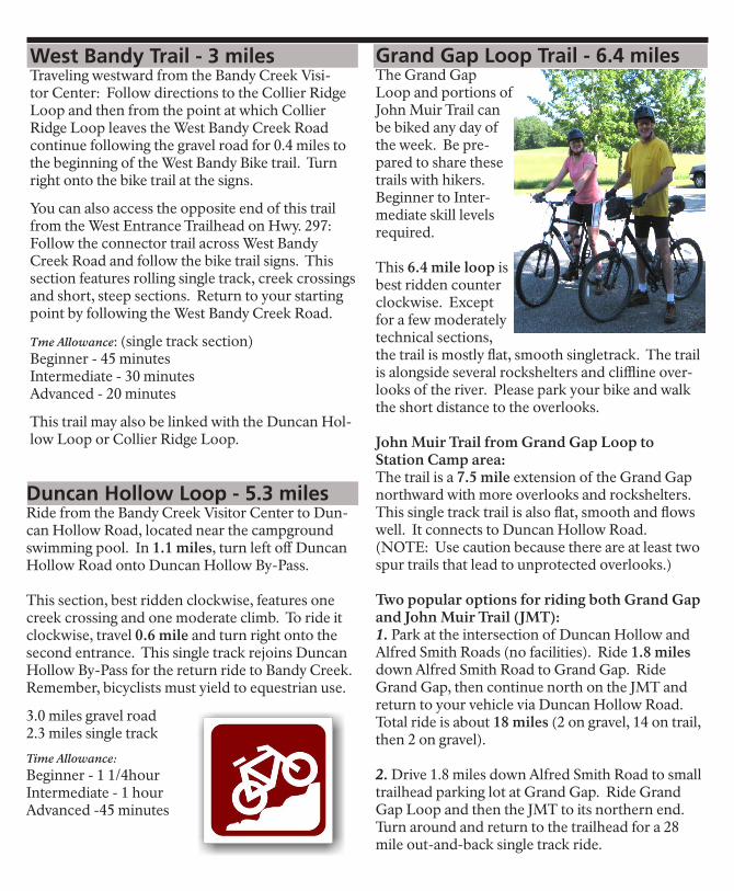
Grand Gap Loop Trail - 6.4 milesThe Grand Gap Loop and portions of John Muir Trail can be biked any day of the week. Be pre-pared to share these trails with hikers. Beginner to Inter-mediate skill levels required.
This 6.4 mile loop is best ridden counter clockwise. Except for a few moderately technical sections, the trail is mostly flat, smooth singletrack. The trail is alongside several rockshelters and cliffline over-looks of the river. Please park your bike and walk the short distance to the overlooks.
John Muir Trail from Grand Gap Loop toStation Camp area:The trail is a 7.5 mile extension of the Grand Gap northward with more overlooks and rockshelters. This single track trail is also flat, smooth and flows well. It connects to Duncan Hollow Road.(NOTE: Use caution because there are at least two spur trails that lead to unprotected overlooks.)
Two popular options for riding both Grand Gap and John Muir Trail (JMT):1. Park at the intersection of Duncan Hollow and Alfred Smith Roads (no facilities). Ride 1.8 miles down Alfred Smith Road to Grand Gap. Ride Grand Gap, then continue north on the JMT and return to your vehicle via Duncan Hollow Road. Total ride is about 18 miles (2 on gravel, 14 on trail, then 2 on gravel).
2. Drive 1.8 miles down Alfred Smith Road to small trailhead parking lot at Grand Gap. Ride Grand Gap Loop and then the JMT to its northern end. Turn around and return to the trailhead for a 28 mile out-and-back single track ride.
Duncan Hollow Loop - 5.3 milesRide from the Bandy Creek Visitor Center to Dun-can Hollow Road, located near the campground swimming pool. In 1.1 miles, turn left off Duncan Hollow Road onto Duncan Hollow By-Pass.
This section, best ridden clockwise, features one creek crossing and one moderate climb. To ride it clockwise, travel 0.6 mile and turn right onto the second entrance. This single track rejoins Duncan Hollow By-Pass for the return ride to Bandy Creek. Remember, bicyclists must yield to equestrian use.
3.0 miles gravel road2.3 miles single track
Time Allowance:Beginner - 1 1/4hourIntermediate - 1 hourAdvanced -45 minutes
West Bandy Trail - 3 milesTraveling westward from the Bandy Creek Visi-tor Center: Follow directions to the Collier Ridge Loop and then from the point at which Collier Ridge Loop leaves the West Bandy Creek Road continue following the gravel road for 0.4 miles to the beginning of the West Bandy Bike trail. Turn right onto the bike trail at the signs.
You can also access the opposite end of this trail from the West Entrance Trailhead on Hwy. 297: Follow the connector trail across West Bandy Creek Road and follow the bike trail signs. This section features rolling single track, creek crossings and short, steep sections. Return to your starting point by following the West Bandy Creek Road.
Tme Allowance: (single track section)Beginner - 45 minutesIntermediate - 30 minutesAdvanced - 20 minutes
This trail may also be linked with the Duncan Hol-low Loop or Collier Ridge Loop.
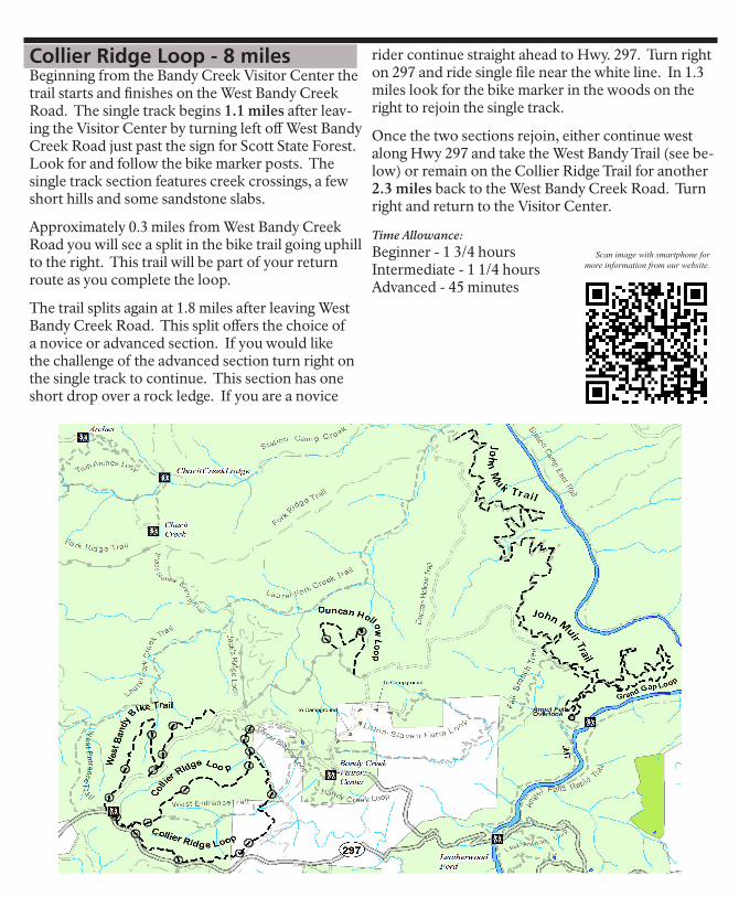
Collier Ridge Loop - 8 milesBeginning from the Bandy Creek Visitor Center the trail starts and finishes on the West Bandy Creek Road. The single track begins 1.1 miles after leav-ing the Visitor Center by turning left off West Bandy Creek Road just past the sign for Scott State Forest. Look for and follow the bike marker posts. The single track section features creek crossings, a few short hills and some sandstone slabs.
Approximately 0.3 miles from West Bandy Creek Road you will see a split in the bike trail going uphill to the right. This trail will be part of your return route as you complete the loop.
The trail splits again at 1.8 miles after leaving West Bandy Creek Road. This split offers the choice of a novice or advanced section. If you would like the challenge of the advanced section turn right on the single track to continue. This section has one short drop over a rock ledge. If you are a novice
rider continue straight ahead to Hwy. 297. Turn right on 297 and ride single file near the white line. In 1.3 miles look for the bike marker in the woods on the right to rejoin the single track.
Once the two sections rejoin, either continue west along Hwy 297 and take the West Bandy Trail (see be-low) or remain on the Collier Ridge Trail for another 2.3 miles back to the West Bandy Creek Road. Turn right and return to the Visitor Center.
Time Allowance:Beginner - 1 3/4 hoursIntermediate - 1 1/4 hoursAdvanced - 45 minutes
Scan image with smartphone for more information from our website.
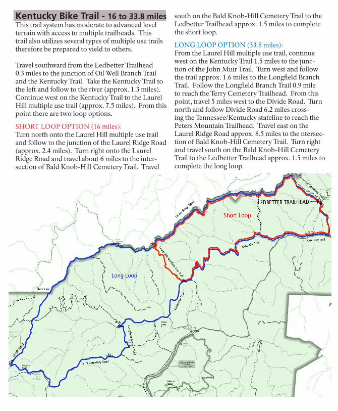
Kentucky Bike Trail - 16 to 33.8 milesThis trail system has moderate to advanced level terrain with access to multiple trailheads. This trail also utilizes several types of multiple use trails therefore be prepared to yield to others.
Travel southward from the Ledbetter Trailhead 0.3 miles to the junction of Oil Well Branch Trail and the Kentucky Trail. Take the Kentucky Trail to the left and follow to the river (approx. 1.3 miles). Continue west on the Kentucky Trail to the Laurel Hill multiple use trail (approx. 7.5 miles). From this point there are two loop options.
SHORT LOOP OPTION (16 miles): Turn north onto the Laurel Hill multiple use trail and follow to the junction of the Laurel Ridge Road (approx. 2.4 miles). Turn right onto the Laurel Ridge Road and travel about 6 miles to the inter-section of Bald Knob-Hill Cemetery Trail. Travel
south on the Bald Knob-Hill Cemetery Trail to the Ledbetter Trailhead approx. 1.5 miles to complete the short loop.
LONG LOOP OPTION (33.8 miles):From the Laurel Hill multiple use trail, continue west on the Kentucky Trail 1.5 miles to the junc-tion of the John Muir Trail. Turn west and follow the trail approx. 1.6 miles to the Longfield Branch Trail. Follow the Longfield Branch Trail 0.9 mile to reach the Terry Cemetery Trailhead. From this point, travel 5 miles west to the Divide Road. Turn north and follow Divide Road 6.2 miles cross-ing the Tennessee/Kentucky stateline to reach the Peters Mountain Trailhead. Travel east on the Laurel Ridge Road approx. 8.5 miles to the ntersec-tion of Bald Knob-Hill Cemetery Trail. Turn right and travel south on the Bald Knob-Hill Cemetery Trail to the Ledbetter Trailhead approx. 1.5 miles to complete the long loop.
Top Related