


Languages
Pages
Legal


Master of Arts in Geography
Course Structure and Syllabus
1st to 4th Semester
Academic Session 2018-19
Department of Geography and Geology
Central University of Punjab
Bathinda
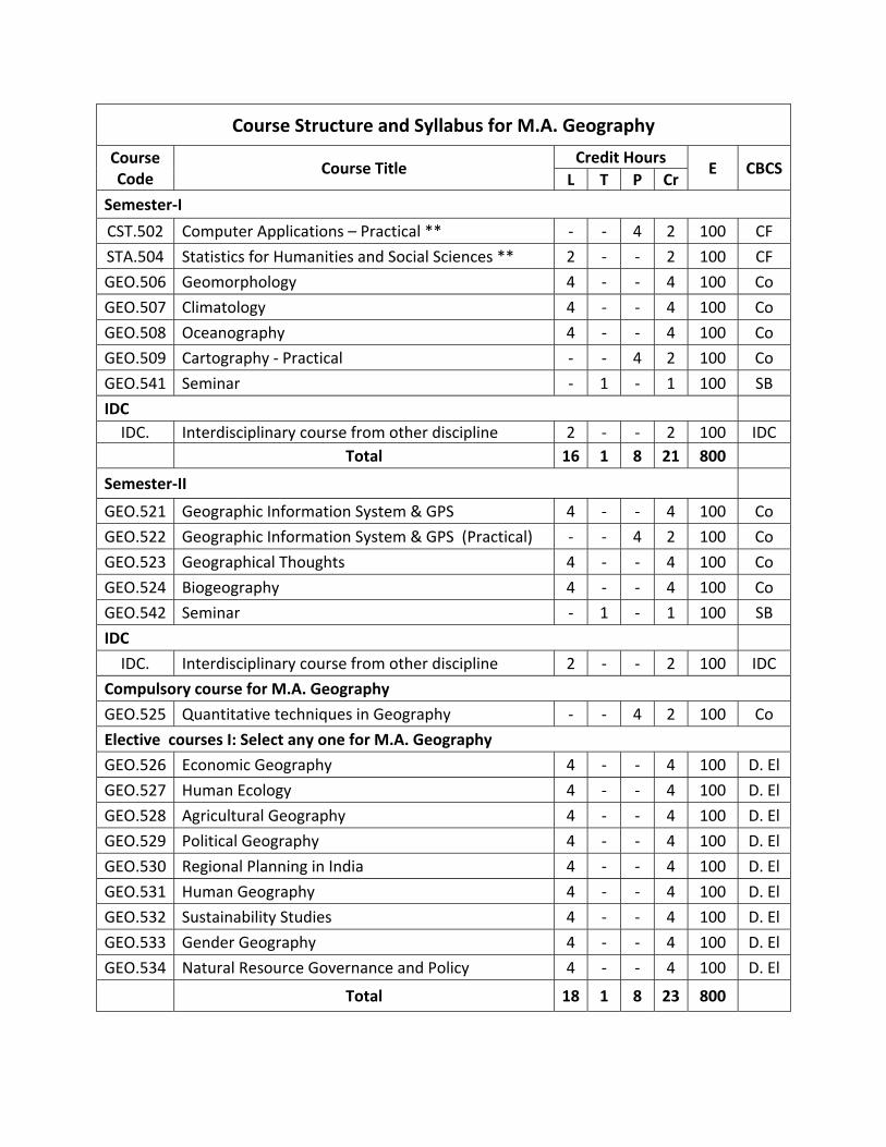
Course Structure and Syllabus for M.A. Geography
Course Code
Course Title Credit Hours
E CBCSL T P Cr
Semester‐I
CST.502 Computer Applications – Practical ** ‐ ‐ 4 2 100 CF
STA.504 Statistics for Humanities and Social Sciences ** 2 ‐ ‐ 2 100 CF
GEO.506 Geomorphology 4 ‐ ‐ 4 100 Co
GEO.507 Climatology 4 ‐ ‐ 4 100 Co
GEO.508 Oceanography 4 ‐ ‐ 4 100 Co
GEO.509 Cartography ‐ Practical ‐ ‐ 4 2 100 Co
GEO.541 Seminar ‐ 1 ‐ 1 100 SB
IDC
IDC. Interdisciplinary course from other discipline 2 ‐ ‐ 2 100 IDC
Total 16 1 8 21 800
Semester‐II
GEO.521 Geographic Information System & GPS 4 ‐ ‐ 4 100 Co
GEO.522 Geographic Information System & GPS (Practical) ‐ ‐ 4 2 100 Co
GEO.523 Geographical Thoughts 4 ‐ ‐ 4 100 Co
GEO.524 Biogeography 4 ‐ ‐ 4 100 Co
GEO.542 Seminar ‐ 1 ‐ 1 100 SB
IDC
IDC. Interdisciplinary course from other discipline 2 ‐ ‐ 2 100 IDC
Compulsory course for M.A. Geography
GEO.525 Quantitative techniques in Geography ‐ ‐ 4 2 100 Co
Elective courses I: Select any one for M.A. Geography
GEO.526 Economic Geography 4 ‐ ‐ 4 100 D. El
GEO.527 Human Ecology 4 ‐ ‐ 4 100 D. El
GEO.528 Agricultural Geography 4 ‐ ‐ 4 100 D. El
GEO.529 Political Geography 4 ‐ ‐ 4 100 D. El
GEO.530 Regional Planning in India 4 ‐ ‐ 4 100 D. El
GEO.531 Human Geography 4 ‐ ‐ 4 100 D. El
GEO.532 Sustainability Studies 4 ‐ ‐ 4 100 D. El
GEO.533 Gender Geography 4 ‐ ‐ 4 100 D. El
GEO.534 Natural Resource Governance and Policy 4 ‐ ‐ 4 100 D. El
Total 18 1 8 23 800

Semester‐III
GEO.551 Remote Sensing 4 ‐ ‐ 4 100 Co
GEO.552 Remote Sensing (Practical) ‐ ‐ 4 2 100 Co
GEO.553 Survey and Field visit ‐ 2 ‐ 2 100 SB
GEO.562 Research Methodology 4 ‐ ‐ 4 100 CF
GEO.543 Seminar ‐ 1 ‐ 1 100 SB
GEO.503 Introduction to Map Reading 1 1 100 VAC
GEO.599 Project work ‐ ‐ 12 6 ‐ SB
Select any one elective course and its respective practical course from the followings:
Elective courses II:
GEO.554 Geography of Disaster 4 ‐ ‐ 4 100 D. El
GEO.556 Social and Demography Geography 4 ‐ ‐ 4 100 D. El
GEO.558 Gender, Health and Development ‐ Theory 4 ‐ ‐ 4 100 D. El
GEO.560 Geography of Forest ‐ Theory 4 ‐ ‐ 4 100 D. El
Elective courses II (Practical):
GEO.555 Geography of Disaster (Practical) ‐ ‐ 4 2 100 D. El
GEO.557 Social and Demography Geography (Practical) ‐ ‐ 4 2 100 D. El
GEO.559 Gender, Health and Development (Practical) ‐ ‐ 4 2 100 D. El
GEO.561 Geography of Forest (Practical) ‐ ‐ 4 2 100 D. El
Total 12 4 20 26 800
Semester‐IV
GEO.571 Geography of India 4 ‐ ‐ 4 100 Co
GEO.572 Population & Settlement Geography 4 ‐ ‐ 4 100 Co
GEO.573 Practice in Geography ‐I ‐ 2 ‐ 2 100 DEC
GEO.574 Practice in Geography ‐II ‐ 2 ‐ 2 100 DEC
GEO.544 Seminar ‐ 1 ‐ 1 100 SB
GEO.504 Introduction to GPS ‐ 1 ‐ 1 100 VAC
GEO.599 Project work ‐ ‐ 12 6 ‐ SB
Select any one elective course and its respective practical course from the followings:
Elective courses III:
GEO.575 Urban System and Planning 4 ‐ ‐ 4 100 D. El
GEO.577 Photogrammetry 4 ‐ ‐ 4 100 D. El
GEO.579 Digital Image Processing & Information Extraction 4 ‐ ‐ 4 100 D. El
GEO.581 Watershed management 4 ‐ ‐ 4 100 D. El
Elective courses II (Practical):
GEO.576 Urban system and Planning (Practical) ‐ ‐ 4 2 100 D. El
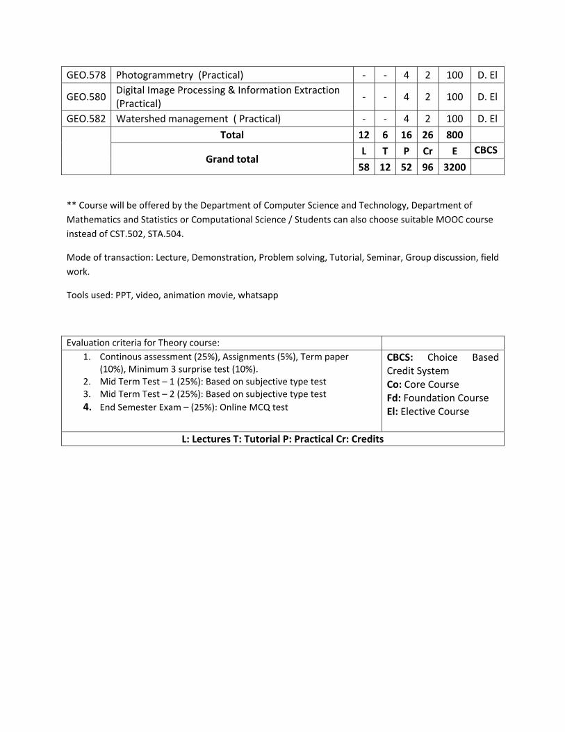
GEO.578 Photogrammetry (Practical) ‐ ‐ 4 2 100 D. El
GEO.580 Digital Image Processing & Information Extraction (Practical)
‐ ‐ 4 2 100 D. El
GEO.582 Watershed management ( Practical) ‐ ‐ 4 2 100 D. El
Total 12 6 16 26 800
Grand total L T P Cr E CBCS
58 12 52 96 3200
** Course will be offered by the Department of Computer Science and Technology, Department of
Mathematics and Statistics or Computational Science / Students can also choose suitable MOOC course
instead of CST.502, STA.504.
Mode of transaction: Lecture, Demonstration, Problem solving, Tutorial, Seminar, Group discussion, field
work.
Tools used: PPT, video, animation movie, whatsapp
Evaluation criteria for Theory course: 1. Continous assessment (25%), Assignments (5%), Term paper
(10%), Minimum 3 surprise test (10%). 2. Mid Term Test – 1 (25%): Based on subjective type test 3. Mid Term Test – 2 (25%): Based on subjective type test
4. End Semester Exam – (25%): Online MCQ test
CBCS: Choice Based Credit System Co: Core Course Fd: Foundation Course El: Elective Course
L: Lectures T: Tutorial P: Practical Cr: Credits
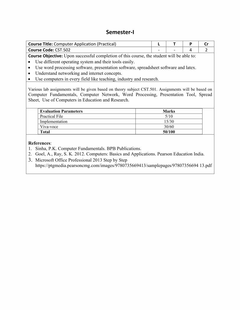
Semester‐I
Course Title: Computer Application (Practical) L T P Cr
Course Code: CST.502 ‐ ‐ 4 2
Course Objective: Upon successful completion of this course, the student will be able to: Use different operating system and their tools easily. Use word processing software, presentation software, spreadsheet software and latex. Understand networking and internet concepts. Use computers in every field like teaching, industry and research. Various lab assignments will be given based on theory subject CST.501. Assignments will be based on Computer Fundamentals, Computer Network, Word Processing, Presentation Tool, Spread Sheet, Use of Computers in Education and Research.
Evaluation Parameters Marks Practical File 5/10 Implementation 15/30 Viva-voce 30/60 Total 50/100
References: 1. Sinha, P.K. Computer Fundamentals. BPB Publications. 2. Goel, A., Ray, S. K. 2012. Computers: Basics and Applications. Pearson Education India. 3. Microsoft Office Professional 2013 Step by Step
https://ptgmedia.pearsoncmg.com/images/9780735669413/samplepages/97807356694 13.pdf
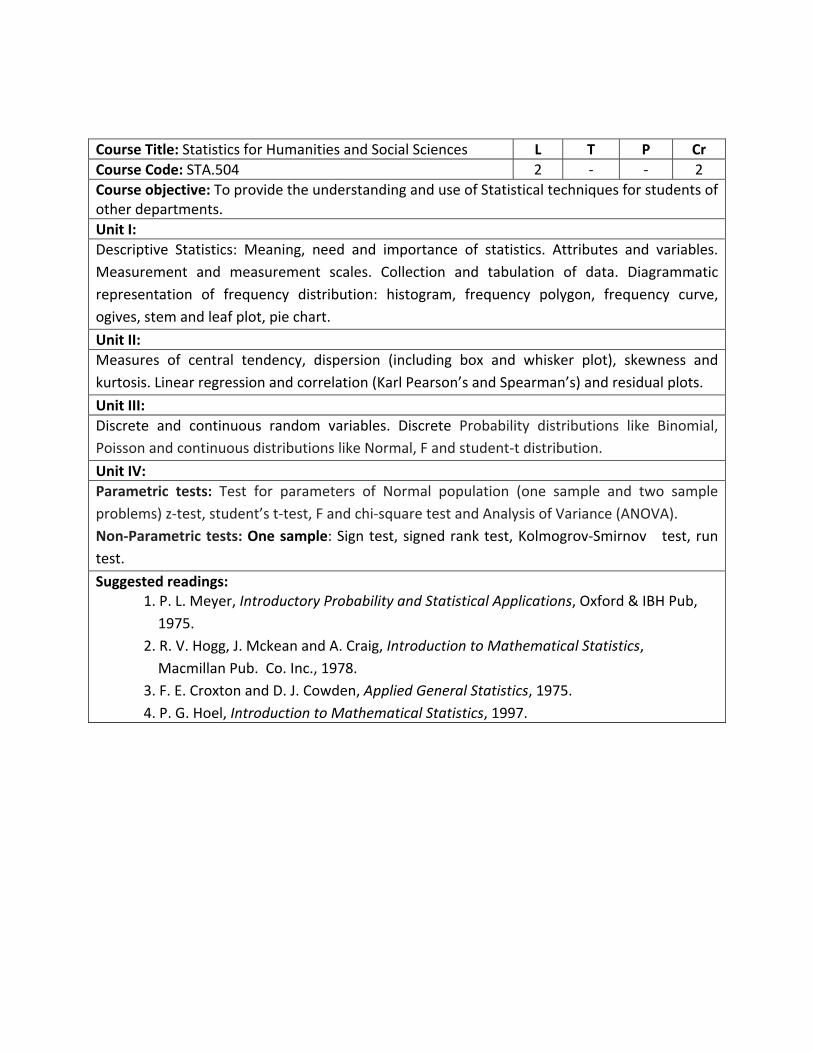
Course Title: Statistics for Humanities and Social Sciences L T P Cr
Course Code: STA.504 2 ‐ ‐ 2
Course objective: To provide the understanding and use of Statistical techniques for students of other departments.
Unit I:
Descriptive Statistics: Meaning, need and importance of statistics. Attributes and variables.
Measurement and measurement scales. Collection and tabulation of data. Diagrammatic
representation of frequency distribution: histogram, frequency polygon, frequency curve,
ogives, stem and leaf plot, pie chart.
Unit II:
Measures of central tendency, dispersion (including box and whisker plot), skewness and
kurtosis. Linear regression and correlation (Karl Pearson’s and Spearman’s) and residual plots.
Unit III:
Discrete and continuous random variables. Discrete Probability distributions like Binomial,
Poisson and continuous distributions like Normal, F and student‐t distribution.
Unit IV:
Parametric tests: Test for parameters of Normal population (one sample and two sample
problems) z‐test, student’s t‐test, F and chi‐square test and Analysis of Variance (ANOVA).
Non‐Parametric tests: One sample: Sign test, signed rank test, Kolmogrov‐Smirnov test, run
test.
Suggested readings: 1. P. L. Meyer, Introductory Probability and Statistical Applications, Oxford & IBH Pub,
1975.
2. R. V. Hogg, J. Mckean and A. Craig, Introduction to Mathematical Statistics,
Macmillan Pub. Co. Inc., 1978.
3. F. E. Croxton and D. J. Cowden, Applied General Statistics, 1975.
4. P. G. Hoel, Introduction to Mathematical Statistics, 1997.
Course Title: Geomorphology L T P Cr
Course Code: GEO.506 4 ‐ ‐ 4
Course objective: It introduces the basic concepts of geomorphology. It covers various geomorphic processes that would help in understanding different landforms on the earths’ surface.
Unit I: Fundamental Concepts in Geomorphology: (12 Lectures)
• Concept & fundamentals of geomorphology; Principles of uniformitarianism • Doctrine of Isostasy ‐ Views of Airy and Pratt • Mountain Building Theories – concepts of Kober, Daly and Holmes. • Concept of relief and relief features – mountains, plateaus, hills, foothills, valleys, plains
and Floodplains.
Unit II: Earth Movements and Interior of the Earth (12 Lectures)
• Plate Tectonics and Continental drift theory. • Earthquake and volcanism – seismology, Plutonism
Evolution of the earth and Earth’s internal structure; composition and characteristics.
Unit III: Geomorphic Processes and landforms (16 Lectures)
• Cycle of Erosion ‐ concepts of Davis and Penck • Gradational and aggradational processes: concept of slope, erosion and mass wasting.
Geomorphic landform: fluvial, glacial, Aeolian, coastal and karst.
Unit IV: Geology and Pedology (16 Lectures)
• Weathering: Physical and chemical Process • Rocks: types, formation and characteristics
Soil: types, formation and characteristics
Suggested readings: 1. Thornbury, W.D. (1969) Principles of Geomorphology, New York: John Wiley and Sons.
2nd edition, December 2004. 2. Singh, Savindra (1998). Geomorphology, Allahabad: Prayag Pustak Bhawan. 3. Bloom, Arthur L., Geomorphology: A Systematic Analysis of Late Cainozoic Landforms,
Pearson Education, Singapore, 3rd Edition, 2003.
4. Bloom, A.L. (1979) Geomorphology, New Delhi: Prentice Hall of India Pvt. Ltd. 5. Chorley, R.J., et.al. (1984): Geomorphology, John Wiley and Sons, New York. 6. Sparks, B.W. (1972): Geomorphology, Longman Group Ltd. 7. Strahler, A.N. (1992) Physical Geography, New York: John Wiley and Sons.
Course Title: Climatology L T P Cr
Course Code: GEO.507 4 ‐ ‐ 4
Course objective: It introduces the basic concepts of climatology. The paper covers understanding the atmospheric condition and various agents affecting the earth surface. It includes applied climatology that would study inter relationship of man and climate.
Unit I: (12 Lectures)
Nature and Scope of Climatology
Earth’s Atmosphere: Evolution, Structure and Composition.
Unit II: (12 Lectures)
Solar radiation and Terrestrial radiation; Variation, distribution and effect on atmosphere
Greenhouse effect and global heat budget
Temperature: Concept, measurement, scales, daily and annual cycles of temperature; vertical distribution; world distribution.
Unit III: (16 Lectures)
Cloud: Type and formation and relation to hydrological cycle
Atmospheric moisture and precipitation: Concept and measurement of atmospheric moisture; condensation ‐ forms of condensation; adiabatic temperature changes, formation and types of precipitation; global distribution of precipitation.
Unit IV: (16 Lectures)
Wind circulation Models of general circulation of the atmosphere: Jet stream, Air masses and fronts, characteristics, movements, frontogenesis.
Tropical cyclones; mechanism and characteristics
Classification of climates: Empirical and generic, Climatic classification with special reference to Koppen and Thornthwaite.
Suggested readings: 1. Savindra Singh (2005). ‘Climatology’, Prayag Pustak Bhavan, Allahabad. 2. Lal, D.S. (1998). ‘Climatology’, Chaitanya Publishing House, Allahabad. 3. Barry, G.G. and Chorley. (1976). Atmosphere, Weather and Climate, Methuen and Co.,
London. 4. Barret, E.C. (1974). Climatology from Satellites, Methuen London. 5. Critchfield, H.F., (1987). General Climatology, Prentice‐Hall of India Pvt. Ltd., New Delhi. 6. Lowa Lutgens, Federic K. & Tarbuck Edward J (1995). ‘The Atmosphere: An Introduction
to Meteorology’, Prentice Hall, New Jersey.
7. Thompson, R.D. and Allen, P. (1997). ‘Applied Climatology: Principles and Practice’, Routledge, London and New York.
Course Title: Oceanography L T P Cr
Course Code: GEO.508 4 ‐ ‐ 4
Course objective:
The objectives of this course are to provide the details of bottom relief of major oceans, major features of ocean basins, circulation patterns in the oceans, temperature and salinity distribution etc. It also helps the students to understand the marine resources and the impacts of humans on marine environment.
Unit I: (12 Lectures)
Nature and Scope of Oceanography;
Major features of Ocean basins and ocean deposits
Bottom relief of Indian, Atlantic and Pacific Oceans.
Unit II: (12 Lectures)
Physical and chemical properties of sea water, sources and factors affecting the distribution of temperature and salinity.
Circulation patterns in the ocean – ocean currents, water masses, waves, tides and tsunamis, their types and theories of origin.
Unit III: (16 Lectures)
Marine biological environment, bio zones – Plankton, Nekton and Benthos
Coral reef; types, characteristics and theories of origin.
Unit IV: (16 Lectures)
Ocean resource and their influence on human activity
Impacts of Humans on the Marine Environment – Laws of the sea, marine resources, pollution, EEZ (exclusive Economic Zone).
Suggested readings: 1. Garrison, T. (2001). Oceanography – An Introduction to Marine Science, Books/Cole,
Pacific Grove, USA. 2. Gross M.Grant (1987). Oceanography – A view of the Earth, Prentice Hall Inc. New
Jersey. 3. Singh Savindra (2001). Oceanography, Allahabad.
Course Title: Cartography (Practical) L T P Cr
Course Code: GEO.509 ‐ ‐ 4 2
Course objective: It introduces the basic concepts of geomorphology. It covers various geomorphic processes that would help in understanding different landforms on the earths’ surface.
Unit I
Map Scale: Horizontal and vertical, vertical exaggeration, Scale factor: Enlargement and reduction of Maps
Reading and Analysis of Topographical Maps of 1:50,000 scale and Preparation of Thematic Map/and Generation of Data from the topographical maps (land use map and
area under different land‐use categories)
Construction of Transect Chart showing the relationship among Relief, Drainage, Vegetation, Settlements, Agriculture and Transport Network
Map projection: Sinusoidal projection, Mollweide’s Projection, UTM projection.
Unit II:
Choropleth mapping (Density of population/Land Use/Cropping pattern)
Nearest Neighbour Analysis
Pie‐graph for representation of land use, cropping pattern, rural‐urban composition, etc.
Cartographic representation of economic data: Age‐sex pyramid, line graph, bar graph
Transport network analysis using connectivity indices (alpha, beta & gamma)
Suggested readings: 1. Keates, J.S. (1998). Cartographic Design and Production, Longman, London. 2. Misra, R.P. and Ramesh, A. (1989). Fundamental of Cartography, Concept Publishing
Company, New Delhi. 3. Monkhouse, F.J. (1994). Maps and Diagrams, Methuen and Co., London. 4. Robinson, A.H. et al. (1992). Elements of Cartography, John Willy & Sons, New York, 6th
edition.
Evaluation criteria for Practical Examination
Examination Practical copy Viva Total
60% 20% 20% 100
Course Title Seminar L T P Cr E
Course Code GEO.541 1 ‐ ‐ 1 100
Evaluation Criteria
Literature Strength (out of 20)
Organization of content (out of 20)
Presentation (out of 20)
Discussion (out of 10)
Report Evaluation (out of 30)
Total (out of 100)
Semester II
Course Title: Geographical Information System L T P Cr
Course Code: GEO. 521 4 ‐ ‐ 4
Course Objective: The course introduces students to the fundamentals of GIS, GPS, data models, data sources, databases and Global Positioning Systems (GPS) and geospatial metadata. It prepares the candidate for the geospatial analysis.
Unit I: (12 Lectures)
Concept and definition of GIS, History and development of GIS technology,

Applications of GIS in various sectors
Unit II: (12 Lectures)
Geographic information System database: data types (map, attributes, image data) and structure; Spatial and non‐spatial data;
Data entry and preparations (inputs, editing and attributing); Geo‐referencing; linking spatial and non‐spatial data; Attribute handling. Functional Elements: Data Acquisition and Topology Creation; Data Management and Structure.
Unit III: (16 Lectures)
Spatial analysis: overlay, buffer and proximity, network analysis;
Contours and spot heights; Determination of slope and hill shading; Data interpolation: point and line data; Output generation and layouts.
Unit IV: (16 Lectures)
Introduction to GPS and history of positioning system;
Segments of GPS; GPS Applications. User interface with global positioning receivers; GNSS and types (NAVSTAR, GLONASS, GALILEO) introduction to DGPS, wide area augmentation system (WAAS);
Suggested readings: 1. Bonham, Carter G.F. (1995): Information Systems for Geoscientists – Modelling with GIS.
Pergamon, Oxford. 2. Burrough, P.A. and McDonnell, R. (1998): Principles of Geographic Information Systems.
Oxford University Press, Oxford. 3. Chang, K.T. (2003): Introduction to Geographic Information Systems. Tata McGraw Hill
Publications Company, New Delhi. 4. Chauniyal, D. D. (2004): Remote Sensing and Geographic Information Systems. (in
Hindi). Sharda Pustak Bhawan, Allahabad.
Course Title: Geographical Information System ‐ (Practical) L T P Cr
Course Code: GEO. 522 ‐ ‐ 4 2
Course Objective: The course provides a firm understanding of the conceptual and technical issues that affects the use of GIS and GPS. Through hands on exercise students will know about beauty of geographic/spatial data management.
Unit I: (12 Lectures)

Geo‐referencing Maps/Images, Digitization of Raster Map: Point, Line and Polygon Features,
Preparation of Attribute Tables, Editing and Joining Tables, Analyzing Attribute Data: Calculating Area, Perimeter, and Length.
Unit II: (12 Lectures)
Spatial Representation: Symbolizing and Map Layouts, Basic Analysis in GIS: Buffering, Overlay and Query Building.
GPS Applications. Collection of ground control points using hand held GPS receiver; transferring data from GPS receiver to PC.
Evaluation criteria for Practical Examination
Examination Practical copy Viva Total
60% 20% 20% 100
Course Title: Geographical Thoughts L T P Cr
Course Code: GEO. 523 4 ‐ ‐ 4
Course Description: It introduces to life and works of various geographers and explains the development of geography as a discipline.
Unit I: (12 Lectures)
Basic Concepts: The field of Geography, its place in the classification of Sciences; Geography as a social science and natural science. Evolution of Geographic Thought: Changing paradigms – Environmentalism, Possibilism, areal differentiation, spatial

organisation.
Unit II: (12 Lectures)
Concept of region, Philosophical debates in Contemporary Geography: Critical understanding of positivism, behaviouralism, realism, Marxism, Structuralism, post‐structuralism and postmodernism.
Unit III: (16 Lectures)
Methods in Geographical Analysis: Epistemology of geography, critical assessment and debates on quantitative, qualitative, field and cartographic methods in geography.
Exceptionalism and the Schaefer‐Hartshorne debate. Feminist geography.
Unit IV: (16 Lectures)
Future of Geography: changing nature, concepts, approaches and methodologies of geography in a Globalising World. Progress and Contributions in Indian Geography.
Suggested readings: 1. Dikshit, R. D. (2004): Geographical Thought. A Critical History of Ideas. Prentice‐Hall of
India, New Delhi. 2. Adams, P., Steven, H. and Karel, T. (eds.) (2001): Texture of Place. Exploring Humanistic
Geographies. University of Minnesota Press, Minneapolis. 3. Anderson, K., Domosh, M., Pile, S. and Thrift, N. (eds.) (2003): Handbook of Cultural
Geography. Sage Publications, London. 4. Barnes, T. and Gregory, D. (eds.) (1997): Readings in Human Geography: The Poetics and
Politics of Inquiry. Arnold, London. 5. Daniels, P., Bradshaw, M., Shaw, D. and Sidaway, J. (2000): An Introduction to Human
Geography. Issues for the 21st Century. Prentice Hall, London. 6. Dear, M. J. and Flusty, S. (2002): The Spaces of Postmodernity: Readings in Human
Geography. Blackwell Publishers, Oxford. 7. Doel, M. (1999): Poststructuralist Geographies. The Diabolical Art of Spatial Science.
Edinburgh University Press, Edinburgh 8. Gaile, G. and Wilmott, C. (eds.) (2003): Geography in America at the Dawn of the 21st
Century. Oxford University Press, Oxford and New York.
Course Title: Bio‐Geography L T P Cr
Course Code: GEO. 524 4 ‐ ‐ 4
Objectives: To familiarise the students with the geographical and historical background of the field of biogeography. It helps the students to understand the ecological factors that shape the distribution of plants and animals and their changes over time. It also provides the details of biogeographical consequences of global change like climate change.
Unit I: (12 Lectures)
Nature, scope, significances, approaches and history of Biogeography
Spatial dimension in biogeography; pattern of plant and animal distributions,
Bio‐geographical regions and realms.
Unit II: (12 Lectures)
Ecology and Ecosystem; significance in biogeography;
Basic ecological principles; Geo‐biochemical cycles: carbon, nitrogen, oxygen and phosphorus cycles;
Biome and biomass;
Unit III: (16 Lectures)
Biogeography of the seas; island biogeography.
Habitat fragmentation; biogeography of linear landscape features.
Biodiversity: depletion and conservation.
Unit IV: (16 Lectures)
Biogeographical information, collection, retrieval and application.
Projecting into the future: Climate change and biodiversity; biogeographical consequences of global change; changing communities and biomes
National forest and wildlife policy of India
Suggested readings: 1. Brown, J. H., & A. C. Gibson, Biogeography, St. Louis, Mosby, 1983. 2. Brown, J.H. and Lomolino, M.V., Biogeography, Second Edition, Sinauer Associates, Inc.
Sunderland, Massachusetts, 1998. 3. Cox, C.B., Moore, P.D., Biogeography, An Ecological and Evolutionary Approach, 5th ed.,
Blackwell Science, Cambridge, 1993. 4. MacDonald, Glen, Biogeography: Introduction to Space, Time and Life, John Wiley, New
York, 2002. 5. Robinson, H., Biogeography, The English Language Book Society and Macdonald and
Evans, London, 1982.
Course Code Course Title L T P Cr E
GEO.542 Seminar 1 ‐ ‐ 1 100
Evaluation Criteria
Literature Strength (out of 20)
Organization of content (out of 20)
Presentation (out of 20)
Discussion (out of 10)
Report Evaluation (out of 30)
Total (out of 100)
Compulsory Paper for M.A.
Course Title: Quantitative Methods in Geography (Practical) L T P Cr
Course Code: GEO. 525 ‐ ‐ 4 2
Course description: Scientific research in geography requires an understanding into tools and techniques for explaining data. This course is design to help students understand quantitative methods in their research works.
Unit I: (12 Lectures)
Geographic pattern and its measures: Nearest Neighbour Analysis; Gini’s Co‐efficient; Lorenz curves; Location quotient; Rank size rule
Network Analysis: Indices of transport network efficiency; Compositing the indices of transport network efficiency; Indices of nodal accessibility; Local degree –Road Local degree –Rail. Weighed road capacity and tortousrity ratio; Compositing the indices of nodal accessibility.
Unit II: (12 Lectures)
Methods of predictions and levels of measurement: Levels of measurement; Methods of sampling; Simple linear regression analysis; Plotting of regression line; Plotting of absolute and relative residuals; Explanation of residuals plotted on the maps.
Measures of disparities and potential model: Gravity and potential models; Delimitation of hinterlands; Combinational analysis of Weaver, S.M. Rafiulla’s method, Measures of Disparities: Kendall’s ranking method.
Suggested readings: 1. Berry, B.J.L. and Marble, D.R. (ed), 1968, Spatial Analysis: A Reader in Statistical
Geography, Prentice Hall, New York.
2. Cole, J.P. and Kind, C.A.M. 1968. Quantitative Geography, John, Wiley, New York. 3. Ibrahim, R., 1984. Market Centers and Regional Development. B.R. Publisher, New Delhi.4. Mahmood, A, 1986. Statistical Methods in Geographic Studies. Rajesh Publishers, New
Delhi. Smith, D.M., 1975. Patterns in Human Geography, Penguin Books, England.
Elective courses I: Select any one for M.A. Geography
Course Title: Economic Geography L T P Cr
Course Code: GEO.526 4 ‐ ‐ 4
Objectives: This course helps the students to understand the basic concepts of economic geography and its relationship with other social sciences. It includes the various measures of economic development and economic theories that will help in understanding location and distribution of economic activities.
Unit I: (12 Lectures)
Economic Geography: Nature and scope; Relationships of economic geography with other branches of social sciences
Approaches in economic geography: regional, systematic and sectoral
Unit II: (12 Lectures)
Resources: Significance of Natural and Human resources in Economic Development;
Economic Development: Measures of economic development: Rostow’s and Myrdal’s models;
Factors of Production: Significance of land, labor and capital in different economic activities,
Unit III: (16 Lectures)
Agricultural Patterns‐Precolonial, colonial and neo‐colonial;
Technology, modernization and structuring of agrarian regions;
Locational models of Von Thunen and Weber ‐ critical and Contemporary perspective
Unit IV: (16 Lectures)
Emergence of new global economy: Global integration and its spatial outcome
Major regional trade blocks of the world, free trade initiatives (GATT, UNCTAD, WTO)
Suggested readings: 1. Bryson, J., et. al. (1999). The Economic Geography Reader, John Wiley, Chichester. 2. Chakraborty, S. and Somik V. (2007). Made in India : The Economic Geography and
Political Economy of Industrialization, Oxford, New Delhi. 3. Clark, G., et. al. (2000). The Oxford Handbook of Economic Geography, Oxford, New
York. 4. Dodson, R.A. (1998). Society in Time and Space, Cambridge University Press, Cambridge. 5. Grossman, G. (1984). Economic Systems, Prentice Hall, New Jersey. 6. Hanink, D. M. (1997). Principles and Applications of Economic Geography, John Wiley,
New York. 7. Hartshorn, Truman, A. and John W. A. (1994). Economic Geography, 3rd Edition,
Prentice Hall of India Pvt. Ltd., New Delhi.
Course Title: Human Ecology L T P Cr
Course Code: GEO.527 4 ‐ ‐ 4
Course Objectives: The course introduce to the concept of ecology with reference to human ecology. The course design will help in better understanding to human and it environment relationship that forms a foundation of geography
Unit I: Human Ecology: (12 Lectures)
Evolution & Development; Key Concepts: Anthropocentricism, cultural lag, the commons and theories; Environmental ethics.
Unit II: Humans and environment: (12 Lectures)
Humans and the Biosphere: Coevolution and coadaptation of human system and ecosystems;
Resources, technologies, environment and consumerism: Problems and consequences; Geographies of wealth, hunger and health.
Unit III: Humans and biophysical system: (16 Lectures)
Humans as agents of larger social system; Human population size, growth and biophysical carrying capacity of Earth; Positive and negative feedback of human numbers and quality of life; Alteration of biogeography, material cycles and energy flow.
Unit IV: Global change adaptation: (16 Lectures)
Environmental crises and human reintegration. The end of duality: Adaptation and behavioural change; Environmental Management (undoing misdeeds): Eco regional and watershed
Management strategies; Landscapes restoration and conservation of biodiversity.
Suggested readings: 1. Beeby, A. and Brennan, A. (2008). First Ecology: Ecological Principles and Environmental
Issues, 3 rd Edition, Oxford University Press. 2. Chandna, R.C. (1998). Environmental Awareness, Kalyani Publishers, New Delhi. 3. Dieter Steiner and Marcus Nauser (eds.): Human Ecology; New York: Routledge, 1993 4. Ehrlich, P.R., A.H. Ehrlich and J.P. Holdren: Human Ecology, San Francisco: W.H. Freeman
& Co.; 1973 5. George A. Theodorson (ed.): Studies in Human Ecology, New York: 6. Global Environment Outlook (2000). Earthscan Publications, London. 7. Kormondy, Edward J. (1989). Concepts of Ecology, Third Edition, Prentice‐Hall of India,
New Delhi. 8. Odum, Eugene P. (1971). Fundamentals of Ecology, Natraj Publishers, Dehra Dun.
Course Title: Agricultural Geography L T P Cr
Course Code: GEO.528 4 ‐ ‐ 4
Course Objectives: The course helps the students to understand the basics of agricultural geography, starting from its nature, contents, progress, approaches, determinants etc., to the important concepts like
cropping Intensity, crop‐concentration, crop pattern, crop combinations, diversification, commercialization, development etc. It familiarizes the students with locational models and diffusion models and provides them the understanding of agricultural regionalization, landuse and land capability classifications as well as classification of agricultural types.
Unit I: (12 Lectures)
The nature, scope and progress in Agricultural Geography.
Approaches: commodity, systematic, regional.
Determinants: physical, economic, socio‐cultural.
Unit II: (12 Lectures)
Agricultural concept and their measurement: Cropping intensity, crop concentration and diversification, crop combinations, agricultural efficiency and productivity;
Agricultural location models: Von Thunen. Diffusion of innovations: T. Haggerstrand’s neighbourhood effect model of agricultural innovation diffusion
Unit III: (16 Lectures)
Land‐use survey and classification (British and Indian).
Land capability classification (U.S. and Britain).
World agricultural systems. A critical evaluation of the classification of world agriculture with special reference to Whittlesey,
Unit IV: (16 Lectures)
Indian agriculture – Characteristics, Problems and prospects
Agricultural policy in India – with reference to green revolution
New perspectives in Agriculture: Sustainable agriculture, Contract Farming, Agri‐business and Food Security.
Suggested readings: 1. Hussain, M. (1996). Systematic Agricultural Geography, Rawat Publications, Jaipur. 2. Ilbery, B. W. (1985). Agricultural Geography, Oxford University Press, Oxford, 1985. 3. Shafi, M. (2006). Agricultural Geography, Pearsons Publications, New Delhi. 4. Singh, J. and Dhillon, S.S.(1984). Agricultural Geography, Tata McGraw Hill, New
Delhi.
Course Title: Political Geography L T P Cr
Course Code: GEO.529 4 ‐ ‐ 4
Course Objectives: The course on political geography introduces various political dynamics in different regions. The understanding into this dynamics would help the students in understanding the study of spatial aspects in geographical explanation. It also helps the students to understand the changing political map of India and emergence of new states.
Unit I: (12 Lectures) Nature and scope of political geography, its approaches and recent trends
Approaches to study; major schools of thoughts
Themes in political geography: State, Nation, Nation‐state and Nation‐building
Unit II: (12 Lectures)
Geographic elements and the state; Physical, Human and Economic Elements Political Geography and Environment Inter‐face.
Frontiers and Boundaries; Colonialism, Decolonization, Neo‐colonialism, Federalism and other forms of governance.
Unit III: (16 Lectures)
The changing patterns of World Powers Perspectives on core periphery concepts, Conflicts cooperation.
Geopolitical significance of Indian ocean;
Political geography of any one of the following regions; SAARC region, South East Asia, West Asia, East Asia.
Unit IV: (16 Lectures)
Political Geography of contemporary India with special reference to: The changing Political map of India, Unity‐Diversity, Centripetal and Centrifugal forces, Stability and Instability,
Inter‐state issues (lake water disputes and riparian claims) and Conflict Resolutions Insurgency in boarder states;
Emergence of New States and Federal India.
Suggested readings: 1. Bhambri, C.P. (1991). Political Process in India, Vikas, New Delhi. 2. Brass, P. R. (1990). The Political Economy of India Since Independence, Cambridge
University Press, New Delhi. 3. Brass, P.R. (1983). Caste, Faction and Party in Indian Politics, Vol. I and II, Chankya
Publications, Delhi. 4. Brass, P. R. (2003). The Production of Hindu Muslim Violence in Contemporary India,
Oxford University Press, Delhi.
Course Title: Regional Planning in India L T P Cr
Course Code: GEO.530 4 ‐ ‐ 4
Course Objectives: Regions as a geographical entity have become a centre of study or interest in modern research. Due to the growing economies and urbanisation, understanding the concept of regional planning and its various elements is important for student. The course specially highlights Indian context.
Unit I: (12 Lectures)
Fundamentals: Concept, nature and scope of regional planning, methods of regional planning, different approaches to regional planning, planning regions, concept and types; methods of delimitation, planning regions of India, regional policies in India.
Unit II: (12 Lectures)
Conceptual Outlook. Regional planning and national development; Economic development and regional development; Regional economic complexes; Inter‐regional and intra‐regional functional interactions; Regional disparities in India.
Unit III: (16 Lectures)
Approaches. Approaches to integrated regional planning at different levels: local, regional and national; Spatial organisation: Central Place Theory, Concept of core and periphery Friedman’s Model of Spatial Organisation and Economic Growth. Growth centres and Growth pole theory of Perroux.
Unit IV: (16 Lectures)
Planning and region: Five Year Plans: command area development, planning for backward area, desert drought‐prone,
hill and tribal area development; Multi‐level planning in India: State, District and Block level planning; Decentralized planning and Panchayati raj; watershed management; Regional economic imbalances and inequalities in India; SEZs in regional development.
Suggested readings: 1. Chandna, R. C. (2000). Regional Planning: A Comprehensive Text. Kalyani Publishers.,
New Delhi. 2. Chaudhuri, J. R. (2001). An Introduction to Development and Regional Planning with
special reference to India. Orient Longman, Hyderabad. 3. Cowen, M.P. and Shenton, R.W. (1996). Doctrines of Development. Routledge, London. 4. Doyle, T. and McEachern, D. (1998). Environment and Politics. Routledge, London. 5. Friedmann, J. (1992). Empowerment: The Politics of Alternative Development. Blackwell,
Cambridge MA and Oxford. 6. Friedmann, J. and Alonso, W. (ed.) (1973). Regional Development and Planning. The MIT
Press, Mass. 7. Hettne, B.; Inotai, A. and Sunkel, O. (eds.) (1999–2000). Studies in the New Regionalism.
Vol.I‐V. Macmillan Press, London. Isard, W. (1960). Methods of Regional Analysis. MIT Press, Cambridge, MA.
Course Title: Human Geography L T P Cr
Course Code: GEO.531 4 ‐ ‐ 4
Course Objectives: The course design to explain the relation of man and nature, distributions of human and phenomena relations to the locations.
Unit I: (12 Lectures)
Nature, scope and development of Human Geography
Branches of Human Geography;
Human versus physical geography;
Unit II: (12 Lectures)
Origin and diffusion of major racial groups in the world;
Major races: Physical characteristics and distribution of the major racial groups (Caucasoid, Mongoloid and Negroid);
Linguistic and religious regions in the world.
Unit III: (16 Lectures)
Geography of Difference and Exclusion: Geographies of identity and difference related to class, religion, caste, gender and location;
Population, Resources And Development: Demographic transformations: Growth of world population, Differential, Population change, the progress of Demographic Transition, Population Agency;
Unit IV: (16 Lectures)
Population Growth and Food Supply, Globalization and Food Regimes,
Reorientation of developing world Agriculture;
Alternative geographies of global development and inequality.
Suggested readings: 1. Agnew, J.A. and Corbridge, S. (1995). Mastering Space: Hegemony, Territory and
International Political Economy, Routledge, London. 2. Benko, G. and Strohmayer, U. (1997). Space and Social Theory : Interpreting Modernity
and Postmodernity, Blackwell Publishers, Oxford, London. 3. Bergwan, Edward E: (1995). Human Geography: Culture, Connections and Landscape,
prentice‐Hall, New Jersey. 4. Bhabha, H. (1994), The Location of Culture, Routledge, London and New York. 5. Carr, M. (1987). Patterns, Process and change in Human Geography, MacMillan
Education, London. 6. Cloke, P., Crang, P. and Goodwin, M (1999). Introducing Human Geographies, Arnold,
London. Corbridge, S., 7. Martin, R. and Thrift, N. (1997). Money, Power and Space, Blackwell, Oxford.
Course Title: Sustainability Studies L T P Cr
Course Code: GEO.532 4 ‐ ‐ 4
Course Objectives: The course gives interdisciplinary perspective to the students. It creates awareness and inculcates knowledge about concept and practices for sustainability.
Unit I: (12 Lectures)
Sustainable Development: Definition, concept and historical developments;
Difference between economic growth, economic development and sustainable development;
Economic theories of sustainable development, reconciliation between political and theoretical discourses.
Unit II: (12 Lectures)
Geography and Sustainable Development: Sustainable development in disciplinary perspective, sustainable development and geographical agenda, geography and the pursuit of sustainable development.
Sustainable Development and the Spatial Scale and Spatial Interaction : Structuring global scale, achieving sustainable development at local, regional, national and global scales, sustainable development and open economies, interaction between different spatial scales
Unit III: (16 Lectures)
Making Cities Sustainable: Continuity and change in urban problems, defining sustainable urban development, urban challenges in developing world.
Sustainable Economic Development: Business and the environment, sustainable economic development as Eco‐efficiency, sustainable farming, resource efficiency and resource redistribution, and sustainable futures.
Unit IV: (16 Lectures)
Climate change, Energy, and Sustainable Development: Climate change as a threat to sustainable development, current and future climate regimes, mitigating climate change.
Future Perspectives: Existing strategies for sustainable development, consensus and contest, challenge of sustainable development, sustainable development and societal change.
Suggested readings: 1. Adams, W.M. (2001). Green Development: Environment and Sustainability in Developing
Countries, 2nd edition, Routledge, London. 2. Barbier, E.B. (1987). The Concept of Sustainable Development, Environmental
Conservation, 14(2), 101‐110. 3. Daly, H.E. (1999). “Towards Some Operational Principles of Sustainable Development”,
Ecological Economics, 2(1), 1‐6. 4. World Commission on Environment and Development (1987). Our Common Future,
Oxford University Press, Oxford. 5. Purvis, M. and Alan Grainger (2004). Exploring Sustainable Development: Geographical
Perspectives, Earthscan, London.
Course Title: Gender Geography L T P Cr
Course Code: GEO.533 4 ‐ ‐ 4
Course Objectives: Objective of the course is to introduce the students to the concept of gender perspective in geography.
It describes approaches, movement and development of gender geography.
Unit I: (12 Lectures)
Feminism and feminist movement,
Feminist epistemology, scope, nature and development of gender geography.
Unit II: (12 Lectures)
Quality of life among female in the developed and developing countries; sex‐ratio and child and maternal mortuary rate, Literacy and education;
Status of females in the society in Development and Developing countries with special reference to India.
Unit III: (16 Lectures)
Gender and Work: Historical developments in the sexual division of labour, Crime against women with special reference to domestic violence;
Participation in economic activities: Primary, Secondary and Tertiary Sector, Domestic work and its significance.
Unit IV: (16 Lectures)
Empowerment of women: education, economic opportunities, access to health services;
Involvement in decision making processes from local bodies to parliaments: Role of women in development, environmental management and disaster management.
Suggested readings: 1. Boserup, E. 1989, Women’s Role in Economic Development Earthscan, London. 2. Dankelman, I & Davidson, J. 1989, Women and environment in the Third world,
Earthsan, London. 3. Deblig, H,J. 1996, Human geography‐Culture, society and space (5thedition), John Wiley,
New York. 4. Johnston, R.J. et, al(eds), 1996. The health of women, A global respective, Westview
press, Boulder. 5. Koblinsky, M.et. Al (eds), 1993. The health of women‐A global respective, Westview
press, Boulder. 6. Lee, D, 1988. Women in geography –A Comprehensive Bibliography, Boca Raton,
Florida.
Course Title: Human Geography L T P Cr
Course Code: GEO.534 4 ‐ ‐ 4
Course Objectives: The course design to explain the relation of man and nature, distributions of human and phenomena relations to the locations.
Unit I: (12 Lectures)
Introduction: Legal and political environments in resource management. Global and local governance, challenges of good governance.
Local utilization and institutions: Joint Forest Management Committees (JFMCs), watershed committees, irrigation committees, Forest Rights Act (FRA) committees, Biodiversity Management Committees (BMCs), etc.
Unit II: (12 Lectures)
Overview of legal policy instruments in Natural Resource Management: National Forest Policy of 1988, National Environment Policy of 2004, National Conservation Policy, National Action Plan on Climate Change of 2008, Coastal Protection Act. Wildlife Protection Act of 1972, Forest Protection Act of 1980, Environment Protection Act of 1986, ICZM‐Indian Coastal zone management, Water Act, 1981. Biological Diversity Act of 2002 and Rule 2004, Forest Rights Act of 2006. Green Tribunal Act, 2009. The precautionary principle and common responsibilities.
Unit III: (16 Lectures)
Non‐Timber Forest Products (NTFP) related policies and other acts: (PESA 1996, FRA 2006), sustainable harvesting rules of MP, Nistar Rights in MP and Chhattisgarh, product specific policies, taxation, Institutional/Organizational Arrangements. NTFP Deregulation, Policy of Odisha.
Conflicts in resource management: Resource management planning, protecting traditional knowledge, customary laws and practice related to traditional knowledge, implications for access benefit sharing
Unit IV: (16 Lectures)
International and National efforts: CITES and other international treaties and conventions, roles of international organizations and NGOS with special reference to UN and specialized agencies, institutional regulatory bodies and authorities.
Suggested readings: 1. Knight, Richard L., editor, et al. 1995. A New Century for Natural Resources
Management. Island Press. 2. Heal, Geoffrey. 2000. Nature and the Marketplace: Capturing The Value Of Ecosystem
Services. Island Press. 3. Bhattacharya P., Kandya A.K. and Krishna Kumar 2008. Joint Forest Management in
India, Aavishkar Publisher, Jaipur. 4. Daily, Gretchen, editor, et al. 1997. Nature’s Services: Societal Dependence on Natural
Semester III
Course Title: Fundamentals of Remote Sensing L T P Cr
Course Code: GEO.551 4 ‐ ‐ 4
Course Objectives:
It introduces the students to the basic concepts and the skills necessary to acquire remote sensing data and extract geo‐information from them. The objective of this course is to give understanding of fundamentals of remote sensing.
Unit I: (12 Lectures)
Fundamental Concepts of Remote Sensing:
Remote Sensing: Definition, Concept, History and Applications; Types of Remote Sensing; Remote Sensing Platforms and Scanning Systems.
Unit II: (12 Lectures)
EMR Principles and Interaction Mechanisms:
Radiation Principles; Electromagnetic Spectrum; Energy‐Atmosphere Interaction; Atmospheric Windows; Energy‐Earth Interaction; Spectral Signatures of Surface Features.
Unit III: (16 Lectures)
Remote Sensing platforms, sensors and satellite series:
RS Satellites‐ Polar sun‐synchronous, geo‐stationary; Platforms: Types and their orbital characteristics; Sensors types: active and passive; Sensors systems: whiskbroom and push broom; Principles and geometry of scanners and CCD arrays; Satellite RS data products or series: LANDSAT, SPOT, IRS, IKONOS, Quick bird.
Unit IV: (16 Lectures)
Image Processing and Interpretation:
Image: Meaning and Types (Analogue and Digital) and Characteristics; Resolution: Spatial, Spectral, Radiometric and Temporal; Basics of Image Processing; Elements of Image Interpretation. Ground Truth Collection, Visual Interpretation.
Suggested readings: 1. Cracknell, A and Hayes, L. (1990). Remote Sensing Year Book, Taylor and Francis,
London. 2. Curran, P.J. (1985). Principles of Remote Sensing, Longman, London. 3. Deekshatulu, B.L. and Rajan, Y.S. (ed.) (1984). Remote Sensing. Indian Academy of
Science, Bangalore. 4. Floyd, F. and Sabins, Jr. (1986). Remote Sensing: Principles and Interpretation, W.H.
Freeman, New York. 5. Guham, P. K. (2003). Remote Sensing for Beginners. Affiliated East‐West Press Private
Ltd., New Delhi. 6. Hallert, B. (1960). Photogrammetry, McGraw Hill Book Company Inc., New York 7. Harry, C.A. (ed.) (1978). Digital Image Processing, IEEE Computer Society, California 8. Hord, R.M. (1982). Digital Image Processing of Remotely Sensed Data, Academic Press,
New York.
Course Title: Fundamentals of Remote Sensing (Practical) L T P Cr
Course Code: GEO.552 ‐ ‐ 4 2
Course objective: The practical course gives operational skills necessary to acquire remote sensing data and extract geo‐information from them.
Unit I
Remote sensing and image interpretation: Referencing layout and indent of Landsat TM or IRS imageries; Identification of objects / features on multiband imageries; Detection of defined objects/features; Preparation of Image interpretation keys; Interpretation, classification, delineation and mapping of land use/land cover from False Colour Composite (FCC); Transfer of information from imagery to base map.
Unit II:
Image Processing: Digital Image: Definition, size and Image Formats; Image Processing System : Image Registration : Image to map and Image to Image; Image Enhancement Techniques : Histogram Equalization. Contrast stretching, filtering and band rationing. Image Classification: selection of training sets, supervised and unsupervised classification.
Suggested readings: 1. Keates, J.S. (1998). Cartographic Design and Production, Longman, London. 2. Misra, R.P. and Ramesh, A. (1989). Fundamental of Cartography, Concept Publishing
Company, New Delhi. 3. Monkhouse, F.J. (1994). Maps and Diagrams, Methuen and Co., London. 4. Robinson, A.H. et al. (1992). Elements of Cartography, John Willy & Sons, New York,
6th edition.
Evaluation criteria for Remote Sensing Practical
Examination Practical copy Viva Total
60% 20% 20% 100
Course Title: Survey and Field visit L T P Cr
Course Code: GEO.553 ‐ 2 ‐ 2
Course objective: This course will help the student to interact with people in studying their socio‐economic study. A survey schedule will be organised in selected areas (village/town, etc.) for 10 – 15 days. This will help the student understand and interact with people more closely that would be beneficial for carrying out research in future.
Unit I
Procure a topographic map of 1:50,000 to 1:25,000 scale to study the Settlements selected in its regional setting. Prepare a site map of the survey area; settlement, road, water body, agricultural field etc. Collection of socio‐economic profile data of the survey site and create a demographic profile from the secondary date; Data procure from census office, economic and statistics office. Assessment of the secondary data by using statistical tools and techniques.
Unit II:
Conduct a socio‐economic survey of the households with a structured scheduled/questionnaire. Supplement the information by personal observations and perceptions. Based on results of the land‐use and socio‐economic enquiry of the households, prepare a critical field‐survey report. Photographs and sketches, in addition to maps and diagrams, may supplement the report.
Evaluation Criteria for Field survey
Active participation in field work Report writing Presentation Total (100)
Course Title: Research Methodology L T P Cr
Course Code: GEO.502 4 ‐ ‐ 4
Course Objectives: The course will make the students aware about types, approaches and methods of research in geography and orient the students to design and prepare geographic research proposal, with emphasis on problem identification, methodology design and literature review.
Unit I: (12 Lectures)
Introduction to research in Geography: Concept and significance of research in geography; Philosophy and methods; Naturalism and anti‐naturalism; realism and idealism, Critical thinking.
Unit II: (12 Lectures)
Research and Academic Integrity: Copyright issues, Conduct of ethical research, Belmont report and Plagiarism in research.
Scientific Research; Inductive and deductive approaches; Research design; Formulation of research problem; Development and testing of hypothesis; Techniques of data collection; Sampling and field survey.
Unit III: (16 Lectures)
Data Analysis, interpretation and report writing: Data classification and tabulation; Data analysis and interpretation; reference writing; APA, MLA, Chicago.
Unit IV: (16 Lectures)
Writing thesis, project report and research paper; Synopsis writing: procedure, content, methods, literature review.
Suggested readings: 1. Blackburn, J. and Holland, J. (eds.) (1998): Who Changes? Institutionalising Participation
in Development. IT Publications, London. 2. Blaxter, L.; Hughes, C. and Tight, M. (1996): How to Research. Open University Press,
Buckingham. 3. Dikshit, R. D. (2003): The Art and Science of Geography: Integrated Readings. Prentice‐
Hall of India, New Delhi. 4. Dorling, D. and Simpson, L. (eds.) (1999): Statistics in Society. Edward Arnold, London. 5. Fisher, P. and Unwin, D., (eds.) (2002): Virtual Reality in Geography. Taylor and Francis,
London. 6. Flowerdew, R. and Martin, D. (eds.) (1997): Methods in Human Geography. A Guide for
Students Doing a Research Project. Longman, Harlow. 7. Hay, I. (ed.) (2000): Qualitative Research Methods in Human Geography. Oxford
University Press, New York. 8. Kitchin, R. and Tate, N., (2001): Conducting Research into Human Geography. Theory,
Methodology and Practice. Prentice‐Hall, London. 9. Limb, M. (2001): Qualitative Methodologies for Geographers. Issue and Debates.
Edward Arnold, London.
Course Title Seminar L T P Cr
Course Code GEO.543 1 ‐ ‐ 1
Course Detail: The student will prepare a report under the guidance of faculty assigned as supervisor and present it for evaluation.
Evaluation Criteria
Literature Strength (out of 20)
Organization of content (out of 20)
Presentation (out of 20)
Discussion (out of 10)
Report Evaluation (out of 30)
Total (out of 100)
Course title Introduction to Map reading L T P Cr
Course code GEO.503 ‐ 2 ‐ 2
The student will opt for courses that are provided at university level.
Course Title Project L T P Cr
Course Code GEO.599
Course Objective: The student will prepare a report under the guidance of faculty assigned as supervisor and present it for evaluation.
Evaluation criteria
Literature Strength (out of 20)
Organization of content (out of 20)
Presentation (out of 20)
Discussion (out of 10)
Report Evaluation (out of 30)
Total (out of 100)
Elective courses II: Select any one elective course and its respective practical course from the
followings:
Course Title: Geography of Disaster L T P Cr
Course Code: GEO.554 4 ‐ ‐ 4
Course Objectives: The course in Geography, as a science of human‐environment interactions, offers key analytical tools for understanding the complex causes and uneven impacts of disaster and hazards around the world. It explores various types and impacts of disasters.
Unit I: (12 Lectures)
Concept Hazard, Disaster and Catastrophe; Concept of vulnerability, risk, mitigation, prevention, preparedness, response and recovery; Classification of Disasters.
Unit II: (12 Lectures)
Natural Disaster study (Causes, Assessment and Management): Cyclones, droughts, forest fires, earthquakes, volcanoes, landslides.
Unit III: (16 Lectures)
Man‐made disaster study: Fire, Terrorism, Food poisoning, stampedes.
Impacts of Disasters: Social, Economic, political, environmental, health, psychological; Differential impacts: Caste, class, gender, age, location, disability.
Unit IV: (16 Lectures)
Applications of GIS and Remote sensing in disaster studies.
Suggested readings: 1. Turk J. (1985). Introduction to Environmental Studies, Saunders, College Publication,
Japan 2. Singh Savindra (2000). Environmental Geography, Parag Pustak Bhavan, Allahabad 3. Morrisawa M (Ed) (1994). Geomorphology and Natural Hazards, Elsevier, Amsterdam 4. Hart M. G. (1986). Geomorphology, Pure and Applied, George Allen and Unwin, London 5. Valdiya K. S. (1987). Environmental Geology, Tata McGraw Hill, New Delhi. 6. Bryant Edward (2000). Natural Hazards, Cambridge University Press 7. Daly Herman E. (1996). Beyond Growth, Beacon Press, Boston 8. Daly Herman E and Twonseed Keneth N (Ed) (1993). Valuing the earth – Economics,
Ecology and Ethics, MIT Press, London 9. Agarwal Anil and Narain Sunita (Ed) (1999). State of India’s Environment The Citizens
Report, Centre for Science and Environment, New Delhi
Course Title: Geography of Disaster (Practical) L T P Cr
Course Code: GEO.555 ‐ ‐ 4 2
Course objective: The course place emphasis on analytical geographical tools to study disasters. Students will learn to do mapping and prepare hazard zones using remote sensing and GIS techniques
Unit I
Risk and vulnerability assessment hazard zonation, Use of remote sensing and GIS in hazard studies.
Unit II:
Hazards zonation/ mapping: meteorological –cyclones, typhoons, hurricanes and droughts, forest fires, causes, assessment, effects and control measures. Natural hazards – Geological – earthquakes, volcanoes, causes, effects and control measures; Natural hazards – Geomorphic – landslides, soil erosion and gullying, coastal erosion causes, assessment, effects and control measures.
Evaluation criteria for Geography of Disaster ‐ Practical
Examination Practical copy Viva Total
60% 20% 20% 100
Course Title: Social and Demography Geography L T P Cr
Course Code: GEO.556 4 ‐ ‐ 4
Course Objectives: The paper reflects various social issues in relation to demographic feature. The student would be introduce to various concepts of social as well as demography that would inculcate in structuring thoughts in the minds of student.
Unit I: (12 Lectures)
Social Welfare and Well‐being: Concept and Components – Healthcare, Housing and Education.
Social Geographies of Inclusion and Exclusion, Slums, Gated Communities, Communal Conflicts and Crime.
Unit II: (12 Lectures)
Population ageing and dependency ratios
Concept of Space: Social space, Material space
Unit III: (16 Lectures)
Introduction to Demography. History of Population Growth. Geographic Distribution of
World Population and Global Variations in Population Size and Growth.
Theories of Population Growth: Malthus and Marx
The Concepts of Age and Sex. Impact of Mortality rate
Unit IV: (16 Lectures)
Demographic evaluation of Family Planning Programme
Demography Dynamics: Fertility, Mortality and Migration – Measures, Determinants and Implications
Suggested Reading: 1. Ahmed A., 1999: Social Geography, Rawat Publications. 2. Casino V. J. D., Jr., 2009) Social Geography: A Critical Introduction, Wiley Blackwell. 3. Cater J. and Jones T., 2000: Social Geography: An Introduction to Contemporary Issues, Hodder Arnold. 4. Holt L., 2011: Geographies of Children, Youth and Families: An International Perspective, Taylor & Francis. 5. Panelli R., 2004: Social Geographies: From Difference to Action, Sage. 6. Rachel P., Burke M., Fuller D., Gough J., Macfarlane R. and Mowl G., 2001: Introducing Social Geographies, Oxford University Press. 7. Smith D. M., 1977: Human geography: A Welfare Approach, Edward Arnold, London. 8. Smith D. M., 1994: Geography and Social Justice, Blackwell, Oxford. 9. Smith S. J., Pain R., Marston S. A., Jones J. P., 2009: The SAGE Handbook of Social Geographies, Sage Publications. 10. Sopher, David (1980): An Exploration of India, Cornell University Press, Ithasa 11. Valentine G., 2001: Social Geographies: Space and Society, Prentice Hall
Course Title: Social and Demography Geography (Practical) L T P Cr
Course Code: GEO.557 ‐ ‐ 4 2
Course objective: This paper is intended to help the student giving geographical thoughts in carrying out research related to demographic issue.
Unit I
Procedures of data collection: primary and secondary
Sampling techniques : random, stratified random and purposive
Preparation of choropleth map, histogram, etc.
Unit II:
Measures of dispersion: mean deviation, quartile deviation, standard deviation and Co‐efficient of variation.
Bivariate scatter diagram and regression trend line
Coefficient of correlation after Karl Pearson
Suggested Reading: 1. Ahmed A., 1999: Social Geography, Rawat Publications. 2. Casino V. J. D., Jr., 2009) Social Geography: A Critical Introduction, Wiley Blackwell. 3. Cater J. and Jones T., 2000: Social Geography: An Introduction to Contemporary Issues, Hodder Arnold. 4. Holt L., 2011: Geographies of Children, Youth and Families: An International Perspective, Taylor & Francis. 5. Panelli R., 2004: Social Geographies: From Difference to Action, Sage. 6. Rachel P., Burke M., Fuller D., Gough J., Macfarlane R. and Mowl G., 2001: Introducing Social Geographies, Oxford University Press. 7. Smith D. M., 1977: Human geography: A Welfare Approach, Edward Arnold, London. 8. Smith D. M., 1994: Geography and Social Justice, Blackwell, Oxford. 9. Smith S. J., Pain R., Marston S. A., Jones J. P., 2009: The SAGE Handbook of Social Geographies, Sage Publications. 10. Sopher, David (1980): An Exploration of India, Cornell University Press, Ithasa 11. Valentine G., 2001: Social Geographies: Space and Society, Prentice Hall
Evaluation criteria for Social and Demography Geography ‐ Practical
Examination Practical copy Viva Total
60 20 20 100
Course Title: Gender, Health and Development L T P Cr
Course Code: GEO.558 4 ‐ ‐ 4
Course Objectives: The student will benefit in understanding the relationship of gender and health.
Unit I: (12 Lectures)
The Concept of gender, Evolution of gender in historical perspective; Patriarchy, Kinship Structure and gender roles, Feminist theories, Gender stratification in traditional and modern societies, Gender Analysis Tools, Gender Sensitive Indicators;
Concept of health, Evolution of the concept of Reproductive Health, life cycle approach to RH and recommendations from ICPD; Changing concept of development, Indicators of development, gender adjusted HDI.
Unit II: (12 Lectures)
Major morbidity and mortality burden in the developing world with major focus on India‐ sex ratio of births, major health problems experienced by women and men, reproductive health of women and men in developing world, differentials in use of male and female methods of contraception; Health infra‐structure and health care providers; Nutritional status, susceptibility to infections;
Major risk factors of men’s health: masculinity, alcoholism, tobacco and drug consumption, accident; Gender and Sexuality: Sexual health of men and women, gender dimension of HIV /AIDS; Gender and Infertility.
Unit III: (16 Lectures)
Gender and Development: Understanding social structures‐ role of caste, class, ethnicity and religion and gender in health inequalities and health outcomes; Gender dimension of social development, status and role of men and women in household and community, culture, marriage customs, dowry and bride price practices, age at marriage; Gender differentials in household headship and role in decision making; Gender differences in access to knowledge‐, education, exposure to media and freedom of movements; Gender based violence‐ Domestic and community violence and gender, Legal aspects of domestic violence and rape.
Unit IV: (16 Lectures)
The concept of Gender Mainstreaming: Historic overview of Gender Mainstreaming‐ Women in development (WID)‐concept and criticism by feminist; shift to Gender and Development (GAD), Gender Mainstreaming and the Millennium Development Goals (MDGs); The rights approach to Health, sexual and reproductive rights, violence, human rights and health
Suggested readings: 1. Basu, Alaka M., (1992): Culture, The Status of Women and Demographic Behaviour,
Oxford University, New York. 2. Bhasin K. (1993). What is patriarchy?, Kali for Women Publishers, New Delhi. 3. Bhasin K. (2000). Understanding Gender, Kali for Women Publishers, New Delhi. 4. Dyson, Tim and Mick Moore, (1983). “On Kinship structure, female autonomy, and
demographic behaviour in India”, Population and Development Review vol. 9(1).
Course Title: Gender, Health and Development (Practical) L T P Cr
Course Code: GEO.559 ‐ ‐ 4 2
Course objective: The student will benefit in understanding the relationship of gender and health.
Unit I
Introduction to SPSS‐ facilities, creating database structure, data entry, specifying scales, validation of data entry, importing and exporting data. Data Manipulation–recoding creating new variable, sorting, filtering and selection of specific data, generating simple frequencies, use of syntax editor. Correlation and regression analysis– interpretation and regression diagnostic test.
Unit II:
Introduction to STATA, generating, variables, commands and do file editor. Survey analysis – estimation of mean, proportion, design. Multivariate analysis–concepts and interpretation of results of multiple regressions, logistic regression, ANOVA, with and without interaction. Survival analysis – Kaplan Meier, Cox regression ‐test of proportionality and heterogeneity. Introduction to GIS and illustration.
Evaluation criteria for Social and Demography Geography ‐ Practical
Examination Practical copy Viva Total
60 20 20 100
Course Title: Geography of Forest L T P Cr
Course Code: GEO.560 4 ‐ ‐ 4
Course Objectives: The paper underlines the geography of forest and the spatial distribution of forest in India. Forest being an important resource the paper reflects policies in relation to conservation and management.
Unit I: (12 Lectures)
Concept of forest and forestry. Identification in types of forest and its characteristics, distribution of forest in India in relation to soil and climatic variation.
Importance of forest resource; forest cover in India, Forest based industry, NTFP.
Unit II: (12 Lectures)
Forest eco‐system; Characteristic, feature and structures
Concept of forest carbon index; contribution and policies
Unit III: (16 Lectures)
Forest conservation and management policies in India; community forestry
Incidence of forest fire and forest disturbances in India.
Unit IV: (16 Lectures)
Application of Remote sensing and GIS in the forest study.
Role of modern techniques in forest study and policy implementation.
Suggested readings:
Course Title: Geography of Forest (Practical) L T P Cr
Course Code: GEO.561 ‐ ‐ 4 2
Course objective: Forest management would be best understood in various techniques related to remote sensing and GIS. Thus the paper reflects various tools in identification and mapping changes in relation to forest.
Unit I
Application of Remote sensing and GIS in the forest study. Mapping of forest types through satellite data.
Unit II:
Exercise in topographical measuring (transects, orientation, etc.) and in special survey and measure techniques concerning the terrain structure and the vegetation structure.
Evaluation criteria for Geography of forest ‐ Practical
Examination Practical copy Viva Total
60% 20% 20% 100
Semester IV
Course Title: Geography of India L T P Cr
Course Code: GEO.571 4 ‐ ‐ 4
Course Objectives: India is a vast country with diversity physically as well as ethnically. The course would help in understanding India and its geographical entity for students.
Unit I: (12 Lectures)
Geological history of India
Relief feature: Physiographic divisions and its formation
Drainage systems; watershed and basin
Unit II: (12 Lectures)
Climate of India: types and Mechanism of monsoon
Indian forest: types and characteristics
Mineral resources: types and belt
Unit III: (16 Lectures)
Agriculture: Salient features of agriculture, agricultural regions, major crops, Agricultural revolution: green revolution, white, blue and yellow revolutions. Industry: Industrial belt of India: Locational factors of cotton, jute, textile, iron and steel,
aluminium, fertilizer, paper, chemical and pharmaceutical, automobile, cottage and agro‐based industries;
New industrial policies; Multinationals and liberalization; Special Economic Zones; Exclusive Economic Zone
Unit IV: (16 Lectures)
Social and environmental challenges in India: Regional disparities in the levels of economic development, distribution of population growth and policies
Flood and drought problem; spatial distribution and management
Suggested readings: 1. Deshpande, C.D. (1992). India: A Regional Interpretation, ICSSR & Northern Book Centre,
New Delhi.
2. Dutt, Ashok K. (Ed.) (1972). Indian – Resources, Potentialities and Planning, Kendall/Hunt Publishing Company, Dubuque.
3. Government of India (2007). National School Atlas, NATMO, Kolkatta. 4. Gautam, A. (2006). Advance Geography of India, Sharda Pustak Bhawan, Allahabad. 5. India. (2013). A Reference Annual: Ministry of Information & Broadcasting, GOI, New
Delhi. 6. Khullar D.R. (2005). India‐A comprehensive geography, Kalyani Publishers, Ludhiana. 7. Nagi P. and Smita Sen Gupta (1993). Geography of India, Concept Publishing Company,
New Delhi.
Course Title: Population & Settlement Geography L T P Cr
Course Code: GEO.572 4 ‐ ‐ 4
Course Objectives: The course introduces population concepts and their importance. It explains how human population is distributed over earth surface and interacts with developmental process.
Unit I: (12 Lectures)
Population geography: Concepts, scope and methodology; Data sources;
Population dynamics: fertility and mortality
Concepts of ageing: young, stationary and stable population.
Unit II: (12 Lectures)
Migration: Concepts and pattern; types of migration and theories
Concept of mobility and migration, sources and quality of data, census definition of migrants and its limitations;
Concepts of population projections and interpolation & extrapolation
Millennium development goals and achievements with special reference to India.
Unit III: (16 Lectures)
Settlement Geography: Nature, scope and significance, concept of Site and situation.
Types of settlement: Clustered and dispersed.
Unit IV: (16 Lectures)
Rural Settlements: Definition and characteristics; Types and materials of farm fencing; Folk housing and folk architecture; Traditional building materials.
Urban Settlements: Definition and characteristics; Theory of Christaller; Functional classification of urban centres; Harris and Nelson; Morphological characteristics of urban settlements; Theories explaining internal structure of cities: Sector, concentric zone and multiple‐nuclei.
Suggested readings: 1. Ahmad, E. 1979. Social and Geographical Aspects of Geography of Human Settlements.
New Delhi: Classical Publications. 2. Ambrose, P. 1970. Concepts in Geography; Settlement Patterns. London: Longmans. 3. Census of India, 1961. House Types and Settlement Patterns of Villages in India. New
Delhi. 4. Chisholm, M. 1969. Rural Settlements and Land Use. London: Hutchinson. 5. Christaller, C. W. 1966. Central Places in Southern Germany. Englewood Cliffs N. J:
Prentice Hall. 6. Clout, H. D. 1972. Rural Geography: Introductory Survey. Oxford: Pergamon. 7. Chisholm, M. (1962). Rural Settlements and Landuse, Hutchinson, London. 8. Ehrlich, P.R. and Ehrlich, A.H. (1996). Ecoscience: Population, Resources, Environment.
6th ed. W.H. Freeman and Company, San Francisco.
Course title Practice in geography – I (DEC) L T P Cr
Course code GEO.573 ‐ 2 ‐ 2
Course objective: This course will provide the opportunity to students for practical exercises in the disciplinary content. This course will be evaluated on the basis of objective type questions.
Course title Practice in geography – II (DEC) L T P Cr
Course code GEO.574 ‐ 2 ‐ 2
Course objective: This course will provide the opportunity to students for practical exercises in the disciplinary content. This course will be evaluated on the basis of objective type questions.
Course title Introduction to GPS L T P Cr
Course code GEO.504 ‐ 2 ‐ 2
The student will opt for courses that are provided at university level.
Course Title Seminar L T P Cr
Course Code GEO.544 1 ‐ ‐ 1
Course Detail: The student will prepare a report under the guidance of faculty assigned as supervisor and present it for evaluation.
Evaluation Criteria
Literature Organization of Presentation Discussion Report Total
Strength (out of 20)
content (out of 20)
(out of 20) (out of 10) Evaluation (out of 30)
(out of 100)
Course Title Project L T P Cr
Course Code GEO.599
Course Objective: The student will prepare a report under the guidance of faculty assigned as supervisor and present it for evaluation.
Evaluation criteria
Literature Strength (out of 20)
Organization of content (out of 20)
Presentation (out of 20)
Discussion (out of 10)
Report Evaluation (out of 30)
Total (out of 100)
Elective courses III: Select any one elective course and its respective practical course from the
followings:
Course Title: Geography of Urban System and Planning L T P Cr
Course Code: GEO.573 4 ‐ ‐ 4
Course Objectives:
Unit I: (12 Lectures)
Characteristics of cities in different historical periods (both industrial and pre‐industrial); Functions and functional classification of towns.
Unit II: (12 Lectures)
Urban land use and functional morphology: functional areas and Peri‐urban areas; Theories of urban structure (Burgess, Hoyt, Harris and Ullman, Mann, White). Remote Sensing and GIS in Urban planning.
Unit III: (16 Lectures)
Issues and Planning. Urban problems: environmental, poverty, slums, transportation, housing, crime; Planned cities: Chandigarh and Jaipur; National Urban Policy and Urban land use planning, Master Plans: A case study of Chandigarh; Smart cities.
Unit IV: (16 Lectures)
Urban transportation: Evaluation of Urban Structure Transportation systems; Management of Transportation system; Regional Transport system; Transport policies.
Suggested readings: 1. Bridge, B. and Watson, S. (eds.) (2000): A Companion to the City. Blackwell, Oxford. 2. Carter, H. (1995): The Study of Urban Geography. 4th ed. Reprinted in 2002 by Rawat
Publications, Jaipur and New Delhi.
3. Dubey, K.K. and Singh, A.K. (1983): Urban Environment in India. Deep and Deep, New Delhi.
4. Dutt, A. Allen, K, Noble, G., Venugopal G. and Subbiah S. (eds.) (2003): Challenges to Asian Urbanisation in the 21st Century. Kluwer Academic Publishers, Dordrecht and London.
5. Hall, P. (1992): Urban and Regional Planning. Routledge, London. 6. Hall, T. (2001): Urban Geography. 2nd edition. Routledge, London. 7. Johnson, J.H. (1981): Urban Geography, Pergaman Press, Oxford. 8. Mayer, H. and Cohn, C. F. (1959): Readings in Urban Geography, University of Chicago
Press, Chicago. 9. Paddison, R. (ed.) (2001): Handbook of Urban Studies. Sage, London. 10. Pacione, M. (2005): Urban Geography: A Global Perspective, Routledge, London and
New York. 11. Ramachandran, R., (1991): Urbanisation and Urban Systems in India. Oxford University
Press, Delhi.
Course Title: Geography of Urban System and Planning (Practical)
L T P Cr
Course Code: GEO.574 ‐ ‐ 4 2
Course objective:
Unit I
Understanding and documenting Urban component such market place, organic and planned, residential districts, station areas, mill lands, urban villages, transport hubs etc.
Baseline surveys for a small/ medium town; Data collection and analysis, comparing with benchmark/standards. Graphic representation of the same.
Unit II:
Urban land use classification system; Remote Sensing and urban land use mapping, GIS and Urban Planning.
The structure and components of urban landscapes – documenting components such as parks, plazas, grounds, road dividers, traffic signals, dumping grounds, green belts etc.
Evaluation criteria for Geography of Urban System and Planning Practical
Examination Practical copy Viva Total
60% 20% 20% 100
Course Title: Photogrammetry L T P Cr
Course Code: GEO.575 4 ‐ ‐ 4
Course Objectives: This course introduces photogrammetry as a data acquisition tool, and provides a general overview of its theory and working principles. Students will gain the ability to extract data from aerial photography.
Unit I: (12 Lectures)
Photogrammetry: Definition and Categories ii. Historical Background: Early Developments in Aerial
Surveying and Mapping; Problems of Aerial Photogrammetry; Application of Photogrammetry.
Unit II: (12 Lectures)
Aerial photos: types, scale, resolution; Geometric properties of aerial photos; Stereoscopy; Stereoscopic parallax; Relief displacement. Calculation of Height of Objects on Vertical Aerial Photograph.
Unit III: (16 Lectures)
Interpretation keys and their types; Aerial mosaics; Multi‐spectral aerial photographs; Ground control for mapping from aerial photos; Rectification methods in aerial photos.
Unit IV: (16 Lectures)
Aerial photo interpretation in general resource evaluation; Geomorphic studies and mapping. Land use/Land cover mapping; Ortho‐photos and Contour Extraction; Applications and limitation of Aerial Photography.
Suggested readings: 1. Cracknell, A. and Ladson, H (1990): Remote Sensing Year Book. Taylor and Francis,
London. 2. Curran, P.J. (1988): Principles of Remote Sensing. ELBS Longman, Essex, U.K. 3. Deekshatulu, B.L. and Rajan, Y.S. (ed.) (1984): Remote Sensing. Indian Academy of
Science, Bangalore. 4. Floyd, F. S. Jr. (1997): Remote Sensing: Principles and Interpretation. W.H. Freeman,
New York. 5. Hallert, B. (1960): Photogrammetry. McGraw Hill Book Company. Inc. New York 6. Leuder, D.R. (1959): Aerial Photographic Interpretation: Principles and Application,
McGraw Hill, New York. 7. Jensen, John R. Remote sensing of the Environment – An Earth Resource Perspective,
Pearson Education, 2000. 8. Lillesand, T.M. and Kiefer, R.W. (2000): Remote Sensing and Image Interpretation. 4th
ed. John Wiley and Sons, New York. 9. Pratt W.K. Digital Image Processing, Wiley, New York, 1978. 10. Rampal, K.K. (1999): Handbook of Aerial Photography and Interpretation. Concept
Publishing. Company, New Delhi.
Course Title: Photogrammetry ( Practical) L T P Cr

Course Code: GEO.576 ‐ ‐ 4 2
Course objective: The course will develop understanding of image interpretation and information extraction from Arial photographs and determination of height of objects.
Unit I
Stereoscopy; Stereoscopic parallax; Relief displacement. Calculation of Height of Objects on Vertical Aerial Photograph; Identification of objects and features; Determination of height of objects from single photographs.
Unit II:
Preparation of thematic maps on lithology and structure, Land use/ Land cover, Hydrogeomorphic mapping.
Evaluation criteria for Photogrammetry
Examination Practical copy Viva Total
60% 20% 20% 100
Course Title: Digital Image Processing & Information Extraction L T P Cr
Course Code: GEO.577 4 ‐ ‐ 4
Course Objectives: This course will introduce fundamental technologies for digital image processing, information extraction, information analysis, and processing. Students will gain understanding of analytical tools, and implementations of various digital image applications.
Unit I: (12 Lectures)
Introduction to Digital Image Processing & Information Extraction
Digital Data Formats; Image Rectification–I
(Radiometric and Atmospheric Correction Techniques) Image Rectification–I
(Geometric Correction Techniques)
Unit II: (12 Lectures)
Image enhancement techniques–I
(Linear and non‐liner contrast stretching) Image enhancement techniques ‐ II
(Image filtering–Low pass, high pass, edge enhancement & detection
filters)
Unit III: (16 Lectures)
Image Transformation

(Spectral rationing, density slicing, Principal Component analysis etc.)
Unit IV: (16 Lectures)
Information Extraction–I
(Unsupervised/Supervised and Hybrid classification techniques) Information Extraction–I
(Accuracy Assessment and integration with GIS)
Suggested Readings: 1. Black, P.E. (1991): Watershed Hydrology, Prentice Hall, London 2. Michael, A.M. (1992): Irrigation Engineering, Vikas Publishing House 3. Murty, J.V.S. (1998): Watershed Management, New Age International, New Delhi 4. Murthy, J.V.S. (1994): Watershed Management in India, Wiley Eastern, New Delhi 5. Purandare, A.P. and Jaiswal, A.K. (1995): Waterhed Development in India, National Institute of Rural Development, Hyderabad 6. Vir Singh, R. (2000): Watershed Planning and Management, Yash Publishing House, Bikaner
Course Title: Digital Image Processing & Information Extraction (Practical)
L T P Cr
Course Code: GEO.578 ‐ ‐ 4 2
Course objective: Through this course students will gain knowledge and practical experience in digital image processing.
Unit I
Image Rectification, Image enhancement and Image transformation
Unit II:
Information Extraction–I
(Unsupervised/Supervised and Hybrid classification techniques) Information Extraction–I
(Accuracy Assessment and integration with GIS)
Suggested Readings: 1. Black, P.E. (1991): Watershed Hydrology, Prentice Hall, London 2. Michael, A.M. (1992): Irrigation Engineering, Vikas Publishing House 3. Murty, J.V.S. (1998): Watershed Management, New Age International, New Delhi 4. Murthy, J.V.S. (1994): Watershed Management in India, Wiley Eastern, New Delhi 5. Purandare, A.P. and Jaiswal, A.K. (1995): Watershed Development in India, National Institute of Rural Development, Hyderabad
6. Vir Singh, R. (2000): Watershed Planning and Management, Yash Publishing House, Bikaner
Evaluation criteria for Digital Image Processing & Information Extraction Practical
Examination Practical copy Viva Total
60% 20% 20% 100
Course Title: Watershed Management L T P Cr
Course Code: GEO.577 4 ‐ ‐ 4
Course Objectives:
Unit I: Fundamental of Watershed management (12 Lectures)
Fundamentals of Watershed Management
Introduction and Basic Concepts of watershed and watershed management, Watershed management policies and decision making
Sustainable Watershed Approach and Practices: natural resources management, agricultural practices, integrated farming, Soil erosion and conservation; conjunctive use of water resources, rainwater harvesting; roof catchment system, Watershed Management Practices in Arid and Semiarid Regions
Unit II: Managing Water Resources (12 Lectures)
Management of Water Quality: Water quality and pollution, types and sources of pollution, water quality modelling, environmental guidelines for water quality
Drought Management: Drought assessment and classification, drought analysis techniques, drought mitigation planning
Water Conservation and Recycling: Perspective on recycle and reuse, Waste water reclamation
Unit III: Social approach in watershed Management (16 Lectures)
Social Aspects of Watershed Management: Community participation, Private sector
participation, Institutional issues, Socio‐economy, Integrated development, Water legislation and implementations, Case studies
Unit IV: Application of tools (16 Lectures)
Use of modern techniques in watershed management: Applications of Geographical Information System and Remote Sensing in Watershed Management, Role of Decision Support System in Watershed Management
Suggested readings: 1. Harry, C.A. (ed.) (1987): Digital Image Processing. IEEE Computer Society, California. 2. Hord, R.M. (1982): Digital Image Processing of Remotely Sensed Data. Academic Press,
New York. 3. Jensen, J.R. (1986): Introductory Digital Image Processing: A Remote Sensing
Perspective, Prentice‐Hall, Englewood Cliffs, New Jersey. 4. Jensen, J.R. (2004): Remote Sensing of the Environment: An Earth Resource Perspective.
Prentice‐Hall, Englewood Cliffs, New Jersey. Indian reprint available. 5. Lillesand, T.M. and Kiefer, R.W. (2000): Remote Sensing and Image Interpretation. John
Wiley and Sons, New York. 6. Nag, P. (ed.) (2000): Thematic Cartography and Remote Sensing. Concept Publishing.
Company, New Delhi.
Course Title: Watershed Management (Practical) L T P Cr
Course Code: GEO.578 ‐ ‐ 4 2
Course objective:
Unit I
Use of modern techniques in watershed management: Applications of Geographical Information System and Remote Sensing in Watershed Management, Role of Decision Support System in Watershed Management.
Unit II:
Demarcation of watershed boundary and Morphometric analysis.
Suggested Readings: 1. Black, P.E. (1991): Watershed Hydrology, Prentice Hall, London 2. Michael, A.M. (1992): Irrigation Engineering, Vikas Publishing House 3. Murty, J.V.S. (1998): Watershed Management, New Age International, New Delhi 4. Murthy, J.V.S. (1994): Watershed Management in India, Wiley Eastern, New Delhi 5. Purandare, A.P. and Jaiswal, A.K. (1995): Watershed Development in India, National Institute of Rural Development, Hyderabad 6. Vir Singh, R. (2000): Watershed Planning and Management, Yash Publishing House, Bikaner
Evaluation criteria for watershed management Practical
Examination Practical copy Viva Total
60% 20% 20% 100

Top Related