


Languages
Pages
Legal


6th EAHC Charting & Hydrography Committee (CHC) Meeting
Marine SDI supporting MyGDI
National Hydrographic CentreMalaysia
16-18 Aug 2017

Bangkok, Thailand (20 - 24 Jun 2011)• Hosted by the Hydrographic Department of the
Royal Thai Navy (NDRTN)
• 20 students from China, Indonesia, Japan,
Malaysia, Philippines, Korea, Singapore,
Vietnam and Thailand
Incheon, Republic of Korea (5-9 November 2012)• Hosted by the Korea Hydrographic and
Oceanographic Administration (KHOA)
• 15 students from Hong Kong, Indonesia,
Japan, Korea, Malaysia, Philippines and
Thailand
Singapore (7 – 11 Oct 2013)• Hosted by the Maritime and Port Authority of
Singapore (MPA)
• 16 students from China, Indonesia, Japan,
Malaysia, Republic of Korea, Philippines, Singapore
and Thailand. including participants from Brunei
Darussalam and Vietnam
Shanghai, China (18 – 22 Jan 2016)• Hosted by the China Maritime Safety Administration
(MSA)
• 21 students from China, Indonesia, Japan,
Malaysia, Republic of Korea, Philippines, Singapore
and Thailand. including participants from Vietnam
EAHC Capacity Building Programme -
MSDI and Database Management
72person

Internal Waters 94, 132 km square
Territorial Waters 65, 035 km square
EEZ 379, 820 km square
Continental Shelf 439, 373 km square
Total 598, 540 km square
Maritime Area
(65.0%)
Land Area
(35.0%)
Malaysia as a Maritime Country
Marine SDI

Malaysia Geospatial Data Infrastructure (MyGDI)
• MyGDI as a National Spatial Data Infrastructure (NSDI)
• Malaysian Center for Geospatial Data Infrastructure(MaCGDI) is acenter under Ministry of Natural Resources and Environment (NRE)
• MaCGDI was formed in 2002 to promote the development andimplementation of MyGDI
• MaCGDI plays crucial roles to spearhead the geospatial industry inMalaysia.

Policy & Governance
(People)
Technical Standards
(Standards)
Information Systems
(ICT)
Geographic Content
(Data)
Key MSDI Components
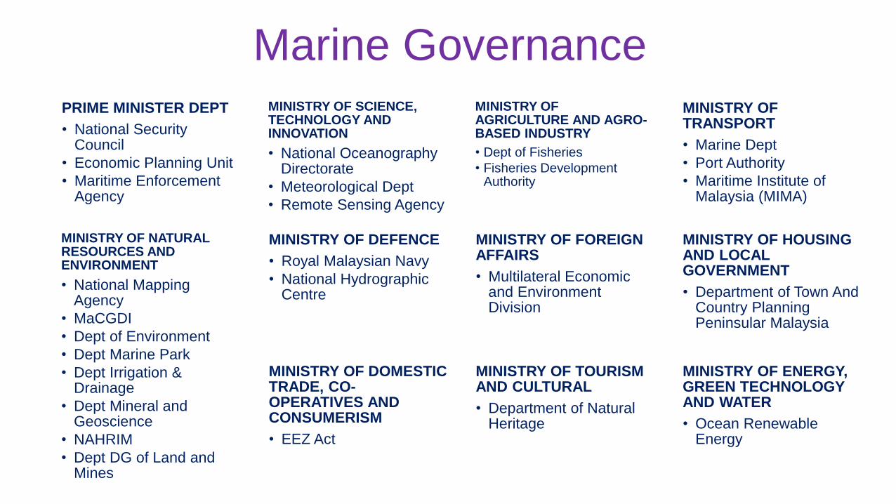
Marine Governance
PRIME MINISTER DEPT
• National Security Council
• Economic Planning Unit
• Maritime Enforcement Agency
MINISTRY OF SCIENCE,TECHNOLOGY ANDINNOVATION
• National Oceanography Directorate
• Meteorological Dept
• Remote Sensing Agency
MINISTRY OF AGRICULTURE AND AGRO-BASED INDUSTRY
• Dept of Fisheries
• Fisheries Development Authority
MINISTRY OFTRANSPORT
• Marine Dept
• Port Authority
• Maritime Institute of Malaysia (MIMA)
MINISTRY OF NATURAL RESOURCES AND ENVIRONMENT
• National Mapping Agency
• MaCGDI
• Dept of Environment
• Dept Marine Park
• Dept Irrigation & Drainage
• Dept Mineral and Geoscience
• NAHRIM
• Dept DG of Land and Mines
MINISTRY OF DEFENCE
• Royal Malaysian Navy
• National Hydrographic Centre
MINISTRY OF FOREIGNAFFAIRS
• Multilateral Economic and Environment Division
MINISTRY OF HOUSINGAND LOCAL GOVERNMENT
• Department of Town And Country Planning Peninsular Malaysia
MINISTRY OF INFORMATION, COMMUNICATION AND CULTURE
•Department of Natural HeritageMINISTRY OF DOMESTIC
TRADE, CO-OPERATIVES AND CONSUMERISM
• EEZ Act
MINISTRY OF TOURISM AND CULTURAL
• Department of Natural Heritage
MINISTRY OF ENERGY, GREEN TECHNOLOGY AND WATER
• Ocean Renewable Energy

MyGDI
GOVERNANCE
MyGDI National Coordinating Committee
(MNCC)
MyGDI Framework Technical
Committees
MyGDI Standard Technical
Committee
MyGDIClearinghouse
Technical Committee
MyGDI Marine Technical
Committee
National Hydrographic
Committee
Port Management and Information
Working Committee
Hydrographic Surveyors
Competency Working
Committee
Underwater Object
Information Working
Committee
Po
licy &
Go
vern
an
ce
(Peo
ple
)

MyGDI Marine Technical CommitteeP
oli
cy &
Go
vern
an
ce
(Peo
ple
)a. Lead Agency : National Hydrographic Centre
b. Secretariat : Malaysian Centre for Geospatial Data
Infrastructure (MaCGDI)
c. Permanent Members (Data Provider/ Ownership)
(1) Department of Survey and Mapping Malaysia (JUPEM)
(2) Minerals and Geoscience Department Malaysia (JMG)
(3) Malaysian Meteorological Department (MMD)
(4) Marine Department Malaysia (JLM)
(5) Department of Irrigation and Drainage (DID)
(6) Department of Environment (DOE)
(7) Department of Fisheries Malaysia (DoF)
(8) Department of Marine Park Malaysia (DMPM)
(9) Department of National Heritage (DNH)
(10) Strategic Technology and S & T Application Division
(formerly NOD), MOSTI.
(11) Ministry of Energy, Green Technology and Water
(KeTTHA)
(12) National Water Services Commission (SPAN)
(13) Malaysian Communications and Multimedia
Commission (MCMC)
(14) Malaysia Petroleum Management (MPM)
(15) Tenaga Nasional Berhad (TNB)
(16) Telekom Malaysia Berhad (TM)
d. Supporting Agencies
(1) National Security Council (MKN)
(2) Malaysia Remote Sensing Agency
(MRSA)
(3) Ministry of Domestic Trade,
Cooperatives and Consumerism
(KPDNKK)

Hydrographic data and its role in MSDI
• ENC - S57 data as
operational
/additional layer
Hydrographic data sets and data infrastructure
Geo
gra
ph
ic C
on
ten
t (D
ata
)
• Raster charts as
basemap

Aeronautical
Built Environment
Demarcation
Geology
Hydrography
Hypsography
Soil
Transportation
Utility
Vegetation
Special Use
General
DCA
JUPEM
JUPEM
JMG
NHC
JUPEM
DOA
JKR
JUPEM
DOA
JUPEM
JUPEM
Framework Data CategoriesG
eo
gra
ph
ic C
on
ten
t (D
ata
)

MyGOS
My HPDDATABASE
ArcMap
Source Editor 1
Source Editor 2
Source Editor 3
Source Editor 4
Paper Chart Editor Paper Chart
ENC
AML
Geodatabase ArcGIS Server
Spatial Fusion Server
DATAACQUISITION
WMS
WFS
WMTS
VPN
DATAPROCESSING
DATA QC/MANAGEMENT
My BATYMETRYSERVER
My BATHYMETRYDATABASE
DATA EDITING/QC/MANAGEMENT
WCSDesktop
Web
Device
My HPDSERVER
Hydrographic Data Management Workflow
Product Editor
Product Editor
SECONDARYDATA

Tech
nic
al
Sta
nd
ard
s(S
tan
da
rds)
S-57 / S-100 and others product specification
Data dissemination through OGC Web Service
…….WMS/WMTS/WFS/WCS etc….
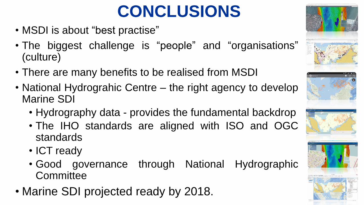
CONCLUSIONS• MSDI is about “best practise”
• The biggest challenge is “people” and “organisations”(culture)
• There are many benefits to be realised from MSDI
• National Hydrograhic Centre – the right agency to developMarine SDI
• Hydrography data - provides the fundamental backdrop
• The IHO standards are aligned with ISO and OGCstandards
• ICT ready
• Good governance through National HydrographicCommittee
• Marine SDI projected ready by 2018.
Thank you for your attention
Top Related