


Languages
Pages
Legal

1
Jason Taylor – User Services Coordinator Thomas Renkevens – SPSD Division Chief
Natalia Donoho – User Services Coordinator
Satellite Products and Services Division (SPSD) Office of Satellite and Product Operations (OSPO)
NOAA/NESDIS/OSPO/SPSD
January 14, 2016 12th Annual Symposium on New Generation Operational Environmental Satellite Systems
American Meteorological Society (AMS) 96th Annual Meeting, New Orleans, LA

2
Presentation Contributors
NESDIS / OSPO / SPSD @ NCWCP • Matt Seybold, GOES-R Data Ops Manager • John Paquette, Physical Scientist • Shuang Qiu, Suomi NPP Product Area Lead (PAL) • Awdesh Sharma, Satellite Operational Soundings PAL • Antonio Irving, Chief - Satellite Products Branch
NESDIS / OSPO / MOD @ NSOF • Donna McNamara, Data Access Manager • Chris Sisko, JPSS Data Operations Manager • Carl Gliniak, Acting POES Lead • Mark Danehy, Chief – Facility Engineering Branch • John Tsui, GOES Lead
National Center for Weather & Climate Prediction (NCWCP)
NOAA Satellite Operations Facility (NSOF)

3
Presentation Outline
• Overview of OSPO • Status of Satellite Operations
– GOES & POES
• Development Initiatives, Products & Hot Topics • Data Access and Distribution • Q&A
4
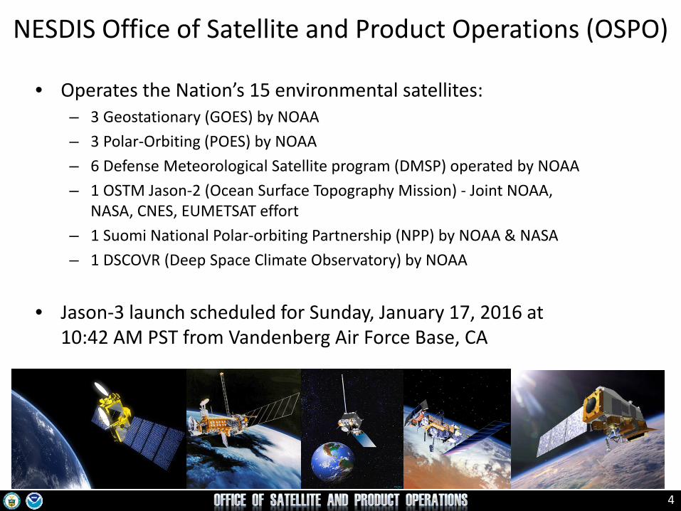
• Operates the Nation’s 15 environmental satellites: – 3 Geostationary (GOES) by NOAA – 3 Polar-Orbiting (POES) by NOAA – 6 Defense Meteorological Satellite program (DMSP) operated by NOAA – 1 OSTM Jason-2 (Ocean Surface Topography Mission) - Joint NOAA,
NASA, CNES, EUMETSAT effort – 1 Suomi National Polar-orbiting Partnership (NPP) by NOAA & NASA – 1 DSCOVR (Deep Space Climate Observatory) by NOAA
• Jason-3 launch scheduled for Sunday, January 17, 2016 at 10:42 AM PST from Vandenberg Air Force Base, CA
NESDIS Office of Satellite and Product Operations (OSPO)
5
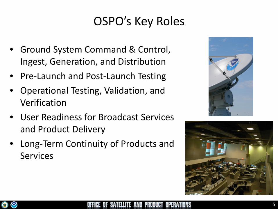
OSPO’s Key Roles
• Ground System Command & Control, Ingest, Generation, and Distribution
• Pre-Launch and Post-Launch Testing • Operational Testing, Validation, and
Verification • User Readiness for Broadcast Services
and Product Delivery • Long-Term Continuity of Products and
Services

6
Satellite Operations, Processing and Distribution
Fairbanks Wallops
Customers
Non-NOAA (Jason2, DMSP, Meteosat, Himawari,
Metop, EOS, COSMIC, others)
Command and Control Satellite Operations Control Center
Office of Satellite Ground Services (OSGS) Ground Systems Development
and Sustainment, IT Enterprise Architecture
Archive and Access
NESDIS Data Centers
Data and Products
Product Development Algorithm Development
Science Maintenance
Center for Satellite Applications and Research (STAR)
Office of Satellite and Product Operations (OSPO) METOP-B/C (AM)
POES NOAA-19
GOES-West GOES-East
Processing and Distribution Environmental Satellite Processing Center
Svalbard McMurdo / Troll
Suitland
SNPP/JPSS-1 (PM)
TDRSS

7
Satellite Direct Service Operations Emergency Managers Weather Information Network (EMWIN): • NOAA satellites relay critical information to users across the country.
http://www.weather.gov/emwin/index.htm
Low Resolution Image Transmission (LRIT): • NOAA satellites are used to relay satellite and weather products to users in remote locations, that do not have landlines or internet connections.
http://www.noaasis.noaa.gov/LRIT/
Data Collection: • NOAA satellites are used to collect and relay scientific data from around the globe.
http://www.noaasis.noaa.gov/DCS/ http://www.noaasis.noaa.gov/ARGOS/
Search and Rescue Satellite Aid Tracking (SARSAT): • NOAA satellites are used to relay distress alerts from aviators, mariners and land-based users (250 rescued through calendar year of 2015).
http://www.sarsat.noaa.gov/
Geonetcast Americas: • Data from NOAA for diverse societal benefits - agriculture, energy, health, climate, weather, disaster mitigation, biodiversity, water resources, and ecosystems.
http://www.geonetcastamericas.noaa.gov/index.html
8
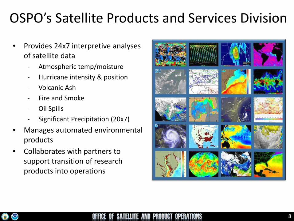
OSPO’s Satellite Products and Services Division
• Provides 24x7 interpretive analyses of satellite data
- Atmospheric temp/moisture - Hurricane intensity & position - Volcanic Ash - Fire and Smoke - Oil Spills - Significant Precipitation (20x7)
• Manages automated environmental products
• Collaborates with partners to support transition of research products into operations

9
Status of Satellite Operations

10
GOES Status (Dec 23, 2015)
http://www.oso.noaa.gov/goesstatus
Key Operational
Spacecraft issues but no user impacts
Operational with limitations
Non-operational
G
R
S/C
Y

11
GOES-13 (East) Launch: May 2006 | Operational: April
2010
Issue #2: XRS capacitor short. Impact: XRS X-ray measurements can potentially invert unexpectedly.
Issue #1: Sounder filter wheel anomaly. Sounder frame sync losses. Impact: Sounder IR data are not usable.
Issue #3: SXI detector damage due to flare. Impact: SWPC forecasting operations slightly degraded.
12
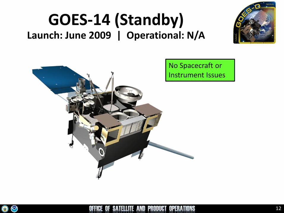
GOES-14 (Standby) Launch: June 2009 | Operational: N/A
No Spacecraft or Instrument Issues
13
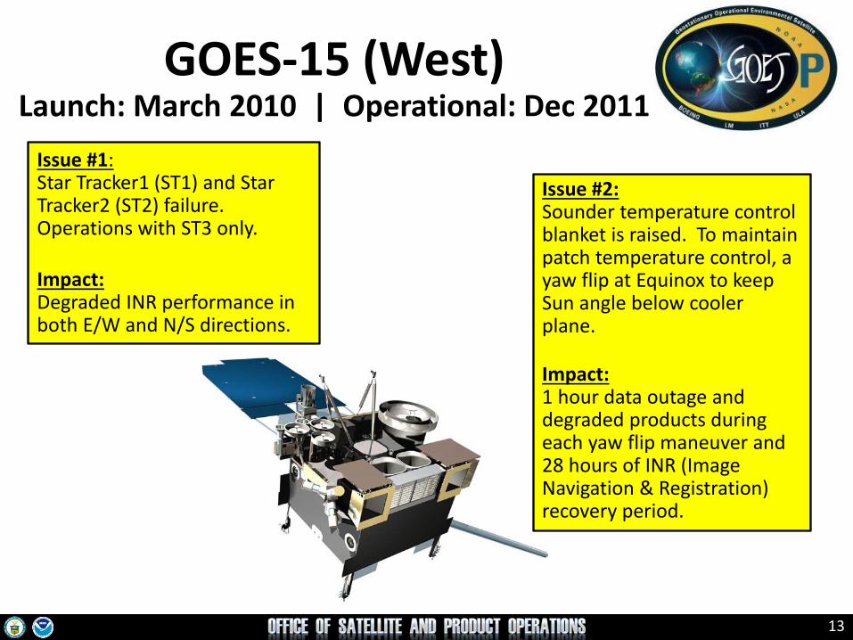
GOES-15 (West) Launch: March 2010 | Operational: Dec 2011
Issue #1: Star Tracker1 (ST1) and Star Tracker2 (ST2) failure. Operations with ST3 only. Impact: Degraded INR performance in both E/W and N/S directions.
Issue #2: Sounder temperature control blanket is raised. To maintain patch temperature control, a yaw flip at Equinox to keep Sun angle below cooler plane. Impact: 1 hour data outage and degraded products during each yaw flip maneuver and 28 hours of INR (Image Navigation & Registration) recovery period.
14
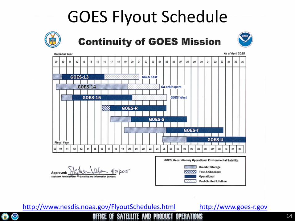
GOES Flyout Schedule
http://www.nesdis.noaa.gov/FlyoutSchedules.html http://www.goes-r.gov

15
Operational G
Spacecraft Issue but no User Impact S/C
Operational with Limitation Y
Non-Operational R
Not Applicable N/A
POES Status (Dec 18, 2015) http://www.ospo.noaa.gov/Operations/POES/status.html

16
S-NPP Status as of Dec 2015
Spacecraft S-NPP
Launch Date Oct 28, 2011
Mission Category LTAN 1330 (PM) +/- 10 mins
Payload Instruments Status
ATMS G
CERES G
CrIS G
OMPS – Nadir G
OMPS – Limb G
VIIRS G
Spacecraft Subsystem Status
TLM, Command & Control G
ADCS G
EPS G
Thermal Control G
Communications G
CDP G
SCC G
GPS G
1553 G
1394 G Operational with limitations (or in standby)
Operational with degraded performance
Operational (or capable of)
Functional but turned off
No status reported Not functional

17
LEO Flyout Schedule
http://www.nesdis.noaa.gov/FlyoutSchedules.html http://www.jpss.noaa.gov
18
Development Initiatives, Products & Other Hot Topics

19
S-NPP Near-Constant Contrast NWS Technical Implementation Notice 15-48 issued on Oct 20, 2015
http://www.nws.noaa.gov/os/notification/tin15-48nde_npp_sbn.htm
• On December 14, 2015 at 1500 UTC, NESDIS began sending S-NPP Near-Constant Contrast (NCC) imagery to the NWS NCF for further broadcast via the Satellite Broadcast Network (SBN) to support NWS AWIPS.
• NCC products provide improved environmental sensing and user analyses in extreme low light conditions.
• The new imagery is provided to four geographical regions:
- Alaska Region Sector (WMO Header: TIPB10 KNES) - Pacific Region Sector (WMO Header: TIPI10 KNES) - CONUS Sector (WMO Header: TIPC10 KNES) - Puerto Rico Sector (WMO Header: TIPQ10 KNES)
Example of NCC in AWIPS2/CAVE -
Alaska Region Sector.
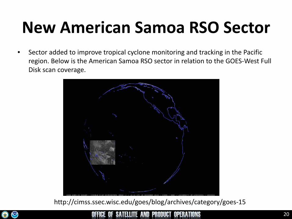
20
New American Samoa RSO Sector • Sector added to improve tropical cyclone monitoring and tracking in the Pacific
region. Below is the American Samoa RSO sector in relation to the GOES-West Full Disk scan coverage.
http://cimss.ssec.wisc.edu/goes/blog/archives/category/goes-15

21
http://cimss.ssec.wisc.edu/goes/blog/archives/category/goes-15

22
MTSAT-2 Transition to Himawari-8 • Background
• The Japan Meteorological Agency (JMA) replaced MTSAT-2 with Himawari-8 at 140E as the primary operational satellite on July 7, 2015.
• To assist users in the transition to the new satellite, JMA operated MTSAT-2 in parallel with H-8 until December 4, 2015.
• OSPO provided current MTSAT-2 products to users until December 4, 2015. • On November 5, 2015, a general email notification was sent to users identifying the
new/replacement McIDAS filenames that will be used for H-8 from December 4. (http://www.ssd.noaa.gov/PS/SATS/MESS/MSG3091948.01.txt)
• OSPO’s Mitigation Plan using H-8 Data • To mitigate the coverage gap for current users of MTSAT-2 data, OSPO replaced MTSAT-2 imagery
with sub-sampled H-8 data in McIDAS format. • Sub-sampled H-8 data reflect the MTSAT-2 specifications of the five channels having a
spatial resolution of 4 km in the IR, and 1 km in the Visible. • OSPO will make H-8 imagery McIDAS Area Files available from its GEODIST system.
23
GOES-East Imager ASOS SCP for CONUS
• On December 29, 2015, the GOES-East Imager ASOS SCP products for CONUS were operationally implemented as a replacement for the GOES-East Sounder ASOS SCP products.
• This action was in response to the loss of IR sounder data from the GOES-East (GOES-13) Sounder instrument failure on November 20, 2015.
• The GOES-East Imager ASOS SCP products may not be able to produce for all the stations that were produced by the GOES-East Sounder ASOS SCP due to a different coverage of Imager and Sounder for CONUS regions.

24
New GOES Ingest NOAAPORT Interface GINI-II – Benefits for AWIPS
• Improved Reliability – Quicker fault detection (missing scan lines, frame
breaks, etc.) – More efficient fault diagnosis and resolution
• Improved Processing Efficiency – Faster production and distribution
• Overall timeliness improvement • Increase in Visible Imagery
– Production of visible imagery periods now dependent on location of AWIPS sector, not a universal time period for all sectors

25
POES AVHRR Channel Switching
• Background: AVHRR Channel 3A/3B – Hydrology Community needs snow/ice data mapping (channel 3A). – Hazard Community needs data for fire detection and monitoring
(channel 3B). • Current configuration:
– POES AVHRR using 3B, NOAA-15, NOAA-18 and NOAA-19 – Metop AVHRR 3A/3B configuration: both A and B swapping at
day/night terminator crossing • Origin of initial request for switching and justification came from
Geographic Information Network of Alaska (GINA). • NWS has submitted a formal request to NESDIS for the activation
of 3A/3B switching of NOAA-15 and NOAA-19 satellites to Channel 3A over the Alaska region for the period excluding June, July, and August.
26
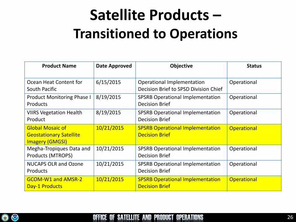
Product Name Date Approved Objective Status
Ocean Heat Content for South Pacific
6/15/2015 Operational Implementation Decision Brief to SPSD Division Chief
Operational
Product Monitoring Phase I Products
8/19/2015 SPSRB Operational Implementation Decision Brief
Operational
VIIRS Vegetation Health Product
8/19/2015 SPSRB Operational Implementation Decision Brief
Operational
Global Mosaic of Geostationary Satellite Imagery (GMGSI)
10/21/2015 SPSRB Operational Implementation Decision Brief
Operational
Megha-Tropiques Data and Products (MTROPS)
10/21/2015 SPSRB Operational Implementation Decision Brief
Operational
NUCAPS OLR and Ozone Products
10/21/2015 SPSRB Operational Implementation Decision Brief
Operational
GCOM-W1 and AMSR-2 Day-1 Products
10/21/2015 SPSRB Operational Implementation Decision Brief
Operational
Satellite Products – Transitioned to Operations
27
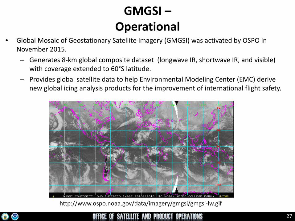
GMGSI – Operational
• Global Mosaic of Geostationary Satellite Imagery (GMGSI) was activated by OSPO in November 2015. – Generates 8-km global composite dataset (longwave IR, shortwave IR, and visible)
with coverage extended to 60°S latitude. – Provides global satellite data to help Environmental Modeling Center (EMC) derive
new global icing analysis products for the improvement of international flight safety.
http://www.ospo.noaa.gov/data/imagery/gmgsi/gmgsi-lw.gif

28
GCOM-W1 AMSR-2 Day 1 Products – Operational
http://www.ospo.noaa.gov/Products/atmosphere/gpds/
• The Global Change Observation Mission - GCOM-W1 Advanced Microwave Scanning Radiometer 2 (AMSR2) Day 1 Products were activated by OSPO in November 2015. – Implementation includes AMSR-2 Imagery, Total Precipitable Water (TPW), Cloud
Liquid Water, Rain Rate, Sea Surface Temperature, and Sea Surface Wind Speed. – Improves numerical weather prediction, precipitation and tropical cyclone location,
intensity analysis, and monitoring.
Total Precipitable
Water
Sea Surface Wind Speed
29
Data Access and Distribution
30
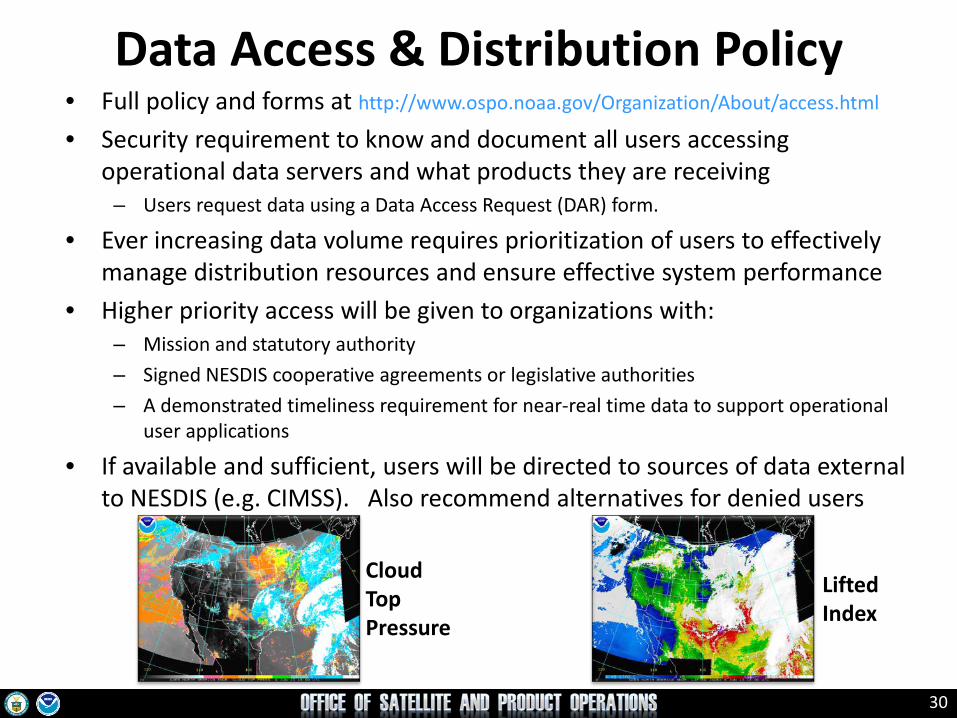
Data Access & Distribution Policy • Full policy and forms at http://www.ospo.noaa.gov/Organization/About/access.html
• Security requirement to know and document all users accessing operational data servers and what products they are receiving
– Users request data using a Data Access Request (DAR) form.
• Ever increasing data volume requires prioritization of users to effectively manage distribution resources and ensure effective system performance
• Higher priority access will be given to organizations with: – Mission and statutory authority – Signed NESDIS cooperative agreements or legislative authorities – A demonstrated timeliness requirement for near-real time data to support operational
user applications
• If available and sufficient, users will be directed to sources of data external to NESDIS (e.g. CIMSS). Also recommend alternatives for denied users
Cloud Top Pressure
Lifted Index
31
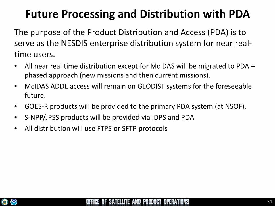
Future Processing and Distribution with PDA The purpose of the Product Distribution and Access (PDA) is to serve as the NESDIS enterprise distribution system for near real-time users. • All near real time distribution except for McIDAS will be migrated to PDA –
phased approach (new missions and then current missions). • McIDAS ADDE access will remain on GEODIST systems for the foreseeable
future. • GOES-R products will be provided to the primary PDA system (at NSOF). • S-NPP/JPSS products will be provided via IDPS and PDA • All distribution will use FTPS or SFTP protocols

32
PDA Distribution Service Improvements • PDA will enable NESDIS to more easily scale framework to meet future distribution
demands. • Provide for enhanced security controls / transfer protocols. • Allow for far greater management control and system insight over data distribution. • Grant the ability to deliver the large mission data (such as GOES-R, JPSS, etc) to
authorized users • In deference to NOAA security policies, PDA will set subscriptions for international
and non-US government partners, as is done now on the DDS. (PDA User Interface requires a government CAC or PIV card.)

33
24/7 Help Desk [email protected]
ESPC Messages http://www.ssd.noaa.gov/PS/SATS/messages.html
WMO GTS Bulletins Urgent: http://www.weather.gov/view/validProds.php?prod=ADM&node=KNES Routine: http://www.weather.gov/view/validProds.php?prod=ADA&node=KNES
User Services [email protected]
Data Access [email protected]
Webmaster [email protected]
Facebook www.facebook.com/NOAANESDIS
Twitter www.twitter.com/noaasatellites
Satellite Ops Status http://www.oso.noaa.gov/daily-news/index.asp
Press releases http://www.nesdis.noaa.gov/news_archives/
Web www.ospo.noaa.gov
ESPC Notifications, Status, and Contacts

34
Thank you!
Questions?
Top Related