


Languages
Pages
Legal


IVM Institute for Environmental Studies
7
Adaptive Water Management at the Local Scale
Synthesis report Ghana Irrigated farming and agroforestry by farmer groups and river basin management: an adapation to the changing climate and environment in the Dayi Basin, Volta Region, Ghana
Ken Kinney (Development Institute Ghana)
Bob Alfa (Water Resources Commission Ghana
Jacobus (Koos) Groen (Acacia Water)
Martien Hoogland (Both Ends)
Pieter Pauw (Institute for Environmental Studies)
Ralph Lasage (Institute for Environmental Studies)
Report R12-02
22 March 2012
IVM Institute for Environmental Studies
This report is released by: Ralph Lasage
Project Leader ADAPTS
IVM
Institute for Environmental Studies
VU University Amsterdam
De Boelelaan 1087
1081 HV AMSTERDAM
The Netherlands
T +31-20-598 9555
F +31-20-598 9553
Copyright © 2012, Institute for Environmental Studies
All rights reserved. No part of this publication may be reproduced, stored in a retrieval
system or transmitted in any form or by any means, electronic, mechanical, photo-
copying, recording or otherwise without the prior written permission of the copyright
holder
IVM Institute for Environmental Studies
Synthesis report Ghana
Contents
1 Introduction 5
1.1 ADAPTS Background 5 1.2 The Ghana Case 5
2 Area Description 7
2.1 Physical Environment 7 2.2 Socio-Economic Situation 8
Socio-Economic Facts and Perceptions 8
Vulnerability and Adaptation to Climate Change 9
3 Changes in Climate, Landuse and Hydrology 11
3.1 Climate and Climate Change 11 3.2 Landuse Change 14 3.3 Hydrological Scenario Studies 15
4 Interventions 21
4.1 Local Action 21 4.2 Governance and Policies 25 4.3 Upscaling 28
5 Dialogue and Dissemination 31
5.1 NGOs 31 5.2 Farmer Groups 31 5.3 Stakeholders in Managing the Dayi River Basin 32 5.4 Water Resources Commission 33
6 Summary and Conclusions 35
References 37


IVM Instituut voor Milieuvraagstukken
Synthesis report Ghana
1 Introduction
1.1 ADAPTS Background
Climate change is expected to result in gradual changes in temperature, rainfall
patterns and sea level rise, but also increased climate variability and extreme events,
threatening water availability and food security for millions of poor people. Adaptation
strategies to deal with these impacts are urgently needed for communities and
national governments alike.
In 2008, the Institute for Environmental Studies, ACACIA Water, and Both ENDS started
the ADAPTS project, funded by the Dutch Ministry of Foreign Affairs. The overall aim of
ADAPTS is to increase developing countries’ adaptive capacities by achieving the
inclusion of climate change and adaptation considerations into water policies, local
planning and investment decisions.
ADAPTS cooperates with local communities, civil society organisations, local and
national governments, scientific institutes, and the private sector. It proves that
adaption is already taking place at the local level. ADAPTS combines local and global
knowledge in the area of water management and empowers vulnerable communities in
designing and implementing cost effective and sustainable adaptation measures.
Through dialogues with local and national governments it helps to ensure the inclusion
of their knowledge and visions into the development of climate proof water policies
and investments. To increase the adaptive capacities in developing countries, ADAPTS
focuses on:
1. Knowledge development: developing climate change information and studying how local water management can be made climate proof.
2. Local Action: the identification, support, documentation, analysis and
dissemination of innovative, locally-based interventions to ensure that local
knowledge and visions are included into basin and national policy dialogues.
3. Dialogue: establishing policy dialogues between local and national stakeholders on the issues of sustainable water management and climate change adaptation.
The project was implemented in six river basins around the world. Projects with a
three year duration have been carried out in Ethiopia, Ghana and Peru. One year
projects are being carried out Botswana, Brazil and Vietnam. This report deals with the
ADAPTS study in Ghana.
1.2 The Ghana Case
The main goals of the Ghana project were to assess changes in water availability in the
Dayi River basin and to support local farmers in setting up irrigated agriculture and
agroforestry, as a local climate adaptation initiative. Next to this, the project aimed to
support the development of a Basin Management Plan and to include climate change,
water use for irrigation (licensing system) and agroforestry (Buffer zone of rivers and
lakes), and also to explore ways to involve local actors in the basin’s development. The
project was implemented by the Ghanaian NGO Development Institute (DI), Water
Resources Commission of Ghana (WRC), Acacia Water, Both ENDS, and Institute for
Environmental Studies (IVM).

Synthesis report Ghana
2 Area Description
2.1 Physical Environment
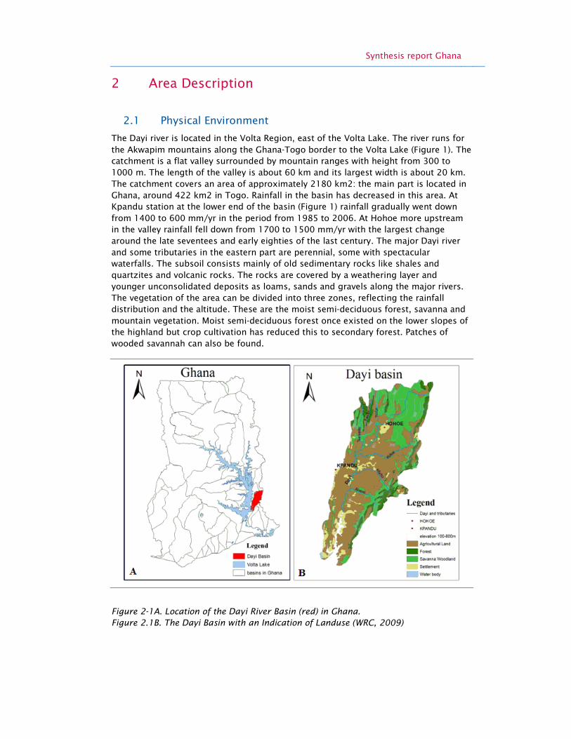
The Dayi river is located in the Volta Region, east of the Volta Lake. The river runs for
the Akwapim mountains along the Ghana-Togo border to the Volta Lake (Figure 1). The
catchment is a flat valley surrounded by mountain ranges with height from 300 to
1000 m. The length of the valley is about 60 km and its largest width is about 20 km.
The catchment covers an area of approximately 2180 km2: the main part is located in
Ghana, around 422 km2 in Togo. Rainfall in the basin has decreased in this area. At
Kpandu station at the lower end of the basin (Figure 1) rainfall gradually went down
from 1400 to 600 mm/yr in the period from 1985 to 2006. At Hohoe more upstream
in the valley rainfall fell down from 1700 to 1500 mm/yr with the largest change
around the late seventees and early eighties of the last century. The major Dayi river
and some tributaries in the eastern part are perennial, some with spectacular
waterfalls. The subsoil consists mainly of old sedimentary rocks like shales and
quartzites and volcanic rocks. The rocks are covered by a weathering layer and
younger unconsolidated deposits as loams, sands and gravels along the major rivers.
The vegetation of the area can be divided into three zones, reflecting the rainfall
distribution and the altitude. These are the moist semi-deciduous forest, savanna and
mountain vegetation. Moist semi-deciduous forest once existed on the lower slopes of
the highland but crop cultivation has reduced this to secondary forest. Patches of
wooded savannah can also be found.
Figure 2-1A. Location of the Dayi River Basin (red) in Ghana.
Figure 2.1B. The Dayi Basin with an Indication of Landuse (WRC, 2009)
IVM Institute for Environmental Studies
8 Area Description
2.2 Socio-Economic Situation
2.2.1 General Characteristics
The Volta Region has a population density of 79.5 persons per km2 and a population
growth of 1.9% after correction for out-migration. The region has some urban centres
such as Ho and Hohoe but is largely dominated by an archipelago of traditional
communities. Around seventy percent of the regional population lives in rural areas
(GSS, 2005). Unemployment rates are 7-8%, but 83% of the economically active
population works in the informal private sector. In total, around 80% of the
economically active population is self-employed, and because the population is rather
young (41% is aged 0-14 years), the dependency ratio is high: 92 dependents on 100
working people (Alfa et al., 2009).
The Dayi Basin is is a rural relatively densely populated area (123 persons/km2; Groen
et al., 2008). The main city in the research area is Hohoe. Main economic activities are
subsistence and some cash crop farming. The major part of the basin belongs to the
Hohoe District, which has a population of 144,550 (Hohoe District, 2009). The
southwestern part belongs to te Kpandu and Lower Dayi District and in the north there
is part belonging to the Jasikan District. The Hohoe District is one of the 18
municipalities in the Volta Region (GSS, 2005). Municipalities are centrally appointed
administrations that contain traditional communities with a chief as leader.
There are two medium sized communal irrigation schemes (15 to 30 farmers and
about 10 to 20 acres). One is at Kpandu with an intake from Lake Volta and sprinkler
irrigation. The system is run by the Irrigation Development Authority (IDA). The other
one is at Ve Koleonu, where water is lifted from the Dayi River, distributed via lined
channels and brought to the fields by furrow irrigation. The system funded by the WB
was never finished and is operated now by the farmer group.
Development Institute and EDYM are the main NGO’s active in development of
sustainable agriculture and agroforestry.
2.2.2 ADAPTS Socio-Economic Survey
Socio-Economic Facts and Perceptions
In May and June 2009 a socio-economic field survey was carried by IVM. Five villages
were selected based upon their representativeness for the three most distinct
ecological zones in the basin.
The villages of Kukurantumi, Abrani, Koloenu, Have and Woadze (from top to bottom)
are neatly spread out along the Dayi River, comprising upstream, midstream and
downstream areas (Figure 2.1). The villages of Have and Woadze represent the
mountainous downstream area. Koloenu represents the mid-stream transitional
savannah, where forests are largely cleared and turned into large scale arable land.
Kukurantumi and Abrani represent the upstream forested area. For the study
information from 109 respondents of all villages have been used. For a detailed
account we refer to (Pauw et al., 2009)
IVM Instituut voor Milieuvraagstukken
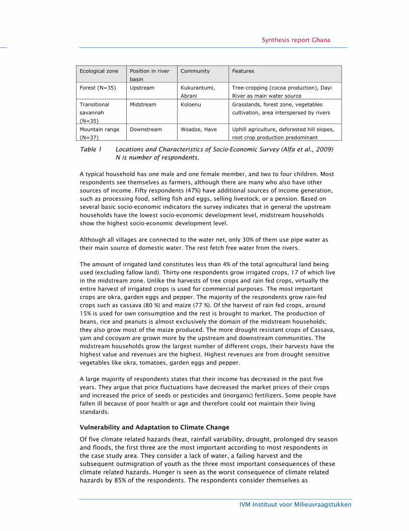
Synthesis report Ghana
Ecological zone Position in river
basin
Community Features
Forest (N=35)
Upstream Kukurantumi,
Abrani
Tree-cropping (cocoa production), Dayi
River as main water source
Transitional
savannah
(N=35)
Midstream Koloenu Grasslands, forest zone, vegetables
cultivation, area interspersed by rivers
Mountain range
(N=37)
Downstream Woadze, Have Uphill agriculture, deforested hill slopes,
root crop production predominant
Table 1 Locations and Characteristics of Socio-Economic Survey (Alfa et al., 2009)
N is number of respondents.
A typical household has one male and one female member, and two to four children. Most
respondents see themselves as farmers, although there are many who also have other
sources of income. Fifty respondents (47%) have additional sources of income generation,
such as processing food, selling fish and eggs, selling livestock, or a pension. Based on
several basic socio-economic indicators the survey indicates that in general the upstream
households have the lowest socio-economic development level, midstream households
show the highest socio-economic development level.
Although all villages are connected to the water net, only 30% of them use pipe water as
their main source of domestic water. The rest fetch free water from the rivers.
The amount of irrigated land constitutes less than 4% of the total agricultural land being
used (excluding fallow land). Thirty-one respondents grow irrigated crops, 17 of which live
in the midstream zone. Unlike the harvests of tree crops and rain fed crops, virtually the
entire harvest of irrigated crops is used for commercial purposes. The most important
crops are okra, garden eggs and pepper. The majority of the respondents grow rain-fed
crops such as cassava (80 %) and maize (77 %). Of the harvest of rain fed crops, around
15% is used for own consumption and the rest is brought to market. The production of
beans, rice and peanuts is almost exclusively the domain of the midstream households;
they also grow most of the maize produced. The more drought resistant crops of Cassava,
yam and cocoyam are grown more by the upstream and downstream communities. The
midstream households grow the largest number of different crops, their harvests have the
highest value and revenues are the highest. Highest revenues are from drought sensitive
vegetables like okra, tomatoes, garden eggs and pepper.
A large majority of respondents states that their income has decreased in the past five
years. They argue that price fluctuations have decreased the market prices of their crops
and increased the price of seeds or pesticides and (inorganic) fertilizers. Some people have
fallen ill because of poor health or age and therefore could not maintain their living
standards.
Vulnerability and Adaptation to Climate Change
Of five climate related hazards (heat, rainfall variability, drought, prolonged dry season
and floods, the first three are the most important according to most respondents in
the case study area. They consider a lack of water, a failing harvest and the
subsequent outmigration of youth as the three most important consequences of these
climate related hazards. Hunger is seen as the worst consequence of climate related
hazards by 85% of the respondents. The respondents consider themselves as
IVM Institute for Environmental Studies
10 Area Description
dependent on the climate, as well as vulnerable to climate related hazards, and afraid
of future hazards.
The government documents show some interest in climate change adaptation but
merely focus on development. The interrelated degradation of soils and deforestation
are important issues in policy documents, as well as irrigation.
Exactly these topics are also brought up by the respondents, both in open and closed
questions of the questionnaire. Reforestation, prevention of land degradation,
irrigation and planting of tree crops are seen as good measures to prevent the
negative effects of climate related hazards, both for individuals and communities as a
whole. Crop diversification is also stated to be a successful measure to cope with
climate related hazards.
The respondents’ motivation to adapt is correlated significantly to their experience in
farming and on the costs of adaptation. Richer farmers appear more motivated to
adapt than the poorer ones.
All in all it can be concluded that the farmers have an above medium risk perception
towards climate related hazards. The subsequent motivation of the respondents to
adapt is correlated significantly to their experience in farming and on the costs of
adaptation. Richer farmers appear more motivated to adapt than the poorer ones.
It is remarked that the perception by the local people of the interconnection between
local environmental problems and climate change is not always correct. Reforestation
can be an adaptive measure, for instance because it prevents erosion during heavy
rainfall or because it slows down runoff. Once erosion has taken place less water may
infiltrate leading to floods and reduced base flows. Deforestation, on the other hand,
is not the cause of global climate change –something many respondents think-, but it
can add to reduction in recycling water to the atmosphere. This might however lead to
a reduction in rainfall in another area.

Synthesis report Ghana
3 Changes in Climate, Landuse and Hydrology
3.1 Climate and Climate Change
Ghana has a tropical climate with a dry season from December to April and a bimodal
wet season that shows peaks in June and September (Figure 4). Average rainfall varies
from 1100 tot 2000 mm/yr. Potential evaporation is around 1500 mm/yr. A result
variations in yearly rainfall have a large impact on groundwater recharge and river base
flow, which also shows interannual variations. Presently base flow is around 1 to 2
m3/s at Hohoe and increases to about 6 m3/s at Gbefi, further downstream.
Figure 3-1 Annual Rainfall at Hohoe
Figure 3-2 Average Monthly Rainfall at Hohoe
0.0
50.0
100.0
150.0
200.0
250.0
300.0
Jan Feb Mar Apr May Jun Jul Aug Sep Oct Nov Dec
rain
fall
in
mm
/mo
nth
1956-1979 1980-2008

12 Changes in Climate, Landuse and Hydrology
The socio-economic study (Pauw et al., 2009) and discussions during the various
missions made clear that population in the Dayi River Basin is well aware of climate
and environmental change (deforestation). They state that rainfall has decreased over
the past decades and has become less reliable. The first rainy season starts late and
the late rainy season ends early. As a result two cropping periods are no longer
possible. Farmers are dependent on the rains in April and May to plant their seedlings.
Rivers and springs disappear or are no longer perennial. Local population also
mentions that deforestation during the last decades is the cause of this decrease of
rainfall and river base flow and the cessation of spring flow. In their perception
reforestation would bring more rain.
The facts underline the perceptions of the local population to a large extent. Rainfall
data show that annual rainfall at Hohoe changed from approximately 1700 mm/year in
1975 to 1400 mm/year at the present (Figure 3-1). Early and late rains decreased
(Figure 3-2). In entire Ghana, lower rainfall amounts over the years due to longer dry
seasons have led to more and more tributaries and main rivers drying up quickly,
leading to a lower surface and groundwater availability for the increasing population
(Alfa et al., 2009).
Mean annual daily temperature has increased by 1°C in the period 1961-2000 (and is
projected to increase by 2.5-3.0 °C by 2050. A recent projection from the Netherlands
Climate Assistance Programme (NCAP, 2011) indicates a further decline of rainfall and
a shortening of the rainy season, combined with increasing temperatures throughout
the year (Figure 3-3). On the other hand trends in temperature indicate an increase of
rainfall for the whole of Ghana in the rainy season (Pauw et al., 2009).
Figure 3-3 Monthly Rainfall for Ghana as a Whole, Predicted by NCAP (2011)
0
50
100
150
200
250
Jan Feb Mar Apr May Jun Jul Aug Sep Oct Nov Dec
Pre
cip
ita
tio
n (
mm
)
Month
Mean (mm)
year 2020
year 2050
year 2080

IVM Instituut voor Milieuvraagstukken
Synthesis report Ghana
There is discussion whether the observed changes are part of climate change or part of
the variability of the West African rainfall regime. Another point of discussion
regarding trends and causes of climate change is the difference between perceptions
and scientific knowledge. Nevertheless it is clear that rainfall patterns are changing.
Farmers, who depend on the rains, are vulnerable to these changes.
In order to get insight in future flood frequency and river base flows records of daily
rainfall are needed. With these records, routed through a rainfall-runoff model of the
Dayi River, the runoff pattern can be simulated for future climates. For the ADAPTS
Ghana project The Vrije Universiteit of Amsterdam (VUA) has developed a tropical
rainfall generator. The rainfall generator uses historical rainfall data from several
locations and a temperature rise based on a certain climate scenario to create the new
dataset with nearest neighbor resampling procedures (Buishand & Brandsma, 2001).
For the Ghana case a scenario with a temperature rise of 3 0C in one century is used.
This resulted in three time series of 25 years with data of temperature and
precipitation representing the present situation, the 2040 climate and the 2080
climate.
The rainfall generator gives on average an increasing yearly rainfall sum when
comparing the present situation with the 2040 and 2080 climate (Figure 3-4). This
increase mainly occurs in the months March and April and August till November
(Figure 3-5). For September and October the precipitation for the 2040 scenario is
lower than for the 2080 scenario.
Table 2 Average Sum of Precipitation and Average of Temperature for a Period of
25 Years, representing the Present Situation, the 2040 Climate and the 2080 Climate
Average
Rainfall/Year
(mm)
Average Yearly
Temperature
(⁰C)
Average Sum of Simulated
Discharge
(mm)
Present
1520
26.9
413
2040
1548
27.3
397
2080
1666
27.8
490

14 Changes in Climate, Landuse and Hydrology
3-4 Yearly Average Temperature and Yearly Sum of Precipitation in VU Rainfall
Generator for Present Situation, 2040 Climate and 2080 Climate.
3-5 Monthly Average Temperature and Average Monthly Sum of Precipitation in
VU Rainfall Generator for Present Situation, 2040 Climate and 2080 Climate.
3.1 Landuse Change
Local population states that deforestation in the last decades caused the decrease of
river and spring flow. A spatial and temporal analysis of land cover is carried out using
satellite images. LANDSAT images show that deforestation intensified after 1987.
However large-scale erosion is not visible and deforestation does not seem to have had
a large impact on river flows and the local climate.
It is clear that agriculture land use has shown a remarkable growth between 1987 and
2001 especially in the areas close to the lake (Figure 3-6). Also the bare patches (which
could be fallow land at the image capture time) or settlement areas have shown an
increase. The forest/grass ratio seems to have decreased from 1972 to 2001 based on
the LANDSAT images. However, there is no visible effect on the size of the lake itself
over this entire period.

Synthesis report Ghana
3-6 Interpreted Landcover Temporal Changes based on LANDSAT Images
LANDSAT NDVI indexes which are an indication of vegetation presence and
characteristics are more or less stable over the years. Apparently the deforestation has
been compensated with secondary forests and dense cropping patterns.
Long term annual and monthly NDVI show a marginally higher vegetation density
presence in October than in February for the same areas in different directions of the
catchment (upper head water and lower downstream parts). This is expected because
October is approximately the end of the rainy season and February approximately is
the middle of the dry season. Eighteen year average of the NDVI for January, March and
September for the whole catchment show the expected highest vegetation index in
September and lowest in March.
Steep slopes are present close to the ridge boundaries and on the headwater side of
the catchment area. Agriculture spread over the entire catchment and in 2001 also
takes place on steep slopes. Presence of settlements close to such areas can be seen
as an explanation of agriculture spread due to economic pressure from farmer
communities.
3.2 Hydrological Scenario Studies
3.1.1 Hydrology General
The path followed by the Dayi River is indicated in Figure 3-7. The river flows from
Togo to the Volta Lake. The tributaries also originate in the higher elevated areas. The
Ahavo, Aflabo and Koloe Rivers originate in the East close to the Togolese border and
pass through an area mainly consisting of quartzite and sandstone. Close to their
confluence with the Dayi River they pass over calcareous rock. The Aflabo and Ahavo
rise close to the highest points in the catchment where acidic rock is found. The
Tsatsadu and Fentbi Rivers run from the steep and densely forested slopes in the
north-western side of the catchment. A third tributary, the Tsidje or Feku River, with a
similar flow direction, North to South, rises in the lower lying area. Because of these
confluences discharge of the Dayi river increases towards the south. In 2004 baseflow
at Gbefi was 4 to 5 times as high as baseflow at Hohoe (Beyen and Rutgrink, 2010).

16 Changes in Climate, Landuse and Hydrology
Figure 3-7 Indication of Tributaries and a description of the geology in the Dayi Basin
(WRC, 2009)
3.1.2 Rainfall Runoff Model
During October and November 2009 a field study was carried out on the runoff
behavior of the Dayi River (Beyen & Rutgrink, 2010). Based on observations and
existing data on daily runoff, rainfall, temperature and potential evapotranspiration a
rainfall-runoff model was made for the catchment upstream if Hohoe. The model is
made with the HBV code, which simulates catchment response by routing rainfall
through three reservoirs (Seibert, 2005). In HBV model two vegetation and five
elevation zones were discerned. The model was calibration by comparing simulated
discharge and measured discharge (Figure 3-8) for different periods, for which both
daily precipitation and daily runoff were available. Catchment parameters were
optimized by calibration using Monte Carlo runs.
3-8 Precipitation (blue) and Discharge (red) data for Hohoe

The dataset shows quite some gaps and some unrealistic high values for discharge
(1974 to 1977). There are only 5 periods with complete data (rainfall and runoff):
1976 – 1977; 1980 – 1981; 1986
shows that base flows before 1972 are
In figure 3-9 average rainfall and temperature data are presented for the last four
decades. Note that the relatively high rainfall in the period 2001
increased rainfall in the last 3 years. Also the increasing temperatures are apparent in
this figure.
Figure 3-9 Observed Precipitation Average Sum (A) and
Observed Temperature Average (B)
Calibration for the five periods resulted in efficiencies varying from
period of 1986 – 1987 gave the best results. The more recent periods were difficult to
calibrate, especially with respect to base flows during the dry season. At times base
flows displayed a sharp drop in discharge. This might be an indication of upstream use
of river water from the river. The suggested cause has not been verified. After 1980
base flow seems to be lower. For the runs 2000
was not able to simulate the base flow (often zero). The ’86
efficiency.
Figure 3-10 Observed Precipitation
Synthesis report Ghana
some gaps and some unrealistic high values for discharge
(1974 to 1977). There are only 5 periods with complete data (rainfall and runoff):
1981; 1986 – 1987; 2000 – 2002; en 2005 – 2006. Figure 3
base flows before 1972 are considerably higher than those after 1976
average rainfall and temperature data are presented for the last four
decades. Note that the relatively high rainfall in the period 2001 – 2008 is the result of
increased rainfall in the last 3 years. Also the increasing temperatures are apparent in
Observed Precipitation Average Sum (A) and
Observed Temperature Average (B)
Calibration for the five periods resulted in efficiencies varying from 0.3 and 0.84
987 gave the best results. The more recent periods were difficult to
calibrate, especially with respect to base flows during the dry season. At times base
flows displayed a sharp drop in discharge. This might be an indication of upstream use
from the river. The suggested cause has not been verified. After 1980
base flow seems to be lower. For the runs 2000 – 2002 and 2005 – 2006 the model
was not able to simulate the base flow (often zero). The ’86-’87 run gives the highest
Observed Precipitation (mm), Observed and Simulated Discharge (mm)
for the ’86-’87 run.
Synthesis report Ghana
some gaps and some unrealistic high values for discharge
(1974 to 1977). There are only 5 periods with complete data (rainfall and runoff):
2006. Figure 3-8
er than those after 1976.
average rainfall and temperature data are presented for the last four
2008 is the result of
increased rainfall in the last 3 years. Also the increasing temperatures are apparent in
and 0.84. The
987 gave the best results. The more recent periods were difficult to
calibrate, especially with respect to base flows during the dry season. At times base
flows displayed a sharp drop in discharge. This might be an indication of upstream use
from the river. The suggested cause has not been verified. After 1980
2006 the model
’87 run gives the highest
(mm), Observed and Simulated Discharge (mm)

18 Changes in Climate, Landuse and Hydrology
3.1.3 Runoff for Various Climate Scenarios
The rainfall runoff model calibrated for 1986 – 1987 data was used to simulate runoff
for different climate projections. The purpose of these scenarios runs was to study
future base flow. The base flow in the dry season is the main source of water and sets
a limit to the sustainable development of irrigated agriculture.
Simulations with the HBV model were carried out for periods of 25 years for the
present situation (1971-1996, the 2040 climate (2028 – 2053) and the 2080 climate
(2068 – 2093).
Table 3 Sum of Precipitation, Average of Temperature, Average Sum of Simulated
Discharge and Average Sum of Actual Evapotranspiration for a Period of
25 years, representing the Present Situation, the 2040 Climate and the
2080 Climate.
Figure 3-11 Yearly Sum and Monthly Sum of Simulated Discharge for the Present
Situation, 2040 Climate and 2080 Climate.
Results show that the effect of climate change depends on temperature and
precipitation. The increase in rainfall amount is not always high enough to compensate
for the increase in the actual evapotranspiration caused by a rise in temperature. In the
wet months September to December of the 2040 climate river discharges have
decreased compared to the present climate, but they rise again above the present
values in the year 2080. In August river discharges seem to grow continuously during
this century. In July and also the preceding dry months the situation remains more or
less stable. Given the uncertainty of the climate and runoff simulations we must
conclude that there is no evidence that present base flows will change much in future.
3.1.4 Adaption Strategies
Within the project several adaptation measures were developed. Before implementing
measures in the field, the effect of these measures were evaluated under current
[mm] [oC] [mm] [mm]
Present 1520 26.9 413 1104
2040 1548 27.3 397 1154
2080 1666 27.8 490 1176
Avg. sum of
Precipitation
Avg. of
Temperature
Avg. sum of Simulated
discharge
Avg. sum of act.
Evapotranspiration

Synthesis report Ghana
climatic conditions and under the conditions projected for the basin. For this
evaluation the model WEAP was used (www.weap21.org). for this evaluation the basic
water related elements of the Basin and their relations as they currently exist were
used. This includes the specification of supply, demand and resource data, including
information on dams and reservoirs, as extracted from sources such as the
population census, satellite images and hydrological measurements. For climate
change, the results of the Weather generator as well as two SRES scenarios were used.
The two strategies that were evaluated are business as usual and construction of a
wear at Hohoe. Under both strategies irrigation is practiced (Table 4).
Table 4 Average Demand site coverage (%) for Eight Demand Sites in the Four Sub
Dayi Catchments, over the Period 2010-2050.
The blue cells show the results without a weir, the green cells show the results with the
Hohoe weir (Pauw & Boateng, 2011).
Figure 3-12 shows for the Weir strategy the unmet demand under all climate scenarios,
from half November until the end of February, averaged over 2012-2050. The water
demand is not fully met from half December until the end of February, with a peak in
January. The unmet demand of the reference scenario is larger than for the A2, B1 and
weather generator scenarios. The low flows in the dry season causes demands not to
be met. The water demand can be met until half December, when irrigation
increases and rains recede. After that the unmet demand increases to its top in
January and reduces again at the beginning of February. The unmet demand increases
under the ‘strong irrigation’ scenario, both under the A2 and weather generator
scenarios. The maximum shortage is approximately 200 cubic meters on 31 January in
the A2-strong irrigation scenario.

20 Changes in Climate, Landuse and Hydrology
Figure 3-12 Unmet Demand for all Climate Scenarios with Weir; 2012-2050 (Daily
Average).
The steep curves in the A2 scenarios denote the transition to another month and can be explained by the fact that this model produced monthly values that were averaged over the days (Pauw & Boateng, 2011)
The main results of this analysis are that unmet water demands very high in the
stategies without a weir. Under current circumstances they exist already and will
increase in the future. The unmet water demands will largely disappear under current
and projected climatic circumstances, due to the buffering effect of the Hohoe weir.
This will have beneficial effects under current circumstances as well as under different
climate scenarios. The weir will not have an impact on high runoff and flooding events.
Based on the analysis under different climate projections, it is not expected that
climate change is a major hurdle for irrigation development in the upper and middle
catchment of the Dayi River because of the weir near Hohoe. The total irrigation needs
remain minimal compared with the water demand of Hohoe town. Given the
uncertainties, this irrigation is a no-regret adaptive measure which can be
implemented.

IVM Instituut voor Milieuvraagstukken
Synthesis report Ghana
4 Interventions
4.1 Local Action
4.1.1 The ADAPTS Irrigation and Agroforestry Schemes
The Woadze Model is an environmentally friendly agriculture model developed by the
Development Institute. The purpose of the Woadze model in the ADAPTS project
context was to reduce the vulnerability of communities in the Dayi River Basin (DRB) as
a result of climate change stressors through sustainable management of natural
resources (forest, river basin, biodiversity, soil and water) in the basin.
The approach being used by the Woadze model is the integrated river basin
management (IRBM); conservation, soil and water management, livelihood security
through strengthening the capacity of farmers in the DRB to transit from rain fed to
irrigation agriculture by the provision of basic tailored made water use facilities and a
secured financial system. There were several principles considered in developing the
‘Woadze Agricultural Model’. Some of these principles include:
• An integrated approach
• Ensuring Conservation
• Ensuring Environmental protection
• Adhering to issues of sustainability
• Community led
• Generation of public goods
• Enabling secured livelihoods
• Setting of the development process
In practice on the ground the Woadze model has five clearly demarcated zones from
the river bed upwards. These consist of;
1. Buffer Zone: Establishing a zone of no cultivation 30-50m contour from the river
bank and the kinds of enrichment planting will be informed by the existing plant
species at the bank of the river.
2. Zone for checking Erosion/land degradation: Using Vertiver grass planned after the
buffer zone.
3. Agro Forestry: This will be a mixture of timber and non-timber species. The kinds of
plants/crops in this mixture are determined by the crop suitability of the area. The
entire DRB had three diffused ecological zones; upper stream (high forest), middle
stream (savannah woodland) and downstream (forest and savannah). Plants/ crops to
be planted will be according to this ecology and what the farmers have selected.
4. Cultivation Area/Production Zone: This is the zone for vegetable production and
other high value crops where irrigation agriculture is practiced regularly.
5. Fire Belt: This is preventive and proactive measure against wild bush fire.
4.1.2 Technical and Agronomical Aspects
In the beginning of 2010 Acacia Water carried out a study of appropriate technologies
and management systems for the envisaged ADAPTS farmer groups. This was
presented and discussed with the farmers in May 2010. All groups preferred the

22 Interventions
option of sprinkler irrigation. The existing Kpandu irrigation system (operated by IDA),
which delegates of all groups visited in June 2010, served as an example.
The systems consist of a central pump, which lifts water from the river and pumps it
under high pressure via pipes and feeders to the sprinklers. The advantage is that land
does not need to be leveled as in case of gravity irrigation. All command areas are
located along the Day River and have been cleared of all trees and graded, apart from
the 50 m wide uncultivated buffer zone and agroforestry zone along the river bank.
Figure 4-1 Sprinkler System
Where the buffer zone needs reforestation trees with a direct economical value are
planted (fruits, timber, moringa).
Before construction selected sites in the communities had their fields surveyed and
demarcated for documentation purposes. The soils at the sites were also evaluated to
determine the nutrient status of the soils. The vegetable selected for production were
also based on soil susitability. All the six selected groups in the project communities
had their capacities enhanced in the following through training workshops and field
visits;
• Nursery establishment and management
• Tree planting skills
• Group formation and development
• Financial management and book keeping
• Procedures for vegetable production for export market
• Irrigation system installation and management.
• The project provided all the inputs and equipment needed for farm operations to
the groups.

IVM Instituut voor Milieuvraagstukken
Synthesis report Ghana
4.1.3 Marketing of Crops
Introduction
Marketing is an essential element within the ADAPTS program. The degradation of
natural resources and the reduced rainfall demand new sources of income for the Dayi
households. This also entails creation of new market outlets. In the proposed
transformation the ADAPTS farmer groups and NGO’s have to play a vital role as they
should organize farmers and mobilize resources towards these market outlets. In
doing this the farmers group have to take the current market position of Dayi Basin
into account, which changed from a market economy in the first half of the twentieth
century towards a degree of self sufficiency in the second half of the 20th century. Only
after 2000 some new markets developed.
Before 2000
In the first half of the twentieth century the economy Dayi Basin became tree based,
with cocoa as main marketing crop. The city of Hohoe became an important
commercial center for cocoa and developed in the most important urban centre of the
area. Migrant workers contributed substantially to this cocoa sector. Other important
tree crops were oil palm and plantain, although it is unclear if the area was ever self
sufficient in these crops. In the seventies and eighties the cocoa economy started to
stagnate and lapsed into a severe crisis. In this period the balance of economic
activities changed from Hohoe to Ho that became the capital of the whole of Volta
area. This was especially so after the introduction of the district system in 1988. Dayi
area became a region dominated by cultivation of annual crops, mostly for
consumption in the area. Significant is the spread of cassava cultivation by women that
eventually became a marketing crop of some importance. In 2010 it was reported that
whole salers from Accra bought cassava at Ho market.
After 2000
In this century irrigated vegetable growing developed at some locations in Dayi Basin.
An important example was the site at Kpandu bordering Lake Volta that started in
1978 under GIDA guidance. The project was not successful and irrigated acreage
lagged behind expectations. The farmer group became independent but nevertheless
developed into an important supplier of okrah. In 2010 tens of buyers visited the
location at harvesting time, some from Togo and Accra.
In 2004 the Ve Koleone irrigation scheme was started, but collapsed due to the top
down approach. From 2006 the Ve farmers group continued with irrigation on part of
the land and was in 2010 the main supplier of okrah, garden eggs and pepper to the
market of Ho.
Some farmers enter into contract farming for a specific type of pepper with an export
trader. He supplies seeds, knowledge on cultivation techniques and buys the harvest
against high prices. Participating are large farmers that can invest in good land
management.
The Woadze farmer group produced in 2008 for the market at Ho. Transport was done
by the truck of DI. The harvest of 2009 failed due to break down of the pump and
diseases. The harvest of the 2010, 2011 season was a success, but market outlets are
unknown. Replicability of these pilots may be constrained by the limited presence of
water in Dayi river (to be elaborated)
Some marketing of tree crops exist in Dayi. Moringa receives considerable attention by
the Edyem company. In 2008 they packed daily 250 bags of moringa tea to be sold in
city markets under a certificate. Edyem is buying at contract arrangements, but prices

IVM Institute for Environmental Studies
24 Interventions
do not seem to be high. Also the New Baika farmer group ventured into processing
moringa, but as they did not succeed in obtaining certification, price remained low, as
it could only be sold on the local market.
An important enterprise for fresh fruit is the Kingdom Fruit Company that grows pine
apples on rainfed basis. It was supported by SNV in developing out grower
arrangements with farmers. Further on in Dayi area occasional mango plantations can
be observed in the savanna areas. Also cashew nut can be grown in the savanne areas.
Marketing outlets are not known. Individual households produce citrus fruit on small
scale. Oranges are sold also in Togo, by groups of farmers hiring a truck.
4.1.4 Cost Benefits of the ADAPTS Schemes
At this stage three irrigation and agroforestry schemes according to the Woadze model
have been realized. The investment costs of these schemes are given below in Table 1.
Table 5 Investment Costs of ADAPTS Schemes
Cost item Budgetted costs Actual costs
GHS EUR GHS EUR
Land development 22,800 12,128 26,328 14,004 Irrigation system & Installation 39,400 20,957 54,039 28,744 Buffer zone & Agroforestry 8,450 4,495 8,150 4,335
Production materials 2,580 1,372 Man hours DI for organization 32,752 17,421 48,576 25,838
Total investment costs 103,402 55,001 139,673 74,294
Investment costs/scheme 34,467 18,334 46,558 24,765 Investment costs/ scheme excl. DI costs 23,550 12,527 30,366 16,152
Presently the average costs per scheme amount to 24,800 euro. The initial costs
estimates for the ADAPTS schemes proved to be too low. One of the reasons was that
longer feeder pipes for the sprinklers appeared to be necessary to cover the command
areas. Also more intensive training was required for operation of the schemes and
farming practices. The project is of the opinion that prices of irrigation equipment can
go down by dealing with suppliers in case this local action will spread out. Also
training costs can be reduced as farmers have organized themselves and advise each
other. The project tam expects that in future total costs for a scheme can be reduced
to 20000 euro or less.
The ADAPTS project supplied the funds for the investmenst costs of the schemes. As
the actual costs proved to be too high, schemes for all five identified farmer groups
could not be realized. For reasons of solidarity and economical profitability of this
local action the ADAPTS team and the farmer groups decided to convert the grant into
an interest free loan with a pay-back period of three years.
The costs and benefits of growing pepper are presented in Table 6. All costs are
included including the yearly down payment of the ADAPTS loan and the labor input by
the farmers themselves as salary. The pepper is not offered to the local market but
sold to an exporter. With a gross profit of 2600 GHS or 1400 euro per acre, pepper
growing is obviously quite profitable. A conservative estimate of 6 GHS per box is used
while it can at times also be 7 GHS per box.

IVM Instituut voor Milieuvraagstukken
Synthesis report Ghana
Table 6 Costs and Benefits per Acre for Pepper Farming in ADAPTS Scheme
Items Unit Quantity Unit costs Amount
GHS GHS EUR
Costs
Pre - planting Costs Land Preperation(Ploughing) Acre 1 100 100 53 Seed Acre 1 280 280 149
Sub-Total 380 202
Planting Costs Transplanting Acre 1 40 40 21 Fertilizers Bag 6 52 312 166 Fert Application Times 3 10 30 16 Spraying Times 10 5 50 27 Chemicals (fung., insect., plant busters) Acre 1 50 50 27
Weeding Times 5 30 150 80
Sub-Total 632 336
Other costs Harvesting cost Box 1100 1.2 1,320 702 Fuel Month 6 60 360 191 Maintenance of system/ Group dues Month 6 30 180 96 Wages for farmer Month 6 100 600 319 Loan servicing Per season Season 1 500 500 266
Sub-Total 2,960 1,574
Total Cost Production per season 3,972 2,113
Revenue from harvesting Box 1100 6 6,600 3,511
Gross Profits per acre 2,628 1,398
Similar cost benefit analyses have also been carried out for other vegetables, which are
sold to local market women and traders. For garden eggs and ocra these analyses
result in profits of 1262 GHS (671 Euro) and 934 GHS (497 Euro) per GHS acre,
respectively. Prices of vegetables fluctuate strongly between the rainy and dry season.
For gardens eggs farm gate prices fluctuate between 5 and 30 GHS per box, while for
ocra the range is from 5 to 20 GHS per box. In the cost benefit analyses conservative
estimates of 10 and 8 GHC per box have been applied for garden eggs and ocra
respectively.
4.2 Governance and Policies
One major challenge in Ghana is coordination of sectoral policies and therefore
governance institutions with respect to natural resources. In particular agriculture
uses, land, forest and water as resource input but how the uses of these resources are
decided on in a coordinated manner leaves much to be desired The ADAPTS project
was therefore an opportunity to coordinate the activities of Ministry of Food and
Agriculture, Water Resources Commission, Environmental Protection Agency, Ministry
of Lands and Natural Resources, land owners and traditional authorities could work
together harmoniously at the local level at the Dayi River Basin within one institution
such as the Dayi Basin Board. This was done through stakeholder engagement;
government agencies, traditional authorities and farmer organization. To be able to
achieve consensus on the sustainable use of resources in the Dayi Basin the
empowerment of farmer groups was very critical.
4.2.1 Farmer Management
To ensure that farmer groups participate actively in the resource management in the
basin and engage government agencies meaningfully from informed position, they

IVM Institute for Environmental Studies
26 Interventions
were taken through several training. These included resource mapping and monitoring
using participatory rural appraisal (PRA) methods. Other empowerment training
included participatory climate change and vulnerability assessment, leadership and
organizational development skills. The rest were governance and policy advocacy
skills. The technical skills were nursery establishment and management; market
oriented vegetable production and irrigation.
The project worked with existing farmer organizations in the various targeted
communities whose capacities were enhanced through re-organization and
institutional development as mentioned above which resulted in a an elaborate
structure from the individual farmer to the group and then the Dayi River Basin area as
a network of participating communities in the ADAPTS project.
Individual farmers in the groups are however, managed through the leadership of their
various groups. The project officer is always available in the communities to give
technical advise and support to the groups. Inputs are supplies to the groups through
their leaders and the members decide on the modalities for the sharing.
4.2.2 Dayi River Basin Board
After meeting the ADAPTS team in 2008 WRC was proposed to play a key role in the up
scaling of the Woadze model in the Dayi river basin. WRC decided to take up Dayi Basin
for a fifth basin plan in Ghana. All important stakeholders in the basin were convened,
included district government services, traditional leaders and farmers, women and
youth organizations. Participants were asked to rate stakeholders for the board. Civic
society was delegated two representatives (DI and a farmers association) compared to
five district representatives. The election of the Dayi board was unique as it was more
bottom up in comparison to the earlier three boards. This was also due the small rural
scale of the board, were as others were in urban environments.
The Dayi Basin Board (DBB) was the fourth river basin management set-up to be
established and was officially inaugurated in July 2010. DBB has a consultative and
advisory role as it relates to the management of the the Dayi River Basin’s water
resources and represents a wide sphere of interest groups within the Basin, including
the traditional authorities. The DBB membership includess the following:
• A Chairperson appointed by the WRC
• A representative of the WRC
• One person representing each of the following within the basin:
���� Woadze Sustainable Agric Farmers Co-operative, Hohoe ���� Forestry Commission, Volta Region ���� Gbi Traditional Council, Hohoe ���� Kpandu Traditional Council, Kpandu ���� Ministry of Health, Hohoe ���� Environmental Protection Agency, Volta Region ���� Department of Women and Children affairs, Volta Region ���� Jasikan District Assembly ���� Ministry of Food and Agriculture, Hohoe ���� Development Institute, Accra (NGO) ���� Ghana Water Company Limited, Hohoe ���� Ghana Fire Service, Volta Region ���� God Deliver Farm Association, New Baika, Jasikan ���� Hohoe Municipal, Hohoe ���� Kpandu District Assembly
IVM Instituut voor Milieuvraagstukken
Synthesis report Ghana
• The Basin Officer as ex-officio member to be appointed by the WRC in charge of the
Board’s Secretariat. The composition and process of Dayi Basin board formation was
a change in the paradigm in the top-down approach of WRC. The Dayi Basin board
is made of CSOs; not only government appointees as all the board before and
operates by not only what the central government in Accra thinks but but taking
into consideration the needs of the stakeholders in the basin.
4.2.3 Dayi River Basin Management Plan
The WRC has elaborated the present RBMP for the Dayi River Basin as part of WRC’s
mandate to “propose comprehensive plans for utilization, conservation, development
and improvement of water resources” 1 with due consideration to stipulations in the
National Water Policy.
The RBMP is based on a number of dedicated assessment studies and information
reviews, all unveiling implications relevant for decisions made during the process of
prioritizing measures forming the RBMP. Guided by SEA procedures and application of
“tools”, consultative meetings and workshops have taken place during the course of
preparation, specifically targeting the DBB members as well as District Assemblies and
their planning officers.
The RBMP for Dayi River Basin addresses the basin-wide water management problems
to be taken into account to achieve a future sustainable management of the Basin’s
water resources, and as such provide a framework for local water management
planning at local level.
Consequently, the effects of the RBMP should not be restricted to a description of
broad existing and projected future environmental and social impacts, but should also
try to describe the effects of the IWRM planning on other existing plans and programs.
The RBMP may entail legal and institutional consequences that might cause conflicting
management structures, which then need to be coordinated and adjusted to ensure an
efficient implementation of the plan.
The Dayi plan was the first in Ghana to incorporate climate change by providing
elaborate info on rain fall patterns and the water runoff also in the dry season. The
basin board was officially inaugurated during a meeting in Jule 2010 in Ho. Here WRC
underlined the urgency of water quality as threatened for example by direct pollution
by petrol stations. The paramount chief stressed the need to implement the national
buffer zone policy by protecting the river boards and paying attention to construction
activities. As this policy is still said to be under development no concrete activities
could be agreed on. The ADAPTS irrigation pilots were brought forward as examples of
the out reach of the Basin Board.
4.2.4 Policies on the Regional and National Scale
Since 1988 Dayi Basin falls within the boundaries of Ho district. Ho is the siege of the
district administration, hosting departments of agriculture, irrigation, education,
health and tourism. Ho district receives its revenues mostly from the national budget,
but 16 per cent originate from local taxation (market tolls and tax of property and
small business).
1 Water Resources Commission (WRC) Act No. 522 of 1996

IVM Institute for Environmental Studies
28 Interventions
Relevant departments are the Ghana Irrigation Development Authority (GIDA). GIDA
guided the Kpandu Torkor irrigation scheme in 1978 and was involved in the failed
Kukurantumi dam in the 1980’s and the WorldBank funded irrigation project at Ve
Koleonu in 2004. GIDA still cooperates with the now independent Kpandu farmer
group but lost contact with the Ve farmer group. GIDA officials still opt for large scale
interventions as this guarantees supply of a sufficient volume for buyers. Small scale
projects have the disadvantage of high costs for infrastructure, so according to GIDA
development via ho and cutlass is not the answer for the development of the
countryside. GIDA stated that water is sufficiently available; (no info was provided on
elasticity of the market for irrigated crops; no info on ecological problem).
The Department of Agriculture (DoA) is implementing the policies of the ministry of
Agriculture at district level and assists groups of farmers in improving cultivation of all
crops, except for cocoa that is delegated the coca board. In 2008 DoA was not
involved in irrigated agriculture in Dayi. DoA officials were aware of the recent
pressure on okrah prices due to increased production, pleaded for diversification of
crops, but were unaware of the number of pumps in Dayi area. DoA is aware of the
ecological problem, but deals with deforestation due to slash and burn mainly by
supporting communication programs, but delegated most of the responsibility to the
chiefs. DoA pleaded for a balanced development of both food and tree crops in the
area.
In Ghana the Water Resources Commission is mandated to monitor the availability and
quality of water in the country. WRC was established in 1996 also due to an ecological
and water crisis in Ghana. This crisis is directly linked to the water level of Lake Volta
and to the hydro power provision of Ghana, as the Volta dam is the main supplier of
energy in Ghana. In recent years a declining water level seriously impacted the energy
supply in Ghana. A buffer zone is developed in order to guarantee a proper
management of the rivers. WRC monitors the availability and quality of water in Ghana,
also by issuing permits for large scale water abstraction to water companies, mining
companies and irrigated agriculture. WRC operates from its national office in Accra and
does not have regional offices. An important tool for WRC are basin plans, where the
water situation is described, and basin boards installed to address threats to the water
situation. The basin board can advise WRC and district authorities, but has no
independent sources of revenues.
The Volta River Authority manages Volta lake and its hydro energy, although its
responsibility is limited to the Volta lake and immediate buffer zone, but VRA
increasingly recognize the necessity to manage the ecology of tributaries of Volta lake,
such as Volta River. VRA is a main national player in developing a so called buffer zone
policy in Ghana. Recently this bureaucratic institution tries to develop relations of
cooperation with the communities. On a national level DI had already brought under
the attention of the Water and sanitation Network the possibility of payment of
environmental services by Volta Rivers Authority to the communities in the support
zone of lake Volta. The limited base flow of Dayi river during the dry season seems to
limit at least the amount of these payments.
4.3 Upscaling
4.2.5 Farmer to Farmer Support
This was a strategy initiated by the Development Institute to enhanced co-oporation
among farmer groups paticipating in the project. It was designed in a way that some

IVM Instituut voor Milieuvraagstukken
Synthesis report Ghana
farmers from different project community visit other groups to share lessons learnt,
challenges and achievements with each other. Opinion farmers in the groups teach on
processes involved in cultivating a particular crop since some of the communities are
known for a particular crop. Due to this intervention, the project groups in the various
communities merged formed a broader network dubbed ‘ADAPTS FARMERS NETWORK’.
Leadership of the network is selected from the various groups.
4.2.6 ADAPTS’ Agricultural Credit System
This was proposed to be the fuel to the project to ensure sustainability of the
interventions and ensure financial security which is an added tool to reduce the
vulnerability of women and men in the project area against climate change. This was
structured as a direct credit to the farmer for their farm operations.
The second more immediate reason to introduce the credit system was the fact that
only three irrigation schemes could be realized instead of the envisaged six schemes.
This is because the construction costs appeared to be higher than expected. Therefore
the ADAPTS team suggested to change the construction grants into loans with a pay-
back period of three years. The farmer groups agreed as they saw the clear economical
profitability and also felt solidarity towards the other two farmer groups. The
construction fund of 75000 euro has now become a sort revolving fund managed by
the Development Institute. In 2012 the first down payments of the three groups will
enable DI to start up the fourth group. In 2013 the fifth group will follow.
The credit was not a cash credit but in form of input supplies and logistical support. It
also took the form of direct payment for farm operation but as the farmer has chosen.
It was the aim of the ADAPTS credit system to reclaim all the funds spent on each
farmer group after agreed period. A cost-benefit analysis conducted revealed that the
groups can pay for all the investments made in the communities within three years if
they crop twice a year. These funds when collected would be paid into a revolving fund
from which farmers’ subsequent productions will be financed where part of it would be
used to set up the scheme in other communities along the DRB.
4.2.7 Formal Credit Organizations and Private Investments
The provision of credit has increasingly been regarded as an important tool for raising
the incomes of rural populations, mainly by mobilizing resources to more productive
uses. As development takes place, one question that arises is the extent to which
credit can be offered to the rural poor to facilitate their taking advantage of the
developing entrepreneurial activities. In Ghana, formal credit organisations failed to
design credit facility to farmers in general. Even when the credit facility is available, the
interest rates are always prohibitive and farmer could not afford. Most of the funding
for agriculture is sourced from the central government, NGOs and Donor partners
through agricultural programmes and projects. To be able to generate sustainable
value of the ADAPTS project there is therefore the need to support the Development
institute and the ADAPTS Farmers Network to develop a credit system that will
support the input supply, marketing challenges faced by poor farmers and to expand
the project to other farmers in the Dayi Basin.
Also the DI and the ADAPTS Farmers Network will continue to look for credit facilities
from international organzations (RABO Development).

IVM Institute for Environmental Studies
30 Interventions
4.2.8 Other Areas Favourable for Dissemination
The ADAPTS Approach has caught the attention of high level government officials like
for example the sector Minister and the chairman of the WRC. The Sector Minister has
asked to show this approach is viable in other basins through another pilot project. If
that pilot is also successful, the ADAPTS approach of involving local actors and CSOs in
RBMP development will become standard in Ghana.
The Development Institute has engaged sector related agencies and district, regional
and national administrators about the ADAPTS Approach on various platforms. One of
such platforms was the workshop organized by WRC on the Sustainability test IWRM
Plan in May, 2011. In this workshop which was attended by the Deputy Minister of
Water Resources, Works and Housing and Chairman of WRC, DI made detailed
presentation on the ADAPTS approach and at the end, there was unanimous decision
for WRC to adopt the approach for the elaboration IWRM action plans. The Water
Resources Commission therefore invited DI in the elaboration of the IWRM action plans
in November, 2011 to facilitate the process of incorporation of the ADAPTS Approach
into the plan which was successful.
If there will be a follow up project to the ADAPTS project the ADAPTS team proposes to
focus on the more drought prone northern region of Ghana. There communities rely
fully on agriculture and WRC is already planning to start RBMP’s in this region. Water
availability is limited. So water harvesting would be needed (3R initiative of the Dutch
Ministry of Foreign Affairs, DGIS). Also sustainable groundwater irrigation is an option.
In such a project the Sahel regreening initiatives could be incorporated
(http://w4ra.few.vu.nl/)
IVM Instituut voor Milieuvraagstukken
Synthesis report Ghana
5 Dialogue and Dissemination
5.1 NGOs
ADAPTS aimed to replicate the Woadze model in other villages. In this replication
NGO’s (like DI) and farmers group played a key role, although each with its own a
specific role. DI was involved with selecting suitable farmer groups in order to help
them integrate their activities with ADAPTS. Such examples include building their
capacity to market their products or providing them with irrigation facilities. The role
each farmer group may plays depends upon their organizational level.
5.1 Farmer Groups
The Kpandu farmer group has reached a good level of organization and has built up
considerable marketing power towards the buyers. Proof of this is that they sell their
products at one place thereby forcing transparency, while buyers have to bid against
each other which is a guarantee for high prices. In 2010 negotiations were ongoing
with GIDA in order to expand the irrigation facilities.
In Ho the farmer group is the most important supplier of fresh vegetables with the
success of their crops being directly dependant on the irrigation facility. Delivery of
their product to market at times though is hampered due to the absence of a
permanent road. In regards to the structure of the group, it is based on formal
membership with an elected leader. Members pay a fee which in turn entitles them to
membership in the association, the maintenance of pump and canals, and allows for
rent to be paid to the absentee land owners. Inequality is limited as most labor is
provided by the households. Men have some degree of dominance, but females play a
key role in hire of labor and in marketing of products. In some households women
even have the lead and control the budget.
The Bakai group was established in 2005 and as of 2010 had 15 members.
Membership consists of couples and individual male and female farmers. As with the
Ho group it is based on formal membership and a fee system, the fees are deposited
into the group’s bank account. The fees are used to rent land for their agricultural
activities. Unfortunately, as of 2010 the group had yet to find a sustainable crop due
to the failure of the planned irrigation scheme.
Initially 11 communities were identified from three districtsfor intervention: Hohoe,
Kpando and Jasikan of the Volta region. The communities included Hove, New Biaka,
Woadze, Vakpo, Bla, Akplamafu, Godenu, Gbi-Kledzo, Gbi-Kpoeta, Lolobi Kumasi and
Gbefi.
This number was further reduced to six, based on the objectives and the criteria of the
project. These were
• The size of land available to the farmers
• The number of members in the group
• The legal registration status of the group
• The financial status of the group
• The dynamics that exist in the group
After the assessment, six communities were selected to take part in the ADAPTS
GHANA pilot project. The communities included Hove, New Biaka, Woadze, Vakpo,
Lolobi Kumasi and Gbefi. Unfortunately the group in Lolobi Kumasi was unable to gain
IVM Institute for Environmental Studies
32 Dialogue and Dissemination
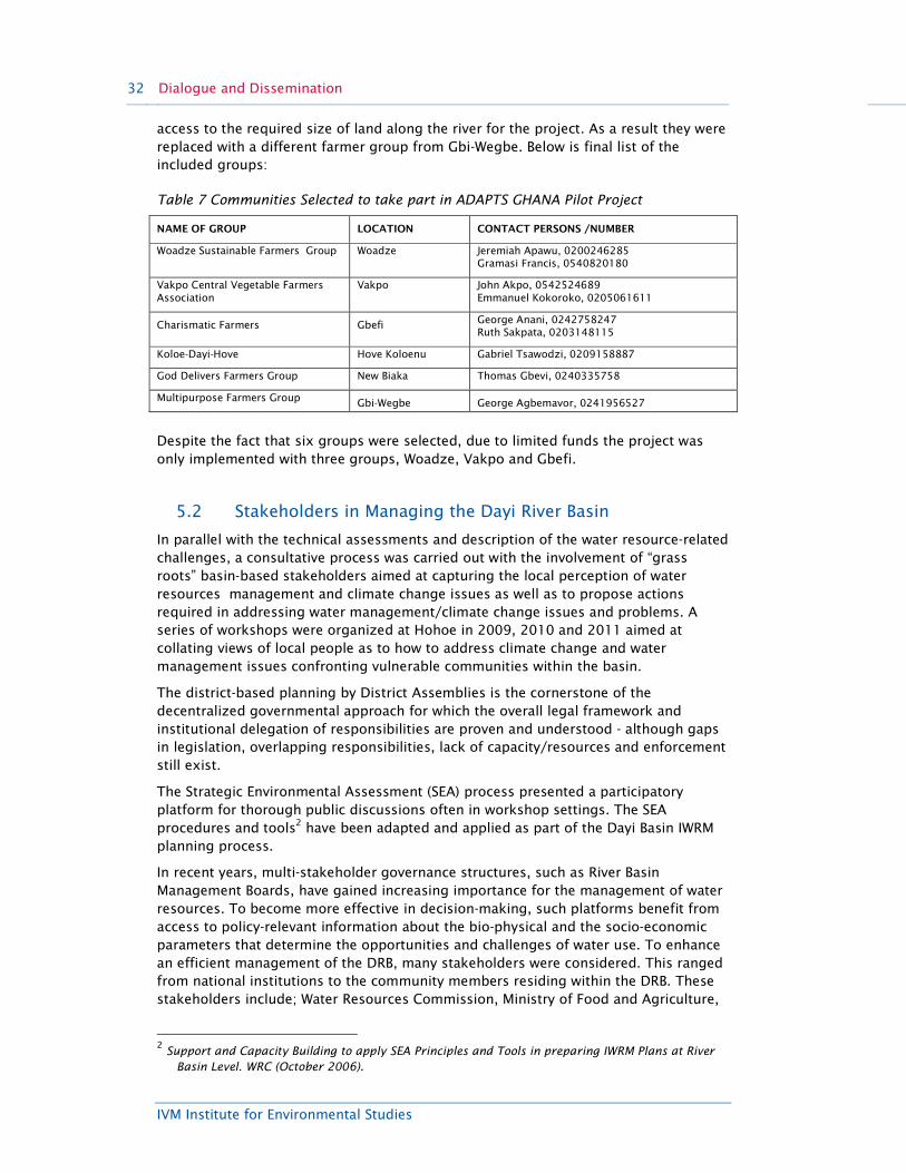
access to the required size of land along the river for the project. As a result they were
replaced with a different farmer group from Gbi-Wegbe. Below is final list of the
included groups:
Table 7 Communities Selected to take part in ADAPTS GHANA Pilot Project
NAME OF GROUP LOCATION CONTACT PERSONS /NUMBER
Woadze Sustainable Farmers Group Woadze Jeremiah Apawu, 0200246285 Gramasi Francis, 0540820180
Vakpo Central Vegetable Farmers Association
Vakpo John Akpo, 0542524689 Emmanuel Kokoroko, 0205061611
Charismatic Farmers Gbefi George Anani, 0242758247 Ruth Sakpata, 0203148115
Koloe-Dayi-Hove Hove Koloenu Gabriel Tsawodzi, 0209158887
God Delivers Farmers Group New Biaka Thomas Gbevi, 0240335758
Multipurpose Farmers Group Gbi-Wegbe George Agbemavor, 0241956527
Despite the fact that six groups were selected, due to limited funds the project was
only implemented with three groups, Woadze, Vakpo and Gbefi.
5.2 Stakeholders in Managing the Dayi River Basin
In parallel with the technical assessments and description of the water resource-related
challenges, a consultative process was carried out with the involvement of “grass
roots” basin-based stakeholders aimed at capturing the local perception of water
resources management and climate change issues as well as to propose actions
required in addressing water management/climate change issues and problems. A
series of workshops were organized at Hohoe in 2009, 2010 and 2011 aimed at
collating views of local people as to how to address climate change and water
management issues confronting vulnerable communities within the basin.
The district-based planning by District Assemblies is the cornerstone of the
decentralized governmental approach for which the overall legal framework and
institutional delegation of responsibilities are proven and understood - although gaps
in legislation, overlapping responsibilities, lack of capacity/resources and enforcement
still exist.
The Strategic Environmental Assessment (SEA) process presented a participatory
platform for thorough public discussions often in workshop settings. The SEA
procedures and tools2 have been adapted and applied as part of the Dayi Basin IWRM
planning process.
In recent years, multi-stakeholder governance structures, such as River Basin
Management Boards, have gained increasing importance for the management of water
resources. To become more effective in decision-making, such platforms benefit from
access to policy-relevant information about the bio-physical and the socio-economic
parameters that determine the opportunities and challenges of water use. To enhance
an efficient management of the DRB, many stakeholders were considered. This ranged
from national institutions to the community members residing within the DRB. These
stakeholders include; Water Resources Commission, Ministry of Food and Agriculture,
2 Support and Capacity Building to apply SEA Principles and Tools in preparing IWRM Plans at River
Basin Level. WRC (October 2006).

IVM Instituut voor Milieuvraagstukken
Synthesis report Ghana
Traditional authorities, Security agencies (National Fire Service, Police etc). The rest are
Environmental Protection Agency, District Assemblies, Forestry Commission, Wildlife
Departments and NGOs. Farmers and fishermen are also not left out of the potential
stakeholders in managing the DRB.
5.3 Water Resources Commission
The present Dayi River Basin IWRM Plan is the fourth of its kind, and this basin was
chosen due to the impact of climate change on Water Resources and ultimately
livelihoods. Other major Water Resources management issues include land and water
quality degradation, water shortages in an otherwise perennial river. Water related
hazards such as floods have become more frequent in the basin and the unpredictable
rainfall pattern has adversely affected rain fed agriculture. In instituting proper water
resources management mechanisms with regards to adaptation to climate change, the
“ADAPTS Concept “of building resilience of vulnerable communities to better adapt to
the impacts of climate change was adopted. It is WRC’s sincere hope that this plan can
be a useful catalyst towards accelerating concrete water management activities in the
Dayi River Basin, and more importantly, may also serve as a source of inspiration to
advance the approach of “ADAPTS” in other basins in Ghana as prescribed in the
National IWRM plan.


IVM Instituut voor Milieuvraagstukken
Synthesis report Ghana
6 Summary and Conclusions
The ADAPTS Ghana case can be considered successful in terms of increasing farmers
capacity to adapt to climate change and in incorporating climate and social concerns
into water management policy. Almost all targets defined in the proposal have been
achieved. The only major difference between plan and implementation is that due to
budget constraints only three communities have been involved in the field construction
of irrigation schemes. The schemes were more expensive than was expected in the
preparation phase. As the three farmer groups that have irrigation schemes now see
the positive impacts, and because they feel solidarity to the other groups that did not
get an irrigation scheme, they have decided to turn the project grant into a loan, to
start a revolving fund for funding schemes in New Baika, Lolobi Kumasi or Ve Koleunu.
DI will be the coordinator of this.
In regards to water policy: in 1998 The Ghanaian governed set about decentralizing
water management throughout the country. The idea was to create separate water
boards to manage the various river basins. At the start of the ADAPTS project three
boards with river basin management plans (RBMP) were in operation in Ghana. Working
closely with the WRC, ADAPTS helped in the creation of the new water board and RBMP
in the Dayi Basin. The ADAPTS bottom up approach, stressing empowerment of local
stakeholders in water, was officially incorporated in the WRC strategy on
decentralization of water management. This approach is used for the first time in
Ghana in the formation of the Dayi River Basin Board. The new RBMP was the first in
the country to be created using a stakeholder consultation approach.3 During its
construction meetings and workshops were held between government officials, NGOs,
civil society groups, ensuring that all had input into the plan’s creation and are
represented in the Basin Board. In addition it is also the first plan to include future
hydrological circumstances, e.g. climate change and adaptation measures in its design.
As such it should help lead to better water management in the basin over the future.
Additionally the government is keen to upscale the approach used in the development
of the Dayi Basin Plan to other basins in the country.
Runoff records do show that river base flows have decreased by some 80 % after the
seventies of the last century. This is attributed to the decrease in rainfall in the same
period. By assessing the effect of irrigation schemes on the flow of water, the project
has contributed to explore the amount of water that can be used for irrigation without
hampering downstream uses. ADAPTS also used information from Global Circulation
Models to assess the limits under possible future climatic circumstances. This has
shown how climate change and adaptation can be made practical for decision- and
plan making.
In regard to increasing farmer capacity: At the farmer level the aim of the ADAPTS
project was to help communities establish sustainable communal irrigation schemes in
addition to rainfed agricultural production during the monsoon season. This was
achieved in Woadze, Vakpo and Gbefi. At the start of the project there was some
uncertainty as to which form of irrigation scheme, sprinkler, drip or gravity would be
most suited to the selected areas. However, following a workshop with the farmers
and group field visits to areas already employing various types of irrigation, it was
agreed to proceed with sprinkler systems. Such a system is easily maintainable and
consists of removable parts: pumps set up on the banks of the river bring water under
3 At the writing of this report the RBMP was awaiting final approval from the central
government.
IVM Institute for Environmental Studies
36 Summary and Conclusions
high pressure via removable pipes to the sprinklers to the adjacent fields. Licenses for
such irrigations systems are to be obtained under the RBMP to avoid negative impacts
on downstream users under current and future circumstances. The ADAPTS project
provided technical and agronomical assistance and the construction funds on a 3 year
loan basis. At present three groups comprising a total of 45 farmers are employing
this method. These farmers have organized themselves in the ADAPTS farmers
association. The success of the new irrigation scheme can be measured in the
increased output of cash crops being produced in the areas. The primary income
earner for most is peppers at the moment. While previously their products were mainly
sold on local markets, the ADAPTS farmer association has found buyers exporting the
peppers to the UK and the Netherlands. This has directly translated into increased
incomes and more sustainable livelihoods.
The loan installments will go to help finance the creation and implementation of the
other irrigation schemes in New Baika, Lolobi Kumasi or Ve Koleunu that were left out
due to a lack of funds at the start.
Because of the success of the ADAPTS schemes the Ministry of Water Resources Works
and Housing and the Water Resources Commission of Ghana has adopted communal
irrigation in combination with river basin management as an essential part of the new
national water policy (National Conference of Water and Climate Change, Accra, May
2011; IWRM action plan of WRC, November, 2011).
The project in Ghana also has developed different datasets and models to assess the
potential changes in climate in the region and its effect on hydrology. Especially the
“weather generator” which generated daily rainfall and temperature records for future
climates in the tropics, is innovative. These tools can be used as generic analytical
methods for planning and management of water in rivers basins with scarce data.
The lessons learned from ADAPTS Ghana are twofold. First is that increased solidarity
among farmers and the willingness to work and invest together as group can lead to
substantial benefits for individual households and communities. Prior to the project,
most farmers in the area operated independently, relying on the rain as their main
source of water. The implementation of an irrigation scheme, a potential benefit for
all, required that farmers banded together to help negotiate its future design and use.
This exercise led to the creation of communal farmer groups that ultimately manage
their water resources together. Moreover, the farmer groups also now manage the
sale, export and profit from their crops allowing them greater market power. Despite
the fact that the use of irrigation is being written into current water policy, irrigation
schemes are expensive and for the most part do not operate on the individual level.
Therefore if future irrigation schemes are to be successful, they first require the
creation of farmer organizations which can have access to credit to finance their
schemes. Provided that the schemes are profitable, the proceeds can go to repay their
loan and/or finance new schemes. This dynamic, as mentioned above, is already taking
place in the project’s pilot area.
The second lesson learned from the project, as is evidenced from the new RBMP and
water board, is that consultations and dialogue between government, stakeholders and
knowledge institutes can lead to a more inclusive and robust water policy better
geared to adapt to the impacts of climate change.

IVM Instituut voor Milieuvraagstukken
Synthesis report Ghana 37
References
Beyen, I & Rutgrink I., 2010. Effects of Changes in Climate and Land Use on the Dayi River. Acacia Water, Vrije Universiteit Amsterdam.
Buishand, T.A. & Brandsma, T. 2001. Multisite Simulation of Daily Precipitation and
Temperature in the Rhine Basin by Nearest-Neighbor Resampling. Water Resources
Research, vol. 37, No. 11, pp. 2761-2776.
Bergström, S. & Forsman, A., 1973, Development of a Conceptual Deterministic
Rainfall Runoff Model, Swedish Meteorological and Hydrological Institute,
Stockholm, Nordic Hydrology, 4, pp. 147-170.
Hohenrainer, J., 2008, Propagation of Drought through the Hydrological Cycle in Two
Different Climatic Regions, MSc thesis, Institut für Hydrologie der Albert Ludwigs-
Universität Freiburg, Germany. Pauw, W.P. & Boateng-Gyimah, M, 2011. Water Resource Planning in Times of Climate
Change: A WEAP model exercise in the Dayi River basin in Ghana. IVM, Vrije Universiteit Amsterdam
Pauw W.P., Kinney K. & Alfa B., 2009. Climate Change Susceptibility of Rural Livelihoods in Eastern Ghana. IVM, Vrije Universiteit Amsterdam
Seibert, J., 2005, HBV light version 2, User’s Manual, Uppsala University, Institute of
Earth Sciences, Department of Hydrology, Uppsala, Sweden.
Top Related