


Languages
Pages
Legal

www.southglos.gov.uk
South Gloucestershire Council
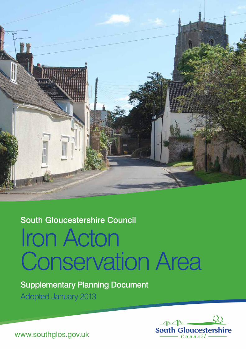
Iron ActonConservation AreaSupplementary Planning DocumentAdopted January 2013
www.southglos.gov.uk
Iron Acton Conservation Area Supplementary Planning Document January 2013
This Supplementary Planning Document (SPD) provides an appraisal of the Iron Acton Conservation Area. It sets out the main features contributing to the distinctive character and appearance of the conservation area. It also suggests a strategy for the preservation and enhancement of the area. The SPD supplements the policies of the South Gloucestershire Local Plan and future Core Strategy and will be used when assessing development proposals.
Contents Page
Introduction 3
What is a conservation area? 4
The conservation area boundary 5
The landscape setting 6
The historic context 7
Character areas 10
The special features 11
Acton Court, Acton Lodge Farm and former deer park 15
Villagegreenandopenfieldstothenorthandsouth 18
The village – west side 21
The village – east side 23
Algars Manor and Station Road to the south of the village 26
Keeping and enhancing character 28
What happens now? 31
How to contact us 31
2
www.southglos.gov.uk
Iron Acton Conservation Area Supplementary Planning Document January 2013
3
Introduction
Iron Acton was designated as a conservation area in 1975 in recognition of its special architectural and historic character and appearance. It comprises the linear planned village of Iron Acton with its many historic buildings including the late 14th century Church of St James the Less. It also includes the exceptionally well preserved Tudor manor house of Acton Court and adjoining fields which contribute to the attractive rural setting of the village. The conservation area boundary is shown on the attached Plan 1.
Once designated, the local planning authority has a statutory duty to ensure that any proposed development will preserve or enhance the character or appearance of the conservation area and its setting. The council also has a dutytoperiodicallyreviewallconservationareasandthisleafletsetsouttheresults of this review.
Purpose of the document
This review has sought to identify the main elements that contribute to the special character or appearance of the conservation area and provides astrategyforitspreservationandenhancement.Bydefiningthespecialcharacter of the conservation area, the review will help to ensure that future development preserves or enhances the conservation area and its setting.
Followingconsultation,theadoptedleafletwillsupplementPolicyL12inthe adopted South Gloucestershire Local Plan and Policy CS9 of the Core Strategy, giving additional guidance against which development proposals will be assessed. It should be read in conjunction with these documents, which include planning policies for the protection and enhancement of the historic environment and landscape character.
Applicants seeking planning permission are expected to provide an assessment demonstrating how their proposals will preserve or enhance thesignificance,characterorappearanceoftheconservationareaanditssetting. Proposals having a harmful impact will be refused.
Iron Acton Conservation Area Supplementary Planning Document January 2013
www.southglos.gov.uk 4
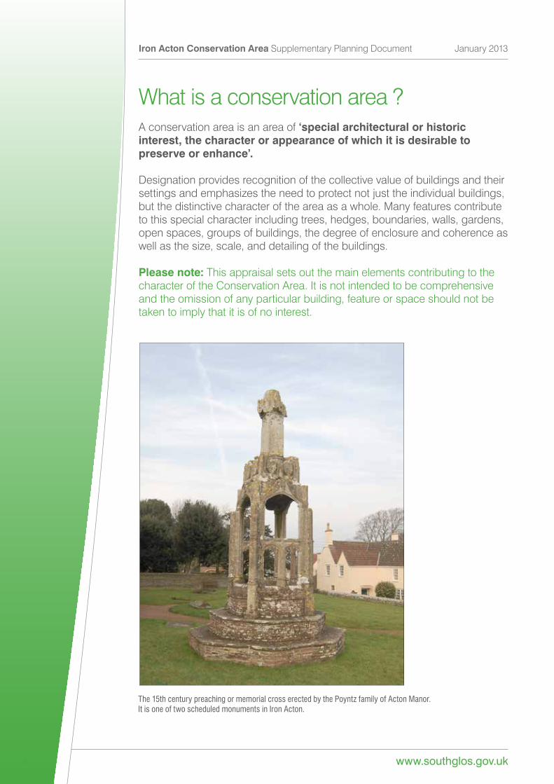
What is a conservation area ?A conservation area is an area of ‘special architectural or historic interest, the character or appearance of which it is desirable to preserve or enhance’.
Designation provides recognition of the collective value of buildings and their settings and emphasizes the need to protect not just the individual buildings, but the distinctive character of the area as a whole. Many features contribute to this special character including trees, hedges, boundaries, walls, gardens, open spaces, groups of buildings, the degree of enclosure and coherence as well as the size, scale, and detailing of the buildings.
Please note: This appraisal sets out the main elements contributing to the character of the Conservation Area. It is not intended to be comprehensive and the omission of any particular building, feature or space should not be taken to imply that it is of no interest.
The 15th century preaching or memorial cross erected by the Poyntz family of Acton Manor. It is one of two scheduled monuments in Iron Acton.
www.southglos.gov.uk
Iron Acton Conservation Area Supplementary Planning Document January 2013
5
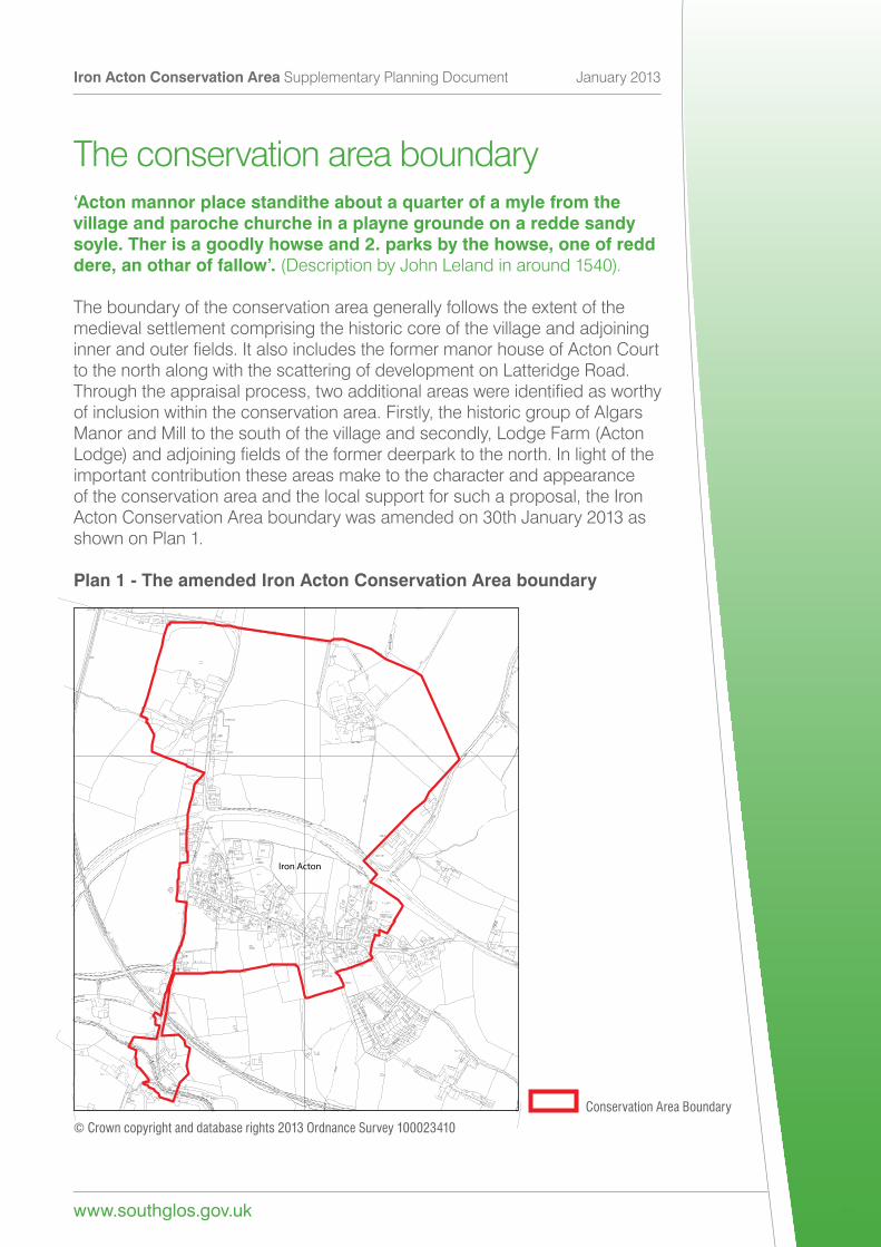
The conservation area boundary‘Acton mannor place standithe about a quarter of a myle from the village and paroche churche in a playne grounde on a redde sandy soyle. Ther is a goodly howse and 2. parks by the howse, one of redd dere, an othar of fallow’. (Description by John Leland in around 1540).
The boundary of the conservation area generally follows the extent of the medieval settlement comprising the historic core of the village and adjoining innerandouterfields.ItalsoincludestheformermanorhouseofActonCourtto the north along with the scattering of development on Latteridge Road. Throughtheappraisalprocess,twoadditionalareaswereidentifiedasworthyof inclusion within the conservation area. Firstly, the historic group of Algars Manor and Mill to the south of the village and secondly, Lodge Farm (Acton Lodge)andadjoiningfieldsoftheformerdeerparktothenorth.Inlightoftheimportant contribution these areas make to the character and appearance of the conservation area and the local support for such a proposal, the Iron Acton Conservation Area boundary was amended on 30th January 2013 as shown on Plan 1.
Plan 1 - The amended Iron Acton Conservation Area boundary
© Crown copyright and database rights 2013 Ordnance Survey 100023410
ST6783ST6783ST6783ST6783ST6783ST6783ST6783ST6783ST6783ST6783ST6783ST6783ST6783ST6783ST6783ST6783ST6783ST6783ST6783ST6783ST6783ST6783ST6783ST6783ST6783ST6783ST6783ST6783ST6783ST6783ST6783ST6783ST6783ST6783ST6783ST6783ST6783ST6783ST6783ST6783
Iron Acton
Conservation Area Boundary
Iron Acton Conservation Area Supplementary Planning Document January 2013
www.southglos.gov.uk 6
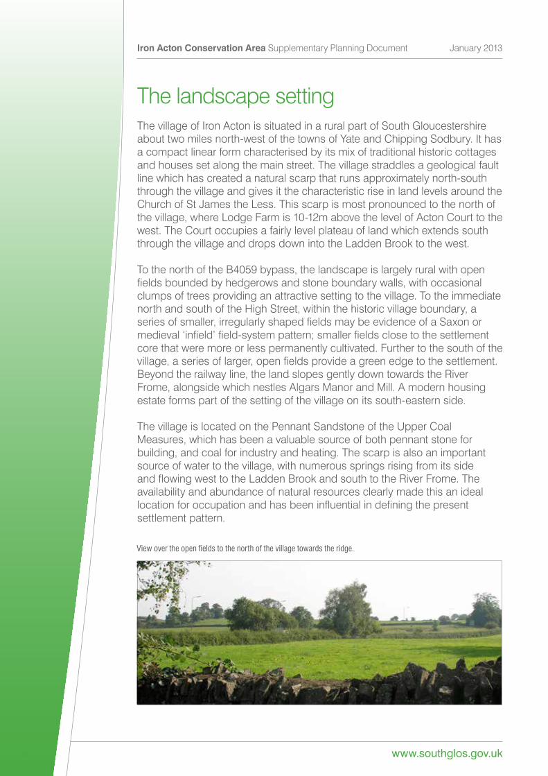
The landscape settingThe village of Iron Acton is situated in a rural part of South Gloucestershire about two miles north-west of the towns of Yate and Chipping Sodbury. It has a compact linear form characterised by its mix of traditional historic cottages and houses set along the main street. The village straddles a geological fault line which has created a natural scarp that runs approximately north-south through the village and gives it the characteristic rise in land levels around the Church of St James the Less. This scarp is most pronounced to the north of the village, where Lodge Farm is 10-12m above the level of Acton Court to the west. The Court occupies a fairly level plateau of land which extends south through the village and drops down into the Ladden Brook to the west.
To the north of the B4059 bypass, the landscape is largely rural with open fieldsboundedbyhedgerowsandstoneboundarywalls,withoccasionalclumps of trees providing an attractive setting to the village. To the immediate north and south of the High Street, within the historic village boundary, a seriesofsmaller,irregularlyshapedfieldsmaybeevidenceofaSaxonormedieval‘infield’field-systempattern;smallerfieldsclosetothesettlementcore that were more or less permanently cultivated. Further to the south of the village,aseriesoflarger,openfieldsprovideagreenedgetothesettlement.Beyond the railway line, the land slopes gently down towards the River Frome, alongside which nestles Algars Manor and Mill. A modern housing estate forms part of the setting of the village on its south-eastern side.
The village is located on the Pennant Sandstone of the Upper Coal Measures, which has been a valuable source of both pennant stone for building, and coal for industry and heating. The scarp is also an important source of water to the village, with numerous springs rising from its side andflowingwesttotheLaddenBrookandsouthtotheRiverFrome.Theavailability and abundance of natural resources clearly made this an ideal locationforoccupationandhasbeeninfluentialindefiningthepresentsettlement pattern.
View over the open fields to the north of the village towards the ridge.
www.southglos.gov.uk
Iron Acton Conservation Area Supplementary Planning Document January 2013
7
The historic contextAlthough there is evidence of early settlement in the area during the Iron Age and Roman periods, Iron Acton village is believed to have Saxon origins. The name Iron Acton is believed to have Saxon origins derived from ac (meaning oak tree) and tun (meaning enclosure, farmstead or village). This suggests it was a settlement in an area characterised by oak woodland that formed part oftheancientRoyalForestofKingswood.Thesuffix‘iron’referredtotheironore found in the area, and from early times iron mining and smelting was an important activity with trees being used to fuel the forges.
The original nucleus of the Saxon settlement, with church and manor house, was probably located on the higher ground by the present Church of St JamestheLessandsurroundedbysmallerinnercropfieldswithlargerpasturefieldsbeyond.SometimebeforetheNormanConquest,theSaxonsettlement had been divided into the two separate manors recorded in 1086. ThesehavebeenidentifiedwithActonCourtinthenorthandActonIlgartothesouth,bothequidistantfromthevillageandfromthechurch.
The village gradually spread westwards from the original Saxon settlement towards the two new manors, creating a linear plan which is typical of many planned settlements of the Middle Ages. The present village green may also have originated at this time, forming an area of common land between the two manors.
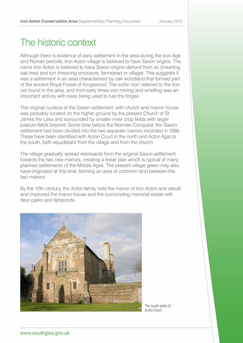
By the 12th century, the Acton family held the manor of Iron Acton and rebuilt and improved the manor house and the surrounding manorial estate with deer-parksandfishponds.
The south gable of Acton Court.
Iron Acton Conservation Area Supplementary Planning Document January 2013
www.southglos.gov.uk 8
AstheActon’swealthgrew,theestatewasenlargedtoincludeActonIlgarwhich ceased to be a separate manor. On the death of Sir John Acton in 1344 the estates passed to the Poyntz family who remained Lords of the manor until 1683. As well as substantially rebuilding the church in the late 14th or early 15th century, the Poyntz family made many changes to Acton Courtreflectingtheirincreasedstatusasroyalcourtiers.Ofparticularnote,weretheimprovementsandimpressivenewwingaddedbySirNicholasPoyntz for a visit by King Henry VIII and Anne Boleyn in 1535.
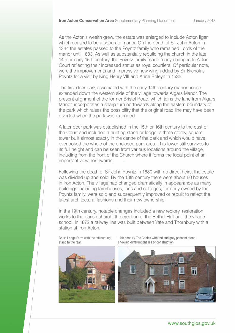
Thefirstdeerparkassociatedwiththeearly14thcenturymanorhouseextended down the western side of the village towards Algars Manor. The present alignment of the former Bristol Road, which joins the lane from Algars Manor, incorporates a sharp turn northwards along the eastern boundary of the park which raises the possibility that the original road line may have been diverted when the park was extended.
A later deer park was established in the 15th or 16th century to the east of theCourtandincludedahuntingstandorlodge;athreestorey,squaretower built almost exactly in the centre of the park and which would have overlooked the whole of the enclosed park area. This tower still survives to its full height and can be seen from various locations around the village, including from the front of the Church where it forms the focal point of an important view northwards.
Following the death of Sir John Poyntz in 1680 with no direct heirs, the estate was divided up and sold. By the 18th century there were about 60 houses in Iron Acton. The village had changed dramatically in appearance as many buildings including farmhouses, inns and cottages, formerly owned by the Poyntzfamily,weresoldandsubsequentlyimprovedorrebuilttoreflectthelatest architectural fashions and their new ownership.
In the 19th century, notable changes included a new rectory, restoration works to the parish church, the erection of the Bethel Hall and the village school. In 1872 a railway line was built between Yate and Thornbury with a station at Iron Acton.
Court Lodge Farm with the tall hunting stand to the rear.
17th century The Gables with red and grey pennant stone showing different phases of construction.
www.southglos.gov.uk
Iron Acton Conservation Area Supplementary Planning Document January 2013
9
At the start of the 20th century there were over 20 shops and businesses in the High Street but today few remain. Other changes include the construction of the bypass to the north of the village, and the loss of open space in the centre of the village for the village hall and housing.
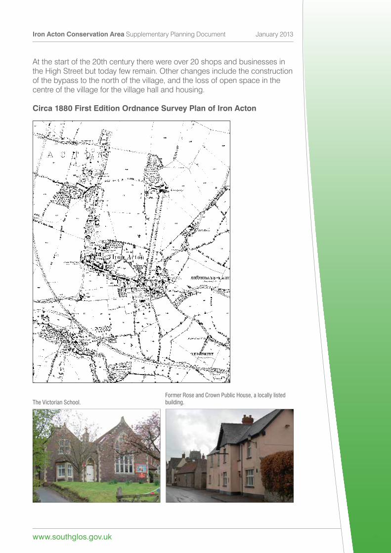
Circa 1880 First Edition Ordnance Survey Plan of Iron Acton
Scale 1:10000
© Crown copyright and database rights 2013 Ordnance Survey 100023410.The Victorian School.Former Rose and Crown Public House, a locally listed building.
Iron Acton Conservation Area Supplementary Planning Document January 2013
www.southglos.gov.uk 10
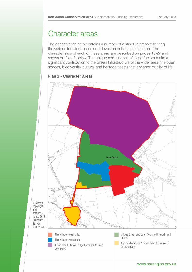
Character areasTheconservationareacontainsanumberofdistinctiveareasreflectingthe various functions, uses and development of the settlement. The characteristics of each of these areas are described on pages 15-27 and shownonPlan2below.TheuniquecombinationofthesefactorsmakeasignificantcontributiontotheGreenInfrastructureofthewiderarea;theopenspaces,biodiversity,culturalandheritageassetsthatenhancequalityoflife.
Plan 2 - Character Areas
ST6783ST6783ST6783ST6783ST6783ST6783ST6783ST6783ST6783ST6783ST6783ST6783ST6783ST6783ST6783ST6783ST6783ST6783ST6783ST6783ST6783ST6783ST6783ST6783ST6783ST6783ST6783ST6783ST6783ST6783ST6783ST6783ST6783ST6783ST6783ST6783ST6783ST6783ST6783ST6783
Iron Acton
© Crown copyright and database rights 2013 Ordnance Survey 100023410
The village – east side.
The village – west side.
Acton Court, Acton Lodge Farm and former deer park.
Village Green and open fields to the north and south.
Algars Manor and Station Road to the south of the village.
www.southglos.gov.uk
Iron Acton Conservation Area Supplementary Planning Document January 2013
11
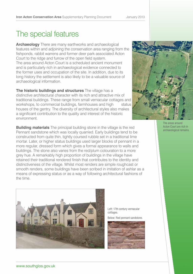
The special featuresArchaeology There are many earthworks and archaeological features within and adjoining the conservation area ranging from the fishponds,rabbitwarrensandformerdeerparkassociatedActonCourttotheridgeandfurrowoftheopenfieldsystem. The area around Acton Court is a scheduled ancient monument and is particularly rich in archaeological evidence connected to the former uses and occupation of the site. In addition, due to its long history the settlement is also likely to be a valuable source of archaeological information.
The historic buildings and structures The village has a distinctive architectural character with its rich and attractive mix of traditional buildings. These range from small vernacular cottages and workshops, to commercial buildings, farmhouses and high status houses of the gentry. The diversity of architectural styles also makes asignificantcontributiontothequalityandinterestofthehistoricenvironment.
Building materials The principal building stone in the village is the red Pennantsandstonewhichwaslocallyquarried.Earlybuildingstendtobeconstructedfromquitethin,tightlycoursedrubblesetinatraditionallimemortar. Later, or higher status buildings used larger blocks of pennant in a more regular, dressed form which gives a formal appearance to walls and buildings. The stone also varies from the red/plum colouration to a more grey hue. A remarkably high proportion of buildings in the village have retainedtheirtraditionalrenderedfinishthatcontributestotheidentityanddistinctiveness of the village. Whilst most renders are simple roughcast or smooth renders, some buildings have been scribed in imitation of ashlar as a means of expressing status or as a way of following architectural fashions of the time.
Left: 17th century vernacular cottages.
Below: Red pennant sandstone.
Scale 1:2500© Crown copyright and database rights 2013 Ordnance Survey 100023410.
The areas around Acton Court are rich in archaeological remains.
Iron Acton Conservation Area Supplementary Planning Document January 2013
www.southglos.gov.uk 12
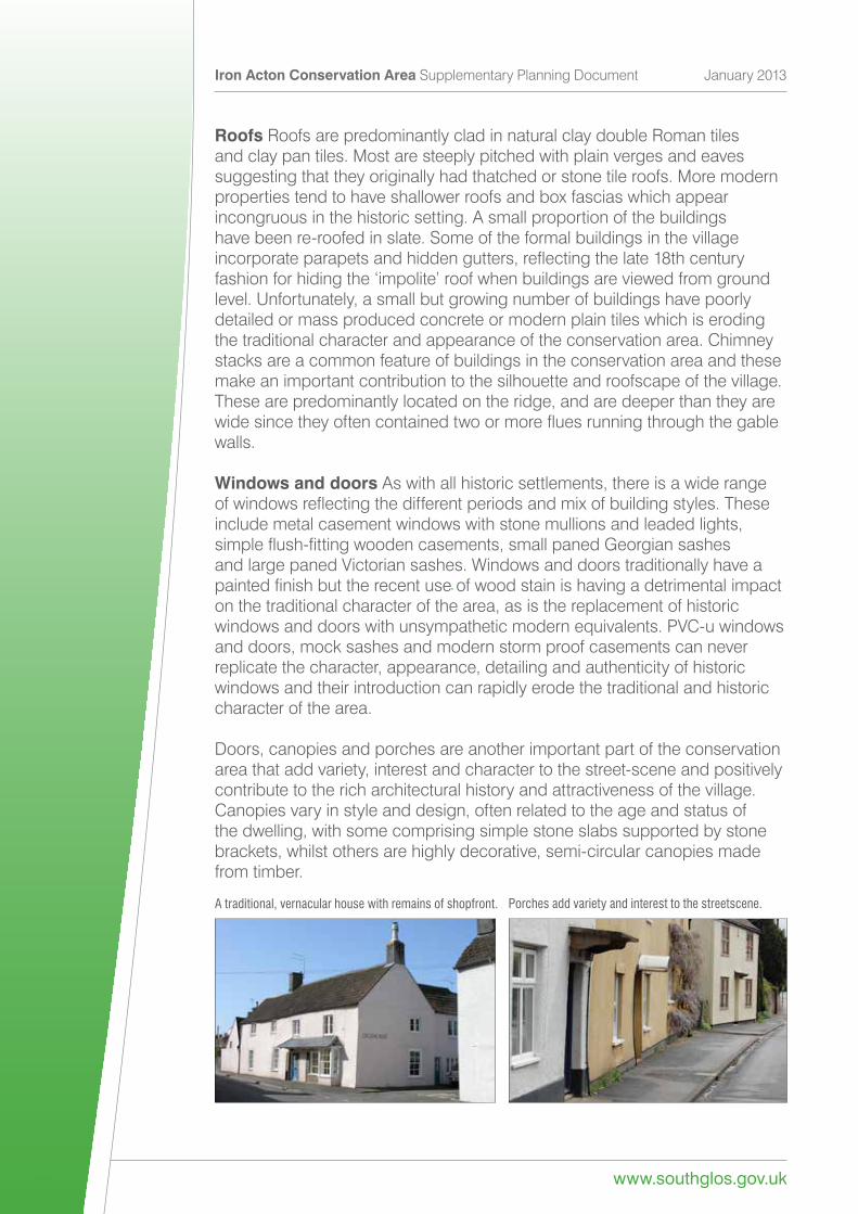
Roofs Roofs are predominantly clad in natural clay double Roman tiles and clay pan tiles. Most are steeply pitched with plain verges and eaves suggesting that they originally had thatched or stone tile roofs. More modern properties tend to have shallower roofs and box fascias which appear incongruous in the historic setting. A small proportion of the buildings have been re-roofed in slate. Some of the formal buildings in the village incorporateparapetsandhiddengutters,reflectingthelate18thcenturyfashionforhidingthe‘impolite’roofwhenbuildingsareviewedfromgroundlevel. Unfortunately, a small but growing number of buildings have poorly detailed or mass produced concrete or modern plain tiles which is eroding the traditional character and appearance of the conservation area. Chimney stacks are a common feature of buildings in the conservation area and these make an important contribution to the silhouette and roofscape of the village. These are predominantly located on the ridge, and are deeper than they are widesincetheyoftencontainedtwoormorefluesrunningthroughthegablewalls.
Windows and doors As with all historic settlements, there is a wide range ofwindowsreflectingthedifferentperiodsandmixofbuildingstyles.Theseinclude metal casement windows with stone mullions and leaded lights, simpleflush-fittingwoodencasements,smallpanedGeorgiansashesand large paned Victorian sashes. Windows and doors traditionally have a paintedfinishbuttherecentuseofwoodstainishavingadetrimentalimpacton the traditional character of the area, as is the replacement of historic windowsanddoorswithunsympatheticmodernequivalents.PVC-uwindowsand doors, mock sashes and modern storm proof casements can never replicate the character, appearance, detailing and authenticity of historic windows and their introduction can rapidly erode the traditional and historic character of the area.
Doors, canopies and porches are another important part of the conservation area that add variety, interest and character to the street-scene and positively contribute to the rich architectural history and attractiveness of the village. Canopies vary in style and design, often related to the age and status of the dwelling, with some comprising simple stone slabs supported by stone brackets, whilst others are highly decorative, semi-circular canopies made from timber.
A traditional, vernacular house with remains of shopfront. Porches add variety and interest to the streetscene.
www.southglos.gov.uk
Iron Acton Conservation Area Supplementary Planning Document January 2013
13
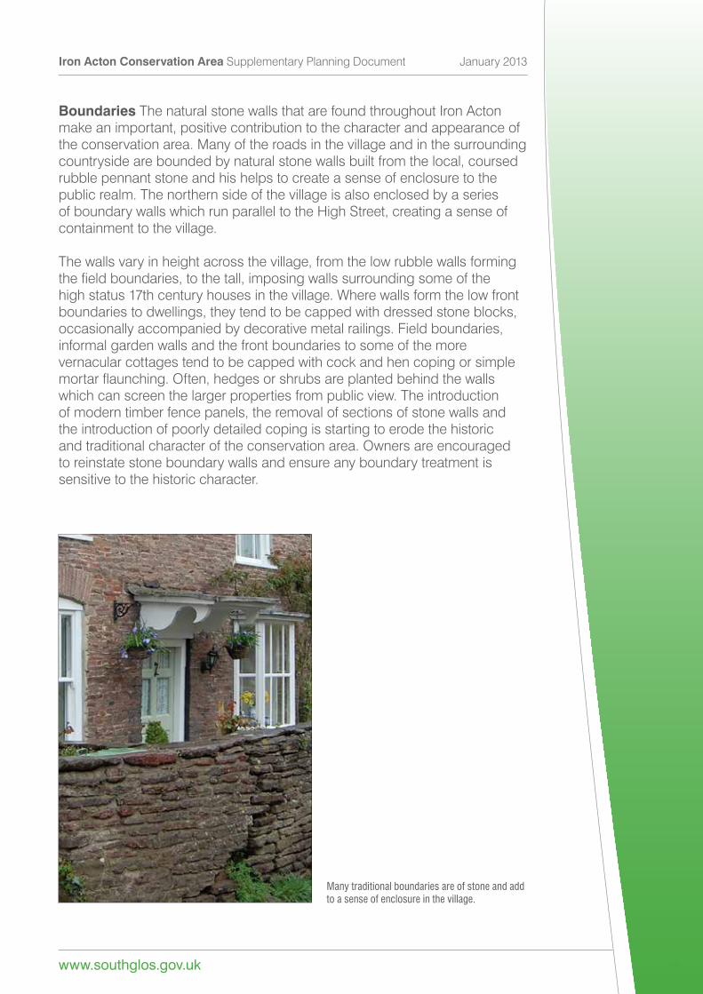
Boundaries The natural stone walls that are found throughout Iron Acton make an important, positive contribution to the character and appearance of the conservation area. Many of the roads in the village and in the surrounding countryside are bounded by natural stone walls built from the local, coursed rubble pennant stone and his helps to create a sense of enclosure to the public realm. The northern side of the village is also enclosed by a series of boundary walls which run parallel to the High Street, creating a sense of containment to the village.
The walls vary in height across the village, from the low rubble walls forming thefieldboundaries,tothetall,imposingwallssurroundingsomeofthehigh status 17th century houses in the village. Where walls form the low front boundaries to dwellings, they tend to be capped with dressed stone blocks, occasionally accompanied by decorative metal railings. Field boundaries, informal garden walls and the front boundaries to some of the more vernacular cottages tend to be capped with cock and hen coping or simple mortarflaunching.Often,hedgesorshrubsareplantedbehindthewallswhich can screen the larger properties from public view. The introduction of modern timber fence panels, the removal of sections of stone walls and the introduction of poorly detailed coping is starting to erode the historic and traditional character of the conservation area. Owners are encouraged to reinstate stone boundary walls and ensure any boundary treatment is sensitive to the historic character.
Many traditional boundaries are of stone and add to a sense of enclosure in the village.
Iron Acton Conservation Area Supplementary Planning Document January 2013
www.southglos.gov.uk 14
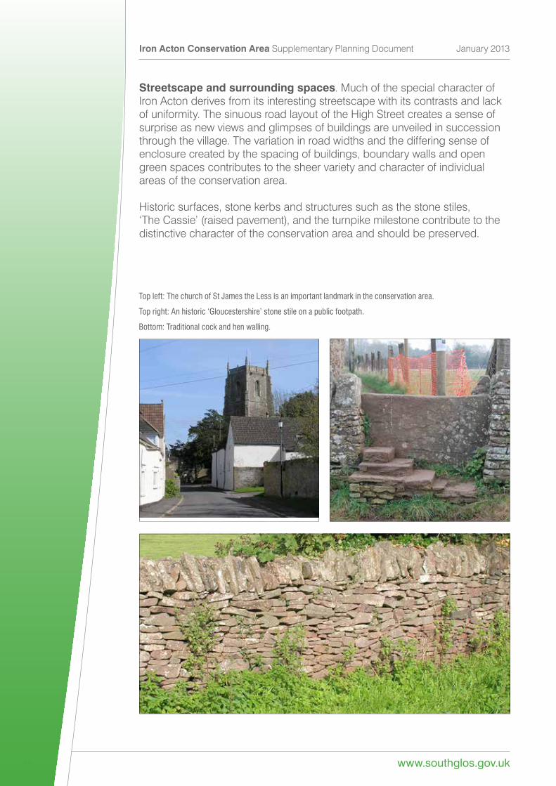
Streetscape and surrounding spaces. Much of the special character of Iron Acton derives from its interesting streetscape with its contrasts and lack of uniformity. The sinuous road layout of the High Street creates a sense of surprise as new views and glimpses of buildings are unveiled in succession through the village. The variation in road widths and the differing sense of enclosure created by the spacing of buildings, boundary walls and open green spaces contributes to the sheer variety and character of individual areas of the conservation area.
Historic surfaces, stone kerbs and structures such as the stone stiles, ‘TheCassie’(raisedpavement),andtheturnpikemilestonecontributetothedistinctive character of the conservation area and should be preserved.
Top left: The church of St James the Less is an important landmark in the conservation area.
Top right: An historic ‘Gloucestershire’ stone stile on a public footpath.
Bottom: Traditional cock and hen walling.
www.southglos.gov.uk
Iron Acton Conservation Area Supplementary Planning Document January 2013
15
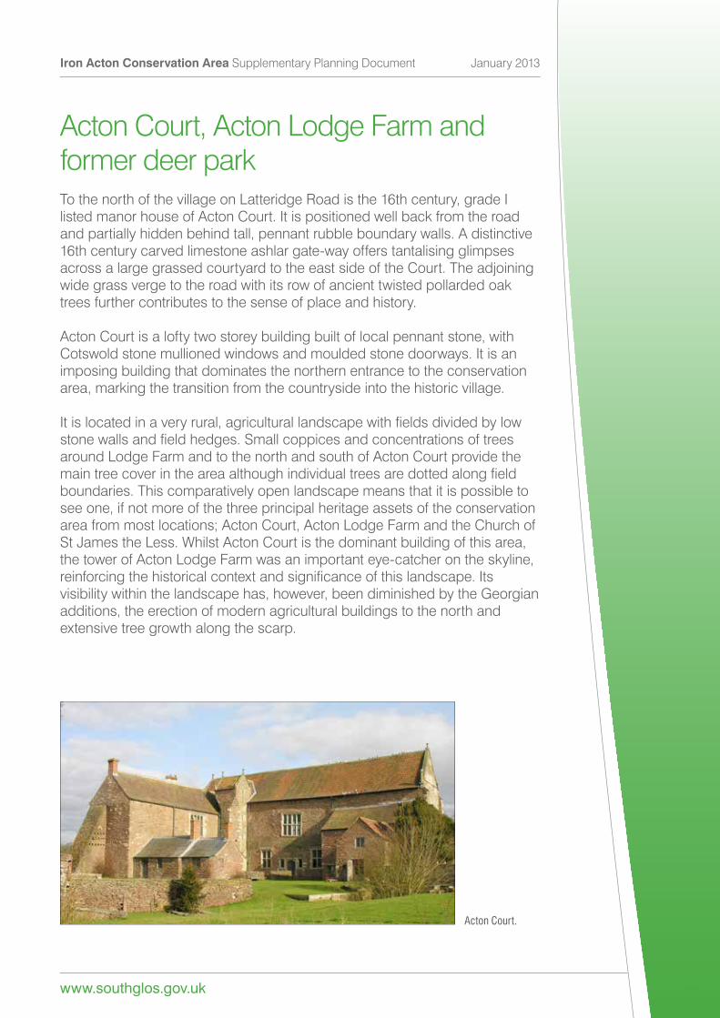
Acton Court, Acton Lodge Farm andformer deer parkTo the north of the village on Latteridge Road is the 16th century, grade I listed manor house of Acton Court. It is positioned well back from the road and partially hidden behind tall, pennant rubble boundary walls. A distinctive 16th century carved limestone ashlar gate-way offers tantalising glimpses across a large grassed courtyard to the east side of the Court. The adjoining wide grass verge to the road with its row of ancient twisted pollarded oak trees further contributes to the sense of place and history.
Acton Court is a lofty two storey building built of local pennant stone, with Cotswold stone mullioned windows and moulded stone doorways. It is an imposing building that dominates the northern entrance to the conservation area, marking the transition from the countryside into the historic village.
Itislocatedinaveryrural,agriculturallandscapewithfieldsdividedbylowstonewallsandfieldhedges.Smallcoppicesandconcentrationsoftreesaround Lodge Farm and to the north and south of Acton Court provide the maintreecoverintheareaalthoughindividualtreesaredottedalongfieldboundaries. This comparatively open landscape means that it is possible to see one, if not more of the three principal heritage assets of the conservation areafrommostlocations;ActonCourt,ActonLodgeFarmandtheChurchofSt James the Less. Whilst Acton Court is the dominant building of this area, the tower of Acton Lodge Farm was an important eye-catcher on the skyline, reinforcingthehistoricalcontextandsignificanceofthislandscape.Itsvisibility within the landscape has, however, been diminished by the Georgian additions, the erection of modern agricultural buildings to the north and extensive tree growth along the scarp.
Acton Court.
Iron Acton Conservation Area Supplementary Planning Document January 2013
www.southglos.gov.uk 16
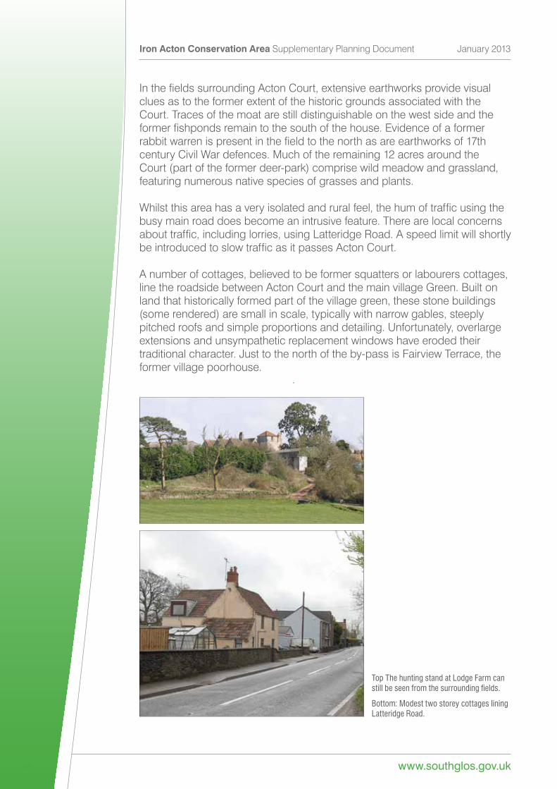
InthefieldssurroundingActonCourt,extensiveearthworksprovidevisualclues as to the former extent of the historic grounds associated with the Court. Traces of the moat are still distinguishable on the west side and the formerfishpondsremaintothesouthofthehouse.Evidenceofaformerrabbitwarrenispresentinthefieldtothenorthasareearthworksof17thcentury Civil War defences. Much of the remaining 12 acres around the Court (part of the former deer-park) comprise wild meadow and grassland, featuring numerous native species of grasses and plants.
Whilstthisareahasaveryisolatedandruralfeel,thehumoftrafficusingthebusy main road does become an intrusive feature. There are local concerns abouttraffic,includinglorries,usingLatteridgeRoad.AspeedlimitwillshortlybeintroducedtoslowtrafficasitpassesActonCourt.
Anumberofcottages,believedtobeformersquattersorlabourerscottages,line the roadside between Acton Court and the main village Green. Built on land that historically formed part of the village green, these stone buildings (some rendered) are small in scale, typically with narrow gables, steeply pitched roofs and simple proportions and detailing. Unfortunately, overlarge extensions and unsympathetic replacement windows have eroded their traditional character. Just to the north of the by-pass is Fairview Terrace, the former village poorhouse.
Top The hunting stand at Lodge Farm can still be seen from the surrounding fields.
Bottom: Modest two storey cottages lining Latteridge Road.
www.southglos.gov.uk
Iron Acton Conservation Area Supplementary Planning Document January 2013
17
Preservation and enhancement strategy
•Ensurethatdevelopment,usesandotherchangesthatrequireplanning permissiondonotharmthecharacter,significanceorsettingofActon Court,orthesignificanceandsettingofarchaeologicalfeaturesandother heritage assets that surround it.
• Protect the historic landscape setting and important views of heritage assets.
• Resist excessive and harmful advertisements around the garden centre.
•Ensureanyhighwayworksaremanagedtosafeguardadjoininghistoric buildings and important features.
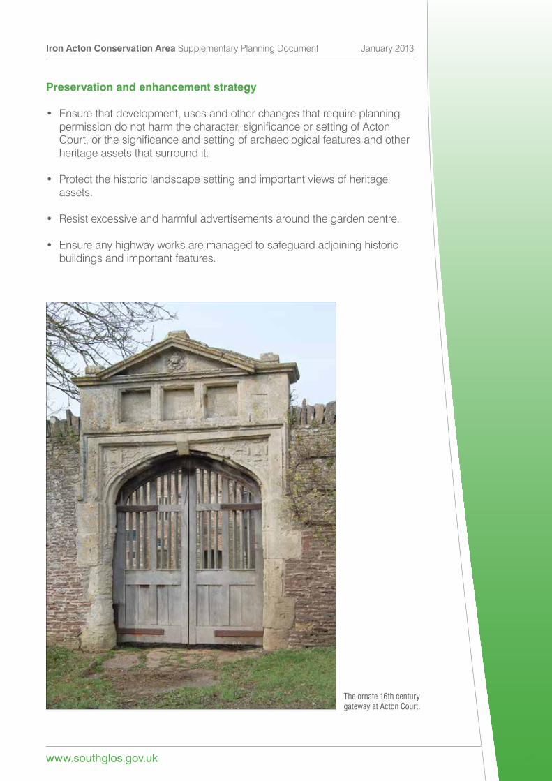
The ornate 16th century gateway at Acton Court.
Iron Acton Conservation Area Supplementary Planning Document January 2013
www.southglos.gov.uk 18
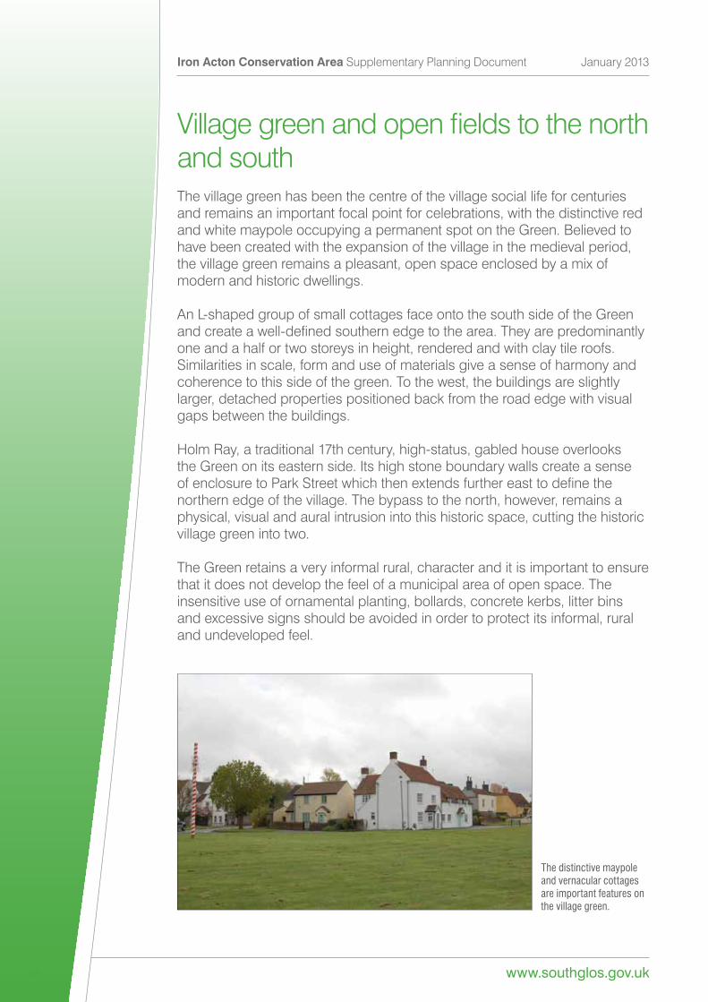
Villagegreenandopenfieldstothenorthand southThe village green has been the centre of the village social life for centuries and remains an important focal point for celebrations, with the distinctive red and white maypole occupying a permanent spot on the Green. Believed to have been created with the expansion of the village in the medieval period, the village green remains a pleasant, open space enclosed by a mix of modern and historic dwellings.
An L-shaped group of small cottages face onto the south side of the Green andcreateawell-definedsouthernedgetothearea.Theyarepredominantlyone and a half or two storeys in height, rendered and with clay tile roofs. Similarities in scale, form and use of materials give a sense of harmony and coherence to this side of the green. To the west, the buildings are slightly larger, detached properties positioned back from the road edge with visual gaps between the buildings.
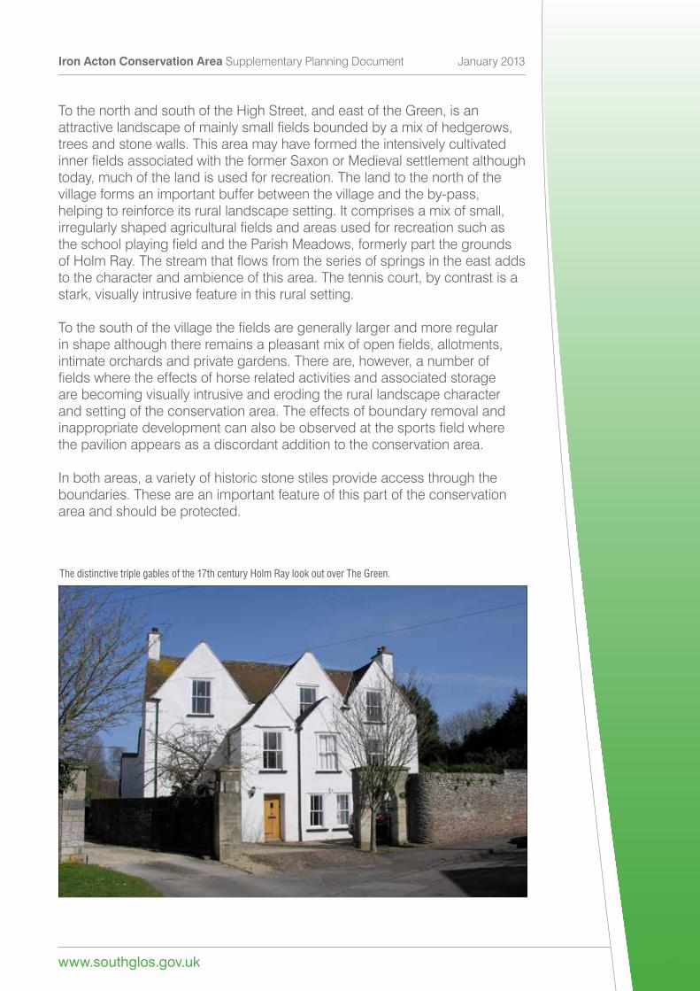
Holm Ray, a traditional 17th century, high-status, gabled house overlooks the Green on its eastern side. Its high stone boundary walls create a sense ofenclosuretoParkStreetwhichthenextendsfurthereasttodefinethenorthern edge of the village. The bypass to the north, however, remains a physical, visual and aural intrusion into this historic space, cutting the historic village green into two.
The Green retains a very informal rural, character and it is important to ensure that it does not develop the feel of a municipal area of open space. The insensitive use of ornamental planting, bollards, concrete kerbs, litter bins and excessive signs should be avoided in order to protect its informal, rural and undeveloped feel.
The distinctive maypole and vernacular cottages are important features on the village green.
www.southglos.gov.uk
Iron Acton Conservation Area Supplementary Planning Document January 2013
19
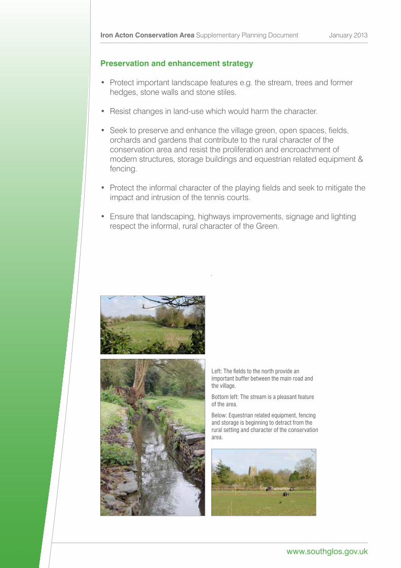
To the north and south of the High Street, and east of the Green, is anattractivelandscapeofmainlysmallfieldsboundedbyamixofhedgerows,trees and stone walls. This area may have formed the intensively cultivatedinnerfieldsassociatedwiththeformerSaxonorMedievalsettlementalthoughtoday, much of the land is used for recreation. The land to the north of thevillage forms an important buffer between the village and the by-pass,helping to reinforce its rural landscape setting. It comprises a mix of small,irregularlyshapedagriculturalfieldsandareasusedforrecreationsuchastheschoolplayingfieldandtheParishMeadows,formerlypartthegroundsofHolmRay.Thestreamthatflowsfromtheseriesofspringsintheeastaddsto the character and ambience of this area. The tennis court, by contrast is astark, visually intrusive feature in this rural setting.
Tothesouthofthevillagethefieldsaregenerallylargerandmoreregularinshapealthoughthereremainsapleasantmixofopenfields,allotments,intimate orchards and private gardens. There are, however, a number offieldswheretheeffectsofhorserelatedactivitiesandassociatedstorageare becoming visually intrusive and eroding the rural landscape characterand setting of the conservation area. The effects of boundary removal andinappropriatedevelopmentcanalsobeobservedatthesportsfieldwherethe pavilion appears as a discordant addition to the conservation area.
In both areas, a variety of historic stone stiles provide access through theboundaries. These are an important feature of this part of the conservationarea and should be protected.
The distinctive triple gables of the 17th century Holm Ray look out over The Green.
Iron Acton Conservation Area Supplementary Planning Document January 2013
www.southglos.gov.uk 20
Preservation and enhancement strategy
• Protect important landscape features e.g. the stream, trees and former hedges, stone walls and stone stiles.
• Resist changes in land-use which would harm the character.
•Seektopreserveandenhancethevillagegreen,openspaces,fields, orchards and gardens that contribute to the rural character of the conservation area and resist the proliferation and encroachment of modernstructures,storagebuildingsandequestrianrelatedequipment& fencing.
•Protecttheinformalcharacteroftheplayingfieldsandseektomitigatethe impact and intrusion of the tennis courts.
•Ensurethatlandscaping,highwaysimprovements,signageandlighting respect the informal, rural character of the Green.
Left: The fields to the north provide an important buffer between the main road and the village.
Bottom left: The stream is a pleasant feature of the area.
Below: Equestrian related equipment, fencing and storage is beginning to detract from the rural setting and character of the conservation area.
www.southglos.gov.uk
Iron Acton Conservation Area Supplementary Planning Document January 2013
21
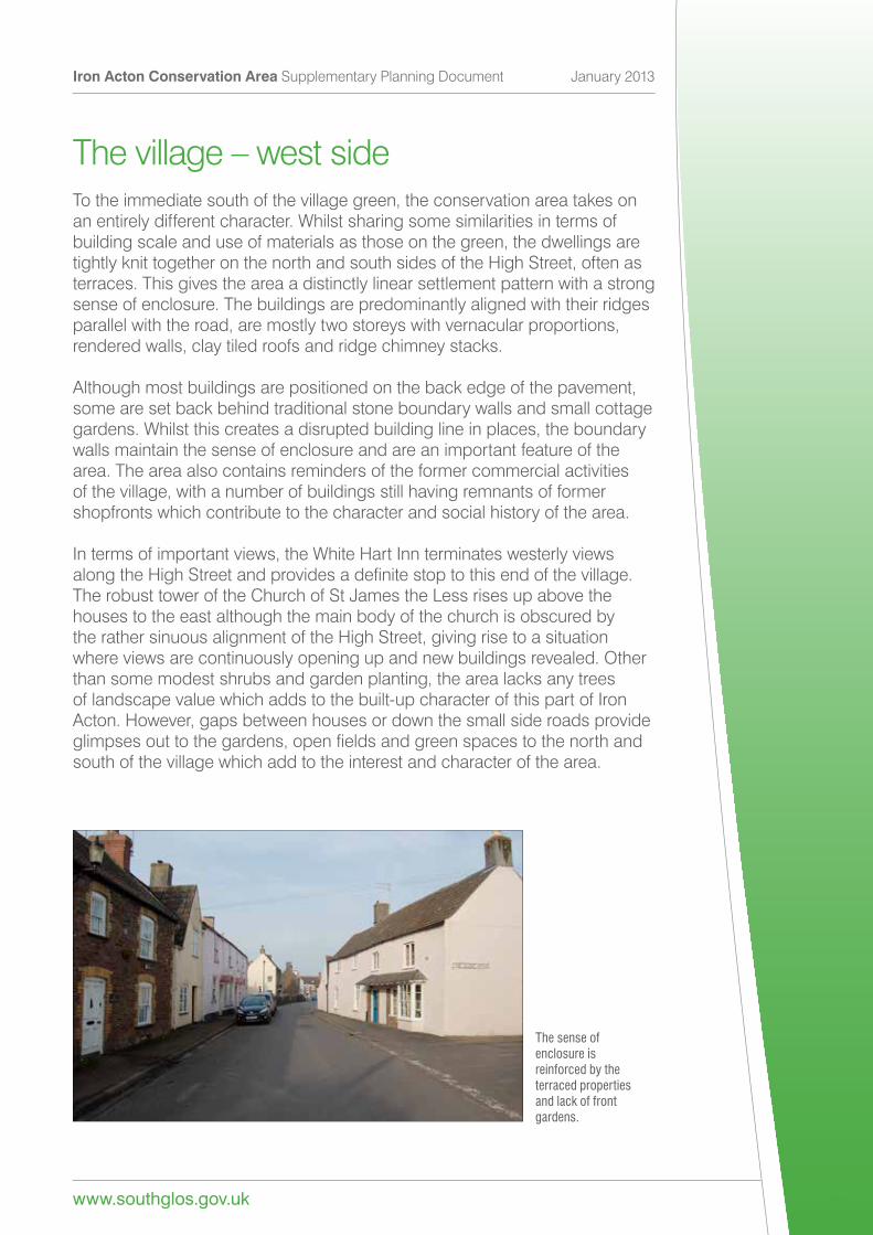
The village – west sideTo the immediate south of the village green, the conservation area takes on an entirely different character. Whilst sharing some similarities in terms of building scale and use of materials as those on the green, the dwellings are tightly knit together on the north and south sides of the High Street, often as terraces. This gives the area a distinctly linear settlement pattern with a strong sense of enclosure. The buildings are predominantly aligned with their ridges parallel with the road, are mostly two storeys with vernacular proportions, rendered walls, clay tiled roofs and ridge chimney stacks.
Although most buildings are positioned on the back edge of the pavement, some are set back behind traditional stone boundary walls and small cottage gardens. Whilst this creates a disrupted building line in places, the boundary walls maintain the sense of enclosure and are an important feature of the area. The area also contains reminders of the former commercial activities of the village, with a number of buildings still having remnants of former shopfronts which contribute to the character and social history of the area.
In terms of important views, the White Hart Inn terminates westerly views alongtheHighStreetandprovidesadefinitestoptothisendofthevillage.The robust tower of the Church of St James the Less rises up above the houses to the east although the main body of the church is obscured by the rather sinuous alignment of the High Street, giving rise to a situation where views are continuously opening up and new buildings revealed. Other than some modest shrubs and garden planting, the area lacks any trees of landscape value which adds to the built-up character of this part of Iron Acton. However, gaps between houses or down the small side roads provide glimpsesouttothegardens,openfieldsandgreenspacestothenorthandsouth of the village which add to the interest and character of the area.
The sense of enclosure is reinforced by the terraced properties and lack of front gardens.
Iron Acton Conservation Area Supplementary Planning Document January 2013
www.southglos.gov.uk 22
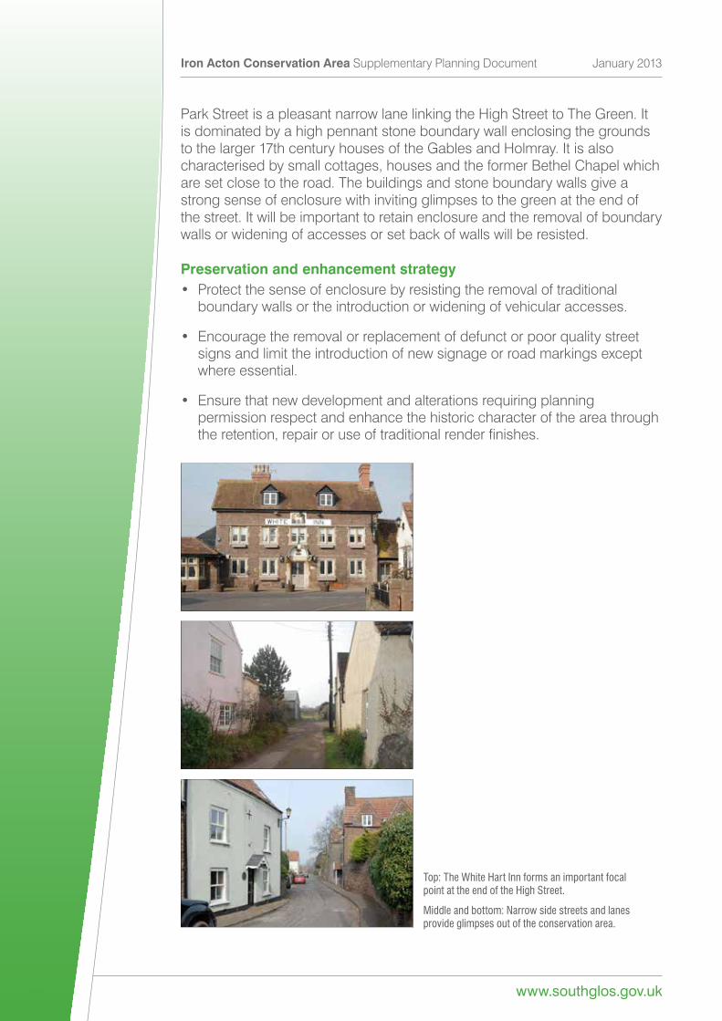
Park Street is a pleasant narrow lane linking the High Street to The Green. It is dominated by a high pennant stone boundary wall enclosing the grounds to the larger 17th century houses of the Gables and Holmray. It is also characterised by small cottages, houses and the former Bethel Chapel which are set close to the road. The buildings and stone boundary walls give a strong sense of enclosure with inviting glimpses to the green at the end of the street. It will be important to retain enclosure and the removal of boundary walls or widening of accesses or set back of walls will be resisted.
Preservation and enhancement strategy• Protect the sense of enclosure by resisting the removal of traditional boundary walls or the introduction or widening of vehicular accesses.
•Encouragetheremovalorreplacementofdefunctorpoorqualitystreet signs and limit the introduction of new signage or road markings except where essential.
•Ensurethatnewdevelopmentandalterationsrequiringplanning permission respect and enhance the historic character of the area through theretention,repairoruseoftraditionalrenderfinishes.
Top: The White Hart Inn forms an important focal point at the end of the High Street.
Middle and bottom: Narrow side streets and lanes provide glimpses out of the conservation area.
www.southglos.gov.uk
Iron Acton Conservation Area Supplementary Planning Document January 2013
23
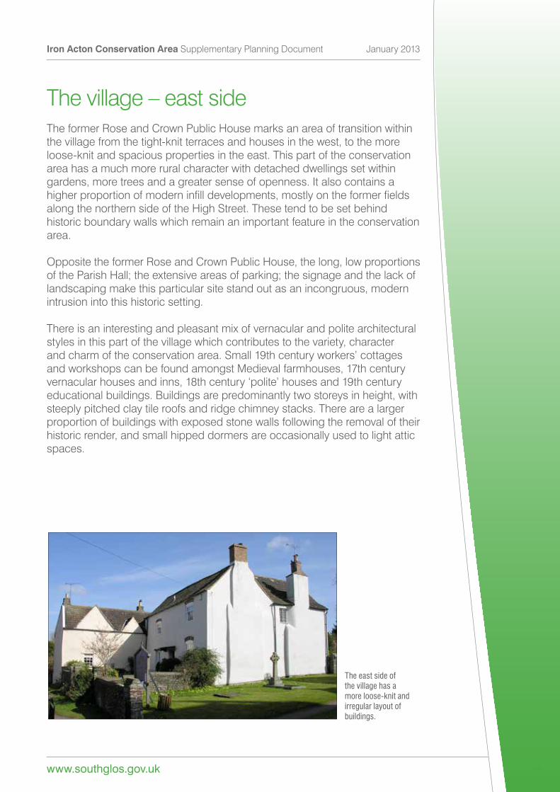
The village – east sideThe former Rose and Crown Public House marks an area of transition within the village from the tight-knit terraces and houses in the west, to the more loose-knit and spacious properties in the east. This part of the conservation area has a much more rural character with detached dwellings set within gardens, more trees and a greater sense of openness. It also contains a higherproportionofmoderninfilldevelopments,mostlyontheformerfieldsalong the northern side of the High Street. These tend to be set behind historic boundary walls which remain an important feature in the conservation area.
Opposite the former Rose and Crown Public House, the long, low proportions oftheParishHall;theextensiveareasofparking;thesignageandthelackoflandscaping make this particular site stand out as an incongruous, modern intrusion into this historic setting.
There is an interesting and pleasant mix of vernacular and polite architectural styles in this part of the village which contributes to the variety, character andcharmoftheconservationarea.Small19thcenturyworkers’cottagesand workshops can be found amongst Medieval farmhouses, 17th century vernacularhousesandinns,18thcentury‘polite’housesand19thcenturyeducational buildings. Buildings are predominantly two storeys in height, with steeply pitched clay tile roofs and ridge chimney stacks. There are a larger proportion of buildings with exposed stone walls following the removal of their historic render, and small hipped dormers are occasionally used to light attic spaces.
The east side of the village has a more loose-knit and irregular layout of buildings.
Iron Acton Conservation Area Supplementary Planning Document January 2013
www.southglos.gov.uk 24
Buildings are no longer predominantly aligned parallel to the road and many of the historic properties are generally larger, detached and of appreciably higher status compared to the terraces of cottages and dwellings to the west.These differences could be attributed to their closer proximity to the church and possibly indicative of their earlier, Medieval origins. This area was the original Saxon core of the settlement, prior to the division of the manor and the establishment of the two manors at Acton Ilger and Acton Court. Many buildings may, therefore, have replaced earlier structures, duplicating the organic character of the earlier settlement pattern compared to the more planned, later development to the west.
Dominating all of this from its elevated position above the High Street is the Parish Church of St James the Less, a predominantly late 14th or early 15th century church in the perpendicular style but incorporating the remains of an earlier Saxon building.
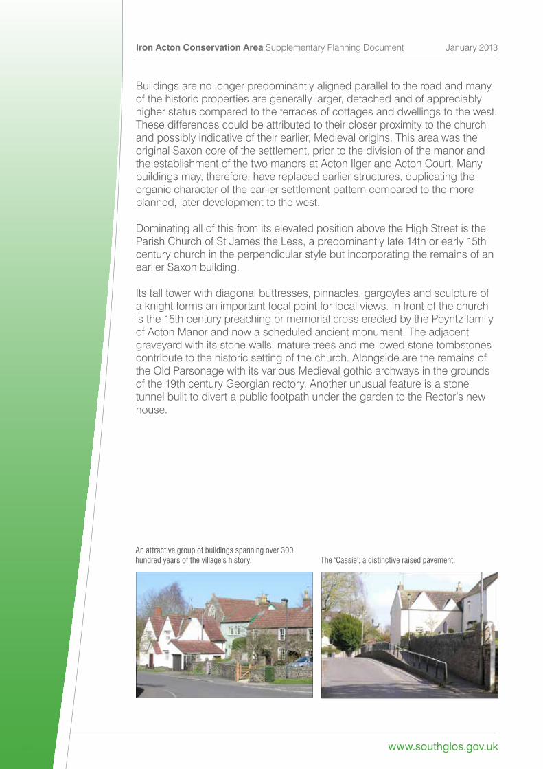
Its tall tower with diagonal buttresses, pinnacles, gargoyles and sculpture of a knight forms an important focal point for local views. In front of the church is the 15th century preaching or memorial cross erected by the Poyntz family of Acton Manor and now a scheduled ancient monument. The adjacent graveyard with its stone walls, mature trees and mellowed stone tombstones contribute to the historic setting of the church. Alongside are the remains of the Old Parsonage with its various Medieval gothic archways in the grounds of the 19th century Georgian rectory. Another unusual feature is a stone tunnelbuilttodivertapublicfootpathunderthegardentotheRector’snewhouse.
An attractive group of buildings spanning over 300 hundred years of the village’s history. The ‘Cassie’; a distinctive raised pavement.
www.southglos.gov.uk
Iron Acton Conservation Area Supplementary Planning Document January 2013
25
An important view from this area is that of the former tree-lined entrance drive from the High Street to Lodge Farm, the former hunting lodge at the centre of the deer park. Fortunately, the bypass is hidden from view so this remains an important, uninterrupted vista which should be protected. Care is also needed to ensure open areas and gardens are not developed resulting in a loss of greenery and a more built up feel. Similarly, the open fieldsontheedgeofthesettlementandbytheschoolactasanimportantlandscape buffer and should be protected. By contrast, the extensive area of hard surfacing and car parking in front of the Lamb Inn appear stark and uncompromisingandwouldbenefitfromsomesensitivelandscaping.
Preservation and enhancement strategy
•Newdevelopmentshouldprotectimportantviews,vistasandopenfields that contribute to the character, appearance or setting of the conservation area and the setting of designated heritage assets.
•Ensurethatalterationstothebypassincludingsignageornewlightingdo not intrude into the view from the Church to Lodge Farm.
•Protecttheloose-knitcharacteroftheareaandresistthefurtherinfillor inappropriate development within gardens that contribute to the character of the conservation area.
• Protect historic features such as the Cassie, stone boundary walls and stonekerbsandenhancethequalityofstreetfurnituregenerally.
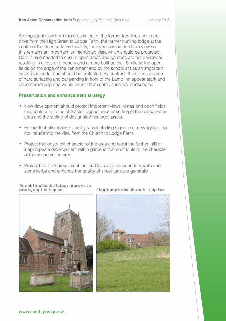
The grade I listed Church of St James the Less with the preaching cross in the foreground. A long distance view from the church to Lodge Farm.
Iron Acton Conservation Area Supplementary Planning Document January 2013
www.southglos.gov.uk 26
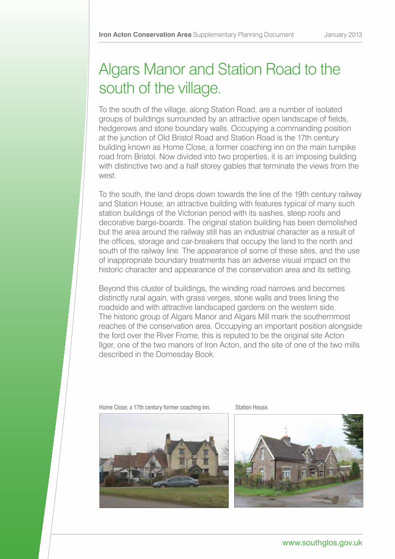
Algars Manor and Station Road to thesouth of the village.To the south of the village, along Station Road, are a number of isolated groupsofbuildingssurroundedbyanattractiveopenlandscapeoffields,hedgerows and stone boundary walls. Occupying a commanding position at the junction of Old Bristol Road and Station Road is the 17th century building known as Home Close, a former coaching inn on the main turnpike roadfromBristol.Nowdividedintotwoproperties,itisanimposingbuildingwith distinctive two and a half storey gables that terminate the views from the west.
To the south, the land drops down towards the line of the 19th century railway andStationHouse;anattractivebuildingwithfeaturestypicalofmanysuchstation buildings of the Victorian period with its sashes, steep roofs and decorative barge-boards. The original station building has been demolished but the area around the railway still has an industrial character as a result of theoffices,storageandcar-breakersthatoccupythelandtothenorthandsouth of the railway line. The appearance of some of these sites, and the use of inappropriate boundary treatments has an adverse visual impact on the historic character and appearance of the conservation area and its setting.
Beyond this cluster of buildings, the winding road narrows and becomes distinctly rural again, with grass verges, stone walls and trees lining the roadside and with attractive landscaped gardens on the western side. The historic group of Algars Manor and Algars Mill mark the southernmost reaches of the conservation area. Occupying an important position alongside the ford over the River Frome, this is reputed to be the original site Acton Ilger, one of the two manors of Iron Acton, and the site of one of the two mills described in the Domesday Book.
Home Close; a 17th century former coaching inn. Station House.
www.southglos.gov.uk
Iron Acton Conservation Area Supplementary Planning Document January 2013
27
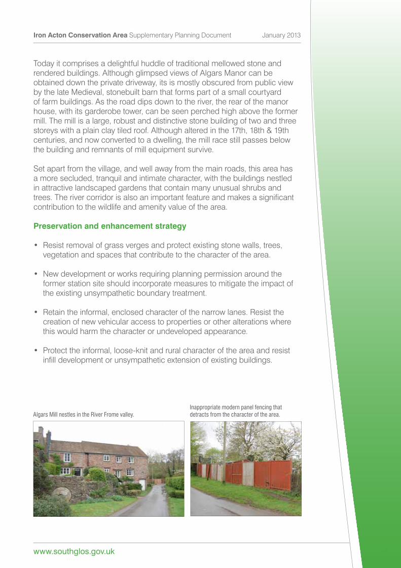
Today it comprises a delightful huddle of traditional mellowed stone and rendered buildings. Although glimpsed views of Algars Manor can be obtained down the private driveway, its is mostly obscured from public view by the late Medieval, stonebuilt barn that forms part of a small courtyard of farm buildings. As the road dips down to the river, the rear of the manor house, with its garderobe tower, can be seen perched high above the former mill. The mill is a large, robust and distinctive stone building of two and three storeyswithaplainclaytiledroof.Althoughalteredinthe17th,18th&19thcenturies, and now converted to a dwelling, the mill race still passes below thebuildingandremnantsofmillequipmentsurvive.
Set apart from the village, and well away from the main roads, this area has amoresecluded,tranquilandintimatecharacter,withthebuildingsnestledin attractive landscaped gardens that contain many unusual shrubs and trees.Therivercorridorisalsoanimportantfeatureandmakesasignificantcontribution to the wildlife and amenity value of the area.
Preservation and enhancement strategy
• Resist removal of grass verges and protect existing stone walls, trees, vegetation and spaces that contribute to the character of the area.
•Newdevelopmentorworksrequiringplanningpermissionaroundthe former station site should incorporate measures to mitigate the impact of the existing unsympathetic boundary treatment.
• Retain the informal, enclosed character of the narrow lanes. Resist the creation of new vehicular access to properties or other alterations where this would harm the character or undeveloped appearance.
• Protect the informal, loose-knit and rural character of the area and resist infilldevelopmentorunsympatheticextensionofexistingbuildings.
Algars Mill nestles in the River Frome valley.Inappropriate modern panel fencing that detracts from the character of the area.
Keeping and enhancing characterGreat care needs to be taken when considering changes within the conservationareaoritssetting.Unsympatheticextensions,poorqualitydesign and the cumulative impact of minor changes by property owners such asusingwrongdetailsormaterialscanharmorerodetheuniquecharacterof the area. Similarly, insensitive changes to the verges, boundaries, open spaces and roads can detract from the pleasant informal character and sense of place.
Collectively, residents, landowners, local and parish councils can help protecttheuniquecharacterofIronActonbyensuringanyworkstheydoaresensitive to the character.
A strategy for the preservation and enhancement of the area – including bothgeneralandmorespecificguidanceissetoutbelowandontheaccompanying Plan 3. The overall aim is to preserve and enhance the historic character and appearance of the conservation area, its historic buildings, features and their settings. Whilst the appraisal focuses on the protection and enhancement of the conservation area, many of the objectives may also contribution to Green Infrastructure objectives in accordance with policy CS2 of the Core Strategy.
Iron Acton Conservation Area Supplementary Planning Document January 2013
www.southglos.gov.uk 28
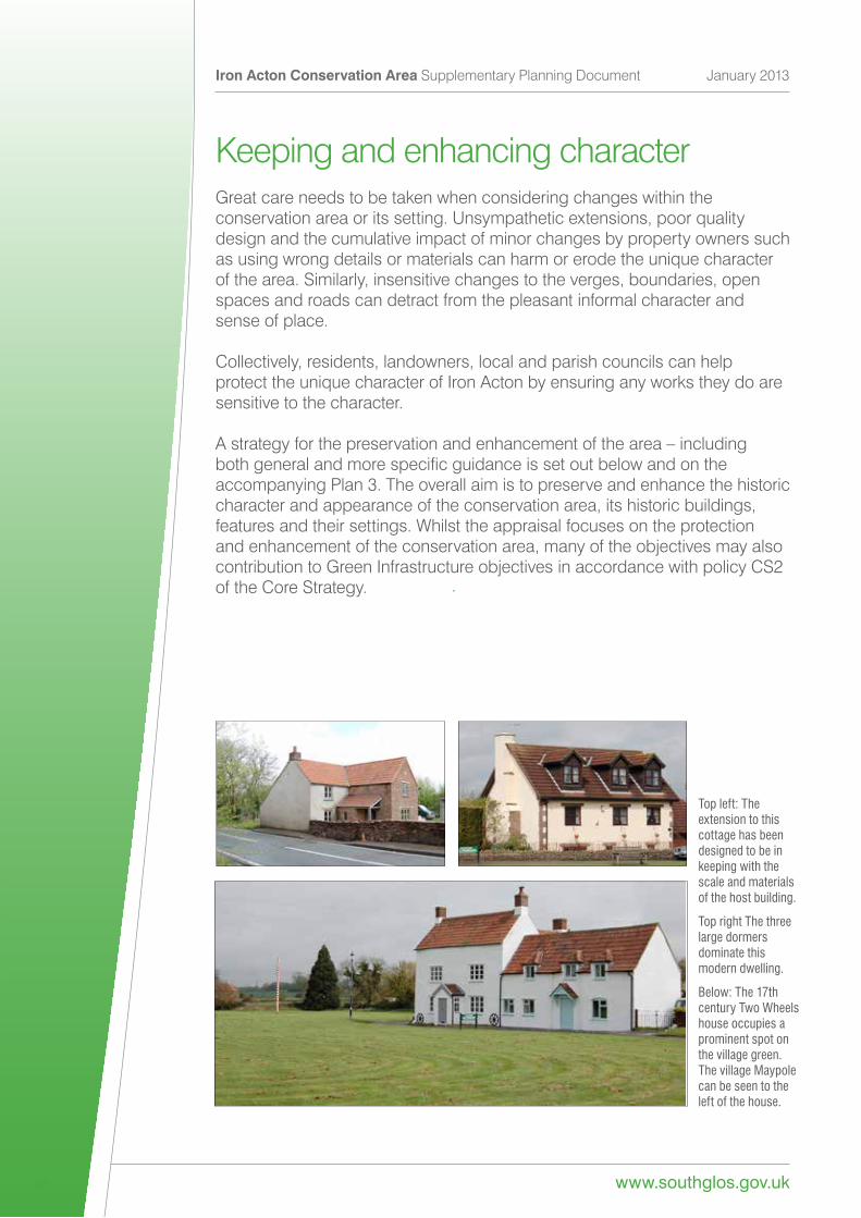
Top left: The extension to this cottage has been designed to be in keeping with the scale and materials of the host building.
Top right The three large dormers dominate this modern dwelling.
Below: The 17th century Two Wheels house occupies a prominent spot on the village green. The village Maypole can be seen to the left of the house.
Preserving and reinforcing the historic character of the conservationarea
•Ensurerepairsandalterationstodesignatedandnon-designatedheritage assets are carried out sensitively and that any works to buildings, features and their settings are considered in relation to the historic context and use appropriate materials, scale and detailing.
• Retain, repair or reinstate traditional features and details, windows, doors, chimneys and stone walls etc in a sympathetic manner.
•Retainandrepairtraditionalrenderfinishesandencouragetheuseof traditional, sustainable materials in new works.
• Retain gardens and open spaces which contribute to the setting of historic properties and resist new development or uses harmful to the character and setting of the conservation area.
www.southglos.gov.uk
Iron Acton Conservation Area Supplementary Planning Document January 2013
29
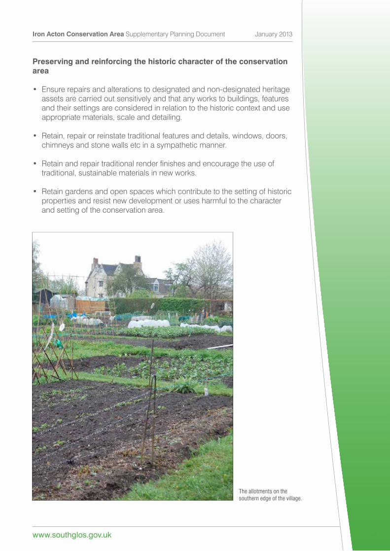
The allotments on the southern edge of the village.
Ensure that any new development (or alteration) respects the historic context.
•Ensuregoodqualitydesigninallnewdevelopmentandalterationthat is sympathetic to the character and appearance of the conservation area. Proposals should have regard to the historic grain and pattern of development, scale, form, massing, building lines and respect open spaces that contribute to the character of the conservation area.
•Ensurethatnewdevelopmentdoesnotadverselyharmthesettingof historic buildings, views or archaeological remains.
• Use traditional materials and construction details that have regard to the distinctive character and appearance of the conservation area.
•Encouragesensitiveredevelopmentofintrusiveorpoorqualitybuildings when opportunities arise
• Reduce the impact of modern development and soften the impact of intrusive features by using native planting, natural stone walls and sustainable drainage systems (SuDs) to reduce run-off, improve water qualityandtobenefitthebiodiversityandvisualamenityofthearea.
•Encourageutilitycompaniestotacklethedamaginganddetrimental appearance of the overhead wires by routing them underground.
Preserve and reinforce the vitality of the historic settlement.
• By ensuring alterations, new development or changes of use are appropriate and enhance the character and economic vitality of the historic settlement.
Iron Acton Conservation Area Supplementary Planning Document January 2013
www.southglos.gov.uk 30
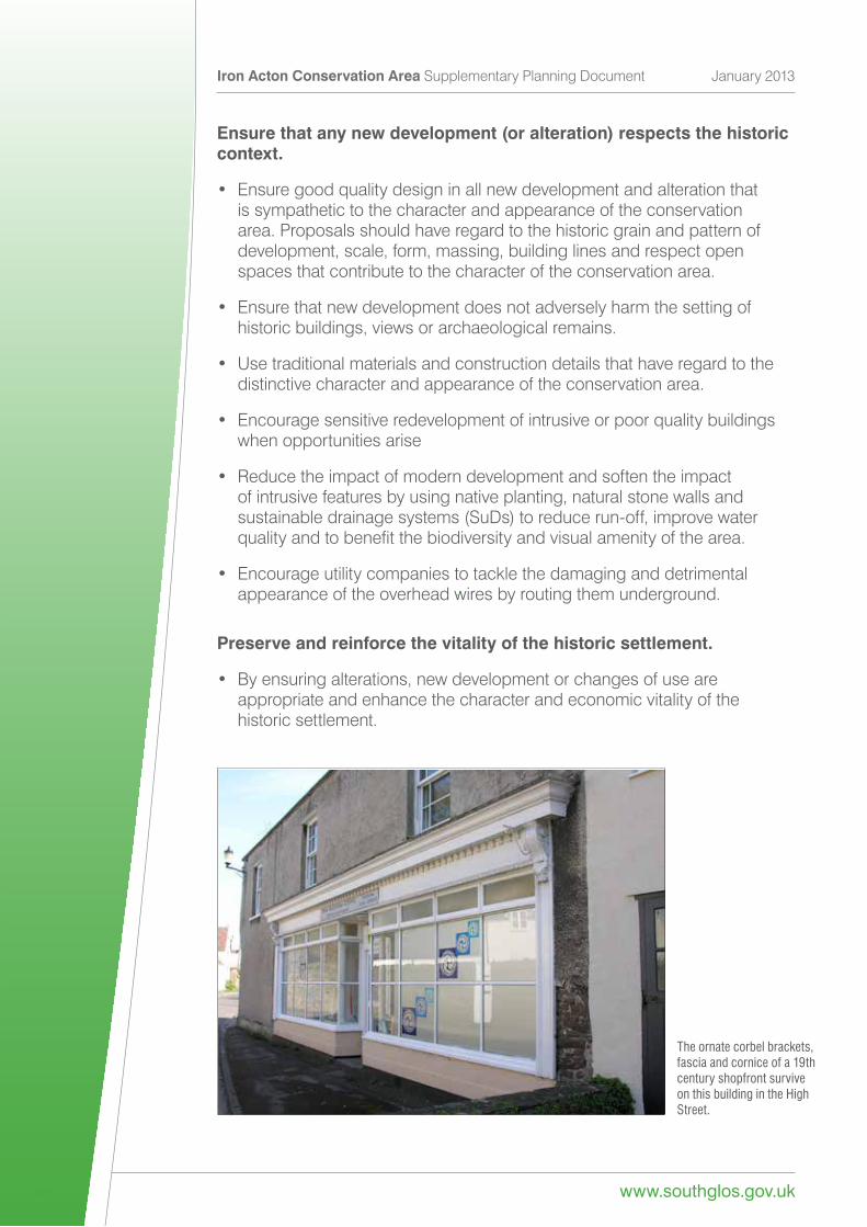
The ornate corbel brackets, fascia and cornice of a 19th century shopfront survive on this building in the High Street.
What happens now?ThisleafletwasadoptedasaSupplementaryPlanningDocument(SPD)on30th January 2013.
The amended Iron Acton Conservation Area boundary was also adopted on 30th January 2013. The contents of this document will be taken into account when assessing planning applications and other proposals in the area. Applicants will need to provide an assessment of the character to demonstrate how their proposals will preserve or enhance the character of the area. Proposals that fail to have regard to the guidance in this SPD and which have a harmful impact will be refused.
In the preparation of this document the views of local residents and other interested parties were sought. Consultation on the draft document and enhancement and preservation strategy took place between August and October2012bywayofanadvertisement,publicationonthecouncil’swebsiteandcirculationoftheleafletwithintheconservationarea.CommentsandproposedamendmentstothedocumentweresubsequentlyreportedtotheleadmembersforPlanning,TransportandStrategicEnvironmentpriortoadoption. (For details see Public Participation Statement – available from the council).
The council is keen to work with the local community and other parties to help preserve and enhance this special area. The strategy sets out ways we can help to achieve this. If you wish to assist in any manner or have any further suggestions, please let us know.
How to contact usIfyouhaveanyqueriesorsuggestions
ConservationOfficer South Gloucestershire Council Natural&BuiltEnvironmentTeam PO Box 2081 South Gloucestershire BS35 9BP
Telephone: 01454 863578 Email:[email protected]
Further information from www.southglos.gov.uk/ConservationAreas
www.southglos.gov.uk
Iron Acton Conservation Area Supplementary Planning Document January 2013
31

www.southglos.gov.uk (access is free from your local library)
If you need this information in another format or language please contact 01454 868004SGC CREATIvE DESIGn • Printed on recycled paper S 6842 I 8 I 13
Top Related