


Languages
Pages
Legal


Introducing locat to mobile multim
David
School of Mathematics and Systems Engineering Reports from MSI - Rapporter från MSI
ion related aspectsedia environments
Martinez
Dec 2006
MSI Report 06165 Växjö University ISSN 1650-2647 SE-351 95 VÄXJÖ ISRN VXU/MSI/IV/E/--06165/--SE
Introducing location related aspects to mobile multimedia environments
Abstract: This work describes a design of a multimedia content
delivery system based on context, to provide multimedia information
and other services according to the user location and his preferences.
It focuses on mobility and the problem of different coherent and
cohesive presentations depending on the available resources of the
presentation environment.
Keywords: inference engine, context aware, navigation systems,
mobile devices, presentation on mobile devices, intelligent
multimedia systems, ubiquitous computing, pervasive computing
David Martinez 2
Introducing location related aspects to mobile multimedia environments
Index
1. Introduction............................................................................................................ 4 1.1. Background..................................................................................................... 4 1.2. Motivation....................................................................................................... 4 1.3. Disposition ...................................................................................................... 5 1.4. Limitations...................................................................................................... 5 1.5. Acknowledgements........................................................................................ 5
2. Problem formulation ............................................................................................. 6 2.1. Defining the problem .................................................................................... 6 2.2. Purpose............................................................................................................ 7 2.3. System requirements..................................................................................... 7 2.4. Problem delimitations................................................................................... 7
3. Method .................................................................................................................... 8 3.1. Research process model................................................................................ 8 3.2. Choosing a research model........................................................................... 8 3.3. Research method ........................................................................................... 9 3.3.1. Scenario-based design................................................................................... 9
4. State of the art ...................................................................................................... 13 4.1. Review of multimedia mobile services ..................................................... 13 4.2. Research activities ....................................................................................... 14 4.3. Related work................................................................................................. 15 4.3.1. MUPE platform ............................................................................................ 15 4.3.2. Dodgeball ...................................................................................................... 17 4.3.3. ImaHima ....................................................................................................... 18 4.3.4. Relation to this work ................................................................................... 18 4.4. Putting all together ...................................................................................... 19 4.5. My contribution ........................................................................................... 20 4.5.1. Scenarios ....................................................................................................... 20 4.5.1.1. Tourist guide......................................................................................... 20 4.5.1.2. Package delivery................................................................................... 21
5. System design ....................................................................................................... 22 5.1. Requirements ............................................................................................... 22 5.2. Use cases ....................................................................................................... 24 5.3. System architecture ..................................................................................... 24 5.4. Components description............................................................................. 26 5.4.1. Inference Engine .......................................................................................... 26 5.4.2. Presentation Engine .................................................................................... 27 5.4.3. Navigation Engine ....................................................................................... 30 5.4.4. Contents Module.......................................................................................... 32 5.4.5. Users Module................................................................................................ 33 5.4.6. Messaging Service........................................................................................ 34 5.5. Client applications ....................................................................................... 35
6. Technical approach and prototypes .......................................................... 36 6.1. Proposed Technologies ............................................................................... 36 6.2. Prototypes developed .................................................................................. 38
7. Reflections upon my work, conclusions and further development ...... 47 8. Table of figures ............................................................................................. 50 9. References..................................................................................................... 51
David Martinez 3

Introducing location related aspects to mobile multimedia environments
1. Introduction
In this chapter is introduced the topic to be studied within the thesis and the
reasons why it has been chosen. There is also explained the disposition of the
report, its limitations and the acknowledgements to the people that made it
possible.
1.1. Background
The use of mobile devices such as “pocket pc”, portable digital assistants
(PDA), and mobile phones have become very useful tools that we use on the
daily basis. Additionally, these devices have gained capabilities to manage
sophisticated multimedia contents and a number of sensors, such as cameras
and global positional systems (GPS), allow developing applications to solve
problems in the areas of rich positional multimedia management, context-aware
and navigation systems. While mobile devices capability for the management of
multimedia content has increased, technical limitations of the device and
limited resources such as memory, screen resolution or bandwidth, influence
the presentation of this information. In order to achieve a broad band of
devices, the systems must deal with the differences and transform the
presentation of the information according to that. In the case of a person with a
mobile device that is doing an activity within a context, all the information
about the activity and the context could be used to infer possible actions to be
taken in order to help the user in his task. Usually, these actions would be to
deliver information (most of the times multimedia contents).
1.2. Motivation
This report has been written by David Martínez Benito, a student at the last
year of Computer Engineering at the “Universitat Politècnica de Catalunya” in
Barcelona, Spain. I have been an exchange student within the Erasmus Program
in Växjö University during the last academic year 2005/2006. I chose this topic
for my master thesis because the fast evolution of networked mobile devices
offers a wide environment where can be created many new systems based on the
high availability of the user and context information.
David Martinez 4

Introducing location related aspects to mobile multimedia environments
The goal of my work is to explore the possibilities of mobile devices with
internet connection and integrated Gps for the development of a context aware
system that periodically receives information about the user’s location and
infers actions to be taken according to this information.
1.3. Disposition
In the next chapter will be formulated the problem that I will deal with in
this thesis and after that will be presented the methodology that is going to be
used to study this problem. In chapter 4 will be raised some scenarios in order
to show how could be used the designed system and its requirements.
1.4. Limitations
The aim of this thesis is to explore the purposed topic by the study of several
works related to this field and the design of a new system that offers some
features not provided by any of them. Although some prototypes will be
implemented in order to illustrate the design, the whole system will not be
implemented due to the high complexity and the long period of time needed to
do it. However, it will be studied and purposed the most suitable technology for
the implementation of each part of the system.
1.5. Acknowledgements
I would like to thank the people that helped me make this thesis better with
their valuable support and comments. I would like to thank my supervisor
Marcelo Milrad, Senior researcher at Växjö University, for his continual support
and comments to my work. Also I would like to thank professor Per Flensburg
that led me during this thesis and especially in the method part. This thesis
would not be as it is without the cooperation with the people from the Celekt
team: Fredrik Alserin and Jonas Gustafsson during the development and test of
the client application and Arianit Kurti with several comments about location-
based services and context awareness. Finally, I want to express my thanks to
my family for their support and interest during all this time.
Once the topic has been introduced, it will be presented the problem
formulation and the questions that will be tried to answer within this thesis.
David Martinez 5

Introducing location related aspects to mobile multimedia environments
2. Problem formulation
In the last years, mobile devices have become a very powerful tool to deal
with multimedia contents. Its network connectivity and computational capacity
have opened the doors to the development of many new systems based on the
high availability of the user (anytime anywhere) and context aspects such as
geographical location, among others. Furthermore, the new devices interfaces
with high quality screens, embedded cameras and sound recorders gives the
possibility to visualize and create video and sound multimedia objects. The
combination of all these features provides a wide framework which presents
many new challenges.
2.1. Defining the problem
“Context-awareness means that the system actively constructs and updates
a model of the ongoing activity by sensing, communicating, and interpreting
changing conditions, resources and processes. Context adaptation takes the
activity as the context to infer what actions to be taken in order to ensure the
success of the overall activity.” [Dey et al.,2004] Context can be defined as a set
of interrelated conditions in the user’s environment. A context-aware system
performs different actions based on inferred information about the context.
The wide range of devices that can use this kind of systems raises the
concept of portability as a key aspect. Thus, it is very important to be able to
develop applications that can adapt the available contents in the network to be
visualized using this kind of devices. On the one hand, it makes necessary to use
a platform which allows the developer to create systems with independence of
the devices that are going to use it. On the other hand, the different kinds of
screens and multimedia formats supported need to have components to
discover the capabilities of each device and adapt to it automatically.
“What these technologies have in common is that they move the site and
style of interaction beyond the desktop and into the larger real world where we
live and act.” [Butz et al., 2001]
David Martinez 6
Introducing location related aspects to mobile multimedia environments
2.2. Purpose
The aim of this thesis is to explore the possibilities of a mobile device with
integrated location service from two main approaches: The mobile device as a
producer of multimedia contents with contextual metadata associated and the
device as a receiver of multimedia contents existing in the network with
previous adaptation. Moreover, the study will take in consideration the use of
the context information to make inferences and do determined actions. Thus,
the questions that will be tried to answer in this thesis are:
• How can be used a mobile device to create and receive multimedia
contents with contextual metadata?
• How can a system use contextual information to perform actions?
These questions are very generic and it will be difficult to answer them
completely within this thesis. Therefore, a design of the system will be done and
a prototype will be implemented in order to exemplify the model.
2.3. System requirements
According to the questions raised previously, the designed system must offer
to the users the possibility to create multimedia contents using mobile devices
and to upload them to the server with contextual metadata associated.
Moreover, the user must be able to define a set of preferences that will be used
by the system to infer which contents are interesting for him in a specific
situation according to the contextual metadata and the current context of the
user.
2.4. Problem delimitations
This study will not base the adaptation of the presentation on the user world
view or apprehension of reality, but will base it on different devices capabilities.
User environment as part of the context will be treated in this study only as
geographical location of the user and the contents.
In this chapter it has been described the topic of this study and the
formulation of the problem by raising some questions that will be tried to
answer.
David Martinez 7

Introducing location related aspects to mobile multimedia environments
3. Method
In this chapter are presented the methods that are going to be used to solve
the raised problems. The chose of an appropriate method is very important to
make a well organized work and increase its scientific quality. Therefore, firstly
will be chosen a research process model and after that will be identified the
most suitable method for the formulated problem.
3.1. Research process model
The research process model will be chosen between the two models
presented in Järvinen’s book [Järvinen, P, 2001]: Jenkin’s model and Wallace’s
model.
The Jenkin’s model contains a sequence of steps to be followed during the
study. It starts with the definition of the research area and continues with
library research to identify the topic. Once the topic is identified, a research
strategy must be chosen. The strategy can be based on an experimental design
and a subsequent analysis of the results.
The Wallace’s model defines a cycle that starts with logical deduction based
on the chosen theory research to formulate Hypothesis. After that, measurable
questions must be formulated in order to prove the hypothesis. Finally, the
researcher takes observations based on the formulated questions and analyses
its results to get an empirical generalization that lets him prove the old theory or
induct a new one. The next step starts again the cycle.
3.2. Choosing a research model
The problem studied within this thesis is about constructing a new artifact.
Thus, the Wallace’s model is not suitable because it focuses on proving a theory
and creating a new one. Since this study lies in the constructive research area,
the Jenkin’s model is the most appropriate to follow. This work started with an
idea about multimedia contents sharing based on location between mobile
devices. During the library research some more concepts like intelligent systems
and context awareness appeared and I ended by defining the research topic of
the thesis. In the research strategy will be defined the most appropriate method
for the raised problem. The experimental design will start with the proposal of a
generic architecture for the system. After that, a design of the system based on
David Martinez 8

Introducing location related aspects to mobile multimedia environments
the architecture will be presented. The following steps are capture and analysis
of the collected data. These tasks will be done during the evaluation of the
implemented prototype. Finally, the final results will be published and
commented.
3.3. Research method
Once the model of research process has been chosen, an appropriate
research method for the formulated problem must be chosen as well. To make
this choice the categorization of the research methods presented by Järvinen
will be used.
According to this categorization and the formulated problem can be
concluded that the research methodology belongs to the group of approaches
which study the reality. Furthermore, the research problem can be placed within
the methods that stress the utility of innovation. Concretely, since the problem
is about designing a new information system it fits in the scope of innovation-
building approaches. The method used to build new innovations is a design-
science research. This is the most suitable methodology for the raised problem.
The proposed design will be based on the existing knowledge and research
and new technological advancements will be used to add innovative features like
an intelligent inference engine that uses contextual information.
The design-science methodology is divided in three main parts: building,
evaluation and action research. The approach used in this problem will be the
building research. According to Järvinen, in this approach there are two
options: The targeted stated is defined or the targeted state has to be defined.
For this problem the targeted state has to be defined. In order to define it will be
used scenarios. Therefore, the design of the system will be done using scenario-
based methodology.
3.3.1. Scenario-based design
The scenario-based design starts by raising some scenarios in order to show
how can be used the system. A scenario is a description of a use episode from
the user point of view. It may include social background, resources and
constraints.
David Martinez 9

Introducing location related aspects to mobile multimedia environments
According to J M Carroll, scenario-based design studies the complexity and
fluidity of design by learning more about the structure and dynamics of the
problem. Trying to see the situation in many different ways [Carroll, J.M,
2000]. A scenario becomes an artifact that may be modified and redefined as
the design process evolves.
“Scenarios are stories. They are stories about people and their activities”
[Carroll, J.M, 1999]. Defining a task, we can obtain the requirements for the
artifact design. Creating the artifact also appear new possibilities for the task.
The cycle ends when the possibilities of the task in the raised situation are
obtained.
Figure 1: Task-artifact cycle [Carroll, J.M, 2000]
I have chosen scenario based design in order to define the system
requirements showing a possible real case. Furthermore, I used scenarios
because they let me keep the user interaction as center of the design. Thus,
scenarios make it easier to satisfy the user needs in the most suitable way,
because the requirements are based on the task that the user wants o perform.
This complementary approach combined with the building research provides
a useful method to solve the formulated problem. Figure 3 shows the scenario
based design model with its five challenges and approaches.
David Martinez 10

Introducing location related aspects to mobile multimedia environments
Figure 2: Challenges and approaches in scenario based design [Carroll, J.M, 1999]
Action versus reflection: This approach lets the designer know better the
users and their tasks, providing a feedback with the needs that should be
covered.
Design problem fluidity: The use of scenarios provides a high flexibility in
the sense that allows the designer to change and revise the requirements during
the design process.
Design moves have many effects: The different perspectives shown by the
scenarios offer several interpretations and solutions for all the actors. Thus, the
system can take into account the needs of all the different kinds of users.
Scientific knowledge lags design application: When the designer has a
lack of scientific knowledge, the scenarios help him to focus on the adequate
knowledge in order to solve the raised problem.
External factors constraint design: The use of scenarios takes into account
all the external factors and let the users participate in the design process.
David Martinez 11

Introducing location related aspects to mobile multimedia environments
These aspects show the advantages of using scenarios as a base for the
design. To base the design on scenarios lets the designer focus on the most
important issues of the problem.
Figure 3: Scenario-based frameworks [Rosson et al., 2001]
Problem scenario: Stories to describe activities in the problem domain.
Activity scenarios: Iterative analysis and redesign to get new functionalities
based on the user needs.
Information and interaction design scenarios: Specification of tasks and
actions that helps users to understand what is happening.
After describing the methodology that will be used to solve the raised
problem, it will be shows the situation of the mobile environment nowadays and
some on-going research within this field, related work and why is it related to
my work. Thus, it will be described the contribution of this study and there will
be raised in the end the scenarios used as starting point of the system design.
David Martinez 12

Introducing location related aspects to mobile multimedia environments
4. State of the art
Following, it is described the actual state in mobile services during the last
years. Firstly, a brief view of the evolution of multimedia mobile services will be
given. After that, some research projects and commercial applications
developed within this field will be shown. Finally, will be explained how these
ideas are related to my work.
4.1. Review of multimedia mobile services
During the last years, the telecom business has evolved from voice services
to value added services such as data services and networked applications [GSM
Association, 2001]. In 1982, was founded in France the “Groupe Spécial Mobile”
(GSM) addressed to the problem of compatibility with the development of
digital radio technology. In 1987 the European Conference of Postal and
Telecommunications (CEPT) started the creation of the standard GSM and two
years later the European Telecommunications Standards Institute (ETSI)
started the development. In 1991 began the commercial operation with
Radiolinja in Finland. It became a standard for the European Mobile Phones
and the major standard for mobile services in Europe and in the whole world.
Figure 4: Structure of a GSM network [Wikipedia, 2006]
The key advantage of GSM for the customer has been high digital voice
quality and low cost alternatives such as SMS. For the operators, it brought the
ability to deploy equipment from different vendors due to the open standard
inter-operability and allows the users to use their phones all over the world.
David Martinez 13

Introducing location related aspects to mobile multimedia environments
As the GSM standard continued to develop, in 1997 the packet data
capabilities were added with the General Packet Radio Service (GPRS).
The 3rd Generation Partnership Project (3GPP) was formed in 1998 for the
creation of the next generation of mobile networks. It also took over the
maintenance and development of the GSM specification. Higher speed has also
been introduced with EDGE in the release 99.
The GSM Association launched in 2001 the Mobile Service Initiative to bring
a new level to data services and a new wave of wireless internet applications.
This year was created in Japan the first large scale real-life commercial
Universal Mobile Telecommunications System (UMTS) network operated by
DoCoMo. Since then, UMTS networks have been implemented all over the
world increasing substantially the data transfer rates.
4.2. Research activities
The fast evolution of mobile networks made smart phones become an area of
high interest for the telecom sector and content providers. Many research
studies have been made, in order to exploit the possibilities offered by mobile
handsets and to create different kinds of context-aware and intelligent
multimedia systems based on the mobility and the high availability of the users.
In this section will be presented the results of some research studies related
to the use of smart-phones and the development of location-based and context-
aware services.
Gregory D. Abowd and other authors from the Georgia Institute of
Technology in Atlanta made the earliest work on developing a location-aware
system tourist guide [Abowd, G. D. et al., 1997]. In this study, they describe a
set of applications for the guide of tours based on location and discuss the
general research issued that have emerged in their experience context-aware
applications in a mobile environment. “The long-term goal is an application that
knows where the tourist is, what she is looking at, can predict and answer
questions she might pose, and provide the ability to interact with other people
and the environment” [Abowd et al., 1997].
Another relevant research work on this field is the prototype GUIDE. It was
developed by Keith Cheverst and other researchers from the Distributed
Multimedia Research Group of Lancaster University. The prototype consists of a
David Martinez 14

Introducing location related aspects to mobile multimedia environments
location-aware application for PDA that supplies relevant information about the
city of Lancaster [Cheverst, K et al., 2000]. In the article they describe technical
aspects of the system and their experience testing the prototype with several
users of different ages, interests and knowledge.
Context Phone is a context-aware platform developed by Mika Raento and
other authors form the University of Helsinki and the Helsinki Institute for
Information Technology [Raento, Mika et al., 2005]. The article describes the
architecture and some applications for this platform.
4.3. Related work
There are many systems already developed related to the topic of this thesis.
Some of them are made for the creation and sharing of multimedia contents
using handhelds and some others are designed to get information depending on
the user’s context, mainly based on location and preferences. Since this study is
related to both fields, multimedia contents sharing and context-awareness,
some existing applications have been studied in order to see different ways to
design the system. Following, some of these projects will be described.
4.3.1. MUPE platform
The Multi-User Publishing Environment [Suomela et al., 2004] is an open
source platform created by Nokia and designed for the development of multi-
user context-aware systems for mobile devices. The main advantage of this
platform is that it provides a basic server framework that the developer can
modify in order to create his own system. The client application is the same for
all different systems and the business logic is then implemented on the server
side. The communication between the server and the client is done using an xml
based script language. This script language defines all the operations which can
be done on the client device. Therefore, the server receives information about
the events from the client application and sends back to the client script control
instructions to perform the requested operations.
Advantages
• This architecture allows the developers to modify the system without
needing the user to reinstall the application on the device.
David Martinez 15

Introducing location related aspects to mobile multimedia environments
• The client application is already created.
• The same client application can be used for multiple systems.
• The developer has to focus only on the server side. He can develop
applications much faster than creating the whole system on his own.
• The developer does not need to care about the portability of the
application.
Disadvantages
• A high flow of information between the server and the client is
needed.
• In order to develop a server application for this platform it is
necessary to learn how to use the script language used to manage the
client.
• The script language restricts the developer to exploit all the device
capabilities.
• The constant flow of information could overload the network and the
server affecting the scalability of the system.
• The application cannot work without having almost permanent
connectivity to the server.
• The response times can grow because almost all actions need to
connect to the server.
Mupe Gui, a sample application to share multimedia items between different
users, has been tested in order to evaluate the performance of the platform. This
application allows the user to take pictures, to record sounds and to write notes
using the embedded camera, the sound recorder and the text editor of the
mobile device. Once the content is created, it is uploaded to the server and
shared with all the other users connected to it. Thus, the application shows a list
which contains all shared items and allows the user to download and visualize
them.
David Martinez 16

Introducing location related aspects to mobile multimedia environments
Figure 5: MUPE GUI screenshot
Although the system has the disadvantages previously raised, this platform
could be very useful for the development of real time multi-user games, but in
my opinion, it is not appropriate for the development of applications as the
tested example and the proposed application. However, the source code is
available and, since this application has many similarities to the one expected to
be designed within this thesis, it can be a good example to see how the device
can be used to develop a prototype.
4.3.2. Dodgeball
Dodgeball, Mobile Society Software, is a commercial system that delivers
sms messages in user communities, alerting them about friends proximity.
Although it does not use any location system such as GPS or cell connection, the
idea of friends proximity and notifications is similar to the system going to be
designed. Instead of a location system, this system uses the information
provided through SMS by the user to know his location and send him
information about other users that are near. Dodgeball has become very popular
and nowadays is used in 22 cities of United States by thousands of users.
Figure 6: Dodgeball
David Martinez 17

Introducing location related aspects to mobile multimedia environments
4.3.3. ImaHima
This system is a location-integrated, community and instant messaging
service that allow users to share their current personal status, such as location,
activity or mood, with their friends publicly or privately and send pictures and
instant messages to them. There are 250.000 active users in Japan accessing the
service through mobile phones. It also let users to keep in touch with users who
are online with their computer. This service alerts users by mobile email or SMS
when a friend is near or feeling lonely.
Figure 7: Imahima
4.3.4. Relation to this work
This section shows the relation among the described systems and the one
that will be designed in this work. The main point that makes those systems
relevant for this study is that they are focused on mobile users and their
environment. Contextual aspects such as user location and presence of specific
elements in the environment are combined in order to provide information
according to the current situation.
Mupe platform is an experimental platform not focused on a concrete
application or area of the context. It shows a generic model for the creation of
context-aware applications with device-independent graphical interface and
contents sharing. Therefore, it is a good example for the design of the proposed
system.
Dodgeball and Imahima are commercial systems mainly based on location.
Since both systems are used by a high amount of people, they are good examples
on how location based systems could be successfully used in social networks.
David Martinez 18

Introducing location related aspects to mobile multimedia environments
4.4. Putting all together
The following table shows the main differences among the described
systems. The first row compares the communication protocols used by each one.
The second row shows the area of the context used. The MUPE platform is
designed to be adapted for the use of any desired area of the context, so it is
open to the developer’s purpose. All the following rows refer to the features
provided. Thus, the table shows for each feature if it is provided and how. The
‘contents’ row refers to the exchange of multimedia files between the users.
Inference is about the capacity of the system to deduct information relevant to
the users in a specific situation. As instant messaging it means a presence
service for the communication among the users such as msn messenger, icq and
others. Finally, the concept of navigation means that the system is able to
provide location based information to show to the user were is an element
placed geographically and how to get there.
MUPE Dodgeball Imahima
Communication Http SMS Http and Mobile
Context Open Location Location
Contents Sharing - Sending
Inference - Users proximity and matching
Users proximity
Instant Messaging
- - Yes, desktop
users too
Navigation - Addresses from
places name -
Figure 8: Related systems comparison
These systems are relevant to this work because they offer some features
related to the questions raised in the problem formulation. On one hand, MUPE
platform uses mobile devices for the creation and sharing of contents and lets
developer adapt it to use contextual information whether to add metadata to the
contents or to consider users current situation in real time. The other two
systems are examples on how users contest information can be used in order to
decide what information must be sent to whom and when.
David Martinez 19

Introducing location related aspects to mobile multimedia environments
4.5. My contribution
The aim of this work is to design a location-based multimedia system for
handheld devices in order to explore the possibilities of context-awareness in
mobile environments. The system will include most of the features provided by
the ones previously described and other new functionalities, such as creation
and sharing of geo-tagged multimedia contents and inference of which ones are
relevant for a concrete user, according to his current location and predefined
preferences. It will also provide detailed maps and route information to show
the user how to find the places associated to the contents. This system will be
designed in order to answer the questions raised in the problem formulation.
4.5.1. Scenarios
The use of scenarios lets the designer deduce the functionalities that must be
provided by the system and define its structure. This section describes the
scenarios used as starting point in the design of the system.
4.5.1.1. Tourist guide
John and Lisa are tourists visiting Barcelona. They are walking around in
the old town and want to receive information about the closest places to see.
John starts running the application on his PDA with GPS and and camera
integrated. He adds to his preferences that he wants information about
buildings, monuments and museums. They start walking and few minutes later
receive a notification about a cathedral that is close to them. They open the link
provided by the notification and get a picture of the building, a brief text
description and a map showing its location. After few minutes, they arrive to a
square with a big gothic cathedral on one side. They stay there for a while and,
before leaving the place, they ask somebody to take a picture of them in front of
the building. Finally, John writes a short description and uploads it to the
repository. John has defined in his preferences that between 12:00 and 14:00 he
wants information about Italian and Chinese restaurants. Few minutes after
12:00, he receives several notifications about some restaurants close to them.
There is information about the menu, the prices and the location of each one.
They also read some reviews from users that have been there the last month.
Finally, they decide to go to an Italian restaurant. After having lunch, they
David Martinez 20

Introducing location related aspects to mobile multimedia environments
continue the tour around the old town. They visit some other interesting places
and upload some more pictures to the repository. Some hours later they decide
to get a Taxi and go back to the Hotel. He takes his PDA and sends a message to
the closest taxis using the application. The closest available taxis receive a
request that shows John’s location on a map. One of them replies and goes to
pick them up. John and the other warned taxis receive a message saying that a
taxi is already on the way. Few minutes later the taxi is there. When they arrive
to the hotel, John turns on his laptop and logs into his account to see where they
have been today and where can they go tomorrow.
4.5.1.2. Package delivery
Jonny works in a package delivery company called Arrow. This morning, he
went to the store to fill his wagon with all the packages he has to deliver today.
In the wagon he has a PDA with GPS and camera integrated. He uses the
camera to scan the barcodes of each new packet before putting it in the wagon.
The bar codes contain information about where must it be delivered and to
whom. Then, before starting the delivery he checks the system and it provides
him a map showing the locations where must be delivered each packet. After
three hours on the road, the system sends him a notification about a close gas
station. He notices that the van is going out of gas and decides to go there to fill
the tank. In the way to the gas station something happens to the engine and he
gets stacked in the middle of the road. Jonny sends a message to the closest
road service van.
Anders is one of the road service workers and he is just going back to the
central station when receives the message from Jonny showing his location. He
replies to Jonas saying that he is going there. Jonny receives a message saying
that the help is coming and after 15 minutes Anders is there. Half hour later the
car is fixed and Jonny can go to the gas station and continues the delivery.
Once the context and the scenarios have been described, next chapter
contains the system design from a conceptual view.
David Martinez 21

Introducing location related aspects to mobile multimedia environments
5. System design
The first idea of this work was to design a client application for multimedia
contents sharing between mobile devices and develop a prototype. The
application was expected to use the phone camera and a location system to
upload to a repository and download multimedia contents with location
metadata and other information provided by the user. Thus, the library research
started with this idea in mind. Due to the fast evolution of mobile devices and
the wide range of possibilities offered by this new mobile environment, it was
easy to find a lot of information related to this topic. Several research articles
and applications were studied in order to find the most suitable way to design
and implement it. Some concepts came up during the research such as context-
awareness and intelligent multimedia systems and brought new ideas to have
into account. During the library research, I started the client application design
and some small prototypes were developed in order to evaluate the possibilities
offered by the available technologies. Although I had already started to work on
the client application, the idea of context-awareness and location based systems
made me redefine the goal. Finally, following my supervisor comments I
decided to design an intelligent system also on the server side instead of just
designing a client application. Thus, I started by raising some scenarios in order
to define the system and its requirements.
5.1. Requirements
The chosen way to define the system requirements is to describe situations
where users are using it (scenarios). This approach lets the designer keep the
user as center of the design and make it as easy to use and user friendly as
possible from the beginning.
According to the raised scenarios the main needs of the system are:
- The system needs to receive location information from the user
periodically. This information will be used by the system to infer the
actions to be taken.
- The system has to authenticate the users.
- The user must be able to manage his groups, contacts and preferences
to define the information he wants to receive.
David Martinez 22

Introducing location related aspects to mobile multimedia environments
- The user can upload and download multimedia contents. Therefore,
the system needs to have a repository where all this contents can be
stored with its corresponding metadata.
- The system has to combine user preferences, contents location and
user’s location in order to send the right information.
- The user must be able to send messages to other users.
The client application have to be able to use the device’s tools like the
camera or the sound recorder to create multimedia objects, attach contextual
metadata automatically like time and location or manually added by the user,
and upload them to a repository. The system must be able to send information
to the users about contents that are relevant for them depending on their
location and their preferences. Therefore, the application must send context and
presence information to the system in order to receive proper information about
the existing contents around him and to provide instant messaging and
presence services.
SYSTEM
Content Management System
Figure 9: Generic diagram of the application
CLIENT APPLICATION
Inference Engine
Instant Messaging Service
- New contents - Presence & messages - Location information - Existing contents - Presence & messages
David Martinez 23

Introducing location related aspects to mobile multimedia environments
5.2. Use cases
Once the requirements are defined, the next step is to specify the use cases.
The figure below shows the use cases diagram extracted from the defined
requirements.
Figure 10: Use cases diagram
5.3. System architecture
The proposed architecture consists of a set of components in charge of the
different tasks needed to be preformed by the system. The components
distribution is based on the use cases. Each use case is related to one or more
components. The functionalities that the system must provide are:
• Users management
• Contents management
• Inferences based on location and user preferences
• Messaging and presence
• Proper presentation of the information
• Location management
David Martinez 24

Introducing location related aspects to mobile multimedia environments
The distribution in several components gives independence between the
different domain areas and lets each part to be modified without affecting the
whole system. This is a key aspect in order make the system scalable, modifiable
and reliable.
Navigation Contents Engine Module
Presentation Inference Engine Engine
Messaging Users Service Module
Figure 11: System architecture
Figure 11 shows the system components distribution. The tasks performed by
each one are as follows:
• The inference engine gives “intelligence” to the system. It Uses
information about the closest items to the user, his preferences and
the items categories in order to infer which information is relevant to
the user.
• The presentation engine serves the client requests and adapts the
contents according to the client device capabilities. The client
interaction with the system is always done through this component.
• The navigation engine is in charge of the historical location
information and the retrieval of maps and route information.
• The contents module is in charge of the content repository and the
metadata.
• The messaging service provides instant messaging and presence.
• The user profile module contains the user data and his preferences.
David Martinez 25
Introducing location related aspects to mobile multimedia environments
5.4. Components description
This section describes the set of tasks to be performed by the different
components and the structure of each one.
5.4.1. Inference Engine
Application in mobile environments needs to be context-aware so that they
can adapt themselves to changing situations and execute actions to help the user
in his activities [Ranganathan et al., 2003]. To promoting context-awareness is
necessary to develop a flexible and expressive model that allows performing
complex operations and lets to cover the variety of possible context
[Anagnostopoulos et al., 2005]. Several context models have been proposed,
such as “Context created by the user” [Dey et al., 2004], first order predicate
calculus [Ranganathan et al., 2003] and ad-hoc models [Cai et al., 2006]. These
models try to solve the problem using different artificial intelligence techniques.
The Inference engine is designed as set of distributed software agents. Each
agent has a working memory (WM) and reasoning about context in his own way
using the most appropriate techniques for each particular region of the context
domain. This allows concentrate the development of each agent in a specific
context. Each agent could implement different reasoning mechanisms like
temporal logic, neuronal networks, modal logic, fuzzy logic, statistical methods,
rule-based inference, Bayesian inference etc, depending on the problem.
As non agent has all the knowledge of the context, they interact between
each other asking and receiving information. Also the agents have a set of
components, called sensors, used to update the values of the changing context,
for instance the position of the user. The effectors (Ei) are the components used
to communicate or trigger the actions to other components of the system. Each
user in the system has set of agents and the set of WMs from the agents are the
context information of the user.
Model of context describe the properties and structures of context
information and the kinds of operations that can be performed [Ranganathan et
al., 2003].
David Martinez 26

Introducing location related aspects to mobile multimedia environments
Figure 12: Inference engine
A possible model of context presented in [Ranganathan et al., 2003] is based
on first order logic predicates. Context predicates have arguments in a subject
verb object (SVO) format. Thus the structure of these predicates is
(<Subject>,<Verb>,<Object>).
The structures of different context predicates are specified with an ontology.
The ontology is used to check the validity of context predicates. It also makes it
easier to write different context predicates since we know what the structure of
the predicate is and what kinds of values different arguments can take. The
ontology also allows different pervasive environments to inter-operate since it is
possible to define translations between the terms used in the ontologism of
these environments. Since the structure of context predicates are specified in
the ontology, it allows different agents in the system to have a common
understanding of the semantics of different contexts. [Ranganathan et al., 2003]
S1 S2 Sn
Agent1 E1
E2Wm2
En
S1 S2 Sn
Agentn E1
E2Wmn
En
Si : Sensors
5.4.2. Presentation Engine
“In order to produce a coherent and cohesive presentation, it is necessary to
adapt a presentation to the available resources of the presentation environment”
[Kray, C. et al., 2003]. Several factors related to the technical resources of the
target device must be taken in consideration in the presentation process. This
Agent2
En
Wm2E2
E1
S1 S2 SnEi : Effectors Wmi : Working Memory
David Martinez 27
Introducing location related aspects to mobile multimedia environments
issue raises several problems such as the device capabilities detection and the
adaptation of the presentation according to this information. “Content and
applications need to offer suitable front-ends, capable of adapting to devices
differing substantially in form factor, screen resolution and aspect ratio as well
as in their input and output capabilities” [Simon et al., 2005].
The adaptation of the presentation can be done depending on cognitive
resources based on the user profile or even context information. For instance, a
user with a sound reproduction capable device could get speech information
while he is driving his car but text or visual information when he is in the library
and it is not allowed to make noise. In this case appears also the concept of
multimodal technologies that provide the possibility to deliver contents in
different media formats (voice, text, image…) depending on the current
situation or other factors. Therefore, the combination of al this elements needs a
complex system equipped with artificial intelligence to decide in each case
which is the best option. However, the presentation engine posed within this
study will not focus specially on cognitive resources or context information, but
it will consider the technical resources of the device in order to find the most
suitable way to deliver the information according to its capabilities.
In addition to multimodal technologies, the real time conversion of
multimedia contents based on information about the supported formats, screen
size and other capabilities is also an important issue. Thus, a multimedia
content available in the network can be converted to another format and
rescaled in real-time to make it possible to be visualized by the device that is
requesting it.
The number of devices that can be supported by an application is a very
important factor that could determine its success. In order to be able to run it on
any device it is necessary to identify the device where the application is running
on and get all the information about its capabilities. There are several ways to do
it depending on which kind of application is used for. For example, a web
application that adapts its contents to the client type that is requesting them can
identify the device extracting information from http headers. In the case of a
client application running on the device, the capabilities can be obtained locally
and be sent to the server, but also the same method as for a web application
could be used in this case.
David Martinez 28

Introducing location related aspects to mobile multimedia environments
There are several ways to get information about the device that is connecting
to a server. Some information can be obtained from the http header:
• Accept: Contains MIME media types supported.
• User-Agent: Line of text that can be used to identify the device and
that may also contain information such as the OS, browser version and
Java capabilities.
• Accept-Charset: Specifies the supported character set.
• Accept-Language: Contains information about the language preference
of the user.
• X-wap-profile: Contains the url where the UAProf document can be
obtained.
As can be seen, just using the Http headers it is not possible to obtain all the
required information to adapt the contents to the client device. However, the x-
wap-profile provides another way to obtain a detailed description of the device
and its capabilities. “When a profile is sent as part of a request to a CC/PP
enabled server, the server may use the information contained within the profile
to adapt the content to the target device” [Gilbert et al., 2005].
User Agent profile (UAProf) is an XML document that contains information
about the features and capabilities of a mobile device. It is a standard defined
and maintained by the Open Mobile Alliance [Open Mobile Alliance, 2006]. It
was created according to the CC/PP (Composite Capabilities/Preferences
Profiles) framework using the schema RDF (Resource Description Framework).
Both were defined by the W3c (World Wide Web Consortium).
User Agent profiles are stored in a server called profile repository. Usually, a
profile repository is maintained by a device manufacturer.
It is possible to get much information about the device capabilities from a
client application running on it. Although this can be another good way to get
information to adapt the contents, it is needed to collect this information on the
client and send it to the server. Thus, concerning content adaptation and
retrieval it is a better solution to use UAProf when it is possible, keeping this
option as an alternative when the profile is not available. Anyway, the
capabilities detection on the client application could very useful to develop
portable applications that can run on different devices without modifications.
Furthermore, non static capabilities such as memory status can be obtained and
David Martinez 29

Introducing location related aspects to mobile multimedia environments
active tests to check the bandwidth can be performed before transferring data.
Thus, the application can avoid requests of contents that the device would not
be able to store or warn the user when a transfer is going to take too long time.
This component is in charge of the device capabilities detection and the
adaptation of the contents to be visualized in the most suitable way. It is placed
between the end users and the system and it is the responsible to receive the
client requests, deal with the system to obtain the required contents, transform
them if it is necessary and deliver them to the client. It also can receive push
information from the system that has to be sent to the specified clients.
For the first case, the client device detection is performed on the server-side
using information extracted from the HTTP headers and device profiles
repositories. For the push information it is not possible to use this technique
since it is the server who starts the communication and it is not required that
the user is logged into the system when this information is sent. In order to
solve this problem several solutions could be adopted. One option is to keep in a
database each user’s client device profile name and upload it each time the user
connects to the server, but it is not possible to be sure always that the user will
receive the information in a proper way because he could be using a different
device than the last time he was connected to the server. Therefore, the best
solution is to use a technology that is supported by all possible client devices
and provide just a short notification about the event and the address where the
user can obtain all the information if he is interested. Thus, the user will also
request this information and the presentation engine will be able to adapt it as it
is described above.
5.4.3. Navigation Engine
This module is in charge of maps and route instructions dynamical
generation. When a user receives information about places of interest around
him the core engine requests this module to get a map showing the location of
these places. This component provides also route instructions to get the desired
place from the current location.
To produce route instructions several steps have to be taken. First, the
origin, intermediate location and target have to be determined. Second, search
of the most suitable route that does not only lead from origin to target but
David Martinez 30

Introducing location related aspects to mobile multimedia environments
ideally takes into account the context (situational factors, user’s preferences,
means of transportation). “If the resulting route is to be described
incrementally, it is also necessary to divide it into smaller segments. In the later
case, several presentations need to be generated that have to be timed according
to the movement of the user, and the system has to present them at the right
location” [Butz et al., 2001].
For the presentation of route instructions on mobile devices some issues
should be taken in mind: Technical resources include factors such as
computational power, bandwidth and screen resolution, among others.
The cognitive resources of the user can also influence the way that
information is presented. An electronic tourist guide should for instance avoid
computing routes on which inexperienced users are likely to get lost.
In many cases a system has to know factors such as speed, heading, view
direction and acceleration to push the user services at a specific location. For
example, turning instructions depends on the reference direction and also the
speed and acceleration is relevant to decide when the instructions have to be
given. In other cases, it is difficult to determine the user position precisely, so in
order to be robust, the system must deal with missing or imprecise location
information. There are many ways to show route information. The most suitable
depends on the context and the device. A common depiction of routes is route
maps. They show the route as a sequence of turning points connected by lines.
The proposed design consists of a database where historical user route
information is stored and external GIS services to obtain maps and route
information. When the core engine receives a new user location, it sends this
location to the navigation engine if the user wants to save the route and requests
the inference engine to get a list of entities close to the user which fit with his
preferences. This list is sent back to the user. Then, if the client requests
information about a concrete location, this module is used to generate a map
showing its location and instructions to go to this place from his current
location. In order to do that, the navigation engine uses the external GIS service
that generates the required map and route information.
David Martinez 31

Introducing location related aspects to mobile multimedia environments
Navigation Engine
Maps
Figure 13: Navigation Engine
5.4.4. Contents Module
This module manages the storage of multimedia contents and the metadata
related to each one. All this contents are created by the users and the metadata
contains information about its location, the date of creation and other data
added by the user when it was uploaded. The most relevant information for the
system is the date of creation, the location, the creator and its category. This
information will be used by the inference engine to deduct which ones are
interesting for a concrete user according to his preferences. It also provides
search functionalities that let users or other components obtain a set of contents
that satisfy the specified conditions. These conditions could be by creator,
category, format, time and location area among others.
This module has a database to save all the information about the contents
and a repository where the multimedia files will be stored. It has also a search
engine that deals with the metadata database. The search engine allows access
to the contents using queries that can combine different metadata field values.
The inference engine uses the search engine to get specific contents according
the user preferences and location. These searches can also be requested by the
user.
Inference Engine
Messaging Service
Historical route
information
& Route info Contents
Module
Presentation Engine
Arcweb public
services
Users Module
David Martinez 32

Introducing location related aspects to mobile multimedia environments
Contents Module
Figure 14: Contents Module
5.4.5. Users Module
The Users Module keeps all the information about users, such as personal
data, preferences and access rights, and the groups of users. The inference
engine communicates with this module in order to obtain the user preferences
and his access rights. Thus, when a user logs into the system, the authentication
information is obtained from this component and the inference engine
instantiates an agent using his preferences and access rights.
This component needs a database to store all the user information. This
database contains the username and password used when the user logs into the
system, a list of preferences defined by the user and another list where are
defined the access rights for this user. The access rights list consists of a set of
rules that define which contents can be accessed for this user. Each user belongs
to one or more groups and for each group he could have permissions to upload
contents or download contents. The user preferences define the information
that the user is interested in. Each preference contains a group that can be
accessed by the user according his access rights, a category of contents, time of
creation of the content (one week ago, one month ago…) and a time interval
when the user is interested in receive this information. The users groups are
also managed by this component. Therefore, the database will contain also a
table for the existing groups.
Inference Engine
Messaging Service
Navigation Engine
Users Module
Content Search Repository Engine
Presentation Engine
David Martinez 33

Introducing location related aspects to mobile multimedia environments
Preferences * *
PrefId : Number CreatedAfter : Date AfterTime : Number BeforeTime : Number Distantce: Number
Figure 15: Users database
5.4.6. Messaging Service
The messaging service is in charge of instant messaging and presence
functionalities. When a user logs into the system, this component provides
information about the availability of the users present in his contact list and
sends presence information to the users which have him in their contact list.
Thus, this component lets each user send instant messages to the available
users.
In order to keep information about user presence, the client application
needs to poll the service periodically. Each time the client polls the service,
updates his presence information and receives the present information of his
contacts and the messages sent to him. Therefore, the service needs to store
information about each user’s contacts list and a queue for each one to keep his
pending messages.
In the first stage of the design, it was not planned to integrate instant
messaging and presence functionalities. Even though, since the client needed to
poll the system periodically in order to update the location of the user, it made
sense to take advantage of this periodical communication and provide this
Users
Username : Varchar Password : Varchar Email : Varchar Phone : Number
Groups
Groupname : Varchar Description : Varchar
Categories
Categname : Varchar Description : Varchar
1 1
*
1
*
*
1
Access_rights
1 *
* ARId: Number Download : Boolean Upload : Boolean
David Martinez 34
Introducing location related aspects to mobile multimedia environments
service. Thus, the presence information sent by the client application contains
also the location of the user. Furthermore, the responses of each presence
message contain a list with the contents close that fit with the user’s
preferences.
5.5. Client applications
The clients of this system could access it whether from a static computer or a
mobile device. From a static computer the user can only manage his account
and browse information such as items location and historical route information.
When the user accesses the system from a mobile device he is also able to use
location-based functionalities such as reception of relevant information
according to his current location and preferences, creation of multimedia
contents with location and user metadata and accessing to detailed maps and
route information to find the places referred by these multimedia contents.
Thus, for a static client the system will only need to retrieve information stored
in the database upon demand, while for a mobile client, the system will also be
polled periodically in order to update presence and location information and get
relevant information. Therefore, the mobile client application will deal with the
camera and sound recorder for the creation and uploading of geo-located
contents.
In this chapter it has been defined the system design and the components
distribution from a conceptual view. The next chapter describes the technical
aspects regarding the implementation of these components and the
implemented prototypes.
David Martinez 35

Introducing location related aspects to mobile multimedia environments
6. Technical approach and prototypes
This chapter describes the proposed technologies for the implementation of
the defined components and the developed prototypes.
6.1. Proposed Technologies
The technologies that can be used for the implementation of this system
include programming languages, open source platforms, public services and
communication protocols. Following are listed the ones proposed for the
development of each component.
• Inference Engine
A suitable implementation of this component is to use XSB, a Logic
Programming and Deductive Database system for UNIX and Windows. XSB
allows full Prolog functionality in tabled code including cuts, (subject to weak
semantic restrictions), in meta-logical predicates, in second-order predicates,
etc. Other related technologies are DAML+OIL [20]. The list of items inferred
by the engine is delivered as an RSS document created using the Rome Api.
Rome is an open source java api designed for the creation and parsing of rss
documents.
• Presentation Engine
The proposed design for this component is to use a web server to receive the
user requests over Http. The server will have an integrated tool to customize the
presentation for the different devices. It will also have a module to extract the
information from the Http header and get device profile information
automatically, providing all the information about the device capabilities during
the dynamical presentation generation process.
The proposed technology for this module is an Apache Tomcat Server with
Apache Cocoon and Delivery Context Library (DELI). The Tomcat server is the
web server that processes the user requests, while the Cocoon component
generates the different presentations according to the device information
obtained using the DELI API. Push advertisements can be sent using just SMS
messages.
David Martinez 36

Introducing location related aspects to mobile multimedia environments
Presentation Navigation
Figure 16: Presentation engine
• Navigation Engine
The proposed technology to implement this component is a MYSQL
database to store the historical user route information and a java API to access
the Arcweb public services. Arcweb offers a set of services such as dynamical
maps generation, geo-coding, route instructions and other GIS solutions. The
communication between the navigation engine and Arcweb public services is
done using web services. The communication with the core engine is also done
through web services. Therefore, this component uses an Apache Axis server to
provide its services.
• Contents Module
All the metadata associated to the contents will be stored in a MYSQL
database. The repository where the contents will be stored consists of a server
with several hard drives and high storage capacity each. The communication
with the other modules is done using web services. Therefore, this component
uses also an Apache Axis server to provide its services. The proposed technology
to implement the search engine is the java platform.
• Users Module
For the management of all this information will be used a Mysql database.
The communication with the other modules is done using web services.
Therefore, the component will use an Apache Axis server to provide its services.
Inference Engine
Messaging Service
Engine
Apache Tomcat
Apache Cocoon
DELI
Engine
Profile Repository
Contents Module
Users Module
David Martinez 37

Introducing location related aspects to mobile multimedia environments
• Messaging Service
The proposed solution for the development of this component is to integrate
the Jabber platform. Jabber defines and Xml based protocol called XMPP
(Extensible Messaging Presence protocol) designed for instant messaging and
presence services. There are several open server implementations that can be
modified and adapted for a specific system. Jabberd 2.0 is a java one that
provides all the functionalities needed for this system.
• Client applications
For static clients that access the system from a desktop computer will be
used a web interface implement with JSP. For the mobile clients, the application
could be implemented on the J2ME platform using the profile MIDP 2.0. This
profile consists mainly of an api, existing in most of new mobile devices, that
lets the developer create a portable application able to run on most of devices
with different capabilities and screen sizes. Thus, using this platform can be
avoided the development of several different applications for each device. Due
to some issues described in the next section, it has been chose to use and
external GPS Bluetooth. For the implementation of the Jabber client, an open
source client developed in J2ME called Mobber could be integrated.
6.2. Prototypes developed
Some prototypes have been developed in order to illustrate the
functionalities of the system and explore the possibilities of the available
technologies. Since the beginning of this study the goal was to design and
develop a full functional client application for the creation and sharing of
multimedia contents with contextual metadata for handheld devices. Thus,
while I was writing the introduction, problem formulation and methodology
chapters, I started to think about the design of the application and to implement
a first prototype for a Nokia 6330 provided by the university to start the
evaluation of the technology. The developed application lets the user take a
picture with the phone camera, add metadata and upload it to a server. It was
going to be used in a project of the Celekt group from the Växjö University that
was coordinated by my supervisor, Marcelo Milrad. This project consisted of the
development of a multimedia system based on location for supporting outdoor
David Martinez 38

Introducing location related aspects to mobile multimedia environments
activities performed by students of a primary school from Växjö. Due to
technological issues, it was decided to use a personal digital assistant with
integrated Gps and camera instead of a cell based location system or an external
Bluetooth Gps with the mobile phone. Therefore, my Supervisor gave me an HP
IPAQ 6900 and I started to develop a new prototype for this device. It was not
difficult to get the Gps information, but the library provided by HP for this
model had problems with the camera and after some attempts we realized that it
was not possible to use the camera until Hp solves this problem. Due to these
facts, this prototype was only getting information from the integrated Gps and
sending it to a server periodically to receive information.
The Gps prototype was used successfully during the activities performed in
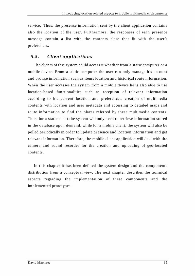
the Amulets project during June of 2006. The activities consisted of outdoor
learning activities carried out with 32 children from 4th grade class distributed
in eight groups. Their goal was to find five hidden places in the forest where
they had to solve different problems such as measuring the size of a tree using a
stick or obtaining the age of a cut tree by counting the circles on it. The mobile
phone camera was used to scan Semacodes (special image codes to encode url’s)
posted on some trees. Once a Semacode was scanned, they got a video created
by the Celekt team where there was explained the task to be performed. Each
group was also carrying and Ipaq 6900 with the Gps prototype running on it.
The Gps information sent by the Ipaq was stored in a database and used to trace
location of the groups during the activity. The routes were shown to the students
later in class. This test allowed me to check out the reliability of a periodical
polling system to update location and receive information.
Although it was not possible to develop a unique prototype for the same
device, these two prototypes illustrate how mobile devices can used for the
implementation of the designed system. The camera application shows the
creation of multimedia contents with associated metadata, while the Gps
application shows how the location of a user can be periodically updated in
order to receive relevant information.
Once the client features have been successfully tested, the next step was to
develop a server prototype in order to illustrate how the system can use the
information provided by the client to send relevant information for the user.
Therefore, a database and a web application were developed to illustrate this
David Martinez 39
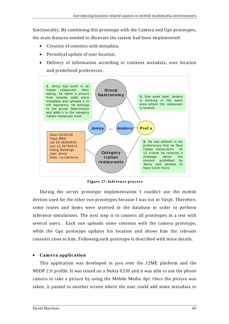
Introducing location related aspects to mobile multimedia environments
functionality. By combining this prototype with the Camera and Gps prototypes,
the main features needed to illustrate the system had been implemented:
• Creation of contents with metadata.
• Periodical update of user location.
• Delivery of information according to contents metadata, user location
and predefined preferences.
1. Jonny has lunch in an Italian restaurant. After eating, he takes a picture from outside, adds some metadata and uploads it to the repository. He belongs to the group Gastronomy and adds it to the category Italian restaurant food.
Group Gastronomy
Figure 17: Inference process
During the server prototype implementation I couldn’t use the mobile
devices used for the other two prototypes because I was not in Växjö. Therefore,
some routes and items were inserted in the database in order to perform
inference simulations. The next step is to connect all prototypes in a test with
several users. Each one uploads some contents with the camera prototype,
while the Gps prototype updates his location and shows him the relevant
contents close to him. Following each prototype is described with more details.
• Camera application
This application was developed in java over the J2ME platform and the
MIDP 2.0 profile. It was tested on a Nokia 6330 and it was able to use the phone
camera to take a picture by using the Mobile Media Api. Once the picture was
taken, it passed to another screen where the user could add some metadata to
Jonny Anders …
Category Italian
restaurants
Date:29/05/06 Type:JPEG Lat:50.26364833 Lon:12.36758473 Categ:Buildings User:Jonny Desc: La Lanterna
Pref x
2. One week later, Anders is working in the same area where the restaurant is located.
3. He has defined in his preferences that he likes Italian restaurants. At 12 o’clock he receives a message about the content published by Jonny and decides to have lunch there.
David Martinez 40

Introducing location related aspects to mobile multimedia environments
the picture. Finally, the picture and its metadata were sent to a server where it
was stored.
2. Add metadata: Who- Patrick, Talia and me When- 24/09/05 14:40 Where- Stockholm (GPS)
1. Picture creation. What- Visiting the city…
3. Upload content and store it into a repository.
How: JPEG 1536x2048, …
Figure 18: Camera prototype
• Gps application
This prototype was implemented with C# over the .net platform. It was
tested on HP IPAQ 6900 and it used the integrated GPS to obtain the current
location of the user and send this information to a server over http. On the
server side, Fredrick Alserin and Jonas Gustafsson from the Celekt team had
developed and application with a database where this information was stored
and Google Maps was used to show the location of the users and their routes. As
was explained above, this application was used in the activities performed with
the students of a primary school for the Amulets project to trace the path
followed by the different groups. It worked by polling the server periodically
updating the current location of the user. This test was successful and let me
conclude that this is a good solution for the implementation of the designed
system.
David Martinez 41
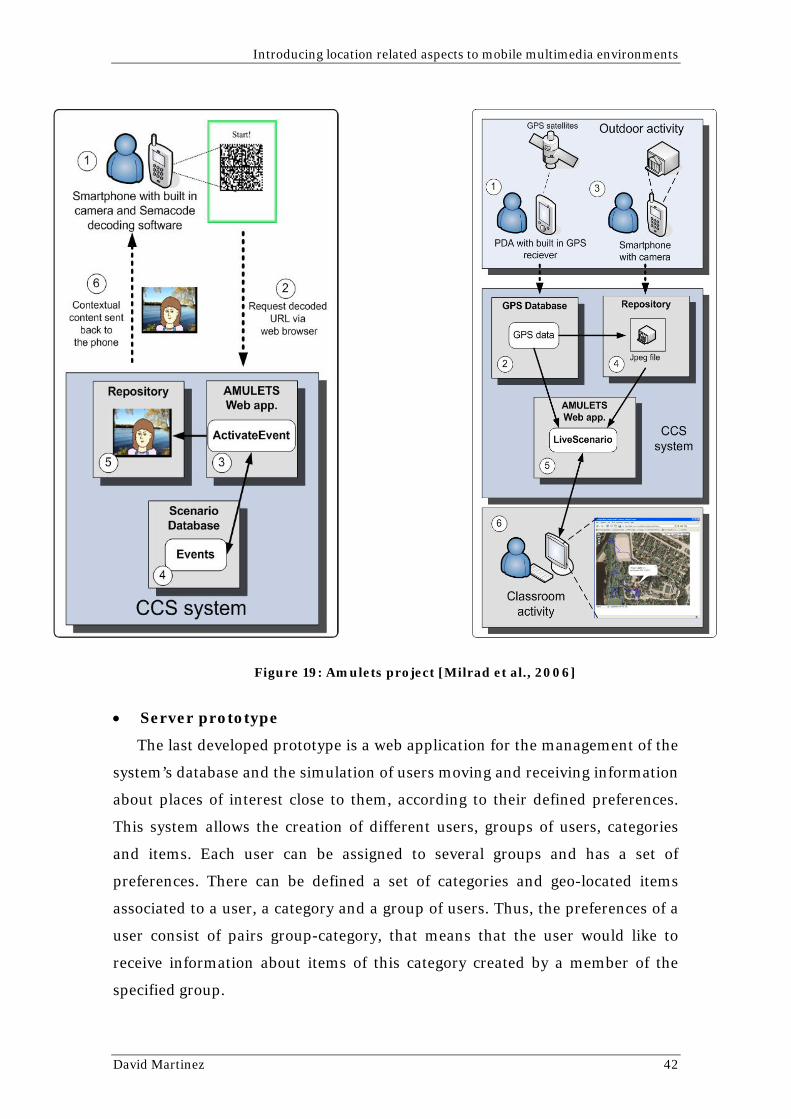
Introducing location related aspects to mobile multimedia environments
Figure 19: Amulets project [Milrad et al., 2006]
• Server prototype
The last developed prototype is a web application for the management of the
system’s database and the simulation of users moving and receiving information
about places of interest close to them, according to their defined preferences.
This system allows the creation of different users, groups of users, categories
and items. Each user can be assigned to several groups and has a set of
preferences. There can be defined a set of categories and geo-located items
associated to a user, a category and a group of users. Thus, the preferences of a
user consist of pairs group-category, that means that the user would like to
receive information about items of this category created by a member of the
specified group.
David Martinez 42

Introducing location related aspects to mobile multimedia environments
The web interface has been implemented with Java Server Pages and a
Mysql database. For the simulation of user movement it has been used Google
Maps and Ajax.
Following, there can be found several screenshots that show with more
details the performance of this prototype.
Figure 20: Users management
This image shows the list of existing users in the database. New users can be
created by pressing the ‘New User’ button and the already created ones can be
edited and modified or deleted. Each user preferences and groups can be
accessed by clicking on the links ‘preferences’ and ‘groups’ placed on the right
side of each row. On the left side, it can be seen the main menu that lets to
access the different sections of the website: Users, Groups, Categories, Items
and Routes.
Figure 21: User preferences
David Martinez 43
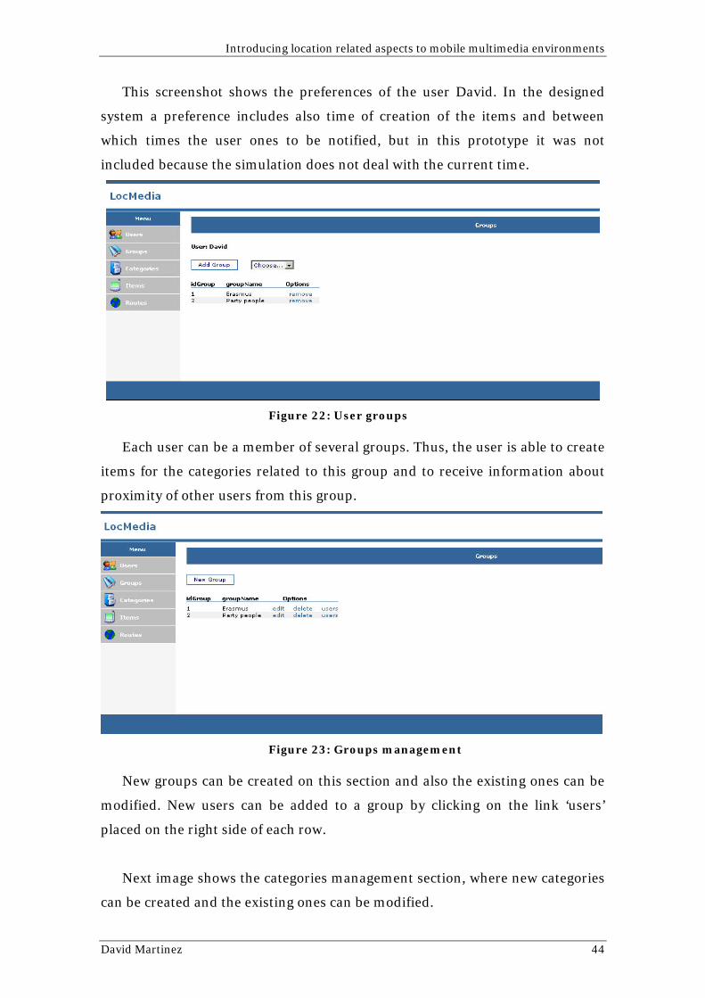
Introducing location related aspects to mobile multimedia environments
This screenshot shows the preferences of the user David. In the designed
system a preference includes also time of creation of the items and between
which times the user ones to be notified, but in this prototype it was not
included because the simulation does not deal with the current time.
Figure 22: User groups
Each user can be a member of several groups. Thus, the user is able to create
items for the categories related to this group and to receive information about
proximity of other users from this group.
Figure 23: Groups management
New groups can be created on this section and also the existing ones can be
modified. New users can be added to a group by clicking on the link ‘users’
placed on the right side of each row.
Next image shows the categories management section, where new categories
can be created and the existing ones can be modified.
David Martinez 44
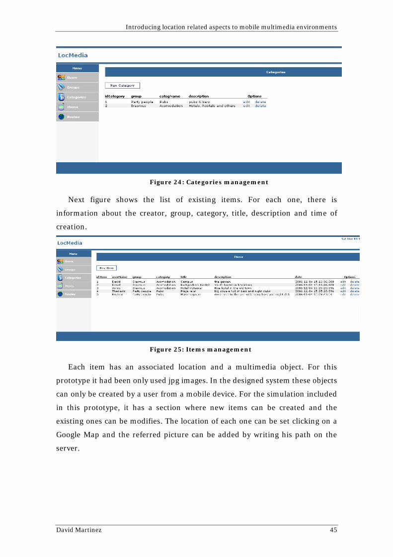
Introducing location related aspects to mobile multimedia environments
Figure 24: Categories management
Next figure shows the list of existing items. For each one, there is
information about the creator, group, category, title, description and time of
creation.
Figure 25: Items management
Each item has an associated location and a multimedia object. For this
prototype it had been only used jpg images. In the designed system these objects
can only be created by a user from a mobile device. For the simulation included
in this prototype, it has a section where new items can be created and the
existing ones can be modifies. The location of each one can be set clicking on a
Google Map and the referred picture can be added by writing his path on the
server.
David Martinez 45
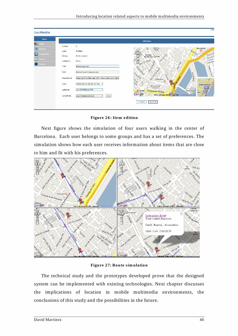
Introducing location related aspects to mobile multimedia environments
Figure 26: Item edition
Next figure shows the simulation of four users walking in the center of
Barcelona. Each user belongs to some groups and has a set of preferences. The
simulation shows how each user receives information about items that are close
to him and fit with his preferences.
Figure 27: Route simulation
The technical study and the prototypes developed prove that the designed
system can be implemented with existing technologies. Next chapter discusses
the implications of location in mobile multimedia environments, the
conclusions of this study and the possibilities in the future.
David Martinez 46
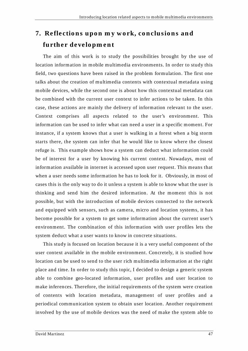
Introducing location related aspects to mobile multimedia environments
7. Reflections upon my work, conclusions and
further development
The aim of this work is to study the possibilities brought by the use of
location information in mobile multimedia environments. In order to study this
field, two questions have been raised in the problem formulation. The first one
talks about the creation of multimedia contents with contextual metadata using
mobile devices, while the second one is about how this contextual metadata can
be combined with the current user context to infer actions to be taken. In this
case, these actions are mainly the delivery of information relevant to the user.
Context comprises all aspects related to the user’s environment. This
information can be used to infer what can need a user in a specific moment. For
instance, if a system knows that a user is walking in a forest when a big storm
starts there, the system can infer that he would like to know where the closest
refuge is. This example shows how a system can deduct what information could
be of interest for a user by knowing his current context. Nowadays, most of
information available in internet is accessed upon user request. This means that
when a user needs some information he has to look for it. Obviously, in most of
cases this is the only way to do it unless a system is able to know what the user is
thinking and send him the desired information. At the moment this is not
possible, but with the introduction of mobile devices connected to the network
and equipped with sensors, such as camera, micro and location systems, it has
become possible for a system to get some information about the current user’s
environment. The combination of this information with user profiles lets the
system deduct what a user wants to know in concrete situations.
This study is focused on location because it is a very useful component of the
user context available in the mobile environment. Concretely, it is studied how
location can be used to send to the user rich multimedia information at the right
place and time. In order to study this topic, I decided to design a generic system
able to combine geo-located information, user profiles and user location to
make inferences. Therefore, the initial requirements of the system were creation
of contents with location metadata, management of user profiles and a
periodical communication system to obtain user location. Another requirement
involved by the use of mobile devices was the need of make the system able to
David Martinez 47

Introducing location related aspects to mobile multimedia environments
adapt the information to different presentation environments. With these
requirements in mind, I considered concrete situations were real users could
use this system by raising the scenarios. The use of this method allowed me to
tackle the problem from a lower level of abstraction and find additional
requirements needed to make the system totally useful from the user
perspective. The first requirement found was the need to provide geographical
information that lets the user to know the location of a specific element. It
makes no sense to tell a user that there is a Chinese restaurant close to him
without letting him know how to get there. Finally, I found a very interesting to
include an instant messaging service. It was not totally essential for this study,
according to the questions raised in the problem formulation, but it brought to a
social component that made it much more interesting. Also, the continuous flow
of information needed to update the location of the user and receive information
could include messaging data without a high growth of the traffic. Thus, the
obtained requirements led me to organize the system architecture with the
proposed components.
The most interesting aspect I have found in this study is how the level of
intelligence of the system can be improved. The possibility of combining user
profiles and learning systems based on historical information opens a wide field
to explore. Historical data about user activities, such as requested information
and visited places, could be added to the user profile. By knowing when and
where a user has rejected specific information, the system can base the
inference on success rates associated to actions performed before in similar
circumstances. The inference engine could also be improved by adding support
to other components of the context, whether using sensors connected to the
client device or accessing external sources, such as weather or traffic
information among others. Information about the whole community of users
can be used as well in the inference process. Thus, the system can consider the
amount of users that have requested concrete contents or users matching
according to their profiles and proximity.
In order to solve the formulated problem, this work has been approached
from a functional perspective. However, the use of location and historical
information requires a high level of privacy. Therefore, the implementation of
David Martinez 48

Introducing location related aspects to mobile multimedia environments
the designed system needs a robust security system, although it has not been
deeply described in this work.
This system has been designed to answer the questions of the problem
formulation. It shows a possible solution to the problem based on existing
technologies. Therefore, from a theoretical approach, the goal of this work has
been reached, but the wide area covered by the problem made me keep the
design in a very high level. The implementation of such a system needs a long
period of time and many tests that could lead to several changes in the initial
design. The developed prototypes try to show that the main functionalities can
al least be implemented. However, in general terms this study offers an example
of the new kinds of systems that could be developed in the future within the
field of mobile multimedia environments.
David Martinez 49
Introducing location related aspects to mobile multimedia environments
8. Table of figures
Figure 1: Task-artifact cycle [Carroll, J.M, 2000]................................................... 10 Figure 2: Challenges and approaches in scenario based design [Carroll, J.M, 1999] .............................................................................................................................. 11 Figure 3: Scenario-based frameworks [Rosson et al., 2001] ................................. 12 Figure 4: Structure of a GSM network ...................................................................... 13 Figure 5: MUPE GUI screenshot ............................................................................... 17 Figure 6: Dodgeball ..................................................................................................... 17 Figure 7: Imahima ....................................................................................................... 18 Figure 8: Related systems comparison ..................................................................... 19 Figure 9: Generic diagram of the application .......................................................... 23 Figure 10: Use cases diagram..................................................................................... 24 Figure 11: System architecture ................................................................................... 25 Figure 12: Inference engine ........................................................................................ 27 Figure 13: Navigation Engine..................................................................................... 32 Figure 14: Contents Module ....................................................................................... 33 Figure 15: Users database .......................................................................................... 34 Figure 16: Presentation engine .................................................................................. 37 Figure 17: Inference process....................................................................................... 40 Figure 18: Camera prototype...................................................................................... 41 Figure 19: Amulets project [Milrad et al., 2006]..................................................... 42 Figure 20: Users management................................................................................... 43 Figure 21: User preferences........................................................................................ 43 Figure 22: User groups................................................................................................ 44 Figure 23: Groups management ................................................................................ 44 Figure 24: Categories management .......................................................................... 45 Figure 25: Items management ................................................................................... 45 Figure 26: Item edition ............................................................................................... 46 Figure 27: Route simulation....................................................................................... 46
David Martinez 50

Introducing location related aspects to mobile multimedia environments
9. References
- Malaka, R. and Zipf, A. (2000) DEEP MAP - Challenging IT research in the framework of a tourist information system. Proc. 7th International Congress on Tourism and Communication Technologies in Tourism, Barcelona, Spain. - Moran, T. P. & Dourish P. (2001). Context-Aware Computing. Human-Computer Interaction, Volume 16. - Järvinen, P. (2001) “On Research Methods”, Opinpajan Kirja, Tampere – Findland. - Carroll, J.M. (2000) Making Use: Scenario-Based design of Human-Computer Interactions. The MIT Press. Page 68. - Carroll, J.M. (1999) Five reasons for Scenario-Based Design. Proceedings of the 32nd Hawaii International Conference on System Science 1999. Page 10. - Rosson, M. B. & Carroll, J. M. (2001). Usability Engineering, Morgan Kaufmann. - GSM Association (2001) M-Services Guidelines, version 3.0. GSM Association Permanent Reference Document: AA.35 - Abowd, G. D., Atkeson, C. G., Hong, J., Long, S., Kooper, R. & Pinkerton, M. (1997). Cyberguide: A mobile context-aware tour guide. Wireless Networks, 3(5):421-433. - Cheverst, K., Davies, N., Mitchell, K., Friday, A. & Estratiou, C. (2000). Developing a context-aware electronic tourist guide: Some Issues and experiences. CHI, 1-6, April 2000. - Suomela, R., Räsänen, E., Koivisto, A., Mattila, J. & Koskinen, T. (2004). Multi-User Publishing Environment (MUPE) Application Platform. Nokia, v1.10, April 2004 - Dodegeball. 2006. Avaliable [Online]: < www.dodgeball.com > [10 April 2006] - Imahima. 2006. Avaliable [Online]:
< www.imahima.com> [15 April 2006]
- Ranganathan, A & Campbell, R.H. (2003). An infrastructure for context awareness based on first order logic. Personal and Ubiquitous Computing Volume 7 , Issue 6 Pages: 353 - 364 ISSN:1617-4909 - Cai, G. & Xue, Y. (2006). Activity-oriented context-aware adaptation assisting mobile geo-spatial activities. Proceedings of the 11th international conference on intelligent user interfaces. Sydney, Australia Pages: 354 - 356.
David Martinez 51

Introducing location related aspects to mobile multimedia environments
- Anagnostopoulos, C., Mpougiouris, P. & Hadjiefthymiades, S. (2005). Prediction intelligence in context-aware applications. Proceedings of the 6th international conference on Mobile data management. Ayia Napa, Cyprus. Pages: 137 - 141 ISBN:1-59593-041-8 - Dey, A. K., Hamid, R., Beckmann, R., Li, I. & Hsu, D. (2004). A CAPpella: programming by demonstration of context-aware applications. Proceedings of the SIGCHI conference on Human factors in computing systems. Vienna, Austria. Pages: 33 - 40 ISBN:1-58113-702-8 - Kray, C., Elting, C., Laakso, K. & Coors, V. (2003). Presenting Route instructions on mobile devices. Proceedings of the 8th international conference on Intelligent user interfaces. Miami, Florida, USA Pages: 117 - 124 ISBN:1-58113-586-6 - Butz, A., Baus, J., Küger, A. & Lohse, M. (2001): A Hybrid Indoor Navigation System. Proceedings of the 6th international conference on Intelligent user interfaces. 25 - 32 . ACM Press. - Simon, R., Wegscheider, F., Tolar, T. (2005). Tool-supported single authoring for device independence and multimodality. Proceedings of the 7th international conference on Human computer interaction with mobile devices & services MobileHCI '05. Salzburg, Austria. Pages: 91 - 98 ISBN:1-59593-089-2 - Gilbert, J. & Butler, M. H. (2003). Using MultipleNamespaces in CC/PP and UAProf. Digital Media Systems Laboratory, HP Laboratories Bristol, February. - Open Mobile Alliance (2006), User Agent Profile v2.0, February 06. - ERSI. 2006. Avaliable [Online]: <www2.arcwebservices.com/v2006/help/index.htm#samples/code_java.htm> [30 April 2006] - Wikipedia. 15 January 2001. Avaliable [Online]: < http://en.wikipedia.org/wiki/Image:Gsm_network.png > [30 March 2006]
David Martinez 52

Matematiska och systemtekniska institutionen SE-351 95 Växjö
Tel. +46 (0)470 70 80 00, fax +46 (0)470 840 04
http://www.vxu.se/msi/
Top Related