


Languages
Pages
Legal


INLAND WATERWAYS
INFORMATION ON INLAND WATERWAYS & NAVIGATION
PRESENTED BY:
SIJO JOSING MBA(PSM)UPES, DEHRADUN, U.K
INLAND WATERWAY(S)

INLAND WATERWAYS
INLAND WATERWAYS are the water bodies like rivers, tidal riverine, canals, brooks etc which are wide and deep enough to be used for inland navigation.

CONTD… INLAND WATERWAYS AUTHORITY OFINDIA under MoS is the body which undertakes development and maintenance of the INLAND WATERWAYS in INDIA.
Rules and Regulations are formulated by IWAI.
The government organization which carries out the operations in the INLAND WATERWAYS is CENTRAL INLAND WATERWAYS TRANSPORT CORPORATION Ltd.
There are THREE NATIONAL WATERWAYS which are operational, Two more have been identified and under MARITIME AGENDA BARAK River will be developed as NW-6.
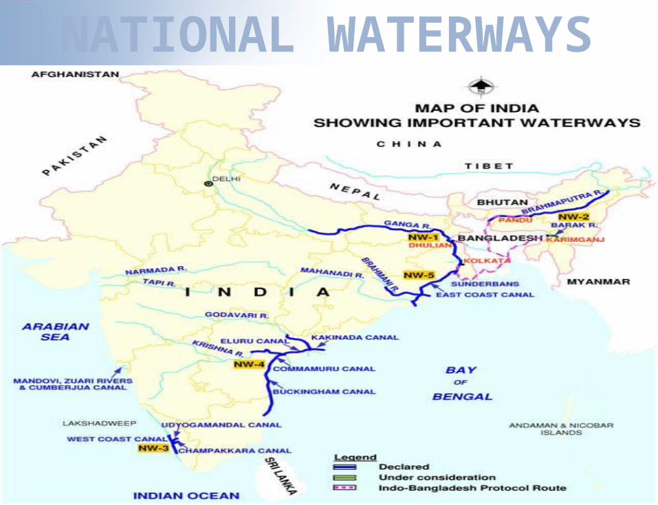
NATIONAL WATERWAYS

NATIONAL WATERWAY-1HALDIA-ALLAHABAD
(1620Km)
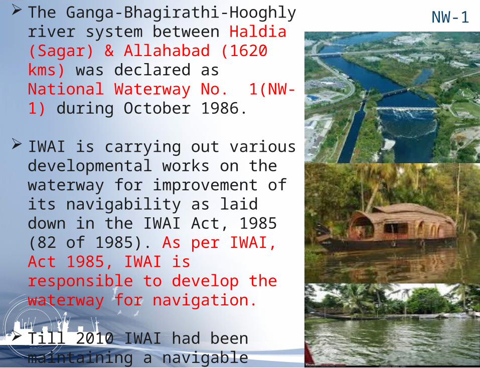
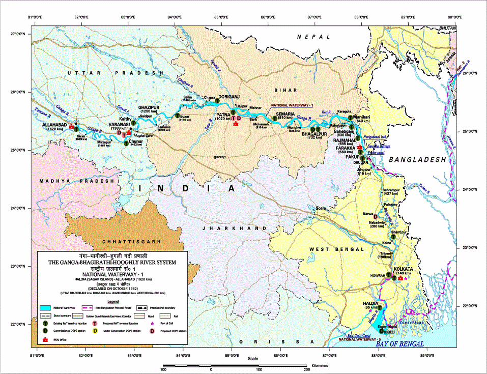
NW-1 The Ganga-Bhagirathi-Hooghly river system between Haldia (Sagar) & Allahabad (1620 kms) was declared as National Waterway No. 1(NW-1) during October 1986.
IWAI is carrying out various developmental works on the waterway for improvement of its navigability as laid down in the IWAI Act, 1985 (82 of 1985). As per IWAI, Act 1985, IWAI is responsible to develop the waterway for navigation.
Till 2010 IWAI had been maintaining a navigable depth of 2.5 meters between Haldia(Sagar) & Farakka (560 km), 2.0 meters in Farakka Patna (460 Km) and 1.5 meters in Patna Allahabad sector (600Km). At present the waterway is being used by tourism vessels, ODC Carriers, IWAI vessels etc.

TERMINALS (FLOATING AND FIXED)
S No.
Name of terminal with Chainage
1 RAJMAHAL (MANGLAHAT) (Ch. 588Km.)
2 SAHEBGANJ (SAMDAGHAT) (Ch.617Km.)
3 BATESH WARSTHAN(Ch. 683Km.)
4 BHAGALPUR(Ch715Km.)
5 MUNGER (Ch.793Km.)
6 SEMARIA (Ch 850 Km..)
7 BARH(Ch. 880 Km..)
8 BUXAR(Ch. 1124 Km.)
9 GHAZIPUR(Ch. 1177Km.)
10 RAJGHAT(VARANASI)(Ch. 1308Km)
11 ALLAHABAD (Ch. 1535Km)

FAIRWAY DEVELOPMENT
YEAR- 2010 2011
Sl. No Stretch (In km)
Depth Maintaine
d
No. of shoals
attended
Depth aimed for 2010-2011
No. of shoals
anticipated
1 Haldia(Sagar) - Farakka (560) 3.0 6 3.0 12
2 Farakka- Patna (460) 2.0 17 2.5 81
3 Patna - Varanasi (363) 1.5 26 2.0 34
4Varanasi - Allahabad (237) 1.5 17 1.5 34
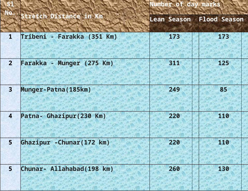
Sl No.
Stretch Distance in Km
Number of day marks
Lean Season Flood Season
1 Tribeni - Farakka (351 Km) 173 173
2 Farakka - Munger (275 Km) 311 125
3 Munger-Patna(185km) 249 85
4 Patna- Ghazipur(230 Km) 220 110
5 Ghazipur -Chunar(172 km) 220 110
5 Chunar- Allahabad(198 km) 260 130

NATIOANAL WATERWAY-2BANGLADESH BODER TO SADIYA
(891Kms)

NW-2 The river Brahmaputra having a length of 891
Km between Bangladesh Border to Sadiya was declared as National Waterway no. 2 (NW-2) on 1st September, 1988. IWAI is carrying out various developmental works on the waterway for improving its navigability as laid down in the IWAI act, 1985 (82 of 1985).
As per IWAI, act 1985, IWAI is responsible to develop the waterway for navigation.
Till 2010 IWAI had been maintaining a navigable depth of 2.0 meters between Bangladesh Border to Dibrugarh (768 Km) and 1.50 meters in Dibrugarh- Sadiya sector (123 Km).

CONTD… At present the waterway is being used by
vessels of Government of Assam, CIWTC, Border Security Force, tourism vessels, and other private operators.
Long cruise tourist vessels are making voyages between Sivsagar near Dibrugarh and Manas wild life sanctuary near Jogighopa continuously. PoL was transported by IWT on trial from Silghat to Budge- Budge and Baghmari in Bangladesh.

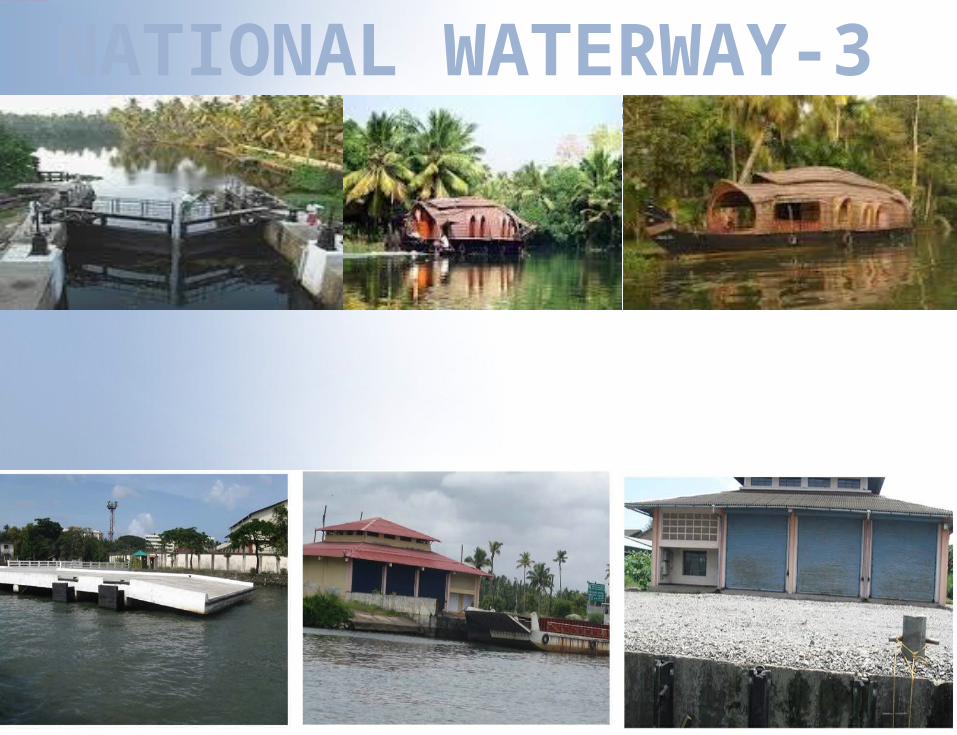
NATIONAL WATERWAY-3BACK-WATERS IN KERALA
(205 Kms)
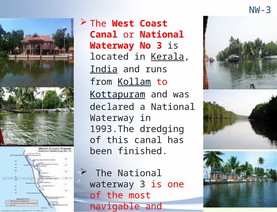
NW-3 The West Coast
Canal or National Waterway No 3 is located in Kerala, India and runs from Kollam to Kottapuram and was declared a National Waterway in 1993.The dredging of this canal has been finished.
The National waterway 3 is one of the most navigable and tourism potential area in India and has much to offer to the potential tourist.
This is the first National Waterway in the country having 24 hours navigation facilities in the entire stretch.


NEW PROJECTS
DEVELOPMENT OF NW-4 : The total cost of development would be around Rs1515 cr on PPP basis(BOT, BOOT or BOOST).
It is proposed that 40% funding (Rs 600 cr) as Viability Gap Funding(VGF) and the rest by private sectors.
DEVELOPMENT OF NW-5 : The total cost of development would be around Rs 4210 cr on PPP BASIS
Two phased development :a) Phase 1- Brahmani river and delta portion from Charbatia to Dhamra.b) Phase 2- EAST COAST CANAL from Geonkhali to Charbatia
PROPOSING NW-6 : The BARAK River in the NER.
INLAND VESSELS
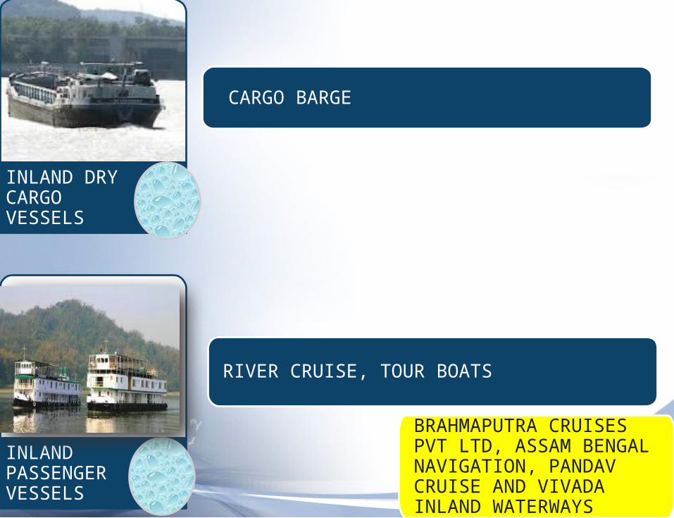
INLAND DRY CARGO VESSELS
CARGO BARGE
RIVER CRUISE, TOUR BOATS
INLAND PASSENGER VESSELS
BRAHMAPUTRA CRUISES PVT LTD, ASSAM BENGAL NAVIGATION, PANDAV CRUISE AND VIVADA INLAND WATERWAYS

PUSHER TUGS, TOW BOATS, RIVER TUGS, INLAND REGISTERED TUGS
TANK BARGE
INLAND TNKERS
INLAND TUGS

INLAND SPECIAL PURPOSE VEHICALS
WORK BOAT, PONTOONS, DREDGERS, HYDROGRAPHIC SURVEY, SPECIAL PURPOSE VEHICALS
IWAI HAS 11 DREDGERS CUTTER SUCTION DREDGERS AND HYDRAULIC DREDGERS

FEASIBILITY STUDY
CASE STUDY
TOWS ANALYSIS
PROBLEMS FACED BY SHIPBUILDING INDUSTRY
SOLUTION FOR RIVER KOSI

CASE STUDYFATUA AND DANAPUR-
11.5 Km away from Patna There were 5 racks in the
yard. The commodities they handled
over there were: 1.Sugar 2.Cement 3.Fertilizers 4.Vegetable 5.Jute 6.Paper bales 7.Automobile

RAILWAYS AND ROADWAYS
65 TON WAGON CHARGE PER WAGON WAS 65000 CARGOS WERE GENERALLY IN BAGS THE LOADING AND DISCHARGE THEY PAYED 1.5/BAG BY ROAD 1000/TON FOR 500-600KMS RUN

TOWS ANALYSIS

THREAT
1
•RAIL ROADS HAVE BETTER CONNECTIVITY AND ARE FASTER
2
•FLOOD SITUATION IN NW-1
3
•FAULTY SURVEYS IN THE STREATCH

OPPORTUNITY
1
•POSSUBILITIES OF PROJECT CARGOS FROM DELHI TO ALLAHABAD
2
•DAMS AND LOCKS CAN BE CONSTRUCTED FOR RIVER KOSI
3
•PRIVATE SECTOR CAN TAKE AN ACTIVE ROLE
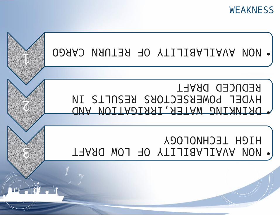
WEAKNESS
1
•NON AVAILABILITY OF RETURN CARGO
2
•DRINKING WATER,IRRIGATION AND HYDEL POWERSECTORS RESULTS IN REDUCED DRAFT
3
•NON AVAILABILITY OF LOW DRAFT HIGH TECHNOLOGY

STRENGTHS
1
•LOW CAPITALCOST
2
•ENVIORNMENT FRIENDLY
3
•LOW ON MAINTENANCE AND FUEL COST

PROBLEMS FACED BY SHIPBUILDING INDUSTRY
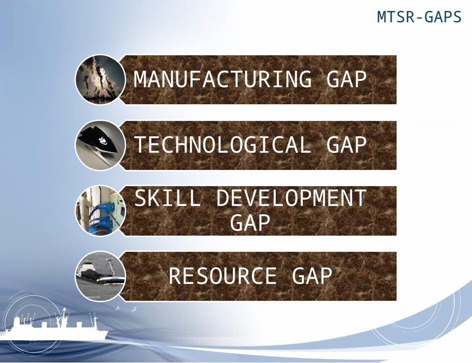
MTSR-GAPS
MANUFACTURING GAP
TECHNOLOGICAL GAP
SKILL DEVELOPMENT GAP
RESOURCE GAP
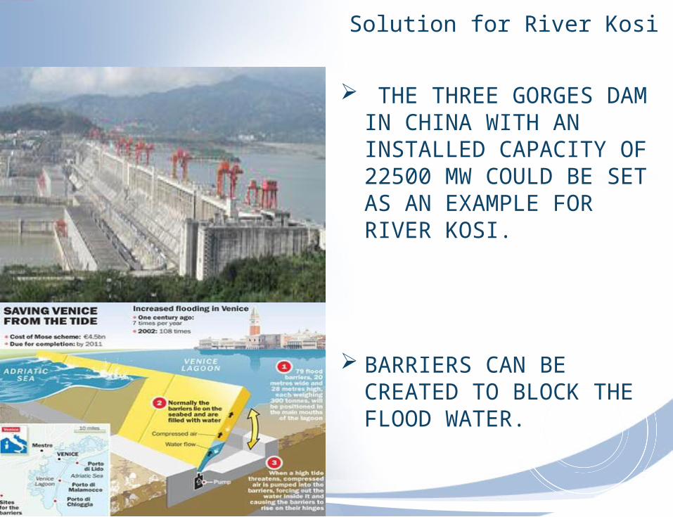
Solution for River Kosi
THE THREE GORGES DAM IN CHINA WITH AN INSTALLED CAPACITY OF 22500 MW COULD BE SET AS AN EXAMPLE FOR RIVER KOSI.
BARRIERS CAN BE CREATED TO BLOCK THE FLOOD WATER.

CONCLUSION
Integrated Strategy involving all modes could be effective.
Absence of which has resulted in lack of competitive neutrality across transport modes, low quality and capacity of inter-modal connections.
Current institutional arrangements do not appear to have provided the level of co-ordination and co-operation between modal jurisdiction needed to address certain issues, as it has led to legal distortion.
The cost to the society is the most by road and rail transport as compared to the inland water transport.
The congestion in the future would leave no other option than to convert the navigable water in to use.

CONTD..
The funds allocated for the projects to be used in a proper fashion.
New ideas to be shared and invited to solve the issues in NW-1

Reference
Web sites: http://www.transportation-dictionary.org/Shipping-Dictionary http://www.iwai.nic.in http://www.irclass.org http://www.shipspotting.com/support/faq.php?category=Inland%20vesse
ls http://www.rina.org.uk/tna.html http://www.legalindia.in http://www.hellenicshippingnews.com/ http://www.dailyshippingtimes.com/news.php
Contd…
PDF: Maritime Agenda 2010-2020)
“The evolution of perspective of inland water transport in India, RITES Journal, April 2006.
“viability of IWT in India”- Rangaraj and Raghuram
“Perspective on IWT in India”- Sriraman.S
“Report on the development of coastal shipping”-TCS Mumbai 2004

Top Related