


Languages
Pages
Legal


Barnsley MBC
Infrastructure
Delivery Plan
Barnsley MBC
6/23/2015

1
Executive Summary
To achieve the Vision and Strategic Policies as set out within the Barnsley Local Plan, Barnsley must be equipped for growth and change. This IDP will therefore form a component in underpinning this Borough’s transformation.
This IDP provides a technical evidence base and seeks to understand:
The current level of infrastructure provision within Barnsley and whether this infrastructure is currently fit for purpose to support the existing population.
The level of planned infrastructure within Barnsley – as set out in plans and strategies adopted by BMBC and the forthcoming strategies from organisations responsible for the delivery of planned infrastructure.
Whether the current and planned infrastructure scheduled to be delivered will support the level of growth planned in Barnsley and whether a gap exists.
The costs associated with planned infrastructure provision and whether there is a gap between committed, allocated and required investment; and
Propose solutions to any gaps between committed and required investment.
Any future CIL and will inform the basis of a Regulation 123 list.
The Infrastructure Delivery Programme includes details of committed and planned
schemes by infrastructure type required to ensure that infrastructure is fit for purpose
and facilitate the planned growth across the Borough.

2
Contents
1) Introduction Page 3
2) Understanding the Policy Context Page 5
3) Methodology Page 8
4) Transport Page 14
5) Education Page 29
6) Utilities Page 38
7) Climate Change and Renewables Page 54
8) Telecommunications Page 58
9) Flood Risk and Drainage Page 63
10) Waste and Recycling Page 70
11) Green Infrastructure, Open Space and Public Space Page 72
12) Health Page 84
13) Sport, Leisure and Recreation Page 88
14) Emergency Services Page 101
15) Community and Cultural Page 105
16) Funding Sources Page 114
17) Conclusions and Recommendations Page 121
18) Infrastructure Delivery Programme Page 129

3
1) Introduction
1.1 Overview
The Council is currently producing a new development plan, called a Local Plan, to
guide future growth and development in the borough up to the year 2033. The Local
Plan sets out the long term spatial vision for the borough and strategic policies to
deliver that vision. To fulfil this role and to be found sound, the Local Plan is
required to identify the infrastructure requirements for the area, who will provide it, as
well as where and when. The Infrastructure Delivery Plan (IDP) is essential to ensure
that services can match demand and the Plan is effective in creating sustainable
development.
The Infrastructure Delivery Plan is part of the evidence base which will be used to
understand any critical ‘showstoppers’ and overarching infrastructure requirements
for the delivery of the Local Plan, with a specific focus on delivery over the short
term: the first five years of the plan. It should be used to underpin strategic decision
making on future targets for local growth and change. It takes a bottom up approach
to assessing existing, planned and future infrastructure provision across a given area.
This includes an appraisal of the quality and quantity of existing infrastructure and the
need for new infrastructure in order to deliver sustainable development.
Over the plan period there will be significant levels of growth, particularly in relation
to housing and employment. The IDP has been prepared following consultation with
key infrastructure providers and delivery agencies for the borough and begins to
present a picture of the key issues relating to infrastructure provision in Barnsley.
Due to the nature of infrastructure, schemes are constantly evolving and as such this
document is intended to evolve and will be monitored and updated as and when
required.
1.2 Role of this Infrastructure Delivery Plan
To achieve the Vision and Strategic Policies as set out within the Barnsley Local Plan, Barnsley must be equipped for growth and change. This IDP will therefore form a component in underpinning this Borough’s transformation.
This IDP provides a technical evidence base and seeks to understand:
The current level of infrastructure provision within Barnsley and whether this infrastructure is currently fit for purpose to support the existing population.
The level of planned infrastructure within Barnsley – as set out in plans and strategies adopted by BMBC and the forthcoming strategies from organisations responsible for the delivery of planned infrastructure.
Whether the current and planned infrastructure scheduled to be delivered will support the level of growth planned in Barnsley and whether a gap exists.
The costs associated with planned infrastructure provision and whether there is a gap between committed, allocated and required investment; and
4
Propose solutions to any gaps between committed and required investment.
Any future CIL and will inform the basis of a Regulation 123 list.
1.3 Duty to Cooperate/Stakeholder Discussions
Planning for infrastructure is a critical element of strategic planning. The National
Planning Policy Framework makes it clear that local planning authorities should work
with other local planning authorities and providers to assess the quality and capacity
of a range of infrastructure types. This will ensure that key infrastructure is properly
planned.
Planning for infrastructure is a key requirement of the effectiveness element of the test
of Local Plan soundness, which requires plans to be deliverable and based on
effective joint working on cross boundary strategic priorities. The involvement of
infrastructure providers in Local Plan preparation is critical to ensure that Local Plans
are deliverable. Participation in the Local Plan preparation process helps to inform
their business plans and to plan and finance the delivery of infrastructure that they
have a legal obligation to provide. The Council has undertaken Duty to Cooperate meetings and engagement with the
following organisations in order to inform the Local Plan and Infrastructure Delivery
Plan:
South Yorkshire Passenger Transport Executive
Sheffield City Council
Peak District National Park Authority
Sheffield City Region Local Enterprise Partnership
Historic England
Highways England
Environment Agency
Rotherham Metropolitan Borough Council
Leeds City Region Local Enterprise Partnership
Doncaster Metropolitan Borough Council
Kirklees Metropolitan Borough Council
Wakefield Metropolitan District Council
Natural England
Homes and Communities Agency
South Yorkshire Local Nature Partnership
Duty to cooperate engagement has continued through the preparation of the Local
Plan Publication version and will be furthered during the consultation period.
5
2) Understanding the Policy Context
2.1 Introduction
The policy overview frames the Barnsley Infrastructure Study. It provides a review of
the strategic context for the study and the policy environment which will impact
Barnsley and inform future plans for growth and development in the Borough.
2.2 National Planning Policy Context
The National Planning Policy Framework (NPPF) attaches great importance to
producing a robust evidence base to support Local Plans. The importance of
providing the infrastructure required to deliver the Local Plan objectives is most
directly referenced in paragraph 162 which states:
Local planning authorities should work with other authorities and providers to:
Assess the quality and capacity of infrastructure for transport, water
supply, wastewater and its treatment, energy (including heat),
telecommunications, utilities, waste, health, social care, education, flood
risk and coastal change management, and its ability to meet forecast
demands; and
Take account of the need for strategic infrastructure including nationally
significant infrastructure within their areas.
The NPPF also states that Local Plans should plan positively for the development and
infrastructure required in the area to meet the objectives, principles and policies of the
NPPF (para 157).
Planning Practice Guidance (March 2014) states that LPAs should:
Provide an adequate supply of land, identifying what infrastructure is
required and how it can be funded and brought on stream at the appropriate
time.
Early discussion with infrastructure and service providers is particularly
important to help understand their investment plans and critical
dependencies.
The local planning authority should also involve the Local Enterprise
Partnership at an early stage in considering the strategic issues facing their
area, including the prospects for investment in infrastructure.
The Local Plan should make clear, for at least the first five years, what
infrastructure is required, who is going to fund and provide it, and how it
relates to the anticipated rate and phasing of development.
Where the deliverability of critical infrastructure is uncertain then the plan
should address the consequences of this, including possible contingency
arrangements and alternative strategies.

6
The evidence which accompanies an emerging Local Plan should show
how the policies in the plan have been tested for their impact on the
viability of development, including (where relevant) the impact which the
Community Infrastructure Levy is expected to have.
2.3 Sheffield City Region Local Enterprise Partnership (SCR LEP)
Local Enterprise Partnerships (LEPs) are partnerships between local authorities and
businesses. They decide what the priorities should be for investment in roads,
buildings and facilities in the area.
The SCR LEP submitted the Strategic Economic Plan (SEP) for the City Region to
Government in March 2014. The Growth Plan is aimed at structurally transforming
the City Region economy in order to deliver growth and jobs and provide businesses
with the right infrastructure they need to thrive such as public transport connectivity,
the provision of an investment infrastructure programme (SCRIF), a housing
development strategy, the development of a long term integrated infrastructure
investment plan, and local sustainable transport programmes.
2.4 Sheffield City Region Investment Fund
The Sheffield City Region Investment Fund (SCRIF) is a funding stream to deliver
essential strategic infrastructure to increase economic growth and jobs in the City
Region. This is available to local authorities and provides the opportunity to deliver
economic schemes that are essential for future growth.
In July 2013, the Sheffield City Region Local Transport Body (LTB) published an
initial prioritised list of schemes which will have the biggest impact on jobs and
economic growth in the City Region over the next decade. The list included two
schemes in Barnsley which were listed as the 1st and 7
th priority respectively:
M1 Junction 36 to Dearne Valley: Strategic Highway Infrastructure and site
preparation for employment (295 Hectares gross) and up to 3,600 housing
units of mixed tenure.
M1 Junction 37 Claycliffe Link-Bypass from M1 Junction 37 to connect with
A635 at Claycliffe. Designed to alleviate congestion and deliver up to 800
dwellings and approximately 93 Hectares gross (63 Hectares net) employment
land.
2.5 Local Growth Fund Announcement
In July 2014, the Sheffield City Region LEP secured a £320 million Growth Deal for
the Sheffield City Region which will go towards supporting over £600 million worth
of infrastructure projects.
The Growth Deal has been achieved as a result of the LEP’s Strategic Economic Plan
which was submitted to Government in March 2014 and sets out plans to transform
the local economy over the next decade.

7
2.6 Barnsley Local Plan
The Council adopted the Core Strategy in September 2011. The Core Strategy set out
the key elements of the planning framework for Barnsley, and the approach to its long
term physical development to achieve the Council's vision of what sort of a place
Barnsley wants to become. It reflects the Council's hopes and aims for the people
who live, work, run businesses and enjoy leisure in Barnsley. The Draft Local Plan,
together with the Joint Waste Plan (2012) which was prepared with Doncaster and
Rotherham will be the statutory development plan for Barnsley when adopted. It
establishes policies and proposals for the development and use of land up to the year
2033 and identifies potential development sites.
Barnsley Council’s overall spatial strategy for change is shaped by local and city
region ambitions. Barnsley’s history and legacy present a series of opportunities and
constraints, which require a range of policy approaches to ensure that the Borough
maintains and enhances its role within the Leeds and Sheffield City Regions.
Challenges linked to delivering housing and economic growth, meeting challenges
relating to the regeneration of the Principal Towns and finding new roles and
functions for local service centres and rural areas, all require the Council to
proactively deliver locally appropriate interventions to secure the long term future of
the borough.
The Spatial Strategy for Barnsley is focussed upon supporting the Leeds and Sheffield
City Regions to achieve their potential in a complementary way, supporting the
sectors which will drive forward the regional economy.
The strategy has been developed with a focus upon delivering growth in the most
sustainable locations that will benefit Barnsley, whilst ensuring that the physical,
environmental and social infrastructure of the Borough is protected and improved.
It is on this basis that the spatial strategy is to direct development in the following
areas:
The Sub-Regional town of Urban Barnsley
The Principal Towns within the ‘Barnsley Growth Corridor’; and
Penistone Principal Town

8
3) Methodology
3.1 Overview
This section sets out the methodology followed to produce the Infrastructure Delivery
Plan.
This IDP is based on a four stage process to understand current and future infrastructure provision, taking into consideration the planned areas of growth and regeneration. This approach has made it possible to identify areas in need of further investment and potential funding mechanisms.
Figure 1: Infrastructure Delivery Plan Stages
To give context to the assessment of current and planned infrastructure, proposed development quantum must be assumed and agreed. The following section therefore sets out the preparatory step prior to undertaking Stages 1 – 4 above.
3.2 Development Quantum Assumptions
Housing
The Local Plan sets out the Council’s housing target to 2033. The policies within the
Local Plan seek to achieve the completion of at least 20 900 new homes in the plan
period and confirm the Council’s intention to maintain a 5 year housing supply.
• Current Provision
• Is this Current Provision fit for purpose? Stage 1
• Planned and Programmed Infrastructure Provision
• Is there a Gap in Infrastructure Provision? Stage 2
• Costs of Planned and Future Provision
• Is there a Gap for Infrastructure Delivery? Stage 3
• What Mechanisms are available to bridge the funding gap?
Stage 4

9
Figure 2: Table demonstrating the quantum and distribution of housing development.
Settlement Total % of Overall
Supply
Urban Barnsley 9327 45
Cudworth 1226 6
Dearne 2857 14
Hoyland 2360 11
Penistone 1026 5
Royston 1282 6
Wombwell 2132 10
Other 680 3
Total 20890 100*
* Percentages are rounded and as a result may not total 100% overall.
The scale of housing growth has important implications on the need for, and demand
on infrastructure. The Council has produced an indicative trajectory in order to
provide an indication of the expected phasing and timing of housing delivery and will
continue dialogue with providers in order to provide certainty and inform investment.
Figure 3: Housing Completions 2014-2033
Continued joint working between the planning and housing teams and other
departments of the Council is required. This is particularly important in areas where
the Council is jointly or solely responsible for services (e.g. Education and Health),
and where certainty over housing delivery figures plays a pivotal role in service
delivery options.
10
Employment
Barnsley’s Jobs and Business Plan (2014-2017) identifies that Barnsley’s economic
performance continues to lag behind regional and national economic indicators and
recovery from the global recession is taking longer in Barnsley than the rest of the
UK.
Barnsley is underperforming with a reliance on the public sector to provide jobs, the
availability of which has vastly reduced due to public sector spending cuts. The
private sector has been unable to absorb the number of jobs that have been lost to
date.
The Jobs and Business Plan sets targets of creating a further 17500 jobs by 2033 in
order to address the employment gap. Increasing the number of VAT registered
companies is the major challenge to improving the Barnsley economy to a size
equivalent to towns of a comparable size and circumstances, achieving essential
economic transformation and job outputs.
The Local Plan highlights the need for the Barnsley economy to meet local needs and
to provide local job opportunities. The objectives in respect of policy solutions to
support economic growth include:
Ensuring the provision of a wide range of employment locations, land and
premises
Resisting the loss of existing employment land that meets the needs of existing
businesses or is likely to meet the needs of businesses in the future.
Promoting opportunities for tourism and culture to make sure that Barnsley is
an attractive place for inward investment.
Based on the jobs growth target of approximately 17,500 additional jobs by 2033, the
objectively assessed employment land requirement (that is land needed for B class
land uses) is around 300 hectares.
The majority of the employment land is mainly concentrated on the M1 corridor, with
land at J36 (Hoyland Cluster) and J37 (43ha at Barugh which will form part of a large
mixed use allocation) and approximately 73ha east of Goldthorpe. The remaining land
is distributed across the borough in smaller concentrations.
Figure 4: Table showing the proposed amount of employment land:
Urban Barnsley 73.7 hectares
Penistone and the Rural West 4.5 hectares
The East 231.2 hectares
Delivery to stimulate commercial development and make sites attractive to investors
is currently led at the regional level. Barnsley benefits from a number of Enterprise
Zones allocated to the Sheffield City Region, meaning that eligible occupiers on these
sites can benefit from a rate-free period of five years. The enterprise designation does
not necessarily overcome the viability gap issue faced by developers. This has led to
the introduction of the JESSICA and the Sheffield City Region Investment Fund
(SCRIF), both of which provides a range of finance to bridge the viability gap or

11
provide essential infrastructure to unlock schemes critical to economic growth.
Barnsley has been successful in securing SCRIF funding and work is underway to
enable the strategic growth cluster at Hoyland to come forward. Barnsley is also due
to benefit from further SCRIF investment to enable development at the remaining
growth clusters. This investment will be key in providing an improved offer to
inward investors.
3.3 Scope of the Infrastructure Delivery Plan
The table below illustrates the relevant infrastructure types and details the subsectors
that were given consideration.
Figure 5: Relevant Infrastructure Types and Sub-Sectors
Infrastructure Sector Sub sector
Transport Highways
Bus
Park and Ride
Rail
Walking and Cycling
Education Primary Schools
Secondary Schools
Utilities Electricity
Gas
Water supply
Waste water
Renewable Energy Low Carbon
Telecommunications ICT
Broadband
Flood Risk and Drainage Flood Risk and Drainage
Waste and Recycling Waste Management
Green Infrastructure, Open Space
and Public Space
Parks and Gardens
Play Areas
Allotments
Green Ways and Public Rights of
Way
Woodland, Natural and Semi-natural
green spaces
Health GP provision
Hospitals and Acute Care
Sport, Leisure and Recreation Sports Pitches
Sports Centres and Pools
Emergency Services Ambulance
Fire and Rescue
Police
Community and Cultural Libraries
Museums, Galleries and Theatres
Cemeteries

12
Spatial context
For the purpose of the IDP the findings have been presented for the following 3
spatial areas:
Urban Barnsley
Penistone and Rural West
East Barnsley (Including Royston, Cudworth (including Grimethorpe),
Goldthorpe (Dearne Towns), Wombwell and Hoyland.
Figure 6: Plan showing the 3 spatial areas for the purpose of the IDP
3.4 Stages of the Infrastructure Delivery Plan
Stage 1: Determining Current Infrastructure and if it is Fit for Purpose
Stage 1 of this IDP focusses on understanding the current infrastructure provision in Barnsley and whether it is adequate to meet the needs of the current population.
This is undertaken through a quantitative assessment of current infrastructure and their spatial distribution, and principally achieved through an extensive review of secondary data sources. This analysis is supplemented by discussions with key stakeholders and local service providers to understand if existing facilities are ‘fit for purpose’.

13
Stage 2: Identify planned infrastructure provision
Stage 2 of this IDP involves identifying planned infrastructure provision. Utilising a baseline of current level and condition of infrastructure, it is possible to carry out a broad assessment of planned infrastructure improvements up to 2033. This is based on an analysis of secondary sources and discussions with stakeholders and officers.
Stage 3: Confirm implications and any gaps in infrastructure provision to meet
growth aspirations
Stage 3 of this IDP involves confirming if current, planned and committed infrastructure will be sufficient to meet the needs and demands in line with growth objectives. This assessment could therefore highlight where there may be gaps in future infrastructure provision. This stage will also confirm the cost of bridging the gap in infrastructure provision required to deliver the Council’s planned housing and employment growth.
Stage 4: Identify Funding Sources to bridge infrastructure gap
Stage 4 requires engaging with public sector organisations, traditional funding mechanisms and potential private sector involvement to establish potential funding options which could deliver the infrastructure needed. These options look to understand what funding sources are already committed, what funding sources have been allocated, and whether there is an identified gap between need and committed/allocated funds.

14
4) Transport
4.1 Data Sources
This section covers the highway, passenger rail, freight rail and cycling and pedestrian improvements.
The following sources of information have been used to populate this chapter:
Discussions with BMBC Transport Policy and Highways Officers
Discussions with South Yorkshire Passenger Transport Executive
Discussions with BMBC Major Projects Team Officers
Local Transport Plan 3
Sheffield City Region Growth Deal and Strategic Economic Plan, 2014.
Barnsley Local Plan Study 2015 – Traffic Impact Study Technical Note (Aecom January 2016)
Draft Barnsley Study Areas, Junctions Report (Aecom January 2016)
M1 Junction 37 – Economic Growth Corridor, Claycliffe, Barnsley (Aecom March 2016)
4.2 Existing Infrastructure and Fit for Purpose
Barnsley’s award winning Transport Interchange was delivered as part of the
Remaking Barnsley Initiative. This has had positive regenerative effects for the town
centre and has become a hub for rail and bus services in the town.
The main issues for Barnsley relate to the lack of external connectivity, affordability
and accessibility together with the low quality passenger experience, journey time,
performance of aged rail rolling stock and line-speed restrictions. Most of the bus
services within Barnsley operate on a radial basis into the town centre, which can
make it difficult to access dispersed employment sites particularly in the Dearne
Valley. However, bus operators are now offering frequent services on corridor routes
together with more regard to serving major employment locations and directly
connecting Principal Towns (Services X26, X27, 26 and 27). Late night / early
morning services are being provided which will support the evening economy
aspirations for the town centre N27.
Welcome as these recent improved offerings are, it is still the case that the public
transport provision (both bus and rail) needs further significant improvements if it is
to be an attractive alternative to the private car.
15
4.2.1 Highways
Congestion on the road network is not as prevalent as some other areas within the
Sheffield and Leeds City Regions; however, some routes such as the A638 and A635
do suffer from peak period congestion.
Integrated Transport Information Service data has been obtained for the Barnsley
district for the AM peak period. The data shows there are some areas that suffer from
slow speeds particularly around Barnsley centre and in some of the larger towns in the
Dearne Valley. A number of main radial routes into Barnsley town centre are affected
by low speeds including the A628 from Dodworth and the A635 corridor from Barugh
Green. Slow speeds affect a number of routes around the centre of Goldthorpe and
Thurnscoe. However, speeds on the strategic network, including the M1 are generally
high.
The National Strategic Highway Network
Highways England is responsible for the management of the national strategic
highway network on behalf of the Secretary of State for Transport. In Barnsley this
includes part of the M1 between junction 35A and junction 38 and the A61(T). The
M1 has dual three lane capacity through the district and all M1 junctions are grade
separated. The A61 (T) is an all-purpose trunk road with a dual two lane carriageway
and at grade junctions that connect the M1 junction 36 with the A616 (T), within
Sheffield.
The M1 and A61 (T) within the Barnsley borough generally have sufficient capacity
for traffic demands. Highways England has introduced ramp metering at M1
junctions 35 and 35A southbound on-slip roads as a means of regulating the flow of
traffic onto the motorway at times of peak demand. Operational conditions on the
strategic road and local highway networks and the potential implications of new
developments will be kept under review and the most up to date information will
inform decisions about proposals for development.
Congestion on the Strategic Network
Highways England has completed a modelling analysis of the strategic network with
the results presented using their Network Analysis Tool (NAT). For future year
forecasts this includes the impact of anticipated housing/employment growth locations
provided by the South Yorkshire Districts, which is then constrained by TEMPRO, a
package used for forecast data for transport planning purposes. This has identified
issues between J36 and J35a which are speed stressed in AM peak along with A616
between Wortley and Junction 35A of M1 in both directions. In the PM the M1
northbound between 34 and 35A is currently operating at 85% to 100% of capacity
and the A616 is currently speed stressed between 35A and Wortley in both directions.
16
Recently Completed Schemes
Cudworth and West Green Bypass: The Cudworth and West Green Bypass scheme
was completed in June 2010. It is a 5.2km bypass scheme with a capital cost of £21
million which aims to reduce the amount of traffic using the A628 through Cudworth
and improve access to vital employment sites as well as unlocking new development
land.
A61 Burton Road Quality Bus Corridor: The A61 Burton Road Quality Bus Corridor
formed part of the improvements made from Barnsley Town Centre to Wakefield
comprising a partnership between the Council, South Yorkshire Passenger Transport
Executive and the main bus operators. The Council and the PTE committed to
installing the infrastructure and the bus operators are obliged to provide timely
services, with clean vehicles and buses matching Euro IV emissions standards. The
success of this scheme has meant that this area is due to be deallocated as an Air
Quality Management Area.
The roundabout at the junction of the M1 motorway and the A628 Barnsley to
Manchester Road has recently been signalised to control the heavy traffic flows and
ease congestion and delay. This project has been designed to both alleviate existing
traffic concerns and also to support the proposed development within the Local Plan.
The Urban Centre Infrastructure Project has recently been completed. This project
involved the regeneration and smartening up of some of the streets in Barnsley.
The revenue funding for 2015/16 under the Local Sustainable Transport Fund scheme
administered by the DfT supported the South Yorkshire ‘In Motion’ bid. The aim was
for people to travel in a way that cuts congestion and carbon therefore delivering
economic and environmental benefits. The South Yorkshire Integrated Transport
Authority won £4.8 million for ‘In Motion! All together better travel’ which is a
partnership between Barnsley, Doncaster, Rotherham and Sheffield Councils and the
South Yorkshire Passenger Transport Executive. The aim of the project was to
encourage better, more sustainable travel through the use of more active forms of
travel and implement the DfT’s Local Sustainable Transport Fund in South Yorkshire
4.2.2 Park and Ride
Rail based park and ride is available at the following railway stations:
Barnsley
Darton
Dodworth
Silkstone Common
Penistone
Wombwell
Goldthorpe
Bolton Upon Dearne
Elsecar
17
4.2.3 Rail (Passenger)
The rail service has been significantly improved in recent years although there are
issues relating to slow journey times and poor rolling stock quality. There are four
services per hour to Sheffield and two services per hour to Leeds with journey times
in the region of 25 minutes and 36 minutes respectively. The interchange also acts as
a focal point for bus services in the town with many services terminating here.
The Northern Franchise is the only franchise that currently goes through Barnsley.
Due to platform length restrictions at Barnsley train station the number of carriages it
can serve is limited which results in a low availability of seats, particularly during
peak times.
4.2.4 Rail (Freight)
There is an existing mineral line to the East of Barnsley that allows for delivery of
sand to Ardagh Glass at West Green.
4.2.5 Bus
The majority of bus services which operate in the borough are provided by Stagecoach.
There are bus lanes on sections of the key routes into the Town Centre and a real time system is being installed (it is already operational on several radial routes). There are very frequent daytime services along radial road corridors to and from the Town Centre.
The use of accessibility modelling such as Accession Software helps to pinpoint areas
with poor accessibility, particularly in the Dearne Valley. Plots for the South
Yorkshire Accession model have been obtained which show access times by Public
Transport. This shows that there is generally good access to Barnsley Town Centre
with much of the borough being able to access the town centre within 30 minutes.
This analysis does however show some areas with poor accessibility including the
rural western areas and the Dearne towns.
The accession data shows that access to Penistone is limited from several places. The
Penistone line and the A628 corridor between the town and Barnsley offer poor
accessibility. Other areas away from this corridor are also poorly served. For
example, Thurgoland is 2.5 miles away from Penistone, but the limited services mean
it can take up to 120 minutes to cover just 2.5 miles. This demonstrates that many
services to Penistone only follow the main A628 corridor and do not deviate to
provide links to other settlements.
The accession data shows that access to Goldthorpe is good from many areas both
surrounding the town and wider afield. The journey time to central Rotherham is up
to 30 minutes, whilst Sheffield and Doncaster have timings up to 45 minutes. Access
to other towns in the area such as Bolton upon Dearne and Mexborough is also good.
The most accessible locations include the Dearne Valley corridor towards Barnsley,

18
the route towards Doncaster and the corridor towards Sheffield via Rotherham.
However, accessibility to other corridors is limited. This demonstrates that buses in
the areas generally use these main corridors, thus demonstrating the importance of
expanding existing services to the Dearne Valley.
An analysis of bus connectivity between key towns in the Borough has been
conducted. This shows that the bus network is primarily made up of relatively high
frequency services on the main radial corridors but the current service pattern offers
limited scope for orbital movement.
4.2.6 Walking and Cycling Barnsley has an existing strategic network of cycle and walking routes via the Trans
Pennine Trail, Barnsley Boundary Walk and existing public rights of way. Safer
Routes to school have been developed in order to improve accessibility to schools via
walking and cycling whilst the latter stage of the Local Sustainable Transport Fund
focussed on improving accessibility to employment sites.
The Barnsley Cycle Hub opened December 2015, and has its own website at
www.barnsleycyclehub.com. This is a project funded by the Local Sustainable
Transport Fund to promote and encourage cycling. The hub offers secure bike
parking, bike servicing and repairs, bike maintenance workshops, free Dr Bike check-
ups, free toilet and shower facilities and facilities to hire/loan a bike. It also acts as a
recycling depot where people can drop off unwanted bikes which are then
reconditioned and offered for sale. It is hope that funding for this scheme will be
available until 2020.
Other cycling schemes currently in operation include the Barnsley cycling package
(formally cycle boost) and Bikeability. The Barnsley Cycling Package offers bike
loan facility, cycle training and bike maintenance free of charge. The Bikeability
scheme is a cycling proficiency (level 1 and level 2) programme targeted at primary
school children in years 5 and 6 across the borough. The scheme aims to teach the
children cycling skills to become more competent cyclists and give them more
confidence and safety awareness when cycling on the road. There is a ‘Bike and Go’
service available at Barnsley rail station which provides the opportunity to combine
multi modal transport including cycling. Barnsley Council also supports and helps to
raise awareness of key cycling events for example the national criterium and Lord
Mayors Parade.
The Council also has a number of small scale short term funded walking projects, one
targeted at businesses and project WoW targeted at Primary Schools. The business
project is to promote and encourage walking in the workplace, focussing on walking
to work, walking to meetings and forming social walking groups. Project Wow has
been offered to a selection of primary schools and is about encouraging the children to
walk once a week. The scheme uses an interactive online travel tracker accessed by
both the school and the Council which logs the walking activity and help the Council
and school to work together. Those that are successful in walking once a week
receive a different badge at the end of each month marking their achievement.

19
4.3 Spatial Assessment: Urban Barnsley The transport system in Barnsley suffers from a number of constraints, including
congestion affecting radial routes into Barnsley, especially the A633/A628
approaches to Stairfoot roundabout, east of the town centre.
The introduction of the A61 Wakefield Road Quality Bus Corridor improvements has
helped in reducing congestion in that area.
The rail service has been significantly improved over the past 10 years although there
are issues relating to slow journey times and poor rolling stock quality. The existing
railway services in Barnsley will need to be improved to take pressure off the road
network in order to support the delivery of the planned growth in Urban Barnsley.
Bus frequency is good in Urban Barnsley with a number of services operating on a
frequent basis.
4.4 Spatial Assessment: Eastern Barnsley The East of the borough has benefited from highway improvements including the
Cudworth and West Green Bypass and the Dearne Valley Parkway. Even with these
improvements connectivity in the east of the Borough is an issue. The large number
of small settlements results in the area being hard to serve by public transport.
Accessibility by public transport is therefore relatively weak, although this has been
recognised by BMBC and identifies the east of the borough as an Accessibility
Improvement Zone to concentrate the focus of future transport investment. The
Sheffield City Region Transport Strategy recognises this.
There are some orbital bus services that connect the key towns in the Dearne Valley
but these often follow a circuitous route which leads to slow end to end journey times
between the main population centres. There are at least 3 buses per hour from
Barnsley towards many of the surrounding towns, including Cudworth, Wombwell,
Hoyland and Royston. The main exception is Goldthorpe which has a lower
frequency service of just two buses per hour. Across the Borough, using accessibility
modelling such as Accession Software helps to pinpoint areas with poor accessibility,
particularly in the Dearne Valley. The data shows that access to Barnsley from
Thurnscoe and Bolton upon Dearne is poor; this is due to a lack of direct services to
Barnsley
4.5 Spatial Assessment: Penistone and the Rural West The Penistone line and the A628 corridor between Penistone and Barnsley offer poor
accessibility. Other areas away from this corridor are also poorly served. For
example, Thurgoland is 2.5 miles away from Penistone, but the limited bus services
mean it can take up to 120 minutes to cover just 2.5 miles due to the lack of journey
opportunities at certain times of the day. This demonstrates that many services to
Penistone only follow the main A628 corridor and do not deviate to provide links to
other settlements. There are no major issues on the highway network.

20
Improvements to bus services, particularly radial routes to Barnsley, plus the delivery
of improved quality measures through the Barnsley Bus Partnership proposals form
potential themes to improve connectivity. There is also scope to improve the quality
and frequency of services on the Penistone Line too. However the relative constraints
affecting housing and employment growth in this part of the Borough means that large
scale infrastructure is not needed to facilitate growth.
4.6 Planned Schemes
Whilst there remains some uncertainty around future availability of capital investment
for transport infrastructure, new funding systems are becoming clearer.
The previous Local Transport Programme (LTP3) and associated Local Sustainable
Transport Fund ended in 2015/2016. Central Government have announced that from
2017 the revenue aspect will be replaced by the Access Fund. Similarly to the former
LSTF this will be focussed on sustainable transport measures such as walking, cycling
and measures to introduce and improve low carbon transport.. Following a successful
bid to the ‘Green Transport Initiative’ a Transition Fund of £2.5m has been awarded
to South Yorkshire to cover the interim period up to 2017.
With reference to the capital element of the former LSTF this has been replaced by
the Sustainable Transport Exemplar Programme (STEP). The Department for
Transport (DfT) announced its firm intention to devolve funding for local major
transport schemes to Local Transport Bodies (LTBs) from 2015. LTBs will be
voluntary partnerships between Local Authorities (LAs), Local Enterprise
Partnerships (LEPs) and maybe other organisations. Their primary role will be to
decide which investments should be prioritised, to review and approve individual
business cases for those investments, and to ensure effective delivery of the
programme.
Therefore, while DfT will no longer have a role in the selection and approval of
individual schemes, it will need to ensure that the devolved system provides
appropriate safeguards for the use of public funds and is able to deliver value for
money for the overall level of Government funding.
Previously the LSTF has been administered by the South Yorkshire Local Transport
Partnership consisting of a group of dedicated officers working on behalf of the four
local authorities (Barnsley, Doncaster, Rotherham and Sheffield) and the South
Yorkshire Passenger Transport Executive. However, the changes to the funding
process means that future capital funding in South Yorkshire will be administered by
the Sheffield City Region LEP. The Local Transport Partnership will continue to
operate and will manage the required bidding process to secure funding for
infrastructure improvements on behalf of the local four local authorities and the
STPTE. The current level of funding secured by the SCR LEP is a total of
approximately £16m over the five year period from 2015.

21
There have also been changes to how the Department for Transport administer the
annual block maintenance fund from 2016. Local authorities are now required to
demonstrate that they are hitting set performance standards and are in turn ascribed a
banding level which determines the level of block maintenance funding received.
Whilst the South Yorkshire authorities were ascribed the lower level band one status
this has been amended to the higher band three status in recognition of the city regions
commitment to take on board the devolution agenda and embrace new ways of
delivering local government.
Every three years there is also the opportunity to bid to secure a portion of the Central
Government ‘Maintenance Challenge Fund’. The potential schemes must be a single
large scale project, with costs of over £5m, and therefore out of the ordinary
maintenance schemes that would not otherwise be possible. Barnsley Council intends
to take the next opportunity to enter a bid to resurface the Hoylandswaine bypass next
year.
The South Yorkshire Passenger Transport Executive will continue to be allocated an
annual level of funding to be spent equitably (per population head) across the four
South Yorkshire authorities. This amounted to £2.25m in 2015.
The current committed schemes included in the Capital Programme in Barnsley are
included in the Infrastructure Delivery Programme. This includes walking, cycling
and bus routes to deliver improved health outcomes and quality of life. There is also
some investment programmed for the road network and traffic management.
Barnsley Council is currently working to develop a voluntary Barnsley Bus
Partnership agreement between the Council, bus operators and the South Yorkshire
Passenger Transport Executive. The agreement aims to provide a range of minimum
standards for bus services and improve journey times across the Barnsley Borough. It
will support delivery of the local plan by taking into account changing service
requirements around the areas of growth. The principles of the agreement are
currently available for consultation for a six week period. The intention is for
implementation to start in January 2017.
The Barnsley Bus Partnership will also complement the Statutory Bus Quality
Scheme which was adopted in April 2010 and guaranteed minimum bus standards for
services using the transport interchange, town centre stops and the A61 Quality Bus
Corridor.
The Council are also working in partnership to consider the potential for Dearne
Valley Bus Rapid Transit. Consultants Pell Frischmenn have been commissioned to
consider potential options for a scheme that will provide fast effective links between
Barnsley and Doncaster via the Dearne Valley, thereby improving access to the
employment opportunities in the area.

22
On a national level, in January 2009 The Secretary of State for Transport announced
managed motorway proposals for the M1 in South and West Yorkshire which are now
underway and nearing completion. The following section of this route will be the
subject of enhancements by the Highways England utilising controlled use of the hard
shoulder (Hard Shoulder Running, HSR):
in 2012 and 2013, M1 junction 32 to 35A east of Sheffield
by 2015 M1 junction 39 to 42 Wakefield
These enhancements will increase capacity for strategic traffic and relieve existing
traffic delays. The Agency has no proposals for enhancements to the A61 (T).
The Highways Agency (predecessor to Highways England) introduced a system of
Route Strategies to inform the Road Investment Strategy 2015-2020. Highways
England in April 2016 confirmed it will be continuing this approach but with greater
engagement as a basis for future Road Investment Strategies. The April 2016
announcement confirmed 18 Route Strategy Studies for England. Three of those
Route Strategies are relevant to Barnsley namely:
London to Scotland (East) – includes the M1 through Barnsley
London to Leeds (East) – includes the A1 M just beyond the eastern border of
Barnsley and
South Pennines – a transpennine study including the strategic roads crossing
the Pennines such as the A628, A61 and M62
The evidence produced in the route strategies will be central to the development of the
next Road Investment Strategy. The information gathered will be the main evidence
base to draw on for future Road Investment Strategies for the periods 2020-2025 and
onwards. Highways England are promoting an ‘engaged’ approach to the Route
Strategies which will enable BMBC individually and through its part in Sheffield and
Leeds City Region partnerships to offer input to the Route Studies and also through its
own on-going Local Plan Duty to Cooperate engagement ensure Highways England is
aware of strategic and local growth proposals for due consideration by Highways
England.
The route strategies will be the foundation for much of the thinking about where
major new investments should be after 2020. Alongside the evidence being gathered
by the Government, by the Office of Rail and Road, by Transport Focus and by
individual stakeholders, it will play a major role in shaping the next investment
programme. Many of the ideas put forward by others will be considered with
reference to the evidence gathered in the route strategies, to make sure that they are
assessed on a fair and consistent basis
Highways England has also more recently shifted from a more restrictive stance
where there was a general presumption that there will be no capacity enhancements to
the strategic highway network to accommodate new developments, to a more
proactive stance. One of the overarching aims of the organisation is to support
economic growth with a modern and reliable road network that reduces delays, creates
jobs, helps business and opens up new areas for development.

23
Growth fund settlement
Central Government have awarded Growth Fund settlements which included an
element of capital funding for transport as part of the infrastructure component. The
settlement for the Sheffield City Region was over £600 million to invest in
infrastructure projects such as improvements to Sheffield City Centre, transport links
to housing and employment sites in the Dearne Valley and an extended airport link
road to Doncaster-Sheffield Airport.
In July 2013, the Sheffield City Region Local Transport Body (LTB) published an
initial prioritised list of schemes which will have the biggest impact on jobs and
economic growth in the City Region over the next decade. The list included two
schemes in Barnsley which were listed as the 1st and 7
th priority respectively:
M1 Junction 36 to Dearne Valley: Strategic Highway Infrastructure and site
preparation for employment
M1 Junction 37 Claycliffe Link-Bypass from M1 Junction 37 to connect with
A635 at Claycliffe. Designed to alleviate congestion and deliver housing and
employment sites.
Following this report the Council has been successful in securing £17.1m of Sheffield
City Region Investment Fund (SCRIF) for the M1 junction 36 element of the scheme.
Up to £11m of this award is to be allocated to highway infrastructure improvements
which will both serve to ease existing congestion problems at Birdwell roundabout
and also enable the proposed economic development proposed within the Local Plan. .
The work required to improve Birdwell roundabout is now underway. The SCRIF
fund is discussed in more detail below.
4.7 Impact of Proposed Development
The Spatial Strategy in Barnsley is to focus growth in Urban Barnsley and the
Principal Towns. The nature of Barnsley’s historic development has led to a
dispersed pattern of settlements. Given the number of Principal Towns within the
borough it is considered that this spatial strategy, based on spreading growth between
these important settlements is necessary to ensure the viability of our places and
communities and deliver sustainable development.
Alongside the Spatial Strategy, the Accessibility Improvement Zone to the East of the
borough is directly associated with the main focus of development and renewal. The
area it covers reflects the focus of growth within the Barnsley Growth Corridor and
our location as a key part of the transport corridor connecting the Sheffield and Leeds
City Regions. By focusing transport investment in this area the Transport Strategy for
the Local Plan supports the delivery of continued sustainable growth. The zone will
enable significant improvement to be made to Barnsley’s sustainable integrated
transport system focusing on the need to improve passenger and freight connectivity
whilst encouraging development in the most sustainable locations.
This will include investment in walking, cycling and public transport services. This
investment could cover physical infrastructure or initiatives to encourage people to
make smarter choices about how they travel. Interventions will build on existing

24
programmes and might include quality bus corridors, improved capacity on existing
rail lines, interchanges, smart ticketing, personalised journey planning and a number
of other similar initiatives.
The local Green Infrastructure Network can help in providing routes for sustainable
travel such as walking and cycling. This is discussed further in the Green
Infrastructure section.
Land Use Transport Integration (LUTI) Assessment: Housing and Employment
Site Selection
In addition to the sustainable spatial strategy, as part of the Local Plan site selection
process, LUTI assessments were carried out on potential sites in order to determine
the sustainability of sites. Whilst some of the proposed sites may score poorly on the
LUTI assessment, they have been carried forward following discussion with South
Yorkshire Passenger Transport Executive. In some cases, particularly on larger sites
the scoring can be skewed as it is measured from the centre point. Furthermore, given
the Local Plan growth strategy focuses on Urban Barnsley and the Principal Towns,
the critical mass of allocations in these areas increases the likelihood for service
providers to make relevant interventions and improvements as these options will
become more viable. The required level of public transport accessibility for
individual planning applications will be determined in accordance with the policies set
out in the transport chapter of the local plan. This will enable the applicants to take
account of the current service provision levels, which are likely to change over time.
Aecom Modelling
The Barnsley Transport Model aims to determine whether the existing highway
infrastructure is able to cope with the projected growth with or without interventions
across the Borough. It assesses the cumulative effects of the proposed Local Plan and
other traffic growth.
The assessment was undertaken using the Barnsley strategic transport models, to
extract outputs from the base (2008) and forecast (2033) years for the AM and PM
peak periods. These were subsequently plotted against a map of Local Plan sites to
show where correlations existed between site location, congestion and general traffic
growth. The initial outcomes within the Barnsley Metropolitan Borough Council
(BMBC) area indicated that with full Local Plan delivery and no mitigation,
congestion was predominant at key points close to where sites had been allocated,
most notably:
Adjacent to the M1 Junction 36 (Hoyland area/A6195 corridor)
Adjacent to the M1 Junction 37 (A628/A635 corridors to/from Barnsley town
centre)
Isolated pockets of congestion east of the region, including junctions close to
Shafton, Darfield, Bolton upon Deane and Brampton
25
In addition individual models have been run to isolate impacts of proposals on
specific areas reflecting the outcomes from the strategic transport model. This
includes:
Modelling of required improvement works at M1 J36
Four junctions in Claycliffe
Cundy Cross (A633 Rotherham Road/Pontefract Road)
Penistone (A628/Bridge Street)
Royston (B6428 High Street/B6132 Church Street)
The impact of the proposed site allocation MU1 at M1 junction 37
The model runs have been based on sites and information provided following the
Local Plan 2014 consultation. Work is ongoing to update these models where
necessary and will inform future iterations of the Infrastructure Delivery Plan.
Particular areas where more modelling work is required is looking at the potential
impact of the mixed use allocation at Carlton (AC12) and key junctions in Hoyland
and Hoyland Common.
With respect of M1 Junction 36 detailed modelling demonstrated the requirements for
improvements to Birdwell roundabout to alleviate current congestion concerns and an
associated spine road from the roundabout to enable proposed Local Plan Growth.
The improvements to Birdwell roundabout have been designed to both mitigate
existing congestion issues, and also provide sufficient capacity to accommodate the
proposed growth set out in the Local Plan.
In respect of the detailed junction assessments modelling conclusions have suggested
that no significant intervention is required at the Penistone Junction, and some local
highway infrastructure works are required at Royston crossroads and Cundy Cross
roundabout. These are relatively modest in scale and are therefore capable of being
funded by developer contributions. Modelling around the Claycliffe junctions have
confirmed that the proposed link road through the proposed mixed use development at
land to the south of Barugh Green Road (MU1) is required alongside further
mitigation.
The specific modelling considering the impact of the proposed mixed use site
allocation MU1 at M1 junction 37 looked at three key areas including the Claycliffe
Road mini roundabout, the Chestnut Tree Roundabout and the Dodworth Road
Corridor. The Dodworth Road corridor includes the length from the capital park
roundabouts in the west, the M1 junction 37, the DodworthRoad/Pogmoor Road
crossroads and the Town End roundabout.
The modelling conclusions suggest that a level of mitigation is required in the
following areas:
Capital Close, Dodworth
Whinby Road, Dodworth
Dodworth Road/Pogmoor Road junction area, Barnsley
A635 Claycliffe Road/Barugh Green Road roundabout
A637 Barnsley Road Claycliffe Road roundabout

26
The Sheffield City Region Strategic Economic Plan has recognised and identified
three key growth areas within the Barnsley Borough, including the land around M1
junction 36, M1 junction 37 and Urban Barnsley. The Sheffield City Region has then
committed to providing funding to support those growth areas as is evidenced by the
level of Sheffield City Region Investment Fund (SCRIF) awarded. The highways
infrastructure that has been identified as key to the delivery of the Local Plan has been
incorporated into the SCRIF process and is detailed below and in the Infrastructure
Delivery Programme. Should the ongoing modelling updates result in any further
proposed mitigation measures the Council are confident that further monies would be
forthcoming if required.
Sheffield City Region Investment Fund (SCRIF)
The Council have been successful in achieving a substantial level of SCRIF funding
to support the delivery of transport infrastructure key to the delivery of the
employment site clusters within the Local Plan.
£17.1m has been secured for the M1 junction 36 element of the scheme. Around
£11m of this award is to be allocated to highway infrastructure improvements which
will both serve to ease existing congestion problems at Birdwell roundabout (this
element is now underway) and also enable the economic development proposed
within the Local Plan. .£6.1m will contribute towards bringing forward the
employment development platforms on HOY1, HOY3 and HOY5 to fruition. This
includes a contribution towards the cost of the required spine road to serve
employment development at HOY1 and alleviate existing and potential future
congestion problems at Hoyland Common Crossroads. The remaining investment
would be funded by the developer. The scheme also includes works on the motorway
slip road that are essential to accommodate growth. Highways England are also
contributing to this element as it falls within their responsibilities.
An initial 1A bid to secure £11.8m to support the delivery of proposed development at
M1 junction 37, site MU1 has been agreed to proceed to full business case for
approval by the Sheffield City Region Combined Authority. The principle for the
funding has been accepted subject to the full business case being approved.
The funding attributed will support the provision of the necessary highways
infrastructure, including a spine road to serve the site and six packages of off-site
improvement works. Two of the six packages are focussed on improving pressure
points to the north of the site (the Chestnut Tree roundabout and the mini roundabout
at Barugh). The remaining four focus on improvements to the A628 to the south of
the site which will resolve concerns about the impact of development.
The principle for a further £7.3m to support proposed employment development at
Goldthorpe, (D1) and the adjacent land reserved for employment use (RSV1) has also
been secured, subject to a full business case being approved by Sheffield City Region
Combined Authority. Funding here will help alleviate the impact of proposals on
Cathill roundabout and will also support improvements to other parts of the existing
Dearne Towns link road. Further modelling is being carried out to determine the most
appropriate solution and its required timescales.

27
The Barnsley Transport Strategy
The Barnsley Transport Strategy, adopted in early 2015 reflects the spatial priorities
set out in the SCR SEP and within the Local Plan. It aims to address four main
aspirations:
Better connectivity
Affordable and inclusive travel
A cleaner environment
A healthier population
The Council are now working to develop an implementation plan which will detail
and prioritise proposed schemes, interventions and associated delivery mechanisms to
help to improve the transport offer the borough and deliver environmental and
economic benefits.
In terms of the impact of proposed development and identifying potential gaps in
transport infrastructure, this infrastructure delivery plan has focussed on the outcomes
of the Aecom modelling. The modelling has determined those areas where transport
infrastructure is suggested as essential to the delivery of the plan. These schemes are
included within the Infrastructure Delivery Programme.
4.8 Summary of Transport Infrastructure
Whilst there remains some uncertainty around future availability of capital investment
for transport infrastructure, new funding systems are becoming clearer.
The revenue element of former Local Sustainable Transport Fund is to be replaced by
the Access Fund from 2017. This fund will be administered by the SCR LEP and
awarded on receipt of successful bid. An interim fund of £2.5m has been made
available to the City Region as a South Yorkshire Transition Fund to cover the period
up to 2017. The capital element has been replaced by the Sustainable Transport
Exemplar Programme (STEP) which will again be administered by the SCR LEP.
Barnsley Council (and the other South Yorkshire Authorities) has also been awarded
the higher band three block maintenance fund on account of the City Region’s
commitment to devolution.
The Council have adopted a Transport Strategy for the borough which reflects the
spatial priorities set out in the SCR SEP and within the Local Plan. The Council are
now working to develop an implementation plan which will detail and prioritise
proposed schemes, interventions and associated delivery mechanisms to support the
Local Plan, improving the transport offer the borough and delivering environmental
and economic benefits.
The current committed schemes included in the Capital Programme in Barnsley are
included in the Infrastructure Delivery Programme. This includes walking, cycling
and bus routes to deliver improved health outcomes and quality of life. There is also
some investment programmed for the road network and traffic management.
28
In terms of the impact of proposed development and identifying potential gaps in
transport infrastructure, this infrastructure delivery plan has focussed on the outcomes
of the Barnsley Transport model. The modelling work has determined those areas
where transport infrastructure is suggested as essential to the delivery of the plan.
These schemes are included within the Infrastructure Delivery Programme.
The Sheffield City Region Strategic Economic Plan has recognised and identified
three key growth areas within the Barnsley Borough, including the land around M1
junction 36, M1 junction 37 and Urban Barnsley. The Sheffield City Region has then
committed to providing funding to support those growth areas as is evidenced by the
level of Sheffield City Region Investment Fund (SCRIF) awarded. The highways
infrastructure that has been identified as key to the delivery of the Local Plan has been
incorporated into the SCRIF process and is detailed below and in the Infrastructure
Delivery Programme. Should the ongoing modelling updates result in any further
proposed mitigation measures the Council are confident that further monies would be
forthcoming if required.
Further updates to the infrastructure Delivery Plan will include the outcomes of the
Barnsley Transport Plan and associated forthcoming Implementation Plan.

29
5) Education
5.1 Data Sources This section covers the provision of primary and secondary schools.
The following sources of information have been used to populate this chapter:
Discussions with the BMBC Education Department.
Data on school places provided by the BMBC Education Department.
Discussions with BMBC Estates Department
5.2 Existing Infrastructure and Fit for Purpose
The BMBC People Directorate carry out an assessment of the expected numbers of
primary school pupils using Registrar data, midwife data from NHS and Children’s
Centre data. BMBC have reported a significant reduction of 15% in the birth rate in
the 2012/13 school year which will result in a reduction in the numbers of Reception
pupils admitted to school from 2017/18. The birth rate then remains relatively
constant over the following three years.
National Offer day is the point in each year when parents are informed of the outcome
of their application for a primary school place. Between this date and the point of
entry (September) BMBC can work to a more accurate position on the numbers of
pupils who require school places.
The process of allocating school places is based on parental preference. Parents/carers are
invited to submit a ranked list of preferred schools for their child. If there are sufficient
places to meet demand, then the child will be allocated the highest ranked available
school place. If a school is over-subscribed, then the published admission criteria will be
applied. In Barnsley, children who have an Education Health Care Plan (previously
referred to as a statement of special educational needs) which names the school, are
required to be admitted.
The oversubscription criteria are as follows:
1. Looked After children and previously Looked After children;
2. Children with brothers and/or sisters attending the school on the proposed
date of admission
3. Children living nearest the school, the distance to be measured by a
straight line from the centre point of the child’s ordinary place of
residence to the main entrance of the school building
Parents are able to apply for a school place in a neighbouring authority which can
result in a loss/gain of the pupil population.
In general it is a parent or carers responsibility to transport children to and from
school, however there are a number of situations where BMBC provides assistance
with travel in order to fulfil statutory duties. Assistance towards travel is provided to
pupils under eight years of age who reside over two miles from the nearest available
school and to pupils over the age of eight who live above three miles from the nearest
available school, the distance being measured by the shortest suitable walking route.

30
Barnsley’s education infrastructure has previously undergone a substantial
programme of change which included the revitalisation of the secondary school stock
through the Building Schools for the Future Programme (BSF). The BSF programme
renewed the entire secondary school estate, rationalising thirteen schools into nine
(not including Barnsley Academy) Of these new secondary schools five are on the
same site as the previous school and four are on new sites. This has affected patterns
of attendance across the Borough.
In terms of primary school provision, 13 new primary schools were built in the
Borough under the government’s Private Finance Initiative (PFI). In addition there
has been a significant number of building projects to provide increased
accommodation in existing schools to meet the increasing demand for primary school
places over the last 5-6 years.
Where an Authority considers that there is a need for a new school in its area to address
basic need, there is a presumption that they must first seek proposals to establish a free
school. In such cases the Regional Schools Commissioner is the decision-maker.
This process together, with the increasing number of schools converting to academies is
changing the role of the Authority in school organisation.
Spatial Assessment
The Authority is able to include projections up to 2019, for primary schools this
includes the furthest point of available birth data and for secondary schools the
projections are drawn from the existing primary school population
Since the previous draft Plan over 1000 additional places have been created to manage
the recent increase in the primary population. The areas which have seen the greatest
increase in primary school places are Urban Barnsley South, Dearne, Wombwell and
Penistone.
Spatial Assessment: Urban Barnsley
Urban Barnsley is served by 31 Primary Schools
Figure 7: Current projections for the supply of Primary School Places in Urban
Barnsley
Projections of Reception Intake
Net Capacity 2016 2017 2018 2019
Urban Barnsley N 3175 3283 3251 3196 3124
Urban Barnsley S 2121 2126 2186 2246 2246
Urban Barnsley E 1540 1561 1522 1472 1488
Urban Barnsley W
2030 2036 2062 2086 2118
TOTAL 8866 9006 9021 9000 8976
Deficit of places -140 -155 -134 -110

31
The table above identifies the current position regarding the forecast Number on Roll
(NOR) in primary schools in Urban Barnsley. The figures indicate that the area will
be under significant pressure throughout the projection period
Secondary Schools
The overall position in the secondary phase across the Borough is included at Figure
16.
Figure 8: Current projections for secondary schools in Urban Barnsley MBC
Net Capacity 2019 Projections Surplus/deficit
Barnsley Academy 900 927 -62
Darton College 1200 1137 +63
Holy Trinity 700 784 -84
Horizon 2000 2192 -192
Outwood Academy Carlton 1100 789 +311
5900 5829 +36
Figure 8a indicates that for the Urban Barnsley area, by 2019 there will be an overall
surplus of 36 secondary school places across these 5 schools.
It must be noted that whilst the projections indicates a small overall surplus in this
area, the numbers of pupils transferring from primary to secondary will continue to
increase. The Authority is undertaking a feasibility study on the need for a Free
School within the Town Centre area.
Spatial Assessment: Eastern Barnsley
Primary
The Eastern Barnsley area is currently served by 37 primary schools.
Figure 9: Current projections for the supply of Primary School Places in Barnsley East
Projected NOR
NC 2016 2017 2018 2019
Cudworth 1820 1827 1826 1806 1786
Dearne 2481 1992 1897 1795 1686
Hoyland 1830 1707 1656 1609 1583
Royston 840 786 785 764 757
Wombwell 1890 1724 1735 1717 1707
TOTAL 8861 8036 7899 7691 7519
Surplus places +825 +962 +1170 +1342
The table above identifies the current position regarding the forecast Number on Roll
(NOR) in primary schools in Barnsley East. The figures indicate that the area has
excess capacity over the current projection period.
32
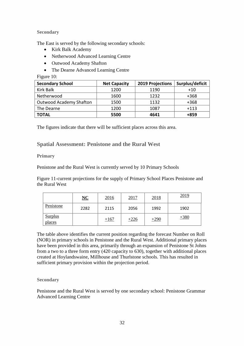
Secondary
The East is served by the following secondary schools:
Kirk Balk Academy
Netherwood Advanced Learning Centre
Outwood Academy Shafton
The Dearne Advanced Learning Centre
Figure 10:
Secondary School Net Capacity 2019 Projections Surplus/deficit
Kirk Balk 1200 1190 +10
Netherwood 1600 1232 +368
Outwood Academy Shafton 1500 1132 +368
The Dearne 1200 1087 +113
TOTAL 5500 4641 +859
The figures indicate that there will be sufficient places across this area.
Spatial Assessment: Penistone and the Rural West
Primary
Penistone and the Rural West is currently served by 10 Primary Schools
Figure 11-current projections for the supply of Primary School Places Penistone and
the Rural West
NC 2016 2017 2018 2019
Penistone 2282 2115 2056 1992 1902
Surplus
places +167 +226 +290 +380
The table above identifies the current position regarding the forecast Number on Roll
(NOR) in primary schools in Penistone and the Rural West. Additional primary places
have been provided in this area, primarily through an expansion of Penistone St Johns
from a two to a three form entry (420 capacity to 630), together with additional places
created at Hoylandswaine, Millhouse and Thurlstone schools. This has resulted in
sufficient primary provision within the projection period.
Secondary
Penistone and the Rural West is served by one secondary school: Penistone Grammar
Advanced Learning Centre

33
Figure 12: Current projections for the supply of Secondary School Places Penistone:
NC 2019 projections Surplus/deficit
Penistone Grammar 1400 1512 -112
Penistone Grammar Advanced Learning Centre is the only secondary school to serve
the Penistone and Rural West area of Barnsley. Based on the current projections there
is expected to be a deficit of 112 places in this area at 2019. The Authority is
undertaking a feasibility study on the need for a secondary Free School within the
Town Centre area, a number of pupils from the Dodworth/Town Centre area are
accessing places at Penistone and the Free School should provide additional
alternative places for these pupils.
5.3 Planned Schemes
The previous draft Plan made reference to an application for a Free School which was
to provide an additional 420 primary school places in the Urban Barnsley area. This
application has now been withdrawn.
The Authority currently receives a capital grant from the government for Basic Need
provision which is used to ensure there are sufficient pupil places across the estate for
children starting Primary school. In addition to this, a capital grant for school
condition is also received which allows major works, such as re-roofing, replacement
boilers and school rewiring to take place. At the moment we have managed to keep
these two grants for their intended purpose, but early indications suggest that if
funding continues at the same levels, the school condition fund would have to be used
to support Basic Need Schemes.
5.4 Impact of Proposed Development
Primary School Places
Existing projections for primary school places are based on a 4-5 year timeframe
which currently project forward to 2019. As the methodology used for calculating
school places is closely linked to demographics it is more difficult to accurately
identify the need for school places over long periods. It is essential to provide
certainty that an adequate number of school places are available for the first five years
of the plan period after which point, a plan monitor manage approach will need to be
taken to ensure that sufficient school places are available to meet demand.
The forecast Number on Roll (NOR) in primary schools across the Borough has been
set out in the section above. However, birth rates have reduced over the past four
years which will result in a reduced demand for primary school places. The pressure
on primary schools will decrease as a higher number of pupils move to the secondary
phase than enter at Reception.

34
As detailed in section 5.3 above, the current projections determine need for places up
to 2019. The number of dwellings proposed in the Local Plan would result in an
increase of 954 pupils in the primary school population from 2017-2019. The
proposed housing growth in the Local Plan will have the following impact on primary
school places:
Urban Barnsley-Number of dwellings identified by the Local Plan/number of
additional pupils and impact on school places at 2019
BMBC currently utilises a formula which anticipates that 100 dwellings will generate
an additional 3 pupils in each year group i.e. 21 primary pupils and 15 secondary
pupils.
Figure 13
Area Net
Capacity 2019
Projections No. of
dwellings Additional
pupils Adjusted
Total Surplus/deficit
Urban Barnsley 8866 8976
2299 483 9459 -593
The table above indicates the number of dwellings proposed for Urban Barnsley up to
the 2019/20 school year, together with the number of pupils expected to be generated
by these developments and the expected impact. The table indicates there will be a
deficit of 593 places in the Urban Barnsley area by 2019.
Due to recent changes to central government policy there is uncertainty around
funding for the provision of new schools. Whilst the onus remains with Local
Authorities to enable the schools, there is no allocated central government funding to
do so. It is expected that the provision of new schools are to take the form of free
schools. Therefore the Council have made provision in the local plan to meet the
identified shortfall and allocated four sites for primary schools. However, given the
current uncertainty of funding available for the development of new schools, further
work will need to be done alongside partners to support their delivery. Following
discussion with BMBC Education further details regarding the provision of the school
required as part of the development on mixed use site MU1 Land south of Barugh
Green Road is included in the Infrastructure Delivery Programme.
Eastern Barnsley- Number of dwellings identified by the Local Plan/number of
additional pupils and impact on school places at 2019
Figure 14
Area
Net Capacit
y
2019 Projection
s
No. of dwelling
s
Additional pupils
Adjusted Total
Surplus/deficit
Eastern Barnsle
y 8861 7519
2041
429 7948 +913
The table above indicates the number of dwellings proposed for Eastern Barnsley in
the 2019/20 period, together with the number of pupils expected to be generated by

35
these developments and the expected impact. The table indicates there will be a
surplus of 913 places in the Eastern Barnsley area by 2019.
Penistone and the Rural West- Number of dwellings identified by the Local
Plan/number of additional pupils and impact on school places at 2019
Figure 15
Area Net
Capacity
2019 Projection
s
No. of dwelling
s
Additional Pupils
Adjusted Total
Surplus/deficit
Penistone
2282 1902 864
182 2084 +198
The table above indicates the number of dwellings proposed for Penistone and Rural
West in the 2019/20 period, together with the number of pupils expected to be
generated by these developments and the expected impact. The table indicates there
will be a surplus of 198 places in this area by 2019.
Secondary School Places
Figure 16: The projections for all secondary schools are included below
Secondary School Net Capacity 2019 Projections
Barnsley Academy 900 927
Darton College 1200 1137
Holy Trinity 700 784
Horizon 2000 2192
Kirk Balk 1200 1190
Netherwood 1600 1232
Outwood Academy Carlton 1100 789
Outwood Academy Shafton 1500 1132
Penistone Grammar 1400 1512
The Dearne 1200 1087
TOTAL 12800 11982
There will be an impact as the increasing primary pupil population moves to the
secondary phase putting significant pressure on places over the next 7 years. There is
however a distinction to be made between the oversubscribed schools within the
Urban Barnsley and Penistone area (Figures 13 and 15) against those in the east of the
Borough (Figure 14) that will continue to have a surplus of places.
It is essential to ensure that sufficient places are available for the first five years of the
plan period (2014-2019) and a plan, monitor, and manage approach taken to
determine need over the remainder of the plan period. This is due to the difficulties
associated with planning for school places over long periods due to the methodology
being heavily dependent on demographics.

36
It is more difficult to identify which secondary school would serve an individual area
as there is greater mobility for secondary pupils throughout the Borough.
Based on the projections provided by the BMBC Education Department detailed in
Figure 16, it is expected that there will be a surplus of 818 secondary school places
across the Borough in 2019.
5.5 Summary of Education Infrastructure
The forecast of pupil numbers will be updated shortly with the NOR from the
September 2016 census together with a further year’s birth data for the 2015/16
school year which will provide one further projection year to 2020/21.
It is expected that there will be a requirement to provide additional primary and secondary school places to support housing growth up to 2033. However, as the methodology for determining need for school places is heavily linked to demographics it is difficult to accurately determine need for the full plan period. It is therefore important to ensure that the current and planned infrastructure is adequate to meet need in the first five years of the plan period (2014-20) and a plan, monitor and manage approach taken to determine need for subsequent five year periods and in response to individual planning applications in terms of impact on school places.
In terms of primary school provision, there have been 13 new primary schools under
the government’s Private Finance Initiative (PFI). There is still further school building
works required to be undertaken in the Authority’s remaining maintained primary
schools estate to bring them up to modern day standards. All Barnsley’s secondary
(9) and special (2) schools have been rebuilt within the last ten years under the
government’s Building Schools for the Future (BSF) programme.
From the projections provided by BMBC Peoples Directorate it is clear that the
Reception (age 5) intake will reach will be a peak in 2016; following a 15% reduction
the position will then stabilise. The secondary phase will however continue to increase
as the current primary cohort transfers into secondary schools. This is expected to
continue until 2023.
Due to recent changes to central government policy there is uncertainty around
funding for the provision of new schools. Whilst the onus remains with Local
Authorities to enable the schools, there is no allocated central government funding to
do so. It is expected that the provision of new schools are to take the form of free
schools.
Funding mechanisms could include
Basic Needs Allowance
Potential S106 predominantly to expand existing schools
Free Schools (central government funding)
Potential CIL for new schools later on in the plan period
Therefore the Council have made provision in the local plan to meet the identified
shortfall and allocated four sites for primary schools. However, given the current

37
uncertainty of funding available for the development of new schools, further work
will need to be done alongside partners to support their delivery.

38
6) Utilities
6.1 Data Sources
This section covers the primary utility networks linked with electricity, gas and water supply and waste water treatment.
The following sources of information have been used to populate this chapter:
Electricity
Northern Powergrid Long Term Development Statement, 2013
Northern Gas Networks Long Term Development Statement 2013
National Grid, Gas Transportation, Ten Year Statement 2013
Meeting with Northern Powergrid. 9th September 2014
Website access to Northern Powergrid website
Northern Powergrid response to the Local Plan Consultation 2014
Gas
Northern Gas Networks, Long Term Development Statement (LTDS) 2013
Northern Gas Networks, Business Reports 2012
Northern Gas Networks, Stakeholder Report 2013
Water Supply and Treatment
Discussion with Yorkshire Water (2014)
Representations received from Yorkshire Water on the Barnsley Local Plan Additional Consultation 2015
6.2 Existing Infrastructure and Fit for Purpose Electricity
The local electricity distribution network in the Barnsley area is operated by Northern
Powergrid (NPg) which is a wholly owned subsidiary of Berkshire Hathaway Energy.
The network connects to the National Grid network which is owned and operated by
National Grid Company. Electricity is regulated by Ofgem.
The electricity network is fit for current usage. Early discussions with NPg and an
examination of their Long Term Development Statement (LTDS) for 2013 indicate
that in the short term up to 2017/2018 there is sufficient capacity at 132KV/Primary
Sub-station level throughout the area. Locally some substations have limited spare
capacity and the supply solution could be reinforcement or system manipulated. This
would depend upon the nature of the demand and the timescales involved. Each
development area is considered in relation to those substations which could supply it.
It is very likely that local low voltage reinforcements will be required for individual
developments and the cost of these should be consistent with the budgets for the
developments.

39
Gas
The local gas distribution network in the Barnsley area is predominately supplied by
National Grid (NG) though part of the north of the Borough is supplied by Northern
Gas Networks (NGN). Both areas receive gas from National Grid’s main transmission
system. Barnsley is well positioned in Yorkshire being close to the major gas import
installations on the East Coast. The gas industry is regulated by Ofgem.
Figure 16: Map of Gas Suppliers in Barnsley MBC

40
Figure 17: Northern Gas Networks’ Distribution Map
Source: Northern Gas Networks
Northern Gas Networks and National Grid receive gas at high pressure from National
Grid’s main transmission lines. The gas enters the local network at high pressure and
through a series of pressure reducers, governors and gasometers and increased main
sizes, the pressure is adjusted for distribution to premises.
The gas network is fit for current usage.
Figure 18: Beach to Meter schematic
Source: Northern Gas Networks

41
Water Supply
The regulated water company in the area is Yorkshire Water (YW). Their regulator is
Ofwat. YW is responsible for the full range of the water business from production,
treatment, distribution, metering and billing.
Figure 19: Yorkshire Water’s Supply Grid
Waste Water Treatment
The Waste Water Treatment Works in Barnsley are set out below:
Urban Barnsley
Cheese bottom WwTW
Darton WwTW
Lundwood WwTW
Eastern Barnsley
Darfield WwTW
Wombwell WwTW
Grimethorpe WwTW
Bolton upon Dearne WwTW
Worsbrough WwTW

42
Penistone and Rural West
Cudworth WwTW
Silkstone WwTW
Cawthorne WwTW
High Hoyland WwTW
Hoyland Swaine WwTW
Ingbirchworth WwTW
Langsett WwTW
Scout Dike WwTW
Tankersley WwTW
6.3 Planned Schemes
Electricity
There is much planned work proposed for West Melton Supply Point which serves
Barnsley, mainly for connecting generated electricity and renewing transformers. This
work does not increase West Melton’s capacity to support development.
The majority of works to existing substations planned in the area seek to enable the
connection of locally generated electricity, which does not improve the system ability
to meet the demands of new development. The introduction of generated electricity
into the networks affects fault levels and requires additional system management to
counter the effect of generated electricity.
Gas
Northern Gas Networks and National Grid carry out major refurbishment programmes
of gas mains throughout Yorkshire as part of their overall asset management plans.
This work covers the statutory replacement of old iron mains within 30 metres of
properties and the replacement of old and corroded cast iron and ductile iron mains.
There are no future programmes of work planned by the Northern Gas Networks or
National Grid.
Other companies in the gas industry are responsible for production, metering and
billing.
The gas connections market is very competitive, and whilst Northern Gas Networks
and National Grid do have a connections business and they are the incumbents in the
area, other operators will provide the service in Barnsley.
Water Supply and Waste Water Treatment
Yorkshire Water will commence its next 5 year Asset Management Plan (known as
AMP 6) in April 2015 and will have sign-off for the business plan from their regulator
OFWAT in December 2014. It is likely that there will be significant works to meet
new water quality requirements undertaken at Lundwood, Cudworth and Wombwell

43
waste water treatment works (WwTW). Lundwood serves all of the urban area of
Barnsley itself as well as Royston and Wombwell treats foul flows from Hoyland.
Growth within these catchments would be allowed for in the design of the
improvement works.
It has now been confirmed that following investigation work for a major
refurbishment of the Bolton upon Dearne WwTW to meet new water quality
requirements and to provide for additional treatment capacity to accommodate growth
in the catchment. Yorkshire water will be undertaking a major refurbishment of
Bolton upon Dearne WwTW scheme where the works will likely move from utilising
filters to an activated sludge process. Yorkshire Water will continue to liaise with
Barnsley Council as more detailed designs emerge.
Development within Cudworth and Penistone would have to be prioritised within
YW's region wide growth funding allowance. The WwTW serving these settlements
are relatively small and so development should be appropriately phased to allow for
any necessary infrastructure to be put in place in a timely manner to properly serve the
development.
6.4 Impact of Proposed Development
The overall quantum of development assessed by the utilities providers in 2014 is broadly commensurate to that going forward in the Local Plan Publication Version. We have received confirmation from Northern Gas Networks that (for their network area) the information contained in the IDP is still applicable and there is sufficient capacity in the network to support the level of growth identified in the Local Plan. In addition we will continue to work with the relevant utility providers through the course of Publication consultation and in preparation for examination.
Electricity
Electricity provision overall would seem to be adequate to meet residential growth
aspirations up to 2033. This is confirmed in Northern Power Grid’s response to the
Barnsley Local Plan Consultation 2014. Local strategic reinforcements would be
needed at the primary substations in the areas of Hoyland and Urban Barnsley West if
all the employment development currently proposed in the Local Plan materialises in
these areas. Size and timescales of these elements would depend upon the size of the
development and its delivery timescale.
Electricity Demand and Capacity
Figures of annual electricity consumption for buildings are widely published; however the specific maximum instantaneous electrical demand for buildings is less well understood. Whereas consumption increases fairly linearly with development floor area, maximum demand per unit area is smaller for larger developments, as the proportion of equipment that can reasonably be expected to be operating simultaneously is less.
Although published guidance is available for design of individual buildings this is less suited to larger developments where it can result in significant over estimation.

44
It is generally recognised throughout the industry that demand is overestimated. Arup is working on Maximum Demand Methodologies and this work has confirmed excessive overestimates of electricity demand. Over estimation of demand results in investment in over-sized electrical infrastructure, increased running costs and longer completion times. Over estimation also effects the evaluation of spare capacity at substations.
There is no industry standard approach for estimating demand. The key issue here is very often the “diversity factor”. This in its simplest form is the proportion of electricity actually being used on a proportioned number of devices by the proportioned number within a population instead of the theoretical maximum used by all devices and the whole population
The demand profiles for residential developments are well known since people tend to follow routines and patterns. Demand profiles for the planning classifications for industry, commercial, retail and entertainment are less well understood and without specific purposes and uses the maximum demand is more difficult to estimate correctly.
Electricity distribution companies use differing methods depending upon the extent of the development. The size of the development dictates the “diversity factor” and if the development is mixed then the coincidence of commercial/retail/industry loads with residential loads can be applied further reducing the theoretical maximum demand.
The diversity factor and maximum demand was discussed with UKPN with a view to
agreeing the load per residential unit and the load per area (m2). An overall demand
of 2kW/residential unit was finally agreed. The load per m2 of
commercial/industry/retail was harder to agree because of the wide range of uses
within the planning categories and the lack of detail within the development quanta.
UKPN provided indicative loads from their records against types of business though
without specific details (when, where, what etc.). These figures ranged from
23kWh/m2 for light manufacturing to 450kWh/m2 for high end supermarkets.
Following discussions with UKPN the figure of 120W/m2 was agreed as being a
realistic standard average demand for the employment quanta.
Development Quanta and Electrical Demand
NPg’s LTDS forecasts load/demand information up to 2017/2018. Beyond that period the load/demand information forecast figures can be extrapolated and an estimation of when load/demand exceeds capacity can be made. BMBC is planning an extra 20,621 homes up to 2033. This represents approximately 1100 homes per year from 2014 to 2033 and an additional after diversity load/demand on the system of approximately 2.2MW per year. This load/demand is spread throughout the Borough area including the following centres; Barnsley, Penistone, Royston, Wombwell, Cudworth, Hoyland and Goldthorpe. The development settlements, their residential size, employment proposals and electrical demands are shown in the table below (Figure 20).
Figure 20: Predicated Electricity Demand for Proposed Development Quantum
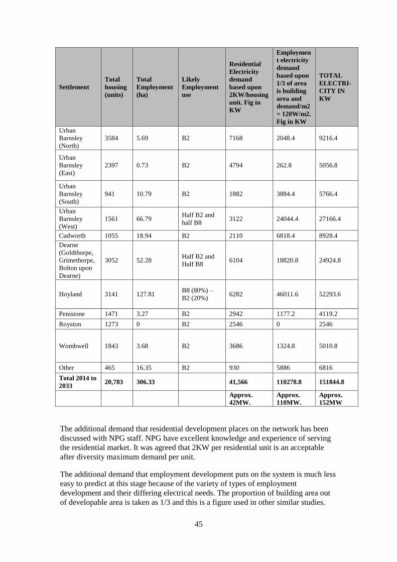
45
Settlement
Total
housing
(units)
Total
Employment
(ha)
Likely
Employment
use
Residential
Electricity
demand
based upon
2KW/housing
unit. Fig in
KW
Employmen
t electricity
demand
based upon
1/3 of area
is building
area and
demand/m2
= 120W/m2.
Fig in KW
TOTAL
ELECTRI-
CITY IN
KW
Urban
Barnsley
(North)
3584 5.69 B2 7168 2048.4 9216.4
Urban
Barnsley
(East)
2397 0.73 B2 4794 262.8 5056.8
Urban
Barnsley
(South)
941 10.79 B2 1882 3884.4 5766.4
Urban
Barnsley
(West)
1561 66.79 Half B2 and
half B8 3122 24044.4 27166.4
Cudworth 1055 18.94 B2 2110 6818.4 8928.4
Dearne
(Goldthorpe,
Grimethorpe,
Bolton upon
Dearne)
3052 52.28 Half B2 and
Half B8 6104 18820.8 24924.8
Hoyland 3141 127.81 B8 (80%) –
B2 (20%) 6282 46011.6 52293.6
Penistone 1471 3.27 B2 2942 1177.2 4119.2
Royston 1273 0 B2 2546 0 2546
Wombwell 1843 3.68 B2 3686 1324.8 5010.8
Other 465 16.35 B2 930 5886 6816
Total 2014 to
2033 20,783 306.33
41,566 110278.8 151844.8
Approx.
42MW.
Approx.
110MW.
Approx.
152MW
The additional demand that residential development places on the network has been
discussed with NPG staff. NPG have excellent knowledge and experience of serving
the residential market. It was agreed that 2KW per residential unit is an acceptable
after diversity maximum demand per unit.
The additional demand that employment development puts on the system is much less
easy to predict at this stage because of the variety of types of employment
development and their differing electrical needs. The proportion of building area out
of developable area is taken as 1/3 and this is a figure used in other similar studies.

46
The range of demand/m2 for the range of planning categories was discussed with
NPG and until such time as development types are confirmed a figure of 120W/m2
was agreed as an acceptable figure.
A detailed demand analysis of any multi-use (residential and employment) would
include diversifying residential and employment demands on the simple basis that
much of electricity demand follows persons. There are lags before and after
arrival/departure and these can be calculated and accounted for. The figures used
above assume no diversity between residential and employment and thus at this stage
the combined demand is an overestimate.
Taking all the development quanta into account it can be seen that proposed
employment could have a significant effect upon the network and depending upon its
location could require extensive reinforcement of the network.
Existing Electricity Network Capacity
Discussions with NPG staff and examination of the LTDS have indicated the spare capacity at substations throughout the area. This information is then used to determine what spare capacity there is in relation to proposed developments, at which substation it is and which substations will need reinforcement.
At the Bulk Supply level, Barnsley is supplied via 132kv Bulk Supply Points at
Barugh and Hunshelf, 66kv Bulk Supply Point at Hunningley and 33kv Bulk Supply
Point at West Melton. At this level of voltage these substations have over 190MW
spare which exceeds the future maximum possible increase in demand of 152MW. As
this capacity is spread through the substations it is evident that some 11kv substations
have far more capacity than others.
The table below has been produced using information from discussions with NPg
staff, examination of the LTDS and use of the NPg website.
Figure 21: Predicated Electricity Demand and Capacity at Adjacent Sub Stations
Settlement Max
Residential
Demand in
MW
Max
Employment
Demand in
MW
TOTAL
MAX
DEMAND
in MW
Adjacent
substations
Total Spare
Capacity at
these
substations
in MW.
Urban Barnsley
(North)
7.2 2 9.2
Barnsley* ,
Barugh,
Smithy Green 11
Urban Barnsley
(East)
4.8 0.3 5.1
Hunningley,
Stairfoot,
Burton Road,
Fish Dam* 25
Urban Barnsley
(South) 1.9 3.9 5.8
Worsborough,
Aldham 6
Urban Barnsley
(West) 3.1 24 27.1
Barnsley,
Elmhirst Lane,
Penistone* 11.7
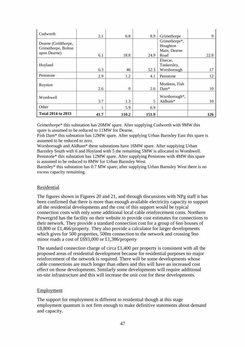
47
Cudworth 2.1 6.8 8.9 Grimethorpe 9
Dearne (Goldthorpe,
Grimethorpe, Bolton
upon Dearne) 6.1 18.8 24.9
Grimethorpe*,
Houghton
Main, Dearne
Road 22.8
Hoyland
6.3 46 52.3
Elsecar,
Tankersley,
Worsborough 17
Penistone 2.9 1.2 4.1 Penistone 12
Royston 2.6 0 2.6
Monkton, Fish
Dam* 10
Wombwell 3.7 1.3 5
Worsborough*,
Aldham* 10
Other 1 5.9 6.9
Total 2014 to 2033 41.7 110.2 151.9 126
Grimethorpe* this substation has 20MW spare. After supplying Cudworth with 9MW this
spare is assumed to be reduced to 11MW for Dearne.
Fish Dam* this substation has 12MW spare. After supplying Urban Barnsley East this spare is
assumed to be reduced to zero.
Worsborough and Aldham* these substations have 16MW spare. After supplying Urban
Barnsley South with 6 and Hoyland with 5 the remaining 5MW is allocated to Wombwell.
Penistone* this substation has 12MW spare. After supplying Penistone with 4MW this spare
is assumed to be reduced to 8MW for Urban Barnsley West.
Barnsley* this substation has 0.7 MW spare; after supplying Urban Barnsley West there is no
excess capacity remaining.
Residential
The figures shown in Figures 20 and 21, and through discussions with NPg staff it has been confirmed that there is more than enough available electricity capacity to support all the residential developments and the cost of this support would be typical connection costs with only some additional local cable reinforcement costs. Northern Powergrid has the facility on their website to provide cost estimates for connections to their network. They provide a standard connection cost for a group of 6no houses of £8,800 or £1,466/property. They also provide a calculator for larger developments which gives for 500 properties, 500m connection to the network and crossing 9no minor roads a cost of £693,000 or £1,386/property
The standard connection charge of circa £1,400 per property is consistent with all the proposed areas of residential development because for residential purposes no major reinforcement of the network is required. There will be some developments whose cable connections are much longer than others and this will have an increased cost effect on those developments. Similarly some developments will require additional on-site infrastructure and this will increase the unit cost for these developments.
Employment
The support for employment is different to residential though at this stage
employment quantum is not firm enough to make definitive statements about demand
and capacity.

48
Figure 20 and 21 identifies Urban Barnsley West, Dearne and Hoyland as areas which
if fully developed with employment will need additional capacity at 11kv.
Urban Barnsley West area is assumed to spread from the west side of the town centre
out over the MI and towards Penistone. This area would be supplied mainly from
Elmhirst Lane which itself is fed from the Bulk Supply Points at Barugh and
Hunshelf. There is very limited spare capacity at Barnsley to send into this area. If the
employment demand reaches the maximum target of the development quanta then an
additional 16MW is required. This would entail the enlargement of Elmhirst and the
reinforcement of its connection from Barugh or Hunshelf. The estimated cost of
providing this extra 16MW is estimated as £3.5m.
Dearne contains Grimethorpe, Goldthorpe and Bolton upon Dearne and is a
widespread area to the East of Barnsley. At this stage the estimated total demand is
circa 25MW made up of circa 6MW for residential and 19MW for employment.
There is circa 23MW spare at the substations. It is considered that with demand
refinement, diversification between residential and employment demands and system
manipulation the system would not need major reinforcement to meet these demands.
This area is targeted for development and borders Doncaster and Rotherham who
have their own development plans for their parts of this area. Development activity is
these adjacent Council areas should be coordinated with regard to overall energy and
electricity strategy to ensure the most efficient use of energy and electricity and the
networks that provide it.
Hoyland is identified as the area with the largest proposed employment development
and the development demand far exceeds the capacity of the local 11kv systems. The
nearest bulk supply point at West Melton is already at 87% capacity and has only
18MW spare. At this stage the estimated total demand is circa 52MW made up of
6MW for residential and 46MW for employment. The available capacity at the local
substations is 17MW. It is considered that if all this employment development
materialises then the Supply Point at West Melton would have to be reinforced as well
as substations at Tankersley, Worsborough and Elsecar. The cost of this is estimated
at £4m to get the required additional capacity of 35MW into the area. We are
continuing to work with Northern Power Grid to better quantify the cost implications.
Timescales for Delivery
The electricity supply infrastructure does not have a timescale to deliver additional supplies to meet development proposals. When development proposals receive confirmation then contact with NPg should be made to give it sufficient time to include any local reinforcements in its asset management plans. The planning, design and construction of additional primary substations can take up to 2 years to complete so advance notice of development proposals is recommended.
Cost of Connections
It is considered that there are no exceptionally high connection costs for the residential developments. The employment connections if kept within the capacity of the local substations again would have no exceptionally high connection costs.
The only areas where high costs are likely to occur are for the employment development areas of Urban Barnsley West and Hoyland.

49
The additional costs over and above the normal connection costs for all the proposed
development quantum in Urban Barnsley West is estimated as £3.5m. We are
continuing to work with Northern Power Grid to better quantify the cost implications.
The additional costs over and above the normal connection costs for all the proposed
development quantum in Hoyland is estimated as £8m. We are continuing to work
with Northern Power Grid to better quantify the cost implications.
Gas
All the development areas are presently located with areas with a gas supply. All the proposed residential development areas will have an existing gas network in their vicinity and, according to National Grid and Northern Gas Networks, the issue here is the length and size of gas pipe to be installed from the proposed development area to that point on the gas network which has sufficient capacity to meet the demand of the development.
The employment developments, their gas demands and the capacity of the local network to supply the demand is much less clear than residential. Some employment may require medium pressure connections whilst others may not require any gas at all and use electricity to supply all their energy needs.
The table below provides an estimate of the gas demands that the development areas will create.

50
Figure 22: Predicated Gas Demand based on Proposed Development Quantum
Settlement
Total
housing
(units)
Total
Employment
(ha)
Likely
Employment
use
Residential
Gas demand
based upon
5KW/housing
unit. Fig in
KW
Employment
gas demand
based upon
1/3 of area is
building
area and
demand/m2
= 80W/m2.
Fig in KW
TOTAL
GAS in
KW
Urban Barnsley
(North) 3584 5.69 B2 17920 1365.6 19285.6
Urban Barnsley
(East) 2397 0.73 B2 11985 175.2 12160.2
Urban Barnsley
(South) 941 10.79 B2 4705 2589.6 7294.6
Urban Barnsley
(West) 1561 66.79
Half B2 and
half B8 7805 16029.6 23834.6
Cudworth 1055 18.94 B2 5275 4545.6 9820.6
Dearne
(Goldthorpe,
Grimethorpe,
Bolton upon
Dearne)
3052 52.28 Half B2 and
Half B8 15260 12547.2 27807.2
Hoyland 3141 127.81 B8 (80%) –
B2 (20%) 15705 30674.4 46379.4
Penistone 1471 3.27 B2 7355 784.8 8139.8
Royston 1273 0 B2 6365 0 6365
Wombwell 1843 3.68 B2 9215 883.2 10098.2
Other 465 16.35 B2 2325 3924 6249
Total 2014 to
2033 20,783 306.33 103,915 73,519.20 177,434
SAY 104
MW. Say 74MW. 178MW
Through discussions with Northern Gas Networks it has been confirmed that the residential gas demand of a single unit is approximately 5MW. The majority of this gas will be used for heating and this heating load is very predicable with regard to time of the day and the year. The outside temperature will have a profound effect upon the demand. The heating aspect of this demand is thus much less diverse than for cooking or washing. Gas heating demand is much less diverse than electricity demand, more stable and much higher in terms of MW. The gas infrastructure is designed to support the distribution of these large quantities of energy.
There is diversity between residential demands and industry demands and this has not been taken into account in the above figures so the total above is an overestimate of the likely total demand.

51
The effect of employment on the overall gas demand is significant but in total the employment demand is less than the residential demand. The employment demand in most areas is no more than the addition of few hundred residential units. On this basis, these areas will have sufficient gas in their vicinity for their developments and the cost of connecting it will not be exceptionally high.
There are two development areas; Urban Barnsley West and Hoyland where employment demand exceeds residential demand. This is considered to be sufficiently significant and in response it is considered that these areas will require some additional reinforcement. A standard gas connection is circa £1000 per property taking into account the cost of mains to get the gas to the street and then the service from the street into the property. Employment connection costs have a much wider range. It is considered that the cost of the reinforcement works to support ALL the proposed development in Hoyland and Urban Barnsley West would result in costs being 10-20% higher in these areas than others. The accuracy of this figure would improve when more specific locations of the employment areas are determined and then examined in relation to their demands and the local gas network.
There is no infrastructure gap in provision of gas, as only local reinforcements are required.
Timescales for Delivery
The gas supply infrastructure does not have a timescale to deliver additional supplies to meet the development proposals. When development proposals receive confirmation then early contact with National Grid/Northern Gas Networks should be made to give them sufficient time to include any local reinforcements in their asset management plans.
Delivery of Connections
The gas industry is the most open and competitive with regard to connections. There are many companies with an interest in installing and investing in gas apparatus. Connections can be installed by Independent Connections Providers (ICP) who due to their structure can install more competitively than the local incumbents. These ICPs can sell the assets back to the incumbents or to Independent Gas Transporters (IGT). These IGTs earn revenue from the gas transported through their assets.
Water Supply
Dialogue with Yorkshire Water in 2014 had confirmed that there are no strategic water supply issues in the Barnsley Borough and there is adequate capacity to provide water to the proposed quantum of development. Waste Water Treatment
As set out in Section 6.3 YW will work to carry out the necessary upgrades and agree
phasing with developers as appropriate.

52
6.5 Summary of Utilities Infrastructure
The overall quantum of development assessed by the utilities providers in 2014 is broadly commensurate to that going forward in the Local Plan Publication Version. We have received confirmation from Northern Gas Networks that (for their network area) the information contained in the IDP is still applicable and there is sufficient capacity in the network to support the level of growth identified in the Local Plan. In addition we will continue to work with the relevant utility providers through the course of Publication consultation and in preparation for examination.
Electricity
Electricity provision overall would seem to be adequate to meet residential growth
aspirations up to 2033. Local strategic reinforcements would be needed at the
primary substations in the areas of Hoyland and Urban Barnsley West if all the
employment development as proposed materialises in these areas. Size and timescales
of these elements would depend upon the size of the development and its delivery
timescale.
Gas
Early discussions with National Grid and Northern Gas Networks have confirmed that
the overall gas network within BMBC is robust and flexible and that strategic
reinforcement of the network would not be necessary to support the development set
out in the emerging Local Plan. Local reinforcements will be required to service local
developments as and when these are allocated and designed. These should be
considered as extensions to the existing local distribution networks and in proportion
to the size of the proposed development and consistent with costs that would normally
be associated with providing services to developments.
Water Supply
Dialogue with Yorkshire Water in 2014 confirmed that there were no strategic water
supply issues in the Barnsley Borough and there is adequate capacity to provide water
to the proposed quantum of development.
Waste Water Treatment
Yorkshire Water will commence their next 5 year Asset Management Plan (known as
AMP 6) in April 2015 and will have sign off for the business plan from their regulator
OFWAT in December 2014. It is likely that there will be significant works to meet
new water quality requirements undertaken at Lundwood, Cudworth and Wombwell
waste water treatment works (WWTW). Lundwood serves all of the urban area of
Barnsley itself as well as Royston and Wombwell treats foul flows from Hoyland.
Growth within these catchments would be allowed for in the design of the
improvement works.

53
It has now been confirmed that following investigation work for a major
refurbishment of the Bolton upon Dearne WwTW to meet new water quality
requirements and to provide for additional treatment capacity to accommodate growth
in the catchment. Yorkshire water will be undertaking a major refurbishment of
Bolton upon Dearne WwTW scheme where the works will likely move from utilising
filters to an activated sludge process. Yorkshire Water will continue to liaise with
Barnsley Council as more detailed designs emerge.
Development within Cudworth and Penistone would have to be prioritised within
YW's region wide growth funding allowance. The WWTW serving these settlements
are relatively small and so development should be appropriately phased to allow for
any necessary infrastructure to be put in place in a timely manner to properly serve the
development.
As set out in Section 6.3 YW will work to carry out the necessary upgrades and agree
phasing with developers as appropriate.

54
7) Climate Change and Renewable Energy
7.1 Data Sources
This section covers the provision of renewable energy and climate change infrastructure.
The following sources of information have been used to populate this chapter:
A discussion with BMBC Housing and Energy Service
BMBC Energy Strategy 2015-2025
7.2 Existing Infrastructure and Future Objectives
BMBC is seeking to promote a lower carbon economy as set out in the Energy Strategy 2015-2025. The strategy builds upon the Councils long established focus on the energy efficiency of the BMBC property estate to a situation where land assets are used to produce local green energy as well as facilitating private sector investment in energy production.
Wind Energy
The Borough has a significant wind resource, particularly in more rural areas such as
Penistone and the Rural West and parts of Eastern Barnsley. Wind energy
development in the borough has been concentrated in the rural west in the Pennine
Foothills. There may also be locations where future wind energy schemes could be
accommodated.

55
The following operational schemes have been consented:
Figure 23: Consented and operational wind energy schemes-borough wide.
Scheme Name Type Capacity
(MW)
Scheme
Status
Planning
Ref
Blackstone
Edge Wind
Farm
Wind (3 turbines) 2MW each
turbine Operational 2008/0171
Royd Moor
Wind Farm Wind (13 turbines)
0.5 MW each
turbine Operational
Hazelhead
Wind Farm Wind (3 turbines)
2.5MW each
turbine Operational 2006/1575
Spicer Hill
Wind Farm Wind (3 turbines)
2.3MW each
turbine Operational 2009/0572
Darton ALC Wind (1 turbine) 0.225MW Consented 2011/0397
Engine Lane,
Shafton Wind (1 turbine) 0.225MW Consented 2011/0398
Penistone ALC Wind (1 turbine) 0.225MW Consented 2011/0403
Land at
Highwells
Farm
Wind (1 turbine) 0.055MW Consented 2011/1413
Bird Lane
House Farm Wind (1 turbine) 0.011MW Consented 2012/0150
Martins Nest
Farm Wind (1 turbine) 0.050MW Consented 2012/0222
Bull Haw Hill
Farm Wind (1 turbine) 0.050MW Consented 2012/0395
Broadstone
Reservoir Wind (1 turbine) 0.050MW Consented 2012/0689
Cockle Edge
Farm Wind (1 turbine) 0.1MW Consented 2012/0691
Mount
Pleasant Farm Wind (1 turbine)
0.080MW each
turbine Consented 2012/1140
Houghton Wind (2 turbines) 0.5MW Consented 2013/1039
Ferry Moor
Lane
Cudworth
Wind (1 turbine) 2MW each
turbine Operational 2008/0171
Strategic Heat Networks
Feasibility studies have shown that a commercially viable heat network could be
developed in and around Barnsley Town Centre to serve a variety of public and
private sector systems. Feasibility work continues, with a view to a network being
constructed from 2018 onwards.
Biomass
In addition to the wind energy developments, Urban Barnsley has sufficient heating
density to support district heating networks. Recognising the Borough’s district

56
heating potential, BMBC has implemented a programme to connect buildings to a
biomass heating scheme. The Council initiated the programme with a number of its
own public buildings and has established a local biomass supply chain from which to
source its biomass heat supply. The South Yorkshire Forest provides a strong
opportunity to increase the availability of wood to use for biomass.
The following schemes are currently operational:
Figure 24: Existing district heating networks in Barnsley
Type of system Description Postcode
Boiler House Sheffield Road Flats S70 4NW
Boiler House 500 KW scheme for the
Council depot, Smithies
Lane
S71 1NL
Boiler House Town Hall S70 2TA
Boiler House Digital Media Centre S70 2JW
Solar Photovoltaics
The Council has already begun to increase the uptake of this technology through the
Energise Barnsley programme, under which panels are being installed on housing and
non-domestic properties in the Council’s ownership.
7.3 Planned Schemes
Dearne Valley Ecovision
A vision for the Dearne has been established which seeks to transform the Dearne
over the next 25 to 30 years. This is known as the Dearne Valley Eco-Vision and is a
partnership including Barnsley, Doncaster and Rotherham. The vision is for a whole
new future and a whole new identity for the Dearne Valley as the first Eco Park in the
UK. However, financial constraints in recent years have necessitated a fundamental
review of the Eco-Vision. This review report is due to be published later this year.
Metrodome Leisure Centre Boiler Replacement
It is anticipated that the existing boiler at the Metrodome Leisure Centre will be
replaced by the installation of a combined heat and power plant. Should the scheme
go ahead it is likely that a new gas main will be required. This work will be funded
by Norse Energy.
7.4 Impact of Proposed Development
It will be possible to deliver the proposed level of housing and employment growth
planned in Barnsley without increasing the supply of renewable energy. However the
Council has set a clear policy commitment to increase the level of renewable and low
carbon energy. Barnsley already has a strong track record of delivering biomass and

57
wind power. The South Yorkshire Forest provides a strong opportunity to increase
the availability of wood to use for biomass.
The planned new housing and employment development in Barnsley will be required to meet building regulation standards in relation to fabric efficiency.
BMBC will also investigate on-going opportunities to support the low carbon economy and favourably consider the delivery of renewable energy, with consideration of technical and environmental constraints.
Potential funding opportunities to support the delivery of renewable and low carbon energy include:
Energy Service Companies (ESCos)
Feed-in-tariffs
Renewable Energy Heat Incentive
Salix Finance (Carbon Trust)
Community Infrastructure Levy
Energy Company Obligation (ECO).
Section 106
Various strands of European funding
BMBC Capital fund
Barnsley Solar Bond (under Energise Barnsley)
Leeds City Region and Sheffield City Region Local Growth Funds
Sheffield City Region Investment Fund
7.5 Summary of Climate Change and Renewables Infrastructure
BMBC is seeking to promote a lower carbon economy as set out in the Energy Strategy 2015-2025. The strategy builds upon the Councils long established focus on the energy efficiency of the BMBC property estate to a situation where land assets are used to produce local green energy as well as facilitating private sector investment in energy production.
The Council has set a clear policy commitment to increase the level of renewable and
low carbon energy. Barnsley already has a strong track record of delivering biomass
and wind power. However, whilst a potential funding gap has been identified within
the infrastructure delivery programme for the provision of low carbon infrastructure it
will be possible to deliver the proposed level of housing and employment growth
planned in Barnsley without increasing the supply of renewable/low carbon energy.
Therefore the delivery of the Local Plan is not dependant on these schemes coming
forward.
The planned new housing and employment development in Barnsley will be required to meet building regulation standards in relation to fabric efficiency.
BMBC will also investigate on-going opportunities to support the low carbon economy and favourably consider the delivery of renewable energy, with consideration of technical and environmental constraints.

58
8) Telecommunications
8.1 Data Sources
This section identifies whether adequate telecommunications infrastructure exists in the area to enable the demand for public telecom services to be met, and what additional infrastructure provision might be required.
The telecom services considered in the chapter comprise:
fixed telecom services which are composed of telephone services and access to broadband services;
cellular mobile services; and
television distribution services, including cable TV.
Data sources include
Discussion with Superfast South Yorkshire Team
Mobile network coverage - http:/maps.ofcom.org.uk/check-coverage
8.2 Existing Infrastructure and Fit for Purpose
Digital communications are now a crucial and expected component of everyday life. Over the recent years, technologies such as mobile phones and broadband have revolutionised the way we work, socialise and enjoy our leisure time.
Reliable and high quality fixed and mobile broadband connections support growth in productivity, efficiency and labour force participation across the whole economy. They enable new and more efficient business processes, open-up access to new markets and support more flexible working opportunities.
Demand for digital services and applications are set to rise rapidly, with a consequent acceleration in the amount of data being carried over networks. Over the next decade we can expect the emergence of new services, applications and devices which will create additional demands on networks. To support these demands, it is crucial that infrastructure is available that is high capacity, reliable, resilient, secure, affordable and fast.
With the proposed growth and regeneration of commercial, retail and residential developments within the Borough, there needs to be a consistent requirement for future proofed telecommunications infrastructure to be delivered as standard to meet the growing demands of today’s digital society.
Our residents and businesses expect consumer choice from broadband, telephony and television and this can only be achieved through competition. Competition is a powerful driver of innovation, faster services and improved customer experience.
Ofcom has helped deliver competition in the broadband retail market. More than 95% of homes are able to receive telecoms services from BT exchanges which have been unbundled by other providers, who now have a significant share of the residential

59
broadband market. Without the right regulatory and competitive environment, this investment could not have occurred.
Enabling a digitally connected borough provides significant opportunity for Barnsley to introduce and deliver council services online.
Current Activity
The Superfast South Yorkshire programme is separate from any commercial activity and exists to plug the gap where the commercial market either has not or does not intend to invest in fibre broadband; ensuring no one gets left behind digitally. The programme funding is used to make areas currently deemed as not commercially viable, commercially viable by funding the gap.
As the lead authority Barnsley MBC, on behalf of all South Yorkshire authorities, signed a contract with BT in late 2014 to extend the roll out fibre broadband to 97.9% of South Yorkshire which is over 103,000 premises. Fibre broadband is capable of achieving speeds of 24mbps and above.
Since this time further investment has been made to extend coverage to 99% and
bring ultrafast technology to the Enterprise Zone’s (Ashroyd, Shortwood, Gladman
Park, Capitol Park1) and key business parks (Goldthorpe, Wentworth, Wharncliffe,
Carlton, Park Springs, Claycliffe Business Park, Wentworth, Wharncliffe, Zenith1),
making South Yorkshire EZ one of the best connected in the UK. The public and
private investment through Superfast South Yorkshire is now over £29m.
A phased roll out will take place, with twelve phases that will be completed by the end of 2019. The first areas were able to access improved broadband towards the end of 2015. Fibre to the cabinet (FTTC) will be the main technology used. This can deliver speeds of up to 80Mbps to households.
Fibre to the premises technology (FTTP) − delivering ultra fast speeds of up to 330Mbps - will also be installed in some Enterprise Zones and Business Parks.
The new fibre-based network installed by BT Openreach will be open to all Internet Service Providers. Households and businesses in South Yorkshire will benefit from a highly competitive market, which is expected to bring greater choice and affordability from providers.
The deployment phases can be viewed using the weblink below http://www.superfastsouthyorkshire.co.uk/sfsy/where
In addition, the government has allocated £10 million as part of a national supplementary scheme which provides vouchers to fund the installation of superfast broadband services to the most difficult to reach areas of the UK, i.e. the remaining 1% in South Yorkshire.
Significant investment is also taking place commercially by Virgin across the UK. Virgin’s network is already capable of providing ultrafast speeds of up to 300Mbps and the company is investing £3 billion to extend its network to a further 4 million
1 Please note that only the postcodes and premises which existed at the time of
modelling are included for ultrafast; only areas that are not already covered
commercially are eligible for ultrafast; as the sites develop further the connectivity is
the responsibility of the developer, not Superfast South Yorkshire.
60
homes over the next 5 years. Areas of Barnsley already have access to the Virgin network.
BT is considering building more fibre to the premise (FTTP) broadband, and is carrying out trials of its G.Fast technology, which delivers ultrafast speeds over copper lines. BT has suggested it will use G.Fast to deliver ultrafast speeds of up to 500Mbps to most of the UK within a decade.
Cellular mobile services and mobile internet
All four cellular mobile networks provide services in the Barnsley Borough area.
As elsewhere in the UK, the national networks are currently rolling out 4G. The present state of availability of 4G in the Barnsley area is as follows:
EE (formerly Orange and T-Mobile) – 4G available in Barnsley Town and the whole of the East of the Borough, 4G is limited in parts of the west of the Borough including Crow Edge and Millhouse Green.
02 – 4G available in Barnsley Town and the whole of the East of the Borough. Limited availability in parts of the west of the borough including Penistone, Thurlstone, Millhouse Green, Crow Edge and Langsett.
Three – 4G available in Barnsley Town and most of the East of the Borough, patchy in Royston, Brierley and Thurnscoe. 4G is limited in much of the west of the borough including Penistone, Millhouse Green, Crow, Thurlstone, Oxspring, Thurgoland, Silkstone, Silkstone Common, Cawthorne and Crow Edge.
Vodafone – 4G in Barnsley Town and the whole of the East of the Borough. 4G limited in parts of the west of the Borough including Penistone, Thurlstone, Millhouse Green and Crane Moor.
The cellular mobile companies offer mobile broadband access in Barnsley as elsewhere in the UK.
UK Government targets
Voice coverage to 90% of the UK geographic area by the end of 2017. The government has secured a landmark agreement with the 4 MNOs which will also deliver significant improvements to mobile internet coverage
• 4G rollout: By 2017, 98% of premises should have access to 4G mobile broadband
• Spectrum clearance to further enhance mobile broadband connectivity by helping to future-proof the coverage, capacity and quality of the UK’s mobile networks, the government is committed to releasing 700MHz spectrum for mobile broadband use. Ofcom plans to hold an auction before the end of the Parliament
TV distribution
Off-air TV distribution in the Barnsley area is the same as in the rest of the UK; the Digital Switch Over programme has been completed.
Virgin Media has operated a cable network in Barnsley for many years.

61
Spatial Assessment: Urban Barnsley
Broadband provision in Urban Barnsley is good with broadband availability and speed
within the settlement areas offering residents and non-residents both choice and range
of broadband speeds. Small scale local reinforcement may be needed to support
development.
All four of the main cellular mobile networks provide 3G and 4G services in the
Urban Barnsley area.
In relation to TV distribution, the Digital Switch Over programme has been completed
in this area.
Spatial Assessment: Eastern Barnsley
Broadband provision in the east of the Borough is generally good with broadband
availability and speed within the settlement areas offering residents and non-residents
both choice and range of broadband speeds. Small scale local reinforcement may be
needed to support development.
All four of the main cellular mobile networks provide 3G and 4G services in the
Eastern Barnsley area.
In relation to TV distribution, the Digital Switch Over programme has been completed
in this area.
Spatial Assessment: Penistone and the Rural West
Broadband provision in the West of the borough is generally good. The only
exception to this is in Silkstone. The settlement is served by two operators, other than
BT therefore very little market competition exists. Delivering a high quality provision
of broadband services in the west will play a fundamental role in supporting rural
businesses and improved access to services.
All four of the main cellular mobile networks provide services in the Penistone and
Rural West area. 4G is widely available in this area on the EE network but is limited
on Vodaphone, 02 and Three.
In relation to TV distribution, the Digital Switch Over programme has been completed
in this area.

62
8.3 Fit for Purpose
Is additional telecommunications infrastructure required? What are
the future options?
The future options include
• New development sites and need to building in connectivity
• Ensuring the continued ultrafast status at EZs for new developments
• Universal Service Obligation
8.4 Planned Schemes
8.5 Impact of Proposed Development Demand for superfast broadband and greater is growing fast with businesses and
households, as connectivity is now an essential part of everyday life it is expected by
all consumers. Access to broadband is now likened to essential utilities such as gas
and water, ones that are taken for granted in new developments.
On 5th February 2016 a new agreement was announced between Government,
Openreach and the Home Builders Federation, this will see fibre based broadband
offered to all new developments either for free or as part of a co-funded initiative. It is
estimated that more than half of all new properties can be connected to fibre
broadband free of charge to developers.
As part of this agreement Openreach is introducing an early planning connectivity
assessment for homebuilders, many other suppliers can also offer a similar service.
Having the right level of connectivity is crucial for commercial developments to
ensure businesses have the complete infrastructure available from the first day.
Suppliers are equally interested in working to provide connectivity at commercial
sites, but critically need to be made aware of developments are the earliest possible
opportunity to enable the best solution.
8.6 Summary of Telecommunications Infrastructure
In terms of superfast broadband, Barnsley currently has over 80% of residential and
business premises able to access fibre broadband from previous commercial activity.
All four cellular mobile networks provide services in the Barnsley Borough area, including mobile broadband access. 4G mobile broadband is available in all areas but is limited in Penistone and rural areas. Digital TV is also available in all areas.
The Superfast South Yorkshire programme aims to increase the footprint of fibre broadband infrastructure in the South Yorkshire region to 99% by 2019 which would give access to 103,433 premises, opening up the benefit and opportunities provided by superfast broadband

63
9) Flood Risk and Drainage
9.1 Data Sources
This section considers flood risk infrastructure in Barnsley including fluvial and surface water flooding infrastructure.
The following sources of information have been used to populate this chapter:
BMBC Preliminary Flood Risk Assessment (July 2011)
Discussions with BMBC Drainage Service
Discussions with the Environment Agency (2014)
Discussions with Yorkshire Water (2014)
9.2 Existing Infrastructure and Fit for Purpose
The main agencies involved in the maintenance and provision of flood risk infrastructure include:
Barnsley Metropolitan Borough Council (BMBC)
The Internal Drainage Board (IDB): Danvm Drainage Commissioners (Danvm DC)
Environment Agency (EA).
Yorkshire Water (YW).
Barnsley Local Flood Risk Management Strategy
As an authority, BMBC promotes resilience in the business community. We support
the development of individual continuity plans before flooding occurs. This reduces
the reliance of businesses on our services and keeps them operating to support the
wider community during flooding.
The principles of flood risk management employed in Barnsley utilises a 3-step
approach to manage flooding and surface water drainage in the Borough:
Prevention: Endeavour to avoid flooding, where ever possible through
appropriate design of new systems, and the correct level of maintenance and
management of existing surface water drainage systems
Management: When this is not possible we will endeavour minimise the
impact on communities
Response & Recovery: When flooding does happen we will take a risk based
approach to our response
An integral component of this is to ensure that as an authority we promote an ethos
that empowers community resilience.

64
Flood Re: is a scheme has been designed specifically for those residents who are
affected by flooding or are at risk of flooding and was launched this in April
2016. The ‘Flood Re’ scheme has been jointly set up by the insurance industry and
Government and works through a tax on the insurance industry. This will be used to
create a subsidy for householders that should significantly reduce excess levels and
give those in high flood-risk areas access to affordable insurance cover. In the
aftermath of a flooding event all contact will remain with the consumers’ chosen
insurer, including the process for handling claims in the event of a flood.
A significant number of leading insurers have signed up to the scheme and a list of
those insurance brands who are providing Flood Re supported products can be found
on the Flood Re website. Further information including a short video which helps
explain how the scheme works can be viewed on their website www.floodre.co.uk
When considering where, when and how we manage storm waters, the Council’s
initial focus will be on avoiding flooding from occurring in the first place. This works
for most circumstances, but there are occasions when all our efforts are overwhelmed
by the conditions. We plan to build community resilience within the areas most at
risk in advance of a flooding event so that the impact on our communities and council
services is reduced when it does happen.
Work to manage flood risks should be done with sensitivity, needing good design and
planning. This will help us also achieve other aspirations, such as sustainability as
well as environmental and social improvement. The aim of the strategy is to
sustainably reduce the impact of flooding in Barnsley and promoting Barnsley as a
safe place to live, work and travel to, whilst supporting future sustainable growth.
Preliminary Flood Risk Assessment
All available records of past flood incidences, in addition to records obtained from
partner organisations have been collated and mapped for the Preliminary Flood Risk
Assessment (PFRA).
The recorded events originate from a range of flood sources. The PFRA focuses on
flooding from surface water, ordinary watercourses and groundwater. However
flooding’s from sewers and canals which are not main rivers were also considered.
The Preliminary Flood Risk Assessment identified 2 incidents of flooding in Barnsley
which are detailed in the table below:
Figure 26: Table to show recorded incidents of flooding in Barnsley up to 2009
Flooding event Source Significant
consequence
?
Likely to
reoccur ?
January 2008: A period of intense rainfall
resulted in a small number of properties
within the Darton area being affected by
internal flooding of basements within their
Surface
Water
No Yes

65
Two further incidents of flooding have occurred in Barnsley since 2009, these were
both surface water flooding incidents and are detailed in the table below:
Figure 27: Table to show recorded incidents of flooding in Barnsley since 2009
Flooding event Source Significant
consequence
?
Likely to
reoccur ?
August 2014: A period of intense rainfall
resulted in a small number of residential
properties experiencing internal flooding of
the basements and habitable parts of their
homes along with some highway
infrastructure damage in various locations
across the borough being affected
Surface
Water
Yes Yes
July 2012: A period of intense rainfall
resulted in a small number of residential
properties experiencing internal flooding of
the basements and habitable parts of their
homes
Surface
Water
No Yes
Fluvial
The key areas at risk of fluvial flooding within the Borough include Darton, Low
Barugh, Lundwood, Darfield Bridge and Bolton-on Dearne on the river Dearne and
Aldham Bridge and Wombwell ( including Low Valley) on the river Dove. Of these
areas, Low Valley at Wombwell is at particular risk with approximately one third of
all properties in the Barnsley area, which are at risk of being impacted by river
flooding located in Low Valley. In the 2007 flood event of the 660 properties that
were inundated around 180 of these were flooded in the Low Valley area.
When fluvial flooding does occur, the Borough can become ‘dissected’ so that access
across Barnsley is very difficult, with restricted access to the hospital and M1.
Principal river crossings would need improvement to remain operational during times
of flood.
properties
June 2007: Intense rainfall for a prolonged
period culminated in severe flooding on 15th
June throughout the whole of the borough.
The continuation of the intense rainfall led to
a repeat-a 2nd
and more significant flooding
event on 25th June.
Surface
Water
Main River
Ground
Water
Yes Yes

66
Surface Water
Surface water flooding is also a key issue, particularly in areas away from the main
rivers. During the 2007 flooding, forty eight locations suffered from surface water
flooding, equating to around 40% of the total properties flooded during that event. In
addition, groundwater flooding can be an issue, with problems observed at
Lundwood.
Spatial Assessment: Urban Barnsley
The PFRA identified 6 communities that were severely affected by the 2007 floods.
This includes the Darton and Lundwood area in Urban Barnsley.
Record of sewer floods indicate that Monk Bretton, Town End, Worsborough Bridge
and the Old Town areas have previously been affected.
Spatial Assessment: Eastern Barnsley
The PFRA identifies that Bolton-upon-Dearne, Darfield Bridge, Low Valley and
Aldham Bridge were affected by the 2007 flood event. In many cases properties were
affected by diluted untreated sewage which had contaminated the flood waters, when
waste water treatment installations and combined sewers were overwhelmed.
In terms of records of sewer floods Royston, Great Houghton, Goldthorpe and
Hoyland Common have been affected to the East of Barnsley.
Spatial Assessment: Penistone and the Rural West
The PFRA provides details of 6 communities that were severely affected in the 2007
floods, none of which were to the West of the borough.
Recent investment
The Environment Agency (EA) currently maintain and operate a number of regulators
(typically washlands) along the lower River Dearne valley which provide flood risk
protection to communities further downstream (along the River Dearne but primarily
the River Don). A number of studies covering the River Don catchment are
underway. The studies are exploring the strategy for water level management in the
catchment and flood risk reduction. This will consider a variety of options ranging
from enhancement through to discontinuance.
Additionally, the EA continually reviews flood warnings, aiming to increase the
coverage and uptake of flood warnings, so that communities can prepare for flooding
and improve resilience. The River Dearne is covered by a level gauge warning
system, linked to rainfall forecasts, while the River Dove is covered by a level gauge
warning system. These measures have increased the effectiveness and accuracy of the
flood warning coverage.
67
Following the major flooding of 2007, BMBC has invested approximately £1 million
on measures to address flooding issues on ordinary watercourses. Significant
additional investment has also been committed to maintaining and clearing-out of
drainage systems. This has yielded considerable success, both in terms of reducing
flood risk but also in reassuring the public that action and management is actively
being undertaken to reduce and minimise the risk of flooding. During the flood event
of 2007 660 residential properties were flooded, however during the flooding events
of 2014 only 6 properties were affected.
9.3 Planned Schemes
The EA currently has no further proposals for the implementation of flood risk
management schemes within the Barnsley local authority area. There are two ongoing
schemes which are included within the Environments Agency medium term plans
(and as such have been allocated funding subject to detailed feasibility work) as
follows.
Low Valley Flood Alleviation Scheme. The Environment Agency have prepared a
high-level feasibility study for the River Dove which has identified a combination of
upstream storage and raised defences as a potential preferred option to provide
protection to the Low Valley area. The scheme also has the potential to protect the an
additional area of land at Low Valley that has planning permission for housing, but is
currently undevelopable due to the flood risk to the site, a risk that increased as a
result of flooding events after planning permission had been granted.
As demonstrated in the infrastructure delivery programme at Chapter 18 there is a
funding gap of £500 000. Further feasibility work is underway to determine the
number of houses that the scheme would protect. This will then determine the level
of available funding. If after the detailed feasibility work is complete it is clear that
the funding gap will remain, options to amend the scheme to a lower cost option will
be explored. However, whilst it is noted that there is a potential funding gap for this
scheme, the scheme itself is not essential to the delivery of the Local Plan proposals.
Wombwell Ings Flood Storage Scheme. This is a £750 000 project to develop a
flood storage scheme which benefits biodiversity with specific reference to birdlife
associated with nearby Old Moor Wetland reserve. The grant funding application for
this scheme is being prepared and it is anticipated that work will be completed in the
next 12-18 months. The required land acquisition is nearing completion and the
funding application anticipated to be positive.
9.4 Impact of Proposed Development
The PFRA identified the following future issues:
Sustainable Urban Drainage
It is now clear that the previously anticipated that 2015 SuDS regulations will no longer be brought forward. The Council are therefore working to develop a corporate

68
SuDS policy which will be used to provide comment on planning applications and guide the SuDS provision. The policy will provide clarity on the necessary surface water management strategies (both for managing surface water onsite and the off-site impacts) and define responsibilities for the provision and future management of the schemes.
Surface Water Flooding: Using the EA datasets for Areas Susceptible to Surface
Water Flooding, the number of properties at risk of surface water flooding within
Barnsley has been estimated. For a rainfall event with a 1 in 200 annual chance of
occurring, 850 properties are at risk from flooding to a depth of 0.1m and 330
properties are at risk from flooding to a depth of 0.3m.
Groundwater Flooding: The Environment Agency’s national dataset, Areas
Susceptible to Groundwater Flooding, has been used to form the basis of the
assessment of future flood risk from groundwater. There is no local information
available which provides evidence on future groundwater flood risk across Barnsley
and groundwater rebound is not believed to be an issue within the borough.
Canals: There are no navigable canals or canal networks within Barnsley and the
Canal & River Trust (formerly British Waterways) do not have any canals within the
BMBC boundary. Therefore there is no perceived future flood risk from canals owned
by the Canal & River Trust. However, there are canals owned on land owned by
BMBC that does pose a risk of future flooding these include the Barnsley Canal at
Royston and also the Dearne & Dove Canal at Tingle Bridge and Wombwell.
Ordinary Watercourse Consent (OWC): The transfer of ordinary watercourse
consenting powers from the Environment Agency to Local Authorities is a
requirement of the Flood and Water Management Act (FWMA) 2010. These specific
duties came into force on 6th
April 2012 and require Local Authorities, acting in its
role as the Lead Local Flood Authority (LLFA) are to lead on Ordinary Water Course
(OWC) consenting and enforcement. Except where works are associated with a main
river the duty remains with the Environment Agency (EA), or where the works are in
an Internal Drainage Board (IDB) area where the IDBs will retain their existing
powers.
The NPPF aims to ensure that flood risk is taken into account at all stages in the
planning process to avoid inappropriate development in areas at risk of flooding, and
to direct development away from areas at highest risk. Where new development is,
exceptionally, necessary in such areas, policy aims to make it safe without increasing
flood risk elsewhere and where possible, reducing flood risk overall.
The Housing Site Selection methodology used to shortlist potential housing sites
excludes sites that are in Flood Zones 2 and 3. There are no sites proposed outside of
Flood Zone 1.
The Employment Site Selection methodology used to shortlist potential employment
sites gives consideration to the likely flood risk of potential sites. Three sites include
areas of high flood risk as follows:
C2 Land off Ferrymoor Way, this is a former Unitary Development Plan
allocation that has been continued forward into the Local Plan.
69
Site D1 Land South of Dearne Valley Parkway; and the adjacent
Site RSV1 Land reserved for employment, South of Dearne Valley Parkway.
The individual site policies recognise this position and guide location of development
on the sites accordingly.
The EA currently has no further proposals for the implementation of flood risk
management schemes within the Barnsley local authority area. The ongoing
promotion of flood warnings uptake in communities directly adjacent to main rivers
will be important, as well as monitoring and maintenance of ordinary watercourses
and drainage systems. In the longer term, flood risk and drainage issues will need to
be re-examined in light of climate change and development patterns.
9.5 Summary of Flood Risk and Drainage Infrastructure
A meeting has been held with BMBC Drainage. Based on information provided and data taken from the Preliminary Flood Risk Assessment the area’s most at risk of flooding are; Darton, Lundwood, Low Valley, Darfield Bridge and Bolton-on-Dearne.
When fluvial flooding does occur, the Borough can become ‘dissected’ so that access across Barnsley is very difficult, with restricted access to the hospital and the M1. Principal river crossings need improvement to maintain operational during times of flood.
Responsibility for delivery of planned and future works will be delivered through a partnership approach. Responsibility for carrying out works will fall to the Council, Environment Agency, Internal Drainage Board and the SAB. We will continue to work with the relevant infrastructure providers through the course of Publication consultation and in preparation for examination.

70
10) Waste and Recycling
10.1 Data Sources
This section covers provision of waste management infrastructure.
The following sources of information have been used to populate this chapter:
The Barnsley, Doncaster and Rotherham Joint Waste Plan (2011)
Discussion with Planning Policy Officers, BMBC.
10.2 Existing Infrastructure and Fit for Purpose
In Barnsley waste is organised and collected as follows:
grey bin for general waste
green bin for garden waste
blue bin for cardboard
brown bin for cans, glass bottles, jars and plastic bottles
white bag for paper
Barnsley is working in partnership with Doncaster Metropolitan Borough Council and
Rotherham Metropolitan Borough Council to manage waste across all three local
authority areas. As such, facilities located outside Barnsley’s administrative boundary
are used to manage waste.
The existing facilities that have been safeguarded through the Adopted Joint Waste
Plan include Grange Lane at Stairfoot, which is a Waste Transfer Station.
The municipal waste contract for the Council is currently managed by Waste
Recycling Group (WRG), who uses facilities across the three authority areas to
deliver their contract.
Spatial Assessment: Urban Barnsley/Eastern Barnsley and Penistone and the Rural West
It is difficult to pick out location specific waste management issues for Barnsley. This
is because waste in Barnsley is managed on a cross boundary basis with Rotherham
and Doncaster Council’s and the infrastructure used to manage Barnsley’s waste is
actually located outside the local authority boundary.
10.3 Planned Schemes
For Barnsley to meet the targets set at European, national and regional level they must
have the facilities in place to move waste away from landfill. To meet these targets a
new waste facility was required. As a result a new strategic waste management
facility has been built at Manvers in Rotherham, financed through a PFI scheme with

71
£140 million of central government funding. The new facility is a mechanical
biological treatment plant and anaerobic digestion plant.
The Manvers facility is now the focus for municipal waste management and allows
the three local authorities to control their waste management activities going forward,
rather than the Council using WRG to manage their waste with the aim of meeting
European and national waste targets.
10.4 Impact of Proposed Development
The proposed quantum and distribution of new housing in Barnsley can be managed within the facilities set out above. There is currently no requirement for additional facilities to be allocated through the Local Plan. The quantum of housing planned in the borough, as set out in the Core Strategy, has been taken into account in the production of the Joint Waste Plan and as such no additional provision is expected to be required. The Joint Waste Plan will be reviewed as appropriate in due course.
10.5 Summary of Waste and Recycling Infrastructure
BMBC are working jointly with Doncaster MBC and Rotherham MBC to manage
waste across the 3 local authority areas.
Housing projections have been used in the production of the Joint Waste Plan and as
such there is no funding gap for the provision of waste infrastructure in Barnsley.
72
11) Green Infrastructure, Open Space and Public Space
11.1 Data Sources
This section covers provision of green infrastructure, open space, play areas
allotments and green ways.
The following sources of information have been used to populate this chapter:
Green Space Strategy Part One Document (2006)
Green Space Strategy: In Your Neighbourhood Documents (2012)
Discussions with the Dearne Valley Landscape Partnership
Discussions with BMBC Officers
11.2 Existing Infrastructure and Fit for Purpose
Green Infrastructure is a combination of natural environmental assets, the
functionality of which shapes the places we live, work, play and enjoy. Those assets
include:
Green or open spaces that can link together to create an informal but planned
network across the Borough and beyond
Parks, gardens, woodland, wildlife sites, watercourses, street trees and the
open countryside
Spaces that can perform a number of different functions, such as formal and
informal recreation, nature conservation, food production, enhanced settings
for development, routes for cycleways/walkways, areas for flood risk
management and education resources. Together, these assets form an
environmental system, the performance of which will increasingly determine
how successful our cities, towns and villages will be in the future.
As discussed in the transport section, the social and economic benefits of green
infrastructure should also be maximised and can include things such as increased
accessibility using sustainable transport such as attractive footpaths and cycle ways,
the creation of an attractive environment which improves image and encourages
investment and development, increased property values and more tourism. Green
Infrastructure will also have an important role to play in the boroughs adaptation to
climate change.
The Barnsley GI Strategy was developed to complement the Leeds & Sheffield City
Region GI Strategies and provide a vision and framework for protection and
enhancement of GI taking into account planned growth within the area.
“Barnsley’s special green infrastructure assets will enable it to become a successful,
uniquely distinctive 21st century market town at the centre of a borough that offers
prosperity and a high quality of life for all and that is resilient to climate change”
At a strategic level Barnsley’s Green Infrastructure network includes the following
corridors:
River Dearne Valley Corridor
73
River Dove Valley Corridor
River Don Valley Corridor
Dearne Valley Green Heart Corridor
Historic Landscape Corridor
Barnsley’s mining legacy provides Barnsley with a unique landscape of reclaimed
colliery sites, some of which have naturally regenerated and others which have
received significant investment and intervention. In GI terms the Dearne Valley is a
model for large scale environmental regeneration and provides opportunities for the
visitor economy, recreation and biodiversity.
In addition around 7.4% of the Borough is existing woodland scattered across the
borough. Most of the woodlands lie in a band between the M1 and Penistone running
north-south and extending to the south of Barnsley. There is very little woodland
cover in and around Barnsley and the Principal Towns in the north east of the
Borough. Woodland cover is also very limited west of Penistone due to the open
upland character of the landscape.
According to GIS data provided by the Council there are 30 upland oak woodlands,
28 upland mixed ash woods or parts of woods, 67 streamside woods and 18 carr
woodlands in the Borough. There are also a number of former parkland estates that
contain mature trees and woodland pasture, including Stainborough Park that is Grade
1 listed parkland. The largest single woodland, Wombwell Wood is found to the west
of Wombwell.
On average the Borough falls short of the Woodland Access Standards that are set by
the Woodland Trust in order to ensure adequate accessibility of woodland for the
population. According to the data, the Borough shows significant shortcoming on the
percentage of the population with woodland access to a 2ha+ wood within 500m.
However, the Borough scores very highly with only 0.85% of the population require
new woodland for access to a 20ha+ wood within 4 km to their home. For Barnsley
the data identifies a need for at least 283ha woodland planting for 2ha+ forests and
20ha for 20ha+ forests in order to fulfil the Woodland Trust’s standards. Although
these figures identify a potential requirement to increase the tree cover, tree growth is
naturally linked to the geology, topography and climate of a place and careful
consideration needs to be given to the choice of appropriate species as well as the
extent tree cover that would naturally have been in the Borough.
Trans Pennine Trail
The Trans Pennine Trail is a strategic multi user recreational routeway. The route
passes through Barnsley on both the coast to coast route and north-south route
connecting Leeds and Chesterfield and provides excellent opportunities for recreation,
habitat corridors and active travel.
In addition to the TPT Barnsley has a network of local greenways and that provides
links between settlements and green infrastructure and open space networks.
Management arrangements

74
Barnsley Council has entered into a new partnership arrangement with the Yorkshire
Wildlife Trust focusing on a number of key nature reserves and public open spaces.
The Yorkshire Wildlife Trust has taken on the day to day management and will seek
to improve the sites in association with local communities.
Spatial Assessment: Urban Barnsley
Strategic Green Infrastructure corridors in Urban Barnsley include the River Dearne
and Dove Corridors and The Dearne Valley Park which is within easy walking
distance of the town centre.
Parks and Open Spaces
Urban Barnsley benefits from the following borough level parks:
Dearne Valley Park (including Central, North, Tank Row and Barnsley Main)
Worsbrough Country Park
Locke Parke
Monk Bretton Priory
These parks provide for a wide catchment and draw visitors from all areas of the
borough along with neighbouring areas.
Urban Barnsley benefits from the following District Level Parks:
Ardsley Park
Kendray Central Park
Worsbrough Dale Park
Mapplewell Park
Darton Park
Wilthorpe Park
Central Barnsley, Dodworth, Gawber, Redbrook, Barugh Green, Higham, Monk
Bretton, Pogmoor, Worsbrough Common, Worsbrough Bridge, Ward Green,
Athersley, New Lodge and Smithies do not have access to a District Level Park.
Many of the spaces that are available are too small to serve a District Level Park
function.
The majority of the area is served by local level spaces but there are some pockets of
deficiency in line with the adopted accessibility standards in the Green Space
Strategy. The quality of the local level spaces varies significantly across the area.
Central Barnsley in particular is significantly deficient in access to parks and open
spaces.
In terms of natural and semi natural areas, there is a lack of spaces within the urban
fabric, however spaces on the periphery of the built up areas serve the majority of
Urban Barnsley. There are pockets of deficiency such as Athersley and New Lodge,
Barugh and Higham, Kingstone and Kendray.
Children’s Play

75
A particular issue in relation to access to children’s play is the severance created by
the numerous main roads and railway lines. In accordance with Fields in Trust (the
national charity formed to safeguard recreational spaces) standards and the Green
Space Strategy Standards, children should not have to walk more than 5 minutes to an
equipped play area and 1 minute to an informal play space without crossing a main
road. This equates to a pedestrian route of 400 metres for equipped play areas.
The majority of the area benefits from access to youth facilities, with the exception of
Carlton and Honeywell which are deficient.
Neighbourhood Equipped Areas for Play (NEAPs) are mainly aimed at eight to
fourteen year olds and have at least eight types of fixed play equipment. These are
available at Ardsley Park, New Lodge and Carlton. A NEAP is currently under
construction at Wilthorpe Park in order to upgrade from the current LEAP standard
facility. The remainder of the area does not have access to a NEAP standard facility.
Local Equipped Areas for Play (LEAPs) are mainly for four to eight year olds and
have at least five types of fixed play equipment in line with national standards set by
the Fields in Trust. In addition to LEAPs the Barnsley Green Space Strategy sets a
local standard Equipped Play Area (EPAs) to due to the number of play areas across
the borough that do not meet the national standard in terms of minimum pieces of play
equipment; these serve the same age group as LEAPs,
In terms of EPA and LEAP standard play areas there are large pockets of deficiency
in line with adopted standards. Deficiencies exist to the South of Ardsley, Athersley
South, Barugh Green and Low Barugh, Central, Darton and Mapplewell, Dodworth,
Honeywell and Old Town, Small parts of Kendray, parts of Kingstone, Monk Bretton,
parts of Lundwood, parts of Smithies and small pockets of deficiency in Ward Green
and Worsbrough. Gawber and Redbrook have access to play areas however quality is
lacking in this area.
Quality does vary across sites in terms of children’s play areas. The Playbuilder
Programme helped to improve the quality of play areas across the Borough. 22 sites
were upgraded through an investment of approximately £900,000. In addition S106
monies have been utilised where possible; projects include provision of a Skate Park
at Hoyle Mill, MUGA at Locke Park, the abovementioned NEAP at Wilthorpe Park
and a children’s play area and MUGA at Bluebell Bank as part of the redevelopment
of the former Yorkshire Traction site at Sheffield Road. Monies are also available to
provide a LEAP standard play area at Lesley Road, Kendray; residents are currently
being consulted on this proposal.
Allotments
Allotments are provided within Urban Barnsley however these are of a mixed quality
and value and a number of sites are in need of improvement. The majority of the area
is served by allotments; however Barugh and Higham, Central, Pogmoor, North
Darton and parts of Smithies are completely deficient. Through dialogue with BMBC
officers it was highlighted that the priority should be upgrading existing allotment
sites where possible.

76
Natural Areas
Natural areas are provided in the Urban Barnsley area, however the majority of spaces
available tend to be around the periphery of the built up area, with a lack of sites in
the built up area itself. The main deficiencies present are in Athersley and New
Lodge, Barugh and Higham, Kendray and the Central area. There are partial
deficiencies in other settlements across the wider area.
Green Ways
The majority of the area is served by a network of green ways including the Trans
Pennine Trail and local routes. The existing routes tend to pass through existing GI
assets such as the Dearne Valley Park along with stretches that run road-side through
the built up area. The existing network is a mixed standard with some routes suitable
for wheelchair and pushchair users; however some routes are unsuitable for these
users.
Spatial Assessment: Eastern Barnsley
Strategic GI
The Nature Improvement Area covers a large geographical area to the East of the
borough stretching into Urban Barnsley.
There is a network of former pit sites in the Eastern Barnsley area providing an
opportunity for recreation and biodiversity. The diagram below produced by the
Dearne Valley Green Heart project shows the extent of the former pit sites across the
DVGH area.
Figure 28: Diagram showing extent of Dearne Valley Green Heart project area

77
The River Dearne and Don corridors provide a significant GI asset; a network of GI
assets are available along the corridors including but not limited to:
RSPB Old Moor: This is a year round facility situated right at the heart of the
Dearne Valley. There are lots of events, guided walks and family activities.
Broomhill Flash
Houghton Washlands
Natural England and the Environment Agency along with partners are promoting a
network of improved multi-user sites around the Dearne Valley linking the five RSPB
Dearne Valley nature reserves such as Old Moor, Wombwell Ings, Gypsy Marsh,
Edderthorpe Flash and Bolton Ings. Cycling is the best way of viewing all the sites in
the valley on gentle gradients with generally good-quality paths.
Parks and Open Spaces
The majority of the area is served by local level green spaces; however these are of a
mixed quality and value. Some areas are completely deficient in access to parks and
open spaces including parts of Darfield, parts of Goldthorpe and the whole of
Billingley. District parks are available in Birdwell, Cudworth, Darfield, Elsecar and
Jump, Royston and Wombwell however access is constrained by the severance
created by the strategic highway network. Some settlements do not have any access
to a District level park including Hoyland, Bolton upon Dearne Goldthorpe and
Grimethorpe: settlements of this size should include District provision.
The main issue in terms of parks and open spaces is the varied quality: improvements
should be prioritised at sites that have the potential to serve a district level function in
order to serve a wider catchment.

78
Children’s Play
A large proportion of the Eastern Area is deficient in access to children’s play in line
with the adopted Green Space Strategy Standards. The settlements where deficiencies
are most significant include Billingley, Darfield, Hoyland, Elsecar and Jump. Other
settlements do have some provision but there are partial deficiencies present.
Quality does vary across sites in terms of children’s play areas. The Playbuilder
Programme helped to improve the quality of play areas across the Borough. 22 sites
were upgraded through an investment of approximately £900,000. In addition S106
monies have been utilised where possible. S106 monies have been utilised to provide
a MUGA at Goldthorpe Recreation Ground and LEAP standard play area as part of
the redevelopment of the former Royston High School site which is currently under
construction.
The majority of the area is served by youth facilities as provision has been
significantly improved over the past five years.
Allotments
Allotments are provided within Eastern Barnsley however these are of a mixed quality
and value and a number of sites are in need of improvement or are disused. The
majority of the area is served by allotments; however Brierley, North Grimethorpe,
Middlecliffe and Billingley are completely deficient. Through dialogue with BMBC
officers it was highlighted that the priority should be upgrading existing allotment
sites where possible.
Natural Areas
Natural areas are provided in the Eastern Barnsley area, however there are significant
deficiencies in Billingley, Little Houghton, Middlecliffe, Hoyland and Wombwell,
particularly in the built up area. There are partial deficiencies in other settlements
across the wider area.
Green Ways
The majority of the area is served by a network of green ways including the Trans
Pennine Trail and local routes. The existing routes tend to pass through existing GI
assets along with stretches that run road-side through the built up area. The existing
network is a mixed standard with some routes suitable for wheelchair and pushchair
users; however some routes are unsuitable for these users.
Spatial Assessment: Penistone and the Rural West
Strategic GI
The Penistone and Rural West area benefits from a significant amount of Strategic
Green Infrastructure including the Peak District National Park and the historic
landscape corridor to the West of the M1 comprising Cannon Hall and Wentworth
Castle.

79
The majority of the Borough’s woodland cover is in the Penistone and Rural West
area.
Parks and Open Spaces
The majority of communities are served by local level spaces however access is
constrained due to the severance created by the strategic highway network. Penistone
lacks a District Level Park which you would expect in a settlement of this size.
Penistone Recreation Ground however has received QEII Fields status which
heightens the protection and opens up potential funding streams to enhance the site.
This has the potential to serve a District function.
Quality varies significantly across the area.
Children’s Play
Play areas are provided in the Penistone and Rural West area; however significant
deficiencies are present in Cawthorne and Hoylandswaine. Severance is also in issue
in the area due to the A628, particularly in Penistone, Silkstone Common, Thurgoland
and Thurlstone: this creates partial deficiencies in these settlements. Many of the
children’s play areas require improvement and are currently an EPA standard
therefore do not meet Field in Trust standards for Locally Equipped Areas for Play
(LEAPs).
Youth facilities are available however Ingbirchworth, Cawthorne and Hoylandswaine
are deficient.
Quality varies significantly across the area.
Allotments
Allotments are available however Hoylandswaine and Thurlstone are completely
deficient. There is a small deficiency in Penistone and demand for pitches is very
high in this area.
Quality varies significantly across the area with some sites in need of improvement.
Natural Areas
Penistone and the Rural West have adequate access to natural areas in line with Green
Space Strategy Standards.
Green Ways
The majority of the area is served by a network of green ways including the Trans
Pennine Trail and local routes. The existing routes tend to pass through existing GI
assets along with stretches that run road-side through the built up area. The existing
network is a mixed standard with some routes suitable for wheelchair and pushchair
users; however some routes are unsuitable for these users.

80
11.3 Planned Schemes
Nature Improvement Area
The Nature Improvement Area covers a large geographical area to the East of the
borough stretching into Urban Barnsley. The NIA is managed and promoted by the
existing Dearne Valley Green Heart Partnership. The vision for the NIA is to restore
and enhance the ecological network in the Valley.
Dearne Valley Landscape Partnership
The Dearne Valley Landscape Partnership (DVLP) is funded by the Heritage Lottery
Fund (HLF) as part of its national landscape partnerships programme. It runs from
June 2014 to June 2019 covering the Dearne Valley area of South Yorkshire,
including parts of the boroughs of Barnsley, Doncaster and Rotherham. The Dearne
Valley is rich in industrial heritage, valuable biodiversity, beautiful landscapes and
strong communities. The landscape, geology and geography mean it has been at the
heart of industrial development over thousands of years.
The DVLP is managed by Museums and Heritage Service of Barnsley Council who
secured £1.9m of HLF funding. Barnsley Council are the lead partner in a broad
partnership that includes Rotherham Council and Doncaster Council, RSPB Old
Moor, the Environment Agency, Natural England, the Garganey Trust, Groundwork
South Yorkshire and others. Its aim is to protect preserve and enhance the heritage
and landscapes of the Dearne Valley and it builds on over 10 years of work by this
wide range of partners. The DVLP will work with local groups in restoring and
protecting listed buildings and key environmental sites. The impact and importance of
industry on the landscape will be highlighted through a range of surveys and
community projects. Grants will be provided to supported local community groups in
helping deliver the aims and objectives of the DVLP. Projects will be supported
across the area with an emphasis on developing sustainable skills and activities so that
the DVLP has an impact beyond its lifetime.
The DVLP aims to reconnect people with the wealth of industrial heritage, unique
landscapes, significant environmental features, leisure opportunities and economic
potential within the Dearne Valley. It will raise awareness of the area’s significance,
allow local communities to become actively involved in shaping it, increase their
understanding of what makes it so special and encourage more people to benefit from
the Dearne’s built and natural assets. The five year programme for the DVLP is
contained within it Landscape Conservation Action Plan.
The projects are detailed in the Infrastructure Delivery Programme.
Dearne Valley Green Heart Partnership
The Dearne Valley Green Heart (DVGH) Partnership is working to bring
environmental improvements to the Dearne Valley parts of Barnsley, Doncaster and
Rotherham boroughs. It was formed by organisations including Yorkshire Wildlife
Trust, the RSPB, the Environment Agency, Natural England and the three local
authorities. The Partnership aims to:

81
Develop and maintain the green assets of the Dearne Valley for people and
wildlife;
Ensure the green assets contribute to the economic regeneration of the valley
and help people lead active, healthy, more prosperous and fulfilling lives;
Reconnect local people to the natural environment in the valley so they feel
confident and safe to enjoy it.
Previous DVGH Partnership projects have created new nature reserves, alleviated
flooding, engaged community groups in their environment and improved access to the
countryside.
Dearne Valley Green Heart NIA
The Dearne Valley Green Heart Nature Improvement Area (NIA) was one of only 12
of these new, statutory nature conservation designations created in England by the
government in 2012. NIA’s seek to address the ongoing reduction in biodiversity by
working on a landscape-scale. DVGH Partnership led the way in securing
government funding to help set up the NIA and delivered a set of agreed projects in its
first three years. The NIA covers a large geographical area to the east of the borough
and stretching westwards into Urban Barnsley. The diagram below shows the extent
of the NIA area.
Source: Image provided by Yorkshire Wildlife Trust.

82
Significant developments in the NIA are expected to provide ecological enhancements
as well as the usual mitigation measures to reduce impacts on biodiversity. This will
be required through the Planning Development Management process. Examples of
enhancements could be by ensuring that any Sustainable Drainage System also has an
above-ground element designed to allow amphibians to breed, or a green roof on a
new building.
It is the Council’s intention to produce a Supplementary Planning Document that
supports the Local Plan policies on biodiversity and sustainability that will provide
greater weight and clarification on the required enhancements in the Dearne Valley
Rights of Way Improvement Plan (ROWIP)
BMBC has published its Rights of Way Improvement Plan in accordance with the
requirement under the Countryside and Rights of Way Act 2000. This is a ten year
strategy for developing, improving and protecting public rights of way and open space
in Barnsley. The four strategic objectives of the ROWIP are:
improving maintenance of all routes and sites to the BVPI standard
greater access for mobility impaired users
an integrated network of multi-user routes
improved information provision and promotion.
11.4 Impact of Proposed Development
Appropriate Green Infrastructure and Open Space policies need to be developed
through the emerging Local Plan in order to develop a framework for delivering either
on site green space or off site contributions to upgrade existing green space. The
network of Green Infrastructure will be secured by protecting open space, creating
new open spaces as part of new development, and by using developer contributions to
create and improve Green Infrastructure.
With the scale of growth planned in Barnsley, the loss of some areas of biodiversity
value will be inevitable so ensuring no overall net loss in this value is a key challenge.
Public policy at the international, national and regional levels has long regarded
declining biodiversity as a major environmental challenge. Investment in green
infrastructure to improve biodiversity specifically has generally been made by
environmental organisations using members’, charitable and public funds. Often, such
opportunities will be realised on the back of projects designed to achieve another
complementary objective, for example as part of new or enhanced public parks.
In places, especially those areas of regeneration, the advance delivery of new
infrastructure will play a key role in promoting development opportunities. The role
of green infrastructure in helping to attract greater levels of investment and improving
the economic performance of the local economy (in terms of workforce productivity,
tourism development, and overall ‘place’ branding) is increasingly recognised. As the
Council places greater emphasis on achieving a step change in business and skills
performance, so the need to create a quality of place, a quality of life, and
environmental remediation increases.

83
The Green Space Strategy provides a local assessment of green space provision for
each settlement across the borough and determines the priorities per settlement. The
S106 Public Open Space Prioritisation Framework identifies the sites of strategic
importance and the Council priorities in order to deliver corporate priorities such as
improving health outcomes and improving the visitor economy.
The Green Space Strategy Part Two documents are constantly updated in order to
provide an up to date record of the quality, quantity and accessibility of existing assets
and bring about improvements to the quality and accessibility of the most locally and
strategically important sites, along with gaps in provision to determine the
requirement for new spaces.
Green Infrastructure and green space will benefit from continued enhancement and
improvements of green space through on and off site-contributions linked to new
housing and employment developments, Council budgets and potentially CIL for
strategic green infrastructure.
11.5 Summary of Green, Open Space and Public Space
Infrastructure
Taking into account the planned growth across the borough, broadly speaking the
existing Green Infrastructure and open space provision is in the main sufficient in
quantitative terms, with the main issues being quality and accessibility of the spaces.
There are some pockets of deficiency which will need to be remedied through on site
provision, particularly on large scale allocations.
The main factors that will drive the demand for green infrastructure investment in the
Borough in the coming years are:
sustainable economic growth and regeneration
climate change
health and well-being
biodiversity

84
12) Health
12.1 Data Sources
This section has been populated using the following data sources:
Discussions with the Barnsley Clinical Commissioning Group
Discussions with Barnsley Hospital Foundation Trust
Joint Strategic Needs Assessment
Representations from the Barnsley Hospital Foundation Trust on the Local
Plan Consultation 2014.
12.2 Existing Infrastructure and Fit for Purpose
NHS Barnsley Clinical Commissioning Group is responsible for commissioning
health services to meet the needs of Barnsley residents. NHS Barnsley CCG formed
in April 2013 and is a membership organisation bringing together all general practices
serving the residents of the Barnsley Borough. The combined registered population of
Barnsley’s 36 general practices (as at April 2016) is 256,398.
The CCG has around £400 million funding for health services including Hospital,
Community and Primary Medical Services (GP’s) for Barnsley residents. The level of
funding available is based on a national formula which is linked to population size
And various other factors including deprivation levels and the age profile of the local
population. The cost of increasing health provision is therefore intended to be met by
funding from central government and NHS England using this formula. NHS
England oversee the local CCGs to ensure services are being commissioned and
delivered to meet the needs of the local population and assure the CCG’s plans for
transformation and sustainability of healthcare provision.
The CCG Strategic Commissioning Plan sets out an ambitious strategy to realise a
wider model of out of hospital care in which patients and the public in Barnsley
receive fast, responsive access to the care and support they require by ensuring that
the services we commission for the people of Barnsley are designed to put people first
and help them to have control and be empowered to maximise their own health and
well-being. The clinical priorities for transformation are: Cancer, Cardiovascular
Disease, Long Term Conditions, Mental Health, Unplanned Care, Planned Care and
Maternity/Children. Alongside these there is also a clear programme to improve the
capacity and quality of primary care to support the strategic objective care being
provided out of hospital and closer to home wherever it makes clinical sense do so.
Spatial assessment: Urban Barnsley
There are no specific issues for the Urban Barnsley area of the Borough relating to the
provision of health infrastructure.

85
Spatial assessment: Barnsley East
There are no specific issues for the East of the Borough relating to the provision of
health infrastructure.
Spatial assessment: Penistone and the Rural West
There are no specific issues for the Penistone and Rural West area of the borough
relating to the provision of health infrastructure.
12.3 Planned Schemes
There are currently no major planned schemes relating to the provision of health
infrastructure however there are ongoing capital programmes to improve the quality
of the overall estate including primary care.
12.4 Impact of Proposed Development
Through discussions with representatives of the Barnsley CCG and Barnsley Hospital
it was confirmed that the NHS in Barnsley have the physical infrastructure in place to
deliver the current required level of health provision, but that the level of development
(alongside other external factors) may result in increased pressure on the hospital’s
A&E service provision. We will continue to work with the Barnsley Hospital
Foundation Trust to better understand the potential implications and update the
Infrastructure Delivery Plan as necessary.
Barnsley Hospital currently provides a full range of acute hospital services, including
emergency and intensive care, medical and surgical, elderly care, paediatric and
maternity, along with diagnostic and clinical support. The Trust also provides a
number of specialised services, such as cancer and surgical services in partnership
with Sheffield Teaching Hospitals NHS Foundation Trust. The Trust is currently
developing its Clinical Service Strategy to steer its service provision, investment and
partnership decisions over the forthcoming five year period.
Given the relatively recent major investments in health provision in the borough it is
unlikely that major new facilities will be required, with workforce being the capacity
issue rather than premises. There have been 9 Local Improvement Finance Trust
(LIFT) Centres in the borough that have been introduced over the past 12 years:
The Darton Centre-Opened 17 October 2011, cost £2million
The Hoyland Centre-Opened 15 August 2011, cost £6million
The Roundhouse Medical Centre, Athersley New Lodge, Opened March 2011,
cost £2.5million
Great Houghton Medical Centre, Opened February 2011, cost £1.5million
The Cudworth Centre, Opened September 2008, cost £7.6 million
The Grimethorpe Centre-Opened November 2004, cost £2.5 million
The Goldthorpe Centre-Opened November 2004, cost £3.6 million
The Thurnscoe Centre-Opened November 2004, cost £2.6 million
86
The Worsbrough Centre-Opened October 2004, cost £3.1 million
These offer primary care in addition to a range of other amenities such as community
health and social services. The LIFT centres were delivered by the NHS Trust in
partnership with BMBC. There is also a vast number of other GP Surgeries outside of
LIFT centres offering primary care.
In addition to the LIFT centres there have also been a number of other new primary
care centres opened in Barnsley which offer access to improved facilities and higher
quality buildings which meet modern day standards.
The c.400 bed hospital at the Gawber Road site was built in the 1970s and has been
subject of addition and adaptation over past decades to meet the evolving
requirements and demands of the healthcare sector. The site extends to approximately
8.2 hectares and accommodates over 3000 staff.
In response to changing business and service needs, and in response to government
policy drivers, the hospital will evolve to deliver a greater intensity of specialised
services from a smaller physical footprint. The specialised services will draw patients,
carers and staff from a wider area and the hospital will offer these services through
longer hours thereby increasing accessibility and capacity. The hospital estate will
respond to this evolution through careful management, planning and development.
Wards and theatres will be refurbished and the range of ancillary and supporting
facilities increased.
Any increase in the range and capacity of services must be supported by adequate
infrastructure and appropriate ancillary facilities. For instance, sufficiency of car
parking capacity to ensure ease of use of the hospital and dissuade local on-street
parking. Similarly, the provision of internal and ancillary shops such as newsagent,
coffee shop, gift shop, florist, small convenience store, chemist etc.) and facilities
enhance the experience of patients, visitors and staff, making the hospital more
attractive, competitive and therefore sustainable.
The Trust is continuing to develop its Estates Strategy which will guide the use and
development of the hospital site over the next 5-10 years or so. Key to the success of
elements of this strategy will be its interrelationship with other healthcare bodies and
stakeholders including Barnsley Metropolitan Borough Council. The Trust’s on-going
dialogue with the Council, aim to help integrate the consideration of planning matters
and healthcare requirements.
From discussions with the CCG it was confirmed that sign up for dental care is low in
Barnsley and some patients only gain treatment when in an emergency situation. This
puts additional pressure on secondary care facilities.
12.5 Summary of Health Infrastructure
There has been significant investment in the provision of health care infrastructure in
the past 12 years with the introduction of LIFT centres across the borough and other

87
capital developments in primary care and by the local acute, community and mental
health providers.
Through discussions with representatives of the Barnsley CCG and Barnsley Hospital
it was confirmed that the NHS in Barnsley have the physical infrastructure in place to
deliver the current required level of health provision, but that the level of development
(alongside other external factors) may result in increased pressure on the hospital’s
A&E service provision. We will continue to work with the Barnsley Hospital
Foundation Trust to better understand the potential implications and update the
Infrastructure Delivery Plan as necessary.
Barnsley Hospital currently provides a full range of acute hospital services, including
emergency and intensive care, medical and surgical, elderly care, paediatric and
maternity, along with diagnostic and clinical support. The Trust also provides a
number of specialised services, such as cancer and surgical services in partnership
with Sheffield Teaching Hospitals NHS Foundation Trust. The Trust is currently
developing its Clinical Service Strategy to steer its service provision, investment and
partnership decisions over the forthcoming five year period.
Given the recent investment in health provision in the borough it is unlikely that
major new facilities will be required, with workforce being the capacity issue rather
than premises.

88
13) Sport, Leisure and Recreation
13.1 Data Sources
This chapter has been populated with the following information:
Discussions with BMBC Sports and Active Recreation
BMBC Playing Pitch Strategy 2011
Discussions with BMBC Green Space Officer
13.2 Existing Infrastructure and Fit for Purpose
Built Sports Facilities
The leisure facilities owned by Barnsley MBC are currently managed by Barnsley
Premier Leisure (BPL). BPL manage all BMBC’s leisure facilities including the
Metrodome Leisure Complex on the edge of the town centre and a number of other
leisure centres which are dispersed across Barnsley’s principal towns. The stock is
very well used by the local population, but is aging and is likely to need upgrading in
the medium to long term.
The following sites are managed by BPL:
Dearneside Leisure Centre
Dorothy Hyman Sports Centre
Hillies Pavilion Golf Course
Hoyland Leisure Centre
Metrodome Leisure Complex
Royston Civic Hall
Royston Leisure Centre
Further details in relation to other Built Sports Facilities and their current availability
and standard are available in the spatial assessments section below.
Playing Pitches and outdoor facilities
The Playing Pitch Strategy assessed a total of 137 playing pitch sites currently in use across all organised outdoor sports including football, rugby league and union, cricket hockey, netball, athletics, tennis, golf and bowls. These provide a total of 228 playing pitches across the sports assessed. In relation to courts and greens, 48 sites providing 30 tennis courts and 40 bowling greens were identified. Not all are available for community use.
Pitches, courts and greens are managed by a number of different organisations and are
available through a number of different management and hiring arrangements:
Barnsley MBC
CISWO
Private
Parish Council

89
BMBC Education
The Strategy details the extent of the quality and quantity of grass and synthetic
playing surfaces accessible to the general public in Barnsley and their ability to meet
the needs of the users.
In terms of pitches that are available and accessible by the community, Barnsley MBC
is the main provider either through Parks Services or Education. In many cases,
because public pitches are often located within publicly accessible open space, there is
often a ‘quality ceiling’ i.e. the area is open to unofficial sporting uses and other
recreational use.
The key findings from the Strategy, presented by sporting activity include:
Football
The modelling shows that provision in terms of quantity is relatively sufficient
although there are pockets of deficiency in several of the 5 sub area
assessments. In some cases these will be addressed through improvements
and greater availability due to the impact of the BSF programme.
There is a surplus of adult pitches in all areas generally offset by deficiencies
in either mini or youth pitch provision.
In terms of estimating all demand against available supply, indications are that
available pitches only need to accommodate between 1 and 2 games per week
in most areas to service demand.
There are significant qualitative deficiencies-only 1 in 5 football pitches are
rated as good or better. Quality is particularly poor in the North East and
South West. Less than half the clubs consulted rate their facilities positively.
Poor quality pitch provision has potential implications for capacity with the
available stock only just adequate to service the estimated number of games
per week.
Access arrangements (in terms of fees, charges and distances travelled to
access provision) vary significantly across the borough-but there is a
consensus that improved access to facilities locally is a priority.
Cricket:
The modelling results show that provision in terms of quantity is deficient. Only the North has a relatively adequate amount of provision in comparison to the other 5 sub-analysis areas. Deficiencies are present in most areas; overall in terms of total games, and pitches available, supply is at capacity. The modelling is based on an average of 3 home games per 4 week period (rather than 2), so represents a ‘worst case’ scenario.
The quality of pitches is lacking in key areas; in the South East and South West only around half of the pitches meet the required quality standard-these areas generate the bulk of cricket demand (83% of the borough total) and have the most significant quantitative deficiencies.
Clubs have shown that their priorities are for higher quality facilities which may require members to travel further to.
Rugby Union:

90
The modelling results show that provision (in terms of quantity) is theoretically adequate to meet demand, but this does not accurately reflect specific issues faced by the 2 clubs located within the borough. In reality both clubs are nearing capacity in terms of meeting current and future projected growth in membership.
The quality of pitches is relatively good-73% of the community accessible rugby union pitches in the borough are rated as being ‘good’ or ‘excellent’. However, this masks quality issues at Wortley RUFC. Facilities here are below average and in need of significant improvement.
Rugby League:
The modelling results show that provision (in terms of quantity) is just adequate to meet current demand. However, Barnsley Broncos report issues with latent demand (relating to the lack of pitches for winter teams) and future growth for both clubs would be difficult to accommodate at current venues.
The quality of pitches is relatively good-the only rugby league pitch (which is in the South West area) is of a ‘good standard’, but those used for Rugby League at Shaw Lane Community Sports Centre are also of a high standard.
Both clubs have capacity for new members, and the NGB plans to support both clubs to grow-however, access to improved facilities will be required to facilitate this.
Hockey
The modelling results show that provision (in terms of quantity) is sufficient to meet demand. This is on the assumption that access is secured for hockey use at the Darton High School pitch at the appropriate times.
The quality of pitches is relatively good-the Darton AGP is of a good standard with priority meetings for hockey. It is also floodlit.
Although Barnsley Hockey Club rates their current facility as ‘excellent’ they report issues with the availability of AGP facilities in the area generally-it is known that the pitch is used by a number of teams from outside of the borough.
Tennis
The assessment indicates some theoretical deficiencies in supply to
accommodate estimated regular demand. This is despite comparatively low
levels of demand and is in part due to low levels of accessible supply across
the borough.
The South East currently, and in the future has comparatively low levels of
supply and is potentially the priority for future provision (outside of club
provision) to mirror the network available elsewhere-the future assessment
indicates that even with new provision available through the BSF programmes,
overall levels of supply will be deficient.
Future supply is likely to be more than adequate to meet demand with the
exception of the South East-this is on the basis of all planned provision being
appropriately accessible. Deficiencies are more likely to relate to indoor and
floodlit facilities and the outdoor stock is improved.

91
Quality varies across the borough-it has been assumed that this will largely be
addressed through a new stick of courts on BSF school sites. However, some
investment will be needed within the timeframe of this strategy to upgrade
facilities at Barnsley Tennis Club.
Opportunities for formal participation are limited-there is only one formal
tennis club in the borough based in the North area. Linked to this, Barnsley
Tennis Club cannot accommodate significantly more growth within the
constraints of their current facilities.
Bowls:
The assessment indicates sufficient supply to accommodate estimated regular
demand, in all areas of the borough currently and when taking account of
potential future growth
Provision is also sufficient is participation levels were almost doubled to
mirror the national average-however, bowls participation has declined since
the last survey, more clubs expect a decline in their membership that an
increase and there are more greens than clubs across the borough.
There are quality issues across the borough-in 4 of the 5 areas assessed
facilities are viewed as average across the area at best.
From the research completed, the majority of bowls participants travel by car
to access facilities.
AGP’s & MUGAs
These provide facilities for training for a number of the pitch sports assessed, in
addition to accommodating more casual forms of the sports, such as 5 a side football.
Ensuring the provision of a network of accessible and high quality facilities is
therefore a key priority, both in relation to providing an infrastructure to increase
sports participation, but in relation to easing pressure and preventing over use of
natural turf facilities.
The key observations currently are:
Limited full size AGP provision-and no full size 3G pitches currently
provided.
Heavy demand for existing full size pitches from both hockey and football,
including imported demand (i.e. use by teams from outside of the borough)
Less than half of the local football clubs access a formal training facility, and
only a small percentage of these use AGPs currently.
A number of AGP’s were developed as part of the BSF programme. Although these
facilities are primarily for education use, all of the sports facilities on each site are
subject to a community use agreement which secures access for local clubs, teams and
individuals.
The BSF programme resulted in 9 new MUGAs providing facilities for both tennis
and outdoor netball.
Spatial Assessment: Urban Barnsley

92
Barnsley Football club is the only professional sports team in the Borough and is
based in the Urban Barnsley area.
Built Sport Facilities
Urban Barnsley benefits from a number of high quality sports centres/hubs that serve
a wide catchment and draw visitors from across the borough. The following
facilities are available:
Body Language
Outwood Academy, Carlton
Carlton Primary School
Darton College
Higham Methodist Church Hall
Honeywell Sports Centre
Mapplewell and Staincross Village Hall
St Helen’s Church Hall
Woodlands Driving Range
Holy Trinity Catholic and Church of England School
Springwell Community Special School
Bannatynes Health Club
Barnsley Academy
Barnsley Christian School
Barnsley Rugby Union Football Club Ltd
DW Sport Fitness
Greenacre School
Horizon Community College
Keele Fitness Centre
Lifestyle Fitness Barnsley
Metrodome Leisure Complex
Thornley Arms Public House
YMCA (Barnsley)
This includes the Metrodome Leisure Centre which is in close proximity to the town
centre and provides a number of activities including swimming, ten pin bowling,
gymnasium, fitness studios and a hair salon along with conference and banqueting
facilities.
The Metrodome is popular for national and international sports events such as ten pin
bowling, darts and snooker. BPL has significantly invested in the Metrodome over
the past five years and plans to build on this work further over the coming years. This
included the refurbishment of the gym and studios, replacement of the indoor crown
green bowling area with a new 10 pin bowling alley and the refurbishment of the
Rigby Suite to enhance the conference and banqueting facilities.
Shaw lane sports ground provides facilities for 10 sports and is significantly investing
in current and planned facilities. The sports club have recently taken over additional
facilities within close proximity of Shaw lane in order to further improve the facilities
available.

93
Barnsley College at Honeywell provides a combination of indoor and outdoor sports
facilities. It is one of a few colleges in the country with a Sports Academy that
provides learners with the opportunity to study in any subject area and at the same
time pursue sporting interests. Over the past two years Barnsley College has invested
heavily in a capital build programme which has seen excellent new sports facilities
being developed at the Honeywell Campus. Barnsley College accommodates private
one-off bookings or long-term block bookings. Facilities include outdoor floodlit 3rd
Generation synthetic turf pitch, outdoor multi use games area, sports hall, fitness
centre, grass pitches, sports science and physiology lab, sports massage suite,
classrooms and conference facilities.
In addition there are a number of private swimming pools in the area that are offered
for private use and swimming lessons including the Deborah Yule Swim School on
summer lane which is in the Urban Barnsley area.
Playing pitches and outdoor facilities
The following borough level facilities are available in Urban Barnsley:
Kendray Recreation Ground
Shaw Lane Community Sports Centre
Worsbrough Bridge Miners Welfare
Barnsley Football Club Training Ground
Dodworth Miners Welfare
Woolley Colliery Miners Welfare
Barnsley Tennis Club
Barnsley Golf Course
In addition there are a number of District Level sports facilities:
Kingstone/Holgate ALC
Darton Longfield
North Gawber Miners Welfare
Darton ALC
Athersley Memorial Park
Carlton Recreation Ground
Carlton Community College ALC
There is also a number of local level sports facilities available.
In terms of football provision there are quantitative deficiencies in the Central Area
that cannot be offset by re-designation of pitches. These shortages are further
compounded by poor quality. Quantitative and qualitative deficiencies in the
Northern Area have been met through the BSF programme: there is however a
reliance predominantly on a network of single-pitch sites.
There is an existing deficiency in cricket provision, although pitches are of a high
quality and theoretical capacity of pitches is high. Accessibility is good.
In terms of Rugby, Barnsley RUFC facilities are at capacity to meet demand. Quality
is generally high but facilities on site are also used by the adjacent school and by

94
Barnsley Broncos RFLC off season. These are unlikely to meet the ambitious growth
projected by the club.
Barnsley Hockey Club and Penistone Ladies currently access facilities at Darton High
School. There is pressure on these facilities from outside the borough and from other
sports.
In terms of tennis there is an adequate supply of courts in the Urban Barnsley area.
The resurfacing of courts at Barnsley Lawn Tennis Club and planned expansion will
ensure continued provision in both quantitative and qualitative terms.
The main priorities identified in the Playing Pitch Strategy for the Central area are
additional facilities for football, maintaining levels of provision for cricket,
maximising the impact of BSF facilities for community use and consideration to the
rationalisation of bowls provision. The main priorities for the North area are to
ensure BSF facilities are maximised for community impact, facilitate improvements
to the quality of facilities across sports, and the protection of hockey access at Darton
ALC. Support to Barnsley Lawn Tennis Club will also be required and rationalisation
of bowls provision should be considered.
Spatial Assessment: Eastern Barnsley
Built Sports Facilities
Eastern Barnsley benefits from a number of sports and leisure centres that are run by
BPL on behalf of BMBC:
Hoyland leisure Centre
Royston Leisure Centre- recent works include ceiling replacement in both the
main pool area and teaching pool have been replaced and work done to the
external roof.
Dorothy Hyman-2 lanes of the running track are in need of repair, there is also
an issue with part of the banking around the track cracking and moving. The
astro-turf is now closed due to the poor condition of the surface; it has been
fenced off for public safety.
Dearneside Leisure Centre-Recent internal alterations have been carried out to
create a smaller hall within the facility, the gym equipment has been replaced
and the changing rooms and reception have been refurbished.
In addition the following Built Sports Facilities are available:
Be Fitness, Cudworth
Shafton Outwood Academy
Superbodies, Royston
The Club, Brierley
Valley Community Centre
The Dearne ALC
Gooseacre Primary School
The Hill Primary School
Birdwell Community Centre and Recreation Ground

95
Birdwell Venue
Darfield All Saints Academy
Darfield Valley Primary School
High View Primary Learning Centre
Hillies Pavillion and Golf Course
Kirk Balk Community College
Milton Hall
Netherwood ALC
Rockingham Sports Ground
Temple Gym
Wombwell Community Hall
Wombwell Recreation Ground
Birdwell Community Centre
Playing pitches and outdoor facilities
In terms of outdoor facilities, the following borough level sports facilities are
available in the Eastern Barnsley area:
Dorothy Hyman Sports Centre
Grimethorpe Miners Welfare
Dearne Miners Welfare
Houghton Miners Welfare
In addition the following District level facilities are available:
Shafton ALC
Dearne ALC
Foulstone ALC
Rockingham Sports Ground
Kirk Balk ALC
Sandhill Golf Course
Hillies Pavillion and Golf Course
There is also a number of local level sports facilities available.
In the Playing Pitch Strategy, the findings for the North East area identifies that whilst
there is a current modest surplus in football pitch provision in the area, there are acute
quality deficiencies with just over 1 in 5 pitches rates as good quality. In order to
address this it is recommended that quality improvements be prioritised at existing
multi pitch sites with changing facilities and support is given to appropriate local
clubs to develop their own facilities where there are clear sports development benefits.
In the North East there is projected to be a deficiency in junior and mini facilities,
offset by a surplus of adult pitches. Overall there is a ‘net’ surplus, but the type of
provision is not projected to fit with the demand profile. Quality, although lacking
across some sites, is better (based on average site scores) than all other areas in the
borough. Over 60% of pitches are rated good or excellent. This is in part to a
number of private enclosed sports ground. It is recommended that quality
improvements are priorities are multi-pitch sites with existing changing room
facilities.
96
There are no hockey or rugby union clubs operating in the Eastern Barnsley area.
In terms of Rugby League Hoyland Vikings operate in the area and are currently
based at Elsecar Cricket Club. Demand is accommodates predominantly because
fixtures are played in the winter. However, within the timeframe of the Strategy there
are plans for introducing summer rugby at an amateur level.
In terms of cricket there is adequate provision in the North East but no spare capacity,
in the South East there is currently a deficiency in pitches in the area which is
projected to increase in the future. Quality deficiencies are also recorded in the South
East with just under half of the pitches audited falling below a good standard. The
Strategy recommends that support is given too local club to maintain the quality and
capacity of local facilities and work alongside the Yorkshire Cricket Board to identify
new potential provision.
In terms of tennis provision quantitative and qualitative deficiencies were reduced
through the BSF programme. It is recommended that community access is managed
and monitored to ensure continued access to the new and enhanced provision.
The main priorities for the North East are quality improvements at a number of multi
pitch sites and maximising the impact of the new BSF facilities. Rationalising the
current levels of Bowls provision will also need to be considered. The main priorities
for the South East area include some re-designation of football supply to align with
demand across mini, junior and adult forms of the game, increasing the overall level
of cricket facilities and maximising the impact of BSF facilities for community sport.
There is potential to reduce current levels of Bowls provision in the area and focus
resources on improvements to quality.
Spatial Assessment: Penistone and the Rural West
Built Sports Facilities
Penistone Leisure Centre is a BMBC owned facility that was taken over by a
community group ‘Sporting Penistone’ following closure in 2011. Sporting Penistone
is an independent registered charity governed by a voluntary board formed from local
residents and users of the facility together with Penistone and District Community
Partnership. Sporting Penistone opened its doors to the public on 22nd
September
2012 for classes in the main hall and the gym re-opened on 9th
September 2013.
Sporting Penistone provides a sports hall which can be used for a variety of uses
including badminton, table tennis, cricket, 5 a side football and indoor bowling along
with a gym. Recent building maintenance and upgrades have been carried out
following grants from the Co-Op and Peak Park including generosity of local
residents.
In addition the following Built Sports Facilities are available:
Silskstone Common Junior & Infant School
Tankersley Manor
Penistone Grammar School ALC
97
Playing pitches and outdoor facilities
In terms of outdoor sports facilities there are currently no borough level facilities
available in Penistone and the Rural West
Penistone Church Football Club and Penistone ALC provide the only district level
facilities. There is also Wortley Golf Club and Silkstone Golf Club.
There is also a number of local level sports facilities available.
The Playing Pitch Strategy identified a small deficiency in mini and junior football
pitches in the area, offset by a surplus in adult football however this has been met
through access to BSF facilities. There are significant deficiencies in quality across
the area with less than 1 in 5 pitches rated positively. This is due in part to only 1 in 3
community accessible sites being served by changing rooms.
In terms of cricket there are current deficiencies in pitch provision which is
compounded by generally lower quality facilities than other areas of the borough.
Less than half of the pitches assessed were found to be of a good standard.
In terms of Rugby Union Wortley RUFC are located in the area. Provision at the club
is adequate in relation to quantity, but this is due in part to a low number of teams.
Quality of facilities is poor-the site needs levelling works and is not fully utilised
(there is potential for the creation of a training area or half sized pitch), changing
provision is poor with no floodlighting on site. Both the club and the RFU report
potential issues with latent demand-the club cannot grow without improvements being
made to facilities.
Penistone Ladies Hockey Club currently plays at Darton High School. The AGP at
Penistone ALC has been developed to FA standards and has adopted a football focus,
and as such is not suitable for hockey use.
Demand for tennis has been met through the BSF programme.
As with other area of the borough the Playing Pitch Strategy has identified a surplus
in bowling greens. As in other areas there are some issues with dwindling club
membership and overall sustainability of current infrastructure.
The main priorities identified by the Playing Pitch Strategy for the South West area
include the development of changing room provision at some of the key multi-pitch
sites in the area and general improvements to the quality of existing facilities.
Additional provision for cricket will need to be explored and facilities for both codes
of rugby are needed. As in other areas of the borough, maximising the impact of
facilities to be provided through the BSF programme is key to meeting existing and
future requirements and consideration should be given to rationalisation of bowls
facilities.

98
13.3 Planned Schemes
Sports and Leisure Centres
BPL is currently rolling out a programme of improvements to existing sports centres.
A number of improvements have already been undertaken and are detailed in the
‘Current Infrastructure’ section above. The following schemes are planned:
Hoyland Leisure Centre: Gym equipment is to be refreshed and major works
are planned to the swimming pool due to a crack in the side, a pool lines may
be installed rather than retiling. The reception area is also to be refurbished
along with the replacement of the pool hall windows and minor refurbishment
work in the changing rooms.
Royston Leisure Centre: Gym equipment to be refreshed shortly.
13.4 Impact of Proposed Development
The planned growth in Urban Barnsley and the Principal Towns is expected to create
an opportunity to remedy existing deficiencies in terms of playing pitch provision.
Residential developments that exceed 20 residential units are expected to contribute
towards the provision of new open space, including formal recreation. The
Supplementary Planning Document Open Space Provision on New Housing
Developments sets out the requirements for each type of open space. Larger site may
be expected to include formal recreation provision on site and smaller developments
will generally pay a commuted sum to be utilised on upgrading existing provision in
the locality.
Playing Pitches and Outdoor Sports Facilities
The Playing Pitch Strategy will help inform the Council’s decision making process for the management and proposed enhancement of its outdoor sports pitch provision including utilisation within the planning process where appropriate. This will enable informed decisions as to future provision both in terms of the quantity and quality of facilities available. Projections were made based on the anticipated population growth and expected increases in participation in individual sports.
In addition, the Playing Pitch Strategy identified a number of policy options to ensure
adequate provision of playing pitches and outdoor sports facilities across the borough:
General Strategy:
A number of policy options have been appraised in relation to the assessment findings. The outcome of this appraisal forms the general strategy for Barnsley. The following options are considered to be appropriate for Barnsley:
Changing the use of existing pitches/re-designation-there is some potential for this option to have an impact given the modest deficiencies in certain types of football facilities in most areas of the borough, off-set with a small surplus of other types.
99
Dual use facilities and greater use of education facilities-this option was progressed to a certain degree through maximising the community benefit of the BSF programme. The impact of BSF has been more significant in some areas of the borough than others, and has impacted more significantly on some sports than others-cricket and tennis in particular. This option relies on commitment from school and partners to ensure that community use is managed appropriately.
Enhancing carrying capacity through improving the quality of pitches-this option should be explored and a number of priority sites have been identified in the recommendations of the Playing Pitch Strategy, with a focus on multi-pitch sites. This option needs to be considered alongside other options, particularly those involving potential changes to management and maintenance. Carrying capacity needs to be monitored as current multi-pitch sites are over used. Any investment in improvements to quality need to be supported by sufficient maintenance packages.
Management options including community asset transfer (CAT) and long term leasing-there is potential for this option to be explored further. In some areas, transferring assets to one club when there may be several clubs demanding facilities could have an overall negative impact. It is suggested that the option is piloted in more detail, and further research is needed to explore capacity and willingness of sports clubs, leagues and consortia of clubs to adopt this approach.
Recommendations:
It is clear from the appraisals that although there is no one policy option that will
adequately address the assessment findings and issues and challenges emerging from
these, a number do present a viable approach on which to base a future strategy.
However, a reality is that public sector funding is going to be reducing and not
increasing – this means the context for delivery of a future strategy is focused on
protecting existing provision and that new and improved facilities have to be realised
through external funding (capital and revenue). This means the following:
Ensuring current facilities are used as effectively as possible with clear
management, maintenance and booking responsibilities
Delivery of improvements through partnership working with private, other
public and voluntary sectors.
Enabling leases and/or Community Asset Transfers to community sports hubs
(multi-sport groups, collectives and social enterprises) only where there are
clear sports participation benefits, with appropriate access rights for schools,
leagues and other user groups.
A number of area and sport specific recommendations are detailed within the main
body of the Playing Pitch Strategy and are summarised above. These include site
specific recommendations relating to priorities for investment.
13.5 Summary of Sport, Leisure and Recreation Infrastructure
The delivery of sports pitches, leisure and recreation provision is generally the
responsibility of BMBC, BPL and private operators or sports clubs.

100
In general current provision is sufficient to serve the existing population however
quality varies both geographically and across the different sports. The Building
Schools for the Future Programme helped to increase the offering, however efforts
need to be continued to ensure these facilities remain open for community use.
The existing BPL managed facilities with the exception of the Metrodome are in need
of investment, with facilities such as Dorothy Hyman costing a significant amount of
money to remain open.
In terms of pitch and court provision, larger development sites will provide an
opportunity to remedy deficiencies through provision of on-site formal recreation
facilities. Smaller sites can contribute towards upgrading existing facilities.
Funding for sports provision includes:
BMBC capital and revenue funding.
Sport England.
S106 contributions / Community Infrastructure Levy – or provision on site
requirements are set out in planning documents).

101
14) Emergency Services
14.1 Data Sources
The following information was used to populate this chapter:
Discussions with Dacres (on behalf of Yorkshire Ambulance Service 2014)
South Yorkshire Police website and discussions with South Yorkshire Police
South Yorkshire Fire and Rescue Website and Operational Plan and
discussions with DLP (on behalf of South Yorkshire Fire and Rescue)
14.2 Existing Infrastructure and Fit for Purpose
Fire
Two new fire stations have been built in the area in Cudworth and Manvers, Wath
upon Dearne. The Cudworth site is 1.4 hectares and can accommodate four fire
engines. The station also acts as a training facility for the fire service’s Technical
Rescue Unit and includes a community room. The station will provide emergency
cover and resource for the Barnsley Borough. The station located at Manvers, Wath-
Upon-Dearne can also accommodate four engines and will provide a supportive
element (i.e. typically back-up provision only) for Barnsley.
Ambulance
The provision of ambulance services in Barnsley is carried out by Yorkshire
Ambulance Service NHS Trust.
Yorkshire Ambulance Service also provided other Access and Response Services,
handling calls diverted from GP surgeries when they are closed. Out-of-hours cover
includes handling calls for patient transport for hospitals in Barnsley.
Service delivery in Barnsley is currently delivered through a mixture of administrative
buildings, non- operational related fleet workshops, and operational facilities.
Services are delivered across local authority boundaries and the decisions on where to
locate operational facilities is based upon response times.
The YAS is currently exploring the use of “Hub and Spoke” model of delivery. This
looks to lessen the burden on central ambulance stations and use a flexible model
which provides more stand-by points/Rapid Response Units. These are more flexible
and more efficient and can cater for demands more effectively.
Operational facilities which serve the local authority area of Barnsley are located in
the following areas:
Carlton (Barnsley)
Wakefield City Centre (Wakefield)
South Kirkby (Wakefield)

102
Wath Upon Dearne (Rotherham)
Penistone (Barnsley); and
Hoyland (Barnsley)
Barnsley District Hospital (Barnsley)
There are also two stand-by points (Rapid Response Units), both of which are recent
additions and are located in the following locations:
Darfield (Barnsley); and
Chapletown (Sheffield)
Stocksbridge (Sheffield)
Police
The town centre Police headquarters was built in the 1960s and has in recent years
undergone a programme of refurbishment, which included fitting new windows and
roofing. This facility provides a number of front-of-house and support functions on
site and there is an enquiry desk and custody suite. The custody suite is currently
being replaced and is due to be completed in October 2016.
Wombwell station is of a significant size and features a response function and some
support. The building is situated on a large site, and was constructed in the 1970s.
The exterior is aging but there are no structural issues. The other stations across the
borough, such as those in Cudworth, Royston, Goldthorpe. Kendray, Penistone and
Hoyland, are smaller stations which are in need of repair and refurbishment when
funds permit.
The town centre Police headquarters is ideally located and the current building has not
needed much in the way of restructuring or remodelling, with the exception of the
custody suite which is currently being replaced. It remains fit for purpose and should
remain so for the next 10 to 15 years.
Spatial Analysis: Urban Barnsley There are no major issues currently relating to emergency service infrastructure in
Urban Barnsley.
Spatial Analysis: Eastern Barnsley There are no major issues relating to emergency service infrastructure in Eastern
Barnsley
Spatial Analysis: Penistone and the Rural West There are no major issues relating to emergency service infrastructure in Penistone
and the Rural West

103
14.3 Planned Schemes
At present there are no plans to deliver new operational facilities in the catchment
area of Barnsley. There is an ongoing general maintenance and repair programme.
14.4 Impact of Proposed Development
Fire
South Yorkshire Fire and Rescue Service is duty bound to provide emergency cover
as required. Historically new infrastructure provision has been driven by response
times to 999 calls. These were monitored and analysis of this data determined the
need for additional operational facilities.
However, following recent changes within Central Government organisation the Fire
and Rescue Services now part of the Home Office and are no longer working to the
emergency response time targets set by the Department for Communities and Local
Governments. South Yorkshire Fire and rescue are currently working with
consultants DLP to develop their own long term (at least 15 years) infrastructure
plans. These plans will need to take into account both changes in population and
proposed development across South Yorkshire. The project is expected to continue
over the next two years and therefore will not be completed during the timescales for
Barnsley’s Local Plan preparation.
South Yorkshire Fire and Rescue Service provide their services on a cross-Borough
basis and have two brand new, state of the art fire stations to serve the Barnsley
Borough. It is therefore not anticipated that there will be any issues relating to
infrastructure provision in the short to medium term. Given the ongoing infrastructure
planning we will continue to work with DLP and South Yorkshire Fire and Rescue
through Publication and examination of the local plan and in updating the
Infrastructure Delivery Plan.
Ambulance
Through discussions with a representative at Dacres, who manage estates on behalf of
the Yorkshire Ambulance Service, it is considered that the existing geographical
coverage is perfectly adequate, taking into account the planned growth. Together the
main stations and stand-by points meet the response times for Barnsley and provide
resources to do so for the foreseeable future. If there are significant changes in
demand, then the existing strategy is to cover this with additional stand by points.
New infrastructure provision is driven by response times which, along with 999 calls,
are monitored and logged. Yorkshire Ambulance Service (YAS) NHS Trust is duty-
bound to provide cover as required and will therefore respond accordingly to any
increases in demand.
At present there are no plans to deliver new operational facilities in the catchment
area of Barnsley.

104
Police
The Police force may look to co-locate in the future in an effort to drive efficiencies
and create community hubs. They continue to work closely with partners to develop
opportunities to collocate and share premises wherever it is appropriate and feasible.
The outlying stations are likely to be at risk of obsolescence before 2026, so there is a
need for a strategy of refurbishment or redevelopment at some point, however it is not
considered to be critical for the next 5 years.
There are no issues with current provision and none foreseen for the next five years.
The key issue for the town centre police function is the maintenance of the egress and
access route to the station as the force needs to respond quickly to incidents and police
officers need to be deployed quickly and efficiently. This will be monitored and dealt
with if/when necessary.
The second largest station is in Wombwell, which has a response function and some
support. Other smaller stations are in need of repair and refurbishment as most are
located in older buildings, but this is not critical. The station at Goldthorpe is in need
of refurbishment or co-location. This is not pressing in the next five years but will
need to be addressed before 2026.
14.5 Summary of Emergency Services Infrastructure
There are no identified gaps in the provision of emergency services infrastructure

105
15) Community and Cultural
15.1 Data Sources
The following sources of information have been used to populate this chapter:
Discussions with BMBC Arts, Museums and Archives Service
Discussions with the Dearne Valley Green Heart Partnership
BMBC Destination Management Plan
BMBC Visitor Economy Strategy
Discussions with BMBC Bereavement Services
15.2 Existing Infrastructure and Fit for Purpose Cemeteries and Crematoriums
BMBC Bereavement Services currently manage 21 cemeteries across the Borough:
Ardsley
Barnsley
Bolton upon Dearne
Brierley
Carlton
Cudworth
Elsecar
Grimethorpe
Great Houghton
Hoyland
Jump
Monk Bretton
New Cudworth
Penistone
Royston
Silkstone
Thurgoland
Thurnscoe
Wombwell
In addition to the cemeteries the Service manages 16 closed churchyards owned by
the Sheffield and Yorkshire and the Dales diocese (which are not open for new
burials) and 1 crematorium at Ardsley which has 4 Cremators.
There are capacity issues in a few of the cemeteries; this is discussed further in the
spatial analysis section below.

106
Libraries
The Barnsley Library Service is free to join and open to everyone. It provides access
to a wide range of books, information and entertainment in print, digital and audio.
All of Barnsley’s libraries offer free access to computers and the internet and provide
assistance to help people go online.
There are libraries in the following areas:
Central library
Cudworth
Darfield
Dodworth
Goldthorpe
Grimethorpe
Hoyland
Mapplewell
Penistone
Priory
Roundhouse
Royston
Thurnscoe
Wombwell
Worsbrough
Monk Bretton Library closed in November 2014 and a small book collection is now
held at Silverdale Community Centre. Kendray Library closed in November 2014
with extended provision of the Children’s collection at Sunnybank Children’s Centre
(or Bank End Family Centre). There are no public access computers at these centres.
The mobile library service was also withdrawn in April 2015, however the home
delivery service remains available to people with mobility problems and the elderly.
Museums and Galleries
The visitor economy is the UK’s sixth largest industry. The visitor sector in Barnsley
is predominantly leisure based. The borough recognises that there is huge scope for
improving visits from across the region, the UK and internationally. The Destination
Management Plan and Visitor Economy Strategy highlight the current assets:
The Cooper Gallery: the Arts and Heritage Service runs the gallery on behalf
of the Cooper Gallery Trustees. It conserves and displays an impressive
permanent art collection and curates a diverse range of changing exhibitions,
and has recently undergone a major extension following investment from the
Heritage Lottery Fund. It is also an important showcase for the sale of
Yorkshire arts and crafts.
107
Cannon Hall Museum, Park and Gardens: Georgian country house museum set
in 70 acres of formal gardens and landscaped parkland. Conserves and
displays collections of decorative and fine arts, as well as telling the story of
this Georgian country estate. Cannon Hall is also home to galleries
showcasing the De Morgan Foundation collection of Pre-Raphaelite / Arts &
Crafts collections. The park and gardens are currently subject to a major
funding application to invest in its conservation, visitor offer and future
sustainability.
Worsbrough Mill Museum and Country Park: a working industrial museum
producing organic flour in a water-mill which dates to 1625. Set in 200 acre
parkland and reservoir linked to the Trans-Pennine Trail.
Elsecar Heritage Centre: industrial powerhouse of the Fitzwilliam family,
operating as a heritage visitor attraction and retail site with shops and
cafes. The site is also home to the internationally important Newcomen Beam
Engine, a Scheduled Ancient Monument which was recently restored with a
Heritage Lottery Fund grant and the volunteer run Elsecar Heritage Railway.
The site is currently subject to an extensive masterplanning exercise.
Experience Barnsley: The first-ever Museum telling the stories of Barnsley, its
collections brought together by the communities of the borough. Created
within Barnsley Town Hall, it is also home to a new archives-based Discovery
Centre and tourist information centre.
Wentworth Castle Garden and Stainborough Park is operated by an
independent Trust, the only Grade 1 listed gardens in South Yorkshire and also
home to the impressive and recently conserved Victorian Conservatory.
The Civic, Lamp Room, Dearne Valley Playhouse, and Take 2 Academy provide
theatres to serve the borough.
In addition to the above, the Borough is also home to the privately operated Cannon
Hall Open Farm attraction, and Wigfield Farm, owned by Barnsley Council but
operated as a college and visitor attraction by Barnsley College. In addition RSPB
operate the Old Moor nature reserve in the Dearne Valley.
Spatial Analysis: Urban Barnsley
Cemeteries and Crematoriums
BMBC Bereavement Services Team constantly monitors the take up of cemeteries
and crematorium provision. Through dialogue it was noted there is broadly enough
cemetery provision to meet projected needs. Figure 30 below sets out the years
remaining at each cemetery in the Urban Barnsley area.
108
Figure 29: Cemeteries capacity
Cemetery Years Remaining as at April 2016
Ardsley 40.91
Barnsley 29.58
Carlton* 264.14
Dodworth 18.33
Monk Bretton 35.14
*Shared burial space with Royston
The main issue is Dodworth cemetery; dialogue has indicated that Bereavement
Services are assessing the potential to expand the current site to accommodate
additional capacity. Whilst Barnsley cemetery has 29 years remaining, Bereavement
Services have indicated they are exploring potential to introduce a site in the Darton
area to take the pressure off the Barnsley site.
There is 1 Crematorium in the Borough in Urban Barnsley (Ardsley) which carries out
1800-1900 cremations per year which accounts for 83% of the dying population. The
crematorium has 4 cremators and only 2 are needed at the present time, this means
that the crematorium could double capacity and can therefore accommodate the
projected Local Plan growth across the borough.
Libraries
The following libraries are available in the Urban Barnsley Area:
Central library
Dodworth
Mapplewell
Priory
Roundhouse
Worsbrough
Monk Bretton Library closed in November 2014 and a small book collection is now
held at Silverdale Community Centre. Kendray Library closed in November 2014
with extended provision of the Children’s collection at Sunnybank Children’s Centre
(or Bank End Family Centre). There are no public access computers at these centres.
The mobile library service was also withdrawn in April 2015, however the home
delivery service remains available to people with mobility problems and the elderly
The existing assets are fit for purpose, however the Central Library is currently
temporarily relocated to Wellington House and will move to a new building as part of
the Better Barnsley regeneration plans; this is discussed further in the Planned
Schemes section.
Museums and Galleries
The current assets are available in the Urban Barnsley area:
The Cooper Gallery
Worsbrough Mill Museum and Country Park

109
Experience Barnsley Museum
Lamp Room Theatre
Civic
In addition to the above, there is also Wigfield Farm, operated by Barnsley College.
The existing assets are fit for purpose, however in order to maximise visitor numbers
and improve the visitor economy, BMBC have committed to generating investment in
this area through the Jobs & Growth Plan, and through attracting external investment.
An investment strategy has been developed and is in progress.
Spatial Analysis: Eastern Barnsley
Cemeteries and crematoriums
BMBC Bereavement Services Team constantly monitors the take up of cemeteries
and crematorium provision. Through dialogue it was noted there is broadly enough
cemetery provision to meet existing needs however there are some areas such as
Wombwell, Bolton Upon Dearne and Darfield where capacity is at a critical level.
Figure 31 below sets out the years remaining at each cemetery in the Eastern area.
Figure 30: Cemeteries capacity
Cemetery Years Remaining as at April 2016
Bolton 15.78
Brierley 46.02
Cudworth 0
New Cudworth 737
Darfield 18.75
Elsecar 41.31
Grimethorpe 17.56
Great Houghton 116.26
Hoyland 233.3
Jump 98.16
Royston* 0
Thurnscoe 59.75
Wombwell 22.59
*Shared burial space with Carlton
Although Royston cemetery is at capacity for new burial, provision has been made for
new burial at Carlton Cemetery. The main issues are therefore in the Wombwell,
Bolton Upon Dearne and Darfield areas. Wombwell cemetery has a critical 22 year
capacity left and pre purchase has been suspended at Wombwell, Bolton Upon Dearne
and Darfield. Bereavement services are currently looking at Council land holdings in
order to create additional cemeteries in these localities.
There is 1 Crematorium in the Borough in Urban Barnsley (Ardsley) which carries out
1800-1900 cremations per year which accounts for 85% of the dying population. The

110
crematorium has 4 cremators and only 2 are needed at the present time therefore is fit
for purpose as it could double existing capacity.
Libraries
The following libraries are available in the Eastern area of Barnsley:
Cudworth
Darfield
Goldthorpe
Grimethorpe
Hoyland
Royston
Thurnscoe
Wombwell
The mobile library service was withdrawn in April 2015, however the home delivery
service remains available to people with mobility problems and the elderly
The existing infrastructure is considered fit for purpose.
Museums and Galleries
Current museum infrastructure is as follows:
Elsecar Heritage Centre
In terms of theatres, The Dearne Valley Playhouse is a popular theatre and the Take 2
Academy is available at Birdwell.
The existing assets are fit for purpose, however in order to maximise visitor numbers
and improve the visitor economy, BMBC have committed to generating investment in
this area. Elsecar Heritage Centre has seen a significant uplift in footfall since the
restoration of the Newcomen Beam Engine, and wider site improvements. The site is
currently subject to an extensive masterplanning exercise with the aim of attracting
significant investment over the next few years to establish the site as a major visitor
destination.
Spatial Analysis: Penistone and the Rural West
Cemeteries and crematoriums
BMBC Bereavement Services Team constantly monitors the take up of cemeteries
and crematorium provision. Through dialogue it was noted there is broadly enough
cemetery provision to meet projected needs. Figure 32 below sets out the years
remaining at each cemetery in the Penistone and Rural West area.

111
Figure 31 Cemeteries capacity
Cemetery Years Remaining as at April 2016
Penistone 55.21
Silkstone 18.57
Thurgoland 32.5
There is 1 Crematorium in the Borough in Urban Barnsley (Ardsley) which carries out
1800-1900 cremations per year which accounts for 85% of the dying population. The
crematorium has 4 cremators and only 2 are needed at the present time, this means
that the crematorium could double capacity and is therefore considered fit for purpose.
Libraries
Penistone Library is the only library available in Penistone and the Rural West.
The mobile library service was withdrawn in April 2015, however the home delivery
service remains available to people with mobility problems and the elderly
Museums and Galleries
The following museums are available in Penistone and the Rural West:
Cannon Hall Museum, Park and Gardens
Penistone Paramount is the only theatre in Penistone and the Rural West.
The existing assets are fit for purpose, however in order to maximise visitor numbers
and improve the visitor economy, BMBC have committed to generating investment in
this area. Significant improvements to Cannon Hall Museum have taken place in
recent years, including investment from a range of funders including Leader and
Heritage Lottery Fund which has seen huge improvements to the visitor experience
and physical infrastructure. Barnsley Council is currently finalising a Round 2
submission for funding to the Heritage Lottery Fund which will result in over £3M
investment in the conservation of the lakes, park and gardens, as well as significant
further improvements to the visitor offer.
15.3 Planned Schemes
Cemeteries
In order to alleviate capacity issues in localities with a critical capacity issue,
Bereavement Services are in discussions with the Council’s Estates Department, NPS
to determine available land holdings in order to deliver new facilities. This is planned
in Wombwell, Bolton Upon Dearne, Darfield and Darton. Consideration is being
given to the potential of extending the existing cemetery at Dodworth. The expected
cost for a new cemetery is around £250,000 which will generally be funded through
the Council’s capital budget or through prudential borrowing.
Libraries

112
A new library is planned as part of the ‘Better Barnsley’ regeneration plans for
Barnsley Town Centre. The £4 million scheme is expected to be completed in early
2018.
Museums and Galleries
BMBC have secured funding for a number of schemes to improve the existing cultural
offering in Barnsley in order to help deliver the Destination Management Plan and
Visitor Economy Strategy for the Borough, attracting over £10M of investment in
recent years Significant programmes of improvement are underway across all the
sites. Details of these schemes are included in the Infrastructure Delivery
Programme.
15.4 Impact of Proposed Development
In terms of Cemeteries there are existing capacity issues in a number of areas and
Bereavement Services are currently working up options to alleviate this. Through
dialogue with Bereavement Services the planned level and distribution of growth is
not expected to create further issues. Around 83% of deaths in Barnsley lead to
cremation. There is 1 crematorium in Barnsley which undertakes 1800-1900
cremations per year. The crematorium, located in Ardsley has 4 cremators so has the
capacity to double the number of cremations as only 2 cremators are used at the
current time.
In terms of libraries, the planned growth is not expected to create a capacity issue.
The Library Service currently offers E Book services, online reference resources, E
audio books and a home delivery service for those with mobility problems and the
elderly in order to provide alternatives to visiting existing library buildings. There is
no identified gap in the provision of library services in Barnsley.
The provision of museums and galleries in Barnsley is adequate to serve the planned
growth in the Borough. The visitor economy is a priority for BMBC and as such there
is plans to invest in the existing infrastructure in order to maximise footfall and help
drive forward the local economy. There are no identified gaps in the provision of
museums and galleries in Barnsley, however the service continues to strive for
improvement and is currently undertaking work to improve the Grade 2 listed
Barnsley Main site linked to the Dearne Valley Landscape Partnership project.
It is important to improve and maintain good transport links in order to ensure that
local people are able to access these facilities by a range of transport modes, including
public transport. Due to the historic settlement pattern, facilities tend to be difficult to
move between without the use of a private car. Significant investment has been made
in terms of improving the cycle routes such as the TPT in order to increase footfall
and improve connectivity. The quality of facilities will also need to be continually
monitored to ensure that the current offer does not become dated and in turn
underused. Public transport to Cannon Hall remains a significant concern.
113
15.5 Summary of Community and Cultural Infrastructure
There are existing capacity issues in some of the borough’s cemeteries however
suspension of pre purchase has reduced the critical nature of this issue. BMBC
Bereavement Services department is currently looking at land holdings in order to
introduce new cemeteries in areas where there are capacity issues. Through dialogue
with Bereavement Services it is recognised that there is a potential gap in provision at
Bolton Upon Dearne towards the end of the plan period 2031-2032. However, it is
recognised that changes in burial patterns and increases in cremations are likely to
occur over this period of time and the infrastructure gap is therefore uncertain given
the plan period ends in 2033. Bereavement Services will continue to monitor the
position through the plan period and any changes will be reflected in updates of the
Infrastructure Delivery Plan. If the potential gap in provision at Bolton upon Dearne
becomes apparent towards the end of the plan period Bereavment Services will be
funded through the Councils capital budget or through prudential borrowing.
The availability of libraries is considered adequate to meet the projected growth in the
borough. There is no identified gap in this type of infrastructure.
Through dialogue with BMBC Arts, Museums and Archives Service the provision of
museums and galleries is considered adequate to serve the planned growth in the
borough. The visitor economy is however underperforming and the Council is
committed to driving forward this agenda and attracting investment. Through
dialogue, an issue identified was the need to market existing heritage attractions,
museums and theatres both within the borough and further afield. Significant
improvements have been made in this area, with the support of jobs & Growth
funding. This additional investment in marketing, together with capital investment,
has led to visitor numbers to the museums increasing significantly in recent years,
now standing at over 1.2M visits per year, with an economic impact of over £26M per
year to the local economy.

114
16) Funding Sources
16.1 Overview
This section examines the potential funding mechanisms for financing strategic
infrastructure investment in Barnsley.
There is a broad range of potential approaches to funding strategic infrastructure.
Individual project characteristics, including type of economic and financial outputs
generated, play a key role in determining the most appropriate approach for a
particular project. The purpose of this analysis is to outline the key potential
mechanisms and key players, both in the public and private sectors. Consideration is
also given to how policy changes may affect the funding environment in the future.
16.2 Changes in infrastructure funding
There have been significant changes to the public funding environment in recent
years, largely in response to the depth of the recession and on-going constraints in
public sector expenditure. The way in which future infrastructure projects are likely
to be funded has also changed as a consequence.
The Government has made boosting private sector investment in infrastructure a
priority, alongside achieving long-term reductions in public expenditure. There are a
number of challenges in achieving this objective. In particular, the ability of the
Government to ensure the right environment such that there is a sufficient appetite for
investing in long-term assets by prospective investors, both at home and abroad will
be critical. To support this objective, the government published a guide to investing
in UK infrastructure (Investing in Infrastructure HM Treasury/UKTI July 2014),
targeted at encouraging private sector investment from an international investor base.
Changes have also occurred in relation to the bodies responsible for local growth,
most significantly through the introduction and continuing development of Local
Economic Partnerships (LEPs). LEPs have an influential role in the future investment
of local infrastructure.
In terms of Education due to recent changes to central government policy there is
uncertainty around funding for the provision of new schools. Whilst the onus remains
with Local Authorities to enable the schools, there is no allocated central government
funding to do so. It is expected that the provision of new schools are to take the form
of free schools.
With reference to funding for Transport Infrastructure there remains some uncertainty
around future availability of capital investment for transport infrastructure, but new
funding systems are becoming clearer.
The previous Local Transport Programme (LTP3) and associated Local Sustainable
Transport Fund ended in 2015/2016. Central Government have announced that from
2017 the revenue aspect will be replaced by the Access Fund. Similarly to the former

115
LSTF this will be focussed on sustainable transport measures such as walking, cycling
and measures to introduce and improve low carbon transport. Following a successful
bid to the ‘Green Transport Initiative’ a Transition Fund of £2.5m has been awarded
to South Yorkshire to cover the interim period up to 2017.
With reference to the capital element of the former LSTF this has been replaced by
the Sustainable Transport Exemplar Programme (STEP). The Department for
Transport (DfT) announced its firm intention to devolve funding for local major
transport schemes to Local Transport Bodies (LTBs) from 2015. LTBs will be
voluntary partnerships between Local Authorities (LAs), Local Enterprise
Partnerships (LEPs) and maybe other organisations. Their primary role will be to
decide which investments should be prioritised, to review and approve individual
business cases for those investments, and to ensure effective delivery of the
programme.
Therefore, while DfT will no longer have a role in the selection and approval of
individual schemes, it will need to ensure that the devolved system provides
appropriate safeguards for the use of public funds and is able to deliver value for
money for the overall level of Government funding.
Previously the LSTF has been administered by the South Yorkshire Local Transport
Partnership consisting of a group of dedicated officers working on behalf of the four
local authorities (Barnsley, Doncaster, Rotherham and Sheffield) and the South
Yorkshire Passenger Transport Executive. However, the changes to the funding
process means that future capital funding in South Yorkshire will be administered by
the Sheffield City Region LEP. The Local Transport Partnership will continue to
operate and will manage the required bidding process to secure funding for
infrastructure improvements on behalf of the local four local authorities and the
STPTE. The current level of funding secured by the SCR LEP is a total of
approximately £16m over the five year period from 2015.
There have also been changes to how the Department for Transport administer the
annual block maintenance fund from 2016. Local authorities are now required to
demonstrate that they are hitting set performance standards and are in turn ascribed a
banding level which determines the level of block maintenance funding received.
Whilst the South Yorkshire authorities were ascribed the lower level band one status
this has been amended to the higher band three status in recognition of the city regions
commitment to take on board the devolution agenda and embrace new ways of
delivering local government.
Every three years there is also the opportunity to bid to secure a portion of the Central
Government ‘Maintenance Challenge Fund’. The potential schemes must be a single
large scale project, with costs of over £5m, and therefore out of the ordinary
maintenance schemes that would not otherwise be possible.

116
16.3 Sheffield City Region LEP: Role and funding mechanisms
LEPs have assumed many of the responsibilities of Regional Development Agencies
(RDAs) and are gaining an increasing range of powers in respect of funding and
income generation.
In the context of their role in delivering strategic infrastructure projects, the LEPs
have the following powers and responsibilities:
Growing Places Fund-Allocations from the Growing Places Fund have been
made to the LEPs to be spent on infrastructure;
Local Growth Fund-Ability to apply for funds from the Single Local Growth
Fund from 2015-16;
European Structural and Investment Funds-Responsibility for delivering part
of the EU Structural and Investment Funds for 2014-2020 as of June 2014; and
Access to cheaper borrowing through the PWLB-Access to cheaper borrowing
through the Public Works Local Board, which allocates funding for local
priority infrastructure projects to a maximum value of £1.5 billion.
These powers and responsibilities will be important in enabling the LEPs to deliver
their ‘Growth Deals’ and ‘Strategic Economic Plans (SEPs)’ outlining their plans for
economic growth. The Sheffield City Region’s Strategic Economic Plan sets out the
LEPs ambition for economic growth of the City Region. The plan was agreed with
central government in July 2014 in a ‘Growth Deal’ that approved the following
allocation:
Local Growth Fund-£320 million which will go towards supporting over £600
million worth of infrastructure projects.
16.3.1 Local Growth Fund (LGF)
Local Growth Fund is bringing together resources to support housing, transport and
skills. These are some of the key drivers of local growth and central government
expects Local Enterprise Partnerships to support those local economic growth
priorities agreed in their Strategic Economic Plan.
The Sheffield City Region LEP has agreed an initial list of priority projects with
central Government.
Future rounds of Local Growth Fund will be an important potential source of funding
for infrastructure projects in Barnsley. Competition for funds will be intense however
and it will be important for a robust case to be put forward for projects. Projects that
can demonstrate strong economic outputs and deliverability, as well as being of
strategic importance to the Sheffield City Region as a whole will have a greater
chance of securing funding.
What is clear from experiences across the country is that the Local Growth Fund
should not be approached as the sole source of funding for a project however (unless
there are exceptional circumstances). There is a need to match LGF with other
sources including private sector funds, local council and European funds as far as

117
possible. It is also anticipated that LEDPs will increasingly seek a financial return
(where viable) on projects going forward in order to maximise their resources.
16.4 Other Mechanisms
16.4.1 Collaboration with the Homes and Communities Agency (HCA)
The HCA will continue to collaborate with the Sheffield City Region LEP and Local
Authorities on the development of pipeline projects and alignment of investment.
Accordingly, there will continue to be opportunities to work together with these
organisations in order to develop and deliver projects. The HCA will aim to align its
available portfolio of assets with SCRIF assets and investment as part of a joint
investment plan to achieve SCRIF and Ministerial priorities. The joint investment plan
will look at how receipts from HCA and SCRIF assets can be reinvested in the region.
16.4.2 New Homes Bonus
The New Homes Bonus is a grant paid by central government to local councils for
increasing the number of homes and their use.
The bonus is paid each year for 6 years. It is based on the amount of extra Council
Tax revenue raised for new-build homes, conversions and long-term empty homes
brought back into use. There is also an extra payment for providing affordable
homes. The £917 million of New Homes Bonus allocations announced for 2014 to
2015 brings the total to £2.2 billion over the 4 years between 2011 and 2015.
Local Councils can decide how to spend the New Homes Bonus. In principle, it can
be used to pay for infrastructure requirements. However, government requires
councils to consult communities about how they will spend the money, especially
communities where housing stock has increased.
The delivery of new homes bonus is dependent on housing delivery and net housing
growth performance, to which there is inevitably a fair degree of risk.
Between July and September 2013 the government consulted on a proposal to pool
New Homes Bonus as part of the Local Growth Fund. Following which, an
announcement in the autumn 2013 Statement that pooling would proceed only in
London. Further consultation has been undertaken and there could be further
refinements to how the scheme operates.
Barnsley has so far secured nearly £11 million between the periods 2011/12-2014/15,
£5.6M in the period 15/16 and has estimated a forthcoming award of approximately
£6.6M for the period 2016/17.

118
16.4.3 Section 106
Developer contributions in the form of Section 106 agreements have historically been
an important source of funds for local authorities. However, their site specific nature
and diminishing receipts in the current economic climate results in a reduced overall
benefit to Borough wide infrastructure. In addition new regulations include
limitations to Section 106 agreements including limiting the pooling of contributions.
16.4.4 Community Infrastructure Levy
The Community Infrastructure Levy (CIL) Regulations came into force on 6th
April
2010. Provisions for CIL are included in the Localism Bill. CIL allows Local
Authorities to raise funds from developers undertaking new building projects in their
area. The money can be used to fund a range of infrastructure needed as a result of
development. Charging authorities may also pass money to bodies outside their area
to deliver infrastructure which will benefit the development of their area, for example
to the Environment Agency for flood defences. Charging authorities can also
collaborate and pool their revenue to support the delivery of sub-regional
infrastructure. The levy is designed to be fairer, faster and more transparent than the
existing Section 106 system. The use of S106 agreements will be scaled back so that
they will only be used for securing affordable housing and mitigating the immediate
site-specific impacts of development.
Barnsley Council is currently preparing their Community Infrastructure Levy and
consulted on a draft charging schedule in June/July 2015. The Infrastructure Delivery
Plan will inform the ongoing development of the CIL.
16.4.5 Business Rate Retention
On 1 April 2013 a new system of business rates retention began in England. Before
April 2013 all business rate income collected by councils formed a single, national
pot, which was then distributed by government in the form of formula grant.
Through the Local Government Finance Act 2012, and regulations that followed, the
government gave local authorities the power to keep up to half of the business rate
growth in their area by splitting business rate revenue into the ‘local share’ and the
‘central share’. The central share is redistributed to councils in the form of revenue
support grant in the same was as formula grant. Local share tax base growth is
retained within local government.
Whilst this changes gives financial incentives to councils to grow their local
economies, at the same time it has resulted in more risk and uncertainty. The scheme
is structured in a way that is consistent with the Government’s deficit reduction plans.
The total external income to local government is planned to fall by 40 per cent in real
terms over the life of this Parliament.
The experience of councils to date has been varied and no two stories have been the
same. In particular, there is a huge diversity between the amounts collected by
authorities. Emergent issues that are common among local authorities include the

119
level of financial risk that councils face due to appeals and business rate avoidance,
with little scope for those risks to be managed under the current arrangements.
There is a significant case nationally for utilising business rate income for
infrastructure funding and delivery, particularly where infrastructure can help unlock
economic development and commercial property opportunities. However, the ability
to use this source will depend on the net growth of business rates over time.
In summary, business rate retention does offer potential for raising funds for
infrastructure projects. It is a complex area however and has significant risks.
Further changes to the scheme may be announced in coming months responding to
some of the issues to date.
16.4.6 Asset disposal receipts
Proceeds from the disposal of surplus Council and other public sector owner assets for
a further source of funding that can potentially be used to pay for infrastructure works.
Barnsley Council owns a significant amount of land, some of which it is anticipated
will be available for release for development over the period of the Local Plan.
However, it should be recognised that the utilisation of capital receipts for
infrastructure investment purposes will be subject to internal assessment in the same
way as any other investment proposal and that there will need to be a strong business
case in respect of contributing to the Council’s corporate objectives and priorities.
16.4.7 Prudential borrowing
The Government’s CIL guidance documents highlight the availability of prudential
borrowing to local authorities to enable forward funding of infrastructure works. The
Council can borrow from a number of sources, most commonly from the Public
Works Loan Board (PWLB).
The cost of prudential borrowing is particularly low, well below typical private sector
debt or equity costs. However, whilst PWLB borrowing is cheap the local authority
needs revenue headroom to ensure debt repayments through the term of the
borrowing-taking into consideration the risks of delivery of CIL revenue.
The use of prudential borrowing is clearly a valuable source of funding to assist with
cash flow, but as it is debt it will not plug any funding gaps.
Joint Ventures
The use of a partnership approach to develop sites across an area is a potential route,
including delivery of infrastructure improvements. Such partnerships can include the
public sector vesting land/and or equity alongside an equivalent commitment by a
commercial partner to deliver a development or regeneration scheme. The site is
developed together through the vehicle by leveraging development capital using the

120
public sector assets-the profits are then shared between the two parties or reinvested in
further schemes.
The development of an infrastructure based joint venture has potential where the
public sector owns development land and is able to use that land to attract private
sector investment to deliver infrastructure. In this case, the private sector would put
equity into the joint venture to pay for infrastructure works, then development takes
place on the Council’s land, the receipts from which are shared between the parties.
The potential for such mechanisms to be applied on an ad hoc or area wide strategic
basis should be explored alongside the consideration of asset disposal discussed
above.

121
17) Conclusions and Recommendations
17.1 Overall Conclusion
The overall conclusion from the IDP is that there is broadly sufficient infrastructure,
either current or planned to support the housing and economic growth aspirations for
Barnsley up to 2033. As such, the current evidence shows that the strategy set out in
the emerging Local Plan is broadly deliverable.
There remains some uncertainty in terms of availability of capital funding for certain
infrastructure types such as transport and education, however the picture is becoming
clearer for transport. The Infrastructure Delivery Plan will be updated to support the
Submission Version of the Local Plan.
17.2 Conclusions by Infrastructure Type:
Transport
Whilst there remains some uncertainty around future availability of capital investment
for transport infrastructure, new funding systems are becoming clearer.
The Sheffield City Region Strategic Economic Plan has recognised and identified
three key growth areas within the Barnsley Borough, including the land around M1
junction 36, M1 junction 37 and Urban Barnsley. The Sheffield City Region has then
committed to providing funding to support those growth areas as is evidenced by the
level of Sheffield City Region Investment Fund (SCRIF) awarded. The highways
infrastructure that has been identified as key to the delivery of the Local Plan has been
incorporated into the SCRIF process and is detailed below and in the Infrastructure
Delivery Programme. Should the ongoing modelling updates result in any further
proposed mitigation measures the Council are confident that further monies would be
forthcoming if required.
The Council have adopted a Transport Strategy for the borough which reflects the
spatial priorities set out in the SCR SEP and within the Local Plan. The Council are
now working to develop an implementation plan which will detail and prioritise
proposed schemes, interventions and associated delivery mechanisms to support the
Local Plan, improving the transport offer the borough and delivering environmental
and economic benefits. Further updates to the infrastructure Delivery Plan will
include the outcomes of the Barnsley Transport Plan and associated forthcoming
Implementation Plan.
In terms of the impact of proposed development and identifying potential gaps in
transport infrastructure, this infrastructure delivery plan has focussed on the outcomes
of the Barnsley Transport model. The modelling work has determined those areas
where transport infrastructure is suggested as essential to the delivery of the plan.
These schemes are included within the Infrastructure Delivery Programme.

122
The current committed schemes included in the Capital Programme in Barnsley are
included in the Infrastructure Delivery Programme. This includes walking, cycling
and bus routes to deliver improved health outcomes and quality of life. There is also
some investment programmed for the road network and traffic management.
Education
The forecast of pupil numbers will be updated shortly with the NOR from the
September 2016 census together with a further year’s birth data for the 2015/16
school year which will provide one further projection year to 2020/21.
It is expected that there will be a requirement to provide additional primary and secondary school places to support housing growth up to 2033. However, as the methodology for determining need for school places is heavily linked to demographics it is difficult to accurately determine need for the full plan period. It is therefore important to ensure that the current and planned infrastructure is adequate to meet need in the first five years of the plan period (2014-20) and a plan, monitor and manage approach taken to determine need for subsequent five year periods and in response to individual planning applications in terms of impact on school places.
In terms of primary school provision, there have been 13 new primary schools under
the government’s Private Finance Initiative (PFI). There is still further school building
works required to be undertaken in the Authority’s remaining maintained primary
schools estate to bring them up to modern day standards. All Barnsley’s secondary
(9) and special (2) schools have been rebuilt within the last ten years under the
government’s Building Schools for the Future (BSF) programme.
From the projections provided by BMBC Peoples Directorate it is clear that the
Reception (age 5) intake will reach will be a peak in 2016; following a 15% reduction
the position will then stabilise. The secondary phase will however continue to increase
as the current primary cohort transfers into secondary schools. This is expected to
continue until 2023.
Due to recent changes to central government policy there is uncertainty around
funding for the provision of new schools. Whilst the onus remains with Local
Authorities to enable the schools, there is no allocated central government funding to
do so. It is expected that the provision of new schools are to take the form of free
schools.
Funding mechanisms could include
Basic Needs Allowance
Potential S106 predominantly to expand existing schools
Free Schools (central government funding)
Potential CIL for new schools later on in the plan period
Therefore the Council have made provision in the local plan to meet the identified
shortfall and allocated four sites for primary schools. However, given the current
uncertainty of funding available for the development of new schools, further work
will need to be done alongside partners to support their delivery.

123
Utilities
The overall quantum of development assessed by the utilities providers in 2014 is broadly commensurate to that going forward in the Local Plan Publication Version. We have received confirmation from Northern Gas Networks that (for their network area) the information contained in the IDP is still applicable and there is sufficient capacity in the network to support the level of growth identified in the Local Plan. In addition we will continue to work with the relevant utility providers through the course of Publication consultation and in preparation for examination.
Electricity provision overall would seem to be adequate to meet residential growth
aspirations up to 2033. Local strategic reinforcements would be needed at the
primary substations in the areas of Hoyland and Urban Barnsley West if all the
employment development as proposed materialises in these areas. Size and timescales
of these elements would depend upon the size of the development and its delivery
timescale. We are continuing to work with Northern Power Grid to better quantify the
cost implications.
Early discussions with National Grid and Northern Gas Networks have confirmed that
the overall gas network within BMBC is robust and flexible and that strategic
reinforcement of the network would not be necessary to support the development set
out in the emerging Local Plan. Local reinforcements will be required to service local
developments as and when these are allocated and designed. These should be
considered as extensions to the existing local distribution networks and in proportion
to the size of the proposed development and consistent with costs that would normally
be associated with providing services to developments.
Dialogue with Yorkshire Water in 2014 confirmed that there were no strategic water
supply issues in the Barnsley Borough and there is adequate capacity to provide water
to the proposed quantum of development.
In terms of waste water it is likely that there will be significant works to meet new
water quality requirements undertaken at Lundwood, Cudworth and Wombwell waste
water treatment works (WWTW). Lundwood serves all of the urban area of Barnsley
itself as well as Royston and Wombwell treats foul flows from Hoyland. Growth
within these catchments would be allowed for in the design of the improvement
works. Development within Cudworth and Penistone would have to be prioritised
within YW's region wide growth funding allowance. The WWTW serving these
settlements are relatively small and so development should be appropriately phased to
allow for any necessary infrastructure to be put in place in a timely manner to
properly serve the development.
It has now been confirmed that following investigation work for a major
refurbishment of the Bolton upon Dearne WwTW to meet new water quality
requirements and to provide for additional treatment capacity to accommodate growth
in the catchment. Yorkshire water will be undertaking a major refurbishment of
Bolton upon Dearne WwTW scheme where the works will likely move from utilising
filters to an activated sludge process. Yorkshire Water will continue to liaise with
Barnsley Council as more detailed designs emerge.

124
Renewable Energy
BMBC is seeking to promote a lower carbon economy as set out in the Energy Strategy 2015-2025. The strategy builds upon the Councils long established focus on the energy efficiency of the BMBC property estate to a situation where land assets are used to produce local green energy as well as facilitating private sector investment in energy production.
The Council has set a clear policy commitment to increase the level of renewable and
low carbon energy. Barnsley already has a strong track record of delivering biomass
and wind power. However, whilst a potential funding gap has been identified within
the infrastructure delivery programme for the provision of low carbon infrastructure it
will be possible to deliver the proposed level of housing and employment growth
planned in Barnsley without increasing the supply of renewable/low carbon energy.
Therefore the delivery of the Local Plan is not dependant on these schemes coming
forward.
The planned new housing and employment development in Barnsley will be required to meet building regulation standards in relation to fabric efficiency.
BMBC will also investigate on-going opportunities to support the low carbon economy and favourably consider the delivery of renewable energy, with consideration of technical and environmental constraints.
Telecommunications
In terms of superfast broadband, Barnsley currently has over 80% of residential and
business premises able to access fibre broadband from previous commercial activity.
All four cellular mobile networks provide services in the Barnsley Borough area, including mobile broadband access. 4G mobile broadband is available in all areas but is limited in Penistone and rural areas. Digital TV is also available in all areas.
The Superfast South Yorkshire programme aims to increase the footprint of fibre broadband infrastructure in the South Yorkshire region to 99% by 2019 which would give access to 103,433 premises, opening up the benefit and opportunities provided by superfast broadband
There is no identified gap in the provision of infrastructure.
Flood Risk and Drainage
A meeting has been held with BMBC Drainage. Based on information provided and data taken from the Preliminary Flood Risk Assessment the area’s most at risk of flooding are; Darton, Lundwood, Low Valley, Darfield Bridge and Bolton-on-Dearne.
When fluvial flooding does occur, the Borough can become ‘dissected’ so that access across Barnsley is very difficult, with restricted access to the hospital and the M1. Principal river crossings need improvement to maintain operational during times of flood.

125
Responsibility for delivery of planned and future works will be delivered through a partnership approach. Responsibility for carrying out works will fall to the Council, Environment Agency, Internal Drainage Board and the SAB. We will continue to work with the relevant infrastructure providers through the course of Publication consultation and in preparation for examination.
Waste and Recycling
BMBC are working jointly with Doncaster MBC and Rotherham MBC to manage
waste across the 3 local authority areas. As such, facilities located outside BMBC’s
administrative boundary are used to manage waste. The existing facilities have been
safeguarded through the Adopted Joint Waste Plan including Grange Lane at Stairfoot
which is a waste transfer station. The municipal waste contract for the Council is
currently managed by Waste Recycling Group (WRG), who uses facilities across the
three authority areas to deliver their contract. Housing projections have been used in
the production of the Joint Waste Plan and as such there is no identified funding gap
for the provision of waste infrastructure in Barnsley.
Green Infrastructure, Open Space and Public Space
Barnsley’s special green infrastructure assets will enable it to become a successful,
uniquely distinctive 21st Century market town at the centre of the borough that offers
prosperity and a high quality of life for all and that is resilient to climate change. At a
strategic level Barnsley’s Green Infrastructure corridors include the Rivers Don,
Dearne and Dove corridors, the Dearne Valley Green Heart Corridor and the Historic
Landscape Corridor.
Taking into account the planned growth across the borough, broadly speaking the
existing Green Infrastructure and open space provision is in the main sufficient in
quantitative terms, with the main issues being quality and accessibility of the spaces.
There are some pockets of deficiency which will need to be remedied through on site
provision, particularly on large scale allocations.
Health
There has been significant investment in the provision of health care infrastructure in
the past 12 years with the introduction of LIFT centres across the borough and other
capital developments in primary care and by the local acute, community and mental
health providers.
Through discussions with representatives of the Barnsley CCG and Barnsley Hospital
it was confirmed that the NHS in Barnsley have the physical infrastructure in place to
deliver the current required level of health provision, but that the level of development
(alongside other external factors) may result in increased pressure on the hospital’s
A&E service provision. We will continue to work with the Barnsley Hospital
Foundation Trust to better understand the potential implications and update the
Infrastructure Delivery Plan as necessary.

126
Barnsley Hospital currently provides a full range of acute hospital services, including
emergency and intensive care, medical and surgical, elderly care, paediatric and
maternity, along with diagnostic and clinical support. The Trust also provides a
number of specialised services, such as cancer and surgical services in partnership
with Sheffield Teaching Hospitals NHS Foundation Trust. The Trust is currently
developing its Clinical Service Strategy to steer its service provision, investment and
partnership decisions over the forthcoming five year period.
Given the recent investment in health provision in the borough it is unlikely that
major new facilities will be required, with workforce being the capacity issue rather
than premises.
Sport, Leisure and Recreation
The delivery of sports pitches; leisure and recreation provision is generally the
responsibility of BMBC, BPL and private operators or sports clubs. In general current
provision is sufficient to serve the existing population however quality varies both
geographically and across the different sports. The Building Schools for the Future
Programme helped to increase the offering, however efforts need to be continued to
ensure these facilities remain open for community use. The existing BPL managed
facilities with the exception of the Metrodome are in need of investment, with
facilities such as Dorothy Hyman costing a significant amount of money to remain
open.
In terms of pitch and court provision, larger development sites will provide an
opportunity to remedy deficiencies through provision of on-site formal recreation
facilities. Smaller sites can contribute towards upgrading existing facilities.
Emergency Services
There are no identified gaps in the provision of emergency services infrastructure.
In terms of the Fire Service South Yorkshire Fire and Rescue Service is duty bound to
provide emergency cover as required. Historically new infrastructure provision has
been driven by response times to 999 calls. These were monitored and analysis of this
data determined the need for additional operational facilities.
However, following recent changes within Central Government organisation the Fire
and Rescue Services now part of the Home Office and are no longer working to the
emergency response time targets set by the Department for Communities and Local
Governments. South Yorkshire Fire and rescue are currently working with
consultants DLP to develop their own long term (at least 15 years) infrastructure
plans. These plans will need to take into account both changes in population and
proposed development across South Yorkshire. The project is expected to continue
over the next two years and therefore will not be completed during the timescales for
Barnsley’s Local Plan preparation.

127
South Yorkshire Fire and Rescue Service provide their services on a cross-Borough
basis and have two brand new, state of the art fire stations to serve the Barnsley
Borough. It is therefore not anticipated that there will be any issues relating to
infrastructure provision in the short to medium term. Given the ongoing infrastructure
planning we will continue to work with DLP and South Yorkshire Fire and Rescue
through Publication and examination of the local plan and in updating the
Infrastructure Delivery Plan.
Through discussions with a representative at Dacres, who manage estates on behalf of
the Yorkshire Ambulance Service, it is considered that the existing geographical
coverage is perfectly adequate, taking into account the planned growth. Together the
main stations and stand-by points meet the response times for Barnsley and provide
resources to do so for the foreseeable future. If there are significant changes in
demand, then the existing strategy is to cover this with additional stand by
points. New infrastructure provision is driven by response times which, along with
999 calls, are monitored and logged. Yorkshire Ambulance Service (YAS) NHS
Trust is duty-bound to provide cover as required and will therefore respond
accordingly to any increases in demand. At present there are no plans to deliver new
operational facilities in the catchment area of Barnsley.
In terms of the Police force may look to co-locate in the future in an effort to drive
efficiencies and create community hubs. They continue to work closely with partners
to develop opportunities to collocate and share premises wherever it is appropriate
and feasible. The outlying stations are likely to be at risk of obsolescence before
2026, so there is a need for a strategy of refurbishment or redevelopment at some
point, however it is not considered to be critical for the next 5 years.
There are no issues with current provision and none foreseen for the next five years.
The key issue for the town centre police function is the maintenance of the egress and
access route to the station as the force needs to respond quickly to incidents and police
officers need to be deployed quickly and efficiently. This will be monitored and dealt
with if/when necessary.
The second largest station is in Wombwell, which has a response function and some
support. Other smaller stations are in need of repair and refurbishment as most are
located in older buildings, but this is not critical. The station at Goldthorpe is in need
of refurbishment or co-location. This is not pressing in the next five years but will
need to be addressed before 2026.
Community and Cultural
There are existing capacity issues in some of the borough’s cemeteries however
suspension of pre purchase has reduced the critical nature of this issue. BMBC
Bereavement Services department is currently looking at land holdings in order to
introduce new cemeteries in areas where there are capacity issues. Through dialogue
with Bereavement Services it is recognised that there is a potential gap in provision at
Bolton Upon Dearne towards the end of the plan period 2031-2032. However, it is
recognised that changes in burial patterns and increases in cremations are likely to
occur over this period of time and the infrastructure gap is therefore uncertain given
the plan period ends in 2033. Bereavement Services will continue to monitor the

128
position through the plan period and any changes will be reflected in updates of the
Infrastructure Delivery Plan. If the potential gap in provision at Bolton upon Dearne
becomes apparent towards the end of the plan period Bereavment Services will be
funded through the Councils capital budget or through prudential borrowing.
The availability of libraries is considered adequate to meet the projected growth in the
borough. There is no identified gap in this type of infrastructure.
Through dialogue with BMBC Arts, Museums and Archives Service the provision of
museums and galleries is considered adequate to serve the planned growth in the
borough. The visitor economy is however underperforming and the Council is
committed to driving forward this agenda and attracting investment. Through
dialogue, an issue identified was the need to market existing heritage attractions,
museums and theatres both within the borough and further afield. Significant
improvements have been made in this area, with the support of jobs & Growth
funding. This additional investment in marketing, together with capital investment,
has led to visitor numbers to the museums increasing significantly in recent years,
now standing at over 1.2M visits per year, with an economic impact of over £26M per
year to the local economy.

129
18) Infrastructure Delivery Programme
The Table below represents a summary of the infrastructure required in Barnsley up to 2033. This includes an indicative assessment of costs, committed funding sources and the subsequent funding gaps that exist
There are certain infrastructure types where funding gaps do exist. This relates to infrastructure which will play an important role in delivering the future housing and economic growth of Barnsley.
The infrastructure for which funding is currently needed (i.e. situations where funding is neither committed nor allocated) falls into three main categories:
Strategic infrastructure that is nationally and/or regionally significant;
Enabling infrastructure that is critical to the development of individual strategically important sites in Barnsley and the Leeds and Sheffield City Regions or other infrastructure of strategic importance to Barnsley.
Place shaping infrastructure that is necessary for the regeneration of the Borough
Location
(where)
Scheme Strategic/
Place
Shaping
or
Enabling
Infrastruc
ture
Need for
scheme (why)
Requirements of scheme Lead
delivery/
management
organisation
Delivery
Mechanism
Cost Deliver
y
Phasing
(when)
Gaps in
funding
Baseline
source
TRANSPORT
A61 QBC QBC
improvements
Place
Shaping
Quality of life,
safer roads,
public
transport-bus
journey times,
congestion and
network
management.
QBC improvements and finalisation BMBC Integrated
Transport
Block
£35 000 2016/17 No gap BMBC
Highways
Various Local
Accident
Schemes
Place
Shaping
Quality of life,
safer roads
Local accident schemes including school
safety zones, speed indicator device and
VAS deployment, schemes at Thickett
Lane, Worsborough and Dovecliffe
Road/Wood Walk Junction
BMBC Integrated
Transport
Block
£63 000 2016/17 No gap BMBC
Highways
Various Sustainable/A
ctive Travel
Place
Shaping
Safer roads,
congestion and
network
management,
,Quality of
Life, public
transport
Road crossings (Aids to pedestrian
movements), DDA Improvements to ex
crossings (social inclusions)
BMBC Integrated
Transport
Block
£35 000 2016/17 No gap BMBC
Highways
Shafton Sustainable/A
ctive Travel
Place
Shaping
Safer roads,
congestion and
Shafton Bypass roundabout – visibility
improvements
BMBC Integrated
Transport
£30 000 2016/17 No gap BMBC

Location
(where)
Scheme Strategic/
Place
Shaping
or
Enabling
Infrastruc
ture
Need for
scheme (why)
Requirements of scheme Lead
delivery/
management
organisation
Delivery
Mechanism
Cost Deliver
y
Phasing
(when)
Gaps in
funding
Baseline
source
network
management,
Quality of
Life, public
transport
Block Highways
Mapplewe
ll and
Wombwel
l
Sustainable/A
ctive Travel
Place
Shaping
Quality of life,
congestion and
network
management,
asset
management
and
maintenance
Walking (New footways) at Everill Gate
Lane, Wombwell and Hill End Road,
Mapplewell
BMBC Integrated
Transport
Block
£195 2016/17 No gap BMBC
Highways
Barnsley
Town
Centre
Traffic
Management
Place
Shaping
Safer roads,
congestion and
network
management,
Quality of
Life, public
transport
Peel Square improvements BMBC Integrated
Transport
Block
£100 000 2016/17 No gap BMBC
Highways
Urban
Barnsley
Traffic
Management
Place
Shaping
Safer roads,
congestion and
network
management,
Improvements at Cundy Cross BMBC Integrated
Transport
Block,
Capital
£1.6 2016/17 No gap BMBC
Highways

Location
(where)
Scheme Strategic/
Place
Shaping
or
Enabling
Infrastruc
ture
Need for
scheme (why)
Requirements of scheme Lead
delivery/
management
organisation
Delivery
Mechanism
Cost Deliver
y
Phasing
(when)
Gaps in
funding
Baseline
source
Quality of
Life, public
transport
Maintenance
Grant,
BMBC
Cudworth Bypass
completion
Safer roads,
congestion and
network
management,
Quality of
Life, public
transport
Cudworth and West Green Bypass – final
adjustments and land compensation
BMBC Integrated
Transport
Block
£119 000 2016/17 No gap BMBC
Highways
Various Cycling Place
Shaping
Safer roads,
congestion and
network
management,
Quality of Life
Cycling Package BMBC Integrated
Transport
Block
£30 000 2016/17 No gap BMBC
Highways
Various Other schemes Place
Shaping
Congestion
and network
management
Preliminary scheme designs BMBC Integrated
Transport
Block
£80 000 2016/17 No gap BMBC
Highways
Urban Barnsley
Cycling Safer roads, congestion and network management, Quality of Life, public
Pontefract Road cycleway – continuation of Trans Pennine Trail into town centre
BMBC Sustainable
Transport
Exemplar
Programme
(STEP)
£365, 463 2016/17 No gap BMBC
Highways

Location
(where)
Scheme Strategic/
Place
Shaping
or
Enabling
Infrastruc
ture
Need for
scheme (why)
Requirements of scheme Lead
delivery/
management
organisation
Delivery
Mechanism
Cost Deliver
y
Phasing
(when)
Gaps in
funding
Baseline
source
transport
Urban Barnsley
Cycling Safer roads, congestion and network management, Quality of Life, public transport
M1 J38 to town centre cycle route – lining J38 to the town centre
BMBC Sustainable
Transport
Exemplar
Programme
(STEP)
£804, 300 2016/17 and 2017/18
No gap BMBC
Highways
Park Springs Road to Broomhill
Cycling Safer roads, congestion and network management, Quality of Life, public transport
Park Springs Road to Broomhill cycle route – link existing combined footway/cycleway on Park Spring Road to Broomhill
BMBC Sustainable
Transport
Exemplar
Programme
(STEP)
£256, 745 2016/17 and 2017/18
No gap BMBC
Highways
Great Houghton to Park Springs Road
Cycling Safer roads, congestion and network management, Quality of Life, public transport
Great Houghton to Park Springs Road cycle route – Links Great Houghton to Park Springs Road (ASOS)
BMBC Sustainable
Transport
Exemplar
Programme
(STEP)
£144, 415 2017/18 No gap BMBC
Highways
Urban
Barnsley Cycling Safer roads,
congestion and network management,
Pogmoor to Town Centre cycle route –
links Pogmoor to the town centre, taking
in Horizon ALC
BMBC Sustainable
Transport
Exemplar
Programme
£230, 425 2017/18 No gap BMBC
Highways
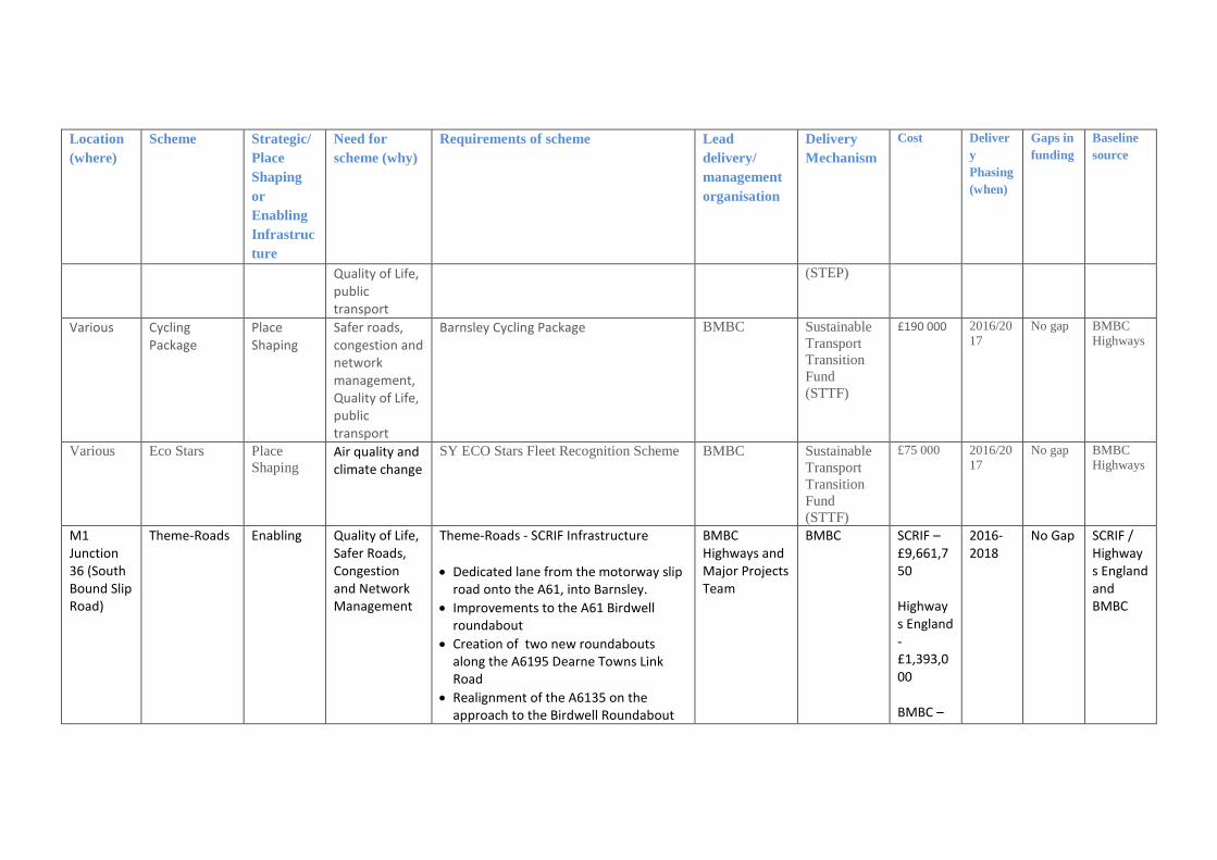
Location
(where)
Scheme Strategic/
Place
Shaping
or
Enabling
Infrastruc
ture
Need for
scheme (why)
Requirements of scheme Lead
delivery/
management
organisation
Delivery
Mechanism
Cost Deliver
y
Phasing
(when)
Gaps in
funding
Baseline
source
Quality of Life, public transport
(STEP)
Various Cycling Package
Place Shaping
Safer roads, congestion and network management, Quality of Life, public transport
Barnsley Cycling Package BMBC Sustainable
Transport
Transition
Fund
(STTF)
£190 000 2016/20
17 No gap BMBC
Highways
Various Eco Stars Place
Shaping Air quality and climate change
SY ECO Stars Fleet Recognition Scheme BMBC Sustainable
Transport
Transition
Fund
(STTF)
£75 000 2016/20
17
No gap BMBC
Highways
M1 Junction 36 (South Bound Slip Road)
Theme-Roads Enabling Quality of Life, Safer Roads, Congestion and Network Management
Theme-Roads - SCRIF Infrastructure
Dedicated lane from the motorway slip road onto the A61, into Barnsley.
Improvements to the A61 Birdwell roundabout
Creation of two new roundabouts along the A6195 Dearne Towns Link Road
Realignment of the A6135 on the approach to the Birdwell Roundabout
BMBC Highways and Major Projects Team
BMBC SCRIF – £9,661,750 Highways England - £1,393,000 BMBC –
2016-2018
No Gap SCRIF / Highways England and BMBC

Location
(where)
Scheme Strategic/
Place
Shaping
or
Enabling
Infrastruc
ture
Need for
scheme (why)
Requirements of scheme Lead
delivery/
management
organisation
Delivery
Mechanism
Cost Deliver
y
Phasing
(when)
Gaps in
funding
Baseline
source
Improved pedestrian & cycling safety by providing shared use routes & designated crossing facilities.
£ 165,000 Total £11,219,750
M1 Junction 37 Claycliffe, Barnsley
Theme-Roads Enabling Quality of Life, Safer Roads, Congestion and Network Management
Theme-Roads - SCRIF Infrastructure
New Primary Road Network through proposed new mixed use development at Barugh Green* (subject to adoption of local plan)
Off Site Mitigation works in the following areas: o Capitol Close, Dodworth o Whinby Road, Dodworth o Dodworth Road / Pogmoor Road
Junction Barnsley o A635 Claycliffe Road / Barugh Green
Road R’about o A637 Barnsley Road
Claycliffe Road/ R’about
BMBC Highways and Major Projects Team
BMBC and Private Sector
Private Sector £4,469,908 * subject to final design and actual cost of mitigation measures fully funded from the SCRIF grant
2017-2020
No Gap SCRIF / Private Sector Developer

Location
(where)
Scheme Strategic/
Place
Shaping
or
Enabling
Infrastruc
ture
Need for
scheme (why)
Requirements of scheme Lead
delivery/
management
organisation
Delivery
Mechanism
Cost Deliver
y
Phasing
(when)
Gaps in
funding
Baseline
source
SCRIF £11,808,000 Total £16,277,908 * subject to final design and actual cost of mitigation measures fully funded from the SCRIF grant
A635 Goldthorpe
Theme-Roads Enabling Quality of Life, Safer Roads, Congestion and Network
Theme-Roads - SCRIF Infrastructure Network Infrastructure mitigation improvements on the DTLR including
BMBC Highways and Major Projects Team
BMBC SCRIF £7,304,000
2017-2020+
No Gap SCRIF / BMBC
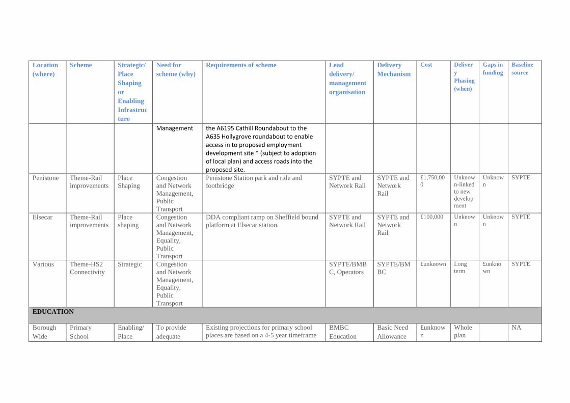
Location
(where)
Scheme Strategic/
Place
Shaping
or
Enabling
Infrastruc
ture
Need for
scheme (why)
Requirements of scheme Lead
delivery/
management
organisation
Delivery
Mechanism
Cost Deliver
y
Phasing
(when)
Gaps in
funding
Baseline
source
Management the A6195 Cathill Roundabout to the A635 Hollygrove roundabout to enable access in to proposed employment development site * (subject to adoption of local plan) and access roads into the proposed site.
Penistone Theme-Rail
improvements Place
Shaping Congestion
and Network
Management,
Public
Transport
Penistone Station park and ride and
footbridge SYPTE and
Network Rail SYPTE and
Network
Rail
£1,750,00
0 Unknow
n-linked
to new
develop
ment
Unknow
n SYPTE
Elsecar Theme-Rail
improvements
Place
shaping
Congestion
and Network
Management,
Equality,
Public
Transport
DDA compliant ramp on Sheffield bound
platform at Elsecar station.
SYPTE and
Network Rail
SYPTE and
Network
Rail
£100,000 Unknow
n
Unknow
n
SYPTE
Various Theme-HS2
Connectivity
Strategic Congestion
and Network
Management,
Equality,
Public
Transport
SYPTE/BMB
C, Operators
SYPTE/BM
BC
£unknown Long
term
£unkno
wn
SYPTE
EDUCATION
Borough
Wide
Primary
School
Enabling/
Place
To provide
adequate
Existing projections for primary school
places are based on a 4-5 year timeframe
BMBC
Education
Basic Need
Allowance
£unknow
n
Whole
plan
NA

Location
(where)
Scheme Strategic/
Place
Shaping
or
Enabling
Infrastruc
ture
Need for
scheme (why)
Requirements of scheme Lead
delivery/
management
organisation
Delivery
Mechanism
Cost Deliver
y
Phasing
(when)
Gaps in
funding
Baseline
source
Provision Shaping primary school
places for
proposed new
housing
development.
which currently project forward to 2019.
As the methodology used for calculating
school places is closely linked to
demographics it is difficult to accurately
identify the need for school places over
long periods. It is essential to provide
certainty that an adequate number of
school places are available for the first
five years of the plan period (i.e. 2014-
2019) after which point, a plan monitor
manage approach will need to be taken to
ensure that sufficient school places are
available to meet demand.
Department
S106
Free School
(central
government
funding)
period
Junction
37
Claycliffe,
Barnsley
Primary
School
Provision
Enabling/
Place
Shaping
To provide
adequate
primary school
places for
proposed new
housing
development.
A maximum 360 Primary School will be
required as part of the development of the
site. It is anticipated that this will be
available by September 2020.
BMBC
Education
Department
Basic Need
Allowance
S106
Priority
Building
Schools for
Future
Free School
(central
c£7.5m Whole
plan
period
£5m BMBC
Educatio
n
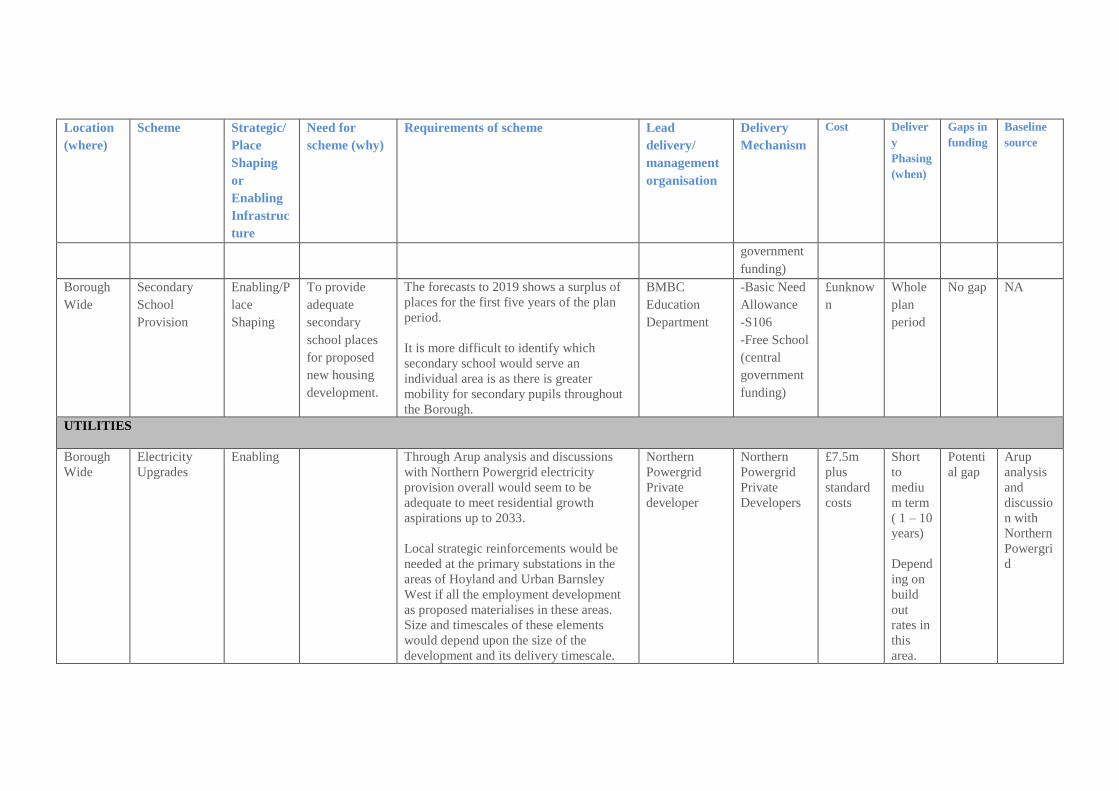
Location
(where)
Scheme Strategic/
Place
Shaping
or
Enabling
Infrastruc
ture
Need for
scheme (why)
Requirements of scheme Lead
delivery/
management
organisation
Delivery
Mechanism
Cost Deliver
y
Phasing
(when)
Gaps in
funding
Baseline
source
government
funding)
Borough
Wide
Secondary
School
Provision
Enabling/P
lace
Shaping
To provide
adequate
secondary
school places
for proposed
new housing
development.
The forecasts to 2019 shows a surplus of
places for the first five years of the plan
period.
It is more difficult to identify which
secondary school would serve an
individual area is as there is greater
mobility for secondary pupils throughout
the Borough.
BMBC
Education
Department
-Basic Need
Allowance
-S106
-Free School
(central
government
funding)
£unknow
n
Whole
plan
period
No gap NA
UTILITIES
Borough
Wide
Electricity
Upgrades
Enabling
Through Arup analysis and discussions
with Northern Powergrid electricity
provision overall would seem to be
adequate to meet residential growth
aspirations up to 2033.
Local strategic reinforcements would be
needed at the primary substations in the
areas of Hoyland and Urban Barnsley
West if all the employment development
as proposed materialises in these areas.
Size and timescales of these elements
would depend upon the size of the
development and its delivery timescale.
Northern
Powergrid
Private
developer
Northern
Powergrid
Private
Developers
£7.5m
plus
standard
costs
Short
to
mediu
m term
( 1 – 10
years)
Depend
ing on
build
out
rates in
this
area.
Potenti
al gap
Arup
analysis
and
discussio
n with
Northern
Powergri
d

Location
(where)
Scheme Strategic/
Place
Shaping
or
Enabling
Infrastruc
ture
Need for
scheme (why)
Requirements of scheme Lead
delivery/
management
organisation
Delivery
Mechanism
Cost Deliver
y
Phasing
(when)
Gaps in
funding
Baseline
source
The additional costs over and above the
normal connection costs for all the
proposed development quantum in Urban
Barnsley West is estimated as £3.5m.
Barnsley Council is continuing to work
with Northern Power Grid to better
quantify the cost implications. .
The additional costs over and above the
normal connection costs for all the
proposed development quantum in
Hoyland is estimated as £4m. Barnsley
Council is continuing to work with
Northern Power Grid to better quantify the
cost implications. Borough
Wide
Gas Upgrades Enabling Early discussions with National Grid and
Northern Gas Networks have confirmed
that the overall gas network within BMBC
is robust and flexible and that strategic
reinforcement of the network would not
be necessary to support the development
set out in the emerging Local Plan. Local
reinforcements will be required to service
local developments as and when these are
allocated and designed. These should be
considered as extensions to the existing
Northern Gas
National Grid
Network
Private
developers
Northern
Gas
National
Grid
Network
Private
developers
£
standard
costs
Short
to
mediu
m term
( 1 – 10
years)
Depend
ing on
build
out
No gap Arup
analysis
and
discussio
n with
Northern
Gas
Network
s.

Location
(where)
Scheme Strategic/
Place
Shaping
or
Enabling
Infrastruc
ture
Need for
scheme (why)
Requirements of scheme Lead
delivery/
management
organisation
Delivery
Mechanism
Cost Deliver
y
Phasing
(when)
Gaps in
funding
Baseline
source
local distribution networks and in
proportion to the size of the proposed
development and consistent with costs
that would normally be associated with
providing services to developments.
A standard gas connection is circa £1000
per property taking into account the cost
of mains to get the gas to the street and
then the service from the street into the
property.
rates in
this
area.
Borough
wide
On-site Water
Supply and
access to
Wastewater
Treatment
Cost
Enabling
To fund on site
infrastructure
costs.
YW have confirmed that they will
commence their next 5 year Asset
Management Plan (known as AMP 6) in
April 2015 and will have sign-off for the
business plan from their regulator
OFWAT in December 2014. It is likely
that there will be significant works to
meet new water quality requirements
undertaken at Lundwood, Cudworth and
Wombwell waste water treatment works
(WWTW).
Lundwood serves all of the urban area of
Barnsley itself as well as Royston and
Wombwell treats foul flows from
YW
YW
Developer
Contribution
£unknow
n
Throug
hout
plan
period.
No gap YW

Location
(where)
Scheme Strategic/
Place
Shaping
or
Enabling
Infrastruc
ture
Need for
scheme (why)
Requirements of scheme Lead
delivery/
management
organisation
Delivery
Mechanism
Cost Deliver
y
Phasing
(when)
Gaps in
funding
Baseline
source
Hoyland. Growth within these catchments
would be allowed for in the design of the
improvement works.
These works will need to be funded by
YW and through developer contributions.
In addition developers will need to pay a
standard infrastructure fund to Yorkshire
Water. There may also be specific on site
issues related to individual sewer capacity.
TELECOMMUNICATIONS
Borough
Wide
Telecommunic
ation
improvements
Place
Shaping
To allow
Barnsley to
compete as a
business
location and
open up new
opportunities
for business
and residents
Secure ongoing investment for
improvements to broadband provision
across the borough and ensure all new
developments are built with fibre
broadband to meet the needs of the
occupied site.
Virgin Media,
BT, Other
communicatio
ns providers
Delivered
commerciall
y:
improvemen
ts will be
market led,
new
development
will be paid
for by
telecommuni
cation
providers or
developers.
Costs will
be funded
by the
infrastruct
ure
providers
or
developer
s
Medium
term 5-
10 years
No gap NA

Location
(where)
Scheme Strategic/
Place
Shaping
or
Enabling
Infrastruc
ture
Need for
scheme (why)
Requirements of scheme Lead
delivery/
management
organisation
Delivery
Mechanism
Cost Deliver
y
Phasing
(when)
Gaps in
funding
Baseline
source
Unknown Superfast
South
Yorkshire
Place
Shaping
To allow
Barnsley to
compete as a
business
location and
open up new
opportunities
for business
and residents
The programme is will deliver 99%
coverage of fibre broadband across South
Yorkshire, ensuring ultrafast connectivity
at the enterprise zones and key strategic
business parks.
Superfast
South
Yorkshire,
BMBC
SCRIF,
BDUK
(Broadband
Delivery UK),
BT
£29m
South
Yorkshire
wide
investmen
t
In
delivery.
Complet
ion due
2019
No gap NA
Various IT connections
visitor
attractions
Enabling Visitor
Economy
Poor connectivity at a number of the
museum sites continues to be an issue,
faster broadband it is essential for service
delivery at these sites. Two of the sites
will receive investment from the Superfast
South Yorkshire programme, further work
is necessary to establish a solution for the
others.
Elsecar Heritage Centre
Worsbrough Mill And Country
Park
Cannon Hall Museum – SFSY
investment
Cooper Gallery – SFSY
BMBC Arts
and
Heritage/SFS
Y
£unknown

Location
(where)
Scheme Strategic/
Place
Shaping
or
Enabling
Infrastruc
ture
Need for
scheme (why)
Requirements of scheme Lead
delivery/
management
organisation
Delivery
Mechanism
Cost Deliver
y
Phasing
(when)
Gaps in
funding
Baseline
source
investment
FLOOD RISK AND DRAINAGE
Low
Valley
Flood
Defences
Enabling Flood
defences, area
susceptible to
flooding
The scheme will improve flood defences
in the area and help to protect 200 existing
properties that are susceptible to flooding.
In addition it will benefit planned
development in the area.
EA/BMBC EA £600k
indicative
Private
developer
£600k
indicative
£1.7
million
Summer
Medium
term
plan
£500
000
BMBC
Drainage
Wombwel
l Ings
Habitat
Creation and
Flood Storage
Extension
Enabling Flood defences
and habitat
creation
To extend existing flood storage area to
reduce flood risk for residential properties
in area and improve existing habitat in
area.
EA/HLF/RSP
B
EA £200k,
£545k
collaboration
between
Historic
England,
Heritage
Lottery Fund
and RSPB
£745,000 March
2017
No Gap BMBC
Drainage
WASTE AND RECYCLING
Cross
boundary
Waste
management
Enabling To provide
adequate waste
management
Joint waste strategy and facilities with
Rotherham and Doncaster. This provision
is in place.
BMBC,
RMBC and
DMBC
Private
sector
funding
£unknown Whole
plan
period
No Gap N/A

Location
(where)
Scheme Strategic/
Place
Shaping
or
Enabling
Infrastruc
ture
Need for
scheme (why)
Requirements of scheme Lead
delivery/
management
organisation
Delivery
Mechanism
Cost Deliver
y
Phasing
(when)
Gaps in
funding
Baseline
source
facilities Private waste
operator.
GREEN INFRASTRUCTURE, OPEN SPACE AND PUBLIC SPACE
Various DVLP ED4
Creating and
Managing
sites more
effectively
Place
Shaping
To provide a
high quality
green
infrastructure
network
Looking at new ways of working for the
creation and management of washlands,
green space, valley verges, woodlands,
community sites, former pit sites and
public open space.
This project is looking at the opportunities
to create and manage environmental sites
more effectively, looking at new ways of
working and increasing the biodiversity of
the area. It is closely linked with ED3
Surveying the Dearne with the community
engagement and findings from there used
as a starting point for practical
improvements to sites. Improvements will
be made directly resulting from the
community engagement and new ways of
managing sites will be trialled, reviewed
and disseminated.
These sites will fall into three broad
categories: Former colliery, industrial and
associated sites, Roadside verges and
DVLP HLF
S106
Small scale
grant
funding
applications
£187,619 July
2015 to
June
2019.
(HLF
£82,807
),
remaind
er
through
S106
and
small
scale
grant
funding
bids
BMBC/D
VLP
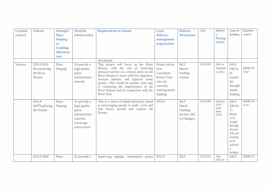
Location
(where)
Scheme Strategic/
Place
Shaping
or
Enabling
Infrastruc
ture
Need for
scheme (why)
Requirements of scheme Lead
delivery/
management
organisation
Delivery
Mechanism
Cost Deliver
y
Phasing
(when)
Gaps in
funding
Baseline
source
Woodlands
Various DVLP ED5
Reconnecting
the River
Dearne
Place
Shaping
To provide a
high quality
green
infrastructure
network
This project will focus on the River
Dearne, with the aim of removing
physical barriers at a critical point on the
River Dearne to assist with fish migration,
increase habitats and improve water
quality. This would be another vital step
in continuing the improvement of the
River Dearne and its connection with the
River Don.
Project led by
Don
Catchment
Rivers Trust
who are
currently
seeking match
funding.
HLF
Match
funding-
various
£154,100 July to
Septemb
er 2015
(HLF
£99,50
0)
remain
der
through
match
funding
BMBC/D
VLP
DVLP
DD7Exploring
the Dearne
Place
Shaping
To provide a
high quality
green
infrastructure
network,
encourage
active travel
This is a series of linked initiatives aimed
at encouraging people to walk, cycle and
ride horses around and explore the
Dearne.
DVLP HLF
Match
Funding-
Section 106,
LA Budgets
£223,099 January
2015
until
June
2019.
(HLF
£99,34
7)
Match
to be
sought
through
Section
106 and
existing
local
authorit
y
budgets
BMBC/D
VLP
DVLP DD8 Place To provide a Improving signage, information points DVLP HLF £162,523 July
2015 to (HLF BMBC/D
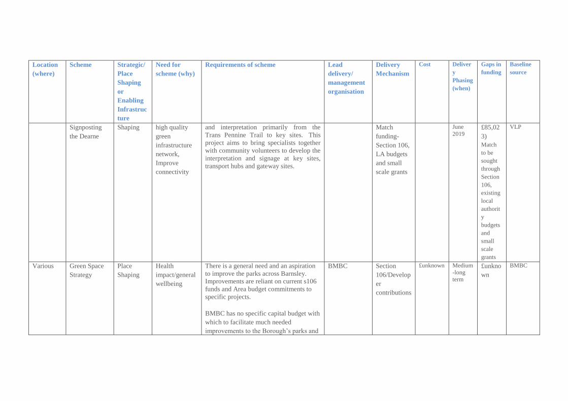
Location
(where)
Scheme Strategic/
Place
Shaping
or
Enabling
Infrastruc
ture
Need for
scheme (why)
Requirements of scheme Lead
delivery/
management
organisation
Delivery
Mechanism
Cost Deliver
y
Phasing
(when)
Gaps in
funding
Baseline
source
Signposting
the Dearne
Shaping high quality
green
infrastructure
network,
Improve
connectivity
and interpretation primarily from the
Trans Pennine Trail to key sites. This
project aims to bring specialists together
with community volunteers to develop the
interpretation and signage at key sites,
transport hubs and gateway sites.
Match
funding-
Section 106,
LA budgets
and small
scale grants
June
2019 £85,02
3)
Match
to be
sought
through
Section
106,
existing
local
authorit
y
budgets
and
small
scale
grants
VLP
Various Green Space
Strategy
Place
Shaping
Health
impact/general
wellbeing
There is a general need and an aspiration
to improve the parks across Barnsley.
Improvements are reliant on current s106
funds and Area budget commitments to
specific projects.
BMBC has no specific capital budget with
which to facilitate much needed
improvements to the Borough’s parks and
BMBC Section
106/Develop
er
contributions
£unknown Medium
-long
term
£unkno
wn
BMBC

Location
(where)
Scheme Strategic/
Place
Shaping
or
Enabling
Infrastruc
ture
Need for
scheme (why)
Requirements of scheme Lead
delivery/
management
organisation
Delivery
Mechanism
Cost Deliver
y
Phasing
(when)
Gaps in
funding
Baseline
source
open spaces.
Site
specific-
various
Green Space
Strategy
Place
Shaping
Health
impact/general
wellbeing
Provision of new space within new
residential developments. There is a need
to ensure revenue funding is made
available to ensure future maintenance of
these new sites
BMBC Section
106/Develop
er
contributions
£unknown Whole
plan
period
£unkno
wn
BMBC
Locke Park Mixed Use
Games Area
Place
Shaping
Health
impact/general
wellbeing
Provision of Mixed Use Games area at Locke Park
BMBC
Developers
Section
106/Develop
er
contributions
£100 000 2016 No gap BMBC
Goldthorp
e
Recreation
Ground
Mixed Use
Games Area
Place
Shaping
Health
impact/general
wellbeing
Provision of Mixed Use Games area at Goldthorpe Recreation Ground
BMBC
Developers
Section
106/Develop
er
contributions
£40 000 2016 No gap BMBC
Wilthorpe
Park
Upgrade of
play area
Place
Shaping
Health
impact/general
wellbeing
Upgrading Wilthorpe Park play area from LEAP to a NEAP
BMBC
Developers
Section
106/Develop
er
contributions
£42 000 2016 No gap BMBC
Bluebell
Bank,
Sheffield
Road
Mixed Use
Games Area
Place
Shaping
Health
impact/general
wellbeing
Provision of Mixed Use Games area at Bluebell Bank
BMBC
Developers
Section
106/Develop
er
contributions
£90 000 2016 No gap BMBC
Lesley
Road,
Refurbished
Play Area
Place
Shaping
Health
impact/general
Refurbish the play area at Lesley Road, Kendray to a LEAP standard – this project
BMBC
Developers
Section
106/Develop
£60-65 tbc No gap BMBC

Location
(where)
Scheme Strategic/
Place
Shaping
or
Enabling
Infrastruc
ture
Need for
scheme (why)
Requirements of scheme Lead
delivery/
management
organisation
Delivery
Mechanism
Cost Deliver
y
Phasing
(when)
Gaps in
funding
Baseline
source
Kendray wellbeing is currently out to consultation with local residents
er
contributions
000
Former
Royston
School
Provision of
play area
Place
Shaping
Health
impact/general
wellbeing
Provision of LEAP standard play area at the former Royston School Site
BMBC
Developers
Section
106/Develop
er
contributions
£unknown tbc No gap BMBC
SPORTS FACILITIES
Various Asset
investment
Place
Shaping
Asset
improvement
The leisure facilities owned by Barnsley
MBC are currently managed by Barnsley
Premier Leisure (BPL). BPL manage all
BMBC’s leisure facilities including the
Metrodome Leisure Complex on the edge
of the town centre and a number of other
leisure centres which are dispersed across
Barnsley’s principal towns. The stock is
very well used by the local population, but
is aging and is likely to need upgrading in
the medium to long term.
BMBC/BPL BMBC
Capital/Spor
t England
£unknown Medium
-long
term
£unkno
wn
BMBC
Borough
wide
Sports Pitches Place
Shaping
Quality
improvements
to existing
playing
pitches.
There is a requirement to improve existing
playing pitches.
Specific capital programme budget
required to ensure a Borough wide
approach to improvements
BMBC BMBC
Capital/Deve
loper
Contribution
s (S106 or
£unknown Whole
plan
period
£unkno
wn
BMBC

Location
(where)
Scheme Strategic/
Place
Shaping
or
Enabling
Infrastruc
ture
Need for
scheme (why)
Requirements of scheme Lead
delivery/
management
organisation
Delivery
Mechanism
Cost Deliver
y
Phasing
(when)
Gaps in
funding
Baseline
source
The provision of new sports pitches will
be required to support large housing sites.
CIL).
HEALTH
No gap in health infrastructure
CLIMATE CHANGE AND RENEWABLES
Site
specific -
various
Solar PV Strategic/
Place
Shaping
Reduction in
energy
costs/commun
ity income
generation/tac
kle fuel
poverty
Energise Barnsley project – BMBC-owned domestic and non-domestic property
Energise
Barnsley
Delivery
Partnership
BMBC
SCR
Community
shares offer
various Ongoing Potentia
l gap
Communit
y
Investmen
t
Solar
Bond
Site
specific -
various
District Heat
Networks
Strategic/
Place
Shaping
Decentralised
energy supply/
income
generation
Feasibility works are underway to look at opportunities to develop district heating in and around town centre.
BMBC
Carbon Trust
Private
developers
BMBC
DECC
SCR
Private
developers
various 2016-
2022
Potentia
l gap
TBD
Metrodom
e Leisure
Boiler
replacement
Place
Shaping
Upgrade It is anticipated that the existing boiler at
the Metrodome Leisure Centre will be
replaced by the installation of a combined
Norse Energy
BMBC
Norse
Energy
£unknown No gap TBD

Location
(where)
Scheme Strategic/
Place
Shaping
or
Enabling
Infrastruc
ture
Need for
scheme (why)
Requirements of scheme Lead
delivery/
management
organisation
Delivery
Mechanism
Cost Deliver
y
Phasing
(when)
Gaps in
funding
Baseline
source
Centre required heat and power plant. Should the scheme
go ahead it is likely that a new gas main
will be required.
HEALTH
No gap in health infrastructure
EMERGENCY SERVICES
No gap in emergency services infrastructure
COMMUNITY AND CULTURAL
Town
Centre
New Library Place
Shaping
The town
centre library
has currently
been
temporarily
relocated to
Wellington
House to make
way for a new
college
Part of the Better Barnsley Plans-total £41
investment in Town Centre regeneration.
Proposed location of new library in
Mayday Green.
BMBC BMBC
Capital
Funding.
£4 million To be
complet
ed early
2018
No gap BMBC
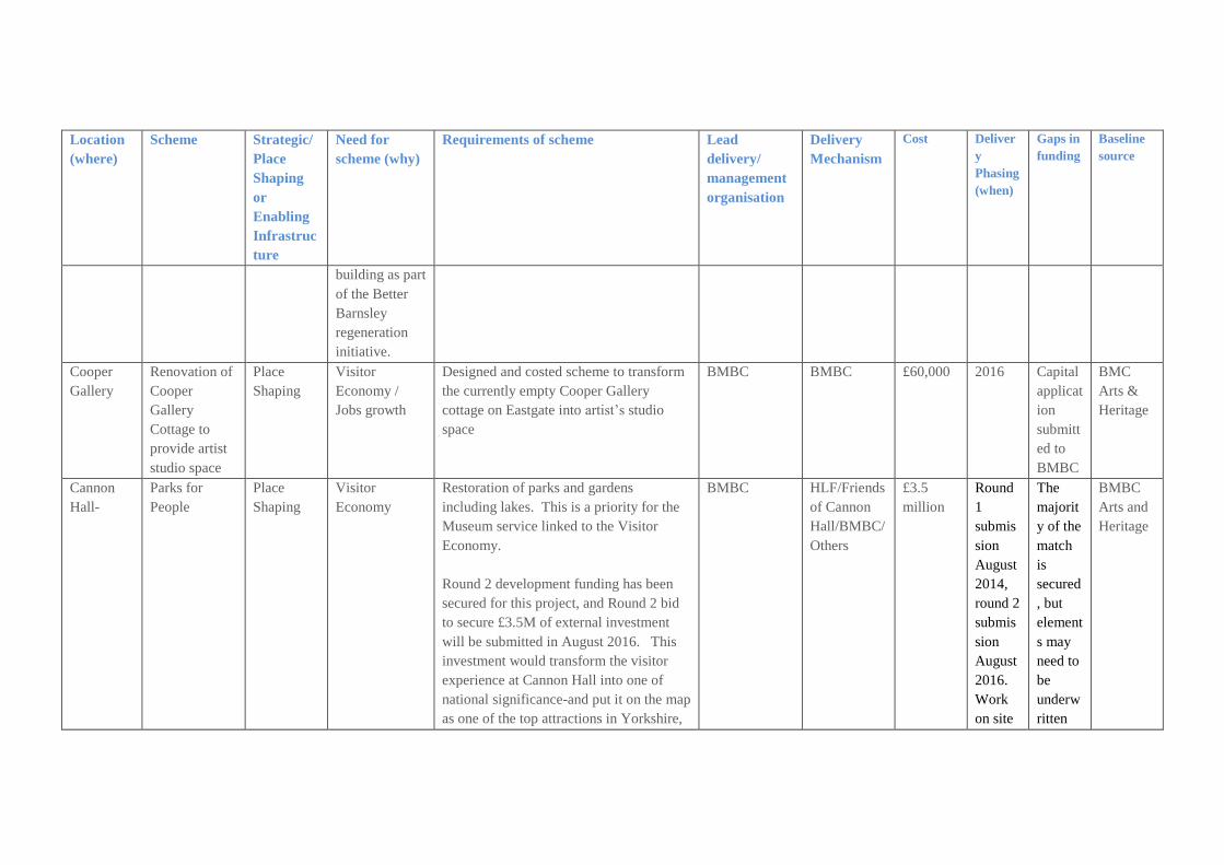
Location
(where)
Scheme Strategic/
Place
Shaping
or
Enabling
Infrastruc
ture
Need for
scheme (why)
Requirements of scheme Lead
delivery/
management
organisation
Delivery
Mechanism
Cost Deliver
y
Phasing
(when)
Gaps in
funding
Baseline
source
building as part
of the Better
Barnsley
regeneration
initiative.
Cooper
Gallery
Renovation of
Cooper
Gallery
Cottage to
provide artist
studio space
Place
Shaping
Visitor
Economy /
Jobs growth
Designed and costed scheme to transform
the currently empty Cooper Gallery
cottage on Eastgate into artist’s studio
space
BMBC BMBC £60,000 2016 Capital
applicat
ion
submitt
ed to
BMBC
BMC
Arts &
Heritage
Cannon
Hall-
Parks for
People
Place
Shaping
Visitor
Economy
Restoration of parks and gardens
including lakes. This is a priority for the
Museum service linked to the Visitor
Economy.
Round 2 development funding has been
secured for this project, and Round 2 bid
to secure £3.5M of external investment
will be submitted in August 2016. This
investment would transform the visitor
experience at Cannon Hall into one of
national significance-and put it on the map
as one of the top attractions in Yorkshire,
BMBC HLF/Friends
of Cannon
Hall/BMBC/
Others
£3.5
million
Round
1
submis
sion
August
2014,
round 2
submis
sion
August
2016.
Work
on site
The
majorit
y of the
match
is
secured
, but
element
s may
need to
be
underw
ritten
BMBC
Arts and
Heritage

Location
(where)
Scheme Strategic/
Place
Shaping
or
Enabling
Infrastruc
ture
Need for
scheme (why)
Requirements of scheme Lead
delivery/
management
organisation
Delivery
Mechanism
Cost Deliver
y
Phasing
(when)
Gaps in
funding
Baseline
source
adjacent to Cannon Hall Open Farm. 2017-
2019
by
BMBC
for the
Round
2
submis
sion.
Cannon
Hall
Cannon Hall
exhibition
galleries
Place
Shaping
To transform
the galleries at
Cannon Hall to
maximise on
use of
collections,
and the new
partnership
with the de
Morgan and
Foundation
Create new galleries utilising museum
service collections and loans.
BMBC HLF £750,000 Submis
sion
2017
Need to
identify
match
funding
BMBC
Arts and
Heritage
Monk
Bretton
Priory
DVLP Place
Shaping
Visitor
Economy
Partnership with Friends of Monk Bretton
Priory to improve signage, interpretation,
access and management of space.
Friends of
Monk Bretton
Priory
HLF and
Grant
funding
£unknown Medium
term
£unkno
wn grant
funding
BMBC
Barnsley
Main/Oak
s Colliery
DVLP Place
Shaping
Visitor
Economy
Conservation management plan to protect
and enhance the site, building pathways,
signage and interpretation.
BMBC/DVLP HLF/S106 £152,500 Short to
medium
term
No Gap BMBC

Location
(where)
Scheme Strategic/
Place
Shaping
or
Enabling
Infrastruc
ture
Need for
scheme (why)
Requirements of scheme Lead
delivery/
management
organisation
Delivery
Mechanism
Cost Deliver
y
Phasing
(when)
Gaps in
funding
Baseline
source
Elsecar Elsecar Master
planning
Place
Shaping
Further investment linked to World
Heritage Status aspiration for the Heritage
Centre and wider village. The investment
would be over a period of ten years.
Development Plan-Elsecar has been
identified in the Visitor Economy Review
Paper and the Destination Management
Plan as the site with most potential to
attract national and international visitors.
The Newcomen Beam Engine has
been described as one of the most
important pieces of industrial heritage
in the world. The Heritage Centre
has just been hosted by European
Routes to Industrial Heritage-a major
European Initiative.
The site at Elsecar has a significant retail
element there are approximately 35
businesses on site, employing
approximately 200 people. This forms a
major part of the visitor offer. The
BMBC HLF and
other
external
funds
£10M +
£50k
secured
from
BMBC
Jobs and
Growth
Plan to
scope
project
and
appoint
consultan
ts for
master
planning
exercise.
Further
BMBC
investme
nt is not
being
sought to
Mediu
m term
5-10
years
£unkno
wn
BMBC
Arts and
Heritage

Location
(where)
Scheme Strategic/
Place
Shaping
or
Enabling
Infrastruc
ture
Need for
scheme (why)
Requirements of scheme Lead
delivery/
management
organisation
Delivery
Mechanism
Cost Deliver
y
Phasing
(when)
Gaps in
funding
Baseline
source
success of these businesses, safeguarding
and creating jobs together with the ability
to attract high quality retailers to
complement the visitor experience, is
dependent on increasing footfall and
visitor spend.
take this
forward.
Worsbrou
gh Mill
Feasibility for
site
development
Place
Shaping
Visitor
Economy
Development of learning facilities
including bakery and cookery school. Full
design and costing has been undertaken
following Jobs & Growth Fund
investment
BMBC HLF/BMBC
Jobs and
Growth Plan
£1M
£50k for
feasibilit
y from
BMBC
Jobs and
Growth
Plan
2017 Subject
to
cabinet
approv
al
BMBC
Arts and
Heritage
Cannon
Hall
Development
of assets
Place
Shaping
Visitor
Economy/Inco
me targets
New function/café space at Cannon Hall
designed for income generation in order to
ensure long term sustainability of the site,
as well as the restoration of two cottages
for holiday let. This is all incorporated in
to the sites new business plan
BMBC Heritage
Enterprise
grant – pre
app
submitted
£1.5M 17/18 Match
funding
10%
BMBC
Arts and
Heritage
Top Related