


Languages
Pages
Legal


Hurricane Hazards and
Outlook for 2013
CWSU
National Weather Service, Houston, TX
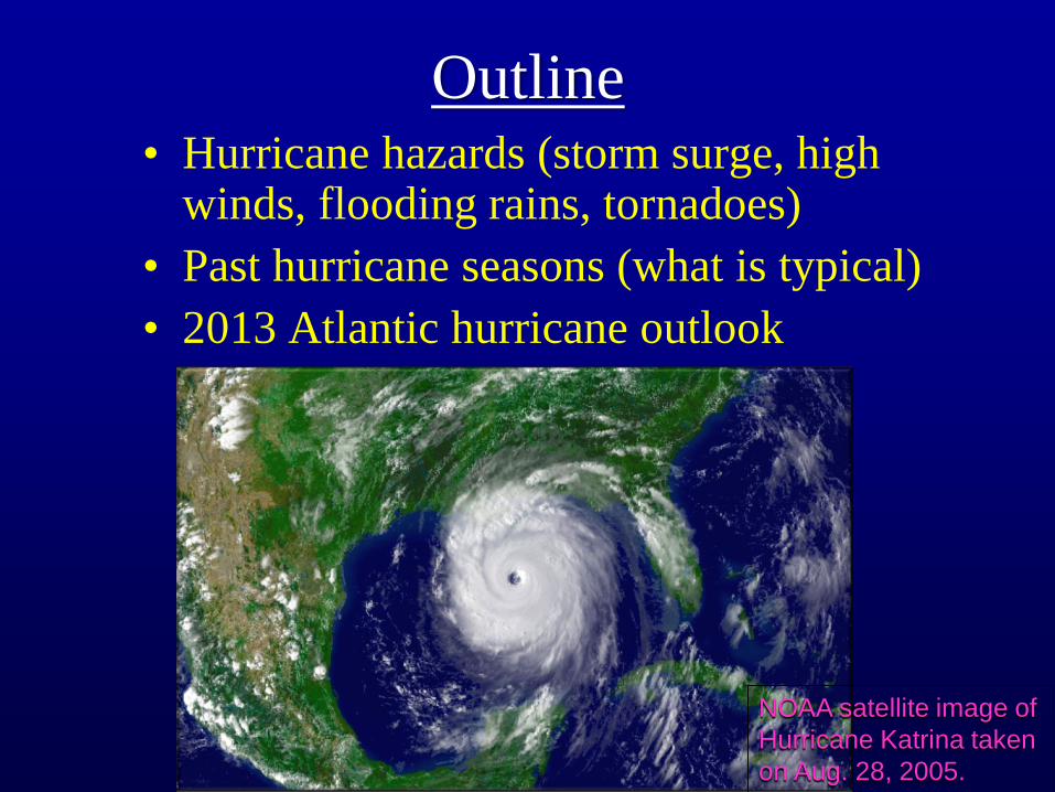
Outline • Hurricane hazards (storm surge, high
winds, flooding rains, tornadoes)
• Past hurricane seasons (what is typical)
• 2013 Atlantic hurricane outlook
NOAA satellite image of
Hurricane Katrina taken
on Aug. 28, 2005.
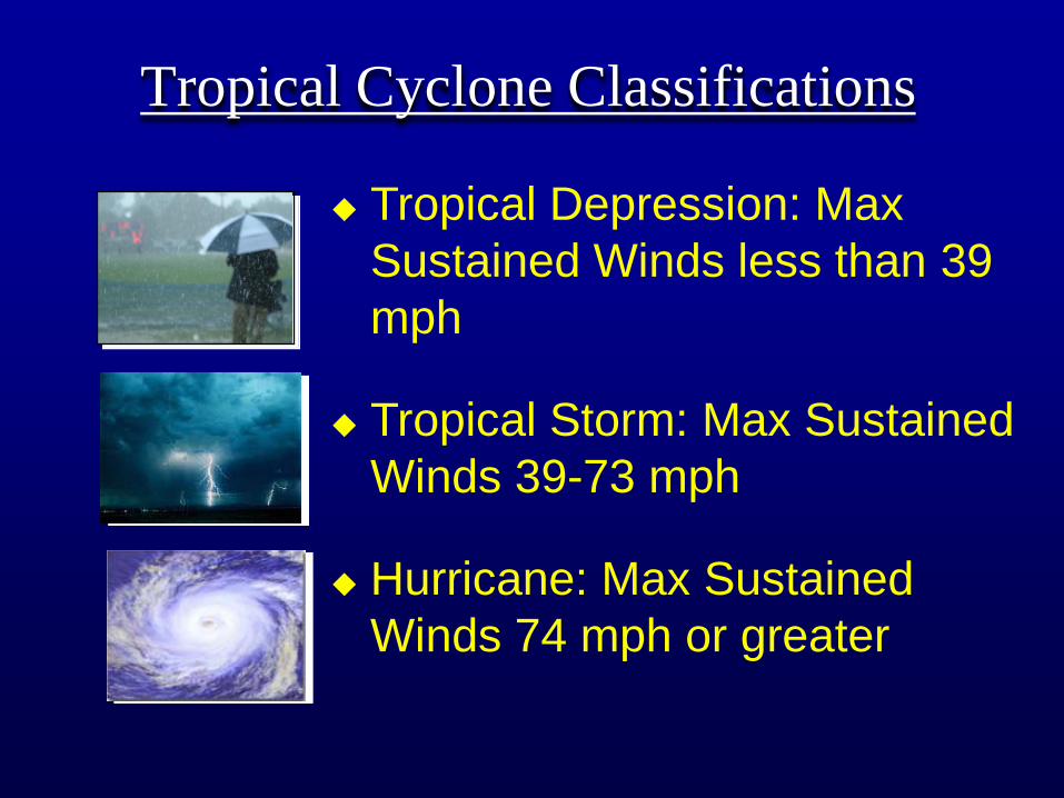
Tropical Cyclone Classifications
◆ Tropical Depression: Max
Sustained Winds less than 39
mph
◆ Tropical Storm: Max Sustained
Winds 39-73 mph
◆ Hurricane: Max Sustained
Winds 74 mph or greater

2013 2014 2015 2016 2017
Andrea Arthur Ana Alex Arlene
Barry Bertha Bill Bonnie Beryl
Chantal Cristobal Claudette Colin Cindy
Dorian Dolly Danny Danielle Don
Erin Edouard Erika Earl Emily
Fernand Fay Fred Fiona Franklin
Gabrielle Gonzalo Grace Gaston Gert
Humberto Hanna Henri Hermine Harvey
Ingrid Isaias Ida Ian Irma
Jerry Josephine Joaquin Julia Jose
Karen Kyle Kate Karl Katia
Lorenzo Laura Larry Lisa Lee
Melissa Marco Mindy Matthew Maria
Nestor Nana Nicholas Nicole Nate
Olga Omar Odette Otto Ophelia
Pablo Paulette Peter Philippe
Rebekah Rene Rose Richard Rina
Sebastien Sally Sam Shary Sean
Tanya Teddy Teresa Tobias Tammy
Van Vicky Victor Virginie Vince
Wendy Wilfred Wanda Walter Whitney
Hurricane and
Tropical Storm
Names
• Alternate
Male/Female
• Repeat every 7
years unless
the name is
retired!

Hurricane Hazards
Storm Surge Tornadoes
Flooding Damaging Winds
• Are any of these hazards not relevant to Montgomery County?
• Which Hazard is the Greatest Threat to Life in Montgomery County?

Hurricane Ike View from Radar
Spiral
Bands
Eye Wall
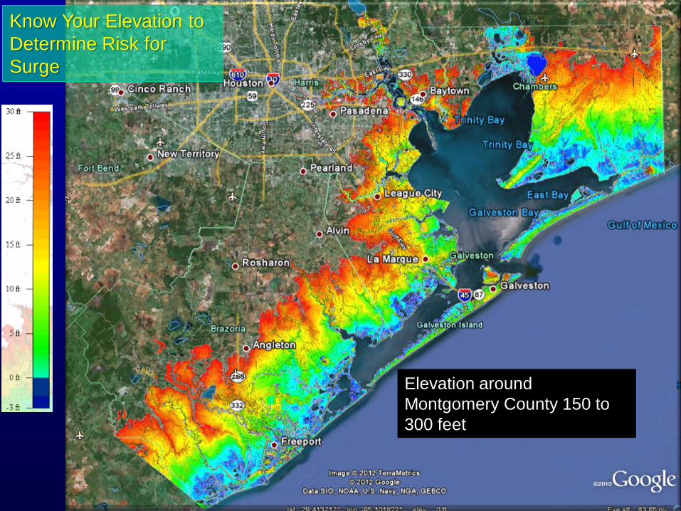
Know Your Elevation to
Determine Risk for
Surge
Elevation around
Montgomery County 150 to
300 feet

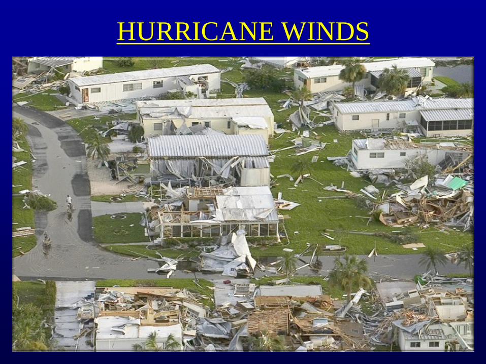
HURRICANE WINDS

Category 1-min. Sustained Winds
(mph)
Storm Examples Wind Impacts
Tropical
Depression
Less than 39 mph Relatively minor
Tropical
Storm
Between 39 and 73 Allison Can be significant
1 74 - 95 Jerry 1989 Very dangerous; will produce
Claudette 2003 some damage
Humberto 2007
2 96 - 110 Georges 1998
Ike 2008
Extremely dangerous; will
produce extensive damage
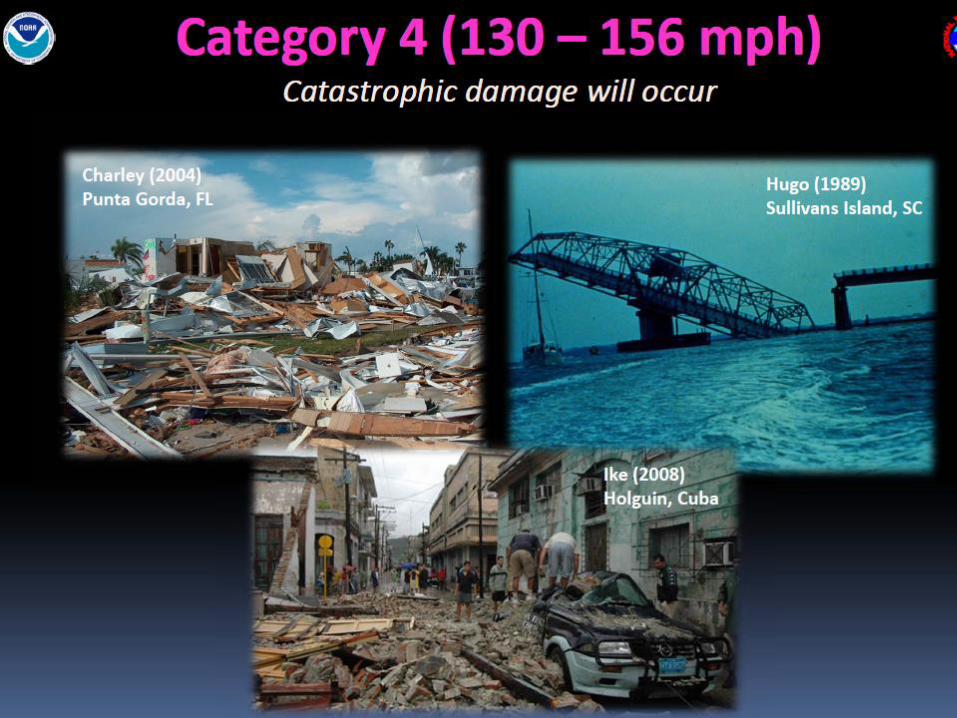
3 111 - 129 Alicia 1983 Devastating damage
Katrina 2005
Rita 2005
4 130 - 156 1900 - Galveston Catastrophic damage
Carla 1961
5 157 or greater Andrew 1992 Catastrophic damage
Camille 1969
Saffir-Simpson Hurricane Wind Scale
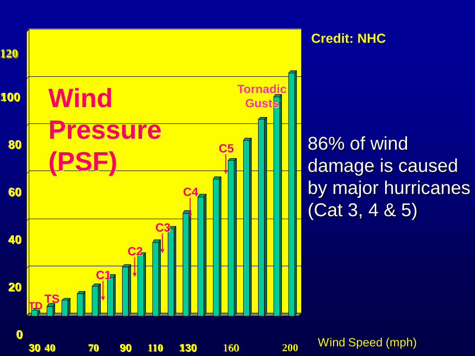
30
0
20
40
60
80
100
120
40 70 90 110 130 160 200
TS
C1
C2
C3
C4
C5
Wind
Pressure
(PSF)
Wind Speed (mph)
86% of wind
damage is caused
by major hurricanes
(Cat 3, 4 & 5)
Tornadic
Gusts
TD
Credit: NHC
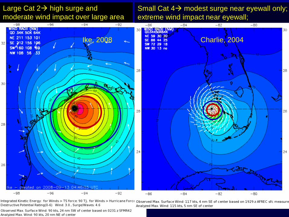
Large Cat 2 high surge and
moderate wind impact over large area
Small Cat 4 modest surge near eyewall only;
extreme wind impact near eyewall;
Charlie, 2004 Ike, 2008
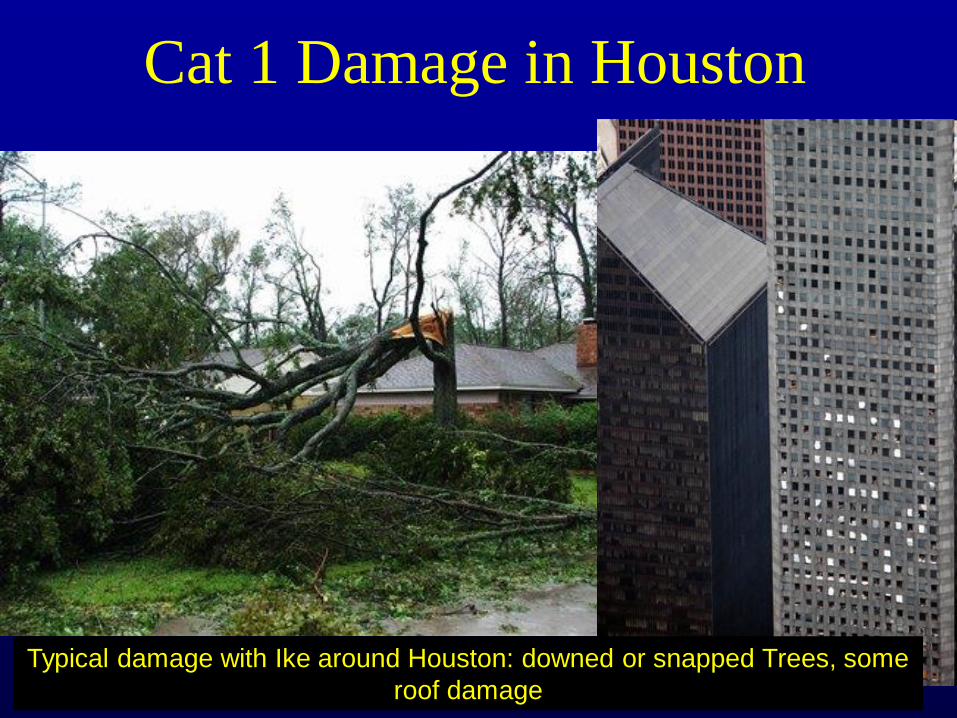
Cat 1 Damage in Houston
Typical damage with Ike around Houston: downed or snapped Trees, some
roof damage

2004 Hurricane Charley – SW
Florida CAT 4 Wind in
Purple
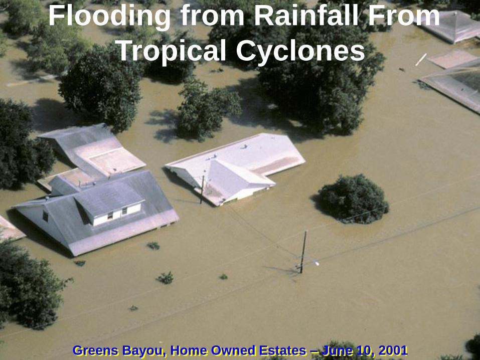
Greens Bayou, Home Owned Estates – June 10, 2001
Flooding from Rainfall From
Tropical Cyclones


Tropical Storm Allison
June 2001 Looped Over SE
Texas; 36.99 inches of rain Port of
Houston


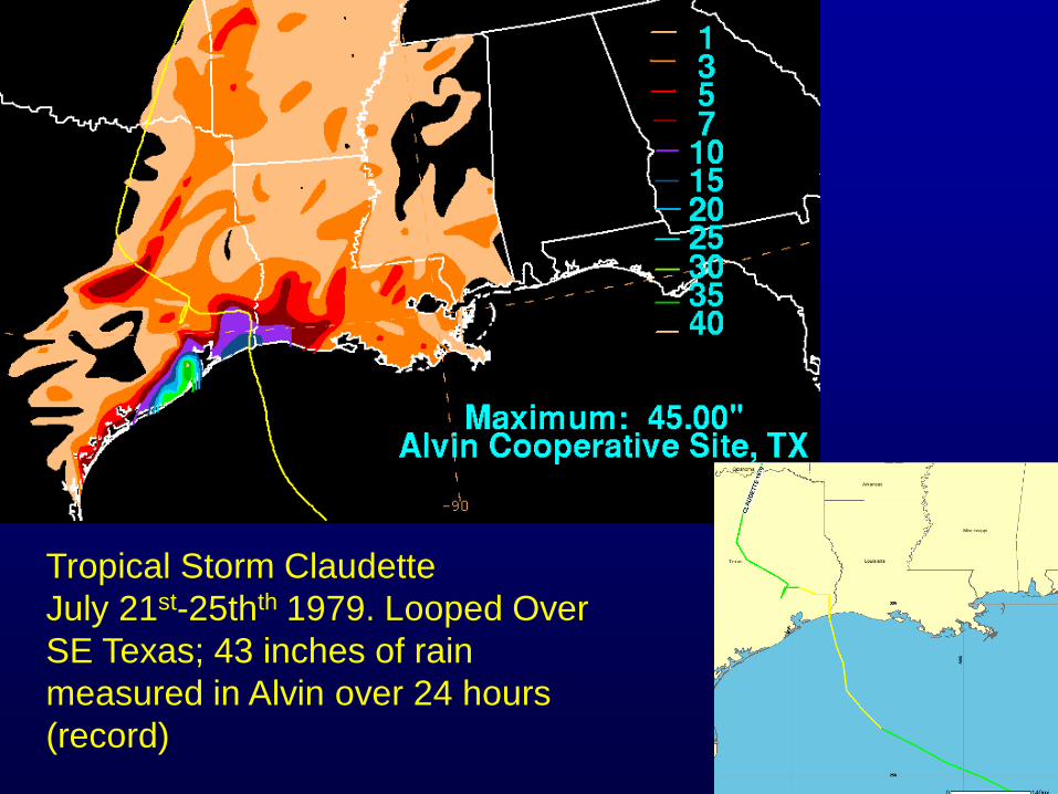
Tropical Storm Claudette
July 21st-25thth 1979. Looped Over
SE Texas; 43 inches of rain
measured in Alvin over 24 hours
(record)

1/29/2014 Weather.gov/houston 27
From Ashley and Ashley, 2008;
50 years of data across the U.S.

Forces on Vehicles Crossing Streams
Buoyancy Force Friction Force
Stream Force
The car will float downstream when:
Stream Force > Friction Force
Vehicle Weight

Hurricane Outlook for 2013
• Tropical Atlantic has warmed over the past several
months which is necessary for tropical formation.
SST’s of 80deg F or greater
• El Nino unlikely which would generally indicated a
less active tropical season
• Since 1900, there were 5 years with similar patterns
to February/March 2013…and 4 out of 5 had above
normal tropical activity

Hurricane Outlook 2013
• We remain in a warm multi-decadal
oscillation
• The MDO does not affect the number of
storms and weak hurricanes
• It noticeably increases the number of weak
hurricanes that mature and become major
hurricanes

Multi Decadal Oscillation

Atlantic Hurricane Outlooks 2012 Forecast Group Number of
Named Storms Number of
Hurricanes
Number of
Major
Hurricanes
ACE
Long-Term
Average
12 6.5 2 92
National Weather
Service
9-15 4-8 87.5
Colorado State 10 9 4 70
Penn State 11
Florida State 13 7 122
Cuba Institute 10 5
Impact Weather 10 5 2
Accuweather 12 5 2
Actual 19 10 2 123

19 Named Storms, 7 Hurricanes, 4 Major Hurricanes
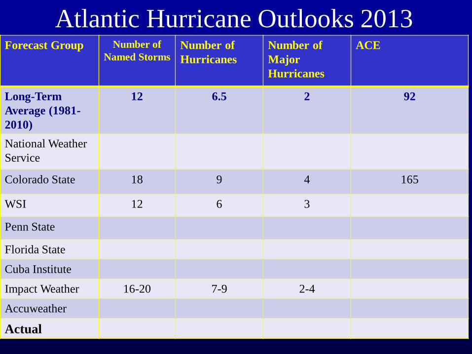
Atlantic Hurricane Outlooks 2013 Forecast Group Number of
Named Storms Number of
Hurricanes
Number of
Major
Hurricanes
ACE
Long-Term
Average (1981-
2010)
12 6.5 2 92
National Weather
Service
Colorado State 18 9 4 165
WSI 12 6 3
Penn State
Florida State
Cuba Institute
Impact Weather 16-20 7-9 2-4
Accuweather
Actual

Least active season 1983 (4 named storms!) No El Nino or La Nina (neutral)
1983, VERY Quiet Season (or was it?)
Very low number of storms, but one
with major impact on SE Texas

Tropical Cyclone Preparation

National Weather Service Web Sites
weather.gov, weather.gov/Houston
• Graphical and text forecasts
• Recorded briefings
• Hurricane audio and video briefings if a
storm is approaching
• Facebook page (Like us!)
Also check out your Office of Emergency
Management pages, Social Media for
weather info and alerts!

http://www.ready.gov
Hurricanes.gov/prepare
http://www.fbcoem.org/
More Preparedness Info at:
• Make a plan
• If I choose to
evacuate
• Build a kit
• Non-perishable food
items
• Water
• Medicines
• Battery powered
radio
• Can opener
• Keep tank full
• Have cash on hand

Top Related