


Languages
Pages
Legal

H e a d w a t e r s | S u m m e r 2 0 1 4 1
COLORADO FOUNDATION FOR WATER EDUCATION | SUMMER 2014
FloodedAnd Coming Back Smarter
Recovering From September 2013
Mapping Floodplains: An Evaluation of Risk
Experts Say, “Get Ready For More Big Floods.”
Water = Extreme

C o l o r a d o F o u n d a t i o n f o r W a t e r E d u c a t i o n | y o u r w a t e r c o l o r a d o . o r g

INCREASING AWARENESS
New Citizen’s Guide Coming SoonAn all-new Citizen’s Guide on Colorado’s transbasin diversions is in the making! CFWE is proud to add a new desk reference to its popular Citizen’s Guide series. This guide will explore Colo-rado’s many transbasin diversions and the historical figures, settings and evolving negotiations that brought them about. Plus it will examine current water planning conversations in Colorado regarding the possibility of new transbasin diversions. Preorder your copy to ensure earliest de-livery and discounted pricing by calling 303-377-4433, or order online at yourwatercolorado.org!
H e a d w a t e r s | S u m m e r 2 0 1 4 1
CFWE Mission in Motion
DEFINING VALUES
Get On The CFWE Tour BusAll aboard! In June 2014, CFWE’s Yampa River Basin Tour led more than 50 policy makers and water gurus through the wild wonders of northwestern Colorado. Participants heard from expert speakers at exclusive sites about the relationships between ecological health, river access, thriv-ing communities, agriculture and industry. Have you bought a ticket on CFWE’s water bus? We invite you to hop on one of our interactive tours to investigate the many values associated with water resources:
September 2014—Explore the power, legacy, benefits and impacts of transbasin diversions in the headwaters of the Gunnison, Arkansas and Colorado rivers.Winter 2014—Get a taste of the beverage industry’s use of water along the Front Range.March 2015—Learn how climate science and water resources are connected at the Na-tional Ice Core Laboratory in Lakewood. May 2015—Pedal along on a CFWE bike tour to investigate a waterway’s relationship to urban development, environmental health and community stewardship. June 2015—Discover the subtle beauty and agricultural abundance of the lower Arkansas River on our annual river basin tour.
Many thanks to our Yampa Basin Tour sponsors: AMCi Wireless; City of Steamboat Springs; Colorado River District; Tri-State Generation and Transmission Association, Inc.; Mount Wer-ner Water District; The Nature Conservancy; and Upper Yampa Water Conservancy District.
Participants on CFWE’s two-day Yampa Basin Tour in June 2014 enjoyed an evening reception at Carpenter Ranch east of Hayden.
Save The Date!
2014 Sustaining Colorado Watersheds Conference
“Come Hell or High Water!” October 7-9, 2014 in Avon, CO
Join us for the year’s best conference on Colorado water!
Sponsorships keep conference fees low! Details at www.coloradowater.org/conferences
Our goal is to expand cooperation in natural resource conservation,
protection and enhancement by informing participants about new
issues, innovative projects and through invaluable networking!
This year's conference will explore the spirit of community resiliency in the
wake of the 2013 floods, wildfires, and other risks to our watersheds.
Dick
Ste
nzel
The spillway at Granby Reservoir, a feature of the Colorado-Big Thompson Project’s collection system

2 C o l o r a d o F o u n d a t i o n f o r W a t e r E d u c a t i o n | y o u r w a t e r c o l o r a d o . o r g
CFWE Mission in Motion
STRENGTHENING LEADERSHIP
Welcome 2014 Water LeadersCFWE is proud to congratulate its 2014 Water Leaders class! These diverse and talented mid-level water professionals have begun a journey to develop their leadership potential and benefit from extensive self-assessment and networking opportunities with similarly accomplished colleagues. The first training in March 2014 focused on self-awareness and functional team building. The group also examined how regional leaders have effectively built water teams in northeastern Colorado through guest presentations and excursions at the Poudre Learning Center in Greeley. Subsequent trainings will be held in Fraser, Pueblo and Denver. Join us in welcoming these emerging water leaders to your community:
Jason Carey River RestorationAdam Cwiklin Town of FraserAaron Derwingson The Nature ConservancyJulia Galucci Colorado Springs UtilitiesJames Henderson 711 RanchDawn Jewell City of AuroraLaurna Kaatz Denver WaterAimee Konowal CDPHE Water Quality Control Division
Steve Malers Open Water FoundationMaria Pastore Grand River ConsultingKlint Reedy Black & Veatch CorporationGigi Richard Colorado Mesa UniversityJennifer Shanahan City of Fort CollinsEnrique Triana MWH AmericasJames VanShaar U.S. Bureau of Reclamation
The 2014 Water Leaders class visited Grand County during its second training session in May 2014.
GROWING CAPACITY
Water Educator NetworkCalling all water educators! CFWE’s Water Edu-cator Network aims to help build your capac-ity for providing high-quality water education in your community. Strong and effective programs have the potential to grow the knowledge, change the attitudes and increase the involve-ment of tens of thousands of Colorado youth and adults annually. CFWE believes this leads to a more active and involved citizenry that ad-vocates for balanced, sustainable solutions. Our new network will offer timely communication, professional networking events, a customized water education resource directory, and techni-cal assistance with our team of experts.
Visit the Water Educator Network website at www.yourwatercolorado.org/water-educator-network to learn how you can sign up for best practices in water education and help increase our collective impact. Memberships are only $100 to $125 per year. Network members ben-efit from priority access to trainings and infor-mation, such as 2014 summer training topics on water festivals, working with formal educa-tion, program evaluation and more!
Thank you to our network supporters:
CFWE’s Kristin Maharg and Colorado Springs Utilities’ water educator Birgit Landin on the 2014 Climate and Colorado’s Water Future Workshop. This annual tour features an after-noon dedicated to providing resources to water educators. Now, the new Water Educator Network creates more learn-ing opportunities with regular webinars, events, a newsletter, resources and more.

H e a d w a t e r s | S u m m e r 2 0 1 4 3
Summer is here, which in the world of water education means field trip time! I’ve spent the past seven summers planning and executing dozens of trips to connect Coloradans with their water resources. I’ve seen the impact of this work firsthand as an organizer, but it’s not often I get to reverse the role and participate as an attendee.
Thanks to Friends of the Yampa, I spent four days in June floating the Yampa River through Dino-saur National Monument with 25 river conservation advocates, ecologists and water professionals. The gratitude I feel for the organizers’ time, knowledge and financial commitment is a great reminder of why I, myself, spend summers doing this work. Educational events require a large commitment of resources. But at the end of the day, an outdoor classroom experience cannot be replaced by webinars, blogs or print materials; it’s an essential educational tool in many contexts.
One of the topics we discussed around the campfire after riding the waves of a huge spring runoff was how to better connect people to their environment. My opinion was that Colorado needs to invest in water education to a degree not yet realized. Today, most local water education programs are carried out by vol-unteers or part-time staff persons. But water education is a long-term effort requiring dedicated resources that are difficult to sustain in volunteer or part-time contexts.
The importance of water education to our state’s water future is clear and often cited. Numerous local, state and national reports on the path forward identify educating the general public and specific interest groups as a critical need. But the resources currently dedicated to water education pale in comparison to what is required. At CFWE, for example, our educational tours sell out weeks in advance, leaving dozens of people on waiting lists. The problem isn’t interest—it’s capacity to meet that interest.
Given the clear need, why hasn’t that investment happened? I’ve lately seen an attitude about water education that, at best, views it as unmeasurable and without definable results and, at worst, as an un-necessary junket. This obviously troubles me, as I see the results of good water education and can easily attest that it is making a difference in our state and local communities.
Good water education increases awareness of the severity and complexity of water issues, creating concern and the desire to get involved.
Good water education broadens perspectives and helps us walk a mile in another’s shoes, develop-ing compassion for other viewpoints and a willingness to explore rather than disengage in the midst of disagreement.
Good water education widens the number of people invested in our water and river systems, producing collaborative solutions that meet multiple needs.
Good water education promotes uncommon alliances by connecting people around common interests instead of dividing them with their differences.
CFWE will be doing its part through the new Water Educator Network. We aim to build the capacity of local water educators and increase the amount, quality and effectiveness of water education in Colorado. CFWE will provide networking, in-person and remote learning opportunities, information on best practices, and a central repository of trusted, proven lesson plans and curriculum. My hope is that we can “profes-sionalize” water education and thereby better demonstrate its critical value to Colorado’s water future.
As a lush Colorado summer begins, I challenge all Headwaters readers to define what you can do to further water education in your communities. Let’s create a commitment that will be the envy of every other western state. As always, I welcome your thoughts and comments.
Happy summer!
ColoradoFoundationfor Water Education
Board Members
Gregg Ten Eyck
President
Justice Gregory J. Hobbs, Jr.
Vice President
Eric Hecox
Secretary
Alan Matlosz
Treasurer
Becky Brooks
Nick Colglazier
Lindsay Cox
Lisa Darling
Steve Fearn
Rep. Randy Fischer
Greg Johnson
Pete Kasper
Scott Lorenz
Dan Luecke
Trina McGuire-Collier
Kate McIntire
Kaylee Moore
Reed Morris
Sen. Gail Schwartz
Andrew Todd
Chris Treese
Reagan Waskom
Staff
Nicole SeltzerExecutive Director
Kristin MahargProgram Manager
Caitlin ColemanProgram Associate
Jennie GeurtsAdministrative Assistant
Alicia Prescott Development Director
Mission Statement The mission of the Colorado Foundation for Water Education is to promote better understanding of water resources through education and information. The Foundation does not take an advocacy position on any water issue.
Acknowledgments The Colorado Foundation for Water Education thanks the people and organizations who provided review, comment and assistance in the development of this issue.
Headwaters Magazine is published three times a year by the Colorado Foundation for Water Education. Headwaters is designed to provide Colorado citizens with balanced and accurate information on a variety of subjects related to water resources. Copyright 2014 by the Colorado Foundation for Water Education. ISSN: 1546-0584 Edited by Jayla Poppleton. Designed by Emmett Jordan.
1580 Logan St., Suite 410, Denver, CO 80203
303-377-4433 • www.yourwatercolorado.org
Executive Director
H e a d w a t e r s | S u m m e r 2 0 1 4 3
Nicole Seltzer (left) led the celebration of water education at CFWE’s 2014 President’s Award reception with backup from Denver Water’s Katie Knoll.

4 C o l o r a d o F o u n d a t i o n f o r W a t e r E d u c a t i o n | y o u r w a t e r c o l o r a d o . o r g
ContentsSummer 2014
CONTRIBUTORSCaitlin Coleman is a writer and program associate for the Colorado Founda-tion for Water Education. “I had never considered the people and programs dedicated to minimizing flood risk,” she says after working on “The Big One” for this issue. “It was heartening to report on something that personally af-fected so many—then to hear about the measures we’ve built into society to keep our communities safe.”
Rachel Walker writes about the environment, the outdoors and parenting from her home in Boulder. When the deluge hit in September 2013, she watched flood-waters rise from nearby Bear Creek, cross the road, and submerge her yard. Understanding the intricacies of the National Flood Insurance Program never seemed more relevant. In covering “Coming Home” for this issue, she was im-pressed with the grit, knowledge and determination of those impacted.
Fort Collins-based writer Joshua Zaffos got a good feel for the scale of flood recovery efforts after tagging along with his sources for “Race to Recovery” this spring: “Just trying to line up interviews with busy recovery leaders was a chal-lenge, so I gained an appreciation for the coordination and cooperative action that has protected so many properties and restored impacted streams and ditches.”
Denver-based photographer Theo Stroomer took a break from current work exploring relationships between the environment and communities of Colorado’s North Fork Valley for this issue’s photo assignments in James-town. He reports: “The community has made incredible progress in its re-construction, but there is still an overwhelming amount to be done.” His other work, as the recipient of a grant from the Documentary Project Fund, will be exhibited in 2015.
Kevin Moloney is a Colorado native and freelance photojournalist who has covered western water issues since 1996 for the New York Times and other publications throughout Europe and the United States. He is a frequent con-tributor to Headwaters.
Glenn Asakawa is a Pulitzer Prize-winning photojournalist who has worked at Denver-area newspapers for 25 years and currently works for his alma mater, University of Colorado, Boulder. In shooting for this issue, he says, “I was honored to meet Jeff Crane and the DiSalvos. Their warmth, optimism, love of community and perseverance in spite of such devastating loss and damage is inspirational.”
The Big One 12By Caitlin Coleman
How September 2013 begat the most devastating flood so far this century, and why it could have been worse.
Race to Recovery 17By Joshua Zaffos
Tragedy brings opportunity as a rush of flood recovery efforts target short-term protection and long-term flood
resiliency goals.
Coming Home 23By Rachel Walker
Trickling streams beckon communities to a lovely life nearby, but when floodwaters rise, so do questions of risk,
responsibility and who bears the cost of repetitive loss.
8 EXTREMEColorado’s pendulum of climate and weather extremes; Could climate change impact flooding in Colorado?
9 RECREATIONOne rapid and one less-than-rapid comeback for whitewater parks; The prized greenway that took the hit; How the fish fared.
11 HEALTHWhen drinking water and wastewater treatment systems meet 100-plus-year floods; Safeguarding systems from future floods.
28 And the Winner Is…In recognition of exemplary water resources stewardship and education, CFWE gives out two annual awards. Meet this year’s winners of the 2014 President’s Award and Emerging Leader Award. By Justice Greg Hobbs
H e a d w a t e r s | S u m m e r 2 0 1 4
1
COLORADO FOUNDATION FOR WATER EDUCATION | SUMMER 2014
FloodedAnd Coming Back SmarterRecovering From September 2013 Mapping Floodplains: An Evaluation of RiskExperts Say, “Get Ready For More Big Floods.”
Water = Extreme
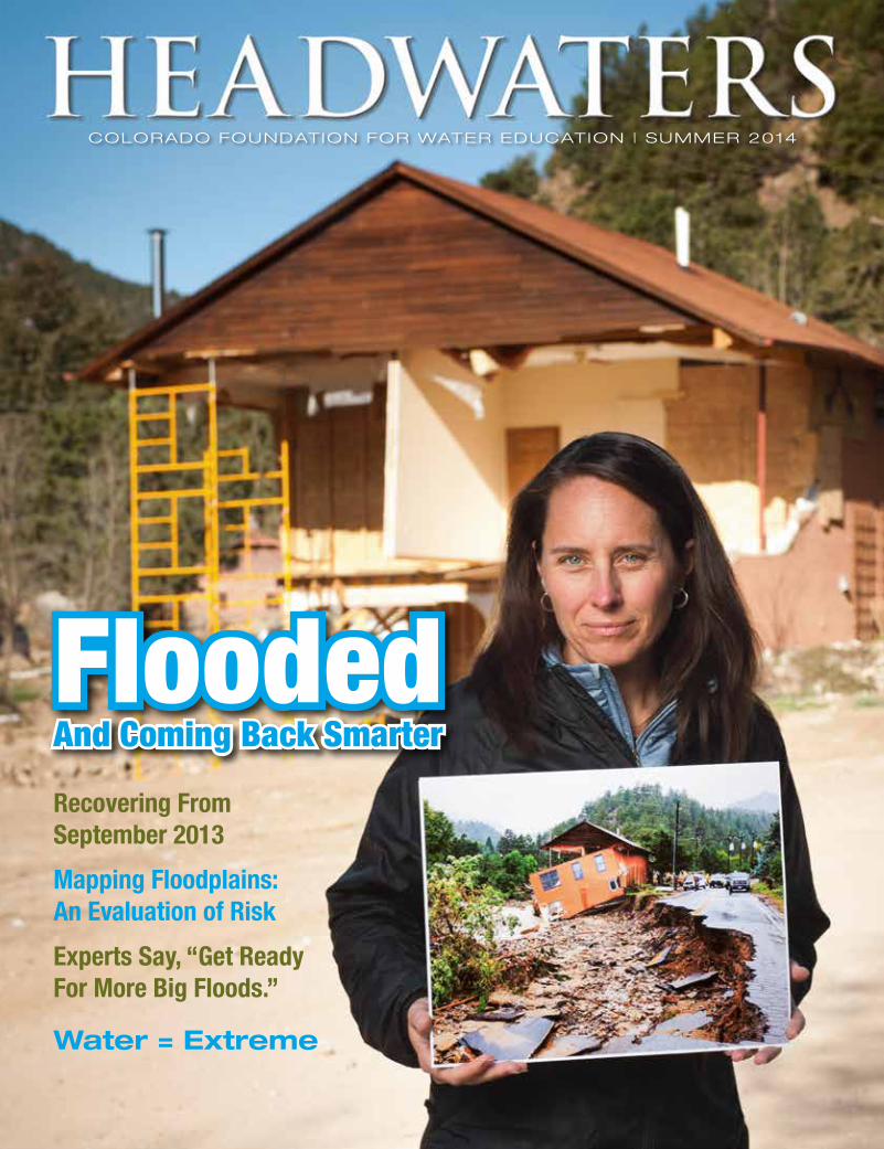
About the cover: Jamestown Mayor Tara Schoedinger shows off progress to rebuild a badly damaged structure, holding up a picture taken at the same site immediately after the September 2013 flood. Photo by Theo Stroomer
Background: U.S. Hwy. 34 east of Greeley. Photo by Mark Goldstein
Inset photos by Terry Plummer and Glenn Asakawa (2)
WATER IS…

When we decided to cover flooding for this issue, we knew we had a timely topic. The September 2013 disaster was fresh on peo-ple’s minds. Whole communities were still being pieced back together; state leaders were scrambling to obtain funding toward re-covery work; and federal and state agencies were deploying staff to provide consultation to local communities trying to figure out how to put one foot in front of another. Beginning our coverage six months out from the flood, we had the advantage of reporting on ideas, strategies and conclusions not yet fully for-mulated late last fall when major media out-lets were publishing their headline news. And yet, it was an incredible challenge to cover a recovery effort continually unfolding before our eyes. Simply tracking down the people closest to the work was far beyond the typi-cal effort required on the part of our reporters. Our sources had more than a few important tasks occupying their time and energy, I suppose!
The spring runoff as it approached was really putting the pressure on to complete projects and shore up lingering hazards. A huge snowpack was looming in the high country. Everyone braced for the worst—a quick, hot snowmelt and heavy spring rains that would lead to gush-ing streams and bring down additional debris. Though significant rain fell during runoff, the peak, if it is over as many believe, didn’t reach the height people had feared. For the most part, recovery work completed in the months following the flood proved effective. Already destabilized stream channels and riverbanks were still vulnerable, and new sediment and woody debris flushed down, sometimes in the form of uprooted live trees. But repairs to ditches and headgates have held, and irrigators benefitted from “run-of-the-river” conditions where all water rights were being fulfilled. Most importantly, everyone is safe.
Although as we go to print a second peak is still possible, with as-yet unknown results, some experts believe work done to prepare for runoff was over-reactive. Dredging to clear channels of debris, for instance, caused damage that is expected to render stretches of riv-ers sterile for years to come. It’s one example of how society, in an effort to mitigate risk, doesn’t always recognize or allow for the natural dynamics of rivers, which include periodic flooding, sediment transport and deposition, and channel migration. We’ve hemmed in our rivers and left them little room to function as they once did. And we end up, often repeatedly, paying a steep price.
Full recovery from the September 2013 flood is a long way off. Encouragingly, the coop-eration, commitment and investment of countless individuals, communities, coalitions and agencies is leading to, in places, solutions to build back smarter than before, in ways that recognize the utterly non-static nature of rivers. But some fear, in the weariness of a long recovery, when people just want to get back in their homes and see life return to normal, the “what-about-the-river?” focus will be lost.
Ellen Wohl, a fluvial geomorphologist at Colorado State University, believes society con-tinues to make the mistake of presuming it can engineer flood hazards away. If Wohl had her way, floodplains would be less a place to raise roofs and lay important infrastructure and more a home for natural areas and open space. Not only would society’s risks decrease, but rivers could again begin to function as nature intended. This leads to questions worth pon-dering, even as we work to rebuild our roads and communities in the same flood-damaged zones: Should we continue to build so close to streams? And if so, can we live with a degree of uncertainty, recognizing that, as tamed as our rivers are in places, they occasionally rear up to assert their wildness? After all, we live upon the Earth, and as smart or prepared as we may believe ourselves to be, we are still at its mercy.
TenThings To Do In This Issue:
1 Step forward to receive the first copies of CFWE’s newest Citizen’s Guide (page 1).
2 Block out a few days in October for the annual Sustaining Colorado’s Watersheds conference (page 1).
3 Read and comment on draft chapters of Colorado’s Water Plan as it takes shape (page 8).
4 Survey the extent of damages inflicted by Colorado’s most economically destructive flood (page 15).
5 Support flood victims or recovery efforts through donations of time or money (page 16).
6 See how an innovative partnership is approaching recovery where the river meets the road (page 20).
7 Follow the money coming in and being doled out to pay for Colorado’s flood recovery (page 21).
8 Study the difference between mapped flood risks and the actual flood event of September 2013 (page 25).
9 Find a map identifying the levels of flood risk affecting your community (page 25).
10 Meet this year’s winners of CFWE’s President’s Award and Emerging Leader Award (page 28).
H e a d w a t e r s | S u m m e r 2 0 1 4 5
Jayla PoppletonEditor
Jayla Poppleton, Editor
Mother Nature sure can throw a mad curve ball.
Theo
Stro
omer
6 C o l o r a d o F o u n d a t i o n f o r W a t e r E d u c a t i o n | y o u r w a t e r c o l o r a d o . o r g
Plenty Enough!I can be the fire breather or bring a gentle rain, I can be the canyon ripper or swell a honey dew;
I can pat the red dirt down or chant hosanna to the light, I can gurgle from your tap or cut your home in half.
I can carry you along, ripple up a sundown sky, I can cleave a cloud in two, splinter forest sentinels;
I can break and wreck and heave, sever channels tried and true, I can rearrange communities you can help put back together.
—Justice Greg Hobbs
Water is Extreme > Recreation > Health

H e a d w a t e r s | S u m m e r 2 0 1 4 7
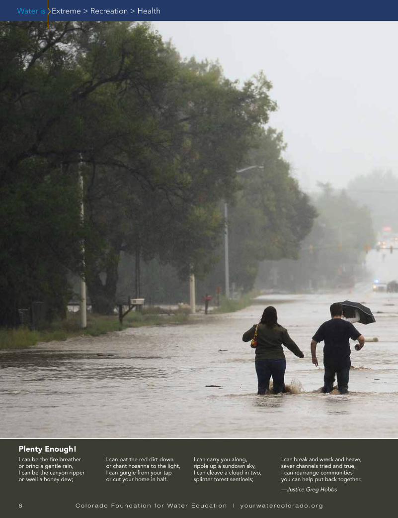
Longmont residents wade northward on a flooded Hover Street toward the city’s north side on Thursday, Sept. 12, 2013. Photo by Lewis Geyer, Longmont Times-Call.
H e a d w a t e r s | S u m m e r 2 0 1 4 7
And it all Came DownAnd it all came downFast and at onceNo one suspectedWe’d drown
She danced to steps of havoc and defianceAdministering doses of careless violenceHer mighty roar could not be silenced
People trappedRoads collapsed
Cars submergedNature diverged
Babbling creeks bursting at their watery seamsThe places we once loved turned to smithereens
She invaded like a snakeLeaving destruction in her wakeHer biblical rainsSwept across the front rangeNo mercy for the towns she had slain
From hilltops to mountainsShe took down thousandsNow eight soulsAre gone for good
And though she’s long gone,Her ghost still remainsLingering in the ruins, we hearEchoes of her watery song.
—Erin Gardner, 12th GradePeak to Peak Charter School, LafayetteKristie Letter, Teacher Winning Poem, K-12 River of Words Poetry Contest Sponsored by Colorado Humanities www.coloradohumanities.org/content/river-words
An anonymous photo rescued from the floodwatersPhoto by Bonnie-Sue Hitchcock

8 C o l o r a d o F o u n d a t i o n f o r W a t e r E d u c a t i o n | y o u r w a t e r c o l o r a d o . o r g
Deconstructing Colorado’s Climate ExtremesColorado is a land of extremes. Severe droughts segue into 1,000-year rains and 100-year floods. It’s all about moisture, says State Climatolo-gist Nolan Doesken—where it comes from, and whether it turns into precipitation.
“Because we are far removed from our mois-ture sources, which are primarily the Pacific Ocean and Gulf of Mexico, most of the time we are dry,” says Doesken. “There are opportunities for rain and snow, but with weather patterns that only infrequently deliver this moisture, anything that disrupts those occurrences will introduce drought challenges.”
In western Colorado, the “wet” season occurs each winter, when the jet stream flowing eastward across the continent is strongest, carrying mois-ture from the Pacific and lifting it up the western face of the Rocky Mountains. For the eastern part of the state, the wet season begins each spring when the jet stream dies down, allowing wet air masses from the Gulf of Mexico that otherwise move eastward to be drawn north into the center of the country.
As Doesken points out, these seasons are only truly “wet” if that moisture is deposited in Colo-rado via rain or snowstorms. “In any given year, it comes down to the opportunity for roughly six major storms,” he says. “If you get them, you have a wet year. If you get half of them, you are in a middle condition. If they skip over us, you are in a drought.”
During 11 of the past 15 years, moderate to extreme drought has plagued at least one region of the state, and in six of those years Coloradans have experienced extreme or exceptional drought. The impact of water shortage on the economy underscores the resource’s importance: The 2002 drought cost various statewide industries $2.8 bil-lion, while the 2012 to 2013 drought cost the agri-cultural sector alone $726 million.
Because of Colorado’s unique climate and to-pography, the storms we do get can also lead
to the other extreme: flooding. “To get rain-in-duced flooding, you need a weather pattern that brings in a lot of water, and then you need to lift it,” says Jeff Lukas, senior research associate with Western Water Assessment at the Univer-sity of Colorado, Boulder. One way this happens is through frontal lifting, when two air masses collide forcing warmer air up and over cooler air. Another way is through convective lifting, where low-level air warms up and rises, resulting in se-vere thunderstorms.
Then there’s terrain lifting. “If you have a 4-, 5-, or 6,000-foot elevation difference, you can have really effective lift and cooling, and the ability to bring precipitation out of moist flow,” says Lukas. This dynamic, in combination with frontal lifting, bore out during September 2013’s historic flood-ing on Colorado’s Eastern Slope.
The Western Slope of the Colorado Rockies can also produce terrain-induced lifting, but the result-ing precipitation is usually less extreme for any given event, says Lukas. This is partly because the
change in elevation isn’t as abrupt as along the Front Range, but also because there’s a clearer path for that Gulf of Mexico moisture-laden air to reach Colorado without interruption from other mountain ranges.
While the September 2013 flooding was ex-treme, it wasn’t unprecedented. In fact, says Kevin Houck, chief of watershed and flood pro-tection for the Colorado Water Conservation Board, “In a state like Colorado, there’s so much variation we likely experience a 100-year flood somewhere every year, although most are not in populated areas.”
On average over the past 100 years, flooding has cost Colorado roughly $85 million a year, with some years contributing more than others to that figure: The September 2013 flood, for instance, caused roughly $3.4 billion in damages. And floods in 1921 and 1965 on the Arkansas River and South Platte respectively, caused $1.1 bil-lion and $2.9 billion in damages in today’s dollars. —Joel Warner
Extreme PlanningTo equip the state for the inevitable, Colo-rado’s Water Plan will include sections on drought and flood readiness. “We can’t prevent these things from happening,” says James Eklund, director of the Colorado Water Conservation Board, the agency re-sponsible for preparing a draft of the plan by December 2014. “But we think that the water plan can serve to ensure that we have, at the state level, put our resources in place and made them flexible enough to be able to respond to things like this when they happen.”
Another section of the plan will focus
on watershed health. By reducing the risk of catastrophic forest fire, for example, in addition to addressing other matters of a healthy watershed, the impacts of both droughts and floods can be minimized. “That section,” says Eklund, “will be de-voted to disaster mitigation for emergency situations where we can make a difference.” —Jayla Poppleton
Water is Extreme
Find and comment on the draft chapters and framework of Colorado’s Water Plan at coloradowaterplan.com.
Dust clouds roll across drought-ridden fields near eastern Colorado’s Lamar in spring 2013.
Jane
Stu
lp

H e a d w a t e r s | S u m m e r 2 0 1 4 9
Water is Recreation
Flood Futures: More Extreme?Watching roads get swept away and towns be-come islands in the midst of September 2013’s flooding, it’s easy to imagine climate change had a hand in the disaster. But can a warming atmo-sphere really be blamed for the destruction? And will climate change impact the likelihood and fre-quency of Colorado flooding in the future?
Such questions don’t have easy answers. “We understand a warmer climate is impacting every-thing now,” says Laurna Kaatz, climate scientist for Denver Water. “But being able to predict indi-vidual events that are caused by climate change, that is not something we are able to do.”
“The issue is a lot of our floods are associ-ated with extreme weather events,” says Levi Brekke, a researcher for the Bureau of Reclama-tion's Science and Technology Program. “And the physical processes that serve as precipita-tors to these extreme events are too small-scale to plug into a lot of our global climate models. The challenge is to have fine-enough-resolution tools to shed light on the picture.”
One contributing factor that could be impact-ed by climate change is the amount of moisture available to be unleashed in the form of rain. Scientists believe warming has led to a 3 to 5 percent increase in atmospheric water vapor globally, but it’s unclear whether that increased vapor will lead to more rain here in Colorado. A recent draft report on climate change prepared for the Colorado Water Conservation Board, for example, noted that climate models weren’t conclusive as to whether the state would see more precipitation by 2050. Nor are researchers convinced Colorado will be among the places expected to experience more extreme rainfall events in coming years.
Regarding atmospheric dynamics that turn moisture to rain and determine where it’s going to fall, some researchers believe changes in the jet stream could lead to slower-moving weather systems, leading to longer periods of rain in Colorado and more potential for flooding, says the Western Water Assessment’s Jeff Lukas—but not all scientists agree.
Plus, as Lukas points out, even if climate change does increase the frequency and mag-nitude of extreme floods that have historically occurred every decade or so, these events are so rare that, “It might be a century before we no-tice the impact of the trend, and in the meantime we will have already suffered all these other sig-nificant losses due to climate change.” In other words, says Lukas, “I don’t think we have to look at flooding events across Colorado to make a stronger case for carbon mitigation. That case can stand on its own.” —Joel Warner
When Boating Gets Swamped What do you do when the creek in front of your house becomes a monster river, pumping more than 40 times the amount of water that usually flows through its narrow channel? If you’re Scott Shipley of Lyons, Colorado, you rescue your wife and two young kids from the island created by the floodwaters. Then you start the long process to rebuild your town.
Shipley, a whitewater park engineer, is a three-time world champion and Olympic kayaker; his wife is also an accomplished boater. The usually mellow St. Vrain Creek that courses behind their back yard is home to three of the best kayak playparks in the country. Those are now thickly bur-ied under sand and cobble from the September 2013 flood.
Gary Lacy of Recreation Engineering and Planning Inc. is the Boulder-based engineer who designed Lyons’ playpark—a process of engineering rapid runs to create surfable waves—and is now consulting for the town to restore damaged whitewater features. He says Lyons’ struc-tures are intact but not functioning due to “enormous amounts” of deposition. Shipley, however, disagrees. He thinks only one feature remains, the October Hole, and that it, too, will need to be repaired. In either case, significant dredging will be required to restore a functioning playpark.
Just to the south, Boulder Creek’s whitewater park near Eben G. Fine Park was also affected by the flooding, but not nearly to the same extent. Some drops were obliterated, other structures were modified—“in a good way,” says Lacy, a 30-year veteran of whitewater design responsible for 86 playparks nationwide, including Boulder’s—and the channel was packed with sediment. While both communities were anxious to see their creeks restored, Boulder had the ability to foot the bill and thus move more quickly while waiting for Federal Emergency Management Agency (FEMA) funds that may or may not come through.
It also helped that dredging and repairs to drop structures on Boulder Creek, among other proj-ects, were needed to serve multiple purposes, such as imminent flood control protection. Work on the Boulder Creek channel began in April 2014, and the playpark was restored to its pre-flood condition in early May. “Boulder Creek will look pretty darn good this summer,” Lacy says. “It’s going to be a great place to come boat.”
Meanwhile, for the much smaller Lyons community, where whitewater is a key driver of the economy, work to bring its kayaking structures back online is still just a glimmer in Shipley’s eye. The town estimates flood damage at $50 million—an astronomical figure for a town with a budget of less than $1 million a year. Other infrastructure and public safety projects have taken priority.
Shipley’s company, S2O Design, worked with FEMA and the U.S. Army Corps of Engineers to move the St. Vrain back to its pre-flood channel and to make sure the town wouldn’t get “shel-lacked,” as Shipley put it, by the spring runoff. But the town won’t tackle rebuilding its whitewater park until 2015.
FEMA grants for channel repairs are limited to projects not specific to the playpark, such as streambank stabilization. The rest of the town’s flood recovery funds will come from city and state grants and private donations. Funding to rehab the whitewater park is still up in the air.
The Lyons Outdoor Games, which draws world-class kayakers—along with spectators and their dollars—to Lyons, was still held as planned in late May 2014. The schedule was limited and the October Hole was the only structure stable enough for boating, but it was light at the end of a long winter tunnel for businesses that had suffered without tourism income since the previous summer.
“For the play [boating] community, it’s very disappointing that Lyons’ rapids won’t be back this summer [2014],” says David Holzman, a local boater who will instead head to Golden’s playpark, where September 2013 flood flows amounted to nothing more than a good spring runoff. Still, he looks on the bright side: “I’ve been boating Boulder Creek and the St. Vrain for 15 years. I could close my eyes and run them, I know them so well. Now they’re like new rivers, with new challenges and new things to learn.”
Shipley, too, concedes a plus to the flooding. “The sunny side of this whole thing is that we can re-envision our town and parks.” —Katy Neusteter
Repairs to the Boulder Creek channel near 17th Street also restored whitewater structures.
Gar
y La
cy

1 0 C o l o r a d o F o u n d a t i o n f o r W a t e r E d u c a t i o n | y o u r w a t e r c o l o r a d o . o r g
Colorado Parks and Wildlife staff sample South Platte River fish populations in the Centennial State Wildlife Area after the September 2013 flood.
Water is Recreation
Rec Path Doubles as Flood Protection Pay a visit to the northern Front Range city of Longmont, and chances are you’ll find yourself somewhere along the city’s flagship recreational attrac-tion—the 8-mile-long St. Vrain Greenway. Recent visitors to the greenway, which forms the spine of the city’s trail and park system, however, will note that virtually every stretch was affected during the September 2013 floods.
“It took 30 years—a generation—to build,” says Dale Rademacher, Long-mont’s director of public works and natural resources, “and Mother Nature took one day to destroy it.”
The system was unique, designed and built with close collaboration between the city and property owners. Residents began a small section of the trail in the mid-80s, and by 1994, the city officially began master-planned improvements, with funding from the Colorado Lottery, grants and private donations.
Despite the widespread damage it sustained, the greenway was a smart way to build on a floodplain. Damages were much less extensive, expensive and dangerous than they would have been if the area had been developed for commercial or residential use. Plus, greenways such as Longmont’s stabilize
streambanks, regulate streamflows and protect riparian ecosystems. Think of the recreational trail as a bonus prize.
Restoring the greenway will be no small task. Longmont estimates it will take $80 million to repair the St. Vrain Creek channel and complete future flood mitigation projects. An additional $15 million will be needed to recover and rebuild the greenway. The money will come partly from the Federal Emer-gency Management Agency and other federal and state sources—a $600,000 grant from Great Outdoors Colorado has already been approved for flood re-pairs to both the St. Vrain and adjoining Lefthand Greenway. The city council also instituted two monthly fee increases on utility bills to fund flood recovery projects and will ask voters to approve a $20 million bond issue in June 2014 to increase available funding.
“The community approach won’t be simply to rebuild the greenway ex-actly as it was,” Rademacher says. “We want to learn from the flood and rebuild the channel to be able to carry a 100-year flood. The trail will be part of that project.” —Katy Neusteter
How Did the Fish Fare? Just fine, says Ken Kehmeier, aquatic biologist for Colorado Parks and Wildlife. While September 2013 flood flows on river surfaces were hellish, the velocity of the water down at the riverbeds stayed steady. In fact, he says, fish counts within the flood zone are consistent with those before the floods.
The flooding may have even been a good thing for rivers like the Cache la Poudre, where flows flushed sediment deposited from fire-scoured hill-sides down the channel, restoring beneficial habi-tat for bugs and fish.
The one exception: Where rivers have been mechanically scoured of debris or put back in their native channels in order to restore roads, for example, fish habitat has been wiped out and fish have all but disappeared. Likewise, flood-ing washed away new habitat, such as riverbed structures, vegetation and driftwood, installed in the last two years by Colorado Trout Unlimited in places like Eldorado State Park, says Larry Quill-ing, director at large.
Still, fish are adaptable, and Kehmeier says anglers can expect a good—if not great—fishing season in 2014. —Katy Neusteter
Longmont will rebuild the St. Vrain Greenway, destroyed by the September 2013 flood, as a beloved recreational asset and continued flood buffer.
City
of L
ongm
ont
Cour
tesy
Col
orad
o Pa
rks
and
Wild
life

H e a d w a t e r s | S u m m e r 2 0 1 4 1 1
Water is Health
Safeguarding Drinking WaterAs flooding gripped the Front Range in Septem-ber 2013, water managers watched in dismay as the systems that delivered millions of gallons of clean water buckled and crumbled and failed. By the night of September 12, water intake struc-tures on creeks were clogged with trees, sand, wrecked buildings and, in some cases, cars and trucks. Delivery pipes were broken and scattered downstream and treatment facilities were com-pletely inundated.
Lyons and Jamestown were especially hard hit, along with dozens of smaller communities served by stand-alone water and sanitation districts. Thousands of people went without water service for days due to the damage, while others had access to water that wasn’t safe to drink. In all, the state would issue 12 boil advisories affecting 45,000 people, according to Nicole Graziano, the Colorado Department of Public Health and Envi-ronment (CDPHE) compliance assurance manager for northern Colorado.
Immediately after the rains passed, most com-munities were able to place temporary lines that allowed them to begin delivering clean water to residents fairly quickly. Now, state water offi-cials say water and wastewater utilities needing to repair or replace systems are taking steps to mitigate the risk from future flooding. Some 60 water systems have sought help from the state and Federal Emergency Management Agency in repairing their facilities. To gain approval from the CDPHE, these utilities must design their systems either out of the floodplain, or build them to en-sure they can withstand major flood events.
Either way, it’s a complicated design undertak-ing, says CDPHE spokesman Mark Salley. Many water systems lie directly in floodplains because they were constructed close to their supply source—streams.
“It is important to understand,” says Salley, “that much of the water and wastewater infra-structure damaged last year includes drinking wa-ter distribution pipes and wastewater collection sewers spread throughout cities and towns that must cross the floodplain of multiple waterways.”
To help towns rebuild—and in some cases im-prove—their systems, state lawmakers passed a bill at the end of the 2014 legislative session cre-ating a water infrastructure Natural Disaster Grant Fund. The fund was seeded with $17 million to be doled out by CDPHE to local governments through mid-2015 for design, renovation and re-construction of drinking water and wastewater treatment systems impacted by the September 2013 floods.
Those funds will help entities take steps to overcome another key challenge in building flood-resilient systems that was noted by direc-tor of the CDPHE Water Quality Control Division, Steve Gunderson: “You have to balance cost with risk.” —Jerd Smith
Health Hazard: Runaway Wastewater Evans’ drinking water system was largely unscathed by September 2013’s floods, but its wastewater system failed and for days after the rain cleared, temporary plastic toilet stalls lined roads. Residents were prohibited from using their toilets or any indoor plumbing.
“They had portable bathrooms on the street to prevent raw sewage from going to the [South Platte] river,” says Ron Falco, safe drinking water program manager for the Colorado Department of Public Health and Environment (CDPHE).
That was only the beginning of the trouble, though. Wastewater treatment systems located along raging streams failed as their control rooms filled with water and their electric systems shorted out. Hundreds of individual septic systems were also washed away. The end result: Millions of gallons of raw sewage surged across yards, city parks and farmland out onto the Eastern Plains. In all, 20 wastewater systems sustained damage, according to the CDPHE.
“All but a few were able to be operating the next day,” says David Kurz, CDPHE’s lead wastewa-ter engineer. And despite being inundated and in some cases cut off from roads, many wastewater plants were able to operate at least partially because their staffers stayed on site around the clock as the crisis unfolded. Still, the rank water became a major public health threat and the state issued multiple advisories urging people to stay away from the floodwaters. Despite state officials’ deep concerns about the threat to public health, no illnesses due to contamination were reported, accord-ing to Mark Salley, CDPHE spokesman.
As communities move forward with repairs, the numbers are daunting, but federal and state as-sistance is helping water providers and districts pay to improve and repair infrastructure. Evans alone expects its wastewater treatment plant to need about $7 million in repairs. Its annual budget for such work is closer to $1 million.
Even with the necessary funds, managers face the rebuilding challenge of mitigating future flood risk. Because wastewater treatment plants must discharge their treated effluent into waterways, they are usually located in floodplains.
Still, innovative safeguards could reduce the likelihood of future flood-inflicted outages or the extent of damages. The U.S. Environmental Protection Agency in early April 2014 published a report outlining disaster-resilient design considerations for the town of Jamestown’s drinking water system, for instance, as well as recommendations for improvements to wastewater treatment approaches there, such as pooling wastewater from low-lying individual septic systems to a publicly operated system sited above the floodplain.
“A lot of folks don’t think about their sewage treatment plant,” says Falco. “But when it goes of-fline, it’s a problem.” —Jerd Smith
City
of L
ongm
ont
Volunteers from oil and gas companies built approximately half of the 212 portable toilets erected in Evans immediately following the September 2013 flood.
City
of E
vans
State officials issued 45 boil-water advisories statewide in 2013, 12 in September alone, compared with 24 in 2012, 39 in 2011 and 22 in 2010. Water must be brought to a boil for two to three minutes to kill bacteria and other pathogens that may have entered the water supply. Source: CDPHE

For northern Colorado, September 2013 was hell. At the time, the National Weather Service called the flooding “biblical.” For those impacted, it might as well have been. Farmers watched herds of mice scurry across wet fields to reach higher ground and avoid inundation—the first plague. People, too, struggled to survive and protect family, animals and property. Those assisting with emer-gency response and rescue efforts lived on adrenaline, Snickers bars and without sleep for days. It felt like the rains would never
stop. Ten lives were lost. Hell.Although total economic losses and flood-related damages won’t be
known with certainty for years, state officials are estimating the tally at around $3.4 billion. In the end, that number will include damage to agri-cultural land and production, tourism losses, as well as impacts to homes, businesses, roads and more.
Repairs and rebuilding continue, but less than a year out it’s too soon to say what Colorado will remember and learn from the event and what will become lore.
The storm began forming along Colorado’s Western Slope on September 7. The previous week was record-breakingly hot and dry, says Nolan Doesken, Colorado’s State Climatologist. Tropical moisture heading north from the Pacific coast of Mexico had swept across the desert Southwest, targeting western Colorado. Kevin Houck, chief of watershed and flood protection for the Colorado Water Conservation Board, recalls emailing Doesken after checking the precipitation forecast, hopeful for a few inches of rain—drought relief. At the time, Doesken told him not to get too excited, these storms rarely pan out.
By September 9, that moisture moved to the Front Range. As rain showers began to fall, another mass of soggy, humid air was sweeping up from the Texas Gulf coast pumping water in like a pipeline, says Mike Chard, director of the Boulder Office of Emergency Management. The dew point was 67 degrees, and “everything was just right for this to turn into a bad day,” Chard recalls.
Even as that Gulf air was driven up against the foothills to meet the Pacific-sourced moisture, a stalled low-pressure front was circulating, making it difficult for forecast-ers to predict the enormity of the storm and where the rain would fall. In the end, that circulating front kept the moisture pointed at Colorado’s East Slope for the better part of a week.
THE BIG
ONESeptember 2013’s flood was
the most recent, but don’t expect it to be the last.
By Caitlin Coleman
Army Staff Sgt. Jose Pantoja (left) hoists evacuee Mike Daniels into a Blackhawk medevac helicopter during rescue operations in Boulder on Sept. 16, 2013. Photo by Sgt. Jonathan C. Thibault, U.S. Army
Soldiers, airmen and members of civilian emergency response agencies unload sandbags to stymie floodwaters in Arvada on Sept. 15, 2013. Photo by Air Force Staff Sgt. Nicole Manzanares, Colorado National Guard
Soldiers assisting local agencies with evacuations load residents into a high-clearance vehicle in Boulder County on Sept. 12, 2013. Photo by U.S. Army Sgt. Joseph K. VonNida, Colorado National Guard
Disaster response volunteers with Hands.org and AmeriCorps muck out homes in Evans on Sept. 25, 2013. Photo by Michael Rieger, FEMA
THE SEPTEMBER 2013 FLOOD’S DESTRUCTIVE PATH
C o l o r a d o F o u n d a t i o n f o r W a t e r E d u c a t i o n | y o u r w a t e r c o l o r a d o . o r g
H e a d w a t e r s | S u m m e r 2 0 1 4 1 3
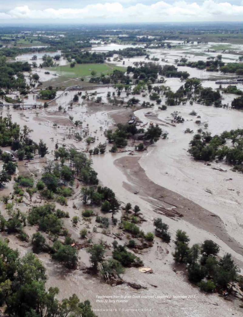
Floodwaters from St. Vrain Creek swamped Longmont in September 2013.Photo by Terry Plummer

By the afternoon of Wednesday the 11th, heavy rains started. “This was the beginning of the main show,” Doesken says. Emergency man-agers activated and all eyes were on the weather. As rain began fall-ing, people first reacted with excitement. College students were tubing in Boulder Creek and playing in the water, but by 8:30 that night the mood had shifted, says Amy Danzl with the Boulder Office of Emergency Management. Danzl was monitoring social media and felt the darkness of the event when tweets and Facebook messages became fearful. “Just got home after driving through waters in Boulder that completely blew up over my windshield and thunder crashing,” Boulder resident Morgan Heim posted on Facebook around 10 p.m. “Now the flash flood sirens are going off all over the city, and it is not a test. Sounds like the end of the world, and I’m grateful to have gotten home.”
The rains continued all week, shifting intensity and focus from as far south as El Paso County in the Arkansas River Basin and casting a wide berth northward along the Front Range. Rains poured down heaviest from 5 p.m. on the 11th until 1 a.m. the morning of the 13th, creating flood surges targeting Larimer, Boulder and Jefferson counties. On the 12th, the heaviest rains focused on Aurora, northeast Denver and parts of Weld County, causing flooding in Sand Creek and a crisis for Denver’s Metro Wastewater plant. The 12th also saw, at Fort Carson south of Colorado Springs, more rain falling in a 24-hour period than ever before recorded by a Colorado rain gauge. Those southern rains were at their wildest slightly east, around Fountain Creek.
That same day, the rains shifted west, striking the upper watersheds of the Big Thompson River and St. Vrain Creek, even pouring west of Evergreen. This western hit set the stage for tumultuous flooding that developed that night on the Big Thompson. As floodwaters rose, in many cases there was no place for people to go, no roads on which to evacu-ate, and yet the rain was still falling. Emergency managers struggled to keep people safe, making plans so rescue helicopters could fly as soon as the storm lifted.
Misinformation was proliferating. In Lyons, someone made a loud-speaker announcement that Buttonrock Dam was failing—if Buttonrock failed, Lyons wouldn’t survive. Officials and emergency managers re-ceived numerous dam failure reports and with each report had to recon-firm the dam was safely intact. As water came pouring over dam spill-ways, as with Buttonrock, many citizens may not have realized the dams were functioning according to design in response to rising water levels.
Other faulty information spread through social media networks. Rogue personalities posted dangerously false information like directing people to evacuate in the wrong direction. For days public information officers answered phones, maintained a social media presence, and quelled the major sources of misinformation.
By Friday, September 13, the rains slowed enough for rescue helicop-ters to fly. At the same time, floodwaters were consolidating. Due to the storm’s large footprint, entire watersheds were flooding. Water pounded down creeks, channels and tributaries, and roaring streams converged to tear through canyons and pour from their mouths. Stream channels were reshaped and rerouted, with flood magnitudes varying by location. According to the Natural Resources Conservation Service, many high country creeks exceeded the 100-year flood level; some exceeded it by as much as five times.
By the time the rushing St. Vrain, Poudre and Big Thompson rivers hit the South Platte out in the plains, they formed a towering flood wave that surged around Greeley. Floodwaters, in an area that itself received only a few inches of rainfall during the storm, breached river banks and flowed more than a mile wide in places, causing severe flooding in Logan, Morgan, Sedgwick and Weld counties. Three rivers overtopped Interstate 25 and all major roads across the northern Front Range closed. On the 14th, local thunderstorms again hit west Aurora and Denver and again sent floodwaters rolling down Sand Creek to Metro Wastewater. Then came an all-day rain over the entire region on the 15th. Finally, on a soggy Monday, Septem-ber 16, the rain subsided and full rescue efforts, assessments and repairs could begin.
After the flood, news media went wild—people wanted informa-tion. “I probably had more media touches in two weeks during the floods than I did in my almost 25-year career here,” says Steve Gunder-son, director of the Water Quality Control Division at the Colorado De-partment of Public Health and Environment (CDPHE). Flooded oil and gas wells and tipped tanks leaking crude oil quickly became the focus of a concerned national audience. But with the release of water quality analyses, the story died quickly.
The Colorado Oil and Gas Conservation Commission estimates los-ing 43,000 gallons of crude oil to surface water, a large number dimin-ished by the comparative volume of wastewater that was rushing down the South Platte. CDPHE estimates releases of 20 million gallons of raw sewage and as much as 270 million gallons of partially treated sewage, Gunderson says. When water quality was tested after the floods, sam-ples revealed highly elevated levels of E. Coli, stemming from wastewa-ter, while volatile organic compounds related to oil and gas production were below human health standards. A month later, E. Coli levels had returned to normal.
In the course of the storm, rainfall totals were high, peaking at 18 inches around Boulder and 15 inches in Aurora, with pockets of con-centrated rainfall reaching 14 to 16 inches in the mountains south of Es-tes Park, west of Lyons, and northwest of Loveland. Compare that to an average annual precipitation of 12 to 16 inches at lower elevations and 16 to 23 inches along the Peak to Peak Highway, plus average Septem-ber precipitation east of the Continental Divide of less than 2 inches. “The problem was, we got the better part of a year’s worth of precipita-tion in a week, with the bulk of that in a day and a half,” Doesken says.
There were other problematic factors that exacerbated the flooding and the damage. Settlement patterns in Front Range canyons have evolved and more people are living in these areas than ever before. Small access trails have become larger paved roads, roads that in some cases constitute half the floodplain’s width and restrict a river’s natural move-ment. Roads and bridges racked up an estimated $535 million in dam-ages during the flood, but the pavement also helped channel water to rip directly down canyons.
The risk of living so closely to wild areas has also manifested in the many wildfires that have ravaged Colorado, burning all the more bright-ly due to years of suppression to protect homes. The burn scars from those wildfires in turn intensify the rush of water and debris into rivers during rain events.
An aerial view shows flood damage in Colorado on Sept. 14, 2013. U.S. Army photo by Staff Sgt. Wallace Bonner
1 4 C o l o r a d o F o u n d a t i o n f o r W a t e r E d u c a t i o n | y o u r w a t e r c o l o r a d o . o r g
THE SEPTEMBER 2013 FLOOD’S DESTRUCTIVE PATH
Trailer homes were no match for the raging South St. Vrain Creek in Lyons. Photo by Bonnie-Sue Hitchcock
Floodwaters submerge fields and a road on the outskirts of Longmont. Photo by Terry Plummer
SEPTEMBER 2013 FLOOD DAMAGE
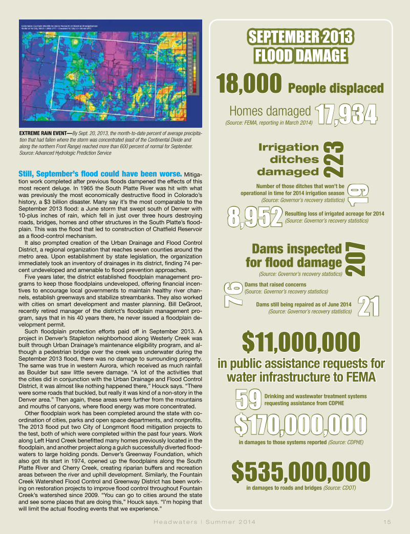
18,000 People displaced
Irrigation ditches
damaged Still, September’s flood could have been worse. Mitiga-tion work completed after previous floods dampened the effects of this most recent deluge. In 1965 the South Platte River was hit with what was previously the most economically destructive flood in Colorado’s history, a $3 billion disaster. Many say it’s the most comparable to the September 2013 flood: a June storm that swept south of Denver with 10-plus inches of rain, which fell in just over three hours destroying roads, bridges, homes and other structures in the South Platte’s flood-plain. This was the flood that led to construction of Chatfield Reservoir as a flood-control mechanism.
It also prompted creation of the Urban Drainage and Flood Control District, a regional organization that reaches seven counties around the metro area. Upon establishment by state legislation, the organization immediately took an inventory of drainages in its district, finding 74 per-cent undeveloped and amenable to flood prevention approaches.
Five years later, the district established floodplain management pro-grams to keep those floodplains undeveloped, offering financial incen-tives to encourage local governments to maintain healthy river chan-nels, establish greenways and stabilize streambanks. They also worked with cities on smart development and master planning. Bill DeGroot, recently retired manager of the district’s floodplain management pro-gram, says that in his 40 years there, he never issued a floodplain de-velopment permit.
Such floodplain protection efforts paid off in September 2013. A project in Denver’s Stapleton neighborhood along Westerly Creek was built through Urban Drainage’s maintenance eligibility program, and al-though a pedestrian bridge over the creek was underwater during the September 2013 flood, there was no damage to surrounding property. The same was true in western Aurora, which received as much rainfall as Boulder but saw little severe damage. “A lot of the activities that the cities did in conjunction with the Urban Drainage and Flood Control District, it was almost like nothing happened there,” Houck says. “There were some roads that buckled, but really it was kind of a non-story in the Denver area.” Then again, these areas were further from the mountains and mouths of canyons, where flood energy was more concentrated.
Other floodplain work has been completed around the state with co-ordination of cities, parks and open space departments, and nonprofits. The 2013 flood put two City of Longmont flood mitigation projects to the test, both of which were completed within the past four years. Work along Left Hand Creek benefitted many homes previously located in the floodplain, and another project along a gulch successfully diverted flood-waters to large holding ponds. Denver’s Greenway Foundation, which also got its start in 1974, opened up the floodplains along the South Platte River and Cherry Creek, creating riparian buffers and recreation areas between the river and uphill development. Similarly, the Fountain Creek Watershed Flood Control and Greenway District has been work-ing on restoration projects to improve flood control throughout Fountain Creek’s watershed since 2009. “You can go to cities around the state and see some places that are doing this,” Houck says. “I’m hoping that will limit the actual flooding events that we experience.”
H e a d w a t e r s | S u m m e r 2 0 1 4 1 5
EXTREME RAIN EVENT—By Sept. 20, 2013, the month-to-date percent of average precipita-tion that had fallen where the storm was concentrated (east of the Continental Divide and along the northern Front Range) reached more than 600 percent of normal for September. Source: Advanced Hydrologic Prediction Service
223
Number of those ditches that won’t be operational in time for 2014 irrigation season
(Source: Governor’s recovery statistics) 19
Homes damaged
Resulting loss of irrigated acreage for 2014 (Source: Governor’s recovery statistics)
Dams inspected for flood damage
(Source: Governor’s recovery statistics) 207
76
Dams that raised concerns (Source: Governor’s recovery statistics)
21 Dams still being repaired as of June 2014 (Source: Governor’s recovery statistics)
17,934
8,952
$11,000,000
in public assistance requests for water infrastructure to FEMA
59 Drinking and wastewater treatment systems requesting assistance from CDPHE
$170,000,000in damages to those systems reported (Source: CDPHE)
$535,000,000in damages to roads and bridges (Source: CDOT)
(Source: FEMA, reporting in March 2014)

1 6 C o l o r a d o F o u n d a t i o n f o r W a t e r E d u c a t i o n | y o u r w a t e r c o l o r a d o . o r g
The Big Thompson Flood of 1976 was the deadliest flash flood in Colorado. On the night of July 31, the mouth of the Big Thomp-son Canyon carried 32,000 cubic feet per second of water, and it came on fast. In the end, there were 144 victims. That deadly flood was high and quick compared to the September 2013 flooding where flows were more sustained and peaked around 15,500 cfs on the Big Thompson at the end of the canyon. As a result of the Big Thompson Flood, Colorado posted “climb to safety” signs in canyons and raised public awareness about the risk of flash flooding.
“This [September 2013 flood] is the No. 1 flood in our history from a dol-lar-loss amount and it doesn’t even rank in the top six for deaths,” Chard says. Ten tragically died in September, but most are relieved that more lives weren’t lost. “We had every way and every reason to have 10 times more than those deaths, statewide,” Chard says. He attributes the reduc-tion to early warning and other steps taken to mitigate risk. Still, emergency managers continue working to improve their systems so they’ll be better prepared to respond quickly when the next emergency strikes.
Although Colorado has grown more resilient and prepared with each disaster, it’s hard to say what the state will learn from September 2013. “Events kind of tend to fade into memory and people will always talk
about it, but the event develops this mythical status as if, ‘Oh, it was the big one,’” says Houck. He cites the Big Thompson Flood as the last “big one,” yet here we are with another big one less than 40 years later.
According to Doesken, floods happen in Colorado nearly every year, big floods happen about every three to five years, and really big floods happen roughly every decade. But people tend to think a disaster won’t hit them, and if it does, they expect there won’t be another, Houck says.
Society may monumentalize this flood, or forget the likelihood of re-currence, but emergency managers can’t afford to be negligent. Each disaster shapes the landscape and brings with it new risk in the future. While reviewing lessons learned with his team of responders, Chard told them to stay on their toes: “Folks, we’re facing flood season. I’ve got a [wildfire] burn scar—that risk still hasn’t changed—and we’ve got wildfire season right around the corner. I’m just getting your heads wrapped around the reality…you’d better have another one in you, be-cause we’re going to be needing you.” q
White & Jankowski Lawyers EMPHASIZING WATER RIGHTS, WATER QUALITY, AND NATURAL RESOURCES 511 Sixteenth Street, Suite 500 Denver, Colorado 80202 303-595-9441 www.white-jankowski.com
The South Platte River flooded U.S. Highway 34 east of Greeley. Photos by Mark Goldstein (3)
A partially ruined cornfield is revealed as floodwaters recede in Weld County.
Flooded oil and gas operations spilled tens of thousands of gallons of crude oil in Weld County.
The flood ripped apart thousands of private residences and left them filled with mud and debris. Photo by Tom Browning
Contribute financially to ongoing flood recovery efforts at helpcoloradonow.org or find a way to volunteer your time via Colorado Volunteer Organizations Active in Disaster: covoad.communityos.org.
THE SEPTEMBER 2013 FLOOD’S DESTRUCTIVE PATH
Many roadways were overwhelmed by surging rivers laden with debris. Photo by Bonnie-Sue Hitchcock
An aerial view shows damage to a road in Colorado due toflooding on Sept. 16, 2013. U.S. Army photo by Sgt.Jonathan C. Thibault

North St. Vrain Creek flows plac-idly along Apple Valley Road on a blue-sky April day amid the commotion of large trucks and track hoes working to reshape
its banks. Seven months earlier, in Sep-tember 2013, driving rains flooded the creek to nearly 10 times its typical volume and caused it to rise more than 5 feet in barely 24 hours, chewing up sections of U.S. Highway 36, the adjacent road-way between Lyons and Estes Park. In Apple Valley, a small side canyon off the highway, the swollen river uprooted and inundated houses and buried cars as it carved a brand new channel.
The close proximity of houses and the high-way to the river not only left them vulnerable to damages, but also compromised the natu-ral function of the North St. Vrain’s floodplain. Although the consequences to homeowners’ properties—“They took a huge, huge hit,” says consultant Jeff Crane, working on behalf of the Colorado Department of Transportation (CDOT)—are still visible in spring, an “unprec-edented” recovery is in motion, Crane says. In the aftermath of the epic flood, the Colorado Department of Transportation, Central Fed-eral Lands Highway Division of the Federal Highway Administration, and Colorado Water Conservation Board (CWCB) are partnering to avoid similar outcomes in the future, tapping cooperation between highway engineers, river restoration scientists and local landowners.
Where Apple Valley Road connects with the highway, CDOT is blasting away bedrock and widening the highway shoulder—by as much as 60 feet in some places. In those stretches, crews are using cobble and rock to create stair-step vegetated benches between the river and the road to accommodate varying flow levels. They’re placing rocks and tree root wads along banks to build contours that enable the creek to meander and diffuse energy. These natural features, which utilize the blasted bedrock as well as dirt and logs uprooted during the flood, will stabilize the riverbanks and protect the road from the next major flood, while also cre-ating habitat for fish and other aquatic species.
“The river affects the road, and the road affects the river,” says CDOT engineer Abra Geissler of her agency’s somewhat unusual interest in and support for river restoration. “Stream stabiliza-tion doesn’t just stop at the [highway] right-of-way, so we have involved landowners and taken a kind of holistic approach.”
With last fall’s floods, opportunity has fol-lowed tragedy. Recovery efforts have meant a chance to upgrade and restore both river sys-tems and infrastructure, which haven’t always functioned in harmony. Initiatives to protect property and lives in the short term are feed-ing into long-term plans to reduce flood risks
RACE TO RECOVERYMeeting Today’s Needs With an Eye on TomorrowBy Joshua Zaffos
H e a d w a t e r s | S u m m e r 2 0 1 4 1 7
In April 2014, Jeff Crane directs a crew working near Apple Valley Drive west of Lyons to realign a section of North St. Vrain Creek in advance of spring runoff.
Glen
n As
akaw
a

1 8 C o l o r a d o F o u n d a t i o n f o r W a t e r E d u c a t i o n | y o u r w a t e r c o l o r a d o . o r g
while also restoring the natural patterns and functions of rivers.
The vision is a herculean one, requiring the coordination and cooperation of scores of federal, state and local government agencies, businesses and conservation groups, and thousands of landowners—all with slightly different interests but a common goal of im-proving flood resiliency. The project unfolding along Highway 36 is a prominent, initial ex-ample of what that cooperation might look like and the results it could produce.
Even as the desire is there to improve the resiliency and function of pre-flood structures and stream channels, managers and officials racing to restore crucial water supply infra-structure or mitigate flood hazards prior to the 2014 spring runoff in many cases discovered their options were limited, not only by the time crunch, but by funding and permitting stipula-tions. So they’ve hustled to ensure the safety of and water delivery to many thousands of people and acres of farmland, in some cases installing temporary measures that can be re-placed or retrofitted down the road.
Short-Term RecoveryOn the night of September 12, 2013, Terry Plummer found himself racing along Left Hand Creek as the rains came down and the flood-waters came up. The vice president of main-tenance and operations of the Left Hand Ditch Company, headquartered in Niwot, directed
crews to build berms to keep the river from breaching its banks and to divert water that threatened homes and water delivery and sup-ply structures. As the rain kept falling, Plummer and colleague Joel Schaap hurried to see how the South St. Vrain diversion was holding up when the debris-swollen river spilled onto the road in front of them, halting their frantic efforts.
The flood surge stranded Plummer and Schaap on a road for six hours and left be-hind a path of catastrophic damage. Plum-mer endured the unnerving flood peak, but his frenzied efforts had just begun. During the following week, he scrambled nonstop to line up construction crews and contractors to miti-gate hazards, to bring water supply operations back online, and to survey the damages. “We went straight to work,” he says. That’s been the story for water and flood managers across northern Colorado, who after more than nine months have yet to stop working.
On-the-ground response began before the September 2013 floodwaters had even subsided. Local ditch companies and water districts supported shareholders and neigh-bors during the flood, building berms to pro-tect properties as rivers sprawled into plains of mud and debris hundreds of feet wide. County, state and federal emergency manag-ers, and National Guard troops focused on saving lives and delivering aid to victims. As immediate threats diminished, officials shifted to assistance and recovery phases, analyzing
damages and lingering risks and coordinating relief and repairs.
After an official disaster declaration by Pres-ident Obama on September 14, federal man-agers began following the National Disaster Recovery Framework, developed in 2011 to provide a flexible and collaborative approach to recovery. Under the framework, the Fed-eral Emergency Management Agency (FEMA), U.S. Army Corps of Engineers and other fed-eral agencies deployed staff and resources through the Joint Field Office in Centennial to complete an “advance assessment,” evaluat-ing recovery challenges and assistance needs in the affected counties.
The first step was to identify “exigent,” or emergency, projects requiring immediate at-tention and then to provide technical support, such as mapping and imaging of channels, to inform recovery efforts and mitigate future flood risks. The list of immediate hazards in-cluded unstable banks, sediment deposition in channels, and avulsion—where streams jump their banks to form new channels—which posed short-term threats to properties along transformed rivers and long-term concerns for delivering water for towns and farmers.
To address the exigent problems, managers safeguarded houses, roadways, bridges and other structures next to undercut riverbanks, placing riprap—large boulders, sometimes locked in place with concrete—to stabilize loose or steep sloping banks. The tally of such
Terry Plummer shows off Left Hand Ditch Company’s newly reconstructed dual diversion structure for its Table Mountain and Bader ditches west of Niwot in early April 2014. The ditches are part of Left Hand’s system to deliver water to approximately 15,000 acres of farmland.
Kevin
Mol
oney

H e a d w a t e r s | S u m m e r 2 0 1 4 1 9
imminently threatened cases was at least 175. Many private property projects qualified for $14.8 million in funds through the Emergency Watershed Protection Program administered by the Natural Resources Conservation Service, a branch of the U.S. Department of Agriculture.
While FEMA and the Army Corps provided technical support for stream restoration efforts on private property, irrigators and water manag-ers raced to make emergency repairs ahead of spring runoff, which kicks off irrigation season across Colorado. Not only did managers need to ensure irrigators could receive their shares of water, but they also had to plan for streams’ annual pulse of snowmelt—bolstered this year by a bountiful snowpack. That runoff would carry additional high-country debris as well as remaining dirt from the flood that could undo initial repairs and further undermine unstable banks. Some emergency structural repairs started up immediately while others had to wait out winter weather for access.
In the short term, Plummer’s crews and home-owner repairs stabilized banks and removed tons of sand, gravel and woody debris from stream channels in an effort to make room for the spring’s forecasted heavy flows. The runoff would test the effectiveness of such measures.
Since the September 2013 flood, Plummer has directed repairs on 10 major diversion projects and numerous stretches of the river. The Table Mountain and Bader diversions along Left Hand Creek were among those thrashed by the floods. Downed trees, boul-ders and floodwaters bent back the ditches’ two metal headgates at 90-degree angles as if they were made of paper. Concrete diver-sion walls snapped like twigs. Sand and de-bris stacked 6 feet deep in places, making it impossible to tell where the stream channel and ditches once flowed.
Contractors initially waited for the ground to dry out, so they could bring backhoes onto the site to move earth and reestablish the channel after the creek carved a new expansive and ter-raced floodplain. By early spring, as Plummer oversaw progress on a warm March day, crews had combined the diversions to use a new, sin-gle headgate—a cost efficiency—and filled in eroded ground beneath the structure with con-crete. To protect the diversion from runoff puls-es and future floods, they grouted riprap into the banks to lock the river’s course in place.
Plummer immediately exhausted emer-gency funds in the aftermath of the storms, so ditch shareholders agreed to a 40 percent rate hike to cover initial repair costs. The CWCB also jumped in with $40 million in emergency loans for ditch companies and irrigators, offer-ing zero-percent interest for three years. Pub-lic assistance dollars through FEMA emerged later to cover up to 75 percent of costs for di-versions and structures, which Left Hand and other ditches can use to repay the state loans.
Wade Gonzales, superintendent for the Highland Ditch Company, calls the CWCB loans “a blessing,” which allowed his com-pany to dive into repairs after its main intake diversion on the St. Vrain was “100 percent” destroyed. The Highland Ditch, which runs all the way to Milliken, primarily serves irriga-tors—and 40,000 acres of farmland—but also
provides water to the City of Longmont. CWCB grants for recovery projects totaling
$2.55 million, dispersed in amounts of $20,000 and $25,000 through the Northern Colorado Water Conservancy District, have also helped pay to repair or replace damaged water supply infrastructure.
Plummer proudly notes the Left Hand Ditch Company will come in under budget with emergency fixes, and he credits the Army Corps for moving quickly to review permits in order to expedite repairs.
Plummer and others expect tons of sand and debris to continually wash down from the high country in coming years, requiring al-most monthly excavations to keep diversions clear and ensure the river stays within its banks. Still, the progress is proof of the suc-cess and immense organization surrounding short-term recovery, from planning to funding to implementation.
But the scramble to address imminent haz-ards ahead of runoff may not even have been the toughest task for managers, especially when weighed against the titanic efforts under-way to coordinate long-term recovery spanning entire watersheds. Says Sean Cronin, executive director of the Longmont-based St. Vrain and Left Hand Water Conservancy District, which works with dozens of ditch companies, “Who would’ve thought this would be the easy part?”
Master Planning for ResiliencyA testament to the size and pace of flood re-covery, Jeff Crane has racked up 700 miles a week on his truck since last November. The Carbondale-based river hydrologist began serv-ing as CWCB’s contract field project coordinator weeks after the storm, teaming up with and ad-vising recovery initiatives from Coal Creek to the Big Thompson River to Fountain Creek.
Beyond its loans and grants for immediate re-pairs, the CWCB is backing long-term, big-pic-ture planning and stream rehabilitation. The Col-orado Watershed Restoration Program supports the creation of watershed master plans to guide community- and basin-wide projects to rehabili-tate rivers’ environmental functions and reduce flood risks. While each master plan is custom-ized for a particular river basin, all are prompted by people’s desire to protect or restore a river system, says the CWCB’s Chris Sturm, who co-ordinates the restoration program.
In the aftermath of the September 2013 floods, the CWCB approved a special round of grants to communities and coalitions in the 18 counties affected by the floods. Under the guidelines of the special release, a watershed master plan covers collaborative projects that tackle a wide range of basin functions: channel stabilization or reconfiguration, flood control and floodplain preservation, habitat enhancement and wetlands restoration, road and bridge protection, and establishment of recreational features.
Consider the program, which provides mon-ey for master planning while requiring matching funds and in-kind contributions up to 50 per-cent, a nudge and incentive toward compre-hensive river planning. “It’s carrots, not sticks,” says Sturm. “What we’re hoping to see is peo-ple approach this recovery effort looking at the
WATERLAWPATRICK|MILLER|KROPF|NOTO
�e worlds� �ost precious resource deserves
a law �r� �ocused only on water
ASPEN • BASALT • DENVER PHOENIX • TULSA
www.waterlaw.com 800.282.5458
©
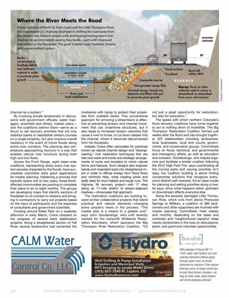
2 0 C o l o r a d o F o u n d a t i o n f o r W a t e r E d u c a t i o n | y o u r w a t e r c o l o r a d o . o r g
channel as a system.” By involving private landowners in discus-
sions with government officials, water man-agers, scientists and others, master plans—and the coalitions behind them—serve as a forum to set recovery priorities that not only stabilize banks or reestablish stream courses on a single property, but also improve overall resiliency in the event of future floods along entire river corridors. The planning also em-phasizes approaching recovery in a way that enables natural river functions during both high and low flows.
Across the Front Range, eight basin-wide coalitions, representing nearly every river sys-tem severely impacted by the floods, have suc-cessfully submitted state grant applications for master planning. Hastening a process that typically spans one to two years, these flood-affected communities are pushing to complete their plans in six to eight months. The groups are developing maps that identify sections of floodplain to re-connect to streams and bring-ing in contractors to carry out projects based on the input of participants and the expertise of consultants and government scientists.
Cruising around Estes Park on a weekday afternoon in early March, Crane checked on the progress of several bank stabilization projects. Along a straightened section of Fall River, several landowners had cemented the
riverbanks with riprap to protect their proper-ties from unstable banks. This conventional approach for armoring a streambank is effec-tive at preventing erosion and channel move-ment that can undermine structures, but it also leads to increased stream velocities that cause a river to incise, or cut down deeper into the channel, where it becomes disconnected from the floodplain.
Instead, Crane often advocates for practices known as natural channel design and “bioengi-neering,” river restoration techniques that use tree root wads and trunks and strategic arrange-ments of rocks and boulders to mimic natural forms and features. Such designs also engineer bends and meanders back into straightened riv-ers in order to diffuse energy from flood flows and minimize risks, while creating pools and spills ideal for trout habitat and kayak runs. The Highway 36 recovery project—with 17 sites along an 11-mile stretch of stream-adjacent roadway—showcases that approach.
The restoration coalitions are building to-ward similar collaborative projects that blend practical and natural elements—changing some people’s views in the process. “The master plan is a means to a greater end,” says John Giordanengo, who until recently worked for the nonprofit Wildlands Resto-ration Volunteers, which sponsors the Big Thompson River Restoration Coalition. “It’s
not just a great opportunity for restoration, but also for education.”
The speed with which northern Colorado’s flood recovery coalitions have come together to act is nothing short of incredible. The Big Thompson Restoration Coalition formed just weeks after the flood and has brought togeth-er 325 stakeholders including landowners, local businesses, local and county govern-ments, and conservation groups. Committees focus on fiscal, technical, and governmental and interagency affairs, as well as education and outreach. Giordanengo, who helped orga-nize and facilitate a similar coalition following the 2012 High Park Fire, says coordinating all the moving parts and varying priorities isn’t easy, but coalition building is about finding compromise solutions that recognize every-one’s distinct self-interests. It’s an ideal model for planning and setting priorities along a river, he says, since what happens either upstream or downstream affects everyone else.
Along the severely damaged Little Thomp-son River, which runs from above Pinewood Springs to Milliken, a coalition of 380 land-owners and other supporters are involved with master planning. Committees meet weekly and monthly, depending on the tasks and workload, and “neighborhood captains” keep nearby landowners in the loop on discussions, plans, and grant and volunteer opportunities.
Where the River Meets the Road
EXISTINGGROUND
Root wad bank stabilization
EXISTING CHANNEL BOTTOM
BASE FLOW
BANKFULL FLOW (Average runoff)
100-YEAR FLOW
Grouted riprap: Keyed into bedrock and filled with soil to promote plant growth
Non-grouted riprap filter B E D R O C K
36ʼ
5ʼ
10ʼ
RoadbedRock fall safety ditch
Road surface
Geotextile barrier
Riprap: Rock or other material used to armor a streambank or streambed from scour and erosion
Banks constructed to facilitate debris and sediment capture in order to promote plant growth
Along stretches of North St. Vrain Creek and the Little Thompson River, the cooperative U.S. Highway 36 project is shifting the road away from the streams into blasted canyon walls and bioengineering tiered river channels to accommodate varying �ow levels—each with improved connection to the �oodplain. The goal? A better road, healthier streams and a more resilient system.
With passage of House Bill 14-1005, water right holders can now relocate diversions without going through water court, as would otherwise be required, if the original diversion point no longer works due to post-flood stream changes—as long as other water rights holders will not be adversely affected.
Char
les C
ham
berlin

H e a d w a t e r s | S u m m e r 2 0 1 4 2 1
“Our goal is flood resiliency,” says Gordon Gilstrap of the Big Thompson Conservation District who is facilitating the Little Thompson Watershed Restoration Coalition and whose organization is the coalition’s financial spon-sor. “We want to get the river to the point where if there’s another event, it’s not as dam-aging as this time.”
An Evolving ApproachWhile the scale of the recovery effort is daunt-ing, the ceaseless efforts of dedicated staff and volunteers are paying off. In the St. Vrain and Left Hand Water Conservancy District, 44 of the 94 ditches and reservoirs sustained damage during the September 2013 flood. For all but four of those diversions and structures, ditch
companies have either succeeded in rebuilding ahead of runoff, or are expected to be online at some point during the 2014 irrigation season. In several cases, repairs have incorporated new natural design elements during rebuilding.
At the shared diversion for the Rough and Ready Ditch and Palmerton Ditch down-stream of Lyons, repairs replaced a concrete
Work to rebuild damaged sections of U.S. Highway 36 northwest of Lyons progresses in tandem with improvements to the adjacent North St. Vrain Creek.
Footing the Bills for Colorado’s Flood RecoverySource Scope Amount
FEMA Public Assistance Covers 75 percent of cost of eligible state and local projects for emergency measures, debris cleanup, and repair of roads, bridges and other infrastructure
$162.6 million
FEMA Individual Assistance Provides individuals and families with rental assistance, basic home repair assistance and other critical emergency assistance
$61.2 million
National Flood Insurance Program Payments on flood insurance claims $65.5 million
U.S. Small Business Administration Loans for homeowners and small businesses $108.2 million
U.S. Department of Housing and Urban Development (HUD) Community Development Block Grants
Given to state to be administered by Colorado Department of Local Affairs; must be expended within 2 years, with 80 percent directed to most affected counties (Boulder, Weld, Larimer)
Two installments:$62.8 million$199 million
Federal Highways Administration Emergency Relief Program
Administered by Colorado Department of Transportation to perform emergency and permanent repairs on federal aid roads and highways
$450 Million
U.S. Department of Agriculture Natural Resources Conservation Service Emergency Watershed Protection Program
Covers up to 75 percent of project costs for emergency measures such as debris removal or streambank stabilization on public or private land
$14.8 million
U.S. Department of Agriculture Farm Service Agency Emergency Conservation Program
Covers rehabilitation of farm and ranch land, debris removal and repair of permanent fencing and water-related structures
$5.8 million
Colorado Water Conservation Board Emergency loans to ditch companies and irrigators to mitigate hazards and repair or replace damaged structures
$40 million
Grants, disbursed by Northern Water, to repair or replace damaged water supply infrastructure $2.55 million
Grants for post-flood watershed master planning and restoration activities $1.9 Million
Grants to help pay the costs of watershed cleanup and restoration in areas affected by the flood (SB14-179) $2.5 Million
U.S. Department of Labor National Emergency Grant Funds to state for debris removal and cleanup, humanitarian assistance and subsidies for jobs recovering flood-damaged infrastructure
$5.7 million
Colorado Department of Public Health and Environment Natural Disaster Grant Fund (HB14-1002)
Funding for planning, design, and construction of water and wastewater infrastructure $12.6 Million
Rehabilitation of on-site wastewater treatment systems $4.2 Million
Glen
n As
akaw
a
Char
les C
ham
berlin
Source: Governor’s Recovery Office, June 2014

2 2 C o l o r a d o F o u n d a t i o n f o r W a t e r E d u c a t i o n | y o u r w a t e r c o l o r a d o . o r g
roller dam, which was great at preventing erosion but difficult for fish and dangerous for boaters to navigate, with a long-sloped dam that has a built-in fish ladder. “It will function much better than what was there before,” says Ken Huson, water resourc-es administrator for the City of Longmont, which has a major stake in the system and other ditches in the region, “but it’s also a very good and stable construction that will be able to withstand what will be an inter-estingly dynamic streambed as it naturally recovers from the flood.”
A similar sloped design was used on the new diversion for the Oligarchy Ditch, an-other significant supply for Longmont, while renovations on smaller ditches incorporated rock weirs, or low barriers, that still back up water to flow through headgates but provide easier passage. “We feel we need to work with the stream,” says Huson.
In other cases, time and financial con-straints as well as regulatory hurdles, whether real or perceived, led to diversion structures being rebuilt almost exactly as they stood in the past. For instance, many federal permits and FEMA funds were un-derstood to be available or expedited only for projects replicating past works, meaning ditch companies preparing for runoff didn’t feel they had much choice. Proposals to re-build around new channels have also com-peted with some landowners’ desires to see streams set back in their former paths.
“There are certainly structures that are
being reconstructed the way they were 100 years ago,” says Sturm. “It’s a real challenge. You’re balancing this legitimate concern of protecting life and property with ecosystem function of the channel.”
Yet many companies, agencies and local governments have gone above and beyond to help protect private property while con-sidering how they can venture into enhanc-ing river systems’ natural functions.
“Companies are, by and large, interested in sitting down and having a conversation about how things could be built differently,” says the St. Vrain and Left Hand district’s Cronin. “But it’s not as easy as just saying we want to do it differently. What [ditch com-panies] found out is the time was going to be longer and the money wasn’t available.”
That may mean some of this year’s fixes could get ripped out and renovated or else retrofitted with more natural elements some-time down the road—again, when funds be-come available. Meanwhile, irrigators and state officials are beginning to think about how they can work with federal agencies so when the next flood occurs, projects to build back for improved resiliency or with added benefit to streams won’t require ditch com-panies and landowners to wade through a more complicated—and possibly limiting—regulatory process than that for projects re-verting to a pre-flood design.
Douglas Mutter spent his career advis-ing recovery programs following disasters, including the 1989 Exxon Valdez oil spill in
Alaska’s Prince William Sound, the 2010 BP oil spill in the Gulf of Mexico, and 2012’s Su-perstorm Sandy. He and other proponents of master planning say there’s been “great success” in both rehabilitating river systems and educating water managers. Structures built for later enhancements, such as Left Hand’s Allen’s Lake diversion, which is be-ing reconstructed to accommodate fish pas-sage in the future, are a prime example that short-term action doesn’t have to preclude long-term planning.
Mutter, who retired from the U.S. Depart-ment of the Interior last year only to be called in to advise Colorado’s recovery efforts, learned during the course of his career that there’s no cookie-cutter approach to recov-ery, and what works best for one river sys-tem and its communities may not serve oth-ers. He emphasizes another essential point, one that flood managers have repeated time and again since last fall: “There’s going to be more big floods.”
“One of the lessons learned is we need to be ready for the next one,” adds Cronin. “We know more now in terms of the responsibil-ity of managing water resources and what makes a healthy ecosystem. It’s a natural evolution.” q
Connect with the official state resource for flood recovery information, updates and resources at Coloradounited.com.
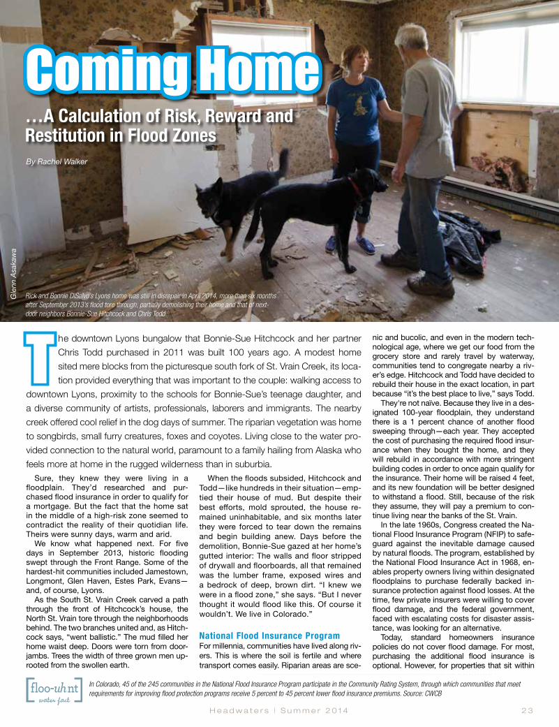
H e a d w a t e r s | S u m m e r 2 0 1 4 2 3
The downtown Lyons bungalow that Bonnie-Sue Hitchcock and her partner Chris Todd purchased in 2011 was built 100 years ago. A modest home sited mere blocks from the picturesque south fork of St. Vrain Creek, its loca-tion provided everything that was important to the couple: walking access to
downtown Lyons, proximity to the schools for Bonnie-Sue’s teenage daughter, and a diverse community of artists, professionals, laborers and immigrants. The nearby creek offered cool relief in the dog days of summer. The riparian vegetation was home to songbirds, small furry creatures, foxes and coyotes. Living close to the water pro-vided connection to the natural world, paramount to a family hailing from Alaska who feels more at home in the rugged wilderness than in suburbia.
Sure, they knew they were living in a floodplain. They’d researched and pur-chased flood insurance in order to qualify for a mortgage. But the fact that the home sat in the middle of a high-risk zone seemed to contradict the reality of their quotidian life. Theirs were sunny days, warm and arid.
We know what happened next. For five days in September 2013, historic flooding swept through the Front Range. Some of the hardest-hit communities included Jamestown, Longmont, Glen Haven, Estes Park, Evans—and, of course, Lyons.
As the South St. Vrain Creek carved a path through the front of Hitchcock’s house, the North St. Vrain tore through the neighborhoods behind. The two branches united and, as Hitch-cock says, “went ballistic.” The mud filled her home waist deep. Doors were torn from door-jambs. Trees the width of three grown men up-rooted from the swollen earth.
When the floods subsided, Hitchcock and Todd—like hundreds in their situation—emp-tied their house of mud. But despite their best efforts, mold sprouted, the house re-mained uninhabitable, and six months later they were forced to tear down the remains and begin building anew. Days before the demolition, Bonnie-Sue gazed at her home’s gutted interior: The walls and floor stripped of drywall and floorboards, all that remained was the lumber frame, exposed wires and a bedrock of deep, brown dirt. “I knew we were in a flood zone,” she says. “But I never thought it would flood like this. Of course it wouldn’t. We live in Colorado.”
National Flood Insurance ProgramFor millennia, communities have lived along riv-ers. This is where the soil is fertile and where transport comes easily. Riparian areas are sce-
nic and bucolic, and even in the modern tech-nological age, where we get our food from the grocery store and rarely travel by waterway, communities tend to congregate nearby a riv-er’s edge. Hitchcock and Todd have decided to rebuild their house in the exact location, in part because “it’s the best place to live,” says Todd.
They're not naïve. Because they live in a des-ignated 100-year floodplain, they understand there is a 1 percent chance of another flood sweeping through—each year. They accepted the cost of purchasing the required flood insur-ance when they bought the home, and they will rebuild in accordance with more stringent building codes in order to once again qualify for the insurance. Their home will be raised 4 feet, and its new foundation will be better designed to withstand a flood. Still, because of the risk they assume, they will pay a premium to con-tinue living near the banks of the St. Vrain.
In the late 1960s, Congress created the Na-tional Flood Insurance Program (NFIP) to safe-guard against the inevitable damage caused by natural floods. The program, established by the National Flood Insurance Act in 1968, en-ables property owners living within designated floodplains to purchase federally backed in-surance protection against flood losses. At the time, few private insurers were willing to cover flood damage, and the federal government, faced with escalating costs for disaster assis-tance, was looking for an alternative.
Today, standard homeowners insurance policies do not cover flood damage. For most, purchasing the additional flood insurance is optional. However, for properties that sit within
Coming Home …A Calculation of Risk, Reward and Restitution in Flood ZonesBy Rachel Walker
Rick and Bonnie DiSalvo’s Lyons home was still in disrepair in April 2014, more than six months after September 2013’s flood tore through, partially demolishing their home and that of next-door neighbors Bonnie-Sue Hitchcock and Chris Todd.
In Colorado, 45 of the 245 communities in the National Flood Insurance Program participate in the Community Rating System, through which communities that meet requirements for improving flood protection programs receive 5 percent to 45 percent lower flood insurance premiums. Source: CWCB
Gle
nn A
saka
wa

2 4 C o l o r a d o F o u n d a t i o n f o r W a t e r E d u c a t i o n | y o u r w a t e r c o l o r a d o . o r g
a designated 100-year floodplain and have a mortgage backed by a federal agency, flood insurance is mandated. Nationwide, approxi-mately 5.5 million properties today are insured through the NFIP. In Colorado, the Federal Emer-gency Management Agency (FEMA), the agency responsible for administering the NFIP, reports a total of 23,255 active policies with annual premi-ums totaling just under $19 million. According to Michael Gease, FEMA natural hazards special-ist, flood insurance premiums in high-risk areas average about $1,000 per year but have been known to cost 15 or more times that.
Of course, insurance is all about hedging against risk. “Flood insurance is not that dif-ferent from auto insurance,” says Ryan Pietra-mali, risk analysis branch chief at FEMA Re-gion 8. “If you take higher risks and are more likely to incur claims, your rates are higher.” In other words, live in the floodplain, and be prepared to pay a premium. Live outside of it, and rates drop to “very affordable prices,” says Pietramali.
Although individuals outside the 100-year floodplain who live in communities participat-ing in the NFIP can also purchase flood insur-ance, few do despite the lower premiums, in part because they do not perceive themselves to be at risk. After all, a floodplain map shows where a flood will occur, right? Yes, and no.
Risk: A Line on a Map The September 2013 floods underscored that existing floodplain maps, which are established by FEMA, aren’t always accurate in their iden-tification of risk. “Our maps offer a really good depiction of a predictable flood risk, but there is uncertainty around that line,” says Pietramali.
“That line” refers to the mapped boundary
denoting the 100-year floodplain, or the high water mark for a flood that has a 1 in 100 chance of occurring any given year. FEMA labels it the high-risk Special Flood Hazard Area. “Nationally, about 25 percent of flood insurance claims come from areas outside our high-risk Special Flood Hazard Area,” says Gease. “And for the September 2013 floods, about half of all flood insurance claims came from low- to moderate-risk areas.”
A December 2013 analysis by the Denver Post showed that more than 17 percent of homes destroyed or damaged in four of the counties hardest hit by September’s flood—Weld, Larimer, Boulder and Logan—were not technically in the floodplain, according to the map. That same analysis found that some of the affected counties’ flood management plans were out of date. In some cases, flood-plain maps had not been updated since 1979.
In other cases, such as in Longmont, flood maps were accurate, but the magnitude and extent of the flooding was so great, on the order of a 500-year flood, that floodwaters reached well beyond the regulatory 100-year floodplain.
In either case, the consequence is that many of the people affected by the floods did not have flood insurance. When their homes were dam-aged or destroyed by the floods, they relied on personal savings, emergency federal and state funding, and the help of nonprofit relief organiza-tions to get back on their feet.
Designating a floodplain, and identifying the risk of living and building within it, is a compli-cated task largely undertaken by FEMA. The highest-risk area is known as a floodway and cannot be built in. The next designation is the 100-year floodplain.
The floods “gave huge insights into where we were close and where we missed the mark” with floodplain maps, says Kurt Bauer, engi-neering project manager with the City of Boul-der’s Public Works Department. For instance, several of the drainages in Boulder County that breached and caused significant damage saw “drastically different inundation than what the maps predicted,” he says.
Immediately after the flood, officials capital-ized on the opportunity to capture data using LiDAR technology, a remote sensing laser tech-
For the Colorado Water Conservation Board’s Kevin Houck, the pace hasn’t slowed in the nine months following September 2013’s flood in the scramble to help communities like Jamestown (above) update flood hydrology information, revise floodplain maps, enforce floodplain building codes and more.
Jamestown Mayor Tara Schoedinger is leading the charge to rebuild her flood-destroyed community and bring residents home.

H e a d w a t e r s | S u m m e r 2 0 1 4 2 5
nology that is used to create high-resolution maps. “With floodplain mapping, everything is theoretical,” explains Bauer. “But for the first 16 days after the flood, for 12 hours straight, we had a team documenting the flood extent and can now correlate that information with the cur-rent floodplain mapping.” This data will be used to update the floodplain maps that “we think were incorrect,” says Bauer.
Although FEMA is typically the agency in charge of updating maps, local communities “can update their map at any time, using the pro-cess to show where the channel has migrated and to show new flood risk,” says Pietramali. Then the community submits the updated map for FEMA approval.
Under national flood insurance reforms passed in 2012 and 2014, FEMA is also re-vamping its mapping program with the guid-ance of a Technical Mapping Advisory Coun-cil. The committee will review the new national flood-mapping program and ensure FEMA is utilizing “technically credible” data and map-ping approaches. However, this is happening at a slow—some would say glacial—pace.
In the aftermath of September 2013’s floods, local and state officials are scrambling to un-dertake their own floodplain mapping analy-ses, rather than waiting for FEMA, according to Kevin Houck, chief of watershed and flood protection for the Colorado Water Conservation Board (CWCB). “Communities are looking for accurate information and will need that to make plans and decisions,” says Houck.
The significance of these efforts is great; a change in designation could preclude a homeowner from rebuilding their property or could add significant expense if a redrawn boundary lands a home in a newly identified floodplain or floodway.
The boundaries impact not only flood insur-ance rates, but also building regulations. FEMA establishes minimum standards for building within the 100-year floodplain, and buildings must adhere to those standards to be eligible for the NFIP. However, “a community or state can al-ways regulate to more restrictive standards than ours,” says Pietramali.
Colorado, in fact, adopted stricter floodplain management standards statewide in 2011, and the state is committed to ensuring that commu-nities rebuild accordingly following September’s flood, says the CWCB’s community assistance program coordinator Jamie Prochno. Highlights of the standards include requiring new structures to be built at least 1 foot above the water surface elevation of the 100-year floodplain, requiring “critical facilities” like schools and hospitals to be built at least 2 feet above the floodplain, and instituting a more restrictive floodway for new flood studies.
When the standards were adopted, commu-nities around the state were given a three-year transition period to finalize their flood ordinanc-es, and the higher floodplain standards were be-ing rolled out when the September 2013 flood hit. Prochno says the standards won’t change in the wake of the flood.
Higher standards reduce the risk of flood loss-es, which also translates to lower flood insurance premiums. For example, in Fort Collins, where city officials have undertaken significant flood mitiga-
tion steps, flood insurance policy holders in high-risk areas receive a 30 percent discount on their policies, says Gease.
Still, many residents whose homes have been destroyed find themselves in limbo while waiting for the mapping analyses to be com-plete. According to the Post, more than 70 properties in Larimer County may now be in the floodway and cannot be rebuilt. In Weld County’s Milliken—where Gease says the flooding exemplified the magnitude of the dif-ference between what was mapped and what actually happened—residents of a decimated trailer park are waiting for the green light to re-turn. The trailer park was not in the designat-ed floodplain, although it was near the South Platte River, and none of the residents had flood insurance. Updating the town’s flood-plain map could render the land a designated floodplain, and with that designation would come strict building requirements. Until that process is complete, many of the residents are in the unenviable position of choosing to move somewhere else or wait to return to their home, knowing that may not be an option.
Moving more quickly than most, the tiny 300-member town of Jamestown embarked on an ambitious project to redraw its flood-plain map in a period of three months—and then started rebuilding. That despite the obvi-ous risks. After all, the flooded James Creek of September 2013 decimated Jamestown: With 26 homes destroyed and another 37 dam-aged, only 20 residents continued to inhabit the community after the flood. One man was killed when a massive landslide crushed his home.
The town’s water supply was ravaged. With its roads and bridges washed out, the town was rendered virtually inaccessible.
But with Mayor Tara Schoedinger at the helm, Jamestown residents are determined to rebuild. Summoning the small town spirit they say dis-tinguished the picturesque community, residents have held fundraisers, pitched in to clear out de-bris and damaged structures, and congregated online at rebuildjamestown.org, where links guide people to give tax-deductible donations and to follow the town’s progress.
Jamestown, which operates on an annual budget of $56,000, has since received more than $5 million toward rebuilding from FEMA and the U.S. Small Business Administration (SBA). That includes almost $1.1 million to 211 residents through FEMA's Individuals and Households Program, and more than $2.5 million in low-inter-est SBA loans. The town’s post office reopened in February, and the U.S. Environmental Protec-tion Agency has repaired damage to the stream corridor along a town park.
The remapping effort, which is guiding the rebuild, was not an idle project, says Mayor Schoedinger. “It was in response to a disaster that displaced an entire community. In order to bring people home, we needed to figure out where our post-flood, 100-year elevation is. We
Find floodplain maps for communities across Colorado, or even enter in your own street address to locate your home on a map, by visiting the FEMA Map Service Center at msc.fema.gov.
Theo
Stro
omer
(2)
In Milliken, the confluence of the Big and Little Thompson rivers in September 2013 spewed floodwaters far exceeding FEMA’s mapped 100-year floodplain. In April 2014, the Town of Milliken approved an extended regulatory floodplain, beyond FEMA’s lines, which will impact local building codes but not the National Flood Insurance Program, which uses FEMA’s map. FEMA, too, plans to update its lines, but it could take several years.
Milliken’s New Map: Accounting for September 2013
CWCB
and
ICO
N En
gine
erin
g, In
c.

2 6 C o l o r a d o F o u n d a t i o n f o r W a t e r E d u c a t i o n | y o u r w a t e r c o l o r a d o . o r g
Durango970.259.7411
Glenwood Springs970.945.7755
Denver 303.480.1700
www.wrightwater.com
Harvard Gulch‒City and County
of Denver
(one of WWE’s first flood control projects)
floodplains
design
planning
Wright Water Engineers has over 50 years of experience in water resources engineering.
need to design what we are going to do in the stream corridor to protect our community from 100-year floods and from spring runoff floods.”
Not every community has coalesced into such a strong community effort, or made as much progress as Schoedinger’s. Out of the canyons downstream of Jamestown, in the prairie town of Evans, population 22,000, a predominantly Latino community is struggling to rebuild. Many Evans residents lack American citizenship, and in addition to losing their homes, they have faced the uncertainty of navigating federal assistance, fearful that attempts to secure recovery funding could lead to questions of citizenship or, worse, deportation. Unlike in Jamestown, there is no fundraising website for Evans.
Bearing the Costs of RiskIn the first six months after the September 2013 flood, more than $284 million in federal funds were provided for recovery. More than $222 million came in the form of disaster grants to individuals and families, flood insurance pay-ments and low-interest loans to renters, home-owners and businesses. Nearly $63 million came as Community Development Block Grant funds from the U.S. Department of Housing and Urban Development (HUD) that were obligated to state and local governments’ response and recovery work. In the week marking precisely six months after the flood, HUD announced a second installment of those block grants, to the tune of $199 million. The message is clear: Most communities want to rebuild and the gov-
ernment assistance is there, despite the risk of a future flood of similar magnitude.
For Hitchcock’s next-door neighbors, Rick DiSalvo and his wife Bonnie, the decision to rebuild has less to do with loyalty to their property and more to do with their personal finances. “We’d like to be out of harm’s way,” says DiSalvo. “But we’re thinking about resale value. We can’t do anything with our property in this condition.” Like thousands of others, to walk away now would mean forgoing the eq-uity in what’s left of their home and defaulting on their existing mortgage. Better to take what insurance money they can, and work on put-ting their house back together. For Hitchcock and Todd, whose flood-ravaged property has an assessed value less than half what it was before, insurance won’t cover the full cost of rebuilding, but it will go a long way.
Some homeowners may be able to sell their properties for fair-market value, as assessed before flood damage occurred, through a FEMA voluntary buyout program. Under the program, communities can apply through the state for a federal grant that provides 75 per-cent of the funds toward purchasing proper-ties in the hardest-hit areas. Structures would be removed and, by law, the land would be-come permanently protected open space. Public parks could be developed and a buffer zone created to reduce risk from future floods. To date, the state and local governments have received 111 applications for projects totalling $225 million under the Hazard Mitigation Grant
Program, which funds not only property acqui-sition but also projects such as retrofitting or elevating flood-prone structures. State offi-cials together with FEMA will determine how many of those homeowners who are seeking a buyout will be approved based on eligibility rules—a project’s projected cost benefits must meet or exceed its costs—and available fund-ing. So far, Colorado’s Division of Homeland Security and Emergency Management, the state entity overseeing the program, estimates $46 million is available to go toward those 111 applications. Once approved, buyouts can take up to one to three years to go through.
Boulder County is committed to helping the 66 homeowners who applied there obtain a buyout, says public information specialist Gabi Boerkicher. For those who don’t qualify through FEMA, the next step will be to seek funds through HUD’s Community Development Block Grants. Highest priority will be given to homes in potentially hazardous areas and “homes that probably shouldn’t have been built there in the first place,” says Boerkicher. “We’ll try to help them in some way to get their money.”
As rebuilding proceeds, some question who shoulders the responsibility—and the cost—of choosing to develop floodplains or governing whether and how such develop-ment should occur: Is it the community, the individual, the federal government or, ulti-mately, taxpayers nationwide?
Government intervention in the wake of natural disasters has been standard in the
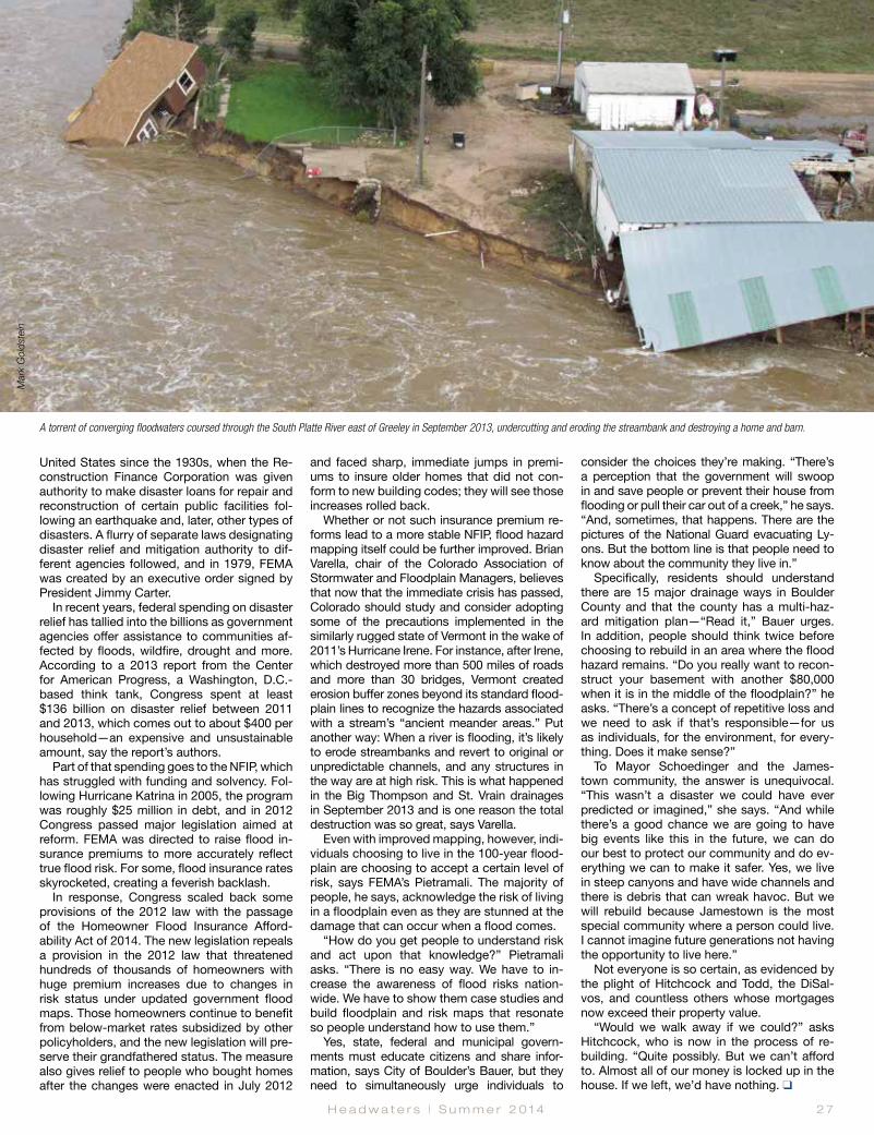
H e a d w a t e r s | S u m m e r 2 0 1 4 2 7
United States since the 1930s, when the Re-construction Finance Corporation was given authority to make disaster loans for repair and reconstruction of certain public facilities fol-lowing an earthquake and, later, other types of disasters. A flurry of separate laws designating disaster relief and mitigation authority to dif-ferent agencies followed, and in 1979, FEMA was created by an executive order signed by President Jimmy Carter.
In recent years, federal spending on disaster relief has tallied into the billions as government agencies offer assistance to communities af-fected by floods, wildfire, drought and more. According to a 2013 report from the Center for American Progress, a Washington, D.C.-based think tank, Congress spent at least $136 billion on disaster relief between 2011 and 2013, which comes out to about $400 per household—an expensive and unsustainable amount, say the report’s authors.
Part of that spending goes to the NFIP, which has struggled with funding and solvency. Fol-lowing Hurricane Katrina in 2005, the program was roughly $25 million in debt, and in 2012 Congress passed major legislation aimed at reform. FEMA was directed to raise flood in-surance premiums to more accurately reflect true flood risk. For some, flood insurance rates skyrocketed, creating a feverish backlash.
In response, Congress scaled back some provisions of the 2012 law with the passage of the Homeowner Flood Insurance Afford-ability Act of 2014. The new legislation repeals a provision in the 2012 law that threatened hundreds of thousands of homeowners with huge premium increases due to changes in risk status under updated government flood maps. Those homeowners continue to benefit from below-market rates subsidized by other policyholders, and the new legislation will pre-serve their grandfathered status. The measure also gives relief to people who bought homes after the changes were enacted in July 2012
and faced sharp, immediate jumps in premi-ums to insure older homes that did not con-form to new building codes; they will see those increases rolled back.
Whether or not such insurance premium re-forms lead to a more stable NFIP, flood hazard mapping itself could be further improved. Brian Varella, chair of the Colorado Association of Stormwater and Floodplain Managers, believes that now that the immediate crisis has passed, Colorado should study and consider adopting some of the precautions implemented in the similarly rugged state of Vermont in the wake of 2011’s Hurricane Irene. For instance, after Irene, which destroyed more than 500 miles of roads and more than 30 bridges, Vermont created erosion buffer zones beyond its standard flood-plain lines to recognize the hazards associated with a stream’s “ancient meander areas.” Put another way: When a river is flooding, it’s likely to erode streambanks and revert to original or unpredictable channels, and any structures in the way are at high risk. This is what happened in the Big Thompson and St. Vrain drainages in September 2013 and is one reason the total destruction was so great, says Varella.
Even with improved mapping, however, indi-viduals choosing to live in the 100-year flood-plain are choosing to accept a certain level of risk, says FEMA’s Pietramali. The majority of people, he says, acknowledge the risk of living in a floodplain even as they are stunned at the damage that can occur when a flood comes.
“How do you get people to understand risk and act upon that knowledge?” Pietramali asks. “There is no easy way. We have to in-crease the awareness of flood risks nation-wide. We have to show them case studies and build floodplain and risk maps that resonate so people understand how to use them.”
Yes, state, federal and municipal govern-ments must educate citizens and share infor-mation, says City of Boulder’s Bauer, but they need to simultaneously urge individuals to
consider the choices they’re making. “There’s a perception that the government will swoop in and save people or prevent their house from flooding or pull their car out of a creek,” he says. “And, sometimes, that happens. There are the pictures of the National Guard evacuating Ly-ons. But the bottom line is that people need to know about the community they live in.”
Specifically, residents should understand there are 15 major drainage ways in Boulder County and that the county has a multi-haz-ard mitigation plan—“Read it,” Bauer urges. In addition, people should think twice before choosing to rebuild in an area where the flood hazard remains. “Do you really want to recon-struct your basement with another $80,000 when it is in the middle of the floodplain?” he asks. “There’s a concept of repetitive loss and we need to ask if that’s responsible—for us as individuals, for the environment, for every-thing. Does it make sense?”
To Mayor Schoedinger and the James-town community, the answer is unequivocal. “This wasn’t a disaster we could have ever predicted or imagined,” she says. “And while there’s a good chance we are going to have big events like this in the future, we can do our best to protect our community and do ev-erything we can to make it safer. Yes, we live in steep canyons and have wide channels and there is debris that can wreak havoc. But we will rebuild because Jamestown is the most special community where a person could live. I cannot imagine future generations not having the opportunity to live here.”
Not everyone is so certain, as evidenced by the plight of Hitchcock and Todd, the DiSal-vos, and countless others whose mortgages now exceed their property value.
“Would we walk away if we could?” asks Hitchcock, who is now in the process of re-building. “Quite possibly. But we can’t afford to. Almost all of our money is locked up in the house. If we left, we’d have nothing. q
A torrent of converging floodwaters coursed through the South Platte River east of Greeley in September 2013, undercutting and eroding the streambank and destroying a home and barn.
Mar
k G
olds
tein
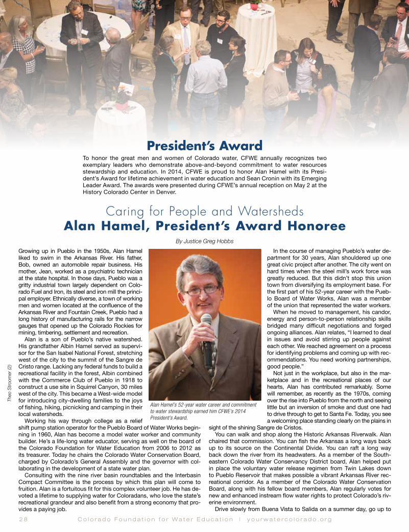
2 8 C o l o r a d o F o u n d a t i o n f o r W a t e r E d u c a t i o n | y o u r w a t e r c o l o r a d o . o r g
Caring for People and Watersheds Alan Hamel, President’s Award Honoree
By Justice Greg HobbsGrowing up in Pueblo in the 1950s, Alan Hamel liked to swim in the Arkansas River. His father, Bob, owned an automobile repair business. His mother, Jean, worked as a psychiatric technician at the state hospital. In those days, Pueblo was a gritty industrial town largely dependent on Colo-rado Fuel and Iron, its steel and iron mill the princi-pal employer. Ethnically diverse, a town of working men and women located at the confluence of the Arkansas River and Fountain Creek, Pueblo had a long history of manufacturing rails for the narrow gauges that opened up the Colorado Rockies for mining, timbering, settlement and recreation.
Alan is a son of Pueblo’s native watershed. His grandfather Albin Hamel served as supervi-sor for the San Isabel National Forest, stretching west of the city to the summit of the Sangre de Cristo range. Lacking any federal funds to build a recreational facility in the forest, Albin combined with the Commerce Club of Pueblo in 1918 to construct a use site in Squirrel Canyon, 30 miles west of the city. This became a West-wide model for introducing city-dwelling families to the joys of fishing, hiking, picnicking and camping in their local watersheds.
Working his way through college as a relief shift pump station operator for the Pueblo Board of Water Works begin-ning in 1960, Alan has become a model water worker and community builder. He’s a life-long water educator, serving as well on the board of the Colorado Foundation for Water Education from 2006 to 2012 as its treasurer. Today he chairs the Colorado Water Conservation Board, charged by Colorado’s General Assembly and the governor with col-laborating in the development of a state water plan.
Consulting with the nine river basin roundtables and the Interbasin Compact Committee is the process by which this plan will come to fruition. Alan is a fortuitous fit for this complex volunteer job. He has de-voted a lifetime to supplying water for Coloradans, who love the state’s recreational grandeur and also benefit from a strong economy that pro-vides a paying job.
In the course of managing Pueblo’s water de-partment for 30 years, Alan shouldered up one great civic project after another. The city went on hard times when the steel mill’s work force was greatly reduced. But this didn’t stop this union town from diversifying its employment base. For the first part of his 52-year career with the Pueb-lo Board of Water Works, Alan was a member of the union that represented the water workers.
When he moved to management, his candor, energy and person-to-person relationship skills bridged many difficult negotiations and forged ongoing alliances. Alan relates, “I learned to deal in issues and avoid stirring up people against each other. We reached agreement on a process for identifying problems and coming up with rec-ommendations. You need working partnerships, good people.”
Not just in the workplace, but also in the mar-ketplace and in the recreational places of our hearts, Alan has contributed remarkably. Some will remember, as recently as the 1970s, coming over the rise into Pueblo from the north and seeing little but an inversion of smoke and dust one had to drive through to get to Santa Fe. Today, you see a welcoming place standing clearly on the plains in
sight of the shining Sangre de Cristos. You can walk and shop along the Historic Arkansas Riverwalk. Alan
chaired that commission. You can fish the Arkansas a long ways back up to its source on the Continental Divide. You can raft a long way back down the river from its headwaters. As a member of the South-eastern Colorado Water Conservancy District board, Alan helped put in place the voluntary water release regimen from Twin Lakes down to Pueblo Reservoir that makes possible a vibrant Arkansas River rec-reational corridor. As a member of the Colorado Water Conservation Board, along with his fellow board members, Alan regularly votes for new and enhanced instream flow water rights to protect Colorado’s riv-erine environment.
Drive slowly from Buena Vista to Salida on a summer day, go up to
President’s AwardTo honor the great men and women of Colorado water, CFWE annually recognizes two exemplary leaders who demonstrate above-and-beyond commitment to water resources stewardship and education. In 2014, CFWE is proud to honor Alan Hamel with its Presi-dent’s Award for lifetime achievement in water education and Sean Cronin with its Emerging Leader Award. The awards were presented during CFWE’s annual reception on May 2 at the History Colorado Center in Denver.
Alan Hamel’s 52-year water career and commitment to water stewardship earned him CFWE’s 2014 President’s Award.
Theo
Stro
omer
(2)

H e a d w a t e r s | S u m m e r 2 0 1 4 2 9
Thank you to our 2014 President’s Award reception sponsors
Silver SponsorsSt. Vrain and Left Hand Water Conservancy DistrictDenver WaterLyons Gaddis Kahn Hall Jeffers Dworak and GrantBrownstein Hyatt Farber SchrekHDRPueblo Board of Water WorksColorado Water Resources and Power Development AuthorityCDM SmithSouthwestern Water Conservation District
the revived Mt. Princeton hot springs and take a soak, hike into the Collegiate Peaks, take a look out on those lovely high mountain hay ranch open spaces irrigated by waters of the Arkansas, and you’ll see this business of Colorado’s agricultural, municipal and recreational economy is alive and well due to many public and private relationships well-forged by people like Alan. A river can’t live to do its work and play and run along without being tended well. A good water plan serves the spectrum of human and environmental needs Coloradans value.
The Pueblo Board of Water Works has a portfolio of transbasin Colorado River water rights and native Arkansas River water rights it owns, supplemented by annual deliveries from the Bureau of Reclama-tion’s Fryingpan-Arkansas Project. Most recently, under Alan’s tenure, Pueblo’s water utility has acquired 25 percent of the Bessemer Irrigat-ing Ditch Company shares with storage in Pueblo Reservoir. It currently leases back 100 percent of this water to farmers. The utility’s aim is to keep as much of this water as possible in agriculture, except when needed by the municipal customers it serves in scarce water years. It is looking at negotiating and implementing rotational land and water
use plans for an enduring sharing arrangement between municipal and agricultural users.
“You need a good base load of storage to do this,” says Alan, “…enough flexibility to withstand drought. You don’t want to permanently dry up lands you don’t have to.”
He adds, “Colorado needs a water plan. We’ve reached a time when, as a state, we need to come together for our future. We need to share wa-ter resources, infrastructure and tools we haven’t even thought about.”
Grace under pressure can gauge a person’s meritorious contribu-tion to community. Alan treasures a polished-up brass pressure clock the employees of the Pueblo Board of Water Works gave him when he retired in 2012. It dates back to 1874, measuring the pressure along that pump station line he maintained as a working college kid.
Shifting Rivers, Changing CourseSean Cronin, Emerging Leader Honoree Sean Cronin got used to planning for drought in his former job as wa-ter resources manager for the City of Greeley. But since the devastating September 2013 flood in northern Colorado, he’s been coping with way too much water.
As executive director of the St. Vrain and Left Hand Water Conser-vancy District, Sean is helping to piece together relationships necessary to construct more resilient water systems and riverine habitat for the near and long term.
He receives many phone calls from those who’ve lost stream front-age—or gained it—when canyon rivers burst their temporal perimeters, carved new channels, wrecked headgates, stranded ditches, and ruined homes built on what might have seemed reliable ground.
“I am trying to match up municipalities and ditch companies with state and federal financial help,” he says. “Our district includes some of the hardest-hit towns and water facilities, including Lyons. I try to deal with people’s passions and help them with information and solutions.”
Much of his work involves education. “Those with new streamfront property think they automatically get water rights now. Those who have water rights might push forward immediately with ‘permanent’ structures. But temporary measures might do the job and lead to better results for water users and riverine habitat in the long run.”
Sean’s steady resolutions under immense pressure are earning accolades. q
Sean Cronin (left) accepted the 2014 Emerging Leader award from CFWE board president Gregg Ten Eyck in May.
Theo
Stro
omer
(2)
Bronze SponsorsThe Colorado River DistrictGeorge K. Baum and CompanyLeonard Rice Engineers, Inc.White and JankowskiCollins Cockrel and ColeBlack and VeatchAurora WaterWest Sage Water ConsultantsPorzak Browning and Bushong LLP
Supporting Sponsors Deere and Ault Consultants, Inc. Brandon and Alicia Prescott CH2M HILL Upper Arkansas Water Conservancy District Hydro Resources Kogovsek and Associates, Inc. South Metro Water Supply Authority
2 9 C o l o r a d o F o u n d a t i o n f o r W a t e r E d u c a t i o n | y o u r w a t e r c o l o r a d o . o r g

1580 Logan St., Suite 410 • Denver, CO 80203
NONPROFIT ORGU.S. POSTAGE
PAIDDENVER, CO
PERMIT NO 178
Publication of the Colorado Foundation for Water Education’s Headwaters magazine is made possible by the generous support of sponsors and advertisers.
We would like to extend our appreciation and thanks to the following sponsors for contributing financially to this issue:
YourWaterColorado.org
Southwestern Water Conservation District
Central Colorado Water Conservancy District
Top Related