


Languages
Pages
Legal


GEOPHYSICS LTD
42MHSE0101 OP91-730 BENOIT 010
jJ J J J J J J J J J J J J J
REPORT ON THEAIRBORNE MAGNETIC AND
VLF-ELECTROMAGNETIC SURVEYSON THE PROPERTY OF
PETER HANLEYBENOIT TOWNSHIP
LARDER LAKE MINING DIVISION, ONTARIO
RESPECTFULLY SUBMITTED BY:
H. FERDERBER GEOPHYSICS LTD,
Val d'Or (Quebec) June 14, 1991
R.A. Campbell, B.Se. Geology

42A08SE0101 OP91-73O BENOIT 01OCTABLE OF CONTENTS
INTRODUCTION . . . . . . . . . . . . . . . . . . .
PROPERTY DESCRIPTION, LOCATION AND ^CCESS . . . . .
GEOLOGY AND MINERALIZATION . . . . . . . . . . . .
INSTRUMENTATION AND SURVEY METHODS . . . . . . . .
VLF-EM Svstem . . . . . . . . ; . . . . . . . .
Tracking Camera and Video Centre . . . . . . .
Survev Parameters . . . . . . . . . . . . . .
DATA PRESENTATION . . . . . . . . . . . . . . . . .
SURVEY RESULTS AND INTERPRETATION . . . . . . . . .
VLF-Electromagnetic Survev . . . . . . . . . .
CONCLUSIONS AND RECOMMENDATIONS . . . . . . . . . .
REFERENCES . . . . . . . . . . . . . . . . . . . .
Page
t
. . . . . 4 j
. . . . . 4 i
i
i
1f- :
. . . . . 0 |
i
. . . . . 6
. . . . . 7
. . . . . 7
r
. . . . . 8
i
. . . . . 10

H. FERDERBER GEOPHYSICS LTD
REPORT ON THE
AIRBORNE MAGNETIC AND
VLF-ELECTROMAGNETIC SURVEYS
ON THE PROPERTY OF
PETER HAWLEY
BENOIT TOWNSHIP
LARDER LAKE MINING DIVISION, ONTARIO
INTRODUCTION
On May 23, 1991, airborne magnetic and VLF-electroraagnetic surveys were flown over the property of Peter Hawley in Benoit; Township, Larder Lake Mining Division, Ontario. Magnetic and VLF- electroraagnetic data was collected by the airborne division of H. Ferderber Geophysics Ltd. The survey was flown from a base at Val d'Or, Quebec. A total of 19.38 miles of data was collected.
The magnetic survey provides data which helps outline the underlying geological structures and helps identify any potential economic concentrations which may contain variations in accessory magnetic minerals. The results of the VLF-electroraagnetic survey define conductive zones which may represent shear zones and.or metallic sulphide deposits containing gold and/or base metal mineralization.
PROPERTY DESCRIPTION, LOCATION AND ACCESS
The property of Peter Hawley is comprised of 4 claims, covering 160 acres in lots 10 and 11 of Concession III, Benoit Township, Larder Lake Mining Division, Ontario. The claims are registered with the Office of the Mining Recorder in Kirkland Lake and are listed below.

H. FERDERBER GEOPHYSICS LTD
-2-
L1151916 L1151917 L1151918 L1151919
The property is located 14 miles northwest of the town of
Kirkland Lake, 17 miles southeast of Matheson, and 14 miles north
of the village of Kenogami Lake. Provincial Highway 11, north from
Kenogami Lake, bisects the property. Bush roads cross the western
claims. A gas pipeline lies trends north along the eastern
boundary and a power line crosses he property, trending northwest
and north.
Most of the claims are forest covered. Colvin Lake lies 500
feet east of the property. The eastern claims exhibit low
topographical relief and a small hill trends north across the
western claims. Outcrop exposure is fair over the western two
claims.
Supplies, services and qualified manpower are available in the
Kirkland Lake-Matheson area.
GEOLOGY AND MINERALIZATION
The claim block is located in the western part of the Abitibi
Volcanic Belt of the Superior Province of the Canadian Shield. The
Abitibi Volcanic Belt extends for nearly 350 miles in a west-east
direction from Timmins to Chibougamau. It is host to a variety of
precious and base metal deposits including the Timmins, Kirkland
Lake, Noranda, Val d'Or, Matagami and Chibougaroau mining camps.
The Abitibi Volcanic Belt is composed of a complex assemblage
of interbedded volcanic and sedimentary rocks intruded by a variety
of intrusives, from ultrabasic to granitic in composition. The
rocks are Archean in age and have been metamorphosed to the
greenschist facies. Numerous late Precambrian diabase dykes cut
formations of the belt. The rocks generally strike east-west, have

H. FERDERBER GEOPHYSICS LTD
-3-
a vertical dip and are highly folded and faulted. Geological interpretation of the Abitibi Volcanic Belt is complicated by both the wide scattering of outcrop and the complex structural relationships.
The Ontario Division of Mines, Map 2205 - the Timmins-Kirkland Lake Geological Compilation Series (at a scale of l inch equal to four miles). Map 2215 - Benoit and Maisonville Townships (at a scale of l inch equals to 1.2 miles) and the Ontario Ministry of Natural Resources Preliminary Map P873 at Benoit Twp., outline the geology underlying the area containing the claims. The Ontario Geological Survey, Mineral Deposits Circular 18, Gold Deposits of Ontario - part 2, 1979, describes the old gold deposits, prospects and occurrences in the vicinity of the property.
The data presented on these maps suggests that the claims are underlain by mafic and ultramafic rocks lying near the southern edge of an intrusive body. These rocks are comprised of serpentinite, peridotite, gabbro and diorite. They include sone zones of basalt and small intrusions of syenite. The contact with the intermediate to mafic metavolcanic rocks strikes west- northwest, 900 to 250 feet south of the property. Approximately 0.5 miles east of the claim group, the mafic and ultramafic intrusive rocks are in contact with felsic metavolcanics, north of the intermediate to mafic metavolcanics.
Several pits have been excavated in the central and northwestern parts of the c-laim group, uncovering northwest trending quartz veining, sulphides and nickel mineralization. In 1951 Ole Hagen drilled three holes in this area, intersecting asbestos veinlets in serpentine. A copper showing (Map 2205) has been found on the property near the north-central boundary.
The property is located l mile northwest of the past Au-Ag producer, the Davidor Mine. The gold and gold-silver tellurides are situated in northwest striking quartz-carbonate veins and lenses in a carbonate NSO'fy trending shear zone in mafic

H. FERDERBER GEOPHYSICS LTD
-4-
metavolcanic rocks. A total of 277 ounces of gold and 50 ounces of silver were produced in 1918 and between 1936 to 1938. The recovered grade was 0.21 oz/ton gold. The Hawley property lies along strike of the shear zone.
The Bergstand gold occurrence is located 0.6 miles north of the property in a felsic porphyry dyke and quartz veins within intermediate to mafic metavolcanic rocks. Low gold values were reported in a 1921 program of pitting and trenching.
In Benoit Township, within 4.5 miles of the property, numerous gold occurrences have been discovered in metavolcanic rocks; Bunting, Cotterill, Skjonsby, Scotvold-Nelson, Erickson, Noranda, Thompson-McLeod, Keefe and Carlson occurrences.
INSTRUMENTATION AND SURVEY METHODS
The survey was completed using a 1972 Cessna 172, fixed wing aircraft, call letters CF-EWK, owned and operated by H. Ferderber Geophysics Ltd. The pilot and navigator/operator were M. Turcotte and D. Monastesse respectively, of Val d'Or and Vassan.
Geophysical sensors were mounted in modified wing tips. The geophysical, navigation and data acquisition systems are in the following pages.
Magnetometer
The magnetometer used was a GEM Systems GSM-11, high sensitivity airborne proton (Overhauser) magnetometer. The instrument continuously measures the Earth's magnetic field a 0.01 gamma sensitivity for l reading per second to 10 readings per second at 0.1 gamma absolute accuracy. For this survey four readings per second were collected. The analog output is on 3 channels, from l to 10,000 gammas full scale.

H. FERDERBER GEOPHYSICS LTD
-5-
VLF-EM System
A Herz Totem 2A VLF-EM System was used to measure the changes
in the total field and in the vertical quadrature field on two
frequencies simultaneously with an accuracy of J.%. The primary
transmitting station of Cutler, Maine (NAA) frequency 24.0 kHz was
employed.
Radar Altimeter
The ground clearance was measured with a King 10/10 A radar
altimeter. The survey was flown at a mean clearance of 300 feet
with the altimeter producing an accuracy of 5% (15 feet) .at this
altitude.
Tracking Camera and Video Centre
A RCA TC-200 colour video camera and Galaxy 200 video centre
was used to record the flight path on standard VHS type video
tapes. Manual fiducials were indicated on the picture frames for
reference with digital printout. Flight path recovery was aided
using a Panasonic Colour Video Monitor-31300 and Video Cassette
Recorder AG-2500.
Data Acquisition System
A Picodas Group Inc. PDAS 1100 data acquisition system
featuring seven analog inputs with two frequency inputs and
external interfacing was used. A Termiflex corp. ST/32 Keyboard
control unit and Sharp Corp. LCD display unit are connected to the
data acquisition system. At present this system stores the
altimeter VLF-1 in-phase, VLF-1 quadrature, VLF-2 in-phase, VLF-2
quadrature, magnetic field (coarse), magnetic field (fine), and the
fourth difference (noise), and fiducials on 3.5 inch floppy disk
drive. The data is then printed out in digital and profile form.

H. FERDERBER GEOPHYSICS LTD
-6-
Survey Parameters
The survey was conducted on lines oriented at 030 and 210 degrees, flown at an average aircraft altitude of 300 feet and a speed of approximately 90 miles per hour. Geophysical responses were collected at data points spaced at 33 foot intervals along the lines. The lines were spaced at 440 feet intervals. Navigation was visual using topographical maps, at a scale of one inch to 1320 feet, manual fiducials, and the flight path recovery system as references.
DATA PRESENTATION
Flight lines, fiducial points and geophysical responses were reproduced from the topographical maps at a scale of one inch to 1320 feet (1:15,840). The outline of the claim block and claim nap are shown on each map sheet.
The aeromagnetic data was corrected for diurnal variations by using a base line as a reference. The data was then contoured at 20 and 100 gamma intervals and presented on Map MG-1.
The VLF-EM was transferred from the Totem 2AG memory to profiled form. Base values were determined for the VLF-EM total field profiled data. These values were used to correct for
variations in transmitter strength and the corrected total field values were plotted on Map EM-1. The positive total field values were contoured at intervals of 2%. The conductor axes were determined and labelled A, B, C, etc. No priority was attached to the labelling system.
A geological interpretation of the magnetic data plus conductor axes are shown on Map GI-1.

H. FERDERBER GEOPHYSICS LTD
-7-
SDRVEY RESULTS AND INTERPRETATION
The data collected by the magnetic survey form west to west- northwest trending isogams, generally decreasing northward and southward from the centre of the property. The highs are probably caused by a ultramafic intrusive body (serpentinite and peridotite) surrounded by mafic intrusive rocks (gabbro and diorite), see Map GI-1. The ultramafic and mafic intrusive rocks appear to underlie approximately 7 5* of the property, bifurcating to the southeast. The pits, sulphides and nickel mineralization are located in these magnetic highs.
The magnetic values surrounding the highs suggest that the northwestern and southeastern corners of the property are underlain by intermediate to mafic raetavolcanic rocks. The southern contact of the intrusive body trends west, 0.25 miles south of the property. The copper occurrence is thought to lie near the northern contact in the central part of the property.
Linear magnetic lows strike west-northwest and west-southwest across the northern part of the surveyed area. These lows are probably caused by units of felsic metavolcanic rocks, intercalated with the intermediate to mafic metavolcanic rocks.
VLF-Electromagnetic Survey
Two conductive zones, A and B are situated on the property and zone C lies just south of the claim block. Zones A and B are located near the power line and may be caused by culture or may represent underlying bedrock features. Zone A trends northwest along the northern edge of the high defining the position of the mafic intrusive body. This zone could be caused by a small shear zone lying along a mafic intrusive and an intermediate to mafic metavolcanic contact and possibly containing the copper mineralization.

H. FERDERBER GEOPHYSICS LTD
-8-
Zone B is comprised of two short conductors trending west
across the north-central part of the claim group. This zone is
situated near pits, quartz veining and sulphide mineralization and
may represent a mineralized shear in mafic intrusive rocks.
Conductive zone C is located just south of the property. The
conductors appear to be caused by small shears in mafic intrusive
rocks and metavolcanics, striking east-northeastward towards the
southeastern boundary.
CONCLUSIONS AND RECOMMENDATIONS
The maps produced by the data collected by the airborne
magnetic and VLF-electromagnetic surveys provide additional
information which better defines the geology and structures
underlying the Hawley property in Benoit Township. It appears that
75% of the property is underlain by ultramafic and mafic intrusive
rocks. Nickel mineralization has been discovered near the northern
edge of the high outlining the location of ultramafic rocks and
sulphides and quart veining lie in the surrounding mafic
intrusives. The 0.75 mile wide intrusive body narrows and
bifurcates to the east. Bands of intermediate to mafic
metavolcanic rocks underlie the northeastern and southeastern
corners of the claim block. The southern intrusive contact trends
westward, 0.25 miles south of the property, in contact with
metavolcanics to the south. The intermediate to mafic metavolcanic
rocks, to the north, are intercalated with bands of felsic
roetavolcanic rocks.
Two potential shear zones are delineated on the property by
the positions of conductive zones A and B. Zone A lies along a
metavolcanic-mafic intrusive contact and may contain copper
mineralization and Zone B is located over pits, quartz veining and
sulphide mineralization.

GEOPHYSICS LTD
-9-
The potential exists on the property for nickel mineralization
in the mafic and ultramafic intrusion and for gold and/or copper
deposition in the metavolcanic rocks thought to underlie the
northeastern and southeastern corners of the claim block. Further
work on the property is warranted. The claims should be prospected
mapped and mineralization sampled. Underlying geology and
structures should be better defined and extended in overburden
covered areas by conducting ground magnetic and electromagnetic
surveys over the claims. Areas of interest with thin overburden
cover could be stripped and mineralization sampled.
Respectfully submitted by,
H. FERDERBER GEOPHYSICS LTD.
R.A. Caropbe11, B.Se. Geologist

ILILILIL.
ILILILILi
1
ILi
1ILIL
ILIL11ILIL
REFERENCES
Ontario Department of Mines and Northern Affairs, 1971Geological Report 92, Geology of the Bourkes Area and Map 2215 - Benoit and Maisonville Townships, by H. L. Lovell.
Ontario Division of Mines, 1972Map 2205, Timmins-Kirkland Lake Geological CompilationSeries .
Ontario Ministry of Natural Resources, 1979Gold Deposits of Ontario, Part 2, by J. B. Gordon, H. L. Lovell, J. de Grijs and R. F. Davie.
Ontario Ministry of Northern Development and Mines, 1985.
Summary of Field Work and Other Activities, OntarioGeological Survey, Misc. Paper 126, Synoptic Mapping of the Kirkland Lake - Larder Lake Areas, District ofTemiskaming, L. S. Jensen, P. 112.
.

jJJJJJJ1Jl1111JllililililiII
-9-
The potential exists on the property for nickel mineralization
in the mafic and ultramafic intrusion and for gold and/or copper
deposition in the metavolcanic rocks thought to underlie the
northeastern and southeastern corners of the claim block. Further
work on the property is warranted. The claims should be prospected
mapped and mineralization sampled. Underlying geology and
structures should be better defined and extended in overburden
covered areas by conducting ground magnetic and electromagneticsurveys over the claims. Areas of interest with thin overburden
cover could be stripped and mineralization sampled.
Respectfully submitted by.
H. FERDERBER GEOPHYSICS LTD.
/f A — ̂R. A. Campbell, B. Se.Geologist
-
.
1

tt FERDQBIER GEOPHYSKS LTD
J
J
Jl
l
Jl
Jl
l
I
l
Jl
I
Jl
Jl
Jl
Jl
-9-
The potential exists on the property for nickel mineralization in the mafic and ultramafic intrusion and for gold and/or copper deposition in the metavolcanic rocks thought to underlie the northeastern and southeastern corners of the claim block. Further work on the property is warranted. The claims should be prospected mapped and mineralization sampled. Underlying geology and structures should be better defined and extended in overburden covered areas by conducting ground magnetic and electromagnetic surveys over the claims. Areas of interest with thin overburden
c cover could be stripped and mineralization sampled.
JlRespectfully submitted by,
H. FERDERBER GEOPHYSICS LTD.
R.A. Campbell, B.Se. Geologist

42AMSE0101 OP91-730 BENOITl
020
COMBINED GEOPHYSICAL SURVEYS, PROSPECTING AND GEOLOGICAL REPORT
ON THEBENOIT TOWNSHIP,
LARDER LAKE MINING DIVISION,RESIDENT GEOLOGY, KIRKLAND LAKE, ONTARIO
Val d'Or (Quebec) December 17, 1991
Peter J. Hawley, B.Eng., B.Se. Geology
P.M. GEOLOGICAL CONSULTANTS LTD. MINING, PETROLEUM AND EXPLORATION855 A. HOSPITAL BLVD.. VAL DOR. QUEBEC. J9P 2N4
TEL: (819) 825-9073 FAX: (819) 8244460

42AOSSE0101 OP91-730 BENOIT 020C
TABLE OF CONTENTS
1. Property Description, Location and Access . . . . . . . . . . . . . . l
2. Geology . . . . . . . . . . . . . . . . . . . . . . . . - . - - - - - l2.1 Regional Geology . . . . . . . . . . . . . . . . . . . . . . - l2.2 Property Geology . . . . . . . . . . . . . . . . . . . . . . . 2
3. Economic Geology . . . . . . . . . . . . . . . . . . . . . . . . . . 33.1 Economic Geology near the Property . . . . . . . . . . . . . . 33.2 Economic Geology on the Property . . . . . . . . . . . . . . . 4
-J. Geophysica'i Survey Methods and Instrument Data . . . . . . . . . . . 4
5. Geophysical Survey Results and Interpretation . . . . . . . . . . . . 65.1 Magnetic Survey . . . . . . . . . . . . . . . . . . . . . . . . 65.2 Electromagnetic Survey . . . . . . . . . . . . . . . . . . . . 7
6. 1991 Prospecting on the Property . . . . . . . . . . . . . . . . . . 10
7. 1991 Geological Program . . . . . . . . . . . . . . . . . . . . . . . 11
3. Conclusions and Recommendations . . . . . . . . . . . . . . . . . . . 15
9. References . . . . . . . . . . . . . . . . . . . . . . . . . . . . . 16
Appendix
Appendix 1: Daily Log of Work ActivitieskAppendix 2: Assay Certificates and Sample DescriptionsFig. A: Detailed Geology of Area AFig. 8: Detailed Geology of Area BFig. C: Detailed Geology of Area CFig. D: Detailed Geology of Area D
Back Pocket
-iL-1 Horizontal LOOD Electromagnetic Survey (1777 Hz) HL-2 Hor'zonta 1 Loop Electromagnetic Survey (3555 Hz) Mag-1 Magnetometer Survey VLF-I V.L.F. Survey--i Prospecting Map G-l Geology

PROPERTY DESCRIPTION, LOCATION AND ACCESS
The property of Peter Hawley is comprised of 4 claims, covering 160
acres in lots 10 and 11 of Concession III, Benoit Township, Larder Lake
Mining Division, Ontario. The claims are registered with the Office of
the Mining Recorder in Kirkland Lake and are listed below.
L1151916 L1151917 L1151918 L1151919
The property is located 14 miles northwest of the town of Kirkland
Lake, 17 miles southeast of Matheson, and 14 miles north of the village of
Kenogami Lake. Provincial Highway 11, north from Kenogami Lake, bisects
the property. Bush roads cross the western claims. A gas pipeline lies
trends north along the eastern boundary and a power line crosses the
property, trending northwest and north.
Most of the claims are forest covered. Colvin Lake lies 500 feet
east of the property. The eastern claims exhibit low topographical relief
ana a small hill trends north across the western claims. Outcrop exposure
is fair over the western two claims.
Supplies, services and qualified manpower are availaole in the
Kirklanc Lake-Matheson area.
GEOLOGY
2.1 REGIONAL GEOLOGY
GEOLOGY AND MINERALIZATION
The claim block is located in the western part of the Abitibi
Volcanic Belt of the Superior Province of the Canadian Shield. The
Abit'.bi Volcanic Belt extends for nearly 350 miles in a west-east
direction from Timmips to Chibougamau. It is host to a variety of
-2-
precious and base metal deposits including the Timmins. Kirkland Lake, Noranda, Val d'Or, Matagami and Ch'bougamau mining camps.
The Abitibi Volcanic Selt is composed of a complex assemblage of interbedded volcanic and sedimentary rocks intruded by a variety of irtrusives, from ultrabasic to granitic in composition. The rocks are Archean in age and have been metamorphosed to the greenschist facies. Numerous 'late Precambrian diabase cykes cut formations of the belt. The rocks gene-ally strike east-west, have a vertical dip and are highly folded and faulted. Geological interpretation of the Abitibi Volcanic Belt is complicated by both the wide scattering of outcrop and the complex structural relationships.
2.2 PROPERTY GEOLOGY
The Ontario Division of Mines, Map 2205 - the Timmins-Ki rkl and Lake Geological Compilation Series (at a scale of l inch equal to four miles), Map 2215 - Benoit and Maisonville Townships (at a scale of l inch equals to 1.2 miles) and the Ontario Ministry of Natural Resources Preliminary Map P873 at Benoit Twp., outline the geology underlying the area containing the claims. The Ontario Geological Survey, Mineral Deposits Circular 18, Gold Deposits of Ontario - part 2, 1979, describes the old gold deposits, prospects and occurrences in the vicinity of the property.
The data presented on these maps suggests that the claims are underlain by mafic and ultramafic rocks lying near the southern edge of an rntrusive body. These rocks are comprised of serpentinite, peridotite, gabbro and diorite. They include some zones of basalt and small intrusions of syenite. The contact with the intermediate to mafic metavolcanic rocks strikes west-northwest, 900 to 250 feet south of the property. Approximately 0.5 miles east of the claim group, the mafic and ultramafic intrusive rocks are in contact with

-3-
felsic raetavolcanics, north of the intermediate to mafic
metavolcanics.
ECONOMIC GEOLOGY
The Ontario Geological Survey, Mineral Deposits Circular 18. Gold Deposits of Ontario - part 2, 1979, describes the old gold deposits,
prospects and occurrences in the vicinity of the property.
3.1 ECONOMIC GEOLOGY NEAR THE PROPERTY
The property is located l mile northwest of the past Au-Ag producer, the Davidor Mine. The gold and gold-silver tellurides are situated in northwest striking quartz-carbonate veins and lenses in a carbonate N30*W trending shear zone in mafic metavolcanic rocks. A total of 277 ounces of gold and 50 ounces of silver were produced in 1918 and between 1936 to 1938. The recovered grade was 0.21 oz/ton gold. The Hawley property lies along strike of the shear zone.
The Bergstand gold occurrence is "located 0.6 miles north of the property in a felsic porphyry dyke and quartz veins within intermediate to mafic netavolcanic rocks. Low gold values were reported in a 1921 program of pitting and trenching.
In Benoit Township, within 4.5 miles of the property, numerous gold occurrences have been discovered in metavolcanic rocks; Bunting, Cotterill, Skjonsby, Scotvoid-Nelson, Erickson, Noranda, Thompson-McLeod, Keefe and Car1 son occurrences.

-4-
3.2 ECONOMIC GEOLOGY OF THE PROPERTY
Several pits have been excavated in the central and
northwestern parts of the claim group, uncovering northwest trending
quartz veining, sulphides and nickel mineralization. In 1951 Ole Kagen drilled three holes in this area, intersecting asbestos
veinlets in serpentine. A copper showing (Map 2205) has been found
on the property near the north-central boundary.
4. GEOPHYSICAL SURVEY METHODS AND INSTRUMENT DATA
The grid was established by cutting a baseline east and west from
post l of claim 1151919 in the centre of the property. North-south crosslines were cut at 400 foot intervals along the baseline. All lines
were chained and picketted at 100 foot intervals.
The magnetic survey was completed using a Gem Systems GSM-8 proton
precession aiagnetomter, recurring the total field intensity of the earth's
total field in gammas. It has a sensitivity ancJ repeatability of one
gammas or better. Magnetic readings were taken at 100 foot intervals
along the cross l : nes. A base station for determining the magnetic diurnal variations was established on line OW at 2+50N. The total field
readings, corrected for the diurnal variations were plotted on map ^ag-1.
All values are 58,000 ganmas olus plotted values. These values were
contoured at 100 and 1000 gammas intervals.
The very low frequency-electromagnetic survey was performed
employing a Geonics EM-16 unit with an accuracy of l*. The VLF method of
electromagnetic geophysical surveying uses powerful radio transmitters
set-up in different parts of the *orld for military communications.
Relative to frequencies generally used in geophysical exploration, this
frequency is considered high. These powerful waves induce electrical currents in conductive bodies thousand of miles away. The induced

-5-
currents then produce secondary magnetic fields which are detected at
surface through deviations of the normal VLF field. This secondary field
from the conductor is added to the primary field vector, so that the
resultant field is tit!ted up on one side of the conductor and down on the
other side. The VLF receiver measures the field tilt with the in-phase
and quadrature components of the vertical magnetic field as a percentage
of the horizontal primary field (i.e. the tangent of the tilt angle and
elioticity). The transmitting station of Cutler, Maine (NAA), frequency
24.0 kHz was used.
Interpretation of the results is quite simple. The conductor is
located at the inflection point marked by the crossover from positive tilt
to negative tilt. The main advantage of the VLF method is that is
responds well to poor conductors and has proved a reliable tool in mapping
faults-shear zones, conductive mineralizations and rock contacts. The
major disadvantage is that because of the high frequency of the trans
mitted wave a multitude of anomalies from unwanted sources such as swamp
eoges. creeks and be taken in interpreting the results in certain areas
displaying t~ese topographical features.
In-ohas2 and quacraiure values were recorded at stations 100 feet
apart. I '-.s F .-aser (1968) .nethod of filtering was applied to the raw in-
jraie ra;a. " 'vs red'jct'an method :ransforc.s the zero crossovers to peaks
f:-.- :orto--"pg rur^oses arse helps reduce the geological noise component
:;.;ec '-'z tne * ~~ :~.-,ve~-, h igh transmitter frequency. The Frater
"'i'::-;?: :ata was ;"ct.tec r.-id the oosti.re values contoured at ICo
- -.5 - . a''i : * a.; V.--1. ::--:uct:r axe-:- ~ sre determined and "abellej A, 3.
T :'.:... . - : ;- : r." : v -v^; attacfec to t-3 Tac-el'i-^ system.
7'".: "-izorta! ": oop-e 1 ectronaqnet" c rea,'-:-: were take- at 1IC ~"oc:
: --r;-vi"; .T" :rg trs :"c;r"i-es. An Apex -arametrics ^ax* : .-i II ...r i t ae-s
.-S:d ^f't- a tran-sm-: ts-r-'E : 5-" ver i-eoaratio^ of 3CC reet at ~requenc : es z ~ 1~"7 arc :55b Hz.

-6-
The MaxMin II is designed for measuring the ind^cec SECc'ida; y
electromagnetic field from a conductive body, that is a structure i \^\cr.
conducts electricity better than barren rocks. This particular instrument
has the advantage of flexibility over most other EM units in that it can
operate with different frequencies as well as having a variety of
di stances between transmitter and receiver. Five frequencies can be used
(222. 444, 888, 1777 and 3555 Hz) and with different coil separations.
By analyzing the characteristics of the curves and comparing the '.n-
phase-quadrature ratios, one can estimate width, dio, depth of burial and
conductivity thickness of a particular conductor. A good conductor such
as a massive sulphide or graphitic horizons will produce a cjrve going
from positive tnrough zero to negative and back again to positive. Both
the in-phase and quadrature will show greater deviation in the out-of-
phase component while a body exhibiting better conductivity will have a
greater deviation in the in-phase component.
The data collected by the horizontal loop-electromagnetic survey is
plotted on 2 mps, HL-1 (1777 Hz) and HL-2 (3555 Hz), and orofiled at a
scale of i inch equals 201. Conductor axes were determined, classified
ano "aoellec A, B, C, etc... The labels are applied for identification
purposes only.
5. GEOPHYSICAL SURVEY RESULTS ANO INTERPRETATION
5.1 Magnetic Survey
Map MAG-1 defines a complex pattern of isogams trending east-
southeast to north-northeast across the property. This contour
pattern is further complicated by the great amount of culture on the
property, highway and telephone line along line O and a high voltage
power line crossv-o the eastern claims. Eventhouah data was
collected on line O along the highway, the data wasn't used in
contouring, with the contour lines oeing postulated from data on

-7-
lines 4E and 4W.
The magnetic relief over the property is high, with "local
relief in the northwest corner of the claim group of up to 18,000
gammas. The strong highs (generally over 5,000 gammas) lying in the
northeastern claims must be caused by underlying rocks containing a
high magnetite content probably ultramafic intrusive rocks. At
least 3 sills of serpentinized perdotite appear to underlie the
western part of claim 1151918. These strong highs are surrounded by
areas of relatively high magnetic values suggesting that the
seprentinized peridotite is surrounded by a mafic intrusive body.
These rocks are probably gabbros forming a rough"!y circular body
underlying claim 1151918, the northwestern part of claim 1151919 and
the northwestern corner of claim 1151917. Nickel mineralization and
asbestos has been discovered in the high underlying the northwest
corner of the property.
Lows trending east-southeast across the property are caused by
underlying rocks of low magnetic susceptibilities, probably
intermediate metavolcanic rocks in 4 units. The magnetic values in
the remaining areas are indicative underlying of intermediate to
ma'Mc rocks. These rocks surround the mafic intrusive body and the
4 units of intermediate metavolcanic rocks. The copper occurrence
appears to be in mafic metavolcanic rocks near the eastern end of
the gabbro and near a contact with a unit of intermediate
metavolcanics.
5.2 Electromagnetic Survey
A total of 6 conductive zones (A to F) were delineated on the
nor-.zontal loop-electromagnetic maps and 5 (A to E) on the VLF-
e 1 aeromagnetic maps. The HLEM conductor axes on the two different
frequencies are coincident except for offsets on conductor A, line
4E and conductor E on line O being outlined on the lower frequency

HLE
M
SU
RV
EY
Zone A 6 c. D
Line
12W
8W 4 W
4E 12E
Li, ME
L8E,
L12E
L8W
4W
Topo
grap
hy
or Cu
ltur
e
Alon
g a
ridg
e
Al ong
a ri
dge
In swampy ground
A '1 o
: . 9
t h e
-f o w
j .
1 i n
e .
Magnetics
In
a low
In
a low
Along
the
sout
hern
ed
ge
of
a high.
In
a low
In
a high,
Across the
east
ern
edge
of
a
high.
East of
high.
Stre
ngth
Very
weak
Weak
Very
we
ak
Weak to
mo
dera
te
Weak
to
ve
ryweak
W .
:; H
\- l
-i
moderate
Weak
Weak
Caus
e
Change in
to
pogr
pahi
ea
1 re
1 i e
f .
Change in
to
pogr
aphi
cal
rel ie
f .
Cond
ucti
ve ov
erbu
rden
or
a
change in
re
l ie
f .
Poss
ible
shear
along
a ga
bbro
-maf
ic metavol-
c a n
i c co
ntac
t.
Poss
ible
shear
in mafic
me tavol canic rocks.
C u
1 t u r e .
Shea
r zo
ne across the
east
ern
edge of
the
gabbro body.
Shea
r zone in
mafic
meta
vol canics ea
st of
the
gabbro and
betw
een
2 units
of intermediate
metavolcanics.

E F
0 L4E
L12W
At th
e highway
Top
of
a hi
ll
A 1 o
r i g the
sout
hern
ed
geof
a
low.
In
a low
In
a strong
high .
Weak
Weak to
mode
rate
Weak
Cul ture or
a
mine
ralized
shear
along
the
sout
hern
co
ntac
t of
bedr
ock
inte
rmed
iate
and
mafic
meta
vol canics
rocks.
Poss
ibl
e sh
ear
inin
term
edia
te me
tavo
l-canics .
Over
a
pit
and
along
ash
ear
in se
rpen
t i n
i zed
per id
ot i te
.
VLF-EM SURVEY
Zone A 6 C D E
Topography
L 1 2
W al
ong
a ri
dge
L4W
east of
a
hill
LO
over a
powerl ine
Nort
heas
t of
a
powerl i
ne
Over
a powerl i
ne
Over
the
highway
on
line
0
Magn
etic
s
L12W is
along
the
nort
hern
S
sout
hern
edges
of
a hi
gh.
In a
weak high on
li
ne
12E.
In a
low
Betw
een
2 1 o
ws
Along
a linear narrow
high
.
Caus
e
Same as
HL
EM "A"
on L1
2W and
4E "C"
on
LO.
Poss
ible
sh
ear
on line 4W
.
Line
HLEM an
omla
y "B",
a shear
in mafic
meta
vol ca
ni cs
.
Cul tu
re
Cult
ure
Poss
ibly
caused by
cu
ltur
e on
li
ne
0 and
a sh
ear-
in
a
narrow mafic
meta
vol-
canic
unit
ea
st of
th
eg
abbr
o 6
betw
een
2 intermediate metavolcanic units.

-10-
only. Coincident VLF-Eh and HLEM conductor axes lie on line 12W - Conductor A, lines O and E - conductor E. VLF conductors B, O and A (Line 0) are located near HLEM conductors B and C. Descriptions and possible causes of the KLEM and VLF conductive zones are presented in the following table.
1991 PROSPECTING ON THE PROPERTY
The ourpose of the prospecting program was to locate outcrop exposures, mineralized showings past workings and topographic relief. By noting all the above the geological mapping, stripping and sampling program concentrated in areas with the best mineralized showings and secondary, with outcrop exposure.
Prospecting delineated a large outcrop ridge in the northwest corner of the property. Outcrop exposure is about SOS with steep ridges encountered. On line 12W/10N an excavated pit was found with a rock dump besides, no mineralization was seen but asbestos was present in most samples inspected.
At location 1+20W/3N an old pit was seen containing l-8% pyrite along shear planes. Also found was an old trench 50-60 feet on strike to the northwest. It is believed that this trench is located in overburden.
Along Highway 11 roadcut outcrop sf seen for a considerable length. Near the northern part 2 old workings were found on the east-west side of the highway. Both are located on strike with 1-2 foot shear containing fine pyrite.
Underneath the main powerline rock rubble of bull white quartz veining can be seen everywhere. Some of this rubble has been used to keep the powerline posts upright. Three small outcrop exposures were found in this vicinity with an increase in quartz veining rubble. It is believed

-11-
that the bull white quartz veining has originated from this area. On a knoll just south and east from the road cut outcrop is seen with moderate overgrowth. No other outcrop was located on the property.
7. 1991 GEOLOGY PROGRAM
During the fall of 1991 a geological program of stripping, washing, geological mapping and channel sampling was performed over selected areas of the Benoit Claim group. Results were discouraging in areas with mineralized showings and old working. The findings are discussed in detail below.
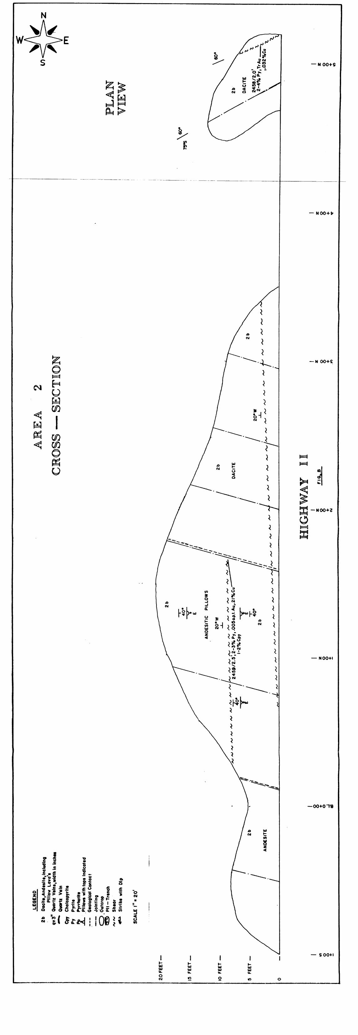
In the northwest corner of the claim group a large steep ridge is prominite. This ridge and high relief plateau has very good outcrop exposure and in the extreme N.W. corner an old pit is present. The entire ridge unit appears to consist of peridotite intrusive which has been altered in various degrees with the more altered forming serpentine and asbestos. All channel samples taken reported low values in Au, Cu, Ni over this entire area. A close examination of rock hand specimens show that the olivines and Ca-poor orthopyroxenes breakdown to serpentine. Products form finely disseminated secondary Fe-oxide grains. Decompo sition of these olivine grains begin on the periphery and along internal fractures producing anastomosing veinlets of cross-fiber serpentine or asbestos. Serpentine also contains secondary magnetite, to various
degrees, depending upon amount of alteration, within its matrix. This being the case the peridotite intrusive was probably injected with hydrous solutions, while it was being formed, resulting in certain areas becoming more altered that others. Magnetic high 8 low profiles may determine to what degree these areas have been altered and the geological trend and/or pattern if any of the alteration units.
Area l consists of an old pit sunk along a moderate strong shear striking 160" Az, dipping 72"E. An old trench was also found 50 feet to

-12-
the northwest on strike but appears to have been dug in overburden. This
area was power stripped and washed over an area measuring approximately
150 x 100 feet. The sheared dacite unit in and near the old pit contains
up to 10% fine disseminated 0.25-.50 inch laminae of pyrite within a
highly silicified matrix. The shear appears to have widths between 1.5- 2.5 feet and is viewed over a strike length of 60 feet. Assay results
display disappointing low Au, Cu, Ni values. In this area the dacite unit exhibits flow textures especially near the contact with a face change of
pillowed andesites. Bull white quartz veinlets are seen at the contact
wh:ch strike 170" Az and dip 700 to the east. The veinlets are barren as
seen by assays taken. The relick pillow rinds are poorly preserved but in areas viewed may indicate tops facing east.
In area 2 outcrop exposure along the Highway 11 allows one to view
the units as a cross section. At the northern end previous working of an old trench was found along and E-W trending shear. The dacitic unit is
moderately sheared, highly silicified and contains up to 105 fine disse
minated pyrite along the shear fabric. Fine micro-cubic pyrite with
concentration between 1-21 appears consistant throughout the unaltered
rock. The shear zone is very consistant and viewed over a strike length
of at least 150 feet with widths between 1-2 feet. The same shear zone is
present in Area C on the opposite side of the highway where an olc pit has been sunk.
Along the Area 2 exposure, which faces west, steeply dipping
jointing patterns are present which strike 220" Az and dip 75" south. Near
the bottom of the outcrop exposure a small flat shear bisects the unit
throughout with the trend of 22" Az strike and dipping 20" west. Also seen
near 3+00 north is the contact between the dacitic flow unit and andesitic
pillows which dips 750 E. Here the pillows can be seen as a globular mound
with the jointing pattern prevalent throughout. Again a norm of 1-21 fine micro-cubic pyrite is consistant throughout. Samples taken in this area reported low assay results.

-13-
In Area 3, which faces east, similar rock units are present. Near the north outcrop exposure a large pit has been sunk by previous workers along the previous described E-W trending shear zone. The shear is also highly silicified and along with containing ID-12% fine disseminated pyrite also exhibits globs of concentrated pyrite. Trace to 2\ magnetite is also contained within the sheared dacitic unit. The rocks in this area contain a norm back ground of X-2% fine microcubic pyrite within their matrix. The prevalent jointing pattern is common throughout with the same attitude as described above. Globular pillows and pillow rinds can be seen both or, top of the exposure and in section and again may indicate tops facing east but the pillow noses are not well decerned. At 2+50 north a small shear is seen which is not present on the west outcrop exposure. This shear exhibits the attitude of 110" strike with a dip of 450 north and has a 2-3 inch smokey grey quartz vienlets injected along the shear fabric. The vein contains 2-35 fine disseminated pyrite and samples taken reported low values.
Area 4 is an extension of Area 3 on top of a knoll 80 feet to the east. A stripped and washed area of approximately 160 x 80 feet was cleared. The outcrop exposure revealed the same jointing pattern with .25-1 inch bull white veinlets seen in area following the jointing trend. These veinlets do not have considerable strike length and samples taken reported low-nil values. Again the background norm of 1-21 fine micro cubic pyrite is present throughout.
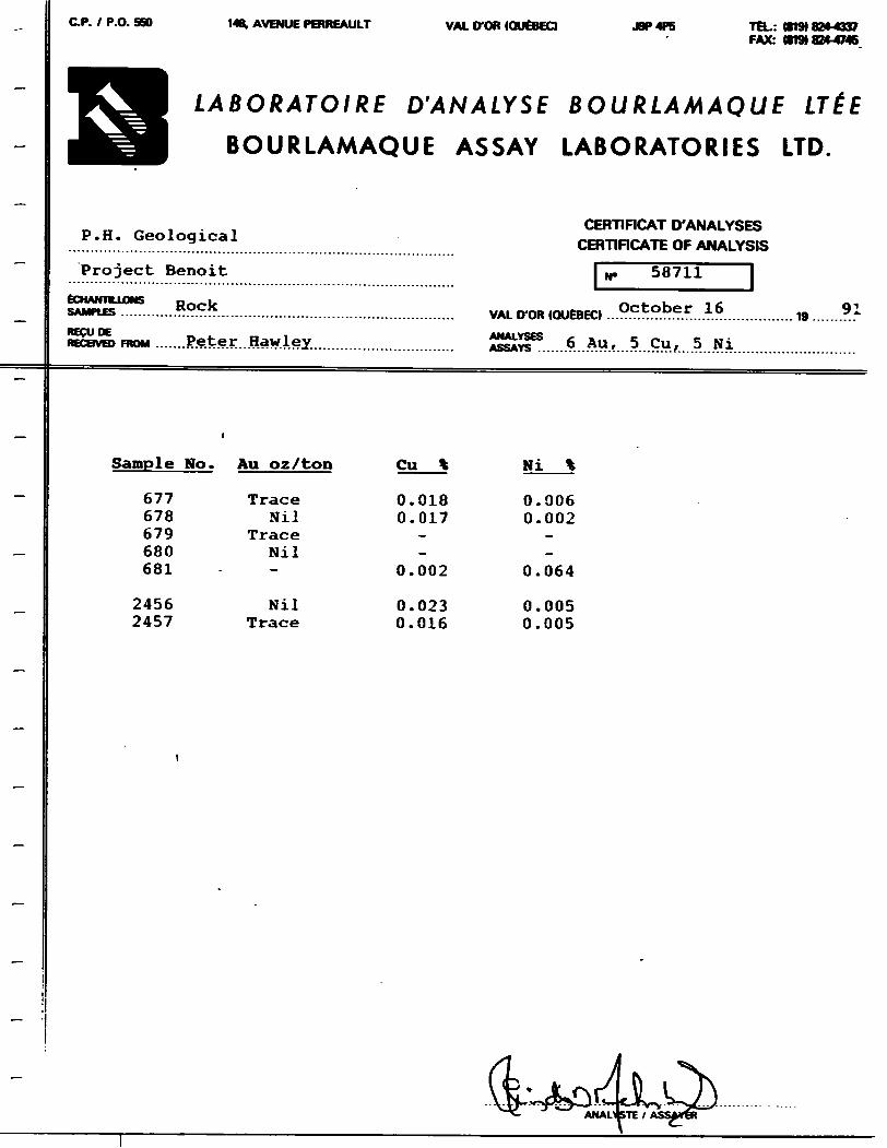
Near the same area but 60 to 100 feet north are three small outcrop exposures under the main hydro line. These exposures contain a fair amount of bull white quartz veining rubble. Surface stripping by grub hoe revealed E-nl trending vein system(s) with the average width of the veining between 0.5-1.0 feet. One vein was followed along strike for a distance of 30 feet before pinching out. The bull white quartz veins are hosted in dacite with the vein injected along a fracture. The veining contains l-4t fine disseminated pyrite with Trace to \\ chalcopyrite. The best channel sample taken assayed 0.003 opt Au, Q.01% Cu/2.0 feet. The following is a description for channel sample.

Sample Number
0677
0678
0679
0680
0681
2456
2457
2458
2459
2460
2461
2462
2460
Rock Description
Sheared dacite with smears of S-10% pyrite, 1-21 pyrrhotite.
Silicified dacite with 30S quartz within matrix, sheared, rehealed, 51 pyrite, 31 pyrrhotite, 11 chalcopyrite
Sheared basalt, fine grained, slightly silicified, S-5% pyrite.
Bull white quartz vein, 3-6", sheared in parts, 1-33; pyrite, Ilk pyrrhotite.
Peridotite, serpentinized with micro asbestos fibres, 0.25", veinlet of pyrrhotite.
Bullwhite quartz vein with dacite, contact, 2-3S pyrite, trace-1% chalcopyrite.
Bullwhite quartz vein andecite contact, 6.0 ft NE on strike from #2456, 61 diss. pyrite, trace chalcopyrite.
Dacite with .25" laminae of diss. pyrite along weak shear plane.
Basalt, highly silicified, 1-41 diss. pyrite within chloritic matrix, l-2% chalcopyrite.
Bull white quartz vein, weakly sheared, rehealed 1-21 fine diss. pyrite suspended within matrix.
Bull white quartz vein massive, trace-1% fine pyrite.
Serpentinized peridotite, soft, talcose. 0.12-0.25" veinlets of pyrite/ pyrrhotite.
As above (re-assay)
Width (ft)
2.0
2.0
0.5
0.5
0.5
1.0
1.5
2.0
2.5
0.5
2.0
1.0
1.5
Au Opt
trace
Nil
trace
Nil
—
Nil
trace
trace
0.005
trace
0.003
trace
trace
Cu l
0.018
0.017
— —
—
0.002
0.023
0.016
0.032
0.210
0.017
0.010
0.009
0.056
Ni 1
0.006
0.002
— —
--
0.064
0.005
0.005
——
—
—
—
—

-15-
8. CONCLUSION AND RECOMMENDATION
The results of the 1991 prospecting, stripping, washing, geological mapping and channel sampling are disappointing. Previous airborne survey work indicated magnetic high and low trends in the north west corner of the property. These trends can now be explained by the presence of a serpentinized peridotite which contains various amounts of magnetite within its matrix. Along the micro layered or platty fabric thin laminae of pyrrhotite is present with the best channel sample assaying Q.064% Ni. Other sections of the property near the main Highway 11, (areas A, B, C, D) exhibit well developed shear zones, quartz veins and veinlets, which show that the mineralized trending units are shear related. All channel samples taken reported low Au, Cu, Ni values. What is of interest is the norm background of 1-21 fine micro cubic pyrite constantly throughout the dacite unit in this area. One possible explanation of poor assay results is that a free Fe ion from a Fe 3* to Fe 2* exchange has been incorporated into the dacite matrix. If this is the case then the lack of free Fe would inhibit the deposition of auriferous mineralization. Whole rock geochemistry should confirm this hypothesis.
The conductive zones are generally weak to very weak in strength. The sheared peridotite was picked-up on line 12W. On the property HLEH conductive zones (A(4E), B(12E), and (8W, 4W) define the positions of weak narrow shear zones in underlying mafic metavolcanics and gabbro in overburden covered areas.
Thus it is recommended that no further work be performed on the property due to the lack of economic mineralization anywhere.
Respectfully submitted by,
-16-
REFERENCES
H. Ferderber Geophysics Ltd., 1990Report on the Airborne Magnetic and VLf-electromagnetic survey on the Property of Peter Hawley, Benoit Twp., Larder Lake Mining Division, Ontario, R.A. Campbell.
Ontario Department of Nines and Northern Affairs, 1971Geological Report 92, kGeology of the Bourkes Area and Hap 2215 - Benoit and Maisonville Townships, by H.L. Lovell.
Ontario Division of Mines, 1972Map 2205, Timmins-Kirkland Lake Geological Compilation Series.
Ontario Ministry of Natural Resources, 1979Gold Deposits of Ontario, Part 2, by J.B. Gordon H.L. Lovell, J. De Grijs and R.F. Davie.
Ontario Ministry of Natural Development and Mines, 1985.Summary of Field Work and Other Acitivities, Ontario Geological Survey, Misc. paper 126, Synoptic Mapping of the Kirkland Lake - Larder Lake Areas, District of Temiskaming, L.S. Jensen, P.112.

APPENDIX l - DAILY LOG OF WORK ACTIVITIES
June June June Aug. Sept Sept Oct. Oct. Oct. Oct. Oct.
22. 199123. 199124. 199131, 1991
. l, 1991. 2, 19911. 19912. 19913. 19914. 19915. 1991
Oct. 5, 1991 Oct. 7, 1991 Oct. 8, 1991 Oct. 9, 1991 Oct. 10, 1991
Detailed Magnetic Survey Claims 1151918 S 1151919 Detailed Magnetic Survey CI a i us 1151916 ft 1151917 Detailed VLf-EM Survey Claims 1151918 ft 1151919 Detailed kVLF-EM Survey Claims 1151916 S 1151917 Detailed H. L. E. M. Survey Claims 1151918 ft 1151919 Detailed H. L. E. M. Survey Claims 1151916 ft 1151917 Prospecting Claims 1151919 S 1151918 Prospecting Claims 1151918 Prospecting Claims 1151916 t 1151917 Prospecting Claims 1151918 ft 1151917 General Geology, Mapping t,Sampling Claims 1151918 ft 1151919 Same as above Claims 1151916 ft 1151917 Detailed mapping and sampling Claims 1151918 t 1151919 Detailed mapping and sampling Claims 1151918 t 1151919 Detailed mapping and sampling Claims 1151916 ft 1151917 Detailed mapping and sampoing Claims 1151916 S 1151917
C.P. l P.O. 5GO 1481, AVENUE PERREAULT VAL D-OR (QUEBEC) J9P4P5 TEL: 18191824-4337 FAX: 1819)824-4746
LABORATOIRE D'ANALYSE BOURLAMAQUE LTEE
BOURLAMAQUE ASSAY LABORATORIES LTD.
P.H. Geological
Project Benoit
RockECHAimLLONS SAMPLES ......
CERHFICAT D'ANALYSES CERTIFICATE OF ANALYSIS
~"i^58711
16RGCUDE - . r. iRECEIVED FROM .......Peter..Hawley..
VAL D-OR KWtBECl
6 Au, 5 Cu, 5 Ni
91
Sample No. Au oz/ton
677678679680681
24562457
Trace Nil
Trace Nil
Nil Trace
Cu_*
0.0180.017
0.002
0.0230.016
Ni_\
0.0060.002
0.064
0.0050.005

C.P. l P.O. SBO 148. AVENUE PERREAULT VAL ITOR (QUEBEC! J9P4P5 TEL: (819) 824*4337 FAX: (819) 8244745
LABORATOIRE D'ANALYSE BOURLAMAQUE LTEE
BOURLAMAQUE ASSAY LABORATORIES LTD.
P.H. Geological
ECHANTIUJONS RockSAMPLES .....,.................
CERTIFICAT D'ANALYSES CERTIFICATE OF ANALYSIS
L*. 58810
VAL D-OR (QU6BEC. .. ..?.9................. 19 .....-?.1
recuoE Peter Hawlev ANALYSES fi AU 6 CuRECBVB) FROM ......."e.V:e.f...??".4.e.X................................. ASSAYS ......?...*-**f....r....V.H.
Sample No. Au oz/ton
245824592460246124622460
Trace 0.005 Trace 0.003 Trace Trace
Cu
0.0320.2100.0170.0100.0090.056

— I +OOW
OLD HIGHWAY II
LE
OE
NO
2b
Dac
ite,A
ndes
lte,in
clud
ing
Pillo
w
Lava
's
1 Q
uart
z V
tlnt,w
idth
in In
ches
Quo
rtz
Vein
C
halc
opyr
ite
PyH
te
Pyrr
hotit
e.P
illow
s w
ith to
ps I
ndic
ated
G
eolo
gica
l C
onta
ct
Join
ting
, Out
crop
PI
l-T
ren
ch
/v/s
/ Sh
ear
4t*
S
trik
e w
ith O
lp
SCA
LE l
" *
20*
Cpy
Py A
AR
EA
2
CR
OSS
— S
EC
TIO
N
PLA
N
YIE
W
20 F
EET
—
15
FEET
—
10
FEE
T
5 FE
ET
AN
OE
SIT
IC
PIL
LO
WS
20*
W ^W
S
*vt
S*~
f S
**
SV
***
V)
O
O
l S O
HIG
HW
AY
II
88 •f CM
FIG
.. B
8 10
8 •i- ^r
60*
o o (O

AR
EA
3
CR
OSS
— S
ECTI
ON
2b Cpy
Py i o
LEG
END
Doci
f t, A
ndet
lte, in
cludin
gPi
llow
Lovo
's Ou
ortz
V*ln
t,wid
th in
Inch
* Qu
ortz
Vtln
Ch
olco
pyrit
t Py
rlt*
Pyrrh
otHt
.Pillo
ws w
ith to
ps In
dlco
ted
Gtol
ogico
l Con
toct
Jo
intin
g . O
utcr
op
PH
-Trt
nch
Shtd
r St
rike
with
Dip
SCAL
E l"
* 2
0'
20 F
EET
—
15 F
EET
—
10 F
EET
—
5 FE
ET
—
AN
DE
SIT
IC
PIL
LOW
S
o o 4-
O)
o o •t- IO
HIG
HW
AY
II
8 •i-o o * K)
FIG
. C
o o * CJ
z o o •4-
o o 5 CD

UJ o o 61-0
0 N
—
5+
00
N —
4+O
ON
—
AR
EA
4
2456
XI.O
',2-3
0XoP
y •T
r-l'/o
Cpy s
-Nil A
u,.0
230X
*Cu,
.005
0XoN
I
AN
OES
ITIC
PI
LLO
WS
I700
V
40
0E2b
qv
3"
Cpy
Py 5.
L6Q
ENO
Doc
itt.A
ndtil
tt, in
cludin
gPi
llow
Lovo
'tQu
ortt
Vtin
t,wid
th in
Inch
tt Qu
ortt
Vein
Ch
olco
pyrlt
t Py
rltt
Pyrrh
otHt
.Pillo
ws w
ith to
ps In
dico
ttd
Gtol
ogico
l Con
loct
Jo
intin
g Ou
tcro
p Pl
t-Trt
nch
ShtO
r St
rlkt
with
Dip
SCA
LE
l"s40
lFI
G.
O

k) c/i
X)•r """"
- **^^^^
H
Ho
v
G]o
CD 10 01
DA i r. 01 issur
LARDER LAKE MINING RFCORnriVS OFFICE
".DWBHiP SUBJECTCook Twp.
'(T s3ESTRY
^s*vJ~- JrJTT i' w!
NOTICE OF FORESTRY ACTIVITYTOWNSHP 7 AHEA FALLS WITHW THE ___ i
WATABEAG MANAGFMENT UNIT Maisonville Twp.H D
MAY BE SUBJECT TO FORESTRY OPERATIONS. THE MNR UNIT FORESTER FOR THIS AREA CAN BE CONTACTED AT: P.O BOX "
TMC INfOMMATION THAT APPEARS ON THIf, MAP HAS RFKN OOMPILFD f I1OM VARIOUS SOUnCFS, AND ACCURACY IS NO l GUARANTFrn THO8FWISHING TO STAKl. MIN ING CLAIMS SHOULD CON SULT WITH TUP MINING nrcoROFR, MiNisrtw or*IORTHFRN OFVl-LOI* MFNI ANDMINFS. FORAI) DIMONAl INIOMMA1ION ON IMF 'HAHr, O!' THEi ANnr, SHOWN unuoN
THE TOWNSHIP OF
BENOITDISTRICT OF COCHRANE
LARDER LAKE MINING DIVISION
SCALE: 1-INCH-40 CHAINS
LEGENDPATENTED LAND '
CROWN l AND SALELEASESLOCATED LANDl ICENSC OF OCCUPATIONMINING RIGHTS ONLYSURFACE RIGHTS ONLYROADSIMPROVED ROADSKlNGjr, HIGHWAYSRAILWAYSPOWER IINTSMARSH OR MIJSKFG
* or (p)
or CS(D
Loc LO
M R O S R O
"'/y l f N TFO S R O
NOTES
400' Surlar* nqM* ie*orvnli0n around all laU*nv c -^
Grovfl Rpsfrvp Shown Thus. |"
•mo' fronlngf on fUilli , l uKp withdrawn Iriiin r^pn'-.ition for proposed summer i' ,oi t
Si* * thdrtiwri fro^n Unltinq unclwr Section if Ihp Miiguiq At l i '
w Fil* Dnt^
PLAN NO.-M.326"/Oii J \Kli-
Or NATuPM REiOURCES' o AND MAi'KlN(; BKANi ri
POK IT O
l
k) C/I
m r ,
r*~
i"t
Q)
4M08SEU101 OPOl"-Ho BENOIT200

l
TRAIL .—
TYPE OF WORK
CLIENT
PROJECT
O >
HfN
Wl :
CLAIM MAP
i" /, mile
Vj"l
LEGENDTOTAL FIELD CONTOUR INTERVAL ? CONDUCTOR AXIS FIDUCIAL POINT LINE DIRECTIONSTATION USED: Ci ITLEK, MAINE, USA Ci40 U \i )
LESS THAN ZERO
AIRBORNE V.LF-EM SURVEY
PETER HAWLEY
H t l* t H. Ferderber Geophysics Ltd.
AREA
BENOIT TWP.ONT
SCALE'/4 mile
DRAWN BY
DATEJUNE 1991
MAP OH SHH1 NOEM-1
42AOBSE0101 6pei-73b BENOIT 210

K\V
7
TRAIL —.
'o,
TYPE OF WORK
CLIENT
PROJECT
BENOIT TWP
CLAIM MAP
bcnle l - 7. mile
N
LEGENDTOTAL FIELD CONTOUR INTERVAL 20
O FIDUCIAL POINT > LINE DIRECTION
BASE VALUE seooo GAMMASMAGNETIC LOW1000 GAMMAS 100 GAMMAS 2O GAMMAS
GAMMAs
AIRBORNE MAGNETIC SURVEY
PETER HAWLEY
H. Ferderber Geophysics Ltd.
AREA
BENOIT TWP,ONT
SCALEmile
DRAWN BY
DATEJUNE 1991
MAP OR SHU t NOMG-I
42A08SE01Q1 OP91-730 BENOIT 220

BENOIT TWP
f| AIM MAC
N)
LEGEND4
3
2
l
Cu
Ni
qs
ULTRAMAFIC INTRUSIVE ROCKS
MAFIC INTRUSIVE ROCKS
FELSIC METAVOLCANIC ROCKS
INTERMEDIATE TO MAFIC MFTAVOLCANIC HOCKS
COPPER
NICKEL
QUARTZ
SULPHIDES
SYMBOLSCONTACT (inferred from magnetic data)
CONDUCTOR AXIS (with label J
B1-730 BENOIT230
——^ f \ iT,5'
1 ? oI 4-c
Q PIT
4 OCCURENCE
TYPE OF WORK
GEOLOGICAL INTERPRETATIONCLIENT
PETER HAWLEYPROJECT
ft^\ Rflr*—^V^y'i) H Ferderber Geophysics Ltd.
AREA
BENOIT TWP.OIMT
SCALE n .1 - /4 mile
DRAWN BYMV1
DATEJUNE 1991
MAP OR SHEET NOGl-l

1 l 1 1 -l l 11 H
IO+OON '
~
5 + OON
P1/NSISI6
P2/II3I9I9 PI/1079048
SYMBOLS
HIGHWAY MOLD ROADBUSH ROADHYDRO LINEBURIED TELEPHONE LINECLAIM POST (LOCATION FOUND)CLAIM POST (APPROX. LOCATION)
EGEND
OUTCROPOUTCROP BOUNDARYTRENCHPITRIDGESWAMP
42A088F0101 OP91-730 BENOIT 240
PROSPECTING MAP
BENOIT TWP. ONTARIOScale f- 200'
Dm K B C
Work by: P. HAWLEY
Date N OV. '91
Map No p— |
K

10+OON
5 + OON
PV6JI24B P4/8SJB66 PJ/IOZ04 J P4/HSI9IU PS/ II S I9i8
BL O+OO
5+00 S
PI/ IHI9I8 P4/HSI9I7
kj ^i -j
l'4/ IIM'118
IM l I I M t it
IO+OOS
5-107. P y 1-27. Po
AREA l
PI/8C58M P2 /IOI BIO
P l/lfl J699
PI/495610
P l / 1 1 5 1 1 1 (, P2/IISI9I?
T
g
SYMBOLS
HIGHWAY IIOLD ROADBUSH ROADHYDRO LINEBURIED TELEPHONE LINECLAIM POST (LOCATION FOUND)CLAIM POST (APPROX. LOCATION)SWAMP
LEGEND3b 3c2b Mqv3"
AsbCpyPoPy
AREA
GABBROSERPENTINIZED PERIDOTITES,ASlIrE4AM9E.SlTE ' INCLUDING PILLOW LAVA'SQUARTZ VEINS,WIDTH IN INCHESASBESTOSCHALCOPYRITEPYRRHOTITEPYRITESTRIKE WITH DIPGEOLOGICAL CONTACTOUTCROP BOUNDARYTRENCHPITRIDGESHEARSEE DETAIL GEOLOGY MAP
42AOBSEQ101 OPB1-730 BENOIT 250
GEOLOGY MAPBENOIT TWP. ONTARIO
'w ole l" .'OH
Dm K B
Work by: R HAWLEY
NOV '91
Mop G~ l

P4/ MSI9IB
950Q
10+OON
5 + OON
P4/853B66 P3/IOZ94J P4/II3I4IQ P3/ IISI9IS
BL OiOO
5+OOS
10+OOS
SCM
-09O
II
liIP
BL-NOITl" OP
L
!WP
(C UN
L 10
CLAIM MAP
Ar;B D
SYMBOLS
HIGHWAY 11OLD ROADBUSH ROADHYDRO LINEBURIED TELEPHONE LINECLAIM POST l LOCATION FOUND) CLAIM POST (APPROXIMATE LOCATION)
LEGENDMEASUREMENT STATIONS ALONG PICKET L INES
READINGS OF EARTH'S TOTAL MAGNETIC FIELD
RECORDED READINGS ARE 5 8,000 PLUS PLOTTED VALUES
FORCE OF THE EARTH'S MAGNETIC FIELD (IN GAMMAS )MAGNETIC CONTOURS
BASE STATION
ELECTRICAL CONDUCTOR
INSTRUMENT USED : GEM SYSTEMS GSM-8
MAGNETOMETER SURVEY
BENOIT TWP, ONTARIOScale f- 200'
Dm K B
Work by. P HAWLEY
Date OCT / 1 991
Map No MAG-l

l U5I9I8
i o
270
CLAIM MAP' Scale i 1 50.000
[]
SYMBOLS
HIGHWAY IIOLD ROADBUSH ROADHYDRO LINEBURIED TELEPHONE LINE
CLAIM POST i LOCATION FOUND)CLAIM POST (APPROXIMATE LOCATION)
LEGENDMEASUREMENT STATIONS ALONG PICKET LINES ELECTROMAGNETIC READINGS - In Phase Component ELECTROMAGNETIC READINGS - Out of Phase Component W PROFILE - In Phase Component (Scale l" = 20 96) PROFILE - Out of Phase Component (Scale l" ~ 20 y*) COIL SEPARATION - 300 Feet INSTRUMENT- APEX PARA METRICS MAX MIN u ELECTRICAL CONDUCTOR POSc iRL F
- PENNATE
HLEM SURVEY 1777 Hz
B t NOIT 1WP ONTARIO
Work by P HAWLEY
NOV '91
M i,, rj.. H L -
"" f 'D.ttoi * U

ki
N
1 1 1 \ l M * l t,
1 f l l l M ') l l
T ^1l" s i , 'V-4 vT *" - v
-|Q ' *- \*
v .' 'l-K.; ^ *~-*.-**-i-JZ-Z-^Tf
LI l :r ,M l I WlN
CON
V,\.
CLAIM MAP',l Illf l SO,OUO
illdhWM II nth HI iA iHUSH U'l/u-
il II" i 'j|
h i'. H i- l l , l l MDNI l INF
' ! ^iM l '' t ( l Q( A l ION FOUND
le' -' i
LEGENDMEASUREMENT STATIONS ALONG PICKET LINES ELECTROMAGNETIC READINGS - In Phase Component ELECTROMAGNETIC READINGS - Out of Phase Component PROFILE - In Phase Component (Scale l" * 20 %) PROFILE - Out of Phase Component (Scale l" ^ 20 y*) COIL SEPARATION - 300 FeetINSTRUMENT- A PEX PARAMLIRICS MAX- MINI
ELECTRICAL CONDUCTOR - POSSIBLE"DEFINATE
HLEM SURVEY 3555 Hz
BENOIT TWP. ONTARIOl (H
h M
Work by P HAWLEY
:-,i, NOV 91
H L- 2

k. (t)•vi
PI/ IHI9I8 P4/IISI9I7
ki ^-vj
P*/ II9I9I8
10+OON
5 + OON
PI/II51916 |5 IO P 2/IISI9I7
P1/6JI24H P4/83JB66 PS/IOZ943 P4/II3I9I9PJ/II3I9I8
O+OO
5+OOS
PJ/IIJI8I9
IO+OOS
42A088E010lpfl1 290
Ut
'ic 1
NOI 1
\* '
\\
L 1!
CLAIf
|DTWIJ
\*^ "1
v'vbX^
L 10
iN
CON III
\\A M AP
' i III, 1 M 1 1 II M 1
SYMBOLS
H K .K WAY II
01 D HOAO
HUSH HOAO
HYDRO l INLHum L D TELF PHONE LINE
( l AIM CO', f l LOCATION RHl l.A|M POM ( APPROXIMAU UK.
LEGENDMEASUREMENT STATIONS ALONG PICKET LINES
FRASER REDUCTION METHOD USED
CONTOUR INTERVAL : - i o 7U
ELECTRICAL CONDUCTOR
INSTRUMENT USED : GEONICS EM - 16
STATION USED: CUTLER MAINE (240 KHZ)
FRASER FILTERVLF- E M
BENOIT TWP. ONTARIOSeul p l - ?.OO'
Drn K B
Work by Peter Hawley
Dote Oct, 1991
Map No VLF - l
Top Related