


Languages
Pages
Legal

JABATAN UKUR KEMENTERIAN PEMBANGUNAN
BRUNEI DARUSSALAM Dipersijilkan
Certified ISO 9001
Tel : 2382171 Fax : 2382900 Website : http://survey.gov.bn E-mail : [email protected]
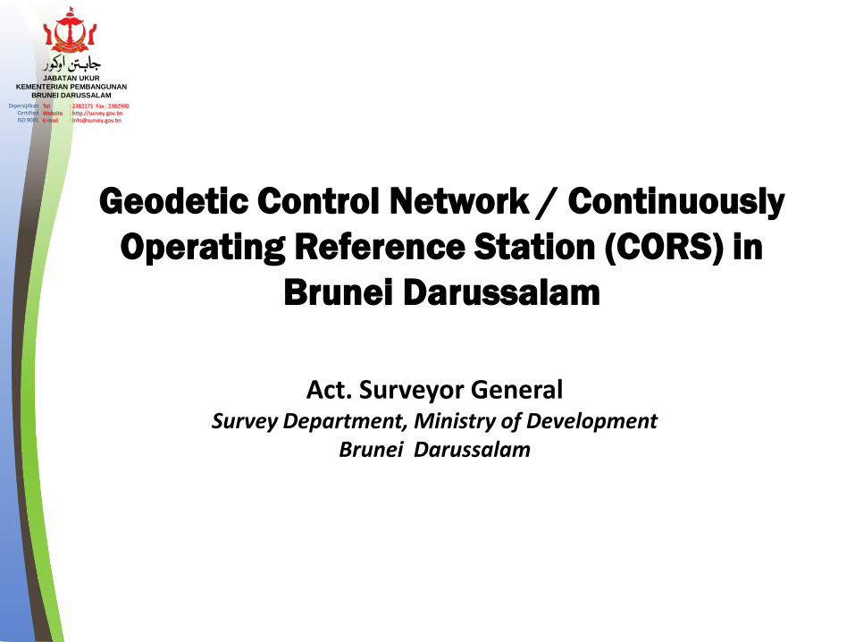
Geodetic Control Network / Continuously Operating Reference Station (CORS) in
Brunei Darussalam
Act. Surveyor General Survey Department, Ministry of Development
Brunei Darussalam

JABATAN UKUR KEMENTERIAN PEMBANGUNAN
BRUNEI DARUSSALAM Dipersijilkan
Certified ISO 9001
Tel : 2382171 Fax : 2382900 Website : http://survey.gov.bn E-mail : [email protected]
Introduction History of Satellite Survey at Survey Department The new Geocentric Datum & CORS infrastructure in Brunei
Darussalam
Brunei CORS service
Activities and Contribution
Way Forward
Concluding Remarks
Presentation Outline

JABATAN UKUR KEMENTERIAN PEMBANGUNAN
BRUNEI DARUSSALAM Dipersijilkan
Certified ISO 9001
Tel : 2382171 Fax : 2382900 Website : http://survey.gov.bn E-mail : [email protected]
• Brunei Darussalam has a total area of 5,765 sq.km
• Population is estimated 411,000 people with a growth rate of 1.9%.
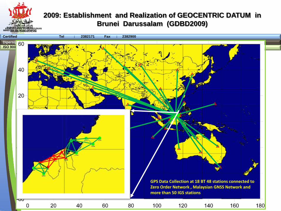
• Oil and gas industries are the major contributor to the national economy. • A new geocentric datum for Brunei Darussalam 2009 (GDBD2009) was
established using GPS space geodetic technology based on the ITRF2005 reference frame.
• The GDBD2009 is related to ITRF2005 through the inclusion of the 8 GPS
stations of the Brunei Darussalam Zero Order Network and have been processed together with more than fifty IGS stations around the world.
Introduction

JABATAN UKUR KEMENTERIAN PEMBANGUNAN
BRUNEI DARUSSALAM Dipersijilkan
Certified ISO 9001
Tel : 2382171 Fax : 2382900 Website : http://survey.gov.bn E-mail : [email protected]
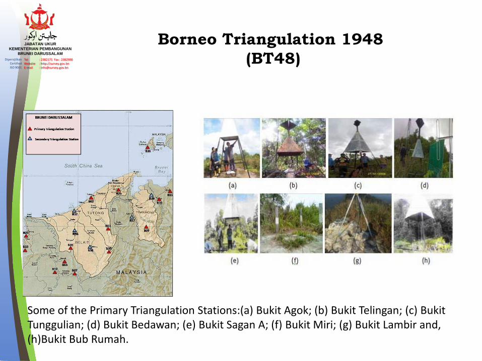
In 1947: Readjustment of triangulation (including Sabah & Sarawak) was undertaken by the to establish a local geodetic reference system known as Borneo Triangulation 1948 (BT48) This reference system had its origin at Bukit Timbalai and uses the Modified Everest as the reference ellipsoid. Applicable for Northern Borneo
Borneo Triangulation 1948 (BT48)
Timbalai, Labuan
History of Geodetic Control Survey
1934 to 1937 : The original survey by Directorate of Colonial Surveys (DCS), Bridges 1937
JABATAN UKUR KEMENTERIAN PEMBANGUNAN
BRUNEI DARUSSALAM Dipersijilkan
Certified ISO 9001
Tel : 2382171 Fax : 2382900 Website : http://survey.gov.bn E-mail : [email protected]
Some of the Primary Triangulation Stations:(a) Bukit Agok; (b) Bukit Telingan; (c) Bukit Tunggulian; (d) Bukit Bedawan; (e) Bukit Sagan A; (f) Bukit Miri; (g) Bukit Lambir and, (h)Bukit Bub Rumah.
Borneo Triangulation 1948 (BT48)

JABATAN UKUR KEMENTERIAN PEMBANGUNAN
BRUNEI DARUSSALAM Dipersijilkan
Certified ISO 9001
Tel : 2382171 Fax : 2382900 Website : http://survey.gov.bn E-mail : [email protected]
• 2002 - 2003: GPS campaign was carried out on 17 stations which include some primary & secondary triangulation stations
2002 – 2003 : Establishment of new GPS network
113.60 113.80 114.00 114.20 114.40 114.60 114.80 115.00 115.20 115.40 115.60 115.80 116.00 116.20Longitude
3.80
4.00
4.20
4.40
4.60
4.80
5.00
5.20
5.40
5.60
Latit
ude
B02
B03
B07
B08 B09
B10
B11
B12
B19
B21
B25
B35
B36
B39
B26
B27
B32
B38
B40
SABAH
SARAWAK KALIMANTAN
Primary Triangulation Station
Secondary Triangulation Station
(c) To determine the new 3 transformation parameters between WGS84 & BT48
(a) to establish a new GPS network, and monuments
(b) to analyze the existing geodetic network
Ref: Morgan, 2004).

JABATAN UKUR KEMENTERIAN PEMBANGUNAN
BRUNEI DARUSSALAM Dipersijilkan
Certified ISO 9001
Tel : 2382171 Fax : 2382900 Website : http://survey.gov.bn E-mail : [email protected]
The new Geocentric Datum & CORS infrastructure
JABATAN UKUR KEMENTERIAN PEMBANGUNAN
BRUNEI DARUSSALAM Dipersijilkan
Certified ISO 9001
Tel : 2382171 Fax : 2382900 Website : http://survey.gov.bn E-mail : [email protected]
Dipersijilkan Website : http://survey.gov.bn/ ISO 9001 E-mail : [email protected]
Certified Tel : 2382171 Fax : 2382900
SURVEY DEPARTMENT MINISTRY OF DEVELOPMENT
2009: Establishment and Realization of GEOCENTRIC DATUM in Brunei Darussalam (GDBD2009)
GPS Data Collection at 18 BT 48 stations connected to Zero Order Network , Malaysian GNSS Network and more than 50 IGS stations

JABATAN UKUR KEMENTERIAN PEMBANGUNAN
BRUNEI DARUSSALAM Dipersijilkan
Certified ISO 9001
Tel : 2382171 Fax : 2382900 Website : http://survey.gov.bn E-mail : [email protected]
Dipersijilkan Website : http://survey.gov.bn/ ISO 9001 E-mail : [email protected]
Certified Tel : 2382171 Fax : 2382900
SURVEY DEPARTMENT MINISTRY OF DEVELOPMENT
2. Computation of Transformation Parameters;
a. GDBD2009 to BT48 and Reverse Bursa-Wolf 7-Parameter
b. GDBD2009 to WGS84 and Reverse (3-Parameter)
c. WGS84 TO BT48 (Bursa-Wolf 7-Parameter)
1. GDBD2009 coordinates for 18 stations including 8 Brunei CORS stations
a
b
c
Results from establishments Brunei Geocentric Datum

JABATAN UKUR KEMENTERIAN PEMBANGUNAN
BRUNEI DARUSSALAM Dipersijilkan
Certified ISO 9001
Tel : 2382171 Fax : 2382900 Website : http://survey.gov.bn E-mail : [email protected]
Dipersijilkan Website : http://survey.gov.bn/ ISO 9001 E-mail : [email protected]
Certified Tel : 2382171 Fax : 2382900
SURVEY DEPARTMENT MINISTRY OF DEVELOPMENT
Brunei CORS service

JABATAN UKUR KEMENTERIAN PEMBANGUNAN
BRUNEI DARUSSALAM Dipersijilkan
Certified ISO 9001
Tel : 2382171 Fax : 2382900 Website : http://survey.gov.bn E-mail : [email protected]
Brunei Darussalam Zero order CORS network Infrastructure
Nine (9) GNSS CORS that form the Zero Order Network of Brunei Darussalam are: 1. KBEL 2. LABI 3. MURA 4. LAMU 5. LIAN 6. TEMB 7. TUTO 8. UKUR 9. LABU

JABATAN UKUR KEMENTERIAN PEMBANGUNAN
BRUNEI DARUSSALAM Dipersijilkan
Certified ISO 9001
Tel : 2382171 Fax : 2382900 Website : http://survey.gov.bn E-mail : [email protected]
The CORS Signal Coverage for RTK users
CORS signal coverage within 35 km radius

JABATAN UKUR KEMENTERIAN PEMBANGUNAN
BRUNEI DARUSSALAM Dipersijilkan
Certified ISO 9001
Tel : 2382171 Fax : 2382900 Website : http://survey.gov.bn E-mail : [email protected]
Dipersijilkan Website : http://survey.gov.bn/ ISO 9001 E-mail : [email protected]
Certified Tel : 2382171 Fax : 2382900
SURVEY DEPARTMENT MINISTRY OF DEVELOPMENT
CORS Monitoring infrastructure

JABATAN UKUR KEMENTERIAN PEMBANGUNAN
BRUNEI DARUSSALAM Dipersijilkan
Certified ISO 9001
Tel : 2382171 Fax : 2382900 Website : http://survey.gov.bn E-mail : [email protected]
• Data Availability • The CORS data are available in RINEX 2.0
format.
• With accuracies of 1 to 3 cm horizontally and 3 to 6 cm vertically
• Data rate – 0ptional 0.1- 60 sec. • Data from the CORS are available in 24/7 • The operational status of the CORS will
be available on its webserver- http://202.160.30.98/
• Data download is made through Internet FTP only and need to be subscribe
GNSS CORS NetWork Services and products
http://www.survey.gov.bn/web/survey_department/

JABATAN UKUR KEMENTERIAN PEMBANGUNAN
BRUNEI DARUSSALAM Dipersijilkan
Certified ISO 9001
Tel : 2382171 Fax : 2382900 Website : http://survey.gov.bn E-mail : [email protected]
GNSS CORS NetWork Services and products
Current Pricing
No Types of Service Price (BND)
Remarks
1 Virtual RINEX data 50.00 For 1 day, unlimited file size
2 Real Time Kinematic (RTK) 1,000.00 Annual fees, need to register to Survey Dept.
3 Real Time Kinematic (RTK) 100.00 Monthly fees, need to register to Survey Dept.
4 Fitted Geoid 5.00 For per station

JABATAN UKUR KEMENTERIAN PEMBANGUNAN
BRUNEI DARUSSALAM Dipersijilkan
Certified ISO 9001
Tel : 2382171 Fax : 2382900 Website : http://survey.gov.bn E-mail : [email protected]
a) VRS Correction Within the limits of RTK network: provide RTK GNSS corrections with accuracies of 1 to 3 cm horizontally and 3 to 6 cm vertically. Distance dependent errors are considerably minimised with utilisation of the RTK network
b) Single Base Real-Time Correction This correction is provided for area within 30 km from the RTK single reference station with an accuracy of 1 to 3 cm horizontally and 3 to 6 cm vertically.
c) Network Base DGPS Correction This correction provides better than 50 cm accuracy for the whole of Brunei Darussalam.
GNSS CORS Network Services and products
RTK system provides the following levels of GNSS correction & data

JABATAN UKUR KEMENTERIAN PEMBANGUNAN
BRUNEI DARUSSALAM Dipersijilkan
Certified ISO 9001
Tel : 2382171 Fax : 2382900 Website : http://survey.gov.bn E-mail : [email protected]
Dipersijilkan Website : http://survey.gov.bn/ ISO 9001 E-mail : [email protected]
Certified Tel : 2382171 Fax : 2382900
SURVEY DEPARTMENT MINISTRY OF DEVELOPMENT
Precise Leveling
GNSS Data
Gravity data Geoid Computation – Computation of Geoid for determination N value (Geoid height) are based on combination of Precise Levelling data, GNSS and Gravity data.
Height Modernization System (HMS) Project in 2010
BRUNEI GEOID

JABATAN UKUR KEMENTERIAN PEMBANGUNAN
BRUNEI DARUSSALAM Dipersijilkan
Certified ISO 9001
Tel : 2382171 Fax : 2382900 Website : http://survey.gov.bn E-mail : [email protected]
Dipersijilkan Website : http://survey.gov.bn/ ISO 9001 E-mail : [email protected]
Certified Tel : 2382171 Fax : 2382900
SURVEY DEPARTMENT MINISTRY OF DEVELOPMENT
WEB BASE GEOID INTERPOLATION CALCULATOR

JABATAN UKUR KEMENTERIAN PEMBANGUNAN
BRUNEI DARUSSALAM Dipersijilkan
Certified ISO 9001
Tel : 2382171 Fax : 2382900 Website : http://survey.gov.bn E-mail : [email protected] Dipersijilkan Website : http://survey.gov.bn/
ISO 9001 E-mail : [email protected]
Certified Tel : 2382171 Fax : 2382900
SURVEY DEPARTMENT MINISTRY OF DEVELOPMENT
113.60 113.80 114.00 114.20 114.40 114.60 114.80 115.00 115.20 115.40 115.60 115.80 116.00 116.20Longitude
3.80
4.00
4.20
4.40
4.60
4.80
5.00
5.20
5.40
5.60
Latit
ude TEMB
UKUR
TUTO
LABI
MURA
LIAN
KBEL
LAMU
• Future Brunei CORS Extension - 1 CORS per year till 2025 • Migration to One Government Network (OGN) – to avoid communication
problem
WAY FORWARD

JABATAN UKUR KEMENTERIAN PEMBANGUNAN
BRUNEI DARUSSALAM Dipersijilkan
Certified ISO 9001
Tel : 2382171 Fax : 2382900 Website : http://survey.gov.bn E-mail : [email protected]
Regional Participation
• ASIA – PACIFIC REFERENCE FRAME PROJECT (Campaign Date : 4/10 to 10/10 2009) (Campaign Date : 12 to 18 Sept 2010) (Campaign Date : 11 to 17 Sept 2011) (Campaign Date : 06 to 13 Sept 2015) (Campaign Date: 18 to 25 Sept 2016)

JABATAN UKUR KEMENTERIAN PEMBANGUNAN
BRUNEI DARUSSALAM Dipersijilkan
Certified ISO 9001
Tel : 2382171 Fax : 2382900 Website : http://survey.gov.bn E-mail : [email protected]
• Require long term maintenance : enclosure to house power supplies, batteries, a computer and telecommunications equipment .
• Communication Problem (Internet Interruption) - Migrate to One Government Network (2016)
• Invites private sectors to work together with the Survey Department (PPP).
challenges .

JABATAN UKUR KEMENTERIAN PEMBANGUNAN
BRUNEI DARUSSALAM Dipersijilkan
Certified ISO 9001
Tel : 2382171 Fax : 2382900 Website : http://survey.gov.bn E-mail : [email protected]
• Brunei GNSS- CORS is the current available infrastructure for application that require high level of positioning accuracy.
• GNSS CORS need to be utilized fully, to benefit local
Government and Private Agencies • GNSS education should be a better choice for Long
Term Strategic Plan 2035 which include education, Economy, Security, Institutional development, Business development, Infrastructure and Environmental
Conclusion

JABATAN UKUR KEMENTERIAN PEMBANGUNAN
BRUNEI DARUSSALAM Dipersijilkan
Certified ISO 9001
Tel : 2382171 Fax : 2382900 Website : http://survey.gov.bn E-mail : [email protected]
Thank You