


Languages
Pages
Legal


GEOCHEMI CAL S o l L SURVEY;
l NDUCED POLAR1 ZATl ON AND RES I ST1 V I 77' SURVEYS
G.J. 1-24 and BLUE JAY 1-8 MINERAL CLAIMS

T A B L E O F C O N T E N T S
.,
Page
I
Department of
Mines and Petroleum Wssoureeo
ASSESS&9E;s,PT REPOAT
MAP ...........................................
I NTRODUCTI ON
# / Loca'f ion Map
GENERAL GEOLOGY
GR l D PREPARATI ON
GEOCHEM 1 CAL SO I L SURVEY
SampI i n g Me'thod
Labora'tory De'terrni \ lact i on Me'fhods
Presen'tzi ti on o f Resu I t s
D i s cu ss i on o f Resu I ' ts
l NDUCED POLAR1 ZATl ON AND RES l ST1 V l TY SURVEY
Mest hod
Presen fa ' t i on o f Resu l t s
Discussion o f Resu l ' t s
RECOMMENDATIONS AND CONCLUSIONS
S'ta'ternen't o f Qua 1 i f i cact i 011s
James T. Wa I ker James D. Knauor Appended

Geocherni ca I Soi i Survey;
Induced Po la r i za ' t i on and R e s i s t i v i ' t y Surveys
o f the
G.J. 1-24 and B lue Jay 1-8 Minera l Claims
Noraiida Exp 1 o ra ' t i 011 Company, L i mi'ted
I NTRODUCTI ON :
The claims r e f e r r e d ' to i n t h i s repor i - a r c r e g i s t e r e d i n ,the name o f
Noranda Exp lo ra t i on Cornpany, L i rni Ted (No Personal L i a b i l i ' t y ) under op' t ion
frorn M r . Fraiik Lehman o f V i c to r i a , B r i ' t i s h Columbia. The names and reco rd
numbers of the miners1 claims a re : Blue Jay I -% and G.J. 1-24: 11318 t o
1 1325 and I61 06 t o 16129 respect i ve l y. The surveys were conducted on the
Has l am Lake proper ty l oca'ted approxi maTe l y s i x m i l es nor theas t o f Powe l I
R i ve r , B.C. near +he west s i do of Haslam Lake. Access t o the proper ty from
Powel l River , B.C. i s by loose sur face and logging roads, the l a ' t t e r r e q u i r e s
a four wheel d r i v e vehi c l e i n sorne areas. A four wheel d r i v e v e h i c l e was
used 'to t ranspor t men and equi prnen't and t o supply She camp du r ing 'the course
o f t h i s survey.
El eva5t ioi i ranges frohi 1,000 ' to 2,450 f e e t . Topography ranges from
ge i i t l e ' to steep slopes wi'th loca l c l i f f s . A por t t ion o f the area has bee11
I ogged and there i s ev i deiice o f a srnal l fo res ' t f i r e having occurred a't some
t ime i n 'the nor'theast sect ion. There i s , t h i ck underbrush over por ' t ions of
'the proper ' ty .
Previous work on 'the area covered by par't o f t h i s survey inc ludes
reconnaissance s o i l sampling a long nearby l o g g i ~ i g roads and b l a s t i n g by
Frank Lehmaii. Fol lowing , this, dur ing November 1967, Arnax Exp lora f io i i fnc .
d i d work on the proper'ty coils i s't i i ig o f decta i l ed goo I og i ca l mapp i ng , l i rn i 'tad
so i l samp l i ng, b l as't i 11g and samp I i ng o f rn i nera l i zed ou'i-crops .
During Apr i l and May of 1970 work was performed on 'the Bl ue Jay 1-8
and G.J. 1 , 3, 5, 1 1 , 12, 13, 14, IS, 20, 22 and 24 minera l c laims. Work
coils i sCted o f ! i ne prepara' f i 017 by Noranda Exp l o ra t i on Company, L i m i ted and
Arnex Exp 1 o ra ' t i oi7 Servi ce L'fd., con'l-rac'tors, f o l lowed by Geophys i ca l aiid
Geochemi ca l Surveys conducted by Noranda Exp l or-a't i oil Company, L irni'ted.

TMRD STATUS EDlT1ON -.~dmmy Isrh. 1967 . v . .
Yr
. i;
Work was done under the d i r e c ' t i o ~ i o f 6.0. Brynel sen, P. Eiig. wi'th
f i e l d superv is ion by J.D. Knacjer (geochsunical) and J.T. Walker (geophysical ) ,
a crew o f n ine men and l i ne prepara t ion by Arnex Expl ora ' t io i i Serv ice Ltd.,
con' tractors. Resu l t s o f 'the Geocherni ca l aiid Geophys i ca l Surveys a re p I o't'ted
oil I i ~ i c h ' to 400 f e e t base maps. Clairn names and i deal i zed bouiidar i es a r e
showii . The surveys were c a r r i e d ou't from Apr i 1 4, 1970 'through May 25, 19'70.
GENERAL GEOLOGY :
General geology i n cthe area covered by t h e B lue Jay and G.J. c la ims
i nd i ca'tes 'the rock 'to be o f 'the Jurass i c-Cre'taceous Coas't Range Ba'thol i ' th ,
Quar'tz-d i o r i ' t e aiid m i nor d i o r i ' t e have been i n'truded by a g r a ~ i i ' t e s'tock.
Rhyol i ' te d i kes have been observed. I n'tetise f rac ' tu r i ng and at ' te ra ' t i on occur
i ii the areas o f i ii 'teras't. Weacther i ng i s i 11.l-ense over most o f 'the ouatcrop
was observed i n 'treiiches and areas o f b las ' t i i i g which
inc luded r i't i te.
GR l D PREPARATI ON :
I n order ' to c a r r y oust 'the de'tai l ed Gaochemi cal and Geophysi cal Surveys,
Two con'trol base I ines and a ' t i e l i n e were es'tabl ished by a chain and ' t ra i i s i ' t
survey. A bear ing o f I 0' was used f o r both base l i iies. The 30W base l i ne
extends from 6N ,to 42N and 'the 60W base I i i i e from 6N <to 32N. The 22N ' t i e
l i n e runs perpeiidicu l a r ' to the base l i nes frorn 15W ' to 6OW, Ni tie add ic t iona l
E-W g r i d l i lies were I ayed ou t perpeiidi cu l a!- 9-0 'the base l i iies, The g r i d l i nes
a re spaced a ' t 400-foot i n t e r v a l s , chained and picke' ted every 100 fee't,
Noranda personnel developed 'the 10,700 fee ' t o f base l i n e aiid ' t i e l i ne. Arnex
Explorabt ion Serv ice L'td, developed 'the g r i d l i nes , a 'to'tai o f 9.4 mi les.
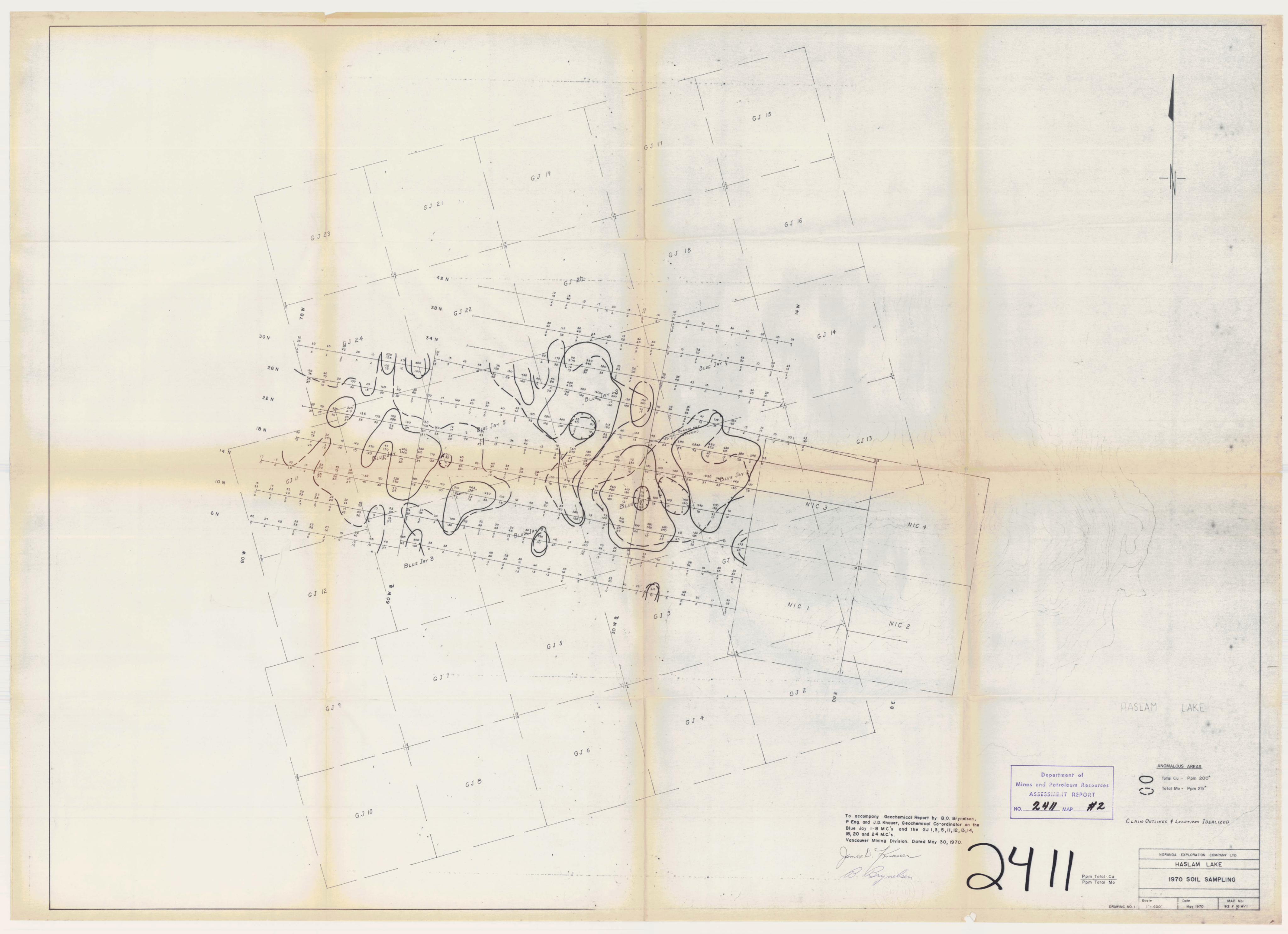
GEOCHEM I CAL SO1 L SURVEY :
Al I sarnp l es were anal yzed f o r copper and mol ybdenurn i n 'the Noranda
Exp I o ra ' t i OII Company, L i rni'ted l abora'tory I ocaated a'i- 1050 Davi e Stree't,
Vancouver 5, B.C., a i ia lys t Ever't Van Leeuwen.

Samp 1 i ng Me'thod :
Samp l es were obctai ned by d i ggi ng hot es w i t h a rna't'tock atid shovel , ' to
a dep'th a? whi ch 'the v i s i b l e grey C Hor i 2011 o r sub-ou,tcrop was encoun'tered.
The C Horizon was sampled and *the lower par ' t o f The 6 Horizon, where v i s i b l e ,
was a l s o sampl ed. The sample rnasterial was placed i n l1Hi Wect S'treng'th Kraf ' t ,
3 1 /2rf by 6 1 /811 Open Endf1 eiivel opes and 'the g r i d s'ta-tion l oca't ion was
marked on 'the enve I opes w i ' t h i lide I i b l e f e l "r pens. Soi l samp l es were 'taken
a t 200-foo't i n'terva l s a I ong 'the l i nes, eas t and wes't.
Labora'tory De'terrni na?i on MePhods :
The samples are f i r s ' t hung i n a d ry cabine't f o r a pe r iod o f 24- hours
' to 48 hours. They are 'then mechanical l y screened and s i f ' ted ' to ob'tain a
-80 mesh f r a c ' t i on.
TIie determinat ion procedure f o r To'tal copper i s as f o l lows: 0.200
grarns o f -80 mesh rna'terial i s d igested i n 2 n i l . o f I-IC1O4 and 13.5 m l . o f
HN03 f o r approxima'tely four hours. Fo l lowing d iges ' t ion each sample i s
d i l u'ted ' to 10 mi . wi'th derni nera l i zed YO. A Var i ail Techtron Model AA-5
A'torni c Absorp't ion specLf-ropho'i-orneter was used t o detet-:ni ne 'the p a r t s per
m i l I i o n Cu conten't i n each sample.
The Theory o f A' tmi c Absorpcti on spec'tropho'tome'try i s f u I l y descr i bed
i n 'the l i te ra ' tu re and w i l l no'? be descr i bed i n >th i s I-epor't.
The de'termi ~ i a ' t i o n procedure f o r ' t o ta l mol ybdenurn i s as f o l lows: 0. I
gram sample o f 'the -80 mesh mafer ia l i s fused wi ' th a sodi urn carbona'te m i x-
t u r e . I't i s +hen d issolved i n YO (demineral ized) and d i l uc ted ' to 10 rnl. A
2 ml. a l i q u o t i s shaken wi'th 2 m i . hydroxlyamine hydroch lor ide so lu ' t ion and
0.5 m l . d i ' t h i o l solu' t ion. The sarnples a re 'fhen compared wi'th co lor ime"rr ic
standards.
Preseli'ta't i on o f Resu l ' ts :
ResulcSs o f ' t h i s survey a re presen'ted i n Dwg. No. I o f ' t h i s repor't, a
p 1 an rnap show i ng copper and mol ybdenum de'terrni na't i ons i 11 par ' ts per m i I l i on.

Copper values grea Per ,than 200 p .p .m. are con'tourod by sol i d l i nes. Mol y-
bdenurn values grea'ter 'than 25 p.p.m. a re con toured by dashed l ines.
Discussion o f Resul'ts:
Values f o r %to ta l copper range from a background o f less 'than I00 p.p.m.
t o anornal ous values grea'ter 'than 200 p.p.m. ToCtal tnol ybdenum val ues range
from a background o f less 'than '7 p.p.m. ' to anomalous values grea8ter 'than 25
p.p.m. Resul'ts f o r copper indica' te anomalous zones on 'the Blue Jay 2, 3 , 4
and '7. Sma l l er anana l i es occur around 'these I arger zones as shown on Dwg. 1
and probab l y a re d i I-ec'tl y associ abted. Soi I 'type nearness o f sub-ou'tcrop i ii
tnos't areas and 'topography 'tend f o ind icaSte very l i ' t ' t l e displacemen't. Molybdenum
resu lL t s show 'two broad zoiies . The major copper anorna l i es a re con'ta i ned w i 'th i n
'these mol ybdenum zones and c lea r l y def i ns 'the areas o f in ' teres' t .
i NDUCED POLAR l ZATl ON AND RES I ST I V l TY SURVEY :
The triduced Po lar iza ' t ion a ~ i d Resis't ivi"i-y Survey was c a r r i e d ou t u ' t i l i z -
i ng Var iab I e Frequency I .P. equipmen-t owned aiid bui l't by Noranda Expl o ra ' t ion
Company, Limi'ted. Tho survey was conduc'ted be'tweeli May 6, 1970 and May 25,
1970. The f i e l d crew, emp I oyed by Noranda Expl o ra ' t i on Company, Limi'ted, con-
s i s'ted o f G. Sauder , rece i ver operator ; D. Earton, Tt-ansrni't'ter opera'tor ; and
R. Feiifon and D. Gee, elec'i-rode prepara t ion men.
Mesthod :
Throughou't ' t h i s 1 .P. and R e s i s ' t i v i t y Survoy the f o l l o w i n g f i e l d pro-
cedure was c a r r i e d ou't fot- The recorded readings apt each 200-foo't s'ta't ion
al ong 'the prepared g r i d l ines. A d i pol e-dipol e e l ec'trode conf i gura't ion (C 2 r P P ) was used wi'th an elec'tl-ode separaTion o f 200 fee t . Currenf i s 'I 1 2 i n jec'ted i ~ i ' t o 'the ear'i-h bectween e lec t rode C aiid C2. The induced vol ' tage I d i f ference between the porous p o t e l ec3trodesP aiid P2 i s measured. The four
I mail f i e l d crew, one man s'taGtioned act each elec'trode, c a r r i e s ou't the survey
' t ranspor' t i ng e l eca?rodes and i ns'trumen'ts s'ta-ti on 'to si-a'ti on a I ong ,the survey
l ines.

The for lowing da'ta are recorded a'f each s'ta'tion:
Grid locaLtion of curreiit elec'trodes C and C2. I Grid l oca*Si on of po'fen'tial el ec'trodos P i and P2.
I n addi'ti on 'the fol lowing eiec'tri cal rneasurernen'ts are made and recorded:
( I ) Curren't on-frequency 10 Hz (Current recorded i n milliamperes)
(2) Receiver measured developed vof8tage (Recorded i n m i 1 l i vol'ts) . (3) Curren't rnai n'tai ned cons'taliLt . Frequency changed 'to 0.3 Hz.
(4) Receiver measures percen? change i n vol'tage caused solely by
'the change i n frequency of curren't.
(Percen? volatage change recorded as perceli't Frequency Effec't.)
No'te on Read i ng Nurnber (4 ) :
By def i i i i t i on Perceri't Frequency Effect equal s the percen't chaiige i n
apparen't res i s'ti vi fy when the apparen't res i s4ti vi'ty i s ca l cu I a'ted for
'two frequencies ( I n 'this survey frequencies used are 10 Hz and 0.3 Hz).
Apparen't Resi s'ti vial-y i s direc'tl y proporttioi7al 'to Vol'tage and inverse1 y
propor,ti ona 1 'to Curren t.
Provi ded the curreiif i s mai n'tai ned cons'taii*t set each frequency, 'the
perceii8t change i n vol +age equal s perceii't change i ii appare~i't res i s't i vi'ty
and *the vol'tage chaiige is 'the11 read directly as Percen't Frequency
Effec't,
The apparen't resis'tiviaty for each s'ta'l-ion is calcula'ted frorn 'the recorded
Vol 'tage and Curren't measurernen'ts.
Presen ta't i on of Resu 1 'ts :
The resu l 'ts of ,the I nduced Pol ar i za'ti oil and Res i sf i vi fy Surveys are
presen'ted OII drawings No. 2 arid No. 3 of T h i s repor't. The Percsii't Frequency
Ef feet and ca I cu I abted Appareii't Resi s'ti v i ty da'ta are p i ot'ted a't m i d poi n't between
I-he grid posi tions of electrodes C and P I . The plot'ted da'ta of each survey I are coii'toured .
Discussion o f ResuI t s :
Ni l ie 1 .P. l i lies were sur-veyed wi'th ,the I ,P. me Thod. The I .P. response
measured as Percenct Frequency Ef fec ' t raiiges from O;g ' to 10%. The 4% F.E,
coii'tour l i i i e broadly del i rni ' ts 'the areas o f poss ib le in teres ' t . Wi'thin ' t h i s
area, s i x 1 .P . anornal ous zones a re i nd i ca'ted. The anornal ous zones a re
del i ~ n i ' t e d by 'the 5% F.E. con'tour aiid a re i n d i ca'ted on Urav~i i ig No. 2 by
ha'tch i ng.
RECOMMENDATIONS AND CONCLUSIONS:
The resu l ' t s o f the Goocherni cal Survey and the I nduced Pol a r i za't i on and
R e s i s t i v i ' t y Survey show d i s ' t i n c t co inc ide i i t anomalous zones. These zones occur
on the B l t ~ e Jay 2, 3 and 7 mi i ieral c laims.
Moderaete f o s'l-rong I .P. and Geocherni ca l so i I r esu l ' t s over 'These areas
rtai-ran'f- addi'Ti oiial i i ives't i g a f i on as ou' t l i ned.
1 . Surface ' t renching and diamond dr i 1 l i ng o f 'the so i l and I .P.
ailomal ies.
2. Fur'ther so i l aiid I .P. coverage ex'tci idi ng ' to 'the northwes't and
sou'fh o f the pi-esen't g r i d .
3. Addi ' t ional geological mapping.
9 B.O. Bryneisen, P. Eng.
V . D . ~ i l a u f Geocherni da I Coord i na'i-or
b . ~ . Wal ker Geophysical Coordina'tor

S'ta'terne~i't o f Qua I i f i ca't i ons
I , James D. Knauer of 'the Ci'i-y of Vancouver, Provi l ice o f B r i ' t i s h
Col urnb i a do cer ' t i f y 'tha't :
I . I have been an emp 1 oyee of Noranda Exp l ora ' t i on Company, L i mi'ted
s ince Augus't 1964.
2. 1 am a gradua'te o f 'the U i i i vers i ' t y o f New Mexico w i t h a Bachelor
o f Science Degree i n Geology.
3. I am a member of 'the Geocherni ca l Soci e'ty.
4. 1 havehe ld~ thepos i%iono fGoochemica l C o o r d i i i a ~ t o r f o r N o r a n d a
Expiora ' t ion Compaiiy, LimiTed, B r i ' t i s h Columbia s ince June 1965.
Da'ted a? Vancouver -L.----
' t h i s 30'i-h day o f May 1970
Geochem i ca 1 Coor d i na'tor
Noranda Exp l o ra ' t i OII Company, L i mi'ted

S"ra8terneii"r o f Qua 1 i f i caai- i 011s
I , James T. Wai ker of t h e Ci ' ty o f Vancouver, Province o f B r i ' t i s h
Co l umb i a do corr t i .l- y '1-ha't :
I . I have been an ernp l oyee of Noranda Exp i ora ' t i on Canpany, Limi ' ted
s ince May 1958.
2. 1 have held 'the posi ' t ion of Geophysical CoordinaLtor f o r Noraiida
Exp lora t ion Company, Limi'ted, B r i ' t i s h Columbia s ince June 1965.
3. I have been responsib le f o r 'the design and coris*truc't ion o f 'the
l iiduced Polar i zactioi i Equi pmen't u ' t i l i zed 'throughoutt ' t h i s Survey.
4. 1 am a rnernber o f the Cariadiari Ins't i"ru'ts of M i ~ i i ~ i g and Metal 1 urgy.
Dacted act Vaiicouver
't17 i s 30'th day o f May 1970
/ James T. Wa 1 ker d Geop hysi ca l Coord i ria'tor
Noranda Explora' t ion Company, Limi ' ted


Top Related