


Languages
Pages
Legal

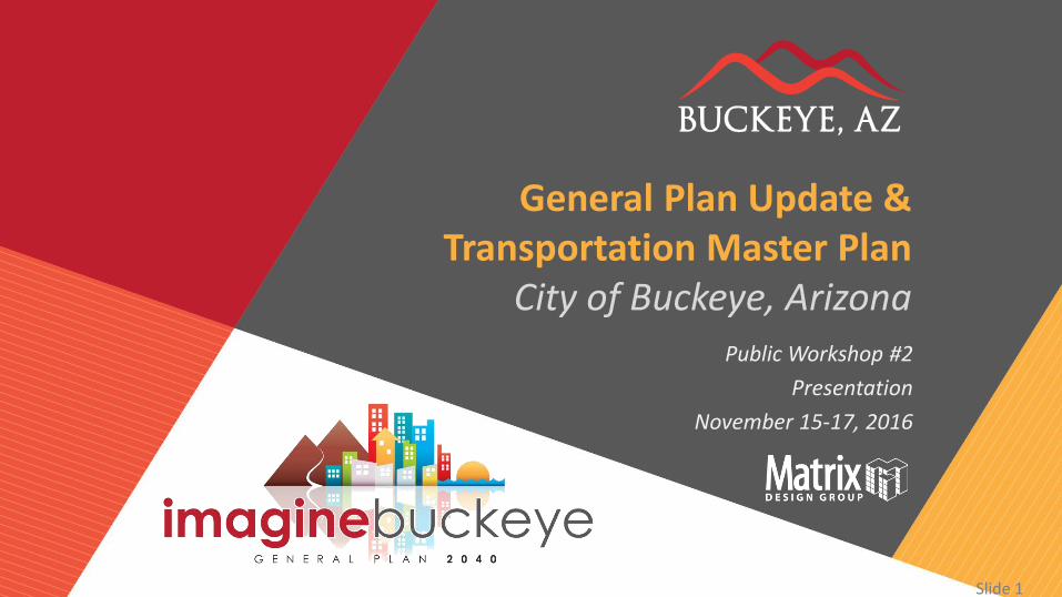
Slide 1 General Plan Update / Transportation Master Plan Slide 1
General Plan Update & Transportation Master Plan
City of Buckeye, Arizona Public Workshop #2
Presentation
November 15-17, 2016
Slide 2 General Plan Update / Transportation Master Plan
1. WELCOME AND INTRODUCTIONS
Slide 3 General Plan Update / Transportation Master Plan
1 . W e l c o m e a n d I n t r o d u c t i o n s
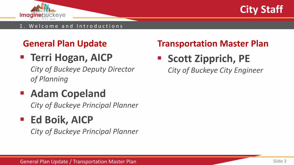
City Staff
Scott Zipprich, PE City of Buckeye City Engineer
Terri Hogan, AICP City of Buckeye Deputy Director of Planning
Adam Copeland City of Buckeye Principal Planner
Ed Boik, AICP City of Buckeye Principal Planner
General Plan Update Transportation Master Plan
Slide 4 General Plan Update / Transportation Master Plan
1 . W e l c o m e a n d I n t r o d u c t i o n s
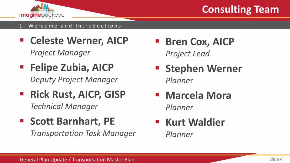
Consulting Team
Celeste Werner, AICP Project Manager
Felipe Zubia, AICP Deputy Project Manager
Rick Rust, AICP, GISP Technical Manager
Scott Barnhart, PE Transportation Task Manager
Bren Cox, AICP Project Lead
Stephen Werner Planner
Marcela Mora Planner
Kurt Waldier Planner
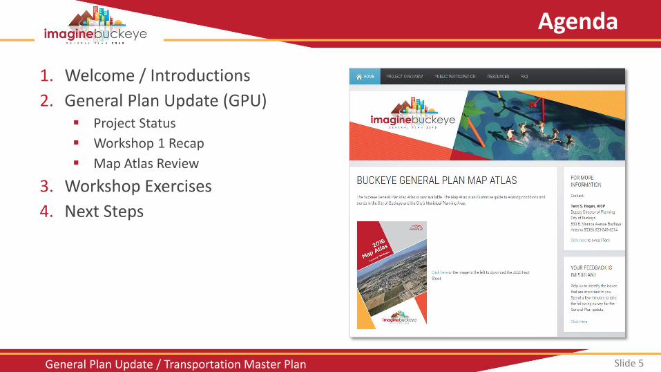
Slide 5 General Plan Update / Transportation Master Plan
Agenda
1. Welcome / Introductions
2. General Plan Update (GPU) Project Status
Workshop 1 Recap
Map Atlas Review
3. Workshop Exercises
4. Next Steps
Slide 6 General Plan Update / Transportation Master Plan
2. GENERAL PLAN UPDATE
Slide 7 General Plan Update / Transportation Master Plan
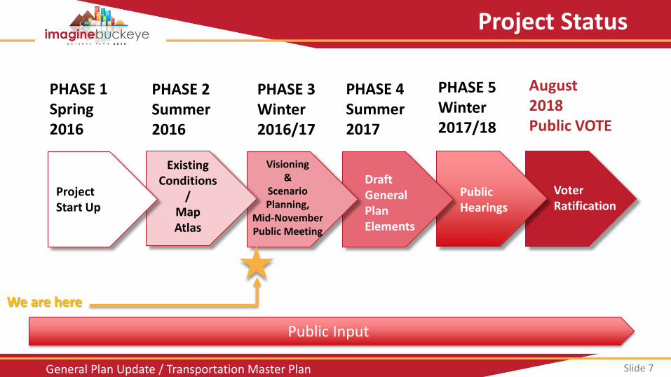
Project Status
Public Input
PHASE 1 Spring 2016
PHASE 2 Summer 2016
PHASE 4 Summer 2017
PHASE 5 Winter 2017/18
August 2018 Public VOTE
Voter Ratification
PHASE 3 Winter 2016/17
Public Hearings
Draft General Plan Elements
Visioning &
Scenario Planning,
Mid-November Public Meeting
Existing
Conditions /
Map Atlas
Project Start Up
We are here
Slide 8 General Plan Update / Transportation Master Plan
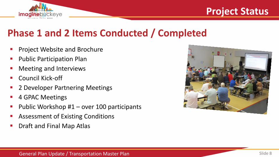
Phase 1 and 2 Items Conducted / Completed
Project Website and Brochure
Public Participation Plan
Meeting and Interviews
Council Kick-off
2 Developer Partnering Meetings
4 GPAC Meetings
Public Workshop #1 – over 100 participants
Assessment of Existing Conditions
Draft and Final Map Atlas
Project Status
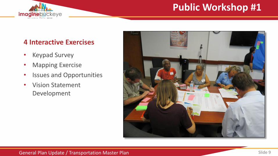
Slide 9 General Plan Update / Transportation Master Plan
4 Interactive Exercises
• Keypad Survey
• Mapping Exercise
• Issues and Opportunities
• Vision Statement Development
Public Workshop #1
Slide 10 General Plan Update / Transportation Master Plan
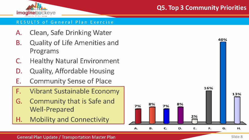
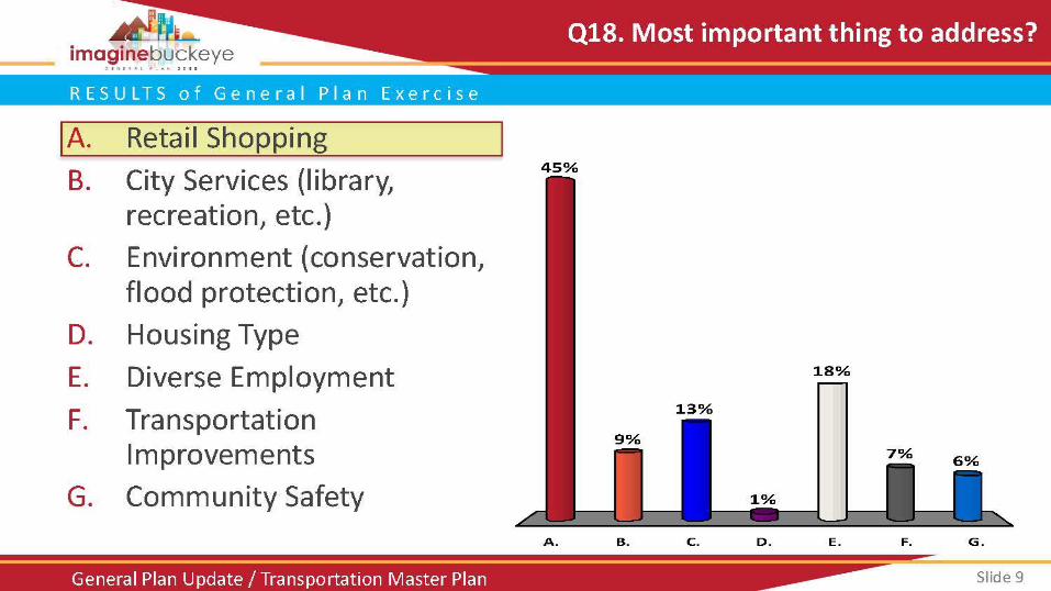
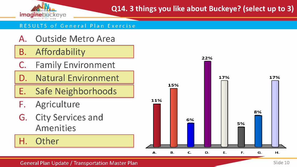
R E S U L T S o f G e n e r a l P l a n E x e r c i s e
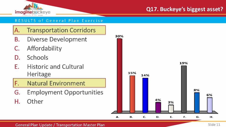
Slide 11 General Plan Update / Transportation Master Plan
R E S U L T S o f G e n e r a l P l a n E x e r c i s e
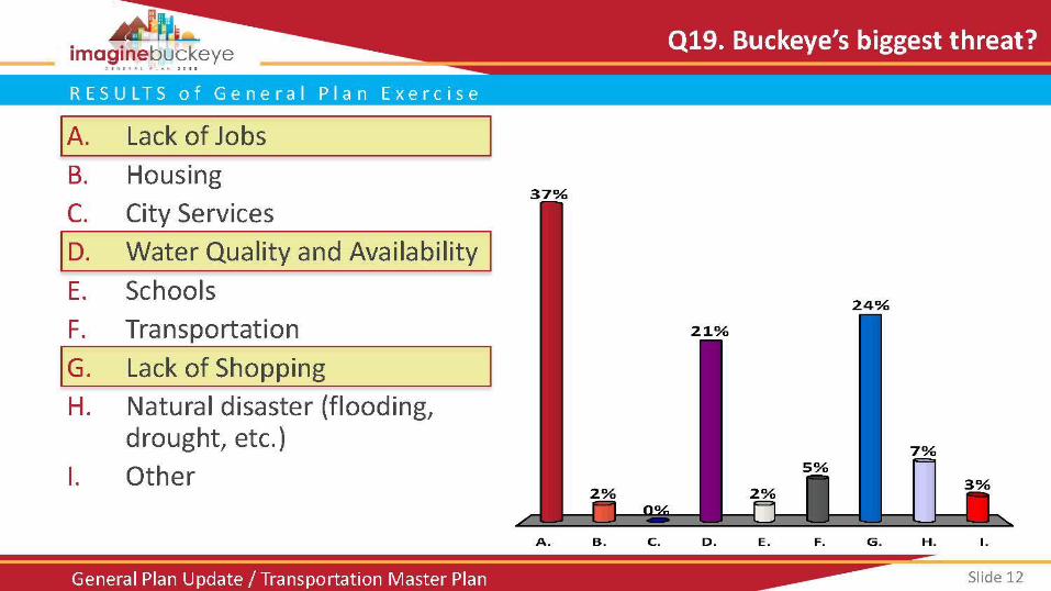
Slide 12 General Plan Update / Transportation Master Plan
R E S U L T S o f G e n e r a l P l a n E x e r c i s e
Slide 13 General Plan Update / Transportation Master Plan
R E S U L T S o f G e n e r a l P l a n E x e r c i s e
Slide 14 General Plan Update / Transportation Master Plan
R E S U L T S o f G e n e r a l P l a n E x e r c i s e
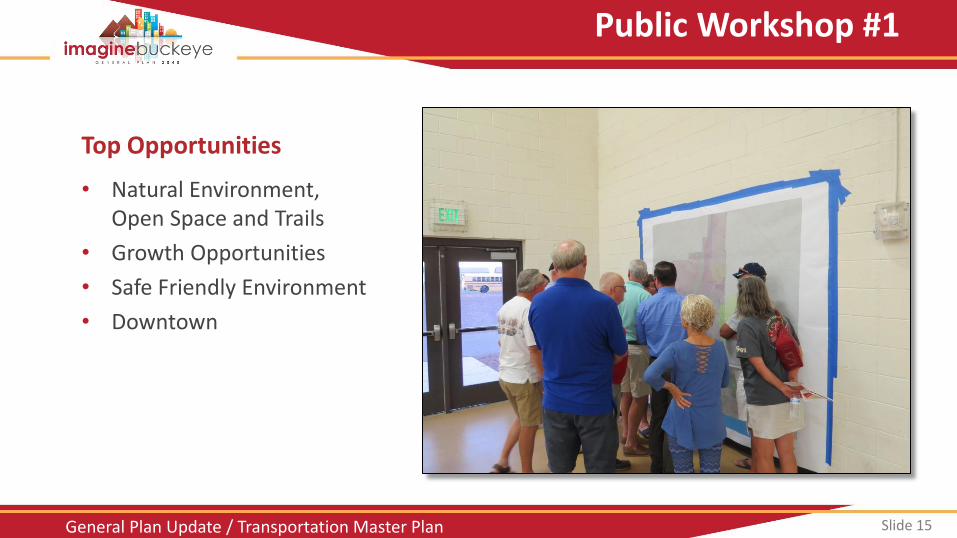
Slide 15 General Plan Update / Transportation Master Plan
Top Opportunities
• Natural Environment, Open Space and Trails
• Growth Opportunities
• Safe Friendly Environment
• Downtown
Public Workshop #1
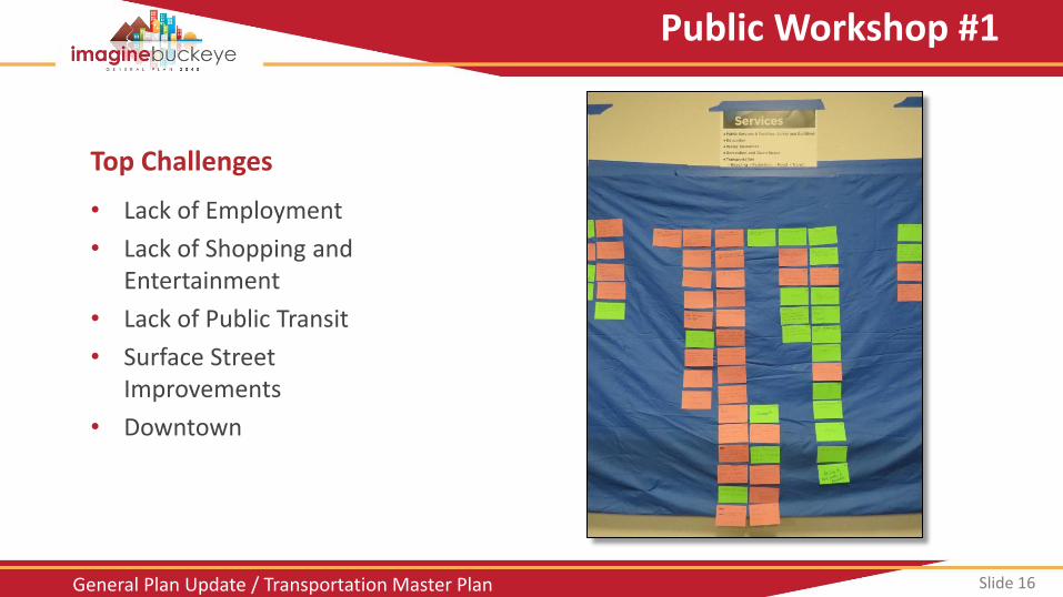
Slide 16 General Plan Update / Transportation Master Plan
Top Challenges
• Lack of Employment
• Lack of Shopping and Entertainment
• Lack of Public Transit
• Surface Street Improvements
• Downtown
Public Workshop #1
Slide 17 General Plan Update / Transportation Master Plan
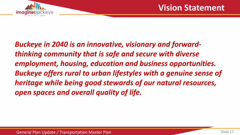
Vision Statement
Buckeye in 2040 is an innovative, visionary and forward-thinking community that is safe and secure with diverse employment, housing, education and business opportunities. Buckeye offers rural to urban lifestyles with a genuine sense of heritage while being good stewards of our natural resources, open spaces and overall quality of life.
Slide 18 General Plan Update / Transportation Master Plan
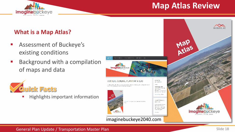
Assessment of Buckeye’s
existing conditions
Background with a compilation of maps and data
Highlights important information
Map Atlas Review
What is a Map Atlas?
imaginebuckeye2040.com
Slide 19 General Plan Update / Transportation Master Plan
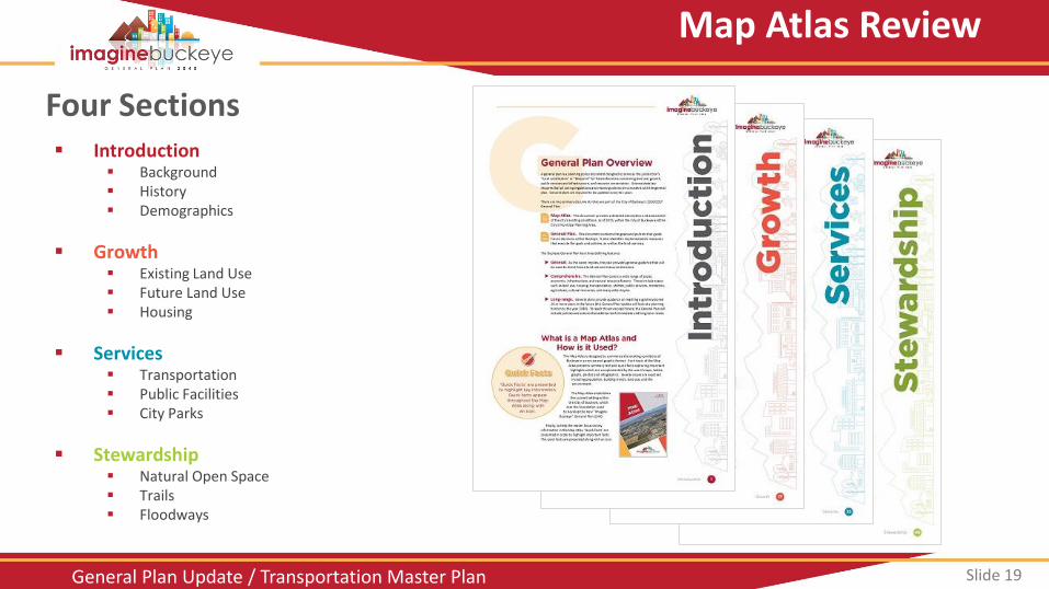
Four Sections
Map Atlas Review
Introduction Background History Demographics
Growth Existing Land Use Future Land Use Housing
Services Transportation Public Facilities City Parks
Stewardship Natural Open Space Trails Floodways
Slide 22 General Plan Update / Transportation Master Plan
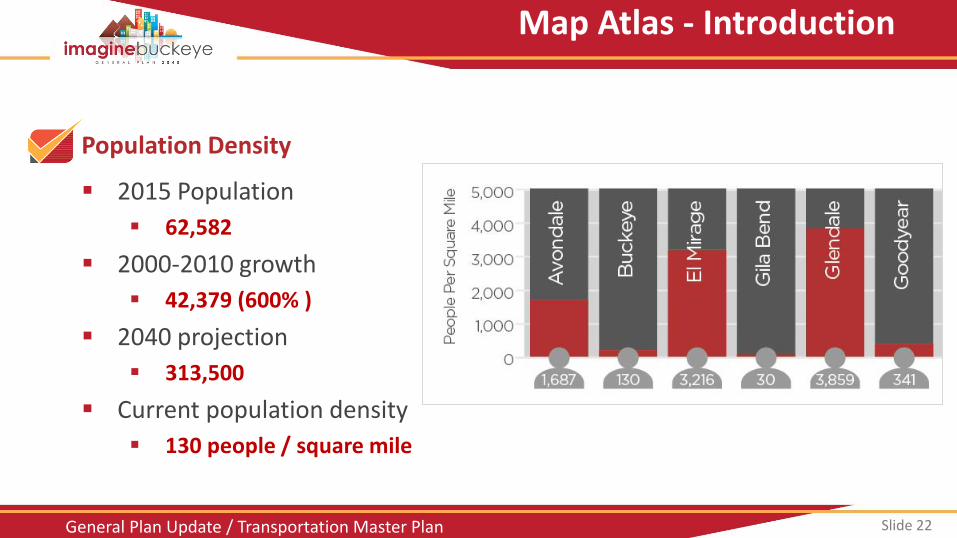
Population Density
2015 Population
62,582
2000-2010 growth
42,379 (600% )
2040 projection
313,500
Current population density
130 people / square mile
Map Atlas - Introduction
Slide 23 General Plan Update / Transportation Master Plan
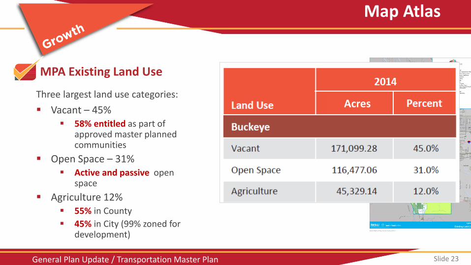
MPA Existing Land Use
Vacant – 45% 58% entitled as part of
approved master planned communities
Open Space – 31% Active and passive open
space
Agriculture 12% 55% in County
45% in City (99% zoned for development)
Three largest land use categories:
Map Atlas
Acres
Slide 24 General Plan Update / Transportation Master Plan
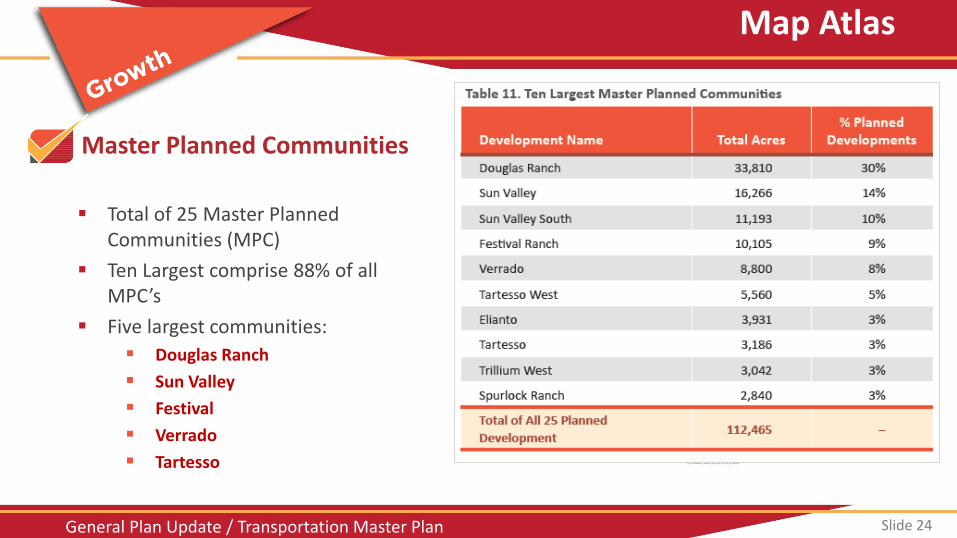
Master Planned Communities
Total of 25 Master Planned Communities (MPC)
Ten Largest comprise 88% of all MPC’s
Five largest communities:
Douglas Ranch
Sun Valley
Festival
Verrado
Tartesso
Map Atlas
Slide 25 General Plan Update / Transportation Master Plan
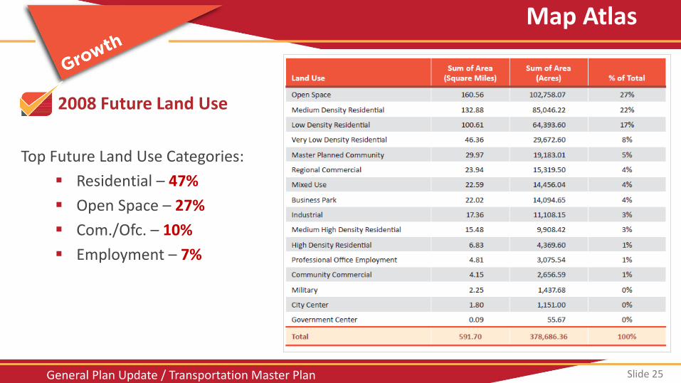
2008 Future Land Use
Top Future Land Use Categories:
Residential – 47%
Open Space – 27%
Com./Ofc. – 10%
Employment – 7%
Map Atlas
Slide 26 General Plan Update / Transportation Master Plan
Buckeye Housing
Map Atlas
Value
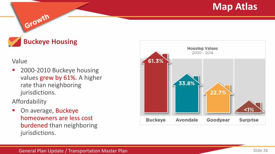
2000-2010 Buckeye housing values grew by 61%. A higher rate than neighboring jurisdictions.
Affordability
On average, Buckeye homeowners are less cost burdened than neighboring jurisdictions.
Slide 27 General Plan Update / Transportation Master Plan
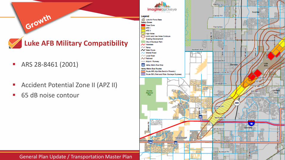
Luke AFB Military Compatibility
Luke AFB Compatibility
ARS 28-8461 (2001)
Accident Potential Zone II (APZ II)
65 dB noise contour
Slide 28 General Plan Update / Transportation Master Plan
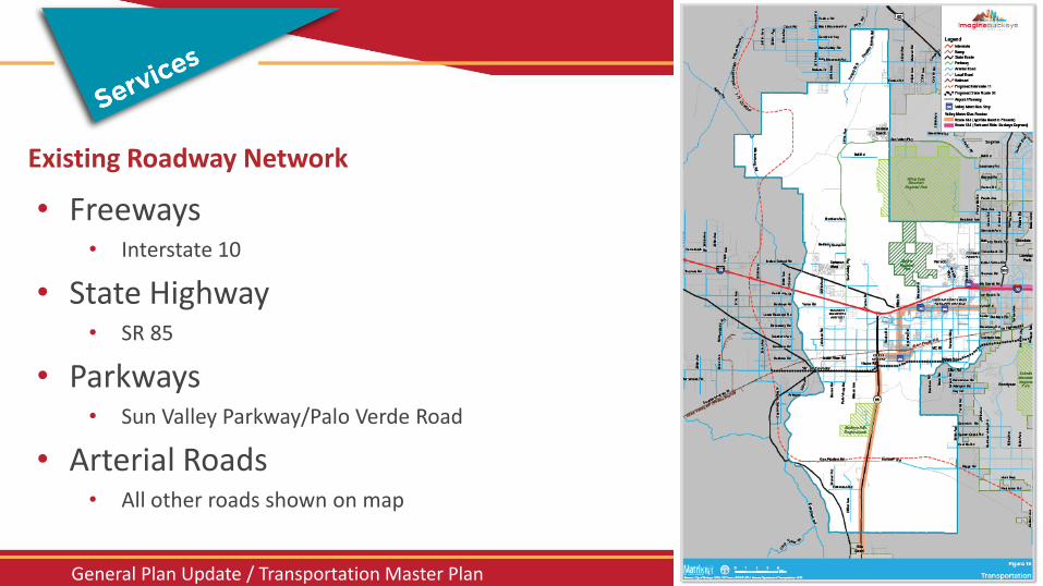
Existing Roadway Network
• Freeways
• Interstate 10
• State Highway • SR 85
• Parkways • Sun Valley Parkway/Palo Verde Road
• Arterial Roads • All other roads shown on map
Map Atlas
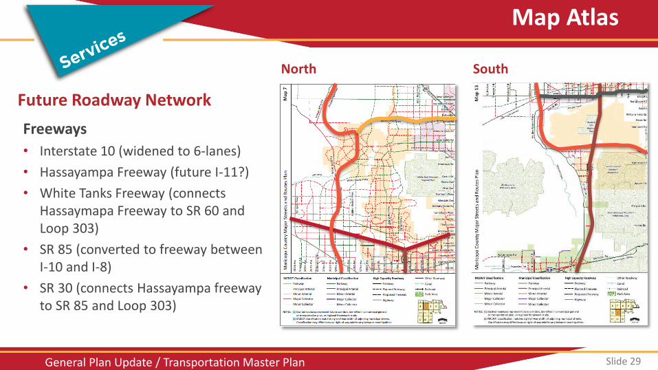
Slide 29 General Plan Update / Transportation Master Plan
Future Roadway Network
Freeways
• Interstate 10 (widened to 6-lanes)
• Hassayampa Freeway (future I-11?)
• White Tanks Freeway (connects Hassaymapa Freeway to SR 60 and Loop 303)
• SR 85 (converted to freeway between I-10 and I-8)
• SR 30 (connects Hassayampa freeway to SR 85 and Loop 303)
Map Atlas
North South
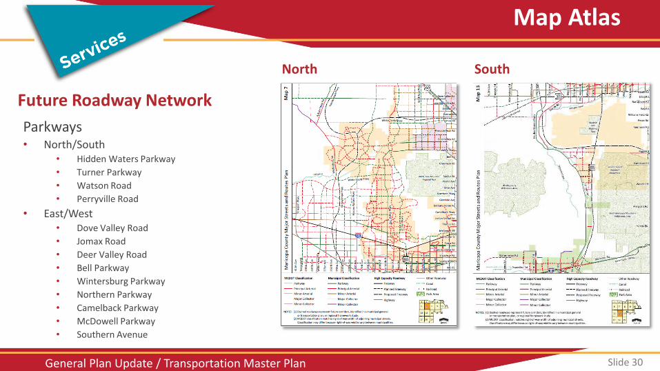
Slide 30 General Plan Update / Transportation Master Plan
Future Roadway Network
Parkways • North/South
• Hidden Waters Parkway
• Turner Parkway
• Watson Road
• Perryville Road
• East/West • Dove Valley Road
• Jomax Road
• Deer Valley Road
• Bell Parkway
• Wintersburg Parkway
• Northern Parkway
• Camelback Parkway
• McDowell Parkway
• Southern Avenue
Map Atlas
North South
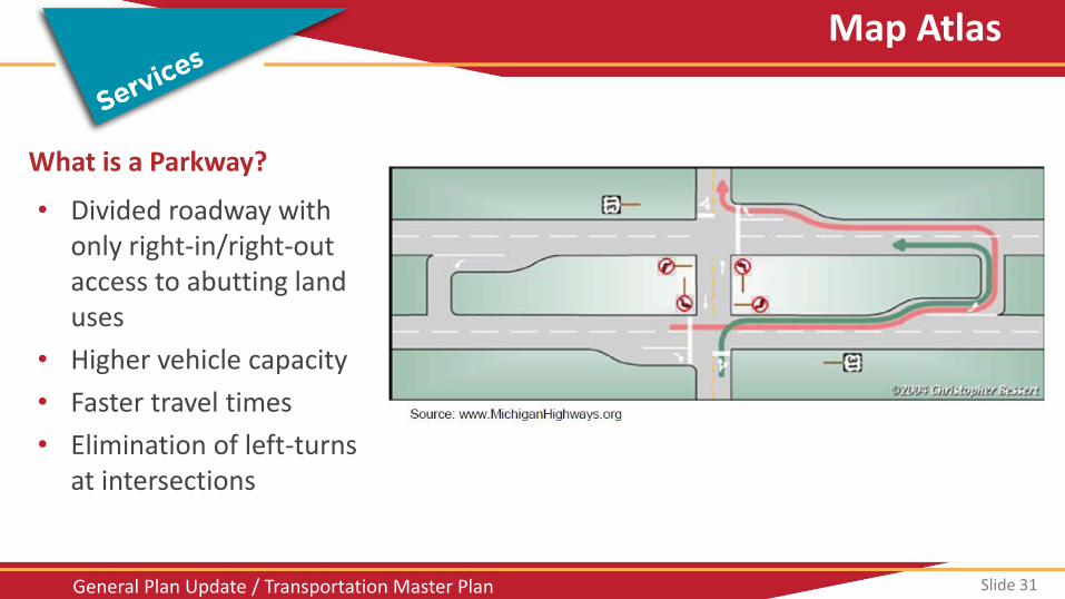
Slide 31 General Plan Update / Transportation Master Plan
What is a Parkway?
• Divided roadway with only right-in/right-out access to abutting land uses
• Higher vehicle capacity
• Faster travel times
• Elimination of left-turns at intersections
Map Atlas
Slide 32 General Plan Update / Transportation Master Plan
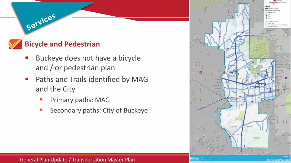
Bicycle and Pedestrian
Buckeye does not have a bicycle and / or pedestrian plan
Paths and Trails identified by MAG and the City
Primary paths: MAG
Secondary paths: City of Buckeye
Map Atlas
Slide 33 General Plan Update / Transportation Master Plan
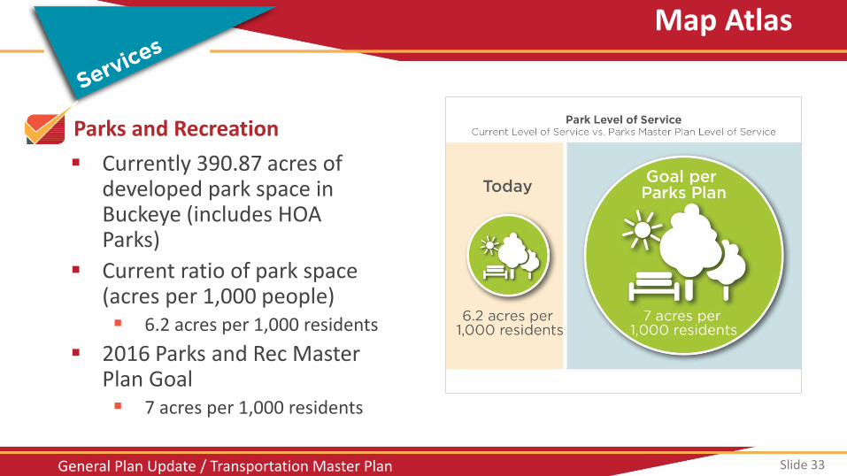
Parks and Recreation
Currently 390.87 acres of developed park space in Buckeye (includes HOA Parks)
Current ratio of park space (acres per 1,000 people) 6.2 acres per 1,000 residents
2016 Parks and Rec Master Plan Goal 7 acres per 1,000 residents
Map Atlas
Slide 34 General Plan Update / Transportation Master Plan
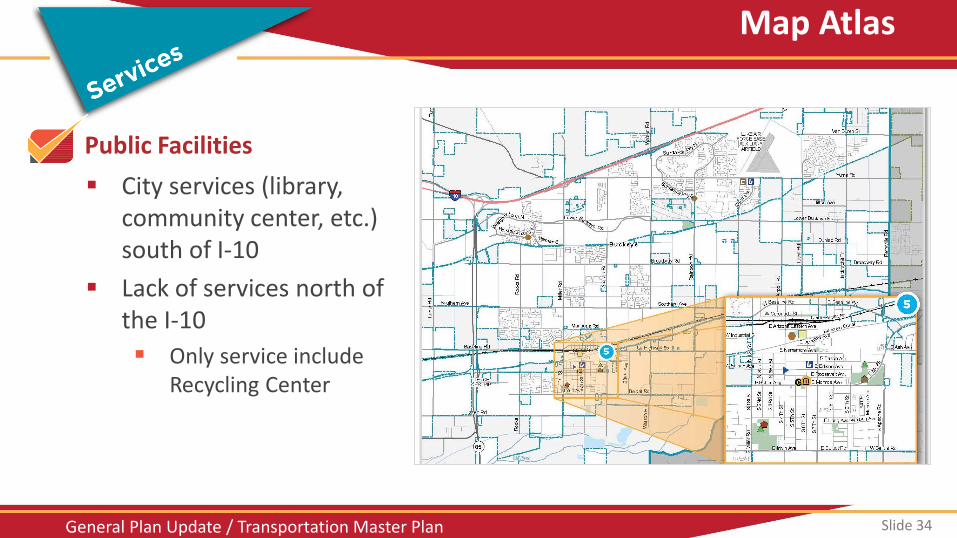
Public Facilities
City services (library, community center, etc.) south of I-10
Lack of services north of the I-10
Only service include Recycling Center
Map Atlas
Slide 35 General Plan Update / Transportation Master Plan
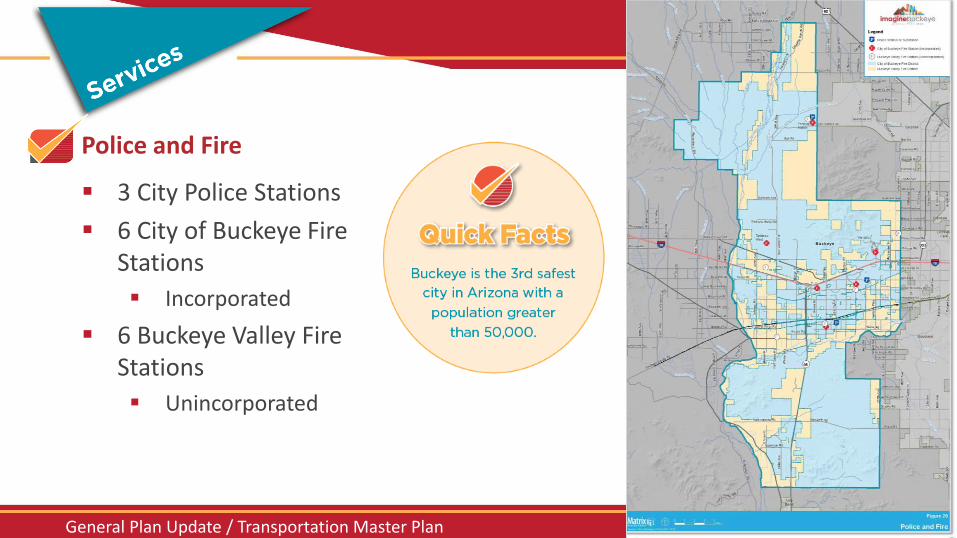
Police and Fire
3 City Police Stations
6 City of Buckeye Fire Stations
Incorporated
6 Buckeye Valley Fire Stations
Unincorporated
Map Atlas
Slide 36 General Plan Update / Transportation Master Plan
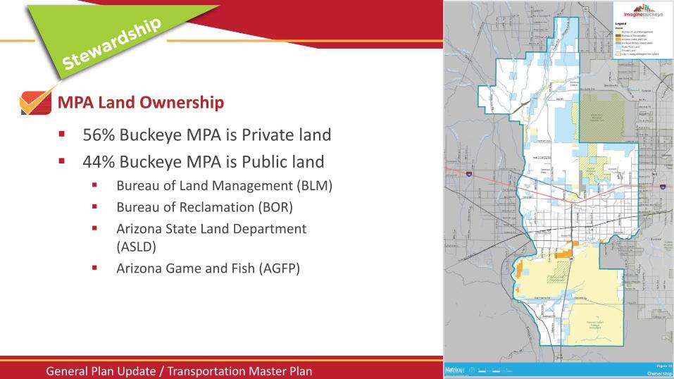
MPA Land Ownership
56% Buckeye MPA is Private land
44% Buckeye MPA is Public land Bureau of Land Management (BLM)
Bureau of Reclamation (BOR)
Arizona State Land Department (ASLD)
Arizona Game and Fish (AGFP)
Map Atlas
Slide 37 General Plan Update / Transportation Master Plan
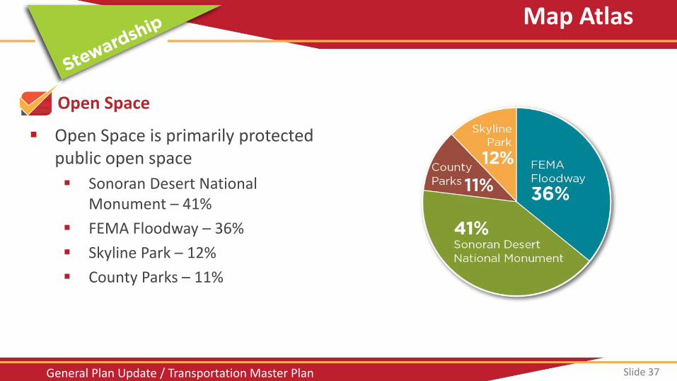
Open Space
Open Space is primarily protected public open space
Sonoran Desert National Monument – 41%
FEMA Floodway – 36%
Skyline Park – 12%
County Parks – 11%
Map Atlas
Slide 38 General Plan Update / Transportation Master Plan
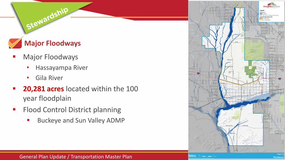
Major Floodways
Major Floodways
• Hassayampa River
• Gila River
20,281 acres located within the 100 year floodplain
Flood Control District planning
Buckeye and Sun Valley ADMP
Map Atlas
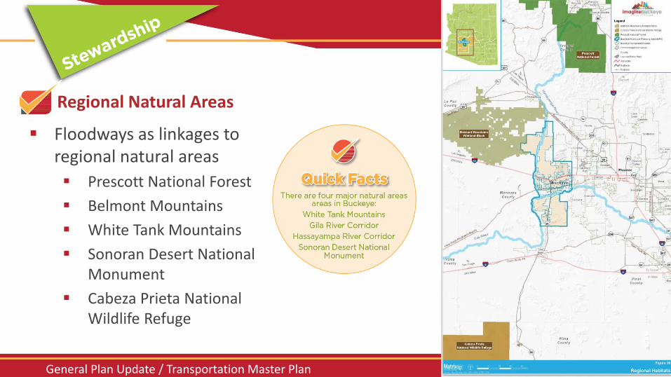
Slide 39 General Plan Update / Transportation Master Plan
Regional Natural Areas
Floodways as linkages to regional natural areas
Prescott National Forest
Belmont Mountains
White Tank Mountains
Sonoran Desert National Monument
Cabeza Prieta National Wildlife Refuge
Map Atlas
Slide 40 General Plan Update / Transportation Master Plan
3. WORKSHOP EXERCISES
• NEIGHBORHOOD AND TRANSPORTATION SURVEY • CHARACTER AREAS • COMMERCIAL / EMPLOYMENT NODES • COMMUNITY FACILITIES • TRANSPORTATION PRIORITIES
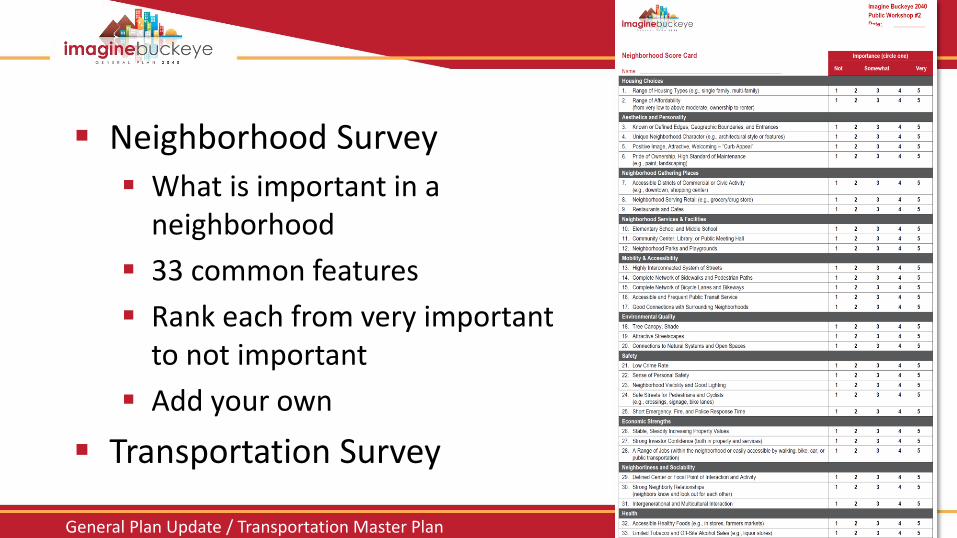
Slide 41 General Plan Update / Transportation Master Plan
Exercises
Neighborhood Survey
What is important in a neighborhood
33 common features
Rank each from very important to not important
Add your own
Transportation Survey
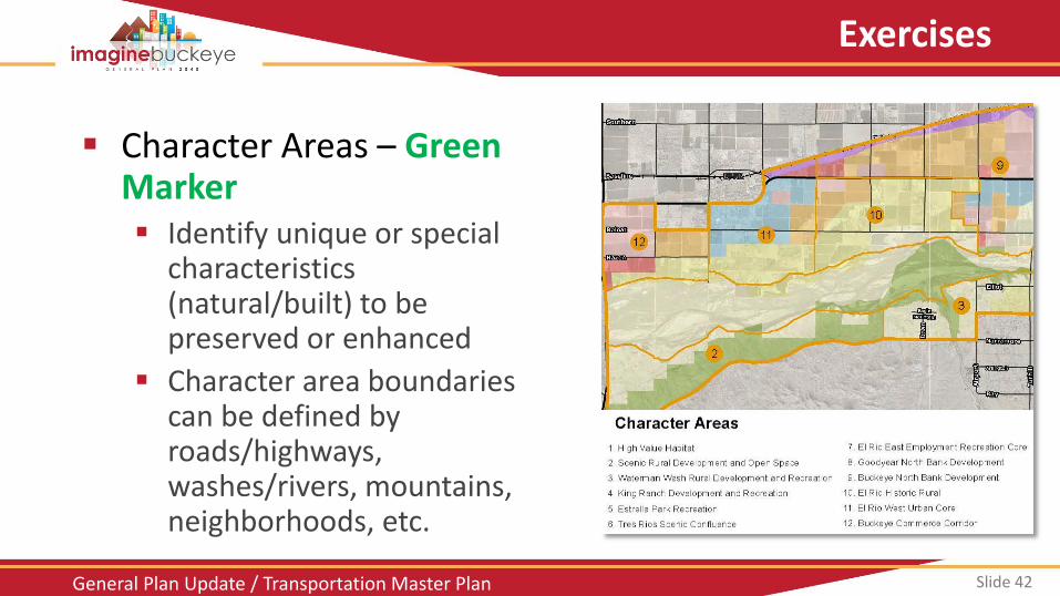
Slide 42 General Plan Update / Transportation Master Plan
Exercises
Character Areas – Green Marker Identify unique or special
characteristics (natural/built) to be preserved or enhanced
Character area boundaries can be defined by roads/highways, washes/rivers, mountains, neighborhoods, etc.
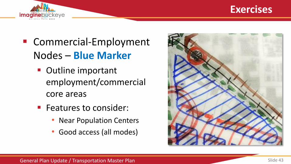
Slide 43 General Plan Update / Transportation Master Plan
Exercises
Commercial-Employment Nodes – Blue Marker
Outline important employment/commercial core areas
Features to consider: • Near Population Centers
• Good access (all modes)
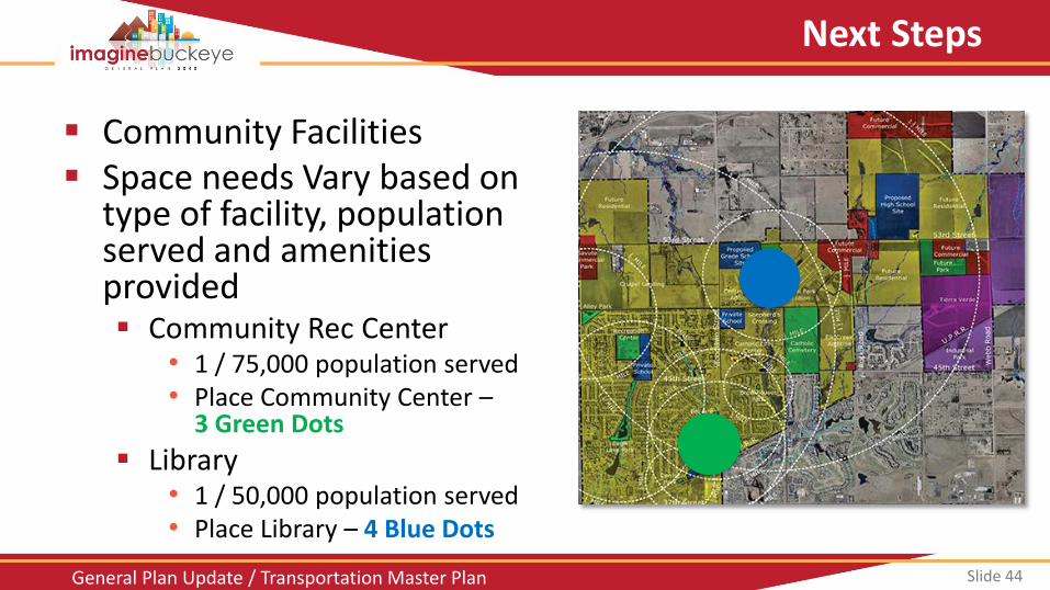
Slide 44 General Plan Update / Transportation Master Plan
Next Steps
Community Facilities Space needs Vary based on
type of facility, population served and amenities provided Community Rec Center
• 1 / 75,000 population served • Place Community Center –
3 Green Dots
Library • 1 / 50,000 population served • Place Library – 4 Blue Dots
Slide 45 General Plan Update / Transportation Master Plan
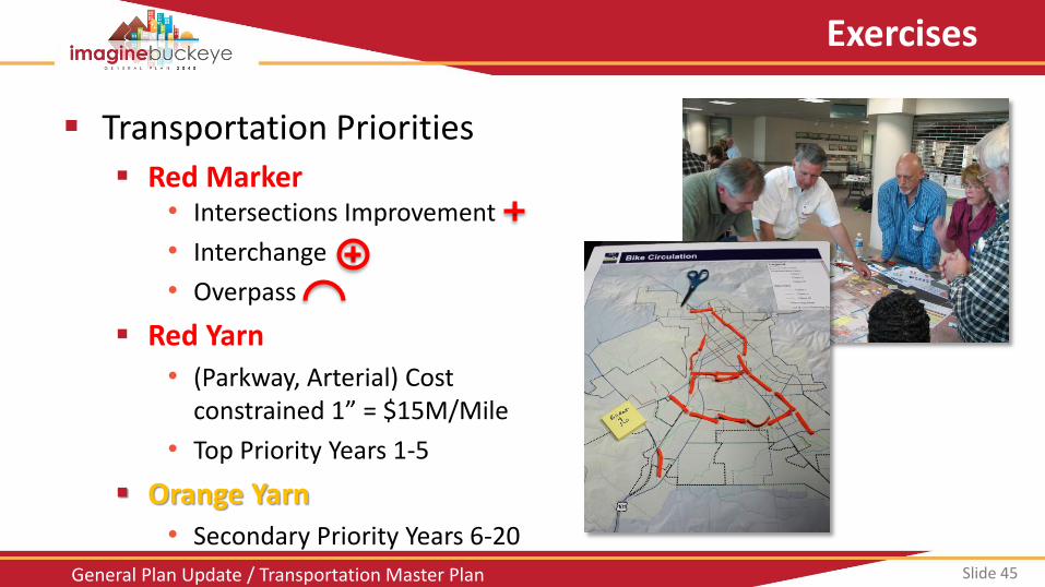
Exercises
Transportation Priorities
Red Marker • Intersections Improvement
• Interchange
• Overpass
Red Yarn
• (Parkway, Arterial) Cost constrained 1” = $15M/Mile
• Top Priority Years 1-5
Orange Yarn
• Secondary Priority Years 6-20
Slide 46 General Plan Update / Transportation Master Plan
Exercises
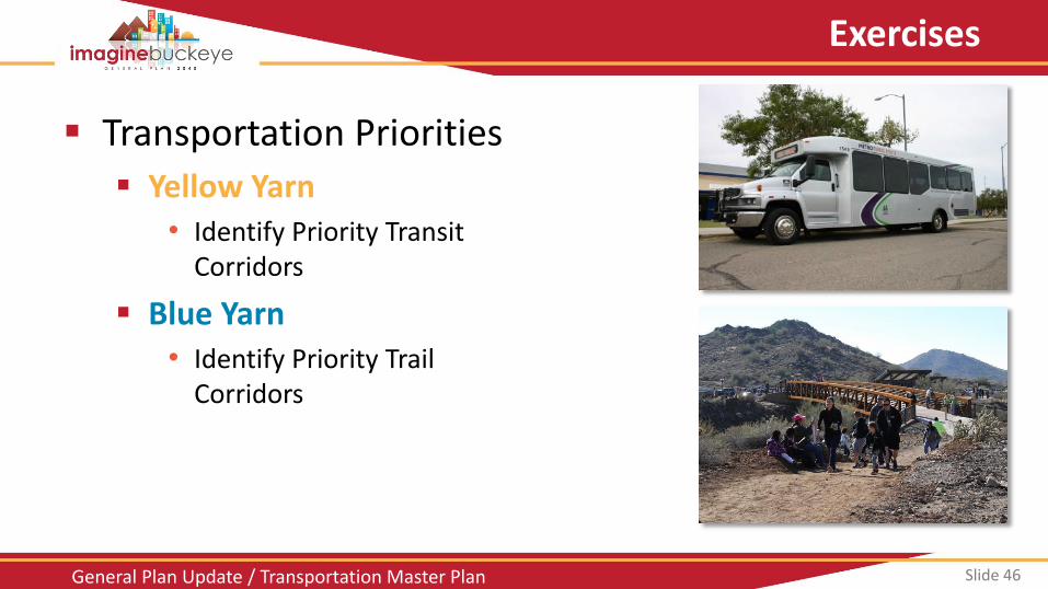
Transportation Priorities
Yellow Yarn • Identify Priority Transit
Corridors
Blue Yarn • Identify Priority Trail
Corridors
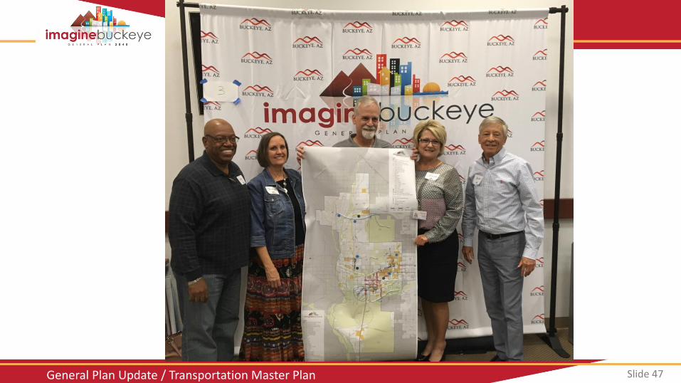
Slide 47 General Plan Update / Transportation Master Plan
Slide 48 General Plan Update / Transportation Master Plan
4. NEXT STEPS
Slide 49 General Plan Update / Transportation Master Plan
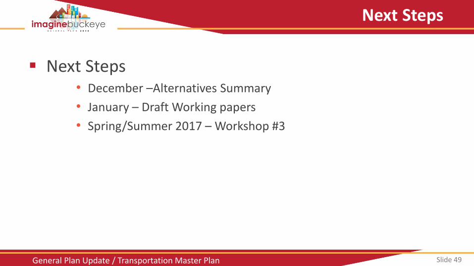
Next Steps
Next Steps • December –Alternatives Summary
• January – Draft Working papers
• Spring/Summer 2017 – Workshop #3
Slide 50 General Plan Update / Transportation Master Plan Slide 50
Thank You!
Top Related