


Languages
Pages
Legal


General information about Lusatian Neisse basin
and major issues regarding water resources 1st Regional Workshop of NEYMO Project
Iwona Zdralewicz
Görlitz 17.09.2012

2
Lenght – 246,1 km
49,6 km – Czech territory
196,5 km - Polish-German border
Area – 4 395 km2 including:
Czech Republic 9%
Germany 33 %
Poland 58 %
Water use at border section
Germany 70 %
Poland 30 %
Source – in Czech republic, on the south-western
slopes of the Jizera Mountains near the Budrichowo.
General information
3
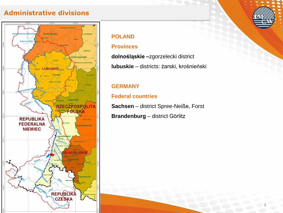
Administrative divisions
POLAND
Provinces
dolnośląskie –zgorzelecki district
lubuskie – districts: żarski, krośnieński
GERMANY
Federal countries
Sachsen – district Spree-Neiße, Forst
Brandenburg – district Görlitz

4
Explanations:
THE MEGAREGION OF MIDDLE EUROPEAN LOWLAND
The Sub-Province of Southern Baltic Lakeland
The Brandenburg-Lubuskie Lakeland
The Warta-Odra Proglacial Valley
The Zielona Góra Heights
The Sub-Province of Saxon-Lusatian Lowlands
The Lower Lusatian Depression
The Warta-Odra Proglacial Valley
The Lusatian Heights
The Sub-Province of Middle Poland Lowlands
The Milicz-Głogów Depression
The Trzebnica Maraine Line
THE MEGAREGION OF CZECH MASSIF
The Sub-Province of Sudeten with Sudeten Foothills
The Western Sudeten Upland
The Western Sudeten
Mesoregions borders
Sub-provinces borders
State borders
Basin border
Rivers
Lakes
Scale – 1 : 500 000
Physico-geographical division

5
Geological structure
1
2
3
4
5
1 Quaternary deposits of river valleys (sands, silts, gravels)
2 Quaternary fluvioglacial deposits (sands, silts, gravels)
3 Quaternary glacial deposits (loam, sands, loam gravels)
4 Tertiary deposits (sands, gravels, clays, and brown coal)
5 Crystalline rocks (granitoids – Precambrian, basalts – Tertiary)

6
Land use (according to Corine Land Cover)
Land use %forests 43.6
arable land 29.5
heterogenous agricultural areas 7.9
pastures 7.6
urban fabric 4.9
/ urban fabric
/ industrial, commercial and transport units
/ mine, dump and construction sites
/ artificial, non-agricultural vegetated areas
/ arable land
/ permanent crops
/ pastures
/ heterogeneous agricultural areas
/ forests
/ scrub and/or herbaceous vegetation associations
/ open spaces with little or no vegetation
/ inland wetlands
/ inland waters

7
Hydrographic division
Main tributaries of Lusatian Neisse:
Right-side
• Miedzianka
• Witka
• Czerwona Woda
• Jędrzychowicki Potok
• Bielawka
• Żółta Woda
• Skroda
• Wodra
• Lubsza
Left-side
• Mandau
• Pließnitz
• Floßgraben
• Legnitzka
• Föhrenfließ
• Malxe
• Schwarze Fließ
• Buderoser Mühlenfließ

8
Lusatian Neisse
Polish
• Porajów
• Sieniawka
• Zgorzelec
• Przewóz
• Gubin
Polish on tributaries
• Turoszów (Miedzianka)
• Ręczyn (Witka)
• Zgorzelec Ujazd (Czerwona Woda)
• Przewoźniki (Skroda)
• Pleśno (Lubsza)
Water gauge stations
German
• Hartau
• Rosental
• Görlitz
• Klein Bademeusel
• Sacro
• Albertinenaue
• Schlagsdorf
• Guben

9
Hydrogeological regional division
Regions
Subregions
Subregions
Subregions borders
Major groundwater basins
Groundwater bodies

10
Kopalnia Węgla Turów
(wody infiltracyjne)
Przedsiębiorstwo Wodociągów
i Kanalizacji „Nysa”
Zakład Usług Komunalnych w Pieńsku
Miejski Zakład Komunalny
w Łęknicy
Przedsiębiorstwo Usług Miejskich w Gubinie
Elektrownia Turów
Stadtwerke Goerlitz/Weihuebel
Betriebsstelle Hagenwerder
Stadtwerke Zittau GmbH
Weissbachtal
Wasserwerk Leuba
Wasserwerk Bad Muskau
Wasserwerk Forst
Trevira GmbH Guben
Wasserwerk Guben
HKW Guben
Samsung Corning
Celltechnik Londenau GmbH & Co. KG
Wasserwerk Goerlitz Weinhuebel
Tagebau Jaenschwalde
Papierfabrik Bad Muskau
Tagebau Nochten
Neissewasseruberleitung
AGPRO Agrarprodukt Rothenburg
Agrargenossenschaft Zodel
Volksbad Goerlitz
Tagebau Berzdorf (Restlochflutung)
Tagebau Berzdorf (Infiltrationswasser)
Bogatyńskie Wodociągi
i Oczyszczalnia Sieniawka
Oczyszczalnia Pieńsk
Oczyszczalnia Łęknica
Przedsiębiorstwo Oczyszczania Ścieków Gubin-Guben
Kopalnia Węgla Turów
(wody kopalniane)
Klaeranlage Zittau
Klaeranlage Hirschfelde
Klaeranlage Ostritz
Klaeranlage Hagenwerder
Klaeranlage Goerlitz Nord
Klaeranlage Rothenburg
Klaeranlage Bad Muskau
Klaeranlage Forst
Celltechnik Londenau GmbH & Co. KG
HKW Guben/Vorfluten-Ost
Tagebau Jaenschwalde GWRA Briesnig
Tagebau Berzdorf
Betriebsstelle Hagenwerder
Fit GmbH
Users of water resources within Lusatian Neisse basin
Withdrawal (2005):
Polish users (6)
German users (21)
Return flow (2005):
Polish users (7)
German users (14)
Pobory / withdrawal
Zrzuty / return flow

11
Discharge in the longitudinal profile
0
4
8
12
16
20
24
28
32
36
40
020406080100120140160180200
Q [
m3/s
]
km czerwiec 1997 lipiec 2002 wrzesień 2002
Ro
se
nth
al
Zg
orz
ele
c
Sa
cro
Turów
Berzdorf
Nochten,
Reichwalde
Janschwalde
Prz
ew
óz
Gu
bin

12
Water users - mines

13
Mine impact on groundwater
0
10
20
30
40
50
60
70
1985
1986
1987
1988
1989
1990
1991
1992
1993
1994
1995
1996
1997
1998
1999
2000
2001
2002
2003
2004
2005
2006
2007
2008
2009
Rz. zw
. w
. p
. [m
n.p
.m.]
Gro
un
dw
ate
r le
vel [m
o.s
.l.]
T-3 (MW) T-6 (MW) T-14/1 (PW)
ΔH = 48,11 m
ΔH = 54,72 m
ΔH = 53,19 m
Effective protection of quaternary and uppercoal
Tertiary aquifers which is a consequence of permeable
wall.
The negative impact of coal mine drainage on
undercoal Tertiary aquifer.

Water users – Berzdorf withdrawal
14
Water transfer Steinbach
Berzdorf withdrawal
PliessnitzLusatian
NeisseSteinbach
2002 1.915
2003 7.514 0.001
2004 5.786 18.694
2005 7.016 40.690
2006 6.977 34.465 1.156
2007 10.177 47.933 2.209
2008 9.613 35.602
2009 9.050 38.907 0.127
2010 6.673 19.802 0.040
year
Withdrawal [mln m3]

15
Water users – water power plants

16
Water users – water power plants

Thank you for attention
Iwona Zdralewicz Instytut Meteorologii i Gospodarki Wodnej
Państwowy Instytut Badawczy 51-616 Wrocław, ul.: Parkowa 30
Tel. (71) 32-00-358 [email protected]
www.imgw.pl
Top Related