


Languages
Pages
Legal

FINAL Site-Specific Environmental Assessment
Houston National Cemetery Phase V Expansion Project
Houston, Harris County, Texas
Prepared for
Department of Veteran’s Affairs National Cemetery Administration
Prepared by
ECS Southwest, LLP
September 2020
Executive Summary and Conclusions i
Executive Summary and Conclusions This FINAL Site-Specific Environmental Assessment (SEA) evaluates the environmental, physical,
cultural consequences of the Proposed Action to construct and operate an approximately 42-acre
expansion of the United States Department of Veterans Affairs (VA), National Cemetery
Association (NCA) Houston National Cemetery (HNC) located at 10410 Veterans Memorial Drive,
Houston, Texas. The cemetery expansion would extend the longevity of the Houston National
Cemetery and allow the VA to continue providing burial opportunities needed by Veterans and their
families in southern Texas. The cemetery expansion would provide additional casket,
columbarium, and in-ground cremation sites, as well as expanded infrastructure including
roadways, irrigation, landscaping, and stormwater management systems.
Purpose and Need The purpose of the Proposed Action is to expand and improve the Houston National Cemetery in
the eastern portion of the existing cemetery property to enable NCA to continue providing
interment benefits to eligible Veterans and their families by further extending the longevity of HNC
by approximately 10 years. The Proposed Action is needed to serve projected Veteran needs and
avoid depleting cemetery internment sites, thus meeting the NCA’s goal of providing eligible
Veterans with reasonable access to VA interment options.
Alternatives The alternatives considered are the preferred alternative and the No-Action alternative. The
preferred alternative consists of the planned Phase V expansion and renovation activities and
anticipated future expansions of the HNC, all of which would occur on undeveloped land owned by
the VA and located immediately adjacent to the existing cemetery. The Phase V expansion would
encompass approximately 42 acres and provide increased burial capacity, maintenance facilities,
installation of a new entrance along Aldine-Western Road, and irrigation infrastructure within the
HNC; future expansions would eventually occupy the entire HNC property. The No-Action
alternative would not expand the HNC into the undeveloped acreage, would not provide the
necessary burial sites to allow the VA to continue providing burial services to veterans at the HNC,
and would not provide needed infrastructure improvements within the developed areas of the HNC.
Affected Environmental and Environmental Consequences
The following table summarizes the potential environmental impacts of the Proposed Action and
the No Action alternatives.
Executive Summary and Conclusions ii
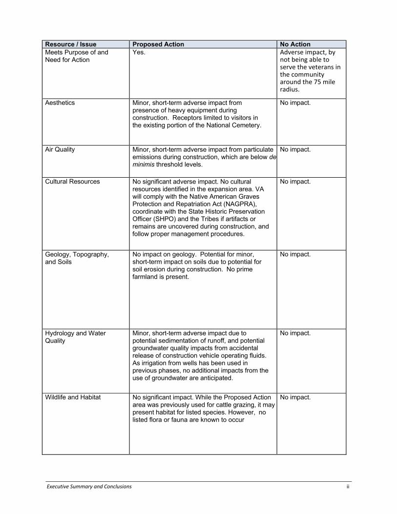
Resource / Issue Proposed Action No Action Meets Purpose of and Need for Action
Yes. Adverse impact, by not being able to serve the veterans in the community around the 75 mile radius.
Aesthetics Minor, short-term adverse impact from presence of heavy equipment during construction. Receptors limited to visitors in the existing portion of the National Cemetery.
No impact.
Air Quality Minor, short-term adverse impact from particulate emissions during construction, which are below de minimis threshold levels.
No impact.
Cultural Resources No significant adverse impact. No cultural resources identified in the expansion area. VA will comply with the Native American Graves Protection and Repatriation Act (NAGPRA), coordinate with the State Historic Preservation Officer (SHPO) and the Tribes if artifacts or remains are uncovered during construction, and follow proper management procedures.
No impact.
Geology, Topography, and Soils
No impact on geology. Potential for minor, short-term impact on soils due to potential for soil erosion during construction. No prime farmland is present.
No impact.
Hydrology and Water Quality
Minor, short-term adverse impact due to potential sedimentation of runoff, and potential groundwater quality impacts from accidental release of construction vehicle operating fluids. As irrigation from wells has been used in previous phases, no additional impacts from the use of groundwater are anticipated.
No impact.
Wildlife and Habitat
No significant impact. While the Proposed Action area was previously used for cattle grazing, it may present habitat for listed species. However, no listed flora or fauna are known to occur
No impact.

Executive Summary and Conclusions iii
Noise Minor, short-term adverse noise impacts due to heavy machinery associated with clearing and grading during construction. Receptors limited to Houston National Cemetery visitors and a few nearby residents.
No impact.
Land Use No impact. Expansion is consistent with existing zoning and land use conditions.
No impact.
Resource / Issue Proposed Action No Action Floodplains, Wetlands, and Coastal Zone Management
No impact to wetlands or jurisdictional Waters of the U.S. No floodplains present at the expansion site. No Coastal Zone Management areas within project area.
No impact.
Socioeconomics Minor, short-term, localized beneficial impact to employment if outside contractors are utilized for grading and cemetery construction. No impact during operation.
Negligible adverse impact due to increased costs for families and visitors once existing burial capacity is reached at Houston National Cemetery, requiring burial at a private cemetery or travel to a National Cemetery outside of Commuting area of Houston.
Community Services Long-term, significantly beneficial impact by extending the longevity of the Houston National Cemetery, benefiting veterans and their families throughout southern Texas.
Potential long-term, adverse impact because longevity will not be extended, requiring South Texans to travel longer distances for burial and visitation. Not in compliance with Service Members Civil Relief Act.
Solid and Hazardous Materials
Minor, short-term increase in solid waste generation (excess construction materials that cannot be recycled) during construction. New potential waste streams include remediation of pesticide-impacted soils, as well as potential asbestos-containing building materials (ACM) and lead-based paint (LBP in Building 3006. Minor, short-term potential impact to soil quality in the event of an accidental release of construction vehicle operating fluids.
Potential long-term impact associated with leaving pesticide-impacted soils at Building 3006 in place. Also, potential asbestos-containing building materials (ACM) and lead-based paint (LBP in Building 3006.
Executive Summary and Conclusions iv
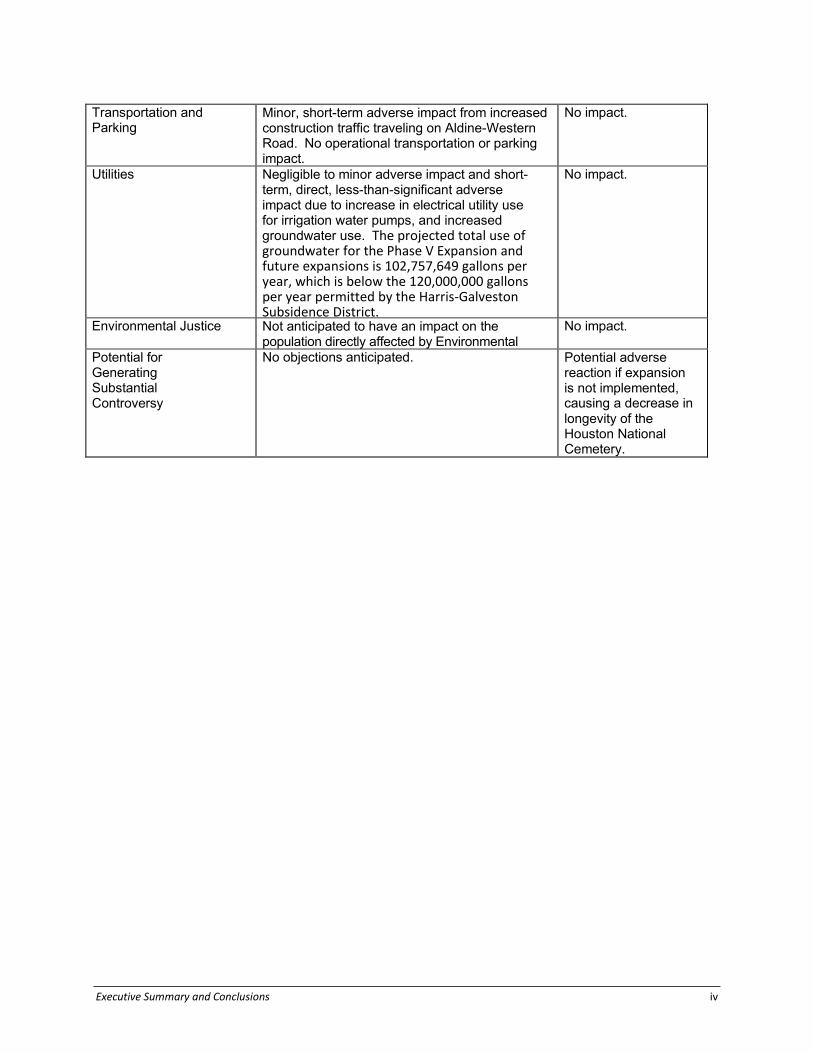
Transportation and Parking
Minor, short-term adverse impact from increased construction traffic traveling on Aldine-Western Road. No operational transportation or parking impact.
No impact.
Utilities Negligible to minor adverse impact and short-term, direct, less-than-significant adverse impact due to increase in electrical utility use for irrigation water pumps, and increased groundwater use. The projected total use of groundwater for the Phase V Expansion and future expansions is 102,757,649 gallons per year, which is below the 120,000,000 gallons per year permitted by the Harris-Galveston Subsidence District.
No impact.
Environmental Justice Not anticipated to have an impact on the population directly affected by Environmental
No impact.
Potential for Generating Substantial Controversy
No objections anticipated. Potential adverse reaction if expansion is not implemented, causing a decrease in longevity of the Houston National Cemetery.

Proposed Houston National Cemetery Phase V Expansion
FINAL Site-Specific Environmental Assessment
iv
Environmental Consequences of the No-Action Alternative The No-Action alternative would not result in any adverse impacts to aesthetics, noise
levels, air quality, biological resources, cultural or historical resources, geology and soils,
hazardous materials, or land use. The No-Action alternative would not provide the
needed upgrades and maintenance to the existing cemetery facilities and would force
veteran families to seek alternative burial options distant from their desired location.
Environmental Consequences of the Preferred Alternative Aesthetics and Noise
The Proposed Action would result in a change in the aesthetics of the undeveloped
portion of the HNC property by incorporating design features consistent with the existing
cemetery. No long-term adverse impacts would result from the cemetery expansion.
Temporary increases in noise levels and aesthetics resulting from construction activities
during Phase V and future expansions would be minimized through the use of best
management practices and controlled construction vehicle access to the expansion area
to limit adverse impacts to cemetery visitors and nearby businesses.
Air Quality
The Proposed Action would not result in any long-term adverse impacts to air quality.
Construction activities could result in short-term temporary increases in dust generation,
nuisance odors, or de minimis emissions from diesel powered construction vehicles
which would be mitigated through best management practices to minimize any adverse
impacts to cemetery visitors and adjacent properties.
Biological Resources
The Proposed Action would not result in adverse impacts to threatened and endangered
species or their habitat. There is no habitat for any threatened or endangered species
within the existing cemetery, the Phase V expansion area, or the remainder of the
undeveloped property. The Phase V expansion would result in a conversion of areas
from improved and grazed pasture grasses to turf grasses and cemetery landscaping.
Specific details regarding endangered or special-status species can be found in
Appendix B.

Proposed Houston National Cemetery Phase V Expansion
FINAL Site-Specific Environmental Assessment
v
Cultural and Historical Resources
The Proposed Action would not adversely impact any known cultural or historical
resources. Pedestrian archaeological surveys conducted within the Phase V expansion
area found no evidence of impacts to culturally or historically significant sites. A copy of
the reports were submitted to the Texas Historical Commission (THC) / State Historic
Preservation Office (SHPO). THC / SHPO replied that the Proposed Action would have
no effect on historic properties. Cultural resources information can be found in Appendix
C.
Geology and Soils
The Proposed Action would not adversely impact geological or soil resources. The
Woodgate Fault crosses through the HNC property. Movement along the fault poses
little seismic risk to the HNC, but could result in long-term damages to roadways,
drainage culverts, and other structures. The Proposed Action does not include
development or construction of structures within 400 feet of the approximate fault
location.
The Proposed Action would not result in a significant increase in groundwater use at the
HNC and would therefore not be expected to increase the rate of land surface
subsidence. Specific details regarding groundwater use can be found in Sections 3.9
and 4.9.
Hazardous Materials
The Phase V and future expansions would not result in an increase in hazardous
materials used or stored at the HNC. Minor spills of hazardous materials or petroleum
products (such as oil or hydraulic fluid) could occur from heavy equipment used onsite
during construction activities. One (1) former residential structure and two (2) farm
structures, identified collectively as Building 3006, will be demolished as part of the
Phase V expansion. VA conducted previous environmental investigations of the Building
3006 area and recognized environmental conditions (RECs) were identified. The RECs
included the following:
The “Milk House” on the north side of Building 3006 contained several bottles of
regulated pesticides/herbicides such as Amine 4 (2,4-D) weed killer and a jug of
Proposed Houston National Cemetery Phase V Expansion
FINAL Site-Specific Environmental Assessment
vi
Chlordane. The improper storage of regulated substances has resulted in staining along
the concrete floor near a floor drain found within the Milk House. Additionally, a septic
system with a drain field is located on the subject property; although the exact location of
the drain field was unknown at the time of the Phase I ESA. The potential for
contaminants to migrate from Building 3006’s drains and deposit contaminants in soil
presented a REC for the subject property.
The “Shed” on the south side of Building 3006 contained several bottles and drums of
petroleum products, and staining was visible on the wooden floor of the building. It was
believed that a crawlspace underlies the building with exposed soil directly underneath
the floor. The potential for contaminants to leach from Building 3006’s floors to the
underlying soil presented a REC for the subject property.
VA conducted soil and groundwater sampling (Phase II Environmental Site Assessment
[ESA]) during November 2018 to address the RECs previously identified. The Phase II
ESAs identified the following environmental concerns:
Analysis of the two soil samples collected from beneath the floor of the Shed (2601-SS-1
and 2601-SS-2) yielded results indicative of a release of Dieldrin, a pesticide, to surface
soil. These results exceeded the Texas Commission on Environmental Quality’s
(TCEQ’s) Protective Concentration Levels (PCLs) for residential soil. Sample 2501-SS-2
also exceeded the commercial PCL for Dieldrin. 4-Chlorophenyl phenyl ether, a semi-volatile organic compound (SVOC), was detected
above the residential PCL in all soil samples collected during the initial Phase II ESA, and
above commercial PCLs in four of the samples (2501-SS-3, 2501-SS-4, 2501-SS-5, and
2501-SS-6). 4-Bromophenyl phenyl ether was detected above the residential PCL at four
sample locations (2501-SS-3, 2501-SS-4, 2501-SS-5, and 2501-SS-6), and above the
commercial PCL in Sample 2501-SS-6. Hexachlorobenzene was also detected above the
residential PCL at four sample locations (2501-SS-3, 2501-SS-4, 2501-SS-5, and 2501-
SS-6). VA conducted an Expanded Phase II ESA from May 21 to 22, 2019 to further characterize
the site. To delineate the exceedances observed during the initial Phase II ESA, 69 soil
samples were collected from 23 locations and analyzed for SVOCs and pesticides.
Proposed Houston National Cemetery Phase V Expansion
FINAL Site-Specific Environmental Assessment
vii
Groundwater grab samples were collected from six locations around the site via the
installation of temporary PVC wells. The analytical data obtained during the Expanded Phase II ESA indicate that the
contamination discovered during the initial Phase II ESA appears to be confined to the
footprint of the shed building of Building 3006. Based on the analytical results of the
Expanded Phase II ESA, Booz Allen recommends the following actions at the subject
property: Remedial action to bring the Dieldrin impacted soil identified during the initial Phase II
ESA into compliance is required. Remedial actions would include the excavation and
disposal of the top 2 feet of soils at the locations where contamination is present. The
remedial action will occur concurrently with the Phase V expansion. Building 3006 may
contain asbestos-containing building materials (ACM) or lead-based paint. Prior to
demolition of Building 3006, VA will conduct ACM and LBP surveys. Any ACM or
building materials coated with LBP will be abated and disposed of in accordance with
federal, state and local requirements prior to demolition. Hazardous materials-related
information can be found in Appendix F.
Land Use
The Phase V expansion and future expansions would result in a change of land use from
pasture to cemetery use. This change in land use was anticipated in the HNC’s Master
Plan and is consistent with the land use of the existing cemetery.
Socioeconomics
The Proposed Action would not result in disproportionately adverse impacts to minority
and/or low income populations. The Phase V expansion would have beneficial impacts
on traffic flow within the HNC, as well as potential vehicular back up on surface roads
outside of HNC, through the installation of a new gate along Aldine-Western Road.
Water Resources
Surface Water - Adverse impacts to surface water could occur during construction of
the Phase V and future expansions from discharges of pollutants or increased sediment
in storm water runoff. Discharges of storm water to surface water bodies, including
drainage ditches and ponds, during construction activities would be authorized under a

Proposed Houston National Cemetery Phase V Expansion
FINAL Site-Specific Environmental Assessment
viii
Texas Pollutant Discharge Elimination System (TPDES) Construction General Permit for
Stormwater Discharges Associated with Construction Activities (TXR150000) from the
Texas Commission on Environmental Quality (TCEQ). A Stormwater Pollution
Prevention Plan (SWPPP) would be prepared and implemented during construction
activities to identify potential sources of pollution resulting from construction activities
and to minimize discharge of pollutants in storm water.
Groundwater - The Phase V and future expansions of the cemetery would increase the
landscaped acreage at the HNC that requires regular irrigation obtained from
groundwater sources using the onsite water wells, as well as the installation and
development of a new irrigation well. The new well would be permitted by the Harris
Galveston Subsidence District (HGSD). The irrigation system upgrades during the
Phase V expansion would result in greater efficiency and would be expected to reduce
the amount of water used per acre and offset the additional demand from the increased
irrigable area. Sprinkler spacing for the burial sections is selected to provide the most
efficient water application. Computer software is used to select the most efficient
pressure, sprinkler, nozzle combination. The efficiency metrics used for selection are the
Distribution Uniformity (DU) and Scheduling Coefficient (SC). The higher the DU
percentage, the greater the application efficiency. The closer the SC is to 1.0, the higher
the application efficiency. Spacing for block style sprinklers will be selected to achieve a
minimum DU of 80% and a SC of 1.2 or less. Spacing of sprinkler alleys in the burial
sections is coordinated with the Cemetery Planner. For example, Rain Bird 8005
sprinklers at 63’x63’ spacing have a DU of 84% and SC of 1.2 and at a 52’x52’ spacing
have a DU of 83% and SC of 1.2. Groundwater-related information can be found in
Sections 3.9 and 4.9.
The potential for groundwater contamination resulting from infiltration of onsite chemical
use and leachate from casketed remains would be minimized through the use of pre-
placed crypts and drainage systems that would collect water from beneath the burial
section and divert it to the retention ponds. Additionally, modern mortuary practices have
discontinued the use of toxic embalming fluids, which will minimize any potential for
contamination.
Proposed Houston National Cemetery Phase V Expansion
FINAL Site-Specific Environmental Assessment
ix
Floodplains - The proposed Phase V and future expansions would not result in adverse
impacts to areas located within floodplains. Storm water runoff would be channeled to
the network of ponds, which retain storm water and only discharge to the municipal
storm sewer system during extreme flooding events and would not result in adverse
impacts to floodplains within or downstream of the HNC.
Wetlands - The proposed Phase V expansion would not result in impacts to
jurisdictional wetlands within the expansion area. Wetlands information can be found in
Appendix D.
Agency and Public Involvement
VA involved regulatory agencies and the public in decision-making for this Proposed
Action. A Notice of Availability (NOA) announcing the release of a Draft SEA for a 30-
day comment period was published in the Houston Chronicle on May 28 and May 31,
2020. The Draft SEA was available for review at the Houston National Cemetery and
an electronic copy was made available for download from the VA website at
http://www.cem.va.gov/cem/EA.asp. Additionally, VA mailed letters to selected federal,
state, and local governmental agencies about the availability of the Draft SEA and the
opportunity to comment during the 30-day review period.
No comments were received from the public during the 30-day review period. Comments
were received from four (4) regulatory agencies. The Federal Emergency Management
Agency (FEMA) requested that the Community Floodplain Administrator be contacted for
review and possible permit requirements. FEMA also commented that if the Proposed
Action is federally funded that it be in compliance with Executive Orders (EO) 11988 and
11990.
The Texas Commission on Environmental Quality (TCEQ) commented that emissions
from the Proposed Action are expected to be below the general conformity de minimis
threshold and are not anticipated to impact the state implementation plan. TCEQ also
commented that the Office of Water does not anticipate significant long term
environmental impacts from this project as long as construction and waste disposal
activities associated with it are completed in accordance with applicable local, state, and
federal environmental permits, statutes, and regulations. TCEQ recommended that the

Proposed Houston National Cemetery Phase V Expansion
FINAL Site-Specific Environmental Assessment
x
applicant take necessary steps to ensure that best management practices are used to
control runoff from construction sites to prevent detrimental impact to surface and
ground water. Finally, TCEQ commented that any debris or waste disposal should be at
an appropriately authorized disposal facility.
The Texas Parks and Wildlife Department (TPWD) commented that soil and erosion
control best management practices, including the use of no-till drilling, hydromulching
and/or hydroseeding rather than the use of erosion control blankets or mesh. TPWD
recommended any vegetation clearing be scheduled outside of the general bird nesting
season of March 15th to September 15th; however, if clearing must occur during nesting
season, nest surveys should be conducted prior to clearing. If nests are observed during
surveys, a vegetation buffer area of no less than 150-feet in diameter should remain
around the nest until all young have fledged. TPWD recommended compliance with the
Federal Migratory Bird Treaty Act. If during construction, the project area is found to
contain rare species, natural plant communities, or special features, TPWD
recommended that precautions be taken to avoid impacts to them. To contribute to
pollinator conservation efforts, TPWD encouraged the VA and HNC to consider
incorporating pollinator habitat into the landscaping plans for the proposed cemetery
expansion. Pollinator habitats can be designed to provide aesthetic benefits to
cemetery visitors. Species appropriate for the project area can be found by
accessing the Lady Bird Johnson Wildflower Center, working with TPWD biologists
to develop an appropriate list of species, or utilizing resources found at the Xerces
Society’s Guidelines webpage. TPWD advised against planting the non-native
milkweed species black swallow-wort (Cynanchum louiseae) and pale swallow-wort
(C. rossicum). Monarch butterflies will lay eggs on these plant species, but the larvae
are unable to feed and complete their life cycle. Additionally, these plant species can
be highly invasive. Additionally, TPWD advised against planting the non-native tropical
milkweed (Asclepias curassavica), a popular commercial nursery milkweed that can
persist year-round in southern states. The year-round persistence of tropical milkweed
fosters greater transmission of the protozoan Ophryocystis elektroscirrha (OE),
increasing the likelihood that monarchs become infected with the debilitating parasite.
Finally, TPWD recommended that mast-producing species be among those native
trees selected for planting at the site in order to enhance food resources for native

Proposed Houston National Cemetery Phase V Expansion
FINAL Site-Specific Environmental Assessment
xi
wildlife, in addition to providing aesthetic value and shade to HNC visitors. Mast-
producing trees would include hard mast species such as native oaks (Quercus
spp.) and hickories (Carya spp.), while soft mast species native to the area would
include red mulberry (Morus rubra) and common serviceberry (Amelanchier
arborea).
The United States Fish and Wildlife Service (USFWS) recommended utilizing the
Information for Planning and Consultation (IPaC) system to obtain information
regarding fish and wildlife resources in the project area. The regulatory agency
correspondence has been incorporated into the Final SEA and were considered prior to
a decision being made on whether or not to implement the Proposed Action. Copies of
responses can be found in Appendix E.
Conclusion
Based on comments received from regulatory agencies on the Draft SEA, VA has
completed this Final SEA without requiring substantive changes relative to the Draft
SEA. As previously concluded in the Draft SEA and reiterated in this Final SEA, the
Proposed Action would not cause significant adverse impacts on the environmental
resources presented herein.

Proposed Houston National Cemetery Phase V Expansion
FINAL Site-Specific Environmental Assessment
xii
Table of Contents Executive Summary and Conclusions ................................................................................ i
Agency and Public Involvement ....................................................................................... ix
Conclusion ....................................................................................................................... xi
Table of Contents ............................................................................................................. xii
Photographs .................................................................................................................... xv
List of Figures.................................................................................................................. xv
Appendices ..................................................................................................................... xv
List of Acronyms .............................................................................................................. xvi
1. Purpose and Need for the Proposed Project .......................................................... 1-1
1.1 Introduction ................................................................................................ 1-1
1.2 Purpose and Need for the Proposed Project ............................................. 1-4
2. Description of Project Alternatives .......................................................................... 2-1
2.1 Proposed Action ........................................................................................ 2-1
2.2 Future Expansions ..................................................................................... 2-3
2.3 No-Action Alternative ................................................................................. 2-3
3. Affected Environment ............................................................................................. 3-1
3.1 Aesthetics and Noise ................................................................................. 3-2
3.1.1 Aesthetics .................................................................................................. 3-2
3.1.2 Noise .......................................................................................................... 3-3
3.2 Air Quality .................................................................................................. 3-3
3.3 Biological Resources ................................................................................. 3-4
3.3.1 Vegetation and Wildlife Habitat .................................................................. 3-4
3.3.2 Threatened and Endangered Species ..................................................... 3-12
3.3.2.1 Least Tern (Sterna antillarum) ................................................................. 3-13
3.3.2.2 Piping Plover (Charadrius melodus) ........................................................ 3-15
3.3.2.3 Red Knot (Calidris canutus rufa) .............................................................. 3-17
3.3.2.4 Texas Prairie Dawn-flower (Hymenoxys texana) ..................................... 3-18
3.3.2.5 West Indian Manatee (Trichechus manatus) ................................................ 3-18
3.4 Cultural and Historical Resources ........................................................... 3-19
3.5 Geology and Soils .................................................................................... 3-20
3.5.1 Geology ................................................................................................... 3-20
3.5.2 Soils ......................................................................................................... 3-22

Proposed Houston National Cemetery Phase V Expansion
FINAL Site-Specific Environmental Assessment
xiii
3.6 Hazardous Materials ................................................................................ 3-22
3.7 Land Use ................................................................................................. 3-25
3.8 Socioeconomics ....................................................................................... 3-26
3.8.1 Demographics .......................................................................................... 3-26
3.8.2 Transportation, Traffic, and Parking......................................................... 3-27
3.8.3 Utilities ..................................................................................................... 3-29
3.9 Water Quality ........................................................................................... 3-30
3.9.1 Surface Water .......................................................................................... 3-30
3.9.2 Groundwater ............................................................................................ 3-30
3.9.3 Wetlands .................................................................................................. 3-34
4. Environmental Consequences ................................................................................ 4-1
4.1 Aesthetics and Noise ................................................................................. 4-1
4.1.1 Phase V Expansion ................................................................................... 4-1
4.1.2 Future Expansions ..................................................................................... 4-2
4.1.3 No-Action Alternative ................................................................................. 4-3
4.2 Air Quality .................................................................................................. 4-3
4.2.1 Phase V Expansion ................................................................................... 4-3
4.2.2 Future Expansions ..................................................................................... 4-4
4.2.3 No-Action Alternative ................................................................................. 4-5
4.3 Biological Resources ................................................................................. 4-5
4.3.1 Phase V Expansion ................................................................................... 4-5
4.3.2 Future Expansions ..................................................................................... 4-5
4.3.3 No-Action Alternative ................................................................................. 4-6
4.4 Cultural and Historical Resources ............................................................. 4-6
4.4.1 Phase V Expansion ................................................................................... 4-6
4.4.2 Future Expansions ..................................................................................... 4-6
4.4.3 No-Action Alternative ................................................................................. 4-6
4.5 Geology and Soils ...................................................................................... 4-7
4.5.1 Phase V Expansion ................................................................................... 4-7
4.5.2 Future Expansions ..................................................................................... 4-7
4.5.3 No-Action Alternative ................................................................................. 4-7
4.6 Hazardous Materials .................................................................................. 4-8
4.6.1 Phase V Expansion ................................................................................... 4-8
4.6.2 Future Expansions ................................................................................... 4-10

Proposed Houston National Cemetery Phase V Expansion
FINAL Site-Specific Environmental Assessment
xiv
4.6.3 No-Action Alternative ............................................................................... 4-10
4.7 Land Use ................................................................................................. 4-10
4.7.1 Phase V Expansion ................................................................................. 4-10
4.7.2 Future Expansions ................................................................................... 4-10
4.7.3 No-Action Alternative ............................................................................... 4-10
4.8 Socioeconomics ....................................................................................... 4-11
4.8.1 Phase V Expansion ................................................................................. 4-11
4.8.2 Future Expansions ................................................................................... 4-12
4.8.3 No-Action Alternative ............................................................................... 4-13
4.9 Water Quality ........................................................................................... 4-14
4.9.1 Phase V Expansion ................................................................................. 4-14
4.9.2 Future Expansions ................................................................................... 4-17
4.9.3 No-Action Alternative ............................................................................... 4-18
5. Cumulative and Indirect Impacts ............................................................................ 5-1
5.1 Cumulative Impacts ................................................................................... 5-1
5.2 Indirect Impacts ......................................................................................... 5-2
6. Agency Coordination and Public Involvement ........................................................ 6-1
6.1 Public Review of Draft Site-Specific Environmental Assessment .............. 6-1
6.2 Federal, State, and Local Agency Coordination ........................................ 6-1
6.3 Native American Tribal Coordination ......................................................... 6-2
7. References ............................................................................................................. 7-1
8. List of Environmental Permits Required ................................................................. 8-1
9. Environmental Management Measures and Monitoring ......................................... 9-1
10. List of Preparers ................................................................................................... 10-1
List of Tables Table 3-1: Special-status Species………………..………………………………………..3-13
Table 3-2: Demographic and Economic Statistics for the Houston Metropolitan Area 3-26 Table 3-3: Saturation Traffic Counts for HNC-area Roadways .................................... 3-27 Table 3-4: Wetlands within the Houston National Cemetery ........................................ 3-26
Table 4-1: Estimated Total Operational Hours for Construction Equipment .................. 4-4
Table 4-2: Total Emissions (grams) ............................................................................... 4-4
Table 4-3: Estimate of Annual Non-road Emissions of Criteria Pollutants ..................... 4-4
Table 4-4: Fleet Average Emission Factors ................................................................... 4-4
Table 4-5: Criteria Pollutants from Non-road Construction Equipment .......................... 4-4

Proposed Houston National Cemetery Phase V Expansion
FINAL Site-Specific Environmental Assessment
xv
Table 4-6: Peak Season Design and Annual Water Requirements………….…………4-15
Table 6-1: Best Management Practices/Minimization Measures……….…….……….…6-2
Table 9-1: Environmental Permits Required…………………………………………………9-1
Photographs Photo Log
List of Figures Figure 1-1: Vicinity Map
Figure 1-2: Aerial View of Proposed Project
Figure 2-1: Phase V Site Plan
Figure 3-1: TPWD Ecosystems
Figure 3-2: Approximate Location of Woodgate Fault
Figure 3-3: NRCS Soils Map
Figure 3-4: FEMA Flood Zone Map
Figure 3-5: Wetland Map
Appendices Appendix A: Grading, Erosion Control and Landscaping Plans
Appendix B: Threatened and Endangered Species Assessment
Appendix C: Cultural Resources Information and Tribal Correspondence
Appendix D: Wetland Delineation
Appendix E: Agency and Stakeholder Correspondance
Appendix F: Hazardous Materials Information
Proposed Houston National Cemetery Phase V Expansion
FINAL Site-Specific Environmental Assessment
xvi
List of Acronyms
CEQ Council on Environmental Quality
CFR Code of Federal Regulations
CO Carbon Monoxide
dB Decibel
EA Environmental Assessment
ESA Endangered Species Act of 1973
FEMA Federal Emergency Management Agency
FONSI Finding of No Significant Impact (on the human
environment, as defined in CEQ Regulations 1508.14)
HGSD Harris-Galveston Subsidence District
HNC Houston National Cemetery
LEED Leadership in Energy & Environmental Design
NAAQS National Ambient Air Quality Standards
NAVD North Atlantic Vertical Datum
NCA National Cemetery Administration
NEPA National Environmental Policy Act of 1969
NOx Nitrous Oxides
NRCS Natural Resource Conservation Service
OSHA Occupational Safety and Health Administration

Proposed Houston National Cemetery Phase V Expansion
FINAL Site-Specific Environmental Assessment
xvii
PM2.5 Particulate Matter less than 2.5 Micrometers
PM10 Particulate Matter less than 10 Micrometers
PST Petroleum Storage Tank
ROG Reactive Organic Gasses
SEA Site-Specific Environmental Assessment
SHPO State Historic Preservation Office
SOx Sulphur Oxides
SPCC Spill Prevention, Control, and Countermeasures
SWPPP Storm Water Pollution Prevention Plan
TARL Texas Archeological Research Laboratory
TCEQ Texas Commission on Environmental Quality
THC Texas Historical Commission
TPDES Texas Pollutant Discharge Elimination System
TPWD Texas Parks and Wildlife Department
TxDOT Texas Department of Transportation
USACE United States Army Corps of Engineers
USEPA U. S. Environmental Protection Agency
USFWS U.S. Fish and Wildlife Service
VA Department of Veterans Affairs
VOCs Volatile Organic Compounds

Proposed Houston National Cemetery Phase V Expansion
FINAL Site-Specific Environmental Assessment
1-1
1. Purpose and Need for the Proposed Project
1.1 Introduction
The Department of Veterans Affairs (VA) National Cemetery Administration (NCA)
provides burial services for eligible veterans and their dependents in national cemeteries
at no cost to the family. The NCA maintains 130 national cemeteries and 33 soldier’s lots
and monument sites throughout the United States and Puerto Rico to serve veterans
and their families.
The Houston National Cemetery (HNC) in Houston, Texas (Figure 1-1) was dedicated in
December 1965 and provides burial services for veterans in the greater Houston area
and southeast Texas. The 75-foot carillon tower known as the Hemicycle, which serves
as the central focal point of the cemetery, was dedicated on May 30, 1970. Since the
completion of the Hemicycle, the cemetery has been expanded three times (Phase II,
Phase III and Phase IV). Phase II included expansion of the site to the east that retained
the original radial planning concept. Phase III, completed in 2009, retained the basic
radial concept by further expanding the cemetery to the east. Phase IV, which was
completed immediately adjacent to the Phase III expansion, provided additional capacity
for burial service and allowed the VA to meet the needs of eligible veterans and their
dependents for an estimated period of ten years and was anticipated in the cemetery’s
original Master Plan.
The HNC is located on 417.5 acres of land owned by the State of Texas and the VA, of
which approximately 213 acres are currently developed as part of the cemetery. The
remaining land is improved pastureland reserved for future cemetery expansion and
currently utilized for cattle grazing. Phase V would encompass approximately 42 acres
of the remaining 206 undeveloped acres within the HNC property. Subsequent
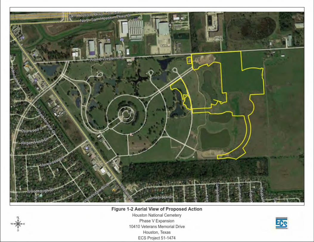
expansions would eventually encompass the entire 417.5 acres (Figure 1-2).


Proposed Houston National Cemetery Phase V Expansion
FINAL Site-Specific Environmental Assessment
1-4
1.2 Purpose and Need for the Proposed Project
The NCA provides burial services, including gravesites, grave markers, and gravesite
maintenance, for eligible veterans and their dependents. One of the NCA’s goals is to
provide veterans access to burial in a state or national veterans cemetery within 75 miles
of their residence. The HNC serves veterans in the greater Houston metropolitan area
and southeast Texas. The HNC estimates an average of 2,700 burials per year for the
next 20 years. The Phase V expansion is necessary to expand the capacity of the
cemetery to continue to provide burial services for an estimated ten years. Future
expansions will also follow a phased development approach until full capacity is
achieved at its existing location, which is anticipated by 2050. Renovations to existing
HNC facilities are also required to upgrade the utility infrastructure, provide necessary
facilities for employees and visitors, and maintain the wetland mitigation ponds and
storm water drainage system.
This Environmental Assessment (EA) has been prepared in compliance with the
National Environmental Policy Act of 1969 (NEPA), the Council on Environmental
Quality (CEQ) regulations implementing NEPA (40 Code of Federal Regulations [CFR]
1500-1508), and VA Regulations, (38 CFR 26.4 [a]), which require the VA NCA to
evaluate the impacts of cemetery development and operations on the environment.
Proposed Houston National Cemetery Phase V Expansion
FINAL Site-Specific Environmental Assessment
2-1
2. Description of Project Alternatives
2.1 Proposed Action
The proposed expansion would develop approximately 42 acres of HNC property east of
the existing cemetery to provide additional burial space and services in a manner
consistent with the cemetery’s Master Plan. Upgrades and new construction to improve
infrastructure, utilities, and existing facilities within the cemetery would also be included
in the Phase V expansion. The upgrades and construction within the existing portions of
the cemetery include maintenance and upgrades to the chapel and hemicycle, improved
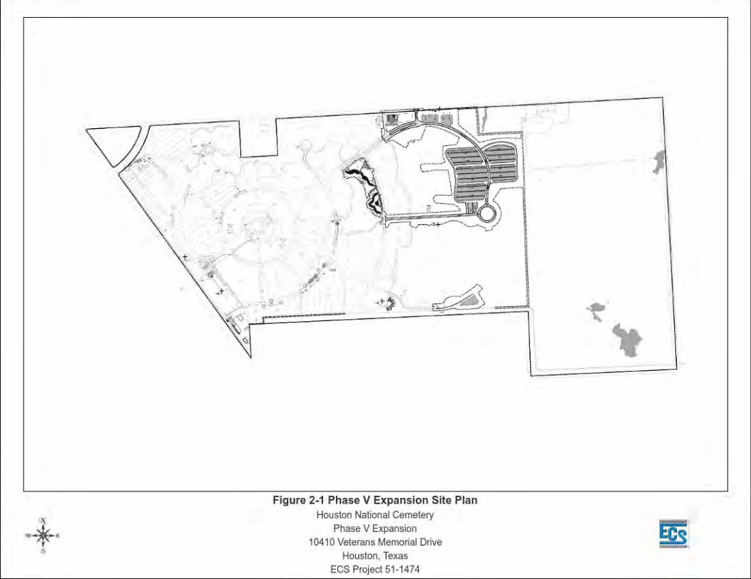
parking and traffic flow through the cemetery, as depicted in Figure 2-1. The Phase V
expansion would consist of burial sections including pre-placed crypts, columbaria
niches, and a committal shelter and associated infrastructure. Drainage, landscaping,
pathways, roadway extensions, parking, signage, and electrical service and other utilities
are incorporated into the expansion design to provide an experience consistent with the
existing portions of the cemetery. Specifically, the Phase V expansion will consist of:
• Burial site expansion of approximately 14,000 pre-placed crypt full casket
gravesites, approximately 8,000 columbaria niches, and approximately 2,000
traditional in-ground cremains. The Proposed Project will also include a
hybrid natural (Green) burial section located within the open naturalized field
area to accommodate 300 total burial sites sized 5’x10’ with the following
types of green burial: no vault burial, no casket burial, biodegradable casket
burial and cremation with no urn burial. This area shall be naturalized
landscaping, non-irrigated, and non-mowed.
• Extension of Veterans Memorial Drive within the cemetery property to the
expansion area. The Proposed Project would also provide a new limited use
cemetery entrance and gate at Aldine Western Road;
• Landscaping improvements;
• Irrigation system improvements and expansion;
• Demolition of existing, non-contributing structures and remediation of
pesticide-impacted soils at Building 3006, as well as potential abatement of
asbestos-containing building materials and lead-based paint.
• Utility and infrastructure improvement and expansion.

Proposed Houston National Cemetery Phase V Expansion
FINAL Site-Specific Environmental Assessment
2-3
No site alternatives were considered for the proposed expansion because the Proposed
Action would be located on land owned by the VA for the purpose of cemetery
expansion. The location is part of the 417.5-acre tract of land set aside for cemetery
development and is immediately adjacent to the existing cemetery facilities.
2.2 Future Expansions
The Proposed Action is expected to provide burial space at the HNC for an estimated
ten years, following the NCA’s phased approach to cemetery planning and design.
Future expansions would continue to expand the cemetery to the east within the 417.5-
acre tract of land owned by the VA. Each expansion would include burial sections and
associated infrastructure designed to provide an estimated ten years of burial service,
similar to the proposed Phase V expansion. Design plans for the future expansions
would be developed as each phase is determined necessary and would incorporate
design features to maximize available burial space while providing an experience
consistent with the overall design plan of the HNC.
2.3 No-Action Alternative
Under the No-Action alternative, the HNC would not increase available burial space at
the HNC. No construction would occur and the remaining acreage at the HNC property
would remain unimproved pastureland.
The No-Action alternative would not be consistent with the NCA’s mission to provide
eligible veterans reasonable access to VA burial options within 75 miles of a veteran’s
home. The nearest available burial options for Houston-area veterans would be Fort
Sam Houston National Cemetery and San Antonio National Cemetery (cremated
remains only), located in San Antonio, approximately 200 miles away or the Dallas-Fort
Worth National Cemetery, approximately 225 miles away.

Proposed Houston National Cemetery Phase V Expansion
FINAL Site-Specific Environmental Assessment
3-1
3. Affected Environment This section describes the existing conditions at Houston National Cemetery and
presents an analysis of the potential environmental consequences of the Proposed
Action and No Action alternative. Each alternative was evaluated for its potential impacts
on physical, biological, and socioeconomic resources in accordance with the CEQ
regulations at 40 CFR 1508.8.
The specific criteria for evaluating the potential environmental impacts of the Proposed
Action and the No Action alternative are described in the following sections. The
significance of an action is also measured in terms of its context and intensity. The
potential environmental impacts are described in terms of duration, whether they are
direct or indirect, the magnitude of the impact, and whether they are adverse or
beneficial, as summarized in the following paragraphs:
Short-term or long-term. In general, short-term impacts are those that would occur only
with respect to a particular time-lined activity, for a finite period, or only during the time
required for construction or installation activities. Long-term impacts are those that are
more likely to be persistent and chronic.
Direct or indirect. A direct impact is caused by an action and occurs around the same
time at or near the location of the action. An indirect impact is caused by an action and
might occur later in time or be farther removed in distance but still be a reasonably
foreseeable outcome of the action.
Less-than-significant (negligible, minor, moderate), or significant. These relative
terms are used to characterize the magnitude or intensity of an impact. Negligible
impacts are generally those that might be perceptible but are at the lower level of
detection. A minor impact is slight, but detectable. A moderate impact is readily
apparent. Significant impacts are those that, in their context and due to their magnitude
(severity), have the potential to meet the thresholds for significance set forth in the CEQ
regulations (40 CFR 1508.27) and, thus, warrant heightened attention and examination
for potential means for mitigation to fulfill the policies set forth in NEPA. Significance
criteria by resource area are presented in the following sections.

Proposed Houston National Cemetery Phase V Expansion
FINAL Site-Specific Environmental Assessment
3-2
Adverse or beneficial. An adverse impact is one having unfavorable or undesirable
outcomes on the man-made or natural environment. A beneficial impact is one having
positive outcomes on the man-made or natural environment.
3.1 Aesthetics and Noise
3.1.1 Aesthetics
The HNC property consists of the currently developed cemetery and the undeveloped
acreage reserved for cemetery expansion.
The existing cemetery is generally a peaceful landscape composed of gravesites, shade
trees, expansive green lawns, and attractive ponds, all fully visible across the cemetery’s
3,500’ of frontage on Veterans Memorial Drive between Aldine Western Road and
Woodsdale Drive. The cemetery’s original Master Plan was developed around a radial
concept emanating from a large circular structure in the center of the site known as the
Hemicycle. The Hemicycle is comprised of a 75-foot carillon tower, chapel, and
pedestrian plaza. The Hemicycle serves as the cemetery’s visual and ceremonial focal
point and is visible throughout the cemetery. Subsequent expansions have incorporated
and retained the radial concept with design features compatible with the original sections
of the cemetery. Three committal shelters located within the burial sections of the
cemetery provide open covered pavilions for committal services with seating for
immediate family and uncovered paved areas for additional overflow attendees. Burial
areas include sections of in-ground burials marked by both flat marker and upright
headstones and columbaria sites. Site furnishings, including signage, benches, flower
watering stations, trash receptacles, fencing, flagpoles, and drinking water fountains are
placed throughout the cemetery and are characteristic and standard elements of the
national cemetery setting. Non-public areas include the maintenance complex, pump
houses, administrative offices, and a storage shed, which are visible from portions of the
cemetery.
The undeveloped acreage within the HNC property is improved pastureland. This area is
used for cattle grazing with low grassy cover and stock ponds on the property.
Proposed Houston National Cemetery Phase V Expansion
FINAL Site-Specific Environmental Assessment
3-3
3.1.2 Noise
Background noise levels are generally elevated in the vicinity HNC resulting from traffic
on the adjacent Veterans Memorial Drive and the close proximity to the Sam Houston
Tollway and Interstate 45, particularly in the morning and in the late afternoon.
Ceremonies conducted at the HNC often are accompanied by music, particularly the
traditional playing of “Taps.” However, noise from activities within the HNC is generally
not heard outside cemetery boundaries due to the nature of cemetery activities and the
elevated background noise levels from the adjacent traffic.
3.2 Air Quality
The U. S. Environmental Protection Agency (USEPA) established National Ambient Air
Quality Standards (NAAQS) for ozone, lead, carbon monoxide, sulfur dioxide, nitrogen
dioxide, and respirable particulate matter. The Texas Commission on Environmental
Quality (TCEQ) classifies the air quality status of each county with respect to NAAQS as
attainment, non-attainment, maintenance, or unclassified. Non-attainment indicates that
the air quality exceeds NAAQS for a specified pollutant or pollutants. Harris County, in
which the HNC is located, is classified as a "non-attainment" area for ozone. It is in
attainment for all other NAAQS. Ozone is not emitted directly into the air but is formed
through chemical reactions between natural and man-made emissions of volatile organic
compounds (VOCs) and nitrogen oxides (NOx) in the presence of sunlight. Ozone
pollution is the periodic increase in the concentration of ozone in the ambient air. When
temperatures are high, sunshine is strong, and winds are weak, ozone can accumulate
at ground level to unhealthful levels.
The General Conformity Provision of the Clean Air Act (CAA) of 1970 (42 USC 7401 et
seq.; 40 CFR Parts 50-87) Section 176(c), including the USEPA’s implementation
mechanism, the General Conformity Rule (40 CFR Part 51, Subpart W), prohibits the
Federal government from conducting, supporting, or approving any actions that do not
conform to a USEPA-approved State Implementation Plan (SIP). A SIP is a state's self-
authored blueprint for achieving and maintaining compliance with the goals of the CAA.
Federal agencies prepare written Conformity Determinations for Federal actions in or
affecting NAAQS non-attainment areas or maintenance areas when the total direct and
indirect emissions of non-attainment pollutants (or their precursors) exceed specified
thresholds. Conformity with the SIP is demonstrated if project emissions fall below

Proposed Houston National Cemetery Phase V Expansion
FINAL Site-Specific Environmental Assessment
3-4
threshold values. According to the USEPA Green Book, dated December 2017, the
Houston, Texas area is currently designated as a moderate non-attainment area for the
2008 eight-hour ozone NAAQS and marginal for the 2015 eight-hour ozone NAAQS.
The primary sources of air pollution at HNC are mobile sources including motor vehicles
and construction and maintenance equipment. Air emissions may result from any
boilers, furnaces, or other sources of combustion onsite.
3.3 Biological Resources
3.3.1 Vegetation and Wildlife Habitat
The vegetation and ecological communities at HNC generally consist of landscaped
areas, pasture, wetland habitat and open water (ponds). However, TPWD has mapped
distinct ecosystems, vegetative communities and existing wildlife habitat types within the
HNC that consist of the following: Texas-Louisiana coastal prairie, urban low intensity,
open water, barren, Texas-Louisiana Coastal Prairie pondshore, native invasive:
deciduous woodland, urban high intensity, and East-Central Texas prairie Post oak
savannah and woodland (Figure 3-1).
Landscaped Areas The existing cemetery at HNC is a highly manicured landscape and is consistent with
other national cemeteries of this size. As is the case with most national cemeteries, well-
maintained turf, primarily Bermuda grass (Cynodon dactylon) with St. Augustine grass
(Stenotaphrum secundum) in shade or partly shaded areas, is the primary and most
visible element of the landscape at HNC. The use of shrubs and groundcovers are
intentionally limited to highly visible areas or for screening purposes in order to reduce
maintenance. A variety of trees well adapted to the Houston climate, including water oak
(Quercus nigra), live oak (Quercus virgiana), loblolly pine (Pinus taeda), southern
magnolia (Magnolia grandiflora), bald cypress (Taxodium distichum), crape myrtle
(Lagerstroemia indica), and sweetbay magnolia (Magnolia virginiana), are located
throughout the cemetery, primarily along driveways and also interspersed among burial
areas.


Proposed Houston National Cemetery Phase V Expansion
FINAL Site-Specific Environmental Assessment
3-6
Pasture The undeveloped area adjacent to the existing cemetery is predominantly an upland
pasture interspersed with concave features that appear to impound rainfall and surface
flow for brief periods in the early and late growing seasons. These temporal
impoundments of rainwater did not represent potentially jurisdictional waters of the U.S.
or wetlands. The vegetation is dominated by Bahia grass (Paspalum notatum), and
Bermuda grass (Cynodon dactylon), and subordinated by white clover (Trifolium
repens), smut grass (Sporobolus indica), St. Augustine grass (Stenotaphrum
secundum), powderpuff flower (Mimosa strigillosa), giant cone flower (Rudbeckia
maxima), and other minor constituents.
Wetland Habitat Herbaceous wetlands located within the existing operational cemetery facilities are
limited to those areas around the sixteen (16) storm water ponds created as
compensatory mitigation for wetland impacts associated with a previous expansion
phase. These communities exist within the narrow littoral zones that partially, and in
some cases, entirely surround these ponds. The typical constituents of the vegetative
assemblages include: wild taro (Colocasia esculenta), cattail (Typha spp.), bull rush
(Scirpus spp.), smartweed (Polygonum spp.), blue flag iris (Iris virginica shrevei),
maidencane (Panicum hemitomon), and red ludwigia (Ludwigia repens).
Areas of herbaceous wetland habitat are present within undeveloped expansion area,
where they are found primarily in depressional landforms that are common throughout
the regional landscape. The typical vegetation in these systems include: alligator weed
(Alternanthera philoxeroides), soft rush (Juncus effuses), cone flower (Echinacea
purpurea), curly dock (Rumex crispus), flat sedge (Cyperus sp.) and beak rush
(Rhynchospora sp.). These pasture wetlands were observed to be significantly denuded
as a result of continuous cattle grazing activities. Of these two wetland variants, those
associated with the storm water ponds appear to reflect higher level of structure, wildlife
utilization and functional quality. However, due to primary management objectives,
grounds maintenance in the cemetery, grazing throughout the pasture and overall
access limitations, none of these wetlands represent a high level of ecological utility
beyond storm water attenuation and foraging sites for transient waterfowl and wading
birds.

Proposed Houston National Cemetery Phase V Expansion
FINAL Site-Specific Environmental Assessment
3-7
A forested wetland is present in the southeastern-most portion of the property. The
canopy is approximately 80 percent closed and contains a number of large trees
dominated by sugarberry (Celtis laevigata). Additional species, including green ash
(Fraxinus pennsylvanica), eastern cottonwood (Populus deltoides), winged elm (Ulmus
alata), and American elm (Ulmus americana), are found within the canopy and
subcanopy. Dwarf palmetto (Sabal minor) is predominant in the shrub stratum. The
herbaceous stratum is sparse except in the interior where dense accumulations of
smartweed (Polygonum puncatum), flat sedge (Cyperus virens) are the dominant
species. In the portions of this wetland dominated only by herbaceous vegetation,
associations of green flat sedge (Cyperus virens), panic grass (Panicum sp.), and jointed
flat sedge (Cyperus articulatus) make up the primary constituents of these assemblages.
Open Water (Ponds) Open water habitat at the HNC consist of a series of storm water ponds within the
cemetery facilities and agricultural stock tanks in the adjacent pasture. The storm water
ponds, particularly those that have well vegetated wetland margins, provide some
habitat for small rodents, several amphibian species, passerine birds, as well as
transient waterfowl and wading birds. While relatively small and shallow, these ponds
are artificially aerated; a practice that enhances water quality, particularly in shallow
impoundments where dissolved oxygen levels can dramatically fluctuate during the
summer months. In contrast, the three agricultural stock tanks exhibit greatly reduced
habitat function and quality. Intensive use by cattle and water quality impacts associated
with nutrient loading from manure appear to represent the most deleterious impact to
these features. Almost no emergent vegetation appears in the littoral zones and
substantial wetland fringe communities are mostly absent. Aquatic vegetation is virtually
non-existent. Observations made of the carcasses of common carp, a herbivorous fish
species, in the near shore zones of the pasture would seem to indicate that during
periods of flooding these fish risk, and often succumb to, stranding to gain access to
terrestrial herbaceous vegetation.
Texas-Louisiana Coastal Prairie This system is generally coincident with the distribution of the Pleistocene Beaumont
and Lissie Formations. This ecosystem is typically located on level to gently rolling
landscapes, with slopes generally less than 5%. Microtopography plays an important
Proposed Houston National Cemetery Phase V Expansion
FINAL Site-Specific Environmental Assessment
3-8
role in local variation in the system, with ridges, swales, mounds, depressions, mima (or
pimple) mounds, and gilgai leading to a mosaic of drier and wetter plant communities.
This mid- to tallgrass prairie occupies Pleistocene surfaces of the Texas and Louisiana
coast, on non-saline soils of level to gently rolling topography. It is dominated by
graminoid species, such as Schizachyrium scoparium (little bluestem), Sorghastrum
nutans (Indiangrass), Paspalum plicatulum (brownseed paspalum), Panicum virgatum
(switchgrass), Andropogon gerardii (big bluestem), Sporobolus compositus (tall
dropseed), Paspalum setaceum (thin paspalum), Fimbristylis puberula (hairy fimbry),
Dichanthelium oligosanthes (fewflower panicgrass), Rhynchospora spp. (beaksedges),
Paspalum floridanum (Florida paspalum), Muhlenbergia capillaris (Gulf muhly), Tridens
strictus (longspike tridens), Bouteloua curtipendula (sideoats grama), Andropogon
glomeratus (bushy bluestem), and Tripsacum dactyloides (eastern gamagrass).
Axonopus spp. (Carpetgrasses), Sporobolus indicus (rat-tail smutgrass), Andropogon
virginicus (broomsedge bluestem), Bothriochloa laguroides ssp. torreyana (silver
bluestem), and Nassella leucotricha (Texas wintergrass) may be particularly noticeable
on over-grazed sites. Non-native graminoids that may be conspicuous to dominant
components include Cynodon dactylon (bermudagrass), Cyperus entrerianus (deep-
rooted sedge), Bothriochloa ischaemum var. songarica (King Ranch bluestem),
Dichanthium spp. (old world bluestems), Lolium perenne (Italian ryegrass), Schedonorus
phoenix (tall fescue), Paspalum notatum (bahiagrass), and Paspalum dilatatum
(dallisgrass). Forbs that may often be encountered include Liatris spp. (gayfeathers),
Sabatia campestris (meadow pink), Ambrosia psilostachya (western ragweed),
Euphorbia bicolor (snow-on-the-prairie), Solidago spp. (goldenrods), Rudbeckia hirta
(Blackeyed Susan), Ruellia humilis (low wild petunia), Asclepias viridis (green
milkweed), Chamaecrista fasciculata (partridge pea), Helianthus angustifolius
(narrowleaf sunflower), Euthamia spp. (goldentops), Ratibida columnifera (Mexican hat),
Symphyotrichum ericoides (heath aster), Silphium laciniatum (compass plant), Baptisia
spp. (wild indigos), Iva angustifolia (narrowleaf sumpweed), Eryngium yuccifolium
(button snakeroot), Boltonia diffusa (smallhead doll's daisy), and Neptunia lutea (yellow
neptunia). Woody species may invade this typically herbaceous vegetation, including
Rosa bracteata (Macartney rose), Acacia farnesiana (huisache), Triadica sebifera
(Chinese tallow), Baccharis halimifolia (baccharis), Celtis laevigata (sugar hackberry),
and Prosopis glandulosa (honey mesquite) (TPWD, 2019).

Proposed Houston National Cemetery Phase V Expansion
FINAL Site-Specific Environmental Assessment
3-9
Urban Low Intensity This ecosystem generally consists or urbanized areas with less than 70% impervious
cover. Typical examples include residential areas, cemeteries, and parks.
Open Water The Open Water is an open aquatic ecosystem that exhibits little to no emergent
vegetation. Typical examples include lakes, ponds, and reservoirs.
Barren The Barren ecosystem is one with little or no vegetation year-round. Typical examples of
this ecosystem include river beds, quarries, areas cleared for development, and rural
roads.
Texas-Louisiana Coastal Prairie Pondshore This system occurs on the coastal Pleistocene terraces, including the Beaumont and
Lissie Formations with localized topographic lows such as ponds and swales within the
generally level landscape. Soils tend to be fine-textured, or are characterized by a
relatively impermeable subsurface horizon.
This system occurs as ponds or swales within the coastal prairie matrix. Soils are poorly-
drained, and surface water from rainfall and local runoff is retained for much of the year
(except for periods of high evapotranspiration). Occurrences are wetter than the
Tripsacum dactyloides (eastern gamagrass) or Panicum virgatum (switchgrass)
dominated prairie sites of the Texas-Louisiana Coastal Prairie. These wetlands are
primarily herbaceous, sometimes with sparse woody cover, and are composed of
various species, such as Eleocharis quadrangulata (squarestem spikesedge), Fuirena
squarrosa (hairy umbrellasedge), Cyperus haspan (sheathed umbrellasedge), Cyperus
virens (green flatsedge), Rhynchospora spp. (beaksedges), Leersia hexandra (clubhead
cutgrass), Steinchisma hians (gaping panicum), Panicum virgatum (switchgrass),
Andropogon glomeratus (bushy bluestem), Xyris jupicai (Richard's yellow-eyed grass),
Centella erecta (erect centella), Sagittaria papillosa (nipplebract arrowhead), Sagittaria
longiloba (longlobe arrowhead), Ludwigia glandulosa (Torrey water- primrose), Ludwigia
linearis (narrowleaf water-primrose), Bacopa spp. (waterhyssops), Hydrocotyle spp.

Proposed Houston National Cemetery Phase V Expansion
FINAL Site-Specific Environmental Assessment
3-10
(pennyworts), Symphyotrichum subulatum (hierba del marrano), and Sesbania spp.
(rattleboxes). Large areas of some of the occurrences may be relatively homogeneous,
dominated by one or a few species. Areas of open water within the ponds may contain
floating and submerged aquatic species, including Stuckenia pectinata (sago
pondweed), Ceratophyllum demersum (coontail), Brasenia schreberi (Schreber
watershield), Nymphoides aquatica (largeleaf floating heart), and Nelumbo lutea (yellow
lotus) (TPWD, 2019)
Native Invasive: Deciduous Woodland This broadly-defined ecosystem may have Celtis laevigata (sugar hackberry), Quercus
nigra (water oak), Ulmus crassifolia (cedar elm), Liquidambar styraciflua (sweetgum),
Ulmus alata (winged elm), Ilex vomitoria (yaupon), Acacia farnesiana (huisache),
Fraxinus spp. (ashes), or Prosopis glandulosa (honey mesquite) among the dominants.
To the south and west, species such as Celtis ehrenbergiana (granjeno), Zanthoxylum
fagara (colima), and Diospyros texana (Texas persimmon) are more common. Quercus
stellata (post oak), Quercus virginiana (coastal live oak), and Quercus fusiformis
(plateau live oak) may be important (TPWD, 2019).
Urban High Intensity This ecosystem generally consists or urbanized areas with greater than 70% impervious
cover. Typical examples include city centers, shopping malls, expansive parking areas,
and highways.
East-Central Texas Prairie Post Oak Savannah and Woodland This system is typical on sedimentary formations of Tertiary age, including Eocene
sands such the Queen City, Sparta, and Carrizo Sands, as well as the Wilcox and
Claiborne groups. The system also occupies other Teritary formations such as the
Goliad and Willis, as well as portions of the Quaternary Willis Formation. This system
occupies gently rolling to hilly topography and is moderately dissected by drainages.
This system represents a transition from the woodlands and forests of East Texas to the
prairies to the west, specifically the Blackland Prairie. Savannas and woodlands are
typically dominated by Quercus stellata (post oak), Quercus marilandica (blackjack oak),
and Carya texana (black hickory). Large areas of woodland, particularly in the south and
Proposed Houston National Cemetery Phase V Expansion
FINAL Site-Specific Environmental Assessment
3-11
east, are dominated or co-dominated by Quercus fusiformis (plateau live oak) or
Quercus virginiana (coastal live oak, east of the Brazos River). Other species, such as
Quercus incana (bluejack oak) (on more xeric sites), Ulmus alata (winged elm), Ulmus
crassifolia (cedar elm), Quercus nigra (water oak), Juniperus virginiana (eastern
redcedar), Celtis laevigata (sugar hackberry), and Prosopis glandulosa (mesquite), can
also be present in the overstory. To the east, Quercus falcata (southern red oak),
Quercus nigra (water oak), Liquidambar styraciflua (sweetgum), Pinus echinata
(shortleaf pine), Pinus taeda (loblolly pine), and Carya alba (mockernut hickory) may be
conspicuous in the overstory. Shrubs may attain significant cover in the understory, with
species including Ilex vomitoria (yaupon) (often dominant), Callicarpa americana
(American beautyberry), Sideroxylon lanuginosum (gum bumelia), Crataegus spp.
(hawthorn), Ilex decidua (possumhaw), Toxicodendron radicans (poison ivy), Smilax
bona-nox (saw greenbrier), Juniperus virginiana (eastern redcedar), and
Symphoricarpos orbiculatus (coral-berry). To the south, this system grades into
vegetation more characteristic of south Texas, with Quercus fusiformis (plateau live
oak) and Prosopis glandulosa (honey mesquite) becoming the primary overstory
components, and shrubs of south Texas such as Acacia rigidula (blackbrush), Forestiera
angustifolia (desert olive), Condalia hookeri (brasil), Colubrina texensis (Texas
hogplum), Eysenhardtia texana (Texas kidneywood), Opuntia engelmannii var.
lindheimeri (Lindheimer pricklypear), and Diospyros texana (Texas persimmon)
becoming increasingly conspicuous understory components. To the east, Vaccinium
arboreum (farkleberry), Morella cerifera (wax-myrtle), Diospyros virginiana (common
persimmon), and Cornus florida (flowering dogwood) may be common components of
the understory. On some sites, Ilex vomitoria (yaupon) can form nearly continuous,
sometimes impenetrable, dense shrub layer. Mid- and tallgrass species including
Schizachyrium scoparium (little bluestem), Sorghastrum nutans (Indiangrass), and
Panicum virgatum (switchgrass) are frequent in the understory where light penetration
supports herbaceous cover, and also form prairie patches within the savanna,
particularly on tighter soils. Other grasses present include Andropogon gerardii (big
bluestem), Bothriochloa laguroides ssp. torreyana (silver bluestem), Paspalum
plicatulum (brownseed paspalum) (to the south), Nassella leucotricha (Texas
wintergrass), Dichanthelium spp. (rosette grasses), Aristida spp. (threeawn), and
Sporobolus cryptandrus (sand dropseed). Non-native grass species such as
Bothriochloa ischaemum var. songarica (King Ranch bluestem), Paspalum
Proposed Houston National Cemetery Phase V Expansion
FINAL Site-Specific Environmental Assessment
3-12
notatum (bahiagrass), and Cynodon dactylon (bermudagrass) may dominate some sites.
Forbs are often conspicuous, and may include species such as Croton capitatus (hog
croton), Gaillardia pulchella (Indian blanket), Monarda punctata (spotted beebalm),
Rudbeckia hirta (blackeyed Susan), Phlox drummondii (Drummond phlox), Commelina
erecta (erect dayflower), Acalypha radians (cardinal’s feather), Verbesina virginica
(frostweed), Aphanostephus skirrhobasis (lazy daisy), Froelichia gracilis (slender snake
cotton), Cnidoscolus texanus (Texas bull-nettle), and many others. Drought, grazing,
and fire are the primary natural processes that affect this system. Much of this system
has been impacted by conversion to improved pasture or crop production. Overgrazing
and fire suppression have led to increased woody cover on most extant occurrences and
the invasion of some areas by problematic brush species such as Juniperus virginiana
(eastern redcedar) (to the north) and Prosopis glandulosa (mesquite) (to the south)
(TPWD, 2019).
3.3.2 Threatened and Endangered Species
Species that are listed by the Federal government as Threatened and Endangered are
protected under the Endangered Species Act of 1973, as amended (ESA) (16 U.S.C.
1531-1543), which requires Federal agencies to ensure that any action they authorize,
fund, or carry out does not jeopardize the “continued existence” of listed species or
result in the destruction or adverse modification of habitat designated as critical to their
existence. The U.S. Fish and Wildlife Service (USFWS) reviews federal actions that may
result in a negative impact on federally listed plants or animals.
Texas Parks and Wildlife Department (TPWD) regulations prohibit the taking,
possession, transportation, or sale of any of the animal species designated by state law
as endangered or threatened without the issuance of a permit. State laws and
regulations prohibit commerce in threatened and endangered plants and the collection of
listed plant species from public land without a permit issued by TPWD.
The USFWS and TPWD maintain lists of Federal and State Threatened and Endangered
species that may occur within Harris County. The potential or documented occurrence of
a listed species in the county does not necessarily mean the species is present within
the HNC. In addition to this, suitable habitat must be present within the area to speculate
on the presence of a listed species. This review was intended to determine the potential

Proposed Houston National Cemetery Phase V Expansion
FINAL Site-Specific Environmental Assessment
3-13
for occurrence of endangered species (animals and plants) within the HNC based on
available habitat. A review of available data from USFWD and TPWD indicates the
presence of five (5) federally listed species and 13 species of State concern that have
the potential to occur at the Proposed Project. The listed species are described in Table
3-1, below: Table 3-1: Special-Status Species
Common Name Scientific Name Federal Status State Status Mammals West Indian Manatee Trichechus manatus
T NL
Birds Least Tern Sterna manatus
E NL
Piping Plover Charadrius melodus
T T/SGCN
Red Knot Caldaris canutus rufa
T T/SGCN
Amphibians Cajun Chorus Frog Pseudacris fouquettei NL NL/SGCN
Southewrn Crawfish Frog Lithobates areolatus NL NL/SGCN
Stecker’s Chorus Frog Pseudacris streckeri NL NL/SGCN
Woodhouse’s Toad Anaxyrus woodhousii NL NL/SGCN
Crustaceans Houston Burrowing
Crayfish
Fallicambarus
houstonensis
NL NL/SGCN
Reptiles Slender Glass Lizard Ophisaurus attenuatus NL NL/SGCN
Western Box Turtle Terrapene ornata NL NL/SGCN
Plants Coastal Gay-feather Liatris bracteata NL NL/SGCN
Houston Daisy Rayjacksonia aurea NL NL/SGCN
Indianola Breakrush Rhynchospora
indianolensis
NL NL/SGCN
Shinner’s Sunflower Helianthus occidentalis
ssp. plantagineus
NL SGCN
Texas Windmill Grass Chloris texensis NL NL/SGCN Notes: T = Threatened; E = Endangered; NL = Not Listed; SGCN = Species of Greatest Conservation Need
3.3.2.1 Least Tern (Sterna antillarum) Least Terns are the smallest North American terns. Adults average 8 to 10 inches in
length, with a 20-inch wingspan. Their narrow, pointed wings make them streamlined
flyers. Males and females are similar in appearance. Breeding adults are gray above and
white below, with a black cap, black nape and eye stripe, white forehead, yellow bill with

Proposed Houston National Cemetery Phase V Expansion
FINAL Site-Specific Environmental Assessment
3-14
a black or brown tip, and yellow to orange legs. Hatchlings are about the size of ping-
pong balls and are yellow and buff with brown mottling. Fledglings (young birds that
have left the nest) are grayish brown and buff colored, with white heads, dark bills and
eye stripes, and stubby tails. Young terns acquire adult plumage after their first molt at
about 1 year, but do not breed until they are 2 to 3 years old. The Least Tern's call has
been described as a high pitched "kit,” "zeep," or "zreep."
Nesting habitat of the Interior Least Tern includes bare or sparsely vegetated sand,
shell, and gravel beaches, sandbars, islands, and salt flats associated with rivers and
reservoirs. The birds prefer open habitat and tend to avoid thick vegetation and narrow
beaches. Sand and gravel bars within a wide unobstructed river channel, or open flats
along shorelines of lakes and reservoirs, provide favorable nesting habitat. Nesting
locations are often at the higher elevations away from the water's edge, since nesting
usually starts when river levels are high and relatively small amounts of sand are
exposed. The size of nesting areas depends on water levels and the extent of
associated sandbars and beaches. Highly adapted to nesting in disturbed sites, terns
may move colony sites annually, depending on landscape disturbance and vegetation
growth at established colonies. For feeding, Interior Least Terns need shallow water with
an abundance of small fish. Shallow water areas of lakes, ponds, and rivers located
close to nesting areas are preferred. As natural nesting sites have become scarce, the
birds have used sand and gravel pits, ash disposal areas of power plants, reservoir
shorelines, and other manmade sites.
There are three subspecies of the Least Tern recognized in the United States. The
subspecies are identical in appearance and are segregated on the basis of separate
breeding ranges. The Eastern or Coastal Least Tern (Sterna antillarum antillarum),
which is not federally listed as endangered or threatened, breeds along the Atlantic
coast from Maine to Florida and west along the Gulf coast to south Texas. The California
Least Tern (Sterna antillarum browni), federally listed as endangered since 1970, breeds
along the Pacific coast from central California to southern Baja California. The
endangered Interior Least Tern (Sterna antillarum athalassos) breeds inland along the
Missouri, Mississippi, Colorado, Arkansas, Red, and Rio Grande River systems.
Although these subspecies are generally recognized, recent evidence indicates that
terns hatched on the Texas coast sometimes breed inland. Some biologists speculate

Proposed Houston National Cemetery Phase V Expansion
FINAL Site-Specific Environmental Assessment
3-15
that the interchange between coastal and river populations is greater than once thought.
The Interior Least Tern is migratory, breeding along inland river systems in the United
States and wintering along the Central American coast and the northern coast of South
America from Venezuela to northeastern Brazil. Historically, the birds bred on sandbars
on the Canadian, Red, and Rio Grande River systems in Texas, and on the Arkansas,
Missouri, Mississippi, Ohio and Platte River systems in other states. The breeding range
extended from Texas to Montana and from eastern Colorado and New Mexico to
southern Indiana. It included the braided rivers of Oklahoma and southern Kansas, salt
flats of northwest Oklahoma, and alkali flats near the Pecos River in southeast New
Mexico.
Today, the Interior Least Tern continues to breed in most of the major river systems, but
its distribution is generally restricted to the less altered and more natural or little
disturbed river segments. In Texas, Interior Least Terns are found at three reservoirs
along the Rio Grande River, on the Canadian River in the northern Panhandle, on the
Prairie Dog Town Fork of the Red River in the eastern Panhandle, and along the Red
River (Texas/Oklahoma boundary) into Arkansas.
As this species only needs to be considered for wind-related projects within the species
migratory route, the proposed project is expected to have no impact to the Interior Least
tern or its habitat.
3.3.2.2 Piping Plover (Charadrius melodus) The Piping Plover is a small shore bird, about 7 1/4 inches long with a 15-inch wingspan.
Distinguishing characteristics include sandy-colored feathers with grayish-brown crowns
and backs, white foreheads, and dark bands across their crowns. Dark, but incomplete
rings encircle their necks. These little birds have yellow-orange legs, black bands across
their foreheads from eye to eye, and black rings around the base of their necks. They
are small, stocky, sandy-colored birds that resemble sandpipers, with short, stubby bills.
Piping Plovers reach sexual maturity at one year, and mate from late March through
April. Males compete against each other for females' attention. They perform elaborate
flights, and then scrape nests in the sand, tossing shells and small stones and twigs into

Proposed Houston National Cemetery Phase V Expansion
FINAL Site-Specific Environmental Assessment
3-16
them with their beaks. To create a nest, they scrape a shallow depression in the sand
about 1 by 2.5 inches (2.5 by 6 cm). After their nests are built, they stand beside them
with their wings partially spread and tails fanned. The males repeat this behavior until a
female indicates interest. Once he has her attention, he begins a high-stepping "dance,"
continuing the courtship ritual. Females will lay about four gray to pale sand-colored
eggs with a few dark spots. After an incubation period of 25 days, the young hatch within
four to eight hours of each other and fledge 30 to 35 days later. Although both sexes
share responsibility for incubating the eggs, females commonly leave the young when
the hatchlings are 14 to 20 days old. Males often remain with them until they can fly.
The chicks can move freely from their nests within hours of drying off. When predators or
intruders come close, the young squat motionless on the sand while the parents attempt
to attract the attention of the intruders to themselves, often by feigning a broken wing.
Gulls, crows, raccoons, foxes and skunks are threats to the eggs and falcons may prey
on the adult birds. The young plovers and adult plovers generally return to the same
nesting area year after year. Plovers often run short distances, pausing to stare at the
ground with a slightly tilted head, before picking a food item from the sand.
There are just over 5,000 known pairs of breeding Piping Plovers. Texas is the wintering
home for 35 percent of the known population of Piping Plovers. They begin arriving in
late July or early August and will remain for up to nine months. The Piping Plover's diet
includes marine worms, beetles, spiders, crustaceans, mollusks and other small marine
animals. Their life span is less than five years, but on occasion, up to 14 years.
Piping Plovers migrate through the Great Lakes along the river systems through the
Bahamas and West Indies. They are currently found along the Atlantic Coast from
Canada to North Carolina and along the shorelines of Lakes Michigan and Superior. Gulf
Coast beaches from Florida to Mexico, and Atlantic coast beaches from Florida to North
Carolina provide winter homes for plovers.
Habitat alteration and destruction are the primary causes for the decline of the Piping
Plover. Loss of sandy beaches and lakeshores due to recreational, residential, and
commercial development has reduced available habitat on the Great Lakes, Atlantic
Coast, and the Gulf of Mexico. Reservoir construction, channel excavation, and
Proposed Houston National Cemetery Phase V Expansion
FINAL Site-Specific Environmental Assessment
3-17
modification of river flows have eliminated sandbar nesting habitat along hundreds of
miles of the Missouri and Platte Rivers. Winter habitats along the Gulf coast are
threatened by industrial and urban expansion and maintenance activities for commercial
waterways.
On the breeding grounds, reproductive success can be curtailed by human disturbance.
Vehicular and foot traffic destroys eggs and chicks. The presence of people on beaches
and sandbar islands inhibits incubation and other breeding behavior. Changes in land
use such as agricultural development, urbanization, and use of beaches has brought an
increase in the number of unleashed pets and other predators.
Increased recreational use of Gulf beaches may also threaten the quality of wintering
sites. Beach traffic, including vehicles and ATV's, as well as the activities of unleashed
dogs, can disturb birds and degrade habitat. Beach raking, a practice associated with
high recreational use, removes driftwood, seaweed, and other debris used by roosting
plovers, and may disrupt nutrient cycles and remove prey organisms from foraging
areas.
In 2001, the total population of Piping Plovers in North America was estimated to be
5,945 breeding adults. The Texas Gulf Coast had the highest wintering population, with
about 1,042 individuals detected. This represents about 44% of birds detected on the
wintering grounds during the 2001 International Piping Plover Census. Most of the
plovers that winter on the Texas coast are found in the lower Laguna Madre, where tidal
flats are extensive and productive.
As this species only needs to be considered for wind-related projects within the species
migratory route, the proposed project is expected to have no impact to the Piping plover
or its habitat.
3.3.2.3 Red Knot (Calidris canutus rufa)
The Red Knot is a medium-sized shorebird. During breeding season, it has a rust
colored face, chest and undersides and dark brown wings. In winter, it has a gray head,
Proposed Houston National Cemetery Phase V Expansion
FINAL Site-Specific Environmental Assessment
3-18
chest and upperparts and a white belly. It has long greenish legs and a pointed black bill.
Males and females look similar.
The Red Knot breeds on islands in the Arctic regions of Canada. It winters along both
the Pacific and Atlantic coasts from California and Massachusetts south to South
America. The Red Knot is also found in Europe and Asia. The Red Knot breeds on the
tundra. During migration and in the winter, it can be found on tidal flats, rocky shores and
beaches.
In its breeding territory, the Red Knot eats the seeds of sedges, horsetails and grass
shoots. It may also poke around in snow-free areas for invertebrates. It also eats beetles
and cutworm larvae. In its winter range, it eats marine worms, grasshoppers, horseshoe
crab eggs and other invertebrates.
As this species only needs to be considered for wind-related projects within the species
migratory route, the proposed project is expected to have no impact to the Red knot or
its habitat.
3.3.2.4 Texas Prairie Dawn-flower (Hymenoxys texana) The Texas prairie dawn (Hymenoxys texana) is a delicate annual that ranges in size
from 1-6 inches in height. It produces small yellow flower heads less than ½ inch in
diameter. The Texas prairie dawn grows in sparsely vegetated areas, at the base of
pimple mounds and other barren areas on slightly saline soils within coastal grassland
communities. This plant has been documented in Harris County and on the outskirts of
Houston. However, no critical habitat has been designated for this species. The subject
property does not present suitable habitat for the Texas Prairie Dawn-flower. Therefore,
the proposed project is expected to have no effect on the species or its habitat.
3.3.2.5 West Indian Manatee (Trichechus manatus)
This is a slow-moving mammal with a rounded body, gray to brown skin with fine sparse
hair, small head, squarish snout with a deeply split upper lip, valvular nostrils, small
eyes, flexible flippers, and a large rounded horizontally flattened tail. Adults usually are
about 10-13 feet (300-400 cm) in total length. Newborn calves are about 3-4 feet (1
meter) long. Habitat includes shallow coastal waters, estuaries, bays, rivers, and lakes;
Proposed Houston National Cemetery Phase V Expansion
FINAL Site-Specific Environmental Assessment
3-19
throughout most of the range, manatees appear to prefer rivers and estuaries over
marine habitats (Lefebvre et al. 1989). Manatees are not averse to traveling through
dredged canals or using quiet marinas. They apparently are not able to tolerate
prolonged exposure to water colder than 20 C. In the north during October-April,
manatees congregate in warmer water bodies (spring-fed rivers, outfalls from power
plants). They prefer waters at least 1-2 meters in depth; along the coast manatees often
are in water 3-5 meters deep, usually in areas lacking strong current (NatureServe,
2018; USFWS, 2019). The subject property does not present suitable habitat for the
West Indian Manatee. Therefore, the proposed project is expected to have no effect on
the species or its habitat.
In summary, due to the urbanization, and the residential and commercial land uses
around the HNC, and the lack of pine flatwoods, coastal areas, and appropriate soils,
there is not likely suitable habitat for any of the Federal or State-listed species. Although
species-specific surveys were not conducted, the HNC provides for less than ideal
conditions in which endangered species may be found. A complete list of Federal- and
State-listed threatened and endangered species that may occur in Harris County can be
found in Appendix B.
3.4 Cultural and Historical Resources
A cultural resources baseline records review was conducted for the HNC utilizing the
cultural resources files at the Texas Archeological Research Laboratory (TARL) and the
Texas Historical Commission (THC) on-line Restricted Sites Atlas. The files at TARL
were used to identify previously recorded archaeological sites within the proposed
project boundaries. The THC’s on-line data base was used to determine if any National
Register of Historic Places listed properties, State Archeological Landmark sites, or
State Historical Markers were located within the project area boundaries. Houston
National Cemetery is a National Register District (Reference No. 100000697) and was
listed on February 29, 2017.
Three (3) archeological / cultural resources studies were prepared for the Proposed
Action. Moore Archeological Consulting, Inc. (MAC) conducted an Archeological
Assessment of the Proposed Action during March 2019. MAC concluded that the overall
environmental conditions were not conducive for retaining shallow or deeply buried and

Proposed Houston National Cemetery Phase V Expansion
FINAL Site-Specific Environmental Assessment
3-20
intact historic or prehistoric cultural resources (Moore, 2019). Komatsu Architecture
(Komatsu) prepared an Architecture / Historic Preservation Report for the Proposed
Action (Komatsu, 2019), and Row 10 Historic Preservation Solutions, LLC (Row 10)
prepared an Initial Cultural Resource Impact Prediction for a portion of the Proposed
Action (Row 10, 2019). The cultural resources reports were submitted to THC /SHPO.
THC / SHPO responded that the Proposed Action would have no effect on historic
properties.
3.5 Geology and Soils
3.5.1 Geology
The HNC is underlain by the upper Lissie Formation, sometimes denoted as the
Montgomery Formation. The upper Lissie Formation is heterogeneous, containing
interbedded layers of clay, sand, and silt. It was deposited in mid-Pleistocene epoch in
shallow coastal river channels and flood plains. Clay present in the formation has been
preconsolidated by a process of desiccation. Numerous wetting and drying cycles have
produced a network of randomly oriented and closely-spaced joints, which are
sometimes slickensided. Slickensided joints or fractures within the soil mass have a
shiny appearance when exposed. Joint patterns can influence the engineering behavior
of the soil mass. Sand and silt layers, seams, pockets, and lenses vary in density from
loose to very dense, and in thickness from a fraction of an inch to many feet due to an
irregular depositional environment. The sand composition is variable. Sand particles vary
from subrounded to subangular, and coarse to very fine. Zones of sand may be poorly-
graded (mostly the same size particles) to well-graded (fine to coarse gradation). Silt is
also often found within the sand matrix (Bureau of Economic Geology, 1982).
The Gulf Coast coastal plain is latticed by non-tectonic growth faults resulting from
compaction of underlying sediment and subsidence. One hundred and thirty faults
(active and inactive) extend over 300 kilometers (200 miles) in Harris County. Ground
movement at these faults is generally gradual rather than episodic as with earthquakes;
however, damage to pavement and buildings may occur in urban areas. These faults are
generally oriented NE-SW, parallel to the coastline. One mapped fault, known as the
Woodgate Fault, crosses the HNC property (Figure 3-2). The Woodgate Fault is
approximately 3 miles long and may experience vertical movement of up to 0.5-1 inch
per year.

Proposed Houston National Cemetery Phase V Expansion
FINAL Site-Specific Environmental Assessment
3-22
Land surface subsidence is a common problem in the Houston-Galveston area, primarily
due to withdrawal of groundwater. Approximately 3-4 feet of land surface subsidence
has occurred in the HNC area, from 1906-2000 (Zilkoski, et al., 2001). Since 1975, the
withdrawal of groundwater in Harris County has been regulated by the Harris-Galveston
Subsidence District (HGSD) to limit continued land surface subsidence. The rate of
subsidence has significantly decreased in many areas throughout the Houston area due
to reductions in groundwater pumping.
3.5.2 Soils
The soils located within the HNC are of the Clodine-Addicks-Gessner association and
include the Clodine fine sandy loam, Addicks loam, and Cyfair-Urban land complex
mapping units as primary constituents (Figure 3-3). Clodine and Addicks soils generally
exist on level terraces. It should be noted that soil surveys published by the National
Resource Conservation Service (NRCS) are generally accurate to about 4 acres and
smaller inclusions of other mapping units present within the master unit often remain
unmapped.
The NRCS identifies map units as prime farmland, farmland of statewide importance,
farmland of local importance, or unique farmland. These designations identify the
location and extent of the soils that are best suited to food, feed, fiber, forage, and
oilseed crops. NRCS policy and procedures on prime and unique farmlands are
published in the "Federal Register," Vol. 43, No. 21, January 31, 1978. The Clodine fine
sandy loam is not listed as prime farmland. Addicks loam is considered farmland of
statewide importance. None of the soils within the HNC are identified as unique
farmland.
3.6 Hazardous Materials
The TCEQ Petroleum Storage Tank (PST) registration database has record of two
historical underground PSTs at the HNC. A review of the TCEQ Central Registry Online
Database indicated that one 1,000-gallon steel tank used for storage of gasoline was
installed in 1965 and removed from the ground in 1993 (TCEQ 2019). A second 2000-
gallon steel tank used to store diesel was installed in 1976 and removed from the ground
in 1993. There are no records of violations or releases of petroleum products to the
environment resulting from these storage tanks.

Proposed Houston National Cemetery Phase V Expansion
FINAL Site-Specific Environmental Assessment
3-24
One (1) former residential structure and two (2) farm structures, identified collectively as
Building 3006, will be demolished as part of the Phase V expansion. VA conducted
previous environmental investigations of the Building 3006 area and recognized
environmental conditions (RECs) were identified (Booz Allen Hamilton 2018, 2019)
(Appendix F). The RECs included the following:
The “Milk House” on the north side of Building 3006 contained several bottles of
regulated pesticides/herbicides such as Amine 4 (2,4-D) weed killer and a jug of
Chlordane. The improper storage of regulated substances has resulted in staining along
the concrete floor near a floor drain found within the Milk House. Additionally, a septic
system with a drain field is located on the subject property; although the exact location of
the drain field was unknown at the time of the Phase I ESA. The potential for
contaminants to migrate from Building 3006’s drains and deposit contaminants in soil
presented a REC for the subject property.
The “Shed” on the south side of Building 3006 contained several bottles and drums of
petroleum products, and staining was visible on the wooden floor of the building. It was
believed that a crawlspace underlies the building with exposed soil directly underneath
the floor. The potential for contaminants to leach from Building 3006’s floors to the
underlying soil presented a REC for the subject property.
VA conducted soil and groundwater sampling (Phase II Environmental Site Assessment
[ESA]) during November 2018 to address the RECs previously identified. The Phase II
ESAs identified the following environmental concerns:
Analysis of the two soil samples collected from beneath the floor of the Shed (2601-SS-1
and 2601-SS-2) yielded results indicative of a release of Dieldrin, a pesticide, to surface
soil. These results exceeded the Texas Commission on Environmental Quality’s
(TCEQ’s) Protective Concentration Levels (PCLs) for residential soil. Sample 2501-SS-2
also exceeded the commercial PCL for Dieldrin. 4-Chlorophenyl phenyl ether, a semi-volatile organic compound (SVOC), was detected
above the residential PCL in all soil samples collected during the initial Phase II ESA, and
above commercial PCLs in four of the samples (2501-SS-3, 2501-SS-4, 2501-SS-5, and
2501-SS-6). 4-Bromophenyl phenyl ether was detected above the residential PCL at four

Proposed Houston National Cemetery Phase V Expansion
FINAL Site-Specific Environmental Assessment
3-25
sample locations (2501-SS-3, 2501-SS-4, 2501-SS-5, and 2501-SS-6), and above the
commercial PCL in Sample 2501-SS-6. Hexachlorobenzene was also detected above the
residential PCL at four sample locations (2501-SS-3, 2501-SS-4, 2501-SS-5, and 2501-
SS-6). VA conducted an Expanded Phase II ESA from May 21 to 22, 2019 to further characterize
the site. To delineate the exceedances observed during the initial Phase II ESA, 69 soil
samples were collected from 23 locations and analyzed for SVOCs and pesticides.
Groundwater grab samples were collected from six locations around the site via the
installation of temporary PVC wells. The analytical data obtained during the Expanded Phase II ESA indicate that the
impacted soil discovered during the initial Phase II ESA appears to be confined to the
footprint of the shed building of Building 3006. Based on the analytical results of the
Expanded Phase II ESA, Booz Allen recommends the following actions at the subject
property: Remedial action to bring the Dieldrin impacted soil identified during the initial Phase II
ESA into compliance is required. Remedial actions would include the excavation and
disposal of the top 2 feet of soils of impacted soil. The remedial action will occur
concurrently with the Phase V expansion. Building 3006 may contain asbestos-
containing building materials (ACM) or lead-based paint. Prior to demolition of Building
3006, VA will conduct ACM and LBP surveys. Any ACM or building materials coated with
LBP will be abated and disposed of in accordance with federal, state and local
requirements prior to demolition.
3.7 Land Use
The HNC has been in operation since 1965. Since then, land use at the HNC has not
varied. The cemetery is landscaped with areas for burials, memorial headstones, and
numerous columbarium areas. In addition to this, there are several committal shelters
on-site utilized for burial services and ceremonies. In the middle of the property, the
Hemicycle contains a chapel, carillon, and speaker’s stand that is utilized for
ceremonies. One administrative building and one maintenance building are located on-

Proposed Houston National Cemetery Phase V Expansion
FINAL Site-Specific Environmental Assessment
3-26
site. Several detention ponds and intensively landscaped areas provide serene visual
displays and storage for surface water and storm water.
Outside of the existing cemetery facilities, the HNC property is primarily comprised of
improved pastureland that is currently utilized for cattle grazing. One farmhouse is
present on the expansion property. The HNC leases the land to an individual who grazes
cattle in the expansion area. Improvements to the leased property consist of the
farmhouse, a cattle shed, storage building, work building, and six-strand barb wire
fencing. The overall topography of the area is relatively flat and slopes gently to the
southeast. The pastureland within the expansion area also contains three stock tanks
that provide water to grazing cattle.
The HNC is surrounded by mixed use commercial, light industrial, and residential areas
to the north, south, east, and west. The area is bounded to the north by light industrial /
commercial businesses, to the south by residential areas, to the west by residential and
commercial areas, and to the east by undeveloped pastureland.
3.8 Socioeconomics
3.8.1 Demographics
The HNC is located in Houston, Texas, the fourth largest city in the United States. The
greater Houston area encompasses ten counties with a total population of over seven
million people and a large veteran population. Demographic and economic statistics for
the Houston metropolitan area are summarized in Table 3 -2.
Table 3-2: Demographic and Economic Statistics for the Houston Metropolitan Area
County Total
Population Veteran
Population White Hispanic African
American Asian Poverty
Median Household
Income
Harris 4,698,619 163,317 29.7% 43.0% 19.7% 7.3% 15.9 $57,791 Chambers 42,454 2,128 67.0% 22.3% 8.4% 1.4% 9.5% 74,368 Fort Bend 787,858 26,736 33.2% 24.5% 21.1% 20.4% 8.0% 93,645 Brazoria 370,200 23,952 47.3% 30.6% 14.2% 6.8% 9.0% 76,426 Galveston 337,890 20,662 57.3% 24.6% 13.4% 3.5% 12.0% 65,702 Montgomery 590,925 30,556 66.2% 24.1% 5.3% 3.1% 8.9% 74,323 Liberty 86,323 5,107 63.3% 24.8% 10.2% 0.6% 15.5% 48.344 Waller 53,126 1,906 42.9% 30.1% 25.4% 1.1% 15.5% 53,506 Austin 29,989 1,577 62.0% 27.1% 9.5% 0.7% 10.7% 62,614
San Jacinto 28,719 2,168 74.8% 13.1% 9.8% 0.5% 18.2% 43,421

Proposed Houston National Cemetery Phase V Expansion
FINAL Site-Specific Environmental Assessment
3-27
Total 7,026,103 317,285 Sources: U.S. Census Bureau, Population Estimates July 1, 2018 (V2018), 2013-2017 American Community Survey 5-Year Estimates.
Harris County has a high minority population and high percentage of people living below
the poverty line. Locally, the HNC is located in the Aldine Independent School District
(ISD) in Harris County. The Aldine ISD student population is predominantly Hispanic
(72.5% based on 2016-2017 estimates) with over 86% of students considered
economically disadvantaged (AISD Student Demographics 2019).
3.8.2 Transportation, Traffic, and Parking
Vehicular Traffic and Parking The Texas Department of Transportation (TxDOT) maintains saturation counts for urban
area, which represent the traffic counts measured at a given location over a 24-hour
period, Monday through Friday. The counts are collected every five years and based on
the number of axels divided by two and therefore are not corrected for large trucks,
trailers, or other vehicles with more than two axels. There are three TxDOT monitoring
locations in the vicinity of the HNC. Traffic counts at the Morewood and Woodsdale
locations decreased from 2006 to 2012, while counts for the Veterans Memorial
monitoring site increased (Table 3-2).
Table 3-3: 24-Hour Saturation Traffic Counts for HNC-area
Roadways
Location 2006 2012 % change 2200 Morewood Drive 1,610 1,470 -8 2200 Woodsdale Blvd 1,700 1,480 -12 10600 Veterans Memorial 17,330 28,920 +66 Source: Houston-Galveston Area Council, 2019
The HNC has one main entry for visitors and staff located on T.C. Jester Blvd.
approximately 350’ northeast of Veterans Memorial Drive. The intersection at T.C. Jester
Boulevard and Veterans Memorial Drive has a signaled left turn, which provides safe
access from Veterans Memorial Drive and sufficient stacking space for large groups of
vehicles entering the site. Off-site access to the Maintenance Building, 500’ south of the
Administration Building, is provided by a gated service entry on Veterans Memorial Drive
located approximately 0.4 miles south of T. C. Jester Boulevard. Additional access,
limited to service and construction, is located on Aldine Western Road to the north. Bus
service on Veterans Memorial Drive, provided by METRO, is available in both inbound
Proposed Houston National Cemetery Phase V Expansion
FINAL Site-Specific Environmental Assessment
3-28
and outbound routes (Metro Route 108) at Morewood Drive, directly in front of the
Administration Building, and at the intersection of T. C. Jester Boulevard. Rail service is
not available in the area.
Motorists arriving at the cemetery enter along a curvilinear one-way asphalt drive,
separated from outbound lanes by a broad variable-width landscaped median and
several ponds. The roadway curves gently to the southeast and arrives at the cortege
lane and Administration Building on axis with a broad tree-lined drive leading directly to
the Hemicycle. The inner loop drive (200’ radius) circumnavigates the Hemicycle entirely
and provides access to the north and east Hemicycle parking areas. The intermediate
loop (500’ radius) provides access to in-ground burial areas and to a northeasterly
extension of the axial drive that connects to the outer loop drive (1000’ radius),
columbaria, the maintenance facilities at its southern end, and the construction entry at
Aldine Western Road near a cul-de-sac at its northern terminus. A short internal drive
along east side of the Administration Building provides direct access to staff and visitor
parking behind the Administration Building and to the Maintenance Building. Parking for
maintenance staff is provided in the gated and enclosed maintenance yard. The cortege
lane, immediately in front of the Administration Building, provides space for
approximately 30 vehicles and is considered adequate for most funeral corteges.
A new, limited, access point will be constructed along Aldine-Western Road proximate to
the existing maintenance entrance. Use of the new entrance will be limited to large
events such as Veteran’s Day, Memorial Day, and Flags across America.
Pedestrian Traffic
Pedestrian access to the cemetery via paved walks on Veterans Memorial Drive is
available near the intersection of Morewood Drive and Veterans Memorial Drive and
provides direct access from the Metro transit bus stop to the Administration Building and
parking area. A walk located on the northeast side of the Administration Building
provides direct pedestrian access to the Hemicycle. There are also pedestrian walks and
plazas in and around the Hemicycle area. Committal shelters are all accessible with
nearby on-street parking and paved walking surfaces providing direct access to the
shelters. Columbaria are accessed along curvilinear walkways. There are numerous
Proposed Houston National Cemetery Phase V Expansion
FINAL Site-Specific Environmental Assessment
3-29
walks around and through the burial areas near the main entry and the lakes in the
northwestern corner of the site. In areas without paved pedestrian access, the cemetery
and its burial areas are turf and are generally flat and accessible.
3.8.3 Utilities
The HNC site is currently served by electrical, communications, potable water, sanitary
sewer, and storm water drainage utilities. Potable water and sanitary sewer services are
provided by the local Municipal Utility District.
The electrical and communication systems onsite consist of the existing primary and low
voltage power distribution systems which utilize original equipment installed in 1965, in
addition to some newer equipment installed in the mid-1990s. Typically, commercial
grade power distribution equipment has a design life of 20 to 25 years. A majority of the
existing equipment does not meet current electrical and safety codes. In addition, the
current system does not have adequate power metering, which will allow the monitoring
of power usage to comply with mandatory energy reductions and Leadership in Energy
and Environmental Design (LEED) recommendations.
The irrigation system at HNC, initially installed in 1965, is a traditional irrigation system
designed around a non-potable subsurface water supply pumped directly from the two
water wells onsite. The system utilizes two large vertical water well pumps, located in
secured and fenced concrete block buildings along the north edge of the site, to deliver
1,550 gallons/minute of water to the surface for distribution through a conventional
system of rotary sprinkler heads. Since the site contains few shrubs and groundcover
beds, the use of other sprinkler head types (spray heads, bubblers, drip emitters) is very
limited on this site. Significant surface water resources (three (3) ponds) are present at
the site and are being utilized to provide irrigation water.
The two (2) existing irrigation wells serving the cemetery are currently out of service due
to mechanical failures. Part of the Proposed Action is to install a new irrigation well
proximate to Aldine-Western Road. The new well will be permitted by the Harris-
Galveston Subsidence District and is not expected to create a significant impact to
groundwater resources in the area.
Proposed Houston National Cemetery Phase V Expansion
FINAL Site-Specific Environmental Assessment
3-30
3.9 Water Quality
3.9.1 Surface Water
Surface water within the HNC property includes 16 storm water retention ponds within
the existing cemetery facilities and three agricultural stock tanks contained within the
adjacent improved pasture. The storm water retention ponds were designed to serve the
primary functions of storm water attenuation and wetland function, along with the
ancillary benefit of landscape enhancement. Nearly all these features exist within the
north half of the existing cemetery facilities and are roughly situated in a semi-circular
arrangement consistent with the original design layout. These ponds range in
approximate size from 0.16 to 1.49 acres. The ponds are separated into two groupings.
Nine of the ponds are linked together by overflow piping that eventually allows storm
water in the ponds to level out and overflow if necessary, to the northwest and offsite
into Harris County Flood Control District storm drain system located along Veterans
Memorial Boulevard. That storm drain system eventually outflows into Greens Bayou to
the north of the cemetery. The other ponds are linked together by overflow piping that
eventually allows storm water in the ponds to level out and overflow if necessary,
towards the south into an offsite drainage channel that discharges to Halls Bayou.
Of the three agricultural stock tanks, the most significant is the approximately 6.18-acre
tank in the southwest corner of the pasture. Observations suggest that during prolonged
storm events this feature discharges to the south and into a ditch that flows east,
eventually discharging into Halls Bayou. The remaining two stock tanks total to less than
3 acres and during events of severe rainfall, are believed to drain to the east.
3.9.2 Groundwater
The Beaumont Formation, along with the underlying Lissie Formations, comprises the
Chicot Aquifer, which extends approximately 400 feet below surface in the area of the
Property. The Evangeline Aquifer is approximately 600 feet thick and extends from the
base of the Chicot Aquifer to approximately 1,000 feet below surface (Baker, 1979).
Shallow groundwater can typically be encountered at a depth of 10 to 20 feet below the
surface in the Harris County area. The Chicot and Evangeline Aquifers are the principal
sources of groundwater in the Houston area. Groundwater flow direction in both the
Chicot and Evangeline Aquifers is highly dependent upon localized effects from recharge

Proposed Houston National Cemetery Phase V Expansion
FINAL Site-Specific Environmental Assessment
3-31
and pumping. In general, the natural direction of groundwater flow in Harris County
would be expected to be toward the southeast.
The HNC maintains two water wells that are permitted by the HGSD. Well #1 was not
operational at the time of the investigative site visit due to a broken pump shaft. The well
log shows an initial installation in 1964 to a depth of 698-feet. HGSD information shows
that the year the well was drilled as 1990 and to a depth of 1300-feet. So, it appears that
this well was deepened or modified around 1990 although the well log for this could not
be found on the Department of Water Resources website. Past documentation shows
that the well should provide 1100 GPM at 80 PSI. HNC staff indicated the current
available flow is closer to 800 GPM. A new VFD control has been installed to mitigate
pressure surges that were causing mainline breakage. In 2016 the well was jetted to
remove residue and encrustation that had developed on the well casing. Well #1 has two
(2) sand separators, two (2) Yardney filters and a small surge tank. According to
Cemetery staff, the sand separators are not operational. The Yardney filters are set to
automatically flush at the end of each irrigation cycle. The surge tank is too small to be
useful.
Well log for Well #2 shows an initial installation in 1964 to a depth of 560-feet. Past
documentation shows the well provides 450 GPM at 85 PSI. There is a VFD control
package on the well. The control package on Well #2 is to be updated with a radio so
that it can communicate with Well #1 to automatically coordinate operation. Cemetery
staff explained that it is intended that Well #2 be the lead pump to handle low flow
conditions and Well #1 is the lag pump to handle full irrigation operation. Pump operation
is coordinated with irrigation system demand via pressure transducers at each well. The
radio communication upgrade has not yet been installed. Well #2 was also jetted in 2016
with Well #1.
Wells #1 and #2 are connected to a looped mainline the supplies water to the existing
cemetery west of Patriot Drive. The mainline is mostly sized 6- and 8-inch with
interconnecting sections of 3- and 4-inch. If the irrigation operation is programmed for
distributed flow, i.e., simultaneous operation spread throughout the cemetery, the
mainline pipe sizing is adequate. The BlackMax pump system is connected to an
irrigation system mainline that is intended to supply water to existing and future burial
Proposed Houston National Cemetery Phase V Expansion
FINAL Site-Specific Environmental Assessment
3-32
sections east of Patriot Drive. The systems are connected at several locations by
mainline that runs under Patriot Drive. The mainline east of Patriot Drive was installed in
the Phase 4 expansion. It consists of a 10- inch mainline that is routed south to north
along the east side of burial sections V-Y1. This 10- inch mainline is stubbed-out at both
the north and south ends for future expansion. The BlackMax pump system has a
capacity of 1100 GPM. The existing 10-inch mainline is adequately sized to carry this
flow.
The Cemetery reports annual irrigation water use to the Harris-Galveston Subsidence
District. Wells #1 and #2 have water meters and Cemetery staff reports the individual
water meter readings. The water use report received from the Subsidence District shows
that Well #1 began reporting water use in 1989 and Well #2 began reporting in 1997. An
observation about the documentation is since 2000 the reported water use for Wells #1
and #2 is identical. The current irrigated area was determined using digital orthorectified
aerial imagery and found to be approximately 162 acres. Phase 5 will add 16.3 irrigated
acres and as master planned, the remainder of the east expansion adds approximately
92 acres.
Floodplains
The northwestern portions of the existing developed cemetery are located within the
100-year floodplain (FEMA Flood Zone AE) or within the 500-year floodplain (FEMA
Flood Zone X with special hazard) as shown in Figure 3-4. No buildings at the HNC are
located within the mapped floodplain. No other areas of the property are located within a
floodplain.


Proposed Houston National Cemetery Phase V Expansion
FINAL Site-Specific Environmental Assessment
3-34
3.9.3 Wetlands
A wetland delineation was conducted for the entire HNC Phase V Expansion Area
property during October 2018. The wetlands identified consisted of the ponds within the
existing cemetery, forested wetland, herbaceous wetlands, and agricultural stock tanks.
The wetlands were categorized as non-jurisdictional; however, the U.S. Army Corps of
Engineers has not yet provided a Jurisdictional Determination. However, in a letter dated
February 12, 2010, USACE that the site did not contain waters of the U.S., including
wetlands. USACE also stated that project site is not subject to Section 404 of the Clean
Water Act or Section 10 of the Rivers and Harbors Act and the discharge of fill material
into the tract does not require a Department of the Army Permit. Non-jurisdictional
wetlands identified during the October 2018 Wetland Delineation within the HNC Phase
V Expansion Area are shown in Figure 3-5 and summarized in Table 3-3.
Table 3-4: Wetland Features Located on the Proposed Project
Feature Classification
Width at
Ordinary
High Water
Mark
Depth at
Ordinary
High Water
Mark
Length Surface Area
Wetland
1a
Non-
jurisdictional N/A N/A N/A 0.65 acres
Wetland
1b
Non-jurisdictional
N/A N/A N/A 1,907 sq. ft.
Wetland
2
Non-jurisdictional
N/A N/A N/A 0.51 acres
Wetland
3
Non-jurisdictional
N/A N/A N/A 1,349 sq. ft.
Wetland
5
Non-jurisdictional
N/A N/A N/A 1.72 acres
Wetland
6
Non-jurisdictional
N/A N/A N/A 0.34 acres

Proposed Houston National Cemetery Phase V Expansion
FINAL Site-Specific Environmental Assessment
3-35
Feature Classification
Width at
Ordinary
High Water
Mark
Depth at
Ordinary
High Water
Mark
Length Surface Area
Wetland
7
Non-jurisdictional
N/A N/A N/A N/A
Wetland
8
Non-jurisdictional
N/A N/A N/A 0.17 acres
Wetland
9
Non-jurisdictional
N/A N/A N/A 7.0 acres
Wetland
10
Non-jurisdictional
N/A N/A N/A 2.98 acres
Wetland
11
Non-jurisdictional
N/A N/A N/A 4.1 acres
INSERT FIGURE 3-5


Proposed Houston National Cemetery Phase V Expansion
FINAL Site-Specific Environmental Assessment
3-36
The sixteen (16) ponds within the existing cemetery grounds, totaling 11.76 acres, were
designed to serve as wetland mitigation areas for wetland impacts associated with a
prior expansion phase and represent the only wetlands within the existing cemetery
facilities, as permitted under Department of the Army Permit No. 20136 (Appendix B).
Most contain an herbaceous fringe supporting a variety of emergent vegetative
assemblages. These mitigation ponds serve multiple functions, most noticeably as
aesthetically pleasing aquatic communities providing additional habitat and scenic
diversity. They also serve as storm water management facilities constructed with a
network of culverts that interconnect each pond to retain storm water and attenuate
discharges into the Harris County Flood Control District municipal storm sewer system.
Because these areas were created as compensatory mitigation, they were delineated as
wetlands.
A forested wetland totaling approximately 5.31 acres is present in the southeastern-most
portion of the property. The canopy is approximately 80 percent closed and contains a
number of large trees dominated by sugarberry (Celtis laevigata), a poorly developed
shrub stratum dominated by dwarf palmetto (Sabal minor), and a generally sparse
herbaceous stratum with dense accumulations of smartweed (Polygonum puncatum)
and flat sedge (Cyperus virens). This system appears to be of higher quality than other
wetlands within the expansion area and the structural development and vegetative
components appear to indicate a relatively normal level of functional stability. However,
landscape support has a tremendous impact on the functional quality of ecological
systems and the surrounding supporting landscape in the form of ditches and cattle
grazing operations present many barriers to optimal aggregate wetland function. These
diminished functions include: storm water attenuation, organic compound and nutrient
sequestration, and wildlife utilization.
The herbaceous wetlands associated with the undeveloped portion of the property
consist of depressional features dominated almost exclusively by herbaceous species.
The dominant species encountered include: soft rush (Juncus effuses), alligator weed
(Alternanthera philoxeroides), flat sedge (Cyperus virens), curly dock (Rumex crispus),
giant cone flower (Rudbeckia maxima), beak rush (Rhynchospera sp.), and coin wort
(Centella asiatica). Many of these wetlands exhibit significant concavity and appear to
maintain wetland hydrology for extended periods throughout a portion of the growing

Proposed Houston National Cemetery Phase V Expansion
FINAL Site-Specific Environmental Assessment
3-37
season. Others appear to maintain hydrology for only brief periods, generally in the early
and later portions of the growing season when evapo-transpirations rates moderate
sufficiently to allow saturation to persist at or near the surface. Most of these wetlands
are significantly degraded due to the effects of long term grazing on the property. As with
many agricultural operations, the property has been managed to facilitate the discharge
of storm water. As such, several of the features appear to discharge storm water into
ditches along the southern and eastern boundary of the pasture.
Three stock tanks were identified within the expansion area. These features currently
serve as impoundments for water required for cattle that graze the surrounding pasture.
The largest stock tank is located just east of the existing cemetery and is situated on a
low terrace devoid of any littoral shelf and associated emergent wetlands. The exception
to this is some small and adjoining herbaceous wetlands extending outward from the
northeast and southeast corners of the pond. Each appears to receive and collect
laminar flow resulting from extended high intensity storm events. Dominant wetland
species observed included: flat sedge (Cyperus virens), alligator weed (Alternantha
philoxeroides), giant cone flower (Rudbeckia maxima), curly dock (Rumex crispus), and
beak rush (Rhynchospora sp.). A second, medium-sized stock tank is located directly
north of the forested wetland system and is similar to the larger tank in function. The
smallest of the three stock tank features is located in the far eastern edge of the pasture
and is similar to the larger tank in vegetative assemblages and function. It appears that
this feature may discharge to the adjacent north/south ditch to the east in response to
flooding.

Proposed Houston National Cemetery Phase V Expansion
FINAL Site-Specific Environmental Assessment
4-1
4. Environmental Consequences This section evaluates the consequences of the proposed Phase V expansion and future
expansions at the HNC to assess the impacts that may occur on the human
environment. Both adverse and beneficial impacts that may result from the Phase V
expansion, future expansions, and the No-Action alternative are considered here.
4.1 Aesthetics and Noise
4.1.1 Phase V Expansion
The Phase V expansion would result in a change in aesthetics, as the unimproved
pastureland would be converted to cemetery use. The overall design, burial areas,
columbaria, landscaping, and site features would be similar to the existing cemetery and
consistent with the HNC Master Plan.
Short-term aesthetic impacts to visitors to the cemetery would occur during construction
activities. Most of the cemetery build-out would occur on the undeveloped acreage east
of the existing cemetery or at the Maintenance Building, which are not frequented by
visitors to the HNC. Construction vehicles would access the expansion area via an
entrance to be constructed from Aldine Western Road, and a construction staging area
would be located adjacent to the entrance, minimizing construction vehicular traffic and
materials staging that would be visible to visitors. However, construction activities related
to construction of the Public Information Center and the maintenance dredging of the
storm water ponds would be visible to visitors to the HNC. These impacts would be short
term during construction activities.
Long-term noise levels would be similar to the existing noise levels. The Phase V
expansion area would be east of the existing cemetery and may receive less noise from
Veterans Memorial Drive but would still be expected to receive traffic noise from the
Sam Houston Tollway, which contributes the greatest noise impact to the HNC. The
number of burial ceremonies conducted per day at the HNC would not be expected to
increase due to the expansion; therefore, there would be no increase in the frequency at
which the noise generating activities are conducted.

Proposed Houston National Cemetery Phase V Expansion
FINAL Site-Specific Environmental Assessment
4-2
Short-term adverse noise impacts to cemetery visitors and adjacent commercial and
residential properties could result during construction due to operation of heavy
machinery and construction vehicular traffic. The HNC has received complaints about
noise levels during construction of the Phase III expansion from businesses along the
northern edge of the cemetery. A noise mitigation program would be implemented, and
construction activities limited to permissible hours to minimize adverse noise impacts to
adjacent properties. As described above, construction vehicles would enter and exit the
Phase V expansion area directly from Aldine-Western Road, minimizing construction-
related traffic through the HNC.
Construction activities involving repetitive, high-level impact noise would be restricted to
working hours of 6:00 a.m. to 6:00 p.m. Repetitive impact noise on the property would
not exceed the following decibel (dB) limitations:
Time Duration of Impact Noise Sound Level in dB
More than 12 minutes in any hour 70
Less than 30 seconds of any hour 85
Less than 3 minutes of any hour 80
Less than 12 minutes of any hour 75
In the event that repetitive noise exceeds the above-listed levels, noise abatement
measures including sound deadening devices such as mufflers and silencers on
equipment, soundproof enclosure for noise producing equipment, and sound deadening
linings in bins and hoppers, may be implemented ensure that construction equipment
noise is minimized. Sound levels would be monitored for noise exposure due to the
construction at least once every five successive working days while work is being
performed above 75 dB (A) noise level.
4.1.2 Future Expansions
Future expansions would result in similar aesthetic changes as Phase V with overall
design features consistent with the current cemetery development. Short-term aesthetic
impacts to cemetery visitor could occur during construction activities and would be
minimized to the extent practicable.

Proposed Houston National Cemetery Phase V Expansion
FINAL Site-Specific Environmental Assessment
4-3
Long-term noise levels would be similar to existing noise levels. Short-term noise levels
would be expected to increase during construction of future expansion phase, projected
to occur approximately every ten years until the cemetery reaches its full build-out. Noise
abatement measures similar to those implemented during the Phase IV expansion would
be used to minimize construction noise impacts to the existing cemetery and
surrounding residences and businesses.
4.1.3 No-Action Alternative
The No-Action alternative would result in no change to aesthetics or noise levels.
4.2 Air Quality
4.2.1 Phase V Expansion
The Phase V expansion would not include any permanent stationary sources of air
emissions. Mobile emission sources from vehicular traffic to the site would be similar to
existing conditions, consisting of visitor traffic, funeral corteges, and cemetery staff and
operational equipment. The expansion activities would not be expected to increase the
daily number of funeral corteges at the HNC. The TCEQ provided a response indicating
that emissions of VOCs and NOx in excess of 100 tons per year (ozone) resulting from
the Proposed Action would trigger a general conformity analysis within the Houston-
Brazoria-Galveston non-attainment area to comply with the State Implementation Plan.
Non-road construction vehicles would emit criteria pollutants during construction of the
expansion. Criteria pollutant emissions from construction equipment were calculated
assuming the use of four tractors/loaders/backhoes/trenchers, two rubber-tired dozers,
and two pickup trucks operating for approximately eight hours per day for a total of 960
workdays. Emissions were estimated using the United States Environmental Protection
Agency Motor Vehicle Emissions Simulator (MOVES) version 2014b for Harris County,
Texas. Table 4-1 presents the estimated operational hours and days for non-road
construction equipment. Tables 4 - 2 through 4 - 4 show estimated annual emissions,
projected equipment operating hours, and equipment emission factors, while Table 4-5
shows the total emissions for the 18-month construction period. Emissions of sulfur
oxides (SOx), nitrous oxides (NOx), volatile organic compounds (VOCs), carbon

Proposed Houston National Cemetery Phase V Expansion
FINAL Site-Specific Environmental Assessment
4-4
monoxide (CO), and lead are below de minimis thresholds; therefore, a General
Conformity Determination is not required.
Table 4-1 Estimated Total operational Hours for Construction Equipment Equipment Type Number Hours/Day Total Days Total Hours
Tractors/Loaders/Backhoes/Trenchers 4 8 240 7680
Rubber Tired Dozers 2 8 360 5760
Pickup Truck 2 8 360 5760
Table 4-2 Total Emissions (grams) Equipment Type VOC/ROG CO NOx SOx CO2 PM10 PM2.5 Tractors/Loaders/Backhoes /Trenchers 202,130 1,004,003 1,183,313 1,796 222,432,194 157,172 152,457
Rubber Tired Dozers 116,886 831,405 2,135,456 5,928 803,154,314 134,876 130,830
Pickup Truck 61,831 651,937 49,805 570 84,859,508 1,273 1,132 Total 380,847 2,487,345 3,368,575 8,294 1,110,446,016 293,321 284,419
Table 4-3 Estimate of Annual Non-Road Emissions of Criteria Pollutants During Construction (pounds) Equipment Type VOC/ROG CO NOx SOx CO2 PM10 PM2.5 Tractors/Loaders/Backhoes/ Trenchers 446 2,213 2,609 4.0 490,382 346.5 336.1
Rubber Tired Dozers 258 1,833 4,708 13.1 1,770,661 297.4 288.4
Pickup Truck 136 1,437 110 1.3 187,084 2.8 2.5 Total 840 5,484 7,426 18.3 2,448,127 646.7 627.0
Table 4-4 Fleet Average Emission Factors (lbs/hr) Equipment Type VOC/ROG CO NOx SOx CO2 PM10 PM2.5
Tractors/Loaders/Backhoes/Trenchers 0.0000 0.0001 0.0001 0.000000 0.0246 0.0000 0.0000
Rubber Tired Dozers 0.0001 0.0009 0.0023 0.000006 0.8646 0.0001 0.0001
Pickup Truck 0.0237 0.2495 0.0191 0.000218 32.4799 0.0005 0.0004
Table 4-5 Total Criteria Pollutant Emissions from Non-Road Construction Vehicles (pounds) Equipment Type VOC/ROG CO NOx SOx CO2 PM10 PM2.5
Tractors/Loaders/Backhoes/Trenchers 446 2,213 2,609 4.0 490,382 346.5 336.1
Rubber Tired Dozers 258 1,833 4,708 13.1 1,770,661 297.4 288.4 Total 703 4,046 7,317 17.0 2,261,043 643.9 624.5
4.2.2 Future Expansions
Future expansions would not include any permanent stationary sources of air emissions.
Mobile emission sources from vehicular traffic to the site would be similar to existing
conditions. Temporary adverse impacts from dust and construction equipment could

Proposed Houston National Cemetery Phase V Expansion
FINAL Site-Specific Environmental Assessment
4-5
occur during constriction of future phases and would be minimized through the use of
best management practices.
4.2.3 No-Action Alternative
The No-Action alternative would not result in any permanent impacts to local or regional
air quality. There would be no increase in mobile or stationary emissions sources.
4.3 Biological Resources
4.3.1 Phase V Expansion
Vegetation and Wildlife Habitat The proposed Phase V expansion would convert approximately 42 acres of pastureland,
with a dominant vegetative cover of Bahia grass and Bermuda grass, and herbaceous
wetland areas also used for grazing, to landscaped grounds. There is sufficient available
pastureland on the remaining acreage to support the herd of cattle that graze in the
Phase V expansion area.
Landscape plantings would be consistent with the existing vegetation at the HNC. This
landscaping would not result in a significant change to plant diversity or the quantity or
quality of wildlife habitat found at the HNC.
Threatened and Endangered Species There is no suitable habitat onsite for any Federal- or State-listed threatened or
endangered species that are listed in Harris County. Therefore, no adverse impacts to
threatened and endangered species or their habitat would be anticipated as a result of
the proposed Phase V expansion.
4.3.2 Future Expansions
Vegetation and Wildlife Habitat Future expansions would convert the remaining pastureland, herbaceous wetlands,
stock tanks, and one forested wetland area to landscaped grounds. This would result in
a loss of available acreage for cattle grazing; however, this acreage has been
designated for cemetery use since 1965. Since that time, the area around the HNC has
changed from rural to a more suburban/urban setting. Future expansions would be

Proposed Houston National Cemetery Phase V Expansion
FINAL Site-Specific Environmental Assessment
4-6
expected to incorporate similar landscaping including trees, shrubs, and wetland and
pond areas that would provide wildlife habitat within this increasingly urban setting.
Threatened and Endangered Species There is no suitable habitat onsite for any Federal or State-listed threatened or
endangered species that are listed in Harris County. Therefore, no adverse impacts to
threatened and endangered species or their habitat would be anticipated as a result of
future cemetery expansions.
4.3.3 No-Action Alternative
The No-Action alternative would result in no impacts to vegetation and wildlife habitat
and would not adversely impact any Federal- or State-listed threatened or endangered
species or their habitat.
4.4 Cultural and Historical Resources
4.4.1 Phase V Expansion
No cultural or historical sites were identified within the Phase V expansion area. The
THC /SHPO issued letters of concurrence indicating no impacts to cultural or historical
resources would be expected to result from the Phase V expansion activities (Appendix
C). If cultural material is located during construction, work would be halted and a
qualified professional archeologist would assess the findings before work continues.
4.4.2 Future Expansions
Future expansions would be on a land contiguous with and sharing a common land use
history with the Phase V expansion. No impacts to cultural or historical resources would
be expected to result from the future expansion activities. If cultural materials are located
during construction, work would be halted and a qualified professional archeologist
would assess the findings before work continues.
4.4.3 No-Action Alternative
The No-Action alternative would result in no adverse impacts to cultural or historical
resources.

Proposed Houston National Cemetery Phase V Expansion
FINAL Site-Specific Environmental Assessment
4-7
4.5 Geology and Soils
4.5.1 Phase V Expansion
The Woodgate Fault crosses through the Phase V expansion area. No permanent
structures will be constructed within 400 feet of the fault line.
Some areas of the Phase V expansion are underlain by soils that could be considered
prime farmland if drained. Public lands, such as national cemeteries, are not considered
available for farming use by the NRCS and are not considered prime farmland,
regardless of the suitability of the underlying soil.
The Phase V expansion would change the physical landform of the property. Burial
sections with pre-placed crypts would be elevated 3-4 feet above the existing,
surrounding grade to allow for the subsurface storm water systems necessary to
maintain adequate drainage.
4.5.2 Future Expansions
The Woodgate Fault crosses through the undeveloped HNC property for future
expansions. Future expansion activities would likely involve roadways and structures
that could suffer damage due to movements along the fault. Future expansion designs
would be expected to incorporate a buffer zone around the surface expression of the
Woodgate fault to minimize potential for damages.
The future expansion area of the HNC is underlain by soils that could be considered
prime farmland if drained. Public lands, such as national cemeteries are not considered
available for farming use by the NRCS and are not considered prime farmland,
regardless of the suitability of the underlying soil.
4.5.3 No-Action Alternative
Under the No-Action alternative there would be no impact to site geology or soils. If there
were no future expansions to the HNC, the remaining acreage could be sold to private
parties. Due to the increasingly urban/suburban setting around the HNC and the
decreasing availability of undeveloped land, the anticipated land use would be
commercial or residential, and would result in a loss of acreage that could be prime
farmland.
Proposed Houston National Cemetery Phase V Expansion
FINAL Site-Specific Environmental Assessment
4-8
4.6 Hazardous Materials
4.6.1 Phase V Expansion
The proposed Phase V expansion activities would not result in an increase in hazardous
materials used or stored at the HNC. Minor spills of hazardous materials or petroleum
products (such as oil or hydraulic fluid) could occur from heavy equipment used onsite
during construction activities. Any minor spills would be cleaned up immediately. The
construction contractors would be required to handle and dispose of all solid and
chemical wastes in compliance with Federal, State, and local requirements.
One (1) former residential structure and two (2) farm structures, identified collectively as
Building 3006, will be demolished as part of the Phase V expansion. VA conducted
previous environmental investigations of the Building 3006 area and recognized
environmental conditions (RECs) were identified (Appendix F). The RECs included the
following:
• The “Milk House” on the north side of Building 3006 contained several bottles of
regulated pesticides/herbicides such as Amine 4 (2,4-D) weed killer and a jug of
Chlordane. The improper storage of regulated substances has resulted in
staining along the concrete floor near a floor drain found within the Milk House.
Additionally, a septic system with a drain field is located on the subject property;
although the exact location of the drain field was unknown at the time of the
Phase I ESA. The potential for contaminants to migrate from Building 3006’s
drains and deposit contaminants in soil presented a REC for the subject property.
The “Shed” on the south side of Building 3006 contained several bottles and drums of
petroleum products, and staining was visible on the wooden floor of the building. It was
believed that a crawlspace underlies the building with exposed soil directly underneath
the floor. The potential for contaminants to leach from Building 3006’s floors to the
underlying soil presented a REC for the subject property.
VA conducted soil and groundwater sampling (Phase II Environmental Site Assessment
[ESA]) during November 2018 to address the RECs previously identified. The Phase II
ESAs identified the following environmental concerns:

Proposed Houston National Cemetery Phase V Expansion
FINAL Site-Specific Environmental Assessment
4-9
Analysis of the two soil samples collected from beneath the floor of the Shed (2601-SS-1
and 2601-SS-2) yielded results indicative of a release of Dieldrin, a pesticide, to surface
soil. These results exceeded the Texas Commission on Environmental Quality’s
(TCEQ’s) Protective Concentration Levels (PCLs) for residential soil. Sample 2501-SS-2
also exceeded the commercial PCL for Dieldrin. 4-Chlorophenyl phenyl ether, a semi-volatile organic compound (SVOC), was detected
above the residential PCL in all soil samples collected during the initial Phase II ESA, and
above commercial PCLs in four of the samples (2501-SS-3, 2501-SS-4, 2501-SS-5, and
2501-SS-6). 4-Bromophenyl phenyl ether was detected above the residential PCL at four
sample locations (2501-SS-3, 2501-SS-4, 2501-SS-5, and 2501-SS-6), and above the
commercial PCL in Sample 2501-SS-6. Hexachlorobenzene was also detected above the
residential PCL at four sample locations (2501-SS-3, 2501-SS-4, 2501-SS-5, and 2501-
SS-6).
VA conducted an Expanded Phase II ESA from May 21 to 22, 2019 to further characterize
the site. To delineate the exceedances observed during the initial Phase II ESA, 69 soil
samples were collected from 23 locations and analyzed for SVOCs and pesticides.
Groundwater grab samples were collected from six locations around the site via the
installation of temporary PVC wells. The analytical data obtained during the Expanded Phase II ESA indicate that the
contamination discovered during the initial Phase II ESA appears to be confined to the
footprint of the shed building of Building 3006. Based on the analytical results of the
Expanded Phase II ESA, Booz Allen recommended the following actions at the subject
property:
Remedial action to bring the Dieldrin impacted soil identified during the initial Phase II
ESA into compliance is required. Remedial actions will include the excavation and
disposal of the top 2 feet of soils at the locations where contamination is present. The
remedial action will occur concurrently with the Phase V expansion.
In the event that renovations or repairs within existing structures involves disturbing
asbestos-containing building materials (ACM) or lead-based paint (LBP), VA will conduct

Proposed Houston National Cemetery Phase V Expansion
FINAL Site-Specific Environmental Assessment
4-10
surveys to assess the asbestos or lead content of building materials. In the event that
building materials or paint meet the criteria of asbestos-containing building material
(ACBM) or LBP, VA will abate any materials prior to disturbance.
4.6.2 Future Expansions
Future expansions would not result in an increase in hazardous materials used or stored
at the HNC. The VA would conduct a survey to determine the presence of asbestos-
containing materials or lead-based paints prior to architectural renovations to any
buildings which could contain these materials.
4.6.3 No-Action Alternative
The No-Action alternative would result in no impacts to hazardous materials used or
stored at the HNC. However, pesticide-impacted soils and potential ACM and LBP would
remain at Building 3006.
4.7 Land Use
4.7.1 Phase V Expansion
The Phase V expansion would convert approximately 22 acres of the undeveloped
acreage at the HNC from pastureland used for cattle grazing to cemetery use. The
Proposed Action would also result in the demolition of the farm structures located within
the expansion area. This change in land use has been planned since the inception of the
HNC. The remaining acreage would continue to be leased for cattle grazing.
4.7.2 Future Expansions
Future expansions would eventually develop the entire 417.5-acre property to cemetery
use, consistent with the planned land use since the development of the HNC in 1965.
Expansion activities would result in the demolition of a former private residence on the
HNC property. Based on the location of the residence, the HNC anticipates that
displacement would not be required until a Phase VI expansion that would not occur for
an estimated 15-20 years.
4.7.3 No-Action Alternative
Under the No-Action alternative, the remaining acreage at the HNC would remain
undeveloped pastureland used for cattle grazing. The resulting loss of cemetery land

Proposed Houston National Cemetery Phase V Expansion
FINAL Site-Specific Environmental Assessment
4-11
would require the HNC to eventually close to future burials and veterans and their
families in the greater Houston metropolitan area and southeast Texas would not have
reasonable access to burial in a national cemetery.
4.8 Socioeconomics
4.8.1 Phase V Expansion
Environmental Justice Executive Order 12898, entitled “Federal Actions to Address Environmental Justice in
Minority Populations and Low-Income Populations,” requires Federal agencies to
evaluate Proposed Actions to identify activities that may have disproportionately high
and adverse human health or environmental effects on minority and low-income
populations.
The HNC is located in an area with both high minority and high economically
disadvantaged populations. Impacts from the Phase V expansion would be generally
limited to HNC property and would not be expected to result in adverse human health or
environmental effects on minority and low-income populations.
Transportation, Traffic, and Parking The Phase V expansion would result in adverse impacts to transportation or traffic
outside the HNC. Traffic entering the HNC is generally comprised of the following
categories: funeral corteges, cemetery and gravesite visitors, cemetery employees,
business support traffic, and construction traffic. The Phase V expansion would not
result in an increase in the number of internments per year or the expected number of
cars visiting the HNC.
The proposed Phase V expansion would result in long-term beneficial impacts to traffic
flow and parking within the HNC. Currently, funeral corteges assemble at the
Administration Building where there is a pull-off lane which can accommodate
approximately 30 vehicles. Extension of Veterans Memorial Drive, as well as the
installation of a limited-use entrance along Aldine-Western Road would allow a fuller flow
of traffic.

Proposed Houston National Cemetery Phase V Expansion
FINAL Site-Specific Environmental Assessment
4-12
Construction activities during the Phase V expansion would result in temporary adverse
impacts to traffic flow and parking within the HNC due to proposed improvements to
existing roadways. All construction activities would be coordinated with the HNC director
and staff to respect the ongoing operation of the cemetery. Traffic re-routes and
temporary cortege lanes would be established to maintain traffic flow within the HNC. A
Construction Sequencing Plan would be implemented to minimize disruption to services
and operations.
Construction access to the Phase V expansion area would be limited to the existing
construction access located on Aldine Western Road. This access point minimizes
construction traffic on T. C. Jester, reduces on-site visibility of construction traffic, and
minimizes potential conflicts between construction activity and on-going burial services
in the cemetery. Construction access to the Maintenance Building site would be at the
maintenance drive on Veterans Memorial Drive only.
Utilities The proposed Phase V expansion would have a beneficial impact on the utility
infrastructure at the HNC by increasing the efficiency of the irrigation system, expanding
utility service into the Phase V expansion area.
4.8.2 Future Expansions
Environmental Justice Impacts from future expansions would be generally limited to HNC property and would
not be expected to result in adverse human health or environmental effects on minority
and low-income populations.
Transportation, Traffic, and Parking Future expansions would incorporate roadways, sidewalks, curb, gutter, drainage, and
parking facilities, as needed to support the needs of the HNC. Future expansion
activities would not be expected to result in long-term adverse impacts to traffic flow or
parking within the HNC or on the surrounding roadways.
Utilities

Proposed Houston National Cemetery Phase V Expansion
FINAL Site-Specific Environmental Assessment
4-13
Future expansions would include installation of utilities, such as electrical, potable water,
and irrigation, necessary to serve the expansion areas. Future expansions may also
include upgrades to existing utilities within the HNC and would have a beneficial impact
on the utility infrastructure within the HNC.
4.8.3 No-Action Alternative
Environmental Justice The No-Action alternative would result in no adverse human health or environmental
effects on minority and low-income populations in the vicinity of the HNC. However, the
under the No-Action alternative, the HNC would not be able to continue providing burial
services to minority and low-income veterans in southeast Texas. Minority and low-
income veterans would be required to travel a greater distance to be buried in a National
Cemetery, which could pose additional economic hardship to the veteran’s family.
Transportation, Traffic, and Parking The No-Action alternative would not provide the increased cortege lanes at the HNC.
The lack of sufficient cortege staging and parking already results in traffic congestion
within the HNC. The No-Action alternative would not require any temporary road
closures within the HNC.
Utilities The No-Action alternative would result in adverse impacts to the utility infrastructure at
the HNC. The existing irrigation system is inoperable and results in a significant amount
of wasted water each year. Under the No-Action alternative, these systems would not
receive necessary upgrades.

Proposed Houston National Cemetery Phase V Expansion
FINAL Site-Specific Environmental Assessment
4-14
4.9 Water Quality
4.9.1 Phase V Expansion
Surface Water Existing Stormwater detention pond A will be enlarged from approximately 3.640 surface
acres to 6.967 surface acres to accommodate the expanded impervious cover areas.
The enlarged Stormwater detention pond will be landscaped to match the existing
hydrophytic vegetation found on the existing pond. Adverse impacts to surface water
could occur from discharges of pollutants or increased sediment in storm water runoff.
Pesticides and fertilizers are used to maintain the turf grasses within cemetery and could
be present in storm water runoff. Water infiltrating the burial sections would be limited
from contacting casketed remains by the use of pre-placed crypts; however some
leachate containing anaerobic microbes, formaldehyde, and nitrogen, from interred
remains, as well as varnishes, sealants, and heavy metals from caskets, could be
present. The subsurface drainage system within the crypt field would collect and channel
infiltrated storm water from sub-base material underlying the pre-placed crypts to the
storm water ponds and could result in accumulation of these chemicals in the ponds.
Aerators installed in the ponds would maintain an aerobic environment. This would limit
the proliferation of anaerobic microbes and may result in loss of organic compounds
through volatilization. Retention of storm water in the ponds would prevent release of
any chemicals to surface waters outside the HNC, except during extreme storm/flooding
events.
During construction of Phase V, discharges of storm water to surface water bodies,
including drainage ditches and ponds, during construction activities would be authorized
under a TPDES Construction General Permit (TXR150000) from the TCEQ. A
Stormwater Pollution Prevention Plan (SWPPP) would be prepared to identify potential
sources of pollution resulting from construction activities and to minimize erosion of
sediment and exposed topsoil and discharge of pollutants in storm water. Erosion and
sediment control best management practices, including the use of silt fencing, stabilized
construction entrances, inlet protection, and fiber logs, would be implemented during
construction activities to prevent discharge of material in storm water runoff.

Proposed Houston National Cemetery Phase V Expansion
FINAL Site-Specific Environmental Assessment
4-15
Groundwater The Phase V expansion would increase the landscaped acreage at the HNC that
requires regular irrigation. HNC requires irrigation from March through October. During
the months of November through February, precipitation exceeds evapotranspiration
and irrigation is not required. The Phase V irrigation system would require an estimated
86,000 gallons per day (GPD) with an estimated seasonal annual total use of 6.2 million
gallons per year.
Table 4-6 Peak Season Design and Annual (Seasonal) Water Use PEAK SEASON DESIGN AND ANNUAL WATER REQUIREMENTS
EXISTING PHASE 5 FUTURE Totals
AREA , acres 162.00 16.30 92.00 270.30
PEAK SEASON DESIGN
PLANT WATER REQUIREMENT, inches/day 0.13 (4) 0.13 (5) 0.13 (6) (7) 0.38
OPERATING LOSS, inches (1) 0.07 0.07 0.07 0.20
TOTAL DAILY APPLICATION REQUIREMENT, inches 0.19 0.19 0.19 0.58
TOTAL DAILY APPLICATION REQUIREMENT, acre*ft 2.62 0.26 1.49 4.37
TOTAL DAILY APPLICATION REQUIREMENT, gallons 854,038 85,931 485,009 1,424,978
SEASONAL PLANT WATER REQUIREMENTS, inches 32.94 32.94 32.94 98.82
SEASONAL EFFECTIVE PRECIPITATION, inches (3) 23.84 23.84 23.84 71.52
TOTAL SEASONAL IRRIGATION APPLICATION, inches (1) 14.00 14.00 14.00 42.00
TOTAL SEASONAL IRRIGATION APPLICATION, acre*ft 189.00 19.02 107.33 315.35
TOTAL SEASONAL IRRIGATION APPLICATION, gallons 61,586,160 6,196,632 34,974,856 102,757,649
IRRIGATION FLOW REQUIREMENT WITH AN IRRIGATION WINDOW OF 8 HOURS, 7 DAYS A WEEK (gpm) (2) 2372 239 1347 3958
IRRIGATION FLOW REQUIREMENT WITH AN IRRIGATION WINDOW OF 10 HOURS, 7 DAYS A WEEK (gpm) (2) 1898 191 1078 3167
IRRIGATION FLOW REQUIREMENT WITH AN IRRIGATION WINDOW OF 12 HOURS, 7 DAYS A WEEK (gpm) (2) 1582 159 898 2639
NOTES:
1. IRRIGATION SYSTEM APPLICATION EFFICIENCY IS ASSUMED TO BE 65%.
2. IRRIGATION SYSTEM TAP UTILIZATION EFFICIENCY IS ASSUMED TO BE 75%. TAP UTILIZATION EFFICIENCY IS DEFINED AS THE AVERAGE DESIGN FLOW/AVERAGE AVAILABLE FLOW.
3. A SEASONAL PRECIPITATION OF 47.7 INCHES IS USED AND IS BASED ON *http://texaset.tamu.edu/ (Average Rainfall) DATA PRECIPITATION IS ASSUMED TO BE 50% EFFECTIVE.
4. PEAK SEASON PLANT WATER REQUIREMENT OF 0.13 IN/DAY IS ASSUMED FOR EXISTING AND IS BASED ON *http://texaset.tamu.edu/ (Average Rainfall) DATA AND A CROP COEFFICIENT OF 60%.
5. PEAK SEASON IRRIGATION REQUIREMENT OF 0.13 IN/DAY IS ASSUMED FOR PHASE 5 AND IS BASED ON *http://texaset.tamu.edu/ (Average Rainfall) DATA AND A CROP COEFFICIENT OF 60%.
6. PEAK SEASON IRRIGATION REQUIREMENT OF 0.13 IN/DAY IS ASSUMED FOR FUTURE AND IS BASED ON *http://texaset.tamu.edu/ (Average Rainfall) DATA AND A CROP COEFFICIENT OF 60%.
7. PEAK SEASON IRRIGATION REQUIREMENT OF 0.13 IN/DAY IS ASSUMED FOR FUTURE AND IS BASED ON *http://texaset.tamu.edu/ (Average Rainfall) DATA AND A CROP COEFFICIENT OF 60%.

Proposed Houston National Cemetery Phase V Expansion
FINAL Site-Specific Environmental Assessment
4-16
The expansion includes upgrades to the existing irrigation system, including
implementation communication between Wells #1 and #2, replacing the central control
unit, installing zone and isolation valves, standardizing the sprinkler heads in use, the
installation of surge tanks, as well as the installation of a new well within Phase V. The
new well would be permitted through HGSD. These upgrades, as well as use of irrigation
from on-site retention basins would result in greater efficiency and would be expected to
reduce the amount of water used per acre. The projected total use of groundwater for
the Phase V Expansion and future expansions is 102,757,649 gallons per year, which is
below the 120,000,000 gallons per year permitted by the Harris-Galveston Subsidence
District.
The land surface within the burial sections would be elevated with fill material
approximately 3-5 feet above the existing grade to both ensure that the base of the pre-
placed crypts are above the highest anticipated groundwater level and ensure positive
drainage of the crypt field. As described above, seepage from crypt fields may contain
anaerobic microbes, formaldehyde, and nitrogen, from interred remains, as well as
varnishes, sealants, and heavy metals from caskets. Fertilizers and pesticides applied to
maintain the landscaping could also infiltrate the soil column. These chemicals may also
pose a potential risk of migration through the unsaturated soil column to groundwater.
The use of pre-placed crypts would limit direct contact of infiltrated water with casketed
remains. In addition, the burial sections would have a drainage system in the sub-base
material underlying the pre-placed crypts that would collect and channel water to the
storm water ponds, reducing the potential for leachates and surface-applied chemicals to
reach groundwater. Modern mortuary practices have discontinued the use of toxic
embalming fluids.
Floodplains The Phase V expansion of HNC would occur in areas of the property not located within
the 100-year or 500-year floodplain.
Wetlands The proposed Phase V expansion would not result in temporary or permanent impacts to
wetlands or jurisdictional waters of the U.S. However, the existing, manmade stormwater
detention pond A will be enlarged from approximately 3.640 surface acres to 6.967
Proposed Houston National Cemetery Phase V Expansion
FINAL Site-Specific Environmental Assessment
4-17
surface acres to accommodate the expanded impervious cover areas. The enlarged
manmade stormwater detention pond will be landscaped to match the existing
hydrophytic vegetation found on the existing pond in accordance with Executive Order
11990.
4.9.2 Future Expansions
Surface Water Future expansions may include maintenance dredging of surface water ponds to
maintain the storm water retention functionality. Construction of future expansion phases
would be expected to disturb greater than 5 acres and would require a Construction
General Permit (TXR150000) to discharge storm water to surface water bodies,
including drainage ditches and ponds. A SWPPP would be prepared and implemented
during construction activities to identify potential sources of pollution resulting from
construction activities and to minimize discharge of pollutants in storm water.
Groundwater Future expansions would increase the acreage of irrigated land at the HNC, resulting in
an increase in groundwater use from the HNC water wells. Available system
improvements and design features, such as surface water use from onsite retention
ponds, may be incorporated to minimize increased irrigation water use from the HNC
water wells. Installation, development and use of a new groundwater well would require
permitting from the HGSD.
Floodplains Future expansions at the HNC would build-out portions of the property not located within
the 100-year or 500-year floodplain. Future expansions would include storm water
drainage and retention features similar to the existing cemetery areas and would not
result in adverse impacts to floodplains within or downstream of the HNC.
Wetlands Future expansions would result in permanent impacts to wetlands. The HNC has applied
for an Approved Jurisdictional Determination for the expansion area. This Jurisdictional
Determination would be valid for five years from the date of issuance. The VA would
renew the Jurisdictional Determination every five years, otherwise, future expansion

Proposed Houston National Cemetery Phase V Expansion
FINAL Site-Specific Environmental Assessment
4-18
activities conducted after the expiration of the Jurisdictional Determination
encompassing areas where the wetlands occur would require a new Jurisdictional
Determination from the USACE. To ensure compliance with Executive Order 11990, the
VA would mitigate any impacts to wetland resulting from future expansion activities,
regardless of USACE jurisdictional status or permitting requirements.
4.9.3 No-Action Alternative
Surface Water The No-Action alternative would result in no direct impacts to surface water bodies. The
onsite ponds would not be dredged which could reduce their water-retaining capacity
and results in greater quantities of storm water released to the municipal storm sewer
system.
Groundwater Under the No-Action alternative there would be no additional acreage that would require
irrigation and there would be no upgrades to the HNC irrigation system. The existing
system is inefficient, aging, and would require increasing repairs. The existing system
would be expected to require more groundwater use to irrigate the existing acreage in
the future if the proposed system upgrades are not installed.
Floodplains There would be no impact to floodplains under the No-Action alternative.
Wetlands The No-Action alternative would result in no impacts to wetlands. The existing
herbaceous wetlands and stock ponds at the HNC would continue to be heavily
impacted by cattle grazing activity and there would be no impacts to forested wetlands.

Proposed Houston National Cemetery Phase V Expansion
FINAL Site-Specific Environmental Assessment
5-1
5. Cumulative and Indirect Impacts The evaluation of the cumulative and indirect impacts of the Proposed Action on the
human environment must account for impacts resulting from other concurrent
development and impacts that may result from reasonably foreseen actions undertaken
in response to the Proposed Action.
5.1 Cumulative Impacts
The Proposed Action includes current and future expansion of the HNC within the
existing property boundaries. There would be no long-term impacts, adverse or
beneficial, to air quality, noise levels, biological resources (including threatened and
endangered species and their habitat), cultural and historical resources, geology, soils
that could be considered prime farmland, or socioeconomic conditions as a result of the
Proposed Action. Therefore, when considered in context with other development, the
Proposed Action would not contribute to cumulative impacts to these resources.
The Proposed Action would result in a change of land use from pastureland to cemetery
and contribute to the cumulative loss of pasture and grazing land in the greater Houston
area. The HNC predates most of the residential and commercial development that has
occurred in the immediate area. Given the land use of the surrounding area, a large
undeveloped tract of land, such as the HNC expansion area, would likely have been
converted to residential or commercial use if it were not already public land, as
agricultural land use within an increasingly urban environment is generally economically
unsustainable.
The proposed Phase V expansion would contribute to a cumulative increase
groundwater use; however, the increase in use is within the volume currently permitted
by HGSD. Future expansion activities may contribute to increases in regional
groundwater use as more irrigable cemetery land is developed. Future irrigation system
designs may minimize these impacts.

Proposed Houston National Cemetery Phase V Expansion
FINAL Site-Specific Environmental Assessment
5-2
5.2 Indirect Impacts
Indirect impacts are those reasonably foreseen impacts that may result from the
Proposed Action that are farther removed in time or distance. These may include
induced growth and associated environmental, land use, and socioeconomic impacts.
The proposed expansion would not be expected to increase the number of yearly visitors
to the HNC or result in changes in development or land use outside the HNC that would
result in indirect impacts to the human environment. Expansion of the cemetery onto the
full 417.5-acre property precludes future residential, commercial, or industrial use of the
land, all of which could reasonably result in adverse future impacts to traffic congestion,
air quality, and vegetation and wildlife habitat. The Proposed Action would preserve the
area as open space and contributes a cultural and historical resource for future
generations.
Proposed Houston National Cemetery Phase V Expansion
FINAL Site-Specific Environmental Assessment
6-1
6. Agency Coordination and Public Involvement
VA invites public participation in decision-making on new proposals through the NEPA
process. Public participation with respect to decision-making on the Proposed Action is
guided by 38 CFR Part 26, VA’s policy for implementing the NEPA. Additional guidance
is provided in VA’s Environmental Compliance Management Directive (VA, 2012) and
VA’s NEPA Interim Guidance for Projects (VA, 2010). Consideration of the views and
information of all interested persons promotes open communication and enables better
decision-making. Agencies, organizations, and members of the public with a potential
interest in the Proposed Action, such as minority, low-income, and disadvantaged
persons, are encouraged to participate. The following sections describe agency
coordination and public involvement efforts associated with this Draft SEA.
6.1 Public Review of Draft Site-Specific Environmental Assessment
VA involved the public in decision-making for this Proposed Action. A Notice of
Availability (NOA) announcing the release of a Draft SEA for a 30-day comment period
was published in the Houston Chronicle on May 28 and May 31, 2020. The Draft SEA
was available for review at the Houston National Cemetery and an electronic copy
was made available for download from the VA website at
http://www.cem.va.gov/cem/EA.asp. Additionally, VA mailed letters to selected federal,
state, and local governmental agencies about the availability of the Draft SEA and the
opportunity to comment during the 30-day review period. No comments were received
from the public during the Draft SEA 30-day public review period.
6.2 Federal, State, and Local Agency Coordination
On May 26, 2020, VA mailed letters to notify relevant federal, state, and local agencies
(listed in the table below) of the publication of the Draft SEA and the opportunity to
review and provide comments within a 30-day period (copies of the letters are provided
in Appendix E).
Comments were received from four (4) regulatory agencies. The Federal Emergency
Management Agency (FEMA) requested that the Community Floodplain Administrator
be contacted for review and possible permit requirements. FEMA also commented that if

Proposed Houston National Cemetery Phase V Expansion
FINAL Site-Specific Environmental Assessment
6-2
the Proposed Action is federally funded that it be in compliance with Executive Orders
(EO) 11988 and 11990. The Texas Commission on Environmental Quality (TCEQ)
commented that emissions from the Proposed Action are expected to be below the
general conformity de minimis threshold and are not anticipated to impact the state
implementation plan. TCEQ also commented that the Office of Water does not anticipate
significant long term environmental impacts from this project as long as construction and
waste disposal activities associated with it are completed in accordance with applicable
local, state, and federal environmental permits, statutes, and regulations. TCEQ
recommended that the applicant take necessary steps to ensure that best management
practices are used to control runoff from construction sites to prevent detrimental impact
to surface and ground water. Finally, TCEQ commented that any debris or waste
disposal should be at an appropriately authorized disposal facility. The Texas Parks and
Wildlife Department (TPWD) commented that soil and erosion control best management
practices, including the use of no-till drilling, hydromulching and/or hydroseeding rather
than the use of erosion control blankets or mesh. TPWD recommended any vegetation
clearing be scheduled outside of the general bird nesting season of March 15th to
September 15th; however, if clearing must occur during nesting season, nest surveys
should be conducted prior to clearing. If nests are observed during surveys, a vegetation
buffer area of no less than 150-feet in diameter should remain around the nest until all
young have fledged. TPWD recommended compliance with the Federal Migratory Bird
Treaty Act. If during construction, the project area is found to contain rare species,
natural plant communities, or special features, TPWD recommended that
precautions be taken to avoid impacts to them. To contribute to pollinator
conservation efforts, TPWD encouraged the VA and HNC to consider incorporating
pollinator habitat into the landscaping plans for the proposed cemetery expansion.
Pollinator habitats can be designed to provide aesthetic benefits to cemetery visitors.
Species appropriate for the project area can be found by accessing the Lady Bird
Johnson Wildflower Center, working with TPWD biologists to develop an appropriate
list of species, or utilizing resources found at the Xerces Society’s Guidelines
webpage. TPWD advised against planting the non-native milkweed species black
swallow-wort (Cynanchum louiseae) and pale swallow-wort (C. rossicum). Monarch
butterflies will lay eggs on these plant species, but the larvae are unable to feed and
complete their life cycle. Additionally, these plant species can be highly invasive.

Proposed Houston National Cemetery Phase V Expansion
FINAL Site-Specific Environmental Assessment
6-3
Additionally, TPWD advised against planting the non-native tropical milkweed (Asclepias
curassavica), a popular commercial nursery milkweed that can persist year-round in
southern states. The year-round persistence of tropical milkweed fosters greater
transmission of the protozoan Ophryocystis elektroscirrha (OE), increasing the likelihood
that monarchs become infected with the debilitating parasite. Finally, TPWD
recommended that mast-producing species be among those native trees selected for
planting at the site in order to enhance food resources for native wildlife, in addition
to providing aesthetic value and shade to HNC visitors. Mast-producing trees would
include hard mast species such as native oaks (Quercus spp.) and hickories (Carya
spp.), while soft mast species native to the area would include red mulberry (Morus
rubra) and common serviceberry (Amelanchier arborea). The United States Fish and
Wildlife Service (USFWS) recommended utilizing the Information for Planning and
Consultation (IPaC) system to obtain information regarding fish and wildlife
resources in the project area. The regulatory agency correspondence has been
incorporated into the Final SEA and were considered prior to a decision being made on
whether or not to implement the Proposed Action.
The following Federal, State, and local agencies and commissions were contacted on
behalf of the HNC and VA and provided an opportunity to comment on the Proposed
Action. Reponses and comments received from agencies are included in Appendix E.
U.S. Army Corps of Engineers U. S. Army Engineer District, Galveston CESWG-PE-R P.O. Box 1229 Galveston, TX 77553-1229 U.S. Fish and Wildlife Service Division of Ecological Services 17629 El Camino Real, Suite 211 Houston, Texas 77058 Texas Historical Commission State Historic Preservation Officer Texas Historical Commission P.O. Box 12276 Austin, Texas 78711-2276
Texas Commission on Environmental Quality P.O. Box 13087 Austin, Texas 78711 Texas Parks and Wildlife Department Wildlife Habitat Assessment Program 4200 Smith School Road Austin, Texas 78744-3291 National Resource Conservation Service State Resource Conservationist Ecological Sciences Natural Resources Conservation Service 101 South Main Temple, Texas 76501-7682 National Park Service

Proposed Houston National Cemetery Phase V Expansion
FINAL Site-Specific Environmental Assessment
6-2
Planning and Environmental Quality Intermountain Regional Office National Park Service 12795 W. Alameda Parkway Lakewood, Co. 80228 City of Houston Floodplain Management Office Department of Public Works and Engineering City of Houston 611 Walker Houston, Texas 77002 Environmental Protection Agency Regional Environmental Review Coordinator EPA Region 6 (6ENXP) 1445 Ross Avenue
Dallas, Texas 75202-2733
Federal Emergency Management Agency Insurance and Mitigative Division Region VI Federal Center Denton, Texas 76201 Harris County Historical Commission 1218 Webster Street The Benjamin Building Houston, Texas 77002-8841 Harris-Galveston Subsidence District 1660 West Bay Area Blvd Friendswood, Texas 77546
6.3 Native American Tribal Coordination
For federal proposed actions, federal agencies are required to consult with federally-
recognized Native American tribes in accordance with NEPA, NHPA, NAGPRA, and EO
13175. Based on a review of the U.S. Department of the Interior Bureau of Indian Affairs,
the Apache Tribe of Oklahoma, the Comanche Nation, the Coushatta Tribe of Louisiana,
the Tonkawa Tribe of Oklahoma, and the Wichita and Affiliated tribes were the federally-
recognized Native American Tribes with ancestral ties to Houston, Texas. On April 23,
2019, VA mailed letters to notify the tribes of the publication of the Draft SEA and the
opportunity to review and provide comments within a 30-day period (copies of the letters
are provided in Appendix C). No comments were received from recognized native
American tribes during the 30-day comment period.

Proposed Houston National Cemetery Phase V Expansion
FINAL Site-Specific Environmental Assessment
7-1
7. References Aldine Independent School District. General Demographics. Accessed September 30,
2009 at
http://www.aldine.k12.tx.us/sections/about/accountability/sdtd.cfm#generalDemograp
hics.
Booz Allen Hamilton. 2018. Phase II Environmental Site Assessment – Houston National
Cemetery Building 3006.
Booz Allen Hamilton. 2019. Expanded Phase II Environmental Site Assessment –
Houston National Cemetery Building 3006.
Bureau of Economic Geology. 1982. Geologic Atlas of Texas, Houston Sheet. The
University of Texas Bureau of Economic Geology.
ECS Southwest, LLP. 2018. Wetland Delineation – Houston National Cemetery
Expansion. Prepared for the Department of Veteran’s Affairs.
Environmental Protection Agency. 2019. Environmental Justice Screen (EJScreen)
Report for 29.931134N, -95.441295W. Accessed July 11, 2019 at
https://ejscreen.epa.gov/mapper/ejscreen_SOE.aspx.
Harris-Galveston Subsidence District. 2019. Well Radius Report for 29° 55’ 41”N, 95° 26’
34”W. Accessed July 10, 2019 at http://www.hgsubsidence.org.
Houston-Galveston Area Council. 2015. Houston Regional Traffic Count Map. Accessed
July 8, 2019 at
http://ttihouston.tamu.edu/hgac/trafficcountmap/TrafficCountMap.html.
Komatsu Architecture. 2019. Architecture/Historic Preservation – Houston National
Cemetery Phase 5.
Moore Archeological Consulting. Inc. 2019. Archeological Desk-Based Assessment of
Houston National Cemetery Lands, Aldine-Western Road, Houston, Harris County,
Texas. Prepared for the Houston National Cemetery.
National Resources Conservation Service. 2019. Custom Soil Survey of Harris County,
Texas. U. S. Department of Agriculture.
Proposed Houston National Cemetery Phase V Expansion
FINAL Site-Specific Environmental Assessment
7-2
Row 10 Historic Preservation Solutions, LLC. 2019. Initial Cultural Resource Impact
Prediction – Building 2501 and Building 3006, 1621 Aldine Western Road, Houston,
TX.
Texas Commission on Environmental Quality. 2019. Leaking Petroleum Storage Tank
Database. Accessed June 2019 at
https://www15.tceq.texas.gov/crpub/index.cfm?fuseaction=iwr.pgmdetail&addn_id=7
69568392002088&re_id=779568382002088&lgcy_sys_cd=PST&program=PETROL
EUM%20STORAGE%20TANK%20REGISTRATION&new=new&lessdisp=Y.
Texas Parks and Wildlife Department. 2019. Rare, Threatened, and Endangered
Species of Texas. Accessed March 13, 2019 at https://tpwd.texas.gov/gis/rtest/.
United States Census Bureau. 2019. QuickFacts. Accessed May 29, 2019 through
AmericanFactFinder at
https://www.census.gov/quickfacts/fact/table/harriscountytexas,US/PST045218.
United States Department of Veterans Affairs. 2016. Veteran Population Model (VetPop
2016). Department of Veterans Affairs: National Center for Veterans Analysis and
Statistics. Accessed May 29, 2019 at
https://www.va.gov/vetdata/veteran_population.asp.
United States Department of Veterans Affairs. 2019. National Cemetery Administration –
Houston National Cemetery, Accessed May 21, 2019 at
https://www.cem.va.gov/cems/nchp/houston.asp
Zilkoski, David, Hall, L., Mitchell, G., Kammula, V., Singh, A., Chrismer, W., and R.
Neighbors. 2001 The Harris-Galveston Coastal Subsidence District/National
Geodetic Survey Automated Global Positioning System Subsidence Monitoring
Project. Houston-Galveston Subsidence District, Houston, Texas.
.

Proposed Houston National Cemetery Phase V Expansion
FINAL Site-Specific Environmental Assessment
8-1
8. List of Environmental Permits Required It is anticipated that the following federal, state, and local permits, approvals and/or
consultation activities will be required for the Proposed Action:
Table 6-1. Environmental Permits Required
Agency Applicable
Regulation
Requirements
Texas
Commission on
Environmental
Quality
Stormwater
Pollution
Prevention Plan
(SWPPP)
Construction General Permit – Notice of Intent (NOI). Submit via TCEQ STEERS at
https://www.tceq.texas.gov/permitting/stormwater/WQ_electronic.html
Harris County
Construction and
Transportation
Permits
Harris County
Development
Code
Submit via Harris County ePermits at
https://epermits.harriscountytx.gov/Login.aspx?ReturnUrl=%2f

Proposed Houston National Cemetery Phase V Expansion
FINAL Site-Specific Environmental Assessment
9-1
9. Environmental Management Measures and Monitoring This chapter summarizes the avoidance, minimization, and management measures (identified in
Chapter 4 and Agency Comment letters) that have been incorporated into the Proposed Action to
ensure that any adverse impacts remain at or below minor, less-than-significant adverse levels.
“Management measures” are defined as routine BMPs and/or regulatory environmental compliance
and protection measures that are regularly implemented as part of VA projects. Per established
protocols, procedures, and requirements, VA (and VA’s design and construction contractors) would
implement these management measures and satisfy all applicable regulatory requirements
associated with the design, construction, and operation of the Proposed Action. These
management measures are summarized in Table 13. Additionally, environmental permits and
approvals potentially required for construction and operation of the Proposed Action are provided
in the list following this table.
Table 9-1. Environmental Protection Measures and Monitoring Incorporated in the Proposed Action
AESTHETICS Construction
Control fugitive dust emissions through routine construction BMPs. Available methods include application of water, dust palliative, or soil stabilizers; use of enclosures, covers, silt fences, or wheelwashers; and suspension of earth-moving activities during high wind conditions. Further measures to prevent dust emissions include covering haul trucks and installing gravel-covered pads to remove dirt from
If warranted, erect temporary privacy fencing around the construction area that are visible to visitors from existing cemetery areas.
Operation Perform routine and scheduled landscape maintenance to ensure the upkeep of the park-like
appearance of the grounds and associated physical infrastructure (e.g. roads, interment areas). AIR QUALITY Construction
Control fugitive dust emissions as described for Aesthetics. Stabilize exposed soil with vegetation or mulching to minimize erosion and subsequent dust
Limit construction vehicle speeds within the Houston National Cemetery at or below posted limits. This will minimize dust generated by vehicles and equipment on paved surfaces. On unpaved surfaces at the site, vehicle speeds will be maintained at or below 5 miles per hour to prevent the generation of dust from exposed soil.
Stabilize previously disturbed areas through revegetation or mulching if the area would be inactive for several weeks or longer.
Visually monitor all construction activities on a daily basis, and particularly during extended periods of dry weather; implement additional dust control measures as needed.
CULTURAL RESOURCES Construction and Operation

Proposed Houston National Cemetery Phase V Expansion
FINAL Site-Specific Environmental Assessment
9-2
In the unlikely event that human remains or cultural resources are encountered during construction, an “Inadvertent Discovery” plan should be immediately implemented. If prehistoric or historic artifacts that could be associated with Native American, early European, or American settlement are encountered at any time within the project site area, the project shall cease all activities involving subsurface disturbance in the vicinity of the discovery and the Texas State Historic Preservation Office would be contacted immediately.
GEOLOGY, TOPOGRAPHY, AND SOILS Construction
Prior to conducting any work, develop a soil erosion and sediment control (SESC) plan for approval by VA. Install and maintain sedimentation and erosion control measures, including the use of silt fencing, synthetic hay bales, specified loading and unloading areas, covering exposed soils during anticipated storm events, and revegetating soils with temporary and/or permanent native, non-invasive vegetation as soon as construction conditions allow.
For soil stabilization and/or revegetation of disturbed areas within the proposed project area, TPWD recommends erosion and seed/mulch stabilization materials that avoid entanglement hazards to snakes and other wildlife species. Because the mesh found in many erosion control blankets or mats pose an entanglement hazard to wildlife, TPWD recommends the use of no-till drilling, hydromulching and/or hydroseeding rather than erosion control blankets or mats due to a reduced risk to wildlife. If erosion control blankets or mats will be used during construction or maintenance, the product should contain no netting or contain loosely woven, natural fiber netting in which the mesh design allows the threads to move, therefore allowing expansion of the mesh openings. Plastic mesh matting should be avoided.
TPWD supports the use of native trees and shrubs in the HNC; TPWD recommends that mast-producing species be among those native trees selected for planting at the site in order to enhance food resources for native wildlife, in addition to providing aesthetic value and shade to HNC visitors. Mast-producing trees would include hard mast species such as native oaks (Quercus spp.) and hickories (Carya spp.), while soft mast species native to the area would include red mulberry (Morus rubra) and common serviceberry (Amelanchier arborea).
Follow NCA Design Guidelines and grade all burial areas with appropriate slopes. Ensure all grades allow surface run-off to flow away from roadways and burial areas.
Maintain construction equipment in good working order. Ensure the construction contractor has an emergency spill kit and is prepared to respond to a release of petroleum-based fluids (diesel, hydraulic fluid) to soil.
Refuel construction equipment in designated impervious areas away from impervious soil Reuse excess soils as a source of on-site fill to the maximum extent technically feasible. Excess
soils that cannot be used on-site would be transported off-site for reutilization. Operation
Conduct routine landscaping to ensure soil remains vegetated and stabilized to prevent erosion. Temporarily stockpile excavated soil for individual burial sites at the maintenance area (or other
designed on-site storage area). Seed or sod new burial sites to prevent erosion of soil. HYDROLOGY AND WATER QUALITY Construction
Implement the BMPs listed above for Geology, Soils, and Topography to minimize sedimentation of run- off.
Develop a site design that maintains or restores pre-development hydrology during post-development conditions to the maximum extent technically feasible.
Landscape using native, non-invasive, drought-resistant vegetation to reduce irrigation volumes.

Proposed Houston National Cemetery Phase V Expansion
FINAL Site-Specific Environmental Assessment
9-3
Implement spill and leak prevention and response procedures, including maintaining a complete spill kit at the project area, to reduce the impact of incidental releases of petroleum-based fluids from construction and operational equipment on groundwater quality.
Refuel machinery in designated maintenance areas, on impervious services, to reduce the possibility for accidental spills or discharges to reach underlying groundwater resources.
Operation During operations, pesticide/herbicide applications (as part of routine maintenance activities)
would be conducted to the minimum extent necessary and in accordance with manufacturer specifications, to avoid impacts to underlying groundwater resources.
WILDLIFE AND HABITAT Construction
TPWD recommends any vegetation clearing be scheduled outside of the general bird nesting season of March 15th to September 15th; however, if clearing must occur during nesting season, nest surveys should be conducted prior to clearing. If nests are observed during surveys, a vegetation buffer area of no less than 150-feet in diameter should remain around the nest until all young have fledged.
Texas Parks and Wildlife (TPW) Code Section 64.002, regarding protection of nongame birds, provides that no person may catch, kill, injure, pursue, or possess a bird that is not a game bird. TPW Code Section 64.003, regarding destroying nests or eggs, provides that no person may destroy or take the nests, eggs, or young and any wild game bird, wild bird, or wild fowl. TPW Code Chapter 64 does not allow for incidental take and; therefore, is more restrictive than the Migratory Bird treaty Act.
If during construction, the project area is found to contain rare species, natural plant communities, or special features, TPWD recommends that precautions be taken to avoid impacts to them.
To contribute to pollinator conservation efforts, TPWD encourages the VA and HNC to consider incorporating pollinator habitat into the landscaping plans for the proposed cemetery expansion. Pollinator habitats can be designed to provide aesthetic benefits to cemetery visitors. Species appropriate for the project area can be found by accessing the Lady Bird Johnson Wildflower Center, working with TPWD biologists to develop an appropriate list of species, or utilizing resources found at the Xerces Society’s Guidelines webpage.
TPWD advises against planting the non-native milkweed species black swallow-wort (Cynanchum louiseae) and pale swallow-wort (C. rossicum). Monarch butterflies will lay eggs on these plant species, but the larvae are unable to feed and complete their life cycle. Additionally, these plant species can be highly invasive. Additionally, TPWD advises against planting the non-native tropical milkweed (Asclepias curassavica), a popular commercial nursery milkweed that can persist year-round in southern states. The year-round persistence of tropical milkweed fosters greater transmission of the protozoan Ophryocystis elektroscirrha (OE), increasing the likelihood that monarchs become infected with the debilitating parasite.

Proposed Houston National Cemetery Phase V Expansion
FINAL Site-Specific Environmental Assessment
9-4
NOISE Construction
Coordinate with HNC Administrator prior to mobilizing construction machinery through the existing cemetery to avoid and minimize noise-related disturbances to ongoing memorial
Inform HNC Administration at least 24-hours in advance of conducting any unusually loud activities in order to schedule such activities during a time that would avoid disrupting a
Perform construction during daylight, weekday hours, unless there is a specific activity that requires completion outside of this normal construction schedule.
Schedule construction activities to minimize impacts to memorial services to the extent possible, unless there is a specific activity that would directly impact the current operation of the cemetery, in which case the activity would be scheduled outside of the normal construction
Comply with OSHA requirements to protect hearing of workers around loud construction Shut down heavy equipment and other noise emitters when they are not in use.
Equip construction equipment with appropriate sound-muffling devices (i.e. from the original equipment manufacturer or better) and limiting engine idling to less than 5 minutes.
SOLID AND HAZARDOUS MATERIALS Construction
Remedial action to bring the Dieldrin impacted soil identified at Building 3006 during the initial Phase II ESA into compliance is required. Remedial actions would include the excavation and disposal of the top 2 feet of soils at the locations where contamination is present. The remedial action will occur concurrently with the Phase V expansion. Building 3006 may contain asbestos-containing building materials (ACM) or lead-based paint. Prior to demolition of Building 3006, VA will conduct ACM and LBP surveys. Any ACM or building materials coated with LBP will be abated and disposed of in accordance with federal, state and local requirements prior to demolition.
Recycle excess construction materials and soils to the maximum extent practicable. Manage solid wastes and hazardous materials according to VA's solid and hazardous materials
SOPs and management measures specified in NCA Master Construction Specifications, and applicable federal and state laws.
TRANSPORTATION AND PARKING Construction
Coordinate with HNC Administrator to identify the preferred entrance and exit points relative to daily mobilization of construction equipment and workers, and prior to mobilizing construction machinery through the existing cemetery to avoid interfering with cortege travel.
If warranted, utilize flaggers to notify oncoming traffic of slower construction vehicles entering or exiting the cemetery from Veteran’s Memorial Drive or Aldine-Western Road.
UTILITIES Construction
In advance of disconnecting electrical service, communicate with the utility provider to ensure no or minimal disruptions occur within HNC or to outside customers.

Proposed Houston National Cemetery Phase V Expansion
FINAL Site-Specific Environmental
Assessment
10-1
10. List of Preparers
ECS Southwest, LLP 14050 Summit Drive, Suite A-101
Austin, Texas 78728
Craig W. Hiatt, M.S., Director of Environmental Services: 24 years experience conducting environmental assessments, environmental site investigations, wetland delineations, special-status species assessment, and risk based assessments. 1995 B.S. Environmental Biology and Management, University of California at Davis; 2012 M.S. Environmental Planning, American Public University System. Roger Will II, M.S., Senior Environmental Project Manager: 6 years experience in wetland delineation and permitting, ecosystem restoration, habitat evaluation, and environmental impact assessment. 2009 B. S. Biology, University of Georgia; 2013 M.S. Environmental Science, University of Texas – San Antonio.
Moore Arceological Consulting, Inc. 2313 Brun Street
Houston, Texas 77019
Ashley E. Jones, M.A., RPA, Principal Investigator: 4 years experience conducting cultural resources surveys, management of field investigations, and reporting for Section 106 of the National Historic Preservation Act. 2008 B.A. Anthropology, University of Virginia -- Charlottesville; 2014 M.A. Anthropology, University of Texas – San Antonio.
Trinity Consultants 3301 C Street, Suite 400
Sacramento, California 95816
Matthew Malchow, Ph.D., Consultant: 18 Years experience conducting stationary and mobile source emission inventories and quantification. 1995, B.S. Civil and Environmental Engineering, Duke University; 1996, M.S. Civil and Environmental Engineering, University of California, Berkeley; 2001, Ph.D. Civil and Environmental Engineering, University of California, Berkeley.
Top Related