


Languages
Pages
Legal


FINAL ACTION MEMORANDUM
PARCEL A SOIL/SEDIMENT TIME-CRITICAL REMOVAL ACTION
FORMER RIVERBANK ARMY AMMUNITION PLANT CITY OF RIVERBANK,
STANISLAUS COUNTY, CALIFORNIA
February 2018

Action Memorandum — RBAAP (WDCN 4064) February 2018 i
TABLE OF CONTENTS
EXECUTIVE SUMMARY .................................................................................................... ES-1 1 PURPOSE ....................................................................................................................... 1-2 2 SITE CONDITIONS AND BACKGROUND .............................................................. 2-1
2.1 LOCATION AND CURRENT SITE DESCRIPTION ....................................... 2-1 2.2 RELEASE OR THREATENED RELEASE INTO THE ENVIRONMENT
OF A HAZARDOUS SUBSTANCE OR POLLUTANT OR CONTAMINANT ................................................................................................ 2-7
2.3 NATIONAL PRIORITIES LIST STATUS ......................................................... 2-7 2.4 PREVIOUS INVESTIGATIONS AND RESPONSE ACTIONS ....................... 2-8
2.4.1 Environmental Baseline Survey ............................................................... 2-8 2.4.2 Site Investigation ..................................................................................... 2-8 2.4.3 RCRA Facility Investigation Report ........................................................ 2-9 2.4.4 Resource Conservation and Recovery Act Facility Investigation ........... 2-9 2.4.5 Initial Galbestos Related Sampling ........................................................ 2-10 2.4.6 USACE Galbestos Investigation ............................................................ 2-11 2.4.7 Soil Investigation ................................................................................... 2-11 2.4.8 Additional Soil PCB Characterization ................................................... 2-12
2.5 CURRENT INVESTIGATIONS AND RESPONSE ACTIONS ...................... 2-13 2.6 STATE AND LOCAL AUTHORITIES’ ROLES ............................................. 2-13
2.6.1 Regulatory Agency Actions to Date ...................................................... 2-13 2.6.2 Potential for Continued Regulatory Agency Response ......................... 2-14
3 THREATS TO PUBLIC HEALTH OR WELFARE OR THE ENVIRONMENT ........................................................................................................... 3-1 3.1 THREATS TO PUBLIC HEALTH OR WELFARE........................................... 3-1 3.2 THREATS TO THE ENVIRONMENT .............................................................. 3-2
4 ENDANGERMENT DETERMINATION................................................................... 4-1 5 PROPOSED ACTIONS AND ESTIMATED COSTS ................................................ 5-1
5.1 PROPOSED ACTIONS ....................................................................................... 5-1 5.2 CONTRIBUTION TO REMEDIAL PERFORMANCE ..................................... 5-3 5.3 APPLICABLE OR RELEVANT AND APPROPRIATE
REQUIREMENTS ............................................................................................... 5-4 5.4 PROJECT SCHEDULE ....................................................................................... 5-4 5.5 ESTIMATED COSTS ......................................................................................... 5-4 5.6 JUSTIFICATION FOR PROPOSED ACTION .................................................. 5-5
6 PUBLIC INVOLVEMENT ........................................................................................... 6-1 6.1 EXPECTED CHANGE IN THE SITUATION SHOULD ACTION BE
DELAYED OR NOT TAKEN ............................................................................ 6-1 6.2 PUBLIC INFORMATION .................................................................................. 6-1
7 OUTSTANDING POLICY ISSUES ............................................................................ 7-1
TABLE OF CONTENTS (Continued)
Action Memorandum — RBAAP (WDCN 4064) February 2018 ii
8 RECOMMENDATION ................................................................................................. 8-1 9 REFERENCES ............................................................................................................... 9-1

Action Memorandum — RBAAP (WDCN 4064) February 2018 iii
LIST OF FIGURES
Figure 1 RBAAP Vicinity Map Figure 2 RBAAP Site Map
Figure 3 Stormwater Conveyance System
Figure 4 Proposed Removal Area (Main Production Area and Southeast Stormwater Reservoir)
Figure 5 Proposed Removal Area (Northwest Stormwater Reservoir) Figure 6 Chromium Sample Results Figure 7 Lead Sample Results
LIST OF APPENDICES
Appendix A Applicable or Relevant and Appropriate Requirements
Appendix B Responses to Regulatory Comments

Action Memorandum — RBAAP (WDCN 4064) February 2018 iv
ABBREVIATIONS AND ACRONYMS
§ Section
AM Action Memorandum ARAR Applicable or Relevant and Appropriate Requirement Army U.S. Army
bgs below ground surface BRAC Base Realignment and Closure
CERCLA Comprehensive Environmental Response, Compensation, and Liability Act CFR Code of Federal Regulations
DoD U.S. Department of Defense DTSC Department of Toxic Substances Control
mg/kg milligrams per kilogram
NCP National Oil and Hazardous Substances Pollution Contingency Plan
RBAAP Riverbank Army Ammunition Plant RCRA Resource Conservation and Recovery Act RSL Regional Screening Level
TCRA time-critical removal action
USACE U.S. Army Corps of Engineers USC United States Code
VOC volatile organic compound
Water Board California Regional Water Quality Control Board, Central Valley Region WESTON Weston Solutions, Inc.

Action Memorandum — RBAAP (WDCN 4064) February 2018 ES-1
EXECUTIVE SUMMARY
Site Name and Location
This Action Memorandum (AM) documents the U.S. Army’s decision to undertake a Time-
Critical Removal Action (TCRA) to reduce the threat to human health and welfare posed by risks
from polychlorinated biphenyls (PCBs) in exposed soil at Parcel A of the former Riverbank
Army Ammunition Plant (RBAAP), Riverbank, California (Figure 1). Parcel A includes
77.7 acres in the center of the former RBAAP and the 3.25 acre fenced area of the Northwest
Stormwater Reservoir (Figure 2).
Statement of Basis and Purpose
The TCRA is based on findings of the threat to human health and welfare due to exposure of
PCB-contaminated soil and sediment in Parcel A. The TCRA at Parcel A will be consistent with
the factors set forth within the National Oil and Hazardous Substances Pollution Contingency
Plan 40 Code of Federal Regulations Part 300.
The U.S. Department of Defense has the authority to undertake Comprehensive Environmental
Response, Compensation and Liability Act responses, including removal actions, under
42 United States Code Section (§) 9604, 10 United States Code § 2701, and Federal Executive
Order 12580, as amended. Under Executive Order 12580, the U.S. Army is the lead federal
agency responsible for the cleanup effort and the EPA provides regulatory oversight with support
from the California Regional Water Quality Control Board, Central Valley Region and the
California Environmental Protection Agency Department of Toxic Substances Control.
Consistent with the planned future land use, which is industrial/commercial, the TCRA objective
is to reduce the threat to human health and welfare posed by risk from PCBs in soil and sediment
at Parcel A. The recommended removal action involves removal and offsite disposal of exposed
soil and sediment containing PCB concentrations in excess of the cleanup goal of 1 milligrams
per kilogram for bulk PCB remediation waste in high occupancy areas as set forth in the Toxic
Substances Control Act regulations at 40 Code of Federal Regulations § 761.61(a)(4)(i)(A).
Exposed soil is soil that is not covered by infrastructure or hardscape.

Action Memorandum — RBAAP (WDCN 4064) February 2018 ES-2
Endangerment Determination
Exposed soil containing PCBs, if not addressed by implementing the response action selected in
this AM, may present an imminent and substantial endangerment to public health and welfare.
The most likely pathways by which potential receptors may come into contact with soil or
sediment containing PCBs is dermal contact, incidental ingestion and inhalation. Removal of
exposed PCB contaminated soil, followed by removal of sediment from the stormwater
conveyance system and stormwater reservoirs will prevent future exposure and facilitate
additional reuse of the RBAAP Main Production Area by the Riverbank Local Redevelopment
Authority.
Proposed Actions
The proposed TCRA activities are listed below and further detailed in the forthcoming Work
Plan, which will be submitted as a separate document. The proposed TCRA field activities are as
follows:
Additional subsurface characterization south of Building 6 and in the Southeast and
Northwest Stormwater Reservoirs to determine the vertical extent of PCB contamination.
Soil excavation south of Building 6.
Confirmation sampling and analysis of PCBs in the removal area south of Building 6 to
verify that PCB-contaminated soil has been removed to concentrations that are acceptable
for industrial use, followed by additional removal and confirmation sampling where
necessary. Analysis for total chromium and lead will be performed on the final
confirmation samples.
Waste profile sampling and analysis of excavated soil and final disposition at an
appropriate offsite facility.
Backfill the area south of Building 6 to the original contour.
Sediment removal and flushing of the active stormwater conveyance system.
Sediment excavation in the Southeast and Northwest Stormwater Reservoirs.
Confirmation sampling and analysis of PCBs in the reservoir removal areas to verify that
PCB-contaminated sediment has been removed to concentrations that are acceptable for

Action Memorandum — RBAAP (WDCN 4064) February 2018 ES-3
industrial use, followed by additional removal and confirmation sampling where
necessary.
Waste profile sampling and analysis of removed materials from the stormwater
conveyance system and reservoirs and final disposition at an appropriate offsite facility.
Recommendation
This AM documents the U.S. Army’s decision to undertake a TCRA at Parcel A as described
above.

Action Memorandum — RBAAP (WDCN 4064) February 2018 1-1
ACTION MEMORANDUM:
Time-Critical Removal Action, Parcel A Soil/Sediment
Former Riverbank Army Ammunition Plant, Riverbank, California
Site Status: National Priorities List (groundwater)
Removal Category: Time-Critical Removal Action
CERCLIS ID: CA7210020759
Site ID: Former Riverbank Army Ammunition Plant (Parcel A)

Action Memorandum — RBAAP (WDCN 4064) February 2018 1-2
1 PURPOSE
This Action Memorandum (AM) documents the U.S. Army’s (Army) decision to undertake a
Time-Critical Removal Action (TCRA) to reduce the threat to human health and welfare posed
by risks from polychlorinated biphenyls (PCBs) in exposed soil and sediment at Parcel A of the
former Riverbank Army Ammunition Plant (RBAAP), Riverbank, California (Figure 1).
Parcel A includes 77.7 acres in the center of the former RBAAP and the 3.25 acre fenced area of
the Northwest Stormwater Reservoir (Figure 2).
This AM has been prepared in accordance with U.S. Environmental Protection Agency (EPA)
AM Guidance (EPA, 2009). The TCRA at Parcel A will be consistent with the factors set forth
within the National Oil and Hazardous Substances Pollution Contingency Plan (NCP) 40 Code
of Federal Regulations (CFR) Part 300.
The U.S. Department of Defense (DoD) has the authority to undertake Comprehensive
Environmental Response, Compensation and Liability Act (CERCLA) responses, including
removal actions, under 42 United States Code (USC) Section (§) 9604, 10 USC. § 2701, and
Federal Executive Order 12580, as amended. Under Executive Order 12580, the Army is the lead
federal agency responsible for the cleanup effort and the EPA provides regulatory oversight with
support from the California Regional Water Quality Control Board, Central Valley Region
(Water Board) and the California Environmental Protection Agency Department of Toxic
Substances Control (DTSC).
Consistent with the planned future land use, which is industrial/commercial, the removal action
objective is to reduce the threat to human health and welfare posed by risk from PCBs in soil and
sediment at Parcel A. The recommended removal action involves removal and offsite disposal of
exposed soil containing PCB concentrations in excess of the cleanup goal of 1 milligram per
kilogram (mg/kg) for bulk PCB remediation waste in high occupancy areas as set forth in the
Toxic Substances Control Act (TSCA) regulations at 40 CFR § 761.61(a)(4)(i)(A). Exposed soil
is soil that is not covered by infrastructure or hardscape.
Action Memorandum — RBAAP (WDCN 4064) February 2018 2-1
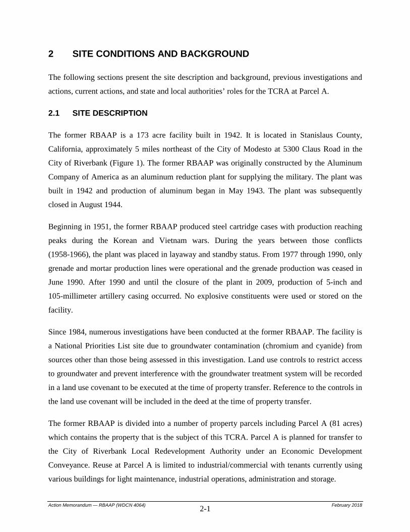
2 SITE CONDITIONS AND BACKGROUND
The following sections present the site description and background, previous investigations and
actions, current actions, and state and local authorities’ roles for the TCRA at Parcel A.
2.1 SITE DESCRIPTION
The former RBAAP is a 173 acre facility built in 1942. It is located in Stanislaus County,
California, approximately 5 miles northeast of the City of Modesto at 5300 Claus Road in the
City of Riverbank (Figure 1). The former RBAAP was originally constructed by the Aluminum
Company of America as an aluminum reduction plant for supplying the military. The plant was
built in 1942 and production of aluminum began in May 1943. The plant was subsequently
closed in August 1944.
Beginning in 1951, the former RBAAP produced steel cartridge cases with production reaching
peaks during the Korean and Vietnam wars. During the years between those conflicts
(1958-1966), the plant was placed in layaway and standby status. From 1977 through 1990, only
grenade and mortar production lines were operational and the grenade production was ceased in
June 1990. After 1990 and until the closure of the plant in 2009, production of 5-inch and
105-millimeter artillery casing occurred. No explosive constituents were used or stored on the
facility.
Since 1984, numerous investigations have been conducted at the former RBAAP. The facility is
a National Priorities List site due to groundwater contamination (chromium and cyanide) from
sources other than those being assessed in this investigation. Land use controls to restrict access
to groundwater and prevent interference with the groundwater treatment system will be recorded
in a land use covenant to be executed at the time of property transfer. Reference to the controls in
the land use covenant will be included in the deed at the time of property transfer.
The former RBAAP is divided into a number of property parcels including Parcel A (81 acres)
which contains the property that is the subject of this TCRA. Parcel A is planned for transfer to
the City of Riverbank Local Redevelopment Authority under an Economic Development
Conveyance. Reuse at Parcel A is limited to industrial/commercial with tenants currently using
various buildings for light maintenance, industrial operations, administration and storage.

Action Memorandum — RBAAP (WDCN 4064) February 2018 2-2
There are approximately 155 buildings at the former RBAAP with a combined square footage of
over 700,000 square feet. The Main Production Area, which contained the production lines, is
generally composed of Galbestos buildings (some approximately 900 feet in length). Nearly all
other support buildings and structures on RBAAP are located to the north and west of the Main
Production Area.
2.1.1 Removal Site Evaluation
A potential source of PCB contamination at Parcel A is spent hydraulic and dielectric fluid that
was spilled and/or discarded onto the ground surface. Non-liquid PCB contamination in exposed
soil adjacent to Galbestos buildings may also be from Galbestos panels that are used for siding
and roofing of the Main Production Area, Buildings 1 through 8 and many of the attached
structures, as well as Buildings 11, 12, 15, and 43 (Figure 2).
Galbestos is a generic name for a line of products previously manufactured by H.H. Robertson
Company. It consists of a galvanized steel sheet metal product coated under heat and pressure
with a thick envelope of specially refined asphalt, known to contain PCBs, and bonded under
pressure with a coat of heavy asbestos felt along with an application of a waterproof sealing coat.
The Galbestos panels have weathered resulting in a release of non-liquid PCB contamination in
the surrounding soil. Exposed PCB-containing soil has been carried into the stormwater
conveyance system in water runoff resulting in PCB contamination in the stormwater reservoirs
and potentially in sediments remaining in the active stormwater conveyance system (Figure 3).
2.1.2 Physical Location
The former RBAAP occupies a total of 173 acres of land and consists of two noncontiguous
areas. The main facility area which contains Parcel A is 146 acres and the
evaporation/percolation ponds are 27 acres approximately 1.5 miles north of the main facility.
Land use surrounding Parcel A at the main plant area is primarily low-density residential and
agricultural. Townsend Avenue and railroad tracks bound the Main Site to the north, Claribel
Road bounds the site to the south, and Claus Road bounds the site to the west. Land uses to the
north, west, and south of the former RBAAP consist primarily of low- to medium-density
residential home (150 homes per square mile); land use to the east consists primarily of

Action Memorandum — RBAAP (WDCN 4064) February 2018 2-3
grazing/pasture land. California Avenue Elementary School, Riverbank Head Start, and
Riverbank High School are the closest schools at just over 1 mile north of the former RBAAP.
Rainbow Sports Complex is 0.2 miles south of the former RBAAP.
Riverbank, the closest town, has a population of over 22,500 (Suburbanstats.Org, 2017).
The nearest large community is Modesto, California, which is located approximately 5 miles
southwest of the former RBAAP with a population of over 201,000 (Suburbanstats.Org, 2017).
State Highway 99 is located about 10 miles, and Interstate 5 about 20 miles, west of the former
RBAAP.
Most of the main facility area is developed. Much of the ground has been paved or is covered by
other hardscape and structures. What little vegetation occurs in the developed areas is
characterized by nonnative species that provide little habitat value to wildlife species. Bat species
could establish day roosts and/or maternity roosts in abandoned buildings; however no bat
surveys have been conducted to date. No species-specific surveys were conducted during the
2007 biological resource study and no special-status wildlife species were observed (U.S. Army
Corps of Engineers, 2009).
There are no known cultural or historical resources at the former RBAAP (U.S. Army Corps of
Engineers, 2009).
2.1.3 Climate
The climate in Riverbank, California, is warm and generally dry. The rainy season generally
extends from December to April, with a distinct dry season from May to October. The annual
average rainfall is about 12 inches, with monthly averages ranging from 0.02 inch in July to
2.4 inches in January (Modesto Irrigation District, 2017). Winter air temperatures are mild, with
a December average minimum temperature of 39 degrees Fahrenheit (°F) (3.9 Celsius [°C]).
Summer air temperatures are very warm, with a July average maximum temperature of 94°F
(34.4°C). The record low of 18°F (-7.8°C) was in December 1932 and the record high
temperature of 113°F (45°C) was in July 2006 (Intellicast, 2017).

Action Memorandum — RBAAP (WDCN 4064) February 2018 2-4
2.1.4 Topography and Surface Water
The topography of RBAAP and the surrounding area is flat valley land that is generally
featureless. The gradient of the land surface within the facility slopes southwestward at a rate of
25 feet per mile. The average elevation of the former RBAAP is 135 feet above mean sea level.
Runoff from the generally flat area is relatively slow. Much of the incident precipitation is
absorbed by the soil, and very little runoff occurs from the surrounding agricultural lands except
during unusually heavy rains. Runoff from buildings and paved areas of the main facility is
directed to two stormwater reservoirs. Stormwater from the eastern portion of the Main
Production Area drains to the Southeast Stormwater Reservoir which is approximately 200 feet
by 50 feet at the top with a capacity of 378,000 gallons. Stormwater from the western portion of
the Main Production Area and remainder of the former RBAAP is transported to a smaller
collection system that has lift pumps that transfer the stormwater to the Northwest Stormwater
Reservoir. In addition, the permanent and larger Northwest Stormwater Reservoir receives
pumped stormwater from the Southeast Stormwater Reservoir. The Northwest Stormwater
Reservoir is trapezoid shaped and has approximate dimensions of 400 feet, 240 feet, 400 feet and
180 feet on the top four sides with a capacity of 2,500,000 gallons.
2.1.5 Geology
The San Joaquin-Madera Association comprises the soils near the former RBAAP. These two
soil series are sometimes intimately associated and cannot be separated. The San Joaquin Series
is composed of moderately coarse, well-drained soils with silica-iron hardpans. The color of the
soils is reddish brown to brown, and the soils are slightly too moderately acidic. Resting on the
indurated hardpan at a depth between 41 and 76 centimeters is the red to reddish brown clayey
subsoil. The Madera Series is composed of medium to moderately coarse, well-drained soils with
hardpans. The surface soil is usually neutral to brown loam or sandy loam; whereas, the subsoil
is reddish brown to brown sandy clay and is underlain by indurated hardpan (iron and silica with
seams of lime). The material underlying the hardpan is generally compact, stratified sandy loam
that is cemented weakly in spots.
The former RBAAP is located in an area of low alluvial plains and fans less than 2 miles south
of the Stanislaus River in the northeastern part of the San Joaquin Valley. Near-surface deposits

Action Memorandum — RBAAP (WDCN 4064) February 2018 2-5
in the vicinity of the site consist of alluvial fan and river channel deposits originating from
fluvial systems in the higher elevations to the east.
The surficial geology at the former RBAAP consists of unconsolidated Pleistocene nonmarine
sedimentary deposits. These deposits are locally called the Riverbank Formation and Aromas
Red Sands, and consist of gray-to-brown and yellow-to-red sands that are cross-bedded. Locally,
these sands are pebbly with minor percentages of clay and silt. The shallow subsurface geology
consists of similar material. The fluvial depositional environment has resulted in the deposition
of hundreds of feet of interlayered sands, clays, and gravels. Locally, substantial clay layers have
been observed in the subsurface.
2.1.6 Groundwater
The hydrostratigraphy at RBAAP has been investigated through several remedial investigation
phases and subsequent design phases. Results of these investigations are presented in the
Remedial Investigation Report (Roy F. Weston, Inc., 1991) and the Field Data Report
(CH2M HILL, 1996). The presence of discontinuous fine-grained sediment layers creates a
complex groundwater flow pattern in the vicinity of RBAAP. Five zones of relatively coarse-
grained sediments, separated by interbeds of finer-grained material, have been identified at the
site (Roy F. Weston, Inc., 1991) and confirmed with recent in situ well installations by Ahtna
in 2015. These stratigraphic zones vary in continuity, thickness, and depth at RBAAP and appear
to be hydraulically interconnected:
A-Zone: Sand and silty sand; approximately 10 feet thick, extends from approximately 30 to 40 feet below ground surface (bgs).
A/A’-Interzone: Clay and silt; approximately 25 feet thick, extends from approximately 40 to 65 feet bgs.
A’-Zone: Sand and silty sand with clayey silt lenses; approximately 20 feet thick, extends from approximately 65 to 85 feet bgs.
A’/B-Interzone: Clayey silt and clayey sand interbedded with the A’-Zone; approximately 10 feet thick, extends from approximately 80 to 90 feet bgs.
B-zone: Well graded and poorly graded sand; approximately 20 feet thick, extends from approximately 90 to 110 feet bgs.
B/C-Interzone: Clay/silty clay with isolated areas of sandy silt; approximately 10 feet thick, extends from approximately 110 to 120 feet bgs.

Action Memorandum — RBAAP (WDCN 4064) February 2018 2-6
C-Zone: Sand and silty sand with isolated areas of silt and clay; approximately 25 feet thick, extends from approximately 120 to 145 feet bgs.
C/D-Interzone: Silt and clay; approximately 50 feet thick, extends from approximately 145 to 195 feet bgs.
D-Zone: Gravel and clayey gravel; greater than 45 feet thick, top of unit is approximately 195 feet bgs.
Groundwater levels vary annually and have been steadily declining for the last 40 years due to
regional groundwater extraction, primarily for agricultural purposes. Due to the decline in the
water table elevation, the A-Zone is now completely unsaturated. As documented by the
National Integrated Drought Information System, the drought conditions in the Central Valley
area of California are suspected to have contributed to a net decline in the water table elevation
at the site. The California Department of Water Resources reported that the Stanislaus/Calaveras
River Basin only received 55 percent of normal rainfall in the 2015 water year. However, recent
rainfall during the 2016 water year has resulted in water level increases of 1.9 to 5.1 feet from
the 2015 Fourth Quarter to the 2016 Second Quarter.
Groundwater velocities in the A/A’-Zone range 100–400 feet per year. Under non-pumping
conditions, the groundwater generally flows to the west, with a small component to the
southwest. During operation of the extraction system, groundwater velocities remain the same
outside of the capture zone of the pumping wells. Within the capture zones, velocities range
500–700 feet per year due to the increased hydraulic gradient. While the overall direction of
groundwater flow is to the west, there are localized areas within the capture zones in which flow
is to the north or south, depending on the position of the monitoring location relative to the
extraction wells.
B-Zone groundwater velocities range 300–500 feet per year. The direction of this flow is similar
to that in the A/A’-Zone, with a similar response to regional water use patterns. Similar effects to
flow direction due to the extraction system, compared with the A/A’-Zone are seen in the
B-Zone. Localized groundwater velocities within the capture zones can approach 750–1,000 feet
per year.

Action Memorandum — RBAAP (WDCN 4064) February 2018 2-7
2.2 RELEASE OR THREATENED RELEASE INTO THE ENVIRONMENT OF A HAZARDOUS SUBSTANCE OR POLLUTANT OR CONTAMINANT
As discussed above in Section 2.1.1, PCB contamination is a result of liquid and non-liquid
sources at the former RBAAP. The exposed PCB-containing soil has been carried into the
stormwater conveyance system in water runoff resulting in PCB contamination in the stormwater
reservoirs and potentially in sediments remaining in the active stormwater conveyance system
(Figure 3). With every rain event, there is a re-release of exposed PCB-containing soil in this
manner. PCBs have been detected inside and outside the buildings constructed with Galbestos
panels, Buildings 1 through 8, 11, 12, 15, 43, and attached structures, as well as the Southeast
and Northwest Stormwater Reservoirs.
Total PCB concentrations from sampling activities to date compared to the cleanup goal of
1 mg/kg for high occupancy areas are shown on Figure 4 for the exposed soil area south of
Building 6 and the Southeast Stormwater Reservoir, and Figure 5 for the Northwest Stormwater
Reservoir. The planned removal areas are also shown on Figures 4 and 5. The remaining areas
not planned for removal in and around the Galbestos buildings are covered by concrete, asphalt,
gravel, railroad ballast or structures. The exposure pathways by which potential receptors may
come into contact with soil or sediment containing PCBs is dermal contact, incidental ingestion
and inhalation. Removal of exposed PCB contaminated soil and sediment will prevent future
exposure.
2.3 NATIONAL PRIORITIES LIST STATUS
The National Priorities List is a list developed by the EPA of hazardous waste sites nationwide
that pose the greatest risks to public health and, therefore, warrant priority responses under
CERCLA. The EPA added the former RBAAP to the National Priorities List on
February 21, 1990, primarily due to the presence of groundwater contamination (cyanide and
chromium) detected on and off the former RBAAP. The CERCLIS Identification Number for
former RBAAP is CA7210020759. The TCRA to remove PCB-contaminated soil and sediment
is not associated with the groundwater contamination; however, the actions described in this AM
will be conducted under the CERCLA and NCP regulatory process.
Action Memorandum — RBAAP (WDCN 4064) February 2018 2-8
2.4 PREVIOUS INVESTIGATIONS AND RESPONSE ACTIONS
Previous investigations associated with the Galbestos buildings and stormwater reservoirs are
described below. With the exception of removed sediment at the Southeast Stormwater Reservoir
discussed in Section 2.4.4, combined total PCB results from the investigations discussed below
are presented on Figures 4 and 5. Results for chromium and lead are presented on Figures 6
and 7, respectively.
2.4.1 Environmental Baseline Survey
During the Environmental Baseline Survey (Norris-Riverbank Environmental, 1998), five soil
samples were collected from the graveled areas just outside Building 11 along the south and west
sides. All samples were collected from below the gravel in surface soil to 1 foot in depth.
The samples were analyzed for total recoverable petroleum hydrocarbons; gasoline; diesel;
volatile organic compounds ([VOCs] which included benzene, toluene, ethylbenzene and total
xylenes); pesticides; PCBs; cyanide; hexavalent chromium; lead; chromium; zinc; and nickel.
Total recoverable petroleum hydrocarbons, gasoline, diesel, VOCs, pesticides, cyanide, and
hexavalent chromium were not detected. Detected metal results were consistent with the RBAAP
background levels and/or below established criteria for hazardous waste. Aroclor 1260 was
detected in all five samples from 0.4 to 1.0 mg/kg. Additional sampling was recommended to
determine the vertical and lateral extent of Aroclor 1260 (Norris-Riverbank
Environmental, 1998). The total PCB results for surface soil samples are shown on Figure 4.
2.4.2 Site Investigation
During the Site Investigation in 2007 (CH2M HILL, 2008), additional sampling was conducted
at two locations near the previous sampling at Building 11 to determine the extent of
Aroclor 1260. Samples were collected from 0 to 0.5 feet (beneath the asphalt and a thin layer of
gravel fill) and 2.5 to 3 feet at both locations. Aroclor 1260 was not detected at the sample
location farthest from Building 11. Aroclor 1260 was reported at 0.038 mg/kg and 0.030 mg/kg
for the 0 to 0.5 foot and 2.5 to 3 foot sample, respectively at the location closest to Building 11
(CH2M HILL, 2008). The total PCB results for surface and subsurface soil samples are shown
on Figure 4.

Action Memorandum — RBAAP (WDCN 4064) February 2018 2-9
2.4.3 Resource Conservation and Recovery Act Facility Investigation Report
The Installation Assessment referenced a 1974 Army Environmental Hygiene Agency report
regarding industrial wastewater of the RBAAP. As noted in the Installation Assessment, one
segment of the Army Environmental Hygiene Agency study examined the chemical analysis of a
water sample from the Northwest Stormwater Reservoir. Elevated levels of heavy metals were
cited as a possible source of contamination. Sampling efforts were conducted during Phase I of
the Remedial Investigation to verify the presence of sediment contamination in the reservoir and
to determine the potential for contaminant migration. Two sediment samples were taken from the
reservoir and analyzed for total and hexavalent chromium; total and free cyanide;
1,1-dichloroethylene; and the organic persistent and bioaccumulative toxic substances listed in
California Title 22 California Code of Regulations. Although total chromium was reported in the
sediment samples at levels greater than three times background levels, the reservoir is not
considered a source of groundwater contamination based on California’s Designated Level
Methodology, which models the potential impact of contaminated soils on groundwater. In 1993,
it was discovered that a cross-connection between the industrial wastewater system and the
stormwater conveyance system was present in an in-line cistern leading to the Northwest
Stormwater Reservoir. As a result, the 40,000-gallon cistern was pumped out and cleaned with a
soap solution.
The Feasibility Study recommended no further action for the reservoir, as is documented in the
final sitewide Record of Decision, which concluded that remedial action was not warranted in
this area based on the Remedial Investigation findings. DTSC concurred with the position of the
Army (as detailed in the April 15, 1996, Revision 2 of the RFI Phase 1 Work Plan) that no
further action was required at the Northwest Stormwater Reservoir (CH2M HILL, 2002).
2.4.4 Resource Conservation and Recovery Act Facility Investigation
During the investigation efforts at Area of Concern 16 (Substation 5) which included the
Southeast Stormwater Reservoir, a sediment sample was collected from the northern end of the
Southeast Stormwater Reservoir. PCBs were detected at 4.5 mg/kg and additional sampling was
conducted as part of the Resource Conservation and Recovery Act (RCRA) Facility Investigation
at Area of Concern 16.

Action Memorandum — RBAAP (WDCN 4064) February 2018 2-10
PCB concentrations reported in sediment samples taken in 2003 from the Southeast Stormwater
Reservoir were greater than the Industrial Preliminary Remediation Goals that were applicable
during the sampling event. The results also indicated that PCB contamination above the
Industrial Preliminary Remediation Goals was limited to shallow sediments. A total of 15 cubic
yards of material was excavated from the Southeast Stormwater Reservoir and disposed at an
offsite Class I landfill. PCBs were not detected in confirmation samples and no further action
was recommended in the Final RFI (Army, 2006).
2.4.5 Initial Galbestos Related Sampling
Initial sampling of Galbestos was conducted by Weston Solutions, Inc. (WESTON) in 2009 to
determine the concentrations of non-liquid PCBs in the panels. Bulk samples were collected
from the siding of buildings in the Main Production Area as well as Buildings 11 and 43. Bulk
samples from Galbestos Buildings 1 through 8, 11, and 15 confirmed the presence of non-liquid
PCBs, including both Aroclor 1260 and Aroclor 1268, in the building materials.
Follow-on activities conducted in 2010 included sampling air, nonporous surfaces (wipes),
concrete, soil and dust in the Galbestos Buildings 1 through 8, 11 and 15. Building 12 was not
known to contain Galbestos panels at the time of this sampling; therefore, was not included in
the sampling efforts. With the exception of the indoor and outdoor air samples, at least one
Aroclor was detected in the remaining sampling media (WESTON, 2010). The sample results
were as follows:
At least one of Aroclors 1254, 1260 or 1268 was detected in all wipe samples collected
on Galbestos panels of each building.
At least one of Aroclors 1254, 1260 or 1268 was detected in all but two bulk concrete
samples.
Aroclors 1260 and 1268 were detected in all but one bulk dust sample.
Aroclors 1260 and 1268 were detected in all surface soil samples collected outside of
Galbestos Buildings 6, 7, 8, 11 and 15.
The total PCB results for surface soil samples are shown on Figure 4.

Action Memorandum — RBAAP (WDCN 4064) February 2018 2-11
2.4.6 USACE Galbestos Investigation
Bulk Galbestos panels were confirmed to contain both Aroclor 1260 and Aroclor 1268 during the
Galbestos investigation conducted by the U.S. Army Corps of Engineers (USACE, 2010). Total
PCBs (includes Aroclor 1260 and 1268 as well as other detected Aroclor mixtures) were detected
in every surface soil sample collected adjacent to Galbestos Buildings 6, 7, 8, and 12. Total
PCBs were also detected in the sediment samples collected from the storm drain inlets south of
Building 6 as well as in the Southeast and Northwest Stormwater Reservoirs. Total PCB
concentrations in all surface soil samples collected near the Galbestos buildings and the sediment
samples from the storm drain inlets south of Building 6 were greater than the cleanup goal of
1 mg/kg for high occupancy areas. Total PCB concentrations in all but one sediment sample
from the interior of the reservoirs exceeded the cleanup goal of 1 mg/kg. The report
recommended removal of Galbestos panels and further delineation of PCBs in soil adjacent to
the buildings and in the stormwater conveyance system (USACE, 2010). The total PCB results
for samples from this investigation are shown on Figures 4 and 5.
2.4.7 Soil Investigation
Soils adjacent to Buildings 6 and 8 in the Main Production Area were sampled by WESTON in
2011 to determine the potential impact from non-liquid PCBs which are found in the Galbestos
siding and roofing materials of these buildings. Elevated levels of Aroclor 1260 and/or
Aroclor 1268 were reported in all but two sample locations which were sampled at the surface to
one foot bgs.
To determine the nature and extent of PCBs, additional surface and subsurface sampling was
conducted by the USACE throughout the former RBAAP. Soil samples across the site were also
analyzed for volatile organic compounds (VOCs) and metals, to determine their absence or
presence. All sample locations were in areas with exposed soil or where soil could be accessed
without concrete/asphalt coring. Aroclor 1260 and Aroclor 1268 were reported at concentrations
greater than the cleanup goal of 1 mg/kg for high occupancy areas in surface and subsurface soils
at locations south of Building 6 and east of Building 8.

Action Memorandum — RBAAP (WDCN 4064) February 2018 2-12
Acetone and 2-butanone were reported in several soil samples; however, these VOCs are
common laboratory contaminants and were not detected at concentrations greater than the
residential or industrial RSLs. The VOC, m,p-xylene was reported in one soil sample, the
concentration was less than both the residential and industrial RSL. Of the metals analyzed,
arsenic, chromium, and lead exceeded the background and or RSL values. The background value
for arsenic of 5.5 mg/kg is greater than the residential and industrial RSLs. The highest arsenic
values were located along the rail lines and the western fence line which are likely a result of
railroad ties treated with an arsenic containing preservative and/or the intended application of an
arsenical pesticide and not associated with a release from industrial activities. Total chromium
concentrations were compared to the background value of 34 mg/kg. The only samples with
chromium concentrations greater than the background value were located adjacent to Buildings 6
and 8 in the Main Production Area. The chromium results did not exceed the cleanup standard of
300 mg/kg being used for Operable Unit 2 at the nearby Defense Distribution Depot San
Joaquin-Sharpe facility in Lathrop, California (URS Group, Inc., 2011). Lead was detected at
four soil sample locations exceeding the 2016 DTSC recommended screening level of 320 mg/kg
for commercial/industrial soil (DTSC, 2016). The lead exceedances are located on the east side
of Building 8 below railroad ballast. The report recommended further evaluation to delineate the
extent of chromium, lead, and PCBs near Buildings 6 and 8 in the Main Production Area
(USACE, 2013). The total PCB results for samples from this investigation are shown on
Figure 4, chromium results are shown on Figure 6, and lead results are shown on Figure 7.
2.4.8 Additional Soil PCB Characterization
In 2013, WESTON collected subsurface soil samples from the exposed soil area south of
Building 6 and below the railroad ballast east of Building 8 to further delineate the vertical and
lateral extent of PCBs. Aroclors 1260 and/or 1268 were reported in all samples. Total PCBs,
which include the sum of all Aroclor mixtures, were reported at concentrations greater than the
cleanup goal of 1 mg/kg for high occupancy areas in most samples near the buildings. Total PCB
concentrations reduced to less than or approaching the RSL at 3 feet below the ground surface
with the highest concentration of 2.5 mg/kg reported at this depth. Only Aroclor 1260 was
reported at concentrations greater than the cleanup goal of 1 mg/kg in samples at three feet below

Action Memorandum — RBAAP (WDCN 4064) February 2018 2-13
the ground surface. The total PCB results for samples from this investigation are shown on
Figure 4.
2.5 CURRENT INVESTIGATIONS AND RESPONSE ACTIONS
Cleanup of PCBs from the interior of Galbestos buildings at the former RBAAP is part of a
phased approach. Over 5,000 tons of equipment containing PCB-contaminated paint and other
PCB waste were removed from the interior of Galbestos buildings and disposed under the
2012 TSCA risk-based approval (EPA, 2012). Work associated with the 2015 TSCA risk-based
approval (EPA, 2015) is currently being conducted to clean the interior building structures and
remove the exterior Galbestos siding and roofing for disposal. To prevent re-contaminating the
removal area south of Building 6, Galbestos panels from the adjacent Buildings 6 and 8 will be
removed before the soil excavation for the TCRA is initiated. Galbestos panels from the
remainder of the buildings will be removed before the stormwater conveyance system is cleaned.
In addition to work being conducted under the 2015 TSCA risk-based approval, a removal action
has been completed south of Parcel A to remove PCB contaminated soil. The area was used for
worker parking at times during the history of the RBAAP. It is believed that oil containing PCBs
may have been used for dust suppression in the parking areas (Army, 2014).
2.6 STATE AND LOCAL AUTHORITIES’ ROLES
Federal Executive Order 12580 delegates to the DoD the President’s authority to undertake
CERCLA response actions. Congress further outlined this authority in its Defense Environmental
Restoration Program Amendments, which can be found at 10 USC § 2701, et seq. Both
CERCLA § 120(f) and 10 USC § 2705 require the Army to ensure that state and local officials
be given timely opportunity to review and comment on response actions being conducted at its
facilities.
2.6.1 Regulatory Agency Actions to Date
The Army, in accordance with the Federal Facilities Site Remediation Agreement, has conducted
remedial actions for various sites at the former RBAAP. The Army is the lead federal agency,

Action Memorandum — RBAAP (WDCN 4064) February 2018 2-14
and EPA is identified in the Federal Facilities Site Remediation Agreement as the lead regulatory
agency with the Regional Water Board and DTSC as support agencies.
2.6.2 Potential for Continued Regulatory Agency Response
On July 2, 1993, President Clinton announced a five-point program to speed the economic
recovery of communities where military bases are scheduled to close. Part of this five-point
program includes the formation of the Base Realignment and Closure (BRAC) Cleanup Team.
The BRAC Cleanup Team is composed of the Army, EPA, Regional Water Board and DTSC.
The EPA, Regional Water Board, and DTSC will continue to provide input through review of
removal action and site investigation documents and participate in the BRAC Cleanup Team.
The purpose of the BRAC Cleanup Team is to expedite cleanup and to facilitate property transfer
and/or sale.

Action Memorandum — RBAAP (WDCN 4064) February 2018 3-1
3 THREATS TO PUBLIC HEALTH OR WELFARE OR THE ENVIRONMENT
PCBs are categorized as hazardous substances under CERCLA. They are also regulated as toxic
substances under Section 313 of Title II of the Superfund Amendments and Reauthorization Act.
In accordance with the NCP, the following threats must be considered in determining the
appropriateness of a removal action (40 CFR § 300.415(b)(2)):
Actual or potential exposure to hazardous substances, pollutants, or contaminants by
nearby populations, animals, or food chains;
Actual or potential contamination of drinking water supplies or sensitive ecosystems;
Hazardous substances or pollutants or contaminants in drums, barrels, tanks, or other
bulk storage containers, that may pose a threat of release;
High levels of hazardous substances or pollutants or contaminants in soils largely at or
near the surface that may migrate;
Weather conditions that may cause hazardous substances or pollutants or contaminants to
migrate or be released;
Threat of fire or explosion;
The availability of other appropriate federal or state response mechanisms to respond to
the release; and
Other situations or factors that may pose threats to public health or welfare or the
environment.
In accordance with the NCP, this section considers the factors that may impact the public health,
welfare, or the environment in determining the appropriateness of a removal action. Potential
risks to human health and the environment posed by exposed chemically-contaminated soil at the
former RBAAP are discussed in this section. Following the completion of the TCRA, these risks
will be re-evaluated.
3.1 THREATS TO PUBLIC HEALTH OR WELFARE
Of the factors listed above, the following three NCP factors potentially apply to the PCB
contamination in exposed soil at Parcel A:

Action Memorandum — RBAAP (WDCN 4064) February 2018 3-2
Actual or potential exposure to nearby human populations from hazardous substances,
pollutants or contaminants
High levels of hazardous substances or pollutants or contaminants in soils largely at or
near the surface that may migrate
Weather conditions that may cause hazardous substances or pollutants or contaminants to
migrate or be released
A human health risk assessment has not been completed to address risk from PCBs at the former
RBAAP and there are no known health effects linked to exposure of PCBs with the current
industrial users at the property. However, exposed surface and subsurface soil are contaminated
with PCBs at concentrations greater than the cleanup goal of 1 mg/kg for high occupancy areas
as set forth in the TSCA regulations at 40 CFR § 761.61(a)(4)(i)(A).
Exposed soil carrying PCBs will continue to migrate into the active stormwater conveyance
system from rainwater runoff resulting in increased PCB contamination in the stormwater
collection system and reservoirs. PCB-contaminated soil may be carried into the interior of
adjacent occupied buildings as windblown dust or from vehicle tires and foot traffic from the
exposed soil areas. The Galbestos buildings are being cleaned and remediated under the 2015
TSCA risk-based approval (EPA, 2015). A TCRA to excavate PCB-contaminated exposed soil
will prevent the potential for PCB migration and possible recontamination of the interior of the
buildings and further contamination of the stormwater conveyance system and reservoirs.
Removal of PCB-contaminated sediments from the stormwater conveyance system will prevent
potential migration of PCB-contaminated sediments carried in the stormwater if the reservoirs
overflow.
3.2 THREATS TO THE ENVIRONMENT
The Parcel A area is fenced and with the exception of the landfill and exposed soil east of
Building 12 and south of Building 6, the remainder of Parcel A is covered with concrete, asphalt,
gravel, railroad ballast or structures. Given the fencing, hardscape, and constant activities, the
industrial area is not a suitable habitat for animals. What little vegetation occurs in the developed
area of Parcel A is characterized by nonnative species that provide little habitat value to wildlife
species.

Action Memorandum — RBAAP (WDCN 4064) February 2018 3-3
The Northwest Stormwater Reservoir may provide marginal nesting habitat for tricolored
blackbirds; however no special-status wildlife species were observed at the Riverbank Army
Ammunition Plant property during the 2007 Biological Resource Study (U.S. Army Corps of
Engineers, 2009). In addition, the lack of emergent marsh habitat in the Northwest Stormwater
Reservoirs limits the nesting potential to a few individual tricolored blackbirds which tend to
form only in large dense colonies.
Action Memorandum — RBAAP (WDCN 4064) February 2018 4-1
4 ENDANGERMENT DETERMINATION
Assessments of threats are summarized in Section 3 and other information contained in
documents prepared for previous investigations presented in Section 2.4.
Exposed soil containing PCBs, if not addressed by implementing the response action selected in
this AM, may present an imminent and substantial endangerment to public health and welfare.
The most likely pathways by which potential receptors may come into contact with soil or
sediment containing PCBs is dermal contact, incidental ingestion and inhalation. Removal of
exposed PCB contaminated soil, followed by removal of sediment from the active stormwater
conveyance system and stormwater reservoirs, will prevent future exposure, potential re-
contamination of adjacent occupied buildings, increased contamination of the stormwater
reservoirs and conveyance system, and potential for migration if the reservoirs overflow, as well
as facilitate additional reuse of the RBAAP Main Production Area by the Riverbank Local
Redevelopment Authority.

Action Memorandum — RBAAP (WDCN 4064) February 2018 5-1
5 PROPOSED ACTIONS AND ESTIMATED COSTS
The proposed actions, contribution to remedial performance, Applicable or Relevant and
Appropriate Requirements (ARARs), project schedule, estimated costs and justification for
proposed actions are discussed in the following sections.
5.1 PROPOSED ACTIONS
Excavation of exposed PCB-contaminated soil and sediment will mitigate the threat to human
health and welfare by direct human contact, accidental ingestion, and inhalation of airborne
particles. Other remedial alternatives to address the PCB contamination at the former RBAAP
include no action and capping. No action does not provide protection or comply with ARARs.
Capping provides for protection by controlling the pathway; however, long-term management
controls are necessary to ensure the cap remains protective in the future. In addition, capping
PCB contamination does not reduce the toxicity, mobility, or volume through treatment.
Consistent with previous actions to address PCBs at the former RBAAP, including the most
recent removal action south of Parcel A, excavation of PCB contamination followed by
appropriate disposal satisfies the most acceptance criteria for alternatives that are feasible.
The proposed TCRA activities are listed below and further detailed in the Work Plan (WESTON,
2018) being submitted as a separate document. The proposed TCRA field activities are as
follows:
Additional subsurface characterization south of Building 6 and in the Southeast and
Northwest Stormwater Reservoirs to determine the vertical extent of PCB contamination.
Soil excavation south of Building 6 (Figure 4).
Confirmation sampling and analysis of PCBs in the removal area south of Building 6 to
verify that PCB-contaminated soil has been removed to concentrations that are acceptable
for industrial soil, followed by additional removal and confirmation sampling where
necessary. Analysis for total chromium and lead will be performed on the final
confirmation samples.
Waste profile sampling and analysis of excavated soil and final disposition at an
appropriate offsite facility.

Action Memorandum — RBAAP (WDCN 4064) February 2018 5-2
Backfill the area south of Building 6 to the original contour.
Sediment removal and flushing of the active stormwater conveyance system.
Sediment excavation in the Southeast and Northwest Stormwater Reservoirs (Figures 4
and 5).
Confirmation sampling and analysis of PCBs in the reservoir removal areas to verify that
PCB-contaminated sediment has been removed to concentrations that are acceptable for
industrial soil, followed by additional removal and confirmation sampling where
necessary.
Waste profile sampling and analysis of removed materials from the stormwater
conveyance system and reservoirs and final disposition at an appropriate offsite facility.
The TCRA will not affect ongoing tenant activities at the former RBAAP facility. The planned
removal area south of Building 6 is currently being used for activities necessary to conduct the
TSCA cleanup described in Section 2.5. There are no tenants currently in Building 6 and limiting
access to the planned removal areas do not affect any operations.
Best management practices will be employed and inspected throughout the TCRA to prevent the
potential for contaminant migration. Excavated and stockpiled soil will be wet or sprayed with a
soil stabilizer as needed when conducting soil removal. Stockpiled soil will be covered or
sprayed with a soil stabilizer when not being accessed. Other best management practices include
cleaning vehicle tires and covering soil being hauled offsite. Excavation will not be conducted
during rain events when the excavated soil is wet enough to produce runoff or when wind speeds
make dust suppression unmanageable.
Further characterization sampling will be conducted to provide additional information regarding
the extent of PCB contamination at the planned removal areas. For planning purposes, an
average two feet of soil south of Building 6 is anticipated to require removal resulting in
approximately 12,700 cubic yards of soil with PCB concentrations greater than the cleanup goal
of 1 mg/kg. An average one foot of sediment in the Southeast and Northwest Stormwater
Reservoirs is anticipated to require removal resulting in approximately 4,400 cubic yards of
sediment with PCB concentrations greater than the cleanup goal of 1 mg/kg. Removed soil and
sediment will be disposed at a TSCA-approved landfill without sampling or RCRA Subtitle C

Action Memorandum — RBAAP (WDCN 4064) February 2018 5-3
landfill. Unsampled soil/sediment will be assumed to contain total PCBs at concentrations equal
to or greater than 50 mg/kg. PCB remediation wastes confirmed by sampling to contain less than
50 mg/kg total PCBs may be transported in end dumps or roll off bins to a state-permitted solid
waste landfill. Access to the removal areas south of Building 6 and the Southeast Stormwater
Reservoir will be at the gate south of the main entrance which will be limited to traffic related to
disposal activities for the TCRA. Haul trucks will avoid residential areas by proceeding west on
Claribel Road and Kiernan Avenue to Highway 99 southbound toward Bakersfield, then east to
the disposal facility via State of California and Nevada highways. Access to the removal area at
the Northwest Stormwater Reservoir will be at the gate leading to the reservoir.
5.2 CONTRIBUTION TO REMEDIAL PERFORMANCE
To avoid the potential for re-contamination, this TCRA will not be initiated in the area adjacent
to Buildings 6 and 8 until the Galbestos panels have been removed from the southern sides of
those buildings. In addition, Galbestos panels from the remaining buildings in the Main
Production Area as well as Buildings 11, 12, 15 and 43 will be removed before the stormwater
conveyance system is cleaned. As part of a phased response, exposed soil south of Building 6
and sediments from the active stormwater conveyance system will be removed and the piping
will be flushed before removal of sediment from the stormwater reservoirs.
The TCRA is consistent with the anticipated final remedy and will mitigate the potential for
direct contact or inhalation of PCB-contaminated media in the areas with exposed soil/sediment.
Other areas potentially containing PCBs in soil are covered by hardscape including concrete,
asphalt, gravel, railroad ballast or structures which prevent direct contact or transport of
contamination.
In addition to removal of PCBs south of Building 6, chromium reported above the background
concentration of 34 mg/kg will be removed during the TCRA. Chromium results were not
reported at concentrations greater than the screening level of 300 mg/kg being used for the
TCRA. The total chromium value of 300 mg/kg was used as the cleanup standard for Operable
Unit 2 at the nearby Defense Distribution Depot San Joaquin-Sharpe facility in Lathrop,
California (URS Group, Inc., 2011). Lead results were not reported at concentrations greater than
the 2016 DTSC recommended screening level of 320 mg/kg for commercial/industrial soil.
Action Memorandum — RBAAP (WDCN 4064) February 2018 5-4
However, both chromium and lead will be analyzed in the final confirmation samples in the
removal area. The addition of chromium and lead to the final confirmation sample analyses will
fulfill the additional sampling at Building 6 as recommended in the Soil Investigation Report
(USACE, 2013).
5.3 APPLICABLE OR RELEVANT AND APPROPRIATE REQUIREMENTS
ARARs are an integral part of the CERCLA process and will substantively guide the cleanup
action. ARARs fall into three categories, depending on the specific site characteristics, location,
and proposed actions, as follows:
Chemical-Specific—Establish numerical standards that limit the concentrations of
substances in the medium of concern or medium affected by the action.
Location-Specific—Refer to restrictions placed on the concentration of substances or
conduct of an action relating to site location.
Action-Specific—Deal with technology- or activity-based restrictions controlling the
performance and design standards of a specific cleanup action.
A discussion of the chemical-specific, location-specific, and action-specific ARARs is presented
in Appendix A.
5.4 PROJECT SCHEDULE
Pending regulatory review, fieldwork is planned to begin in late February and be completed by
the end of June 2018.
5.5 ESTIMATED COSTS
The Army has made an estimate of the costs for the removal action based on estimates of capital
costs and labor expenses. Direct costs include the field activities.
The estimated costs for the selected action are as follows:
Project Management $ 450,000 Meetings $ 20,000 Documentation (AM, Work Plan, Completion Report) $ 450,000

Action Memorandum — RBAAP (WDCN 4064) February 2018 5-5
Field Work $ 3,200,000 Off-Site Transportation & Disposal $ 2,000,000 Community Relations Support $ 20,000 TOTAL $ 6,140,000
5.6 JUSTIFICATION FOR PROPOSED ACTION
The planned future land use at RBAAP Parcel A is limited to industrial/commercial with tenants
using various buildings for light maintenance, industrial operations, administration and storage.
The proposed action will substantially reduce the threat to human health and welfare by
mitigating the risk from direct contact, inhalation and accidental ingestion of PCB-contaminated
soil and sediment.

Action Memorandum — RBAAP (WDCN 4064) February 2018 6-1
6 PUBLIC INVOLVEMENT
This section discusses the expected change in the situation should action be delayed or not taken
as well as public information and participation.
6.1 EXPECTED CHANGE IN THE SITUATION SHOULD ACTION BE DELAYED OR NOT TAKEN
Should action be delayed or not taken at the former RBAAP, the potential for exposure to PCBs
will not be reduced. The nature of the threat from PCBs may increase if flooding occurs and the
Northwest Stormwater Reservoir overflows to the surrounding soil. During dry months, transport
of PCB-contaminated soil may occur in the form of airborne dust.
6.2 PUBLIC INFORMATION
To gain a more thorough understanding of the activities associated with the TCRA, the public
may review documents found online at http://www.riverbanklra.org/services/doclibrary.html or
at the following location:
Riverbank Local Redevelopment 5300 Claus Road Riverbank, California (209) 863-8352
In compliance with the requirements of 40 CFR §§ 300.415(n)(2) and 300.820(b), a public notice
will be published in The Modesto Bee within 60 days of the field action to describe the TCRA
activities. Written comments received from the regulatory agencies on the Draft AM and the
Army’s responses are included in Appendix B.

Action Memorandum — RBAAP (WDCN 4064) February 2018 7-1
7 OUTSTANDING POLICY ISSUES
No outstanding policy issues have been identified at this time.

Action Memorandum — RBAAP (WDCN 4064) February 2018 8-1
8 RECOMMENDATION
This AM documents the Army’s decision to undertake a TCRA to remove PCB-contaminated
soil and sediment in Parcel A at the former RBAAP. It was developed in accordance with the
substantive requirements of CERCLA as amended, and is not inconsistent with the NCP. This
action memorandum supports the following removal activities in Parcel A:
Additional subsurface characterization south of Building 6 and in the Southeast and
Northwest Stormwater Reservoirs to determine the vertical extent of PCB contamination.
Soil excavation south of Building 6 (Figure 4).
Confirmation sampling and analysis of PCBs in the removal area south of Building 6 to
verify that PCB-contaminated soil has been removed to concentrations that are acceptable
for industrial soil, followed by additional removal and confirmation sampling where
necessary.
Waste profile sampling and analysis of excavated soil and final disposition at an
appropriate offsite facility.
Backfill the area south of Building 6 to the original contour.
Sediment removal and flushing of the active stormwater conveyance system.
Sediment excavation in the Southeast and Northwest Stormwater Reservoirs (Figures 4
and 5).
Confirmation sampling and analysis of PCBs in the reservoir removal areas to verify that
PCB-contaminated sediment has been removed to concentrations that are acceptable for
industrial soil, followed by additional removal and confirmation sampling where
necessary.
Waste profile sampling and analysis of removed materials from the stormwater
conveyance system and reservoirs and final disposition at an appropriate offsite facility.

Action Memorandum — RBAAP (WDCN 4064) February 2018 8-2
A TCRA is necessary to address risk to public health and welfare due to the potential for
exposure to PCB-contaminated soil and sediment. This decision document presents the selected
removal action of PCB-contaminated soil and sediment in Parcel A of the former RBAAP,
developed in accordance with CERCLA, as amended, and is not inconsistent with the NCP. This
decision is based on the administrative record for the site.
Thomas E. Lederle Date Division Chief Base Realignment and Closure Division

Action Memorandum — RBAAP (WDCN 4064) February 2018 9-1
9 REFERENCES
California Environmental Protection Agency Department of Toxic Substances Control, Human and Ecological Risk Office. 2016. Human Health Risk Assessment Note Number: 3, DTSC-modified Screening Levels. June.
CH2M HILL. 1996. Riverbank Army Ammunition Plant, Field Data Report.
CH2M HILL. 2002. RCRA Facility Investigation Current Conditions Report, Riverbank Army Ammunition Plan, Riverbank, California. October.
CH2M HILL. 2008. Site Investigation Report, Riverbank Army Ammunition Plant, Riverbank, California. March.
Intellicast. 2017. “Monthly Averages and Records, Modesto California.” http://www.intellicast.com/local/history.aspx?location=USCA0714
Modesto Irrigation District. 2017. Weather Data. “Historical Rainfall Data for Years 1888 to 2017.” http://www.mid.org/weather/wthr-hist2.jsp
Norris-Riverbank Environmental. 1998. Environmental Baseline Survey Phase I Environmental Assessment Report, Facility: Building 11. January 12.
Roy F. Weston. 1991. Riverbank Army Ammunition Plant Remedial Investigation Report. July.
Suburbanstats.Org. 2017. “Population Demographics for California 2017 and 2016.” https://suburbanstats.org/population/how-many-people-live-in-california. Content provided by the U.S. Census Bureau.
URS Group, Inc. 2011. Final Amendment to the Record of Decision Basewide Remedy for Defense Distribution Depot San Joaquin—Sharpe Site (Operable Unit 2 – Soils). June.
U.S. Army. 2006. U.S. Army BRAC 2005 Environmental Condition of Property Phase 1 Report, Riverbank Army Ammunition Plant. Prepared by CH2M Hill. November 17.
U.S. Army. 2014. Update of the U.S. Army BRAC 2005 Environmental Condition of Property Phase I Report Economic Development Conveyance Parcels, Parcel A (Industrial Area) and NW Storm Water Reservoir Site, Riverbank Army Ammunition Plant, Riverbank, California. August.
U.S. Army Corps of Engineers. 2009. Environmental Assessment for BRAC 05 Disposal and Reuse of the Riverbank Army Ammunition Plant, California. March.
U.S. Army Corps of Engineers. 2010. Draft Final Galbestos Investigation Report, Riverbank Army Ammunition Plant, Riverbank, CA. December.
U.S. Army Corps of Engineers. 2013. Draft Final EDC Property & Sale Parcels 2 & 2A Soil Investigation Report, Riverbank Army Ammunition Plant, Riverbank, CA. January.
Action Memorandum — RBAAP (WDCN 4064) February 2018 9-2
U.S. Environmental Protection Agency (EPA). 2009. Superfund Removal Guidance for Preparing Action Memoranda. Office of Solid Waste and Emergency Response (OSWER) Directive 9360.0-42. September.
EPA. 2012. Letter from Jeff Scott of the EPA to Warren Switzer of the Army. “Re: Toxic Substances Control Act (TSCA) – Polychlorinated Biphenyls (PCBs) May 10, 2012 Request for TSCA Risk-Based Disposal and Decontamination Approval Removal of PCB-Containing Galbestos Siding and Cleanup of Residual Siding Particles from Building and Equipment Riverbank Army Ammunition Plant (PCB Cleanup Document) – USEPA R9 Phased Approval.” Including Amendments. September 4.
EPA. 2015. Letter from Jeff Scott of the EPA to Warren Switzer of the U.S. Army and Debbie Olson, of the Riverbank Local Redevelopment Authority. “Subject: Riverbank Army Ammunition Plant – Toxic Substances Control Act Cleanup of Polychlorinated Biphenyls (PCBs), Final Amendment 1 to EPA’s July 2015 Approval.” Including Amendments. December 15.
Weston Solutions, Inc. 2010. “Riverbank Army Ammunition Plant – Phase II Sampling Activities Letter Report.” April 9.
Weston Solutions, Inc. 2018. Final Work Plan Parcel A Soil/Sediment Time-Critical Removal Action, Former Riverbank Army Ammunition Plant, City of Riverbank, Stanislaus County, California. February.

FIGURES

³ 0 1,000 2,000500Feet
CLA
US
RD
PATTERSON RD
CLARIBEL RD
TOWNSEND AVE
Riverbank ArmyAmmunition Plant
ProductionArea
City of RiverbankRiverbank, California
FIGURE 1RBAAP VICINITY MAP
Riverbank Army Ammunition PlantRiverbank, California

CLAU
S RD
CLARIBEL RD
TOWNSEND AVE
³ 0 500 1,000250Feet
Riverbank ArmyAmmunition Plant
MainProductionArea
City of RiverbankRiverbank, California
FIGURE 2RBAAP SITE MAPRiverbank Army Ammunition Plant
Riverbank, California
LEGEND
Galbestos Building
Parcel A Boundary
B Street
C Street
11th Street
E Street
8th Street
F Street
G Street
F Street
Propane Street
Propane Street
Claus R
oadC
laus Road
MAINPRODUCTION
AREA
181
537
8
9
2
3
5
1
6
4
120
13
10
120B
122
160
14
81
11
49
50
17
48
45
47
20
46
182
12
21
121
44
16
171
174
15
156
108 109
51
18
44
43
23
35
172
33
25
139
37
38
80
26
24
34
22
39
55
86
82
31 28
30
27
44
36
32
78
44
74
77
56
177
99
76
76
145
83
162
60
173
147
59
192
97
57
157
133
130
107
137
19
152
98
114
58
52
178
55
169
87
100
96
146
134
170
164
95 180
101
166
163
9N
4444
42
85
148
73
150
158
104
119
106
167
154
165
110
138
79
140
151
159
188
102
105
64
124
126
125
0 300 600150Feet
³
RiverbankArmy
AmmunitionPlant
STANISLAUS COUNTY
Stanislaus River
RIVERBANK
³
Evaporation/Percocolation
Pond
0 10.5Miles
Southeast StormwaterReservoir
City of RiverbankRiverbank, California
FIGURE 3STORMWATER CONVEYANCE SYSTEM
Riverbank Army Ammunition PlantRiverbank, California
LEGEND
FenceD D
Site Feature
Building/Structure
Railroad
Parcel A Boundary
Active Storm Drain Line
Northwest StormwaterReservoir

DD
DD
DDD
DD
DD
D D
D
DD
DD
D D
DD
D D
DDD
DD
DD
D
D D D
DD
D D D
DD
D D D
DD
D D
D
D D D D
DDD
D
D
D D
D
DD
DDDDD
D
D
D DDD
D
D
D
D
D
D
D
D
D
D
D
D
D
D
D
D
D
DD
D
D
D
D
D
D
D
D
D
D
D
D
D
D
D
D
D
D
D
D
D
D
D
D
D
D
D
D
D
D
D
D
D
D
D
D
D
D
D
D
D
D
DD
DD
DD
DD
DD
D
D D D DD
D
D D
D D
D
D
D
DD
D
D D
DDDDD
DD
DD
D
D
DDDDD
DD
D
DD
DD
D
DD DDDDDDDDDDD
DD
D
D
D
D
DD
D
D
D
D
D
D
D
D D D D D DD
D D DD D D D D D DD DD D D D D D D D
DD D
D D D D D D D D
D
D
D
D
DD
DD
DD
DD
D D D
DD
DD
DDD
D D D
DD
D D D
DD
DD
DD
DD
D
D
D
D
D
DD
D D
D
D
D
D
D
D D
D
DD
D DD D
D
D
D
D
D
DDD D D D
D D D D
D
D
D D
D
D
D
D
DDDDD
DD
DD
DD
DD
D D
D
D
D
D D D D D
DD
DD
DD
DD
DD
DD
DD
DD
DD
DD
DD
DD
DD
DD
DD
DD
DD
DD
DD
DD
DD
DDD
DD
DD
DD
DD
D
DD D
DD
D D D D D D D D D D D D D D D D D D D D D D D D D D D D D D D D DD
D D D D DD
DD
DD
DD
DD
DD
D
DD
D D
D
DD
DD
DD
DDDDD
DD
DD
D D D D D
D D
D
D D DD
D
DDD
DD
D D D D D D
DD
D D
DD
D
D D
DD
DD
DD
D D
D
D D
D
DD
D
D D
DDD
D D
D
D
DD
DD
D
D D
DD
D
DDD
D
DD
DD
DD
DD
DD
DD
DD
DD
DD
DD
DD
DD
DD
DD
DD
DD
DD
DD
DD
DDD
DD
DDD
DD
DDD
DD
DDD
D
D DD
D
D
D
D D
D
D
D D
DDD
DDD
DD
DD
D
DD
DD
DD
DD
DD
DD
DD
D D D D D D D D D D D
DD
D
DD
DD
D
DD
DD
DD
DD
DD
DD
DD
DDD
D
DDD
DD
DD
DD
DD
D
D D
DD
D
DDDD
DD
D
D
D
DD
!
!
! !
!
!
!
! !
!
!
!
!
!
!
!
!
!
!
!
!
!!
!
!
!
!
!
!
!
!
!
XW
!
!
!
!
!
XW
!
!
!
!
!
!
!!!
!!
!
!
GF GF GF GF
GF GF GF
GF GF
GF GF
GF
GF
GFGF GF
GF GF
GF GF
GF GF
GF
GF
#*
#*
#*
#*
#*
#*
#*
GF
GF
GF
GFGF
GF
GFGF
GF
GF
GF GF
GF GF GF
GF GF GF
GF GF GF GF GF
GF GF
GFGF
GF
GF
B Street
C Street
11th Street
E Street
8th Street
F Street
F Street
!6-S016.7 (0.0')5.9 (0.5')
RBEDC-S-006110 (0.5')92 (1.0')
6-S035.4 (0.0')25 (0.5')59 (1.0')11 (2.0')2.5 (3.0')
6-S02150 (0.0')110 (0.5')11 (2.0')2.5 (3.0')
181
RBEDC-S-0050.19 (0.5')0.15 (1.0')
RBEDC-S-0110.52 (0.5')0.91 (1.0')
6-S0724 (0.0')31 (0.5')0.45 (2.0')0.13 (3.0')
6-S111.6 (0.5')0.84 (2.0')0.059 (3.0')
6-S0858 (0.0')38 (0.5')79 (1.0')5.2 (2.0')0.25 (3.0')6-S10
37 (0.5')13 (2.0')1.0 (3.0')
6-S0426 (0.0')10 (0.5')
6-S0619 (0.0')20 (0.5')28 (1.0')
6-S0553 (0.0')57 (0.5')
RBEDC-S-00321 (0.5')13 (1.0')
RBEDC-S-00774 (0.5')65 (1.0')
RBEDC-S-0017.6 (0.5')11 (1.0')
RBEDC-S-0080.87 (0.5')0.72 (1.0')
6-S090.034 (0.0')0.11 (0.5')
RBEDC-S-0098.9 (0.5')2.5 (1.0')
RBEDC-S-00234 (0.5')21 (1.0')
RB6-S-392 (0.0')
6-S120.9 (2.0')1.0 (3.0')
RBEDC-S-0100.11 (0.5')0.032 (1.0')
RBEDC-S-0040.29 (0.5')0.17 (1.0')
8-S0325 (1.0')0.88 (2.0')1.9 (3.0')
8-S042.8 (0.0')3.3 (0.5')1.7 (1.0')
RB8-S-643 (0.0')
8-S010.34 (1.0')
8-S021.5 (1.0')
RB8-S-539 (0.0')
RBEDC-S-01526 (0.5')35 (1.0')
RBEDC-S-01452 (0.5')32 (1.0')
RBEDC-S-012110 (0.5')25 (1.0')
RBEDC-S-01343 (0.5')32 (1.0')
RBEDC-S-0164.2 (0.5')2.6 (1.0')
8-S011.8 (0.0')
6-S0266 (0.0')
8-S0266 (0.0')
6-S0164 (0.0')
8-S035.9 (0.0')Duplicate12 (0.0')
53
SoutheastStormwaterReservoir
H050.40 (0.0')
15-S015.9 (0.0')
15-S023.1 (0.0')
RB7-S-18.7 (0.0')
7-S012.6 (0.0')
7-S020.95 (0.0')
RB12-S-15.3 (0.0')
RBSE-S-21.9 (0.0')
RBSE-S-16.9 (0.0')Duplicate7.7 (0.0')
RBSE-S-30.80 (0.0')
RBDI-S-1200 (0.0')
RBDI-S-3320 (0.0')
7
8
9
2
3
5
1
6
4
120
13
10
120B
122
160
14
81
11
49
50
17
48
45
47
20
46
12
21
121
44
16
171
174
15
156
108 109
51
18
44
43
23
35
172
33
25
139
37
38
80
26
24
34
22
39
55
86
82
31 28
30
27
44
36
32
78
44
77
56
177
99
145
83
162
60
173
147
59
97
57
157
133
130
107
137
19
152
98
114
58
52
178
55
169
87
100
96
146
134
170
164
95 180
101
166
163
9N
4444
85
148
73
150
158
104
119
106
167
154
165
110
138
79
140
151
159
188
102
105
64
0 200 400100Feet
³ City of RiverbankRiverbank, California
FIGURE 4PROPOSED REMOVAL AREA(MAIN PRODUCTION AREA AND
SOUTHEAST STORMWATER RESERVOIR) Riverbank Army Ammunition Plant
Riverbank, California
LEGEND
FenceD D
Site Feature
Building/Structure
Note: 1) Total PCB results listed in mg/kg (depth).
Red text denotes total PCB resultsgreater than 1.0 mg/kg.
2) "U" = Nondetect result (value shown is thesample reporting limit)Railroad
Galbestos Building
!> Previous Sample Location
XW Previous Storm Drain Inlet Sample Location
Soil Removal AreaSediment Removal Area
GF Proposed Characterization Sample Location (Bottom)
D
D
D
D
DD
D
D D D D DD
D
!!
!!!
!!
!
!
!
!
!
11-S020.94 (0.0')
1011-020.018 U (0.0-0.5')0.019 U (2.5-3.0')
11-S010.50 (0.0')
11-S037.0 (0.0')
1011-010.038 (0.0-0.5')0.030 (2.5-3.0')
H040.41 (0.0')
H030.68 (0.0')
H020.87 (0.0')
H011.0 (0.0')
11
³0 20 4010
Feet
GF Proposed Confirmation Sample Location (Bottom)
#* Proposed Confirmation Sample Location (Side)
#* Proposed Characterization Sample Location (Side)

GF
GF
GF
GF
#*
#*
#*
#*
#*
#*
#*
#*
#*
#*
#*
GF
GF
GF
GF
GF
#*
#*
#*
#*
#*
GF
GF GF
D
D
D
D
D
D
D D
D
DDD
D
D
D
D
D
D
D
DD
D
D
D
D
D
D
D
D
D
D
D
D
D
D
DD
D
D
D
D
D
D
D
D
D
D
D
D
D
D
D
D
D
D
D
DD
D
D
D
D
DD
D
D
D
D
D
D
DD
D
D
D
D
D
D
D
D
D
D
D
D
D
D
D
D
D
D
DD
DD
DD
D
D
DD
DD
DDD
DD
DD
D
DD
DD
DD
DD
D
D
D
D
D
D
D
D
D
D
DD
DD
DD
DD
D
DD
DD
DD
DD
D
D
DD
DD
DD
DD
DD
DD
DD
DD
DD
DD
DD
DD
DD
DD
DD
D
D
DDD
D
DD D
D
D D D D D D D D D DDDDDDDDDDDDD
!
!
!
!
!
! !
!
!
!
!
!
!
!!
!
RBNW-S-110.59 (0.0)
RBNW-S-130.71 (0.0)
RBNW-S-141.7 (0.0) RBNW-S-15
0.047 (0.0)
RBNW-S-160.17 (0.0)
RBNW-S-170.018 (0.0)
RBNW-S-190.018 (0.0)
RBNW-S-12.6 (0.0)
RBNW-S-27.2 (0.0)
RBNW-S-35.6 (0.0)
RBNW-S-40.81 (0.0)
RBNW-S-50.97 (0.0)
RBNW-S-6 8.8 (0.0)
RBNW-S-70.0057 (0.0) RBNW-S-8
0.016 (0.0)
RBNW-S-90.023 (0.0)
Hetch HetchyAquaductEasement
Claus R
oad
Oakdale Irrigation District Canal
Easement
0 100 20050Feet
³City of Riverbank
Riverbank, California
FIGURE 5PROPOSED REMOVAL AREA
(NORTHWEST STORMWATER RESERVOIR)Riverbank Army Ammunition Plant
Riverbank, California
LEGEND
FenceD D
Sediment Removal Area
Railroad! Previous Sediment Sample Location
Note:Total PCB results listed in mg/kg (depth). Red text denotes total PCB results greater than 1.0 mg/kg.
NorthwestStormwaterReservoir
RiverbankArmy
AmmunitionPlant
³0 0.50.25Miles
GF Proposed Characterization Sample Location (Bottom)#* Proposed Characterization Sample Location (Side)
GF Proposed Confirmation Sample Location (Bottom)
#* Proposed Confirmation Sample Location (Side)

DD
DD
DDD
DD
DD
DD
D
DD
DD
DD
DD
DD
DDD
DD
DD
D
D D D
DD
D D D
DD
D D D
DD
D D
D
D D D D
DDD
D
D
D D
D
DD
DDDDD
D
D
D DDD
D
D
D
D
D
D
D
D
D
D
D
D
D
D
D
D
D
DD
D
D
D
D
D
D
D
D
D
D
D
D
D
D
D
D D
D
D
D
D
D
D
D
D
D
D
D
D
D
D
D
D
D
D
D
D
D
D
D
D
D
D
D
D
D
D
D
DD
DD
DD
DD
DD
D
D D D DD
D
D D
D D
D
D
D
DD
D
D D
DDDDD
DD
DD
D
D
DDDDD
DD
D
DD
DD
D
DDDDDDDDDDDDDDD
D
D
D
D
DD
D
D
D
D
D
D
D
D D D D D DD
D D DD D D D D D DD DD D D D D D D D
DD D
D D D D D D D D D D D D
D
D
D
DD
D
DD
DD
DD
D D D
DD
DD
DDD
D D D
DD
D D D
DD
DD
DD
DD
D
D
D
D
D
DD
D D
D
D
D
D
D
D D
D
D DD
D DD D DD D
D
D
D
D
D
DDD D D D
D D D D
D
D
D D
D
D
D
D
DDDDD
DD
DD
DD
DD
D D
D
D
D
D D D D D D
DD
DD
DD
DD
DD
DD
DD
DD
DD
DD
DD
DD
DD
DD
DD
DD
DD
DD
DD
DD
DD
DDD
DD
DD
DD
DD
D
DD
D
DD D
DD
D
D D D D D D D D D D D D D D D D D D D D D D D D D D D D D D D D DD
D D D D DD
DD
DD
DD
DD
DD
D
DD
D D
D
DD
DD
DD
DDDDD
DD
DD
D D D D D
D D D D D D
D
D D DD
D
DDD
DD
D D D D D D
DDDD
DD
DD
D
D D
DD
DD
DD
D D
D
D D
D
DD
D
D D
DDD
D D
D
D
DD
DD
D
D D DD
D
DDD
DD
DD
D
DD
DD
DD
DD
DD
DD
DD
DD
DD
DD
DD
DD
DD
DD
DD
DD
DD
DD
DD
DDD
DD
DDD
DD
DDD
DD
DDD
D
D DD
D
DD
D D
D
D
D D
DDD
DDD
DD
DD
D
DD
DD
DD
DD
DD
DD
DD
D D D D D D D D D D D
DD
D
DD
DD
D
DD
DD
DD
DD
DD
DD
DD
DDD
D
DDD
DD
DD
D
D D D D D D
DD
DD
D
D D D D
DDDDD
DD
D
DD
DD
D
D D
DD
D
DD
DD
DDDD
DDDDDDDDDDDDD
D
D
D
DD
DD
D
D
D
D
DD
D
DD
!
!
! !
!
!
!
! !
!
!
!
!
!
!
!
!
!
!
!
!
!!
!
!
!
!
!
!
B Street
C Street
11th Street
E Street
8th Street
F Street
F Street
6-S0149 (0.0')
RBEDC-S-00620 (0.5')20 (1.0')
6-S0326 (0.0')
6-S0229 (0.0')
181
RBEDC-S-00519 (0.5')19 (1.0')
RBEDC-S-01120 (0.5')19 (1.0')
6-S0742 (0.0')
6-S0835 (0.0')
6-S0426 (0.0')
6-S0620 (0.0')
6-S0529 (0.0')
RBEDC-S-00322 (0.5')18 (1.0')
RBEDC-S-00741 (0.5')28 (1.0')
RBEDC-S-00119 (0.5')23 (1.0')
RBEDC-S-00818 (0.5')19 (1.0')
6-S0921 (0.0')
RBEDC-S-00965 (0.5')34 (1.0')
RBEDC-S-002110 (0.5')50 (1.0')
RBEDC-S-01018 (0.5')15 (1.0')
RBEDC-S-00419 (0.5')20 (1.0')
8-S0353 (1.0')
8-S0420 (0.0')20 (0.5')19 (1.0')
8-S0117 (1.0')
8-S0244 (1.0')
RBEDC-S-01599 (0.5')86 (1.0')
RBEDC-S-014110 (0.5')73 (1.0')
RBEDC-S-012110 (0.5')54 (1.0')
RBEDC-S-013350 (0.5')190 (1.0')
RBEDC-S-01619 (0.5')17 (1.0')
53
7
8
9
2
3
5
1
6
4
120
13
10
120B
122
160
14
81
11
49
50
17
48
45
47
20
46
12
21
121
44
16
171
174
15
156
108 109
51
18
44
43
23
35
172
33
25
139
37
38
80
26
24
34
22
39
55
86
82
31 28
30
27
44
36
32
78
44
77
56
177
99
145
83
162
60
173
147
59
97
57
157
133
130
107
137
19
152
98
114
58
52
178
55
169
87
100
96
146
134
170
164
95 180
101
166
163
9N
4444
85
148
73
150
158
104
119
106
167
154
165
110
138
79
140
151
159
188
102
105
64
0 150 30075Feet
³City of Riverbank
Riverbank, California
FIGURE 6CHROMIUM SAMPLE RESULTS
Riverbank Army Ammunition PlantRiverbank, California
LEGEND
FenceD D
Site Feature
Building/Structure
Note: 1) Chromium results listed as mg/kg (depth in feet below ground surface).
Railroad
Galbestos Building
!> Previous Discrete Soil Sample Location
SoutheastStormwaterReservoir
Soil Removal Area (2 feet below ground surface)

DD
DD
DDD
DD
DD
DD
D
DD
DD
DD
DD
DD
DDD
DD
DD
D
D D D
DD
D D D
DD
D D D
DD
D D
D
D D D D
DDD
D
D
D D
D
DD
DDDDD
D
D
D DDD
D
D
D
D
D
D
D
D
D
D
D
D
D
D
D
D
D
DD
D
D
D
D
D
D
D
D
D
D
D
D
D
D
D
D D
D
D
D
D
D
D
D
D
D
D
D
D
D
D
D
D
D
D
D
D
D
D
D
D
D
D
D
D
D
D
D
DD
DD
DD
DD
DD
D
D D D DD
D
D D
D D
D
D
D
DD
D
D D
DDDDD
DD
DD
D
D
DDDDD
DD
D
DD
DD
D
DDDDDDDDDDDDDDD
D
D
D
D
DD
D
D
D
D
D
D
D
D D D D D DD
D D DD D D D D D DD DD D D D D D D D
DD D
D D D D D D D D D D D D
D
D
D
DD
D
DD
DD
DD
D D D
DD
DD
DDD
D D D
DD
D D D
DD
DD
DD
DD
D
D
D
D
D
DD
D D
D
D
D
D
D
D D
D
D DD
D DD D DD D
D
D
D
D
D
DDD D D D
D D D D
D
D
D D
D
D
D
D
DDDDD
DD
DD
DD
DD
D D
D
D
D
D D D D D D
DD
DD
DD
DD
DD
DD
DD
DD
DD
DD
DD
DD
DD
DD
DD
DD
DD
DD
DD
DD
DD
DDD
DD
DD
DD
DD
D
DD
D
DD D
DD
D
D D D D D D D D D D D D D D D D D D D D D D D D D D D D D D D D DD
D D D D DD
DD
DD
DD
DD
DD
D
DD
D D
D
DD
DD
DD
DDDDD
DD
DD
D D D D D
D D D D D D
D
D D DD
D
DDD
DD
D D D D D D
DDDD
DD
DD
D
D D
DD
DD
DD
D D
D
D D
D
DD
D
D D
DDD
D D
D
D
DD
DD
D
D D DD
D
DDD
DD
DD
D
DD
DD
DD
DD
DD
DD
DD
DD
DD
DD
DD
DD
DD
DD
DD
DD
DD
DD
DD
DDD
DD
DDD
DD
DDD
DD
DDD
D
D DD
D
DD
D D
D
D
D D
DDD
DDD
DD
DD
D
DD
DD
DD
DD
DD
DD
DD
D D D D D D D D D D D
DD
D
DD
DD
D
DD
DD
DD
DD
DD
DD
DD
DDD
D
DDD
DD
DD
D
D D D D D D
DD
DD
D
D D D D
DDDDD
DD
D
DD
DD
D
D D
DD
D
DD
DD
DDDD
DDDDDDDDDDDDD
D
D
D
DD
DD
D
D
D
D
DD
D
DD
!
!
! !
!
!
!
! !
!
!
!
!
!
!
!
!
!
!
!
!
!!
!
!
!
!
!
!
B Street
C Street
11th Street
E Street
8th Street
F Street
F Street
6-S0159 (0.0')
RBEDC-S-00633 (0.5')14 (1.0')
6-S0378 (0.0')
6-S02100 (0.0')
181
RBEDC-S-00512 (0.5')9.0 (1.0')
RBEDC-S-01115 (0.5')10 (1.0')
6-S07170 (0.0')
6-S0864 (0.0')
6-S0485 (0.0')
6-S0625 (0.0')
6-S0552 (0.0')
RBEDC-S-00360 (0.5')34 (1.0')
RBEDC-S-00756 (0.5')51 (1.0')
RBEDC-S-00123 (0.5')24 (1.0')
RBEDC-S-00833 (0.5')18 (1.0')
6-S0911 (0.0')
RBEDC-S-00954 (0.5')84 (1.0')
RBEDC-S-00258 (0.5')23 (1.0')
RBEDC-S-0109.3 (0.5')8.0 (1.0')
RBEDC-S-0047.9 (0.5')7.0 (1.0')
8-S03120 (1.0')
8-S0421 (0.0')18 (0.5')13 (1.0')
8-S015.3 (1.0')
8-S0276 (1.0')
RBEDC-S-015600 (0.5')510 (1.0')
RBEDC-S-014540 (0.5')250 (1.0')
RBEDC-S-012640 (0.5')200 (1.0')
RBEDC-S-0131400 (0.5')700 (1.0')
RBEDC-S-01612 (0.5')12 (1.0')
53
7
8
9
2
3
5
1
6
4
120
13
10
120B
122
160
14
81
11
49
50
17
48
45
47
20
46
12
21
121
44
16
171
174
15
156
108 109
51
18
44
43
23
35
172
33
25
139
37
38
80
26
24
34
22
39
55
86
82
31 28
30
27
44
36
32
78
44
77
56
177
99
145
83
162
60
173
147
59
97
57
157
133
130
107
137
19
152
98
114
58
52
178
55
169
87
100
96
146
134
170
164
95 180
101
166
163
9N
4444
85
148
73
150
158
104
119
106
167
154
165
110
138
79
140
151
159
188
102
105
64
0 150 30075Feet
³City of Riverbank
Riverbank, California
FIGURE 7LEAD SAMPLE RESULTS
Riverbank Army Ammunition PlantRiverbank, California
SoutheastStormwaterReservoir
LEGEND
FenceD D
Site Feature
Building/Structure
Note: 1) Lead results listed as mg/kg (depth in feet below ground
surface).
Railroad
Galbestos Building
!> Previous Discrete Soil Sample Location
Soil Removal Area (2 feet below ground surface)

APPENDIX A APPLICABLE OR RELEVANT AND APPROPRIATE REQUIREMENTS

Table A-1 Potential Chemical-Specifica ARARs
Parcel A Time-Critical Removal Action Former Riverbank Army Ammunition Plant, Riverbank, California
1 of 2
Location/Requirement Prerequisite Citationb Potential ARAR Determination Comments
FEDERAL SURFACE WATER
Clean Water Act, as Amended (33 United States Code, chapter 26 §§ 1251-1387)c
Water quality standards National Toxics Rule and California Toxics Rule
Discharges to waters of the United States
40 CFR § 131.36(b) and 13.38
Relevant and Appropriate
A Stormwater Pollution Prevention Plan will be prepared and Best Management Practices for stormwater management will be employed during the action to prevent runoff into State waters to achieve substantive compliance for this provision.
Water quality criteria Discharges to waters of the United States and groundwater
33 USC, chapter 26 § 1314(a) and 42 USC, chapter 103 § 9621(d)(2)
Relevant and Appropriate
A Stormwater Pollution Prevention Plan will be prepared and standard practices for stormwater management will be employed during the action to prevent runoff into State waters to achieve substantive compliance for this provision.
SOIL/SEDIMENT Resource Conservation and Recovery Act (42 United States Code, chapter 82, §§ 6901–6991(i))c Defines RCRA hazardous waste A solid waste is characterized as toxic, based on the TCLP, if the waste exceeds the TCLP maximum concentrations.
Waste Cal. Code Regs. title 22, § 66261.21, 66261.22(a)(1), 66261.23, 66261.24(a)(1), and 66261.100
Applicable PCBs are not defined as RCRA hazardous waste; however, PCBs are listed in Table III of Cal. Code Regs. title 22 § 66261.24 as having the characteristic of toxicity.

Table A-1 Potential Chemical-Specifica ARARs
Parcel A Time-Critical Removal Action Former Riverbank Army Ammunition Plant, Riverbank, California
2 of 2
Location/Requirement Prerequisite Citationb Potential ARAR Determination Comments
Toxic Substances Control Act (15 United States Code, chapter 53, §§ 2601-2692)c
Regulates storage and disposal of PCB remediation waste. There are three options: a) self-implementing onsite cleanup and disposal; b) performance-based disposal using existing approved disposal technologies; and c) risk-based disposal.
Soils contaminated with PCBs at concentrations greater than 50 ppm
40 CFR § 761.61(a)(4), (b), and (c)
Applicable Section (a)(4) of the self-implementing onside cleanup establishes a cleanup level for bulk PCB remediation waste in low-occupancy areas as less than or equal to 25 ppm.
STATE SOIL/SEDIMENT
Definitions of designated waste, nonhazardous waste, and inert waste.
Waste Cal. Code Regs. title 27, §§ 20210, 20220, and 20230
Applicable
Notes:
a Many potential action-specific ARARs contain chemical-specific limitations and are addressed in the action-specific ARAR table. b Only the substantive provisions of the requirements cited in this table are potential ARARs. c Statutes and policies, and their citations, are provided as headings to identify general categories of potential ARARs for the convenience of
the reader. Listing the statutes and policies does not indicate that the Army accepts the entire statutes or policies as potential ARARs; specific potential ARARs are addressed in the table below each general heading; only substantive requirements of the specific citations are considered potential ARARs.
Acronyms/Abbreviations: § Section ARAR applicable or relevant and appropriate requirement Cal. Code Regs. California Code of Regulations CFR Code of Federal Regulations PCB polychlorinated biphenyl ppm parts per million RCRA Resource Conservation and Recovery Act TCLP Toxicity Characteristic Leaching Procedure USC United States Code

Table A-2 Potential Location-Specific ARARs
Parcel A Time-Critical Removal Action Former Riverbank Army Ammunition Plant, Riverbank, California
1 of 1
Location/Requirement Prerequisite Citationa Potential ARAR Determination Comments
STATE
Waters of the State Prohibits the passage of enumerated substances or materials into waters of the state deleterious to fish, plant life, or birds.
Not authorized under California Water Code § 13263 or a waiver issued pursuant to subdivision (a) of § 13269 of the Water Code.
California Fish and Game Code § 5650(a), (b), and (c)
Relevant and Appropriate
A Stormwater Pollution Prevention Plan will be prepared and standard practices for stormwater management will be employed during the action to prevent runoff into State waters to achieve substantive compliance for this provision.
Notes: a Only the substantive provisions of the requirements cited in this table are potential ARARs. b Statutes and policies, and their citations, are provided as headings to identify general categories of potential ARARs for the convenience of
the reader; listing the statutes and policies does not indicate that the Army accepts the entire statutes or policies as potential ARARs; specific potential ARARs are addressed in the table below each general heading; only pertinent substantive requirements of the specific citations are considered potential ARARs.
Acronyms/Abbreviations: § Section ARAR applicable or relevant and appropriate requirement TCRA time-critical removal action

Table A-3 Potential Action-Specifica ARARs
Parcel A Time-Critical Removal Action Former Riverbank Army Ammunition Plant, Riverbank, California
1 of 4
Action/Requirement Prerequisite Citationa Potential ARAR Determination Comments
FEDERAL
Resource Conservation and Recovery Act (42 United States Code §§ 6901–6991(i))b Defines RCRA hazardous waste Waste Cal. Code Regs. title 22,
§ 66261.21, 66261.22(a)(1), 66261.23, 66261.24(a)(1), and 66261.100
Applicable PCBs are not defined as RCRA hazardous waste; however, PCBs are listed in Table III of Cal. Code Regs. title 22 § 66261.24 as having the characteristic of toxicity.
Onsite waste generation Specifies requirements for analyzing waste to determine whether waste is hazardous.
Generator of waste Cal. Code Regs. title 22 § 66264.13(a) and (b)
Applicable Applicable for analyzing waste during TCRA.
On-site waste generation Person who generates waste shall determine if that waste is a hazardous waste.
Generator of waste Cal. Code Regs. title 22, § 66262.10(a) and 66262.11
Applicable The determination of whether wastes generated during the TCRA are hazardous will be made at the time the wastes are generated.
Hazardous waste accumulation On-site hazardous waste accumulation is allowed for up to 90 days as long as the waste is stored in containers in accordance with § 66262.171-178 or in tanks, on drip pads, inside buildings, is labeled and dated, etc.
Accumulate hazardous waste
Cal. Code Regs. title 22 § 66262.34
Applicable Applicable for any operation where hazardous waste is generated and transported. The determination of whether wastes generated during the TCRA are hazardous will be made at the time wastes are generated.

Table A-3 Potential Action-Specifica ARARs
Parcel A Time-Critical Removal Action Former Riverbank Army Ammunition Plant, Riverbank, California
2 of 4
Action/Requirement Prerequisite Citationa Potential ARAR Determination Comments
Clean Water Act, as Amended (33 United States Code, chapter 26, §§ 1251-1387)b
Discharge to surface waters, including storm water Owners and operators of construction activities must be in compliance with discharge standards, including substantive provisions of the general requirements for storm water plans and Best Management Practices.
Clean Water Act § 402 (33 USC chapter 26, § 1342) and 40 CFR § 122.44(k)(2) and (4)
Relevant and Appropriate
A Stormwater Pollution Prevention Plan will be prepared and Best Management Practices for stormwater management will be employed during the action to prevent runoff into State waters to achieve substantive compliance for this provision.
Clean Air Act (42 United States Code §§ 7401-7671)b
Discharge to air A person shall not emit from any source for a period or periods aggregating more than 3 minutes in any hour a visible emission which is as dark as or darker than No. 1 on the Ringelmann Chart or of such opacity as to obscure an observer’s view to an equivalent or greater degree.
California Health and Safety Code §§ 40001, 40702, 40752, and 40753
Applicable Substantive provisions are applicable for managing fugitive dust during soil/sediment excavations and carryout/trackout activities.
San Joaquin Valley Air Pollution Control Districtb
Discharge to air A person shall not emit from any source for a period or periods aggregating more than three minutes in any hour, a visible emission which is as dark or darker than No. 1 on the Ringelmann Chart, or of such opacity as to obscure an observer's view to an equivalent or greater degree.
San Joaquin Valley Air Pollution Control District Regulation VIII
To Be Considered Substantive provisions are applicable for managing fugitive dust during soil/sediment excavations and carryout/trackout activities.

Table A-3 Potential Action-Specifica ARARs
Parcel A Time-Critical Removal Action Former Riverbank Army Ammunition Plant, Riverbank, California
3 of 4
Action/Requirement Prerequisite Citationa Potential ARAR Determination Comments
STATE
State Water Resources Control Board (SWRCB)b
Cleanup actions Actions taken by or at the direction of public agencies to cleanup or abate conditions of pollution or nuisance resulting from unintentional or unauthorized releases of waste or pollutants to the environment; provided that wastes, pollutants, or contaminated materials removed from the immediate place of release shall be discharged according to the SWRCB-promulgated sections of Article 2, Subchapter 2, Chapter 3, Subdivision 1 of this division (section 20200 et seq.); and further provided that remedial actions intended to contain such wastes at the place of release shall implement applicable SWRCB-promulgated provisions of this division to the extent feasible.
Cal. Code Regs. title 27, § 20090 (d)
Relevant and Appropriate
Excavation of soil and sediment at Parcel A complies with the substantive provisions of the SWRCB.
Disposal of waste Inert waste as defined at Cal. Code Regs. title 27 § 20230(a) need not be discharged at a classified unit.
Applies to discharges of inert waste to land after 18 July 1997 for treatment, storage, or disposal
Cal. Code Regs. title 27, § 20230(a)
Applicable Applicable if excavated material generated during the TCRA meets the definition of “inert waste.” If the waste is inert, it may be disposed more easily or used as fill, because it does not need to be discharged to a classified unit.

Table A-3 Potential Action-Specifica ARARs
Parcel A Time-Critical Removal Action Former Riverbank Army Ammunition Plant, Riverbank, California
4 of 4
Action/Requirement Prerequisite Citationa Potential ARAR Determination Comments
Disposal of waste Requires that designated waste as defined at California Water Code § 13173 be discharged to Class I or Class II waste management units.
Discharges of designated waste after 18 July 1997 (nonhazardous waste that could cause degradation of surface or ground waters) to land for treatment, storage, or disposal.
Cal. Code Regs. title 27, § 20210
Applicable Applicable if excavated material generated during the TCRA meets the definition of a designated waste.
Disposal of waste Requires that nonhazardous solid waste as defined at § 20220(a) be discharged to a classified waste management unit.
Discharge of nonhazardous solid waste after 18 July 1997 to land for treatment, storage, or disposal
Cal. Code Regs. title 27, § 20220(b), (c), and (d)
Applicable Applicable if excavated material generated during the TCRA meets the definition of nonhazardous solid waste.
Disposal of waste Inert waste as defined at Cal. Code Regs. title 27 § 20230(a) need not be discharged at a classified unit.
Applies to discharges of inert waste to land after 18 July 1997 for treatment, storage, or disposal
Cal. Code Regs. title 27, § 20230(b)
Applicable Applicable if excavated material generated during the TCRA meets the definition of inert waste.
Notes: a Only the substantive provisions of the requirements cited in this table are potential ARARs. b Statutes and policies, and their citations, are provided as headings to identify general categories of potential ARARs for the convenience of the
reader; listing the statutes and policies does not indicate that the Army accepts the entire statutes or policies as potential ARARs; specific potential ARARs are addressed in the table below each general heading; only substantive requirements of the specific citations are considered potential ARARs.
Acronyms/Abbreviations: § Section ARAR applicable or relevant and appropriate requirement Cal. Code Regs. California Code of Regulations CFR Code of Federal Regulations RCRA Resource Conservation and Recovery Act SWRCB State Water Resources Control Board
TCRA time-critical removal action USC United States Code

APPENDIX B RESPONSES TO REGULATORY COMMENTS
Responses to Regulatory Agency Comments
Draft Action Memorandum Parcel A Soil/Sediment Time-Critical Removal Action Former Riverbank Army Ammunition Plant, Riverbank, California
dated June 2017
U.S. Environmental Protection Agency Comments
RTCs AM Soil/Sediment TCRA February 2018 1 of 12
Comment No.
Comment Location Comment Response
Reference Xuan-Mai Tran, U. S. Environmental Protection Agency (EPA) Region 9 dated July 27, 2017
General Comments 1 Section 2 Section 2 should include more details to provide a
thorough assessment of the site as specified in the Superfund Removal Guidance for Preparing Action Memoranda dated September 2009 (AM Guidance). Missing items or details that should be elaborated on include: Description of the site’s physical location in terms
of surrounding land use, population size (e.g., number of workers), and distance to nearest populations
Site-specific meteorological data Information about nearby areas including
residences, schools, habitats, natural resources, threatened or endangered species, sensitive receptors, historical or cultural issues, etc.
Please revise Section 2 to include more detailed site conditions and background in accordance with the AM Guidance.
Section 2 has been revised to include more details on the site conditions and background.

U.S. Environmental Protection Agency Comments
RTCs AM Soil/Sediment TCRA February 2018 2 of 12
Comment No.
Comment Location Comment Response
Reference 2 Section 3 Section 3 should include additional detail about threats
to public health or welfare and the environment as specified in the AM Guidance. The text should discuss how levels of hazardous substances exceed site-specific action levels, and describe any reports of human or animal health effects that have been linked to exposures. The text should also elaborate on estimated amounts of contaminants of concern, soil characteristics, etc. In addition, it should elaborate on the risk of chemical exposures due to weather conditions by providing an estimate of the likelihood of their occurrence and how these conditions would cause contaminant migration, exposing human, plant, or wildlife populations. Please revise Section 3 to include additional detail about threats to public health or welfare or the environment in accordance with the AM Guidance.
Section 3 has been revised to provide more details on the threats to public health or welfare or the environment.
3 Section 5 Section 5 should provide more detail regarding the proposed removal action activities as discussed in the AM Guidance. While it is stated that the proposed Time Critical Removal Action (TCRA) activities will be further detailed in the forthcoming Work Plan, the text should include the information required in the AM Guidance, including information needed before response actions are decided, how vulnerable populations or habitats might affect removal activities, any uncertainties associated with the proposed action, description of off-site disposal, etc. Please revise Section 5 to include additional detail of proposed actions in accordance with the AM Guidance.
Section 5 has been revised to provide more details on the proposed actions.
U.S. Environmental Protection Agency Comments
RTCs AM Soil/Sediment TCRA February 2018 3 of 12
Comment No.
Comment Location Comment Response
Reference Specific Comments
1 Section 2.5 and Section 5.2
It is unclear what the general timeline for TCRA excavation activities will be and if the activities will be phased. Section 2.5 states that Galbestos panels from Buildings 6 and 8 will be removed prior to soil excavation whereas Section 5.2, states that TCRA excavation will not be completed in the immediate area adjacent to Buildings 6 and 8 until Galbestos panels have been removed. Further, it is unclear how the immediate area will be determined. Please revise the text to clarify the general timeline for TCRA excavation activities and if the activities will be phased based on the area closest to the buildings, how this area will be determined.
Galbestos panels have been removed on the southern side of Buildings 6 and 8. To clarify the phased approach for cleanup of PCBs, the first sentence in Section 5.2 has been revised to read as follows: “To avoid the potential for re-contamination, this TCRA will not be initiated in the area adjacent to Buildings 6 and 8 until the Galbestos panels have been removed from the southern sides of those buildings.”

U.S. Environmental Protection Agency Comments
RTCs AM Soil/Sediment TCRA February 2018 4 of 12
Comment No.
Comment Location Comment Response
Reference 2 Section 5.1 and
Figures 4 and 5 It is unclear whether remediation of stormwater reservoirs and removal and flushing of the stormwater conveyance system will be coordinated with the removal of contaminated panels across the site. Figure 4 and Figure 5 indicate that stormwater reservoirs will be remediated, however this should not be done until all of the Galbestos panels are removed and sediment is removed from the storm drainlines to avoid recontamination of the reservoirs. Moreover, Section 5.1 indicates that sediment will be removed and flushed from the active stormwater conveyance system, but timing of these actions should be coordinated with the removal of contaminated panels across the site since Figure 3 depicts stormwater lines are present throughout the areas with Galbestos panels. The text is unclear regarding how these activities will be timed and coordinated with the removal of the Galbestos panels. Please revise the text to clarify the general timeline for remediation of stormwater reservoirs and flushing of the stormwater conveyance system in relation to removal of contaminated Galbestos panels.
To clarify the TSCA actions to be conducted before the TCRA the following has been added as the second sentence in Section 5.2: “In addition, Galbestos panels from the remaining buildings in the Main Production Area as well as Buildings 11, 12, 15 and 43 will be removed before the active stormwater conveyance system is cleaned.”

Central Valley Regional Water Quality Control Board Comments
RTCs AM Soil/Sediment TCRA February 2018 5 of 12
Comment No.
Comment Location Comment Response
Reference Marcus Pierce, Central Valley Regional Water Quality Control Board dated August 21, 2017
Specific Comments 1 Executive
Summary Add "and sediment" after "involves removal and offsite disposal of exposed soil" in the third paragraph.
The second sentence in the third paragraph following the ‘Statement of Basis and Purpose’ header of the Executive Summary in the Action Memorandum has been revised to read as follows: “The recommended removal action involves removal and offsite disposal of exposed soil and sediment containing PCB concentrations in excess of the cleanup goal of 1 milligrams per kilogram for bulk PCB remediation waste in high occupancy areas as set forth in the Toxic Substances Control Act regulations at 40 Code of Federal Regulations § 761.61(a)(4)(i)(A).”
2 Section 2.1 The last paragraph in this section indicates land use controls will be placed in the Parcel A deed at the time of transfer. Please add a sentence that states all necessary land use controls will also be administered through a State Land Use Covenant executed at the time of transfer.
The third sentence in the fifth paragraph of Section 2.1 in the Action Memorandum has been revised to read as follows: “Land use controls to restrict access to groundwater and prevent interference with the groundwater treatment system will be recorded in a land use covenant to be executed at the time of property transfer. Reference to the controls in the land use covenant will be included in the deed at the time of property transfer.”
3 Section 2.4.3 The last paragraph discusses DTSC concurrence on no further action for the Northwest Stormwater Reservoir as detailed in a 1996 work plan and referenced in a 2002 document. Provide the actual letter of concurrence with your responses to these comments and revise this paragraph to refer only to this letter. If no letter of concurrence can be found, then delete this paragraph.
Concurrence to the Resource Conservation and Recovery Act Facility Investigation Phase I Work Plan is included in Attachment 1 to these responses to comments.

Central Valley Regional Water Quality Control Board Comments
RTCs AM Soil/Sediment TCRA February 2018 6 of 12
Comment No.
Comment Location Comment Response
Reference 4 Section 2.4.7 Please remove the comparison of chromium results to
the RSL of 1,800,000 mg/kg and replace it with the range of chromium concentrations detected. Central Valley Water Board staff do not believe this RSL is an appropriate screening level for chromium, especially at a site that is a documented source of hexavalent chromium.
The eighth sentence in the third paragraph of Section 2.4.7 has been revised to read as follows: “The chromium results did not exceed the cleanup standard of 300 mg/kg being used for Operable Unit 2 at the nearby Defense Distribution Depot San Joaquin-Sharpe facility in Lathrop, California (URS Group, Inc., 2011).”
5 Section 3.2 This section states "Given the fencing and hardscape, the industrial area is not suitable habitat for animals." Did the Army/RLRA assess whether the storm water reservoirs are potential habitat for sensitive species including waterfowl?
Section 3.2 has been revised to include the following paragraph: “The Northwest Stormwater Reservoir may provide marginal nesting habitat for tricolored blackbirds; however no special-status wildlife species were observed at the Riverbank Army Ammunition Plant property during the 2007 Biological Resource Study (U.S. Army Corps of Engineers, 2009). In addition, the lack of emergent marsh habitat in the Northwest Stormwater Reservoirs limits the nesting potential to a few individual tricolored blackbirds which tend to form only in large dense colonies.”
6 Section 5.2 The proposed sampling described in the second paragraph does not address the recommended sampling near Building 8. Revise the last sentence accordingly.
The last sentence of Section 5.2 has been revised to read as follows: “The addition of chromium and lead to the final confirmation sample analyses will fulfill the additional sampling at Building 6 as recommended in the Soil Investigation Report (U.S. Army Corps of Engineers, 2013).”
7 Section 5.4 Update the proposed schedule discussed here. Section 5.4 has been revised to read as follows: “Pending regulatory review, fieldwork is planned to begin in late December 2017 and be completed by the end of June 2018.”

Central Valley Regional Water Quality Control Board Comments
RTCs AM Soil/Sediment TCRA February 2018 7 of 12
Comment No.
Comment Location Comment Response
Reference 8 Section 6.1 The last sentence in this section indicates transport of
PCB- contaminated soil may occur in the form of airborne dust. If so, then transport may occur to nearby residential or agricultural areas. Is the proposed soil cleanup level protective if this pathway is complete?
The soil removal area south of Building 6 will be backfilled with clean soil containing no PCBs. The Southeast and Northwest Stormwater Reservoirs will contain water or be moist during the rainy season and will naturally revegetate when the area dries in the spring and summer months making the possibility of airborne dust potentially containing PCBs insignificant. Concentrations of PCBs reported at the extents of the RBAAP facility during the Soil Investigation (U.S. Army Corps of Engineers, 2013) indicate transport of PCBs by way of airborne contamination to offsite areas is insignificant.

Department of Toxic Substances Control Comments
RTCs AM Soil/Sediment TCRA February 2018 8 of 12
Comment No.
Comment Location Comment Response
Reference
Valerie Mitchell Hanley, PhD Staff Toxicologist, Human and Ecological Risk Office (HERO) Department of Toxic Substances Control (DTSC) dated July 6, 2017
1 HERO recommends that a site-specific cumulative Human Health Risk Assessment be completed for this site. HERO acknowledges that the current document is a Time Critical Removal Action and the focus is to reduce PCBs to concentrations below that which may cause an imminent and substantial endangerment to public health and the environment. HERO supports this mission but also encourages that other chemicals of potential concern (COPCs) be evaluated and removed to reduce the cumulative risks on site to below a level of concern. This is particularly important is a no further action determination is an end goal for this site.
As discussed in Section 2.4.7, chemicals of concern at the former RBAAP, PCBs, VOCs, and metals, were analyzed across the site during the Soil Investigation (U.S. Army Corps of Engineers, 2013). A human health screening evaluation was conducted using the data collected. As a conservative screening evaluation, a residential receptor was evaluated along with an industrial receptor for the following exposure pathways: Incidental ingestion of soil Dermal contact with soil Inhalation of fugitive dusts The exposure concentration used for the screening evaluation was the maximum detected concentration. The risk characterization summary noted the following exceedances of the November 2012 Regional Screening Levels (RSLs) and/or background values for arsenic and chromium: PCBs in Parcel A exceed the residential and industrial RSL Arsenic exceeds the residential and industrial RSL at all
locations Chromium exceeds the background value of 34 milligrams
per kilogram (mg/kg) Lead at one location exceeds the industrial RSL and at
several other locations exceeds the residential RSL Results for total PCBs, lead and chromium detected in Parcel A are provided on Figures 4, 6, and 7 of the Action Memorandum. Results for arsenic are included on Figure 1 of Attachment 2 in these responses to comment. Table 1 is the summary table for site risks as documented in the Soil Investigation. Using the highest detected result, arsenic was determined to be in the acceptable risk management range for a commercial/industrial scenario.

Department of Toxic Substances Control Comments
RTCs AM Soil/Sediment TCRA February 2018 9 of 12
Comment No.
Comment Location Comment Response
Reference 1
(continued) Therefore, as described in Section 2.4.7 of the Action
Memorandum, the Soil Investigation Report recommended further evaluation to delineate the extent of chromium, lead, and PCBs near Buildings 6 and 8 in the Main Production Area (U.S Army Corps of Engineers, 2013). Comparison of maximum detected values to the current (November 2017) RSLs provides the same list of contaminants as identified for additional investigation in the Soil Investigation Report. These contaminants where detected in exposed soil are being addressed during the TCRA.
2 HERO does not concur with the clean-up goal of 1 mg/kg, which is stated as the TSCA value for bulk PCB remediation in high occupancy areas. HERO recommends the use of US EPA Regional Screening Levels (RSLs, hppts://www.epa.gov/risk/regional-screening-levels-rsls-generic-tables-june-2017). While the industrial RSL for high-risk PCBs is 0.94 mg/kg, in the absence of any land use controls that prevent future residential use, HERO recommends using the RSL for residential land use of 0.23 mg/kg.
As described in the Executive Summary as well as Sections 1, 2.1, and 5.6 of the Action Memorandum, the planned future land use at RBAAP Parcel A is limited to industrial/commercial with tenants using various buildings for light maintenance, industrial operations, administration and storage. At the time of transfer, the deed will include the appropriate land-use controls necessary for protection of human health and the environment. Based on the current results for total PCBs in the areas planned for excavation, it is likely the average total PCBs in the excavated areas will not exceed 0.94 mg/kg. In addition, the excavation area to the south of Building 6 which will be accessible to workers, will be backfilled with clean materials following the excavation.

Department of Toxic Substances Control Comments
RTCs AM Soil/Sediment TCRA February 2018 10 of 12
Comment No.
Comment Location Comment Response
Reference 3 HERO recommends that arsenic be added to the list of
analytes in the confirmation sampling analysis. Section 2.4.7 discusses the presence of arsenic in soils above background near the railroad tracks and states: “The highest arsenic values were located along the rail lines and the western fence line which are likely a result of railroad ties treated with an arsenic containing preservative and/or the intended application of an arsenical pesticide and not associated with a release from industrial activities.: The document does not present or discuss the detected arsenic concentrations any further. HERO would like to see an additional figure like those presented for PCBs, lead and chromium, that shows the detected concentrations of arsenic in soil. Arsenic in soils above background levels contributes to the cumulative risk to site soils and should be evaluated.
Metals were analyzed at all sample locations shown on Figure 1 (Attachment 2). Arsenic was detected at concentrations greater than 12 mg/kg at sample locations RBEDC-S-036, RBEDC-S-023, RBEDC-S-019, RBEDC-S-013 and RBEDC-S-012 in Parcel A. These sample locations are either at the site perimeter, adjacent to the rail lines or below railroad ballast. Hardscape including rail lines is being maintained in Parcel A.
4 HERO recommends hexavalent chromium be added to the list of analytes for confirmation sampling. Chromium has been detected in concentrations exceeding background. Concentrations were below the industrial RSL for total chrome, however speciation was not determined. The current proposal states that chromium will be included as an analyte in the confirmation sampling following the removal action. HERO recommends that soil be additionally analyzed for the presence of hexavalent chromium unless adequate explanation/justification can be provided as to why hexavalent chromium is not expected.
As discussed in Sections 2.1 and 2.3 of the Action Memorandum, the former RBAAP facility is on the National Priorities List due to groundwater contamination (chromium and cyanide). Extensive soil and groundwater sampling has been conducted showing the excavation area south of Building 6 is not the source of hexavalent chromium detected in groundwater. In addition, as shown on Figure 6 in the Action Memorandum, excavation in the area south of Building 6 will likely remove all detected chromium reported at levels greater than the background concentration of 34 mg/kg. Speciation for hexavalent chromium is not necessary during the TCRA.

Department of Toxic Substances Control Comments
RTCs AM Soil/Sediment TCRA February 2018 11 of 12
Comment No.
Comment Location Comment Response
Reference 5 Please include a discussion regarding asbestos in soils.
The document states that PCBs in the soil are due to weathering of the Galbestos panels. Does this weathering include a breakdown of the asbestos containing portions of the panels? If the soils have not been evaluated for the presence of asbestos HERO recommends that sampling be added to the evaluation.
Because asbestos fibers are most hazardous when inhaled, previous investigations have focused on airborne asbestos contamination at the former RBAAP. Air monitoring conducted by the Federal Occupational Health concluded there were no airborne releases of asbestos at the former RBAAP (U.S. Army Corps of Engineers, 2010). Soil samples surrounding the Galbestos Buildings have not been sampled for asbestos. Based on definitions in the National Emission Standards for Hazardous Air Pollutants regulations and guidance from the San Joaquin Valley Air Pollution Control District, Galbestos is considered a Category I non-friable asbestos containing material (ACM). The asbestos in Galbestos panels is encapsulated in the asphalt and is not released to the environment as free asbestos unless the asphalt is destroyed, severely weathered or subjected to sanding, grinding, cutting or abrading, or otherwise becomes friable. Based on the survey conducted by a California Occupational Safety and Health Administration certified asbestos consultant during the TSCA activities to cleanup PCBs at the former RBAAP, approximately 19,000 square feet of the Galbestos was considered potentially friable due to its poor condition. In these areas pieces of the asbestos containing felt may fall to the ground; however, these materials are being removed and appropriately disposed during the TCRA activities. Any limited particles containing asbestos that may be in the exposed soil or moved by surface water flow to the stormwater conveyance system has no additional means of becoming mobile, and will therefore be removed with PCBs during the TCRA.
Conclusions and Recommendations: General HERO recommends that clean-up goals be established
based on residential land use and that a cumulative human health risk assessment be completed for the site prior to the removal action.
As discussed in response to DTSC HERO Comment Number 1, a human health risk assessment has been completed for Parcel A at the former RBAAP.

Department of Toxic Substances Control Comments
RTCs AM Soil/Sediment TCRA February 2018 12 of 12
Comment No.
Comment Location Comment Response
Reference
Valerie Mitchell Hanley, PhD Staff Toxicologist, HERO, DTSC dated February 8, 2018—comments on review of the Responses to Comments
1 HERO does not support the use of the US EPA RSL’s for arsenic or lead. As per DTSC Human Health Risk Assessment Note 3, DTSC has specific recommendations for both lead and arsenic. For lead, HERO recommends a value of 80 mg/kg for residential and 320 mg/kg for industrial. The DTSC recommended SL’s for arsenic are 0.11 and 0.4 mg/kg for residential and industrial, respectively. Comparison to the site maximum as discussed in the RTC’s would result in an exceedence of the risk management range for industrial exposures using the CA recommended toxicity criteria.
Only lead and chromium are being sampled in the excavation area south of Building 6. Figure 7 in the Action Memorandum shows the excavation area with current results for lead. The comparison criteria for lead is 320 mg/kg which is the criteria for industrial soil as specified in the DTSC Human Health Risk Assessment Note 3. The reuse at the Former Riverbank Army Ammunition Plant is industrial; therefore there are no revisions to address the comparison criteria for lead. Regarding arsenic, as listed in Table 3 of the Soil Investigation Report (U.S. Army Corps of Engineers, 2013), background is 5.5 mg/kg. There are no arsenic values greater than 5.5 mg/kg in the excavation areas. In addition, the excavation area south of Building 6 will be backfilled to the current elevations with acceptable material.
2 HERO continues to recommend that confirmation sampling should include the full suite of Title 22 metals as well as hexavalent chromium in soils.
Eight locations south of Building 6 were sampled for 13 of the 17 Title 22 metals during the Soil Investigation (U.S. Army Corps of Engineers, 2013). Barium, cobalt, molybdenum, and vanadium were the metals not included in the analysis. These four metals are not potential constituents of concern at the site therefore were not included in the analysis for soil samples. Regarding hexavalent chromium, see response to DTSC HERO comment number 4, above.
References: URS Group. 2011. Final Amendment to the Record of Decision Basewide Remedy for Defense Distribution Depot San Joaquin—Sharpe Site
(Operable Unit 2 – Soils). June. U.S. Army Corps of Engineers. 2013. Draft Final EDC Property & Sale Parcels 2 & 2A Soil Investigation Report, Riverbank Army Ammunition
Plant, Riverbank, CA. January. U.S. Army Corps of Engineers. 2010. Draft Final Galbestos Investigation Report, Riverbank Army Ammunition Plant, Riverbank, CA. December. U.S. Army Corps of Engineers. 2009. Environmental Assessment for BRAC 05 Disposal and Reuse of the Riverbank Army Ammunition Plant,
California. March.

ATTACHMENT 1

STATE OF CALIFORNIA-CALIFORNIA ENVIRONME. L PROTECTION AGENCY peTe WILSON, GOVl!'mor
DEPARTMENT OF TOXIC SUBSTANCES CONTROL REGION 1
10151 CROYDON WAY, SUITE 3
SACRAMENTO, CA 95827·2106
(916) 255-3592 ...... ..
Mr .. James Gansel
June 5, 1996
Commander's Representative Riverbank Army Ammunition Plant Post Office Box 856 Riverbank, California 95367-0670
REVIEW OF RESOURCE CONSERVATION AND RECOVERY ACT (RCRA) FACILITY INVESTIGATION PHASE I WORKPLAN, RIVERBANK ARMY AMMUNITION PLANT (RBAAP), STANISLAUS COUNTY, EPA 1.0. NO. CA7210020759
Dear Mr. Gansel:
The Department of Toxic Substances Control (DTSC) has. completed a review of the RCRA Facility Investigation Phase I Workplan Revision No.2 (Workplan) dated April, 1996. The workplan was reviewed using the criteria established in "Scope of Work for a Phase I RFI Plan" (Scope of Work). The Scope of Work was Attachment 2 to the Hazardous Waste'Facility Permit issued to you facility on June 30, 1995 and is included with this letter as Enclosure 1 • . .
RBAAP had previously submittea RCRA Facility Investigation Phase 1 Workplansdated October 30, 1995 (original) and January 9, 1996 (Revision 1). DTSC reviewed these documents and submitted informal comments to RBAAP. on January 10, 1996, a meeting was held between yourself, representing the Department of the Army i Mr.. steve LUQuire and Mr. Kyle Ericson, representing Norris Industries, and Mr. Donald Shaulis representing DTSC. Inadequacies in the original and revision 1 workplans were discussed at this meeting.
Because of the extensive work previously performed at RBAAP under the CERCLA process, DTSC had agreed to review a "partial" workplan from RBAAP. The partial workplan would serve as a current conditions report which would redefine which solid waste management units (SWMUs) and Areas of Concern (ADCs) would require further investigation.. DTSC agrees with the list of SWMUs and AOCs RBAAP has prepared for further investigation. The SWMUs and AOCs are summarized ·in Enclosure 2.
The April 1996 Workplan adequately addressed items 1 and 2 of the scope of .work but did not adequately address items 3, 4, and 5. Within 60 days of receipt of this letter please submit a
DS.ja!sa DS24.046Ijka42
~ ~
Pnnltd On R~roled Peper
Mr. James Gansel June 57 1996 Page :2
document which address item 3, 4, and 5 of the scope of work for all SWMUs and AOes are listed in Enclosure 2. The information should be submitted as an addendum to the April 1996 Workplan.
If you have any questions please contact me at (9·16) 255-3592.
Sincerely,
Donald I. Shaulis Hazardous Substances scientist
certif·ied # P068248006 Enclosures
cc: Mr. steve LuQuire NI Industries 5300 Claus Road Post Office Box 8561 Riverbank, California 95367
DS.jale. DS24.046/jka42

(
( .
Hazardous Waste Facility Permit Riverbank Army Ammunition Plant
Enclosure #1 June 1995
Attachment 2
Soope of Work for a Phase I Rl'Z Plan
1. The Phase I RFI Plan shall provide details about each of the '-'previously specified SWMUs and areas of concern (AOeS),
including:
2.
4.
The type of unit or area;
The location of the unit or area on a topographic map of appropriate scale;
. The general dimensions and capacities;
The function of the unit or area;
The dates that the unit or ·area was operated;
A description of the wastes that were placed in the unit or area; and
A description of ' any known .releases or. spills' (to include ·.gfo~ndwater data, s.oil analyses; and/or s~rface ·water data) .':"
The Phase I RFI Plan shall include a brief Project. Management Plan which describes the technical approach, schedules, budget, and personnel involved in preparation and implementation of the Phase I Plan. and Phase I RFI Report. . The .Project Management Plan shall also include a description
. of. the quali£ications of personnel performing or directing . the Phase I RFI Plan, .including contractor personnel, and shall document the overall management app~oach.
The Phase I RFI Plan shall include a sampling and analysis program, if necessary, designed according to the guideline's and performance standards outlined in Attachment 3 to this Permit ..
The sampling and analysis program' shall be capable of yielding representative samples. The sampling' program shall include a list of parameters capable of detecting mig~ation
2-1

c~· :
'\ .
Hazardous waste Facility Permit Riverbank Army Ammunition Plant
Eociosure #1 June 1995
5.
... .. of hazardous ,waste or hazardous constituents from.the unit or area into ;·soi1. The list shall include the basis for selecting each proposed indicator pa.rameter, including any analysis or calculations performed.. The basis for selection shall, where possible, include chemical analysis ' of .the unit's waste and/or ' leachate as appropriate. In choosing parameters, the owner and/or operator shall consider:
a. The types, quantities, and concentrations of· constituents in waste managed at the SWMU or AOe, including incidental constituents which may be· released from process areas associated with or in close proximity to the solid waste management units or areas of concern;
b. . The mobility, stability, and persistence of waste constituents or their reaction products;
c.. The detectability of waste constituents, or their reaction products; and
d. The natural variatio.ns in background concentrations o,f known or suspected waste constituents or -their reaction products ,.
The Phase I RFJ Pian shall 'be sufficient to determine the presence of ha'Z.aIJious waste or hazardous constituents at the SWMU or Aoe and enable the Owner and/or Operator to determine whether further investigation is warranted. Options include, but are not limited to: ' . .
a.
b.
c.
Phase I RFI s'ampli:ng;
Preparation and implementation of a RFI Plan; or
No further action is required.
2-2

"
SWMU Number
1
4
7
S
\ 16
19
AOC NUMBER
6
SB
12
14
SOLID WASTE MANAGEMENT UNITS (SWMUs) AND AREAS OF CONCERN (AOCs)',REQUIRING
FURTHER INVESTIGATION
SOLID WASTE MANAGEMENT UNITS i
INDUSTRIAL WASTE TREATMENT PLANT (IWTP)
DRUM STAGING AREA (AKA, HAZARDOUS WASTE ACCUMULATION AREA)
COOLANT RECOVERY UNIT (AKA, HYDE 'ULTRAFILTRATION UNIT)
~ASTE OIL ACCUMULATION 'UNIT (AKA" WASTE OIL STORAGE TANK)
PESTICIDE STORAGE AREA (BUILDING 165)
WASTE ZINC-CYANIDE SOLUTION NEUTRALIZATION TANKS
AREAS OF CONCERN
SULFURIC ACID SPILL AREA (1956)
HORIZONTAL ABOVEGROUND STORAGE TANKS ' -THREE (3 ) TRANSFORMER OIL STOAAGE TANKS
INDUSTRIAL WASTEWATER COLLECTION SYSTEM
CYANIDE WASTE SEWER
Enclosure #2
DS.jaIu DS24.046/,ikA42

ATTACHMENT 2

January 2013 R
iverbank CA
26
Draft Final ED
C Property & Sale Parcel 2 & 2A Soil Investigation R
eport R
iverbank Army Am
munition Plant
Figure 1 – EDC
Property & Sale Parcels 2 &
2A Soil Investigation M
etals in Soils

January 2013 Riverbank CA
30
Draft Final EDC Property & Sale Parcel 2 & 2A Soil Investigation Report Riverbank Army Ammunition Plant
Table 1 - Summary of Site Risks
COPC Maximum Detected
Concentration1 (mg/kg)
Residential RSL2
(mg/kg)
Industrial RSL2
(mg/kg)
Residential Risk
Estimate
Residential Hazard
Quotient Industrial
Risk Estimate Industrial
Hazard Quotient
Acetone 0.22 61000 630000 - 3.61E-06 - 3.49E-07 ANTIMONY 13 31 410 - 4.19E-01 - 3.17E-02 ARSENIC 64 0.39 1.6 1.64E-04 - 4.00E-05 - Benzene 0.00055 1.1 5.4 5.00E-10 - 1.02E-10 - BERYLLIUM 3.4 160 2000 - 2.13E-02 - 1.70E-03 Bromomethane 0.00075 7.3 320 - 1.03E-04 - 2.34E-06 2-Butanone 0.0029 28000 200000 - 1.04E-07 - 1.45E-08 CADMIUM 27 70 800 - 3.86E-01 - 3.38E-02 Carbon Disulfide 0.00066 820 3700 - 8.05E-07 - 1.78E-07 CHROMIUM 350 0.29 5.6 1.21E-03 - 6.25E-05 - COPPER 220 3100 41000 - 7.10E-02 - 5.37E-03 2-Hexanone 0.0037 210 1400 - 1.76E-05 - 2.64E-06 LEAD 1400 400 800 - 3.50E+00 - 1.75E+00 MERCURY 0.95 23 310 - 4.13E-02 - 3.06E-03 4-Methyl-2-Pentanone 0.00089 5300 53000 - 1.68E-07 - 1.68E-08 Methylene Chloride 0.00042 56 960 7.50E-12 - 4.38E-13 - Napthalene 0.0031 3.6 18 8.61E-10 - 1.72E-10 - NICKEL 180 1500 20000 - 1.20E-01 - 9.00E-03 PCB (Aroclor 1260) 110 0.22 0.74 5.00E-04 - 1.49E-04 - PCB (Aroclor 1268) 59 0.22 0.74 2.68E-04 - 7.97E-05 - SELENIUM 1.3 390 5100 - 3.33E-03 - 2.55E-04 SILVER 12 390 5100 - 3.08E-02 - 2.35E-03 THALLIUM 0.2 0.78 10 - 2.56E-01 - 2.00E-02 Toluene 0.0007 5000 45000 - 1.40E-07 - 1.56E-08 1,2,4-Trimethylbenzene 0.00044 62 260 - 7.10E-06 - 1.69E-06

Draft Final EDC Property & Sale Parcel 2 & 2A Soil Investigation Report January 2013 Riverbank Army Ammunition Plant Riverbank CA
31
COPC Maximum Detected
Concentration1 (mg/kg)
Residential RSL2
(mg/kg)
Industrial RSL2
(mg/kg)
Residential Risk
Estimate
Residential Hazard
Quotient Industrial
Risk Estimate Industrial
Hazard Quotient
m,p-Xylenes 0.0016 630 2700 - 2.54E-06 - 5.93E-07 ZINC* 1900 23000 310000 - 8.26E-02 - 6.13E-03
ILCR 2.14E-03 3.31E-04 Hazard Index* 1.01E+00 8.16E-02
1 EDC Property SI (USACE, 2012)
2 USEPA Regional Screening Levels (USEPA, November 2012)
* Lead is not evaluated in the cummutalive Hazard Index, rather is evaluated individually
Top Related