


Languages
Pages
Legal


OREGON GEOLOGY, VOLUME 69, NUMBER 1, FALL 2009 25
INTRODUCTION
The Crooked River caldera, in the western part of the Lower Crooked Basin, is a large vent complex that collapsed and filled with more than 580 km3 (139 mi3) of rhyolitic ash-flow tuff during the Oligocene. Although the caldera forms a large volcano-tectonic depression with a remarkable semi-elliptical topographic expression, it was not identified until recently (Mc-Claughry and Ferns, 2006a, 2007). Including the ~41.50–39.34 Ma Wildcat Mountain caldera exposed along the crest of the Ochoco Mountains (McClaughry and others, 2009a) and the ~29.8–28.1 Ma Tower Mountain caldera (Ferns and others, 2001) in northeast Oregon, recognition of the Crooked River
caldera brings to only three the number of Paleogene calderas identified and detailed in Oregon (Figure 1). Geologic studies suggests two additional calderas of Oligocene to early Miocene age in the southwest Oregon Cascades, but these have yet to be fully mapped (Hladky and Wiley, 1993; Hladky, 1996).
The rocks that form the Crooked River caldera are correlative with the late Eocene to earliest Miocene (?) John Day Forma-tion, a dissected belt of volcanogenic sedimentary rocks, mafic lavas, rhyolite domes and lavas, and widespread rhyolite ash-flow tuff sheets (Swanson, 1969; Robinson, 1975; Robinson and Stensland, 1979; Robinson and Brem, 1981; Robinson and others, 1984, 1990; Smith and others, 1998) that cover much of central Oregon (Figure 1). Investigators in Oregon have long
Field trip guide to the Oligocene Crooked River caldera: Central Oregon’s Supervolcano, Crook, Deschutes, and Jefferson Counties, Oregonby Jason D. McClaughry1, Mark L. Ferns1, Caroline L. Gordon2, and Karyn A. Patridge3
1Baker City Field Office, Oregon Department of Geology and Mineral Industries, Baker County Courthouse, 1995 3rd Street, Baker City, Oregon 978142Ochoco National Forest, 3160 NE 3rd St., Prineville, Oregon 977543School of Earth & Environmental Sciences (SEES), Washington State University, Webster Physical Science Building 1228, Pullman, Washington 99164-2812
Figure 1. (left) Location of Paleogene age calderas in Oregon. Red-filled polygons are calderas: (1) Crooked River caldera; (2) Wildcat Mountain caldera; (3) Tower Mountain caldera; (4, 5) unnamed, suggested calderas. Orange shade represents the approximate distribution of ash-flow tuffs in the late Eocene to early Miocene John Day Formation. Dashed black line labeled KBML is the inferred trace of the Klamath-Blue Mountain gravity-anomaly lineament. Solid black lines demarcate physiographic provinces (after Walker, 1977). SFZ, Sisters Fault Zone; BFZ, Brothers Fault Zone. Solid black lines demarcate physiographic provinces (after Walker, 1977): WV - Willamette Valley;CR - Coast Range; KM - Klamath Mountains; WC - West Cascades; HC - High Cascades; DCP - Deschutes Columbia Plateau; BM - Blue Mountains; HLP - High Lava Plains; BR - Basin and Range; OU - Owyhee Uplands. (right) Enlarged central part of area shows the distribution of the “western,” “southern,” and “eastern” facies of Robinson and others (1990) within the John Day Formation.
Overview: This field trip examines the stratigraphy of the Oligocene Crooked River caldera near Prineville, Oregon, and visits three of cen-tral Oregon’s state parks—Prineville Reservoir, Smith Rock, and Peter Skene Ogden—where key features of the caldera geology are promi-nently exposed. Geologic factors that control regional groundwater flow, mineralization, and landslide deposits in the Lower Crooked Basin are discussed. This field trip is 185 km (116 mi).
KBML
KBML
Prineville
1.
Dale
Eugene
BR
HLP
OU
BM
DCP
HCWC
KM
CR
WV
Portland
4.
Baker City
5.
2.
3.
WESTERNFACIES
Dale
SheepRock
EASTERNFACIES
SOUTHERNFACIES
2.
3.
Madras
Clarno
UnityAshwood
PaintedHills
Prineville1.BFZ
SFZ
50 km
50 mi
121o 118o124o
45o
42o

26 OREGON GEOLOGY, VOLUME 69, NUMBER 1, FALL 2009
speculated on the sources of ash-flow tuffs in the John Day For-mation (Robinson and others, 1984, 1990), but recognition of corresponding calderas has been hindered by limited detailed regional geologic mapping. Regional workers have suggested that pyroclastic rocks within the John Day Formation were vented from a nascent West Cascade Range or were erupted near the eastern margin of the present-day Cascades (Robinson, 1975; Robinson and Brem, 1981; Robinson and others, 1984, 1990; Bestland and others, 2002). From volume estimations of ash-flow tuffs within the formation, Robinson and others (1990) concluded that such eruptions would not have resulted in col-lapse calderas. Therefore, small inlier Oligocene rhyolite domes at Powell Buttes, Grizzly Mountain, and Juniper Butte were sug-gested as eruptive sites (Swanson, 1969; Robinson and others, 1984, 1990) as well as the Smith Rock-Gray Butte area (Ober-miller, 1987; Smith and others, 1998). The Crooked River caldera is a volcanic vent much larger than the small, isolated eruptive centers envisaged by preceding workers and is comparable in size to some of the largest calderas known worldwide (Table 1).
Location and geologic setting
The Crooked River caldera forms a ~41 km × 27 km (25 mi × 17 mi), semi-elliptical, northwest-southeast elongated volcano-tectonic depression whose partially eroded remains form the western part of the Lower Crooked Basin between Prineville and Redmond in central Oregon (Figure 2). The main subsid-ence area of the caldera extends from Gray Butte on the north-west, along the western front of the Ochoco Mountains, and to the southeast nearly to Prineville Reservoir. It is drained by the through-flowing Crooked River, for which the structure is named, and the tributaries of Ochoco Creek and McKay Creek.
The caldera is coincident with a relatively undissected struc-tural area juxtaposed between the Klamath-Blue Mountain gravity-anomaly lineament and the Brothers and Sisters fault zones (Figure 3). Two major fault zones that parallel the north-east trend of the Klamath-Blue Mountain gravity-anomaly linea-ment bracket the caldera. The Cyrus Springs fault zone (Smith and others, 1998) bounds the northwest margin while the Prineville Reservoir fault zone bounds the southwest margin. These lineaments define a circumferential, peripheral fault zone that mimics the arcuate structural margin of the caldera. This peripheral fault zone extends at least 10 km (6 mi) outside the main area of subsidence and is associated with numerous small rhyolite intrusions (Figure 2).
Two distinct suites of precaldera rocks enclose the intracal-dera ash-flow tuff. Along the northeast sector of the caldera, intracaldera ash-flow tuff is juxtaposed directly against Eocene calc-alkaline andesite to dacite domes and lavas. These rocks make up part of the Ochoco volcanic field, a ca. 10–13 My older complex of variably exhumed Eocene silicic volcanic and intru-sive rocks, which are part of the Clarno Formation. Development of the Ochoco volcanic field culminated with the eruption of the Tuff of Steins Pillar and collapse of the Wildcat Mountain caldera between 41.5 and 39.35 Ma (McClaughry and others, 2009). Late
Eocene to early Oligocene (36 to 30 Ma) interstratified rhyo-lite ash-flow tuffs, Fe- and Ti-rich mafic to intermediate lavas and volcaniclastic rocks correlated to the John Day Formation unconformably overlie rocks of the Ochoco volcanic field and form the northwest and southeast sectors of the caldera wall. These John Day age rocks were deposited onto middle Eocene calc-alkaline volcanic rocks in a subsiding basin that developed marginally to the Ochoco volcanic field in the middle Eocene to early Oligocene (Smith and others, 1998). The southwest mar-gin of the caldera is poorly defined, as the ring-fracture here is completely buried by relatively undeformed middle Miocene to Pleistocene basalt lavas and sedimentary rocks.
John Day Formation stratigraphy
The regional stratigraphy of the John Day Formation was estab-lished by Peck (1964), Fisher and Rensberger (1972), Robinson and Brem (1981), and Robinson and others (1990). Robinson and Brem (1981) divided the formation into “western,” “south-ern,” and “eastern” facies. The “western” facies is divided into members designated alphabetically from A to I (Peck, 1964; Robinson and Brem, 1981; and Robinson and others, 1990). The “eastern” facies is divided into four members that include from oldest to youngest the Big Basin, Turtle Cove, Kimberly, and Haystack Valley members (Fisher and Rensberger, 1972). The “southern” facies has not been formally divided into mem-bers. The base of the John Day Formation has generally been defined by the regionally widespread Member A ash-flow tuff, which has returned 40Ar/39Ar ages of 39.72 ± 0.03 Ma near the Painted Hills (Bestland and Retallack, 1994b; Retallack and oth-ers, 2000), 39.22 ± 0.03 Ma near Clarno (Bestland and Retallack, 1994a), and 39.17 ± 0.15 Ma near Ashwood (Smith and others, 1998). Many workers consider the Member A ash-flow tuff to be a distinct time-stratigraphic horizon that demarcates the migra-tion of volcanism away from the Clarno arc toward a volcanic axis centered along a nascent Cascade arc and backarc settings east of the Cascades (Robinson, 1975; Robinson and Brem, 1981; Robinson and others, 1984; Robinson and others, 1990; Best-land, 1997; Bestland and others, 2002). An ash flow, defined as Member I, near the top of the formation has been dated at 27.7 ± 0.3 Ma (K/Ar) but may be as young as 22 Ma (?) (Robinson and others, 1990).
Rocks of the Crooked River caldera straddle a stratigraphic discontinuity between the “western" and "southern" facies of the John Day Formation and are correlative with Members G and H of Peck (1964) and Robinson (1975). The Tuff of Smith Rock, correlative with Member G of the “western” facies, has returned 40Ar/39Ar ages of 29.53 ± 0.09 Ma and 29.57 ± 0.17 Ma at Haystack Reservoir (Smith and others, 1998) and 29.56 ± 0.17 Ma at McKay Saddle (Table 2 [located before References section]). These dates are indistinguishable from geochemically similar John Day Formation Member G tuffs exposed north of the Crooked River caldera that have returned similar 40Ar/39Ar ages of 29.61 ± 0.10 Ma west of Teller Flat and 29.54 ± 0.10 Ma near Antelope (Smith and others, 1998; Table 2). The Tuff of

OREGON GEOLOGY, VOLUME 69, NUMBER 1, FALL 2009 27
Barnes Butte, erupted between 29.56 and 27.97 Ma, is strati-graphically correlative with Member H of the western facies (Peck, 1964; Robinson, 1975). Smith and others (1998) report an 40Ar/39Ar age of 27.62 ± 0.63 Ma for the Member H tuff exposed at Haystack Reservoir.
Ash-flow tuffs erupted from the Crooked River caldera are temporally correlative to the Turtle Cove Member in the “east-ern” facies. The Turtle Cove Member includes two distinct
airfall tuffs beneath Carroll Rim in the Painted Hills that have concordant 40Ar/39Ar ages of 29.75 ± 0.02 Ma and 28.70 ± 0.06 Ma (Bestland and Retallack, 1994b; Retallack and others, 2000). The Member H ash-flow tuff (“Picture Gorge ignimbrite”; Fisher, 1966; Robinson and others, 1984) capping Carroll Rim has 40Ar/39Ar ages of 28.65 ± 0.05 Ma and 28.65 ± 0.07 Ma (Retallack and others, 2000).
Table 1. Compilation of some of the largest known explosive eruptions on Earth, including the Crooked River caldera. The table includes caldera-forming eruptions at Crater Lake and Newberry Volcano in Oregon for regional reference. Red ellipses show relative areas of the collapse structures. Gray fill indicates the three Paleogene-age calderas identified in Oregon. Data are from references cited in the table and from Mason and others (2004). Ma is millions of years ago.
Caldera Name and Location Related Ash Flow Unit(s)Caldera
Diameter (km)
Deposit Bulk
Volume (km3) Age (Ma) Reference
La Garita (Colorado, USA) Fish Canyon Tuff 100 × 35 5000 27.8 Lipman (1997)
Toba (Indonesia) Younger Toba Tuff 100 × 30 2800 0.074 Rose and Chesner (1987)
Yellowstone (Wyoming, USA)Huckleberry Ridge Tuff
100 × 50 2450 2 Christiansen (1984, 2001)
Yellowstone (Wyoming, USA) Lava Creek Tuff 85 × 45 1000 0.6 Christiansen (1984, 2001)
Blue Creek (Snake River Plain, Idaho, USA)
Blue Creek Tuff 55 × 30 500 5.6 Morgan and others (1984)
McDermitt complex (Nevada, Oregon USA)
Double H Tuff and Long Ridge Tuffs (3 members)
45 × 30 1030 15.7–15.6Rytuba and McKee (1984); Castor and Henry (2000)
Crooked River (Oregon, USA) Smith Rock Tuff 41 × 27 > 580 29.5this report; McClaughry and Ferns (2007)
Long Valley (California, USA) Bishop Tuff 35 × 20 500 0.7 Bailey (1976)
Tilzapotla (Guererro State, Mexico) Tilzapotla Tuff 33 × 24 > 600 34Moran-Zenteno and others (2004)
Virgin Valley (Nevada, USA) Idaho Canyon Tuff 20 to 25 ? 16.3 Castor and Henry (2000)
Twin Peaks (Idaho, USA) Challis Creek Tuff 20 500 45 Hardyman (1981)
Wildcat Mountain (Oregon, USA) Steins Pillar Tuff 16 × 11 ~90 40 McClaughry and others (2009)
Tower Mountain (Oregon, USA) Dale Tuff 14 ~90 28.5 Ferns and others (2001)
Mahogany Mountain (Oregon, USA)
Leslie Gulch Tuff 20 × 15 360 15.5 Vander Meulen (1989)
Unknown (Harney Basin, Oregon, USA)
Rattlesnake Tuff unknown 332 7.05 Streck and Grunder (1995)
Henry’s Fork (Island Park, Idaho, USA)
Mesa Falls Tuff 19 280 1.3 Christiansen (1984, 2001)
Three Fingers (Oregon, USA) Spring Creek Tuff ~16 × 13 ? 15.4 Vander Meulen (1989)
Big Cottonwood Canyon (Nevada, USA)
Big Cottonwood Canyon ≥ 15 ? 39.7 Castor and others (2003)
Crater Lake (Oregon, USA) Deposits of climactic eruption 10 × 8 50 0.007 Bacon and Lanphere (2006)
Newberry (Oregon, USA)Tepee Draw Tuff, basaltic andesite lapilli tuff
7 × 5 > 10 0.5–0.3 Linneman (1990); MacLeod and others (1995)
?

28 OREGON GEOLOGY, VOLUME 69, NUMBER 1, FALL 2009
2
1
5
6
7
4
3
5 km
0
5 m
i0
Rhy
olite
dom
es, f
low
s,
and
intru
sion
sTu
ff of
Bar
nes
But
te
Tuff
of S
mith
Roc
k B
asal
t and
bas
altic
an
desi
te in
trusi
ons
Bas
altic
and
esite
lava
flow
sP
re-c
alde
ra tu
ff an
d se
dim
enta
ry ro
cks
Olig
ocen
e
Cal
dera
mar
gin
- das
hed
whe
re in
ferr
edFa
ult l
inea
men
tFi
eld
trip
stop
and
rout
e1
x
Red
mon
d
Prin
evill
e
Och
oco
Cre
ek
Mill Cree
k
McK
ay C
reek
Pow
ell
But
tes
Griz
zly
Mou
ntai
n
x
Gra
yB
utte
Bar
nes
But
te
Prin
evill
eR
eser
voir
Sta
te P
ark
Juni
per
But
te
Cro
oked
Riv
erca
lder
a
x
Pilo
tB
utte
x
x
x
x
Cyr
usS
prin
gsfa
ult z
one
Prin
evill
e R
eser
voir
faul
t zon
e
Marks Cree
k
x
Crooked Rive
r
Te
rreb
onne
Wild
cat
Mou
ntai
nca
lder
a
Deschutes
River
44.2
5O
44.5
0O
120.
50O
121.
00O
Pow
ell B
utte
Hay
stac
kR
es.
Sm
ith R
ock
Sta
te P
ark
P. S
. Ogd
enS
tate
Par
k
McK
ay S
addl
e
Gra
vyG
ulch
Juniper Canyon Rd
McKay Creek Rd
NW G
erke
Rd
NW Puckett Rd
NW R
yegr
ass
Rd
NE Barnes Butte Rd NE Barnes Butte Rd
NE B
arne
s Bu
tte R
dNE
Bar
nes
Butte
Rd
Croo
ked
Riv
er
SE L
aure
l Ln
(Rte
96)
SW J
erich
o Ln
SW Springer Rd
SW H
ayst
ack
Res.
NE S
mith
Roc
k W
ay NW Lone Pine Rd
NW O
’Nei
l Hwy
26
26
26
26
97
370
126
380
CLA
RNO
FORMAT
ION
NEO
GEN
EROCKS
NEO
GEN
EROCKS
CLA
RNO
FORMAT
ION
Hay
stac
kB
utte
97
Rob
erts
Bay
OR
EG
ON
N
Figu
re 2
. Sim
plifi
ed g
eolo
gic
map
of t
he C
rook
ed R
iver
cal
dera
labe
led
wit
h fie
ld tr
ip ro
ute
and
asso
ciat
ed s
tops
1 th
roug
h 7.
See
faci
ng p
age
for a
ddit
iona
l des
crip
tion
.
OREGON GEOLOGY, VOLUME 69, NUMBER 1, FALL 2009 29
FIELD TRIP GUIDENote: Road logs are reported in miles [black-boxed numbers] to match most car odometers. GPS coordinates, recorded in longitude and latitude (NAD 27, deg.dddd), are given for each field stop. Compass directions to points of interest are given in azimuthal format. Metric system units are used for all scientific measurements; corresponding standard U.S. units are given in parentheses.
Objectives of this field trip
This field guide is for a one-day trip through the western part of the Lower Crooked Basin and provides an overview of the Crooked River caldera. Emphasis in the guide is placed on the general stratigraphy of the caldera and the geologic factors that control regional groundwater flow, mineralization, and land-slide deposits in the Lower Crooked Basin. Discussion includes how the caldera and its deposits relate to the regional stratigra-phy of the John Day Formation. Additionally, the field trip route visits Prineville Reservoir, Smith Rock, and Peter Skene Ogden state parks where key features of the caldera geology can be seen. Field trip mileage begins and ends at the Ochoco National Forest Office in Prineville.
GEOLOGIC HIGHLIGHTS EN ROUTE TO STOP 1
En route to stops 1 and 2 the field trip passes through middle Miocene to Pliocene lavas of the Prineville Basalt and the De-schutes Formation that unconformably overlie the Oligocene caldera stratigraphy. Basalt lavas of the Miocene to Pliocene Deschutes Formation were erupted from vents within the Lower Crooked Basin, while the older middle Miocene Prineville Basalt was likely erupted farther south. Lavas erupted during both the Prineville and Deschutes volcanic episodes flowed north, following ancestral channels of the Crooked River that were incised into the underlying stratigraphy of the Crooked River caldera. Local basalt eruptions and inundation of the Crooked River with basalt lavas ceased during the middle Pliocene. Subsequent erosion has removed much of the basalt cover in the basin and has now exhumed Crooked River caldera-related rocks to their present stratigraphic level.
Begin field trip mileage:
0.0 Start field trip at U.S. Forest Service (USFS) complex on east end of Prineville and proceed left onto US 26.
0.9 Left turn onto Combs Flat Road. 2.3 Right turn (south) onto Juniper Canyon Road.
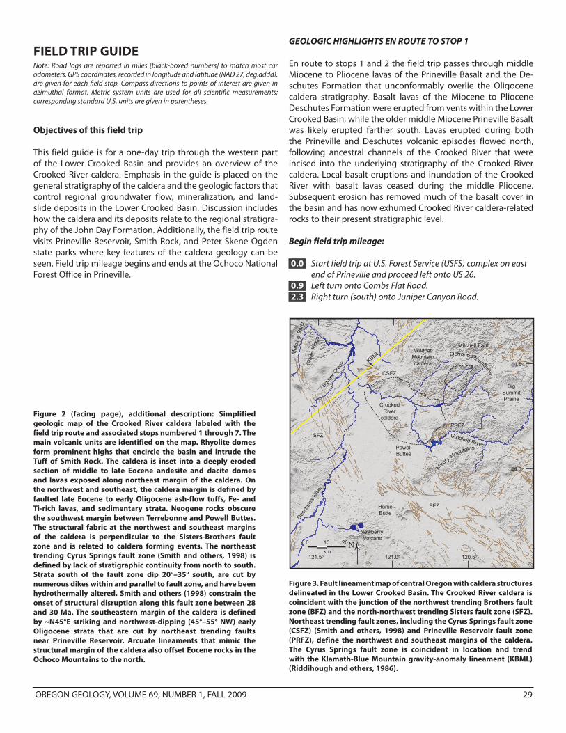
Figure 3. Fault lineament map of central Oregon with caldera structures delineated in the Lower Crooked Basin. The Crooked River caldera is coincident with the junction of the northwest trending Brothers fault zone (BFZ) and the north-northwest trending Sisters fault zone (SFZ). Northeast trending fault zones, including the Cyrus Springs fault zone (CSFZ) (Smith and others, 1998) and Prineville Reservoir fault zone (PRFZ), define the northwest and southeast margins of the caldera. The Cyrus Springs fault zone is coincident in location and trend with the Klamath-Blue Mountain gravity-anomaly lineament (KBML) (Riddihough and others, 1986).
Figure 2 (facing page), additional description: Simplified geologic map of the Crooked River caldera labeled with the field trip route and associated stops numbered 1 through 7. The main volcanic units are identified on the map. Rhyolite domes form prominent highs that encircle the basin and intrude the Tuff of Smith Rock. The caldera is inset into a deeply eroded section of middle to late Eocene andesite and dacite domes and lavas exposed along northeast margin of the caldera. On the northwest and southeast, the caldera margin is defined by faulted late Eocene to early Oligocene ash-flow tuffs, Fe- and Ti-rich lavas, and sedimentary strata. Neogene rocks obscure the southwest margin between Terrebonne and Powell Buttes. The structural fabric at the northwest and southeast margins of the caldera is perpendicular to the Sisters-Brothers fault zone and is related to caldera forming events. The northeast trending Cyrus Springs fault zone (Smith and others, 1998) is defined by lack of stratigraphic continuity from north to south. Strata south of the fault zone dip 20°–35° south, are cut by numerous dikes within and parallel to fault zone, and have been hydrothermally altered. Smith and others (1998) constrain the onset of structural disruption along this fault zone between 28 and 30 Ma. The southeastern margin of the caldera is defined by ~N45°E striking and northwest-dipping (45°–55° NW) early Oligocene strata that are cut by northeast trending faults near Prineville Reservoir. Arcuate lineaments that mimic the structural margin of the caldera also offset Eocene rocks in the Ochoco Mountains to the north.
Newberry Volcano
HorseButte
PowellButtes
PRFZ
Crooked River
Desc
hute
s Rive
r
Met
oliu
s R
iver
Gre
en R
idge
2010
km
0 N121.5o 121.0o 120.5o
44.5o
44.0o
CSFZ
KBML
SFZ
BFZ
Squaw
Cre
ekMitchell Fault
CrookedRiver
caldera
WildcatMountaincaldera
BigSummitPrairie

30 OREGON GEOLOGY, VOLUME 69, NUMBER 1, FALL 2009
5.7 Right turn onto Bonnie Lane. 6.0 Stop 1, along Bonnie Lane.
STOP 1. GEOLOGIC OVERVIEWGPS coordinates: –121.8108, 44.2402
Stop 1 provides an overview of the Lower Crooked Basin and the main components of the Crooked River caldera (Figure 4).The Crooked River caldera is the major vent feature of the Lower Crooked volcanic field, an area of ~1,500 km2 (580 mi2) in the western part of the Lower Crooked Basin underlain by Oligo-cene silicic tuff and rhyolite dome complexes, and tholeiiticbasalt, and basaltic andesite and andesite lavas and intrusions (Figure 2). Although previous workers (Swanson, 1969; Rob-inson and Stensland, 1979; Robinson and others, 1984, 1990) have correlated these rocks with various members of the John Day Formation, lithologic distribution, geochemistry, geochro-nology, and structure now delineate these rocks as a discreet, mappable volcanic field. The field is entirely preserved within the arcuate peripheral fault zone of the Crooked River caldera and is entirely Oligocene in age (Figures 2 and 3). Mafic rocks within the Lower Crooked volcanic field are distinctly tholeiitic, with enriched Fe and Ti contents and relatively low amounts of Al. Silicic rocks in the Lower Crooked volcanic field are character-ized by elevated trace-element abundances for Ba (barium), Zr (zirconium), Y (yttrium), and Nb (niobium) and, generally, have
higher abundances for the light rare-earth elements (LREE) of La (lanthanum) and Ce (cerium) (see Table 3).
The Crooked River caldera is characterized by a combina-tion of thickly ponded silicic pumice-lithic ash-flow tuff, nearly vertical caldera-bounding faults, rhyolite dome complexes that surround the structure, and a corresponding regional relative gravity low. Middle Eocene to early Oligocene stratigraphy exposed outside the caldera is everywhere absent within the inferred ring-fracture. All these features are consistent with caldera formation (Williams, 1941; Smith, 1960; Smith and Bai-ley, 1968; Lipman, 1976, 1984, 1997; Christiansen, 2001). The caldera developed through five stages: (1) a series of Fe- and Ti-rich tholeiitic basaltic andesites and andesites composi-tionally similar to icelandite erupted from volcanic centers between Haystack and Prineville reservoirs between 36 and 30 Ma. These lavas and intrusions apparently coincide with the onset of volcanism in the Lower Crooked volcanic field. (2) Eruption of the Oligocene Tuff of Smith Rock accompanied the major subsidence phase of the Crooked River caldera at 29.56 Ma. (3) Large (20–80 km2; 8–31 mi2) fields of rhyolite lavas, domes, and intrusions were emplaced along the structural mar-gin between ca. 28.8 and 25.8 Ma when major volcanic activity in the field ceased. Rhyolite domes and flows are prominently exposed at Powell Buttes (SSW, 240°, not visible; 28.3, 25.8 Ma), Gray Butte (NW, 310°; 28.82 Ma), Grizzly Mountain (NNW, 330°; no age data), Barnes Butte (NNW, 355°; 27.94 Ma), Ochoco Reservoir (NE, 35°; 27.54 Ma), and Pilot Butte (ESE, 100°; no age data), (Figures 2–4; Tables 2 and 3). (4) The Tuff of Barnes Butte
Crooked River
Gray Butte28.82 Ma
Grizzly Mountain Ochoco Mts.
Rin
g fra
ctur
e zo
ne
Smith Rock
Grass Butte Meyers ButtePrineville
X
Barnes Butte
Intracaldera-fill tuff
Intracaldera-fill tuff Rin
g fra
ctur
e zo
ne
Rin
g fra
ctur
e zo
ne
Ochoco Wayside Overlook
Figure 4. View looking north from stop 1 (continued on next page). Line drawing highlights parts of the Crooked River caldera visible from Bonnie Road.
WEST

OREGON GEOLOGY, VOLUME 69, NUMBER 1, FALL 2009 31
RoundMountain
WildcatMountaincaldera~40 Ma
Ochoco Mtns.Hash Rock39.35 Ma
Wildcat Mountain
Hi-Tor Butte
Ochoco Rhyolite27.54 Ma
Juniper Canyon Quarry
Rin
g fra
ctur
e zo
ne
Rin
g fra
ctur
e zo
ne
Barnes Butte Tuff
Ring fracture zone(inferred)
Figure 4, continued. View looking north from stop 1.
EAST
erupted between 29.56 and 27.97 Ma from a now obscure vent source in the southeast part of the Crooked River caldera. (5) Large hot-springs subsequently formed both within and around the periphery of the caldera. These deposited massive quartz and calcite veins (± cinnabar) along ring-fractures and peripheral fault structures as well as finely laminated to massive mudstones, siliceous pool sinter, and sinter breccia along the caldera wall.
GEOLOGIC HIGHLIGHTS EN ROUTE TO STOP 2
6.3 Return east on Bonnie Lane. Right turn (south) onto Juniper Canyon Road. Drive south to stop 2.
12.5 Traveling south, the field trip route leaves the ridge capping middle Miocene Prineville Basalt and drops down into the Antelope Creek drainage, where a northwest-dipping section of Oligocene ash-flow tuffs and interbedded Fe-rich basaltic andesite lavas is exposed. The ridge line to the left (east) is capped by outflow tuff from the Crooked River caldera. The skyline to the south is formed by northwest-dipping ash-flow tuffs that predate eruption of the caldera.
15.5 Right turn on County Boat Ramp Road. From mile points 15.5 to 16, Oligocene sedimentary rocks are exposed in road cuts on the right.
16.0 Fe- and Ti-rich basaltic andesite lava that overlies the early Oligocene Tuff of Antelope Creek.
16.9 Stop 2, at Prineville Reservoir county boat ramp.
STOP 2. PRE-CALDERA VOLCANIC STRATIGRAPHYGPS coordinates: –121.7491, 44.1329
The northwest tilted section exposed at the Prineville County boat ramp consists of a pre-caldera succession of rhyolite tuffs, interbedded tholeiitic basaltic andesite lavas, and volcaniclastic sedimentary rocks that lie along the southeast caldera margin (Figure 5). Two early to middle Oligocene ash-flow tuffs, vis-ible from the boat ramp, are part of the “southern” facies of the John Day Formation of Robinson and Brem (1981) (Figure 1). Although these ash-flow tuffs are compositionally similar to tuffs erupted from the Crooked River caldera, they are older and erupted from vents that are yet unknown (Table 3). The lower part of the section is formed by the Tuff of Eagle Rock, a strongly welded, sparsely feldspar-phyric, locally rheomorphic pumice-lithic tuff that is up to 50 m thick along the banks of the reservoir. Robinson and others (1990) report a K/Ar age of 32.1 ± 0.7 Ma (plagioclase) for this tuff near Eagle Rock, 10 km (6 mi) northeast of the boat ramp. The younger Tuff of Antelope Creek is a sparsely sanidine-phyric, devitrified, strongly welded and lo-cally rheomorphic ash-flow tuff that is up to 30 m thick. The Tuff of Antelope Creek is geochemically similar to a thick crystal- and micro-pumice-rich fallout tuff exposed beneath Carroll Rim in the Painted Hills for which Retallack and others (2000) report a single crystal 40Ar/39Ar age of 29.75 ± 0.02 Ma.
Lavas interbedded with the ash-flow tuffs near the boat ramp mark the transition in the Lower Crooked Basin between the older Eocene calc-alkaline volcanism of the Ochoco volcanic field and the younger bimodal basalt and rhyolite volcanism

32 OREGON GEOLOGY, VOLUME 69, NUMBER 1, FALL 2009
associated with the Crooked River caldera (Figure 2). These lavas consist of both mafic and intermediate flows that are ex-posed along both the northwest and southeast margins of the caldera. Intermediate-composition rocks consist of tholeiitic ba-saltic andesite and andesite lavas, with chemical compositions similar to that of icelandite (Table 3). Petrographic and chemical characteristics of the intermediate flows indicate compositions similar to those reported by Robinson and Brem (1981) and Robinson and others (1990) for trachyandesites in Member B of the John Day Formation. Intermediate lavas are compositionally similar to a 30.8 ± 0.5 Ma intrusion (K/Ar, whole rock; Robinson and others, 1990) exposed along the northwest margin of the caldera north of Gray Butte and a 30.1 ± 1.1 Ma basaltic andes-ite lava (K/Ar, whole-rock; Evans and Brown, 1981) encountered in a geothermal test well that was drilled just west of Powell Buttes (Brown and others, 1980). The intermediate lavas are interbedded with a poorly exposed series of more mafic aphyric to sparsely olivine-phyric basalts north and west of Gray Butte (Table 3). Similar composition basalt lavas have not been found at Prineville Reservoir. Geochemical analyses of basalts indicate compositions similar to those reported by Robinson (1969), Robinson and Brem (1981), and Robinson and others (1990) for alkali olivine basalts found in Members E, F, and G north of the Lower Crooked volcanic field (Table 1).
The stratigraphic section exposed at the boat ramp lies within the Prineville Reservoir fault zone, a northeast trending structural zone on the southeastern margin of the caldera (Fig-ure 2). The main zone of deformation is ~7 km (4 mi) wide by 16 km (10 mi) long and defines a northeast trending homocline
pervasively cut by faults with both normal and reverse sense of displacement. Beds within the homocline generally strike N45°E and dip 45°–55° northwest back into the caldera (Figures 2 and 5). Outflow facies of the Tuff of Smith Rock overlie the deformed Oligocene section, separated by an angular unconformity. East of Prineville Reservoir, along O’Neil Creek, the outflow tuff is ponded against the tilted structural block and is itself faulted and warped with a northwest verging dip. The Tuff of Smith Rock is the youngest unit deformed in the fault zone. Combined stratigraphic and structural relationships within the Prineville Reservoir fault zone suggest that deformation of the Oligocene section of tuff and basaltic andesite occurred synchronously with formation of the Crooked River caldera and deposition of outflow facies of the Tuff of Smith Rock.
GEOLOGIC HIGHLIGHTS EN ROUTE TO STOP 3
18.3 Return to Juniper Canyon Road. Left turn (north) onto Juniper Canyon Road.
30.9 Left turn on Combs Flat Road.32.3 Right turn on US 26.36.4 A gravel quarry and prospect two thirds of the way up
the cliff-face on the right exposes a brick orange outcrop of strongly welded, hydrothermally altered Tuff of Barnes Butte. Cavities in the tuff contain blood-red, opaque to translucent opal and white to black chalcedonic quartz. The alteration zone marks part of the caldera margin.
37.6 Stop 3, at Ochoco Dam.
Tuff of Eagle Rock(32.1 Ma)
Tuff of Antelope Creek(ca. 30 Ma)
VolcaniclasticSedimentary Rocks
Basaltic andesite(ca. 30 Ma)
SENWTuff of Smith Rock -
(outflow facies 29.56 Ma)
N25E, 55oNW
FIGURE 9Figure 5. Northwest-dipping early Oligocene strata exposed near the Prineville Reservoir county boat ramp at stop 2. The exposed section includes two thick rhyolite tuffs interbedded with Fe- and Ti-rich basaltic andesite and volcaniclastic sedimentary rocks. Dashed white lines are approximate contacts between units. Schematic strike and dip symbol indicates the structural orientation of early Oligocene strata.

OREGON GEOLOGY, VOLUME 69, NUMBER 1, FALL 2009 33
Landslide deposit
Rhyolite of Ochoco Reservoir
Ochoco DamSpillway
Figure 6. View north across Ochoco Creek to large, south-dipping, cliff-forming outcrops of the rhyolite of Ochoco Reservoir. The right abutment of the dam and spillway visible in the photo is founded upon a flanking, large active landslide complex that is sourced in the rhyolite. White arrows indicate general direction of transport of material in the landslide complex. Flow of Ochoco Creek is to the left (west) in the photograph.
STOP 3. SOUTHEASTERN CALDERA MARGIN AND THE OCHOCO RESERVOIR RHYOLITE
GPS coordinates: –121.7235, 44.2998
Stop 3 provides a look at the Rhyolite of Ochoco Reservoir and a discussion of the geologic foundation of Ochoco Dam (Figure 6). The Rhyolite of Ochoco Reservoir, exposed north of stop 3, is a south-dipping, purple to gray, massive, platy to columnar jointed, sanidine-phyric rhyolite that erupted along the south-east margin of the Crooked River caldera. The rhyolite forms a relatively flat-topped, tabular body with a relatively consistent thickness that Waters and Vaughan (1968) interpreted as a rheomorphic ash-flow tuff. Basal flow-breccias, a lack of pumice or other pyroclastic textures (e.g., eutaxitic fabric), and complex internal flow-banding, combined with the tabular habit and as-sociation with a thick section of sedimentary rocks suggest that the rhyolite was emplaced as a lava that erupted and ponded in moat settings near the southeastern margin of the Crooked River caldera. The rhyolite has an 40Ar/39Ar age of 27.54 ± 0.36 Ma (Table 2; McClaughry and Ferns, 2006b). However, this age is discordant with the rhyolite’s stratigraphic position beneath the Tuff of Barnes Butte, which is intruded by a 27.97 ± 0.32 Ma rhyolite dome at Prineville (Table 2). The present structural tilt of the rhyolite to the south may be a result of deformation dur-ing eruption of the Tuff of Barnes Butte at ~28.5 Ma or may be related to lower to middle Miocene faulting in the area.
Ochoco Dam, located ~10 km (6 mi) east of the city of Prin-eville, was completed in 1920 for irrigation and flood control as part of the United States Bureau of Reclamation (USBR) Crooked
River Project (Carter, 1998; Kunzer, 1998). Since its completion, the dam has suffered from persistent seepage problems be-neath the right abutment (north side). Deteriorating site condi-tions since construction resulted in the temporary emptying of the reservoir in 1993 (Carter, 1998). Water storage resumed in 1995 after modifications to increase bank stability and decrease seepage along the right abutment had been completed. Addi-tional flood protection was provided through modifications to the left abutment spillway (Carter, 1998; Kunzer, 1998).
Operational problems at the Ochoco Reservoir dam site are intimately linked to site geology (Carter, 1998). Quaternary landslide deposits line both margins of Ochoco Reservoir and form the foundations upon which the dam structure is built. The construction site was chosen where landslide deposits formed the greatest topographic restriction in the valley. The left abut-ment (south side) of the dam is constructed upon rock-fall and debris flow deposits derived from the 3.56 Ma Basalt of Combs Flat of the Deschutes Formation (McClaughry and Ferns, 2006b). These deposits originate from over steepened, tension-cracked cliff-faces in the basalt that calve and topple or rotate listrically along fractured columnar joint margins. The right abutment of the dam is founded upon landslide deposits composed of intermixed rhyolite and tuffaceous siltstone derived from ten-sion-cracked, southerly dipping, cliff-forming outcrops of the Rhyolite of Ochoco Reservoir and underlying sedimentary rocks interpreted as caldera moat-fill (Figure 6). Persistent seepage beneath the right abutment is linked to sinkholes developed in poorly sorted landslide deposits that have variable permeability and material strength.

34 OREGON GEOLOGY, VOLUME 69, NUMBER 1, FALL 2009
GEOLOGIC HIGHLIGHTS AND ROAD LOG EN ROUTE TO STOP 4
37.6 Left turn on US 26, travel west to Barnes Butte Road.41.7 Right turn on Barnes Butte Road. 42.8 Intersection with Wainright Road. Barnes Butte is visible
on the left. The southern part of the butte is capped by the Tuff of Barnes Butte, an ash-flow tuff erupted from within the southeastern confines of the Crooked River caldera between 29.56 and 27.97 Ma. It is not clear whether eruption of the Tuff of Barnes Butte resulted in the formation of a second collapse structure or whether it erupted from another type of vent structure (e.g., ignimbrite fissure [Aguirre-Diaz and Labarthe-Hernandez, 2003]). No topographic expression of a subsidiary caldera ring-structure is clearly defined. The northern part of Barnes Butte is a rhyolite dome complex, isotopically dated at 27.97 ± 0.32 Ma (40Ar/39Ar whole rock; Table 2; McClaughry and Ferns, 2006a), that intrudes the overlying Tuff of Barnes Butte. The rhyolite intrusion is geochemically indistinguishable from the Tuff of Barnes Butte, identifying this area as the eruptive source for the tuff (Table 3).
43.8 Outcrops of the intracaldera facies of the Tuff of Smith Rock.
46.3 Right turn on McKay Creek Road. 47.3 Pistachio green to buff-colored intracaldera facies
of the Tuff of Smith Rock forms all low-lying hills on right and straight ahead. Small domal knobs forming protuberances in the field on the right are the upper parts of rhyolite domes that intrude the intracaldera ash-flow tuff.
48.6 Intersection of McKay Creek Road and Gerke Road. Left (straight) on Gerke Road. East-southeast of this point, Old Dry Creek runs along the caldera margin.
49.6 Between these mileage points, the field trip passes very near the margin of the Crooked River caldera. The knob on the left consists of a thick section of intracaldera facies of the Tuff of Smith Rock intruded by rhyolite. Road cuts on the right expose tuff and tuffaceous sediments that may have been deposited as caldera moat-fill.
51.1 Continue due west on Gerke (Lamonta) Road52.1 Right turn on NW Puckett Road. In 0.9 miles the road turns
sharply left and becomes Ryegrass Road. 53.0 to 55.8 Intracaldera facies of the Tuff of Smith Rock
against the front of Grizzly Mountain contains exposures of lacustrine sedimentary rocks and hydrothermal hot-spring breccia and sinter.
55.8 Right turn on US 26.57.4 Right turn on Grizzly Mountain Road.60.2 Stop 4, on the lower summit of Grizzly Mountain.
STOP 4. RING-FRACTURE RHYOLITE DOMESGPS coordinates: –121.9588, 44.4297
Grizzly Mountain, a post-caldera rhyolite dome and flow field along the northeast margin of the Crooked River caldera, is the highest standing point of the caldera at 1,733 m (5,685 ft). The lower summit location of stop 4 affords one of central Oregon’s most scenic and relatively unknown vistas. Grizzly Mountain received its auspicious name in the 1870s purportedly due to its “grizzled” color under the sun of central Oregon, not due to any incidents involving grizzly bears (McArthur, 1992).
Rhyolite dome complexes are often associated with calderas after their formation (e.g., Smith and Bailey, 1968; Lipman, 1984; Christiansen, 2001). Ring fracture domes are often emplaced close to or above caldera-bounding faults. Other domes may occur aligned along regional structural trends or scattered ran-domly within a caldera (Lipman, 1984; Self and others, 1986). Following collapse of the Crooked River caldera, large (20 to 80 km2 [8 to 31 mi2]) fields of rhyolite flows, domes, and dikes, geochemically similar to the Tuff of Smith Rock, were emplaced along the structural margin of the caldera and intruded central portions of the intracaldera ash-flow tuff (Figure 7; Table 3). These include the rhyolite domes and flows at Grizzly Mountain as well as other domes and flows at Powell Buttes, Gray Butte, Barnes Butte, and Ochoco Reservoir. Satellite domes form Juni-per Butte and Pilot Butte, outside the northwest and southeast caldera margins, respectively. Radiometric ages of the rhyolite dome complexes range from ca. 28.8 Ma to 25.8 Ma (Table 2 {be-fore References section]); no rhyolites have yet been identified that were emplaced prior to caldera formation. Elongation of rhyolite dikes and dome complexes parallel to the caldera mar-gin and their coincidence with an isostatic gravity low bounding the intracaldera tuff suggests the rhyolites were largely erupted from ring-fracture fault fissures. All rhyolites were apparently emplaced within the boundaries of syncollapse structural de-formation, defined by the peripheral circumferential fault zone preserved in the surrounding country rock (Figure 2).
Figure 7. Flow-banded rhyolite exposed near the summit of Grizzly Mountain.

OREGON GEOLOGY, VOLUME 69, NUMBER 1, FALL 2009 35
The arcuate ring-fractures of the caldera that allowed em-placement of rhyolite intrusions also served as conduits for up-ward movement of hot fluids after the main subsidence phase of the caldera had ended. Many of the rhyolite dome fields are associated with hydrothermal alteration and hot spring style mercury (Hg) mineralization; the rhyolite domes have been sites of past mineral exploration and limited resource production. Most notably, Barnes Butte was the site of a ca. 1940s mercury mine developed in heavily silicified rhyolite (Brooks, 1963). Pow-ell Buttes was variably explored as a potential uranium target in the 1940s and 1950s, and geothermal potential was explored there in the 1980s (Brown and others, 1980). Isochron ages of basalt samples taken from hydrothermal alteration zones range from 29 to 25 Ma, suggesting the timing of alteration (Smith and others, 1998). Numerous other locations along the ring fracture of the caldera also show evidence of quartz and calcite veining, hydrothermal explosion breccias, siliceous sinter, and well-lam-inated, silicified mudstone (Figure 8). Thormahlen (1984) and Gray and Baxter (1986) found detectable amounts of gold (Au), silver (Ag), and arsenic (As) in these deposits. The character and spatial association of these deposits within and peripheral to the caldera are consistent with deposition in geyser and mud-pot fields (e.g., modern Yellowstone caldera). Today, elevated temperature wells (>21o C, 70o F) continue to be drilled in the Prineville area. These relatively warm-water wells are generally confined within or along the inferred caldera margin, although their modern heat source is unknown.
GEOLOGIC HIGHLIGHTS EN ROUTE TO STOP 5
63.0 Return to US 26. Right turn (north) onto US 26. Drive north to stop 5.
68.3 Left turn on SE Laurel Lane (route 96 on the Crooked River National Grassland).
71.4 Historic Gray Butte Cemetery on the right.72.2 The Tuff of Rodman Springs is exposed in a low-lying
hill on the right. Smith and others (1998) obtained a 40Ar/39Ar age of 32.49 ± 0.30 Ma for this ash-flow tuff (Table 2). The high ridge in the distance to the left is the north slope of Gray Butte, a ring-fracture rhyolite dome that intrudes the Tuff of Smith Rock and therefore postdates the eruption of the Crooked River caldera. Smith and others (1998) obtained a 40Ar/39Ar age of
28.82 ± 0.23 Ma for the Rhyolite of Gray Butte. The lower, north slopes of Gray Butte and the topography that intervenes between there and Laurel Lane consist of an older south-dipping section of middle Eocene to lower Oligocene basalt to andesite intrusions and lavas and interbedded sedimentary rocks that host well-known fossil floras (Robinson and Stensland, 1979; Ashwill, 1983; Smith and others, 1998). Robinson and others (1990) report a K/Ar age of 30.8 ± 0.5 Ma from a basalt intrusion exposed in this stratigraphic section 3.2 km (2 mi) south of Gray Butte Cemetery.
72.6 Right turn on Springer Road (SW King Lane). Prominent mesas to the west and north-northeast are capped by orange, crudely columnar-jointed ledges formed by the Tuff of Barnes Butte. This ash–flow tuff postdates initial caldera-forming eruptions in the Crooked River caldera and may be correlative to the Member H tuff for which Smith and others (1998) determined an 40Ar/39Ar age of 27.62 ± 0.63 Ma at Haystack Reservoir (Table 2).
73.9 The field trip route here crosses part of the Cyrus Springs fault zone (Smith and others, 1998), a northeast trending, 800-m-wide composite shear zone coincident in location and trend with the Klamath-Blue Mountain gravity-anomaly lineament (Figure 3). The Cyrus Springs fault zone is defined by a break in stratigraphy across the structure; the fault zone juxtaposes the lowest John Day Formation ash-flow tuff (Member A) on the south against much younger outflow tuff from the Crooked River caldera on the north. Strata south of the fault zone are capped by the 32.49 ± 0.30 Ma Tuff of Rodman Springs, dip 20°–35° south, are cut by numerous basalt to rhyolite dikes within and parallel to the fault zone, and have been hydrothermally altered (Gray Butte cinnabar prospect; Brooks, 1963). Strata on the north of the fault zone form a broadly folded, north-northwest trending homocline. Intrusions and hydrothermal alteration pervasive on the south of the fault zone are notably absent in strata on the north (Smith and others, 1998). Faults within the zone generally strike N45°–60°E, but some faults in the southeastern part of the zone wrap to east-west orientations. On the basis of regional lineament mapping, the Cyrus Springs fault zone is now considered to be part of an arcuate set of faults that encircle the
Figure 8. Sinter and pool deposits related to hot spring activity are spatially distribut-ed along the caldera margin. (a) Massive, brecciated siliceous sinter deposit exposed south of Grizzly Moun-tain. (b) Well-laminat-ed, silicified mudstone exposed southeast of Grizzly Mountain.
A B
a b

36 OREGON GEOLOGY, VOLUME 69, NUMBER 1, FALL 2009
Crooked River caldera. Smith and others (1998) constrain activity along the Cyrus Springs fault zone between ca. 28 and 30 Ma, coincident with collapse of the Crooked River caldera.
77.2 Right turn on Fishing Pier Road.77.5 Stop 5, at Haystack Reservoir.
STOP 5. OUTFLOW TUFF OF THE CROOKED RIVER CALDERA
GPS coordinates: –121.1547, 44.4967
Three geographic lobes of outflow facies of the Tuff of Smith Rock are distributed clockwise from northwest to southeast around the caldera. These include the Haystack Reservoir, McKay Saddle, and Roberts Bay lobes (Figure 2; Tables 2 and 3). Middle Miocene and younger volcanic and sedimentary rocks conceal any outflow lobes that might be present on the west. The well-preserved tuffs at Haystack Reservoir were first described as the Tuff of Haystack Reservoir by Smith and others (1998), who correlated them with Member G of the “western” facies of the John Day Formation (Peck, 1964).
The Haystack Reservoir lobe of the Tuff of Smith Rock is as much as 30 m thick and consists of at least three distinct cool-ing units preserved between the Cyrus Springs fault zone and Haystack Reservoir (Figures 2 and 9). The lower unit at the fish-ing pier consists of 5 to 7 m (16.4–23.0 ft) of densely welded crystal-vitric tuff. Phenocrysts in the tuff include alkali feldspar and plagioclase now altered to cores of white chalky clay. The densely welded tuff is succeeded upward by a nonwelded section of light green, gray, and light purple, 1- to 3-m-thick
(3.3–9.8 ft) beds of plane-bedded and cross-bedded to massive, pumice- and accretionary-lapilli bearing ash-flow tuffs. The bed-ded lower tuff has an 40Ar/39Ar age of 29.53 ± 0.09 Ma. (Table 2; Smith and others, 1998). The upper unit, exposed in the gravel pit above the fishing pier, consists of a dark red-brown, intensely welded ash-flow tuff. The welded tuff typically contains 1 to 5 percent crystals of sanidine, plagioclase, and quartz. It has an 40Ar/39Ar age of 29.57 ± 0.17 Ma (Smith and others, 1998; Table 3). The distribution of the welded tuff, combined with flow directions determined by surge cross beds indicates a source vent to the south-southwest of Haystack Reservoir (Smith and others, 1998). Radiometric ages determined for the tuffs at Haystack Reservoir are indistinguishable from a 29.56 ± 0.17 Ma (40Ar/39Ar) age for the McKay Saddle lobe of the Tuff of Smith Rock and John Day Formation Member G tuffs exposed north of the Crooked River caldera that have 40Ar/39Ar ages of 29.61 ± 0.10 and 29.54 ± 0.10 Ma (Table 2).
GEOLOGIC HIGHLIGHTS EN ROUTE TO STOP 6
77.8 Right turn on SW Haystack Drive.78.2 Left turn on Jericho Lane. The high, flat ridge to the
south of Jericho Lane is capped by densely welded to rheomorphic outflow facies of the Tuff of Smith Rock.
79.6 Left turn on US 97.81.3 The field trip route here traverses the saddle between
Juniper Butte on the west and Haystack Butte on the southeast. Juniper Butte is an Oligocene rhyolite dome that formed as an outlier along the circumferential peripheral fault zone that surrounds the Crooked River caldera. The prominent mesa at Haystack Butte is capped by the Tuff of Barnes Butte; this tuff is underlain by outflow facies of the Tuff of Smith Rock and sedimentary rocks.
83.7 The field trip route between mile point 83.7 and 87.0 travels across the surface of the upper Miocene Basalt of Tetherow Butte, part of the overlying Deschutes Formation. Smith (1986a,b) reports 40Ar/39Ar ages of 5.31 ± 0.05 Ma and 5.43 ± 0.05 Ma for this basalt. The flows were erupted from Tetherow Butte, 5.5 km (3.5 mi) northwest of Redmond.
87.3 Crossing the Crooked River Gorge and the highway bridge that was completed in September, 2000. The US 97 highway bridge spans the Crooked River Gorge, 91 m (300 ft) above river level, with a concrete arch span of 125 m (410 ft). The current bridge replaced the old Conde B. McCullough Steel arch bridge that was built in 1926 and that is now designated as a historic landmark.
87.5 Right turn into Peter Skene Ogden State Park.87.6 Stop 6, at Peter Skene Ogden State Park.
Figure 9. North-dipping, bedded section of outflow tuff exposed near the fishing pier at Haystack Reservoir (stop 5). The lower tan deposits consist of non-welded pumice-crystal tuff with an 40Ar/39Ar age of 29.53 ± 0.09 Ma. The uppermost, red-colored deposit is a densely welded crystal-vitric tuff with an 40Ar/39Ar age of 29.57 ± 0.17 Ma.

OREGON GEOLOGY, VOLUME 69, NUMBER 1, FALL 2009 37
STOP 6. NORTHWEST MARGIN OF THE CROOKED RIVER CALDERA
GPS coordinates: –121.1928, 44.3929
Stop 6 visits Peter Skene Ogden (P. S. Ogden) State Park on the northwest margin of the Crooked River caldera. Peter Skene Ogden State Park is named for an explorer and fur trapper for the Hudson Bay Company during the 1820s, who was the first to describe and name many of the features in central and east-ern Oregon (McArthur, 1992). Two geologic domains are visible from the park.
The ridge visible on the east, from the highway bridge at Peter Skene Ogden State Park, is underlain by a southeast-dipping section of middle Eocene to middle Oligocene rocks that form part of the remnant northwestern wall of the Crooked River caldera (Figure 10). This structural block dips 28°–45° southeast, back toward the interior of the caldera, where the block is abruptly terminated by the primary caldera-bounding ring-fault. The base of the section is composed of calc-alkaline basalts and basaltic andesites of the Clarno Formation. These lavas are overlain by the John Day Formation, which here in-cludes Fe- and Ti-rich basalts and andesites, interbedded vol-caniclastic sedimentary rocks, and tuff. The volcaniclastic sedi-mentary rocks in this section host the well-known Gray Butte fossil floras, including the Kings Gap, Sumner Spring, Nichols Spring, Canal, and Trail Crossing floras. These floras are consid-ered by Ashwill (1983) and Smith and others (1998) to be consis-tent with a middle Eocene to middle Oligocene age for the host strata. The section is capped by the ca. 30 Ma, yellow-altered, welded Tuff of Antelope Creek. This tuff is thicker and more strongly welded where it is more widely exposed in a deformed northwest tilted section along the southeastern margin of the
caldera; it is absent within the arcuate ring-fracture. The young-er intracaldera facies of the 29.56 Ma Tuff of Smith Rock is inset into this southeast-dipping section and forms the high ridge to the right of the prominent yellow-colored hoodoos (Figure 10). Because the Tuff of Smith Rock is ponded against and onlaps the southeast-dipping section, structural tilt is interpreted to have occurred during caldera collapse and eruption of the tuff. Gray Butte, the high peak in the background to the east, is part of a 28.82 Ma, postsubsidence rhyolite dome complex that intrudes the Tuff of Smith Rock along the ring-fracture.
The younger feature is the modern Crooked River Gorge, whose steep walls are composed of a thick intracanyon basalt lava that entered into the ancestral Crooked River drainage about 780,000 years ago. This basalt now serves as the anchor points for the U.S. 97 highway bridge. The intracanyon basalt was erupted from vents on the north flank of Newberry Volcano, located 72 km (45 mi) to the south of the state park. The lava flowed north across a broad plain extending from Newberry Volcano to Redmond (Sherrod and others, 2004). The lava en-tered the Crooked River at several sites northwest of O’Neil and at Smith Rock, approximately 10 km (6 mi) southeast of the pres-ent highway bridge. At Smith Rock these basalt lavas entered a broad, shallow channel cut into Oligocene rocks of the Crooked River caldera and are less than 30 m (100 ft) thick. Downstream of Smith Rock, the Newberry basalt was confined as an intracan-yon flow within a steep-walled ancestral Crooked River Gorge, incised into a thick succession of older interbedded lavas, ash-flow tuffs, and sedimentary rocks of the late Miocene and Plio-cene Deschutes Formation. Intracanyon basalt is more than 100 m (328 ft) thick at P. S. Ogden, where it is inset between canyon walls formed in the upper Miocene Basalt of Tetherow Butte on the north (5.31, 5.43 Ma) and the Pliocene (3.56 Ma) Basalt of
Tuff of Antelope Creek
ca. 30 Ma
Tuff of Smith Rock29.56 Ma
Trace of caldera ring-fracture
Basaltic andesite lavas/sed. rocks (ca. 36-30 Ma)
N80E, 30oS
N SRhyolite ofGray Butte28.82 Ma
Figure 10. View east to southeast dipping section of early Oligocene strata from the old U.S 97 bridge at Peter Skene Ogden State Park at Stop 6. Intracaldera facies of the 29.56 Ma Tuff of Smith Rock are inset into and onlap the older deformed strata. Gray Butte in the distance is a 28.82 Ma rhyolite intrusion that crosscuts the Tuff of Smith Rock. Dashed white line demarcates the structural margin of the caldera. Arrows indicate the relative motion of the downthrown block within the caldera ring-fracture. Schematic strike and dip symbol indicates the structural orientation of early Oligocene strata.

38 OREGON GEOLOGY, VOLUME 69, NUMBER 1, FALL 2009
Redmond on the south. Downstream of P. S. Ogden, Newberry lavas descended into the ancestral Crooked River Canyon form-ing a prominent bench that extends at least another 8 km (5 mi) to Lake Billy Chinook. The modern Crooked River has since incised a steep-walled canyon into the Newberry Basalt.
P. S. Ogden State Park is coincidentally the location where the elevation of the regional water table first corresponds with the streambed of the Crooked River; therefore groundwater discharges to the river from permeable rock units downstream from this point (Gannett and others, 2001). The amount of groundwater discharge (~1100 cfs) between P. S. Ogden State Park and Opal Springs downstream is largely controlled by the relatively high permeability of some of the Deschutes Forma-tion units as compared to the older Clarno and John Day age units exposed near the surface upstream from stop 6 (Stearns, 1931; Lite and Gannett, 2002; Sherrod and others, 2002).
The contrasting permeability of the major rock units along the lower Crooked River drainage is also important as a re-gional boundary to groundwater flow. The John Day and Clarno formations, exposed near or at the surface east of P. S. Ogden State Park, are considered the lower boundary of the regional groundwater flow system in the Lower Crooked Basin and throughout much of the adjoining upper Deschutes Basin on the west (Lite and Gannett, 2002; Sherrod and others, 2002). These rocks typically exhibit low permeability due to the abun-dance of devitrified rhyolite, tuff, and tuffaceous sedimentary rocks that are altered to clay and zeolite (Lite and Gannett, 2002; Gannett and others, 2004). Most of the water wells that pro-
duce out of the John Day and Clarno formations in the Lower Crooked Basin have very low yields except where permeability is locally increased by secondary porosity (fractures). In some cases, wells sourced in John Day Formation rocks have been reported to contain detectable amounts of arsenic. The more productive sources or groundwater in the Lower Crooked Basin unconformably overlie the rocks of the John Day and Clarno Formations. These units include the Prineville Basalt, Deschutes Formation, and post-Deschutes Formation rocks.
GEOLOGIC HIGHLIGHTS EN ROUTE TO STOP 7
87.7 Right turn onto US 97.88.2 Coyote Butte on the east is composed of intracaldera
facies of the Tuff of Smith Rock. The caldera margin here is inferred to swing between the butte and US 97.
89.1 Crossing the inferred ring-fracture zone of the Crooked River caldera now buried beneath Neogene basalt lavas.
90.6 Left turn on B Ave/Smith Rock Way in Terrebonne.91.3 Left turn (north) on 1st Street. 91.8 Road turns abruptly right (east) and becomes NE Wilcox
Avenue. 92.6 Intracaldera ash-flow tuff and intrusive rhyolite dikes
form the prominent cliffs and spires on the left. 93.3 Left turn on Crooked River Drive.93.9 Stop 7, at Smith Rock State Park.
Newberrybasalt
Rhyolitedike
Tuff of Smith Rock
Figure 11. Exposure of intracaldera facies of the Tuff of Smith Rock intruded by rhyolite dikes at Smith Rock State Park. Quaternary basalt from Newberry Volcano is inset into the incised Paleogene surface.

OREGON GEOLOGY, VOLUME 69, NUMBER 1, FALL 2009 39
STOP 7. INTRACALDERA TUFF OF THE CROOKED RIVER CALDERA: THE SMITH ROCK TUFF
GPS coordinates: –121.1335, 44.3706
Nestled in the northwest corner of the Lower Crooked Basin is Smith Rock, a picturesque set of sheer rock walls and case-hardened tuff spires that are well known to thousands of rock climbers, hikers, geologists, and tourists who travel to central Oregon each year (Figure 11). Close examination of the tuff reveals its explosive origins. Smith Rock proper, which forms the sheer rock massif at the state park, is named for John Smith, former sheriff of Linn County and Indian agent at Warm Springs Indian Agency. Smith first described the prominent rock forma-tion during one of his expeditions in central Oregon between 1855 and 1859 (McArthur, 1992).
Until recently, the age, origin, and regional stratigraphic rela-tionships of the Tuff of Smith Rock have been enigmatic, largely due to limited regional geologic mapping. Previous workers (Williams, 1957; Robinson and Stensland, 1979; Obermiller, 1987; Smith and others, 1998; Sherrod and others, 2004) con-sidered the Tuff of Smith Rock to be an exceptionally thick tuff deposit of limited areal extent. The tuff was thought to be a con-formable deposit upon the Rhyolite of Gray Butte and a south-southeast dipping section of Eocene and Oligocene strata. On the basis of K/Ar ages of uncertain quality, Obermiller (1987) interpreted the Tuff of Smith Rock as part of a middle Miocene silicic tuff cone. Smith and others (1998) demonstrated the unit was Oligocene in age, but they concurred with Obermiller (1987) that the Tuff of Smith Rock formed as a silicic tuff cone and was conformable upon the Rhyolite of Gray Butte. Results from regional detailed geologic mapping indicate that the Tuff of Smith Rock is a more widespread, relatively flat-lying, ash-flow tuff that inset in older middle Eocene to middle Oligocene strata. Pre-caldera stratigraphy, into which the tuff is ponded, may be as young as ca. 30 Ma west of Gray Butte; basaltic andes-ite recovered from drill core along the inferred caldera margin near Powell Buttes has a reported K/Ar age of 30.1 ± 1.1 Ma (whole rock, Evans and Brown, 1981). Mapped contact relations also demonstrate that the Tuff of Smith Rock is not conformable upon the 28.82 Ma Rhyolite of Gray Butte but is instead intruded by that unit. These stratigraphic and age relationships constrain the age of the intracaldera facies of the Tuff of Smith Rock to between ca. 29 and 30 Ma. Smith and others (1998) reported a fission-track age of 29 ± 3.0 Ma for the intracaldera ash-flow tuff at Smith Rock State Park; outflow facies of the tuff at McKay Saddle, Haystack Reservoir, Teller Flat, and Antelope return ra-diometric ages of ca. 29.6 Ma.
The intracaldera facies of the Tuff of Smith Rock forms an arcuate belt of discontinuous exposures that extends from the type section at Smith Rock State Park (Robinson and Stensland, 1979) to Ochoco Reservoir (Figure 2). At Smith Rock State Park, the intracaldera facies weathers to spectacular spires up to 200 m (650 ft) tall (Figure 11); along the northeast margin and interi-or of the caldera, similar tuff deposits degrade to form rounded, low-elevation hills. The intracaldera facies is predominantly a massive, unstratified, matrix-supported, pumice-rich, sparsely sanidine-phyric, rhyolite tuff that weathers tan to yellow brown.
Locally, the tuff is altered to light green and maroon and is case-hardened by zeolite alteration. Bedding features in the Tuff of Smith Rock are generally indistinct, but horizontal to gently dipping (<5°) lithic-rich lenses and associated fine-grained ash horizons are intercalated with the pumice-rich tuff in exposures along the Crooked River at Smith Rock State Park and in Skull Hollow. These discontinuous lithic-rich lenses are interpreted as lithic lag-breccias that are indicative of pulsating or surging py-roclastic flows (Figure 12). Rare clasts of limestone, some bear-ing Permian fusulinids (Thompson and Wheeler, 1942), occur as xenoliths within the tuff, suggesting that the Tuff of Smith Rock erupted through a Paleozoic limestone basement. Geochemi-cal samples analyzed from the intracaldera facies of the Tuff of Smith Rock closely compare to those determined for rhyolite dome complexes, which intrude the tuff along the margin and in central areas of the caldera (Figure 11 and Table 3).
The intracaldera ash-flow tuff is typically in complex, high-angle to vertical contact with country rock, and water-well logs within the caldera indicate that the tuff thickens to hundreds of meters immediately away from these contacts (Figure 13). On the basis of regional mapping and water well log analysis of the intracaldera facies, the Tuff of Smith Rock has a minimum intracaldera thickness of 0.5 km. Bulk volume estimates of the
Lithic-rich tuff
Pumice-rich tuff
Figure 12. Close-up outcrop view of the intracaldera facies of the Tuff of Smith Rock at Smith Rock State Park. The tuff is greater than 0.5 km thick and consists of a monotonous section of pumice-lithic tuff intercalated with lithic-rich lenses and fine-ash.

40 OREGON GEOLOGY, VOLUME 69, NUMBER 1, FALL 2009
intracaldera facies indicate more than 580 km3 (139 mi3) of tuff were erupted during caldera formation. This is a minimum estimate as it does not account for correlative outflow tuff de-posits exposed outside the caldera ring fault. Outflow facies are exposed discontinuously around the periphery of the caldera, distributed in three geographic lobes at Haystack Reservoir, McKay Saddle, and Prineville Reservoir (Figure 2). Distal welded ash-flow tuff deposits, up to 5 m (16.5 ft) thick, have been traced as far north as the town of Antelope, 58 km northeast of Smith Rock (Figure 1; Tables 2 and 3).
94.5 Exit the park and make a left turn on NE Wilcox Avenue. 96.7 Left turn on Smith Rock Way. 97.3 Right turn onto NW Lone Pine Road. 98.6 Left turn on O’Neil highway. 107.3 Left turn on Elliot Road. 108.6 Right turn on Elliot Lane.109.2 Right turn on US 26. 113.5 Left turn onto US 26/NW 3rd Street at the US 26-OR 126
junction in Prineville. 115.9 Ochoco National Forest Office in Prineville. End of field
trip.
ACKNOWLEDGMENTSThis field trip guide is a product of a geologic mapping study of the Lower Crooked Basin that was partially funded by the U.S. Geological Survey National Cooperative Geologic Mapping pro-gram under assistance awards 05HQAG0037 and 06HQAG0027 during 2005 and 2006. Additional financial support was pro-vided by the Oregon Water Resources Department (OWRD) and the USFS Ochoco National Forest. Many workers have contrib-uted to our knowledge of the geology of central Oregon. We are particularly indebted to Paul Hammond (PSU), Marshall Gannett (USGS), Larry Chitwood (USFS), John Wolff (WSU), Rick Conrey (WSU), Dave Sherrod (USGS), Ellen Bishop (OPLI), and Julie Donnelly-Nolan (USGS). The authors gratefully acknowledge the support of John and Lynne Breese of the Dixie Meadows Company and the Crooked River Watershed Council. Critical reviews by Ken Lite (OWRD), Martin Streck (PSU), and Ian Madin (DOGAMI), and additional comments by Jay Van Tassell (EOU) and Deb Schueller (DOGAMI) improved the final manuscript.
40Ar/39Ar age determinations were prepared and analyzed by John Huard at the College of Oceanic and Atmospheric Scienc-es, Oregon State University, Corvallis. X-ray fluorescence (XRF) geochemical analyses were prepared and analyzed by Stanley Mertzman, Franklin and Marshall College, Lancaster, Pennsyl-vania, except for those analyses with the prefix PAT, which were analyzed at Washington State University. Analytical procedures for the Franklin and Marshall X-ray laboratory are described by Boyd and Mertzman (1987) and Mertzman (2000) and are avail-able online at http://www.fandm.edu/x7985. Analytical procedures for Washington State University are described by Johnson and others (1999). Geochemical analytical results, shown in Table 3, have been normalized on a volatile-free basis and recalculated with total iron expressed as FeO*.
REFERENCESAguirre-Diaz, G. J., and Labarthe-Hernandez, G. L., 2003, Fissure
ignimbrites: Fissure-source for voluminous ignimbrites of the Sierra Madre Occidental and its relationship with Basin and Range faulting: Geology, v. 31, p. 773-776.
Ashwill, M. S., 1983, Seven fossil floras in the rain shadow of the Cascade Mountains, Oregon: Oregon Geology, v. 45, p. 107–111.
Bacon, C., and Lanphere, M. A., 2006, Eruptive history and geo-chronology of Mount Mazama and the Crater Lake region, Oregon: Geological Society of America Bulletin, v. 118, p. 1,331–1,359.
Bailey, R. A., 1976, Volcanism, structure, and geochronology of Long Valley caldera, Mono County, California: Journal of Geo-physical Research, v. 81, p. 725–744.
Bestland, E. A., and Retallack, G. J., 1994a, Geology and paleoen-vironments of the Clarno Unit, John Day Fossil Beds National Monument, Oregon: U.S. National Park Service Open-File Report, 160 p.
Bestland, E. A., and Retallack, G. J., 1994b, Geology and pa-leoenvironments of the Painted Hills Unit, John Day Fossil Beds National Monument, Oregon: U.S. National Park Service Open-File Report, 211 p.
Tuff of Smith Rock(Oligocene)
Andesite(Eocene)
Figure 13. Caldera ring-fault exposed on the northeast caldera margin where pumice-lithic intracaldera facies of the Oligocene Tuff of Smith Rock is separated from older Eocene andesite country rock by a complex, unfaulted, high-angle contact. The tuff is not faulted and onlaps the country rock surface. The country rock is pervasively cut by a series of regularly spaced shear zones that parallel the caldera margin. Note person near the middle of the photo for scale.

OREGON GEOLOGY, VOLUME 69, NUMBER 1, FALL 2009 41
Bestland, E. A., Hammond, P. E., Blackwell, D. L. S., Kays, M. A., Retallack, G. J., and Stimac, J., 2002, Geologic framework of the Clarno Unit, John Day Fossil Beds National Monument, Central Oregon: Oregon Department of Geology and Mineral Industries Open-File Report O-02-03, 39 p.
Brooks, H. C., 1963, Quicksilver in Oregon: Oregon Department of Geology and Mineral Industries Bulletin 55, 223 p.
Brown, D. E., Black, G. L., McLean, G. D., and Petros, J. R., 1980, Preliminary geology and geothermal resource potential of the Powell Buttes area, Oregon: Oregon Department of Geol-ogy and Mineral Industries Open-File Report O-80-8, 117 p.
Carter, B. H., 1998, Safety of dams modifications to Ochoco Dam Crooked River Project, Oregon, in Schultz, R. A., and Siddhar-than, R., eds., Proceedings of the 33rd Symposium of Engi-neering Geology and Geotechnical Engineering, University of Nevada, Reno.
Castor, S. B., and Henry, C. D., 2000, Geology, geochemistry, and origin of volcanic rock-hosted uranium deposits in north-western Nevada and southeastern Oregon, USA: Ore Geology Reviews, v. 16, p. 1–40.
Castor, S. B., Boden, D. R., Henry, C. D., Cline, J. S., Hofstra, A. H., McIntosh, W. C., Tosdal, R. M., and Wooden, J. P., 2003, The Tuscarora Au-Ag district: Eocene volcanic-hosted epithermal deposits in the Carlin Gold Region, Nevada: Economic Geol-ogy, v. 98, p. 339–366.
Christiansen, R. L., 1984, Yellowstone magmatic evolution: its bearing on understanding large-volume explosive volca-nism, in Boyd F. R., ed., Explosive volcanism: inception, evolu-tion, and hazards. National Research Council Studies in Geo-physics, National Academy Press, Washington D.C., p. 84–95.
Christiansen, R. L., 2001, The Quaternary and Pliocene Yellow-stone Plateau volcanic field of Wyoming, Idaho, and Mon-tana: U.S. Geological Survey Professional Paper 729-G, 145 p.
Coleman, R.G., 1949, The John Day Formation in the Picture Gorge Quadrangle, Oregon [M.S. thesis]: Corvallis, Oregon State University, 211 p.
Evans, S. H., and Brown, F. H., 1981, Summary of potassium/argon dating —1981: U.S. Department of Energy, Division of Geothermal Energy DE-AC07-80-ID-12079-45, 29 p.
Ferns, M. L., and McClaughry, J. D., 2006, Preliminary geologic map of the Powell Buttes 7.5’ quadrangle, Crook County, Or-egon: Oregon Department of Geology and Mineral Industries Open-File Report O-06-24, scale 1:24,000.
Ferns, M. L., Madin, I. P, and Taubeneck, W. H., 2001, Reconnais-sance Geologic Map of the La Grande 30’ x 60’ quadrangle, Baker, Grant, Umatilla, and Union Counties, Oregon: Oregon Department of Geology and Mineral Industries Reconnais-sance Map Series, RMS-1, 52 p., scale 1:100,000.
Fiebelkorn, R. B., Walker, G. W., MacLeod, N. S., McKee, E. H., and Smith, J. G., 1983, Index to K/Ar age determinations for the state of Oregon: Isochron/West, no. 37, p. 3–60.
Fisher, R.V., 1966, Geology of a Miocene ignimbrite layer, John Day Formation, Eastern Oregon: University of California Pub-lications in Geological Sciences, v. 67, 58 p.
Fisher, R. V., and Rensberger, J. M., 1972, Physical stratigraphy of the John Day Formation, central Oregon: California University Publications in Geological Sciences, v. 101, p. 1-45.
Gannett, M.W., and Lite, K.E., Jr., 2004, Simulation of regional groundwater flow in the upper Deschutes Basin, Oregon: U.S. Geological Survey Water Resources Investigation Report 03-4195, 84 p.
Gannett, M.W., Lite, K.E., Jr., Morgan, D.S., and Collins, C.A., 2001, Ground-water hydrology of the upper Deschutes Basin, Or-egon: U.S. Geological Survey Water Resources Investigation Report 00-4162, 77 p.
Gray, J. J., and Baxter, G., 1986, A reinterpretation of the Gray Butte limestone and arenite exposure as a hydrothermally-derived calcite vein and pebble dike: Oregon Geology, v. 48, no. 4, p. 45–46.
Hardyman, R. F., 1981, Twin Peaks caldera of central Idaho: in Montana Geological Society 1981 field conference on southwest Montana, Montana Geological Society, Billings, p. 317–322.
Hladkey, F. R., 1996, Geology and Mineral Resource map of the Grizzly Peak quadrangle, Jackson County, Oregon: Oregon Department of Geology and Mineral Industries Geological Map Series GMS-106, scale 1:24,000.
Hladkey, F. R. and Wiley, T. J., 1993, Ancient caldera complex revealed: Oregon Geology, v. 55, no. 3, p. 70.
Johnson, D. M., Hooper, P.R., and Conrey, R. M., 1999, XRF analy-sis of rocks and minerals for major and trace elements on a single low dilution Li-tetraborate fused bead: Advances in X-ray Analysis, v. 41, p. 843-867.
Kunzer, A. S., 1998, Spillway Modifications: Ochoco Dam, Crooked River Project, Oregon: in Schultz, R. A., and Siddhar-than, R., eds., Proceedings of the 33rd Symposium of Engi-neering Geology and Geotechnical Engineering, University of Nevada, Reno.
Linneman, S., 1990, The petrologic evolution of the Holocene magmatic system of Newberry Volcano, central Oregon [Ph.D. dissertation]: Laramie, University of Wyoming, 293 p.
Lipman, P. W., 1976, Caldera collapse breccias in the western San Juan Mountains, Colorado: Geological Society of America Bulletin, v. 87, p. 1,397–1,410.
Lipman, P. W., 1984, Roots of ash-flow calderas in western North America: Windows into the tops of granitic batholiths: Jour-nal of Geophysical Research, v. 89, p. 8,801–8,841.
Lipman, P. W., 1997, Subsidence of ash-flow calderas: Relation to caldera size and chamber geometry: Bulletin of Volcanology, v. 59, p. 198–218.
Lite, K.E., Jr., and Gannett, M.W., 2002, Geologic framework of the regional ground-water flow system in the upper Deschutes Basin, Oregon: U.S. Geological Survey Water Resources Inves-tigation Report 02-4015, 44 p.
MacLeod, N. S., Sherrod, D. R., Chitwood, L. A., and Jensen, R. A., 1995, Geologic map of Newberry Volcano, Deschutes, Klamath, and Lake Counties, Oregon: U.S. Geological Survey Miscellaneous Investigation Series I 2455.
Mason, B. G., Pyle, D. M., and Oppenheimer, C., 2004, The size and frequency of the largest explosive eruptions on Earth: Bulletin of Volcanology, v. 66, p. 735–748.
McArthur, L. A., 1992, Oregon Geographic Names: Oregon His-torical Society Press, sixth edition, 957 p.

42 OREGON GEOLOGY, VOLUME 69, NUMBER 1, FALL 2009
McClaughry, J. D., and Ferns, M. L., 2006a, Preliminary geologic map of the Prineville 7.5’ quadrangle, Crook County, Oregon. Oregon Department of Geology and Mineral Industries Open-File Report O-06-22, scale 1:24,000.
McClaughry, J. D., and Ferns, M. L., 2006b, Preliminary geologic map of the Ochoco Reservoir 7.5’ quadrangle, Crook County, Oregon. Oregon Department of Geology and Mineral Indus-tries Open-File Report O-06-23, scale 1:24,000.
McClaughry, J. D., and Ferns, M. L., 2007, The Crooked River Caldera: Identification of an early Oligocene eruptive center in the John Day Formation of central Oregon: Geological So-ciety of America Abstracts with Programs, v. 39, no. 4, p. 10.
McClaughry, J. D., Gordon, C. L., and Ferns, M. L., 2009, Field trip guide to the middle Eocene Wildcat Mountain Caldera, Ochoco National Forest, Crook County, Oregon: Oregon Ge-ology, v. 69, no. 1, p. 5–24. [this issue]
Moran-Zenteno, D. J., Alba-Aldave, L. A., Sole, J., and Iriondo, A., 2004, A major resurgent caldera in southern Mexico: the source of the late Eocene Tilzapotla ignimbrite: Journal of Volcanology and Geothermal Research, v. 136, p. 97–119.
Morgan, L. A., Doherty, D. J., and Leeman, W. P., 1984, Ignimbrites of the eastern Snake River Plain: evidence for major caldera forming eruptions: Journal of Geophysical Research, v. 89, p. 8,665–8,678.
Obermiller, W. A., 1987, Geologic, structural, and geochemical features of basaltic and rhyolitic volcanic rocks of the Smith Rock–Gray Butte area, central Oregon [M.S. thesis]: Eugene, University of Oregon, 169 p.
Peck, D. L., 1964, Geologic reconnaissance of the Antelope-Ashwood area of north-central Oregon, with emphasis on the John Day Formation of late Oligocene and early Miocene age: U.S. Geological Survey Bulletin 1161-D, 26 p.
Retallack, G.J., Bestland, E.A., and Fremd, T.J., 2000, Eocene and Oligocene paleosols of Central Oregon: Geological Society of America Special Paper 344, 192 p.
Riddihough, R., Finn, C., and Couch, R., 1986, Klamath–Blue Mountain lineament, Oregon: Geology, v. 14, p. 528–531.
Robinson, P. T., 1969, High-titania alkali-olivine basalt of north-central Oregon: Contributions to Mineralogy and Petrology, v. 22, p. 349–360.
Robinson, P. T., 1975, Reconnaissance geologic map of the John Day Formation in the southwestern part of the Blue Mountains and adjacent areas, north-central Oregon: U.S. Geological Survey Miscellaneous Investigations Map I-872, scale 1:125,000.
Robinson, P. T., and Brem, G. F., 1981, Guide to a geologic field trip between Kimberly and Bend, Oregon with emphasis on the John Day Formation: in Johnston, D. A., and Donnelly-Nolan, J., eds., Guides to some volcanic terranes in Washing-ton, Idaho, Oregon, and northern California: U.S. Geological Survey Circular 838, p. 41–58.
Robinson, P. T., and Stensland, D., 1979, Geologic map of the Smith Rock area, Oregon: U.S. Geological Survey Miscella-neous Investigations Map I-1142, scale 1:48 000.
Robinson, P. T., Brem, G. F., and McKee, E. H., 1984, John Day For-mation of Oregon: a distal record of early Cascade volcanism: Geology, v. 12, p. 229–232.
Robinson, P. T., Walker, G. W., and McKee. E. H., 1990, Eocene(?), Oligocene and lower Miocene rocks of the Blue Mountains region: in Walker, G. W., ed., Geology of the Blue Mountains region of Oregon, Idaho, and Washington: U.S. Geological Survey Professional Paper 1437, p. 29–62.
Rose, W. I., and Chesner, C. A., 1987, Dispersal of ash in the great Toba eruption, 75 ka.: Geology, v. 15, p. 913–917.
Rytuba, J. J., and McKee, E. H., 1984, Peralkaline ash-flow tuffs and calderas of the McDermitt Volcanic Field, southeast Oregon and north-central Nevada: Journal of Geophysical Research, v. 89, p. 8,616–8,628.
Self, S., Goff, G., Gardner, J. N., Wright, J. V., and Kite, W. M., 1986, Explosive rhyolitic volcanism in the Jemez Mountains: vent locations, caldera development, and relation to regional structure: Journal of Geophysical Res., v. 91B, p. 1,779–1,798.
Sherrod, D.R., Gannett, M.W., and Lite, K.E., Jr., 2002, Hydrogeol-ogy of the upper Deschutes Basin, central Oregon: A young basin adjacent to the Cascade volcanic arc: in Moore, G.W., Field Guide to geologic processes in Cascadia: Oregon De-partment of Geology and Mineral Industries Special Paper 36, p. 109-144.
Sherrod, D. R., Taylor, E. M., Ferns, M. L., Scott, W. E., Conrey, R. M., and Smith, G. A., 2004, Geologic map of the Bend 30 x 60 minute quadrangle, central Oregon: U.S. Geological Survey Geologic Investigations Series I-2683, 48 p., scale 1:100,000.
Smith, G. A., 1986a, Stratigraphy, sedimentology, and petrology of Neogene rocks in the Deschutes Basin, central Oregon: a record of continental margin volcanism: Corvallis, Oregon State University, Ph.D. dissertation, 467 p.
Smith, G. A., 1986b, Stratigraphy, sedimentology, and the pe-trology of Neogene rocks in the Deschutes Basin, Central, Oregon: A record of continental-margin volcanism and its influence on fluvial sedimentation in an arc-adjacent basin: U.S Department of Energy Basalt Waste Isolation Project, RHO-BW-SA-555 P.
Smith, G. A., Sherrod, D. R., Ferns, M. L., and Lite, K., 1996, Geol-ogy of the Opal City 7.5’ quadrangle, Deschutes and Jefferson Counties, Oregon: Oregon Department of Geology and Min-eral Industries unpublished map, scale 1:24,000.
Smith, G. A., Manchester, S. R., Ashwill, M., McIntosh, W. C., and Conrey, R. M., 1998, Late Eocene-early Oligocene tectonism, volcanism, and floristic change near Gray Butte, central Oregon: Geological Society of America Bulletin, v. 110, p. 759–778.
Smith, R. L., 1960, Ash flows: Geological Society of America Bul-letin, v. 71, p. 795–842.
Smith, R. L., and Bailey, R. A., 1968, Resurgent cauldrons: Geo-logical Society of America Memoir 116, p. 83–104.
Stearns, H. T., 1931, Geology and water resources of the middle Deschutes River Basin, Oregon: U.S. Geological Survey Water-Supply Paper 637-D, 220 p.
Streck, M. J., and Grunder A. L., 1995, Crystallization and welding variations in a widespread ignimbrite sheet: The Rattlesnake Tuff, eastern Oregon: Bulletin of Volcanology, v. 57, p. 151-169.

OREGON GEOLOGY, VOLUME 69, NUMBER 1, FALL 2009 43
Table 2. Summary of radiometric age determinations for Crooked River caldera stratigraphic units.
Geologic Unit Sample Geologic Unit and Geographic AreaUTM
NorthUTM East
Material Dated Method
Age (Ma) Reference
Croo
ked
Rive
r Cal
dera
Mem
ber
H T
uff
GS095-134 rhyolite tuff (Member H) at Haystack Reservoir 4928680 646560 alkali feldspar 40Ar/39Ar 27.62 ± 0.63 6
Rhyo
lite
In
trus
ions
/ Fl
ows
1.15VII.05 rhyolite lava north of Ochoco Reservoir 4908454 682626 whole rock 40Ar/39Ar 27.54 ± 0.36 1
4B.12VII.05 rhyolite intrusion at Barnes Butte 4909935 674019 whole rock 40Ar/39Ar 27.97 ± 0.32 2
648-623Bb sanidine-phyric rhyolite, summit of Powell Buttes 4895300 661690 Sanidine K/Ar 25.8 ± 0.2 3
PB-5/AH-34 aphyric rhyolite northeast of Powell Buttes summit 4895610 662480 anorthoclase K/Ar 28.3 ± 1.0 4
GSO95-41 rhyolite vitrophyre at Gray Butte 4918390 650260 alkali feldspar 40Ar/39Ar 28.82 ± 0.23 6
Tuff
of S
mit
h Ro
ck
Out
flow
Tuf
f
448 LCJ 07 Tuff of Smith Rock at McKay Saddle 4932290 687550 alkali feldspar 40Ar/39Ar 29.56 ± 0.17this
report
GSO-95-133 Tuff of Smith Rock at Haystack Reservoir, lower tuff 4928490 646710 alkali feldspar 40Ar/39Ar 29.53 ± 0.09 6
GSO95-132 Tuff of Smith Rock at Haystack Reservoir, upper tuff 4928570 646560 alkali feldspar 40Ar/39Ar 29.57 ± 0.17 6
GSO95-144John Day Formation, Member G tuff near Teller Flat, 22.5 km (14 mi) northwest of Haystack Reservoir
4945500 661200 alkali feldspar 40Ar/39Ar 29.61 ± 0.10 6
GSO95-136John Day Formation, Member G tuff along Antelope Cr.eek, 44 km (27.5) mi northwest of Haystack Reservoir
4968030 667890 alkali feldspar 40Ar/39Ar 29.54 ± 0.10 6
Intr
a-
Cald
era
Tuff — Tuff of Smith Rock at Smith Rock State
Park? — — zircon fission-track 29 ± 3.0 6
Pre-
cald
era
Ba
salt
ic
And
esit
e DOGMI-Bas81-2/UT-225
basaltic andesite (310 m depth) in borehole northwest of Powell Buttes 4894200 655700 whole rock K/Ar 30.1 ± 1.1 4
10-6-78-2 basaltic andesite intrusion northeast of Gray Butte 4921590 651660 whole rock K/Ar 30.8 ± 0.5 3, 5
Mem
ber
E &
F
Tuff
648-625A rhyolite tuff at Eagle Rock ~4896180 ~687830 plagioclase K/Ar 32.1 ± 0.7 3, 5
GS095-130 rhyolite tuff at Rodman Springs 4924910 649930 alkalifeldspar 40Ar/39Ar 32.49 ± 0.30 6
References are 1, McClaughry and Ferns (2006b); 2, McClaughry and Ferns (2006a); 3, Robinson and others (1990); 4, Evans and Brown (1981); 5, Fiebelkorn and others (1983); 6, Smith and others (1998).
Swanson, D. A., 1969, Reconnaissance geologic map of the east half of the Bend quadrangle, Crook, Wheeler, Jefferson, Wasco, and Deschutes Counties, Oregon: U.S. Geological Sur-vey Miscellaneous Investigations Map I-568, scale 1:250,000.
Thompson, M.L., and Wheeler, H.E., 1942, Permian fusulinids from British Columbia, Washington, and Oregon: Journal of Paleontology, v. 16, p. 700-711.
Thormahlen, D., 1984, Geology of the northwest quarter of the Prineville quadrangle [M.S. thesis]: Corvallis, Oregon State University, 116 p.
Vander Meulen, D. B., 1989, Intracaldera tuffs and central vent in-trusion of the Mahogany Mountain caldera, eastern Oregon: U.S. Geological Survey Open-File Report 89-77, 69 p.
Walker, G. W., 1977, Geologic map of Oregon east of the 121st meridian: U.S. Geological Survey Map I-902, scale 1:500,000.
Waters, A. C., and Vaughan, R. H., 1968, Reconnaissance geologic map of the Ochoco Reservoir quadrangle, Crook County, Or-egon: U.S. Geological Survey Miscellaneous Geologic Investi-gations Map I-541, scale 1;62,500.
Williams, H., 1941, Calderas and their origin: California University Publications, Department of Geological Sciences Bulletin, v. 25, p. 239–346.
Williams, H., 1957, A geologic map of the Bend quadrangle and a reconnaissance geologic map of the central portion of the High Cascade Mountains: Oregon Department of Geol-ogy and Mineral Industries map (unnumbered series), scale 1:250,000.
Further reading: Achenbach, J., When Yellowstone explodes, Na-tional Geographic website, http://ngm.nationalgeographic.com

44 OREGON GEOLOGY, VOLUME 69, NUMBER 1, FALL 2009
Tabl
e 3.
Rep
rese
ntat
ive
geoc
hem
ical
ana
lyse
s fr
om C
rook
ed R
iver
cal
dera
str
atig
raph
ic u
nits
.
Prec
alde
ra R
ocks
Tuff
of S
mit
h Ro
ck
Post
cald
era
Rhyo
lite
Dom
es a
nd L
avas
Tuff
of
Barn
es
Butt
eTu
ff o
f Ea
gle
Rock
Tuff
of
Ant
elop
e Cr
eek
Basa
ltic
A
ndes
ite
Basa
ltIn
tra-
ca
lder
a Tu
ffO
utflo
w T
uff
Sam
ple
18 L
C
06PA
T
PR11
16 L
C
06†
RC95
-7
6§24
LCJ
06
22 L
CJ
0644
8 LC
J 07
394
LCJ
07PA
T
TF1
PH95
37
6†95
-BE-
31#
RC95
-70
B§PA
T
GR1
08-P
J -0
57.
29VI
. 05
15 P
05
1.15
VII.
0552
0 LC
J 08
PAT
BB
1PA
T
O
R2A
Geo
grap
hic
Are
aPr
inev
ille
Res.
Prin
evill
e Re
s.Pr
inev
ille
Res.
Gra
y Bu
tte
Smith
Ro
ckO
wl
Cree
kM
cKay
Sa
ddle
Hay
stac
k Re
s.Te
ller
Flat
Ant
e-
lope
Ju
nipe
r Bu
tte
Gra
y Bu
tte
Griz
zly
Mtn
.Po
wel
l Bu
ttes
Pow
ell
Butt
esPo
wel
l Bu
ttes
Och
oco
Res.
Pilo
t Bu
tte
Barn
es
Butt
eO
choc
o Re
s.U
TM N
4889
220
4888
930
4889
168
4917
728
4914
036
4902
169
4932
290
4928
481
4945
844
4969
320
4926
158
4919
692
4922
320
4897
123
4894
249
4890
217
4908
454
4898
960
4910
352
4906
892
UTM
E68
0850
6802
8568
0322
6473
9864
8479
6887
2068
7550
6466
1266
1269
6694
3064
1646
6512
6166
2943
6639
1066
2320
6606
0068
2626
6919
0067
4100
6810
43Ag
e (M
a)32
.1ca
. 30
ca. 3
0ca
. 30
29.5
629
.57
29.6
129
.54
28.8
228
.30
25.8
027
.54
27.9
7O
xide
s, w
eigh
t per
cent
SiO
278
.97
76.4
655
.39
49.9
976
.67
77.7
976
.25
78.1
176
.65
75.2
178
.60
76.8
377
.87
79.2
674
.93
76.2
375
.74
78.3
678
.05
78.1
8
Al 2O
310
.96
11.5
114
.16
15.5
212
.06
11.5
713
.02
10.8
411
.50
12.8
110
.92
12.4
011
.99
11.5
511
.62
8.69
11.9
211
.80
11.2
711
.61
TiO
20.
180.
292.
002.
580.
240.
140.
240.
150.
290.
320.
130.
250.
220.
140.
280.
330.
280.
160.
160.
15
FeO
*2.
063.
5513
.56
11.8
42.
761.
811.
251.
922.
802.
201.
631.
311.
351.
064.
247.
143.
171.
031.
801.
15
MnO
0.02
0.08
0.27
0.20
0.05
0.02
0.02
0.03
0.04
0.03
0.01
0.01
0.01
0.01
0.04
0.21
0.05
0.01
0.02
0.01
CaO
0.29
0.90
6.08
10.1
40.
480.
160.
500.
100.
290.
770.
120.
370.
180.
090.
290.
130.
190.
130.
140.
17
MgO
0.15
0.18
2.26
5.84
0.23
0.16
0.13
0.11
0.05
0.57
0.16
0.10
0.02
0.05
0.14
0.11
0.09
0.09
0.09
0.08
K 2O3.
873.
481.
600.
374.
244.
574.
118.
405.
006.
015.
014.
314.
364.
324.
684.
464.
554.
215.
984.
95
Na 2O
3.42
3.50
3.74
2.90
3.21
3.62
4.43
0.33
3.32
2.05
3.41
4.39
3.93
3.49
3.72
2.64
3.96
4.15
2.47
3.64
P 2O5
0.07
0.04
0.92
0.63
0.07
0.05
0.05
0.02
0.06
0.03
0.03
0.03
0.06
0.04
0.05
0.05
0.05
0.05
0.02
0.06
LOI
1.59
3.57
2.70
**N
.D.
2.10
0.97
0.92
2.03
1.98
6.84
**N
.D.
**N
.D.
2.08
0.70
1.67
1.18
0.44
0.81
3.20
2.30
Trac
e El
emen
ts, p
arts
per
mill
ion
Ni
72
449
25
00
016
915
12
63
41
70
Cr0
17
157
00
11
64
08
20
00
07
42
Sc2
430
343
23
04
40
53
11
03
71
2V
1311
148
280
913
1417
328
43
08
1032
912
144
Ba96
097
437
436
710
3560
411
2011
141
622
130
990
599
496
351
625
076
597
550
352
0Rb
118
8445
.77.
013
4.3
134.
913
0.8
180.
015
5.4
192.
017
9.0
132.
012
8.4
115.
011
1.9
136.
311
8.0
133.
313
4.8
124.
4Sr
4312
229
132
943
1947
818
2814
4640
1017
1529
1813
11Zr
490
484
243
186
512
384
596
420
583
582
373
519
546
462
826
1185
771
455
335
341
Y12
0.2
76.3
61.1
40.0
113.
761
.411
3.2
89.6
89.5
103.
099
.064
.086
.263
.110
5.7
145.
011
0.8
85.9
66.8
69.3
Nb
64.7
35.6
20.9
23.0
53.8
53.0
71.9
53.6
44.7
56.0
49.0
68.0
57.0
45.0
70.2
93.1
64.6
75.6
40.0
40.5
Ga
23.7
24.6
24.9
19.0
21.6
24.1
25.9
29.7
24.5
28.0
30.0
27.0
25.3
23.0
29.3
30.9
25.1
20.5
21.0
22.9
Cu0
14
460
00
56
72
32
05
73
25
4Zn
131
126
120
101
180
115
168
124
122
110
111
135
115
4315
515
912
850
9993
Pb2
102
**N
.D.
78
828
1417
1416
143
1122
111
1112
La68
4529
**N
.D.
5959
6860
61**
N.D
.81
**N
.D.
7130
6893
8796
5454
Ce14
878
59**
N.D
.13
912
817
210
813
4**
N.D
.13
0**
N.D
.14
668
155
197
186
200
103
111
Th16
.07.
83.
24.
018
.713
.716
.120
.316
.420
.015
.018
.016
.212
.013
.317
.014
.415
.212
.414
.9U
53
0**
N.D
.5
55
54
**N
.D.
**N
.D.
183
52
15
34
5Co
10
31**
N.D
.0
00
0**
N.D
.**
N.D
.**
N.D
.0
**N
.D.
04
101
10
0
Not
e: M
ajor
ele
men
t det
erm
inat
ions
hav
e be
en n
orm
aliz
ed to
a 1
00%
tota
l on
a vo
latil
e-fr
ee b
asis
and
reca
lcul
ated
with
tota
l iro
n ex
pres
sed
as F
eO*.
Oxi
des
as w
eigh
t per
cent
; tra
ce e
lem
ents
as
part
s pe
r mill
ion.
**N
.D. =
no
data
or e
lem
ent n
ot a
naly
zed.
Coo
rdin
ates
in U
nive
rsal
Tra
nsve
rse
Mer
cato
r (U
TM N
AD
27)
. †H
amm
ond
(200
8), §
Smith
and
oth
ers
(199
8), #
Smith
and
oth
ers
(199
6).
Top Related