


Languages
Pages
Legal

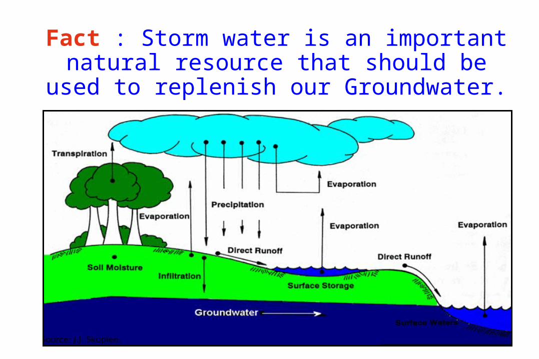
Fact : Storm water is an important natural resource that should be used to
replenish our Groundwater.

Fact : It is generally more efficient and cost-effective to prevent problems rather
than attempt to correct them after the fact.

Fact : The final design of a storm water management system should
attempt to mimic and use the natural drainage features of the site.

• The final site design should maximize on-site storage, infiltration & evaporation of storm water. (Remember, storm water is a resource.)
• Consideration should also be given to neighborhood or regional storage.
Fact :

Fact : When possible, avoid discharging storm water directly to a surface water body such as
a stream.

Fact : Begin at the “end of the pipe,” the receiving
stream.
(Understand where the storm water from the site will discharge and how it will impact downstream areas before design of the storm water system.)

Fact : Regular inspection and maintenance is a key component of a storm water management system!

Storm water management
Gaza Strip as a case study

Remember, storm water is a resource!

Importance of Long-Term Hydrologic Impact Assessment:
• Expansion of urban areas significantly impacts the environment in terms of ground water recharge, water pollution, and storm water drainage.
• Urbanization leads to creation of impervious surfaces which lead to an increase in surface runoff volume, this in turn contributes to downstream flooding and a net loss in groundwater recharge.
• Minimizing the disturbance on an urbanizing watershed is one way of ensuring continued water supply.
• Since each land use has a different level of impact,
careful physical planning can minimize these impacts.

• Assessment of the hydrologic impacts of urban land use
change traditionally includes models that evaluate how
land use change alters peak runoff rates, and these
results are then used in the design of drainage systems.
• Such methods however do not address the long-term
hydrologic impacts of urban land use change and often
do not consider how pollutants that wash off from
different land uses effect water quality.

• Techniques traditionally used to assess the impacts of
land use change on runoff typically focus on individual
short-term "design" storm events of specific recurrence
intervals, and are used to calculate peak discharge rates
and hydrographs.
• Single storm methods are suitable as engineering
approaches in estimating flood intensities for stormwater
facilities management, they do not address the longterm,
cumulative hydrologic impacts of land use change.

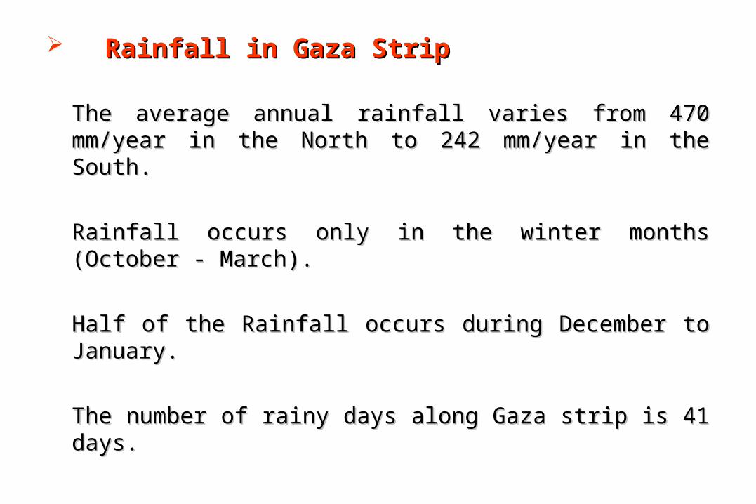
Rainfall in Gaza StripRainfall in Gaza Strip
The average annual rainfall varies from 470 mm/year in the North to The average annual rainfall varies from 470 mm/year in the North to 242 mm/year in the South.242 mm/year in the South.
Rainfall occurs only in the winter months (October - March).Rainfall occurs only in the winter months (October - March).
Half of the Rainfall occurs during December to January.Half of the Rainfall occurs during December to January.
The number of rainy days along Gaza strip is 41 days.The number of rainy days along Gaza strip is 41 days.

0
5
10
15
20
25G
AZ
A
B.H
anoun
B.L
ahia
Els
hati
a
Elm
oghra
qa
Eln
usi
era
t
D.B
ala
h
Khanyuonis
Rafa
h
Stations Location
Nu
mb
er
of
Days Rainy Days >
5mm
10mm
20mm
30mm
40mm
50mm
Number of Rainy Days According to the Quantity in (mm) for Nine Weather Stations in Gaza strip for the Year 2004 (MOT, 2004)

Gaza Strip Base Map Showing Weather Stations Distributions (PWA, 2003).

Inflows (Mm3/yr.) Outflows (Mm3/yr.)
Min Max Min Max
Rainfall rechargeLateral inflow from
IsraelLateral inflow from
EgyptSaltwater intrusion
Water system leaksWastewater return flow
Irrigation return flowLoss of aquifer storage
Other recharge
40.018.0
2.010.010.010.520.0
2.13.5
45.030.0
5.015.015.010.525.0
3.23.5
Municipal abstraction
Agricult. abstraction
Mekorot abstraction
Discharge to the sea
47.080.0
5.010.0
47.0100.
08.0
15.0
Total 116.1 152.2 142.0
170.0
Net balance -25.9 -17.8
Estimated Water Balance of the Gaza Strip (Metcalf& Eddy)
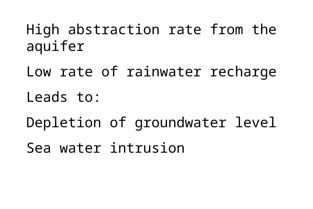
High abstraction rate from the aquifer
Low rate of rainwater recharge
Leads to:
Depletion of groundwater level
Sea water intrusion

Ñ
Ñ
Ñ
Ñ
Ñ
Ñ
Ñ
Ñ
Ñ ÑÑ
Ñ
Ñ Ñ
ÑÑ
Ñ
ÑÑ
Ñ
Ñ
ÑÑ
Ñ
Ñ
ÑÑ
Ñ
ÑÑ
ÑÑ
â
âââââ
ââ
â
â
â
â
â
ââ
ââ
â
â
â
âââ
â
â
âââ
ââ
â
ââ
â
â
â
ââ
â
ââ
â
â
â
â
ââ
â
â
â
â
â
â
â
âââ
â
ââ
â
ââ
â
â
ââ
ââ
â
â
â
â
â
â
â
âââââ
â
â â
âââ
â
â
â
â
â
â
ââââ
ââââ
âââ
â
â
â
â
ââ
ââ
â
ââ
ââ
âââ
ââââ
ââ
â
â
â
â
â
â
â
â
â
â ââ
ââââ
ââ
&&
&&
&
&
&&
&
&
&
&
&
&
&
&
&&&
&&
&
&
&&
&
&
&
&
&
&
&
&
&
&
&
&
&
&
&
&
& &
&
&&
&
&&
&
&&&
&&
&
&&&
&
&&
&&&&
&&&
&&
&
&
&
&&&
&&&&&
&&
&&&&&&&&&
&
&
&&&
&&
&
$
$$
$
$$$
$
$
$$$
$$
$$$$ $
$$$
$$$
$
$
$$
$$
$
$$ $
$ $
$
$
$
$$
$
$
$ $
$
$
$
$
$
$$
$$
$
%
%
%
%
%
%
%%
%
%%
Sources:- MOPIC
Base map based onCairo Agreement Map, 1994
Legend
Existing Ground Water Wells
Regional Plan for Gaza Governorates, Palestine
0 1 2 3 4 5 km
N
© 1998 MOPIC/Planning Sector
Project File: WELLSLayout Name: Wells A4Last update: April, 1998
Settlement AreaWadi GazaSealineDelimiting LineInternational Border
Ñ Control Wellâ Pumping & Test Well& Well With Log$ Makerot Well% Control Well (6 Months)


Existing Stormwater Management
According to Sogreah, et.al, (1999); PECDAR (2000), and Metcalf and Eddy (2000) the existing storm water systems in Gaza Strip will be as following:
I. Beit Hanoun
Storm drainage takes normally place in the streets. While all new roads are being built with storm drains. No particular problem for storm water drainage has been reported.
II. Beit Lahia
Storm drainage takes normally place in the streets. No particular problem for storm water drainage has been reported.
III. Jabalia
Storm water run-off in Jabalia town is lesser problem than that of Jabalia Camp. In the case of Jabalia Camp storm water run-off takes place in the streets, the storm water converges towards local depressions. The most one is Abu Rashid pond that located in the middle of the camp and having volume capacity of 47000 m3. In the case of Jabalia Town there are some local storm water run-off problems reported in areas in the southeast part of Jabalia. Storm water run-off takes place on the streets. Two catchment areas in the south part drains towards Sheikh Radwan pond in Gaza.

IV. Gaza
Storm water in the Coastal zone is not a major problem, as the area slopes to the sea. Most storm water runs-off in the streets, a few drains exists in the lower areas. The Gaza City having two Storm water reservoirs, which are:
IV.1 Sheikh Radwan Reservoir
It serves its own catchment of about 9000 dunums plus it receives over flow from Waqf reservoir, which serves a catchment of 9500 dunums. The storage capacity of Sheikh Radwan reservoir is about 560000 m3.
IV.2 Waqf Reservoir
It is located at a low point in the Asqoula area of the city and receives storm water flows from the adjacent streets and developed areas. Waqf reservoir, serves a catchment of 9500 dunums. The storage capacity of this reservoir is about 34000 m3.
V. Middle Area
Currently there are no facilities for storm water drainage in the urban areas of the middle area. No particular problem for storm water drainage has been reported. Rainfall was retained on the vegetation or infiltrated and run-off was intercepted by streams and Wadis. Recent urban development has increased the run-off ratios and blocked the natural drains.

VI. Khanyounis and Surrounding Villages.
Generally, storm water is drained by surface run-off in the streets or in ditches. A part of Khanyounis is drained towards a depression in the town center near the municipal office, another to the EL-Katiba depression. This depression is flooded during rain. Several smaller depressions in the town center are pumping the water to nearby streets.
VII. Rafah
The main storm water problem in Rafah is in the area near the Rafah Camp, where the storm water is mixed with sewage. Rafah is divided into 15 catchment areas; each catchment has a depression in to which the storm water drains.
VII. Rural Locations
Storm water control in rural areas is varied and sporadic, with emphasis on storage for use in irrigation rather that any flooding problems. Some rainfall collection systems do exist, which are privately controlled and sometimes water is sold on local consumers.

Stormwater Facilities in Gaza Strip. (Metcalf and Eddy, 2000)

Rainwater Harvesting
Collecting roof run-off in cisterns, and using it for both landscape irrigation and indoor purposes.
Collecting rainwater from Urban Areas and storing it in infiltration ponds.
Measures should be taken in the planning of New urban areas to harvest rainwater run-off.
Separation of Stormwater collection system.

Year Built up area (km2)
Number of houses
1997 54.25 152,851
2005 68.49 203,681
2010 94.65 297,111
Current and projected housing units for Gaza Strip (MOPIC, 1998)

year Collected rainwater (Mm3)
Built up area Roofs of houses
1997 10.61 3.71
2005 12.33 4.95
2020 18.5 7.22
Estimates of annual rainwater harvesting
Top Related