


Languages
Pages
Legal

Prepared for
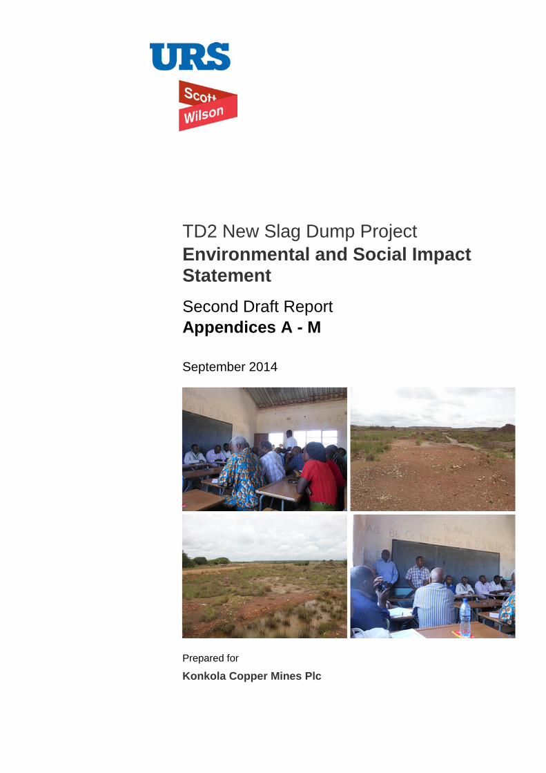
Konkola Copper Mines Plc
TD2 New Slag Dump Project Environmental and Social Impact Statement Second Draft Report Appendices A - M
September 2014
Konkola Copper Mines Plc
New Slag Dump Project
Draft Environmental and Social Impact Statement 146 September 2014
Appendices Appendix A: Approved Terms of Reference
Appendix B: Granulated Copper Slag Material Safety Data Sheet
Appendix C: Air Quality Assessment Report
Appendix D: Traffic Survey Data
Appendix E: Radiological Survey Report
Appendix F: Ecological Assessment Report
Appendix G: Ambient Noise Survey Report
Appendix H: Water Quality Assessment Report
Appendix I(a): Seismic Refraction Survey Report on TD2 Slag Dump in Chingola KCM License Area
Appendix I(b): Supplementary Report on the Seismic Refraction Survey Report on TD2 Slag Dump in Chingola KCM License Area
Appendix J: Minutes of the Public Disclosure Meeting held on 22 August 2014
Appendix K: Soils and Land Use Assessment Report
Appendix L: Social Impact Assessment Report
Appendix M: Design Report – TD2 Slag Dump
Konkola Copper Mines Plc
New Slag Dump Project
Draft Environmental and Social Impact Statement September 2014
Appendix A
Terms of Reference
Prepared for
Konkola Copper Mines Plc
TD2 New Slag Dump Project Environmental Impact Statement Final Terms of Reference March 2014
Konkola Copper Mines Plc New Slag Dump Project
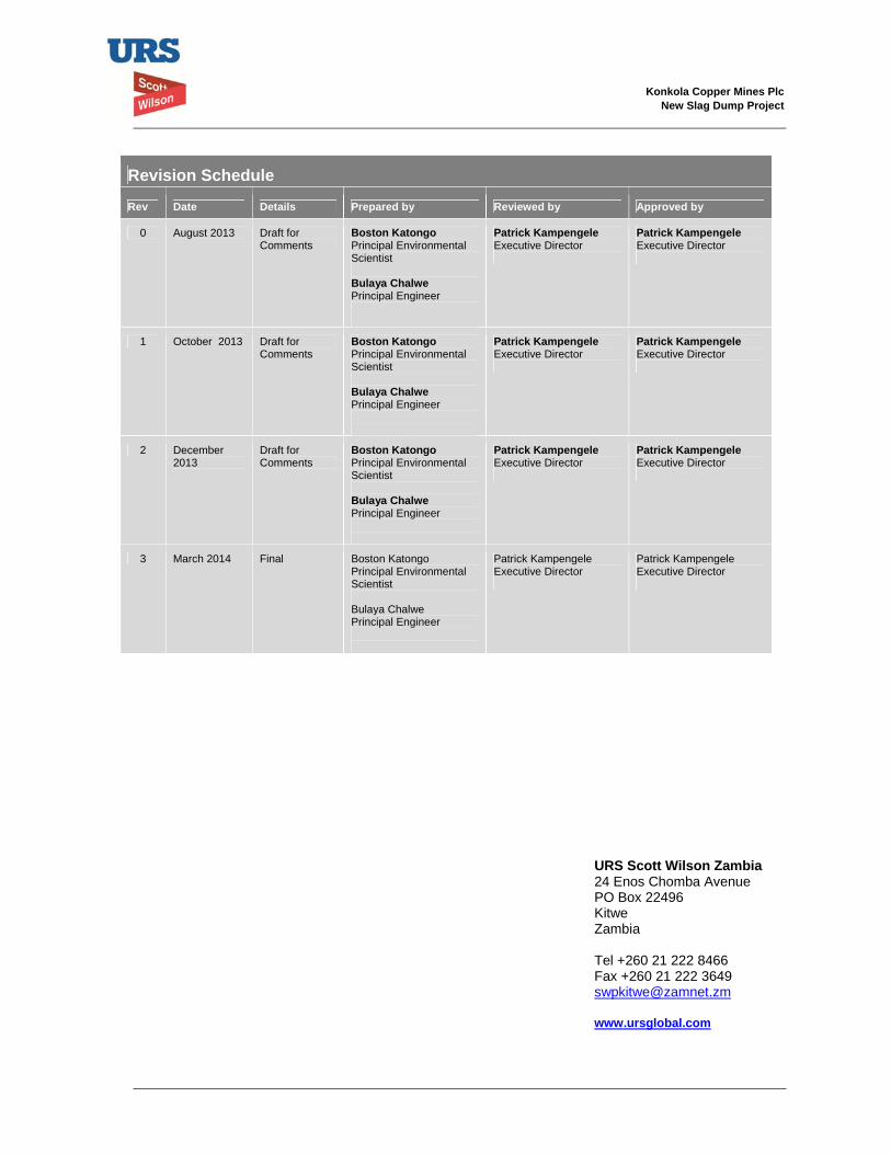
Revision Schedule
Rev Date Details Prepared by Reviewed by Approved by
0 August 2013 Draft for Comments
Boston Katongo Principal Environmental Scientist Bulaya Chalwe Principal Engineer
Patrick Kampengele Executive Director
Patrick Kampengele Executive Director
1 October 2013 Draft for Comments
Boston Katongo Principal Environmental Scientist Bulaya Chalwe Principal Engineer
Patrick Kampengele Executive Director
Patrick Kampengele Executive Director
2 December 2013
Draft for Comments
Boston KatongoPrincipal Environmental Scientist Bulaya Chalwe Principal Engineer
Patrick KampengeleExecutive Director
Patrick KampengeleExecutive Director
3 March 2014 Final Boston Katongo Principal Environmental Scientist Bulaya Chalwe Principal Engineer
Patrick Kampengele Executive Director
Patrick Kampengele Executive Director
URS Scott Wilson Zambia24 Enos Chomba Avenue PO Box 22496 Kitwe Zambia Tel +260 21 222 8466 Fax +260 21 222 3649 [email protected] www.ursglobal.com
Konkola Copper Mines Plc New Slag Dump Project
Final Terms of Reference i March 2014
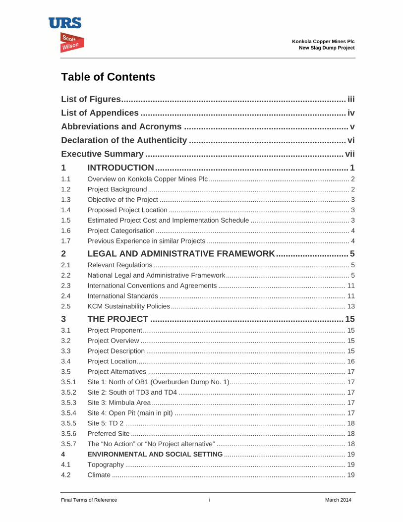
Table of Contents
List of Figures ............................................................................................. iii List of Appendices ..................................................................................... iv
Abbreviations and Acronyms .................................................................... v
Declaration of the Authenticity ................................................................. vi Executive Summary .................................................................................. vii 1 INTRODUCTION ................................................................................ 1
1.1 Overview on Konkola Copper Mines Plc .......................................................................... 2 1.2 Project Background .......................................................................................................... 2 1.3 Objective of the Project .................................................................................................... 3 1.4 Proposed Project Location ............................................................................................... 3 1.5 Estimated Project Cost and Implementation Schedule .................................................... 3 1.6 Project Categorisation ...................................................................................................... 4 1.7 Previous Experience in similar Projects ........................................................................... 4
2 LEGAL AND ADMINISTRATIVE FRAMEWORK .............................. 5
2.1 Relevant Regulations ....................................................................................................... 5 2.2 National Legal and Administrative Framework ................................................................. 5 2.3 International Conventions and Agreements ................................................................... 11 2.4 International Standards .................................................................................................. 11 2.5 KCM Sustainability Policies ............................................................................................ 13
3 THE PROJECT ................................................................................ 15
3.1 Project Proponent ........................................................................................................... 15 3.2 Project Overview ............................................................................................................ 15 3.3 Project Description ......................................................................................................... 15 3.4 Project Location .............................................................................................................. 16 3.5 Project Alternatives ........................................................................................................ 17 3.5.1 Site 1: North of OB1 (Overburden Dump No. 1) ............................................................. 17 3.5.2 Site 2: South of TD3 and TD4 ........................................................................................ 17 3.5.3 Site 3: Mimbula Area ...................................................................................................... 17 3.5.4 Site 4: Open Pit (main in pit) .......................................................................................... 17 3.5.5 Site 5: TD 2 .................................................................................................................... 18 3.5.6 Preferred Site ................................................................................................................. 18 3.5.7 The “No Action” or “No Project alternative” .................................................................... 18 4 ENVIRONMENTAL AND SOCIAL SETTING ................................................................ 19 4.1 Topography .................................................................................................................... 19 4.2 Climate ........................................................................................................................... 19
Konkola Copper Mines Plc New Slag Dump Project
Final Terms of Reference ii March 2014
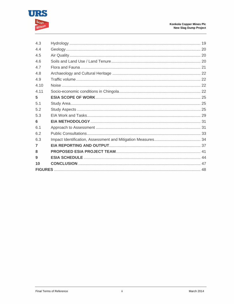
4.3 Hydrology ....................................................................................................................... 19 4.4 Geology .......................................................................................................................... 20 4.5 Air Quality ....................................................................................................................... 20 4.6 Soils and Land Use / Land Tenure ................................................................................. 20 4.7 Flora and Fauna ............................................................................................................. 21 4.8 Archaeology and Cultural Heritage ................................................................................ 22 4.9 Traffic volume ................................................................................................................. 22 4.10 Noise .............................................................................................................................. 22 4.11 Socio-economic conditions in Chingola .......................................................................... 22 5 ESIA SCOPE OF WORK ............................................................................................... 25 5.1 Study Area ...................................................................................................................... 25 5.2 Study Aspects ................................................................................................................ 25 5.3 EIA Work and Tasks ....................................................................................................... 29 6 EIA METHODOLOGY .................................................................................................... 31 6.1 Approach to Assessment ............................................................................................... 31 6.2 Public Consultations ....................................................................................................... 33 6.3 Impact Identification, Assessment and Mitigation Measures .......................................... 34 7 EIA REPORTING AND OUTPUT................................................................................... 37 8 PROPOSED ESIA PROJECT TEAM............................................................................. 41 9 ESIA SCHEDULE .......................................................................................................... 44 10 CONCLUSION ............................................................................................................... 47 FIGURES ..................................................................................................................................... 48

Konkola Copper Mines Plc New Slag Dump Project
Final Terms of Reference iii March 2014
List of Figures Figure 1.1: Site Location – Nchanga Mine
Figure 1.2: Proposed TD2 Slag Dump

Konkola Copper Mines Plc New Slag Dump Project
Final Terms of Reference iv March 2014
List of Appendices Appendix A: Scoping Report including minutes of the Scoping Meeting held on 2 October 2013 at
Mushishima Primary School
Appendix B: Curriculum Vitae for the proposed EIA Study Team
Appendix C: Project categorisation criteria and screening checklist for the New Slag Dump
Appendix D: TD2 Slag Dump Project Design Report
Konkola Copper Mines Plc New Slag Dump Project
Final Terms of Reference v March 2014
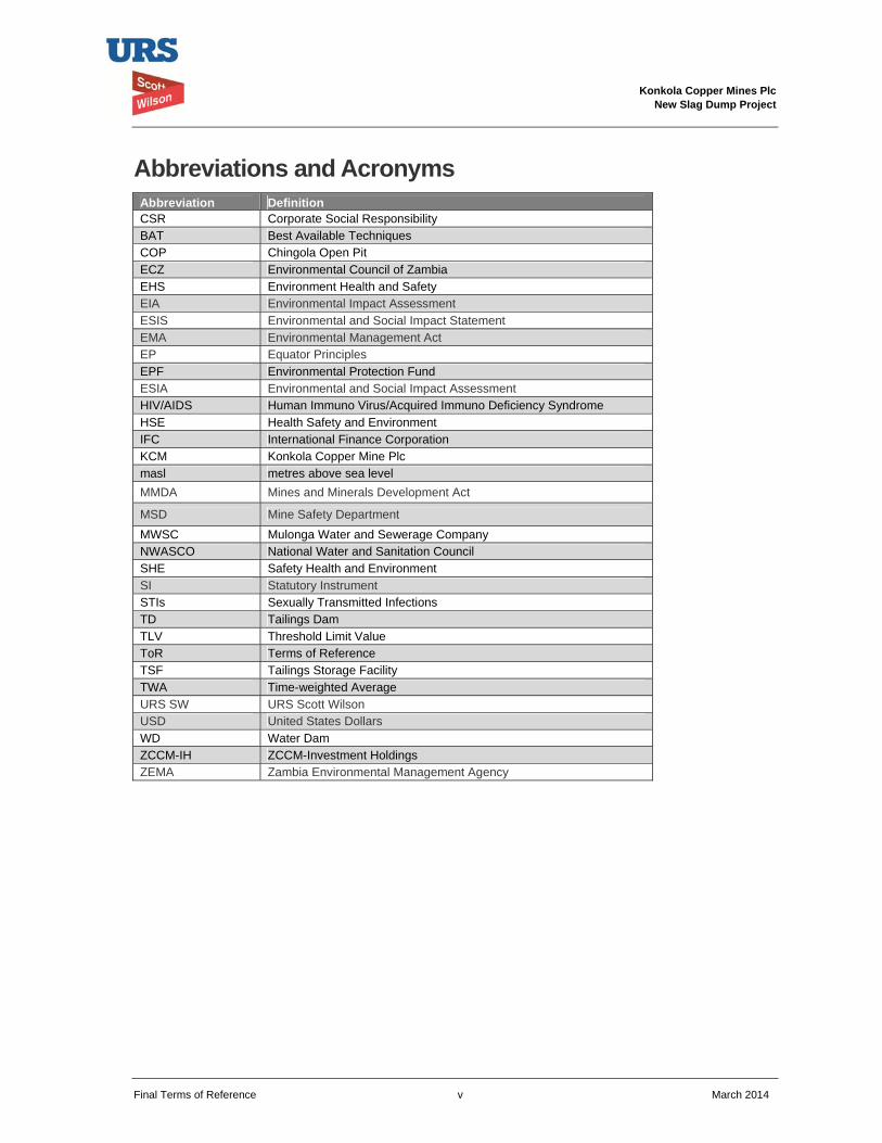
Abbreviations and Acronyms Abbreviation Definition CSR Corporate Social Responsibility BAT Best Available Techniques COP Chingola Open Pit ECZ Environmental Council of Zambia EHS Environment Health and Safety EIA Environmental Impact Assessment ESIS Environmental and Social Impact Statement EMA Environmental Management Act EP Equator Principles EPF Environmental Protection Fund ESIA Environmental and Social Impact Assessment HIV/AIDS Human Immuno Virus/Acquired Immuno Deficiency Syndrome HSE Health Safety and Environment IFC International Finance Corporation KCM Konkola Copper Mine Plc masl metres above sea level MMDA Mines and Minerals Development Act
MSD Mine Safety Department MWSC Mulonga Water and Sewerage Company NWASCO National Water and Sanitation Council SHE Safety Health and Environment SI Statutory Instrument STIs Sexually Transmitted Infections TD Tailings Dam TLV Threshold Limit Value ToR Terms of Reference TSF Tailings Storage Facility TWA Time-weighted Average URS SW URS Scott Wilson USD United States Dollars WD Water Dam ZCCM-IH ZCCM-Investment Holdings ZEMA Zambia Environmental Management Agency
Konkola Copper Mines Plc New Slag Dump Project
Final Terms of Reference vi March 2014
Declaration of the Authenticity
I, ___________________________________________ the undersigned, declare that the contents of this Terms of Reference reflect the scope of work that will be undertaken in conducting the environmental and social impact assessment study for the proposed TD2 Slag Dump in accordance with 2012 version of the IFC Performance Standards and Equator Principles
We further declare that the concerns raised by stakeholders at the time of carrying the consultations have been taken into account in preparing these Terms of Reference.
We acknowledge that environmental and social impact assessment study for the proposed project will be implemented in accordance with the applicable Zambian legal and administrative framework. The study will also conform to 2012 version of the IFC Performance Standards and Equator Principles.
For and on behalf of Konkola Copper Mines Plc
______________________________________
Manager Environment
Konkola Copper Mines Plc
Konkola Copper Mines Plc New Slag Dump Project
Final Terms of Reference vii March 2014
Executive Summary Introduction
This document presents the draft Terms of Reference (ToR) for undertaking the environmental and social impact assessment (ESIA) study and preparation of an Environmental and Social Impact Statement (ESIS) for the proposed New Slag Dump Project. The ToR document has been prepared on behalf of Konkola Copper Mines Plc (KCM), which is the project proponent. URS Scott Wilson has been commissioned by KCM to prepare the ESIS for the Project.
This ToR document set forth the scope of the ESIA study and the approach that will be used to conduct the study and to prepare the ESIS for the project.
It gives a description of the proposed project, which is construction and operation of the New Slag Dump. Five sites have been identified as potential slag dumpsite which will be evaluated during the ESIA to determine the most suitable site. The preferred site will be delineated to define the spatial and temporal boundaries of the project. It has also identified potential negative and positive environmental and social impacts associated with the proposed project following a preliminary assessment of the project components and their interactions with the existing baseline conditions. The detailed baseline studies will be carried out to inform decision-making.
This ToR document will therefore provide an opportunity for the Zambia Environmental Management Agency (ZEMA) and other stakeholders to confirm the scope of the assessments which will form the ESIA study approach to be adopted in the process of producing the New Slag Dump ESIS.
The document has been prepared in line with the requirements of the Zambian Environmental Impact Assessment Regulations, 1997 (Statutory Instrument No.28 of 1997), Vedanta Sustainability Framework, and 2012 version of the IFC PS. These regulatory standards stipulate issues to be covered in conducting an ESIA study and the stages that must be followed.
Project Background
KCM owns and operates Nchanga, Konkola, Nkana and Nampundwe mine sites in Zambia. Nampundwe mine site is located in Lusaka Province while the other mines are located on the Copperbelt Province. At its Nchanga Mine Site in Chingola, KCM undertakes both underground and open cast mining operations.
In 2008, KCM commissioned the Nchanga Copper Smelter at Nchanga Mine to smelt copper concentrates from its own concentrators and purchased concentrates. The smelter is located within the main plant area at Nchanga mine site and it has a design capacity of 300,000 tonnes of finished copper per year. The main products produced from the smelter are copper anodes and the waste product is granulated slag. An estimated 35,000 tonnes of granulated slag is generated per month, which is about 1,000 to 1,500 tonnes of slag per day.
The slag is currently disposed of at Slag Dump No.25, which has a design capacity of 2.6 million tonnes, situated within the KCM Mine License area (LSM 34) on the South-eastern rim of Block A Open Pit. Approximately 1.75 million tonnes has so far been dumped. The dump is approaching its design capacity and its expansion is constrained by the existence of several physical features in the vicinity (Block A Open Pit, Chingola Stream, Chingola - Chililabombwe Public road, KCM Haulage Road and drain). There is currently inadequate space to dispose of the slag. There is need for an alternative dumping space. KCM is, therefore, proposing to undertake a project to construct and operate a new slag dump.
Objective of the Project
The objective of the project is to dispose of slag in a safe and environmentally friendly manner by constructing and operating a new slag dump.
Proposed Project Locations
Konkola Copper Mines Plc New Slag Dump Project
Final Terms of Reference viii March 2014
The proposed project sites are situated within KCM Nchanga Mine License Area. These are:
Site 1. North of OB 1 Site 2. South of TD3 and TD4 Site 3. Mimbula area Site 4. Open Pit (main in pit) Site 5. TD2
Site No. 5 (TD2) is identified as a preferred site as explained in section 3.6.6. This site is within the reclaimed TD2 tailings storage facility footprint adjacent to the Western flank of TD7 tailings storage facility, which is currently being used as an emergency tailings dam. The site is characterised by small bare anti-hills and heaps of the remaining tailings. Prior to completion of the engineering drawings for dump design, it was assumed that the site would have a lifespan of 7 years. But following a detailed design of the dump the lifespan of the dump has turned out to be 20 years. The stakeholders will be informed of the change in lifespan during the public disclosure of the contents of the draft ESIS.
Estimated Project Cost
The estimated project cost is K 950,000.00. Project implementation has been planned to commence once approval of the Final ESIS has been granted by ZEMA.
Project Categorisation
The project was screened against KCM Sustainability Framework. The framework in aligned with IFC's Policy on Environmental and Social Sustainability requirements. According to these requirements, the proposed new slag dump project is a Category B project. This is principally because the proposed project has potential adverse environmental and/or impacts that are few in number, generally site-specific, largely reversible and readily addressed through mitigation measures.
Legal and Administrative Framework
The ToR document has been prepared in line with the requirements of the Zambian Environmental Management Act, 2011 and its subsidiary legislation, the Environmental Impact Assessment Regulations, 1997 (Statutory Instrument No.28 of 1997). It also refers to the Mines and Minerals Development Act, 2008, the Mines and Minerals (Environmental) Regulations, 1997, the Public Roads Act, 2002, the Road Traffic Act, 2002 and other applicable legislations and regulations. The administrative framework within which the proposed project will be implemented will include Zambia Environmental Management Agency (ZEMA), the Mine Safety Department and other regulatory and government agencies.
Project implementation will also conform to international conventions and internationally recognised standards such as Equator Principles (EP). The EP are based on and implemented in accordance with World Bank Group’s International Finance Corporation (IFC) Performance Standards and the IFC Environmental Health and Safety (EHS) Guidelines.
Vedanta Sustainability Framework is aligned with IFC PS and is domesticated by KCM. Henceforth, KCM’s sustainability policies and procedures are being implemented to ensure that its operations are undertaken in an environmentally and socially responsible manner. This project will be implemented within the confinement of these guidelines.
Project Description
The project elements will involve widening the existing access road to reclaimed TD2, construction of a drainage system around the footprint of the dump in order to direct runoff from the dump to the pollution control dam, transportation of slag from Nchanga Smelter to TD2 Slag Dump. This will be followed by dumping of slag on site and levelling.
Environmental and Social Setting and preliminary potential impacts
Konkola Copper Mines Plc New Slag Dump Project
Final Terms of Reference ix March 2014
The ToR outlines the environmental and social setting within the project area. The key potential impacts on the existing baselines conditions and that will be assessed further and mitigation measures recommended in this EIA study will be dust generation, surface water and groundwater contamination and potential increase in criminal trespass, theft and vandalism. Preliminary assessment shows that there will be no resettlement of people.
ESIS Scope of Work
The spatial boundaries for the study area will be fifteen Kilometres (15km) radius from the boundary of the project site (TD2). This entails that the assessment will not only be limited to the footprint of the proposed TD2 Slag Dump site (reclaimed TD2 tailings storage facility) but also areas where significant environmental and socio-economic impacts can be induced by the project. These areas will include surrounding farm (Mulenda Dairy Farm) and settlements. The ESIA will assess all the environmental and social facets of the project throughout the entire life cycle from construction and operation to decommissioning and closure phases.
The study aspects that will be included in the assessment relate to air quality, soils and land use, surface water and groundwater quality, noise and ground vibration, Radiation, flora and fauna, ecosystem services, traffic, carbon footprint, archaeological and cultural heritage and socio-economic.
ESIA Methodology and ESIA Reporting
An ESIA Methodology that will be adopted in carrying out the environmental and social impact study is outlined in this document. It includes the approach to environmental and social impact assessment, public consultations and identification and assessment of the impacts. The impacts will be assessed using standard methods of assessment and terminology. The ESIA study report will be prepared to meet the requirements of both the Zambian Environmental Impact Assessment Regulations, 1997, Statutory Instrument No. 28 of 1997 and the Vedanta Sustainability Framework (VSF)
Proposed ESIA Project Team
The ESIA Project team proposed to prepare the ESIS for the proposed project will include the Project Director to provide project oversight and strategic management, the Lead ESIS Author to coordinate ESIA activities and ESIS report writing and the Social Scientist / Economist to undertake an assessment of the socio-economic impacts that may potentially arise from the project. The Team will also include a Civil / Environmental Engineer to undertake a critical analysis of the project components in relation to existing environmental and social setting, and an Ecologist to conduct an assessment of the potential project impacts on biodiversity attributes and associated functions of the ecosystems services. A Water Resources Expert will also be part of the team with the role of assessing surface water and groundwater quality. Other experts that will be part of the team will include the following:
Radiation Expert – to undertake an assessment of radiation dose levels from the existing slag material;
Soils Expert – to determine soil texture, moisture holding capacity, fertility (NPK) and porosity.
ESIA Schedule
The ESIA schedule has been proposed and is included in this document. The schedule indicates the activity to be undertaken and the means of getting to the desired result following performance of the activity. It also shows the responsible party and the target dates. It is expected that the Final ESIS for the project will be submitted to ZEMA by June 2014.
Conclusion
This ToR document highlights the approach that will be undertaken and the legal framework within which the project will be implemented following approval of the ToR and approval of the completed ESIS by ZEMA. The terms of reference have been prepared to ensure that the resultant ESIA is conducted in line with all applicable national and international regulations and guidelines.
Konkola Copper Mines Plc New Slag Dump Project
Final Terms of Reference x March 2014
It is also KCM’s commitment to undertake its projects in a sustainable manner by addressing project impacts in an environmentally and socially sound manner.
Konkola Copper Mines Plc New Slag Dump Project
Final Terms of Reference 1 March 2014
1 INTRODUCTION This document presents the Final Terms of Reference (ToR) for undertaking the environmental and social impact assessment (ESIA) study and preparation of an Environmental and Social Impact Statement (ESIS) for the proposed New Slag Dump (the Project). The ToR has been prepared on behalf of Konkola Copper Mines Plc (KCM), the project proponent. URS Scott Wilson has been commissioned by KCM to prepare the ESIS for the Project.
The purpose of this ToR document is to set forth the scope of the ESIA study and the approach that will be used to conduct the study and to prepare the ESIS for the project to international standards. In addition, the document presents the legal and administrative framework within which the project will be implemented.
This ToR has given a description of the proposed project, which is construction and operation of the New Slag Dump at TD2. It has identified the spatial and temporal boundaries of the project. It has also identified potential negative and positive environmental and social impacts associated with the proposed project following a preliminary assessment of the project components and their interactions with the existing baseline conditions. The detailed baseline studies that will be carried out to inform decision-making by relevant primary stakeholders will involve primary data collection in the following disciplines: air, soils and land use, surface water and groundwater quality, noise and ground vibration, radiation, flora and fauna, ecosystem services, traffic, carbon footprint, archaeological and cultural heritage and socio-economic. Secondary data on other environmental and social baseline conditions will also be gathered through review of existing data relevant to the project. Section 5 of this document presents the scope of the ESIA work to be undertaken.
Primary and secondary data on the prevailing environmental and social conditions of the project area and analysis of the project components will form the basis for the prediction and assessment of the potential environmental and social impacts of the proposed project and subsequent compilation of the ESIS. Section 6 of this document presents impact assessment methodology and terminology that will be adopted in assessing the impacts.
The study area has been defined as being 15km radius from the boundary of the existing footprint of reclaimed TD2 and the surrounding areas.
This ToR document will therefore provide an opportunity for the Zambia Environmental Management Agency (ZEMA) and other stakeholders to confirm the scope of the assessments which form the ESIA study approach to be adopted in the process of producing the ESIS for the new slag dump.
The document has been prepared in line with the requirements of the Environmental Protection and Pollution Control (Environmental Impact Assessment) Regulations, 1997 (Statutory Instrument No.28 of 1997), which stipulates issues to be covered in conducting an ESIA study and the stages that must be followed. It has also been prepared in line with the requirements of Vedanta Sustainability Framework. Site specific conditions have also been taken into account in determining the likely significance of the issues to be covered in the study.
Konkola Copper Mines Plc New Slag Dump Project
Final Terms of Reference 2 March 2014
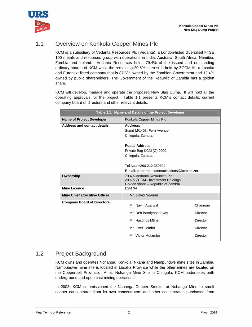
1.1 Overview on Konkola Copper Mines Plc KCM is a subsidiary of Vedanta Resources Plc (Vedanta), a London-listed diversified FTSE 100 metals and resources group with operations in India, Australia, South Africa, Namibia, Zambia and Ireland. Vedanta Resources holds 79.4% of the issued and outstanding ordinary shares of KCM while the remaining 20.6% interest is held by ZCCM-IH, a Lusaka and Euronext listed company that is 87.6% owned by the Zambian Government and 12.4% owned by public shareholders. The Government of the Republic of Zambia has a golden share.
KCM will develop, manage and operate the proposed New Slag Dump. It will hold all the operating approvals for the project. Table 1.1 presents KCM’s contact details, current company board of directors and other relevant details.
Table 1.1: Name and Details of the Project Developer
Name of Project Developer Konkola Copper Mines Plc
Address and contact details Address:Stand M/1408, Fern Avenue, Chingola, Zambia. Postal Address: Private Bag KCM (C) 2000, Chingola, Zambia. Tel No.: +260 212 350604 E-mail: [email protected]
Ownership 79.4% Vedanta Resources Plc 20.6% ZCCM - Investment Holdings Golden share – Republic of Zambia
Mine Licence LSM 34
Mine Chief Executive Officer Mr. David Ngándu
Company Board of Directors Mr. Navin Agarwal Chairman
Mr. Deb Bandyopadhyay Director
Mr. Hastings Mtine Director
Mr. Liver Tembo Director
Mr. Victor Mutambo Director
1.2 Project Background KCM owns and operates Nchanga, Konkola, Nkana and Nampundwe mine sites in Zambia. Nampundwe mine site is located in Lusaka Province while the other mines are located on the Copperbelt Province. At its Nchanga Mine Site in Chingola, KCM undertakes both underground and open cast mining operations.
In 2008, KCM commissioned the Nchanga Copper Smelter at Nchanga Mine to smelt copper concentrates from its own concentrators and other concentrates purchased from
Konkola Copper Mines Plc New Slag Dump Project
Final Terms of Reference 3 March 2014
some other mines. The smelter is located within the main plant area at Nchanga mine site and it has a design capacity of 300,000 tonnes of finished copper per year. The main products produced from the smelter are copper anodes and the waste product is granulated slag. An estimated 35,000 tonnes of granulated slag is generated per month, which is about 1,000 to 1,500 tonnes of slag per day.
The slag is currently disposed of at Slag Dump No.25 situated within the KCM Mine License area (LSM 34). The dump has been formed by end-tipping of granulated slag material from dump trucks and evenly spreading it outward using a loader or grader. This has resulted in the formation of dump slopes that are at the natural angle of repose of the slag material. Approximately 1.75 million tonnes has so far been dumped and the dump is approaching its design capacity of 2.6 million tonnes. There is currently inadequate space to dispose of the slag. Therefore, there is need for an alternative dumping space within KCM Surface Rights in Chingola.
Expansion of the existing dump is constrained by the presence of Block A Open Pit on the north-western edge, the Chingola Stream which lies approximately 300 m on the south-western edge, the Chingola - Chililabombwe public road at approximately 400m on the south-western edge, and the KCM Haulage Road and drain located on the eastern flank. There is also power line on the southern periphery of the existing dump.
KCM is, therefore, proposing to undertake a project to construct and operate a new slag dump. The proposed preferred site for the new slag dump is the already reclaimed TD2 tailings storage facility (TSF). According to the dump design, the proposed dumpsite has a 20 years lifespan as opposed to the initial assumption of 7 years earlier communicated to stakeholders.
1.3 Objective of the Project The objective of the project is to dispose of slag material in safe and environmentally friendly manner by constructing and operating a new slag dump.
1.4 Proposed Project Location The proposed preferred slag dump site is situated within KCM Mining License Area. This site is within the reclaimed TD2 tailings storage facility footprint adjacent to the Western flank of TD7 tailings storage facility. TD7 is currently being used as an emergency tailings dam. The site had previously contained large volumes of tailings which have since been reclaimed by hydraulic monitoring means. It is a substantially reclaimed area with largely no vegetation cover; there is only very limited grass cover in a few and isolated places but a very large area is bare. The site is characterised by small bare anti-hills and heaps of the remaining tailings. Figure 1.2 shows the location of the proposed site.
1.5 Estimated Project Cost and Implementation Schedule The estimated project preparation cost is K 950,000.00. The project implementation has been planned to commence once approval has been granted by ZEMA. The Final ESIS is expected to be submitted by June 2014 and therefore implementation will be by July 2014.
Konkola Copper Mines Plc New Slag Dump Project
Final Terms of Reference 4 March 2014
1.6 Project Categorisation The project was screened against KCM Sustainability Framework. The framework in aligned with IFC's Policy on Environmental and Social Sustainability requirements. According to these requirements, the proposed new slag dump project is a Category B project. This is principally because the proposed project has potential adverse environmental and/or impacts that are few in number, generally site-specific, largely reversible and readily addressed through mitigation measures. The project categorisation criteria and screening checklist is appended in Appendix C.
1.7 Previous Experience in similar Projects KCM has demonstrable experience in constructing and operating slag dumps. The existing slag dump has been constructed and operated by KCM since 2010. The dump is inspected routinely while statutory inspections are undertaken by independent competent persons every two years. The dump is operated as required under the Mines and Minerals (Environmental) Regulations, 1997 and is compliant with all licence conditions.
Konkola Copper Mines Plc
New Slag Dump Project
Final Terms of Reference 5 March 2014
2 LEGAL AND ADMINISTRATIVE FRAMEWORK This section outlines the legal and administrative framework within which the project will be implemented. It outlines the relevant national legislations and international agreements. The section also includes KCM’s sustainability policies.
2.1 Relevant Regulations New Slag Dump Project will be implemented within the Zambian legal and administrative framework and KCM Policies and plans. It will also be implemented to conform to international conventions and international best practices outlined in the Equator Principles (EP), the 2012 version of the International Finance Corporation (IFC) Performance Standards and Environment Health and Safety (EHS) Guidelines.
2.2 National Legal and Administrative Framework Environmental Management Act, 2011
The Zambian Environmental Management Act (EMA), 2011 is the superior Act on matters relating to environmental protection and management. Its superiority is outlined in Section 3 of the Act. The Act sets out a framework for Environmental Impact Assessments (EIA's) as well as renaming the Environmental Council of Zambia (ECZ) as the Zambia Environmental Management Agency (ZEMA), a regulatory Agency mandated to do all such things as are necessary to ensure the sustainable management of natural resources and the protection of the environment, and the prevention and control of pollution.
The EMA outlines principles governing environmental management and provides for, among other things, Environmental Impact Assessment and regulations relating to environmental assessments. The Act has also spelt out offences relating to failure to prepare and submit an EIA report for projects that require such reports.
The projects that require preparation of EIA reports must be approved by ZEMA prior to implementation. Section 29 of the Act specifically states that “a person shall not undertake any project that may have an effect on the environment without the written approval of the Agency, and except in accordance with any conditions imposed in that approval”.
The Environmental Protection and Pollution Control (Environmental Impact Assessment) Regulations, 1997 (Statutory Instrument No. 28 of 1997) specifies the requirements for an EIA and it also sets out in its Second Schedule projects for which EIAs are applicable. It provides specific guidelines for conducting environmental impact assessments and for evaluation of environmental impact statements. The regulations require project developers undertaking projects that may have significant effect on the environment to conduct environmental impact assessment prior to obtaining written approval from ZEMA on implementation of the project. Regulation 3 of the Instrument specifically states that “A developer shall not implement a project for which a project brief or an environmental impact statement is required under these Regulations, unless the project brief or an environmental impact assessment has been concluded in accordance with these Regulations.
Konkola Copper Mines Plc
New Slag Dump Project
Final Terms of Reference 6 March 2014
New Slag Dump Project will be implemented in accordance with the provisions of the Act and applicable environmental regulations.
Mines and Mineral Development Act, 2008
The Mines and Minerals Development Act (MMDA), 2008 addresses issues of environmental, human health and safety in the mining sector in Zambia. The Mines and Minerals (Environmental) Regulations, 1997 (Statutory Instrument No. 29 of 1997), a subsidiary legislation of the MMDA, provides a framework for preparing and submitting environmental project briefs and environmental impact statements prior to undertaking any prospecting, exploration or mining operations. The regulations also provide for, among other things, auditing of environmental and social management plans, mine dump reporting, mine site closure and associated decommissioning and closure costs, storage areas and handling of hazardous materials.
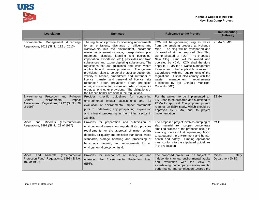
Table 2.1 presents a summary of some of the Zambian legislations that are relevant in the implementation of the proposed Project.
Konkola Copper Mines Plc
New Slag Dump Project
Final Terms of Reference 7 March 2014
Legislation Summary Relevance to the Project Implementing Authority
Environmental Management (Licensing) Regulations, 2013 (SI No. 112 of 2013)
The regulations provide for licensing requirements for air emissions, discharge of effluents and wastewaters into the environment, hazardous waste management (storage, transportation, pre-treatment, disposal, labelling and packaging, importation, exportation, etc.), pesticides and toxic substances and ozone depleting substances. The regulations set out guidelines and limits where applicable and general provisions. The general provisions relate to personal protective equipment, validity of licence, amendment and surrender of licence, transfer and renewal of licence, site restoration order, prevention order, protection order, environmental restoration order, compliance order, among other provisions. The obligations of the licence holder are sent in the regulations.
KCM will be generating slag as waste from the smelting process at Nchanga Mine. The slag will be transported and disposed of at the proposed New Slag Dump situated at TD2. The proposed New Slag Dump will be owned and operated by KCM. KCM shall therefore apply to ZEMA for a Waste Management Licence and other applicable licences in accordance with the requirements of the regulations. It shall also comply with the waste management requirements prescribed by the Chingola Municipal Council (CMC).
ZEMA / CMC
Environmental Protection and Pollution Control (Environmental Impact Assessment) Regulations, 1997 (SI No. 28 of 1997)
Provides specific guidelines for conducting environmental impact assessments and for evaluation of environmental impact statements prior to undertaking any prospecting, exploration and mineral processing in the mining sector in Zambia.
For the project to be implemented an ESIS has to be prepared and submitted to ZEMA for approval. The proposed project requires an ESIA study, which should be approved by ZEMA, prior to project implementation
ZEMA
Mines and Minerals (Environmental) Regulations, 1997 (SI No. 29 of 1997)
Provides for preparation and submission of environmental assessment reports. It also provides requirements for the approval of mine residue deposits, air quality and emission standards, waste standards, storage handling and processing of hazardous material, and requirements for an environmental protection fund.
The proposed project involves dumping of slag material from copper concentrate smelting process at the proposed site. It is a mining operation that requires regulation to safeguard the environment and human health and safety. Dumping operations must conform to the stipulated guidelines in the regulation.
MSD
Mines and Minerals (Environmental Protection Fund) Regulations, 1998 (SI No. 102 of 1998)
Provides for mechanism of setting up and operating the Environmental Protection Fund (EPF).
The proposed project will be subject to independent annual environmental audits and evaluation with the view of ascertaining the company’s environmental performance and contribution towards the
Mines Safety Department (MSD)
Konkola Copper Mines Plc
New Slag Dump Project
Final Terms of Reference 8 March 2014
Legislation Summary Relevance to the Project Implementing Authority
EPF.
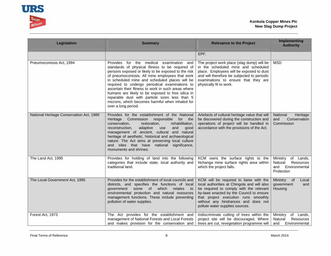
Pneumoconiosis Act, 1994 Provides for the medical examination and standards of physical fitness to be required of persons exposed or likely to be exposed to the risk of pneumoconiosis. All mine employees that work in scheduled mine and scheduled places will be required to undergo periodical examinations to ascertain their fitness to work in such areas where humans are likely to be exposed to free silica in reparable dust with particle sizes less than 5 microns, which becomes harmful when inhaled for over a long period.
The project work place (slag dump) will be in the scheduled mine and scheduled place. Employees will be exposed to dust and will therefore be subjected to periodic examinations to ensure that they are physically fit to work.
MSD
National Heritage Conservation Act, 1989
Provides for the establishment of the National Heritage Commission responsible for the conservation, restoration, rehabilitation, reconstruction, adaptive use and good management of ancient, cultural and natural heritage of aesthetic, historical and archaeological nature. The Act aims at preserving local culture and sites that have national significance, monuments and shrines.
Artefacts of cultural heritage value that will be discovered during the construction and operations of project will be handled in accordance with the provisions of the Act.
National Heritage and Conservation Commission
The Land Act, 1995
Provides for holding of land into the following categories that include state, local authority and traditional land.
KCM owns the surface rights to the Nchanga mine surface rights area within which the project falls.
Ministry of Lands, Natural Resources and Environmental Protection
The Local Government Act, 1995
Provides for the establishment of local councils and districts, and specifies the functions of local government some of which relates to environmental protection and natural resources management functions. These include preventing pollution of water supplies.
KCM will be required to liaise with the local authorities at Chingola and will also be required to comply with the relevant by-laws enacted by the Council to ensure that project execution runs smoothly without any hindrances and does not pollute water supplies sources.
Ministry of Local government and Housing
Forest Act, 1973
The Act provides for the establishment and management of National Forests and Local Forests and makes provision for the conservation and
Indiscriminate cutting of trees within the project site will be discouraged. Where trees are cut, revegetation programme will
Ministry of Lands, Natural Resources and Environmental
Konkola Copper Mines Plc
New Slag Dump Project
Final Terms of Reference 9 March 2014
Legislation Summary Relevance to the Project Implementing Authority
protection of forests and trees; and provide for the licensing and sale of forest produce.
be implemented to offset the losses.
Protection
Public Health Act, 1995
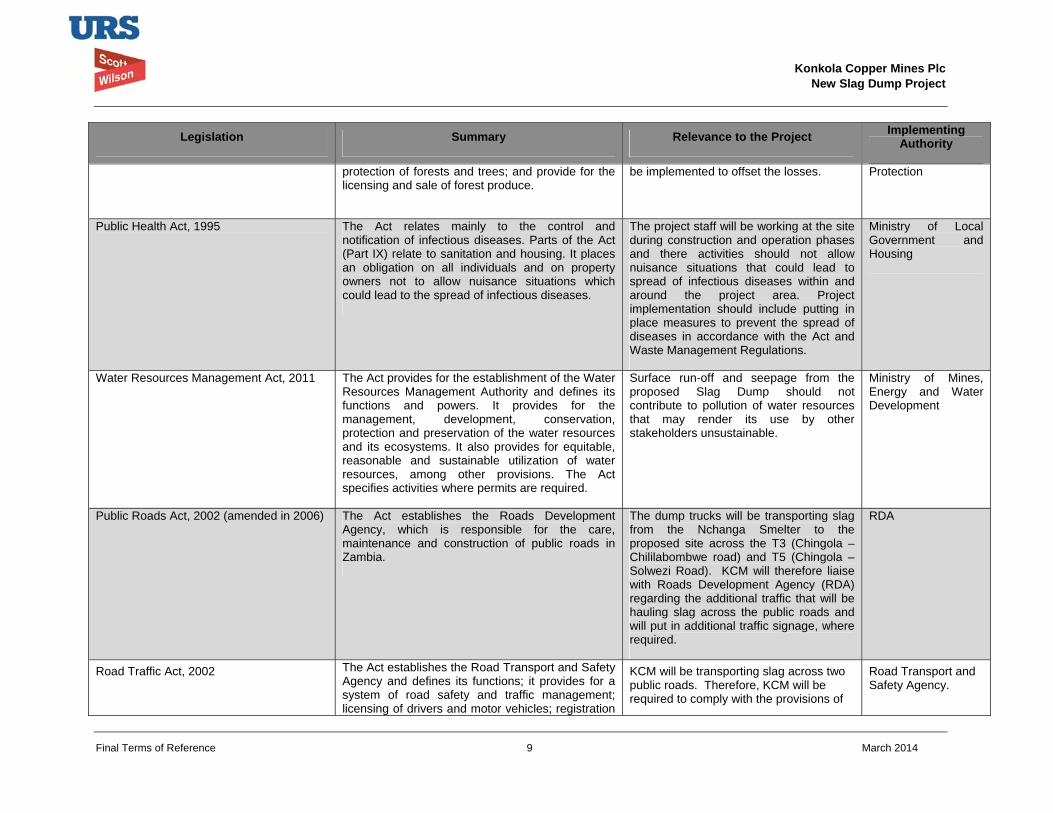
The Act relates mainly to the control and notification of infectious diseases. Parts of the Act (Part IX) relate to sanitation and housing. It places an obligation on all individuals and on property owners not to allow nuisance situations which could lead to the spread of infectious diseases.
The project staff will be working at the site during construction and operation phases and there activities should not allow nuisance situations that could lead to spread of infectious diseases within and around the project area. Project implementation should include putting in place measures to prevent the spread of diseases in accordance with the Act and Waste Management Regulations.
Ministry of Local Government and Housing
Water Resources Management Act, 2011 The Act provides for the establishment of the Water Resources Management Authority and defines its functions and powers. It provides for the management, development, conservation, protection and preservation of the water resources and its ecosystems. It also provides for equitable, reasonable and sustainable utilization of water resources, among other provisions. The Act specifies activities where permits are required.
Surface run-off and seepage from the proposed Slag Dump should not contribute to pollution of water resources that may render its use by other stakeholders unsustainable.
Ministry of Mines, Energy and Water Development
Public Roads Act, 2002 (amended in 2006) The Act establishes the Roads Development Agency, which is responsible for the care, maintenance and construction of public roads in Zambia.
The dump trucks will be transporting slag from the Nchanga Smelter to the proposed site across the T3 (Chingola – Chililabombwe road) and T5 (Chingola – Solwezi Road). KCM will therefore liaise with Roads Development Agency (RDA) regarding the additional traffic that will be hauling slag across the public roads and will put in additional traffic signage, where required.
RDA
Road Traffic Act, 2002 The Act establishes the Road Transport and Safety Agency and defines its functions; it provides for a system of road safety and traffic management; licensing of drivers and motor vehicles; registration
KCM will be transporting slag across two public roads. Therefore, KCM will be required to comply with the provisions of
Road Transport and Safety Agency.
Konkola Copper Mines Plc
New Slag Dump Project
Final Terms of Reference 10 March 2014
Legislation Summary Relevance to the Project Implementing Authority
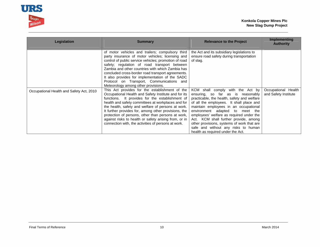
of motor vehicles and trailers; compulsory third party insurance of motor vehicles; licensing and control of public service vehicles; promotion of road safety; regulation of road transport between Zambia and other countries with which Zambia has concluded cross-border road transport agreements. It also provides for implementation of the SADC Protocol on Transport, Communications and Meteorology among other provisions.
the Act and its subsidiary legislations to ensure road safety during transportation of slag.
Occupational Health and Safety Act, 2010 This Act provides for the establishment of the Occupational Health and Safety Institute and for its functions. It provides for the establishment of health and safety committees at workplaces and for the health, safety and welfare of persons at work. It further provides for, among other provisions, the protection of persons, other than persons at work, against risks to health or safety arising from, or in connection with, the activities of persons at work.
KCM shall comply with the Act by ensuring, so far as is reasonably practicable, the health, safety and welfare of all the employees. It shall place and maintain employees in an occupational environment adapted to meet the employees’ welfare as required under the Act. KCM shall further provide, among other provisions, systems of work that are safe and without any risks to human health as required under the Act.
Occupational Health and Safety Institute
Konkola Copper Mines Plc
New Slag Dump Project
Final Terms of Reference 11 March 2014
2.3 International Conventions and Agreements Table 2.2 summarises international conventions and agreements to which the Zambian Government is a party and which are applicable to the project. The agreements and protocols impose obligations on Zambia to address issues or topics included in these documents.
Table 2.2: International Conventions relevant to the Project
Convention Relevance
Convention on Biological Diversity (ratified in 1993)
The objectives the Zambia’s National Biodiversity Action Plans include, ensuring the conservation of a full range of Zambia’s natural ecosystems through a network of protected areas, development and implementation of strategies for conservation of biodiversity, sustainable use and management of biological resources. Biological resources of significant conservation value that will be identified during Project implementation will be conserved and protected.
Convention on Wetlands of International Importance (1975)
The Convention aims at promoting conservation and sustainable use of wetlands and their resources for the benefit of the present and future generations. The Project development and implementation would need to be undertaken in a way that should not comprise the ecological character of the nearby water bodies.
Convention Concerning the Protection of World Heritage (1972)
The Convention aims at ensuring the identification, protection, conservation, presentation and transmission to future generations of the cultural and natural heritage. Cultural and natural heritage sites that may be identified during implementation of the proposed Project will be protected and conserved in accordance with the provisions of the Convention to which Zambia is party to.
2.4 International Standards This ESIA also makes due reference to internationally recognised standards in order to establish a transparent regulatory framework for the Project which is in line with both national requirements and the expectations of international stakeholders.
The Equator Principles (EP) are a financial industry benchmark for determining, assessing and managing social and environmental risk in project financing. They are adopted voluntarily by international financial institutions to ensure that projects financed by these institutions are developed in a manner that is socially responsible and reflect sound environmental management practices. They are based on and implemented in accordance with World Bank Group’s International Finance Corporation (IFC) Performance Standards on social and environmental sustainability and the IFC Environmental Health and Safety (EHS) Guidelines. The IFC is part of the World Bank Group and its standards and guidelines define both a robust approach to managing risks and impacts, and determine good international industry practice for significant project components.
KCM subscribes to the tenets of the Equator Principles and the IFC Performance Standards on social and environmental sustainability. Therefore, KCM will apply the EPs, IFC Performance Standards and EHS Guidelines to the Project’s impact assessment and
Konkola Copper Mines Plc
New Slag Dump Project
Final Terms of Reference 12 March 2014
mitigation process. The social and environmental impact assessments that will be undertaken for the Project also involves public consultation with all interested and affected parties, formulation of environmental and social management plans and mechanisms for redress of grievances associated with the Project.
In order to ensure compliance with current international best practices, the environmental and social impact assessment study for the project will be carried out in accordance with the policies, safeguard procedures, and guidance of the World Bank Group and Vedanta Sustainability Framework. It will also been carried out to meet Zambian legislative requirements.
The IFC Performance Standards and EHS Guidelines relevant to the Project are briefly outlined below.
2.4.1 International Finance Corporation Performance Standards
The IFC Performance Standards set out the underlying principles for sustainable project management, including impact/risk assessment, mitigation strategies, public consultation and performance monitoring.
Their relevance to the Project is briefly summarised below:
IFC Performance Standard 1: Assessment and Management of Environmental and Social Risks and Impacts: Establishes requirements for social and environmental performance management throughout the life of a project through initial baseline studies and identification of risks and impacts, establishment of management programmes that describe mitigation and performance improvement measures and actions to address identified risks and impacts, stakeholder engagement and application of management system to monitor and improve performance.
IFC Performance Standard 2: Labour and Working Conditions: Highlights the need for workers’ rights regarding income generation, employment creation, relationship management, commitment to staff, retention and staff benefits. It identifies and outlines the need to provide workers with a safe and healthy working environment. This Performance Standard is guided by international conventions.
IFC Performance Standard 3: Resource Efficiency and Pollution Prevention: Defines an approach to pollution prevention and abatement in line with current internationally disseminated technologies and good practice. It deals with ambient and cumulative considerations, resource conservation and energy efficiency, hazardous materials and waste management, pesticide use and management, and emergency preparedness and response provisions.
IFC Performance Standard 4: Community Health, Safety and Security: Specifies requirements for mitigating any potential for community exposure to risks and impacts arising from equipment accidents, structural failures and releases of hazardous materials. In addition, communities may be affected by impacts on their natural resources, exposure to diseases, and the use of security personnel.
IFC Performance Standard 5: Land Acquisition and Involuntary Resettlement: Outlines a policy to avoid or minimise involuntary physical resettlement as a consequence of the project. Where it is unavoidable, it requires suitable measures to mitigate adverse impacts on affected stakeholders, including appropriate compensation for any economic displacement such as loss of subsistence or commercial livelihood.
Konkola Copper Mines Plc
New Slag Dump Project
Final Terms of Reference 13 March 2014
IFC Performance Standard 6: Biodiversity Conservation and Sustainable Management of Living Natural Resources: Sets out an approach to protect and conserve biodiversity, including habitats, species and communities, ecosystem diversity, and genes and genomes, all of which have potential social, economic, cultural and scientific importance.
IFC Performance Standard 7: Indigenous Peoples: Recognises that Indigenous Peoples can be marginalized and vulnerable (such as, if their lands and resources are encroached upon by or significantly degraded by a Project). Their languages, cultures, religions, spiritual beliefs, and institutions may also be under threat.
IFC Performance Standard 8: Cultural Heritage: Aims to protect irreplaceable cultural heritage and to provide guidance for protecting cultural heritage throughout a Project’s life cycle.
Evolving sustainability issues associated with climate change, biodiversity and ‘eco-system services’, human rights and gender, labour and supply chains, and stakeholder engagement with affected communities are included in the Performance Standards and in certain cases have been enhanced following review of Performance Standards.
2.4.2 Environmental, Health and Safety Guidelines
The IFC EHS Guidelines were designed to broadly define ‘good international industry practice’ and set specific minimum design and operating standards (such as for emissions, discharge or exposure limits) in regard to the environment, occupational health and safety, community health and safety, and life cycle impacts including during construction, operation and decommissioning.
The detail in these standards is generally derived from globally recognised sources (such as the World Health Organisation) and are basically intended for application where host government’s legislation is either not available or is potentially deficient in regards to good international practice. Stipulated performance levels and measures are “generally considered to be achievable in new facilities by existing technology at reasonable costs”.
However, there is also some flexibility in regard to both their application to existing facilities and the fact that less stringent measures can be adopted, provided that there is a detailed justification for any proposed alternatives as part of the site-specific EIA. In the event of any unavoidable deviation from a performance measure stipulated in an EHS Guideline, the justification should be clearly explained.
The General EHS Guidelines are designed to apply to all projects and all sectors, but the detailed requirements can be superseded by sector guidelines, where factors such as facility size, technology and associated impacts merit specific attention. The specific industry sector EHS Guidelines that may be applicable to the proposed project include the guidelines on Waste Management Facilities, Mining and Water and Sanitation.
2.5 KCM Sustainability Policies KCM has nine sustainability policies adopted from the Vedanta Sustainability Framework. These policies are in line with the requirements of the IFC and the Equator Principles. They guide the way KCM manages sustainability issues as captioned in the policy names below:
• Safety Health and Environment; • Security;
Konkola Copper Mines Plc
New Slag Dump Project
Final Terms of Reference 14 March 2014
• Social; • Biodiversity; • Human Rights; • HIV/AIDS; • Water Management; • Energy and Carbon; • Supplier and Contractor Management.
Konkola Copper Mines Plc
New Slag Dump Project
Final Terms of Reference 15 March 2014
3 THE PROJECT 3.1 Project Proponent
The project proponent is Konkola Copper Mines Plc (KCM) and will hold all project operating approvals and authorisations.
3.2 Project Overview Slag dumpsite No. 25 was commissioned in 2010. The slag that was dumped at the unauthorised dump was also shifted to this dumpsite thereby drastically reducing dump’s design capacity. As a result, KCM intends to construct and operate a new slag dump. The proposed site for the new slag dump is a brownfield site located at the reclaimed TD2 facility.
The proposed Slag Dump will have an operational life of approximately 20 years, storing an estimated 10.95 million tonnes of slag material. The proposed slag dump will cover a maximum footprint area of 100 ha.
3.3 Project Description The various development phases of the proposed Project, which include the construction, operations and decommissioning stages, will be described in this section. The following describes the different project elements in more detail;
Site preparation by leveling the existing surface of the Project Site. The proposed Project site is the reclaimed TD2 area with a footprint of approximately 120 ha. The proposed slag dump will be located within the TD2 footprint and is expected to cover an area of approximately 100 ha. In order to ensure the safe disposal of slag material at the proposed site it will be necessary to improve the surface layout of the site. The surface elevations currently range between 1292 masl and 1297 masl over the entire surface, with the high sections being around the central part of the dump. Preparation of the surface through leveling and infilling of some much lower section will provide an even surface over which dump trucks and other access vehicle will be able to pass safely during dumping. The extent that the proposed dumpsite will cover will ensure that drainage of the area is well maintained with minimal environmental consequences. The detailed design report of the facility is appended in Appendix D. Adequate buffer zones will be created between the edge of the dump and any existing external drainage systems;
Grading and improvement of existing access roads from the Smelter Plant to the Project Site. It is proposed that access to the proposed dump site will be along already existing access routes from the main plant area to TD2 TSF and the adjacent TD 2 reclamation pumping station. The access roads are currently used as access to other dumps that are further North such as TD3 and TD4. Dump trucks will be used along these access gravel roads and therefore there is need to improve their current condition. Areas of improvement will include drainage, widening and grading of the roads. There will also be improvement to the existing road safety particularly at the road crossing with the main truck road that the access road will intersect with; namely Chingola-Solwezi (T5) road;
Construction of the drainage network around the Project Site: This will be done in the early stages of the project and also as and when the need arises during the operational phase. The drainage pattern around the proposed site will need to be done in such a way that the runoff is captured and treated prior to discharge into the receiving natural watercourses. The Project site is drained by the Mushishima and Chingola Streams.
Konkola Copper Mines Plc
New Slag Dump Project
Final Terms of Reference 16 March 2014
Where ground profile allows, the drainage will be profiled so that it discharges into the Pollution Control Dam (PCD).
Dumping of slag material: Material from the Smelter Plant will be hauled in dump trucks [30-40 tonnes truck] and transported to the proposed dump site. Approximately 1500 tonnes of slag material will be dumped at the site per day and at least two dump trucks will be involved in the dumping operations. The dumping operations will basically involve end tipping of the granulated slag from the dump trucks and the subsequent spreading and leveling of the material. The material will be spread and leveled using either a Grader or Dozer. Selection of the appropriate equipment to use will be determined by the amount of spreading required and the stage of the development of the dump. At elevated heights use of the more versatile Dozer will be appropriate. Material will be dozed outwardly towards the edges to ensure the dump slope profile is formed and at the same time ensure all material is within the designed footprint of the dump. The design of the dump will take into account the maximum height of the dump in relation to the surrounding environment. The proposed design will be to develop the dump site in modular cells with each cell storing up to one years’ production of granulated slag.
The anticipated waste from the construction works is mainly construction rubble and un-reclaimed tailings, which will be disposed of at designated dump site.
3.4 Project Location The proposed slag dump site is within the footprint of the reclaimed TD2 Tailings Storage Facility (TSF). The site has previously contained large volumes of tailing, most of which has since been reclaimed for mineral reprocessing. The remaining surface of the area is largely bare with isolated patches of grass vegetation in certain places. The surface is uneven with old anthills exposed in places where the reclamation process has been completed. There are several old drainage paths over the surface that were used for directing tailings slurry into collection sumps during the active reclamation activities.
TD2 lies about 6.2 Km to the North-West of the Smelter Plant Complex and covers an area of about 120 ha. At its widest point the site is approximately 1.5 km wide in a North-South direction. To the northern end of the TSF is an open grassy area with a fall towards the Mushishima Stream, which is approximately 1 Km further north. An access gravel road forms the boundary between the TSF and the open northern area. Eroded tailings from the TSF have covered some section of the northern area.
To the immediate East is the TD2 pumping station. An access road running in a North-South direction forms the boundary between the pumping station and the TSF. To the South of the proposed site is TD7 Tailings Storage Facility. An earthfill embankment forms the boundary between TD7 and TD2. TD7 has also been largely reclaimed.
To the West and South-West is the Mulenda Dairy Farm. An access road, open drain and a partially wooded area forms a buffer boundary between the edge of the TD2 TSF and Mulenda Dairy Farm.
Figure 1.2 shows the location of the proposed project site for the new Slag Dump at TD2.
Konkola Copper Mines Plc
New Slag Dump Project
Final Terms of Reference 17 March 2014
3.5 Project Alternatives The possible project alternatives that have been considered relate to the location of the slag dump. Site selection criteria involved taking into account three pillars of sustainable development, namely environmental, social and economic factors.
As a minimum, the preferred route should meet sustainability requirements in the disciplines that include safety, health, environment, economics, social and security.
Five sites have been identified within the KCM Mine License Area. The sites have been preliminarily assessed based on the site selection criteria that take into account environmental, social and economic factors.
The subsections below give brief characteristics of the identified sites.
3.5.1 Site 1: North of OB1 (Overburden Dump No. 1) This site is located to the North of OB1. The preliminary assessment has indicated that the following:
The site is a greenfield with a modified habitat;
The site has no direct route to access it;
It is also located at long distance from the Nchanga Smelter.
3.5.2 Site 2: South of TD3 and TD4 Site 2 is located to the South of TD3 and TD4. The preliminary assessment has indicated the following:
The site will require resettlement and/or compensation of some local communities;
The site is very close to the Chingola – Solwezi road;
It is also a greenfield site with a modified habitat.
3.5.3 Site 3: Mimbula Area The preliminary assessment of Site 3 situated in Mimbula Area has indicated the following:
The site will require resettlement and/or compensation of people;
The site is located at a long distance from the Smelter;
There is no direct route to access the site;
Greenfield site with a modified habitat.
3.5.4 Site 4: Open Pit (main in pit) Site 4 is located in the Nchanga Open Pit (main in pit). Preliminary assessment indicates the following:
The site is near to the Smelter but has safety risks on underground operations;
No resettlement and/or compensation of people will be required;
The site is not visible to the general public;

Konkola Copper Mines Plc
New Slag Dump Project
Final Terms of Reference 18 March 2014
It is a brownfield site with no significant impacts on biodiversity.
3.5.5 Site 5: TD 2 Site 5 is located at the reclaimed TD2 tailings storage facility. Preliminary assessment of the site indicates the following:
The site is near to Nchanga Smelter;
There will be no resettlement and/or compensation issues associated with the site;
The site is highly visible to the general public;
The site is a brownfield with no significant impacts on biodiversity;
The site has already an existing access road, which will need to be widened.
3.5.6 Preferred Site The preferred site is the reclaimed TD2 tailings storage facility because it is a brownfield site and is near to the smelter. It is approximately 6.2 km from the Smelter. The site has adequate area (120 ha) that gives the proposed slag dump an expected lifespan of 20 years. Access road to the proposed dump is readily available. There are no resettlement or compensation issues associated with the preferred site.
3.5.7 The “No Action” or “No Project alternative” Under the “No Projective Alternative”, any potential adverse environmental and social impacts associated with the project would not occur. However, the preliminary assessment indicates that the disadvantages with the no project scenario include the following:
Significant reduction in copper production since there will be limited space for slag disposal, a process directly connected to the operations of the smelter;
Loss of employment for people working at the smelter and associated plant facilities;
Loss of government revenue through reduced taxes;
Loss of business for suppliers and contractors directly and indirectly dependent on the operations of the smelter.
Konkola Copper Mines Plc
New Slag Dump Project
Final Terms of Reference 19 March 2014
4 ENVIRONMENTAL AND SOCIAL SETTING The preliminary overview of the environmental and social baseline conditions of the project area are briefly described in this section. Detailed descriptions will be presented in the ESIS and will be used as the baseline against which potential environmental and social impacts will be assessed.
4.1 Topography The project site is in the Copperbelt region. The topography of the region is gently undulating with elevations ranging from 1250 to 1400 metres above sea level (masl). The site is within the Nchanga Mine, which lies on plateau with an average elevation of 1300 masl. The local topography of the mine area has been significantly modified by overburden dumps and tailings storage facilities that have been created within the mine license area through historical and current mining activities. The dumps have higher elevations in relation to the natural ground while the open pits have created depressions.
The proposed project site is located within a reclaimed TD2 tailings storage facility with an average elevation of 1300 masl and with a gentle fall in elevations towards the Mushishima and Chingola Streams.
4.2 Climate The climate of the Project area is characterized by three distinct seasons: a rainy season from November to April; a cool and dry season from May to August; and a hot and dry season from September to October.
The project area is situated in a high rainfall area. The annual average rainfall, based on long standing records at Kafironda Weather Station located about 35 km South-east of Chingola, is in the order of 1400 mm, with most of it concentrated over the period from November to March. Evaporation data has shown that evaporation exceeds rainfall for two thirds of the year. This typically occurs from April to November.
The prevailing wind direction is predominantly from the northeast to southwest. The average wind velocities range from 1.4 m/sec in the summer months to 1.0 m/sec in winter.
4.3 Hydrology Surface Water
The Copperbelt region’s surface waters are drained into the Kafue River, either directly or via a well-developed dendritic drainage pattern formed by its tributary streams and rivers.
The project site lies within the Kafue River drainage system with the Chingola and Mushishima Streams drainage systems being the nearest and most important hydrological features in relation to being the potential receptors of run-off from the proposed Slag Dump. Chingola steam flows into the Mushishima Stream, which flows into the Kafue River. The proposed project site is drained by the Mushishima and Chingola streams. The site does not cut across any surface stream.
The potential impact of the operations of the slag dump with regard to surface water pollution will be assessed. Slag leachability will be assessed based on laboratory leachability tests data. The results will be compared with whatever secondary data that might be available at KCM.
Konkola Copper Mines Plc
New Slag Dump Project
Final Terms of Reference 20 March 2014
Groundwater
The groundwater regime within the Nchanga Mining License Area has significantly been changed because of underground and open pit mining activities. In terms of groundwater quality, the available data generally indicates that both shallow and deeper Bedrock Aquifer groundwater quality falls within the World Health Organisation Drinking Water Standards.
The quality, quantity and direction of groundwater flow at the proposed site are not elaborately defined. The nearest groundwater monitoring borehole sunk on the north-eastern side of the proposed site has not intercepted water at a depth of 50 metres. Despite this borehole being dry, there is water recharge into the Mushishima stream on the western side of the site. A review of available hydrogeological data relevant to the project area will be undertaken to understand the hydrogeological conditions of the project site. A geophysical study will be undertaken to identify fracture zones in the area.
4.4 Geology The geology of the Nchanga Mining License consists of two major rock units, namely the Basement Complex and the Katanga System. The Basement Complex is overlain by the Katanga System, which is divided into the Roan, Mwashia, and Kundelungu groups and includes quarzites, argillites, dolomites, limestones, shales, and sandstones as the main rock types.
Mineralisation at the Nchanga Mine exists in two main horizons, namely the Upper and Lower orebodies. Generally, the underground operations extract ore from the Lower Orebody while open pit mining operations extract one or both where they exist. There are also significant satellite orebodies along the strike length, some of which have appreciable exploration potential. The orebodies are dispersed along the 40 km of strike in the Lower Roan Group strata that are folded into the major north-westerly plunging asymmetrical synclines and anticlines draped around the a hub of red granite.
4.5 Air Quality The main sources of dust emissions that can reduce local air quality within the project area include movement of utility vehicles along the access road and remains of exposed tailings material at TD2. The workers within the project area, the surrounding human communities, flora and fauna have the potential of being exposed to dust emissions.
A survey of time-weighted average (TWA) personal total dust exposures undertaken on operators at TD2 in February 2001 and June 2002 revealed that the maximum total dust exposure as TWA concentration over an 8-hour work shift was 1.1 mg/m3. This was within the total dust Threshold Limit Value (TLV) of 5 mg/m3.
A review of air quality monitoring data around and within the site will be undertaken as part of the environmental and social impact assessment of the proposed project. Ambient air quality monitoring will be undertaken as part of the ESIA study to identify potential impacts of dust and air emissions on human health and functions of the ecosystems services within and around projects site as defined by the study area.
4.6 Soils and Land Use / Land Tenure Soils
Konkola Copper Mines Plc
New Slag Dump Project
Final Terms of Reference 21 March 2014
The surface soils at the proposed site are mostly covered with whitish brown fine to medium grained tailings while the subsoils are principally reddish brown, fine to coarse grained insitu material. Reddish brown, medium to coarse grained lateritic soils, and dark brown and fine grained mixture of tailings and insitu material, graduating into darkish grey insitu material, are found in some places within the proposed site. Further north of the proposed site, there is accumulation of tailings on the soil surface as a result of run-off from TD2 flowing into adjacent areas that include the catchment of Water Dam 2 (WD2), Chingola Stream and Pollution Control Dam.
Further insight into the soil characterisation will be determined through soils investigations to be undertaken by the Soils Expert. The investigations will take into account soil characteristics which will include soil texture, moisture holding capacity, soil fertility in terms of NPK and porosity. The baseline data will also be used to benchmark future rehabilitation activities during decommissioning and closure.
Land Use / Land Tenure
Proposed site falls within the Nchanga Mine Surface Rights Area owned by KCM. Land use within the area is dominated by mining activities. The proposed new Slag Dump site was previously used as a tailings storage facility. The facility has since been substantially reclaimed. The proposed site will also be restricted for use as a slag disposal facility.
Within the broader Nchanga Mine Surface Rights Area, agricultural activities by surrounding local communities have been extended into the mine surface rights area. This has particularly occurred in areas not actively used by the mine. Charcoal burning and illegal mining activities are also some of the activities being undertaken by some local communities.
Current land use activities within the project’s study area will be mapped during the socio-economic survey to be undertaken as part of the ESIA study.
4.7 Flora and Fauna Miombo woodland is principally the vegetation type found in the Copperbelt region. The common tree species found in this vegetation type are Brachystegia, Isoberliriia, and Julbernardia. The natural vegetation patterns of the region have however been extensively disturbed by human activities that include mining activities, wood harvesting for fuel (charcoal production), subsistence / shifting agriculture and plantations among other activities.
The vegetation within the KCM Nchanga Mining Licence Area has equally been significantly disturbed through mining, charcoal production, subsistence agriculture and other human activities. The diversity of wildlife species within the Nchanga mining license area is poor mainly because of mining operations, human settlements, agriculture and other human activities that have resulted in loss of wildlife habitat and subsequent loss in species diversity.
The proposed site is largely bare with little to no vegetation cover. The area has been extensively used for mining activities that have subsequently changed wildlife habitats. Rare or endangered species are not found within and around the proposed site. Detailed flora and fauna survey will be undertaken as part of the environmental impact assessment.
A flora and fauna survey will be undertaken as part of the ESIA study to assess biodiversity attributes of the area. Recommendations will be provided of ensuring that further biodiversity losses are minimised and/or avoided, and where avoidance is not possible, the losses are offset.
Konkola Copper Mines Plc
New Slag Dump Project
Final Terms of Reference 22 March 2014
4.8 Archaeology and Cultural Heritage There are no known archaeological or cultural heritage sites at the proposed site. The site has been extensively used for mining operations particularly for storage of tailings from the plant area. The tailings have since been reclaimed and reprocessed at the Tailings Leach Plant (TLP).
Accordingly, no archaeological or cultural heritage study is recommended. In the event that an archaeological artefact is exhumed, this will managed as per company procedure of chance finds.
4.9 Traffic volume Currently dump trucks hauling the slag from the smelter to the existing slag dump do not cross the T3 road and the T5 (Chingola – Solwezi Road). With the proposed slag dump site, the dump trucks will be required to cross the two trunk roads (T3 and T5) during the operational phase of the dump. This will potentially increase traffic volumes across the roads.
A traffic assessment will be undertaken to gather primary data on the traffic situation along T5. Secondary data, if available, will be compared with the primary data. The assessment will take into account how the proposed project will impact on all road users including pedestrians. Appropriate mitigation measures will be recommended. Other issues that will be taken into account include congestion, safety, emission [dust], security and carbon footprint.
4.10 Noise Noise disturbance as a result of the construction and operations of the proposed Slag Dump will be assessed. Sensitive receptors within the study area will be identified and the potential impacts assessed. Noise surveys will be undertaken to generate primary baseline data, which will be supplemented with secondary data if available.
Based on the findings from the secondary and primary data, the data will be analysed and potential impacts will be identified. Appropriate mitigation measures will be recommended.
The noise surveys will consider noise levels and exposure to all receptors.
4.11 Socio-economic conditions in Chingola Economic Activities
Mining dominates the local economy of Chingola District and the Copperbelt Province in general. It drives the local socio-economic activities of the district and contributes significantly to the local economy through employment and tax revenues to the local authority. KCM remains the major private sector employer in the district. Its contribution to the local economy is through the provision of direct and contractor employment offered by many firms providing goods and services to KCM.
Apart from mining, agriculture, hospitality industry, transport and general trading in various goods are other sources of livelihoods in the district.
Education
In terms of education, Chingola District has 54 government schools, 51 private schools and 22 community schools. KCM owns and operates the Nchanga Trust School in Chingola The Trust School provides quality universal primary and secondary education to over 1000
Konkola Copper Mines Plc
New Slag Dump Project
Final Terms of Reference 23 March 2014
children of both mine employees and children from the related communities. In addition, KCM provides early childhood care education and development to children/dependants of marketeers at Chiwempala Market in Chingola. The centre provides daytime meals and early learning to the children.
Other activities undertaken by KCM and that relates to education include offering of KCM Scholarship Awards to pupils at KCM and Government schools, raising of computer literacy and development of infrastructure at schools and universities.
The nearest school to the proposed project site is Mushishima Primary School, which is located over 1 km to the South of the proposed site.
Health Facilities
Chingola District has two hospitals and several clinics operated by government and private surgeries. KCM owns and operates Nchanga South Hospital and clinics which provide quality healthcare to employees and the community. .
Within the district and like in many other districts in Zambia, malaria is one of the leading causes of morbidity and mortality. It has caused many deaths and placed a burden on the economy in terms of health care and lost productivity. Thus, as a counteractive measure, KCM initiated the roll-back malaria campaign programme which is being implemented in partnership with Government.
Transport and communication
Chingola district is interlinked by both road and rail infrastructure. Mobile telephone and fixed line telecommunications are available in the area.
Water Supply and Sanitation
Mulonga Water and Sewerage Company (MWSC) provides water supply and sanitation services in urban and peri-urban areas of Chingola, MWSC is licenced by the National Water and Sanitation Council (NWASCO) to provide water and sanitation services in urban and peri-urban areas of the district. The Kafue River is MWSC’s raw water source.
Potential Resettlement and Compensation
The initial social assessment indicates that there will be no resettlement or compensation issues associated with the proposed project. The project will not result in any physical or economical displacement of the local communities living in the vicinity of the project area.
A socio-economic survey will be undertaken as part of the ESIA study and will consider, where relevant, the following:
Lifestyle impacts – on the way people behave and relate to family, friends and cohorts on a day-to-day basis.
Cultural impacts – on shared customs, obligations, values, language, cultural artifacts, religious belief and other elements which make a social or ethnic group distinct.
Community impacts – on infrastructure, services, voluntary organisations, activity networks and cohesion.
Quality of life impacts – on sense of place, aesthetics and heritage, perception of belonging, security and livability, and aspirations for the future.
Konkola Copper Mines Plc
New Slag Dump Project
Final Terms of Reference 24 March 2014
Demographic factors: number of people, location, population density, age etc.
Socio-economic determinants: factors affecting income and productivity, such as risk aversion of the poorest groups, land tenure, access to productive inputs and markets, family composition, kinship reciprocity, and access to labour opportunities and migration.
Social organization: organization and capacity at the household and community levels affecting participation in local level institutions as well as access to services and information.
Socio-political context: implementing agencies’ development goals, priorities, commitment to project objectives, control over resources, experience, and relationship with other stakeholder groups.
Needs and values: stakeholder attitudes and values determining whether development interventions are needed and wanted, appropriate incentives for change and capacity of stakeholders to manage the process of change.
Socio-cultural changes: examples include social and governance structures, access to cultural heritage and/or natural resources, gender roles and relations, value and belief systems and well-being impacts on family, leisure, and recreation needs.
Socioeconomic changes: examples include demographic shifts through migration and/or organic population changes, demand for social services, changes in the local or regional economy, and fiscal impacts on local or regional government expenditures for social services.
Environmental effects: examples include amenity (dust, noise etc), water quality and consumption, soil fertility and agricultural use, and access to building materials.
Health issues: examples include changes in infant mortality rates, HIV and other infectious diseases and general health among the local communities.
Human rights considerations need to be integrated into Communities and Social Performance assessments and programmes to mitigate any identified risks and avoid complicity in human rights breaches. For example, an understanding of diversity and gender dynamics, both within the workforce and the community, and what the potential impact of our operations will be on the more vulnerable and marginalised groups in local society.
Traffic Impacts: The impact of traffic on all road users
Land Use: Land use and any other economic activities
Criminal activities to the surrounding communities
Konkola Copper Mines Plc
New Slag Dump Project
Final Terms of Reference 25 March 2014
5 ESIA SCOPE OF WORK 5.1 Study Area
The spatial boundaries for the study area will be fifteen Kilometres (15km) radius from the boundary of the project site (TD2). This entails that the assessment will not only be limited to the footprint of the proposed TD2 Slag Dump site (reclaimed TD2 tailings storage facility) but also areas where significant environmental and socio-economic impacts can be induced by the project. These areas will include surrounding farm (Mulenda Dairy Farm) and settlements. The ESIA will assess all the environmental and social facets of the project throughout the entire life cycle from construction and operation to decommissioning and closure phases.
The study aspects that will be included in the assessment relate to air quality, soils and land use, surface water and groundwater quality, noise and ground vibration, Radiation, flora and fauna, ecosystem services, traffic, carbon footprint, archaeological and cultural heritage and socio-economic.
5.2 Study Aspects Table 5.1 presents a summary of the potential sources of environmental and socio-economic impacts relating to the Project. This is based on the review of the existing environmental documentation pertinent to the proposed project site, available baseline data and issues and concerns raised during a Scoping Meeting held on 2 October 2013 at Mushishima Primary School.
The issues and concerns raised by stakeholders at the scoping meeting are presented in the minutes of the meeting given in Appendix A. The key issues from the meeting which form the basis for detailed studies are highlighted below:
Dust emissions arising from construction and operations of the slag dump;
Criminal trespass, theft and vandalism arising from ease accessibility of the dump site to thieves and illegal miners;
Criminal activities to the surrounding communities
Contamination of surface and groundwater;
Physical displacement as a result of the proposed project.
The ESIA study will assess the impacts presented in Table 5.1 using standard methods of assessment and terminology outlined in Section 6.3 of this document. Potentially significant environmental and social impacts will be assessed in detail in the ESIS.

Konkola Copper Mines Plc
New Slag Dump Project
Final Terms of Reference 26 March 2014
Table 5.1: Potential Environmental and Social Impacts
Parameter Potential Source Issue raised
by stakeholders
How they will be assessed in ESIA
Air Quality Movement of dump trucks along the access road to the proposed slag dump and dumping of slag generating dust and exhaust emissions.
√
Baseline data, with respect to ZEMA and World Bank Ambient Air Quality Guidelines, will be established through primary data collection. The technical report shall have to detail among other issues, physical properties of the potential pollutants in the ambient air - type, size, density and composition of particulate matter both PM10 and PM2.5. Other issues to be considered are: Establishment of the likely duration the particulate matter
would remain in suspension and including dispersion distance.
Establishment of air quality impacts on biophysical and social environment.
Recommendations on mitigation measures to manage air quality impacts.
Soils and land capability
Dumping of slag on surface soils potentially resulting in loss of topsoil.
Loss of topsoil to be assessed based on primary surface soil. Mitigation strategies to minimise loss of topsoil, where applicable, will be included in ESIS.
Spillage and /or flow of granulated slag material overland from haulage vehicles and dump slopes respectively resulting in soil contamination.
Potential soil contamination from granulated slag will be assessed and included in the ESIS. Mitigation measures to minimise contamination will be proposed.
Construction of high elevated slag dump resulting in the alteration of the local landscape and visual character of the reclaimed TD2 area; changes in the scenic view of the study area.
Changes in local landscape and visual character will be assessed and will be included in the ESIS.
Surface Water and Groundwater
Quality
Surface runoff from the dump slopes contributing to contamination of surface water in nearby Mushishima Stream by potentially washing down slag into the nearby Chingola and Mushishima streams.
√
The potential for slag to be washed down into Mushishima Stream and its potential to be leached when in contact with surface run-off will be assessed. Slag leachability tests on the existing slag will be undertaken to assess the potential of slag to be leached when in contact with surface runoff.
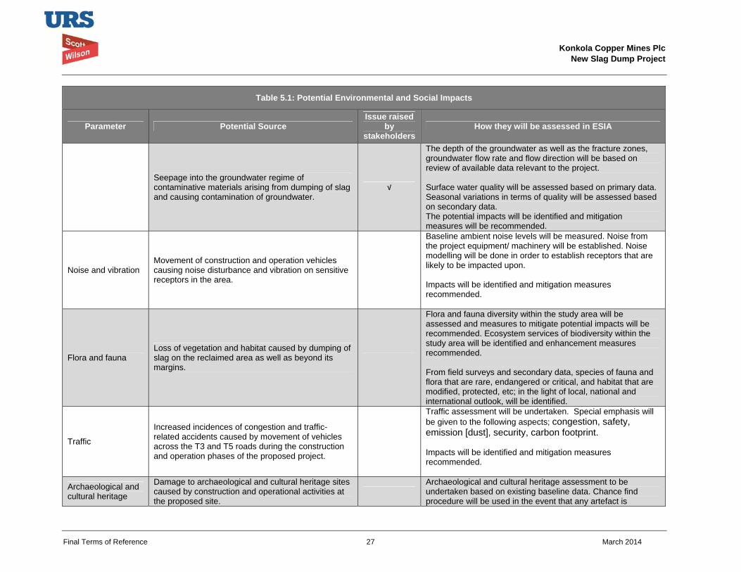
Konkola Copper Mines Plc
New Slag Dump Project
Final Terms of Reference 27 March 2014
Table 5.1: Potential Environmental and Social Impacts
Parameter Potential Source Issue raised
by stakeholders
How they will be assessed in ESIA
Seepage into the groundwater regime of contaminative materials arising from dumping of slag and causing contamination of groundwater.
√
The depth of the groundwater as well as the fracture zones, groundwater flow rate and flow direction will be based on review of available data relevant to the project. Surface water quality will be assessed based on primary data. Seasonal variations in terms of quality will be assessed based on secondary data. The potential impacts will be identified and mitigation measures will be recommended.
Noise and vibration Movement of construction and operation vehicles causing noise disturbance and vibration on sensitive receptors in the area.
Baseline ambient noise levels will be measured. Noise from the project equipment/ machinery will be established. Noise modelling will be done in order to establish receptors that are likely to be impacted upon. Impacts will be identified and mitigation measures recommended.
Flora and fauna Loss of vegetation and habitat caused by dumping of slag on the reclaimed area as well as beyond its margins.
Flora and fauna diversity within the study area will be assessed and measures to mitigate potential impacts will be recommended. Ecosystem services of biodiversity within the study area will be identified and enhancement measures recommended. From field surveys and secondary data, species of fauna and flora that are rare, endangered or critical, and habitat that are modified, protected, etc; in the light of local, national and international outlook, will be identified.
Traffic
Increased incidences of congestion and traffic-related accidents caused by movement of vehicles across the T3 and T5 roads during the construction and operation phases of the proposed project.
Traffic assessment will be undertaken. Special emphasis will be given to the following aspects; congestion, safety, emission [dust], security, carbon footprint. Impacts will be identified and mitigation measures recommended.
Archaeological and cultural heritage
Damage to archaeological and cultural heritage sites caused by construction and operational activities at the proposed site.
Archaeological and cultural heritage assessment to be undertaken based on existing baseline data. Chance find procedure will be used in the event that any artefact is
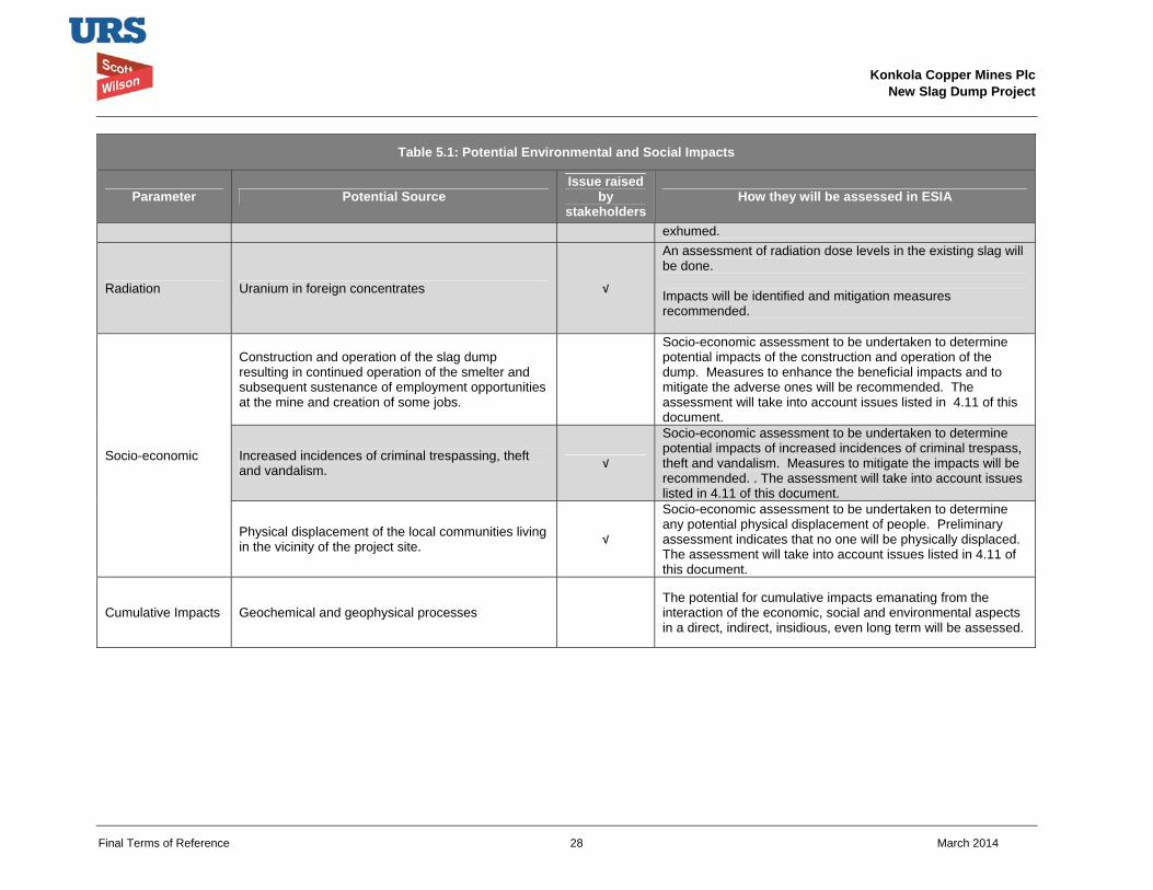
Konkola Copper Mines Plc
New Slag Dump Project
Final Terms of Reference 28 March 2014
Table 5.1: Potential Environmental and Social Impacts
Parameter Potential Source Issue raised
by stakeholders
How they will be assessed in ESIA
exhumed.
Radiation Uranium in foreign concentrates √
An assessment of radiation dose levels in the existing slag will be done. Impacts will be identified and mitigation measures recommended.
Socio-economic
Construction and operation of the slag dump resulting in continued operation of the smelter and subsequent sustenance of employment opportunities at the mine and creation of some jobs.
Socio-economic assessment to be undertaken to determine potential impacts of the construction and operation of the dump. Measures to enhance the beneficial impacts and to mitigate the adverse ones will be recommended. The assessment will take into account issues listed in 4.11 of this document.
Increased incidences of criminal trespassing, theft and vandalism. √
Socio-economic assessment to be undertaken to determine potential impacts of increased incidences of criminal trespass, theft and vandalism. Measures to mitigate the impacts will be recommended. . The assessment will take into account issues listed in 4.11 of this document.
Physical displacement of the local communities living in the vicinity of the project site. √
Socio-economic assessment to be undertaken to determine any potential physical displacement of people. Preliminary assessment indicates that no one will be physically displaced. The assessment will take into account issues listed in 4.11 of this document.
Cumulative Impacts Geochemical and geophysical processes
The potential for cumulative impacts emanating from the interaction of the economic, social and environmental aspects in a direct, indirect, insidious, even long term will be assessed.
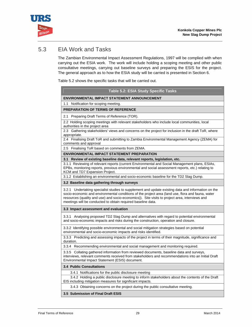
Konkola Copper Mines Plc
New Slag Dump Project
Final Terms of Reference 29 March 2014
5.3 EIA Work and Tasks The Zambian Environmental Impact Assessment Regulations, 1997 will be complied with when carrying out the ESIA work. The work will include holding a scoping meeting and other public consultative meetings, carrying out baseline surveys and preparing the ESIS for the project. The general approach as to how the ESIA study will be carried is presented in Section 6.
Table 5.2 shows the specific tasks that will be carried out.
Table 5.2: ESIA Study Specific Tasks
ENVIRONMENTAL IMPACT STATEMENT ANNOUNCEMENT 1.1 Notification for scoping meeting.
PREPARATION OF TERMS OF REFERENCE
2.1 Preparing Draft Terms of Reference (TOR). 2.2 Holding scoping meetings with relevant stakeholders who include local communities, local authorities in the project area 2.3 Gathering stakeholders' views and concerns on the project for inclusion in the draft ToR, where appropriate. 2.4 Finalising Draft ToR and submitting to Zambia Environmental Management Agency (ZEMA) for comments and approval 2.5 Finalising ToR based on comments from ZEMA. ENVIRONMENTAL IMPACT STATEMENT PREPARATION 3.1 Review of existing baseline data, relevant reports, legislation, etc. 3.1.1 Reviewing of relevant reports (current Environmental and Social Management plans, ESIAs, EPBs, monitoring reports, previous environmental and social assessment reports, etc.) relating to KCM and TD7 Expansion Project. 3.1.2 Establishing an environmental and socio-economic baseline for the TD2 Slag Dump.
3.2 Baseline data gathering through surveys
3.2.1 Undertaking specialist studies to supplement and update existing data and information on the socio-economic and environmental conditions of the project area (land use, flora and fauna, water resources (quality and use) and socio-economics)). Site visits to project area, interviews and meetings will be conducted to obtain required baseline data.
3.3 Impact assessment and evaluation
3.3.1 Analysing proposed TD2 Slag Dump and alternatives with regard to potential environmental and socio-economic impacts and risks during the construction, operation and closure.
3.3.2 Identifying possible environmental and social mitigation strategies based on potential environmental and socio-economic impacts and risks identified. 3.3.3 Predicting and assessing impacts of the project in terms of their magnitude, significance and duration. 3.3.4 Recommending environmental and social management and monitoring required.
3.3.5 Collating gathered information from reviewed documents, baseline data and surveys, interviews, relevant comments received from stakeholders and recommendations into an Initial Draft Environmental Impact Statement (ESIS) document.
3.4 Public Consultations 3.4.1 Notifications for the public disclosure meeting 3.4.2 Holding a public disclosure meeting to inform stakeholders about the contents of the Draft
EIS including mitigation measures for significant impacts. 3.4.3 Obtaining concerns on the project during the public consultative meeting.
3.5 Submission of Final Draft ESIS
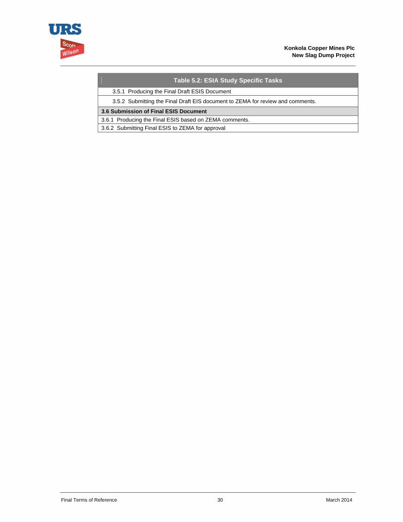
Konkola Copper Mines Plc
New Slag Dump Project
Final Terms of Reference 30 March 2014
Table 5.2: ESIA Study Specific Tasks
3.5.1 Producing the Final Draft ESIS Document
3.5.2 Submitting the Final Draft EIS document to ZEMA for review and comments.
3.6 Submission of Final ESIS Document 3.6.1 Producing the Final ESIS based on ZEMA comments. 3.6.2 Submitting Final ESIS to ZEMA for approval
Konkola Copper Mines Plc
New Slag Dump Project
Final Terms of Reference 31 March 2014
6 EIA METHODOLOGY 6.1 Approach to Assessment
An assessment of the environmental and social impacts associated with the Project will be undertaken as part of the ESIA process. This assessment will address potential impacts from construction, operation and decommissioning phases of the Project. Potential receptors of impacts will be identified from baseline data, with an assessment of the significance of potential impacts on these receptors.
Extensive baseline data will have to be gathered in order to provide current data set from which to base the evaluation of impacts. Secondary data will be used in most cases as supplementary. The environmental and social impacts that may potentially arise will be assessed against the baseline that will be established.
The environmental and social impact assessment will be conducted as required under the applicable Zambian legislations, notably the Environmental Impact Assessment Regulations, 1997 (Statutory Instrument No. 28 of 1997). These regulations provide guidelines on undertaking environmental assessment. The assessment will also be undertaken to conform to 2012 version of the World Bank Group’s International Finance Corporation (IFC) Performance Standards, it’s supporting applicable IFC Environment Health and Safety (EHS) Guidelines and other general international industry best practices.
The general approach that will be followed in preparing the ESIS for the proposed project will include the following:
Gathering available environmental and social baseline data; Analysis of the proposed Project with regard to potential impacts and risks during its
implementation; Identification of environmental and social mitigation strategy; Prediction and assessment of the impacts in terms of their magnitude, significance and
duration; Recommendations for environmental management and monitoring; Development of the decommissioning and closure plan; Estimation of the closure cost; and Collation of the above information into the ESIS.
The baseline studies included as part of the ESIA study are briefly described below.
Ambient Air Quality
Ambient air quality monitoring will be conducted to establish ambient air quality baseline conditions within the project area prior to the construction and operation of the proposed slag dump. A multi-gas analyser fitted with an in-built pump to suck air will be used to analyse ambient air quality at predetermined sampling points. The results will be compared with ZEMA and World Bank Ambient Air quality guidelines.
The monitoring exercise will be conducted at selected sampling points for a minimum of fourteen days to be able to get representative results. Any limitations to the study will be highlighted.
The monitoring results to be obtained will considered as indicative of the baseline ambient air quality within the project area prior to commencement of the project.
Water Resources
Konkola Copper Mines Plc
New Slag Dump Project
Final Terms of Reference 32 March 2014
Surface water monitoring within the project area will be undertaken as part of the ESIA study. Surface water from the nearby water bodies (Mushishima and Chingola Streams) will be sampled and analysed at an independent and reputable laboratory for parameters that will be used to assess quality of water (surface water pollution). The results will be compared with applicable water quality standards. The results will be used as baseline data. This will be supplemented with secondary data generated through routine environmental monitoring programmes.
The potential contribution of slag to surface water pollution through leaching of the slag by surface run-off will be assessed by conducting slag leachability tests. The tests will be done at an independent and recognised laboratory.
Groundwater
A desktop study and review of available hydrogeological data relevant to the project area will be undertaken to understand the hydrogeological conditions of the project site such as groundwater flow rate and flow direction. A geophysical study of the project site will be carried out to identify fracture zones. The purpose of this study will be to understand the potential pathways through which pollutants could flow into potential receptors such as surface water courses and underground water aquifers.
Groundwater within and around the project site will be sampled and analysed at an independent and recognised laboratory. The purpose of this exercise will be to assess the quality of groundwater prior to implementing the project.
Soils
Soil investigations will be carried out as part of the ESIA study. Soil samples will be collected from selected places within the project area. The soils will be analysed for parameters that will include soil texture, soil moisture holding capacity, soil porosity and soil fertility in terms of NPK. The baseline data that will be gathered through this study will be used to benchmark future decommissioning and rehabilitation activities.
Noise and vibrations
Baseline Environmental ambient noise level survey will be conducted on and around TD 2. A noise level meter will be used to take the measurements from ten equidistant locations around the target site. The maximum distance in a particular direction from the site will be determined by taking into consideration high incidences of intrusive noises.
The measurements will be taken on each location on three different days, during three different periods i.e 0600 hrs to 1200 hrs, 1200 hrs to 1800 hrs and 1800 hrs to 0600 hrs and a noise level survey report will be prepared. The noise levels that will be obtained will compared with international thresholds to establish the baseline noise levels prior to project implementation.
Flora and fauna
Flora and fauna field surveys within the project area will be undertaken by an ecologist. The purpose of the survey will be to assess the biodiversity attributes of the project area. The surveys will be supplemented with the secondary data that will be gathered through desk-based study and consultation.
The flora and fauna data that will be gathered will be considered as baseline flora and fauna conditions of the project area.
Traffic
Konkola Copper Mines Plc
New Slag Dump Project
Final Terms of Reference 33 March 2014
Traffic survey will be carried out on the Chingola – Solwezi Road (T5) to gather primary data on the traffic situation on the road. The current traffic (number and type of vehicles), movement of other road users (pedestrians / bicycle movements) and projected traffic generation arising from the proposed project will be taken into account when carrying out the survey.
A traffic assessment expert will carry out the survey. A detailed methodology will be included in the specialist technical report.
Radiation
Radiological survey will be conducted in order to ascertain gamma, alpha and beta radiation dose levels at the following location/sites of KCM:
Proposed slag dump site at reclaimed TD 2 including 100 metres periphery.
The area occupied by the nearest Community.
Proposed routes for transporting the slag (options A and B).
Along the Chingola stream.
Mushishima stream at three points (namely, Hellen, TD 3, and Solwezi Road Bridges).
The current smelter slag dump, which will help the Client predict dose rate levels at the proposed slag dump site.
Radiological measurements will be conducted using two radiation survey meters:
(a) Automess 6150 AD 6/E with the Automess Szintillorsonde 6150 AD-b/E probe, and
(b) Automess 6150 AD 5 with the Automess 6150 AD-17 probe.
The area to be surveyed will be mapped in grids of 75m by 75m except for Mushishima Stream where the dose rates will be taken from three points only, (Hellen, TD 3, and Solwezi bridges). One dose rate reading will be taken from each grid.
A radiological survey report will be compiled following the radiological measurements.
Socio-economic
Socio-economic surveys will carried out in order to establish the social baseline conditions of the project area. The surveys will include Focused Group Discussions (FGD), interviews with key stakeholders (local communities, the local authority, relevant government departments, Non-governmental Organisations, etc.). Desk-based study will also be used establish the baseline conditions.
Detailed methodology will be presented in the socio-economic survey report to be prepared by the Social Scientist / Economist.
Any limitations that will be encountered during the course of carrying out different technical studies will be highlighted in the reports.
6.2 Public Consultations Public consultations will be undertaken as part of the ESIA process for the proposed project.
The initial public consultations undertaken was a project scoping meeting held on 2 October 2013 at Mushishima Primary School in Chingola. The stakeholders were drawn from Konkola
Konkola Copper Mines Plc
New Slag Dump Project
Final Terms of Reference 34 March 2014
Copper Mines Plc, Zesco, Mulonga Water and Sewerage Company, URS Scott Wilson Zambia, Chingola Municipal Council, Mushishima community, Katunga Bulungu community, Kafue Hippo Pool community, Helen/Kansenji community and Mulenda farm community. The stakeholders helped to determine the scope of the work to be carried out when preparing the ESIS by contributing and raising their concerns on the proposed project at the meeting. The views of the stakeholders, where appropriate, have been taken into account in preparing the draft ToR for submission to ZEMA.
The minutes of the Scoping Meeting are appended in Appendix A.
A second public consultation meeting will be a public disclosure meeting on the draft ESIS following baselines surveys and assessment of impacts in line with the impact identification and impact assessment methodology outlined this document.
Other consultations will be carried out during baseline surveys prior to holding the public disclosure meeting.
The minutes of the public disclosure meeting will be appended to the draft and final ESIS document.
6.3 Impact Identification, Assessment and Mitigation Measures The potential impacts of the proposed Project will be identified and assessed based on review of project description and critical assessment of the project components in relation to the prevailing environmental and social baseline conditions. The identification and assessment of potential impacts will also be based on applicable national legislations and design guidelines for the slag dump.
A standard impact assessment methodology will be applied on identified impacts and will take into account the nature1 or status of the predicted impact, extent of the impact2, magnitude or intensity3 of the impact, the duration4 of the impact and the probability5 of the impact occurring. The impacts will be given a rating using the assessment criteria as indicated in Table 8.1. The overall significance of the impact will be obtained based on the extent (E), duration (D), intensity (I) and probability of the impact (P) occurring.
Significance of predicted impact (S) = (E + D + I) x P
The impact assessment terminology and ratings that will be used to describe the impacts are presented in Table 6.1.
The ESIS will also include a description of mitigation measures aimed at enhancing beneficial impacts and avoiding, reducing, remediating or compensating significant adverse impacts.
1 Nature of impact – an appraisal of the type of effect an activity would have on the affected environment. 2 Extent of the impact – indicates whether the impact will be site specific, local, regional, national or international. 3 Magnitude or intensity of the impact – indicates whether the impact is destructive or benign. 4 Duration of the impact – indicates the lifetime of the impact as either short-term, medium-term and long-term. 5 Probability of the impact – describes the likelihood of the impact actually occurring.
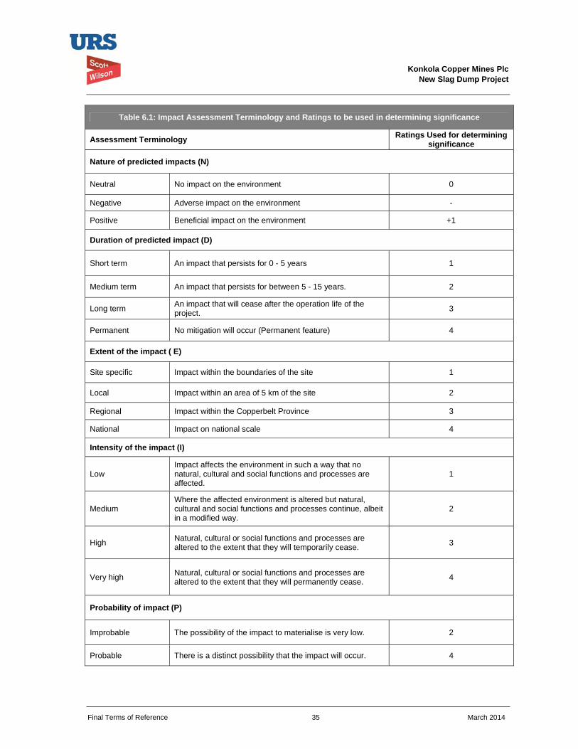
Konkola Copper Mines Plc
New Slag Dump Project
Final Terms of Reference 35 March 2014
Table 6.1: Impact Assessment Terminology and Ratings to be used in determining significance
Assessment Terminology Ratings Used for determining significance
Nature of predicted impacts (N)
Neutral No impact on the environment 0
Negative Adverse impact on the environment -
Positive Beneficial impact on the environment +1
Duration of predicted impact (D)
Short term An impact that persists for 0 - 5 years 1
Medium term An impact that persists for between 5 - 15 years. 2
Long term An impact that will cease after the operation life of the project. 3
Permanent No mitigation will occur (Permanent feature) 4
Extent of the impact ( E)
Site specific Impact within the boundaries of the site 1
Local Impact within an area of 5 km of the site 2
Regional Impact within the Copperbelt Province 3
National Impact on national scale 4
Intensity of the impact (I)
Low Impact affects the environment in such a way that no natural, cultural and social functions and processes are affected.
1
Medium Where the affected environment is altered but natural, cultural and social functions and processes continue, albeit in a modified way.
2
High Natural, cultural or social functions and processes are altered to the extent that they will temporarily cease. 3
Very high Natural, cultural or social functions and processes are altered to the extent that they will permanently cease. 4
Probability of impact (P)
Improbable The possibility of the impact to materialise is very low. 2
Probable There is a distinct possibility that the impact will occur. 4
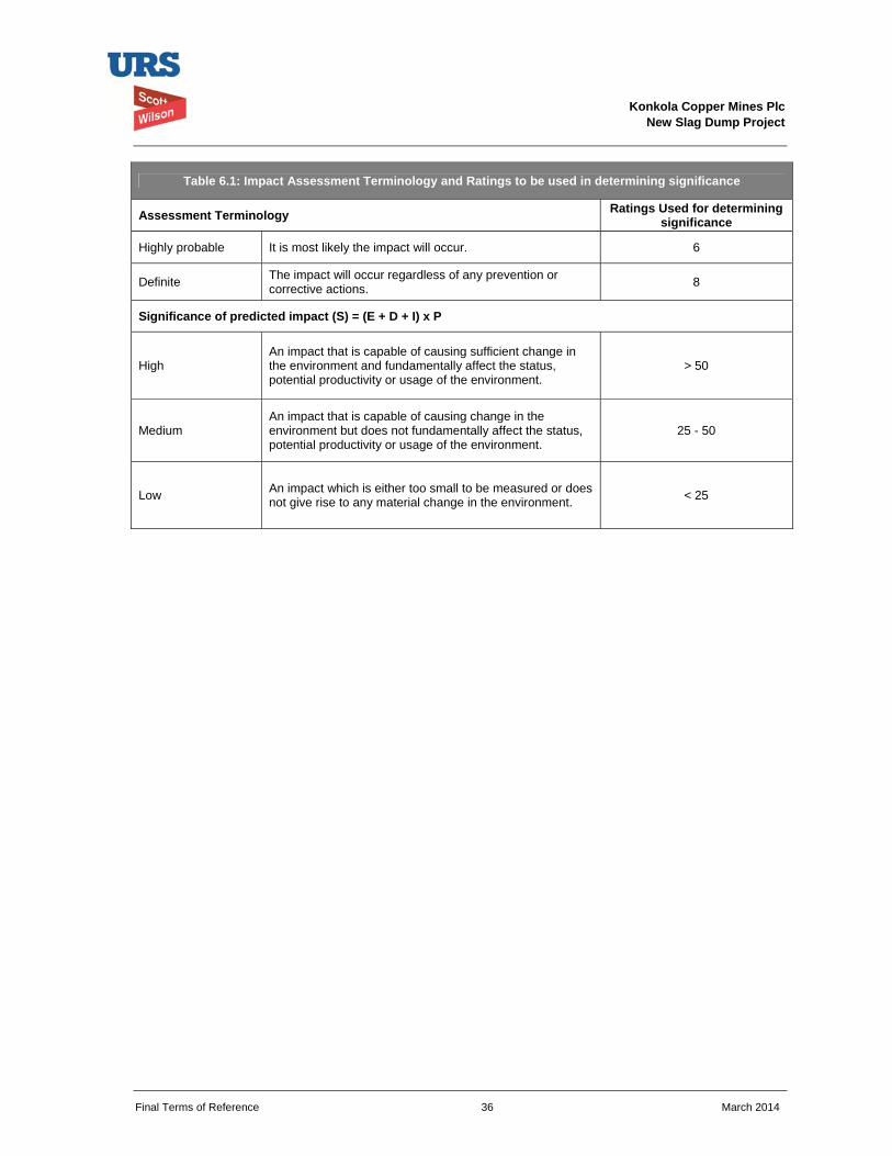
Konkola Copper Mines Plc
New Slag Dump Project
Final Terms of Reference 36 March 2014
Table 6.1: Impact Assessment Terminology and Ratings to be used in determining significance
Assessment Terminology Ratings Used for determining significance
Highly probable It is most likely the impact will occur. 6
Definite The impact will occur regardless of any prevention or corrective actions. 8
Significance of predicted impact (S) = (E + D + I) x P
High An impact that is capable of causing sufficient change in the environment and fundamentally affect the status, potential productivity or usage of the environment.
> 50
Medium An impact that is capable of causing change in the environment but does not fundamentally affect the status, potential productivity or usage of the environment.
25 - 50
Low An impact which is either too small to be measured or does not give rise to any material change in the environment. < 25
Konkola Copper Mines Plc
New Slag Dump Project
Final Terms of Reference 37 March 2014
7 EIA REPORTING AND OUTPUT The ESIS shall include the information stipulated in the Environmental Protection and Pollution Control (Environmental Impact Assessment) Regulations, 1997, which include but not limited to the following:
a description of the project, reasonable alternatives which have been considered;
a description of the proposed site and reasons for rejecting alternative sites (including the “no action” or “no project” alternative);
a brief description of the site and the surrounding environment including specifying any information necessary to identify and assess the environmental effects of the project;
a description of the raw material inputs into the project and their potential environmental effects;
a description of the technology and processes that shall be used;
a description of the products and by-products of the project;
the environmental effects of the project, and reasonable alternatives, including the direct, indirect cumulative, short-term and long-term effects;
the socio-economic impacts of the project; and
an impact management plan containing a description of measures proposed for preventing, minimising or compensating for any adverse impact, and enhancing beneficial effects, and measures to monitor effluent streams or important environmental features which may be affected by the project.
It will also include relevant information stipulated in the KCM’s sustainability standards.
The completed ESIS will include:
Impacts - identification of both potential and perceived impacts. Potential impacts will be identified from a critical analysis of the proposed project in relation to their environmental and social setting. This will draw upon secondary data; primary data from baseline surveys commissioned for this specific Project; and on the experience of the URS SW project team. Perceived impacts, as expressed by populations, will also be considered where appropriate. The significance of effect of each impact on each receptor will be described.
Mitigation Measures - development of proposed programmes or processes to be implemented to eliminate or minimise the significant negative effects or enhance the positive ones identified for each aspect studied. Mitigation includes preventative engineering implemented during the design phase of the proposed project, on-going and planned programmes to eliminate or minimise impacts during development of the Project and monitoring plans to evaluate the success of the mitigation. An evaluation of the level of predicted impacts that will remain after the implementation of all proposed mitigation measures will be undertaken. The nature of the predicted impact will be described and the significance of effects determined by reference to appropriate standards or guidelines.
Evaluation of Mitigated Impact – assessment of residual effect following mitigation.
Konkola Copper Mines Plc
New Slag Dump Project
Final Terms of Reference 38 March 2014
Environmental and Social Management – preparation of necessary mitigation, management, monitoring and institutional measures for incorporation into the existing KCM Environmental Management Plan.
Rehabilitation and Closure Plan – development of a provisional plan for
decommissioning and closure of the new Slag Dump for incorporation into the existing KCM Closure Plan for the site in line with the KCM TS 17.
The ESIS will contain an executive summary (Non-technical and in an agreed language), stating the main findings and recommendations and shall be signed by every individual person involved in its preparation.
The structure of the ESIS will be as outlined below:
Declaration of Authenticity
List of Figures
Acronyms and Abbreviations
Executive Summary
1 Introduction 1.1 Background 1.2 Overview on Konkola Copper Mine Plc 1.3 Project Rationale 1.4 Project Objectives 1.5 Estimated Project Cost 1.6 EIA Study Methodology and Reporting
2 Project Description 2.1 Project Location 2.2 Project Background and Project Elements 2.3 Project Construction Phase 2.4 Project Operation Phase 2.5 Decommissioning and Closure Phase 2.6 Project Alternatives 3 Legal and Administrative Framework
4 Environmental Impact Assessment 4.1 Assessment Methodology 4.2 Impact Identification and Assessment 4.3 Environmental Setting of the Project Site 4.3.1 Topography 4.3.2 Climate 4.3.3 Geology
5 Water Resources and Quality Assessment 5.1 Scope and Methodology 5.2 Baseline Conditions 5.2.1 Surface Hydrology 5.2.2 Groundwater Hydrogeology
Konkola Copper Mines Plc
New Slag Dump Project
Final Terms of Reference 39 March 2014
5.3 Assessment of Potential Impacts on Surface Water and Groundwater 5.3.1 Surface Water and Groundwater Resources 5.3.2 Conclusion
6 Air Quality 6.1 Scope and Methodology 6.2 Air Quality Baseline Conditions 6.3 Impact Assessment 6.3.1 Air Quality 6.3.2 Conclusion
7 Soils and Land Use 7.1 Scope and Methodology 7.2 Soils and Land Use Baseline conditions 7.3 Impact Assessment 7.3.1 Soils and Land Use 7.3.2 Conclusion
8 Flora and Fauna 8.1 Scope and Methodology 8.2 Flora and Fauna Baseline Conditions 8.3 Impact Assessment 8.3.1 Flora and Fauna 8.3.2 Conclusion
9 Archaeology and Cultural Heritage 9.1 Scope and Methodology 9.2 Baseline Conditions 9.3 Impact Assessment 9.3.1 Archaeology and Cultural Heritage 9.3.2 Conclusion
10 Traffic volume 10.1 Scope and Methodology 10.2 Baseline Conditions 10.3 Impact Assessment 10.3.1 Traffic Volume 10.3.2 Conclusion
11 Noise and vibrations 11.1 Scope and Methodology 11.2 Baseline Conditions 11.3 Impact Assessment 11.3.1 Traffic Volume 11.3.2 Conclusion
12 Socio-economic conditions (Chingola) 12.1 Scope and Methodology
Konkola Copper Mines Plc
New Slag Dump Project
Final Terms of Reference 40 March 2014
12.2 Socio-economic Baseline Conditions 12.3 Impact Assessment 12.3.1 Socio-economics 12.3.2 Conclusion
13 Radiation 13.1 Scope and Methodology 13.2 Baseline Conditions 13.3 Impact Assessment 13.3.1 Exposure Risks 13.3.2 Conclusion
14 Environmental Management and Monitoring Plan
15 Decommissioning and Closure Plan
16 Consultation
17 Conclusion
18 References
Figures
Appendices
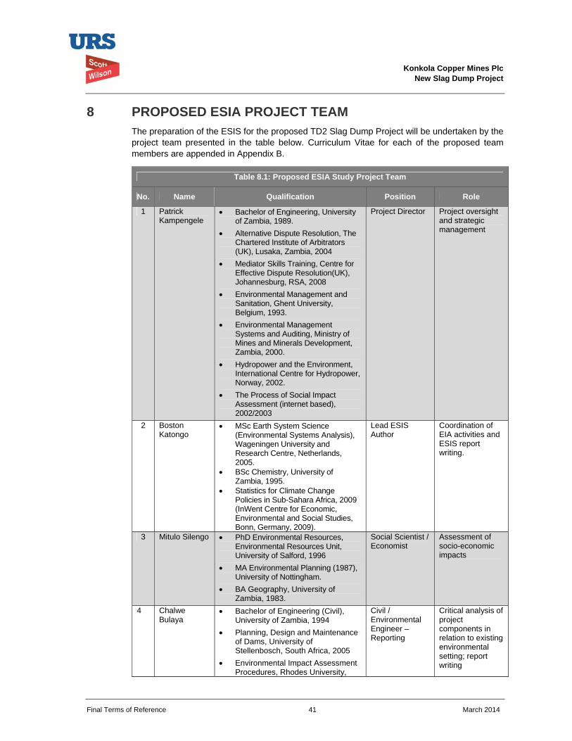
Konkola Copper Mines Plc
New Slag Dump Project
Final Terms of Reference 41 March 2014
8 PROPOSED ESIA PROJECT TEAM The preparation of the ESIS for the proposed TD2 Slag Dump Project will be undertaken by the project team presented in the table below. Curriculum Vitae for each of the proposed team members are appended in Appendix B.
Table 8.1: Proposed ESIA Study Project Team
No. Name Qualification Position Role
1 Patrick Kampengele
Bachelor of Engineering, University of Zambia, 1989.
Alternative Dispute Resolution, The Chartered Institute of Arbitrators (UK), Lusaka, Zambia, 2004
Mediator Skills Training, Centre for Effective Dispute Resolution(UK), Johannesburg, RSA, 2008
Environmental Management and Sanitation, Ghent University, Belgium, 1993.
Environmental Management Systems and Auditing, Ministry of Mines and Minerals Development, Zambia, 2000.
Hydropower and the Environment, International Centre for Hydropower, Norway, 2002.
The Process of Social Impact Assessment (internet based), 2002/2003
Project Director Project oversight and strategic management
2 Boston Katongo
MSc Earth System Science (Environmental Systems Analysis), Wageningen University and Research Centre, Netherlands, 2005.
BSc Chemistry, University of Zambia, 1995.
Statistics for Climate Change Policies in Sub-Sahara Africa, 2009 (InWent Centre for Economic, Environmental and Social Studies, Bonn, Germany, 2009).
Lead ESIS Author
Coordination of EIA activities and ESIS report writing.
3 Mitulo Silengo PhD Environmental Resources, Environmental Resources Unit, University of Salford, 1996
MA Environmental Planning (1987), University of Nottingham.
BA Geography, University of Zambia, 1983.
Social Scientist / Economist
Assessment of socio-economic impacts
4 Chalwe Bulaya
Bachelor of Engineering (Civil), University of Zambia, 1994
Planning, Design and Maintenance of Dams, University of Stellenbosch, South Africa, 2005
Environmental Impact Assessment Procedures, Rhodes University,
Civil / Environmental Engineer – Reporting
Critical analysis of project components in relation to existing environmental setting; report writing
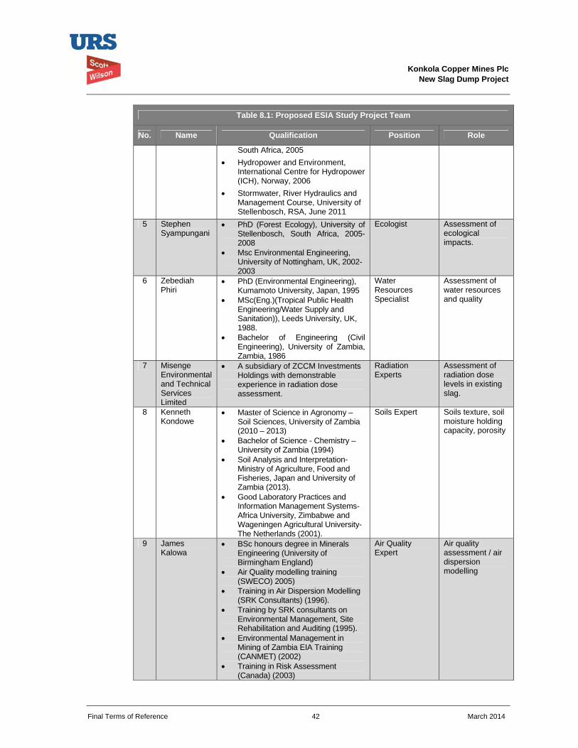
Konkola Copper Mines Plc
New Slag Dump Project
Final Terms of Reference 42 March 2014
Table 8.1: Proposed ESIA Study Project Team
No. Name Qualification Position Role
South Africa, 2005 Hydropower and Environment,
International Centre for Hydropower (ICH), Norway, 2006
Stormwater, River Hydraulics and Management Course, University of Stellenbosch, RSA, June 2011
5 Stephen Syampungani
PhD (Forest Ecology), University of Stellenbosch, South Africa, 2005-2008
Msc Environmental Engineering, University of Nottingham, UK, 2002-2003
Ecologist Assessment of ecological impacts.
6 Zebediah Phiri
PhD (Environmental Engineering), Kumamoto University, Japan, 1995
MSc(Eng.)(Tropical Public Health Engineering/Water Supply and Sanitation)), Leeds University, UK, 1988.
Bachelor of Engineering (Civil Engineering), University of Zambia, Zambia, 1986
Water Resources Specialist
Assessment of water resources and quality
7 Misenge Environmental and Technical Services Limited
A subsidiary of ZCCM Investments Holdings with demonstrable experience in radiation dose assessment.
Radiation Experts
Assessment of radiation dose levels in existing slag.
8 Kenneth Kondowe
Master of Science in Agronomy – Soil Sciences, University of Zambia (2010 – 2013)
Bachelor of Science - Chemistry – University of Zambia (1994)
Soil Analysis and Interpretation- Ministry of Agriculture, Food and Fisheries, Japan and University of Zambia (2013).
Good Laboratory Practices and Information Management Systems- Africa University, Zimbabwe and Wageningen Agricultural University- The Netherlands (2001).
Soils Expert Soils texture, soil moisture holding capacity, porosity
9 James Kalowa
BSc honours degree in Minerals Engineering (University of Birmingham England)
Air Quality modelling training (SWECO) 2005)
Training in Air Dispersion Modelling (SRK Consultants) (1996).
Training by SRK consultants on Environmental Management, Site Rehabilitation and Auditing (1995).
Environmental Management in Mining of Zambia EIA Training (CANMET) (2002)
Training in Risk Assessment (Canada) (2003)
Air Quality Expert
Air quality assessment / air dispersion modelling
Konkola Copper Mines Plc
New Slag Dump Project
Final Terms of Reference 43 March 2014
Table 8.1: Proposed ESIA Study Project Team
No. Name Qualification Position Role
GIS Training Swaziland (2004)
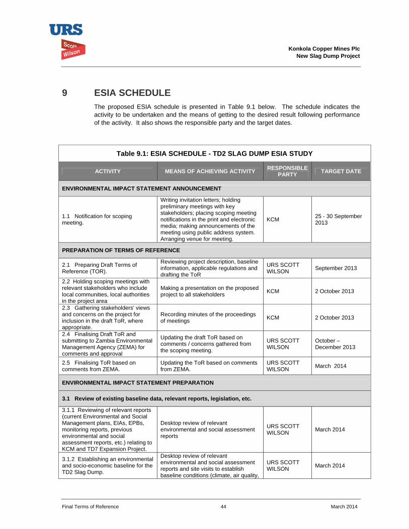
Konkola Copper Mines Plc
New Slag Dump Project
Final Terms of Reference 44 March 2014
9 ESIA SCHEDULE The proposed ESIA schedule is presented in Table 9.1 below. The schedule indicates the activity to be undertaken and the means of getting to the desired result following performance of the activity. It also shows the responsible party and the target dates.
Table 9.1: ESIA SCHEDULE - TD2 SLAG DUMP ESIA STUDY
ACTIVITY MEANS OF ACHIEVING ACTIVITY RESPONSIBLE PARTY TARGET DATE
ENVIRONMENTAL IMPACT STATEMENT ANNOUNCEMENT
1.1 Notification for scoping meeting.
Writing invitation letters; holding preliminary meetings with key stakeholders; placing scoping meeting notifications in the print and electronic media; making announcements of the meeting using public address system. Arranging venue for meeting.
KCM 25 - 30 September 2013
PREPARATION OF TERMS OF REFERENCE
2.1 Preparing Draft Terms of Reference (TOR).
Reviewing project description, baseline information, applicable regulations and drafting the ToR
URS SCOTT WILSON September 2013
2.2 Holding scoping meetings with relevant stakeholders who include local communities, local authorities in the project area
Making a presentation on the proposed project to all stakeholders KCM 2 October 2013
2.3 Gathering stakeholders' views and concerns on the project for inclusion in the draft ToR, where appropriate.
Recording minutes of the proceedings of meetings KCM 2 October 2013
2.4 Finalising Draft ToR and submitting to Zambia Environmental Management Agency (ZEMA) for comments and approval
Updating the draft ToR based on comments / concerns gathered from the scoping meeting.
URS SCOTT WILSON
October – December 2013
2.5 Finalising ToR based on comments from ZEMA.
Updating the ToR based on comments from ZEMA.
URS SCOTT WILSON March 2014
ENVIRONMENTAL IMPACT STATEMENT PREPARATION
3.1 Review of existing baseline data, relevant reports, legislation, etc.
3.1.1 Reviewing of relevant reports (current Environmental and Social Management plans, EIAs, EPBs, monitoring reports, previous environmental and social assessment reports, etc.) relating to KCM and TD7 Expansion Project.
Desktop review of relevant environmental and social assessment reports
URS SCOTT WILSON March 2014
3.1.2 Establishing an environmental and socio-economic baseline for the TD2 Slag Dump.
Desktop review of relevant environmental and social assessment reports and site visits to establish baseline conditions (climate, air quality,
URS SCOTT WILSON March 2014
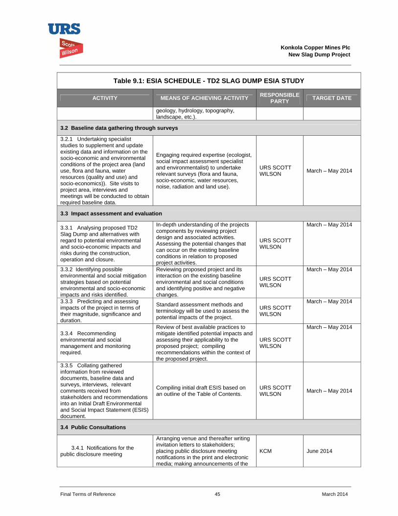
Konkola Copper Mines Plc
New Slag Dump Project
Final Terms of Reference 45 March 2014
Table 9.1: ESIA SCHEDULE - TD2 SLAG DUMP ESIA STUDY
ACTIVITY MEANS OF ACHIEVING ACTIVITY RESPONSIBLE PARTY TARGET DATE
geology, hydrology, topography, landscape, etc.).
3.2 Baseline data gathering through surveys
3.2.1 Undertaking specialist studies to supplement and update existing data and information on the socio-economic and environmental conditions of the project area (land use, flora and fauna, water resources (quality and use) and socio-economics)). Site visits to project area, interviews and meetings will be conducted to obtain required baseline data.
Engaging required expertise (ecologist, social impact assessment specialist and environmentalist) to undertake relevant surveys (flora and fauna, socio-economic, water resources, noise, radiation and land use).
URS SCOTT WILSON March – May 2014
3.3 Impact assessment and evaluation
3.3.1 Analysing proposed TD2 Slag Dump and alternatives with regard to potential environmental and socio-economic impacts and risks during the construction, operation and closure.
In-depth understanding of the projects components by reviewing project design and associated activities. Assessing the potential changes that can occur on the existing baseline conditions in relation to proposed project activities.
URS SCOTT WILSON
March – May 2014
3.3.2 Identifying possible environmental and social mitigation strategies based on potential environmental and socio-economic impacts and risks identified.
Reviewing proposed project and its interaction on the existing baseline environmental and social conditions and identifying positive and negative changes.
URS SCOTT WILSON
March – May 2014
3.3.3 Predicting and assessing impacts of the project in terms of their magnitude, significance and duration.
Standard assessment methods and terminology will be used to assess the potential impacts of the project.
URS SCOTT WILSON
March – May 2014
3.3.4 Recommending environmental and social management and monitoring required.
Review of best available practices to mitigate identified potential impacts and assessing their applicability to the proposed project; compiling recommendations within the context of the proposed project.
URS SCOTT WILSON
March – May 2014
3.3.5 Collating gathered information from reviewed documents, baseline data and surveys, interviews, relevant comments received from stakeholders and recommendations into an Initial Draft Environmental and Social Impact Statement (ESIS) document.
Compiling initial draft ESIS based on an outline of the Table of Contents.
URS SCOTT WILSON March – May 2014
3.4 Public Consultations
3.4.1 Notifications for the public disclosure meeting
Arranging venue and thereafter writing invitation letters to stakeholders; placing public disclosure meeting notifications in the print and electronic media; making announcements of the
KCM June 2014
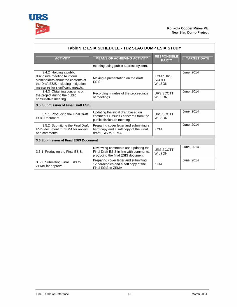
Konkola Copper Mines Plc
New Slag Dump Project
Final Terms of Reference 46 March 2014
Table 9.1: ESIA SCHEDULE - TD2 SLAG DUMP ESIA STUDY
ACTIVITY MEANS OF ACHIEVING ACTIVITY RESPONSIBLE PARTY TARGET DATE
meeting using public address system.
3.4.2 Holding a public disclosure meeting to inform stakeholders about the contents of the Draft ESIS including mitigation measures for significant impacts.
Making a presentation on the draft ESIS
KCM / URS SCOTT WILSON
June 2014
3.4.3 Obtaining concerns on the project during the public consultative meeting.
Recording minutes of the proceedings of meetings
URS SCOTT WILSON
June 2014
3.5 Submission of Final Draft ESIS
3.5.1 Producing the Final Draft ESIS Document
Updating the initial draft based on comments / issues / concerns from the public disclosure meeting
URS SCOTT WILSON
June 2014
3.5.2 Submitting the Final Draft ESIS document to ZEMA for review and comments.
Preparing cover letter and submitting a hard copy and a soft copy of the Final draft ESIS to ZEMA
KCM June 2014
3.6 Submission of Final ESIS Document
3.6.1 Producing the Final ESIS. Reviewing comments and updating the Final Draft ESIS in line with comments; producing the final ESIS document.
URS SCOTT WILSON
June 2014
3.6.2 Submitting Final ESIS to ZEMA for approval
Preparing cover letter and submitting 12 hardcopies and a soft copy of the Final ESIS to ZEMA
KCM June 2014
Konkola Copper Mines Plc
New Slag Dump Project
Final Terms of Reference 47 March 2014
10 CONCLUSION This ToR document highlights the approach that will be undertaken and the legal framework within which the new Slag Dump Project will be implemented following approval of the ToR and approval of the completed ESIS by ZEMA. It has been prepared principally as required under the Zambian Environmental Management Agency Act, 2011 read together with the Environmental Impact Assessment Regulations, 1997 and Vedanta Sustainability Framework.
It is KCM’s commitment that a comprehensive ESIS for the proposed new Slag Dump at TD2 will be prepared and implemented to adequately address the potential impacts associated with the proposed project. This is will be carried out following approval of the document by ZEMA.
Konkola Copper Mines Plc
New Slag Dump Project
Final Terms of Reference 48 March 2014
FIGURES Figure 1.1: Site Location – Nchanga Mine
Figure 1.2: Proposed Location of TD2 Slag Dump

Konkola Copper Mines Plc
New Slag Dump Project
Final Terms of Reference 49 March 2014
Figure 1.1: Location of Nchanga Mine
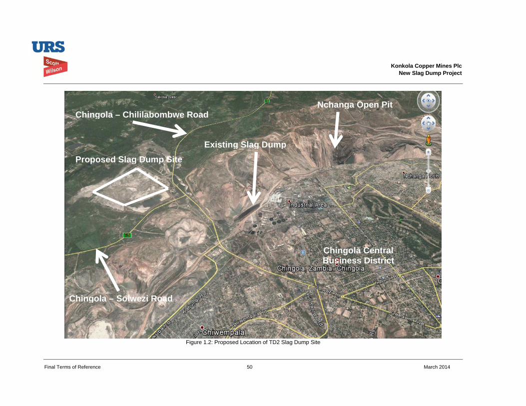
Konkola Copper Mines Plc
New Slag Dump Project
Final Terms of Reference 50 March 2014
Figure 1.2: Proposed Location of TD2 Slag Dump Site
Chingola – Solwezi Road
Chingola – Chililabombwe Road
Existing Slag DumpProposed Slag Dump Site
Nchanga Open Pit
Chingola Central Business District
Konkola Copper Mines Plc
New Slag Dump Project
Final Terms of Reference 51 January 2014
APPENDICES Appendix A: Scoping Report including minutes of the Scoping Meeting held on 2 October 2013
Appendix B: Curriculum Vitae for the proposed EIA Study Team
Appendix C: Project categorisation criteria and screening checklist for the New Slag Dump
Appendix D: TD2 Slag Dump Project Design Report
Konkola Copper Mines Plc
New Slag Dump Project
Final Terms of Reference March 2014
Appendix A
Scoping Report including minutes of the Scoping Meeting held on 2 October 2013
Prepared for
Konkola Copper Mines Plc
TD2 New Slag Dump Site Environmental Impact Statement Scoping Report March 2014
Konkola Copper Mines Plc New Slag Dump Site Project
Scoping Report March 2014
URS Scott Wilson Zambia 24 Enos Chomba Avenue PO Box 22496 Kitwe Zambia Tel +260 21 222 8466 Fax +260 21 222 3649 [email protected] www.ursglobal.com
Revision Schedule
Rev Date Details Prepared by Reviewed by Approved by
0 March 2014 Boston Katongo
Principal Environmental Scientist
Bulaya Chalwe
Principal Engineer
Patrick Kampengele
Executive Director
Patrick Kampengele
Executive Director
Konkola Copper Mines Plc New Slag Dump Site Project
Scoping Report iii March 2014
Table of Contents Acronyms and Abbreviations ......................................................................................................................... v
1. INTRODUCTION ....................................................................................................................................... 1
1.1. Proposed New Slag Dump Project ............................................................................................... 1
1.2. Environmental Impact Assessment .............................................................................................. 2
1.3. Purpose of Scoping Exercise ........................................................................................................ 2
1.4. Structure of the Scoping Report ................................................................................................... 2
2. PROPERTY DESCRIPTION .................................................................................................................... 4
2.1. Regional Setting .............................................................................................................................. 4
2.2. Proposed Location of the Slag Dump .......................................................................................... 4
2.3. Land Use .......................................................................................................................................... 5
3. PROPOSED SLAG DUMP PROJECT OUTLINE ................................................................................... 6
3.1. Principal Design Criteria ................................................................................................................ 6
3.2. Site Preparation .............................................................................................................................. 8
3.3. Dumping Procedures ...................................................................................................................... 8
4. RATIONALE FOR THE PROJECT ........................................................................................................ 10
5. PROJECT ALTERNATIVES .................................................................................................................. 11
5.1. Site 1: North of OB1 (Overburden Dump No. 1) ...................................................................... 11
5.2. Site 2: South of TD3 and TD4 ..................................................................................................... 11
5.3. Site 3: Mimbula Area .................................................................................................................... 11
5.4. Site 4: Open Pit (main in pit) ....................................................................................................... 11
5.5. Site 5: TD 2 .................................................................................................................................... 12
5.6. Preferred Site ................................................................................................................................ 12
5.7. The “No Action” or “No Project alternative” ............................................................................... 12
6. DESCRIPTION OF THE ENVIRONMENT ............................................................................................. 13
6.1. Climate............................................................................................................................................ 13
6.2. Rainfall ............................................................................................................................................ 13
6.3. Wind ................................................................................................................................................ 13
6.4. Hydrology ....................................................................................................................................... 13
6.5. Geology .......................................................................................................................................... 13
6.6. Air Quality ....................................................................................................................................... 14
Konkola Copper Mines Plc New Slag Dump Site Project
Scoping Report iv March 2014
6.7. Soils ................................................................................................................................................ 14
6.8. Land Use / Land Tenure .............................................................................................................. 14
6.9. Flora and Fauna ............................................................................................................................ 14
6.10. Archaeology and Cultural Heritage ........................................................................................ 15
6.11. Traffic volume ............................................................................................................................ 15
6.12. Noise ........................................................................................................................................... 15
6.13. Socio-economic conditions ...................................................................................................... 15
7. LEGISLATIVE AND ADMINISTRATIVE FRAMEWORK ..................................................................... 17
7.1. National legislative framework .................................................................................................... 17
7.2. International Convention and Agreements ............................................................................... 19
7.3. International Standards ................................................................................................................ 20
7.4. Konkola Copper Mines Plc Sustainability Policies ................................................................... 20
8. ENVIRONMENTAL IMPACTS AND ASSESSMENT METHODOLOGY ............................................. 21
8.1. Impact Identification ...................................................................................................................... 21
8.2. Impact Mitigation ........................................................................................................................... 22
8.3. Potential impacts of the proposed TD2 Slag Dump Project ................................................... 22
8.4. Impact Assessment Methodology .............................................................................................. 23
9. PUBLIC CONSULTATION ..................................................................................................................... 26
10. TERMS OF REFERENCE .................................................................................................................. 27
10.1. Description of specific tasks to be undertaken for the EIA Process ................................. 27
10.2. Investigations to be undertaken for the EIA Study .............................................................. 28
10.3. Description of assessment methodology .............................................................................. 28
10.4. Public Participation Process .................................................................................................... 28
11. CURRICULUM VITAE OF THE EIA STUDY TEAM .......................................................................... 30
12. REFERENCES .................................................................................................................................... 32
13. APPENDICES ..................................................................................................................................... 33
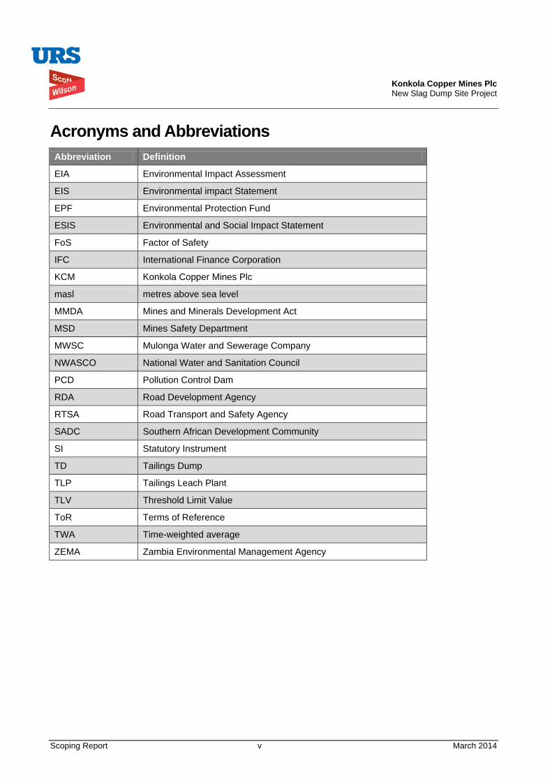
Konkola Copper Mines Plc New Slag Dump Site Project
Scoping Report v March 2014
Acronyms and Abbreviations Abbreviation Definition
EIA Environmental Impact Assessment
EIS Environmental impact Statement
EPF Environmental Protection Fund
ESIS Environmental and Social Impact Statement
FoS Factor of Safety
IFC International Finance Corporation
KCM Konkola Copper Mines Plc
masl metres above sea level
MMDA Mines and Minerals Development Act
MSD Mines Safety Department
MWSC Mulonga Water and Sewerage Company
NWASCO National Water and Sanitation Council
PCD Pollution Control Dam
RDA Road Development Agency
RTSA Road Transport and Safety Agency
SADC Southern African Development Community
SI Statutory Instrument
TD Tailings Dump
TLP Tailings Leach Plant
TLV Threshold Limit Value
ToR Terms of Reference
TWA Time-weighted average
ZEMA Zambia Environmental Management Agency
Konkola Copper Mines Plc New Slag Dump Site Project
Scoping Report 1 March 2014
1. INTRODUCTION Konkola Copper Mines Plc (KCM) is a subsidiary of Vedanta Resources Plc (Vedanta), a London-listed diversified FTSE 100 metals and resources group with operations in India, Australia, South Africa, Namibia, Zambia and Ireland. Vedanta Resources holds 79.4% of the issued and outstanding ordinary shares of KCM while the remaining 20.6% interest is held by ZCCM-IH, a Lusaka and Euronext listed company that is 87.6% owned by the Zambian Government and 12.4% owned by public shareholders. The Government of the Republic of Zambia has a golden share.
KCM owns and operates Nchanga, Konkola, Nkana and Nampundwe mine sites in Zambia. Nampundwe mine site is located in Lusaka Province while the other mines are located on the Copperbelt Province.
At Nchanga Mine Site in Chingola, KCM owns and operates the Nchanga Copper Smelter at which copper concentrates from its own Concentrators and other concentrates purchased from some other mines are treated. The main products from the smelter are copper anodes and the waste product is granulated slag.
The slag is currently disposed of at Slag Dump No.25 situated within the KCM Mine License area (LSM 34). The dump has been formed by end-tipping of granulated slag material from dump trucks and evenly spreading it outward using a loader or grader. This has resulted in the formation of dump slopes that are at the natural angle of repose of the slag material. Approximately 1.7 million tonnes of has so far been dumped and the dump is approaching its design capacity. There is currently inadequate space to dispose of the slag. Therefore, there is need for an alternative dumping space within KCM Surface Rights Area in Chingola.
KCM is, therefore, proposing to undertake a project to construct and operate a new slag dump site at the reclaimed TD2 tailings storage facility (TSF). The proposed site is within KCM Mine License Area.
1.1. Proposed New Slag Dump Project The proposed new slag dump will have an estimated operational life of 20 years and will cover a maximum footprint area of 100 ha. Its design storage capacity is estimated at 10.95 million tonnes of slag material.
The following activities will be carried out in order to implement the proposed project:
• Site Preparation: This will involve levelling and infilling of lower sections of the surface to provide an even surface over which dump trucks and other access vehicle will be able to pass safely during dumping. The drainage of the area will be well maintained to ensure minimal environmental consequences. Adequate buffer zones will be created between the edge of the dump and any existing external drainage systems.
• Grading and improvement of existing access roads from the Smelter Plant to the Project Site: This will involve widening and grading of the already existing access roads that will be used by the dump trucks hauling slag from the smelter to the proposed slag dump. This will also involve improving drainage along the access roads as well as improving road safety at the road crossing with the main trunk road (Chingola-Solwezi - T5) road that the access road will intersect.
• Construction of the drainage network around the Project Site: This will be done in the early stages of the project and also as and when the need arises during the operational phase. The drainage pattern around the proposed site will need to be done in such a way that the runoff is captured and treated prior to discharge into the receiving natural watercourses.
• Dumping of slag material: Material from the Smelter Plant will be hauled in dump trucks [30-40 tonnes truck] and transported to the proposed dump site. The dumping operations will basically
Konkola Copper Mines Plc New Slag Dump Site Project
Scoping Report 2 March 2014
involve end tipping of the granulated slag from the dump trucks and the subsequent spreading and levelling of the material. Dumping procedures are presented in Section 3 of this report.
The total cost of construction works is estimated at USD 46,103.55.
1.2. Environmental Impact Assessment KCM intends to apply for a license to own and operate a new slag dump at TD2. As part of the application process and prior to any dumping of the slag at the proposed site, KCM is required to conduct an environmental and social impact assessment in accordance with the Environmental Impact Assessment Regulations, Statutory Instrument No. 28 of 1997.
KCM appointed URS Scott Wilson to conduct the environmental and social impact study. In accordance with the requirements of the stated regulations, under the Fourth Schedule, scoping of the proposed project should be carried out as part of the EIA process.
1.3. Purpose of Scoping Exercise Scoping exercise is the process of identifying the content and extent of the environmental information to be gathered by the developer and submitted to a competent authority (Zambia Environmental Management Agency) under the EIA process. This is an early stage in the EIA process and is designed to ensure that the environmental impact assessment studies provide all the relevant information on the impacts of the project, the alternatives to the project and any other relevant information on the project. The specific objectives of the scoping exercise are to:
• Plan for stakeholder involvement during the study;
• Explain to interested and affected parties the nature of the proposed project;
• Gather interested and affected parties’ input concerning key issues that need be addressed in the EIA study;
• Identify major environmental and social concerns from stakeholders and affected parties;
• Establish priorities for EIA study;
• Prepare a scoping report (this report);
• Select experts to undertake the environmental and social impact assessment studies based on identified types of environmental and social impacts to be investigated.
• Prepare Terms of Reference (ToRs) for the EIA study for the proposed project;
For the proposed TD2 Slag Dump Project, a scoping exercise was conducted as an initial stage in the EIA study. A scoping meeting was held on 2 October 2013 at Mushishima Basic School in Chingola. It was held to meet the objectives outlined above.
This scoping report is therefore a compilation of the outcomes of the scoping meeting held as part of the EIA process for the TD2 Slag Dump Project. It also includes secondary information gathered through literature review of relevant environmental documentation on the project area.
1.4. Structure of the Scoping Report This scoping report has been structured as described below.
Konkola Copper Mines Plc New Slag Dump Site Project
Scoping Report 3 March 2014
Section 1 outlines an introduction to the report which also includes the purpose of the scoping exercise while Section 2 gives a brief description of the regional setting, the proposed location of the slag dump and land use within the project area.
The principal design criteria, site preparation and dumping procedures are presentd in Section 3 while the project rationale and project alternatives are presented in Sections 4 and 5 respectively.
The description of the environment and the legislative and administrative framework are presented in Sections 6 and 7 respectively.
Section 8 presents environmental impacts and assessment methodology and includes impact identification, impact mitigation and potential impacts of the proposed project. Sections 9 and 10 respectively present information on public consultation and highlights on the Terms of Reference. The names and brief qualifications of the EIA Study Team are presented in Section 11.
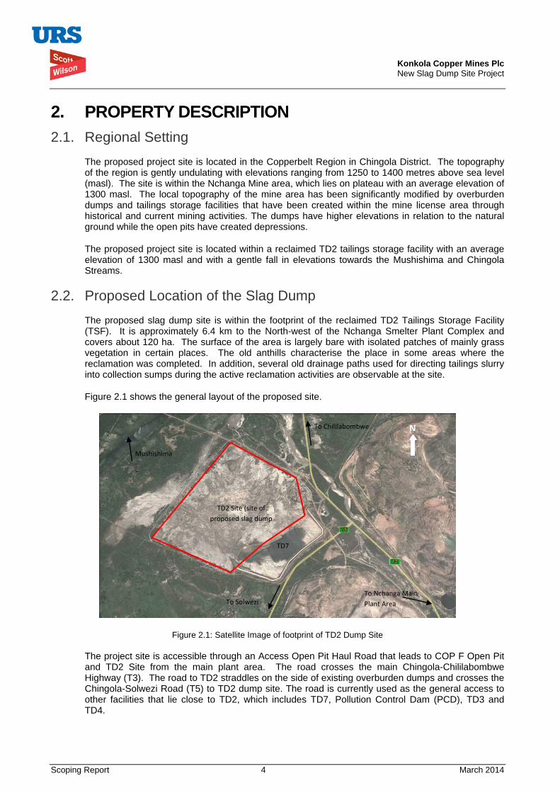
Konkola Copper Mines Plc New Slag Dump Site Project
Scoping Report 4 March 2014
2. PROPERTY DESCRIPTION 2.1. Regional Setting
The proposed project site is located in the Copperbelt Region in Chingola District. The topography of the region is gently undulating with elevations ranging from 1250 to 1400 metres above sea level (masl). The site is within the Nchanga Mine area, which lies on plateau with an average elevation of 1300 masl. The local topography of the mine area has been significantly modified by overburden dumps and tailings storage facilities that have been created within the mine license area through historical and current mining activities. The dumps have higher elevations in relation to the natural ground while the open pits have created depressions.
The proposed project site is located within a reclaimed TD2 tailings storage facility with an average elevation of 1300 masl and with a gentle fall in elevations towards the Mushishima and Chingola Streams.
2.2. Proposed Location of the Slag Dump The proposed slag dump site is within the footprint of the reclaimed TD2 Tailings Storage Facility (TSF). It is approximately 6.4 km to the North-west of the Nchanga Smelter Plant Complex and covers about 120 ha. The surface of the area is largely bare with isolated patches of mainly grass vegetation in certain places. The old anthills characterise the place in some areas where the reclamation was completed. In addition, several old drainage paths used for directing tailings slurry into collection sumps during the active reclamation activities are observable at the site.
Figure 2.1 shows the general layout of the proposed site.
Figure 2.1: Satellite Image of footprint of TD2 Dump Site
The project site is accessible through an Access Open Pit Haul Road that leads to COP F Open Pit and TD2 Site from the main plant area. The road crosses the main Chingola-Chililabombwe Highway (T3). The road to TD2 straddles on the side of existing overburden dumps and crosses the Chingola-Solwezi Road (T5) to TD2 dump site. The road is currently used as the general access to other facilities that lie close to TD2, which includes TD7, Pollution Control Dam (PCD), TD3 and TD4.
To Chililabombwe N
TD2 Site (site of proposed slag dump
To Nchanga Main Plant Area To Solwezi
Mushishima
Stream
TD7
Konkola Copper Mines Plc New Slag Dump Site Project
Scoping Report 5 March 2014
2.3. Land Use Land use within the area is dominated by mining activities. The proposed new Slag Dump site was previously used as a tailings storage facility. The facility has since been substantially reclaimed. The proposal is to use the reclaimed TD2 site as a slag disposal facility, which is also one of the mining activities being carried out by KCM. The use of the proposed site will therefore be restricted to mining activities as before.
Agricultural activities, charcoal burning and illegal mining are some of the activities being undertaken by the local communities within the broader Nchanga Mine Surface Rights Area.
Konkola Copper Mines Plc New Slag Dump Site Project
Scoping Report 6 March 2014
3. PROPOSED SLAG DUMP PROJECT OUTLINE This Section briefly profiles the principal design criteria of the proposed slag dump. It also highlights the dump configuration, slope stability analysis results and the main activities to be undertaken prior to dumping.
3.1. Principal Design Criteria The proposed granulated slag dump has been designed based on the need to provide a facility that will be cost effective in the storage of slag material in addition to being stable and safe and being able to mitigate adverse environmental and social impacts. The basic design criteria that have been adopted are detailed in the New Slag Dump Design Report (URS Scott Wilson, 2014). The design criteria take into account the following:
• Effective stabilisation and compaction of the underlying foundation and access road to ensure overall dump stability;
• Stable configuration of the dump to ensure low aesthetic change to the surrounding environment and its surroundings;
• Management of seepage to mitigate against adverse environmental impacts;
• Stormwater management to avoid undue contamination of clean water; and
• Modular development of the dump in stages, to reduce the overall initial capital cost investment.
Table 3.1 summarises the design parameters for the proposed slag dump.
The components that form the design of the slag dump are:
i. Configuration and footprint analysis of the dump, which is based on a design dump height of 15 m;
ii. Selection of an under-drainage system for the dump including rainfall runoff management; and
iii. Slope stability analysis for the dump configurations.
The details on the design components outlined above are provided in the Slag dump design report (URS Scott Wilson, 2014). The dump will be constructed with a toe drain and under-drainage filters along the periphery of the dump. The filters will be incorporated to collect seepage, which will be directed into the toe drain. The toe drain will be discharging seepage and rainfall runoff into Pollution Control Dam via a seepage sump to be constructed along the drain. The sump will serve as an environmental compliance monitoring point.
The dump will be developed in 8 stages up to a maximum height of 15 m. Table 3.2 summaries the development stages and the principal dimensions for the proposed TD2 Slag Dump. For each stage of dumping, the principal leading dimensions will be 225 m x 225 m with a dump height of 15 m.
The slopes of the dump will be formed to the natural repose angle of the granulated slag material, which is between 50o and 53o.
Details of the Slope Stability Analysis undertaken are included in the Slag Dump Design Report (URS Scott Wilson, 2014). The analysis of the dumps was undertaken against recommended Factors of Safety (FoS) for static and seismic conditions and for whole slope or embankment failure. Table 3.3 shows the results obtained following the analysis.
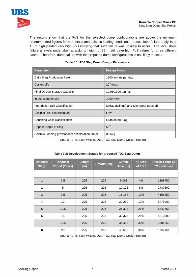
Konkola Copper Mines Plc New Slag Dump Site Project
Scoping Report 7 March 2014
The results show that the FoS for the selected dump configurations are above the minimum recommended figures for both static and seismic loading conditions. Local slope failure analysis at 15 m high yielded very high FoS implying that such failure was unlikely to occur. The local slope failure analysis undertaken at a dump height of 25 m still gave high FoS values for three different cases. Therefore, dump failure with the proposed dump configurations is not likely to occur.
Table 3.1: TD2 Slag Dump Design Parameters
Parameter Design Factor
Daily Slag Production Rate 1500 tonnes per day
Design Life 20 Years
Final Design Storage Capacity 10,950,000 tonnes
In-situ slag density 1900 Kg/m3
Foundation Soil Classification SAND (tailings) and Silty Sand (Gravel)
Seismic Risk Classification Low
Confining walls classification Granulated Slag
Repose Angle of Slag 530
Seismic Loading gravitational acceleration factor 0.067g
Source (URS Scott Wilson, 2014 TD2 Slag Dump Design Report)
Table 3.2: Development Stages for proposed TD2 Slag Dump
Disposal Stage
Disposal Period (Years)
Length (m)
Breadth (m) Cumm.
Area (ha) % Area of TD 2
Stored Tonnage (Cumulative)
1 2.5 225 225 5.063 4% 1368750
2 5 225 225 10.125 8% 2737500
3 7.5 225 225 15.188 13% 4106250
4 10 225 225 20.250 17% 5475000
5 12.5 225 225 25.313 21% 6843750
6 15 225 225 30.375 25% 8212500
7 17.5 225 225 35.438 30% 9581250
8 20 225 225 40.500 34% 10950000
Source (URS Scott Wilson, 2014 TD2 Slag Dump Design Report)
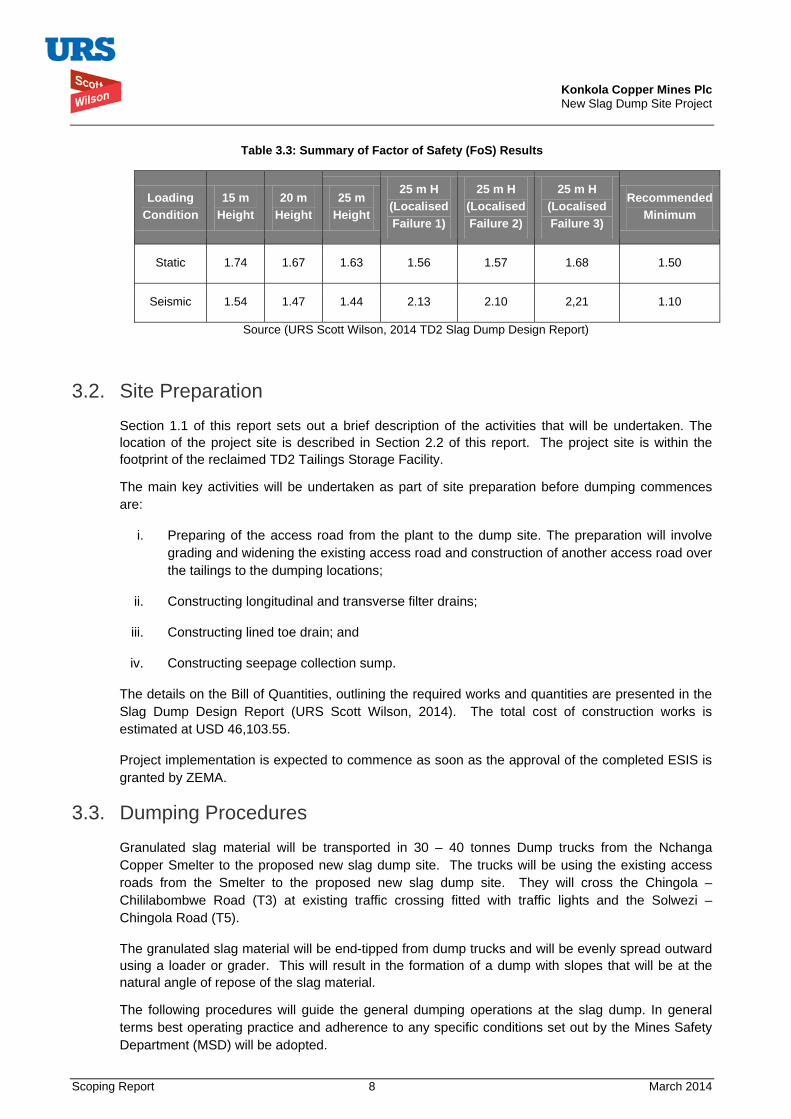
Konkola Copper Mines Plc New Slag Dump Site Project
Scoping Report 8 March 2014
Table 3.3: Summary of Factor of Safety (FoS) Results
Loading Condition
15 m Height
20 m Height
25 m Height
25 m H (Localised Failure 1)
25 m H (Localised Failure 2)
25 m H (Localised Failure 3)
Recommended Minimum
Static 1.74 1.67 1.63 1.56 1.57 1.68 1.50
Seismic 1.54 1.47 1.44 2.13 2.10 2,21 1.10
Source (URS Scott Wilson, 2014 TD2 Slag Dump Design Report)
3.2. Site Preparation Section 1.1 of this report sets out a brief description of the activities that will be undertaken. The location of the project site is described in Section 2.2 of this report. The project site is within the footprint of the reclaimed TD2 Tailings Storage Facility.
The main key activities will be undertaken as part of site preparation before dumping commences are:
i. Preparing of the access road from the plant to the dump site. The preparation will involve grading and widening the existing access road and construction of another access road over the tailings to the dumping locations;
ii. Constructing longitudinal and transverse filter drains;
iii. Constructing lined toe drain; and
iv. Constructing seepage collection sump.
The details on the Bill of Quantities, outlining the required works and quantities are presented in the Slag Dump Design Report (URS Scott Wilson, 2014). The total cost of construction works is estimated at USD 46,103.55.
Project implementation is expected to commence as soon as the approval of the completed ESIS is granted by ZEMA.
3.3. Dumping Procedures Granulated slag material will be transported in 30 – 40 tonnes Dump trucks from the Nchanga Copper Smelter to the proposed new slag dump site. The trucks will be using the existing access roads from the Smelter to the proposed new slag dump site. They will cross the Chingola – Chililabombwe Road (T3) at existing traffic crossing fitted with traffic lights and the Solwezi – Chingola Road (T5).
The granulated slag material will be end-tipped from dump trucks and will be evenly spread outward using a loader or grader. This will result in the formation of a dump with slopes that will be at the natural angle of repose of the slag material.
The following procedures will guide the general dumping operations at the slag dump. In general terms best operating practice and adherence to any specific conditions set out by the Mines Safety Department (MSD) will be adopted.
Konkola Copper Mines Plc New Slag Dump Site Project
Scoping Report 9 March 2014
The basic dumping process is outlined below:
• The material will be hauled to the dump site by road using dump trucks; • The material will be end-tipped from dump trucks; • During end-tipping dump trucks will be operated in reverse direction; • The material shall be heaped at a safe distance from the edge of the dump surface with a
minimum approach distance of not less than 10m from the edge; • The dump trucks will be guided by the dump attendant to ensure the minimum set distances are
not exceeded; • The heaps of granulated slag are to be levelled using a Grader or Dozer; • Levelling the surface to be an intermediate operation after sufficient quantities of slag have been
heaped.
The following general guidelines will be applicable during all dumping operations:
• Ensure that all equipment being used is in good operational condition; • The trucks should not be overloaded to avoid any spillages; • Access roads to be maintained in a good condition at all times; • Dumping of the material should commence from the outer boundaries of the dump; • Trucks should dump the slag material while moving in a reverse direction up to the minimum set
approach distance; • An attendant should be present at all times to guide the trucks when dumping; • Dump surface to be levelled and have no depressions; • Design wall profiles and extent to be adhered to at all times; • Regular cleaning of the toe drain, filter drain outlets and seepage sump to be undertaken.
Konkola Copper Mines Plc New Slag Dump Site Project
Scoping Report 10 March 2014
4. RATIONALE FOR THE PROJECT The existing Slag Dump No. 25 is steadily reaching its design capacity and so far has about 1.75 million tonnes of slag dumped at the site. The remaining space is not adequate to dispose of the slag.
The existing slag dump cannot be effectively expanded. This is because of the presence of Block A Open Pit on the north-western edge, the Chingola Stream which lies approximately 300 m on the south-western edge, the Chingola - Chililabombwe public road at approximately 400m on the south-western edge, and the KCM Haulage Road and a storm drain located on the eastern flank.
These features have constrained the expansion of the dump. The presence of a power line on the southern periphery of the existing dump has also constrained the expansion of the dump.
KCM is, therefore, proposing to construct and operate a new slag dump at TD2.
Konkola Copper Mines Plc New Slag Dump Site Project
Scoping Report 11 March 2014
5. PROJECT ALTERNATIVES The possible project alternatives that have been considered relate to the location of the slag dump. Site selection criteria involved taking into account three pillars of sustainable development, namely environmental, social and economic factors.
As a minimum, the preferred route should meet sustainability requirements in the disciplines that include safety, health, environment, economics, social and security.
Five sites have been identified within the KCM Mine License Area. The sites have been preliminarily assessed based on the site selection criteria that take into account environmental, social and economic factors.
The characteristics of the identified sites are briefly outlined below.
5.1. Site 1: North of OB1 (Overburden Dump No. 1) This site is located to the North of OB1. The preliminary assessment has indicated the following:
• The site is a greenfield site with a modified habitat;
• The site has no direct route to access it;
• It is also located at long distance from the Nchanga Smelter.
5.2. Site 2: South of TD3 and TD4 Site 2 is located to the South of TD3 and TD4. The preliminary assessment has indicated the following:
• The site will require resettlement and/or compensation of some local communities;
• The site is very close to the Chingola – Solwezi road;
• It is also a greenfield site with a modified habitat.
5.3. Site 3: Mimbula Area The preliminary assessment of Site 3 situated in Mimbula Area has indicated the following:
• The site will require resettlement and/or compensation of people;
• The site is located at a long distance from the Smelter;
• There is no direct route to access the site;
• Greenfield site with a modified habitat.
5.4. Site 4: Open Pit (main in pit) Site 4 is located in the Nchanga Open Pit (main in pit). Preliminary assessment indicates the following:
• The site is near to the Smelter but has safety risks on underground operations;
• No resettlement and/or compensation of people will be required;
• The site is not visible to the general public;
Konkola Copper Mines Plc New Slag Dump Site Project
Scoping Report 12 March 2014
• It is a brownfield site with no significant impacts on biodiversity.
5.5. Site 5: TD 2 Site 5 is located at the reclaimed TD2 tailings storage facility. Preliminary assessment of the site indicates the following:
• The site is near to Nchanga Smelter;
• There will be no resettlement and/or compensation issues associated with the site;
• The site is highly visible to the general public;
• The site is a brownfield with no significant impacts on biodiversity;
• The site has already an existing access road, which will need to be widened.
5.6. Preferred Site The preferred site is the reclaimed TD2 tailings storage facility because it is a brownfield site and is near to the smelter. It is approximately 6.2 km from the smelter. The site has adequate area (120 ha) that gives the proposed slag dump an expected lifespan of 20 years. Access road to the proposed dump is readily available. There are no resettlement or compensation issues associated with the preferred site.
5.7. The “No Action” or “No Project alternative” Under the “No Projective Alternative”, any potential adverse environmental and social impacts associated with the project would not occur. However, the preliminary assessment indicates that the disadvantages with the no project scenario include the following:
• Significant reduction in copper production since there will be limited space for slag disposal, a process directly connected to the operations of the smelter;
• Loss of employment for people working at the smelter and associated plant facilities;
• Loss of government revenue through reduced taxes;
• Loss of business for suppliers and contractors directly and indirectly dependent on the operations of the smelter.
Konkola Copper Mines Plc New Slag Dump Site Project
Scoping Report 13 March 2014
6. DESCRIPTION OF THE ENVIRONMENT This section describes briefly the environmental and social conditions of the project area. It gives highlights on climate, rainfall, wind, hydrology, geology, air quality, soils, land use / land tenure, flora and fauna, archaeology and cultural heritage, traffic volume, noise and socio-economics.
6.1. Climate The climate of the Project area is characterized by three distinct seasons: a rainy season from November to April; a cool and dry season from May to August; and a hot and dry season from September to October.
6.2. Rainfall The project area is situated in a high rainfall area. The annual average rainfall, based on long standing records at Kafironda Weather Station located about 35 km South-east of Chingola, is in the order of 1400 mm, with most of it concentrated over the period from November to March. Evaporation data has shown that evaporation exceeds rainfall for two thirds of the year. This typically occurs from April to November.
6.3. Wind The prevailing wind direction is predominantly from the northeast to southwest. The average wind velocities range from 1.4 m/sec in the summer months to 1.0 m/sec in winter.
6.4. Hydrology Surface Water
The project site lies within the Kafue River drainage system with the Chingola and Mushishima Streams drainage systems being the nearest and most important hydrological features in relation to being the potential receptors of run-off from the proposed Slag Dump. Chingola steam flows into the Mushishima Stream, which flows into the Kafue River. The proposed project site is drained by the Mushishima and Chingola streams. The site does not cut across any surface stream.
Groundwater
The groundwater regime within the Nchanga Mining License Area has significantly been changed because of underground and open pit mining activities. In terms of groundwater quality, the available data generally indicates that both shallow and deeper Bedrock Aquifer groundwater quality falls within the World Health Organisation Drinking Water Standards.
The quality, quantity and direction of groundwater flow at the proposed site are not elaborately defined. The nearest groundwater monitoring borehole sunk on the north-eastern side of the proposed site has not intercepted water at a depth of 50 metres. Despite this borehole being dry, there is water recharge into the Mushishima stream on the western side of the site.
6.5. Geology The geology of the Nchanga Mining License consists of two major rock units, namely the Basement Complex and the Katanga System. The Basement Complex is overlain by the Katanga System, which is divided into the Roan, Mwashia, and Kundelungu groups and includes quarzites, argillites, dolomites, limestones, shales, and sandstones as the main rock types.
Mineralisation at Nchanga Mine exists in two main horizons, namely the Upper and Lower orebodies. Generally, the underground operations extract ore from the Lower Orebody while open pit
Konkola Copper Mines Plc New Slag Dump Site Project
Scoping Report 14 March 2014
mining operations extract one or both where they exist. There are also significant satellite orebodies along the strike length, some of which have appreciable exploration potential. The orebodies are dispersed along the 40 km of strike in the Lower Roan Group strata that are folded into the major north-westerly plunging asymmetrical synclines and anticlines draped around the a hub of red granite.
6.6. Air Quality The main sources of dust emissions that can reduce local air quality within the project area include movement of utility vehicles along the access road and remains of exposed tailings material at TD2, if blown out by strong winds. The workers within the project area and surrounding local communities are considered to be sensitive receptors and have the potential of being exposed to dust emissions.
A survey of time-weighted average (TWA) personal total dust exposures undertaken on operators at TD2 in February 2001 and June 2002 revealed that the maximum total dust exposure as TWA concentration over an 8-hour work shift was 1.1 mg/m3. This was within the total dust Threshold Limit Value (TLV) of 5 mg/m3.
6.7. Soils The surface soils at the proposed site are mostly covered with whitish brown fine to medium grained tailings while the subsoils are principally reddish brown, fine to coarse grained insitu material. Reddish brown, medium to coarse grained lateritic soils, and dark brown and fine grained mixture of tailings and insitu material, graduating into darkish grey insitu material, are found in some places within the proposed site. Further north of the proposed site, there is accumulation of tailings on the soil surface as a result of run-off from TD2 flowing into adjacent areas that include the catchment of Water Dam 2 (WD2), Chingola Stream and Pollution Control Dam.
6.8. Land Use / Land Tenure Land use within the Nchanga Mine Surface Rights Area owned by KCM area is dominated by mining activities. Overburden dumps and tailings storage facilities have been formed through mining activities. Some of the tailings storage facilities have been reclaimed. The proposed new Slag Dump site has been planned to be located at the reclaimed TD2 tailings storage facility.
Agricultural, charcoal burning and illegal mining are some of the activities being undertaken within the mine surface rights license area by some members of the surrounding local communities.
6.9. Flora and Fauna Miombo woodland is principally the vegetation type found in the Copperbelt region. The common tree species found in this vegetation type are Brachystegia, Isoberliriia, and Julbernardia. The natural vegetation patterns of the region have however been extensively disturbed by human activities that include mining activities, wood harvesting for fuel (charcoal production), subsistence / shifting agriculture and plantations among other activities.
The vegetation within the KCM Nchanga Mining Licence Area has equally been significantly disturbed through mining, charcoal production, subsistence agriculture and other human activities. The diversity of wildlife species within the Nchanga mining license area is poor mainly because of mining operations, human settlements, agriculture and other human activities that have resulted in loss of wildlife habitat and subsequent reduction in species diversity.
The proposed site is largely bare with little to no vegetation cover. The area has been extensively used for mining activities that have subsequently changed wildlife habitats. Rare or endangered species are not found within and around the proposed site.
Konkola Copper Mines Plc New Slag Dump Site Project
Scoping Report 15 March 2014
6.10. Archaeology and Cultural Heritage There are no known archaeological or cultural heritage sites at the proposed site. The site has been extensively used for mining operations particularly for storage of tailings from the plant area. The tailings have since been reclaimed and reprocessed at the Tailings Leach Plant (TLP).
6.11. Traffic volume Currently dump trucks hauling the slag from the smelter to the existing slag dump do not cross the T3 (Chingola – Chililabombwe) and the T5 (Chingola – Solwezi) roads. No data is currently available on traffic volumes along the T3 and T5 roads at Chingola but it is generally known that traffic volumes have increased since the development of mines (both old and new) in the northern and north-western part of Zambia.
6.12. Noise The main potential source of noise disturbance at the project site is the movement of utility vehicles and heavy duty equipment such as loaders and graders. The workers and local communities near the project site are considered to be sensitive receptors. The local communities are however distantly located from the project site and are not likely to be disturbed by the noise.
6.13. Socio-economic conditions Economic Activities
Mining dominates the local economy of Chingola District and the Copperbelt Province in general. It drives the local socio-economic activities of the district and contributes significantly to the local economy through employment and tax revenues to the local authority. KCM remains the major private sector employer in the district. Its contribution to the local economy is through the provision of direct and contractor employment offered by many firms providing goods and services to KCM.
Apart from mining, agriculture, hospitality industry, transport and general trading in various goods are the main sources of livelihoods in the district.
Education
Chingola District has 54 government schools, 51 private schools and 22 community schools. KCM owns and operates the Nchanga Trust School in Chingola The Trust School provides universal primary and secondary education to over 1000 children of both mine employees and non-KCM employees. In addition, KCM provides early childhood care education and development to children/dependants of marketeers at Chiwempala Market in Chingola.
Other activities undertaken by KCM include provision of KCM Scholarship Awards to pupils at KCM and Government schools, raising of computer literacy and development of infrastructure at schools and universities.
Health Facilities
Chingola District has two hospitals and several clinics operated by government and private surgeries. KCM owns and operates Nchanga South Hospital and clinics which provide quality healthcare to employees and the community. It is also involved in some community health programmes such as the roll-back malaria campaign programme, which is being implemented in partnership with Government.
Transport and communication
Konkola Copper Mines Plc New Slag Dump Site Project
Scoping Report 16 March 2014
Chingola district is interlinked by both road and rail infrastructure. Mobile telephone and fixed line telecommunications are available in the area.
Water Supply and Sanitation
Mulonga Water and Sewerage Company (MWSC) provides water supply and sanitation services in urban and peri-urban areas of Chingola. The company is licenced by the National Water and Sanitation Council (NWASCO) to provide such services. It abstracts its raw water from the Kafue River.
Konkola Copper Mines Plc New Slag Dump Site Project
Scoping Report 17 March 2014
7. LEGISLATIVE AND ADMINISTRATIVE FRAMEWORK TD2 Slag Dump Project will be administered and implemented in accordance with the provisions of the Zambian administrative and legislative framework and in conformance with international best practices. The legislations applicable to the implementation of the proposed project are briefly outlined in the section 7.1. A brief outline of international conventions to which Zambia is a party is presented in Section 7.2.
7.1. National legislative framework Environmental Management Act (EMA), 2011
The Zambian Environmental Management Act (EMA), 2011 and its subsidiary legislation the Environmental Impact Assessment Regulations, 1997 (Statutory Instrument No. 28 of 1997) is the basis for the environmental impact assessment process followed for the TD2 Slag Dump Project. The Act sets out a framework for Environmental Impact Assessments (EIA's) and gives the mandate to the Zambia Environmental Management Agency (ZEMA) to do all such things as are necessary to ensure the sustainable management of natural resources and the protection of the environment, and the prevention and control of pollution.
The Act outlines principles governing environmental management and provides for, among other things, Environmental Impact Assessment and regulations relating to environmental assessments. The Act has also spelt out offences relating to failure to prepare and submit an EIA report for projects that require such reports.
Projects that require preparation of EIA reports must be approved by ZEMA prior to implementation. Section 29 of the Act specifically states that “a person shall not undertake any project that may have an effect on the environment without the written approval of the Agency, and except in accordance with any conditions imposed in that approval”.
The Environmental Impact Assessment) Regulations, 1997 (Statutory Instrument No. 28 of 1997) specifies the requirements for an EIA and it also set out in its Second Schedule projects for which EIAs are applicable. It provides specific guidelines for conducting environmental impact assessments. The regulations require project developers undertaking projects that may have significant effect on the environment to conduct environmental impact assessment prior to obtaining written approval from ZEMA on implementation of the project. Regulation 3 of the Statutory Instrument specifically states that “A developer shall not implement a project for which a project brief or an environmental impact statement is required under these Regulations, unless the project brief or an environmental impact assessment has been concluded in accordance with these Regulations”.
Environmental Management (Licensing) Regulations, 2013 (SI No. 112 of 2013) is also a subsidiary legislation of the Environmental Management Act. The regulations provide for licensing requirements for air emissions, discharge of effluents and wastewaters into the environment, hazardous waste management (storage, transportation, pre-treatment, disposal, labelling and packaging, importation, exportation, etc.), pesticides and toxic substances and ozone depleting substances. The regulations set out guidelines and limits where applicable and general provisions. The general provisions relate to personal protective equipment, validity of licence, amendment and surrender of licence, transfer and renewal of licence, site restoration order, prevention order, protection order, environmental restoration order, compliance order, among other provisions. The obligations of the licence holder are also set in the regulations.
Mines and Mineral Development Act, 2008
The Mines and Minerals Development Act (MMDA), 2008, enforced by Ministry of Mines and Water Development (Mines Safety Department), addresses issues of environmental, human health and safety in the mining sector in Zambia. The Mines and Minerals (Environmental) Regulations, 1997 (Statutory Instrument No. 29 of 1997), a subsidiary legislation of the MMDA, provides a framework for preparing and submitting environmental project briefs and environmental impact statements prior
Konkola Copper Mines Plc New Slag Dump Site Project
Scoping Report 18 March 2014
to undertaking any prospecting, exploration or mining operations. The regulations also provide for, among other things, auditing of environmental and social management plans, mine dump reporting, mine site closure and associated decommissioning and closure costs, storage areas and handling of hazardous materials.
Mines and Minerals (Environmental Protection Fund) Regulations, 1998 (SI No. 102 of 1998), which is also subsidiary legislation of MMDA, provides for mechanism of setting up and operating the Environmental Protection Fund (EPF).
Pneumoconiosis Act, 1994
This Act provides for the medical examination and standards of physical fitness to be required of persons exposed or likely to be exposed to the risk of pneumoconiosis. All mine employees that work in scheduled mine and scheduled places will be required to undergo periodical examinations to ascertain their fitness to work in such areas where humans are likely to be exposed to free silica in reparable dust with particle sizes less than 5 microns, which becomes harmful when inhaled for over a long period.
National Heritage Conservation Act, 1989
The National Heritage and Conservation Commission is the administrative body for the enforcement of the National Heritage Conservation Act. The Act provides for the establishment of the National Heritage Commission responsible for the conservation, restoration, rehabilitation, reconstruction, adaptive use and good management of ancient, cultural and natural heritage of aesthetic, historical and archaeological nature. The Act aims at preserving local culture and sites, monuments and shrines that have national significance.
The Land Act, 1995
The Lands Department in the Ministry of Lands, Natural Resources and Environmental Protection is the government agency that enforces the provisions of the Land Act. The Act provides for holding of land into categories that include state, local authority and traditional land.
The Local Government Act, 1995
The Ministry of Local Government and Housing is the administrative body for the enforcement of the Local Government Act. The Act provides for the establishment of local councils and districts, and specifies the functions of local government some of which relates to environmental protection and natural resources management functions. These include preventing pollution of water supplies, among others.
Forest Act, 1973
The Forestry Department under the Ministry of Lands, Natural Resources and Environmental Protection is the administrative body mandated to enforce the provisions of the Act. The Act provides for the establishment and management of National Forests and Local Forests and makes provision for the conservation and protection of forests and trees; and provide for the licensing and sale of forest produce.
Public Health Act, 1995
This Act relates mainly to the control and notification of infectious diseases. Parts of the Act (Part IX) relate to sanitation and housing. It places an obligation on all individuals and on property owners not to allow nuisance situations which could lead to the spread of infectious diseases. The Act is enforced by the Ministry of Local Government and Housing.
Water Resources Management Act, 2011
Konkola Copper Mines Plc New Slag Dump Site Project
Scoping Report 19 March 2014
The Act provides for the establishment of the Water Resources Management Authority and defines its functions and powers. It provides for the management, development, conservation, protection and preservation of the water resources and its ecosystems. It also provides for equitable, reasonable and sustainable utilization of water resources, among other provisions. The Act specifies activities where permits are required. The administrative body for the enforcement of the Act is the Water Resources Management Authority.
Public Roads Act, 2002 (amended in 2006)
The Act establishes the Roads Development Agency RDA), which is responsible for the care, maintenance and construction of public roads in Zambia. The Agency is the administrative body for the enforcement of the Act.
Road Traffic Act, 2002
The Act establishes the Road Transport and Safety Agency (RTSA) and defines its functions; it provides for a system of road safety and traffic management; licensing of drivers and motor vehicles; registration of motor vehicles and trailers; compulsory third party insurance of motor vehicles; licensing and control of public service vehicles; promotion of road safety; regulation of road transport between Zambia and other countries with which Zambia has concluded cross-border road transport agreements. It also provides for implementation of the SADC Protocol on Transport, Communications and Meteorology among other provisions. RTSA is the administrative body for the enforcement of the Act.
Occupational Health and Safety Act, 2010
This Act provides for the establishment of the Occupational Health and Safety Institute and for its functions. It provides for the establishment of health and safety committees at workplaces and for the health, safety and welfare of persons at work. It further provides for, among other provisions, the protection of persons, other than persons at work, against risks to health or safety arising from, or in connection with, the activities of persons at work.
7.2. International Convention and Agreements This subsection summarises some of the international conventions and agreements to which the Zambian Government is a party and which are applicable to the project. The agreements and protocols impose obligations on Zambia to address issues or topics included in these documents.
Convention on Biological Diversity (ratified in 1993)
This convention requires Parties to it to prepare national biodiversity action plans. Zambia has already in place a National Biodiversity Action Plan whose objectives include, ensuring the conservation of a full range of Zambia’s natural ecosystems through a network of protected areas, development and implementation of strategies for conservation of biodiversity, sustainable use and management of biological resources.
Biological resources of significant conservation value that will be identified during Project implementation will be conserved and protected.
Convention on Wetlands of International Importance (1975)
The Convention aims at promoting conservation and sustainable use of wetlands and their resources for the benefit of the present and future generations.
The Project development and implementation would need to be undertaken in a way that should not comprise the ecological character of the nearby water bodies.
Convention Concerning the Protection of World Heritage (1972)
Konkola Copper Mines Plc New Slag Dump Site Project
Scoping Report 20 March 2014
The Convention aims at ensuring the identification, protection, conservation, presentation and transmission to future generations of the cultural and natural heritage.
Cultural and natural heritage sites that may be identified during implementation of the proposed Project will be protected and conserved in accordance with the provisions of the Convention to which Zambia is party to.
7.3. International Standards Reference will be made to internationally recognised standards in implementing the project. These will include the International Finance Corporation (IFC) Performance Standards on social and environmental sustainability, and IFC Environmental Health and Safety Guidelines.
7.4. Konkola Copper Mines Plc Sustainability Policies KCM’s sustainability policies adopted from the Vedanta Framework will be followed in implementing the proposed project. The policies are in line with the requirements of the IFC and Equator Principles.
Konkola Copper Mines Plc New Slag Dump Site Project
Scoping Report 21 March 2014
8. ENVIRONMENTAL IMPACTS AND ASSESSMENT METHODOLOGY Environmental impacts are any changes in the physical, natural or cultural environment arising from undertaking a development project. These environmental impacts are investigated to identify and assess their significance, which is basis for informing decision-making by the regulatory authorities and other stakeholders. This subsection highlights the types of potential impacts that may arise as a result of undertaking the proposed project and the approach to be used to assess the significance of the impacts.
8.1. Impact Identification The potential impacts of the proposed Project will be identified and assessed based on review of project description and critical assessment of the project components in relation to the prevailing environmental and social baseline conditions. The assessment will include:
• Determining the baseline environmental and social conditions in sufficient detail against which the impacts can be identified and assessed;
• Determining the future changes to the environment;
• Critical analysis of the proposed project to understand its potential effects; and
• Identifying significant impacts likely to happen if the proposed project is undertaken.
The process of identification and assessment of potential impacts will also be based on applicable national legislations and design guidelines for the slag dump.
The impacts will be characterised in terms of being beneficial (positive impact on the environment) or adverse (negative impact on the environment) or neutral (no impact on the environment). They will further be characterised as direct, indirect, cumulative, reversible and irreversible based on the definitions below:
Direct These are impacts that are typical, inevitable and predictable. They are caused by the project and occur directly during implementation of project activities. The location of the impact is within the project impact area.
Indirect These are reasonably foreseeable and probable impacts that are caused by a project’s direct and indirect effects. The impacts may occur at some future time after direct effects and will be located within the boundaries of the systems affected by the project.
Cumulative These are reasonably foreseeable and probable impacts that are caused by a project’s direct and indirect effects and other activities. The impacts may occur at the time of project construction or in the future and will be located within the boundaries of systems affected by the project.
Reversible Impacts These are impacts that can be reversed.
Irreversible Impacts These are impacts that are not reversible.
Local Impact will affect the immediate project area.
Konkola Copper Mines Plc New Slag Dump Site Project
Scoping Report 22 March 2014
Regional Impact will affect areas outside the project area.
National Impact on a national scale.
8.2. Impact Mitigation For identified and predicted impacts, appropriate mitigation measures will be implemented to eliminate or minimise the significant negative effects or enhance the positive ones. These may include preventative engineering implemented during the design phase of the proposed project, on-going and planned programmes to eliminate or minimise impacts during development of the Project and monitoring plans to evaluate the success of the mitigation. The objectives of mitigation are basically to:
• find more environmentally and socially responsible ways of undertaking some activities;
• enhance environmental and social benefits of a proposed project;
• avoid, minimise or remedy negative impacts within acceptable levels;
• ensure that residual negative impacts are within acceptable levels.
8.3. Potential impacts of the proposed TD2 Slag Dump Project Preliminary potential impacts of the proposed project were identified during the scoping exercise and review of secondary data. These impacts have provided an initial indication of baseline surveys and investigations that should be carried out as part of the EIA study. The following are the identified potential impacts:
Air Quality
• Air pollution caused by dust and exhaust emissions generated through movement of dump trucks along the access road to the proposed slag dump.
Soils and land capability
• Potential loss of topsoil caused by dumping of slag on surface soils.
• Soil contamination arising from spillage and /or flow of granulated slag material overland from haulage vehicles and dump slopes onto surface soils.
Local landscape
• Alteration of the local landscape and visual character of the reclaimed TD2 area and changes in the scenic view of the project area caused by construction of a high elevated slag dump.
Surface Water and Groundwater Quality
• Potential contamination of surface water in the nearby water bodies caused by contaminated surface runoff and slag particles from the dump slopes.
• Potential contamination of groundwater caused by seepage into the groundwater regime of contaminative materials arising from dumping of slag at the proposed site.
Noise and vibration

Konkola Copper Mines Plc New Slag Dump Site Project
Scoping Report 23 March 2014
• Noise and vibration disturbance on sensitive receptors in the area caused by movement of construction and operation vehicles.
Flora and fauna
• Potential loss of vegetation and habitat caused by construction of the slag dump at the site.
Traffic
• Increased incidences of congestion and traffic-related accidents caused by movement of vehicles across the T3 and T5 roads during the construction and operation phases of the project.
Archaeological and cultural heritage
• Damage to archaeological and cultural heritage sites caused by construction and operational activities at the proposed site.
Radiation
• Potential exposure to Uranium as a result of treating foreign concentrates with high Uranium content.
Socio-economic
• Sustenance of employment and creation of some jobs at the mine arising from construction and operation of the new slag dump resulting in continued operation of the smelter.
• Increased incidences of criminal trespassing, theft and vandalism in the nearby local communities caused by the construction of a new slag dump.
• Physical displacement of the local communities living in the vicinity of the project site caused by the construction of the new slag dump.
8.4. Impact Assessment Methodology A standard impact assessment methodology will be applied on identified impacts and will take into account the nature or status of the predicted impact, extent of the impact, magnitude or intensity of the impact, the duration of the impact and the probability of the impact occurring. The impacts will be given a rating using the assessment criteria as indicated in Table 8.1. The overall significance of the impact will be obtained based on the extent (E), duration (D), intensity (I) and probability of the impact (P) occurring.
Significance of predicted impact (S) = (E + D + I) x P
The impact assessment terminology and ratings that will be used to describe the impacts are presented in Table 8.1.
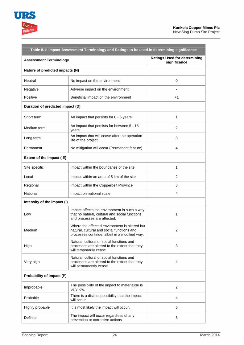
Konkola Copper Mines Plc New Slag Dump Site Project
Scoping Report 24 March 2014
Table 8.1: Impact Assessment Terminology and Ratings to be used in determining significance
Assessment Terminology Ratings Used for determining significance
Nature of predicted impacts (N)
Neutral No impact on the environment 0
Negative Adverse impact on the environment -
Positive Beneficial impact on the environment +1
Duration of predicted impact (D)
Short term An impact that persists for 0 - 5 years 1
Medium term An impact that persists for between 5 - 15 years. 2
Long term An impact that will cease after the operation life of the project. 3
Permanent No mitigation will occur (Permanent feature) 4
Extent of the impact ( E)
Site specific Impact within the boundaries of the site 1
Local Impact within an area of 5 km of the site 2
Regional Impact within the Copperbelt Province 3
National Impact on national scale 4
Intensity of the impact (I)
Low Impact affects the environment in such a way that no natural, cultural and social functions and processes are affected.
1
Medium Where the affected environment is altered but natural, cultural and social functions and processes continue, albeit in a modified way.
2
High Natural, cultural or social functions and processes are altered to the extent that they will temporarily cease.
3
Very high Natural, cultural or social functions and processes are altered to the extent that they will permanently cease.
4
Probability of impact (P)
Improbable The possibility of the impact to materialise is very low. 2
Probable There is a distinct possibility that the impact will occur. 4
Highly probable It is most likely the impact will occur. 6
Definite The impact will occur regardless of any prevention or corrective actions. 8
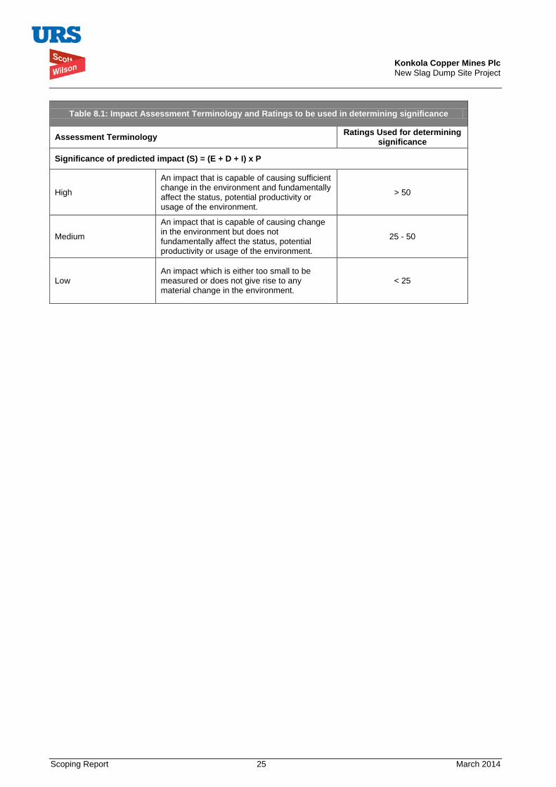
Konkola Copper Mines Plc New Slag Dump Site Project
Scoping Report 25 March 2014
Table 8.1: Impact Assessment Terminology and Ratings to be used in determining significance
Assessment Terminology Ratings Used for determining significance
Significance of predicted impact (S) = (E + D + I) x P
High
An impact that is capable of causing sufficient change in the environment and fundamentally affect the status, potential productivity or usage of the environment.
> 50
Medium
An impact that is capable of causing change in the environment but does not fundamentally affect the status, potential productivity or usage of the environment.
25 - 50
Low An impact which is either too small to be measured or does not give rise to any material change in the environment.
< 25
Konkola Copper Mines Plc New Slag Dump Site Project
Scoping Report 26 March 2014
9. PUBLIC CONSULTATION Public consultation is an integral part of the overall environmental and social impact assessment process. It is an important tool used for management of a two-way communication between a project sponsor and the public. Public consultation brings out among other important issues better information on local environmental and socio-economic issues of concerns that may arise from proposed projects. In addition, it can produce better ideas on issues and/or alternatives that may not have been previously considered by project proponents.
International corporations such as the International Finance Corporation (IFC) have adopted policy and procedural requirements regarding public consultation and disclosure. The IFC requirements are designed to ensure that IFC financed projects are implemented in an environmentally and socially responsible manner (IFC, 1998). Some operational policies on environmental assessment (IFC Operational Policies - Environmental Assessment, OP 4.01) specifically requires a Project sponsor to conduct meaningful consultations with relevant stakeholders including affected groups and other interested parties.
In addition, IFC requires that material relevant to a project be disclosed and provided to the project affected people and other interested groups. This should be carried in a timely manner and in a language understandable and accessible to the groups being consulted (IFC, 1998).
The Zambian Environmental Management Act No.12 of 2011 provides for public participation in Part VII of the Act. Its subsidiary legislation, the Environmental Impact Assessment Regulations, 1997 also provides for on-going public participation throughout the EIA process including the scoping and preparation of the Terms of Reference (ToR) for the environmental and social impact assessment study. The Fourth Schedule of the Regulations gives guidance on conducting EIA studies and it specifically provides for public participation.
In compliance with the Zambian environmental regulations and to conform to international best practices in conducting environmental and social impact assessments, a project scoping meeting was held on 2 October 2013 at Mushishima Primary School in Chingola. The meeting was held to explain to stakeholders the nature of the proposed New Slag Dump project; to gather their input concerning key environmental and social issues that need to be addressed in the EIA study and to identify major environmental and social concerns.
Project information on alternatives, anticipated impacts, proposed mitigation measures, among others, was presented in English and translated in the local language (Bemba) well understood by the local communities. The presentation, which was presented by a representative from KCM, is presented in Appendix A. The stakeholders provided feedback and suggestions on project information presented. The stakeholders were drawn from Konkola Copper Mines Plc, Zesco, Mulonga Water and Sewerage Company, URS Scott Wilson Zambia, Chingola Municipal Council, Mushishima community, Katunga Bulungu community, Kafue Hippo Pool community, Helen/Kansenji community and Mulenda farm community. The stakeholders were informed about the meeting through different modes that included:
• Adverts in the daily newspapers (Times of Zambia, Daily Mail and Post Newspaper);
• Announcement on the local community station (Radio Icengelo);
• Announcements using Public Address System;
• Physical visitation of stakeholders (direct invitation).
The stakeholders helped to determine the scope of the work to be carried out when preparing the EIA report by contributing and raising their concerns on the proposed project. The relevant concerns raised by the stakeholders are summarised in Section 8.3 of this report. These concerns have been taken into account in preparing the ToR for the EIA study.
The minutes of the Scoping Meeting are presented in Appendix B.
Konkola Copper Mines Plc New Slag Dump Site Project
Scoping Report 27 March 2014
10. TERMS OF REFERENCE It is a requirement in terms of Regulations 8 of the Zambian Environmental Impact Assessment Regulations, 1997 to prepare an EIS in accordance with the Terms of Reference (ToR). The ToR should be prepared by the project developer in consultation with the ZEMA. The regulations further require that the project developer ensures that public views are taken into account during the preparation of the terms of reference through organising a public consultation process. This public consultation process should involve Government agencies, local authorities, nongovernmental and community-based organisations and interested and affected parties who should contribute in determining the scope of work to be done in the conducting EIA study and in preparation of the EIS.
The basis of this scoping report is the scoping exercise undertaken as initial stage in the EIA process. This exercise helped to determine the scope of the EIA study for the New Slag Dump Project. Key issues and concerns arising from scoping meetings are summarised in Section 8.3 and have been taken into account in the preparation of the ToR.
The draft ToR document was prepared in December 2013 and submitted to ZEMA accordance with the provisions of the Environmental Impact Assessment Regulations, Statutory instrument No. 28 of 1997. Following review and comments by ZEMA on the draft ToR, the final ToR (the approach) for conducting the EIA study has been prepared. This scoping reporting is an appendix to the final Terms of Reference for the study.
10.1. Description of specific tasks to be undertaken for the EIA Process The regulations provide guidance on conducting the EIA study. The specific tasks that will be carried out are briefly outlined below.
• Notification for scoping meeting: This has already been carried as part of the process. All the key stakeholders were informed of the meeting through the print and electronic media.
• Holding scoping meeting with the stakeholders: The meeting was held on 2 October 2012 at Mushishima Primary School in Chingola.
• Writing scoping report and draft ToR: The views and concerns of the stakeholders on the proposed project were gathered and incorporated, where appropriate, in the draft Terms of Reference.
• Submitting draft ToR to ZEMA for review and comments.
• Receiving feedback and suggestions from ZEMA on the draft ToR.
• Preparing final ToR based on feedback from ZEMA.
• Submitting the final ToR to ZEMA for approval:
• Preparing the Environmental and Social Impact Statement
o Reviewing of relevant environmental documentation relating to KCM in general and TD7 Expansion Project in particular.
o Establishing an environmental and socio-economic baseline for the TD2 Slag Dump Project through undertaking specialist studies to supplement and update existing secondary data and information on the socio-economic and environmental conditions of the project area.
o Analysing proposed New Slag Dump and alternatives with regard to potential environmental and socio-economic impacts and risks during the construction, operation and closure.
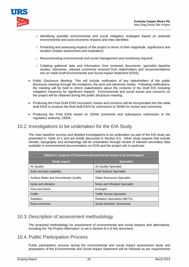
Konkola Copper Mines Plc New Slag Dump Site Project
Scoping Report 28 March 2014
o Identifying possible environmental and social mitigation strategies based on potential environmental and socio-economic impacts and risks identified.
o Predicting and assessing impacts of the project in terms of their magnitude, significance and duration (impact assessment and evaluation).
o Recommending environmental and social management and monitoring required.
o Collating gathered data and information from reviewed documents, specialist baseline studies, interviews, relevant comments received from stakeholders and recommendations into an Initial Draft Environmental and Social Impact Statement (ESIS).
• Public Disclosure Meeting: This will include notification of key stakeholders of the public disclosure meeting through the invitations, the print and electronic media. Following notifications, the meeting will be held to inform stakeholders about the contents of the Draft EIS including mitigation measures for significant impacts. Environmental and social issues and concerns on the project will be obtained during the public disclosure meeting.
• Producing the Final Draft ESIS Document: Issues and concerns will be incorporated into the initial draft ESIS to produce the final draft ESIS for submission to ZEMA for review and comments.
• Producing the Final ESIS based on ZEMA comments and subsequent submission to the regulatory authority, ZEMA.
10.2. Investigations to be undertaken for the EIA Study The main baseline surveys and detailed investigations to be undertaken as part of the EIA study are presented in Table 10.1 and are briefly discussed in Section 8.3. Other study aspects that include climate, topography and archaeology will be undertaken through review of relevant secondary data available in environmental documentation on KCM and the project site in particular.
Table10.1: Aspects of Environmental and Social Issues to be investigated
Study aspect Specialist Air Quality Air Quality Specialist
Soils and land capability Soils Science Specialist
Surface Water and Groundwater Quality Water Resources Specialist
Noise and vibration Noise and Vibration Specialist
Flora and fauna Ecologist
Traffic Traffic Survey Specialist
Radiation Radiation Specialists (METS)
Socio-economic Social Scientist / Economist
10.3. Description of assessment methodology The proposed methodology for assessment of environmental and social impacts and alternatives, including the “No Project Alternative” is set in Section 8.4 of this document.
10.4. Public Participation Process Public participation process during the environmental and social impact assessment study and preparation of the Environmental and Social Impact Statement will be followed as per requirements
Konkola Copper Mines Plc New Slag Dump Site Project
Scoping Report 29 March 2014
set out in Regulation 8(2), Regulation 10 and Stage 5 of the Fourth Schedule of the Environmental Impact Assessment Regulations, Statutory Instrument No. 28 of 1997. The process will involve the following:
• Notification of the meeting in writing to Government agencies, local authorities, nongovernmental and community-based organisations and interested and affected parties;
• Placing of notices of the public meetings on noticeboards and in the print and electronic media (local newspapers and radio);
• Holding public meetings with the identified stakeholders;
• Obtaining stakeholders’ inputs (views and concerns) initially at the time of scoping the project and preparation of the Terms of Reference. Other meetings will be held during the surveys and at the public disclosure of the draft Environmental and Social Impact Statement.
Public participation process in conducting the EIA study and preparation of the ESIS for the proposed New Slag Dump has already commenced. The initial public meeting was held with stakeholders in October 2013 to help determine the scope and content of environmental and social information in the Environmental and Social Impact Statement. This scoping report is a compilation of the proceedings of the scoping meeting and information and data obtained through review of environmental documentation relevant to the project.
A public disclosure meeting will be held following preparation of the draft ESIA report.
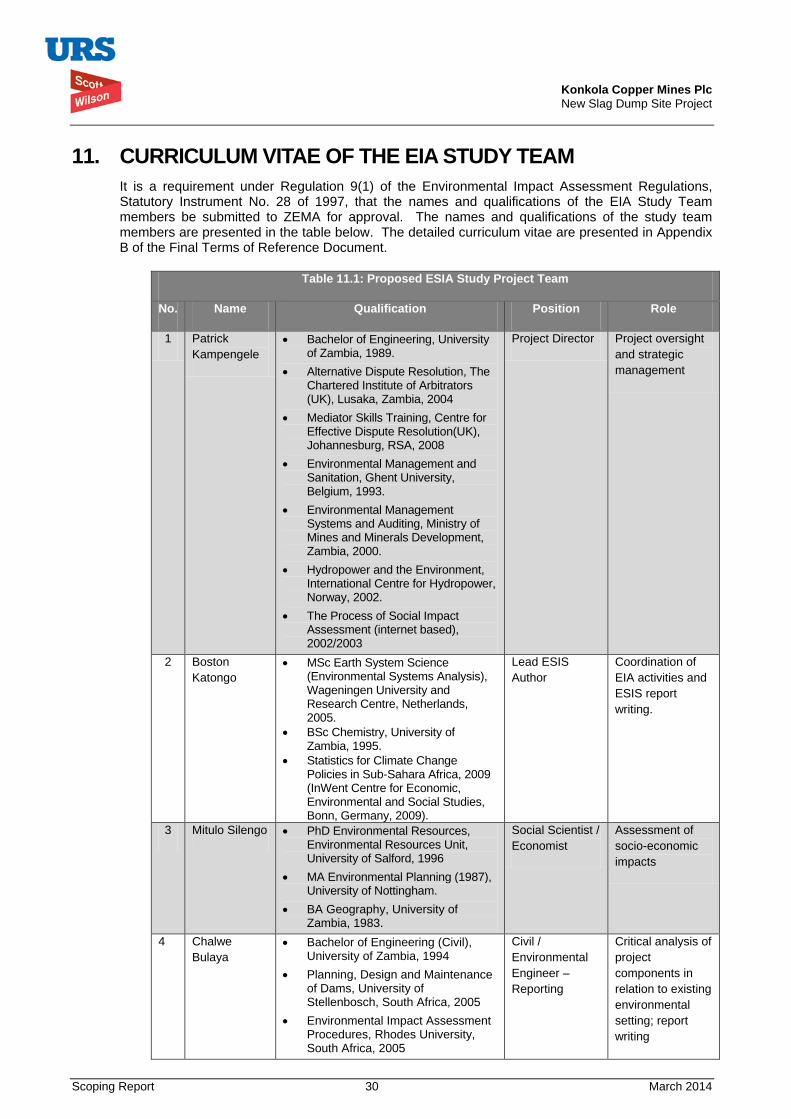
Konkola Copper Mines Plc New Slag Dump Site Project
Scoping Report 30 March 2014
11. CURRICULUM VITAE OF THE EIA STUDY TEAM It is a requirement under Regulation 9(1) of the Environmental Impact Assessment Regulations, Statutory Instrument No. 28 of 1997, that the names and qualifications of the EIA Study Team members be submitted to ZEMA for approval. The names and qualifications of the study team members are presented in the table below. The detailed curriculum vitae are presented in Appendix B of the Final Terms of Reference Document.
Table 11.1: Proposed ESIA Study Project Team
No. Name Qualification Position Role
1 Patrick Kampengele
• Bachelor of Engineering, University of Zambia, 1989.
• Alternative Dispute Resolution, The Chartered Institute of Arbitrators (UK), Lusaka, Zambia, 2004
• Mediator Skills Training, Centre for Effective Dispute Resolution(UK), Johannesburg, RSA, 2008
• Environmental Management and Sanitation, Ghent University, Belgium, 1993.
• Environmental Management Systems and Auditing, Ministry of Mines and Minerals Development, Zambia, 2000.
• Hydropower and the Environment, International Centre for Hydropower, Norway, 2002.
• The Process of Social Impact Assessment (internet based), 2002/2003
Project Director Project oversight and strategic management
2 Boston Katongo
• MSc Earth System Science (Environmental Systems Analysis), Wageningen University and Research Centre, Netherlands, 2005.
• BSc Chemistry, University of Zambia, 1995.
• Statistics for Climate Change Policies in Sub-Sahara Africa, 2009 (InWent Centre for Economic, Environmental and Social Studies, Bonn, Germany, 2009).
Lead ESIS Author
Coordination of EIA activities and ESIS report writing.
3 Mitulo Silengo • PhD Environmental Resources, Environmental Resources Unit, University of Salford, 1996
• MA Environmental Planning (1987), University of Nottingham.
• BA Geography, University of Zambia, 1983.
Social Scientist / Economist
Assessment of socio-economic impacts
4 Chalwe Bulaya
• Bachelor of Engineering (Civil), University of Zambia, 1994
• Planning, Design and Maintenance of Dams, University of Stellenbosch, South Africa, 2005
• Environmental Impact Assessment Procedures, Rhodes University, South Africa, 2005
Civil / Environmental Engineer – Reporting
Critical analysis of project components in relation to existing environmental setting; report writing
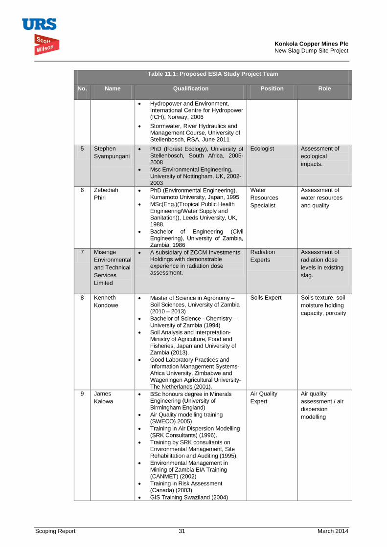
Konkola Copper Mines Plc New Slag Dump Site Project
Scoping Report 31 March 2014
Table 11.1: Proposed ESIA Study Project Team
No. Name Qualification Position Role
• Hydropower and Environment, International Centre for Hydropower (ICH), Norway, 2006
• Stormwater, River Hydraulics and Management Course, University of Stellenbosch, RSA, June 2011
5 Stephen Syampungani
• PhD (Forest Ecology), University of Stellenbosch, South Africa, 2005-2008
• Msc Environmental Engineering, University of Nottingham, UK, 2002-2003
Ecologist Assessment of ecological impacts.
6 Zebediah Phiri
• PhD (Environmental Engineering), Kumamoto University, Japan, 1995
• MSc(Eng.)(Tropical Public Health Engineering/Water Supply and Sanitation)), Leeds University, UK, 1988.
• Bachelor of Engineering (Civil Engineering), University of Zambia, Zambia, 1986
Water Resources Specialist
Assessment of water resources and quality
7 Misenge Environmental and Technical Services Limited
• A subsidiary of ZCCM Investments Holdings with demonstrable experience in radiation dose assessment.
Radiation Experts
Assessment of radiation dose levels in existing slag.
8 Kenneth Kondowe
• Master of Science in Agronomy – Soil Sciences, University of Zambia (2010 – 2013)
• Bachelor of Science - Chemistry – University of Zambia (1994)
• Soil Analysis and Interpretation- Ministry of Agriculture, Food and Fisheries, Japan and University of Zambia (2013).
• Good Laboratory Practices and Information Management Systems- Africa University, Zimbabwe and Wageningen Agricultural University- The Netherlands (2001).
Soils Expert Soils texture, soil moisture holding capacity, porosity
9 James Kalowa
• BSc honours degree in Minerals Engineering (University of Birmingham England)
• Air Quality modelling training (SWECO) 2005)
• Training in Air Dispersion Modelling (SRK Consultants) (1996).
• Training by SRK consultants on Environmental Management, Site Rehabilitation and Auditing (1995).
• Environmental Management in Mining of Zambia EIA Training (CANMET) (2002)
• Training in Risk Assessment (Canada) (2003)
• GIS Training Swaziland (2004)
Air Quality Expert
Air quality assessment / air dispersion modelling
Konkola Copper Mines Plc New Slag Dump Site Project
Scoping Report 32 March 2014
12. REFERENCES GRZ, 2011. Environmental Management Act No. 12 of 2011. Government Printers, Lusaka, Zambia.
GRZ, 1997. The Environmental Impact Assessment Regulations, 1997. Statutory Instrument No. 28 of 1997. Government Printers, Lusaka, Zambia.
IFC, 1998. International Finance Corporation Operation Policies – OP 4.01 – Environmental Assessment.
URS Scott Wilson, 2014. TD2 Slag Dump Project Design Report prepared for Konkola Copper Mines Plc, Nchanga Integrated Business Unit. Chingola.
URS Scott Wilson, 2011. TD7 Tailings Storage Facility Expansion Project Environmental Project Brief prepared for Konkola Copper Mines Plc, Chingola.
URS Scott Wilson, 2011. Overburden Dump No. 26 Environmental Impact Statement prepared for Konkola Copper Mines Plc, Chingola.
URS Scott Wilson, TD7 Expansion Design Report prepared on behalf of Konkola Copper Mines Plc, Chingola.
Konkola Copper Mines Plc New Slag Dump Site Project
Scoping Report 33 March 2014
13. APPENDICES Appendix A: Powerpoint Presentation on Proposed Project
Appendix B: Minutes of the Scoping Minutes
Appendix C: Curriculum Vitae of the ESIA Study Team Members
Konkola Copper Mines Plc New Slag Dump Site Project
Scoping Report March 2014
Appendix C: Curriculum Vitae of the ESIA Study Team Members
Konkola Copper Mines Plc New Slag Dump Site Project
Appendix A: Powerpoint Presentation on Proposed Project
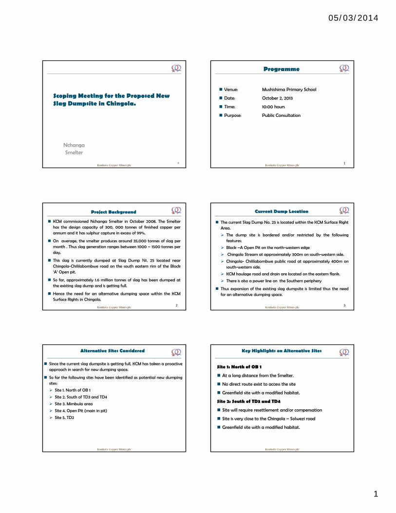
05/03/2014
1
Scoping Meeting for the Proposed New Slag Dumpsite in Chingola.
NchangaSmelter
0
Programme
Venue: Mushishima Primary School
Date: October 2, 2013
Time: 10:00 hours
Purpose: Public Consultation
1
Project Background
KCM commissioned Nchanga Smelter in October 2008. The Smelterhas the design capacity of 300, 000 tonnes of finished copper perannum and it has sulphur capture in excess of 99%.
On average, the smelter produces around 35,000 tonnes of slag permonth . Thus slag generation ranges between 1000 – 1500 tonnes perday.
This slag is currently dumped at Slag Dump №. 25 located nearChingola-Chililabombwe road on the south eastern rim of the Block‘A’ Open pit.
So far, approximately 1.6 million tonnes of slag has been dumped atthe existing slag dump and is getting full.
Hence the need for an alternative dumping space within the KCMSurface Rights in Chingola.
2
Current Dump Location
The current Slag Dump No. 25 is located within the KCM Surface RightArea.
The dump site is bordered and/or restricted by the followingfeatures:
Block –A Open Pit on the north-western edge
Chingola Stream at approximately 300m on south-western side.
Chingola- Chililabombwe public road at approximately 400m onsouth-western side.
KCM haulage road and drain are located on the eastern flank.
There is also a power line on the Southern periphery
Thus expansion of the existing slag dumpsite is limited thus the needfor an alternative dumping space.
3
Alternative Sites Considered
Since the current slag dumpsite is getting full, KCM has taken a proactiveapproach in search for new dumping space.
So far the following sites have been identified as potential new dumpingsites:
Site 1. North of OB 1
Site 2. South of TD3 and TD4
Site 3. Mimbula area
Site 4. Open Pit (main in pit)
Site 5. TD2
Key Highlights on Alternative Sites
Site 1: North of OB 1
At a long distance from the Smelter.
No direct route exist to access the site
Greenfield site with a modified habitat.
Site 2: South of TD3 and TD4
Site will require resettlement and/or compensation
Site is very close to the Chingola – Solwezi road
Greenfield site with a modified habitat.
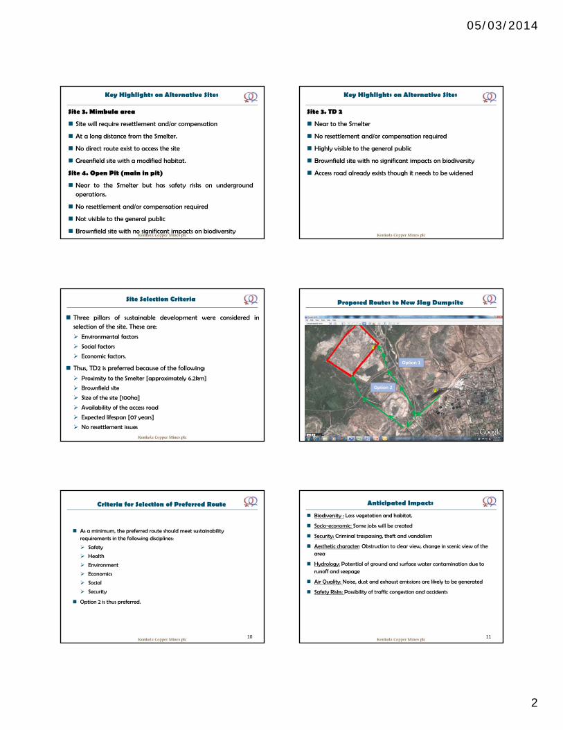
05/03/2014
2
Key Highlights on Alternative Sites
Site 3. Mimbula area
Site will require resettlement and/or compensation
At a long distance from the Smelter.
No direct route exist to access the site
Greenfield site with a modified habitat.
Site 4. Open Pit (main in pit)
Near to the Smelter but has safety risks on undergroundoperations.
No resettlement and/or compensation required
Not visible to the general public
Brownfield site with no significant impacts on biodiversity
Key Highlights on Alternative Sites
Site 3. TD 2
Near to the Smelter
No resettlement and/or compensation required
Highly visible to the general public
Brownfield site with no significant impacts on biodiversity
Access road already exists though it needs to be widened
Site Selection Criteria
Three pillars of sustainable development were considered inselection of the site. These are:
Environmental factors
Social factors
Economic factors.
Thus, TD2 is preferred because of the following:
Proximity to the Smelter [approximately 6.2km]
Brownfield site
Size of the site [100ha]
Availability of the access road
Expected lifespan [07 years]
No resettlement issues
Proposed Routes to New Slag Dumpsite
9
Option 1
Option 2
Criteria for Selection of Preferred Route
As a minimum, the preferred route should meet sustainability requirements in the following disciplines:
Safety
Health
Environment
Economics
Social
Security
Option 2 is thus preferred.
10
Anticipated Impacts
Biodiversity : Loss vegetation and habitat.
Socio-economic: Some jobs will be created
Security: Criminal trespassing, theft and vandalism
Aesthetic character: Obstruction to clear view, change in scenic view of the area
Hydrology: Potential of ground and surface water contamination due to runoff and seepage
Air Quality: Noise, dust and exhaust emissions are likely to be generated
Safety Risks: Possibility of traffic congestion and accidents
11
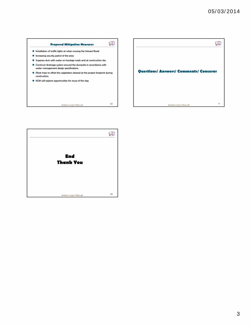
05/03/2014
3
Proposed Mitigation Measures
Installation of traffic lights at when crossing the Solwezi Road
Increasing security patrol of the area
Suppress dust with water on haulage roads and at construction site.
Construct drainage system around the dumpsite in accordance with water management design specifications.
Plant trees to offset the vegetation cleared at the project footprint during construction.
KCM will explore opportunities for reuse of the slag
12
Questions/ Answers/ Comments/ Concerns
13
14
EndThank You
Konkola Copper Mines Plc New Slag Dump Site Project
Appendix B: Minutes of the Scoping Minutes
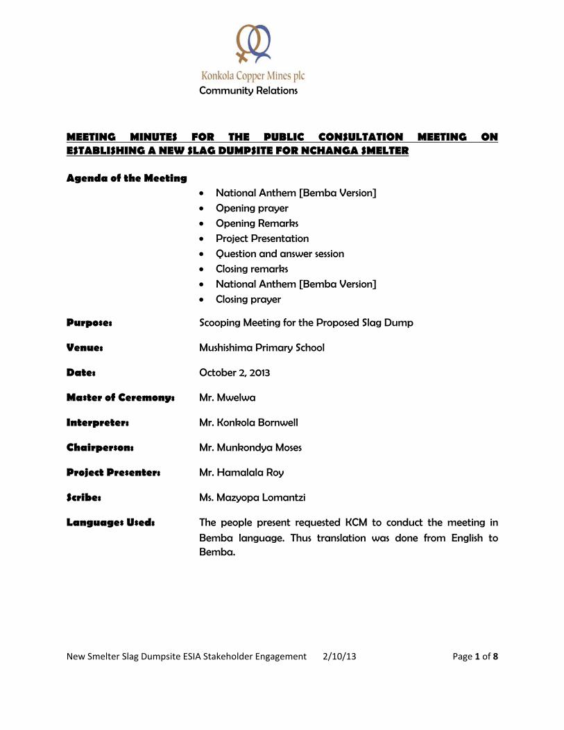
New Smelter Slag Dumpsite ESIA Stakeholder Engagement 2/10/13 Page 1 of 8
Community Relations
MEETING MINUTES FOR THE PUBLIC CONSULTATION MEETING ON ESTABLISHING A NEW SLAG DUMPSITE FOR NCHANGA SMELTER Agenda of the Meeting
National Anthem [Bemba Version]
Opening prayer
Opening Remarks Project Presentation
Question and answer session
Closing remarks National Anthem [Bemba Version]
Closing prayer
Purpose: Scooping Meeting for the Proposed Slag Dump
Venue: Mushishima Primary School
Date: October 2, 2013
Master of Ceremony: Mr. Mwelwa
Interpreter: Mr. Konkola Bornwell
Chairperson: Mr. Munkondya Moses
Project Presenter: Mr. Hamalala Roy
Scribe: Ms. Mazyopa Lomantzi
Languages Used: The people present requested KCM to conduct the meeting in
Bemba language. Thus translation was done from English to Bemba.
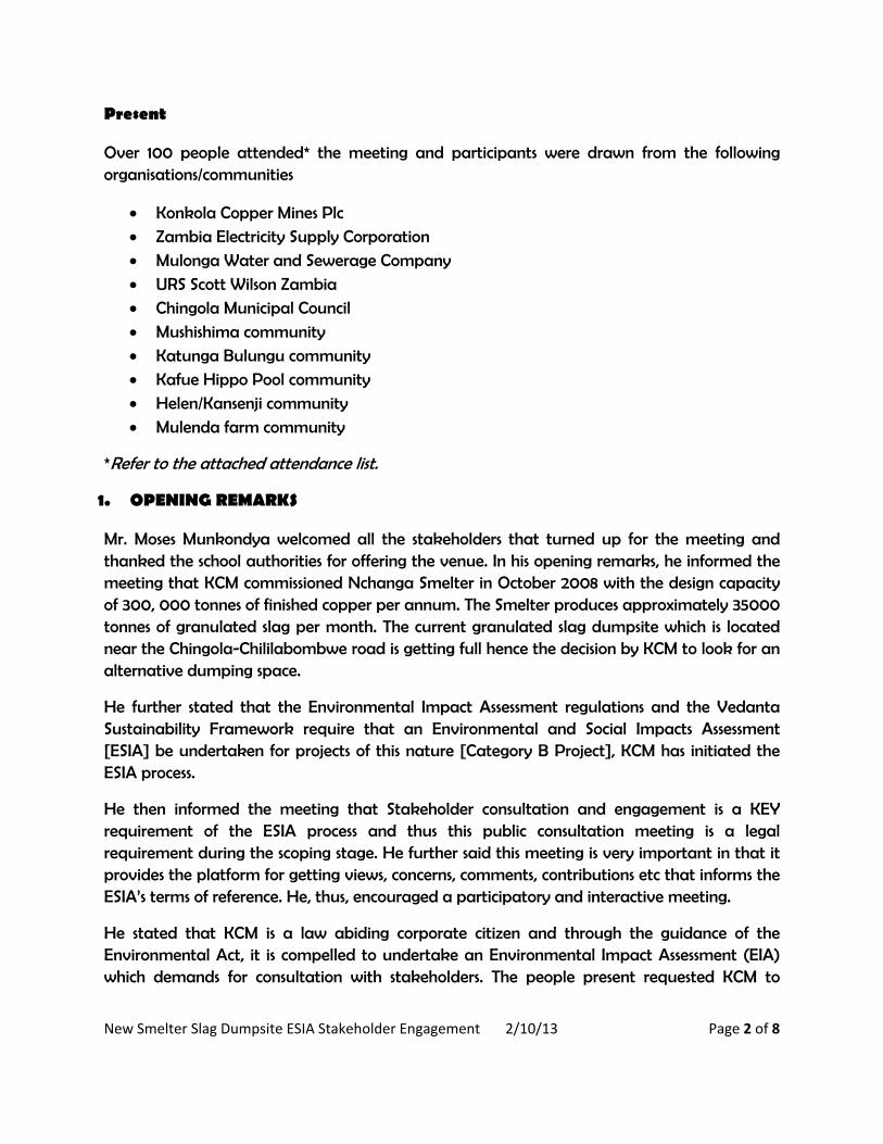
New Smelter Slag Dumpsite ESIA Stakeholder Engagement 2/10/13 Page 2 of 8
Present
Over 100 people attended* the meeting and participants were drawn from the following organisations/communities
Konkola Copper Mines Plc Zambia Electricity Supply Corporation
Mulonga Water and Sewerage Company
URS Scott Wilson Zambia Chingola Municipal Council
Mushishima community
Katunga Bulungu community Kafue Hippo Pool community
Helen/Kansenji community
Mulenda farm community
*Refer to the attached attendance list.
1. OPENING REMARKS
Mr. Moses Munkondya welcomed all the stakeholders that turned up for the meeting and thanked the school authorities for offering the venue. In his opening remarks, he informed the meeting that KCM commissioned Nchanga Smelter in October 2008 with the design capacity of 300, 000 tonnes of finished copper per annum. The Smelter produces approximately 35000 tonnes of granulated slag per month. The current granulated slag dumpsite which is located near the Chingola-Chililabombwe road is getting full hence the decision by KCM to look for an alternative dumping space.
He further stated that the Environmental Impact Assessment regulations and the Vedanta Sustainability Framework require that an Environmental and Social Impacts Assessment [ESIA] be undertaken for projects of this nature [Category B Project], KCM has initiated the ESIA process.
He then informed the meeting that Stakeholder consultation and engagement is a KEY requirement of the ESIA process and thus this public consultation meeting is a legal requirement during the scoping stage. He further said this meeting is very important in that it provides the platform for getting views, concerns, comments, contributions etc that informs the ESIA’s terms of reference. He, thus, encouraged a participatory and interactive meeting.
He stated that KCM is a law abiding corporate citizen and through the guidance of the Environmental Act, it is compelled to undertake an Environmental Impact Assessment (EIA) which demands for consultation with stakeholders. The people present requested KCM to
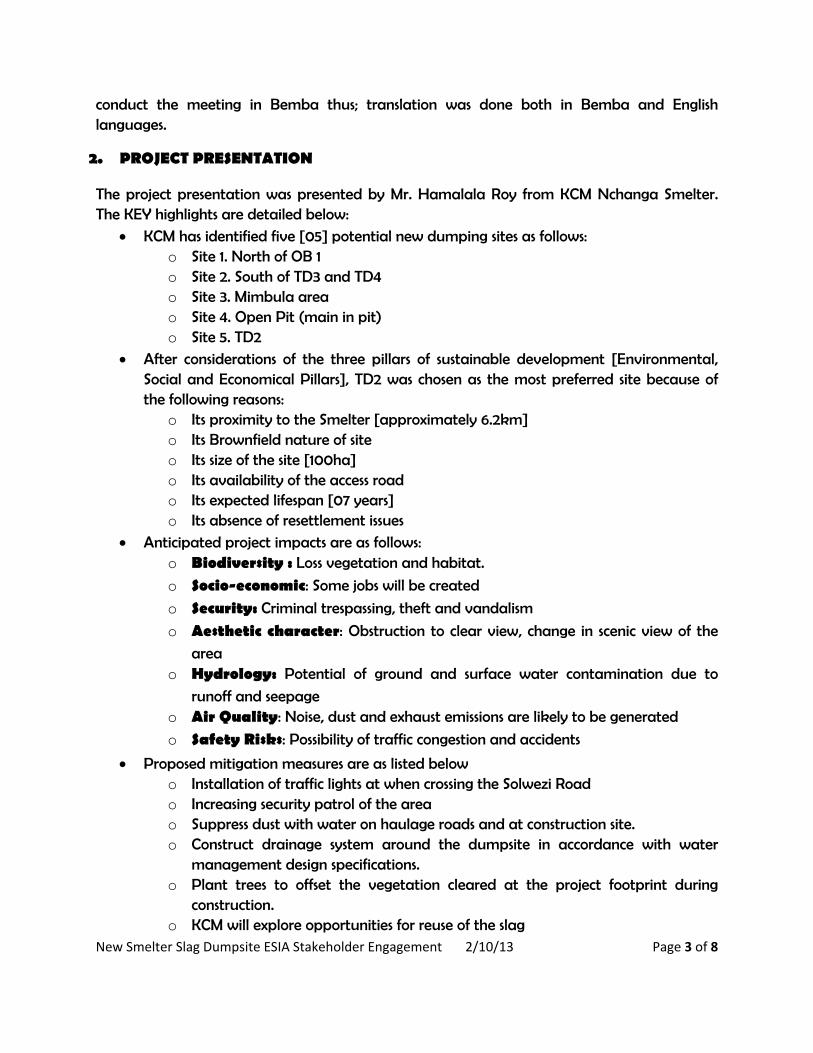
New Smelter Slag Dumpsite ESIA Stakeholder Engagement 2/10/13 Page 3 of 8
conduct the meeting in Bemba thus; translation was done both in Bemba and English languages.
2. PROJECT PRESENTATION
The project presentation was presented by Mr. Hamalala Roy from KCM Nchanga Smelter. The KEY highlights are detailed below:
KCM has identified five [05] potential new dumping sites as follows: o Site 1. North of OB 1 o Site 2. South of TD3 and TD4 o Site 3. Mimbula area o Site 4. Open Pit (main in pit) o Site 5. TD2
After considerations of the three pillars of sustainable development [Environmental, Social and Economical Pillars], TD2 was chosen as the most preferred site because of the following reasons:
o Its proximity to the Smelter [approximately 6.2km] o Its Brownfield nature of site o Its size of the site [100ha] o Its availability of the access road o Its expected lifespan [07 years] o Its absence of resettlement issues
Anticipated project impacts are as follows: o Biodiversity : Loss vegetation and habitat.
o Socio-economic: Some jobs will be created
o Security: Criminal trespassing, theft and vandalism
o Aesthetic character: Obstruction to clear view, change in scenic view of the
area o Hydrology: Potential of ground and surface water contamination due to
runoff and seepage o Air Quality: Noise, dust and exhaust emissions are likely to be generated
o Safety Risks: Possibility of traffic congestion and accidents
Proposed mitigation measures are as listed below o Installation of traffic lights at when crossing the Solwezi Road o Increasing security patrol of the area o Suppress dust with water on haulage roads and at construction site. o Construct drainage system around the dumpsite in accordance with water
management design specifications. o Plant trees to offset the vegetation cleared at the project footprint during
construction. o KCM will explore opportunities for reuse of the slag
New Smelter Slag Dumpsite ESIA Stakeholder Engagement 2/10/13 Page 4 of 8
3. QUESTION AND ANSWER SESSION
Resettlement Issues Question: Kabaso Washamba wanted to know whether KCM was going to demolish
Mushishima Village as a result of implementing the proposed project. Answer: Roy Hamalala said the proposed project will not cause any resettlement issues. Thus,
KCM will not relocating anyone, meaning Mushishima village will not be disturbed by our activity. Question: Bruno Mulopwe said that there were rumors that the proposed project will cause
displacement of Mushishima Village and thus wanted to know where they will be taken to. Answer: Roy Hamalala said the concern is similar to the one asked earlier by Kabaso and
that KCM answer remains the same “the proposed project will not cause any displacements.” Question: Gladys Pojana expressed a future concern that the site [TD2] KCM has chosen has
the life span of only 7 years. This means that after that KCM will have to shift to another site. The new site might trigger displacements. Thus, she appealed to KCM to give them advance notice so that they can start preparing for relocation. Answer: Moses Munkondya responded that KCM operates within its surface right boundary.
This licensed area is a private area and access in restricted. Therefore, KCM gets sadden when it sees its stakeholders encroaching on its land as it gives KCM problems in undertaking its developmental projects. Accordingly, KCM’s appeal to the general public is that stop encroaching on KCM licensed area. Those encroach on KCM land will not have security of land. The best thing to do is to engage with Chingola Municipal Council to get land with a title deed. Dust Emission Question: Stephen Nkonde expressed concern that proposed project might worse the dust
and vibrations problem since they receive a lot of dust and vibrations from the operations of COP F. This happens especially during blasting times and their houses shake vigorously.
New Smelter Slag Dumpsite ESIA Stakeholder Engagement 2/10/13 Page 5 of 8
Answer: Roy Hamalala said that the proposed project will not involve blasting of any kind.
The project involves transportation of granulated slag [which is already fragmented] from the Smelter to TD2. Question: Mr. Sinkala demanded for an assurance of how dust from the slag will be
managed so that it does not affect the community. Answer: Roy Hamalala said that dust will be generated during construction and operation
phases from the earth moving equipment. Water will be used to suppress dust along the haulage roads and the construction site. The slag is not expected to generate dust during transportations as it is transported while wet with moisture content in the range of 12% to 14%. Question: Belita Nakalumbi said that as they pass through the open pit to go to town, they
encounter a lot of dust from the pits. As a result the community requested the Chingola Municipal Council [CMC] to put a bus stop. However, the CMC refused. She was, thus, finding out whether KCM could assist them with a bus station. Answer: Moses Munkondya said that the question is not directly related to the proposed
project. He said that he is not competent to provide the answer to that request. However, the question has been noted and it will be directed to appropriate department for an informed feedback. Question: Gideon Mako expressed concern that the proposed project might subject the
community to health issues such as TB. He thus wanted to know mitigation measures that KCM would put in place to avert the effects otherwise relocate this community (Mushishima). Answer: Bbautu informed the meeting that TB is caused by bacteria (Mycobacterium
tuberculosis ) not dust. He refuted that slag contain bacteria responsible for TB. If the project was about copper ore mining, there would be a concern with silicosis. Effluent Discharge Question: Mulaisho wanted to know what would happen to slag when it is raining. Will the
slag melt or not. He was concern about it melting and further contributing to the deterioration of the water quality in the already polluted Mushishima stream. Answer: Roy Hamalala said that slag is inert and would not melt under normal conditions.
The drainage system will be implemented to manage any fines that might get washed away during heavy rains.
New Smelter Slag Dumpsite ESIA Stakeholder Engagement 2/10/13 Page 6 of 8
Comment: Stephen Nkonde expressed concern that during rainy season when it is raining, all
the soil and water from the open pit settles in Mushishima stream. Answer: Roy Hamalala said the drainage and paddocks will be constructed around the slag
dumpsite to collect water and settle the silt prior to its discharge in the receiving stream – Mushishima stream. Security issues Question: Nyirenda wanted to know about the security measures that KCM will put in place
to curb criminal activities since the slag dump might attract more criminals like thieves. Answer: Roy Hamalala said that KCM will increase security patrols.
ESIA Process Question: Mr. Sinkala said he was happy that KCM invited and consulted with stakeholders
before implementing the proposed project but expressed concern about the absence of ZEMA at the meeting. He wondered whether ZEMA [competent experts] was aware of what KCM is intending to undertake. Answer: Mr. Moses Munkondya said YES we formally invited ZEMA through an invitation
letter. The other modes of inviting stakeholders included:
Advert for a meeting in the daily newspapers [Times of Zambia, Daily Mail and Post Newspaper]
Announcement on Radio Ichengelo Announcement using Public Address system Direct invitation by physical visitation
Question: Mr. Boston Katongo” what is the roadmap in this process?
Answer: Mr. Moses Munkondya said that there are six main stages of the EISA process. These
are 1. Screening Exercise [done] 2. Scoping Exercise [current stage] 3. Baseline data collection 4. Impact Assessment 5. ESIA Output 6. Public Disclosure
Other concerns
New Smelter Slag Dumpsite ESIA Stakeholder Engagement 2/10/13 Page 7 of 8
Bishop Kapwepwe said that the record for KCM is not good in the area. Some members of
the community in the area are already complaining of dust emission and their gardens. As a result, he wanted to know the monitoring systems KCM intend to use to proactively detect issues before they magnify into irreversible impacts. He also suggested that KCM should explore the opportunity for reusing slag as raw material in concrete block making and roads construction. Answer: Roy Hamalala agreed that KCM will surely look into the monitoring system so
those statutory thresholds are not exceeded. Question: Lombe bemoaned lack of adequate sources of clean water in his area. He stated
that the population was growing and this would exert increased pressure on the existing water sources. He acknowledged with thanks that KCM has given them 5 boreholes and one water tank but he wondered whether KCM will be giving them some more tanks. Answer: Roy Hamalala said the question is not related to the current project. However, we
have taken note of the question and we will direct it the relevant official handling the water issues.
4. CONCLUDING REMARKS
Mushishima community Chairman, Mr. Billy Simwanda thanked everyone for their participation in the meeting and KCM for letting the people know its intentions. He was very hopeful that the project will generate development and employment for the local people. Hippo Pool community Chairman, Mr. Augustine Lombe was very grateful for the good work KCM was doing in his area. He appealed to the company to increase the number of water tanks in his area. In conclusion, the KCM Team Leader thanked everyone for coming to the meeting. He assured the people that all their questions and concerns relating to the propose project have been recorded and will be addressed in the ESIA. KCM will provide feedback on these issues in the later stages of the ESIA as required by law. There being no other business, the meeting was closed by singing the National Anthem (Bemba version) and a closing prayer at 12:25hours.

New Smelter Slag Dumpsite ESIA Stakeholder Engagement 2/10/13 Page 8 of 8
______________________ ________________________ Chairperson Scribe
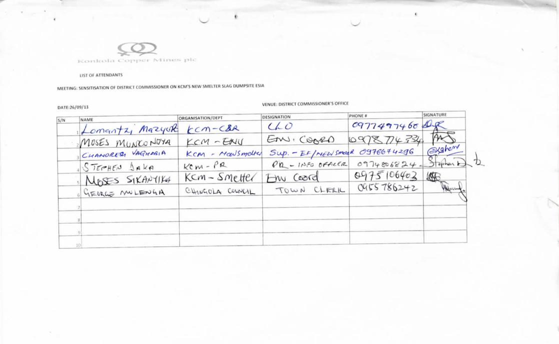
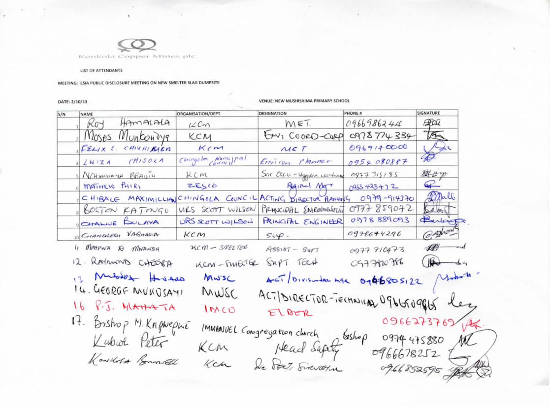
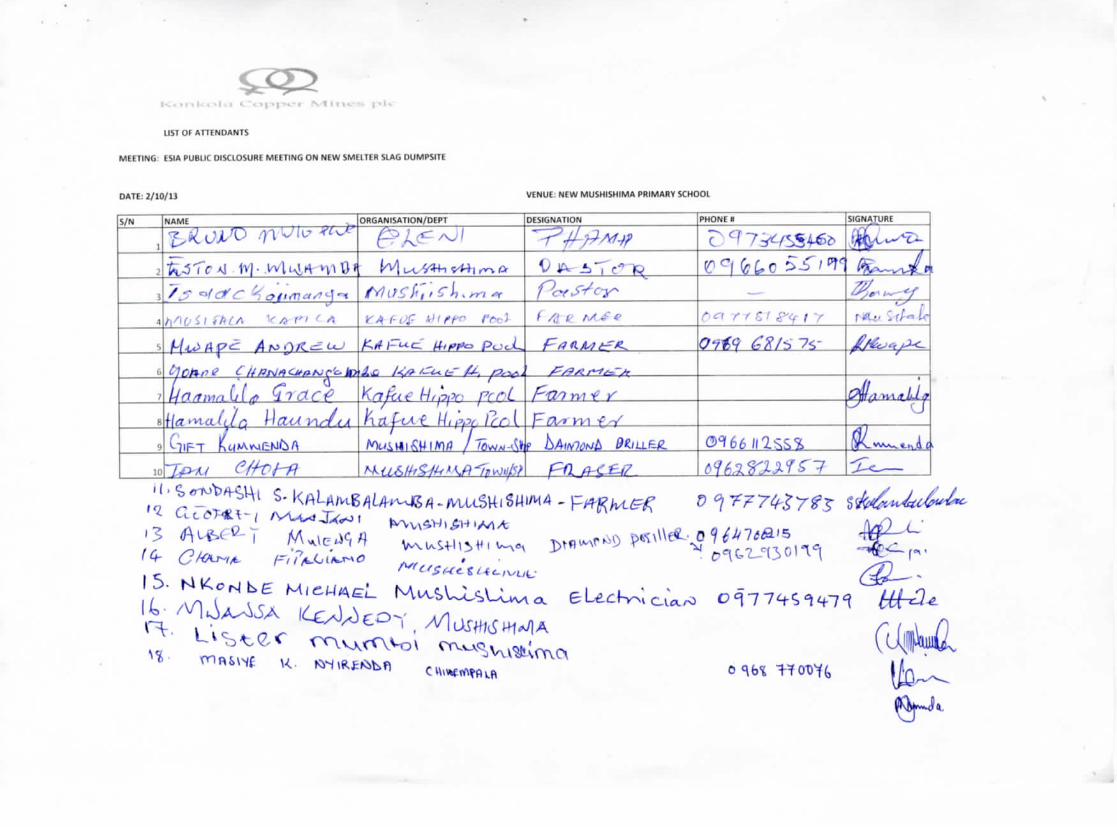
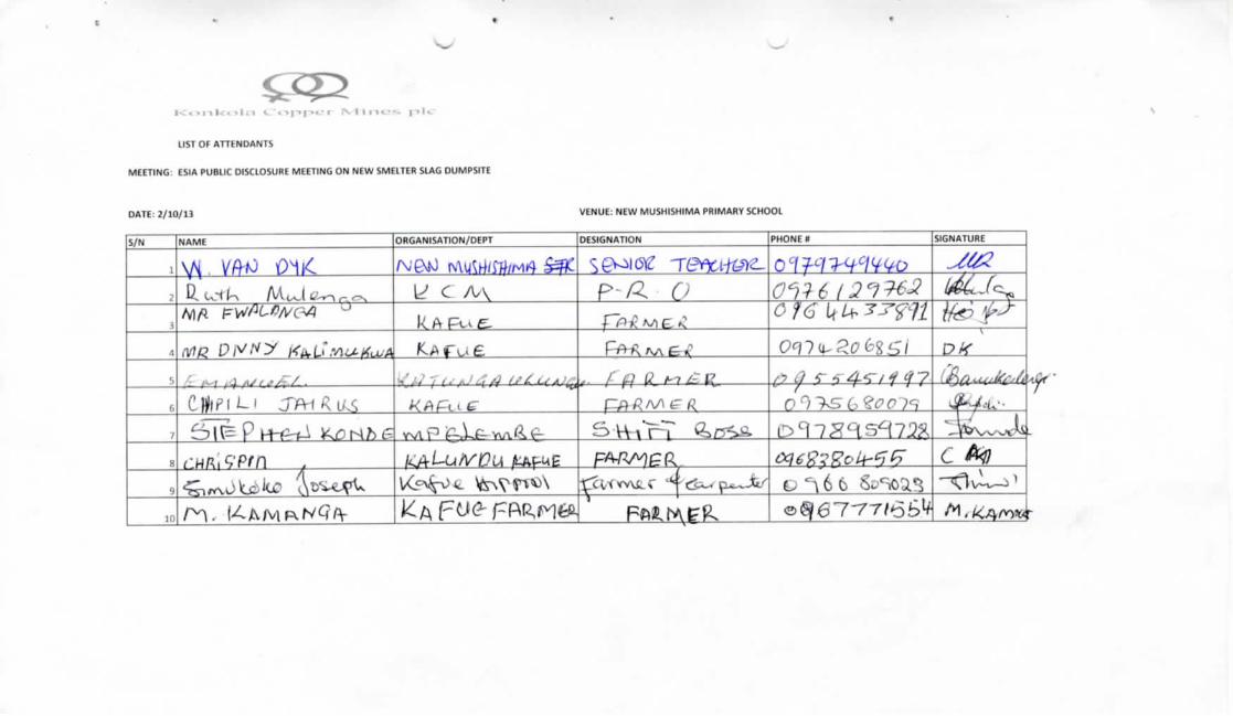
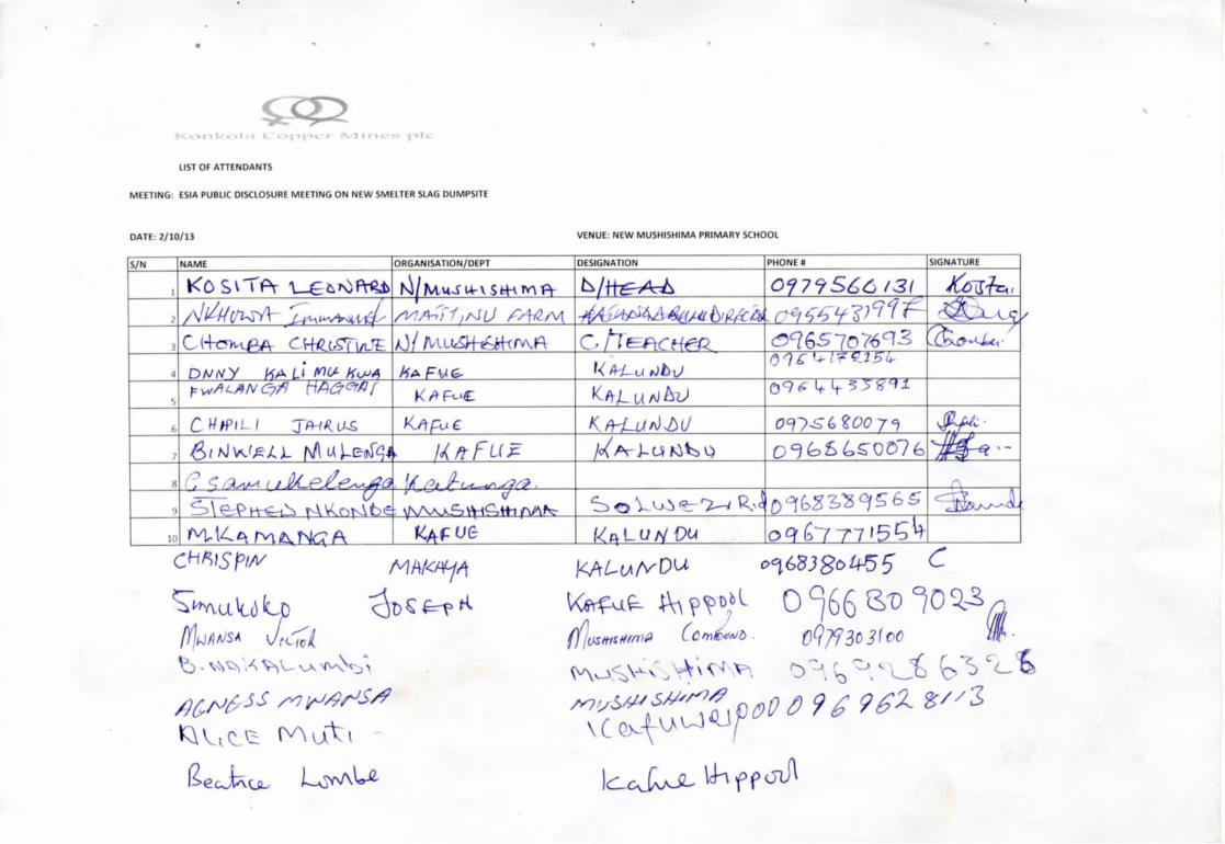
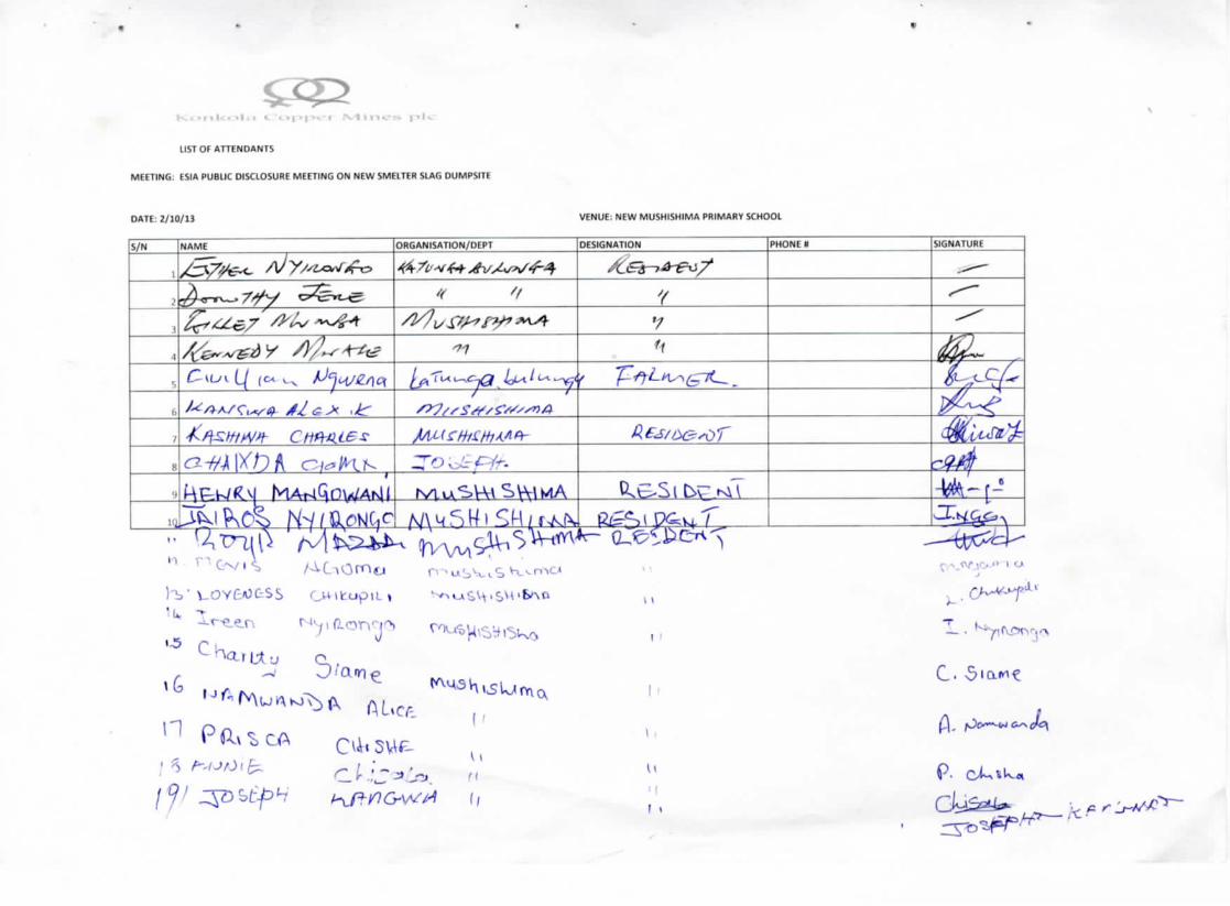
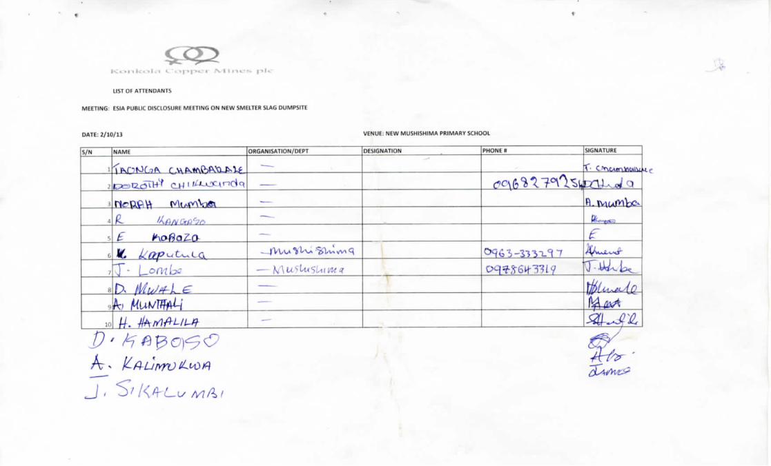
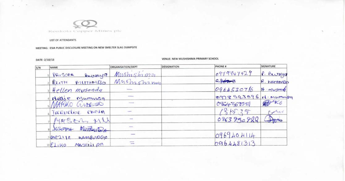
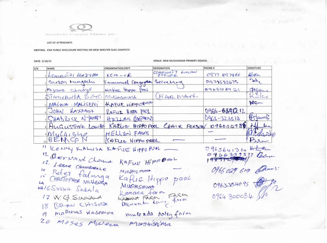
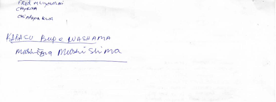
Konkola Copper Mines Plc New Slag Dump Site Project
Appendix C: Curriculum Vitae of the ESIA Study Team Members
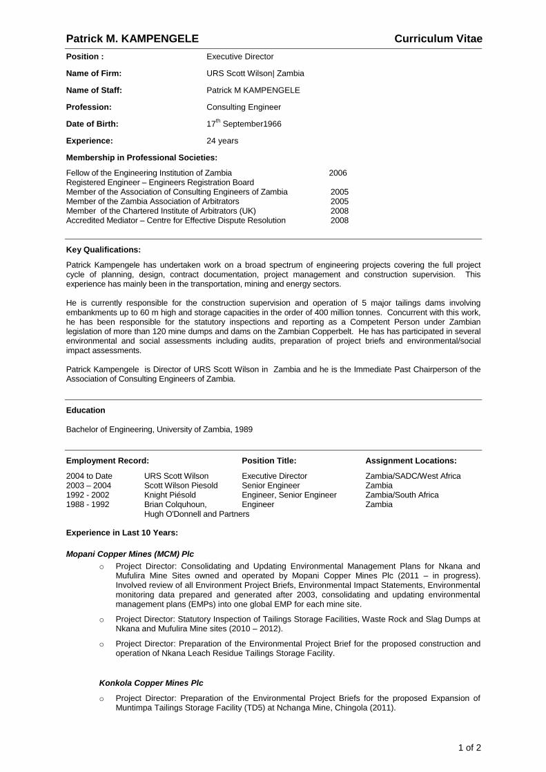
Patrick M. KAMPENGELE Curriculum Vitae
1 of 2
Position : Executive Director
Name of Firm: URS Scott Wilson| Zambia
Name of Staff: Patrick M KAMPENGELE
Profession: Consulting Engineer
Date of Birth: 17th
September1966
Experience: 24 years
Membership in Professional Societies:
Fellow of the Engineering Institution of Zambia 2006 Registered Engineer – Engineers Registration Board Member of the Association of Consulting Engineers of Zambia 2005 Member of the Zambia Association of Arbitrators 2005 Member of the Chartered Institute of Arbitrators (UK) 2008 Accredited Mediator – Centre for Effective Dispute Resolution 2008
Key Qualifications:
Patrick Kampengele has undertaken work on a broad spectrum of engineering projects covering the full project cycle of planning, design, contract documentation, project management and construction supervision. This experience has mainly been in the transportation, mining and energy sectors. He is currently responsible for the construction supervision and operation of 5 major tailings dams involving embankments up to 60 m high and storage capacities in the order of 400 million tonnes. Concurrent with this work, he has been responsible for the statutory inspections and reporting as a Competent Person under Zambian legislation of more than 120 mine dumps and dams on the Zambian Copperbelt. He has has participated in several environmental and social assessments including audits, preparation of project briefs and environmental/social impact assessments. Patrick Kampengele is Director of URS Scott Wilson in Zambia and he is the Immediate Past Chairperson of the Association of Consulting Engineers of Zambia.
Education
Bachelor of Engineering, University of Zambia, 1989
Employment Record: Position Title: Assignment Locations:
2004 to Date URS Scott Wilson Executive Director Zambia/SADC/West Africa 2003 – 2004 Scott Wilson Piesold Senior Engineer Zambia 1992 - 2002 Knight Piésold Engineer, Senior Engineer Zambia/South Africa 1988 - 1992 Brian Colquhoun, Engineer Zambia Hugh O'Donnell and Partners Experience in Last 10 Years:
Mopani Copper Mines (MCM) Plc
o Project Director: Consolidating and Updating Environmental Management Plans for Nkana and Mufulira Mine Sites owned and operated by Mopani Copper Mines Plc (2011 – in progress). Involved review of all Environment Project Briefs, Environmental Impact Statements, Environmental monitoring data prepared and generated after 2003, consolidating and updating environmental management plans (EMPs) into one global EMP for each mine site.
o Project Director: Statutory Inspection of Tailings Storage Facilities, Waste Rock and Slag Dumps at Nkana and Mufulira Mine sites (2010 – 2012).
o Project Director: Preparation of the Environmental Project Brief for the proposed construction and operation of Nkana Leach Residue Tailings Storage Facility.
Konkola Copper Mines Plc
o Project Director: Preparation of the Environmental Project Briefs for the proposed Expansion of Muntimpa Tailings Storage Facility (TD5) at Nchanga Mine, Chingola (2011).
Patrick M. KAMPENGELE Curriculum Vitae
2 of 2
21/06’2013
o Project Director: Preparation of the Environmental Project Briefs for TD7 Tailings Storage Facility Extension Project; Development of two New Overburden Dumps at Fitwaola Open Pit Mine Site; OB26 Dump Extension Project; Slag Dump No. 67 Reclamation Project, proposed Overburden Dump No. 26 Extension Project, Chingola (December 2011)..
o Project Director :Statutory Inspections of Slag Dumps, Overburden Dumps, Waste Rock Dumps and Tailings Storage Facilities at Konkola Copper Mine’s Nkana, Nampundwe Mine and Nchanga Integrated Business Units (2010 – 2011). Statutory Inspections of Overburden Dumps at Konkola Copper Mine’s Nchanga Integrated Business Units (December 2012).
o Project Director : Review of the Resettlement Action Plan for the proposed OB26 Dump Extension Project at Nchanga Mine (2012).
Kansanshi Mining Plc
o Project Director: Preparation of an Environmental Impact Statement for the proposed construction and operation of Kansanshi Copper Smelter at Kansanshi Mine, Solwezi (March 2012).
o Project Director :Preparation of an Environmental Project Brief on the proposed construction and operation of Waste Stabilisation Ponds at Kansanhi Mine, Solwezi (September – 2012).
o Project Director :Statutory inspections of Waste Rock Dumps, Overburden Dumps and Mineralised Ore stockpiles at Kansanshi Mine (2012).
Lumwana Mining Company Limited
o Project Director : Preparation of N143-101 Technical Report on Lumwana Mine site. Report prepared on behalf of Barrick Limited. Conducted environmental audit as part of preparation of the N143-101 Technical Report. Audit conducted in collaboration with the Roscoe Postle Associates Inc (July, 2011).
Zesco / Itezhi-Tezhi Hydropower Company
o Project Director :Updating the Environmental and Social Impact Assessment Report for the Itezhi-Tezhi Hydropower Plant in Itezhi-Tezhi, Zambia (June 2012)
First Quantum Minerals and Operations Limited
o Project Director : Preparation of the Decommissioning and Closure Plan for Bwana Mkubwa Mine in Ndola, Zambia, (September 2010).
Other Experience:
Lusiwasi Hydropower Station, Zambia- Responsible for the preparation of an Environmental Project Brief for
the rehabilitation works.
Ministry of Agriculture and Co-operatives – Project Director responsible for the design of Kanakantapa
Earth Dam in Chongwe District, Lusaka Province.
Gwembe-Tonga Rehabilitation & Development Project –Dams and Weirs, Zambia –Responsible for site
investigations, preparation of the EPB ,coordinating topographical surveys, preparation of tender documents, tender evaluation, adjudication, contract negotiations, project management and contract administration for ten dams and weirs.
Certification:
I, the undersigned, certify that to the best of my knowledge and belief, these data correctly describes me, my qualifications, my experience and me. ………………………………………………………………………………… Date:……………………… (Signature of staff member and authorised representative of the firm ) Day/Month/ Year Full name of staff member: Patrick M KAMPENGELE
Curriculum Vitae Boston L KATONGO
Page 1 of 3
Position : Principal Environmental Scientist
Name of Firm : URS Scott Wilson Zambia
Name of Staff : Boston Lazalo KATONGO
Date of Birth : 11th September, 1971.
Work Experience : +14 years
Professional Membership : Engineering Institute of Zambia
KEY AREAS OF EXPERIENCE
Boston Katongo has valuable experience in environmental assessment and environmental pollution
monitoring; and has in the recent past been involved in works requiring site investigations and preparation
statutory inspection reports and comprehensive environmental assessment reports that include
Environmental Impact Statements (EIS), Environmental Project Briefs, Environmental Management Plans
(for existing and proposed projects in different sectors of the economy), Environmental Audit and
Compliance Review, Mine Decommissioning and Rehabilitation Plan. He has a worthy of practical work
experience acquired from the mining industries and from the national environmental regulatory body that
has enabled him to effectively review and assess process operations, solid waste and effluent disposal,
pollution control systems, environmental aspects of a number of industries.
EDUCATION AND TRAINING:
Master of Science Degree in Earth System Science specialized in Environmental Systems Analysis,
Wageningen University and Research Centre, Netherlands (Sept., 2003–March, 2005);
Bachelor of Science Degree in Chemistry, University of Zambia, (Nov. 1990 – Dec., 1994);
Certificate in Statistics for Climate Change Policies in Sub-Sahara Africa, 2009 (InWent Centre for Economic, Environmental and Social Studies, Bonn, Germany, 2009);
Certificate in Community-based Risk Screening – Adaptation and Livelihoods (CRiSTAL TOOL),
Lusaka (2009).
Certificate in Environmental Impact Assessment and Strategic Environmental Assessment using
Spatial Decision Support Tools, University of Twente, The Netherlands (31 October 2011 – 9
December 2011).
Certificate of Participation in a Regional Training Course on “3rd
Annual Water and Waste Management
in Mining”. Crowne Plaza Johannesburg – The Rosebank, Johannesburg, South Africa (14th – 17
th
January 2013);
Professional Experience (Employment)
Item Company / Organisation Position From - To
1 URS Scott Wilson Zambia Principal Environmental
Scientist
2011 - to date
2 United Nations Development Programme /
Environmental Council of Zambia, Lusaka
National Project
Coordinator
2008 to 2010
3 Scott Wilson Piesold Zambia Sub-consultant 2005 - 2010
4 Environmental Council of Zambia, Lusaka,
Zambia
Inspector May 2003 –
September, 2003
5 NFC Africa Mining Plc, ,Kalulushi
Sectional Chemist March, 2001 – March,
2003)
6 Mopani Copper Mines Plc, Nkana Division,
Kitwe -
Plant Process Control
Senior Chemist
April 2000– February
2001
Curriculum Vitae Boston L KATONGO
Page 2 of 3
Professional Experience (Employment)
Item Company / Organisation Position From - To
7 Zambia Consolidated Copper Mines
Limited, Nkana Division, Kitwe -
Plant Process Control
and Environmental
Pollution Control Senior
Chemist
January 1997 – March
2000
Recent relevant projects
Project Name Role From - To
1 Musenga Tar Pit Remediation Project Environmental and Social Impact Assessment for the construction of an engineered containment cell at Musenga Acid Tar Pits in Chingola, Zambia
Principal Environmental
Scientist / In-country
project coordination
February 2012 – in
progress.
2 Consolidating and Updating Environmental
Management Plans for Nkana and Mufulira
Mine Sites owned and operated by Mopani
Copper Mines Plc
Lead ESMP Author 2011 – 2013
3 Preparation of an Environmental Impact Statement for the proposed Overburden Dump No. 26 Extension Project, Chingola
Lead Author December 2011
4 Preparation of an Environmental Impact Statement for the proposed construction and operation of Kansanshi Copper Smelter at Kansanshi Mine, Solwezi
Lead Author – compiling
and co-editing the
specialist reports
March 2012
5 Participated in updating the Environmental and Social Impact Assessment Report for the Itezhi-Tezhi Hydropower Plant in Itezhi-Tezhi, Zambia
Noise measurement and
coordination of in-country
project activities.
June 2012
6 Preparation of an Environmental Management Plan on behalf of Scaw Limited, Kitwe, Zambia
Environmental Scientist May 2010
7 Preparation of Environmental Project Brief on
the construction and operations of a Pressure
Leach Plant, Oxygen Plant (2005), Waste
Stabilisation Ponds (2012), Sulphuric Acid
Plant (2007), Gold Processing Plant (2007),
Oxides Tailings Storage Facility (2006),
Environmental Scientist /
Lead Author
2005 - .2012
8 Environmental auditing of all operational facilities of Scaw Zambia Limited, and review of its compliance with World Bank Group Pollution Prevention and Abatement requirements and the Zambian Environmental Legislations and Regulations.
Environmental Scientist July, 2007
9 Preparation of the Environmental Project Briefs for Expansion of Muntimpa Tailings Storage Facility (TD5), Extension of TD7 Tailings Storage Facility; Development of two New Overburden Dumps at Fitwaola Open Pit Mine Site; Extension of OB26 Dump; Reclamation of Slag Dump No. 67 (on behalf
Environmental Scientist /
Lead Author
Curriculum Vitae Boston L KATONGO
Page 3 of 3
Recent relevant projects
Project Name Role From - To
of Konkola Copper Mines plc).
10 Preparation of N143-101 Technical Report on Lumwana Mine site. Report prepared on behalf of Barrick Limited. Conducted environmental audit as part of preparation of the N143-101 Technical Report. Audit conducted in collaboration with the Roscoe Postle Associates Inc.
Environmental Scientist July, 2011
Certification:
I, the undersigned, certify that to the best of my knowledge and belief, these data correctly describes my qualifications, my experience and me. I further confirm that I will be available for the duration of the project immediately it commences.
_______________________ Date: 14th July 2013.
(Signature)
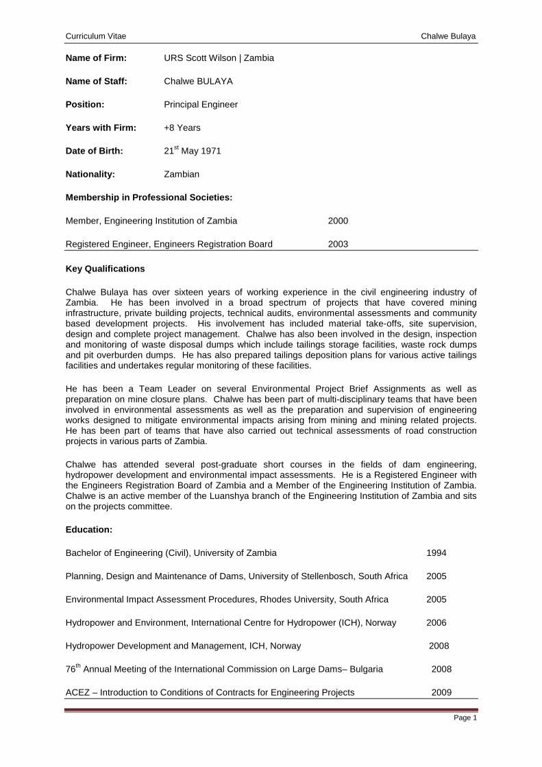
Curriculum Vitae Chalwe Bulaya
Page 1
Name of Firm: URS Scott Wilson | Zambia
Name of Staff: Chalwe BULAYA
Position: Principal Engineer
Years with Firm: +8 Years
Date of Birth: 21st May 1971
Nationality: Zambian
Membership in Professional Societies:
Member, Engineering Institution of Zambia 2000
Registered Engineer, Engineers Registration Board 2003
Key Qualifications
Chalwe Bulaya has over sixteen years of working experience in the civil engineering industry of Zambia. He has been involved in a broad spectrum of projects that have covered mining infrastructure, private building projects, technical audits, environmental assessments and community based development projects. His involvement has included material take-offs, site supervision, design and complete project management. Chalwe has also been involved in the design, inspection and monitoring of waste disposal dumps which include tailings storage facilities, waste rock dumps and pit overburden dumps. He has also prepared tailings deposition plans for various active tailings facilities and undertakes regular monitoring of these facilities.
He has been a Team Leader on several Environmental Project Brief Assignments as well as preparation on mine closure plans. Chalwe has been part of multi-disciplinary teams that have been involved in environmental assessments as well as the preparation and supervision of engineering works designed to mitigate environmental impacts arising from mining and mining related projects. He has been part of teams that have also carried out technical assessments of road construction projects in various parts of Zambia.
Chalwe has attended several post-graduate short courses in the fields of dam engineering, hydropower development and environmental impact assessments. He is a Registered Engineer with the Engineers Registration Board of Zambia and a Member of the Engineering Institution of Zambia. Chalwe is an active member of the Luanshya branch of the Engineering Institution of Zambia and sits on the projects committee.
Education:
Bachelor of Engineering (Civil), University of Zambia 1994
Planning, Design and Maintenance of Dams, University of Stellenbosch, South Africa 2005
Environmental Impact Assessment Procedures, Rhodes University, South Africa 2005
Hydropower and Environment, International Centre for Hydropower (ICH), Norway 2006
Hydropower Development and Management, ICH, Norway 2008
76th Annual Meeting of the International Commission on Large Dams– Bulgaria 2008
ACEZ – Introduction to Conditions of Contracts for Engineering Projects 2009
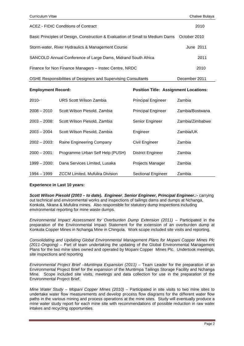
Curriculum Vitae Chalwe Bulaya
Page 2
ACEZ - FIDIC Conditions of Contract 2010
Basic Principles of Design, Construction & Evaluation of Small to Medium Dams October 2010
Storm-water, River Hydraulics & Management Course June 2011
SANCOLD Annual Conference of Large Dams, Midrand South Africa 2011
Finance for Non Finance Managers – Instec Centre, NRDC 2010
OSHE Responsibilities of Designers and Supervising Consultants December 2011
Employment Record: Position Title: Assignment Locations:
2010- URS Scott Wilson Zambia Principal Engineer Zambia
2008 – 2010 Scott Wilson Piesold, Zambia Principal Engineer Zambia/Bostwana
2003 – 2008: Scott Wilson Piesold, Zambia Senior Engineer Zambia/Zimbabwe
2003 – 2004 Scott Wilson Piesold, Zambia Engineer Zambia/UK
2002 – 2003: Raine Engineering Company Civil Engineer Zambia
2000 – 2001: Programme Urban Self Help (PUSH) District Engineer Zambia
1999 – 2000: Dana Services Limited, Lusaka Projects Manager Zambia
1994 – 1999 ZCCM Limited, Mufulira Division Sectional Engineer Zambia
Experience in Last 10 years:
Scott Wilson Piesold (2003 – to date). Engineer, Senior Engineer, Principal Engineer.:- carrying out technical and environmental works and inspections of tailings dams and dumps at Nchanga, Konkola, Nkana & Mufulira mines. Also responsible for statutory dump inspections including environmental reporting for mine waste dumps.
Environmental Impact Assessment for Overburden Dump Extension (2011) – Participated in the preparation of the Environmental Impact Statement for the extension of an overburden dump at Konkola Copper Mines in Nchanga Mine in Chingola. Work scope included site visits and reporting.
Consolidating and Updating Global Environmental Management Plans for Mopani Copper Mines Plc (2011-Ongoing) – Part of team undertaking the updating of the Global Environmental Management Plans for the two mine sites owned and operated by Mopani Copper Mines Plc. Undertook meetings, site inspections and reporting
Environmental Project Brief –Muntimpa Expansion (2011) – Team Leader for the preparation of an Environmental Project Brief for the expansion of the Muntimpa Tailings Storage Facility and Nchanga Mine. Scope included site visits, meetings and data collection for use in the preparation of the Environmental Project Brief.
Mine Water Study – Mopani Copper Mines (2010) – Participated in site visits to two mine sites to undertake water flow measurements and develop process flow diagrams for the different water flow paths in the various mining and process operations at the mine sites. Study will eventually produce a mine water study report for each mine site with recommendations of possible reduction in raw water intakes and recycling opportunities.
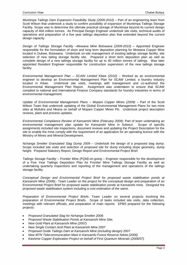
Curriculum Vitae Chalwe Bulaya
Page 3
Muntimpa Tailings Dam Expansion Feasibility Study (2009-2010) – Part of an engineering team from Scott Wilson that undertook a study to confirm possibility of expansion of Muntimpa Tailings Storage Facility. Scope was to determine the ultimate practical storage of Muntimpa beyond its current design capacity of 404 million tonnes. As Principal Design Engineer undertook site visits, technical audits of operations and preparation of a five year tailings deposition plan that extended beyond the current design capacity.
Design of Tailings Storage Facility –Mowana Mine Botswana (2009-2010) – Appointed Engineer responsible for the formulation of short and long term deposition planning for Mowana Copper Mine located in Dukwe, Botswana. Undertook on-site management of existing tailings storage facility, site selection of new tailing storage facility site. Prepared a short term deposition plan as well as complete design of a new tailings storage facility for up to 40 million tonnes of tailings. Was later appointed Resident Engineer responsible for construction supervision of the new tailings storage facility.
Environmental Management Plan – SCAW Limited Kitwe (2010) – Worked as an environmental engineer to develop an Environmental Management Plan for SCAW Limited, a foundry industry located in Kitwe. Undertook site visits, meetings with management and co-authored the Environmental Management Plan Report. Assignment was undertaken to ensure that SCAW complied to national and International Finance Company standards for foundry industries in terms of environmental management.
Update of Environmental Management Plans – Mopani Copper Mines (2009) – Part of the Scott Wilson Team that undertook updating of the Global Environmental Management Plans for two mine sites at Mufulira and Nkana on behalf of Mopani Copper Mines Plc. Undertook project description reviews, plant and process updates.
Environmental Compliance Review of Kansanshi Mine (February 2009): Part of team undertaking an environmental management plan update for Kansanshi Mine in Solwezi. Scope of specific assignments included site inspections, document reviews and updating the Project Description for the site to enable the mine comply with the requirement of an application for an operating licence with the Ministry of Mines and Mineral Development.
Nchanga Smelter Granulated Slag Dump 2009 – Undertook the design of a proposed slag dump. Scope included site visits and selection of proposed site for dump including slope geometry, dump height. Prepared Statutory Report, Design Report and Environmental Project Brief.
Tailings Storage Facility – Frontier Mine (FQM)-on-going – Engineer responsible for the development of a Five Year Tailings Deposition Plan for Frontier Mine Tailings Storage Facility as well as undertaking quarterly inspections and reporting of the management and operations of the tailings storage facility.
Conceptual Design and Environmental Project Brief for proposed waste stabilisation ponds at Kansanshi Mine (2008):- Team Leader on the project for the conceptual design and preparation of an Environmental Project Brief for proposed waste stabilisation ponds at Kansanshi mine. Designed the proposed waste stabilisation system including a cost estimation of the same.
Preparation of Environmental Project Briefs: Team Leader on several projects involving the preparation of Environmental Project Briefs. Scope of tasks included site visits, data collection, meetings with relevant officials, and preparation of main reports: EPBS prepared for the following projects:
• Proposed Granulated Slag for Nchanga Smelter 2008; • Proposed Waste Stabilisation Ponds at Kansanshi Mine Site; • New Gold Plant at Kansanshi Mine (2007) • New Single Contact Acid Plant at Kansanshi Mine 2007 • Proposed Oxide Tailings Dam at Kansanshi Mine (including design) 2007 • New MTN Telecommunication Mast in Kansamfu Forest Reserve Ndola (2006) • Kashime Copper Exploration Project on behalf of First Quantum Minerals (2006/07)
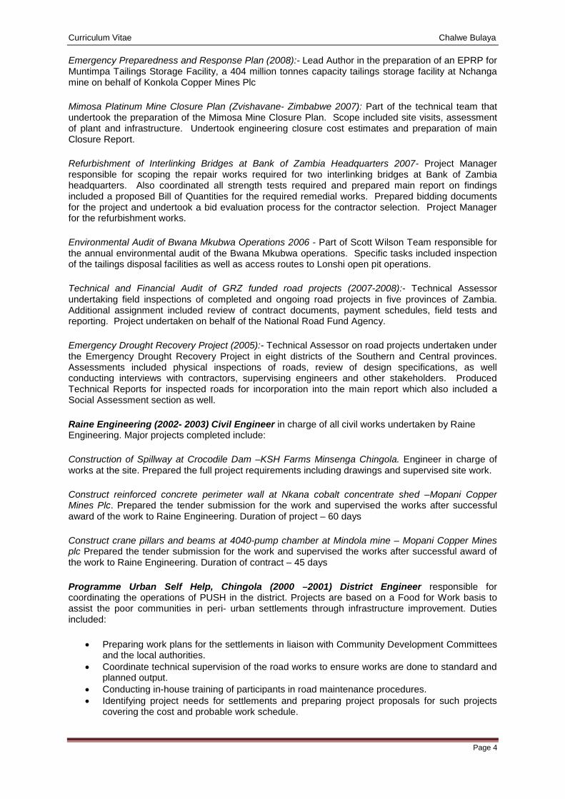
Curriculum Vitae Chalwe Bulaya
Page 4
Emergency Preparedness and Response Plan (2008):- Lead Author in the preparation of an EPRP for Muntimpa Tailings Storage Facility, a 404 million tonnes capacity tailings storage facility at Nchanga mine on behalf of Konkola Copper Mines Plc
Mimosa Platinum Mine Closure Plan (Zvishavane- Zimbabwe 2007): Part of the technical team that undertook the preparation of the Mimosa Mine Closure Plan. Scope included site visits, assessment of plant and infrastructure. Undertook engineering closure cost estimates and preparation of main Closure Report.
Refurbishment of Interlinking Bridges at Bank of Zambia Headquarters 2007- Project Manager responsible for scoping the repair works required for two interlinking bridges at Bank of Zambia headquarters. Also coordinated all strength tests required and prepared main report on findings included a proposed Bill of Quantities for the required remedial works. Prepared bidding documents for the project and undertook a bid evaluation process for the contractor selection. Project Manager for the refurbishment works.
Environmental Audit of Bwana Mkubwa Operations 2006 - Part of Scott Wilson Team responsible for the annual environmental audit of the Bwana Mkubwa operations. Specific tasks included inspection of the tailings disposal facilities as well as access routes to Lonshi open pit operations.
Technical and Financial Audit of GRZ funded road projects (2007-2008):- Technical Assessor undertaking field inspections of completed and ongoing road projects in five provinces of Zambia. Additional assignment included review of contract documents, payment schedules, field tests and reporting. Project undertaken on behalf of the National Road Fund Agency.
Emergency Drought Recovery Project (2005):- Technical Assessor on road projects undertaken under the Emergency Drought Recovery Project in eight districts of the Southern and Central provinces. Assessments included physical inspections of roads, review of design specifications, as well conducting interviews with contractors, supervising engineers and other stakeholders. Produced Technical Reports for inspected roads for incorporation into the main report which also included a Social Assessment section as well.
Raine Engineering (2002- 2003) Civil Engineer in charge of all civil works undertaken by Raine Engineering. Major projects completed include:
Construction of Spillway at Crocodile Dam –KSH Farms Minsenga Chingola. Engineer in charge of works at the site. Prepared the full project requirements including drawings and supervised site work.
Construct reinforced concrete perimeter wall at Nkana cobalt concentrate shed –Mopani Copper Mines Plc. Prepared the tender submission for the work and supervised the works after successful award of the work to Raine Engineering. Duration of project – 60 days
Construct crane pillars and beams at 4040-pump chamber at Mindola mine – Mopani Copper Mines plc Prepared the tender submission for the work and supervised the works after successful award of the work to Raine Engineering. Duration of contract – 45 days
Programme Urban Self Help, Chingola (2000 –2001) District Engineer responsible for coordinating the operations of PUSH in the district. Projects are based on a Food for Work basis to assist the poor communities in peri- urban settlements through infrastructure improvement. Duties included:
• Preparing work plans for the settlements in liaison with Community Development Committees and the local authorities.
• Coordinate technical supervision of the road works to ensure works are done to standard and planned output.
• Conducting in-house training of participants in road maintenance procedures. • Identifying project needs for settlements and preparing project proposals for such projects
covering the cost and probable work schedule.
Curriculum Vitae Chalwe Bulaya
Page 5
• Coordinated HIPC funded projects under PUSH i.e. Construct new skills centre, improved water wells and pit latrines. Conduct HIV /AIDS awareness programmes among the PUSH participants.
• Siting and construction of improved pit latrines and water wells. • Produce monthly and quarterly activity reports on technical, community and financial activities
of district to regional and national office.
Dana Services Limited (1999-2000) Projects Manager;
Construct Office Complex for Dana. Coordinated the construction works, which included an office block, perimeter wall, electric gate and carport driveway with paving bricks.
Construct Sludge Tank –National Assembly motel 1999 Prepared tender submission and supervised works
Refurbish Zambia Sugar Offices Lusaka. Prepared full tender documentation and upon award of contract, supervised the refurbishment works as Project Manager handling all procurement, labour recruitment and construction programming.
Property Maintenance of Zambia Sugar Offices and Residential properties. Carrying out daily maintenance works on Zambia Sugar offices and residential properties in Lusaka. Works included refurbishment and alterations to Malambo road offices, sewerage works, building maintenance works such as roof repairs, electrical repairs and civils for residential units.
New sewer line for ZESCO offices Kabwe- Laying new 400m long sewer line for ZESCO area offices in Kabwe.
Designing septic tanks, soak aways and sewer systems.
Experience Beyond Ten Years
ZCCM Mufulira Division (1994 –1999) – Senior Assistant Engineer, Sectional Engineer – Civil
Assess the sewage disposal/treatment process to check on the treatment capacity of the sewer ponds and recommend new operational and maintenance plans in line with the Environmental Impact Assessment for Mufulira Division.
Part of project team tasked to study the provision of water, sewerage and public health facilities to the mine townships. Study covered cost analysis, current operational mode and recommend ways of delinking these operations from the core business of mining. This work culminated resulted into the formation of AHC- MMS after privatisation of the mines.
Construct new high cost wing at Malcolm Watson Hospital. Part of the team that designed, planned, and supervised the construction of a new high cost wing at Malcolm Watson Hospital.
Supervised construction works in the plant area carried out either in-house or contracted. All contract work was supervised to ensure standards and specifications are adhered to. Check all invoices against measured works.
Supervised civil repair works undertaken at the Smelter electric furnace complex after it caught fire. Work included new floor slabs, tapping floor, bund walls and office refurbishments.
Produced quality assurance procedures for civil and carpentry works under civil department. Procedures done to conform to the ISO 9002 accreditation of Mufulira Engineering Department.
Prepared operating, working cost and capital budgets for civil section. Conducted weekly cash flow analysis for civil section. Budget holder for civil section.
Curriculum Vitae Chalwe Bulaya
Page 6
• Extension of Mufulira Trust School Hall. Supervised the contractor in site and undertook the supervision of mini-piles.
• Supervised Wade Adams Piling and Foundation in the installation of 80 piles for the concentrator crane gantry foundations;
• Supervised Mil Construction during the construction of a slime plant for the Mufulira refinery. • Site Engineer for construction of a new weighbridge at Mufulira. • Construction of a new clinic in Murundu township including septic tanks and water reticulation. • Supervised the underpinning works for the Mufulira division general offices. Works was
undertaken by Wade Adams Piling and Foundations Limited.
Certification:
I, the undersigned, certify that to the best of my knowledge and belief, these data correctly describe me, my qualifications and my experience. I further commit myself to be available when the works commence.
_____________________________________________________ Date: 18 / 07 / 2013
(Signature of staff member or authorized representative firm) Day/Month/Year
Full name of staff member: Chalwe BULAYA
Full name of authorised representative: Patrick M Kampengele
Curriculum Vitae Mitulo Silengo, PhD 1. Proposed Position: Socio-Economist
2. Name of Firm: URS Scott Wilson
3. Name of Staff: Mitulo Silengo
4. Date of Birth: 10 May 1960 Nationality: Zambia
5. Education: Ph.D., Environmental Resources, University of Salford, 1992-1996
MA, Environmental Planning, University of Nottingham, 1985-1987 BA Ed. (Geography ) University of Zambia, 1979-1983
6. Membership of Professional Associations:
Fellow Leadership for Environment and Development - Southern Africa Member of the International Association for Impact Assessment, (IAIA) 1998 Member of the International Geographical Union (IGU) 1998 Member of the Network for Environment and Sustainable Development in Africa
7. Other Training:
8. Countries of Work Experience:
Zambia, Democratic Republic of Congo
10. Employment Record:
Date from - date Employer Position held
2009 - 2012 Disaster Management Training Centre, Mulungushi University Director
2007 - 2009 School of Build Environment, Mulungushi University, Kabwe Dean
2002 - 2007 Leadership for Environment and Development (LEAD), Lusaka
1998 - 2002 Departmental of Urban & Regional Studies, School of The Built Environment, The Copperbelt University, Kitwe.
Lecturer and Head
1987 - 1992 Department of Planning & Land Economy, School of Environmental Studies, The Copperbelt University Kitwe.
Lecturer and Head
1983 - 1984 Department of Town and Country Planning, Lusaka, Zambia Planning Assistant
12. Work Undertaken that Best Illustrates Capability to Handle the Tasks Assigned
Name of assignment or project: Muchinga Hydropower Project Social baseline study for ESIA 2011/2012 for ERM/AMC
Year: Zambia
Client: Lunsemfwa Hydro Power Company
Main project features: Environmental and Social Impact Study
Positions held: Social Impact Study Specialist
Activities performed: Collecting and compiling baseline Information
Name of assignment or project: Itezhi-tezhi Hydropower Project Social baseline study for ESAI 2012 for URS Scott Wilson 2012
Year: 2012
Location: Zambia
Client: Scott Wilson
Main project features: Environmental and Social Impact Study
Positions held: Social Impact Study Specialist
Activities performed: collecting and compiling baseline Information
Name of assignment or project: Kansanshi Copper Mines Social Baseline Study for ESIA for Copper Smelter for URS Scott Wilson 2011
Year: 2011
Location: Kansanshi, Solwezi
Client: Kansanshi Mining Plc
Main project features: Environmental and Social Impact Study
Positions held: Social Impact Assessment Specialist
Activities performed: Conducted baseline survey and compiled social impact report
Name of assignment or project: Konkola Copper Mines PLC OB 26 Extension Social Baseline study for ESIA and Resettlement Action plan 2011/2012
Year: 2012
Location: Zambia
Client: Konkola Copper Mines
Main project features: Environmental and Social Impact Study
Positions held: Social Impact Study Specialist
Activities performed: collecting and compiling baseline Information and preparing Resettlement Action Plan
Name of assignment or project: Kansanshi Copper Mines Social Baseline Study for ESIA for Copper Smelter for URS Scott Wilson 2011
Year: 2011
Location: Kansanshi, Solwezi
Client: Kansanshi Mining Plc
Main project features: Environmental and Social Impact Study
Positions held: Social Impact Assessment Specialist
Activities performed: Conducted baseline survey and compiled social impact report
Name of assignment or project: Mopani Copper Mines Updating Social Management Plans 2011 for URS Scott Wilson.
Year: 2011
Location: Kitwe
Client: Mopani Copper Mines plc
Main project features: Social impact Assessment
Positions held: Social Scientist
Activities performed: Updated Social Management Plans
Name of assignment or project GERANDO, Community Based Disaster Risk Reduction Workshop, Monze
Year 2012
Location Monze, Zambia
Client World Vision, Zambia
Main project features Capacity Building Workshop
Curriculum Vitae Mitulo Silengo, PhD Position held Facilitator
Main activities Facilitating and compilation of training workshop report
Name of assignment or project Project Evaluation of Community-Led Disaster Resilience Project
Year 2012
Location Kazungula, Namwala, Livingstone, Mongu, Zambia
Client Oxfam (Great Britain)
Main project features End of Project Evaluation
Position held Project Evaluation Team Leader
Main activities Evaluation and compilation of end of project report
Name of assignment or project Public Hearing meeting for NOSE K Open Pit Project, Wusakile, Kitwe
Year 2012
Location Kitwe, Zambia
Client ZEMA
Main project features Public Consultation
Position held Facilitator
Main activities Facilitating and compilation of public hearing meeting report
Name of assignment or project Public Hearing meeting for Neelkanth Limestone Project, Masaiti, Ndola
Year 2012
Location Ndola, Zambia
Client ZEMA
Main Project Features Public Consultation
Position held Facilitator
Main activities Facilitating and compilation of public hearing meeting report
Name of assignment or project: Copperbelt Environment Project Public
Year: 2007
Location: Zambia
Client: ZCCM-IH
Main project features: Public Disclosure
Positions held: Lead Consultant
Activities performed: Public Disclosure of Copperbelt Environment Project
Name of assignment or project: Anvil Mining Kinseverre Mining Project Scoping Study for Environmental Impact Assessment
Year: 2005
Location: DRC
Client: African Mining Consultants, Zambia
Main project features: Environmental and Social Impact Study
Positions held: Social Impact Study Consultant
Activities performed: Collecting baseline information and compiling social impact study
Name of assignment or project: Swan Mines SPRL Kalikundi Mining Project Social Impact Study and Resettlement Action Plan
Year: 2005
Location: DRC
Client: African Mining Consultants, Zambia
Main project features: Environmental and Social Impact Study
Positions held: Social Impact Study Consultant
Activities performed: Collecting baseline information and compiling social impact study
Name of assignment or project: Environmental and Social Audit Konkola Copper Mines PLC
Year: 2004
Location: Zambia
Client: African Mining Consultants, Zambia
Main project features: Social Audit of Social Management plans
Positions held: Consultant – Final Social Management Plan
Activities performed: Collecting baseline information and compiling social impact study
Name of assignment or project: Anvil Mining Project
Year: 2003
Location: DRC
Client: African Mining Consultants, Zambia
Main project features: Social Impact Assessment
Positions held: Social Impact Study Consultant
Activities performed: Collecting baseline information and compiling social impact study
Name of assignment or project: Lumwana Mining Project, North-Western Province, Zambia
Year: 2003
Location: Zambia
Client: African Mining Consultants, Zambia
Main project features: Social Impact Assessment of Lumwana Project
Positions held: Social Impact Study Consultant
Activities performed: Collecting baseline information and compiling social impact study
13. Publications & Papers Mitulo Silengo (1996) ‘Environmental Policy and Practice in Southern Africa: A Case Study of Zambia’ Environmental Policy & Practice, Volume 6, Number 1. 27-31 Mitulo Silengo, Nana Baryeh & Mike Pugh-Thomas, ‘Socio-Economic Factors and the Management of Natural Resources in the Developing Countries Context’. Paper presented at The Sixth International Symposium on Society and Resources Management: Social Behavior, Natural Resources and the Environment, The Pennsylvania State University May 18-23, 1996 Mitulo Silengo, Nana Baryeh & Mike Pugh-Thomas ‘Improving Environmental Assessment in Developing Countries: The Role of Education and Training’. Paper presented at the International Association for Impact Assessment IAIA’96 Conference Improving Environmental Assessment Effectiveness: Research, Practice, and Training Centro Escolar Turistico e Hoteleiro, Estoril, Portugal 20-23 June 1996. Mitulo Silengo, ‘Evolution of Environmental Impact Assessment in Zambia’. Paper presented at Reunion Des Professionnels En Etudes D’Impact Environnmentaux De L’Afrique Francophone Sub-Saharienne, Yaoundé, Cameroun 14-16 January, 1997 Mitulo Silengo, ‘Fostering Public Participation in EIA in Zambia: Lessons from Participatory Approaches’. Paper presented at the International Association of Impact Assessment Meeting IAIA’98. April 21-24, 1998, Christchurch, New Zealand.
Curriculum Vitae Mitulo Silengo, PhD 14. Certification I, the undersigned, certify that to the best of my knowledge and belief this CV correctly describes my qualifications and my experience. I understand that any wilful misstatement described herein may lead to disqualification or dismissal, if engaged. I will be available to undertake the assignment immediately the works commence. ______________________ Date: 14th July, 2013 Mitulo Silengo
Curriculum Vitae Zebediah Phiri
Page 1
Name of Firm: URS Scott Wilson | Zambia
Name of Staff: Zebediah Phiri
Position: Water Resources Specialist
Years with Firm: +3 Years
Date of Birth: 24 September, 1962
Nationality: Zambian
Membership in Professional Societies:
Fellow, Engineering Institution of Zambia
Registered Engineer, Engineers Registration Board Member, Institute of Directors of Zambia (IODZ)
Member, International Water Resources Association (IWRA)
Member, American Society of Civil Engineers(ASCE)
Member, International Water Association(IWA)
Member, Water and Sanitation Association of Zambia (WASAZA)
Key Qualifications Zebediah is a qualified civil and environmental, water supply and sanitation and water resources engineer with more than 25 years experience. He has vast experience in consultancy, teaching, research, training and project management. His core competencies are in the areas of water-related environmental assessments, water supply and sanitation; integrated water resources management in national and transboundary contexts; and environmental engineering and management. He has consulted on environmental matters and has managed major projects in the areas of national and transboundary water resources management; and integrated water resources management. He has also served as a governing board member of both the International Water Association and the International Water Resources Association in addition to board membership of a number of southern African regional water-related bodies
Education: 2010 MBA, Regent Business School, South Africa
2002 Certificate in National and International Water Resources Law
1995 PhD, Environmental Engineering, Kumamoto University, JAPAN
1992 Certificate, Japanese Language, Kyushu University, JAPAN
1988 MSc (Eng), Tropical Public Health (Environmental) Engineering, Leeds University, U.K
1986 B.Eng, Civil Engineering, University of Zambia, ZAMBIA
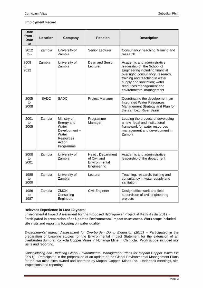
Curriculum Vitae Zebediah Phiri
Page 2
Employment Record
Date from - Date
to Location Company Position Description
2012 to -
Zambia University of Zambia
Senior Lecturer Consultancy, teaching, training and research
2008 to 2012
Zambia University of Zambia
Dean and Senior Lecturer
Academic and administrative leadership of the School of Engineering including financial oversight; consultancy, research, training and teaching in water supply and sanitation; water resources management and environmental management
2005 to
2008
SADC SADC Project Manager Coordinating the development an Integrated Water Resources Management Strategy and Plan for the Zambezi River Basin
2001 to
2005
Zambia Ministry of Energy and Water Development – Water Resources Action Programme
Programme Manager
Leading the process of developing a new legal and institutional framework for water resources management and development in Zambia
2000 to
2001
Zambia University of Zambia
Head , Department of Civil and Environmental Engineering
Academic and administrative leadership of the department
1988 to
2000
Zambia University of Zambia
Lecturer Teaching, research, training and consultancy in water supply and sanitation
1986 to
1987
Zambia ZMCK Consulting Engineers
Civil Engineer Design office work and field supervision of civil engineering projects
Relevant Experience in Last 10 years: Environmental Impact Assessment for the Proposed Hydropower Project at Itezhi-Tezhi (2012)– Participated in preparation of an Updated Environmental Impact Assessment. Work scope included site visits and reporting focusing on water quality.
Environmental Impact Assessment for Overburden Dump Extension (2011) – Participated in the preparation of baseline studies for the Environmental Impact Statement for the extension of an overburden dump at Konkola Copper Mines in Nchanga Mine in Chingola. Work scope included site visits and reporting.
Consolidating and Updating Global Environmental Management Plans for Mopani Copper Mines Plc (2011) – Participated in the preparation of an update of the Global Environmental Management Plans for the two mine sites owned and operated by Mopani Copper Mines Plc. Undertook meetings, site inspections and reporting
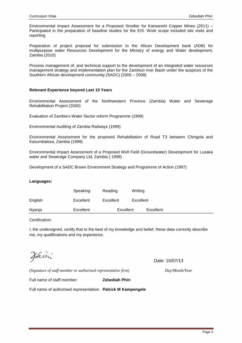
Curriculum Vitae Zebediah Phiri
Page 3
Environmental Impact Assessment for a Proposed Smelter for Kansanshi Copper Mines (2011) – Participated in the preparation of baseline studies for the EIS. Work scope included site visits and reporting
Preparation of project proposal for submission to the Afican Development bank (ADB) for multipurpose water Resources Development for the Ministry of energy and Water development, Zambia (2010)
Process management of, and technical support to the development of an integrated water resources management strategy and implementation plan for the Zambezi river Basin under the auspices of the Southern African development community (SADC) (2005 – 2008)
Relevant Experience beyond Last 10 Years
Environmental Assessment of the Northwestern Province (Zambia) Water and Sewerage Rehabilitation Project (2000)
Evaluation of Zambia’s Water Sector reform Programme (1999)
Environmental Auditing of Zambia Railways (1999)
Environmental Assessment for the proposed Rehabilitation of Road T3 between Chingola and Kasumbalesa, Zambia (1999)
Environmental Impact Assessment of a Proposed Well Field (Groundwater) Development for Lusaka water and Sewerage Company Ltd, Zambia ( 1998)
Development of a SADC Brown Environment Strategy and Programme of Action (1997)
Languages:
Speaking Reading Writing
English Excellent Excellent Excellent
Nyanja Excellent Excellent Excellent
Certification:
I, the undersigned, certify that to the best of my knowledge and belief, these data correctly describe me, my qualifications and my experience.
Date: 15/07/13
(Signature of staff member or authorized representative firm) Day/Month/Year
Full name of staff member: Zebediah Phiri
Full name of authorised representative: Patrick M Kampengele
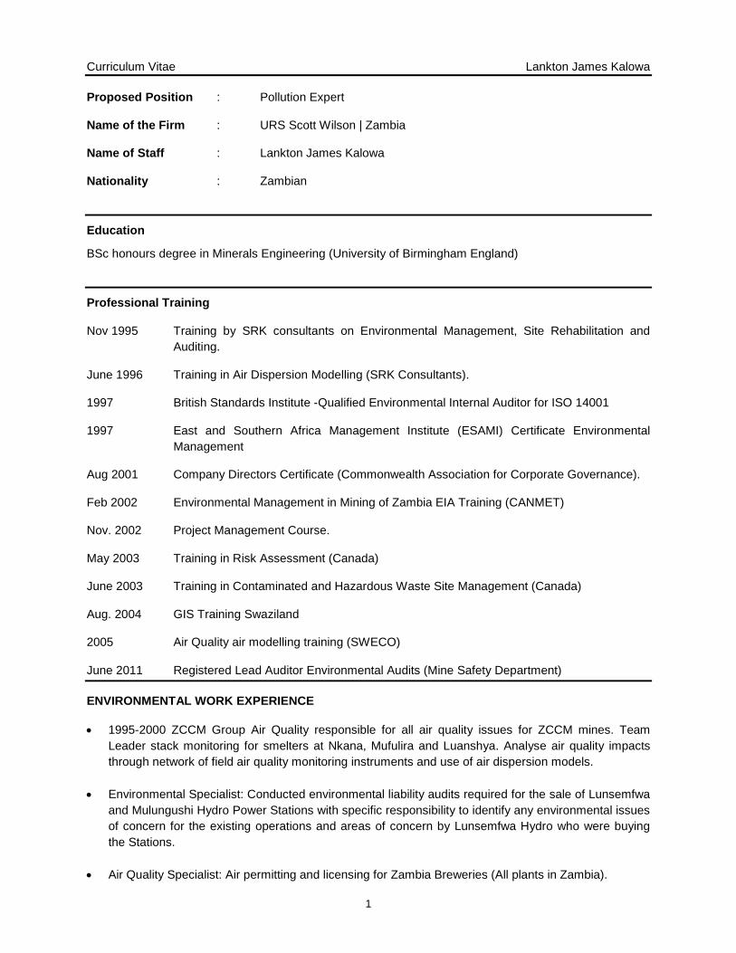
Curriculum Vitae Lankton James Kalowa
1
Proposed Position : Pollution Expert
Name of the Firm : URS Scott Wilson | Zambia
Name of Staff : Lankton James Kalowa
Nationality : Zambian
Education
BSc honours degree in Minerals Engineering (University of Birmingham England)
Professional Training
Nov 1995 Training by SRK consultants on Environmental Management, Site Rehabilitation and Auditing.
June 1996 Training in Air Dispersion Modelling (SRK Consultants).
1997 British Standards Institute -Qualified Environmental Internal Auditor for ISO 14001
1997 East and Southern Africa Management Institute (ESAMI) Certificate Environmental Management
Aug 2001 Company Directors Certificate (Commonwealth Association for Corporate Governance).
Feb 2002 Environmental Management in Mining of Zambia EIA Training (CANMET)
Nov. 2002 Project Management Course.
May 2003 Training in Risk Assessment (Canada)
June 2003 Training in Contaminated and Hazardous Waste Site Management (Canada)
Aug. 2004 GIS Training Swaziland
2005 Air Quality air modelling training (SWECO)
June 2011 Registered Lead Auditor Environmental Audits (Mine Safety Department)
ENVIRONMENTAL WORK EXPERIENCE
• 1995-2000 ZCCM Group Air Quality responsible for all air quality issues for ZCCM mines. Team Leader stack monitoring for smelters at Nkana, Mufulira and Luanshya. Analyse air quality impacts through network of field air quality monitoring instruments and use of air dispersion models.
• Environmental Specialist: Conducted environmental liability audits required for the sale of Lunsemfwa and Mulungushi Hydro Power Stations with specific responsibility to identify any environmental issues of concern for the existing operations and areas of concern by Lunsemfwa Hydro who were buying the Stations.
• Air Quality Specialist: Air permitting and licensing for Zambia Breweries (All plants in Zambia).
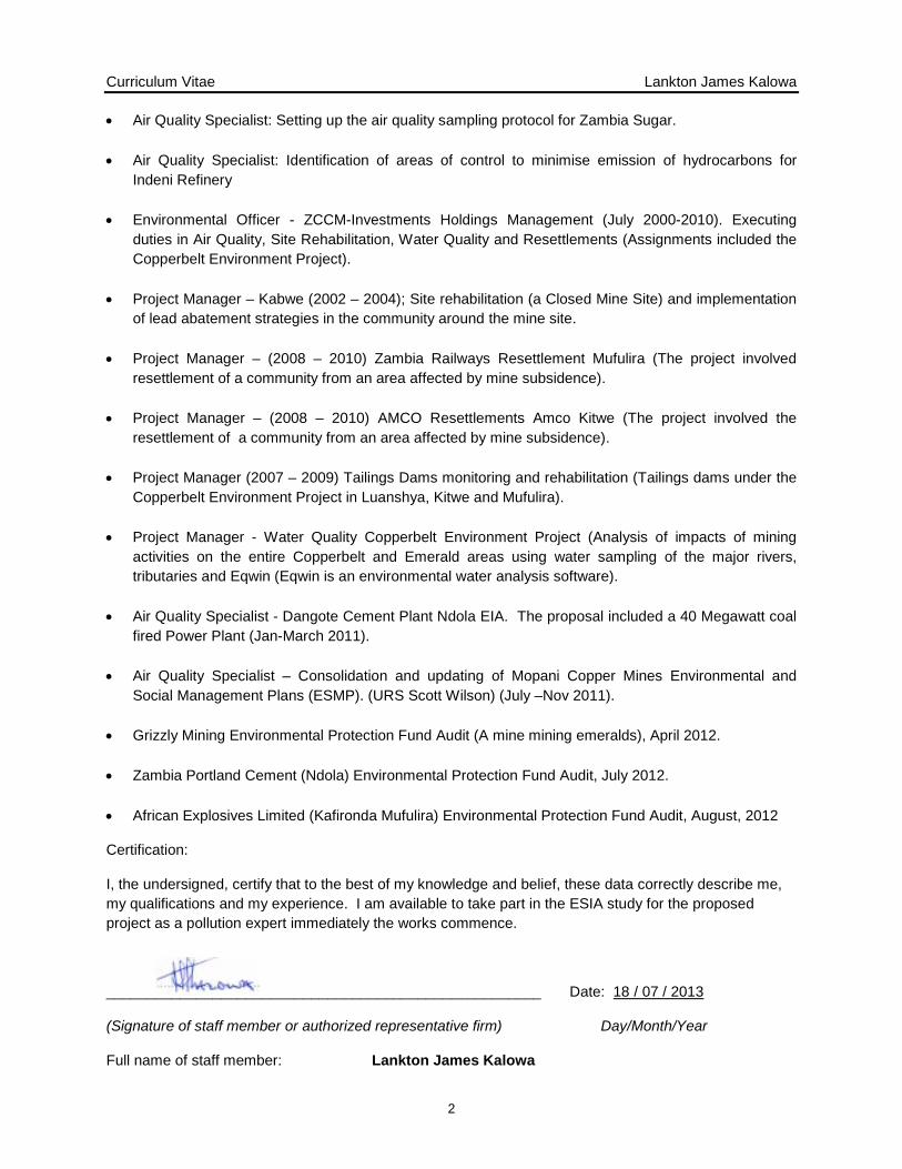
Curriculum Vitae Lankton James Kalowa
2
• Air Quality Specialist: Setting up the air quality sampling protocol for Zambia Sugar.
• Air Quality Specialist: Identification of areas of control to minimise emission of hydrocarbons for Indeni Refinery
• Environmental Officer - ZCCM-Investments Holdings Management (July 2000-2010). Executing duties in Air Quality, Site Rehabilitation, Water Quality and Resettlements (Assignments included the Copperbelt Environment Project).
• Project Manager – Kabwe (2002 – 2004); Site rehabilitation (a Closed Mine Site) and implementation
of lead abatement strategies in the community around the mine site.
• Project Manager – (2008 – 2010) Zambia Railways Resettlement Mufulira (The project involved resettlement of a community from an area affected by mine subsidence).
• Project Manager – (2008 – 2010) AMCO Resettlements Amco Kitwe (The project involved the resettlement of a community from an area affected by mine subsidence).
• Project Manager (2007 – 2009) Tailings Dams monitoring and rehabilitation (Tailings dams under the
Copperbelt Environment Project in Luanshya, Kitwe and Mufulira).
• Project Manager - Water Quality Copperbelt Environment Project (Analysis of impacts of mining activities on the entire Copperbelt and Emerald areas using water sampling of the major rivers, tributaries and Eqwin (Eqwin is an environmental water analysis software).
• Air Quality Specialist - Dangote Cement Plant Ndola EIA. The proposal included a 40 Megawatt coal
fired Power Plant (Jan-March 2011).
• Air Quality Specialist – Consolidation and updating of Mopani Copper Mines Environmental and Social Management Plans (ESMP). (URS Scott Wilson) (July –Nov 2011).
• Grizzly Mining Environmental Protection Fund Audit (A mine mining emeralds), April 2012.
• Zambia Portland Cement (Ndola) Environmental Protection Fund Audit, July 2012.
• African Explosives Limited (Kafironda Mufulira) Environmental Protection Fund Audit, August, 2012
Certification:
I, the undersigned, certify that to the best of my knowledge and belief, these data correctly describe me, my qualifications and my experience. I am available to take part in the ESIA study for the proposed project as a pollution expert immediately the works commence.
_____________________________________________________ Date: 18 / 07 / 2013
(Signature of staff member or authorized representative firm) Day/Month/Year
Full name of staff member: Lankton James Kalowa
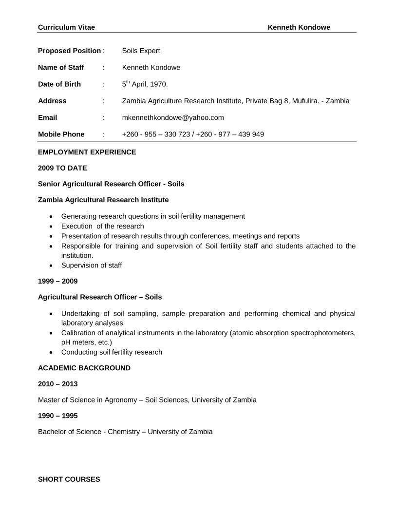
Curriculum Vitae Kenneth Kondowe
Proposed Position : Soils Expert
Name of Staff : Kenneth Kondowe
Date of Birth : 5th April, 1970.
Address : Zambia Agriculture Research Institute, Private Bag 8, Mufulira. - Zambia
Email : [email protected]
Mobile Phone : +260 - 955 – 330 723 / +260 - 977 – 439 949
EMPLOYMENT EXPERIENCE
2009 TO DATE
Senior Agricultural Research Officer - Soils
Zambia Agricultural Research Institute
• Generating research questions in soil fertility management • Execution of the research • Presentation of research results through conferences, meetings and reports • Responsible for training and supervision of Soil fertility staff and students attached to the
institution. • Supervision of staff
1999 – 2009
Agricultural Research Officer – Soils
• Undertaking of soil sampling, sample preparation and performing chemical and physical laboratory analyses
• Calibration of analytical instruments in the laboratory (atomic absorption spectrophotometers, pH meters, etc.)
• Conducting soil fertility research
ACADEMIC BACKGROUND
2010 – 2013
Master of Science in Agronomy – Soil Sciences, University of Zambia
1990 – 1995
Bachelor of Science - Chemistry – University of Zambia
SHORT COURSES
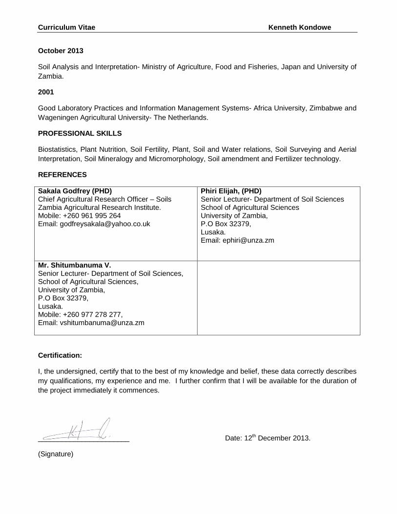
Curriculum Vitae Kenneth Kondowe
October 2013
Soil Analysis and Interpretation- Ministry of Agriculture, Food and Fisheries, Japan and University of Zambia.
2001
Good Laboratory Practices and Information Management Systems- Africa University, Zimbabwe and Wageningen Agricultural University- The Netherlands.
PROFESSIONAL SKILLS
Biostatistics, Plant Nutrition, Soil Fertility, Plant, Soil and Water relations, Soil Surveying and Aerial Interpretation, Soil Mineralogy and Micromorphology, Soil amendment and Fertilizer technology.
REFERENCES
Sakala Godfrey (PHD) Chief Agricultural Research Officer – Soils Zambia Agricultural Research Institute. Mobile: +260 961 995 264 Email: [email protected]
Phiri Elijah, (PHD) Senior Lecturer- Department of Soil Sciences School of Agricultural Sciences University of Zambia, P.O Box 32379, Lusaka. Email: [email protected]
Mr. Shitumbanuma V. Senior Lecturer- Department of Soil Sciences, School of Agricultural Sciences, University of Zambia, P.O Box 32379, Lusaka. Mobile: +260 977 278 277, Email: [email protected]
Certification:
I, the undersigned, certify that to the best of my knowledge and belief, these data correctly describes my qualifications, my experience and me. I further confirm that I will be available for the duration of the project immediately it commences.
_______________________ Date: 12th December 2013.
(Signature)
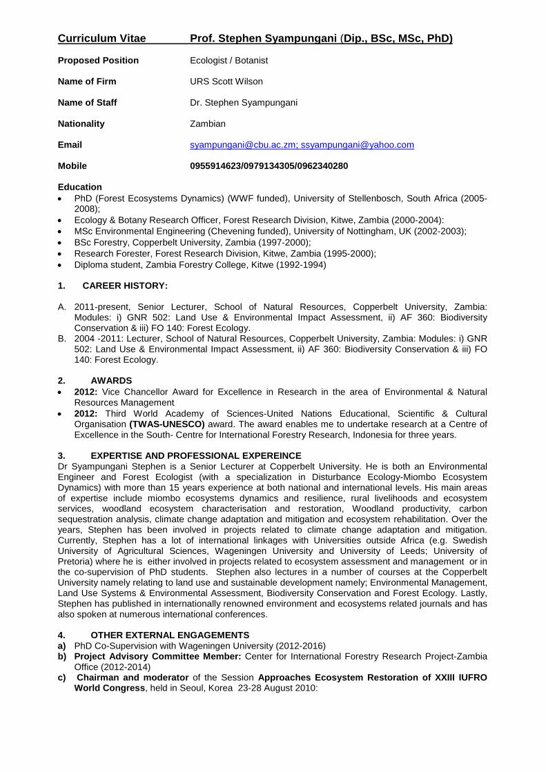
Curriculum Vitae Prof. Stephen Syampungani (Dip., BSc, MSc, PhD) Proposed Position Ecologist / Botanist Name of Firm URS Scott Wilson Name of Staff Dr. Stephen Syampungani Nationality Zambian Email [email protected]; [email protected] Mobile 0955914623/0979134305/0962340280 Education • PhD (Forest Ecosystems Dynamics) (WWF funded), University of Stellenbosch, South Africa (2005-
2008); • Ecology & Botany Research Officer, Forest Research Division, Kitwe, Zambia (2000-2004): • MSc Environmental Engineering (Chevening funded), University of Nottingham, UK (2002-2003); • BSc Forestry, Copperbelt University, Zambia (1997-2000); • Research Forester, Forest Research Division, Kitwe, Zambia (1995-2000); • Diploma student, Zambia Forestry College, Kitwe (1992-1994) 1. CAREER HISTORY:
A. 2011-present, Senior Lecturer, School of Natural Resources, Copperbelt University, Zambia:
Modules: i) GNR 502: Land Use & Environmental Impact Assessment, ii) AF 360: Biodiversity Conservation & iii) FO 140: Forest Ecology.
B. 2004 -2011: Lecturer, School of Natural Resources, Copperbelt University, Zambia: Modules: i) GNR 502: Land Use & Environmental Impact Assessment, ii) AF 360: Biodiversity Conservation & iii) FO 140: Forest Ecology.
2. AWARDS • 2012: Vice Chancellor Award for Excellence in Research in the area of Environmental & Natural
Resources Management • 2012: Third World Academy of Sciences-United Nations Educational, Scientific & Cultural
Organisation (TWAS-UNESCO) award. The award enables me to undertake research at a Centre of Excellence in the South- Centre for International Forestry Research, Indonesia for three years.
3. EXPERTISE AND PROFESSIONAL EXPEREINCE Dr Syampungani Stephen is a Senior Lecturer at Copperbelt University. He is both an Environmental Engineer and Forest Ecologist (with a specialization in Disturbance Ecology-Miombo Ecosystem Dynamics) with more than 15 years experience at both national and international levels. His main areas of expertise include miombo ecosystems dynamics and resilience, rural livelihoods and ecosystem services, woodland ecosystem characterisation and restoration, Woodland productivity, carbon sequestration analysis, climate change adaptation and mitigation and ecosystem rehabilitation. Over the years, Stephen has been involved in projects related to climate change adaptation and mitigation. Currently, Stephen has a lot of international linkages with Universities outside Africa (e.g. Swedish University of Agricultural Sciences, Wageningen University and University of Leeds; University of Pretoria) where he is either involved in projects related to ecosystem assessment and management or in the co-supervision of PhD students. Stephen also lectures in a number of courses at the Copperbelt University namely relating to land use and sustainable development namely; Environmental Management, Land Use Systems & Environmental Assessment, Biodiversity Conservation and Forest Ecology. Lastly, Stephen has published in internationally renowned environment and ecosystems related journals and has also spoken at numerous international conferences. 4. OTHER EXTERNAL ENGAGEMENTS a) PhD Co-Supervision with Wageningen University (2012-2016) b) Project Advisory Committee Member: Center for International Forestry Research Project-Zambia
Office (2012-2014) c) Chairman and moderator of the Session Approaches Ecosystem Restoration of XXIII IUFRO
World Congress, held in Seoul, Korea 23-28 August 2010:
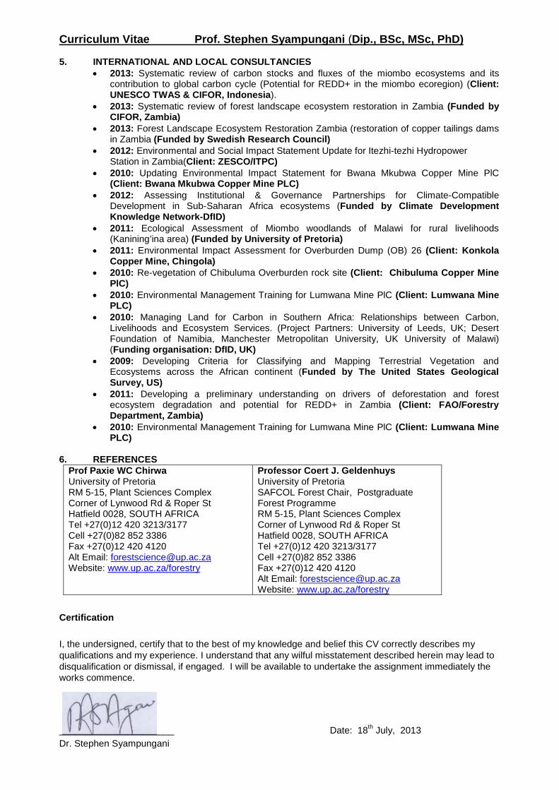
Curriculum Vitae Prof. Stephen Syampungani (Dip., BSc, MSc, PhD) 5. INTERNATIONAL AND LOCAL CONSULTANCIES
• 2013: Systematic review of carbon stocks and fluxes of the miombo ecosystems and its contribution to global carbon cycle (Potential for REDD+ in the miombo ecoregion) (Client: UNESCO TWAS & CIFOR, Indonesia).
• 2013: Systematic review of forest landscape ecosystem restoration in Zambia (Funded by CIFOR, Zambia)
• 2013: Forest Landscape Ecosystem Restoration Zambia (restoration of copper tailings dams in Zambia (Funded by Swedish Research Council)
• 2012: Environmental and Social Impact Statement Update for Itezhi-tezhi Hydropower Station in Zambia(Client: ZESCO/ITPC)
• 2010: Updating Environmental Impact Statement for Bwana Mkubwa Copper Mine PlC (Client: Bwana Mkubwa Copper Mine PLC)
• 2012: Assessing Institutional & Governance Partnerships for Climate-Compatible Development in Sub-Saharan Africa ecosystems (Funded by Climate Development Knowledge Network-DfID)
• 2011: Ecological Assessment of Miombo woodlands of Malawi for rural livelihoods (Kanining’ina area) (Funded by University of Pretoria)
• 2011: Environmental Impact Assessment for Overburden Dump (OB) 26 (Client: Konkola Copper Mine, Chingola)
• 2010: Re-vegetation of Chibuluma Overburden rock site (Client: Chibuluma Copper Mine PlC)
• 2010: Environmental Management Training for Lumwana Mine PlC (Client: Lumwana Mine PLC)
• 2010: Managing Land for Carbon in Southern Africa: Relationships between Carbon, Livelihoods and Ecosystem Services. (Project Partners: University of Leeds, UK; Desert Foundation of Namibia, Manchester Metropolitan University, UK University of Malawi) (Funding organisation: DfID, UK)
• 2009: Developing Criteria for Classifying and Mapping Terrestrial Vegetation and Ecosystems across the African continent (Funded by The United States Geological Survey, US)
• 2011: Developing a preliminary understanding on drivers of deforestation and forest ecosystem degradation and potential for REDD+ in Zambia (Client: FAO/Forestry Department, Zambia)
• 2010: Environmental Management Training for Lumwana Mine PlC (Client: Lumwana Mine PLC)
6. REFERENCES
Prof Paxie WC Chirwa University of Pretoria RM 5-15, Plant Sciences Complex Corner of Lynwood Rd & Roper St Hatfield 0028, SOUTH AFRICA Tel +27(0)12 420 3213/3177 Cell +27(0)82 852 3386 Fax +27(0)12 420 4120 Alt Email: [email protected] Website: www.up.ac.za/forestry
Professor Coert J. Geldenhuys University of Pretoria SAFCOL Forest Chair, Postgraduate Forest Programme RM 5-15, Plant Sciences Complex Corner of Lynwood Rd & Roper St Hatfield 0028, SOUTH AFRICA Tel +27(0)12 420 3213/3177 Cell +27(0)82 852 3386 Fax +27(0)12 420 4120 Alt Email: [email protected] Website: www.up.ac.za/forestry
Certification I, the undersigned, certify that to the best of my knowledge and belief this CV correctly describes my qualifications and my experience. I understand that any wilful misstatement described herein may lead to disqualification or dismissal, if engaged. I will be available to undertake the assignment immediately the works commence. ______________________ Date: 18th July, 2013 Dr. Stephen Syampungani
1 Investments House, Plot 1591 Kantanta Street, P.O. Box 20172 Kitwe, Zambia. Phone: +260 212 245822,245819. Email: [email protected]
Company Registration No. 107730
Misenge Environmental and Technical Services Ltd A Subsidiary of ZCCM Investments Holdings Plc
Company Profile
2 Investments House, Plot 1591 Kantanta Street, P.O. Box 20172 Kitwe, Zambia. Phone: +260 212 245822,245819. Email: [email protected]
Company Registration No. 107730
COMPANY BACKGROUND
Misenge Environmental and Technical Services Ltd (METS) is the former Environment
Department of the ZCCM Investments Holdings Plc (ZCCM-IH).
The department traces its existence back to 1994, when Zambia Consolidated Copper Mines
(ZCCM) Ltd established Group Environmental Services (GES), with designated personnel at
the Operations Centre of ZCCM Ltd and at each of the operating divisions. In 1997, in order
for ZCCM Ltd to comply with the Mines and Minerals Act of 1995, GES spearheaded the
development of the ZCCM Ltd Environmental Impact Statement for Chambishi, Chibuluma,
Kansanshi, Konkola, Luanshya, Mufulira, Nampundwe, Nkana, Nchanga mines and Ndola
Lime Company Ltd.
Following the privatization of the assets of ZCCM Ltd and the transformation of the
Company into ZCCM-IH, the GES was transformed into an Environment Department with
the responsibility of addressing the Government of the Republic of Zambia (GRZ) and ZCCM
Ltd statutory and contractual environmental historical obligations that were not passed on
to the new mine investors.
In 2003, as part of the privatization process, the World Bank, Nordic Development Fund and
GRZ funded Copperbelt Environment Project (CEP). Through the initiative of Government,
ZCCM-IH established ZCCM-IH Environmental Coordination Unit (ZECU) with the
responsibility of implementing the Copperbelt Environment Project. The CEP came to an end
on 31st March 2011 and ZECU reverted to an Environment Department within ZCCM-IH.
Subsequently ZCCM-IH decided to transform the Environment Department into a wholly
owned Subsidiary company, namely Misenge Environmental and Technical Services Limited.
3 Investments House, Plot 1591 Kantanta Street, P.O. Box 20172 Kitwe, Zambia. Phone: +260 212 245822,245819. Email: [email protected]
Company Registration No. 107730
BUSINESS LOCATION
Misenge Environmental and Technical Services Ltd offices are located at Investments House
in Kitwe on the Copperbelt and a Satellite office in Kabwe in Central Province.
VISION
To be a leader in the provision of environmental consultancy and technical services in
Zambia and within the SADC region.
OBJECTIVES
The main business objectives are:
To extinguish all the legacy environmental obligations of the parent company,
ZCCM-IH
To extend provision of environmental consultancy services to other clients within
Zambia and abroad.
To provide quality analytical services to clients within Zambia and abroad.
To promote excellence in radiation protection for our clients and provide practical,
cost effective radiation protection solutions for our clients
To grow the business from inception to a fully-fledged environmental and analytical
services provider within the shortest time possible
OUR VALUES
Integrity
Professionalism
Teamwork
Accountability
Innovation
Efficiency
4 Investments House, Plot 1591 Kantanta Street, P.O. Box 20172 Kitwe, Zambia. Phone: +260 212 245822,245819. Email: [email protected]
Company Registration No. 107730
QUALITY POLICY
It is the policy and primarily business objective of METS to provide services to the highest quality standards and in full compliance with our customer specified requirements.
SAFETY HEALTH AND ENVIRONMENT POLICY
METS acknowledges the importance of having a safe and healthy environment in an organization. METS recognize the fact that safety, health and environmentally sound programs aim to protect not only the employees, but also the public from work place hazards. It is therefore Company policy to comply with all applicable safety, health and environmental laws and regulations. The company is further committed to minimizing the impact of its business on the environment with methods that are socially responsible, scientifically based and economically sound. The Company encourages conservation, recycling and energy use programs that promote clean air and water and reduce land degradation.
COMPANY SERVICES
METS is a multifaceted full service company with a traceable excellent knowledge and
record of environmental management in the mining and mineral processing industry
Zambia. METS professionals have the technical expertise, strength in project management,
and a focus on delivery of high quality product to the client. METS services include the
following:
1. Environmental Services
Environmental Impact Assessment (EIA)
Environmental Project Brief (EPB)
Environmental Due Diligence (EDD)
Project Management
Hazardous Waste assessment, packaging, transportation and disposal
Demolition and Site cleanup of defunct facilities
Revegetation of tailings dams
Remediation of contaminated sites
Environmental Audits
5 Investments House, Plot 1591 Kantanta Street, P.O. Box 20172 Kitwe, Zambia. Phone: +260 212 245822,245819. Email: [email protected]
Company Registration No. 107730
2. Radiation Safety
METS is a registered licence holder under the Ionizing Radiation Protection Act 2005. As
regulations and radiation safety requirements change, METS will provide invaluable
assistance to our customers to ensure that their radiation safety programs are safe and
in compliance with existing regulations and best industry standards.
Services offered include:-
Radiation Safety Program Design (e.g preparation of Radiation Management Plans)
Radiation Protection Programs Audits
Radiation Safety Procedures
Radiological Surveys
Annual X-Ray Machine Surveys To Verify No Leakage Norm (Naturally Occurring)
Radioactive Material Surveys
Licensing Facilitation
Sealed Source Leak And Shutter Testing
Radiation Shielding Evaluation
Radioactive Sealed Source Conditioning
Periodic Radiation Worker and General Public Dose Assessments
Radiation Safety Training
Radiation Safety Consultancy
METS operates on behalf of ZCCM-IH an Interim Radiation Waste Storage facility for
storage of spent sealed radiation sources and conditioned spent sealed radiation
sources.
3. Analytical Services
METS Analytical Laboratory at Kabwe satellite office offers expert services in lead in
blood surveillance, monitoring and analyses for persons exposed to lead. The Analytical
Laboratory also analyses water and soil samples.
METS owns Lead Care Analyzer machines. The LeadCare Analyzer is a rapid, on site test
for quantitative determination of lead levels in human blood samples. The Analyzer
allows the determination of blood lead concentrations within 3 minutes using 50µg/L
sample of capillary (finger tip) blood.
6 Investments House, Plot 1591 Kantanta Street, P.O. Box 20172 Kitwe, Zambia. Phone: +260 212 245822,245819. Email: [email protected]
Company Registration No. 107730
LeadCare Analyzer
METS owns and operates two Nitro XLt Analyzers. Nitro XLt Analyzers are handheld high
performance portable X-Ray Fluorescence (XRF) elemental analyzers. The Niton XRF
Analyzer can analyze for elements such as Managanese (Mn), Lead (Pb), Selenium (Se),
Arsenic (As), Mercury (Hg), Cadmium (Cd), Chromium (Cr), Zinc (Zn), Copper (Cu), Nickel (Ni),
Cobalt (Co), Palledium ( Pd), Iron (Fe), Silver (Ag), Lanthanum ( La), Barium (Ba), Tellurium
(Te), Tin (Sb), Molybdenum (Mo), Zirconium ( Zr) , Strontium (Sr), Rubidium (Rb) and Cesium
Nitro XLt Analyzers
7 Investments House, Plot 1591 Kantanta Street, P.O. Box 20172 Kitwe, Zambia. Phone: +260 212 245822,245819. Email: [email protected]
Company Registration No. 107730
4. Other Services
METS owns the Trimble S8 Total Station surveying equipment. The Trimble S8 represents
the ultimate in functionality for the most demanding of projects requiring, speed,
efficiency and accuracy surveying. It's designed to deliver unsurpassed performance and
productivity in:-
Land surveying
Performing boundary and cadastral surveying
Mapping
Specialized engineering applications, such as monitoring and tunneling
Stockpile scanning and volume report generation
Measuring and specialized engineering projects such as on construction sites,
monitoring, and building sites and in city planning (applications that require the
highest levels of accuracy available).
FUTURE PLANS
Accreditation to the following standards:
ISO 9001:2008
ISO 14001
OHSAS 18001
METS intends to develop the following capacity in the near future:
Environmental Services:
o Ambient air quality monitoring
o Air dispersion modeling
o Dust follow out monitoring
o Noise level assessment
o Geochemical assessment
o Acid Mine drainage assessments
o Environmental Management System
o Environmental performance monitoring
Analytical Services,
Expand the Analytical Lab in Kabwe to offer the following services:
Geological Analysis
Bacteriological analysis
Mobile Laboratory
Set up analytical lab in Kalulushi
8 Investments House, Plot 1591 Kantanta Street, P.O. Box 20172 Kitwe, Zambia. Phone: +260 212 245822,245819. Email: [email protected]
Company Registration No. 107730
Radiation Safety Services:
Personal radiation dosimetry services
Random gas sampling and assessments
NORM sample analysis
CONTACT DETAILS
Call on us to discuss your specific needs in Environmental, Analytical Services and
Radiation Safety.
Tel: +260 212 245822, 245819 Mob: +260 955 412048 Fax: Email: [email protected]
Konkola Copper Mines Plc
New Slag Dump Project
Final Terms of Reference March 2014
Appendix B Curriculum Vitae / Profile for the proposed ESIA Study
Team
Konkola Copper Mines Plc
New Slag Dump Project
Final Terms of Reference March 2014
Appendix C Project Categorisation Criteria and Screening Checklist
New Slag Dump Project
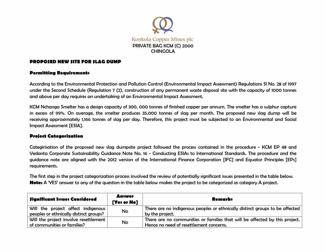
PRIVATE BAG KCM (C) 2000 CHINGOLA
PROPOSED NEW SITE FOR SLAG DUMP
Permitting Requirements
According to the Environmental Protection and Pollution Control (Environmental Impact Assessment) Regulations SI No. 28 of 1997 under the Second Schedule (Regulation 7 (2), construction of any permanent waste disposal site with the capacity of 1000 tonnes and above per day requires an undertaking of an Environmental Impact Assessment.
KCM Nchanga Smelter has a design capacity of 300, 000 tonnes of finished copper per annum. The smelter has a sulphur capture in excess of 99%. On average, the smelter produces 35,000 tonnes of slag per month. The proposed new slag dump will be receiving approximately 1,166 tonnes of slag per day. Therefore, this project must be subjected to an Environmental and Social Impact Assessment [ESIA].
Project Categorization
Categirisation of the proposed new slag dumpsite project followed the process contained in the procedure - KCM EP 48 and Vedanta Corporate Sustainability Guidance Note No. 16 - Conducting ESIAs to International Standards. The procedure and the guidance note are aligned with the 2012 version of the International Finance Corporation [IFC] and Equator Principles [EPs] requirements.
The first step in the project categorization process involved the review of potentially significant issues presented in the table below. Note: A ‘YES’ answer to any of the question in the table below makes the project to be categorized as category A project.
Significant Issues Considered Answer
[Yes or No] Remarks
Will the project affect indigenous peoples or ethnically distinct groups?
No There are no indigenous peoples or ethnically distinct groups to be affected by the project.
Will the project involve resettlement of communities or families?
No There are no communities or families that will be affected by this project. Hence no need of resettlement concerns.
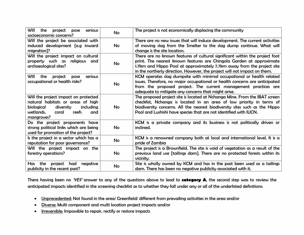
Will the project pose serious socioeconomic concerns?
No The project is not economically displacing the community
Will the project be associated with induced development [e.g inward migration]?
No There are no new issues that will induce development. The current activities of moving slag from the Smelter to the slag dump continue. What will change is the site location.
Will the project impact on cultural property such as religious and archaeological sites?
No
There are no known features of cultural significant within the project foot print. The nearest known features are Chingola Garden at approximate 1.7km and Hippo Pool at approximately 7.7km away from the project site in the northerly direction. However, the project will not impact on them.
Will the project pose serious occupational or health risks? No
KCM operates slag dumpsite with minimal occupational or health related issues. Therefore, no major occupational or health concerns are anticipated from the proposed project. The current management practices are adequate to mitigate any concerns that might arise.
Will the project impact on protected natural habitats or areas of high biological diversity including wetlands, coral reefs and mangroves?
No
The proposed project site is located at Nchanga Mine. From the IBAT screen checklist, Nchanga is located in an area of low priority in terms of biodiversity concerns. All the nearest biodiversity sites such as the Hippo Pool and Lushishi have species that are not identified with IUCN.
Do the project proponents have strong political links which are being used for promotion of the project?
No KCM is a private company and its business is not politically driven or inclined.
Is the project in a sector which has a reputation for poor governance? No
KCM is a renowned company both at local and international level. It is a pride of Zambia
Will the project impact on the forestry operations? No
The project is a Brownfield. The site is void of vegetation as a result of the previous land use [tailings dam]. There are no protected forests within its vicinity.
Has the project had negative publicity in the recent past?
No Site is wholly owned by KCM and has in the past been used as a tailings dam. There has been no negative publicity associated with it.
There having been no ‘YES’ answer to any of the questions above to lead to category A, the second step was to review the
anticipated impacts identified in the screening checklist as to whether they fall under any or all of the underlisted definitions:
• Unprecedented: Not found in the area/ Greenfield/ different from prevailing activities in the area and/or • Diverse: Multi component and multi location project impacts and/or
• Irreversible: Impossible to repair, rectify or restore impacts
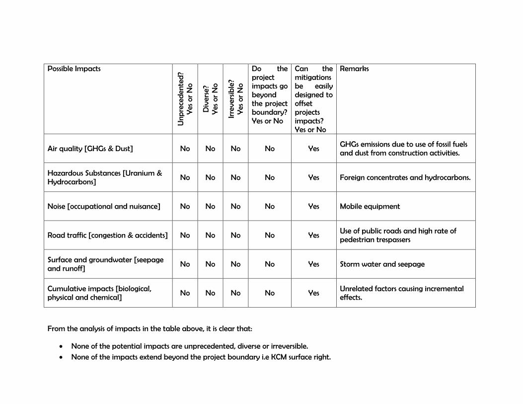
Possible Impacts
Unp
rece
den
ted
? Y
es o
r N
o
Div
erse
? Y
es o
r N
o
Irre
vers
ible
? Y
es o
r N
o
Do the project impacts go beyond the project boundary? Yes or No
Can the mitigations be easily designed to offset projects impacts? Yes or No
Remarks
Air quality [GHGs & Dust] No No No No Yes GHGs emissions due to use of fossil fuels and dust from construction activities.
Hazardous Substances [Uranium & Hydrocarbons]
No No No No Yes Foreign concentrates and hydrocarbons.
Noise [occupational and nuisance] No No No No Yes Mobile equipment
Road traffic [congestion & accidents] No No No No Yes Use of public roads and high rate of pedestrian trespassers
Surface and groundwater [seepage and runoff]
No No No No Yes Storm water and seepage
Cumulative impacts [biological, physical and chemical]
No No No No Yes Unrelated factors causing incremental effects.
From the analysis of impacts in the table above, it is clear that:
• None of the potential impacts are unprecedented, diverse or irreversible. • None of the impacts extend beyond the project boundary i.e KCM surface right.
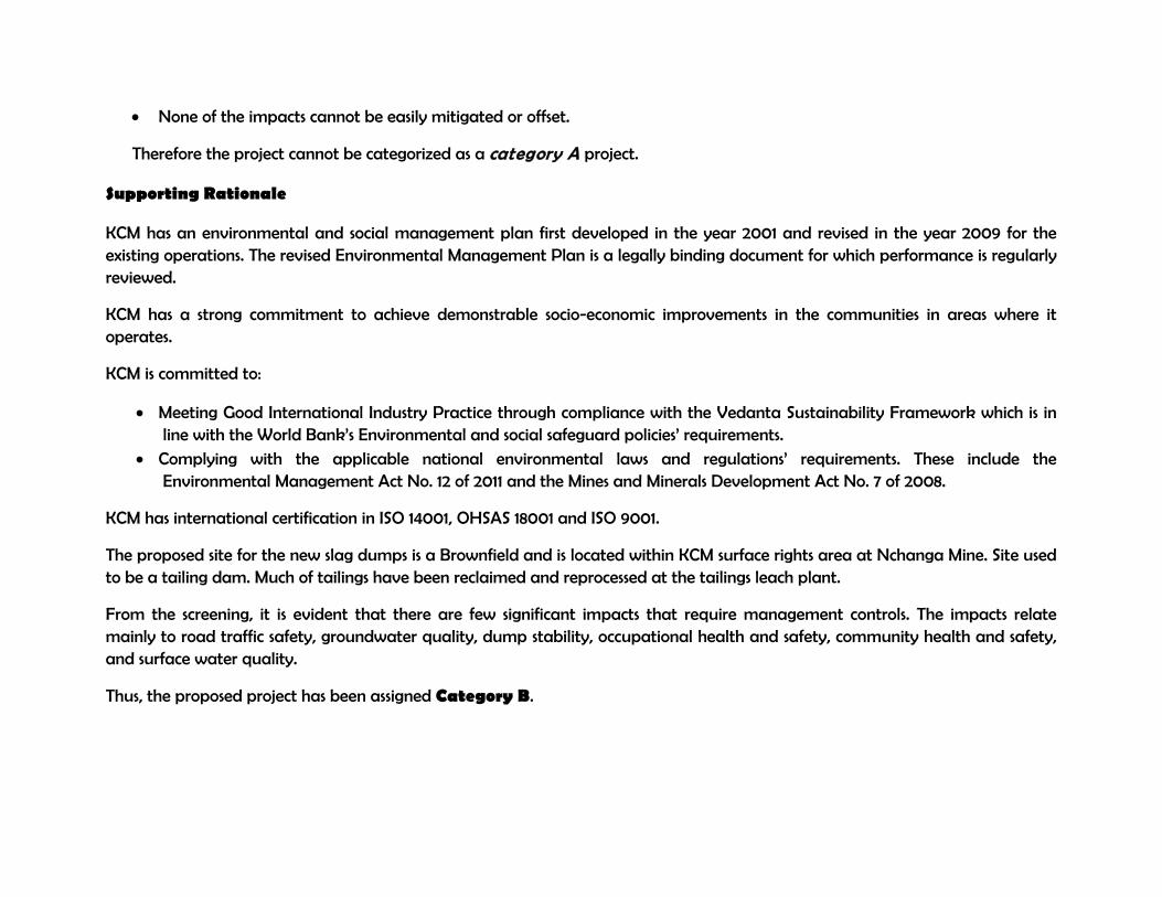
• None of the impacts cannot be easily mitigated or offset.
Therefore the project cannot be categorized as a category A project.
Supporting Rationale
KCM has an environmental and social management plan first developed in the year 2001 and revised in the year 2009 for the existing operations. The revised Environmental Management Plan is a legally binding document for which performance is regularly reviewed.
KCM has a strong commitment to achieve demonstrable socio-economic improvements in the communities in areas where it operates.
KCM is committed to:
• Meeting Good International Industry Practice through compliance with the Vedanta Sustainability Framework which is in line with the World Bank’s Environmental and social safeguard policies’ requirements.
• Complying with the applicable national environmental laws and regulations’ requirements. These include the Environmental Management Act No. 12 of 2011 and the Mines and Minerals Development Act No. 7 of 2008.
KCM has international certification in ISO 14001, OHSAS 18001 and ISO 9001.
The proposed site for the new slag dumps is a Brownfield and is located within KCM surface rights area at Nchanga Mine. Site used to be a tailing dam. Much of tailings have been reclaimed and reprocessed at the tailings leach plant.
From the screening, it is evident that there are few significant impacts that require management controls. The impacts relate mainly to road traffic safety, groundwater quality, dump stability, occupational health and safety, community health and safety, and surface water quality.
Thus, the proposed project has been assigned Category B.
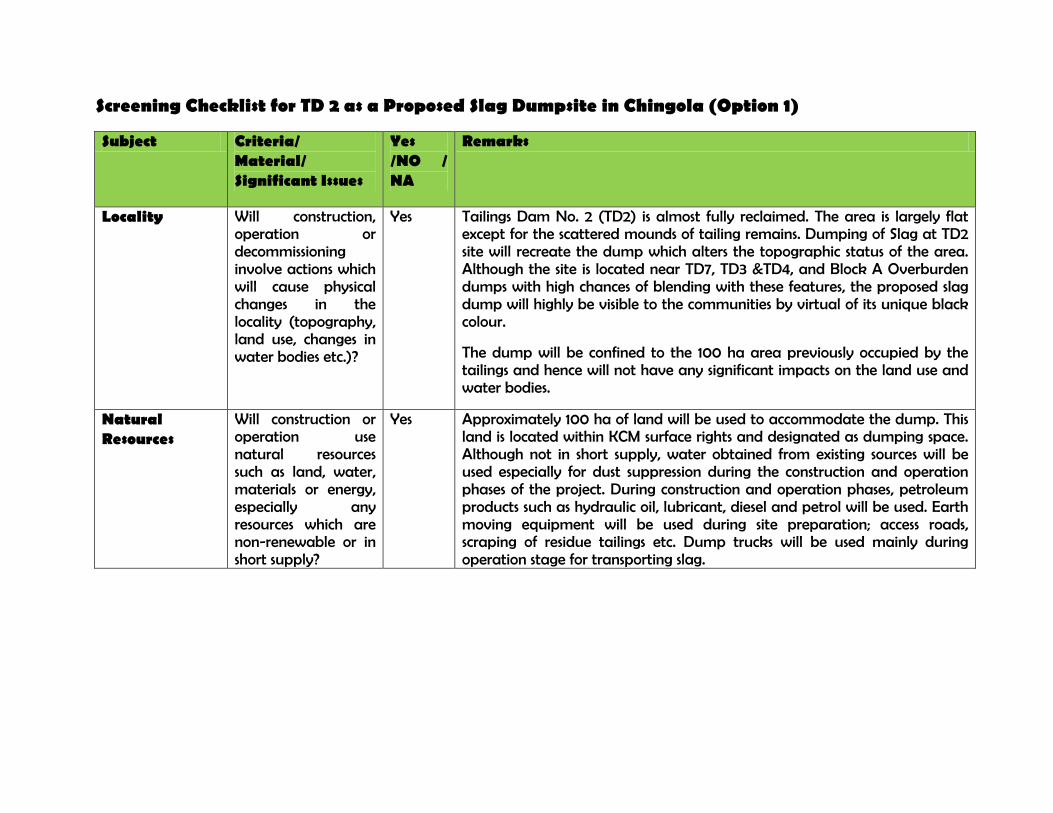
Screening Checklist for TD 2 as a Proposed Slag Dumpsite in Chingola (Option 1)
Subject Criteria/ Material/ Significant Issues
Yes /NO / NA
Remarks
Locality Will construction, operation or decommissioning involve actions which will cause physical changes in the locality (topography, land use, changes in water bodies etc.)?
Yes Tailings Dam No. 2 (TD2) is almost fully reclaimed. The area is largely flat except for the scattered mounds of tailing remains. Dumping of Slag at TD2 site will recreate the dump which alters the topographic status of the area. Although the site is located near TD7, TD3 &TD4, and Block A Overburden dumps with high chances of blending with these features, the proposed slag dump will highly be visible to the communities by virtual of its unique black colour.
The dump will be confined to the 100 ha area previously occupied by the tailings and hence will not have any significant impacts on the land use and water bodies.
Natural Resources
Will construction or operation use natural resources such as land, water, materials or energy, especially any resources which are non-renewable or in short supply?
Yes Approximately 100 ha of land will be used to accommodate the dump. This land is located within KCM surface rights and designated as dumping space. Although not in short supply, water obtained from existing sources will be used especially for dust suppression during the construction and operation phases of the project. During construction and operation phases, petroleum products such as hydraulic oil, lubricant, diesel and petrol will be used. Earth moving equipment will be used during site preparation; access roads, scraping of residue tailings etc. Dump trucks will be used mainly during operation stage for transporting slag.
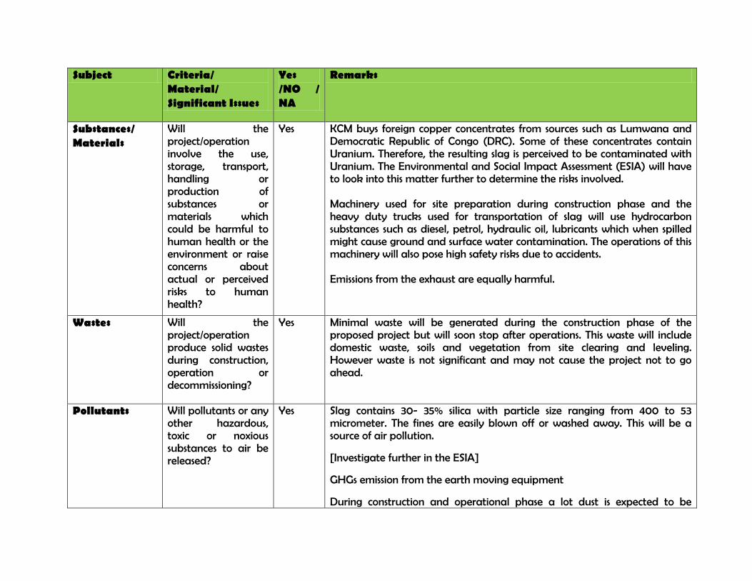
Subject Criteria/ Material/ Significant Issues
Yes /NO / NA
Remarks
Substances/ Materials
Will the project/operation involve the use, storage, transport, handling or production of substances or materials which could be harmful to human health or the environment or raise concerns about actual or perceived risks to human health?
Yes KCM buys foreign copper concentrates from sources such as Lumwana and Democratic Republic of Congo (DRC). Some of these concentrates contain Uranium. Therefore, the resulting slag is perceived to be contaminated with Uranium. The Environmental and Social Impact Assessment (ESIA) will have to look into this matter further to determine the risks involved. Machinery used for site preparation during construction phase and the heavy duty trucks used for transportation of slag will use hydrocarbon substances such as diesel, petrol, hydraulic oil, lubricants which when spilled might cause ground and surface water contamination. The operations of this machinery will also pose high safety risks due to accidents. Emissions from the exhaust are equally harmful.
Wastes Will the project/operation produce solid wastes during construction, operation or decommissioning?
Yes Minimal waste will be generated during the construction phase of the proposed project but will soon stop after operations. This waste will include domestic waste, soils and vegetation from site clearing and leveling. However waste is not significant and may not cause the project not to go ahead.
Pollutants Will pollutants or any other hazardous, toxic or noxious substances to air be released?
Yes Slag contains 30- 35% silica with particle size ranging from 400 to 53 micrometer. The fines are easily blown off or washed away. This will be a source of air pollution.
[Investigate further in the ESIA]
GHGs emission from the earth moving equipment
During construction and operational phase a lot dust is expected to be
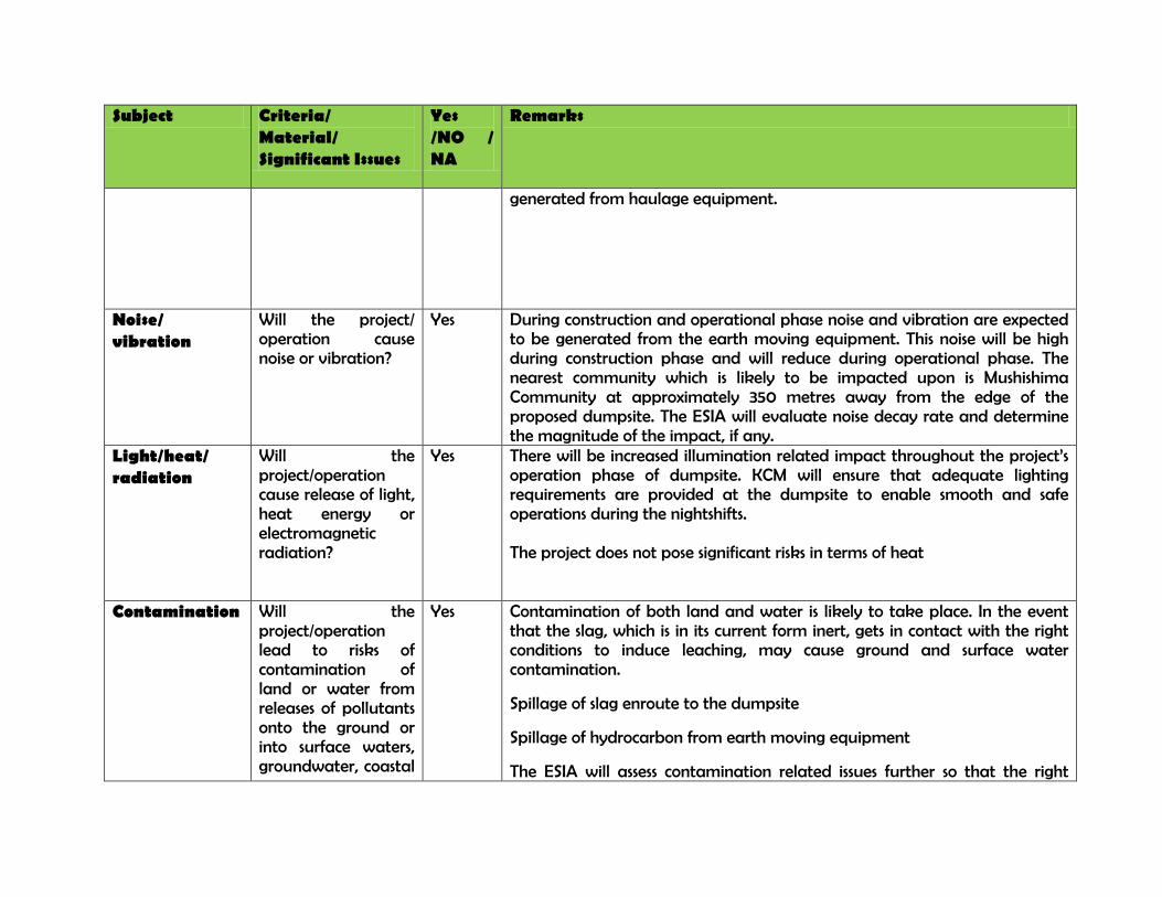
Subject Criteria/ Material/ Significant Issues
Yes /NO / NA
Remarks
generated from haulage equipment.
Noise/ vibration
Will the project/ operation cause noise or vibration?
Yes During construction and operational phase noise and vibration are expected to be generated from the earth moving equipment. This noise will be high during construction phase and will reduce during operational phase. The nearest community which is likely to be impacted upon is Mushishima Community at approximately 350 metres away from the edge of the proposed dumpsite. The ESIA will evaluate noise decay rate and determine the magnitude of the impact, if any.
Light/heat/ radiation
Will the project/operation cause release of light, heat energy or electromagnetic radiation?
Yes There will be increased illumination related impact throughout the project’s operation phase of dumpsite. KCM will ensure that adequate lighting requirements are provided at the dumpsite to enable smooth and safe operations during the nightshifts. The project does not pose significant risks in terms of heat
Contamination Will the project/operation lead to risks of contamination of land or water from releases of pollutants onto the ground or into surface waters, groundwater, coastal
Yes Contamination of both land and water is likely to take place. In the event that the slag, which is in its current form inert, gets in contact with the right conditions to induce leaching, may cause ground and surface water contamination.
Spillage of slag enroute to the dumpsite
Spillage of hydrocarbon from earth moving equipment
The ESIA will assess contamination related issues further so that the right
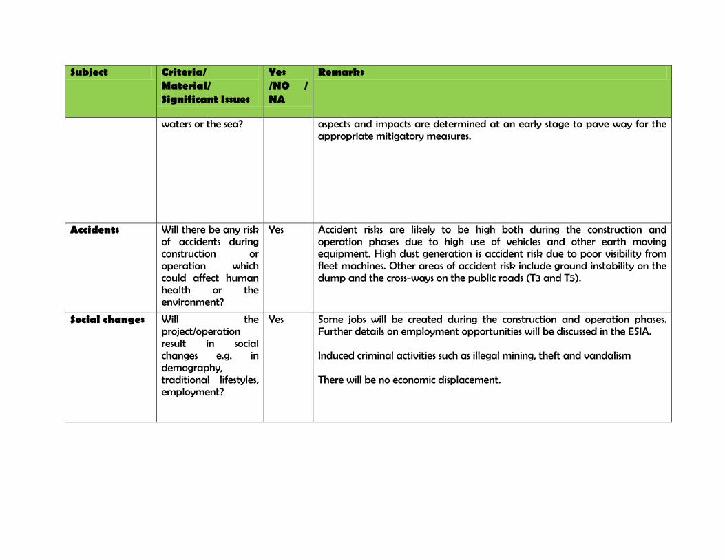
Subject Criteria/ Material/ Significant Issues
Yes /NO / NA
Remarks
waters or the sea? aspects and impacts are determined at an early stage to pave way for the appropriate mitigatory measures.
Accidents Will there be any risk of accidents during construction or operation which could affect human health or the environment?
Yes Accident risks are likely to be high both during the construction and operation phases due to high use of vehicles and other earth moving equipment. High dust generation is accident risk due to poor visibility from fleet machines. Other areas of accident risk include ground instability on the dump and the cross-ways on the public roads (T3 and T5).
Social changes Will the project/operation result in social changes e.g. in demography, traditional lifestyles, employment?
Yes Some jobs will be created during the construction and operation phases. Further details on employment opportunities will be discussed in the ESIA. Induced criminal activities such as illegal mining, theft and vandalism There will be no economic displacement.
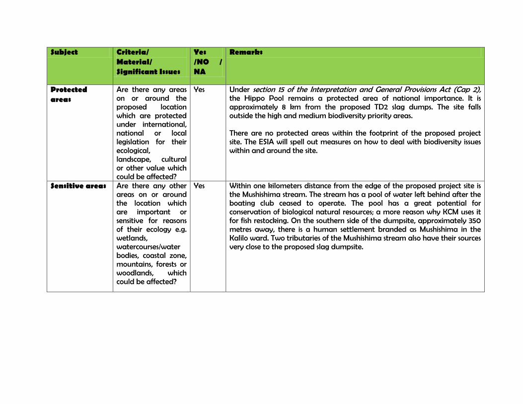
Subject Criteria/ Material/ Significant Issues
Yes /NO / NA
Remarks
Protected areas
Are there any areas on or around the proposed location which are protected under international, national or local legislation for their ecological, landscape, cultural or other value which could be affected?
Yes Under section 15 of the Interpretation and General Provisions Act (Cap 2), the Hippo Pool remains a protected area of national importance. It is approximately 8 km from the proposed TD2 slag dumps. The site falls outside the high and medium biodiversity priority areas. There are no protected areas within the footprint of the proposed project site. The ESIA will spell out measures on how to deal with biodiversity issues within and around the site.
Sensitive areas Are there any other areas on or around the location which are important or sensitive for reasons of their ecology e.g. wetlands, watercourses/water bodies, coastal zone, mountains, forests or woodlands, which could be affected?
Yes Within one kilometers distance from the edge of the proposed project site is the Mushishima stream. The stream has a pool of water left behind after the boating club ceased to operate. The pool has a great potential for conservation of biological natural resources; a more reason why KCM uses it for fish restocking. On the southern side of the dumpsite, approximately 350 metres away, there is a human settlement branded as Mushishima in the Kalilo ward. Two tributaries of the Mushishima stream also have their sources very close to the proposed slag dumpsite.
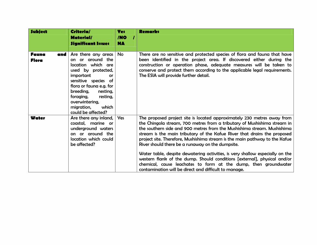
Subject Criteria/ Material/ Significant Issues
Yes /NO / NA
Remarks
Fauna and Flora
Are there any areas on or around the location which are used by protected, important or sensitive species of flora or fauna e.g. for breeding, nesting, foraging, resting, overwintering, migration, which could be affected?
No There are no sensitive and protected species of flora and fauna that have been identified in the project area. If discovered either during the construction or operation phase, adequate measures will be taken to conserve and protect them according to the applicable legal requirements. The ESIA will provide further detail.
Water Are there any inland, coastal, marine or underground waters on or around the location which could be affected?
Yes The proposed project site is located approximately 230 metres away from the Chingola stream, 700 metres from a tributary of Mushishima stream in the southern side and 900 metres from the Mushishima stream. Mushishima stream is the main tributary of the Kafue River that drains the proposed project site. Therefore, Mushishima stream is the main pathway to the Kafue River should there be a runaway on the dumpsite.
Water table, despite dewatering activities, is very shallow especially on the western flank of the dump. Should conditions [external], physical and/or chemical, cause leachates to form at the dump, then groundwater contamination will be direct and difficult to manage.
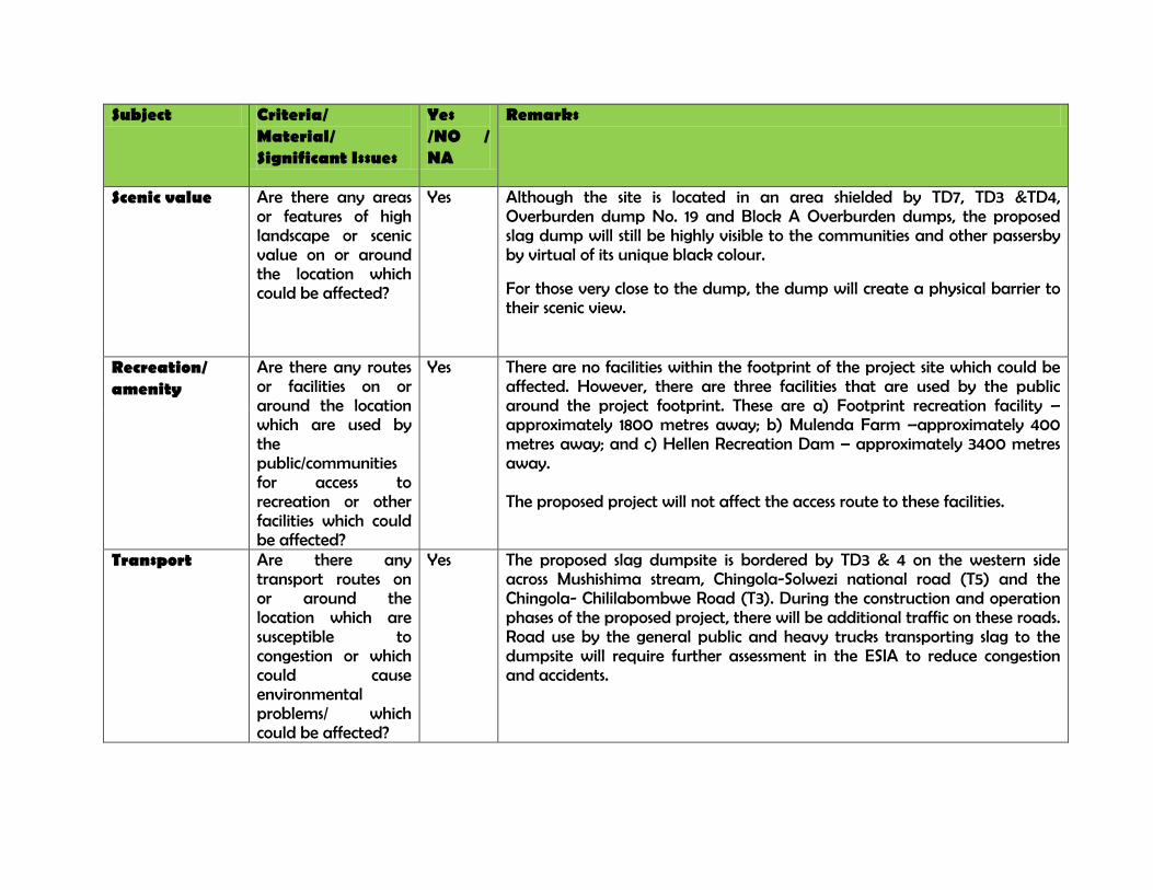
Subject Criteria/ Material/ Significant Issues
Yes /NO / NA
Remarks
Scenic value Are there any areas or features of high landscape or scenic value on or around the location which could be affected?
Yes Although the site is located in an area shielded by TD7, TD3 &TD4, Overburden dump No. 19 and Block A Overburden dumps, the proposed slag dump will still be highly visible to the communities and other passersby by virtual of its unique black colour.
For those very close to the dump, the dump will create a physical barrier to their scenic view.
Recreation/ amenity
Are there any routes or facilities on or around the location which are used by the public/communities for access to recreation or other facilities which could be affected?
Yes There are no facilities within the footprint of the project site which could be affected. However, there are three facilities that are used by the public around the project footprint. These are a) Footprint recreation facility – approximately 1800 metres away; b) Mulenda Farm –approximately 400 metres away; and c) Hellen Recreation Dam – approximately 3400 metres away. The proposed project will not affect the access route to these facilities.
Transport Are there any transport routes on or around the location which are susceptible to congestion or which could cause environmental problems/ which could be affected?
Yes The proposed slag dumpsite is bordered by TD3 & 4 on the western side across Mushishima stream, Chingola-Solwezi national road (T5) and the Chingola- Chililabombwe Road (T3). During the construction and operation phases of the proposed project, there will be additional traffic on these roads. Road use by the general public and heavy trucks transporting slag to the dumpsite will require further assessment in the ESIA to reduce congestion and accidents.
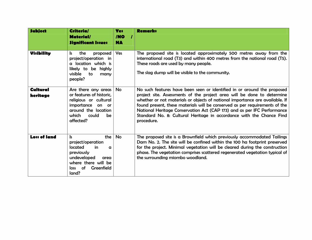
Subject Criteria/ Material/ Significant Issues
Yes /NO / NA
Remarks
Visibility Is the proposed project/operation in a location which is likely to be highly visible to many people?
Yes The proposed site is located approximately 500 metres away from the international road (T3) and within 400 metres from the national road (T5). These roads are used by many people.
The slag dump will be visible to the community.
Cultural heritage
Are there any areas or features of historic, religious or cultural importance on or around the location which could be affected?
No No such features have been seen or identified in or around the proposed project site. Assessments of the project area will be done to determine whether or not materials or objects of national importance are available. If found present, these materials will be conserved as per requirements of the National Heritage Conservation Act (CAP 173) and as per IFC Performance Standard No. 8: Cultural Heritage in accordance with the Chance Find procedure.
Loss of land Is the project/operation located in a previously undeveloped area where there will be loss of Greenfield land?
No The proposed site is a Brownfield which previously accommodated Tailings Dam No. 2. The site will be confined within the 100 ha footprint preserved for the project. Minimal vegetation will be cleared during the construction phase. The vegetation comprises scattered regenerated vegetation typical of the surrounding miombo woodland.
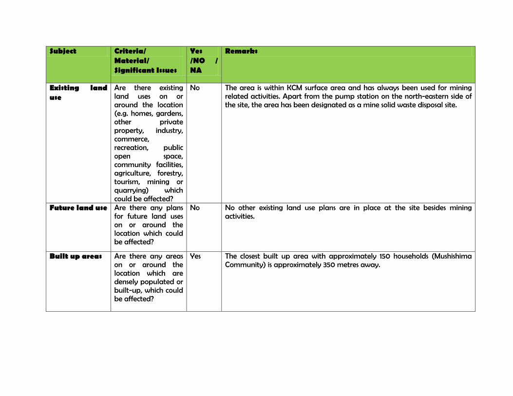
Subject Criteria/ Material/ Significant Issues
Yes /NO / NA
Remarks
Existing land use
Are there existing land uses on or around the location (e.g. homes, gardens, other private property, industry, commerce, recreation, public open space, community facilities, agriculture, forestry, tourism, mining or quarrying) which could be affected?
No The area is within KCM surface area and has always been used for mining related activities. Apart from the pump station on the north-eastern side of the site, the area has been designated as a mine solid waste disposal site.
Future land use Are there any plans for future land uses on or around the location which could be affected?
No No other existing land use plans are in place at the site besides mining activities.
Built up areas Are there any areas on or around the location which are densely populated or built-up, which could be affected?
Yes The closest built up area with approximately 150 households (Mushishima Community) is approximately 350 metres away.
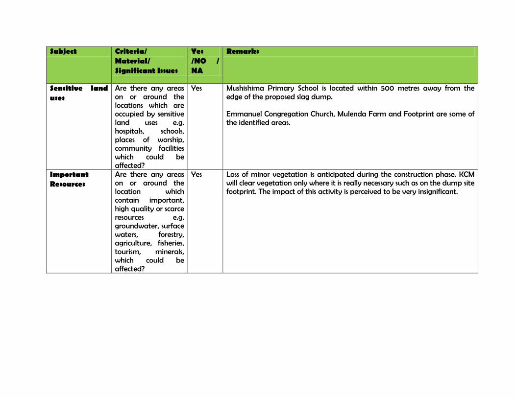
Subject Criteria/ Material/ Significant Issues
Yes /NO / NA
Remarks
Sensitive land uses
Are there any areas on or around the locations which are occupied by sensitive land uses e.g. hospitals, schools, places of worship, community facilities which could be affected?
Yes Mushishima Primary School is located within 500 metres away from the edge of the proposed slag dump. Emmanuel Congregation Church, Mulenda Farm and Footprint are some of the identified areas.
Important Resources
Are there any areas on or around the location which contain important, high quality or scarce resources e.g. groundwater, surface waters, forestry, agriculture, fisheries, tourism, minerals, which could be affected?
Yes Loss of minor vegetation is anticipated during the construction phase. KCM will clear vegetation only where it is really necessary such as on the dump site footprint. The impact of this activity is perceived to be very insignificant.
Subject Criteria/ Material/ Significant Issues
Yes /NO / NA
Remarks
Environmental damage
Are there any areas on or around the location which are already subject to pollution or environmental damage e.g. where existing legal environmental standards are exceeded which could be affected?
Yes The site is an old tailings dam which is almost fully reclaimed. It is surrounded by overburden dumps and areas which are highly degraded from the previous mining activities. The baseline environmental conditions are already degraded and if the proposed slag dumpsite is not well managed could lead to further degradation.
Environmental conditions
Is the project/operation location susceptible to earthquakes, subsidence, landslides, erosion, flooding, or extreme / adverse climatic conditions (e.g. fog, severe winds, and temperature inversions)?
No The nearest cave limit signage from UG workings is approximately 500 metres away on the eastern side of the proposed site. There is an allowance of hundred [100] metres safe distance from the signage inwards to where the crack delights from underground caving.
Subject Criteria/ Material/ Significant Issues
Yes /NO / NA
Remarks
Cumulative impacts
Is there a risk of cumulative impact on areas or resources used or directly impacted by the project, or from other existing, planned or reasonably defined developments?
Yes The proposed slag dumpsite is a Brownfield which used to be a tailings dam. In the past tailings of low pH used to be deposited here. An emergency tailing dam (TD7) which is an annex of TD2 also has history of acidic tailing being deposited there. These and other factors are more likely to induce cumulative impacts in the area.
ACKNOWLEDGEMENT
I, _______________________, have read and fully understand the environmental and social risks and impacts associated with the proposed Slag Dump Site in Chingola as detailed in this checklist.
Signature: _________________________________ Date:_______________________________
Konkola Copper Mines Plc
New Slag Dump Project
Final Terms of Reference March 2014
Appendix D TD2 Slag Dump Project Design Report
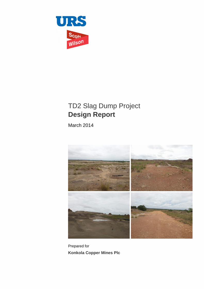
Prepared for
Konkola Copper Mines Plc
TD2 Slag Dump Project Design Report March 2014
Konkola Copper Mines Plc TD2 Slag Dump Project
TD2 Slag Dump Design Report March 2014
URS Scott Wilson Zambia 24 Enos Chomba Avenue PO Box 22496 Kitwe Zambia Tel +260 21 222 8466 Fax +260 21 222 3649 [email protected] www.ursglobal.com
TD2 Slag Dump Design Report
March 2014
Rev Date Details Prepared by Reviewed by Approved by
0 March 2014 Chalwe Bulaya
Principal Engineer
Patrick Kampengele
Executive Director
Patrick Kampengele
Executive Director
Samuel Simumba
Engineer

Konkola Copper Mines Plc TD2 Slag Dump Project
TD2 Slag Dump Design Report i March 2014
Table of Contents 1. Introduction .............................................................................................................................................. 1
2. Basis of Design ........................................................................................................................................ 1
2.1. Background............................................................................................................................................ 1
2.2. Principal Design Criteria ......................................................................................................................... 1
2.3. Principal Design Parameters ................................................................................................................. 2
3. Site Characterisation ............................................................................................................................... 2
4. Slag Dump Configuration and Capacity ................................................................................................ 3
5. Site Preparation ....................................................................................................................................... 4
6. Stability Analysis ..................................................................................................................................... 5
7. Dumping Procedures .............................................................................................................................. 6
8. References ............................................................................................................................................... 7
9. Appendices .............................................................................................................................................. 8

Konkola Copper Mines Plc TD2 Slag Dump Project
TD2 Slag Dump Design Report 1 March 2014
1. Introduction Nchanga Copper Smelter of Konkola Copper Mines Plc (KCM) intends to use part of the reclaimed TD 2 tailings dump site as a storage facility for the granulated slag, one of the main solid waste products from the smelting operations from the smelter. Subsequently KCM has commissioned URS Scott Wilson to undertake the design of the proposed TD 2 slag dump.
2. Basis of Design 2.1. Background
The Nchanga Copper Smelter, which was commissioned in 2008 processes copper concentrates obtained from KCM concentrator plants as well as purchased concentrates. The main products produced from the smelting operations are copper anodes and granulated slag. The granulated slag, which is a waste product, is disposed off at the existing Slag Dump No. 25 located on the southern rim of Block A open pit. Approximately 1.6 million tonnes has so far been deposited at the existing slag dump and the dump is reaching its design storage capacity. Further expansion of the slag dump is constrained by physical features around the dump such as the Block A open pit, Chingola Stream and the KCM open pit haulage road.
There is therefore need for a new disposal site and the TD2 reclamation site has been identified as the most preferred site. The site is within the reclaimed TD2 tailing dump footprint and is a brownfield.
The whole project will involve the provision of an adequate haul road to the dump, by widening the existing access road to TD2, the construction of a drainage system in order to direct runoff to the pollution control pond as well as reduce seepage to the groundwater regime. The dump site will be prepared with adequate under-drainage system installed. The surface of the site will be levelled before the dumping operations can actually commence.
2.2. Principal Design Criteria
The philosophy that forms the basis of the design of the granulated slag dump is to provide a cost effective storage of the slag material in a facility that is stable, safe and mitigates against adverse environmental and social impacts. The basic design criteria that have been adopted are outlined below:
• Effective stabilisation and compaction of the underlying foundation and access road to ensure overall dump stability;
• Stable configuration of the dump to ensure low aesthetic change to the surrounding environment and its surroundings;
• Management of seepage to mitigate against adverse environmental impacts;
• Stormwater management to avoid undue contamination of clean water; and
• Modular development of the dump in stages, to reduce the overall initial capital cost investment.
The design report also includes a Bill of Quantities for the preparatory works that will be required before dumping can commence. The following components form the design of the slag dump:
a. Configuration and footprint analysis of the dump. This is based on a design dump height of 15 m;
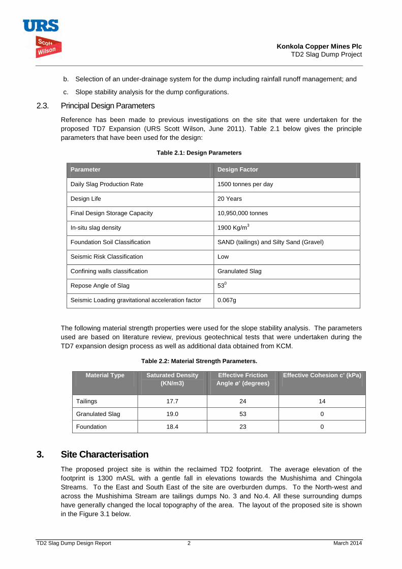
Konkola Copper Mines Plc TD2 Slag Dump Project
TD2 Slag Dump Design Report 2 March 2014
b. Selection of an under-drainage system for the dump including rainfall runoff management; and
c. Slope stability analysis for the dump configurations.
2.3. Principal Design Parameters
Reference has been made to previous investigations on the site that were undertaken for the proposed TD7 Expansion (URS Scott Wilson, June 2011). Table 2.1 below gives the principle parameters that have been used for the design:
Table 2.1: Design Parameters
Parameter Design Factor
Daily Slag Production Rate 1500 tonnes per day
Design Life 20 Years
Final Design Storage Capacity 10,950,000 tonnes
In-situ slag density 1900 Kg/m3
Foundation Soil Classification SAND (tailings) and Silty Sand (Gravel)
Seismic Risk Classification Low
Confining walls classification Granulated Slag
Repose Angle of Slag 530
Seismic Loading gravitational acceleration factor 0.067g
The following material strength properties were used for the slope stability analysis. The parameters used are based on literature review, previous geotechnical tests that were undertaken during the TD7 expansion design process as well as additional data obtained from KCM.
Table 2.2: Material Strength Parameters.
Material Type Saturated Density (KN/m3)
Effective Friction Angle ø’ (degrees)
Effective Cohesion c’ (kPa)
Tailings 17.7 24 14
Granulated Slag 19.0 53 0
Foundation 18.4 23 0
3. Site Characterisation The proposed project site is within the reclaimed TD2 footprint. The average elevation of the footprint is 1300 mASL with a gentle fall in elevations towards the Mushishima and Chingola Streams. To the East and South East of the site are overburden dumps. To the North-west and across the Mushishima Stream are tailings dumps No. 3 and No.4. All these surrounding dumps have generally changed the local topography of the area. The layout of the proposed site is shown in the Figure 3.1 below.
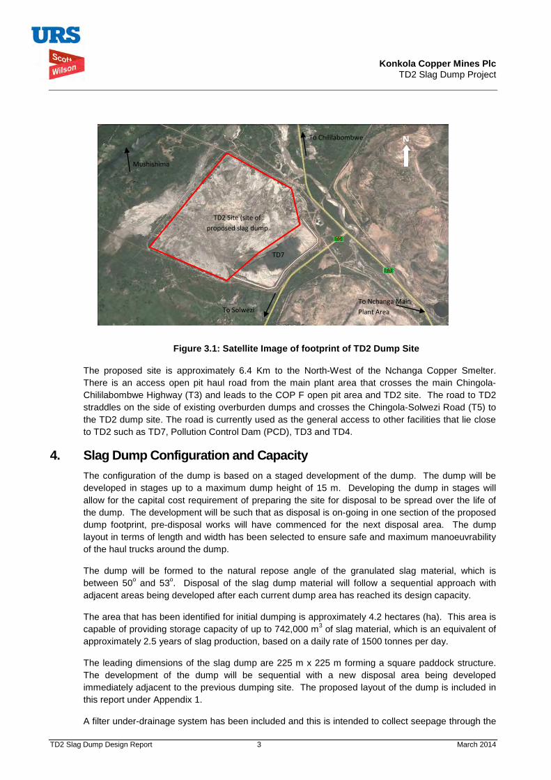
Konkola Copper Mines Plc TD2 Slag Dump Project
TD2 Slag Dump Design Report 3 March 2014
Figure 3.1: Satellite Image of footprint of TD2 Dump Site
The proposed site is approximately 6.4 Km to the North-West of the Nchanga Copper Smelter. There is an access open pit haul road from the main plant area that crosses the main Chingola-Chililabombwe Highway (T3) and leads to the COP F open pit area and TD2 site. The road to TD2 straddles on the side of existing overburden dumps and crosses the Chingola-Solwezi Road (T5) to the TD2 dump site. The road is currently used as the general access to other facilities that lie close to TD2 such as TD7, Pollution Control Dam (PCD), TD3 and TD4.
4. Slag Dump Configuration and Capacity The configuration of the dump is based on a staged development of the dump. The dump will be developed in stages up to a maximum dump height of 15 m. Developing the dump in stages will allow for the capital cost requirement of preparing the site for disposal to be spread over the life of the dump. The development will be such that as disposal is on-going in one section of the proposed dump footprint, pre-disposal works will have commenced for the next disposal area. The dump layout in terms of length and width has been selected to ensure safe and maximum manoeuvrability of the haul trucks around the dump.
The dump will be formed to the natural repose angle of the granulated slag material, which is between 50o and 53o. Disposal of the slag dump material will follow a sequential approach with adjacent areas being developed after each current dump area has reached its design capacity.
The area that has been identified for initial dumping is approximately 4.2 hectares (ha). This area is capable of providing storage capacity of up to 742,000 m3 of slag material, which is an equivalent of approximately 2.5 years of slag production, based on a daily rate of 1500 tonnes per day.
The leading dimensions of the slag dump are 225 m x 225 m forming a square paddock structure. The development of the dump will be sequential with a new disposal area being developed immediately adjacent to the previous dumping site. The proposed layout of the dump is included in this report under Appendix 1.
A filter under-drainage system has been included and this is intended to collect seepage through the
To Chililabombwe N
TD2 Site (site of proposed slag dump
To Nchanga Main Plant Area To Solwezi
Mushishima
Stream
TD7

Konkola Copper Mines Plc TD2 Slag Dump Project
TD2 Slag Dump Design Report 4 March 2014
dumped slag material. The slag material, which is granular in nature, will allow direct rainfall to percolate through its body mass to the base of the dump. The seepage through the slag material will percolate further into the underlying foundation strata. However, in order to reduce the amount of potential seepage to the underlying strata, a filter drain will be incorporated to collect the seepage and direct it into a toe drain. The toe drain will direct the collected seepage into the Pollution Control Dam (PCD). The filter drain will be along the outer periphery of the slag dump. The details of the filter drainage system are shown on the construction drawings, as well as the grading envelopes for the filter material. Prior to discharge into the PCD, the seepage will be collected into a seepage sump for environmental monitoring.
The principal dimensions of the dump are given in the table below. There will be a 20 m buffer zone between the existing outer embankment of TD2 and the toe of the slag dump. For each stage of dumping, the principal leading dimensions will be 225 m x 225 m with a dump height of 15 m. The cumulative covered area for the different stages of development of the slag dump is also given in the table below. For up to 20 years of disposal, eight disposal stages have been developed and each stage will provide 2.5 years of storage space. The sequence of the stage development numbered 1 up to 8 is included on the layout drawings of the dump. The slag dump is will cover approximately 35% of the existing TD2 dump footprint.
Table 4. 1: Development Stages for TD2 Slag Dump
Disposal Stage
Disposal Period (Years) Length (m)
Breadth (m)
Cumm. Area (ha)
% Area of TD 2
Stored Tonnage (Cumulative)
1 2.5 225 225 5.063 4% 1368750
2 5 225 225 10.125 8% 2737500
3 7.5 225 225 15.188 13% 4106250
4 10 225 225 20.250 17% 5475000
5 12.5 225 225 25.313 21% 6843750
6 15 225 225 30.375 25% 8212500
7 17.5 225 225 35.438 30% 9581250
8 20 225 225 40.500 34% 10950000
5. Site Preparation The following main key activities will be undertaken as part of site preparation before dumping commences. A Bill of Quantities, outlining the required works and quantities has also been provided. An engineer’s estimate of the construction cost has been included in Appendix 2.
a. Prepare access road from the plant to the dump;
i. Grade existing access road including widening;
ii. Construct over the tailings an access road to the dumping locations.
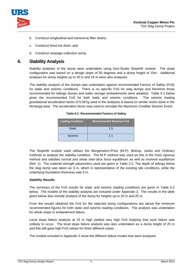
Konkola Copper Mines Plc TD2 Slag Dump Project
TD2 Slag Dump Design Report 5 March 2014
b. Construct longitudinal and transverse filter drains;
c. Construct lined toe drain; and
d. Construct seepage collection sump.
6. Stability Analysis Stability analyses of the dump were undertaken using Geo-Studio Slope/W module. The slope configuration was based on a design slope of 50 degrees and a dump height of 15m. Additional analyses for dump heights up to 20 m and 25 m were also analysed.
The stability analysis of the dumps was undertaken against recommended Factors of Safety (FoS) for static and seismic conditions. There is no specific FoS for slag dumps and therefore those recommended for tailings dumps and water storage embankments were adopted. Table 6.1 below gives the recommended FoS for both static and seismic conditions. The seismic loading gravitational acceleration factor of 0.067g used in the analyses is based on similar works done in the Nchanga area. The acceleration factor was used to simulate the Maximum Credible Seismic Event.
Table 6.1: Recommended Factors of Safety
Loading Condition Recommended Minimum FoS
Static 1.5
Seismic 1.1
The Slope/W module used utilises the Morgenstern-Price (M-P), Bishop, Janbu and Ordinary methods to analyse the stability condition. The M-P method was used as this is the most rigorous method and satisfies normal and shear inter-slice force equilibrium as well as moment equilibrium (Ref. 1). The material strength parameters used are given in Table 2.2. The depth of tailings below the slag dump was taken as 3 m, which is representative of the existing site conditions, while the underlying foundation thickness was 5 m.
Stability Results
The summary of the FoS results for static and seismic loading conditions are given in Table 6.2 below. The models of the stability analysis are included under Appendix 3. The results in the table given below also include analysis of the dump for heights up to 20 m and 25 m.
From the results obtained the FoS for the selected dump configurations are above the minimum recommended figures for both static and seismic loading conditions. The analysis was undertaken for whole slope or embankment failure.
Local slope failure analysis at 15 m high yielded very high FoS implying that such failure was unlikely to occur. The local slope failure analysis was also undertaken as a dump height of 25 m and this still gave high FoS values for three different cases.
The models included in Appendix 3 show the different failure modes that were analysed.

Konkola Copper Mines Plc TD2 Slag Dump Project
TD2 Slag Dump Design Report 6 March 2014
Table 6. 2: Summary of FoS Results
Loading Condition
15 m Height
20 m Height
25 m Height
25 m H (Localised Failure 1)
25 m H (Localised Failure 2)
25 m H (Localised Failure 3)
Recommended Minimum
Static 1.74 1.67 1.63 1.56 1.57 1.68 1.50
Seismic 1.54 1.47 1.44 2.13 2.10 2,21 1.10
7. Dumping Procedures The following procedures will guide the general dumping operations at the slag dump. In general terms best operating practice and adherence to any specific conditions set out by the Mines Safety Department (MSD) will be adopted.
The basic dumping process is outlined below:
• The material will be hauled to the dump site by road using dump trucks; • The material will be end-tipped from tipper trucks; • During end-tipping tipper trucks will be operated in reverse direction; • The material shall be heaped at a safe distance from the edge of the dump surface with a
minimum approach distance of not less than 10m from the edge; • The tipper trucks will be guided by the dump attendant to ensure the minimum set distances are
not exceeded; • The heaps of granulated slag are to be levelled using a Grader or Dozer; • Levelling the surface to be an intermediate operation after sufficient quantities of slag have been
heaped;
The following general guidelines will be applicable during all dumping operations:
• Ensure that all equipment being used is in good operational condition; • The trucks should not be overloaded to avoid any spillages; • Access roads to be maintained in a good condition at all times; • Dumping of the material should commence from the outer boundaries of the dump; • Trucks should dump the slag material while moving in a reverse direction up to the minimum set
approach distance; • An attendant should be present at all times to guide the trucks when dumping; • Dump surface to be levelled and have no depressions; • Design wall profiles and extent to be adhered to at all times; • Regular cleaning of the toe drain, filter drain outlets and seepage sump to be undertaken.
Konkola Copper Mines Plc TD2 Slag Dump Project
TD2 Slag Dump Design Report 7 March 2014
8. References 1. John Krahn, 2004. Stability Modelling with Slope/W – An Engineering Methodology
August 2004.
2. URS Scott Wilson, 2011. Muntimpa Tailings Dam (TD 5) – Slope Stability Analysis Report prepared on behalf of Konkola Copper Mines Plc. August 2011
3. URS Scott Wilson, 2011. TD7 Expansion Design Report prepared on behalf of Konkola Copper Mines Plc. June 2011.

Konkola Copper Mines Plc TD2 Slag Dump Project
TD2 Slag Dump Design Report 8 March 2014
9. Appendices
Appendix 1: Dump Layout and Construction Drawing Appendix 2: Pre-Disposal Works Bill of Quantities
Appendix 2: Stability Analysis Models
Konkola Copper Mines Plc TD2 Slag Dump Project
TD2 Slag Dump Design Report March 2014
Appendix 1: Dump Layout and Construction Drawings
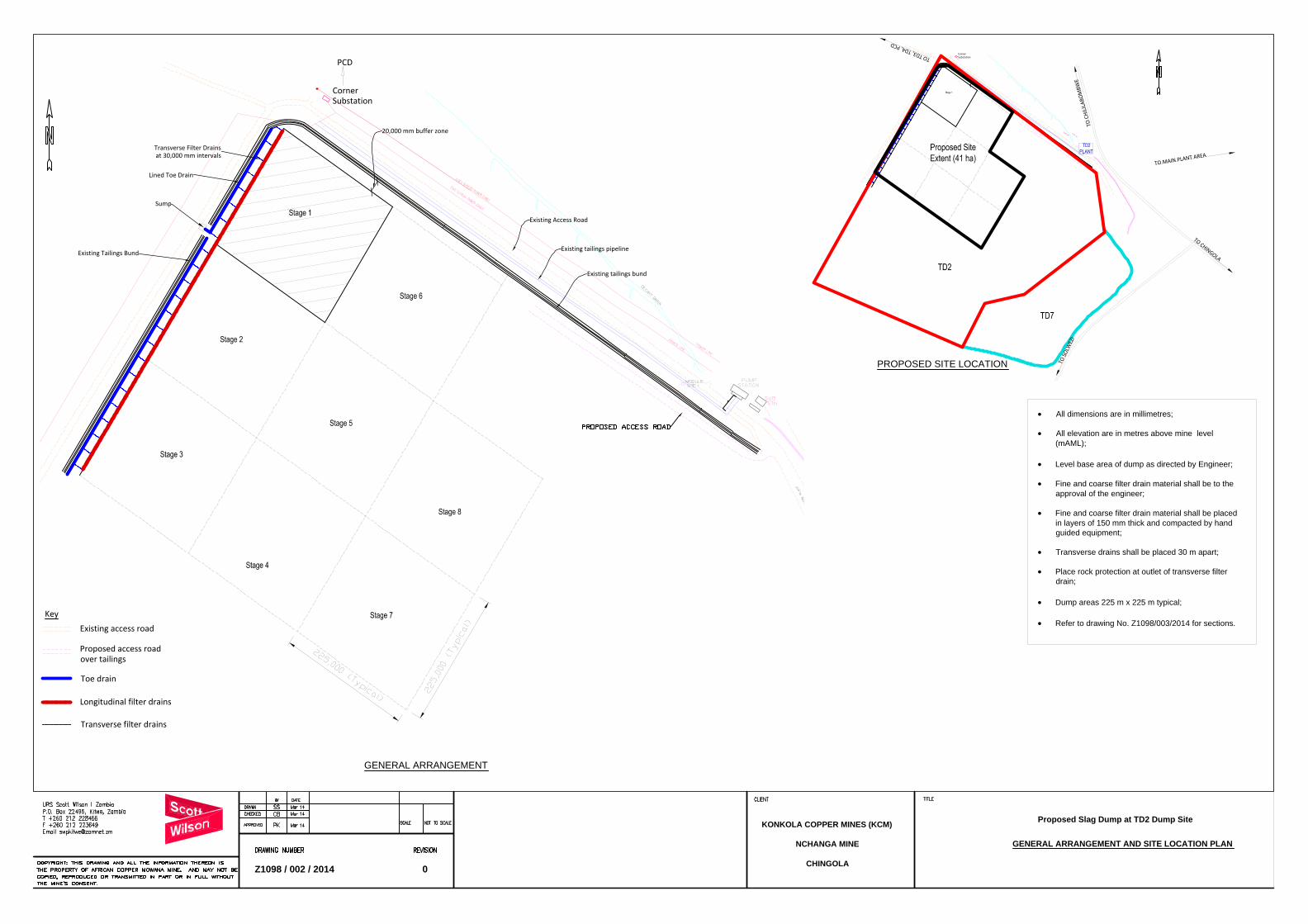
Existing Access Road
Existing tailings pipeline
Existing tailings bund
Transverse Filter Drainsat 30,000 mm intervals
Lined Toe Drain
Existing Tailings Bund
CornerSubstation
PCD
20,000 mm buffer zone
Key
Existing access road
Proposed access roadover tailings
Toe drain
Transverse filter drains
Longitudinal filter drains
Sump
GENERAL ARRANGEMENT AND SITE LOCATION PLAN
KONKOLA COPPER MINES (KCM)
NCHANGA MINE
CHINGOLA
Proposed Slag Dump at TD2 Dump Site
Z1098 / 002 / 2014 0
CornerSubstation
TO CHINGOLA
TO SO
LWEZ
I
TO C
HILI
LABO
MBW
E
TO TD3, TD4, PCD
TO MAIN PLANT AREA
All dimensions are in millimetres;
All elevation are in metres above mine level
(mAML);
Level base area of dump as directed by Engineer;
Fine and coarse filter drain material shall be to the
approval of the engineer;
Fine and coarse filter drain material shall be placed
in layers of 150 mm thick and compacted by hand
guided equipment;
Transverse drains shall be placed 30 m apart;
Place rock protection at outlet of transverse filter
drain;
Dump areas 225 m x 225 m typical;
Refer to drawing No. Z1098/003/2014 for sections.
GENERAL ARRANGEMENT
PROPOSED SITE LOCATION

FILTER MATERIAL GRADING ENVELOPES
COARSE FILTER
MATERIAL
TYPE B
Pe
rce
nta
ge
P
assin
g
FINE FILTER
MATERIAL
TYPE A
Pe
rce
nta
ge
P
assin
g
Existing levelledtailings surface
Fall towards filter drains
Toe drain 75 mm thickconcrete lining
DETAIL ''A''
TYPICAL SECTIONS, PLANS AND DETAIL ''A''
KONKOLA COPPER MINES (KCM)
NCHANGA MINE
CHINGOLA
Proposed Slag Dump at TD2 Dump Site
Z1098 / 003 / 2014 0
G/L
200 mm thick concretereinforced with a single layerof conforce 257 wire mesh
NOTES
All dimensions are in millimetres;
All elevation are in metres above mine level
(mAML);
Level base area of dump as directed by Engineer;
Fine and coarse filter drain material shall be to the
approval of the engineer;
Fine and coarse filter drain material shall be placed
in layers of 150 mm thick and compacted by hand
guided equipment;
Transverse drains shall be placed 30 m apart;
Place rock protection at outlet of transverse filter
drain;
Dump areas 225 m x 225 m typical;
Refer to drawing No. Z1098/002/2014 for General
Arrangement and Site Location Plan.
100 mm thick coarse tailingsFine filter material Type ACoarse filter material type B
30,000Longitudinal drain
To toe drain
Transverse filter drain
Transverse filter drain
Fine filter material
(Type A)
Coarse filter material
(Type B)
To toe drain
Fall towards filter drains
Slag dump toeToe drain75 mm concrete lining
Slag dump downsteam slope
100 mm thick Clean tailings cover
Fine filter material (Type A)Coarse filter material (Type B)
Outletrock protection
TYPICAL SLAG DUMP SECTION
SUMP SECTION
SUMP PLAN
FILTER DRAIN
DETAIL
TYPICAL PLAN OF LONGITUDINAL AND
TRANSVERSE FILTER DRAINS
DETAIL ''A''
Konkola Copper Mines Plc TD2 Slag Dump Project
TD2 Slag Dump Design Report March 2014
Appendix 2: Pre-disposal Works Bill of Quantities
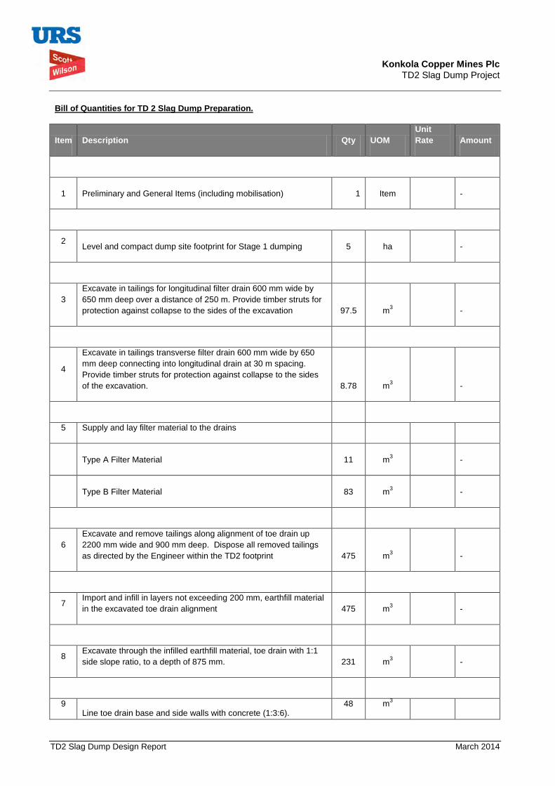
Konkola Copper Mines Plc TD2 Slag Dump Project
TD2 Slag Dump Design Report March 2014
Bill of Quantities for TD 2 Slag Dump Preparation.
Item Description Qty UOM
Unit Rate Amount
1 Preliminary and General Items (including mobilisation) 1 Item -
2 Level and compact dump site footprint for Stage 1 dumping 5 ha -
3 Excavate in tailings for longitudinal filter drain 600 mm wide by 650 mm deep over a distance of 250 m. Provide timber struts for protection against collapse to the sides of the excavation 97.5 m3
-
4
Excavate in tailings transverse filter drain 600 mm wide by 650 mm deep connecting into longitudinal drain at 30 m spacing. Provide timber struts for protection against collapse to the sides of the excavation. 8.78 m3
-
5 Supply and lay filter material to the drains
Type A Filter Material 11 m3 -
Type B Filter Material 83 m3 -
6 Excavate and remove tailings along alignment of toe drain up 2200 mm wide and 900 mm deep. Dispose all removed tailings as directed by the Engineer within the TD2 footprint 475 m3
-
7 Import and infill in layers not exceeding 200 mm, earthfill material in the excavated toe drain alignment 475 m3
-
8 Excavate through the infilled earthfill material, toe drain with 1:1 side slope ratio, to a depth of 875 mm. 231 m3
-
9 Line toe drain base and side walls with concrete (1:3:6).
48 m3

Konkola Copper Mines Plc TD2 Slag Dump Project
TD2 Slag Dump Design Report March 2014
Bill of Quantities for TD 2 Slag Dump Preparation.
Item Description Qty UOM
Unit Rate Amount
Concrete lining 75 mm thick. -
10 Excavate 2000 mm x 2000 mm x 1500 mm deep seepage collection sump at end of the toe drain. 6 m3
-
11 Cast reinforced concrete lining to the seepage collection sump 100 mm thick to all walls and floor. 1.7 m3
-
S/Total
-
VAT -
G/Total
-

Konkola Copper Mines Plc TD2 Slag Dump Project
TD2 Slag Dump Design Report March 2014
Priced Bill of Quantities for TD 2 Slag Dump Preparation - Engineers Estimate
Item Description Qty UOM Unit Rate (K)
Amount (K)
1 Preliminary and General Items (including mobilisation) 1 Item 45,000.00
2 Level and compact dump site footprint for Stage 1 dumping 5 ha 10,000.00
50,000.00
3 Excavate in tailings for longitudinal filter drain 600 mm wide by 650 mm deep over a distance of 250 m. Provide timber struts for protection against collapse to the sides of the excavation 97.5 m3
35.34
3,445.65
4 Excavate in tailings transverse filter drain 600 mm wide by 650 mm deep connecting into longitudinal drain at 30 m spacing. Provide timber struts for protection against collapse to the sides of the excavation. 8.78 m3
35.34
310.11
5 Supply and lay filter material to the drains
Type A Filter Material (Fine material) 88 m3 114.00
10,032.00
Type B Filter Material (Coarse material) 11 m3 252.00
2,772.00
6 Excavate and remove tailings along alignment of toe drain up 2200 mm wide and 900 mm deep. Dispose all removed tailings as directed by the Engineer within the TD2 footprint 475 m3
35.34
16,786.50
7 Import and infill in layers not exceeding 200 mm, earthfill material in the excavated toe drain alignment 475 m3
85.00
40,375.00
8 Excavate through the infilled earthfill material toe drain with 1:1 side slope ratio, to a depth of 875 mm . 231 m3
47.71
11,020.78
9 Line toe drain base and side walls with concrete (1:3:6). Concrete lining 75 mm thick. 48 m3
900.00
43,200.00
10 Excavate 2000 mm x 2000 mm x 1500 mm deep seepage collection sump at end of toe drain. 6 m3
47.71
286.26
11 Cast reinforced concrete lining to the seepage collection sump 100 mm thick to all walls and floor. 1.7 m3
1,950.00
3,315.00
S/Total 226,543.30
VAT
36,246.93
G/Total 262,790.23
USD 46,103.55
Konkola Copper Mines Plc TD2 Slag Dump Project
TD2 Slag Dump Design Report March 2014
Appendix 2: Stability Analysis Models

Konkola Copper Mines Plc TD2 Slag Dump Project
TD2 Slag Dump Design Report March 2014
Model 1: Height = 15 m, Static Loading Condition
Model 2: Height = 15 m, Seismic Loading Condition
1.740
Granualetd Slag
Tail ings
Foundation
Distance-2 0 2 4 6 8 10 12 14 16 18 20 22 24 26 28 30 32 34 36 38 40 42 44 46
Elev
atio
n
-2
0
2
4
6
8
10
12
14
16
18
20
22
24
26
28
30
1.535
Granualetd Slag
Tailings
Foundation
Distance-2 0 2 4 6 8 10 12 14 16 18 20 22 24 26 28 30 32 34 36 38 40 42 44 46
Elev
atio
n
-2
0
2
4
6
8
10
12
14
16
18
20
22
24
26
28
30
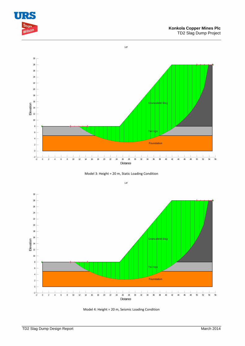
Konkola Copper Mines Plc TD2 Slag Dump Project
TD2 Slag Dump Design Report March 2014
Model 3: Height = 20 m, Static Loading Condition
Model 4: Height = 20 m, Seismic Loading Condition
1.67
Granualetd Slag
Tailings
Foundation
Distance-2 0 2 4 6 8 10 12 14 16 18 20 22 24 26 28 30 32 34 36 38 40 42 44 46 48 50 52 54 56
Elev
atio
n
-2
0
2
4
6
8
10
12
14
16
18
20
22
24
26
28
30
1.47
Granualetd Slag
Tailings
Foundation
Distance-2 0 2 4 6 8 10 12 14 16 18 20 22 24 26 28 30 32 34 36 38 40 42 44 46 48 50 52 54 56
Elev
atio
n
-2
0
2
4
6
8
10
12
14
16
18
20
22
24
26
28
30

Konkola Copper Mines Plc TD2 Slag Dump Project
TD2 Slag Dump Design Report March 2014
Model 4: Height = 25 m, Static Loading Condition
Model 5: Height = 25 m, Seismic Loading Condition
1.63
Granualetd Slag
Tailings
Foundation
Distance-2 0 2 4 6 8 10 12 14 16 18 20 22 24 26 28 30 32 34 36 38 40 42 44 46 48 50 52 54 56
Elev
atio
n
-2
0
2
4
6
8
10
12
14
16
18
20
22
24
26
28
30
32
34
36
38
40
1.44
Granualetd Slag
Tailings
Foundation
Distance-2 0 2 4 6 8 10 12 14 16 18 20 22 24 26 28 30 32 34 36 38 40 42 44 46 48 50 52 54 56
Elev
atio
n
-2
0
2
4
6
8
10
12
14
16
18
20
22
24
26
28
30
32
34
36
38
40
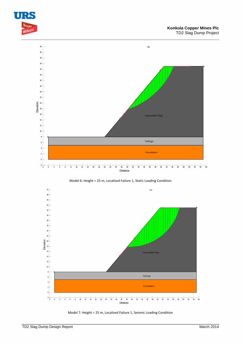
Konkola Copper Mines Plc TD2 Slag Dump Project
TD2 Slag Dump Design Report March 2014
Model 6: Height = 25 m, Localised Failure 1, Static Loading Condition
Model 7: Height = 25 m, Localised Failure 1, Seismic Loading Condition
1.56
Granualetd Slag
Tailings
Foundation
Distance-2 0 2 4 6 8 10 12 14 16 18 20 22 24 26 28 30 32 34 36 38 40 42 44 46 48 50 52 54 56
Elev
atio
n
-2
0
2
4
6
8
10
12
14
16
18
20
22
24
26
28
30
32
34
36
38
40
2.13
Granualetd Slag
Tailings
Foundation
Distance-2 0 2 4 6 8 10 12 14 16 18 20 22 24 26 28 30 32 34 36 38 40 42 44 46 48 50 52 54 56
Elev
atio
n
-2
0
2
4
6
8
10
12
14
16
18
20
22
24
26
28
30
32
34
36
38
40

Konkola Copper Mines Plc TD2 Slag Dump Project
TD2 Slag Dump Design Report March 2014
Model 8: Height = 25 m, Localised Failure 2, Static Loading Condition
Model 9: Height = 25 m, Localised Failure 2, Seismic Loading Condition
1.57
Granualetd Slag
Tail ings
Foundation
Distance-2 0 2 4 6 8 10 12 14 16 18 20 22 24 26 28 30 32 34 36 38 40 42 44 46 48 50 52 54 56
Elev
atio
n
-2
0
2
4
6
8
10
12
14
16
18
20
22
24
26
28
30
32
34
36
38
40
2.10
Granualetd Slag
Tailings
Foundation
Distance-2 0 2 4 6 8 10 12 14 16 18 20 22 24 26 28 30 32 34 36 38 40 42 44 46 48 50 52 54 56
Elev
ation
-2
0
2
4
6
8
10
12
14
16
18
20
22
24
26
28
30
32
34
36
38
40

Konkola Copper Mines Plc TD2 Slag Dump Project
TD2 Slag Dump Design Report March 2014
Model 10: Height = 25 m, Localised Failure 3, Static Loading Condition
Model 11: Height = 25 m, Localised Failure 3, Seismic Loading Condition
1.68
Granualetd Slag
Tailings
Foundation
Distance-2 0 2 4 6 8 10 12 14 16 18 20 22 24 26 28 30 32 34 36 38 40 42 44 46 48 50 52 54 56
Elev
atio
n
-2
0
2
4
6
8
10
12
14
16
18
20
22
24
26
28
30
32
34
36
38
40
2.21
Granualetd Slag
Tailings
Foundation
Distance-2 0 2 4 6 8 10 12 14 16 18 20 22 24 26 28 30 32 34 36 38 40 42 44 46 48 50 52 54 56
Elev
atio
n
-2
0
2
4
6
8
10
12
14
16
18
20
22
24
26
28
30
32
34
36
38
40
Konkola Copper Mines Plc
New Slag Dump Project
Draft Environmental and Social Impact Statement September 2014
Appendix B Granulated Copper Slag Materials Safety Data Sheet
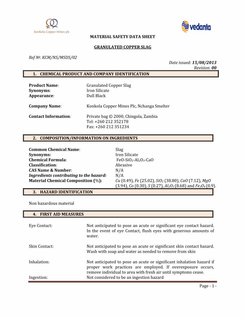
Page - 1 -
MATERIAL SAFETY DATA SHEET
GRANULATED COPPER SLAG
Ref №. KCM/NS/MSDS/02
Date issued: 15/08/2013 Revision: 00
1. CHEMICAL PRODUCT AND COMPANY IDENTIFICATION
Product Name: Granulated Copper Slag Synonyms: Iron Silicate Appearance: Dull Black
Company Name: Konkola Copper Mines Plc, Nchanga Smelter
Contact Information: Private bag © 2000, Chingola, Zambia
Tel: +260 212 352178 Fax: +260 212 351234
2. COMPOSITION/INFORMATION ON INGREDIENTS
Common Chemical Name: Slag Synonyms: Iron Silicate Chemical Formula: FeO-SiO2-Al2O3-CaO Classification: Abrasive CAS Name & Number: N/A Ingredients contributing to the hazard: N/A Material Chemical Composition (%): Cu (0.49), Fe (25.02), SiO2 (38.80), CaO (7.12), MgO
(3.94), Co (0.30), S (0.27), Al2O3 (8.68) and Fe3O4 (0.9).
3. HAZARD IDENTIFICATION
Non hazardous material
4. FIRST AID MEASURES
Eye Contact: Not anticipated to pose an acute or significant eye contact hazard.
In the event of eye Contact, flush eyes with generous amounts of water.
Skin Contact: Not anticipated to pose an acute or significant skin contact hazard.
Wash with soap and water as needed to remove from skin Inhalation: Not anticipated to pose an acute or significant inhalation hazard if
proper work practices are employed. If overexposure occurs, remove individual to area with fresh air until symptoms cease.
Ingestion: Not considered to be an ingestion hazard
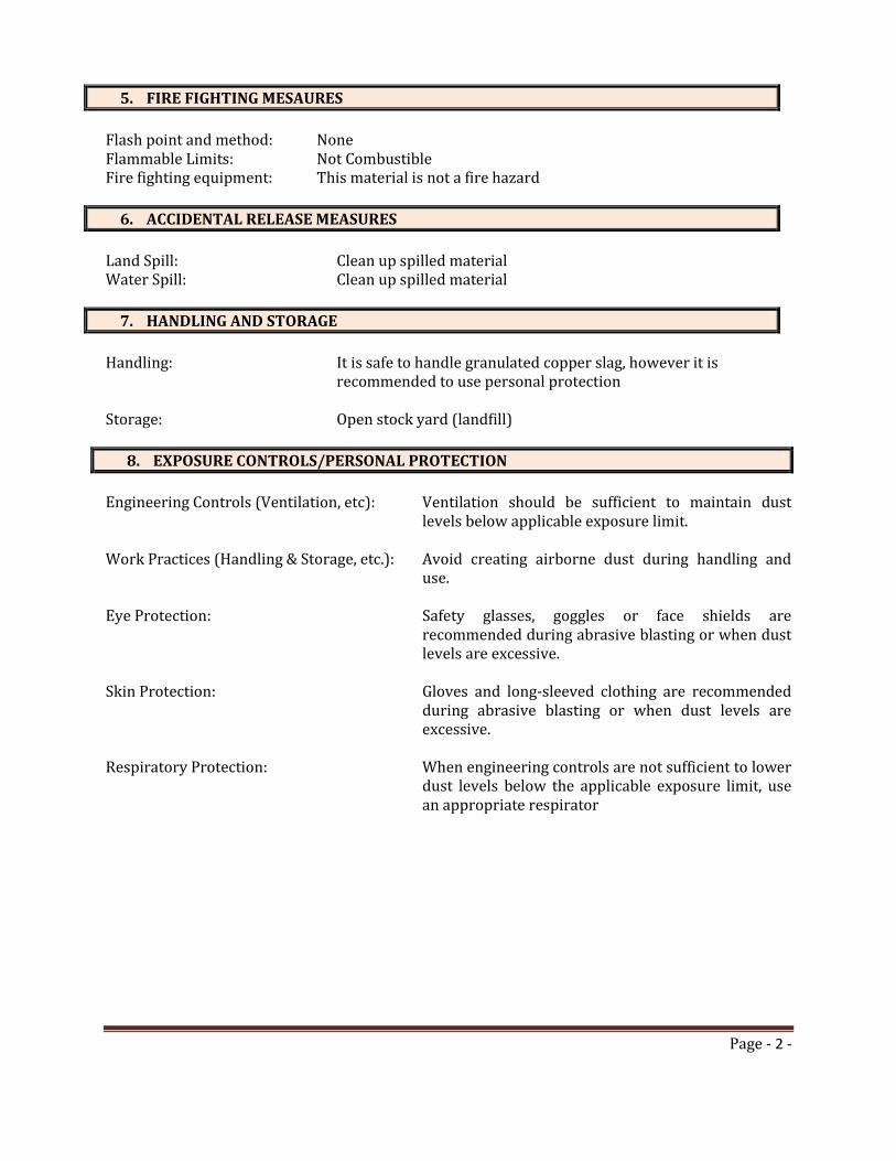
Page - 2 -
5. FIRE FIGHTING MESAURES
Flash point and method: None Flammable Limits: Not Combustible Fire fighting equipment: This material is not a fire hazard
6. ACCIDENTAL RELEASE MEASURES
Land Spill: Clean up spilled material Water Spill: Clean up spilled material
7. HANDLING AND STORAGE
Handling: It is safe to handle granulated copper slag, however it is
recommended to use personal protection Storage: Open stock yard (landfill)
8. EXPOSURE CONTROLS/PERSONAL PROTECTION
Engineering Controls (Ventilation, etc): Ventilation should be sufficient to maintain dust
levels below applicable exposure limit. Work Practices (Handling & Storage, etc.): Avoid creating airborne dust during handling and
use. Eye Protection: Safety glasses, goggles or face shields are
recommended during abrasive blasting or when dust levels are excessive.
Skin Protection: Gloves and long-sleeved clothing are recommended
during abrasive blasting or when dust levels are excessive.
Respiratory Protection: When engineering controls are not sufficient to lower
dust levels below the applicable exposure limit, use an appropriate respirator
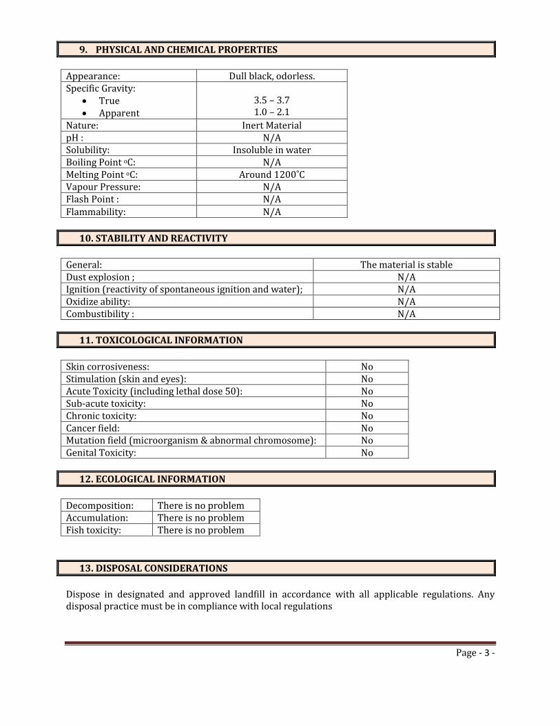
Page - 3 -
9. PHYSICAL AND CHEMICAL PROPERTIES
Appearance: Dull black, odorless. Specific Gravity:
True Apparent
3.5 – 3.7 1.0 – 2.1
Nature: Inert Material pH : N/A Solubility: Insoluble in water Boiling Point oC: N/A Melting Point oC: Around 1200˚C Vapour Pressure: N/A Flash Point : N/A
Flammability: N/A
10. STABILITY AND REACTIVITY
General: The material is stable Dust explosion ; N/A Ignition (reactivity of spontaneous ignition and water); N/A Oxidize ability: N/A Combustibility : N/A
11. TOXICOLOGICAL INFORMATION
Skin corrosiveness: No Stimulation (skin and eyes): No Acute Toxicity (including lethal dose 50): No Sub-acute toxicity: No Chronic toxicity: No Cancer field: No Mutation field (microorganism & abnormal chromosome): No Genital Toxicity: No
12. ECOLOGICAL INFORMATION
Decomposition: There is no problem Accumulation: There is no problem Fish toxicity: There is no problem
13. DISPOSAL CONSIDERATIONS
Dispose in designated and approved landfill in accordance with all applicable regulations. Any disposal practice must be in compliance with local regulations
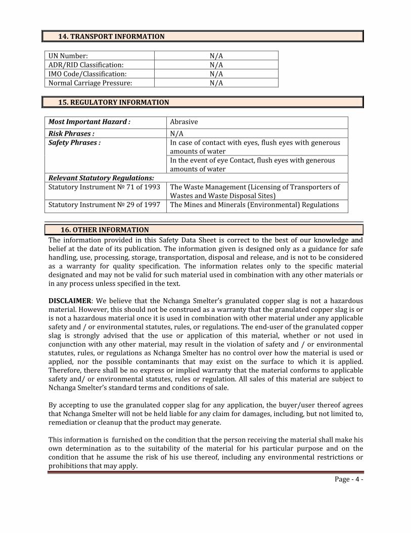
Page - 4 -
14. TRANSPORT INFORMATION
UN Number: N/A ADR/RID Classification: N/A IMO Code/Classification: N/A Normal Carriage Pressure: N/A
15. REGULATORY INFORMATION
Most Important Hazard : Abrasive
Risk Phrases : N/A Safety Phrases : In case of contact with eyes, flush eyes with generous
amounts of water In the event of eye Contact, flush eyes with generous amounts of water
Relevant Statutory Regulations: Statutory Instrument № 71 of 1993 The Waste Management (Licensing of Transporters of
Wastes and Waste Disposal Sites) Statutory Instrument № 29 of 1997 The Mines and Minerals (Environmental) Regulations
16. OTHER INFORMATION
The information provided in this Safety Data Sheet is correct to the best of our knowledge and belief at the date of its publication. The information given is designed only as a guidance for safe handling, use, processing, storage, transportation, disposal and release, and is not to be considered as a warranty for quality specification. The information relates only to the specific material designated and may not be valid for such material used in combination with any other materials or in any process unless specified in the text. DISCLAIMER: We believe that the Nchanga Smelter’s granulated copper slag is not a hazardous material. However, this should not be construed as a warranty that the granulated copper slag is or is not a hazardous material once it is used in combination with other material under any applicable safety and / or environmental statutes, rules, or regulations. The end-user of the granulated copper slag is strongly advised that the use or application of this material, whether or not used in conjunction with any other material, may result in the violation of safety and / or environmental statutes, rules, or regulations as Nchanga Smelter has no control over how the material is used or applied, nor the possible contaminants that may exist on the surface to which it is applied. Therefore, there shall be no express or implied warranty that the material conforms to applicable safety and/ or environmental statutes, rules or regulation. All sales of this material are subject to Nchanga Smelter’s standard terms and conditions of sale. By accepting to use the granulated copper slag for any application, the buyer/user thereof agrees that Nchanga Smelter will not be held liable for any claim for damages, including, but not limited to, remediation or cleanup that the product may generate. This information is furnished on the condition that the person receiving the material shall make his own determination as to the suitability of the material for his particular purpose and on the condition that he assume the risk of his use thereof, including any environmental restrictions or prohibitions that may apply.

Konkola Copper Mines Plc
New Slag Dump Project
Draft Environmental and Social Impact Statement September 2014
Appendix C Air Quality Assessment Report
TD2 Slag Dump Project June 2014
Konkola Copper Mines Plc TD2 Slag Dump Project
Air Quality Assessment i September 2014
Table of Contents
Abbreviations ............................................................................................ iii Executive Summary .................................................................................. iv
1 Introduction ..................................................................................... 1 1.1 Project Background ........................................................................................................ 1 1.1.1 Objectives of the study in relation to the overall project .................................................. 1 1.1.2 Location of the Project .................................................................................................... 1 1.2 Scope of the Work .......................................................................................................... 2 1.2.1 Study Area ...................................................................................................................... 2 1.2.2 Study Aspect .................................................................................................................. 2 1.3 ESIA Methodology .......................................................................................................... 3 1.3.1 Approach to Assessment ................................................................................................ 3 1.3.2 Consultation.................................................................................................................... 3 1.4 Structure of the Report ................................................................................................... 3
2 Policy, legal and Institutional Framework ..................................... 5 2.1 National .......................................................................................................................... 5 2.2 International agreements and Conventions ..................................................................... 8 2.3 International Standards ................................................................................................... 8 2.4 KCM Sustainability Policies ............................................................................................ 9
3 Project Description ....................................................................... 10 3.1 Project Proponent ......................................................................................................... 11 3.2 Project Overview .......................................................................................................... 11 3.3 Project Location ............................................................................................................ 11 3.4 Project Design – Slag Dump Design ............................................................................. 13 3.5 Construction Phase ...................................................................................................... 13 3.5.1 Site Preparation ............................................................................................................ 13 3.5.2 Construction Activities .................................................................................................. 13 3.6 Operation Phase ........................................................................................................... 14 3.7 Decommissioning and Closure Phase .......................................................................... 14
4 Project Alternatives ....................................................................... 15 4.1 Site 1: North of OB1 (Overburden Dump No. 1) ............................................................ 15 4.2 Site 2: South of TD3 and TD4 ....................................................................................... 15 4.3 Site 3: Mimbula Area .................................................................................................... 15 4.5 Site 4: Open Pit (main in pit) ......................................................................................... 15 4.6 Site 5: TD 2................................................................................................................... 15 4.7 Preferred Site ............................................................................................................... 16 4.8 The “No Action” or “No Project alternative” ................................................................... 16

Konkola Copper Mines Plc TD2 Slag Dump Project
Air Quality Assessment ii September 2014
5 Environmental and Social Impacts Assessment ........................ 17
6 Environmental Baseline Study ..................................................... 19 6.1 Scope and Methodology ............................................................................................... 19 6.1.1 Air Quality ..................................................................................................................... 19 6.2 Impact Assessment and Evaluation .............................................................................. 20 6.3 Mitigation Measures ...................................................................................................... 21 6.4 Conclusion .................................................................................................................... 22
7 Environmental Management and Monitoring Plan ...................... 23 7.1 Environmental and Social Management Plan ................................................................ 23 7.2 Roles and Responsibilities ............................................................................................ 23 7.3 Environmental and Social Monitoring Plan .................................................................... 23 7.4 Limitation of the Study .................................................................................................. 23
8 Consultation .................................................................................. 28
9 Conclusion ..................................................................................... 29
10 References ..................................................................................... 30
Appendices ............................................................................................... 31
Konkola Copper Mines Plc TD2 Slag Dump Project
Air Quality Assessment iii September 2014
Abbreviations Abbreviation Definition CSR Corporate Social Responsibility BAT Best Available Techniques COP Chingola Open Pit ECZ Environmental Council of Zambia EHS Environment Health and Safety EIA Environmental Impact Assessment ESIS Environmental and Social Impact Statement EMA Environmental Management Act EP Equator Principles EPF Environmental Protection Fund ESIA Environmental and Social Impact Assessment HIV/AIDS Human Immuno Virus/Acquired Immuno Deficiency Syndrome HSE Health Safety and Environment IFC International Finance Corporation KCM Konkola Copper Mine Plc masl metres above sea level MMDA Mines and Minerals Development Act
MSD Mine Safety Department MWSC Mulonga Water and Sewerage Company NWASCO National Water and Sanitation Council PM2.5 Particle Matter of Aerodynamic Diameter Less than 2.5µm PM10 Particle Matter of Aerodynamic Diameter Less than 10µm SHE Safety Health and Environment SI Statutory Instrument STIs Sexually Transmitted Infections TD Tailings Dam TLV Threshold Limit Value ToR Terms of Reference TSF Tailings Storage Facility TSP Total Suspended Particles TWA Time-weighted Average URS SW URS Scott Wilson USD United States Dollars WD Water Dam ZCCM-IH ZCCM-Investment Holdings ZEMA Zambia Environmental Management Agency
Konkola Copper Mines Plc TD2 Slag Dump Project
Air Quality Assessment iv September 2014
Executive Summary The two main emission sources that were identified in this project were windblown dust from the stockpiled slag and dust that will be generated on the haulage roads by the trucks. The slag material is coarse with a 4% silt content compared to 50% in tailings and will not generate much dust in terms of TSP and PM10. The contribution of the slag dump source and haulage roads to the ambient air in surrounding community nearest to the dump derived from air dispersion modelling is in the range of 4 to 9 µg/m3 PM10 and 13 µg/m3 which is the predominant wind direction. The project impacts will be of low significance to the residents and the environment. The air quality will still be within the guidelines in the Environmental Management(Licensing) regulations 2013.
L.J.Kalowa
Air Quality Specialist
Konkola Copper Mines Plc
TD2 Slag Dump Project
Air Quality Assessment 1 September 2014
1 Introduction KCM is proposing to construct a copper slag dump on an area where copper tailings were reclaimed. The area will be prepared during construction and water drainage facilities will be installed. The slag will be brought to site via dump trucks. The slag will be dumped on site and leveled by bulldozers. The final size of the slag dump over the entire dumping period will be 40 hectares. The air quality study is designed to assess the current air quality in the project area before the project commencement and to assess potential future air quality impacts during the construction and operation of the slag dump. The potential impacts are assessed against the provisions of the Environmental Management Act (Licensing) Regulations 2013, Emission Limits for Ambient Air Pollutants. The study has proposed mitigation measures for all adverse impacts
1.1 Project Background KCM owns and operates Nchanga, Konkola, Nkana and Nampundwe mine sites in Zambia. Nampundwe mine site is located in Lusaka Province while the other mines are located on the Copperbelt Province. At its Nchanga Mine Site in Chingola, KCM undertakes both underground and open cast mining operations.
In 2008, KCM commissioned the Nchanga Copper Smelter at Nchanga Mine to smelt copper concentrates from its own concentrators and purchased concentrates. The smelter is located within the main plant area at Nchanga mine site and it has a design capacity of 300,000 tonnes of finished copper per year. The main products produced from the smelter are copper anodes and the waste product is granulated slag. An estimated 35,000 tonnes of granulated slag is generated per month, which is about 1,000 to 1,500 tonnes of slag per day.
The slag is currently disposed of at Slag Dump No.25, which has a design capacity of 2.6 million tonnes, situated within the KCM Mine License area (LSM 34) on the South-eastern rim of Block A Open Pit. Approximately 1.75 million tonnes has so far been dumped. The dump is approaching its design capacity and its expansion is constrained by the existence of several physical features in the vicinity (Block A Open Pit, Chingola Stream, Chingola - Chililabombwe Public road, KCM Haulage Road and drain). There is currently inadequate space to dispose of the slag. There is need for an alternative dumping space. KCM is, therefore, proposing to undertake a project to construct and operate a new slag dump.
1.1.1 Objectives of the study in relation to the overall project The objective of the air quality study is to assess the potential impacts that may arise mainly from the haulage of slag to the dumping area, windblown dust that may arise from slag deposition and storage. The effects of exhaust gases and particulate emissions from the heavy mobile machinery are also assessed on their impacts in the environment.
1.1.2 Location of the Project This site is within the reclaimed TD2 tailings storage facility footprint adjacent to the Western flank of TD7 tailings storage facility. TD7 is currently being used as an emergency tailings dam. The site had previously contained large volumes of tailings which have since been reclaimed by hydraulic monitoring means.
Konkola Copper Mines Plc
TD2 Slag Dump Project
Air Quality Assessment 2 September 2014
1.2 Scope of the Work The scope of work involved:
• Desk study of available information from KCM and other mines operating similar operations.
• Site visits to get a clear view of site conditions and location of communities and other facilities in the area.
• Air quality sampling of existing condition in the area before project commencement (Appendix 2).
• The use of dispersion modelling techniques to determine impact areas for windblown dust from the slag dump and dust from haulage roads (Appendix 1)
• Determining impacts that require mitigation and recommend mitigation measures and monitoring plans.
1.2.1 Study Area The spatial boundaries for the study area will be fifteen Kilometers (15km) radius from the boundary of the project site (TD2). This entails that the assessment will not only be limited to the footprint of the proposed TD2 Slag Dump site (reclaimed TD2 tailings storage facility) but also areas where significant environmental and socio-economic impacts can be induced by the project.
1.2.2 Study Aspect The air quality is focussed on what potential impacts will arise during construction, operation and decommissioning of the slag dump. The main potential pollutant of study is the PM10 and TSP. The operations have potential to release dust on the roads and fine materials in the slag could be dispersed naturally by prevailing winds in the area.
Site Preparation
Grading and widening of access roads will generate some dust. The generation of this dust is expected to be for a short duration and will be of low significance.
There will be some dust arising from the site levelling operation. These works will generate some dust but the dust levels will be mainly in the locality for a short duration and of low significance.
The use of heavy mobile machinery releases gases and particulates. The exhaust emissions include nitrous oxides, carbon monoxide gases and particulate matter. The impacts of these emissions are expected to be of low impact to the air quality and hence to the environment.
Operation phase
There will be movement of dump truck to move the slag from the smelter to the dump. The movement of haulage truck will generate some dust and with some mitigation this dust generation will be kept low.
Similarly tipping of the material will not generate much dust because of the coarse nature of the slag material.
Konkola Copper Mines Plc
TD2 Slag Dump Project
Air Quality Assessment 3 September 2014
The dumped granulated slag is fairly coarse and will resist wind erosion. Dust emissions from the slag dump are expected to be low.
Decommissioning and Closure
Similarly the residual dumped slag is expected to be stable, maintain its coarse particle size and hence dust emissions from the dump will be low, in the locality and will be of low significance.
1.3 ESIA Methodology 1.3.1 Approach to Assessment
The ESIA Methodology and the approach to assessment is outlined in the Final Terms of Reference presented in Appendix A of the main ESIA report for the proposed Slag Dump.
Ambient Air Quality
Ambient air quality monitoring is on the baseline studies included as part of the ESIA study. The monitoring was conducted to establish ambient air quality baseline conditions within the project area prior to the construction and operation of the proposed slag dump. A multi-gas analyser fitted with an in-built pump to suck air was used to analyse ambient air quality at predetermined sampling points. The results were compared with ZEMA and World Bank Ambient Air quality guidelines.
A DustMate instrument for measuring TSP, PM10 and PM2.5 particles was used to determine the baseline values in the TD2 area surrounding community
The monitoring exercise was conducted at selected sampling points for five days to be able to get representative results indicative of the baseline ambient air quality within the project area prior to commencement of the project.
1.3.2 Consultation The air quality study was informed by the submissions of stakeholders’ concerns on mainly dust from the operations. The issues were raised at the scoping meeting at Mushishima Primary school. The air quality sampling was conducted in the field were the locals also indicated their experiences with some dust in the area. The people at Milenda farm showed the sampling point where the dust levels were expected to be high.
1.4 Structure of the Report The report has sections under the listing below. The air quality impact assessment is underpinned by the two appended reports. The report on the baseline air quality sampling (Appendix 2) and the TD2 slag dump dispersion modelling reports (Appendix 1).
Executive Summary
Introduction
Policy, Legal and Institutional Framework
Project Description
Project Alternatives
Environmental Baseline
Konkola Copper Mines Plc
TD2 Slag Dump Project
Air Quality Assessment 4 September 2014
Environmental and Social Impacts
Potential Impact Assessment/Evaluation
Environmental Management and Monitoring Plan
Consultation
Conclusion
References
Appendices
Konkola Copper Mines Plc
TD2 Slag Dump Project
Air Quality Assessment 5 September 2014
2 Policy, legal and Institutional Framework 2.1 National
Environmental Management Act, 2011
The Zambian Environmental Management Act (EMA), 2011 is the superior Act on matters relating to environmental protection and management. Its superiority is outlined in Section 3 of the Act. The Act sets out a framework for Environmental Impact Assessments (EIA's) as well as renaming the Environmental Council of Zambia (ECZ) as the Zambia Environmental Management Agency (ZEMA), a regulatory Agency mandated to do all such things as are necessary to ensure the sustainable management of natural resources and the protection of the environment, and the prevention and control of pollution.
The EMA outlines principles governing environmental management and provides for, among other things, Environmental Impact Assessment and regulations relating to environmental assessments. The Act has also spelt out offences relating to failure to prepare and submit an EIA report for projects that require such reports.
The projects that require preparation of EIA reports must be approved by ZEMA prior to implementation. Section 29 of the Act specifically states that “a person shall not undertake any project that may have an effect on the environment without the written approval of the Agency, and except in accordance with any conditions imposed in that approval”.
The Environmental Protection and Pollution Control (Environmental Impact Assessment) Regulations, 1997 (Statutory Instrument No. 28 of 1997) specifies the requirements for an EIA and it also sets out in its Second Schedule projects for which EIAs are applicable. It provides specific guidelines for conducting environmental impact assessments and for evaluation of environmental impact statements. The regulations require project developers undertaking projects that may have significant effect on the environment to conduct environmental impact assessment prior to obtaining written approval from ZEMA on implementation of the project. Regulation 3 of the Instrument specifically states that “A developer shall not implement a project for which a project brief or an environmental impact statement is required under these Regulations, unless the project brief or an environmental impact assessment has been concluded in accordance with these Regulations.
New Slag Dump Project will be implemented in accordance with the provisions of the Act and applicable environmental regulations.
Mines and Mineral Development Act, 2008
The Mines and Minerals Development Act (MMDA), 2008 addresses issues of environmental, human health and safety in the mining sector in Zambia. The Mines and Minerals (Environmental) Regulations, 1997 (Statutory Instrument No. 29 of 1997), a subsidiary legislation of the MMDA, provides a framework for preparing and submitting environmental project briefs and environmental impact statements prior to undertaking any prospecting, exploration or mining operations. The regulations also provide for, among other things, auditing of environmental and social management plans, mine dump reporting, mine site closure and associated decommissioning and closure costs, storage areas and handling of hazardous materials.
Table 2.1 presents a summary of some of the Zambian legislations that are relevant in the implementation of the proposed Project sections.
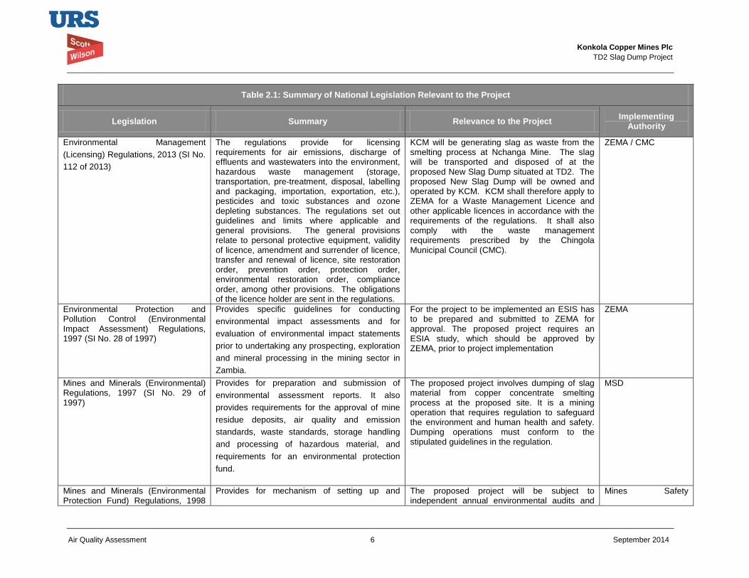
Konkola Copper Mines Plc
TD2 Slag Dump Project
Air Quality Assessment 6 September 2014
Table 2.1: Summary of National Legislation Relevant to the Project
Legislation Summary Relevance to the Project Implementing Authority
Environmental Management (Licensing) Regulations, 2013 (SI No. 112 of 2013)
The regulations provide for licensing requirements for air emissions, discharge of effluents and wastewaters into the environment, hazardous waste management (storage, transportation, pre-treatment, disposal, labelling and packaging, importation, exportation, etc.), pesticides and toxic substances and ozone depleting substances. The regulations set out guidelines and limits where applicable and general provisions. The general provisions relate to personal protective equipment, validity of licence, amendment and surrender of licence, transfer and renewal of licence, site restoration order, prevention order, protection order, environmental restoration order, compliance order, among other provisions. The obligations of the licence holder are sent in the regulations.
KCM will be generating slag as waste from the smelting process at Nchanga Mine. The slag will be transported and disposed of at the proposed New Slag Dump situated at TD2. The proposed New Slag Dump will be owned and operated by KCM. KCM shall therefore apply to ZEMA for a Waste Management Licence and other applicable licences in accordance with the requirements of the regulations. It shall also comply with the waste management requirements prescribed by the Chingola Municipal Council (CMC).
ZEMA / CMC
Environmental Protection and Pollution Control (Environmental Impact Assessment) Regulations, 1997 (SI No. 28 of 1997)
Provides specific guidelines for conducting environmental impact assessments and for evaluation of environmental impact statements prior to undertaking any prospecting, exploration and mineral processing in the mining sector in Zambia.
For the project to be implemented an ESIS has to be prepared and submitted to ZEMA for approval. The proposed project requires an ESIA study, which should be approved by ZEMA, prior to project implementation
ZEMA
Mines and Minerals (Environmental) Regulations, 1997 (SI No. 29 of 1997)
Provides for preparation and submission of environmental assessment reports. It also provides requirements for the approval of mine residue deposits, air quality and emission standards, waste standards, storage handling and processing of hazardous material, and requirements for an environmental protection fund.
The proposed project involves dumping of slag material from copper concentrate smelting process at the proposed site. It is a mining operation that requires regulation to safeguard the environment and human health and safety. Dumping operations must conform to the stipulated guidelines in the regulation.
MSD
Mines and Minerals (Environmental Protection Fund) Regulations, 1998
Provides for mechanism of setting up and The proposed project will be subject to independent annual environmental audits and
Mines Safety
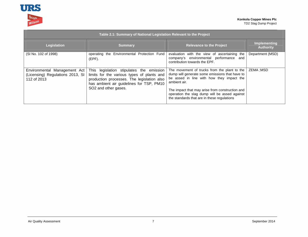
Konkola Copper Mines Plc
TD2 Slag Dump Project
Air Quality Assessment 7 September 2014
Table 2.1: Summary of National Legislation Relevant to the Project
Legislation Summary Relevance to the Project Implementing Authority
(SI No. 102 of 1998) operating the Environmental Protection Fund (EPF).
evaluation with the view of ascertaining the company’s environmental performance and contribution towards the EPF.
Department (MSD)
Environmental Management Act (Licensing) Regulations 2013, SI 112 of 2013
This legislation stipulates the emission limits for the various types of plants and production processes. The legislation also has ambient air guidelines for TSP, PM10 SO2 and other gases.
The movement of trucks from the plant to the dump will generate some emissions that have to be assed in line with how they impact the ambient air.
The impact that may arise from construction and operation the slag dump will be assed against the standards that are in these regulations
ZEMA ;MSD
Konkola Copper Mines Plc
TD2 Slag Dump Project
Air Quality Assessment 8 September 2014
2.2 International agreements and Conventions Table 2.2 summarises international conventions and agreements to which the Zambian Government is a party and which are applicable to the project. The agreements and protocols impose obligations on Zambia to address issues or topics included in these documents.
Table 2.2: International Conventions relevant to the Project
Convention Relevance
Convention on Biological Diversity (ratified in 1993)
The objectives the Zambia’s National Biodiversity Action Plans include, ensuring the conservation of a full range of Zambia’s natural ecosystems through a network of protected areas, development and implementation of strategies for conservation of biodiversity, sustainable use and management of biological resources. Biological resources of significant conservation value that will be identified during Project implementation will be conserved and protected.
Convention on Wetlands of International Importance (1975)
The Convention aims at promoting conservation and sustainable use of wetlands and their resources for the benefit of the present and future generations. The Project development and implementation would need to be undertaken in a way that should not comprise the ecological character of the nearby water bodies.
Convention Concerning the Protection of World Heritage (1972)
The Convention aims at ensuring the identification, protection, conservation, presentation and transmission to future generations of the cultural and natural heritage. Cultural and natural heritage sites that may be identified during implementation of the proposed Project will be protected and conserved in accordance with the provisions of the Convention to which Zambia is party to.
2.3 International Standards 2.3.1 International Finance Corporation Performance Standards
The IFC Performance Standards set out the underlying principles for sustainable project management, including impact/risk assessment, mitigation strategies, public consultation and performance monitoring.
Their relevance to the Project is briefly summarised below:
• IFC Performance Standard 1: Assessment and Management of Environmental and Social Risks and Impacts: Establishes requirements for social and environmental performance management throughout the life of a project through initial baseline studies and identification of risks and impacts, establishment of management programmes that describe mitigation and performance improvement measures and actions to address identified risks and impacts, stakeholder engagement and application of management system to monitor and improve performance.
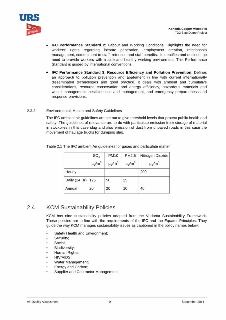
Konkola Copper Mines Plc
TD2 Slag Dump Project
Air Quality Assessment 9 September 2014
• IFC Performance Standard 2: Labour and Working Conditions: Highlights the need for workers’ rights regarding income generation, employment creation, relationship management, commitment to staff, retention and staff benefits. It identifies and outlines the need to provide workers with a safe and healthy working environment. This Performance Standard is guided by international conventions.
• IFC Performance Standard 3: Resource Efficiency and Pollution Prevention: Defines an approach to pollution prevention and abatement in line with current internationally disseminated technologies and good practice. It deals with ambient and cumulative considerations, resource conservation and energy efficiency, hazardous materials and waste management, pesticide use and management, and emergency preparedness and response provisions.
2.3.2 Environmental, Health and Safety Guidelines
The IFC ambient air guidelines are set out to give threshold levels that protect public health and safety. The guidelines of relevance are to do with particulate emission from storage of material in stockpiles in this case slag and also emission of dust from unpaved roads in this case the movement of haulage trucks for dumping slag.
Table 2.1 The IFC ambient Air guidelines for gases and particulate matter
2.4 KCM Sustainability Policies KCM has nine sustainability policies adopted from the Vedanta Sustainability Framework. These policies are in line with the requirements of the IFC and the Equator Principles. They guide the way KCM manages sustainability issues as captioned in the policy names below:
• Safety Health and Environment; • Security; • Social; • Biodiversity; • Human Rights; • HIV/AIDS; • Water Management; • Energy and Carbon; • Supplier and Contractor Management.
SO2
µg/m3
PM10
µg/m3
PM2.5
µg/m3
Nitrogen Dioxide
µg/m3
Hourly 200
Daily (24 Hr) 125 50 25
Annual 20 20 10 40
Konkola Copper Mines Plc
TD2 Slag Dump Project
Air Quality Assessment 10 September 2014
3 Project Description The proposed project will include the construction, operations and decommissioning stages. . The following describes the different project elements in more detail;
• Site preparation by leveling the existing surface of the Project Site. The proposed Project site is the reclaimed TD2 area with a footprint of approximately 120 ha. The proposed slag dump will be located within the TD2 footprint and is expected to cover an area of approximately 100 ha. In order to ensure the safe disposal of slag material at the proposed site it will be necessary to improve the surface layout of the site. The surface elevations currently range between 1292 masl and 1297 masl over the entire surface, with the high sections being around the central part of the dump. Preparation of the surface through leveling and infilling of some much lower section will provide an even surface over which dump trucks and other access vehicle will be able to pass safely during dumping. The extent that the proposed dumpsite will cover will ensure that drainage of the area is well maintained with minimal environmental consequences. Adequate buffer zones will be created between the edge of the dump and any existing external drainage systems;
• Grading and improvement of existing access roads from the Smelter Plant to the Project Site. It is proposed that access to the proposed dump site will be along already existing access routes from the main plant area to TD2 TSF and the adjacent TD 2 reclamation pumping station. The access roads are currently used as access to other dumps that are further North such as TD3 and TD4. Dump trucks will be used along these access gravel roads and therefore there is need to improve their current condition. Areas of improvement will include drainage, widening and grading of the roads. There will also be improvement to the existing road safety particularly at the road crossing with the main truck road that the access road will intersect with; namely Chingola-Solwezi (T5) road;
• Construction of the drainage network around the Project Site: This will be done in the early stages of the project and also as and when the need arises during the operational phase. The drainage pattern around the proposed site will need to be done in such away that the runoff is captured and treated prior to discharge into the receiving natural watercourses. The Project site is drained by the Mushishima and Chingola Streams. Where ground profile allows, the drainage will be profiled so that it discharges into the Pollution Control Dam (PCD).
• Dumping of slag material: Material from the Smelter Plant will be hauled in dump trucks [30-40 tonnes truck] and transported to the proposed dump site. Approximately 1500 tonnes of slag material will be dumped at the site per day and at least two dump trucks will be involved in the dumping operations. The dumping operations will basically involve end tipping of the granulated slag from the dump trucks and the subsequent spreading and leveling of the material. The material will be spread and leveled using either a Grader or Dozer. Selection of the appropriate equipment to use will be determined by the amount of spreading required and the stage of the development of the dump. At elevated heights use of the more versatile Dozer will be appropriate. Material will be dozed outwardly towards the edges to ensure the dump slope profile is formed and at the same time ensure all material is within the designed footprint of the dump. The design of the dump will take into account the maximum height of the dump in relation to the surrounding environment. The proposed design will be to develop the dump site in modular cells with each cell storing up to one years’ production of granulated slag.
The anticipated waste from the construction works is mainly construction rubble and un-reclaimed tailings, which will be disposed of at designated dump site.
Konkola Copper Mines Plc
TD2 Slag Dump Project
Air Quality Assessment 11 September 2014
3.1 Project Proponent The project proponent is Konkola Copper Mines Plc (KCM) and will hold all project operating approvals and authorisations.
3.2 Project Overview Slag dumpsite No. 25 was commissioned in 2010. The slag that was dumped at the unauthorised dump was also shifted to this dump site thereby drastically reducing dump’s design capacity. As a result, KCM intends to construct and operate a new slag dump. The proposed site for the new slag dump is a brownfield site located at the reclaimed TD2 facility.
The proposed Slag Dump will have an operational life of approximately 20 years, storing an estimated 10.95 million tonnes of slag material. The proposed slag dump will cover a maximum footprint area of 40 ha.
3.3 Project Location The proposed slag dump site is within the footprint of the reclaimed TD2 Tailings Storage Facility (TSF). The site has previously contained large volumes of tailing, most of which has since been reclaimed for mineral reprocessing. The remaining surface of the area is largely bare with isolated patches of grass vegetation in certain places. The surface is uneven with old anthills exposed in places where the reclamation process has been completed. There are several old drainage paths over the surface that were used for directing tailings slurry into collection sumps during the active reclamation activities.
TD2 lies about 6.2 Km to the North-West of the Smelter Plant Complex and covers an area of about 100 ha. At its widest point the site is approximately 1.5 km wide in a North-South direction. To the northern end of the TSF is an open grassy area with a fall towards the Mushishima Stream, which is approximately 1 Km further north. An access gravel road forms the boundary between the TSF and the open northern area. Eroded tailings from the TSF have covered some section of the northern area.
To the immediate East is the TD2 pumping station. An access road running in a North-South direction forms the boundary between the pumping station and the TSF. To the South of the proposed site is TD7 Tailings Storage Facility. An earthfill embankment forms the boundary between TD7 and TD2. TD7 has also been largely reclaimed.
To the West and South-West is the Milenda Dairy Farm. An access road, open drain and a partially wooded area forms a buffer boundary between the edge of the TD2 TSF and Milenda Dairy Farm.
Figure 3.1 shows the location of the proposed project site for the new Slag Dump at TD2.
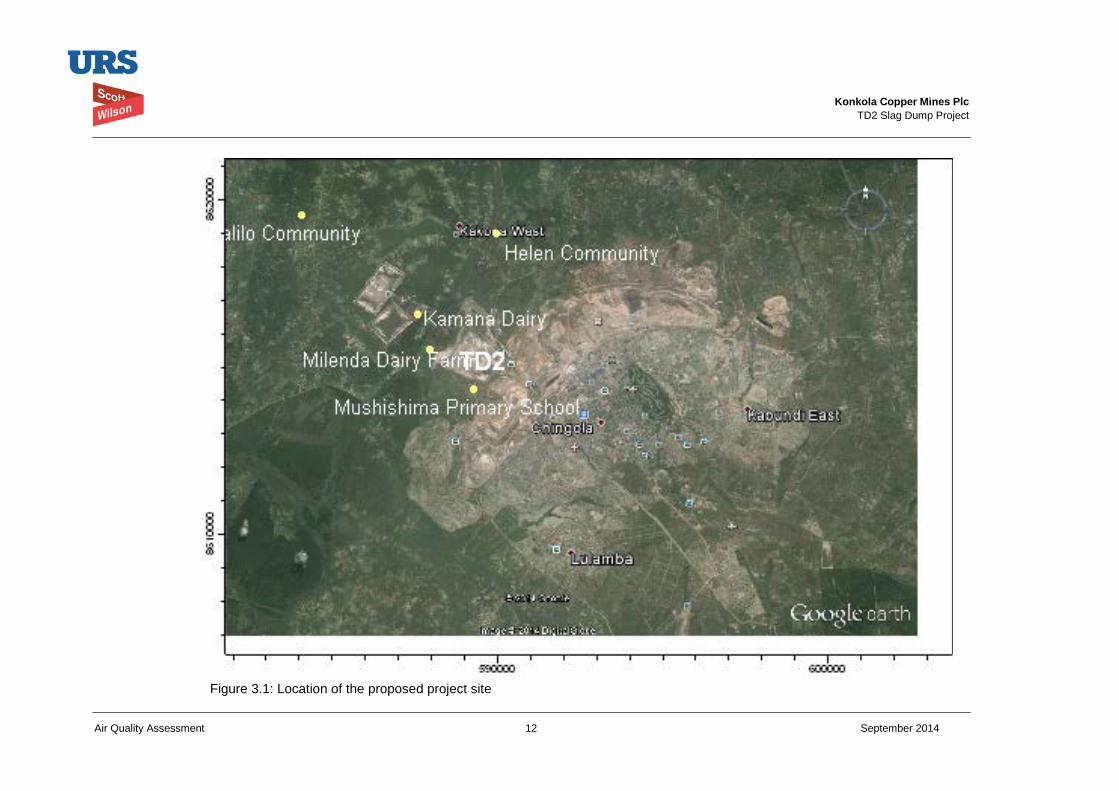
Konkola Copper Mines Plc
TD2 Slag Dump Project
Air Quality Assessment 12 September 2014
Figure 3.1: Location of the proposed project site
Konkola Copper Mines Plc
TD2 Slag Dump Project
Air Quality Assessment 13 September 2014
3.4 Project Design – Slag Dump Design The philosophy that forms the basis of the design of the granulated slag dump is to provide a cost effective storage of the slag material in a facility that is stable, safe and mitigates against adverse environmental and social impacts.
The basic design criteria that have been adopted are outlined below:
• Effective stabilisation and compaction of the underlying foundation and access road to ensure overall dump stability;
• Stable configuration of the dump to ensure low aesthetic change to the surrounding environment and its surroundings;
• Management of seepage to mitigate against adverse environmental impacts;
• Stormwater management to avoid undue contamination of clean water; and
• Modular development of the dump in stages, to reduce the overall initial capital cost investment.
3.5 Construction Phase
3.5.1 Site Preparation Site preparation activities (Refer to the TD2 Slag Dump Design Report). The following main key activities will be undertaken as part of site preparation before dumping: • Prepare access road from the plant to the dump.
• Grade existing access road including widening. The grading and widening of the road will generate some dust. The road grading will be not more than three kilometre. The road way already exits. The duration of this activity will be short and the impacts are likely to be low in the local area. The nearest settled community is at Mushishima.
• Construct over the tailings an access road to the dumping locations.
3.5.2 Construction Activities • Construct longitudinal and transverse filter drains; The work of the drains on construction
of the drains is a local activity that will generate some dust but it will be for a short duration and may have an impact in the local area .the emission of dust from this activity will be low key.
• Construct lined toe-drain; and The construction of the drains will be again a low impact activity.
• . Construct seepage collection sump. This activity is a very small civil works with low impact on the environment.
Konkola Copper Mines Plc
TD2 Slag Dump Project
Air Quality Assessment 14 September 2014
3.6 Operation Phase Dumping of slag material: Material from the Smelter Plant will be hauled in dump trucks [30-40 tonnes truck] and transported to the proposed dump site. Approximately 1500 tonnes of slag material will be dumped at the site per day and at least two dump trucks will be involved in the dumping operations. The use of haulage trucks for about fifty trips a day from the plant to dumpsite will generate some dusts on unpaved roads. The dust levels can be managed to limit emissions such that the impact will be moderate to low,
There will also be gaseous and some particulate emissions from the haulage trucks and they are expected to have a localized effect and of minimal significance.
The dumping operations will basically involve end tipping of the granulated slag from the dump trucks and the subsequent spreading and leveling of the material.
The material will be spread and leveled using either a Grader or Dozer. Material will be dozed outwardly towards the edges to ensure the dump slope profile is formed and at the same time ensure all material is within the designed footprint of the dump.
3.7 Decommissioning and Closure Phase The slag dump material at closure is likely to remain where it is dumped. The dust emissions from the dump are unlikely to change as the slag is fairly stable. The particle size of the dumped material will remain coarse. After the wind erosion of the top layers after active dumping stops mostly coarse material without fines will remain in the top layer. The wind will not be turning the slag material and hence emissions from this source will be greatly reduced. Dust emission from the dump will be low and may affect only a local area and will have a low significance.
Konkola Copper Mines Plc
TD2 Slag Dump Project
Air Quality Assessment 15 September 2014
4 Project Alternatives Five sites have been identified within the KCM Mine License Area. The sites have been assessed based on the site selection criteria that take into account environmental, social and economic factors.
The subsections below give brief characteristics of the identified sites.
4.1 Site 1: North of OB1 (Overburden Dump No. 1)
This site is located to the North of OB1. The preliminary assessment has indicated that the following:
• The site is a greenfield with a modified habitat;
• The site has no direct route to access it;
• It is also located at long distance from the Nchanga Smelter.
4.2 Site 2: South of TD3 and TD4
Site 2 is located to the South of TD3 and TD4. The preliminary assessment has indicated the following:
• The site will require resettlement and/or compensation of some local communities;
• The site is very close to the Chingola – Solwezi road;
• It is also a greenfield site with a modified habitat.
4.3 Site 3: Mimbula Area The preliminary assessment of Site 3 situated in Mimbula Area has indicated the following:
• The site will require resettlement and/or compensation of people;
• The site is located at a long distance from the Smelter;
• There is no direct route to access the site;
• Greenfield site with a modified habitat.
4.5 Site 4: Open Pit (main in pit)
Site 4 is located in the Nchanga Open Pit (main in pit). Preliminary assessment indicates the following:
• The site is near to the Smelter but has safety risks on underground operations;
• No resettlement and/or compensation of people will be required;
• The site is not visible to the general public;
• It is a brownfield site with no significant impacts on biodiversity.
4.6 Site 5: TD 2
Site 5 is located at the reclaimed TD2 tailings storage facility. Preliminary assessment of the site indicates the following:
Konkola Copper Mines Plc
TD2 Slag Dump Project
Air Quality Assessment 16 September 2014
• The site is near to Nchanga Smelter;
• There will be no resettlement and/or compensation issues associated with the site;
• The site is highly visible to the general public;
• The site is a brownfield with no significant impacts on biodiversity;
• The site has already an existing access road, which will need to be widened.
4.7 Preferred Site
The preferred site is the reclaimed TD2 tailings storage facility because it is a brownfield site and is near to the smelter. It is approximately 6.2 km from the Smelter. The site has adequate area (100 ha) that gives the proposed slag dump an expected lifespan of 20 years. Access road to the proposed dump is readily available. There are no resettlement or compensation issues associated with the preferred site.
4.8 The “No Action” or “No Project alternative” Under the “No Projective Alternative”, any potential adverse environmental and social impacts associated with the project would not occur. However, the preliminary assessment indicates that the disadvantages with the no project scenario include the following:
• Significant reduction in copper production since there will be limited space for slag disposal, a process directly connected to the operations of the smelter;
• Loss of employment for people working at the smelter and associated plant facilities;
• Loss of government revenue through reduced taxes;
• Loss of business for suppliers and contractors directly and indirectly dependent on the operations of the smelter.
Konkola Copper Mines Plc
TD2 Slag Dump Project
Air Quality Assessment 17 September 2014
5 Environmental and Social Impacts Assessment The potential impacts of the proposed Project have been identified and assessed based on review of project description and critical assessment of the project components in relation to the prevailing environmental and social baseline conditions. The identification and assessment of potential impacts was also based on applicable national legislations and design guidelines for the slag dump.
A standard impact assessment methodology was be applied on identified impacts and took into account the nature1 or status of the predicted impact, extent of the impact2, magnitude or intensity3 of the impact, the duration4 of the impact and the probability5 of the impact occurring. The impacts were given a rating using the assessment criteria as indicated in Table 5.1. The overall significance of the impact was obtained based on the extent (E), duration (D), intensity (I) and probability of the impact (P) occurring.
Significance of predicted impact (S) = (E + D + I) x P
The impact assessment terminology and ratings used to describe the impacts are presented in Table 5.1.
Table 5.1: Impact Assessment Terminology and Ratings to be used in determining significance
Assessment Terminology Ratings Used for determining significance
Nature of predicted impacts (N)
Neutral No impact on the environment 0
Negative Adverse impact on the environment -
Positive Beneficial impact on the environment +1
Duration of predicted impact (D)
Short term An impact that persists for 0 - 5 years 1
Medium term An impact that persists for between 5 - 15 years. 2
Long term An impact that will cease after the operation life of the project. 3
Permanent No mitigation will occur (Permanent feature) 4
Extent of the impact ( E)
Site specific Impact within the boundaries of the site 1
Local Impact within an area of 5 km of the site 2
1Nature of impact – an appraisal of the type of effect an activity would have on the affected environment. 2Extent of the impact – indicates whether the impact will be site specific, local, regional, national or international. 3Magnitude or intensity of the impact – indicates whether the impact is destructive or benign. 4Duration of the impact – indicates the lifetime of the impact as either short-term, medium-term and long-term. 5Probability of the impact – describes the likelihood of the impact actually occurring.
Konkola Copper Mines Plc
TD2 Slag Dump Project
Air Quality Assessment 18 September 2014
Table 5.1: Impact Assessment Terminology and Ratings to be used in determining significance
Assessment Terminology Ratings Used for determining significance
Regional Impact within the Copperbelt Province 3
National Impact on national scale 4
Intensity of the impact (I)
Low Impact affects the environment in such a way that no natural, cultural and social functions and processes are affected.
1
Medium
Where the affected environment is altered but natural, cultural and social functions and processes continue, albeit in a modified way.
2
High Natural, cultural or social functions and processes are altered to the extent that they will temporarily cease.
3
Very high Natural, cultural or social functions and processes are altered to the extent that they will permanently cease.
4
Probability of impact (P)
Improbable The possibility of the impact to materialise is very low. 2
Probable There is a distinct possibility that the impact will occur. 4
Highly probable It is most likely the impact will occur. 6
Definite The impact will occur regardless of any prevention or corrective actions. 8
Significance of predicted impact (S) = (E + D + I) x P
High
An impact that is capable of causing sufficient change in the environment and fundamentally affect the status, potential productivity or usage of the environment.
> 50
Medium
An impact that is capable of causing change in the environment but does not fundamentally affect the status, potential productivity or usage of the environment.
25 – 50
Low An impact which is either too small to be measured or does not give rise to any material change in the environment.
< 25
Konkola Copper Mines Plc
TD2 Slag Dump Project
Air Quality Assessment 19 September 2014
6 Environmental Baseline Study The air quality baseline studies were conducted by sampling of the air in at designated sites in the project area. The air quality sampling was conducted for dust mainly TSP, PM10 and PM2.5 particles. Some gases including sulphur dioxide ,carbon monoxide and Oxides of Nitrogen were also sampled.
6.1 Scope and Methodology Ambient air quality survey within Tailings Dam 2 (TD 2) and the surrounding community was conducted from 21st June to 26th June 2014. The air quality measurements were done in the TD2 project area and covered areas where there are existing settlements and farming activities. The TESTO 350XL Multi- Gas Analyzer was used sample gases for 20 minutes duration and determining the constituents. The Multigas instrument draws in a sample and is determined electronically by the pre-calibrated instrument. The gases that were sampled were oxygen, carbon monoxide, nitrous oxides and sulphur dioxide. The readings were obtained in ppm except for oxygen and were converted to µg/m³. . The DustMate instrument was used to determine the Total Suspended Solids (TSP), PM10 and PM2.5 particles. The DustMate is also pre-calibrated instrument and uses a laser to give also direct readings of the dust levels in the field. The instrument has a post field facility to download the data into the computer for processing. The full report on the field air quality sampling is given in Appendix 2.
6.1.1 Air Quality Chingola is a town whose economic activity is based on mining. KCM operates a number of open pits, metallurgical plants which include a smelter. There are also a number of tailings dams from past operations which are being reprocessed. A number of companies in Chingola are involved in support industries which provide some engineering services and supply of some mine requirements. There are no major industries with production units which are continuously contributing to air emissions. KCM is operating a smelter which has some emissions of sulphur dioxide and particulate emission. The Smelter is fitted with an acid plant and recovers most of the sulphur dioxide and particulate emissions .Blasting in the open pits and also hauling of the ores to the processing plants are some of the sources of particulate and gaseous emissions in the area. The various stockpiles of materials on overburden dumps, tailings dam will contribute to sources of windblown dust from stockpiles. TD2 area is bounded by two roads to Solwezi and to Chililabombwe which have heavy traffic that is a source of gaseous emissions and particulates from the trucks and other light vehicles. The traffic survey on T3 (Chingola Chililabombwe Road) and T5 (Chingola-Solwezi Road) showed a heavy movement of vehicles. The survey shows that about 240 vehicles go to and from T3 and 470 go to and from T3 daily. The combustion of fuels mainly firewood, charcoal and other biomass also contribute significantly to the PM10 load. The particulate measurements in the area will not be solely from KCM operations though the sulphur dioxide measured will be mostly from the smelter operations. The baseline results indicate the following.
• The PM2.5, PM10 and TSP measurements measured in the communities around the dump are all in compliance with the current ambient air guidelines. There elevated
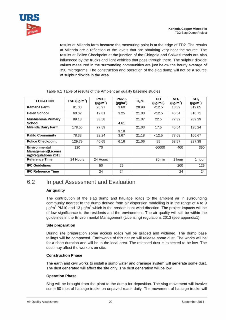
Konkola Copper Mines Plc
TD2 Slag Dump Project
Air Quality Assessment 20 September 2014
results at Milenda farm because the measuring point is at the edge of TD2. The results at Milenda are a reflection of the levels that are obtaining very near the source. The results at Police Checkpoint at the junction of the Chingola and Solwezi roads are also influenced by the trucks and light vehicles that pass through there. The sulphur dioxide values measured in the surrounding communities are just below the hourly average of 350 micrograms. The construction and operation of the slag dump will not be a source of sulphur dioxide in the area.
Table 6.1 Table of results of the Ambient air quality baseline studies
LOCATION TSP (µg/m3) PM10 (µg/m3)
PM2.5 (µg/m3) O2 % CO
(µg/m3) NOx
(µg/m3) SO2
(µg/m3) Kamana Farm 81.00 26.97 3.60 20.98 <12.5 13.39 319.05
Helen School 60.02 19.81 3.25 21.03 <12.5 45.54 310.71
Mushishima Primary School
89.13 33.58 4.61
21.07 22.5 72.32 289.29
Milenda Dairy Farm 178.55 77.59 9.18
21.03 17.5 45.54 195.24
Kalilo Community 78.33 28.24 3.67 21.18 <12.5 77.68 166.67
Police Checkpoint 129.79 40.65 6.16 21.06 95 53.57 827.38
Environmental Management(Licensing)Regulations 2013
120
70 60000 400 350
Reference Time 24 Hours 24 Hours 30min 1 hour 1 hour
IFC Guidelines 50 25 200 125
IFC Reference Time 24 24 24 24
6.2 Impact Assessment and Evaluation Air quality
The contribution of the slag dump and haulage roads to the ambient air in surrounding community nearest to the dump derived from air dispersion modelling is in the range of 4 to 9 µg/m3 PM10 and 13 µg/m3 which is the predominant wind direction. The project impacts will be of low significance to the residents and the environment. The air quality will still be within the guidelines in the Environmental Management (Licensing) regulations 2013 (see appendix1).
Site preparation
During site preparation some access roads will be graded and widened. The dump base tailings will be compacted. Earthworks of this nature will release some dust. The works will be for a short duration and will be in the local area. The released dust is expected to be low. The dust may affect the workers on site.
Construction Phase
The earth and civil works to install a sump water and drainage system will generate some dust. The dust generated will affect the site only. The dust generation will be low.
Operation Phase
Slag will be brought from the plant to the dump for deposition. The slag movement will involve some 50 trips of haulage trucks on unpaved roads daily. The movement of haulage trucks will
Konkola Copper Mines Plc
TD2 Slag Dump Project
Air Quality Assessment 21 September 2014
release dust from the roads. The dust generation can be considerable if the roads are very dry. The dust generation is also enhanced by the speed of haulage trucks as dust is lifted by the wheels. The dust released can have an impact in the local area. The generated will have medium to low impact with mitigation. There are 109 rain days in Chingola and that will keep dust naturally during a good number of days in the rain season. The dust also remains low so long there is moisture to bind the dust together. The haulage trucks also emit gases and particulates from the combustion of fuel. The emissions from this source are expected to be low in the locality.
The slag will be dumped by end tipping from the trucks and levelled by a bulldozer. The dumping and levelling will not generate much dust as the slag is course. The local winds are always present but because of the coarse nature of the slag not much dust will be generated from the slag throughout the deposition period.
Closure and decommissioning
The slag dump will remain there after closure. The dump will not change much in size distribution as that slag is very stable and will maintain its physical properties. The coarser slag particles even resist rolling over from wind because of the size and angular shapes which tend to lock rather than roll which happens with more rounded particles. The slag material has been used as part of construction material. It is possible to reclaim some of the material for use in construction. As far as air quality is concern monitoring has been recommended to assess if environmental issues of concern arise. A detailed decommissioning and closure plan will be done towards the end of life. During operations should there be issues to deal with then progressive rehabilitation measures are to be effected.
6.3 Mitigation Measures Air Quality
During the site preparation and construction activities there will be some dust releases. These dust release impact can affect the workers involved at the site and hence appropriate protective attire must be provided and worn at all times. The use of dust masks will be required for the workers. The dust released will only be for the duration of these activities and for a short term.
The haulage trucks that will be used for slag and the bulldozer that will be used will release some nitrogen oxides and some particulate matter. The regular maintenance of this fleet to ensure performance of the engines at a high standard will reduce such emissions.
The movement of haulage trucks on unpaved roads will release dust. The releases of dust will depend on the condition of the road. When the road surface is wet the fines dust is bound to other particles and hence will not be raised by the truck wheels and blown away .Windblown dust is also greatly reduced when the material is wet. When the road surface is dry then watering will be applied to keep the dust levels low. When mobile equipment is moving slowly the dust release is reduced and hence speed controls will be applied to reduce dust releases.
The slag dumping and slag levelling will not generate much dust and hence no mitigation measures will be applied. The slag is coarse and has very low levels of silt material.
The slag that will be dumped is coarse in nature. The slag particle shapes also resist wind erosion as they are angular and will not roll as other more rounded particles .The slag dump will be therefore have no specific mitigation measures for dust. The slag is also expected to be stable over long periods and hence there are no dust mitigation measures expected during closure and decommissioning.
Konkola Copper Mines Plc
TD2 Slag Dump Project
Air Quality Assessment 22 September 2014
6.4 Conclusion The site preparation and construction activities for the slag dump will release some dust but it will be of low significance and for a short duration. The haulage of slag over unpaved roads will generate some dust through the life of the operations. The dust from movement of haulage trucks when mitigated by keeping the haulage road surfaces wet will reduce the significance of this impact to be low.
The slag material because of its coarse nature will not be readily blown away from the dump and hence the dust emissions will be low. The coverage of 40 hectares of part of the tailings material will actually reduce fugitive dust from that part of the former tailings dam.
The contribution to dump related air quality impacts will not increase environmental risk to the residents and communities in the area. The incremental additional impact from the project of PM10, TSP will still leave the air quality within the Zambian air quality guidelines.
Konkola Copper Mines Plc
TD2 Slag Dump Project
Air Quality Assessment 23 September 2014
7 Environmental Management and Monitoring Plan An Environmental and Management Plan has been developed that is targeted at minimising identified impacts during the site preparation, construction, operation decommissioning and closure. The main activity that will be ongoing for the duration of the mine is haulage of slag and the dumping of slug. The main focus of this management plan is the control of the dust generated when hauling slag from the smelter to the slag dump to be kept at minimum. The monitoring plan also is aimed at ensuring that the exhaust emissions of particulate matter, carbon monoxide and nitrous oxides form mobile heavy equipment are kept to design levels. The slag dump itself will be monitored on its progression.
7.1 Environmental and Social Management Plan The main activity that will take place during the operation period is the haulage of slag from the smelter to the slag dump. This operation will result in 50 truck movements to deliver slag. The roads used have to be watered to ensure that there is minimal dust that is released from the roads. The roads can be examined visually where and when being raised by the trucks. A scheduled response will be part of the routine especially in the dry season. There are no nearby settled communities except Mushishima on one of the roads. The dust generated may affect other drivers on the T3 and T5 roads.
The vehicle speed is one of the causes of dust releases from the roads. The drivers have to be given a speed that they adhered to for both to and from trips. The slower the speed the less the dust generated.
Gaseous and particulate emissions from the haulage trucks and bulldozers used in this project should be controlled by regular maintenance of the machinery to keep emissions at design levels.
The deposited material will not have specific mitigation actions as it is considered stable with minimum impacts on the environment. The plan is as given in Table 7.1
7.2 Roles and Responsibilities The responsibility for ensuring compliance is at the highest level in the organisation. The personnel in the field should take a leading role to meet the desired objectives. The drivers using haulage trucks have to adhere to stipulated speeds. The haulage trucks speed surveys and checking on compliance to watering roads can be done by environmental officers
The Fleet Engineers should ensure the performance of the trucks and other machinery is up-to-date. The roles and responsibilities are shown in Table 7.2
7.3 Environmental and Social Monitoring Plan The monitoring plan will include some dust surveys that can be done bimonthly. Sampling at the unpaved haulage roads and three other points one upwind of slag dump and two downwind of slag dump. The monitoring of ambient air is just to ensure that if any changes occur due to project activities they can be detected.
7.4 Limitation of the Study The air quality baseline sampling for PM2.5, PM10 and TSP were derived from sampling periods which are less than 24hr periods. The results of 30minute sampling are given as being indicative in the area.
Konkola Copper Mines Plc
TD2 Slag Dump Project
Air Quality Assessment 24 September 2014
The emissions from the slag dump and haulage roads are derived from empirical studies which are not the exact replica of conditions like at this site none the less they can be used by incorporating some local modifications.

Konkola Copper Mines Plc
TD2 Slag Dump Project
Air Quality Assessment 25 September 2014
Table 7.1: TD2 Slag Dump Project – Summary of Environmental and Social Impacts
No.
Environmental
Aspect/Issue Affected
Environment Potential Impact Nature of predicted
impact Timing of
Impact Duration
of the Impact
Magnitude of the impact
Extent of the Impact
Probability of the Impact
Mitigation Measures
Significance with
mitigation
1
Grading of access roads
Air quality Dust generated may affect surrounding community and workers on site
Negative-Direct
Construction 1 2 2 4 Watering of roads Low
2
Levelling and compacting of the dump site
Air quality Dust generated may affect surrounding communities and workers on site
Negative-Direct
Construction 1 2 2 4 Monitoring by observation
Low
3
Construction of the drainage system
Air quality Releases of dust may affect the workers
Negative-Direct
Construction 1 1 1 2 Monitoring by Observation
Low
4
Haulage of slag
Air quality Releases of dust from the roads may affect surrounding communities
Negative-Direct
Operation 3 2 2 4 Watering of roads as required Speed control of trucks to minimise road dust
Low
5
Dumping of slag on TD2
Ai quality Releases of dust may affect workers on site
Negative-Direct
Operation 3 1 2 2 Provide adequate and appropriate personal protective clothing
Low
6
Levelling of dumped slag on TD2
Air Quality Releases of dust may affect surrounding community
Negative-Direct
Operation 3 1 2 2 None but monitor dust levels in the ambient air
Low
Windblown dust from slag dump
Air quality Windblown may affect surrounding community
Negative-Direct
Operation 3 2 2 2 None but monitor dust levels in the ambient air
Low
7 Windblown dust from the
Air quality Windblown dust may affect
Negative-Direct
Decommissioning and
3 2 2 2 None but monitor dust levels in the
Low
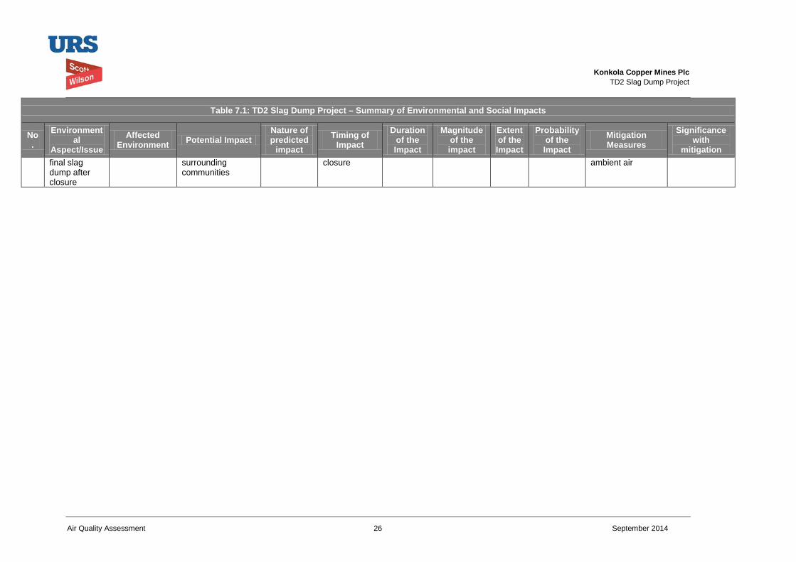
Konkola Copper Mines Plc
TD2 Slag Dump Project
Air Quality Assessment 26 September 2014
Table 7.1: TD2 Slag Dump Project – Summary of Environmental and Social Impacts
No.
Environmental
Aspect/Issue Affected
Environment Potential Impact Nature of predicted
impact Timing of
Impact Duration
of the Impact
Magnitude of the impact
Extent of the Impact
Probability of the Impact
Mitigation Measures
Significance with
mitigation final slag dump after closure
surrounding communities
closure ambient air
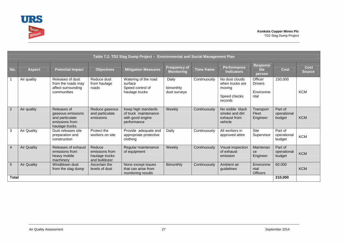
Konkola Copper Mines Plc
TD2 Slag Dump Project
Air Quality Assessment 27 September 2014
Table 7.2: TD2 Slag Dump Project – Environmental and Social Management Plan
No. Aspect Potential Impact Objectives Mitigation Measures Frequency of Monitoring Time frame Performance
Indicators Responsi
ble person
Cost Cost Source
1 Air quality Releases of dust from the roads may affect surrounding communities
Reduce dust from haulage roads
Watering of the road surface Speed control of haulage trucks
Daily bimonthly dust surveys
Continuously No dust clouds when trucks are moving Speed checks records
Officer Drivers Environmental
150,000
KCM
2 Air quality Releases of gaseous emissions and particulate emissions from haulage trucks
Reduce gaseous and particulate emissions
Keep high standards of truck maintenance with good engine performance
Weekly Continuously No visible black smoke and dirt exhaust from vehicle
Transport Fleet Engineer
Part of operational budget KCM
3 Air Quality Dust releases site preparation and construction
Protect the workers on site
Provide adequate and appropriate protective clothing
Daily Continuously All workers in approved attire
Site Supervisor
Part of operational budget KCM
4 Air Quality Releases of exhaust emissions from heavy mobile machinery
Reduce emissions from haulage trucks and bulldozer
Regular maintenance of equipment
Weekly Continuously Visual inspection of exhaust emission
Maintenance Engineer
Part of operational budget KCM
5 Air Quality Windblown dust from the slag dump
Ascertain the levels of dust
None except issues that can arise from monitoring results
Bimonthly Continuously Ambient air guidelines
Environmental Officers
60.000 KCM
Total 210,000
Konkola Copper Mines Plc
TD2 Slag Dump Project
Air Quality 28 September 2014
8 Consultation The stakeholders participated during the scoping meetings.
Konkola Copper Mines Plc
TD2 Slag Dump Project
Air Quality 29 September 2014
9 Conclusion The study has shown that the construction and operation of the slag dump will have low level of air quality impacts. The dust emissions arising from unpaved haulage roads will contribute to some emissions in the local area but when roads are maintained wet when required result in this impact being of low significance. The nature of the slag is such that it contains a very small amounts of silt (4%) and it is coarse. As a consequence there will be little windblown dust from the stockpiled slag. The deposition of slag over some of the former tailings will reduce dust emissions from the 40 hectare footprint of the tailings dam. The tailings can have up to 50% silt by weight. The slag that will remain after closure will maintain its coarse nature for a long time and hence will not contribute much to windblown dust.
Konkola Copper Mines Plc
TD2 Slag Dump Project
Air Quality 30 September 2014
10 References 1 National Pollutant Inventory Emission Estimation technique Manual for Mining version
3.1 January 2012 Australian Government Department of Sustainability, Environment, Water, Population and Communities
2 Users Guide of the AMS/EPA Regulatory Model EPA-454B-03-001 September 2004
3 Demonstration PM10 State Implementation Plan for Hayden ArizonaPrepared by Engineering Science 75 Fiar Oaks Arizona ,Pasadena ,CA July 24 1987
Konkola Copper Mines Plc
TD2 Slag Dump Project
Air Quality Assessment September 2014
Appendices 1 TD2 Slag Dump Air Quality Dispersion Modelling 2 Ambient Air Quality Survey at TD2 Nchanga
Konkola Copper Mines Plc
TD2 Slag Dump Project
Air Quality Assessment September 2014
Appendix 1
TD2 Slag Dump Air Quality Dispersion Modelling
TD2 SLAG DUMP PROJECT AIR DISPERSION MODELLING
June 2014
L.J.Kalowa Air quality Specialist
2
Contents SUMMARY ...................................................................................................................................................................... 3
1.0 Air Quality ............................................................................................................................................................ 3
1.1 Air Pollution Background ................................................................................................................................. 3
2.0 The Current Report and Methodology .................................................................................................................. 3
3.0 Project Description ................................................................................................................................................ 3
4.0 Project Location .................................................................................................................................................... 4
5.0 Ambient Air .......................................................................................................................................................... 4
6.0 Air Dispersion Modelling of TD2 Slag Dump Project ......................................................................................... 5
6.1 Introduction ....................................................................................................................................................... 5
6.2 Model Description............................................................................................................................................ 5
6.3 Emission Parameters ........................................................................................................................................ 5
6.4 Modelled Domain/Receptors ............................................................................................................................ 8
6.5 Meteorology ...................................................................................................................................................... 8
6.6 Terrain ............................................................................................................................................................. 11
6.7 Assessment of TSP and PM10 Impacts from the TD2 Slag Dump Project .................................................... 11
6.7.2 TSP daily maximum ground concentration ................................................................................................. 11
6.7.3 TSP Annual maximum ground concentration ............................................................................................. 11
7.0 Conclusion ........................................................................................................................................................... 13
8.0 References .......................................................................................................................................................... 13
3
SUMMARY Ambient air baseline studies have shown that all of the surrounding communities ambient air values of TSP, PM10 and some gases are within the Environmental Management (Licensing) regulations 2013. The measured ambient PM2.5 is also low when compared to the IFC guidelines. The higher values like at Milenda are measured just at the near the edge of TD2. The project related emissions of PM10 particles, TSP and NOx contribution to the ambient air are of low significance and the resultant air quality will remain within the current air guidelines. The results of air dispersion modelling show the highest levels of TSP of 28.1 µg/m3 will occur on the dumpsite. The PM10 particles also will be highest at 14.7 µg/m3 at the dumpsite.
1.0 Air Quality
1.1 Air Pollution Background Chingola is a town whose economic activity is based on mining. KCM operates a number of open pits, metallurgical plants which include a smelter. There are also a number of tailings dams from past operations which are being reprocessed. A number of companies in Chingola are involved in support industries which provide some engineering services and supply of some mine requirements. There are no major industries with production units which are continuously contributing to air emissions.
KCM is operating a smelter which has some emissions of sulphur dioxide and particulate emission. The Smelter is fitted with an acid plant and recovers most of the sulphur dioxide and particulate emissions .Blasting in the open pits and also hauling of the ores to the processing plants are some of the sources of particulate and gaseous emissions in the area. The various stockpiles of materials on overburden dumps, tailings dam will contribute to sources of windblown dust from stockpiles.
TD2 area is bounded by two roads to Solwezi and to Chililabombwe which have a heavy traffic that is a source of gaseous emissions and particulates from the trucks and other light vehicles. The traffic survey on T3 (Chingola Chililabombwe Road) and T5 (Chingola-Solwezi Road) showed a heavy movement of vehicles. The survey shows that about 240 vehicles go to and from T3 and 470 go to and from T3 daily. The combustion of fuels mainly firewood, charcoal and other biomass also contribute significantly to the PM10 load. The particulate measurements in the area will not be solely from KCM operations though the sulphur dioxide measured will be mostly from the smelter operations.
2.0 The Current Report and Methodology
This report is being done as part of the EISA study for the construction and operation of copper slag from the smelter. Ambient air quality baseline studies were conducted and air dispersion modelling was done to assess the impact of this project. The study develops some emissions for the slag dump and emissions that will arise from the movement of haulage trucks. The emissions of TSP and PM10 particulates from the proposed slag dump, and the haulage road are used together with meteorological data in air dispersion modelling to give a picture of both the level and the extent of the impact areas.
3.0 Project Description
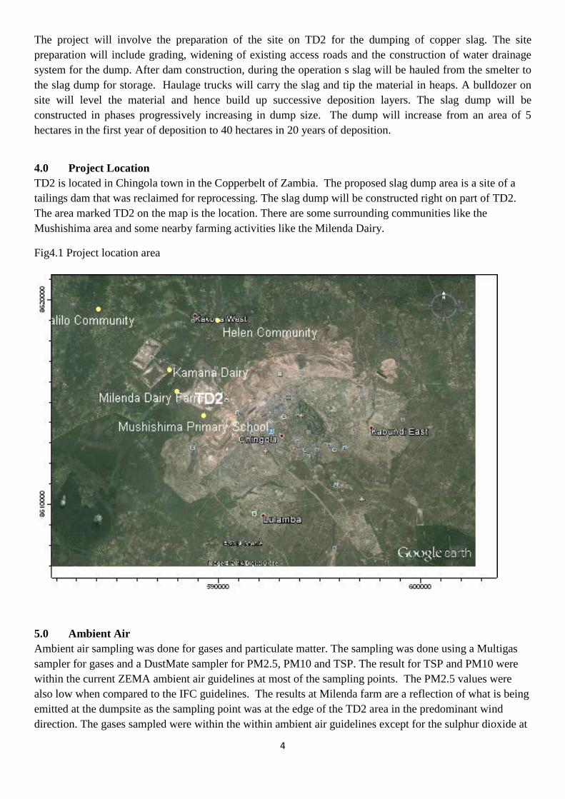
4
The project will involve the preparation of the site on TD2 for the dumping of copper slag. The site preparation will include grading, widening of existing access roads and the construction of water drainage system for the dump. After dam construction, during the operation s slag will be hauled from the smelter to the slag dump for storage. Haulage trucks will carry the slag and tip the material in heaps. A bulldozer on site will level the material and hence build up successive deposition layers. The slag dump will be constructed in phases progressively increasing in dump size. The dump will increase from an area of 5 hectares in the first year of deposition to 40 hectares in 20 years of deposition.
4.0 Project Location TD2 is located in Chingola town in the Copperbelt of Zambia. The proposed slag dump area is a site of a tailings dam that was reclaimed for reprocessing. The slag dump will be constructed right on part of TD2. The area marked TD2 on the map is the location. There are some surrounding communities like the Mushishima area and some nearby farming activities like the Milenda Dairy.
Fig4.1 Project location area
5.0 Ambient Air Ambient air sampling was done for gases and particulate matter. The sampling was done using a Multigas sampler for gases and a DustMate sampler for PM2.5, PM10 and TSP. The result for TSP and PM10 were within the current ZEMA ambient air guidelines at most of the sampling points. The PM2.5 values were also low when compared to the IFC guidelines. The results at Milenda farm are a reflection of what is being emitted at the dumpsite as the sampling point was at the edge of the TD2 area in the predominant wind direction. The gases sampled were within the within ambient air guidelines except for the sulphur dioxide at
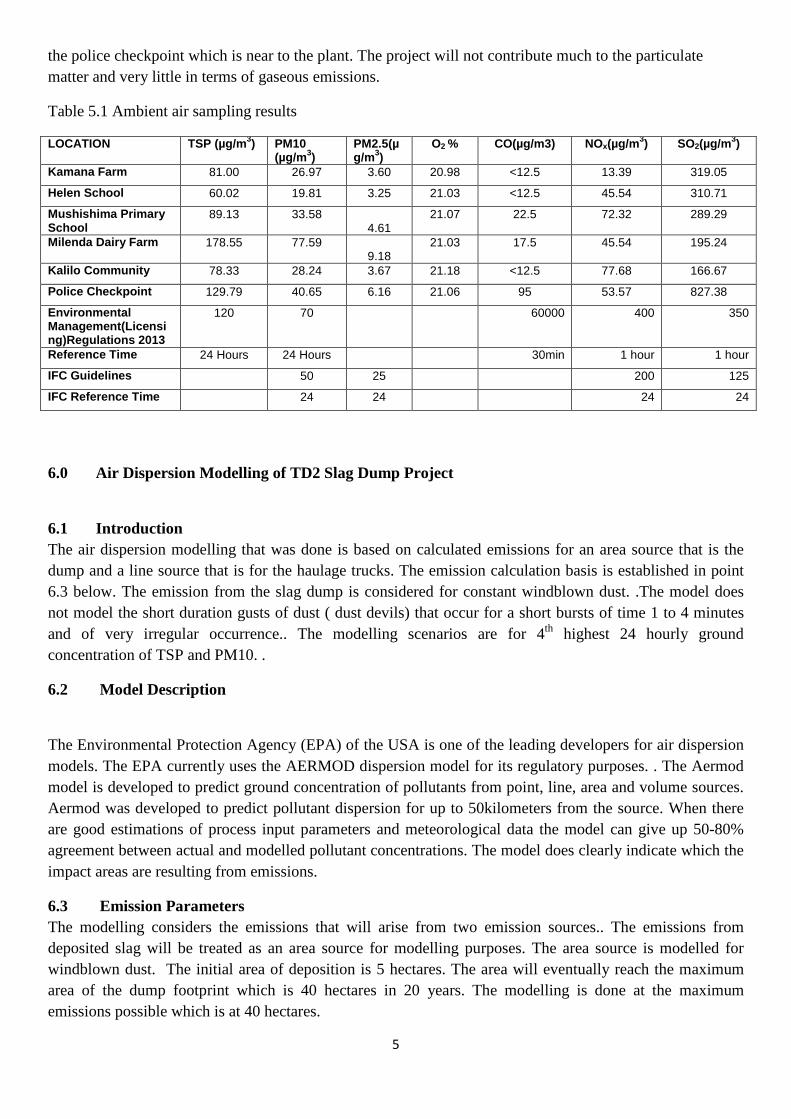
5
the police checkpoint which is near to the plant. The project will not contribute much to the particulate matter and very little in terms of gaseous emissions.
Table 5.1 Ambient air sampling results
LOCATION TSP (µg/m3) PM10 (µg/m3)
PM2.5(µg/m3)
O2 % CO(µg/m3) NOx(µg/m3) SO2(µg/m3)
Kamana Farm 81.00 26.97 3.60 20.98 <12.5 13.39 319.05
Helen School 60.02 19.81 3.25 21.03 <12.5 45.54 310.71
Mushishima Primary School
89.13 33.58 4.61
21.07 22.5 72.32 289.29
Milenda Dairy Farm 178.55 77.59 9.18
21.03 17.5 45.54 195.24
Kalilo Community 78.33 28.24 3.67 21.18 <12.5 77.68 166.67
Police Checkpoint 129.79 40.65 6.16 21.06 95 53.57 827.38
Environmental Management(Licensing)Regulations 2013
120
70 60000 400 350
Reference Time 24 Hours 24 Hours 30min 1 hour 1 hour
IFC Guidelines 50 25 200 125
IFC Reference Time 24 24 24 24
6.0 Air Dispersion Modelling of TD2 Slag Dump Project
6.1 Introduction The air dispersion modelling that was done is based on calculated emissions for an area source that is the dump and a line source that is for the haulage trucks. The emission calculation basis is established in point 6.3 below. The emission from the slag dump is considered for constant windblown dust. .The model does not model the short duration gusts of dust ( dust devils) that occur for a short bursts of time 1 to 4 minutes and of very irregular occurrence.. The modelling scenarios are for 4th highest 24 hourly ground concentration of TSP and PM10. .
6.2 Model Description
The Environmental Protection Agency (EPA) of the USA is one of the leading developers for air dispersion models. The EPA currently uses the AERMOD dispersion model for its regulatory purposes. . The Aermod model is developed to predict ground concentration of pollutants from point, line, area and volume sources. Aermod was developed to predict pollutant dispersion for up to 50kilometers from the source. When there are good estimations of process input parameters and meteorological data the model can give up 50-80% agreement between actual and modelled pollutant concentrations. The model does clearly indicate which the impact areas are resulting from emissions.
6.3 Emission Parameters The modelling considers the emissions that will arise from two emission sources.. The emissions from deposited slag will be treated as an area source for modelling purposes. The area source is modelled for windblown dust. The initial area of deposition is 5 hectares. The area will eventually reach the maximum area of the dump footprint which is 40 hectares in 20 years. The modelling is done at the maximum emissions possible which is at 40 hectares.
6
The other source of emissions is the dust arising from the movement of haulage trucks to and from the TD2 dumpsite. The dust that will be generated is treated as a volume source for the entire route. The dust generated in this source is driven by the movement of trucks on the road. The modelling considers the number of trips, speed of truck movement and other parameter to come up with emission factors.
The emissions of dust arising from movement of haulage trucks on unpaved roads and windblown dust from stock piles are not readily available and are difficult to obtain. A very detailed and extensive work is required to derive the most important variables to determine the emissions. The EPA has over years developed some approaches to get the emission values by deriving some emission factors.
An emission factor is a value that attempts to relate the representative quantity of a pollutant released to the atmosphere with an activity associated with the release of that pollutant. Emission factors usually are expressed as the weight of pollutant divided by the unit weight, and the time.(g/m²/s) The EPA has developed some emission factor guidelines EPA AP42 Section 13.2.2, Unpaved Roads and some formulae for windblown dust. The guidelines are used with the understanding and modifications from the local environment and material characteristics. The use of emission estimates is acceptable in dispersion modelling. Although there may be some uncertainties in the actual quantum, the use of emission factors allows the project to be assessed on the spatial influence of the project. When the meteorological data is accurate then the footprint where the emissions will impact can be determined. s.
The area source was for TSP 0.4kg/ha/hr and PM10 0.2kg/ha/hr. The emission factors were based on comparison with the Australian Government Environmental Manual Ref 1 The emissions were further reduced on account of it being slag so the TSP will be 50 tonnes per year and PM10 25tonnes per year when the whole 40 hectares are covered The emission for the 1st year will be 6 tonnes/per year TSP as the area deposited will be just 5 hectares.
The road haulage emission rate is calculated 691kg/day EPA AP42 guidelines Section 13.2.2, Unpaved roads. The annual TSP emissions will be 180 tonnes and PM10 about 90 tonnes/year.
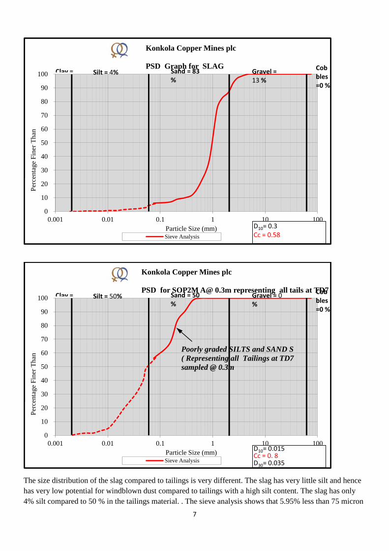
7
The size distribution of the slag compared to tailings is very different. The slag has very little silt and hence has very low potential for windblown dust compared to tailings with a high silt content. The slag has only 4% silt compared to 50 % in the tailings material. . The sieve analysis shows that 5.95% less than 75 micron
0
10
20
30
40
50
60
70
80
90
100
0.001 0.01 0.1 1 10 100
Perc
enta
ge F
iner
Tha
n
Particle Size (mm)
Konkola Copper Mines plc PSD Graph for SLAG
Sieve Analysis
D10= 0.3 Cc = 0.58
Clay = Silt = 4% Sand = 83 %
Gravel = 13 %
Cobbles =0 %
0
10
20
30
40
50
60
70
80
90
100
0.001 0.01 0.1 1 10 100
Perc
enta
ge F
iner
Tha
n
Particle Size (mm)
Konkola Copper Mines plc PSD for SOP2M A@ 0.3m representing all tails at TD7
Sieve Analysis
D10= 0.015 Cc = 0. 8 D30= 0.035
Clay = Silt = 50% Sand = 50 %
Gravel = 0 %
Cobbles =0 %
Poorly graded SILTS and SAND S ( Representing all Tailings at TD7 sampled @ 0.3m
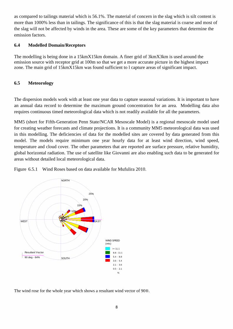
8
as compared to tailings material which is 56.1%. The material of concern in the slag which is silt content is more than 1000% less than in tailings. The significance of this is that the slag material is coarse and most of the slag will not be affected by winds in the area. These are some of the key parameters that determine the emission factors.
6.4 Modelled Domain/Receptors The modelling is being done in a 15kmX15km domain. A finer grid of 3kmX3km is used around the emission source with receptor grid at 100m so that we get a more accurate picture in the highest impact zone. The main grid of 15kmX15km was found sufficient to l capture areas of significant impact.
6.5 Meteorology
The dispersion models work with at least one year data to capture seasonal variations. It is important to have an annual data record to determine the maximum ground concentration for an area. Modelling data also requires continuous timed meteorological data which is not readily available for all the parameters.
MM5 (short for Fifth-Generation Penn State/NCAR Mesoscale Model) is a regional mesoscale model used for creating weather forecasts and climate projections. It is a community MM5 meteorological data was used in this modelling. The deficiencies of data for the modelled sites are covered by data generated from this model. The models require minimum one year hourly data for at least wind direction, wind speed, temperature and cloud cover. The other parameters that are reported are surface pressure, relative humidity, global horizontal radiation. The use of satellite like Giovanni are also enabling such data to be generated for areas without detailed local meteorological data.
Figure 6.5.1 Wind Roses based on data available for Mufulira 2010.
The wind rose for the whole year which shows a resultant wind vector of 90®.
Resultant Vector
90 deg - 64%
NORTH
SOUTH
WEST EAST
5%
10%
15%
20%
25%
WIND SPEED (m/s)
>= 11.1
8.8 - 11.1
5.4 - 8.8
3.6 - 5.4
2.1 - 3.6
0.5 - 2.1
Calms: 3.11%
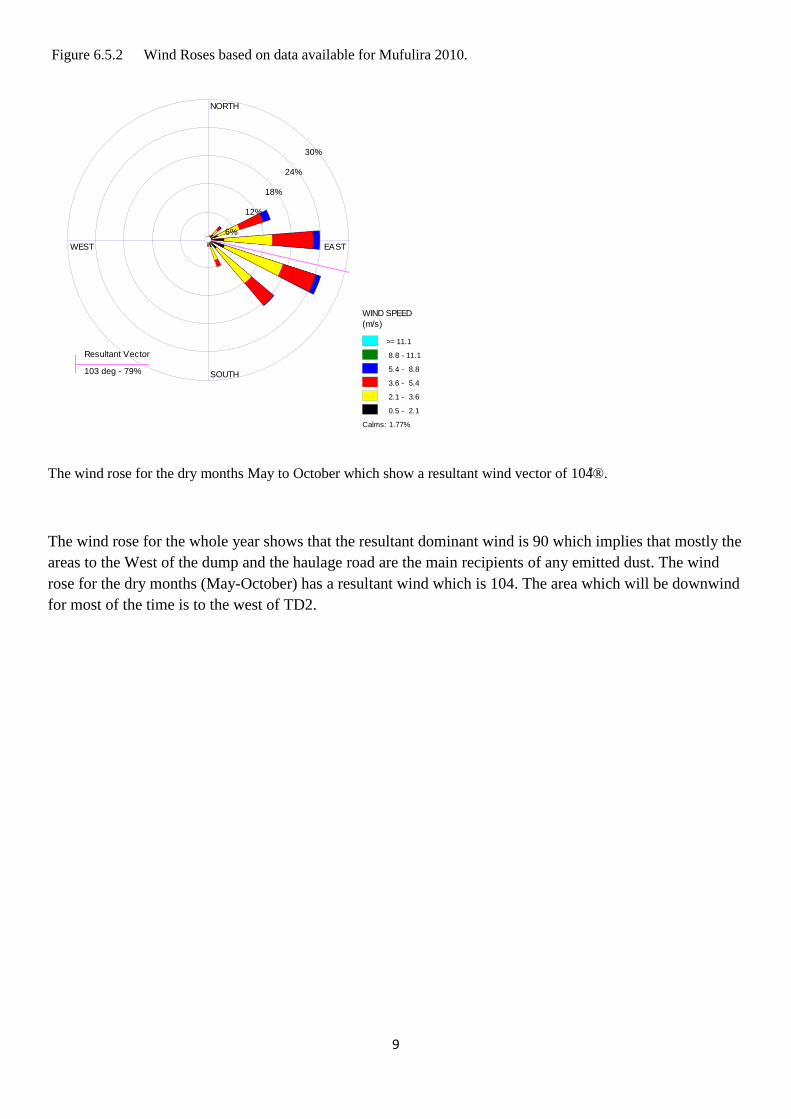
9
Figure 6.5.2 Wind Roses based on data available for Mufulira 2010.
The wind rose for the dry months May to October which show a resultant wind vector of 104̊®.
The wind rose for the whole year shows that the resultant dominant wind is 90 which implies that mostly the areas to the West of the dump and the haulage road are the main recipients of any emitted dust. The wind rose for the dry months (May-October) has a resultant wind which is 104. The area which will be downwind for most of the time is to the west of TD2.
Resultant Vector
103 deg - 79%
NORTH
SOUTH
WEST EAST
6%
12%
18%
24%
30%
WIND SPEED (m/s)
>= 11.1
8.8 - 11.1
5.4 - 8.8
3.6 - 5.4
2.1 - 3.6
0.5 - 2.1
Calms: 1.77%
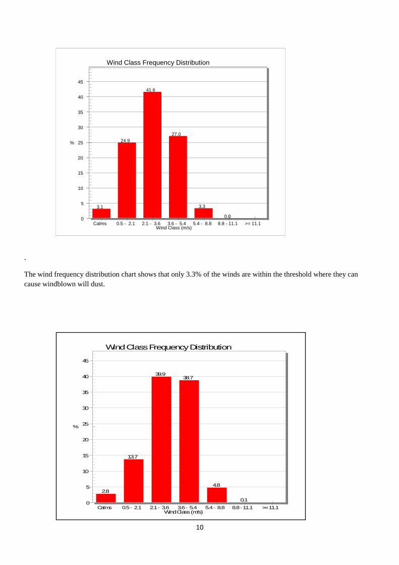
10
.
The wind frequency distribution chart shows that only 3.3% of the winds are within the threshold where they can cause windblown will dust.
3.1
24.9
41.6
27.0
3.3 0.0 0
5
10
15
20
25
30
35
40
45
%
Wind Class Frequency Distribution
Wind Class (m/s) Calms 0.5 - 2.1 2.1 - 3.6 3.6 - 5.4 5.4 - 8.8 8.8 - 11.1 >= 11.1
2.8
13.7
39.938.7
4.8
0.10
5
10
15
20
25
30
35
40
45
%
Wind Class Frequency Distribution
Wind Class (m/s)Calms 0.5 - 2.1 2.1 - 3.6 3.6 - 5.4 5.4 - 8.8 8.8 - 11.1 >= 11.1
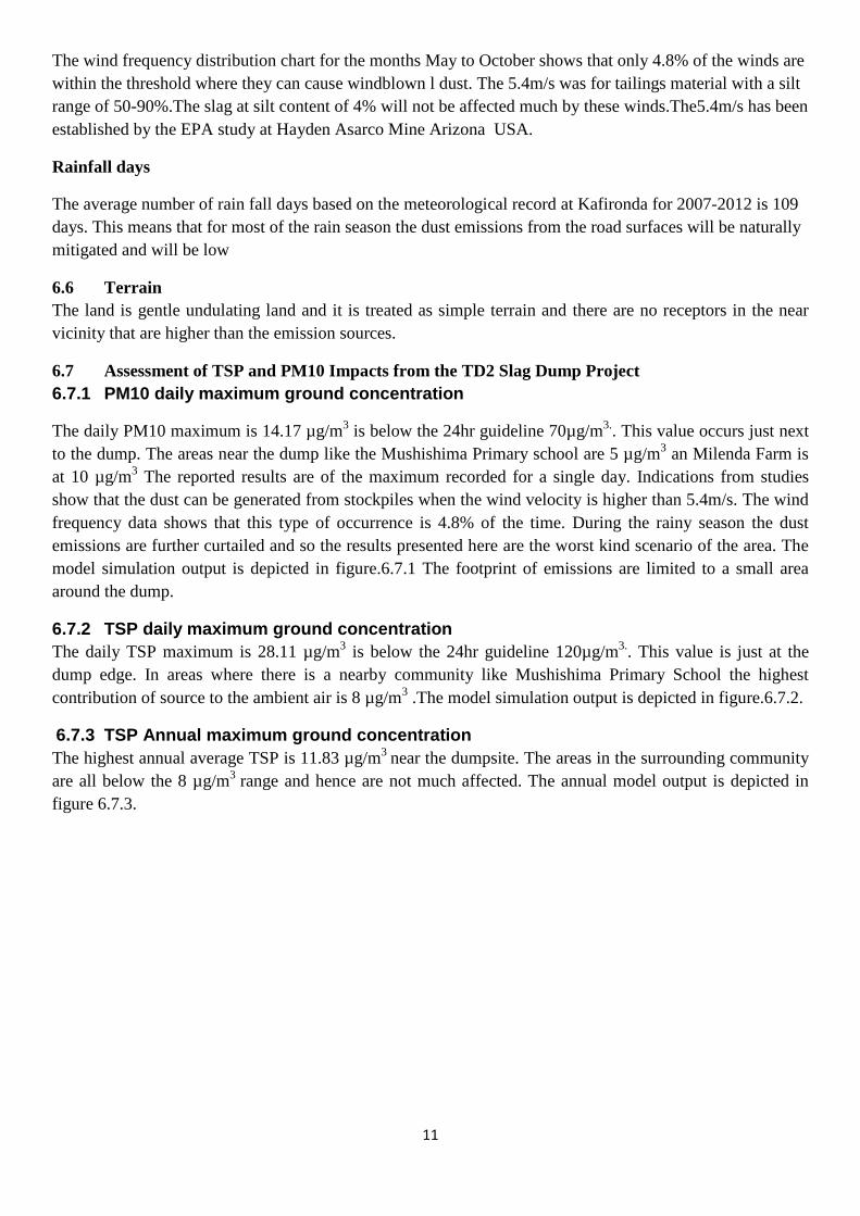
11
The wind frequency distribution chart for the months May to October shows that only 4.8% of the winds are within the threshold where they can cause windblown l dust. The 5.4m/s was for tailings material with a silt range of 50-90%.The slag at silt content of 4% will not be affected much by these winds.The5.4m/s has been established by the EPA study at Hayden Asarco Mine Arizona USA.
Rainfall days
The average number of rain fall days based on the meteorological record at Kafironda for 2007-2012 is 109 days. This means that for most of the rain season the dust emissions from the road surfaces will be naturally mitigated and will be low
6.6 Terrain The land is gentle undulating land and it is treated as simple terrain and there are no receptors in the near vicinity that are higher than the emission sources.
6.7 Assessment of TSP and PM10 Impacts from the TD2 Slag Dump Project 6.7.1 PM10 daily maximum ground concentration
The daily PM10 maximum is 14.17 µg/m3 is below the 24hr guideline 70µg/m3.. This value occurs just next to the dump. The areas near the dump like the Mushishima Primary school are 5 µg/m3 an Milenda Farm is at 10 µg/m3 The reported results are of the maximum recorded for a single day. Indications from studies show that the dust can be generated from stockpiles when the wind velocity is higher than 5.4m/s. The wind frequency data shows that this type of occurrence is 4.8% of the time. During the rainy season the dust emissions are further curtailed and so the results presented here are the worst kind scenario of the area. The model simulation output is depicted in figure.6.7.1 The footprint of emissions are limited to a small area around the dump.
6.7.2 TSP daily maximum ground concentration The daily TSP maximum is 28.11 µg/m3 is below the 24hr guideline 120µg/m3.. This value is just at the dump edge. In areas where there is a nearby community like Mushishima Primary School the highest contribution of source to the ambient air is 8 µg/m3 .The model simulation output is depicted in figure.6.7.2.
6.7.3 TSP Annual maximum ground concentration The highest annual average TSP is 11.83 µg/m3 near the dumpsite. The areas in the surrounding community are all below the 8 µg/m3 range and hence are not much affected. The annual model output is depicted in figure 6.7.3.
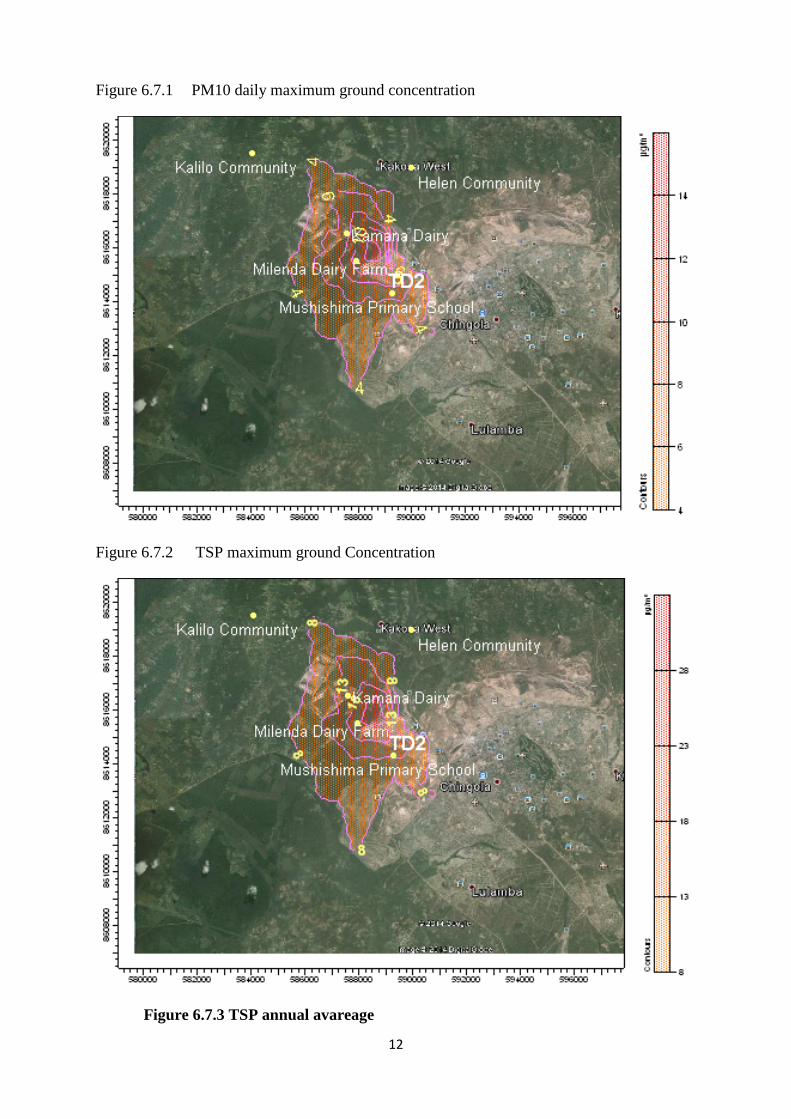
12
Figure 6.7.1 PM10 daily maximum ground concentration
Figure 6.7.2 TSP maximum ground Concentration
Figure 6.7.3 TSP annual avareage
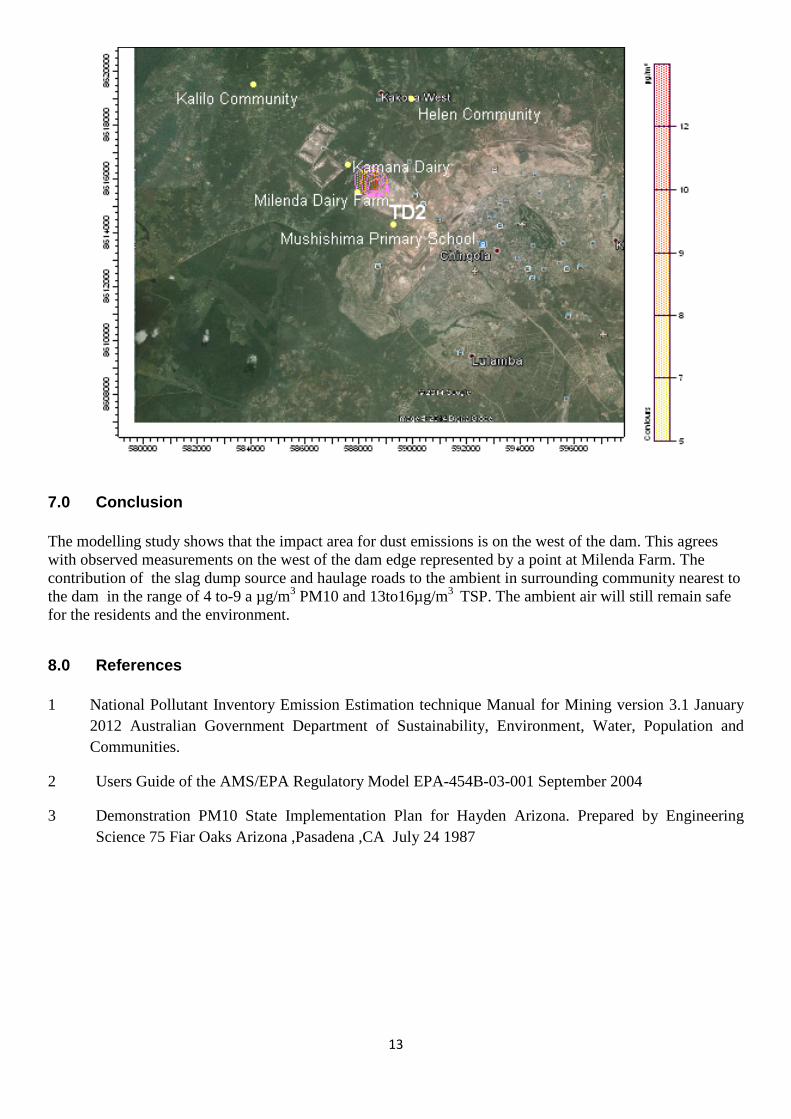
13
7.0 Conclusion The modelling study shows that the impact area for dust emissions is on the west of the dam. This agrees with observed measurements on the west of the dam edge represented by a point at Milenda Farm. The contribution of the slag dump source and haulage roads to the ambient in surrounding community nearest to the dam in the range of 4 to-9 a µg/m3 PM10 and 13to16µg/m3 TSP. The ambient air will still remain safe for the residents and the environment.
8.0 References 1 National Pollutant Inventory Emission Estimation technique Manual for Mining version 3.1 January
2012 Australian Government Department of Sustainability, Environment, Water, Population and Communities.
2 Users Guide of the AMS/EPA Regulatory Model EPA-454B-03-001 September 2004
3 Demonstration PM10 State Implementation Plan for Hayden Arizona. Prepared by Engineering Science 75 Fiar Oaks Arizona ,Pasadena ,CA July 24 1987
Konkola Copper Mines Plc
TD2 Slag Dump Project
Air Quality Assessment September 2014
Appendix 2
Ambient Air Quality Survey at TD2 Nchanga
All work is undertaken subject to our standard trading terms and conditions.
This test certificate shall not be reproduced in full, without the written approval by Alfred H Knight [Zambia] Limited and if faxed will only
be valid when supported by the original document
ALFRED H KNIGHT (ZAMBIA) LIMITED
Corner Mindola/Golf Club Roads, Nkana West PO Box 20303, Kitwe, Copperbelt, Zambia
Tel. [260] 21 222 6433/4 Fax [260] 21 222 6306 email ; [email protected] Company Reg No. 41960 VAT No. 10126160-33
Engineering Services Division
METALLURGY DEPARTMENT
Project No. MET55332
Ambient Air Quality Survey at TD2- KCM Nchanga
Report No.1 Distribution Mr. Boston Katongo Mr. Chalwe Bulaya File June 2014
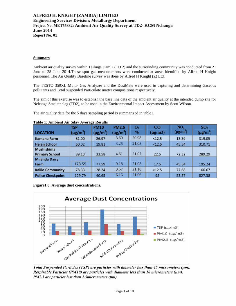
ALFRED H. KNIGHT [ZAMBIA] LIMITED Engineering Services Division; Metallurgy Department Project No. MET55332: Ambient Air Quality Survey at TD2- KCM Nchanga June 2014 Report No. 01
Page 1 of 10
Summary Ambient air quality survey within Tailings Dam 2 (TD 2) and the surrounding community was conducted from 21 June to 28 June 2014.These spot gas measurements were conducted at areas identified by Alfred H Knight personnel. The Air Quality Baseline survey was done by Alfred H Knight (Z) Ltd. The TESTO 350XL Multi- Gas Analyzer and the DustMate were used in capturing and determining Gaseous pollutants and Total suspended Particulate matter compositions respectively. The aim of this exercise was to establish the base line data of the ambient air quality at the intended dump site for Nchanga Smelter slag (TD2), to be used in the Environmental Impact Assessment by Scott Wilson. The air quality data for the 5 days sampling period is summarized in table1. Table 1: Ambient Air 5day Average Results
LOCATION TSP (µg/m3)
PM10 (µg/m3)
PM2.5 (µg/m3)
O2 %
CO (µg/m3)
NOx (µg/m3)
SO2 (µg/m3)
Kamana Farm 81.00 26.97 3.60 20.98 <12.5 13.39 319.05
Helen School 60.02 19.81 3.25 21.03 <12.5 45.54 310.71
Mushishima Primary School 89.13 33.58
4.61
21.07 22.5 72.32 289.29
Milenda Dairy Farm 178.55 77.59
9.18
21.03 17.5 45.54 195.24
Kalilo Community 78.33 28.24 3.67 21.18 <12.5 77.68 166.67
Police Checkpoint 129.79 40.65 6.16 21.06 95 53.57 827.38
Figure1.0. Average dust concentrations.
Total Suspended Particles (TSP) are particles with diameter less than 45 micrometers (μm). Respirable Particles (PM10) are particles with diameter less than 10 micrometers (μm). PM2.5 are particles less than 2.5micrometers (μm)
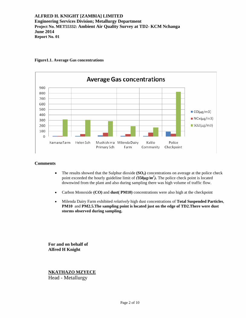
ALFRED H. KNIGHT [ZAMBIA] LIMITED Engineering Services Division; Metallurgy Department Project No. MET55332: Ambient Air Quality Survey at TD2- KCM Nchanga June 2014 Report No. 01
Page 2 of 10
Figure1.1. Average Gas concentrations
Comments
The results showed that the Sulphur dioxide (SO2) concentrations on average at the police check
point exceeded the hourly guideline limit of (350μg/m3). The police check point is located downwind from the plant and also during sampling there was high volume of traffic flow.
Carbon Monoxide (CO) and dust( PM10) concentrations were also high at the checkpoint
Milenda Dairy Farm exhibited relatively high dust concentrations of Total Suspended Particles, PM10 and PM2.5.The sampling point is located just on the edge of TD2.There were dust storms observed during sampling.
For and on behalf of Alfred H Knight NKATHAZO MZYECE Head - Metallurgy
ALFRED H. KNIGHT [ZAMBIA] LIMITED Engineering Services Division; Metallurgy Department Project No. MET55332: Ambient Air Quality Survey at TD2- KCM Nchanga June 2014 Report No. 01
Page 3 of 10
1.0 INTRODUCTION
An ambient air quality survey was conducted to establish the baseline air quality before commencement of the proposed copper slag dump. The baseline survey included measurements of TSP, PM10 and PM2.5 particles and gases of Sulphur dioxide, Oxides of Nitrogen, Carbon monoxide and Oxygen. Alfred H Knight Zambia Ltd, Metallurgy Department, was thus contracted by URS Scott Wilson Zambia to carry out ambient air quality monitoring in predetermined locations within and around TD 2. The choice of sampling points was dependent on the distances and directions relative to TD 2. The presence of human activity and settlement was also considered in selecting the points. The main objective of this exercise was to establish the base line air quality data. Testo 350X Multi- Gas Analyzer and Dust Mate were used for measuring SO2, CO NOx and dust concentrations in the ambient air respectively.
2.0 SAMPLING
At each predetermined point, the Testo 350XL (a digital multi-gas analyzer which has an in-built pump to suck air from a source or area of measurement through electro-chemical cells which then determines the strength of each gaseous component) was switched on and readings displayed recorded. After measuring at each point for the duration of 30minutes, the instrument’s cells were rinsed to get rid of gases absorbed at one point so that they did not affect other results measured at other points. Dust sampling was also performed via a Dust Mate parallel to gas sampling at each predetermined sampling point for the same duration. Three runs of measurements were done at each sampling point for a period of five days. The following were the sampling locations:
1. Kamana Farm 2. Helen community School 3. Mushishima Primary School 4. Milenda Dairy Farm 5. Kalilo community 6. Police Checkpoint
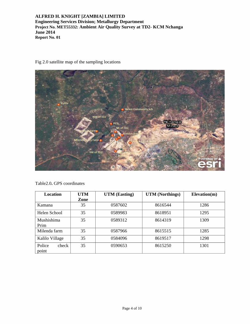
ALFRED H. KNIGHT [ZAMBIA] LIMITED Engineering Services Division; Metallurgy Department Project No. MET55332: Ambient Air Quality Survey at TD2- KCM Nchanga June 2014 Report No. 01
Page 4 of 10
Fig 2.0 satellite map of the sampling locations
Table2.0. GPS coordinates
Location UTM Zone
UTM (Easting) UTM (Northings) Elevation(m)
Kamana 35 0587602 8616544 1286
Helen School 35 0589983 8618951 1295 Mushishima Prim
35 0589312 8614319 1309
Milenda farm 35 0587966 8615515 1285 Kalilo Village 35 0584096 8619517 1298 Police check point
35 0590653 8615250 1301
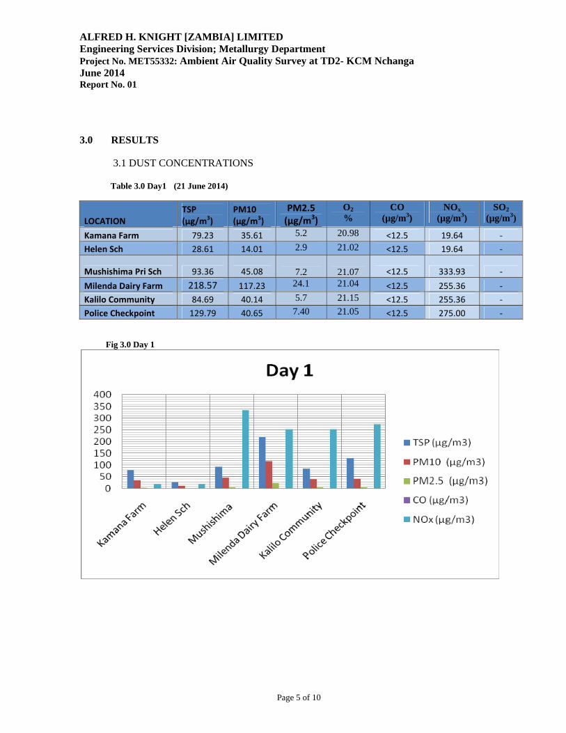
ALFRED H. KNIGHT [ZAMBIA] LIMITED Engineering Services Division; Metallurgy Department Project No. MET55332: Ambient Air Quality Survey at TD2- KCM Nchanga June 2014 Report No. 01
Page 5 of 10
3.0 RESULTS
3.1 DUST CONCENTRATIONS Table 3.0 Day1 (21 June 2014)
LOCATION TSP (µg/m3)
PM10 (µg/m3)
PM2.5 (µg/m3)
O2 %
CO (µg/m3)
NOx (µg/m3)
SO2 (µg/m3)
Kamana Farm 79.23 35.61 5.2 20.98 <12.5 19.64 ‐
Helen Sch 28.61 14.01 2.9 21.02 <12.5 19.64 ‐
Mushishima Pri Sch 93.36 45.08
7.2
21.07 <12.5 333.93 ‐
Milenda Dairy Farm 218.57 117.23 24.1 21.04 <12.5 255.36 ‐
Kalilo Community 84.69 40.14 5.7 21.15 <12.5 255.36 ‐
Police Checkpoint 129.79 40.65 7.40 21.05 <12.5 275.00 ‐
Fig 3.0 Day 1
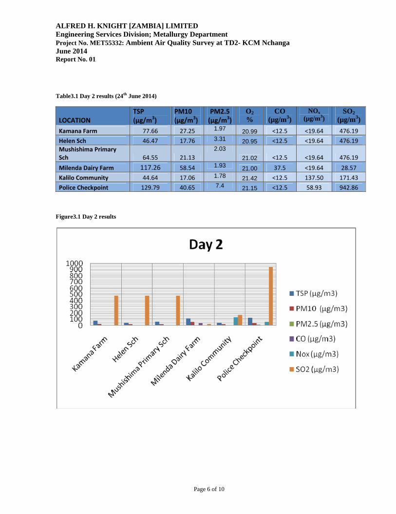
ALFRED H. KNIGHT [ZAMBIA] LIMITED Engineering Services Division; Metallurgy Department Project No. MET55332: Ambient Air Quality Survey at TD2- KCM Nchanga June 2014 Report No. 01
Page 6 of 10
Table3.1 Day 2 results (24th June 2014)
LOCATION TSP (µg/m3)
PM10 (µg/m3)
PM2.5 (µg/m3)
O2 %
CO (µg/m3)
NOx (µg/m3)
SO2 (µg/m3)
Kamana Farm 77.66 27.25 1.97 20.99 <12.5 <19.64 476.19
Helen Sch 46.47 17.76 3.31 20.95 <12.5 <19.64 476.19
Mushishima Primary Sch 64.55 21.13
2.03 21.02 <12.5 <19.64 476.19
Milenda Dairy Farm 117.26 58.54 1.93 21.00 37.5 <19.64 28.57
Kalilo Community 44.64 17.06 1.78 21.42 <12.5 137.50 171.43
Police Checkpoint 129.79 40.65 7.4 21.15 <12.5 58.93 942.86 Figure3.1 Day 2 results
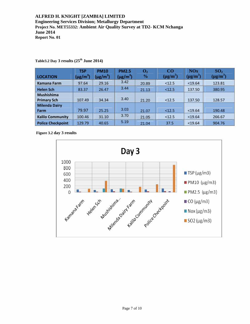
ALFRED H. KNIGHT [ZAMBIA] LIMITED Engineering Services Division; Metallurgy Department Project No. MET55332: Ambient Air Quality Survey at TD2- KCM Nchanga June 2014 Report No. 01
Page 7 of 10
Table3.2 Day 3 results (25th June 2014)
LOCATION TSP (µg/m3)
PM10 (µg/m3)
PM2.5 (µg/m3)
O2
% CO
(µg/m3) NOx
(µg/m3) SO2
(µg/m3) Kamana Farm 97.64 29.16 3.42 20.89 <12.5 <19.64 123.81
Helen Sch 83.37 26.47 3.44 21.13 <12.5 137.50 380.95
Mushishima Primary Sch 107.49 34.34
3.40 21.20 <12.5 137.50 128.57
Milenda Dairy Farm 79.97 25.25
3.03 21.07 <12.5 <19.64 190.48
Kalilo Community 100.46 31.10 3.70 21.05 <12.5 <19.64 266.67
Police Checkpoint 129.79 40.65 5.19 21.04 37.5 <19.64 904.76 Figure 3.2 day 3 results
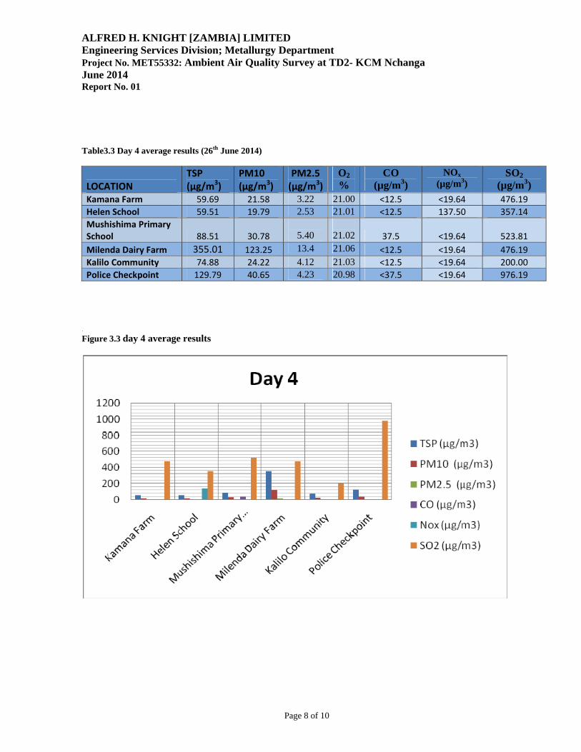
ALFRED H. KNIGHT [ZAMBIA] LIMITED Engineering Services Division; Metallurgy Department Project No. MET55332: Ambient Air Quality Survey at TD2- KCM Nchanga June 2014 Report No. 01
Page 8 of 10
Table3.3 Day 4 average results (26th June 2014)
LOCATION TSP (µg/m3)
PM10 (µg/m3)
PM2.5 (µg/m3)
O2 %
CO (µg/m3)
NOx (µg/m3)
SO2 (µg/m3)
Kamana Farm 59.69 21.58 3.22 21.00 <12.5 <19.64 476.19
Helen School 59.51 19.79 2.53 21.01 <12.5 137.50 357.14
Mushishima Primary School 88.51 30.78
5.40
21.02 37.5 <19.64 523.81
Milenda Dairy Farm 355.01 123.25 13.4 21.06 <12.5 <19.64 476.19
Kalilo Community 74.88 24.22 4.12 21.03 <12.5 <19.64 200.00
Police Checkpoint 129.79 40.65 4.23 20.98 <37.5 <19.64 976.19 .
Figure 3.3 day 4 average results
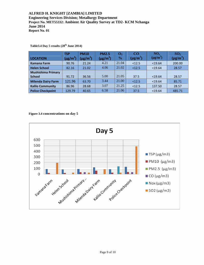
ALFRED H. KNIGHT [ZAMBIA] LIMITED Engineering Services Division; Metallurgy Department Project No. MET55332: Ambient Air Quality Survey at TD2- KCM Nchanga June 2014 Report No. 01
Page 9 of 10
Table3.4 Day 5 results (28th June 2014)
LOCATION TSP (µg/m3)
PM10 (µg/m3)
PM2.5 (µg/m3)
O2 %
CO (µg/m3)
NOx (µg/m3)
SO2 (µg/m3)
Kamana Farm 90.76 21.24 4.21 21.04 <12.5 <19.64 200.00
Helen School 82.16 21.02 4.06 21.02 <12.5 <19.64 28.57
Mushishima Primary School 91.72 36.56
5.00
21.05 37.5 <19.64 28.57
Milenda Dairy Farm 121.96 63.70 3.44 21.00 <12.5 <19.64 85.71
Kalilo Community 86.96 28.68 3.07 21.25 <12.5 137.50 28.57
Police Checkpoint 129.79 40.65 6.58 21.06 37.5 <19.64 485.71
Figure 3.4 concentrations on day 5
ALFRED H. KNIGHT [ZAMBIA] LIMITED Engineering Services Division; Metallurgy Department Project No. MET55332: Ambient Air Quality Survey at TD2- KCM Nchanga June 2014 Report No. 01
Page 10 of 10
4.0 CONCLUSSIONS It was clearly observed that the sampling point at Milenda farm was located near the source (TD2) and thus exhibited high levels of dust concentration generally due to the wind direction and the dust storms off TD2. Also worth noting at the police checkpoint, there is heavy traffic and a nearby plant that could be contributing to the measured results. Apart from the outlined observations in certain areas with high levels of either dust or gaseous pollutant concentrations, the results obtained from the survey are representative of the baseline conditions in the area.
Konkola Copper Mines Plc
New Slag Dump Project
Draft Environmental and Social Impact Statement September 2014
Appendix D Traffic Survey Data
TRAFFIC SURVEY DATA
CHINGOLA/SOLWEZI/CHILILABOMBWE T3/T5 INTERSECTION
MAY 2014
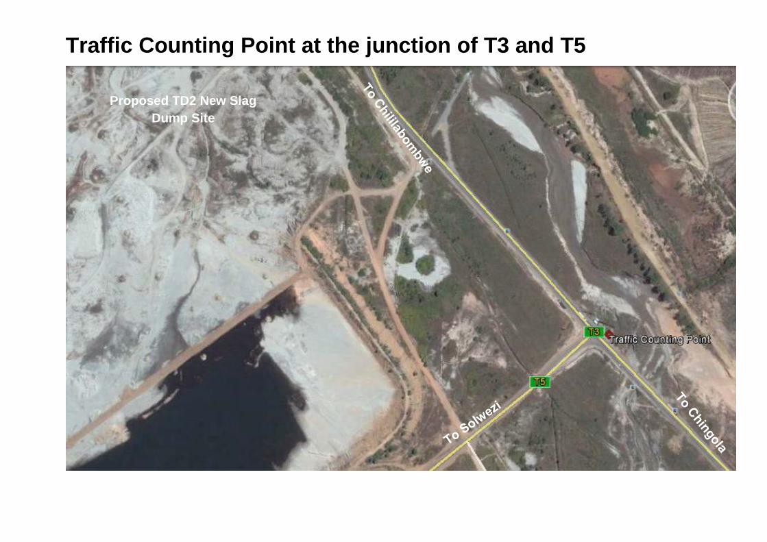
Traffic Counting Point at the junction of T3 and T5
Proposed TD2 New Slag Dump Site
Hourly Count in each DirectionDa
y No.
Date
Day
Point
No.
Prov
ince
Distr
ict
Road
No.
Direc
tion
Motor
cycle
and S
coote
r
Pass
enge
r Car
Micro
Bus
Light
Deliv
ery V
ehicl
e
Mediu
m De
livery
Veh
icle
Mini
Bus
Big B
us
Rigid
Truc
k 2 A
xles
Rigid
Truc
k 3 an
d 4 A
xles
Rigid
Truc
k and
Draw
bar T
railer
Horse
and S
emi T
railer
3&4 A
xles
Horse
and S
emi T
railer
5&6 A
xles
Horse
and S
emi T
railer
7 Ax
les
Horse
and T
wo (S
emi) T
railer
s
Othe
r Veh
icles
1 22.05.14Thur 6:00 7:00 1 C/B CHINGOLA T5 WST 1 9 0 4 2 1 1 3 2 9 0 41 22.05.14thur 7:00 8:00 1 C/B CHINGOLA T5 WST 11 2 14 2 2 0 5 1 8 1 01 22.05.14Thur 8:00 9:00 1 C/B CHINGOLA T5 WST 14 1 7 5 0 0 2 2 9 31 22.05.14thur 9:00 10:00 1 C/B CHINGOLA T5 WST 6 0 12 7 1 0 5 0 6 01 22.05.14Thur 10:00 11:00 1 C/B CHINGOLA T5 WST 9 0 7 4 0 1 4 1 10 11 22.05.14thur 11:00 12:00 1 C/B CHINGOLA T5 WST 7 1 6 1 1 1 6 2 5 11 22.05.14Thur 12:00 13:00 1 C/B CHINGOLA T5 WST 7 0 11 0 0 0 0 0 5 11 22.05.14thur 13:00 14:00 1 C/B CHINGOLA T5 WST 1 1 7 2 3 2 3 0 3 21 22.05.14Thur 14:00 15:00 1 C/B CHINGOLA T5 WST 10 2 9 2 7 2 7 1 7 51 22.05.14thur 15:00 16:00 1 C/B CHINGOLA T5 WST 10 0 4 0 2 1 2 2 10 41 22.05.14Thur 16:00 17:00 1 C/B CHINGOLA T5 WST 6 2 7 0 1 0 1 2 2 51 22.05.14thur 17:00 18:00 1 C/B CHINGOLA T5 WST 9 0 6 0 0 3 0 0 3 11
TOTAL CHINGOLA 1 100 9 91 25 18 11 79 13 78 1 37
2 23.05.14 Fri 6:00 7:00 1 C/B CHINGOLA T5 WST 3 2 13 6 1 3 3 62 23.05.14 Fri 7:00 8:00 1 C/B CHINGOLA T5 WST 9 4 7 5 1 2 1 122 23.05.14 Fri 8:00 9:00 1 C/B CHINGOLA T5 WST 8 2 19 4 1 5 4 11 42 23.05.14 Fri 9:00 10:00 1 C/B CHINGOLA T5 WST 8 6 12 1 1 1 1 12 3 52 23.05.14 Fri 10:00 11:00 1 C/B CHINGOLA T5 WST 8 6 10 6 1 3 1 1 72 23.05.14 Fri 11:00 12:00 1 C/B CHINGOLA T5 WST 9 1 8 2 6 2 2 9 2 12 23.05.14 Fri 12:00 13:00 1 C/B CHINGOLA T5 WST 1 3 9 1 5 1 10 32 23.05.14 Fri 13:00 14:00 1 C/B CHINGOLA T5 WST 4 2 16 3 1 1 7 18 32 23.05.14 Fri 14:00 15:00 1 C/B CHINGOLA T5 WST 8 3 3 4 4 10 1 8 2 62 23.05.14 Fri 15:00 16:00 1 C/B CHINGOLA T5 WST 8 2 9 1 2 3 10 32 23.05.14 Fri 16:00 17:00 1 C/B CHINGOLA T5 WST 9 6 16 3 3 2 5 8 12 23.05.14 Fri 17:00 18:00 1 C/B CHINGOLA T5 WST 11 2 8 5 2 2 4 4
TOTAL CHINGOLA 1 91 36 131 38 219 11 40 11 116 19 25 1
3 24.05.14 Sat 6:00 7:00 1 C/B CHINGOLA T5 WST 1 6 1 7 5 1 1 2 1 10 33 24.05.14 Sat 7:00 8:00 1 C/B CHINGOLA T5 WST 14 5 10 5 2 7 23 24.05.14 Sat 8:00 9:00 1 C/B CHINGOLA T5 WST 16 1 14 5 1 1 1 8 13 24.05.14 Sat 9:00 10:00 1 C/B CHINGOLA T5 WST 10 9 7 1 9 3 13 24.05.14 Sat 10:00 11:00 1 C/B CHINGOLA T5 WST 6 1 9 4 1 1 4 23 24.05.14 Sat 11:00 12:00 1 C/B CHINGOLA T5 WST 18 2 11 5 1 1 1 33 24.05.14 Sat 12:00 13:00 1 C/B CHINGOLA T5 WST 17 2 12 4 2 2 5 4 6 13 24.05.14 Sat 13:00 14:00 1 C/B CHINGOLA T5 WST 14 1 6 1 2 3 53 24.05.14 Sat 14:00 15:00 1 C/B CHINGOLA T5 WST 14 8 3 5 1 5 63 24.05.14 Sat 15:00 16:00 1 C/B CHINGOLA T5 WST 11 3 8 4 1 4 53 24.05.14 Sat 16:00 17:00 1 C/B CHINGOLA T5 WST 9 3 11 3 6 2 1 6 33 24.05.14 Sat 17:00 18:00 1 C/B CHINGOLA T5 WST 22 5 7 6 2 2 14 2 1
TOTAL CHINGOLA ## 1 157 24 112 52 20 2 15 13 0 0 79 11 21 4
4 25.05.14 Sun 6:00 7:00 1 C/B CHINGOLA T5 WST 8 1 9 3 2 7 14 25.05.14 Sun 7:00 8:00 1 C/B CHINGOLA T5 WST 7 2 8 3 1 84 25.05.14 Sun 8:00 9:00 1 C/B CHINGOLA T5 WST 9 3 7 5 6 34 25.05.14 Sun 9:00 10:00 1 C/B CHINGOLA T5 WST 15 6 9 2 1 7 10 4 14 25.05.14 Sun 10:00 11:00 1 C/B CHINGOLA T5 WST 17 0 5 1 1 1 5 7 34 25.05.14 Sun 11:00 12:00 1 C/B CHINGOLA T5 WST 23 1 13 2 6 2 10 54 25.05.14 Sun 12:00 13:00 1 C/B CHINGOLA T5 WST 22 1 6 1 2 1 4 9 34 25.05.14 Sun 13:00 14:00 1 C/B CHINGOLA T5 WST 9 4 12 1 2 1 13 34 25.05.14 Sun 14:00 15:00 1 C/B CHINGOLA T5 WST 18 3 9 1 4 4 1 13 1 24 25.05.14 Sun 15:00 16:00 1 C/B CHINGOLA T5 WST 17 1 6 3 1 2 3 10 64 25.05.14 Sun 16:00 17:00 1 C/B CHINGOLA T5 WST 17 2 4 3 2 4 1 7 64 25.05.14 Sun 17:00 18:00 1 C/B CHINGOLA T5 WST 15 2 15 3 2 2 2 2 7 1
TOTAL CHINGOLA 198 26 90 12 18 11 44 6 102 1 33 2
5 26.05.14 Mon 6:00 7:00 1 C/B CHINGOLA T5 WST 6 3 5 1 2 2 1 4 35 26.05.14 Mon 7:00 8:00 1 C/B CHINGOLA T5 WST 9 4 8 1 2 1 8 3 15 26.05.14 Mon 8:00 9:00 1 C/B CHINGOLA T5 WST 3 2 5 3 2 1 3 3 35 26.05.14 Mon 9:00 10:00 1 C/B CHINGOLA T5 WST 8 3 10 6 3 1 8 3 25 26.05.14 Mon 10:00 11:00 1 C/B CHINGOLA T5 WST 15 3 10 5 1 1 3 9 15 26.05.14 Mon 11:00 12:00 1 C/B CHINGOLA T5 WST 2 2 14 3 4 1 1 7 25 26.05.14 Mon 12:00 13:00 1 C/B CHINGOLA T5 WST 17 1 6 6 1 2 2 1 17 15 26.05.14 Mon 13:00 14:00 1 C/B CHINGOLA T5 WST 21 3 3 3 2 5 13 65 26.05.14 Mon 14:00 15:00 1 C/B CHINGOLA T5 WST 2 4 12 5 5 2 3 9 45 26.05.14 Mon 15:00 16:00 1 C/B CHINGOLA T5 WST 28 9 20 3 7 6 2 1 12 115 26.05.14 Mon 16:00 17:00 1 C/B CHINGOLA T5 WST 1 20 6 25 5 2 2 17 25 26.05.14 Mon 17:00 18:00 1 C/B CHINGOLA T5 WST 22 4 21 2 3 1 2 1 4 6
TOTAL CHINGOLA 1 166 44 137 43 34 16 38 6 77 1 41
Time
TRAFFIC SURVEY: SOLWEZI CHINGOLA (SOUTH) DIRECTION-T5
Hourly Count in each DirectionDa
y No.
Date
Day
Point
No.
Prov
ince
Distr
ict
Road
No.
Direc
tion
Motor
cycle
and S
coote
r
Pass
enge
r Car
Micro
Bus
Light
Deliv
ery V
ehicl
e
Mediu
m De
livery
Veh
icle
Mini
Bus
Big B
us
Rigid
Truc
k 2 A
xles
Rigid
Truc
k 3 an
d 4 A
xles
Rigid
Truc
k and
Draw
bar T
railer
Horse
and S
emi T
railer
3&4 A
xles
Horse
and S
emi T
railer
5&6 A
xles
Horse
and S
emi T
railer
7 Ax
les
Horse
and T
wo (S
emi) T
railer
s
Othe
r Veh
icles
1 22.05.14 Thur 6:00 7:00 1 C/B CHINGOLA T5 NORTH 46 16 28 4 8 1 5 11 1 31 22.05.14 Thur 7:00 8:00 1 C/B CHINGOLA T5 NORTH 46 22 17 3 1 1 7 3 23 61 22.05.14 Thur 8:00 9:00 1 C/B CHINGOLA T5 NORTH 36 13 19 6 1 1 3 8 19 1 31 22.05.14 Thur 9:00 10:00 1 C/B CHINGOLA T5 NORTH 32 12 20 1 1 10 1 19 31 22.05.14 Thur 10:00 11:00 1 C/B CHINGOLA T5 NORTH 27 17 18 5 1 1 4 4 16 6 11 22.05.14 Thur 11:00 12:00 1 C/B CHINGOLA T5 NORTH 29 11 27 3 3 7 12 21 31 22.05.14 Thur 12:00 13:00 1 C/B CHINGOLA T5 NORTH 40 12 27 6 3 1 9 2 24 31 22.05.14 Thur 13:00 14:00 1 C/B CHINGOLA T5 NORTH 28 16 13 5 4 3 4 251 22.05.14 Thur 14:00 15:00 1 C/B CHINGOLA T5 NORTH 39 8 25 6 6 1 6 5 18 14 31 22.05.14 Thur 15:00 16:00 1 C/B CHINGOLA T5 NORTH 33 14 10 2 1 1 8 3 28 181 22.05.14 Thur 16:00 17:00 1 C/B CHINGOLA T5 NORTH 34 9 20 6 7 2 2 2 22 61 22.05.14 Thur 17:00 18:00 1 C/B CHINGOLA T5 NORTH 33 11 24 3 4 1 4 7 30 4 1
TOTAL CHINGOLA 423 161 248 50 40 10 68 51 256 2 69 5
2 23.05.14 Fri 6:00 7:00 1 C/B CHINGOLA T5 NORTH 1 49 5 28 1 8 3 7 2 29 1 52 23.05.14 Fri 7:00 8:00 1 C/B CHINGOLA T5 NORTH 55 4 10 1 2 2 16 9 21 42 23.05.14 Fri 8:00 9:00 1 C/B CHINGOLA T5 NORTH 44 6 24 1 1 9 2 7 52 23.05.14 Fri 9:00 10:00 1 C/B CHINGOLA T5 NORTH 43 6 17 1 1 2 9 3 22 132 23.05.14 Fri 10:00 11:00 1 C/B CHINGOLA T5 NORTH 39 6 12 1 2 14 8 18 122 23.05.14 Fri 11:00 12:00 1 C/B CHINGOLA T5 NORTH 55 8 11 1 11 1 28 82 23.05.14 Fri 12:00 13:00 1 C/B CHINGOLA T5 NORTH 35 18 24 1 2 12 5 31 52 23.05.14 Fri 13:00 14:00 1 C/B CHINGOLA T5 NORTH 51 4 15 4 2 8 2 20 72 23.05.14 Fri 14:00 15:00 1 C/B CHINGOLA T5 NORTH 46 4 12 2 9 8 19 32 23.05.14 Fri 15:00 16:00 1 C/B CHINGOLA T5 NORTH 41 5 14 2 1 6 2 21 62 23.05.14 Fri 16:00 17:00 1 C/B CHINGOLA T5 NORTH 47 7 21 5 1 10 1 21 42 23.05.14 Fri 17:00 18:00 1 C/B CHINGOLA T5 NORTH 71 6 11 1 4 1 9 25 4
TOTAL CHINGOLA 1 580 78 199 6 33 14 124 43 246 1 763 24.05.14 Sat 6:00 7:00 1 C/B CHINGOLA T5 NORTH 24 11 8 3 7 1 4 2 28 23 24.05.14 Sat 7:00 8:00 1 C/B CHINGOLA T5 NORTH 19 10 11 2 2 1 3 29 7 23 24.05.14 Sat 8:00 9:00 1 C/B CHINGOLA T5 NORTH 23 14 15 3 1 4 15 3 23 24.05.14 Sat 9:00 10:00 1 C/B CHINGOLA T5 NORTH 22 13 15 3 9 4 22 43 24.05.14 Sat 10:00 11:00 1 C/B CHINGOLA T5 NORTH 21 14 10 4 3 3 12 4 33 24.05.14 Sat 11:00 12:00 1 C/B CHINGOLA T5 NORTH 34 10 16 5 4 1 5 7 15 5 13 24.05.14 Sat 12:00 13:00 1 C/B CHINGOLA T5 NORTH 34 14 15 5 2 1 3 3 15 6 33 24.05.14 Sat 13:00 14:00 1 C/B CHINGOLA T5 NORTH 48 10 20 8 6 3 4 2 15 6 13 24.05.14 Sat 14:00 15:00 1 C/B CHINGOLA T5 NORTH 1 30 10 16 4 7 5 2 16 4 33 24.05.14 Sat 15:00 16:00 1 C/B CHINGOLA T5 NORTH 53 14 22 2 2 1 6 2 28 3 93 24.05.14 Sat 16:00 17:00 1 C/B CHINGOLA T5 NORTH 36 11 13 6 6 2 23 43 24.05.14 Sat 17:00 18:00 1 C/B CHINGOLA T5 NORTH 54 16 12 2 6 5 3 21 3
TOTAL CHINGOLA 1 421 149 161 46 41 13 49 35 239 44 31
4 25.05.14 Sun 6:00 7:00 1 C/B CHINGOLA T5 NORTH 14 1 4 4 7 1 5 5 24 14 25.05.14 Sun 7:00 8:00 1 C/B CHINGOLA T5 NORTH 8 6 5 3 2 1 8 9 74 25.05.14 Sun 8:00 9:00 1 C/B CHINGOLA T5 NORTH 16 8 7 1 5 18 34 25.05.14 Sun 9:00 10:00 1 C/B CHINGOLA T5 NORTH 25 7 3 5 1 6 1 15 24 25.05.14 Sun 10:00 11:00 1 C/B CHINGOLA T5 NORTH 23 3 3 6 2 1 2 11 114 25.05.14 Sun 11:00 12:00 1 C/B CHINGOLA T5 NORTH 26 4 6 1 3 24 3 14 25.05.14 Sun 12:00 13:00 1 C/B CHINGOLA T5 NORTH 39 9 13 3 2 2 1 29 114 25.05.14 Sun 13:00 14:00 1 C/B CHINGOLA T5 NORTH 31 8 7 4 1 20 54 25.05.14 Sun 14:00 15:00 1 C/B CHINGOLA T5 NORTH 39 13 7 1 1 3 14 74 25.05.14 Sun 15:00 16:00 1 C/B CHINGOLA T5 NORTH 42 12 12 13 20 24 25.05.14 Sun 16:00 17:00 1 C/B CHINGOLA T5 NORTH 35 14 9 3 3 1 1 154 25.05.14 Sun 17:00 18:00 1 C/B CHINGOLA T5 NORTH 36 13 17 3 6 1 8 4
TOTAL CHINGOLA 334 98 93 29 31 3 29 27 0 0 207 0 56 1
5 26.05.14 Mon 6:00 7:00 1 C/B CHINGOLA T5 NORTH 17 4 7 1 7 2 15 25 26.05.14 Mon 7:00 8:00 1 C/B CHINGOLA T5 NORTH 22 16 10 1 1 15 15 45 26.05.14 Mon 8:00 9:00 1 C/B CHINGOLA T5 NORTH 23 19 7 14 2 12 45 26.05.14 Mon 9:00 10:00 1 C/B CHINGOLA T5 NORTH 34 7 12 1 3 1 7 3 13 35 26.05.14 Mon 10:00 11:00 1 C/B CHINGOLA T5 NORTH 1 37 10 9 2 1 4 3 13 85 26.05.14 Mon 11:00 12:00 1 C/B CHINGOLA T5 NORTH 26 11 9 1 1 7 1 10 55 26.05.14 Mon 12:00 13:00 1 C/B CHINGOLA T5 NORTH 36 10 11 2 9 8 35 26.05.14 Mon 13:00 14:00 1 C/B CHINGOLA T5 NORTH 43 14 6 4 1 3 1 22 35 26.05.14 Mon 14:00 15:00 1 C/B CHINGOLA T5 NORTH 36 8 5 1 6 2 15 25 26.05.14 Mon 15:00 16:00 1 C/B CHINGOLA T5 NORTH 30 14 16 4 1 6 23 45 26.05.14 Mon 16:00 17:00 1 C/B CHINGOLA T5 NORTH 36 13 1 3 7 15 55 26.05.14 Mon 17:00 18:00 1 C/B CHINGOLA T5 NORTH 49 8 11 6 1 10 2 12 2 2
TOTAL CHINGOLA 1 376 116 94 4 26 5 96 16 173 2 45
Time
TRAFFIC SURVEY CHINGOLA CHILILABOMBWE (NORTH) –T3
Hourly Count in each DirectionDa
y No.
Date
Day
Point
No.
Prov
ince
Distric
t
Road
No.
Direc
tion
Motor
cycle
and S
coote
r
Pass
enge
r Car
Micro
Bus
Light
Deliv
ery V
ehicl
e
Mediu
m De
livery
Veh
icle
Mini
Bus
Big B
us
Rigid
Truck
2 Ax
les
Rigid
Truck
3 an
d 4 A
xles
Rigid
Truck
and D
rawba
r Trai
ler
Horse
and S
emi T
railer
3&4 A
xles
Horse
and S
emi T
railer
5&6 A
xles
Horse
and S
emi T
railer
7 Ax
les
Horse
and T
wo (S
emi) T
railer
s
Othe
r Veh
icles
1 22.05.14 Thur 6:00 7:00 1 C/B CHINGOLA T5 SOTH 1 32 4 6 1 2 2 3 3 11 21 22.05.14 Thur 7:00 8:00 1 C/B CHINGOLA T5SOUTH 31 7 16 2 2 5 5 11 22.05.14 Thur 8:00 9:00 1 C/B CHINGOLA T5 SOTH 23 15 12 2 3 2 6 5 11 1 51 22.05.14 Thur 9:00 10:00 1 C/B CHINGOLA T5SOUTH 30 11 19 2 2 6 2 27 131 22.05.14 Thur 10:00 11:00 1 C/B CHINGOLA T5 SOTH 46 12 30 6 3 1 5 4 18 1 41 22.05.14 Thur 11:00 12:00 1 C/B CHINGOLA T5SOUTH 1 36 9 16 2 14 5 19 2 1 11 22.05.14 Thur 12:00 13:00 1 C/B CHINGOLA T5 SOTH 32 7 26 3 1 6 13 40 5 21 22.05.14 Thur 13:00 14:00 1 C/B CHINGOLA T5SOUTH 42 11 17 3 1 1 4 6 27 2 21 22.05.14 Thur 14:00 15:00 1 C/B CHINGOLA T5 SOTH 27 12 37 2 5 3 37 11 22.05.14 Thur 15:00 16:00 1 C/B CHINGOLA T5SOUTH 45 13 35 1 6 1 15 8 32 12 11 22.05.14 Thur 16:00 17:00 1 C/B CHINGOLA T5 SOTH 41 13 40 3 1 1 9 11 28 3 31 22.05.14 Thur 17:00 18:00 1 C/B CHINGOLA T5SOUTH 50 29 34 6 10 2 10 3 42 14 5
TOTAL CHINGOLA T5 2 424 151 298 34 37 15 70 66 298 42 37 1
2 23.05.14 Fri 6:00 7:00 1 C/B CHINGOLA T5SOUTH 18 3 2 5 5 1 1 1 6 72 23.05.14 Fri 7:00 8:00 1 C/B CHINGOLA T5SOUTH 24 8 4 5 5 1 6 72 23.05.14 Fri 8:00 9:00 1 C/B CHINGOLA T5SOUTH 19 19 11 3 9 1 19 32 23.05.14 Fri 9:00 10:00 1 C/B CHINGOLA T5SOUTH 39 12 16 1 6 9 12 23.05.14 Fri 10:00 11:00 1 C/B CHINGOLA T5SOUTH 39 13 10 2 3 3 1 14 12 23.05.14 Fri 11:00 12:00 1 C/B CHINGOLA T5SOUTH 39 11 6 2 2 4 5 122 23.05.14 Fri 12:00 13:00 1 C/B CHINGOLA T5SOUTH 45 12 19 6 4 7 5 23 172 23.05.14 Fri 13:00 14:00 1 C/B CHINGOLA T5SOUTH 44 15 9 3 1 4 18 92 23.05.14 Fri 14:00 15:00 1 C/B CHINGOLA T5SOUTH 47 8 15 4 2 4 182 23.05.14 Fri 15:00 16:00 1 C/B CHINGOLA T5SOUTH 49 15 14 10 9 1 7 1 16 12 23.05.14 Fri 16:00 17:00 1 C/B CHINGOLA T5SOUTH 50 11 1 2 3 2 2 1 172 23.05.14 Fri 17:00 18:00 1 C/B CHINGOLA T5SOUTH 64 31 14 7 3 1 13 4
TOTAL CHINGOLA 416 128 104 37 33 3 32 13 0 0 140 0 33 0
3 24.05.14 Sat 6:00 7:00 1 C/B CHINGOLA T5SOUTH 39 3 4 1 7 2 1 7 43 24.05.14 Sat 7:00 8:00 1 C/B CHINGOLA T5SOUTH 35 6 3 5 2 1 1 113 24.05.14 Sat 8:00 9:00 1 C/B CHINGOLA T5SOUTH 43 10 17 6 1 4 223 24.05.14 Sat 9:00 10:00 1 C/B CHINGOLA T5SOUTH 65 12 23 2 1 1 10 6 28 33 24.05.14 Sat 10:00 11:00 1 C/B CHINGOLA T5SOUTH 62 20 15 4 7 2 6 1 8 33 24.05.14 Sat 11:00 12:00 1 C/B CHINGOLA T5SOUTH 42 13 14 1 2 6 4 29 33 24.05.14 Sat 12:00 13:00 1 C/B CHINGOLA T5SOUTH 48 13 16 4 4 10 3 133 24.05.14 Sat 13:00 14:00 1 C/B CHINGOLA T5SOUTH 44 9 14 3 3 1 12 9 22 73 24.05.14 Sat 14:00 15:00 1 C/B CHINGOLA T5SOUTH 44 20 14 2 3 16 2 17 143 24.05.14 Sat 15:00 16:00 1 C/B CHINGOLA T5SOUTH 39 15 11 1 6 1 10 1 42 1 263 24.05.14 Sat 16:00 17:00 1 C/B CHINGOLA T5SOUTH 46 8 11 1 6 8 36 93 24.05.14 Sat 17:00 18:00 1 C/B CHINGOLA T5SOUTH 45 11 17 2 7 1 13 1 21 5
TOTAL CHINGOLA 565 139 154 23 57 11 99 28 223 1 74
4 25.05.14 Sun 6:00 7:00 1 C/B CHINGOLA T5SOUTH 8 3 3 4 2 1 64 25.05.14 Sun 7:00 8:00 1 C/B CHINGOLA T5SOUTH 18 7 5 3 4 2 5 24 25.05.14 Sun 8:00 9:00 1 C/B CHINGOLA T5SOUTH 18 3 13 2 5 3 114 25.05.14 Sun 9:00 10:00 1 C/B CHINGOLA T5SOUTH 25 2 12 3 1 1 29 1 54 25.05.14 Sun 10:00 11:00 1 C/B CHINGOLA T5SOUTH 28 9 11 4 3 2 4 33 4 74 25.05.14 Sun 11:00 12:00 1 C/B CHINGOLA T5SOUTH 35 8 13 2 2 1 5 1 27 1 24 25.05.14 Sun 12:00 13:00 1 C/B CHINGOLA T5SOUTH 38 10 11 5 3 1 11 4 37 5 54 25.05.14 Sun 13:00 14:00 1 C/B CHINGOLA T5SOUTH 31 6 9 5 2 6 53 4 94 25.05.14 Sun 14:00 15:00 1 C/B CHINGOLA T5SOUTH 41 11 15 2 3 2 20 10 74 25.05.14 Sun 15:00 16:00 1 C/B CHINGOLA T5SOUTH 39 12 17 5 10 2 6 14 134 25.05.14 Sun 16:00 17:00 1 C/B CHINGOLA T5SOUTH 19 12 11 4 1 7 17 1 34 25.05.14 Sun 17:00 18:00 1 C/B CHINGOLA T5SOUTH 53 16 23 4 2 1 5 35
TOTAL CHINGOLA 348 87 140 32 46 11 45 10 287 28 51
5 26.05.14 Mon 6:00 7:00 1 C/B CHINGOLA T5SOUTH 18 3 2 5 5 1 1 1 6 75 26.05.15 Mon 7:00 8:00 1 C/B CHINGOLA T5SOUTH 24 8 4 5 5 1 6 75 26.05.16 Mon 8:00 9:00 1 C/B CHINGOLA T5SOUTH 19 19 11 3 9 1 19 35 26.05.17 Mon 9:00 10:00 1 C/B CHINGOLA T5SOUTH 39 12 16 1 6 9 15 26.05.18 Mon 10:00 11:00 1 C/B CHINGOLA T5SOUTH 39 13 10 2 3 3 1 14 15 26.05.19 Mon 11:00 12:00 1 C/B CHINGOLA T5SOUTH 39 11 6 2 2 4 5 125 26.05.20 Mon 12:00 13:00 1 C/B CHINGOLA T5SOUTH 45 12 19 6 4 7 5 23 175 26.05.21 Mon 13:00 14:00 1 C/B CHINGOLA T5SOUTH 44 15 9 3 1 4 18 95 26.05.22 Mon 14:00 15:00 1 C/B CHINGOLA T5SOUTH 47 8 15 4 2 4 185 26.05.23 Mon 15:00 16:00 1 C/B CHINGOLA T5SOUTH 49 15 14 10 9 1 7 1 16 15 26.05.24 Mon 16:00 17:00 1 C/B CHINGOLA T5SOUTH 50 11 1 2 3 2 2 1 175 26.05.25 Mon 17:00 18:00 1 C/B CHINGOLA T5SOUTH 64 31 14 7 3 1 13 4
TOTAL CHINGOLA 416 128 104 37 33 3 32 13 0 0 140 0 33 0
Time
TRAFFIC SURVEY: HOURLY FLOW RATE CHILILABOMBWE –CHINGOLA (SOUTH)-T3
Summary of Traffic Data - 5 Days Count
Direction
Mot
orcy
cle
and
Sco
oter
Pas
seng
er C
ar
Mic
ro B
us
Ligh
t Del
iver
y V
ehic
le
Med
ium
Del
iver
y V
ehic
le
Min
i Bus
Big
Bus
Rig
id T
ruck
2 A
xles
Rig
id T
ruck
3 a
nd 4
Axl
es
Rig
id T
ruck
and
Dra
wba
r Tra
iler
Hor
se a
nd S
emi T
raile
r 3 &
4 A
xles
Hor
se a
nd S
emi T
raile
r 5 &
6 A
xles
Hor
se a
nd S
emi T
raile
r 7 A
xles
Hor
se a
nd T
wo
(Sem
i) Tr
aile
rs
Oth
er v
ehic
les
Ave
rage
Dai
ly T
raffi
c (A
DT)
SOLWEZI / CHINGOLA -SOUTH 8 493 127 447 96 62 51 129 26 1 3 360 12 179 4 400
CHINGOLA / SOLWEZI - WEST 5 746 160 671 181 526 71 320 60 0 0 567 42 198 4 710CHINGOLA / CHILILABOMBWE - NORTH 3 2134 602 795 135 171 45 366 172 0 0 1121 49 277 6 1175CHILILABOMBWE / CHINGOLA - SOUTH 2 2169 633 800 163 206 43 278 130 0 0 1088 71 228 1 1162
Konkola Copper Mines Plc
New Slag Dump Project
Draft Environmental and Social Impact Statement September 2014
Appendix E Radiological Survey Report
Misenge Environmental and Technical Services Ltd A Subsidiary of ZCCM Investments Holdings Plc
DRAFT REPORT
RADIOLOGICAL SURVEY FOR THE PROPOSED KCM SMELTER SLAG DUMP SITE AT RECLAIMED TD 2 IN CHINGOLA
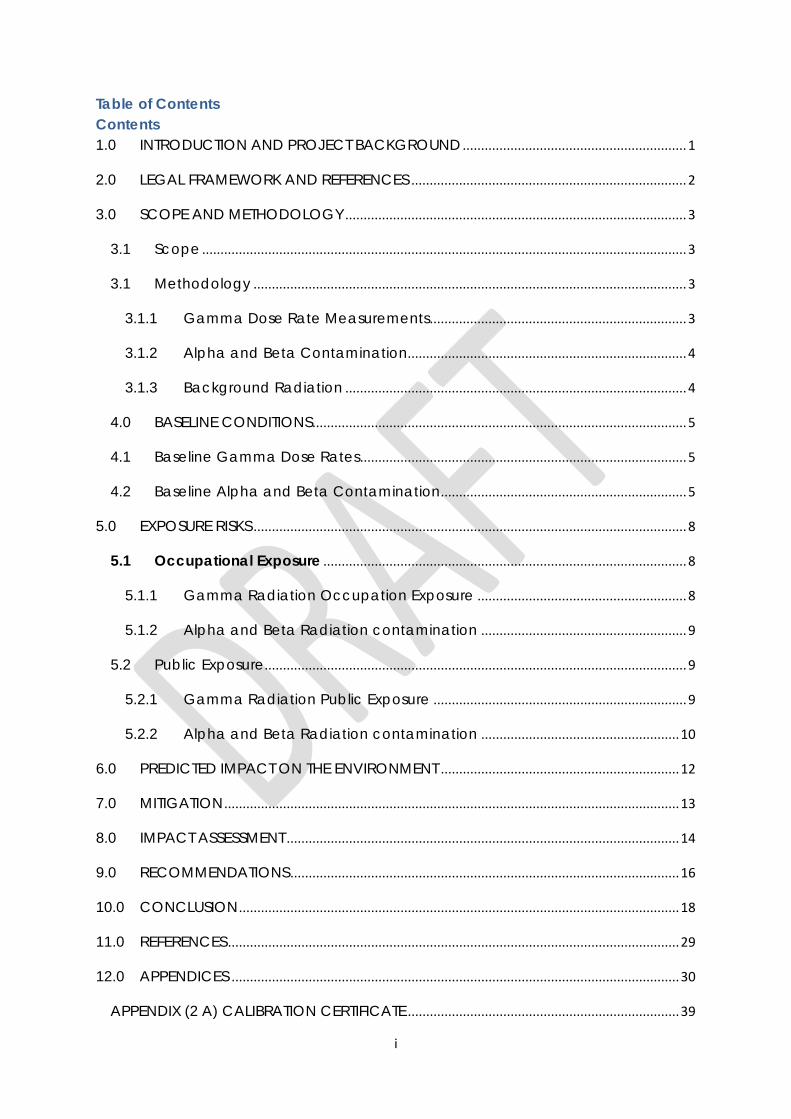
i
Table of Contents Contents 1.0 INTRODUCTION AND PROJECT BACKGROUND ............................................................. 1
2.0 LEGAL FRAMEWORK AND REFERENCES ........................................................................... 2
3.0 SCOPE AND METHODOLOGY ............................................................................................. 3
3.1 Scope .................................................................................................................................... 3
3.1 Methodology ...................................................................................................................... 3
3.1.1 Gamma Dose Rate Measurements ...................................................................... 3
3.1.2 Alpha and Beta Contamination............................................................................ 4
3.1.3 Background Radiation ............................................................................................. 4
4.0 BASELINE CONDITIONS ...................................................................................................... 5
4.1 Baseline Gamma Dose Rates ......................................................................................... 5
4.2 Baseline Alpha and Beta Contamination ................................................................... 5
5.0 EXPOSURE RISKS ...................................................................................................................... 8
5.1 Occupational Exposure ................................................................................................... 8
5.1.1 Gamma Radiation Occupation Exposure ......................................................... 8
5.1.2 Alpha and Beta Radiation contamination ........................................................ 9
5.2 Public Exposure ................................................................................................................... 9
5.2.1 Gamma Radiation Public Exposure ..................................................................... 9
5.2.2 Alpha and Beta Radiation contamination ...................................................... 10
6.0 PREDICTED IMPACT ON THE ENVIRONMENT ................................................................. 12
7.0 MITIGATION ............................................................................................................................ 13
8.0 IMPACT ASSESSMENT ........................................................................................................... 14
9.0 RECOMMENDATIONS .......................................................................................................... 16
10.0 CONCLUSION ........................................................................................................................ 18
11.0 REFERENCES ........................................................................................................................... 29
12.0 APPENDICES .......................................................................................................................... 30
APPENDIX (2 A) CALIBRATION CERTIFICATE .......................................................................... 39
ii
APPENDIX (2 B) CALIBRATION CERTIFICATE ........................................................................... 40
LIST OF TABLES Table 4.1a Summaries of surface dose rates due to gamma for all sites in nano Sievert......................................................................................................................................5
Table 4.1b Summaries of surface dose rates due to gamma for all sites in milli Sievert………………………………………………………………………………………………..5
Table 4.2a Summary of Summary of Alpha and Beta Radiation Dose Rates for all sites……………………………………………………………………………………………………6
Table 4.2b Summary of surface contamination due to alpha and beta particles in Becquerel (Conversion efficiency for natural uranium is 0.4 s-1/Bq)……………………..6
Table 5.1.1 Annual Gamma Occupational Exposure……………………………………8
Table 5.1.2 Alpha and Beta Radiation Contamination…………………………………9
Table 5.2.1 Annual Gamma Public Exposure…………………………………………….10
Table 5.2.2 Alpha and Beta radiation Contamination…………………………………10
Table 8a Impact Assessment………………………………………………………………14
Table 8b Significance of Predicted Impacts…………………………………………...15
Figure 1: Location of Surveyed Area ....................................................................................................... 1
Figure 2: Graphical presentation of the results for surface dose rates (mSv/yr) and contamination (Bq) ........................................................................................................................... 7
Figure 3: Radiation Due to Gamma on the Chingola and Mushishima Streams ................................... 19
Maps
Map of sampling points on the Current Sag Dump – Gamma Radiation……………. 25
Map of sampling points on the Current Sag Dump – Alpha and Beta Radiation……26
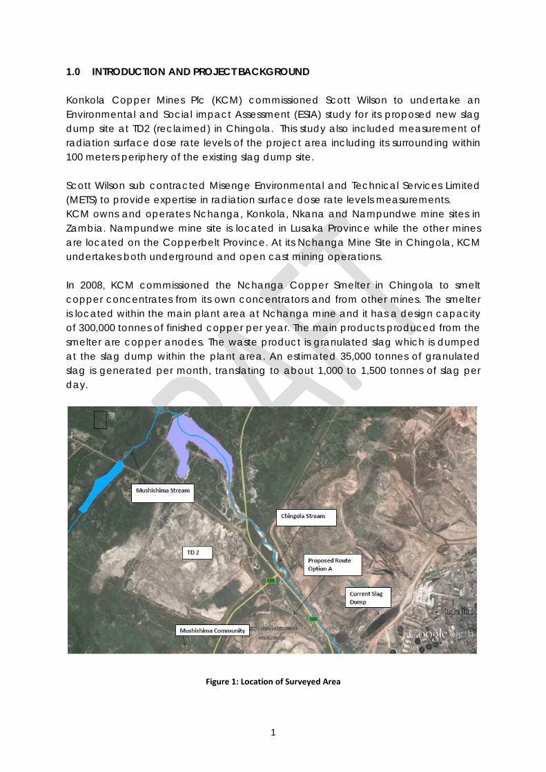
1
1.0 INTRODUCTION AND PROJECT BACKGROUND Konkola Copper Mines Plc (KCM) commissioned Scott Wilson to undertake an Environmental and Social impact Assessment (ESIA) study for its proposed new slag dump site at TD2 (reclaimed) in Chingola. This study also included measurement of radiation surface dose rate levels of the project area including its surrounding within 100 meters periphery of the existing slag dump site. Scott Wilson sub contracted Misenge Environmental and Technical Services Limited (METS) to provide expertise in radiation surface dose rate levels measurements. KCM owns and operates Nchanga, Konkola, Nkana and Nampundwe mine sites in Zambia. Nampundwe mine site is located in Lusaka Province while the other mines are located on the Copperbelt Province. At its Nchanga Mine Site in Chingola, KCM undertakes both underground and open cast mining operations. In 2008, KCM commissioned the Nchanga Copper Smelter in Chingola to smelt copper concentrates from its own concentrators and from other mines. The smelter is located within the main plant area at Nchanga mine and it has a design capacity of 300,000 tonnes of finished copper per year. The main products produced from the smelter are copper anodes. The waste product is granulated slag which is dumped at the slag dump within the plant area. An estimated 35,000 tonnes of granulated slag is generated per month, translating to about 1,000 to 1,500 tonnes of slag per day.
Figure 1: Location of Surveyed Area
2
The granulated slag is currently dumped at Slag Dump No.25 situated within the KCM Mine License area (LSM 34). The dump site has been formed by end-tipping of granulated slag material from dump trucks and evenly spread outwardly using a loader or grader. This has resulted in the formation of dump slopes that are at the natural angle of repose of the slag material. Approximately 1.75 million tonnes has so far been dumped and the dump is approaching its design capacity of 2.6 million tonnes. Therefore, there is an urgent need for an alternative dumping space within KCM Surface Rights in Chingola. Expansion of the existing dump site is constrained by the presence of Block A Open Pit on the north-western edge, the Chingola Stream which is approximately 300 meters on the south-western edge, the Chingola - Chililabombwe public road (T3) at approximately 400 meters on the south-western edge, and the KCM Haulage Road and main drain located on the eastern flank and the power line on the southern periphery of the existing dump. KCM is, therefore, proposing to construct and operate a new slag dump at the site of the reclaimed TD 2 storage facility. The proposed site for the new slag dump is the already reclaimed TD2 tailings storage facility (TSF). According to the dump site design, the proposed dump site has approximately 20 years lifespan not 7 years as earlier communicated to stakeholders. This document is a report of METS surface dose rate findings and recommendations.
2.0 LEGAL FRAMEWORK AND REFERENCES The Ionising Radiation Protection (General) Regulations of 2011 of The Ionising Protection Act 2005 states that the occupational exposure of any employee shall be so controlled such that an effective dose of 20 mSv per year averaged over five consecutive years, or 50 mSv in any single year shall not be exceeded. As for the public, the limit of 1 mSv per year has been adopted. All employees therefore dealing in radioactive materials should comply with this law. References have been made to the International Atomic Energy Agency (IAEA) to which Zambia has been a member since 1969. The IAEA is the world's center of cooperation in the nuclear field and works with its Member States and multiple partners worldwide to promote safe, secure and peaceful nuclear technologies. Recommendations and guidance on radiation protection from the International Commission on Radiological Protection (ICRP) have been referred to as well. Established in 1928, ICRP is an independent, international non-governmental organisation providing recommendations and guidance on radiation protection. It has therefore vast experience in radiological issues.
3
3.0 SCOPE AND METHODOLOGY
3.1 Scope The scope involved measuring gamma dose rates, and alpha and beta contamination at the following sites;
• At the proposed Slag Dump Site at reclaimed TD 2 including 100 metres periphery
• At Mushishima Community including Mushishima School • Along the proposed routes for transporting the slag from the smelter to the
dump site • Along the Chingola Stream • At Helen, TD 3 and Solwezi Road Bridges along Mushishima Stream. • At the current Smelter Slag Dump within KCM Mine Plant
The maps of the above sites have been presented in figures 3 to 10. 3.1 Methodology 3.1.1 Gamma Dose Rate Measurements Gamma dose rates were taken at;
• The proposed dumping site (reclaimed TD 2) • Mushishima Community • The proposed routes (options A and B) • Chingola Stream • Mushishima Stream (at Helen, TD 3 and Solwezi Road bridges) • The current slag dump
The points for measurements were marked using a Garmins GPS 72 at predetermined distances of 75 meters apart. Where it was not possible to have the distances predetermined, the distances between points of measurements ware determined using the measuring wheel. For example, the distances along the proposed routes options A and B were dealt in this manner The survey meter that was used to take measurements was the Teletector 6150 AD-t with a read out 6150 AD5, Serial Number 131809, held at about 1 meter from ground level and recorded in nano Sieverts per hour (nSv/hr). The instrument was calibrated on 12 July 2013 at Nuclear Energy Corporation of South Africa – NECSA (see appendix 2 A).
4
3.1.2 Alpha and Beta Contamination Alpha and beta contamination were taken at;
• The proposed dumping site (reclaimed TD 2) • Mushishima Community • The proposed routes (options A and B) • Chingola Stream • Mushishima Stream (at Helen, TD 3 and Solwezi Road bridges) • The current slag dump
Determination of the points of measurements was just the same as in 3.2.1. The meter used was the Automess 6150 AD6 contamination monitor with Alpha-Beta-Gamma Probe 6150 AD-17 Pancake probe. It was calibrated on 11 July 2013 at Nuclear Energy Corporation of South Africa (refer to appendix 2 B). With the cap on the probe, alpha and beta are filtered giving a reading for gamma radiation only. When the filter is removed, the meter reads gross radiation comprising gamma, alpha and beta radiations. The difference between the two readings is attributed to alpha and beta radiations. These measurements were taken with the probe held at10 cm from the source and recorded in pulse per seconds (p/sec). 3.1.3 Background Radiation Background radiation measurements for gamma, alpha and beta were taken at the following locations;
• Shoprite Checkers Shop in Chingola town centre, • Chiwempala Market • Africa Mechanical and Superlift Limited along Kitwe Road • Kafue Bridge on Chililabombwe Road
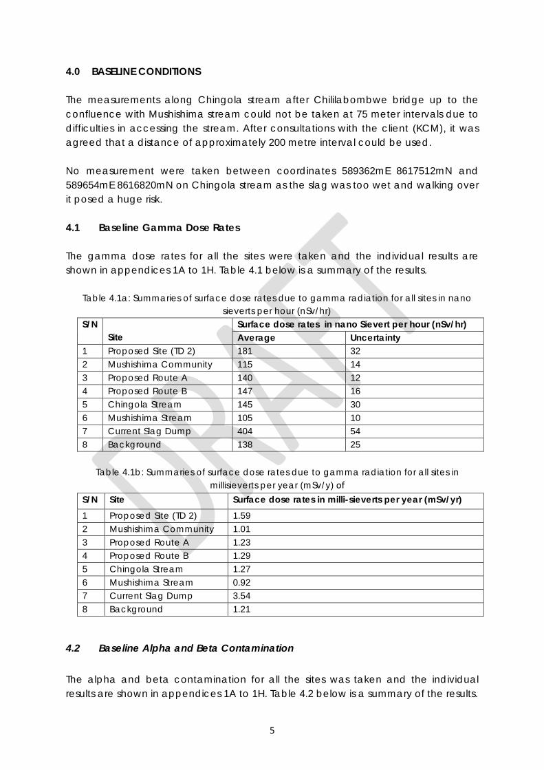
5
4.0 BASELINE CONDITIONS The measurements along Chingola stream after Chililabombwe bridge up to the confluence with Mushishima stream could not be taken at 75 meter intervals due to difficulties in accessing the stream. After consultations with the client (KCM), it was agreed that a distance of approximately 200 metre interval could be used. No measurement were taken between coordinates 589362mE 8617512mN and 589654mE 8616820mN on Chingola stream as the slag was too wet and walking over it posed a huge risk. 4.1 Baseline Gamma Dose Rates The gamma dose rates for all the sites were taken and the individual results are shown in appendices 1A to 1H. Table 4.1 below is a summary of the results.
Table 4.1a: Summaries of surface dose rates due to gamma radiation for all sites in nano
sieverts per hour (nSv/hr) S/N
Site Surface dose rates in nano Sievert per hour (nSv/hr) Average Uncertainty
1 Proposed Site (TD 2) 181 32 2 Mushishima Community 115 14 3 Proposed Route A 140 12 4 Proposed Route B 147 16 5 Chingola Stream 145 30 6 Mushishima Stream 105 10 7 Current Slag Dump 404 54 8 Background 138 25
Table 4.1b: Summaries of surface dose rates due to gamma radiation for all sites in
millisieverts per year (mSv/y) of S/N Site Surface dose rates in milli-sieverts per year (mSv/yr) 1 Proposed Site (TD 2) 1.59 2 Mushishima Community 1.01 3 Proposed Route A 1.23 4 Proposed Route B 1.29 5 Chingola Stream 1.27 6 Mushishima Stream 0.92 7 Current Slag Dump 3.54 8 Background 1.21
4.2 Baseline Alpha and Beta Contamination The alpha and beta contamination for all the sites was taken and the individual results are shown in appendices 1A to 1H. Table 4.2 below is a summary of the results.
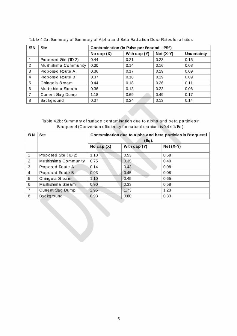
6
Table 4.2a: Summary of Summary of Alpha and Beta Radiation Dose Rates for all sites
S/N Site Contamination (in Pulse per Second - PS-1) No cap (X) With cap (Y) Net (X-Y) Uncertainty
1 Proposed Site (TD 2) 0.44 0.21 0.23 0.15 2 Mushishima Community 0.30 0.14 0.16 0.08 3 Proposed Route A 0.36 0.17 0.19 0.09 4 Proposed Route B 0.37 0.18 0.19 0.09 5 Chingola Stream 0.44 0.18 0.26 0.11 6 Mushishima Stream 0.36 0.13 0.23 0.06 7 Current Slag Dump 1.18 0.69 0.49 0.17 8 Background 0.37 0.24 0.13 0.14
Table 4.2b: Summary of surface contamination due to alpha and beta particles in Becquerel (Conversion efficiency for natural uranium is 0.4 s-1/Bq).
S/N Site Contamination due to alpha and beta particles in Becquerel (Bq).
No cap (X) With cap (Y) Net (X-Y)
1 Proposed Site (TD 2) 1.10 0.53 0.58 2 Mushishima Community 0.75 0.35 0.40 3 Proposed Route A 0.14 0.43 0.08 4 Proposed Route B 0.93 0.45 0.08 5 Chingola Stream 1.10 0.45 0.65 6 Mushishima Stream 0.90 0.33 0.58 7 Current Slag Dump 2.95 1.73 1.23 8 Background 0.93 0.60 0.33
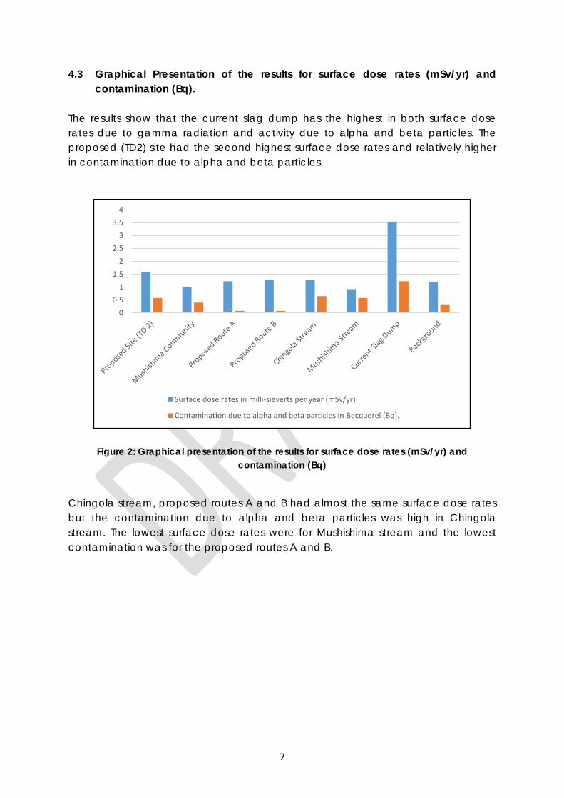
7
4.3 Graphical Presentation of the results for surface dose rates (mSv/yr) and contamination (Bq).
The results show that the current slag dump has the highest in both surface dose rates due to gamma radiation and activity due to alpha and beta particles. The proposed (TD2) site had the second highest surface dose rates and relatively higher in contamination due to alpha and beta particles.
Figure 2: Graphical presentation of the results for surface dose rates (mSv/yr) and contamination (Bq)
Chingola stream, proposed routes A and B had almost the same surface dose rates but the contamination due to alpha and beta particles was high in Chingola stream. The lowest surface dose rates were for Mushishima stream and the lowest contamination was for the proposed routes A and B.
00.5
11.5
22.5
33.5
4
Surface dose rates in milli-sieverts per year (mSv/yr)
Contamination due to alpha and beta particles in Becquerel (Bq).
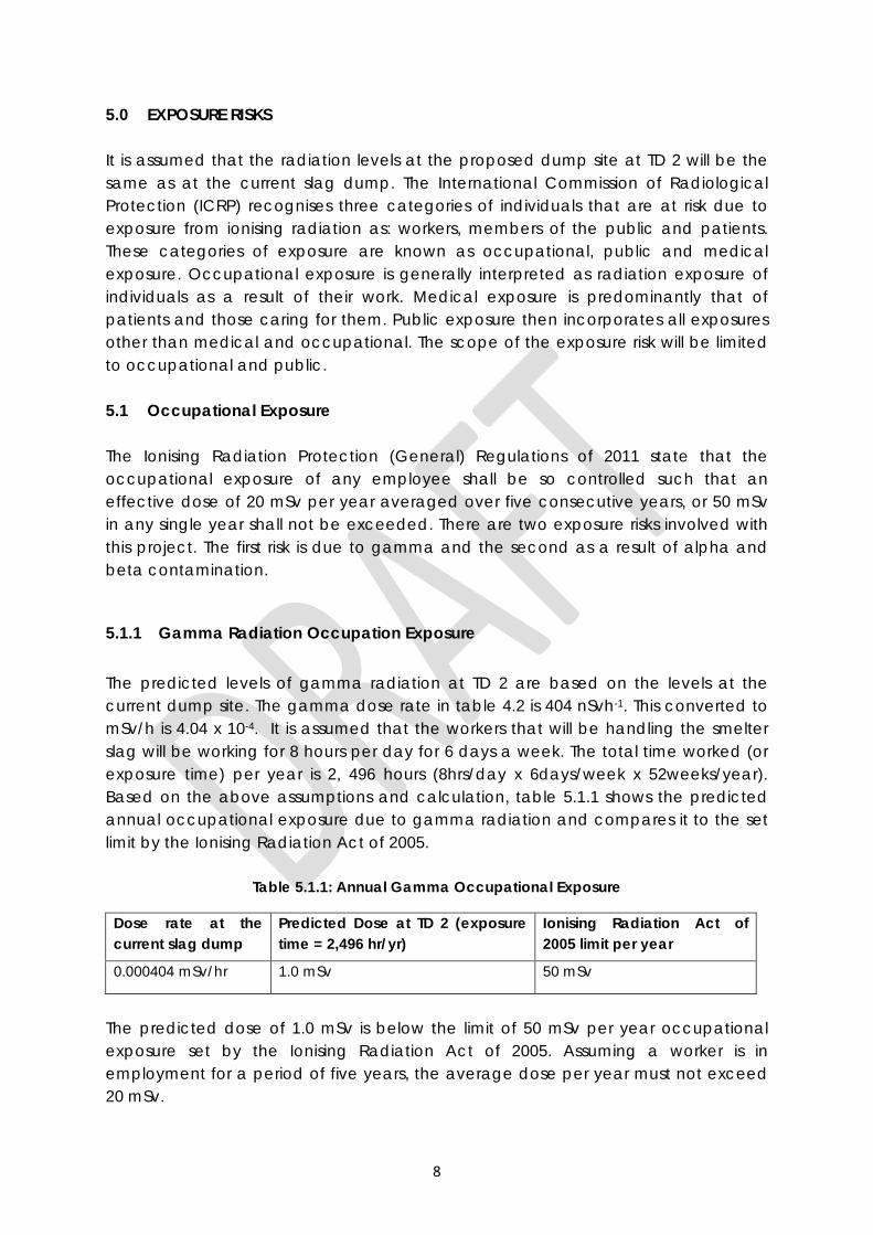
8
5.0 EXPOSURE RISKS It is assumed that the radiation levels at the proposed dump site at TD 2 will be the same as at the current slag dump. The International Commission of Radiological Protection (ICRP) recognises three categories of individuals that are at risk due to exposure from ionising radiation as: workers, members of the public and patients. These categories of exposure are known as occupational, public and medical exposure. Occupational exposure is generally interpreted as radiation exposure of individuals as a result of their work. Medical exposure is predominantly that of patients and those caring for them. Public exposure then incorporates all exposures other than medical and occupational. The scope of the exposure risk will be limited to occupational and public. 5.1 Occupational Exposure The Ionising Radiation Protection (General) Regulations of 2011 state that the occupational exposure of any employee shall be so controlled such that an effective dose of 20 mSv per year averaged over five consecutive years, or 50 mSv in any single year shall not be exceeded. There are two exposure risks involved with this project. The first risk is due to gamma and the second as a result of alpha and beta contamination.
5.1.1 Gamma Radiation Occupation Exposure The predicted levels of gamma radiation at TD 2 are based on the levels at the current dump site. The gamma dose rate in table 4.2 is 404 nSvh-1. This converted to mSv/h is 4.04 x 10⁻⁴. It is assumed that the workers that will be handling the smelter slag will be working for 8 hours per day for 6 days a week. The total time worked (or exposure time) per year is 2, 496 hours (8hrs/day x 6days/week x 52weeks/year). Based on the above assumptions and calculation, table 5.1.1 shows the predicted annual occupational exposure due to gamma radiation and compares it to the set limit by the Ionising Radiation Act of 2005.
Table 5.1.1: Annual Gamma Occupational Exposure
Dose rate at the current slag dump
Predicted Dose at TD 2 (exposure time = 2,496 hr/yr)
Ionising Radiation Act of 2005 limit per year
0.000404 mSv/hr 1.0 mSv 50 mSv
The predicted dose of 1.0 mSv is below the limit of 50 mSv per year occupational exposure set by the Ionising Radiation Act of 2005. Assuming a worker is in employment for a period of five years, the average dose per year must not exceed 20 mSv.
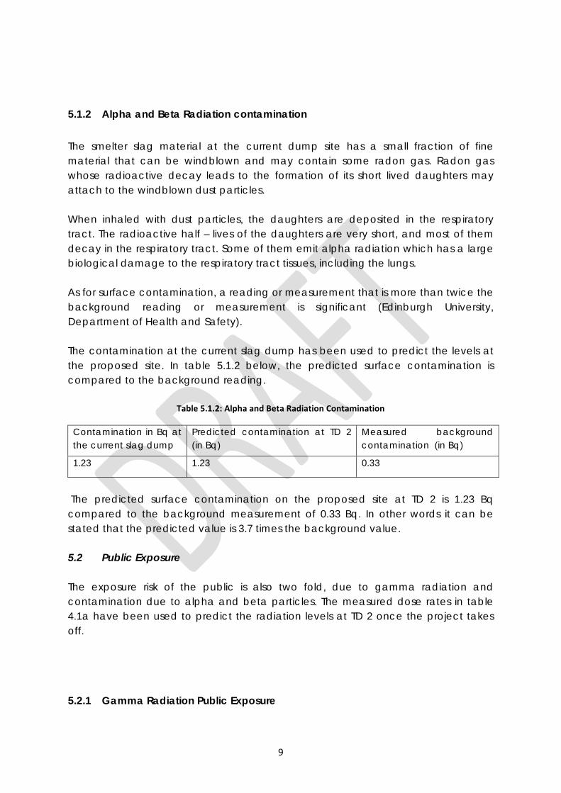
9
5.1.2 Alpha and Beta Radiation contamination The smelter slag material at the current dump site has a small fraction of fine material that can be windblown and may contain some radon gas. Radon gas whose radioactive decay leads to the formation of its short lived daughters may attach to the windblown dust particles. When inhaled with dust particles, the daughters are deposited in the respiratory tract. The radioactive half – lives of the daughters are very short, and most of them decay in the respiratory tract. Some of them emit alpha radiation which has a large biological damage to the respiratory tract tissues, including the lungs. As for surface contamination, a reading or measurement that is more than twice the background reading or measurement is significant (Edinburgh University, Department of Health and Safety). The contamination at the current slag dump has been used to predict the levels at the proposed site. In table 5.1.2 below, the predicted surface contamination is compared to the background reading.
Table 5.1.2: Alpha and Beta Radiation Contamination
Contamination in Bq at the current slag dump
Predicted contamination at TD 2 (in Bq)
Measured background contamination (in Bq)
1.23 1.23 0.33
The predicted surface contamination on the proposed site at TD 2 is 1.23 Bq compared to the background measurement of 0.33 Bq. In other words it can be stated that the predicted value is 3.7 times the background value.
5.2 Public Exposure The exposure risk of the public is also two fold, due to gamma radiation and contamination due to alpha and beta particles. The measured dose rates in table 4.1a have been used to predict the radiation levels at TD 2 once the project takes off.
5.2.1 Gamma Radiation Public Exposure
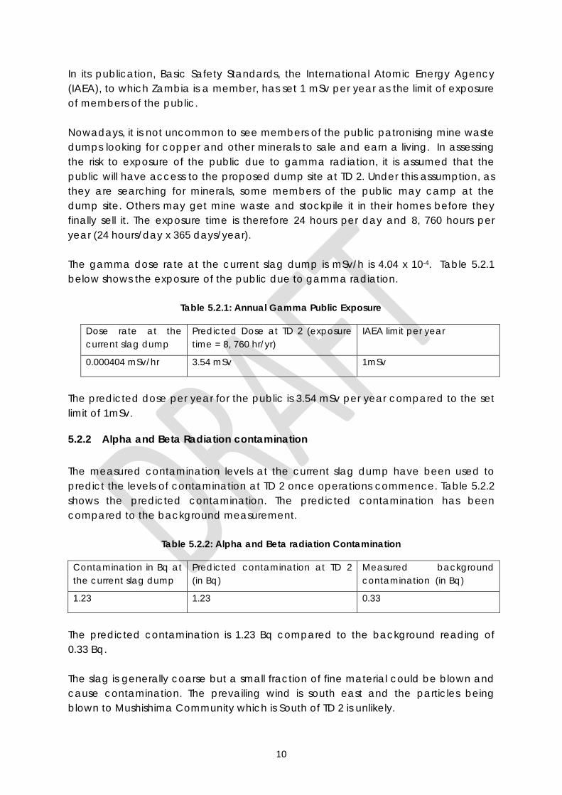
10
In its publication, Basic Safety Standards, the International Atomic Energy Agency (IAEA), to which Zambia is a member, has set 1 mSv per year as the limit of exposure of members of the public. Nowadays, it is not uncommon to see members of the public patronising mine waste dumps looking for copper and other minerals to sale and earn a living. In assessing the risk to exposure of the public due to gamma radiation, it is assumed that the public will have access to the proposed dump site at TD 2. Under this assumption, as they are searching for minerals, some members of the public may camp at the dump site. Others may get mine waste and stockpile it in their homes before they finally sell it. The exposure time is therefore 24 hours per day and 8, 760 hours per year (24 hours/day x 365 days/year). The gamma dose rate at the current slag dump is mSv/h is 4.04 x 10⁻⁴. Table 5.2.1 below shows the exposure of the public due to gamma radiation.
Table 5.2.1: Annual Gamma Public Exposure
Dose rate at the current slag dump
Predicted Dose at TD 2 (exposure time = 8, 760 hr/yr)
IAEA limit per year
0.000404 mSv/hr 3.54 mSv 1mSv
The predicted dose per year for the public is 3.54 mSv per year compared to the set limit of 1mSv.
5.2.2 Alpha and Beta Radiation contamination The measured contamination levels at the current slag dump have been used to predict the levels of contamination at TD 2 once operations commence. Table 5.2.2 shows the predicted contamination. The predicted contamination has been compared to the background measurement.
Table 5.2.2: Alpha and Beta radiation Contamination
Contamination in Bq at the current slag dump
Predicted contamination at TD 2 (in Bq)
Measured background contamination (in Bq)
1.23 1.23 0.33
The predicted contamination is 1.23 Bq compared to the background reading of 0.33 Bq. The slag is generally coarse but a small fraction of fine material could be blown and cause contamination. The prevailing wind is south east and the particles being blown to Mushishima Community which is South of TD 2 is unlikely.

11
12
6.0 PREDICTED IMPACT ON THE ENVIRONMENT The smelter slag that will be dumped at TD 2 will be mostly coarse with a small fraction of fine material. The small fraction of fine particles contaminated with radioactive material can be dispersed by wind and deposited in another area depending on wind direction (the dispersion of the fine particles is fully discussed in the Air Quality Report of this Study). This can happen during transportation or from the dump site. It is also possible for the fine smelter slag particles to be moved by water into the surrounding streams/rivers. The following therefore are the predicted impacts on the environment:
• Contamination of the area surrounding TD 2 • Possible contamination along the route to be adopted as the material is being
moved to TD 2 • Possible pollution of the Chingola stream as the area around TD 2 drains into
the same stream
13
7.0 MITIGATION In order to mitigate against contamination of the environment, KCM should take the following measures;
• The waste material as it is being transported from the smelter should be covered in order to avoid spillage on the road
• Plant vegetation around the proposed slag dump site at TD 2 to trap what may be blown by wind and contaminate the environment
• Construct a perimeter drain leading to a point where solids could settle and be reclaimed and put back into the dump
• KCM should come up with a closure programme that will include covering the slag material with soil and establish vegetation on top
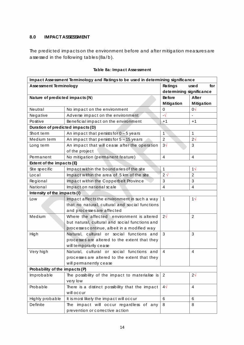
14
8.0 IMPACT ASSESSMENT The predicted impacts on the environment before and after mitigation measures are assessed in the following tables (8a/b).
Table 8a: Impact Assessment
Impact Assessment Terminology and Ratings to be used in determining significance Assessment Terminology Ratings used for
determining significance Nature of predicted impacts (N) Before
Mitigation After Mitigation
Neutral No impact on the environment 0 0√ Negative Adverse impact on the environment -√ - Positive Beneficial impact on the environment +1 +1 Duration of predicted impacts (D) Short term An impact that persists for 0 – 5 years 1 1 Medium term An impact that persists for 5 – 15 years 2 2√ Long term An impact that will cease after the operation
of the project 3√ 3
Permanent No mitigation (permanent feature) 4 4 Extent of the impacts (E) Site specific Impact within the boundaries of the site 1 1√ Local Impact within the area of 5 km of the site 2 √ 2 Regional Impact within the Copperbelt Province 3 3 National Impact on national scale 4 4 Intensity of the impacts (I) Low Impact affects the environment in such a way
that no natural, cultural and social functions and processes are affected
1 1√
Medium Where the affected environment is altered but natural, cultural and social functions and processes continue, albeit in a modified way
2√ 2
High Natural, cultural or social functions and processes are altered to the extent that they will temporarily cease
3 3
Very high Natural, cultural or social functions and processes are altered to the extent that they will permanently cease
4 4
Probability of the impacts (P) Improbable The possibility of the impact to materialise is
very low 2 2√
Probable There is a distinct possibility that the impact will occur
4√ 4
Highly probable It is most likely the impact will occur 6 6 Definite The impact will occur regardless of any
prevention or corrective action 8 8
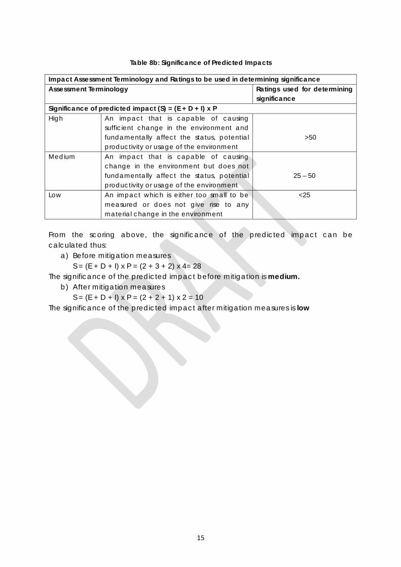
15
Table 8b: Significance of Predicted Impacts
Impact Assessment Terminology and Ratings to be used in determining significance Assessment Terminology Ratings used for determining
significance Significance of predicted impact (S) = (E + D + I) x P High An impact that is capable of causing
sufficient change in the environment and fundamentally affect the status, potential productivity or usage of the environment
>50
Medium An impact that is capable of causing change in the environment but does not fundamentally affect the status, potential productivity or usage of the environment
25 – 50
Low An impact which is either too small to be measured or does not give rise to any material change in the environment
<25
From the scoring above, the significance of the predicted impact can be calculated thus:
a) Before mitigation measures S = (E + D + I) x P = (2 + 3 + 2) x 4= 28
The significance of the predicted impact before mitigation is medium. b) After mitigation measures
S = (E + D + I) x P = (2 + 2 + 1) x 2 = 10 The significance of the predicted impact after mitigation measures is low
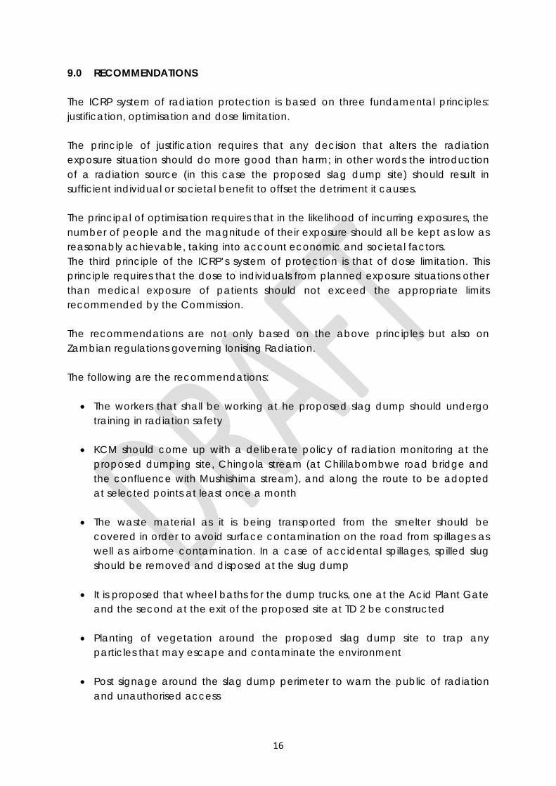
16
9.0 RECOMMENDATIONS The ICRP system of radiation protection is based on three fundamental principles: justification, optimisation and dose limitation. The principle of justification requires that any decision that alters the radiation exposure situation should do more good than harm; in other words the introduction of a radiation source (in this case the proposed slag dump site) should result in sufficient individual or societal benefit to offset the detriment it causes. The principal of optimisation requires that in the likelihood of incurring exposures, the number of people and the magnitude of their exposure should all be kept as low as reasonably achievable, taking into account economic and societal factors. The third principle of the ICRP’s system of protection is that of dose limitation. This principle requires that the dose to individuals from planned exposure situations other than medical exposure of patients should not exceed the appropriate limits recommended by the Commission. The recommendations are not only based on the above principles but also on Zambian regulations governing Ionising Radiation. The following are the recommendations:
• The workers that shall be working at he proposed slag dump should undergo training in radiation safety
• KCM should come up with a deliberate policy of radiation monitoring at the
proposed dumping site, Chingola stream (at Chililabombwe road bridge and the confluence with Mushishima stream), and along the route to be adopted at selected points at least once a month
• The waste material as it is being transported from the smelter should be
covered in order to avoid surface contamination on the road from spillages as well as airborne contamination. In a case of accidental spillages, spilled slug should be removed and disposed at the slug dump
• It is proposed that wheel baths for the dump trucks, one at the Acid Plant Gate
and the second at the exit of the proposed site at TD 2 be constructed
• Planting of vegetation around the proposed slag dump site to trap any particles that may escape and contaminate the environment
• Post signage around the slag dump perimeter to warn the public of radiation
and unauthorised access
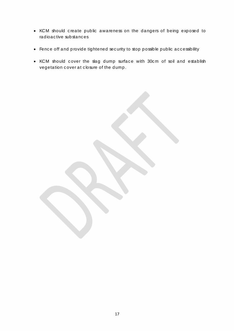
17
• KCM should create public awareness on the dangers of being exposed to radioactive substances
• Fence off and provide tightened security to stop possible public accessibility
• KCM should cover the slag dump surface with 30cm of soil and establish
vegetation cover at closure of the dump.
18
10.0 CONCLUSION The significance of impacts on the environment for this project is predicted to be low provided the proposed mitigation measures are followed through. These measures and recommendations should be included in financing the project. It is possible for residual impacts to occur and a contingency should be allowed for such. It is therefore proposed that the mitigation and recommendations be factored in a re-worked project proposal.
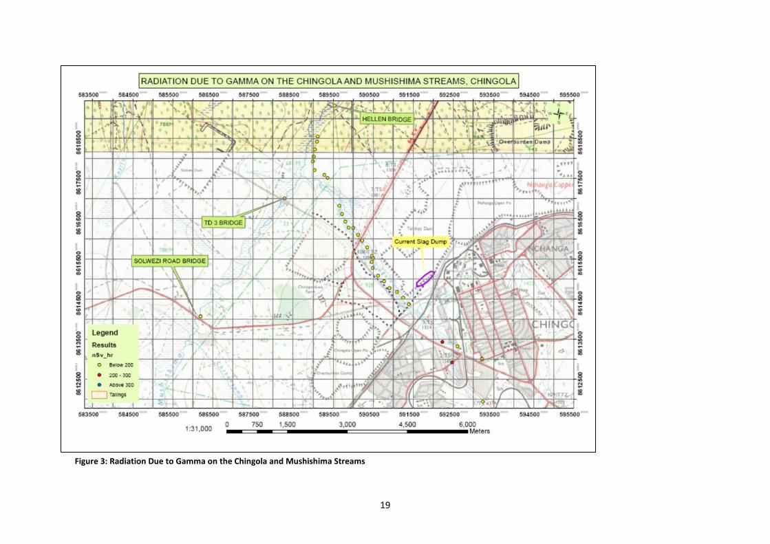
19
Figure 3: Radiation Due to Gamma on the Chingola and Mushishima Streams
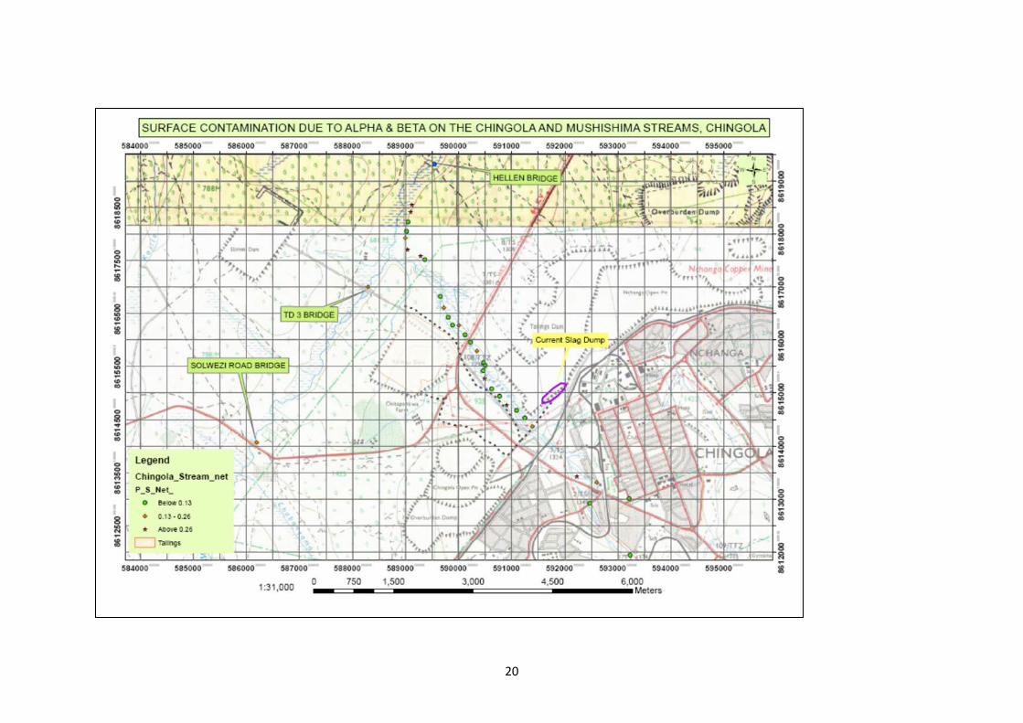
20
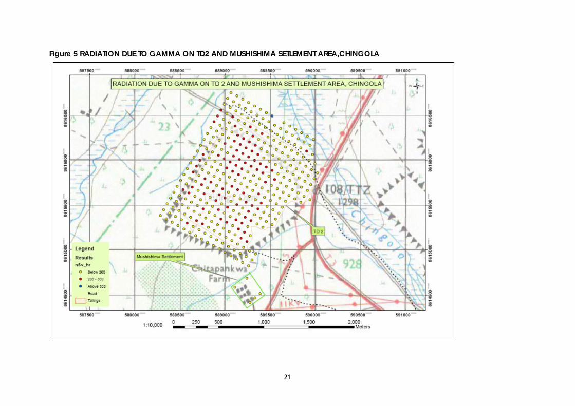
21
Figure 5 RADIATION DUE TO GAMMA ON TD2 AND MUSHISHIMA SETLEMENT AREA,CHINGOLA
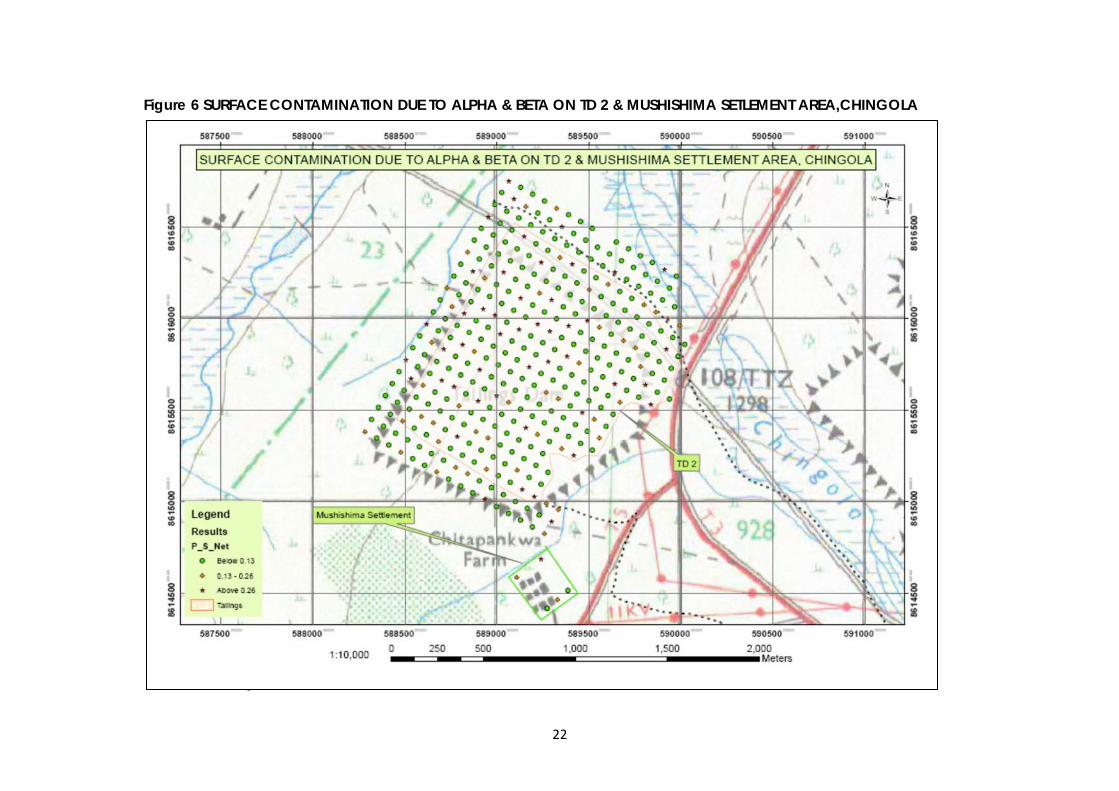
22
Figure 6 SURFACE CONTAMINATION DUE TO ALPHA & BETA ON TD 2 & MUSHISHIMA SETLEMENT AREA,CHINGOLA Figure 7 RADIATION DUE TO GAMMA ON ROUTE OPTIONS AND CURRENT SLAG DUMP,TD2,CHINGOLA
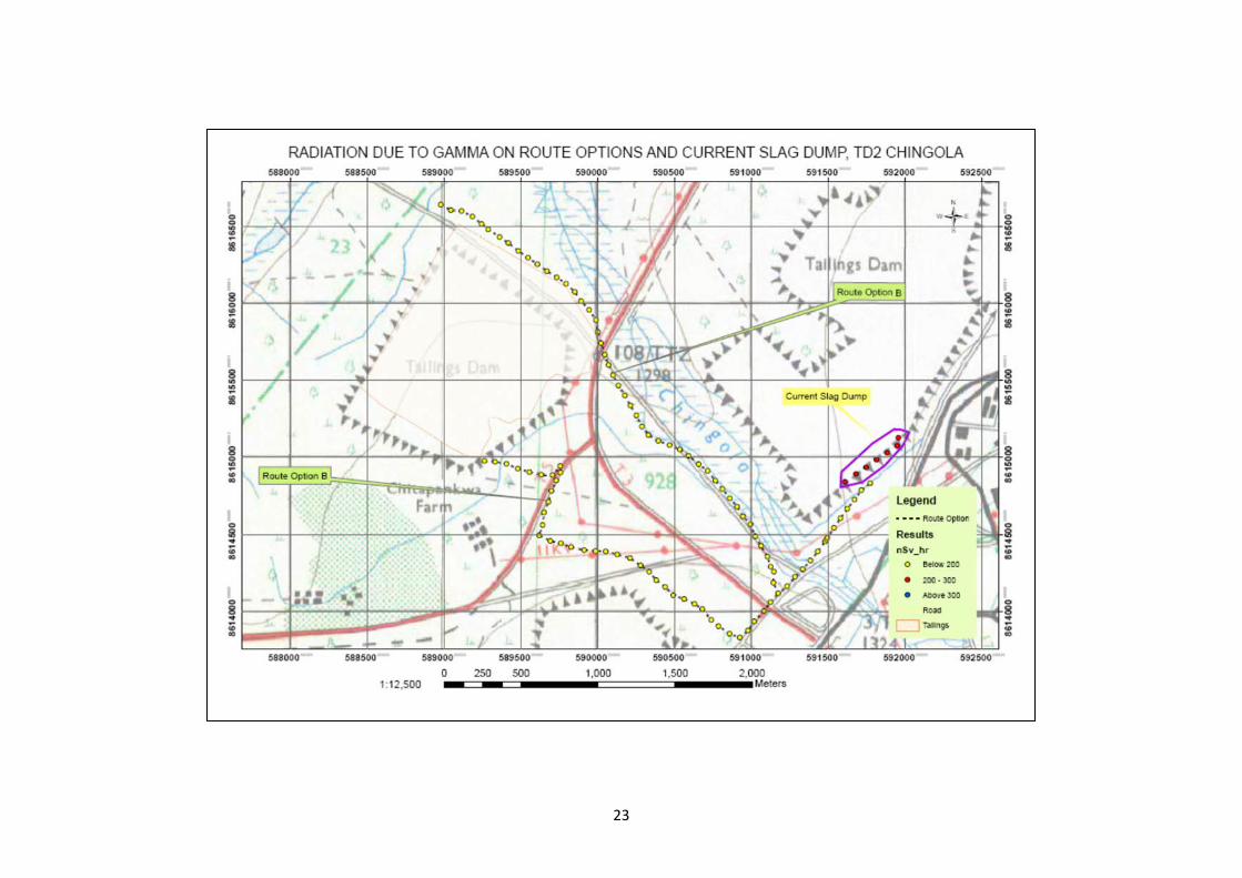
23
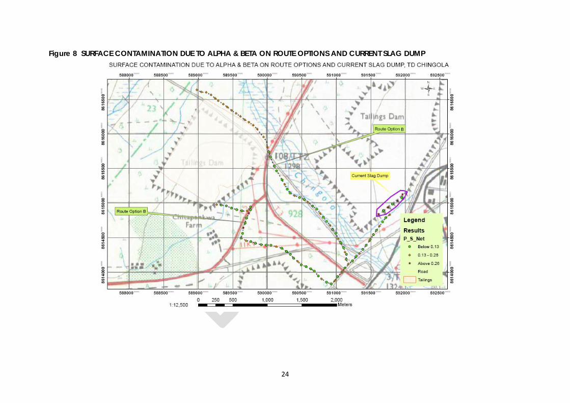
24
Figure 8 SURFACE CONTAMINATION DUE TO ALPHA & BETA ON ROUTE OPTIONS AND CURRENT SLAG DUMP
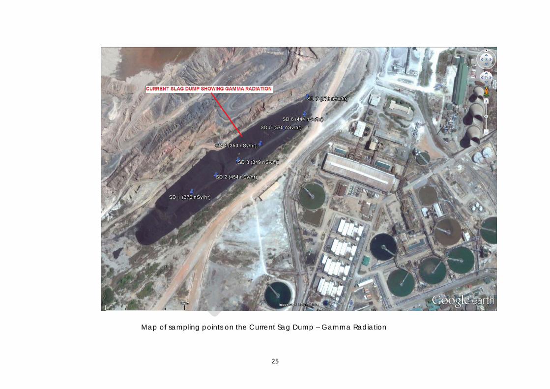
25
Map of sampling points on the Current Sag Dump – Gamma Radiation
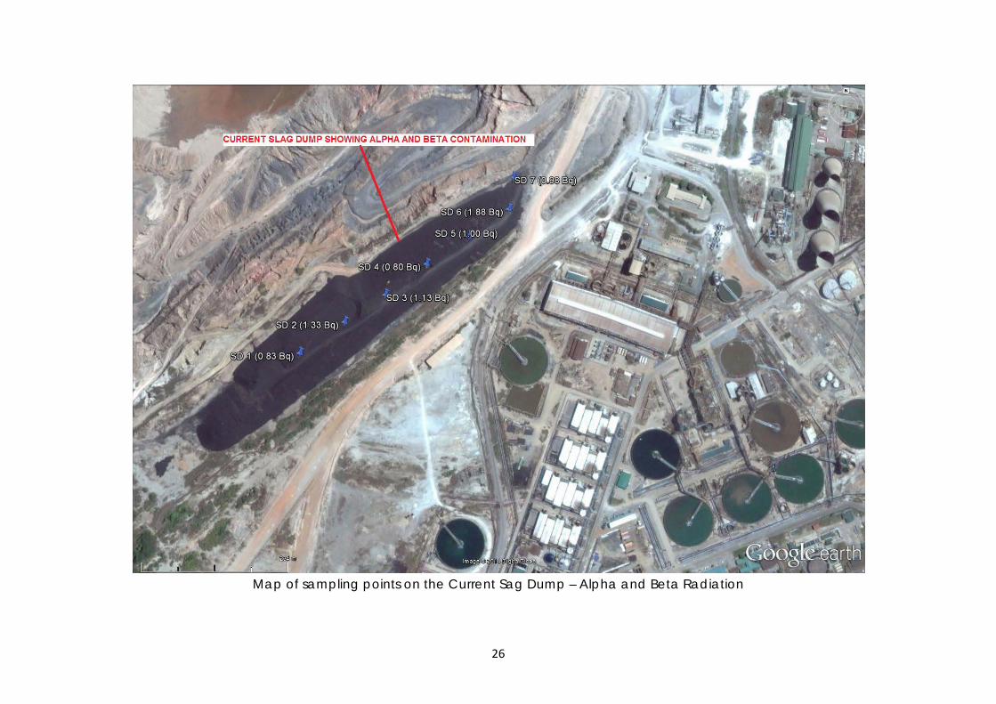
26
Map of sampling points on the Current Sag Dump – Alpha and Beta Radiation
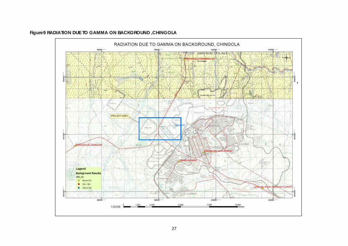
27
Figure9 RADIATION DUE TO GAMMA ON BACKGROUND ,CHINGOLA Figure 10 SURFACE CONTAMINATION DUE TO ALPHA & BETA ON BACKGROUND ,CHINGOLA
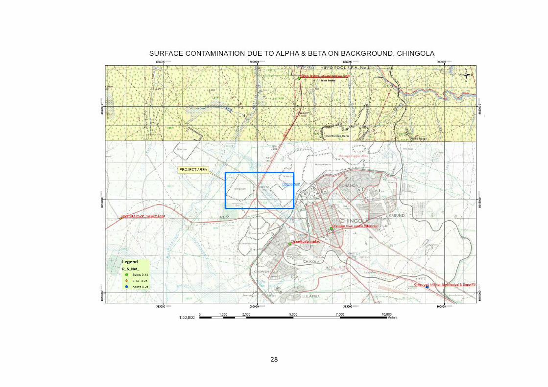
28
29
11.0 REFERENCES
• Government of Zambia, The Ionising Radiation Protection Act, 2005 • International Atomic Energy Agency, International Basic Safety Standards for
Protection against Ionising Radiation and for the Safety of Radiation Sources, Vienna 1994
• The University of Edinburgh, Publication RP COP003 – Surface Monitoring Procedures in Research Laboratories
• International Commission on Radiological Protection – The 2007 recommendation, publication ICRP 103
• European Commission Scientific Committee on Emerging and Newly Identified Health Risks, Publication SENIHR 2012
30
12.0 APPENDICES APPENDIX (1 A) RADIATION DOSE RATES AND GPS POSITIONS AT THE PROPOSED SITE - TD 2 Note the average/mean and the standard deviations are shown at the bottom
Site No. Coordinates Gamma Radiation Contamination (due to Alpha & Beta Radiation)
Eastings Northings nSv/hr P/S (no Cap) P/S (with Cap) P/S(Net) 1 589063 8616751 154 0.45 0.18 0.27 2 589026 8616686 135
3 588989 8616621 192 4 588952 8616556 283 0.67 0.34 0.33 5 588915 8616491 251
6 588877 8616426 208 7 588840 8616361 181 0.43 0.22 0.21 8 588803 8616295 158
9 588766 8616230 172
10 588728 8616165 172 0.37 0.21 0.16 11 588691 8616100 182
12 588654 8616035 190 13 588617 8615970 186 0.56 0.22 0.34 14 588580 8615905 165
15 588542 8615840 169 16 588505 8615775 181 0.48 0.22 0.26 17 588468 8615709 197
18 588431 8615644 178 19 588393 8615579 179 0.32 0.21 0.11 20 588356 8615514 178
21 588319 8615449 157 22 588282 8615384 198 0.37 0.24 0.13 23 588347 8615347 154
24 588384 8615412 148 25 588421 8615477 161 0.3 0.19 0.11 26 588459 8615542 168
27 588496 8615607 168 28 588533 8615672 223 0.64 0.27 0.37 29 588570 8615737 197
30 588607 8615802 192 31 588645 8615868 201 0.47 0.24 0.23 32 588682 8615933 225
33 588719 8615998 204 34 588756 8616063 207 0.4 0.25 0.15 35 588794 8616128 184
36 588831 8616193 158 37 588868 8616258 153 0.85 0.18 0.67 38 588905 8616323 161
39 588942 8616388 163 40 588980 8616454 183 0.32 0.22 0.1 41 589017 8616519 176 42 589054 8616584 177 43 589091 8616649 142 0.45 0.17 0.28 44 589129 8616714 159 45 589194 8616677 136 46 589156 8616612 149 0.41 0.18 0.23 47 589119 8616547 188 48 589082 8616481 248 49 589045 8616416 169 0.26 0.2 0.06 50 589008 8616351 175 51 588970 8616286 170 52 588933 8616221 177 0.39 0.21 0.18 53 588896 8616156 181 54 588859 8616091 193 55 588821 8616026 160 0.58 0.19 0.39 56 588784 8615961 179 57 588747 8615895 182 58 588710 8615830 189 0.54 0.23 0.31 59 588673 8615765 185 60 588635 8615700 206 61 588598 8615635 202 0.45 0.24 0.21 62 588561 8615570 173
31
63 588524 8615505 166
Site No. Coordinates Gamma Radiation Contamination (due to Alpha & Beta Radiation) Eastings Northings nSv/hr P/S (no Cap) P/S (with Cap) P/S(Net)
64 588486 8615440 175 0.41 0.21 0.2 65 588449 8615374 172
66 588412 8615309 148 67 588477 8615272 155 0.32 0.19 0.13 68 588514 8615337 183
69 588551 8615402 143 70 588589 8615467 162 0.45 0.19 0.26 71 588626 8615533 165
72 588663 8615598 173 73 588700 8615663 183 0.94 0.22 0.72 74 588738 8615728 214
75 588775 8615793 204 76 588812 8615858 196 0.7 0.24 0.46 77 588849 8615923 183
78 588887 8615988 189 79 588924 8616054 213 0.57 0.26 0.31 80 588961 8616119 200 81 588998 8616184 219 82 589035 8616249 195 0.64 0.23 0.41 83 589073 8616314 184 84 589110 8616379 213 85 589147 8616444 185 0.53 0.22 0.31 86 589184 8616509 170 87 589222 8616574 139 88 589259 8616640 124 0.14 0.11 0.03 89 589324 8616602 121 0.33 0.15 0.18 90 589287 8616537 117 91 589249 8616472 198 92 589212 8616407 172 0.24 0.21 0.03 93 589175 8616342 186 94 589138 8616277 205 95 589101 8616212 210 0.35 0.25 0.1 96 589063 8616147 193 97 589026 8616081 173 98 588989 8616016 227 0.83 0.27 0.56 99 588952 8615951 187
100 588914 8615886 171 101 588877 8615821 187 0.47 0.22 0.25 102 588840 8615756 231 103 588803 8615691 195 104 588766 8615626 203 0.55 0.24 0.31 105 588728 8615560 199 106 588691 8615495 190 107 588654 8615430 141 0.36 0.17 0.19 108 588617 8615365 157 109 588579 8615300 206 110 588542 8615235 161 0.25 0.19 0.06 111 588607 8615198 157 112 588644 8615263 165 113 588682 8615328 223 0.47 0.27 0.2 114 588719 8615393 174 115 588756 8615458 216 116 588793 8615523 185 0.36 0.22 0.14 117 588831 8615588 157 118 588868 8615653 204 119 588905 8615719 183 0.67 0.22 0.45 120 588942 8615784 188 121 588980 8615849 163 122 589017 8615914 215 0.72 0.26 0.46 123 589054 8615979 218 124 589091 8616044 237 125 589128 8616109 208 0.87 0.25 0.62
32
Site No. Coordinates Gamma Radiation Contamination (due to Alpha & Beta Radiation) Eastings Northings nSv/hr P/S (no Cap) P/S (with Cap) P/S(Net)
126 589166 8616174 263 127 589203 8616240 257
128 589240 8616305 183 0.52 0.22 0.30 129 589277 8616370 212
130 589315 8616435 157 131 589352 8616500 168 0.54 0.20 0.34 132 589389 8616565 162
133 589454 8616528 133 134 589417 8616463 139 0.22 0.17 0.05 135 589380 8616398 137 136 589342 8616333 198 0.44 0.24 0.20
137 589305 8616267 201 138 589268 8616202 204
139 589231 8616137 219 0.46 0.26 0.20
140 589194 8616072 226 141 589156 8616007 258 142 589119 8615942 243 0.70 0.29 0.41 143 589082 8615877 211
144 589045 8615812 159 145 589007 8615746 176 0.26 0.21 0.05 146 588970 8615681 205
147 588933 8615616 247 148 588896 8615551 252 0.59 0.30 0.29 149 588859 8615486 191
150 588821 8615421 169 151 588784 8615356 187 0.68 0.22 0.46 152 588747 8615291 202
153 588710 8615226 155 154 588672 8615160 135 0.36 0.16 0.20 155 588737 8615123 196 156 588775 8615188 167 0.41 0.20 0.21 157 588812 8615253 181
158 588849 8615319 183 159 588886 8615384 188 0.44 0.23 0.21 160 588924 8615449 281
161 588961 8615514 146 162 588998 8615579 207 0.67 0.25 0.42 163 589035 8615644 193
164 589073 8615709 212 165 589110 8615774 164 0.29 0.20 0.09 166 589147 8615839 249
167 589184 8615905 235 168 589221 8615970 284 0.74 0.34 0.40 169 589259 8616035 285 170 589296 8616100 207 0.66 0.25 0.41 171 589333 8616165 201
172 589370 8616230 185 173 589408 8616295 201 0.96 0.24 0.72 174 589445 8616360 137
175 589482 8616426 167 176 589519 8616491 303 0.15 0.10 0.05 177 589547 8616388 143 178 589510 8616323 138 0.26 0.17 0.09 179 589473 8616258 176
180 589435 8616193 174 181 589398 8616128 176 0.24 0.21 0.03 182 589361 8616063 217
183 589324 8615998 269 184 589287 8615932 297 0.81 0.36 0.45 185 589249 8615867 185
186 589212 8615802 128 187 589175 8615737 171 0.51 0.21 0.30
33
Site No. Coordinates Gamma Radiation Contamination (due to Alpha & Beta Radiation) Eastings Northings nSv/hr P/S (no Cap) P/S (with Cap) P/S(Net)
188 589138 8615672 214 189 589100 8615607 195
190 589063 8615542 156 0.42 0.19 0.23 191 589026 8615477 230
192 588989 8615412 179 193 588951 8615346 222 0.46 0.27 0.19 194 588914 8615281 165
195 588877 8615216 177 196 588840 8615151 164 0.41 0.20 0.21 197 588803 8615086 151 198 588868 8615049 147
199 588905 8615114 171 200 588942 8615179 184 0.37 0.22 0.15
201 588979 8615244 173
202 589017 8615309 236 203 589054 8615374 166 0.31 0.20 0.11
204 589091 8615439 184 205 589128 8615505 207
206 589165 8615570 159 0.28 0.19 0.09
207 589203 8615635 206 208 589240 8615700 134
209 589277 8615765 129 0.50 0.15 0.35
210 589314 8615830 169 211 589352 8615895 218
212 589389 8615960 224 0.53 0.27 0.26
213 589426 8616025 182 214 589463 8616091 197
215 589501 8616156 184 0.48 0.22 0.26
216 589538 8616221 198 217 589575 8616286 134
218 589612 8616351 172 0.26 0.21 0.05 219 589649 8616416 162
220 589715 8616379 175 221 589677 8616314 185 222 589640 8616249 155 0.46
0.19 0.27
223 589603 8616184 155 0.41 0.19 0.22
224 589566 8616118 153 225 589528 8616053 165
226 589491 8615988 172 0.54 0.21 0.33
227 589454 8615923 218 228 589417 8615858 211
229 589380 8615793 185 0.78 0.22 0.56
230 589342 8615728 181 231 589305 8615663 153 232 589268 8615598 158 0.35 0.19 0.16 233 589231 8615532 220
234 589193 8615467 157 235 589156 8615402 189 0.54 0.23 0.31 236 589119 8615337 209
237 589082 8615272 167 238 589044 8615207 174 0.26 0.21 0.05 239 589007 8615142 186 240 588970 8615077 170 241 588933 8615012 131 0.18 0.16 0.27 242 588998 8614974 133 0.43 0.14 0.04
243 589035 8615039 181 244 589072 8615105 177
245 589110 8615170 193 0.39 0.23 0.16 246 589147 8615235 213
247 589184 8615300 228 248 589221 8615365 230 0.52 0.28 0.24 249 589258 8615430 214
250 589296 8615495 204 251 589333 8615560 168 0.43 0.20 0.23

34
Site No. Coordinates Gamma Radiation Contamination (due to Alpha & Beta Radiation) Eastings Northings nSv/hr P/S (no Cap) P/S (with Cap) P/S(Net)
252 589370 8615625 209 253 589407 8615691 194
254 589445 8615756 246 0.45 0.30 0.15 255 589482 8615821 175
256 589519 8615886 251 257 589556 8615951 162 0.36 0.19 0.17 258 589594 8616016 152
259 589631 8616081 146 260 589668 8616146 175 0.26 0.21 0.05 261 589705 8616211 168 262 589742 8616277 160
263 589780 8616342 126 0.25 0.15 0.10 264 589845 8616304 135 265 589808 8616239 165
266 589770 8616174 133
267 589733 8616109 158
268 589696 8616044 134 0.09 0.05 0.04 269 589659 8615979 197 270 589621 8615914 178
271 589584 8615849 187 0.31 0.22 0.09 272 589547 8615784 210 273 589510 8615718 132
274 589473 8615653 150 0.26 0.18 0.08 275 589435 8615588 198 276 589398 8615523 206
277 589361 8615458 202 0.34 0.24 0.10 278 589324 8615393 186 279 589286 8615328 206
280 589249 8615263 186 0.22 0.18 0.04 281 589212 8615198 211 282 589175 8615132 201 283 589137 8615067 187 0.56
0.22 0.34
284 589100 8615002 158 285 589063 8614937 135 286 589128 8614900 122 287 589165 8614965 136
288 589203 8615030 188 0.66 0.23 0.43 289 589240 8615095 230 290 589277 8615160 186
291 589351 8615291 158 0.39 0.19 0.20 292 589389 8615356 199 293 589426 8615421 191
294 589463 8615486 154 0.53 0.18 0.35 295 589500 8615551 178 296 589538 8615616 165 297 589575 8615681 142 0.26
0.17 0.09
298 589612 8615746 132 299 589649 8615811 191 300 589687 8615877 169 0.37
0.20 0.17
301 589724 8615942 152 302 589761 8616007 180 303 589798 8616072 159 0.39 0.19 0.20 304 589835 8616137 142 305 589873 8616202 144 306 589910 8616267 133 0.45 0.16 0.29 307 589975 8616230 197 0.31 0.24 0.07 308 589938 8616165 158 309 589901 8616100 201 310 589863 8616035 175 0.36
0.21 0.15
311 589826 8615970 156 312 589789 8615904 190 313 589752 8615839 166 0.35
0.20 0.15
314 589714 8615774 161 315 589677 8615709 149
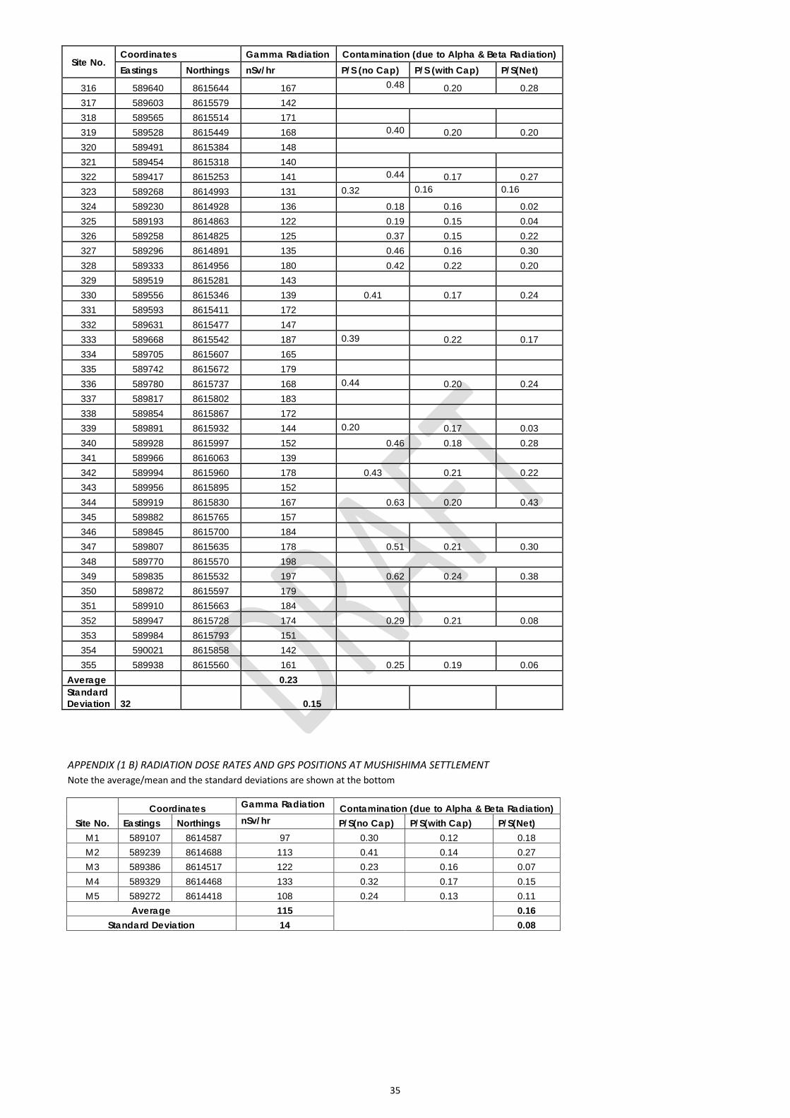
35
Site No. Coordinates Gamma Radiation Contamination (due to Alpha & Beta Radiation) Eastings Northings nSv/hr P/S (no Cap) P/S (with Cap) P/S(Net)
316 589640 8615644 167 0.48
0.20 0.28 317 589603 8615579 142 318 589565 8615514 171 319 589528 8615449 168 0.40
0.20 0.20
320 589491 8615384 148 321 589454 8615318 140 322 589417 8615253 141 0.44
0.17 0.27
323 589268 8614993 131 0.32 0.16 0.16
324 589230 8614928 136 0.18 0.16 0.02 325 589193 8614863 122 0.19 0.15 0.04 326 589258 8614825 125 0.37 0.15 0.22 327 589296 8614891 135 0.46 0.16 0.30 328 589333 8614956 180 0.42 0.22 0.20 329 589519 8615281 143
330 589556 8615346 139 0.41 0.17 0.24 331 589593 8615411 172
332 589631 8615477 147 333 589668 8615542 187 0.39 0.22 0.17 334 589705 8615607 165
335 589742 8615672 179 336 589780 8615737 168 0.44 0.20 0.24 337 589817 8615802 183
338 589854 8615867 172 339 589891 8615932 144 0.20 0.17 0.03 340 589928 8615997 152 0.46 0.18 0.28 341 589966 8616063 139 342 589994 8615960 178 0.43 0.21 0.22 343 589956 8615895 152
344 589919 8615830 167 0.63 0.20 0.43 345 589882 8615765 157 346 589845 8615700 184 347 589807 8615635 178 0.51 0.21 0.30 348 589770 8615570 198 349 589835 8615532 197 0.62 0.24 0.38 350 589872 8615597 179 351 589910 8615663 184
352 589947 8615728 174 0.29 0.21 0.08 353 589984 8615793 151 354 590021 8615858 142
355 589938 8615560 161 0.25 0.19 0.06 Average
0.23
Standard Deviation
32 0.15
APPENDIX (1 B) RADIATION DOSE RATES AND GPS POSITIONS AT MUSHISHIMA SETTLEMENT Note the average/mean and the standard deviations are shown at the bottom
Site No. Coordinates Gamma Radiation Contamination (due to Alpha & Beta Radiation)
Eastings Northings nSv/hr P/S(no Cap) P/S(with Cap) P/S(Net) M1 589107 8614587 97 0.30 0.12 0.18 M2 589239 8614688 113 0.41 0.14 0.27 M3 589386 8614517 122 0.23 0.16 0.07 M4 589329 8614468 133 0.32 0.17 0.15 M5 589272 8614418 108 0.24 0.13 0.11
Average 115
0.16 Standard Deviation 14 0.08
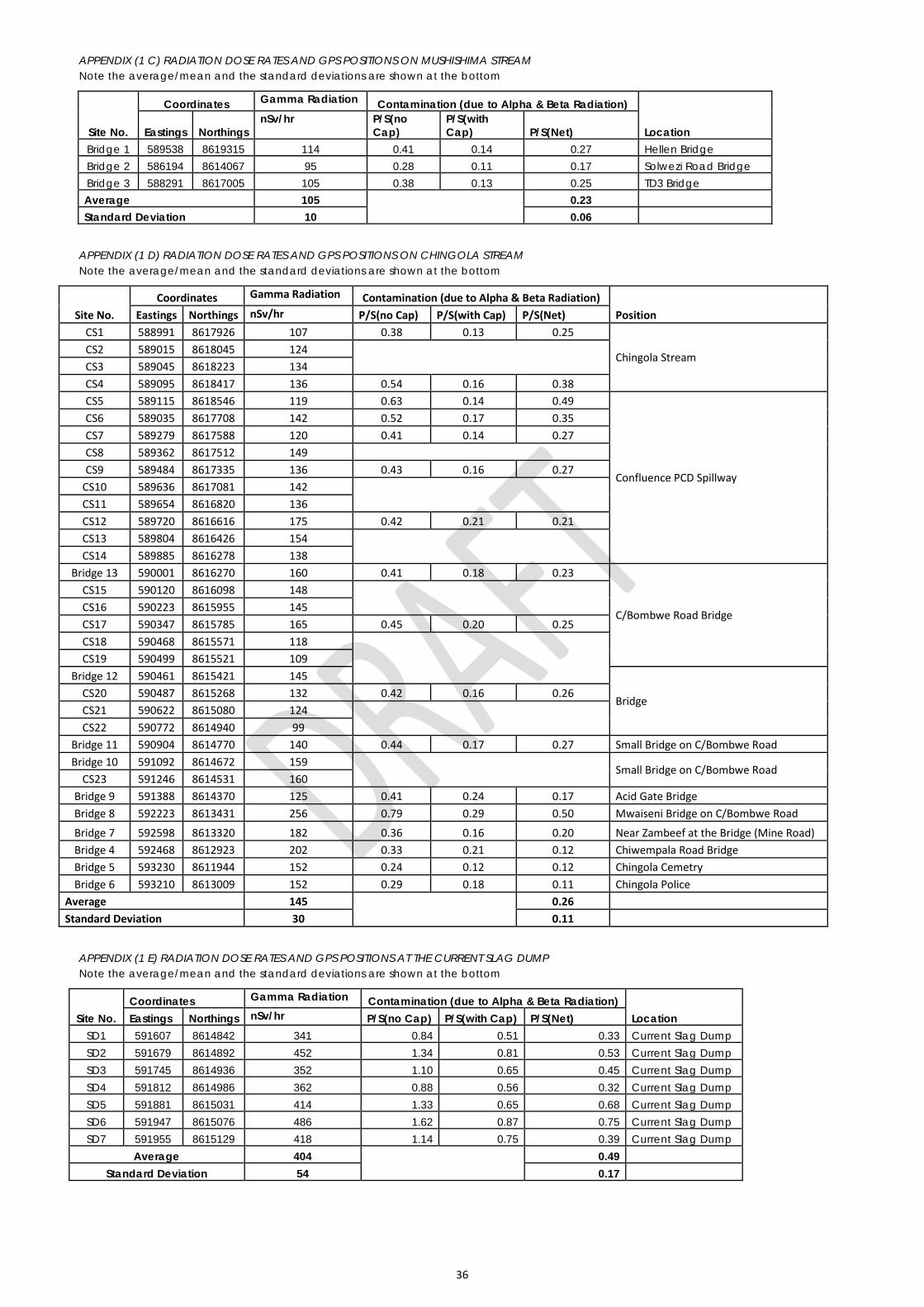
36
APPENDIX (1 C) RADIATION DOSE RATES AND GPS POSITIONS ON MUSHISHIMA STREAM Note the average/mean and the standard deviations are shown at the bottom
Site No.
Coordinates Gamma Radiation Contamination (due to Alpha & Beta Radiation)
Location Eastings Northings nSv/hr P/S(no
Cap) P/S(with Cap) P/S(Net)
Bridge 1 589538 8619315 114 0.41 0.14 0.27 Hellen Bridge Bridge 2 586194 8614067 95 0.28 0.11 0.17 Solwezi Road Bridge Bridge 3 588291 8617005 105 0.38 0.13 0.25 TD3 Bridge Average 105
0.23
Standard Deviation 10 0.06
APPENDIX (1 D) RADIATION DOSE RATES AND GPS POSITIONS ON CHINGOLA STREAM Note the average/mean and the standard deviations are shown at the bottom
Site No. Coordinates Gamma Radiation Contamination (due to Alpha & Beta Radiation)
Position Eastings Northings nSv/hr P/S(no Cap) P/S(with Cap) P/S(Net) CS1 588991 8617926 107 0.38 0.13 0.25
Chingola Stream CS2 589015 8618045 124
CS3 589045 8618223 134 CS4 589095 8618417 136 0.54 0.16 0.38 CS5 589115 8618546 119 0.63 0.14 0.49
Confluence PCD Spillway
CS6 589035 8617708 142 0.52 0.17 0.35 CS7 589279 8617588 120 0.41 0.14 0.27 CS8 589362 8617512 149 CS9 589484 8617335 136 0.43 0.16 0.27
CS10 589636 8617081 142 CS11 589654 8616820 136
CS12 589720 8616616 175 0.42 0.21 0.21 CS13 589804 8616426 154
CS14 589885 8616278 138 Bridge 13 590001 8616270 160 0.41 0.18 0.23
C/Bombwe Road Bridge
CS15 590120 8616098 148 CS16 590223 8615955 145
CS17 590347 8615785 165 0.45 0.20 0.25 CS18 590468 8615571 118
CS19 590499 8615521 109
Bridge 12 590461 8615421 145
Bridge CS20 590487 8615268 132 0.42 0.16 0.26 CS21 590622 8615080 124
CS22 590772 8614940 99 Bridge 11 590904 8614770 140 0.44 0.17 0.27 Small Bridge on C/Bombwe Road Bridge 10 591092 8614672 159
Small Bridge on C/Bombwe Road
CS23 591246 8614531 160 Bridge 9 591388 8614370 125 0.41 0.24 0.17 Acid Gate Bridge Bridge 8 592223 8613431 256 0.79 0.29 0.50 Mwaiseni Bridge on C/Bombwe Road
Bridge 7 592598 8613320 182 0.36 0.16 0.20 Near Zambeef at the Bridge (Mine Road) Bridge 4 592468 8612923 202 0.33 0.21 0.12 Chiwempala Road Bridge Bridge 5 593230 8611944 152 0.24 0.12 0.12 Chingola Cemetry Bridge 6 593210 8613009 152 0.29 0.18 0.11 Chingola Police
Average 145
0.26 Standard Deviation 30 0.11
APPENDIX (1 E) RADIATION DOSE RATES AND GPS POSITIONS AT THE CURRENT SLAG DUMP Note the average/mean and the standard deviations are shown at the bottom
Site No. Coordinates Gamma Radiation Contamination (due to Alpha & Beta Radiation)
Location Eastings Northings nSv/hr P/S(no Cap) P/S(with Cap) P/S(Net) SD1 591607 8614842 341 0.84 0.51 0.33 Current Slag Dump SD2 591679 8614892 452 1.34 0.81 0.53 Current Slag Dump SD3 591745 8614936 352 1.10 0.65 0.45 Current Slag Dump SD4 591812 8614986 362 0.88 0.56 0.32 Current Slag Dump SD5 591881 8615031 414 1.33 0.65 0.68 Current Slag Dump SD6 591947 8615076 486 1.62 0.87 0.75 Current Slag Dump SD7 591955 8615129 418 1.14 0.75 0.39 Current Slag Dump
Average 404
0.49 Standard Deviation 54 0.17
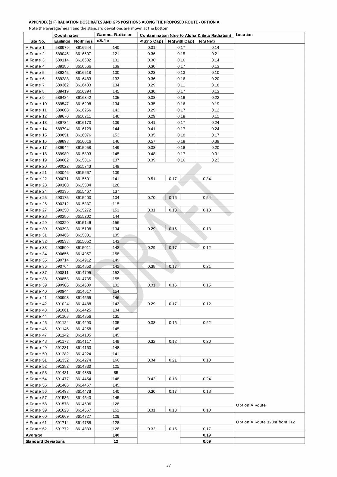
37
APPENDIX (1 F) RADIATION DOSE RATES AND GPS POSITIONS ALONG THE PROPOSED ROUTE - OPTION A Note the average/mean and the standard deviations are shown at the bottom
Site No. Coordinates Gamma Radiation Contamination (due to Alpha & Beta Radiation) Location Eastings Northings nSv/hr P/S(no Cap) P/S(with Cap) P/S(Net)
A Route 1 588979 8616644 140 0.31 0.17 0.14
Option A Route
A Route 2 589045 8616607 121 0.36 0.15 0.21 A Route 3 589114 8616602 131 0.30 0.16 0.14 A Route 4 589185 8616566 139 0.30 0.17 0.13 A Route 5 589245 8616518 130 0.23 0.13 0.10 A Route 6 589288 8616483 133 0.36 0.16 0.20 A Route 7 589362 8616433 134 0.29 0.11 0.18 A Route 8 589419 8616394 145 0.30 0.17 0.13 A Route 9 589484 8616342 135 0.38 0.16 0.22 A Route 10 589547 8616298 134 0.35 0.16 0.19 A Route 11 589608 8616256 143 0.29 0.17 0.12 A Route 12 589670 8616211 146 0.29 0.18 0.11 A Route 13 589734 8616170 139 0.41 0.17 0.24 A Route 14 589794 8616129 144 0.41 0.17 0.24 A Route 15 589851 8616076 153 0.35 0.18 0.17 A Route 16 589893 8616016 146 0.57 0.18 0.39 A Route 17 589944 8615958 149 0.38 0.18 0.20 A Route 18 589989 8615893 145 0.48 0.17 0.31 A Route 19 590002 8615816 137 0.39 0.16 0.23 A Route 20 590022 8615743 149
A Route 21 590046 8615667 139 A Route 22 590071 8615601 141 0.51 0.17 0.34 A Route 23 590100 8615534 128
A Route 24 590135 8615467 137 A Route 25 590175 8615403 134 0.70 0.16 0.54 A Route 26 590212 8615337 115 A Route 27 590250 8615272 151 0.31 0.18 0.13 A Route 28 590286 8615202 144
A Route 29 590329 8615146 156 A Route 30 590393 8615108 134 0.29 0.16 0.13 A Route 31 590466 8615081 135
A Route 32 590533 8615052 143 A Route 33 590590 8615011 142 0.29 0.17 0.12 A Route 34 590656 8614957 158
A Route 35 590714 8614912 149 A Route 36 590764 8614850 142 0.38 0.17 0.21 A Route 37 590811 8614795 152
A Route 38 590858 8614735 155 A Route 39 590906 8614680 132 0.31 0.16 0.15 A Route 40 590944 8614617 154
A Route 41 590993 8614565 146 A Route 42 591024 8614488 143 0.29 0.17 0.12 A Route 43 591061 8614425 134
A Route 44 591103 8614356 135 A Route 45 591124 8614290 135 0.38 0.16 0.22 A Route 46 591145 8614258 145
A Route 47 591142 8614185 145 A Route 48 591173 8614117 148 0.32 0.12 0.20 A Route 49 591231 8614163 148
A Route 50 591282 8614224 141 A Route 51 591332 8614274 166 0.34 0.21 0.13 A Route 52 591382 8614330 125
A Route 53 591431 8614389 85 A Route 54 591477 8614454 148 0.42 0.18 0.24 A Route 55 591486 8614467 145 A Route 56 591493 8614478 140 0.30 0.17 0.13 A Route 57 591536 8614543 145
A Route 58 591578 8614606 128 A Route 59 591623 8614667 151 0.31 0.18 0.13 A Route 60 591669 8614727 129
Option A Route 120m from T12 A Route 61 591714 8614788 128 A Route 62 591772 8614833 128 0.32 0.15 0.17 Average 140
0.19
Standard Deviations 12 0.09
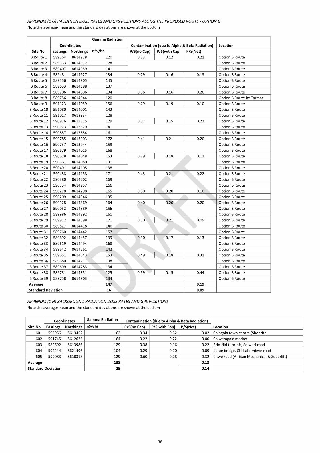
38
APPENDIX (1 G) RADIATION DOSE RATES AND GPS POSITIONS ALONG THE PROPOSED ROUTE - OPTION B Note the average/mean and the standard deviations are shown at the bottom
Site No. Coordinates
Gamma Radiation Contamination (due to Alpha & Beta Radiation) Location
Eastings Northings nSv/hr P/S(no Cap) P/S(with Cap) P/S(Net) B Route 1 589264 8614978 120 0.33 0.12 0.21 Option B Route
B Route 2 589333 8614972 128
Option B Route B Route 3 589407 8614959 141 Option B Route B Route 4 589481 8614927 134 0.29 0.16 0.13 Option B Route B Route 5 589556 8614905 145
Option B Route
B Route 6 589633 8614888 137 Option B Route B Route 7 589706 8614886 134 0.36 0.16 0.20 Option B Route B Route 8 589756 8614944 120 Option B Route By Tarmac B Route 9 591123 8614059 156 0.29 0.19 0.10 Option B Route
B Route 10 591080 8614001 142
Option B Route B Route 11 591017 8613934 128 Option B Route B Route 12 590976 8613875 129 0.37 0.15 0.22 Option B Route B Route 13 590923 8613829 141
Option B Route
B Route 14 590857 8613854 161 Option B Route B Route 15 590785 8613903 172 0.41 0.21 0.20 Option B Route B Route 16 590737 8613944 159
Option B Route
B Route 17 590679 8614015 168 Option B Route B Route 18 590628 8614048 153 0.29 0.18 0.11 Option B Route B Route 19 590561 8614080 131
Option B Route
B Route 20 590491 8614105 138 Option B Route B Route 21 590438 8614158 171 0.43 0.21 0.22 Option B Route B Route 22 590380 8614202 169
Option B Route
B Route 23 590334 8614257 166 Option B Route B Route 24 590278 8614298 165 0.30 0.20 0.10 Option B Route B Route 25 590209 8614346 135 Option B Route B Route 26 590128 8614369 164 0.40 0.20 0.20 Option B Route B Route 27 590052 8614389 156
Option B Route
B Route 28 589986 8614392 161 Option B Route B Route 29 589912 8614398 171 0.30 0.21 0.09 Option B Route B Route 30 589827 8614418 146
Option B Route
B Route 31 589760 8614442 157 Option B Route B Route 32 589692 8614457 139 0.30 0.17 0.13 Option B Route B Route 33 589619 8614494 168
Option B Route
B Route 34 589642 8614561 142 Option B Route B Route 35 589651 8614643 153 0.49 0.18 0.31 Option B Route B Route 36 589680 8614711 138
Option B Route
B Route 37 589699 8614783 134 Option B Route B Route 38 589731 8614851 125 0.59 0.15 0.44 Option B Route B Route 39 589758 8614903 134 Option B Route Average 147 0.19
Standard Deviation 16 0.09
APPENDIX (1 H) BACKGROUND RADIATION DOSE RATES AND GPS POSITIONS Note the average/mean and the standard deviations are shown at the bottom
Site No. Coordinates Gamma Radiation Contamination (due to Alpha & Beta Radiation)
Location Eastings Northings nSv/hr P/S(no Cap) P/S(with Cap) P/S(Net) 601 593956 8613452 162 0.34 0.32 0.02 Chingola town centre (Shoprite) 602 591745 8612626 164 0.22 0.22 0.00 Chiwempala market 603 582692 8613986 129 0.38 0.16 0.22 Brickfild turn-off, Solwezi road 604 592244 8621496 104 0.29 0.20 0.09 Kafue bridge, Chililabombwe road 605 599083 8610318 129 0.60 0.28 0.32 Kitwe road (African Mechanical & Superlift)
Average 138
0.13 Standard Deviation 25 0.14
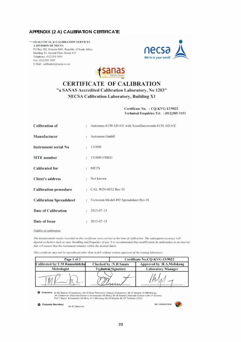
39
APPENDIX (2 A) CALIBRATION CERTIFICATE
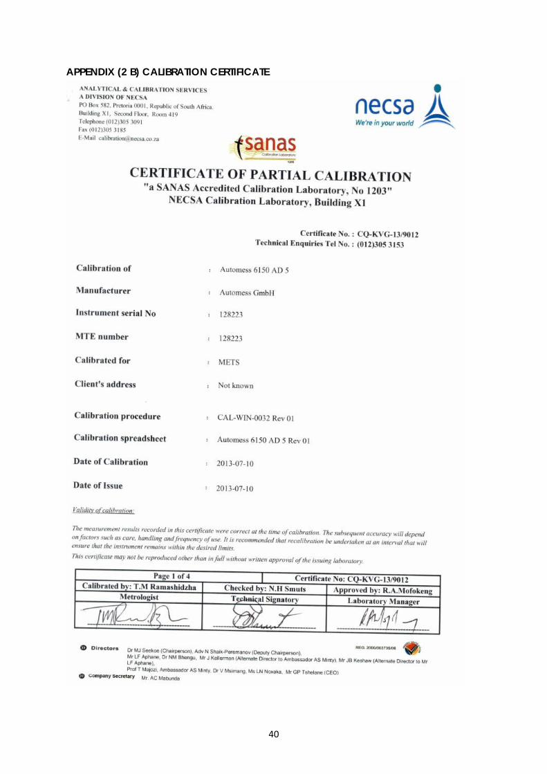
40
APPENDIX (2 B) CALIBRATION CERTIFICATE
Konkola Copper Mines Plc
New Slag Dump Project
Draft Environmental and Social Impact Statement September 2014
Appendix F Ecological Assessment Report
Prepared for
Konkola Copper Mines Plc
ECOLOGICAL IMPACT ASSESSMENT TECHNICAL REPORT FOR TD2 SLAG DUMP PROJECT
SEPTEMBER 2014
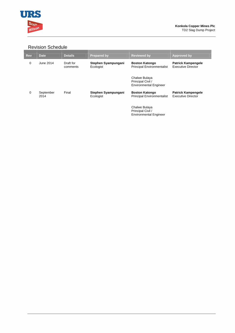
Konkola Copper Mines Plc
TD2 Slag Dump Project
Revision Schedule
Rev Date Details Prepared by Reviewed by Approved by
0 June 2014 Draft for comments
Stephen Syampungani Ecologist
Boston Katongo Principal Environmentalist
Patrick Kampengele Executive Director
Chalwe Bulaya Principal Civil / Environmental Engineer
0 September 2014
Final Stephen Syampungani Ecologist
Boston Katongo Principal Environmentalist
Patrick Kampengele Executive Director
Chalwe Bulaya Principal Civil / Environmental Engineer
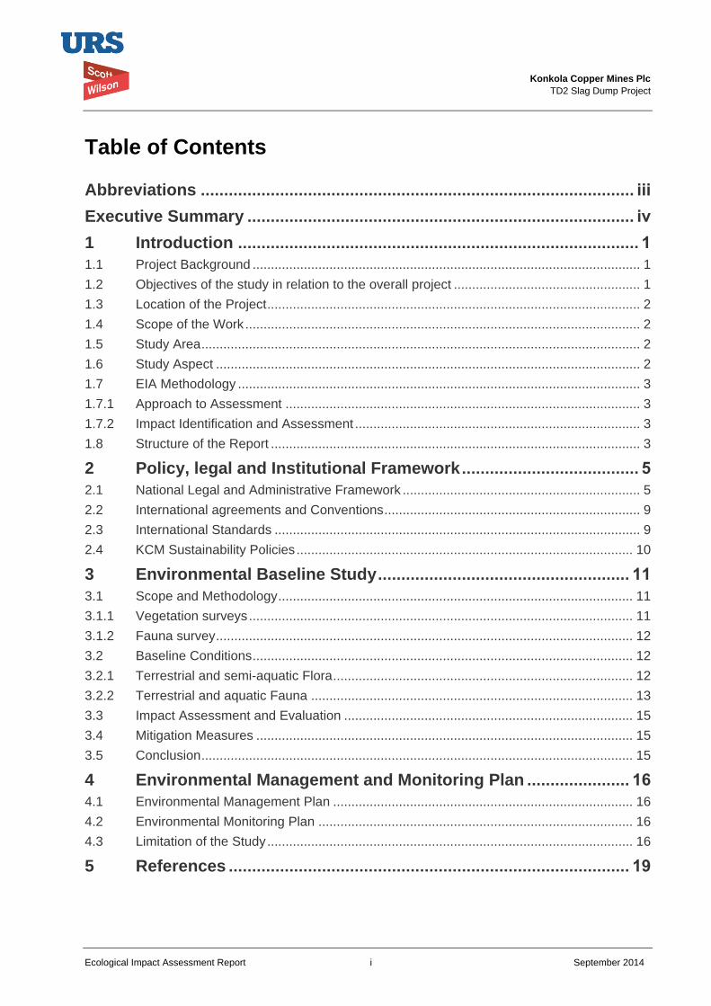
Konkola Copper Mines Plc
TD2 Slag Dump Project
Ecological Impact Assessment Report i September 2014
Table of Contents
Abbreviations ............................................................................................. iii
Executive Summary ................................................................................... iv
1 Introduction ...................................................................................... 1
1.1 Project Background .......................................................................................................... 1
1.2 Objectives of the study in relation to the overall project ................................................... 1
1.3 Location of the Project ...................................................................................................... 2
1.4 Scope of the Work ............................................................................................................ 2
1.5 Study Area ........................................................................................................................ 2
1.6 Study Aspect .................................................................................................................... 2
1.7 EIA Methodology .............................................................................................................. 3
1.7.1 Approach to Assessment ................................................................................................. 3
1.7.2 Impact Identification and Assessment .............................................................................. 3
1.8 Structure of the Report ..................................................................................................... 3
2 Policy, legal and Institutional Framework ...................................... 5
2.1 National Legal and Administrative Framework ................................................................. 5
2.2 International agreements and Conventions ...................................................................... 9
2.3 International Standards .................................................................................................... 9
2.4 KCM Sustainability Policies ............................................................................................ 10
3 Environmental Baseline Study ...................................................... 11
3.1 Scope and Methodology ................................................................................................. 11
3.1.1 Vegetation surveys ......................................................................................................... 11
3.1.2 Fauna survey .................................................................................................................. 12
3.2 Baseline Conditions ........................................................................................................ 12
3.2.1 Terrestrial and semi-aquatic Flora .................................................................................. 12
3.2.2 Terrestrial and aquatic Fauna ........................................................................................ 13
3.3 Impact Assessment and Evaluation ............................................................................... 15
3.4 Mitigation Measures ....................................................................................................... 15
3.5 Conclusion ...................................................................................................................... 15
4 Environmental Management and Monitoring Plan ...................... 16
4.1 Environmental Management Plan .................................................................................. 16
4.2 Environmental Monitoring Plan ...................................................................................... 16
4.3 Limitation of the Study .................................................................................................... 16
5 References ...................................................................................... 19
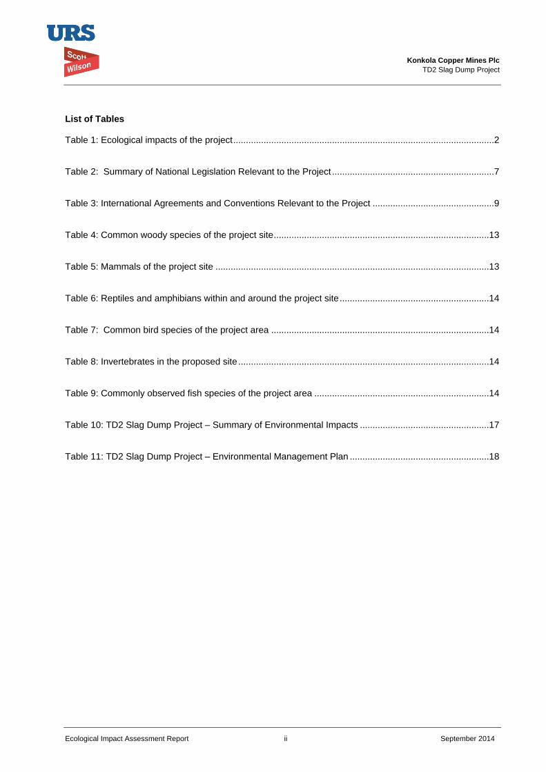
Konkola Copper Mines Plc
TD2 Slag Dump Project
Ecological Impact Assessment Report ii September 2014
List of Tables Table 1: Ecological impacts of the project .......................................................................................................2
Table 2: Summary of National Legislation Relevant to the Project ................................................................7
Table 3: International Agreements and Conventions Relevant to the Project ................................................9
Table 4: Common woody species of the project site .....................................................................................13
Table 5: Mammals of the project site ............................................................................................................13
Table 6: Reptiles and amphibians within and around the project site ...........................................................14
Table 7: Common bird species of the project area ......................................................................................14
Table 8: Invertebrates in the proposed site ...................................................................................................14
Table 9: Commonly observed fish species of the project area .....................................................................14
Table 10: TD2 Slag Dump Project – Summary of Environmental Impacts ...................................................17
Table 11: TD2 Slag Dump Project – Environmental Management Plan .......................................................18
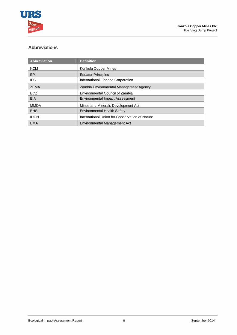
Konkola Copper Mines Plc
TD2 Slag Dump Project
Ecological Impact Assessment Report iii September 2014
Abbreviations
Abbreviation Definition
KCM Konkola Copper Mines
EP Equator Principles
IFC International Finance Corporation
ZEMA Zambia Environmental Management Agency
ECZ Environmental Council of Zambia
EIA Environmental Impact Assessment
MMDA Mines and Minerals Development Act
EHS Environmental Health Safety
IUCN International Union for Conservation of Nature
EMA Environmental Management Act
Konkola Copper Mines Plc
TD2 Slag Dump Project
Ecological Impact Assessment Report iv September 2014
Executive Summary
Introduction
This technical report presents results of the ecological study which is part of the environmental and
Social Impact Assessment study that is required for the preparation of Environmental Impact Statement
for the proposed New Slag Dump Project. It has been prepared by URS Scott Wilson on behalf of
Konkola Copper Mines Plc (KCM), which is the project proponent. The report has been prepared in
conformity within the requirements of national policy, legal and institutional framework and international
agreements to which Zambia is party.
Objectives of the study
The overall objective of the technical study is to carry out an ecological impact assessment of the TD2
Dump project site. The specific objectives are as follows:
To assess the flora and fauna diversity and status within the study area;
To identify impacts and measures necessary to mitigate the project associated impacts;
Identify the ecosystem services of biodiversity within the study area and recommend measures to
enhance them;
To include common names and respective scientific names of the identified terrestrial and aquatic
species.
Project location
The proposed preferred slag dump site is situated within KCM Mining License Area. This site is within
the reclaimed TD2 tailings storage facility footprint adjacent to the Western flank of TD7 tailings storage
facility.
Legal and Administrative Framework
The report has been prepared in line with the requirements of the Zambian Environmental Management
Act, 2011 and its subsidiary legislation, the Environmental Impact Assessment Regulations, 1997
(Statutory Instrument No.28 of 1997). It also refers to the Mines and Minerals Development Act, 2008,
the Mines and Minerals (Environmental) Regulations, 1997, the Forest Act, 1971 and other applicable
legislations and regulations. The administrative framework within which the proposed project will be
implemented will include Zambia Environmental Management Agency (ZEMA), the Mine Safety
Department and other regulatory and government agencies.
Project implementation will also conform to international conventions and internationally recognised
standards such as Equator Principles (EP). The EP are based on and implemented in accordance with
World Bank Group’s International Finance Corporation (IFC) Performance Standards and the IFC
Environmental Health and Safety (EHS) Guidelines. Additionally, Vedanta Sustainability Framework
which is domesticated by KCM is aligned with IFCPS will provide the main guidelines in implementing
this project.
Ecological Assessment scope of work
The study generated ecological baseline data for use in the identification of impacts arising from
changing the use of TD2 tailings dam to Slag Dump site.
Konkola Copper Mines Plc
TD2 Slag Dump Project
Ecological Impact Assessment Report v September 2014
Ecological Impact Assessment approaches and reporting
The approach considered in undertaking the assignment is outlined in detail in this document. It involves
laying out plots for assessing plant diversity, and conducting transect walks to observe in any trails or
foot prints across and around the project area. Additionally, a few local community members were
interviewed to get information of fauna of the area. The techniques employed in evaluation of ecological
impacts are also highlighted in the document.
Conclusion
The conclusion based on the ecological study is given on why the project should go ahead on the
proposed site.
Stephen Syampungani, Prof
Name and position of the EIA Team Member
Konkola Copper Mines Plc
TD2 Slag Dump Project
Ecological Impact Assessment Report 1 September 2014
1 Introduction
1.1 Project Background
KCM owns and operates Nchanga, Konkola, Nkana and Nampundwe mine sites in Zambia.
Nampundwe mine site is located in Lusaka Province while the other mines are located on
the Copperbelt Province. At its Nchanga Mine Site in Chingola, KCM undertakes both
underground and open cast mining operations.
In 2008, KCM commissioned the Nchanga Copper Smelter at Nchanga Mine to smelt
copper concentrates from its own concentrators and other concentrates purchased from
some other mines. The smelter is located within the main plant area at Nchanga mine site
and it has a design capacity of 300,000 tonnes of finished copper per year. The main
products produced from the smelter are copper anodes and the waste product is granulated
slag. An estimated 35,000 tonnes of granulated slag is generated per month, which is
about 1,000 to 1,500 tonnes of slag per day.
The slag is currently disposed of at Slag Dump No.25 situated within the KCM Mine License
area (LSM 34). The dump has been formed by end-tipping of granulated slag material from
dump trucks and evenly spreading it outward using a loader or grader. This has resulted in
the formation of dump slopes that are at the natural angle of repose of the slag material.
Approximately 1.75 million tonnes has so far been dumped and the dump is approaching its
design capacity of 2.6 million tonnes. There is currently inadequate space to dispose of the
slag. Therefore, there is need for an alternative dumping space within KCM Surface Rights
in Chingola.
Expansion of the existing dump is constrained by the presence of Block A Open Pit on the
north-western edge, the Chingola Stream which lies approximately 300 m on the south-
western edge, the Chingola-Chililabombwe public road at approximately 400m on the
south-western edge, and the KCM Haulage Road and drain located on the eastern flank.
There is also power line on the southern periphery of the existing dump.
KCM is, therefore, proposing to undertake a project to construct and operate a new slag
dump. The proposed preferred site for the new slag dump is the already reclaimed TD2
tailings storage facility (TSF). According to the dump design, the proposed dumpsite has a
20 years lifespan as opposed to the initial assumption of 7 years earlier communicated to
stakeholders.
1.2 Objectives of the study in relation to the overall project
The overall objective of the technical study is to carry out an ecological assessment within the
proposed project site. The specific objectives are as follows:
To assess the flora and fauna diversity and status within the study area
To identify impacts and measures necessary to mitigate the project associated impacts
Identify the ecosystem services of biodiversity within the study area and recommend
measures to enhance them
To include common names and respective scientific names of the identified terrestrial and
aquatic species
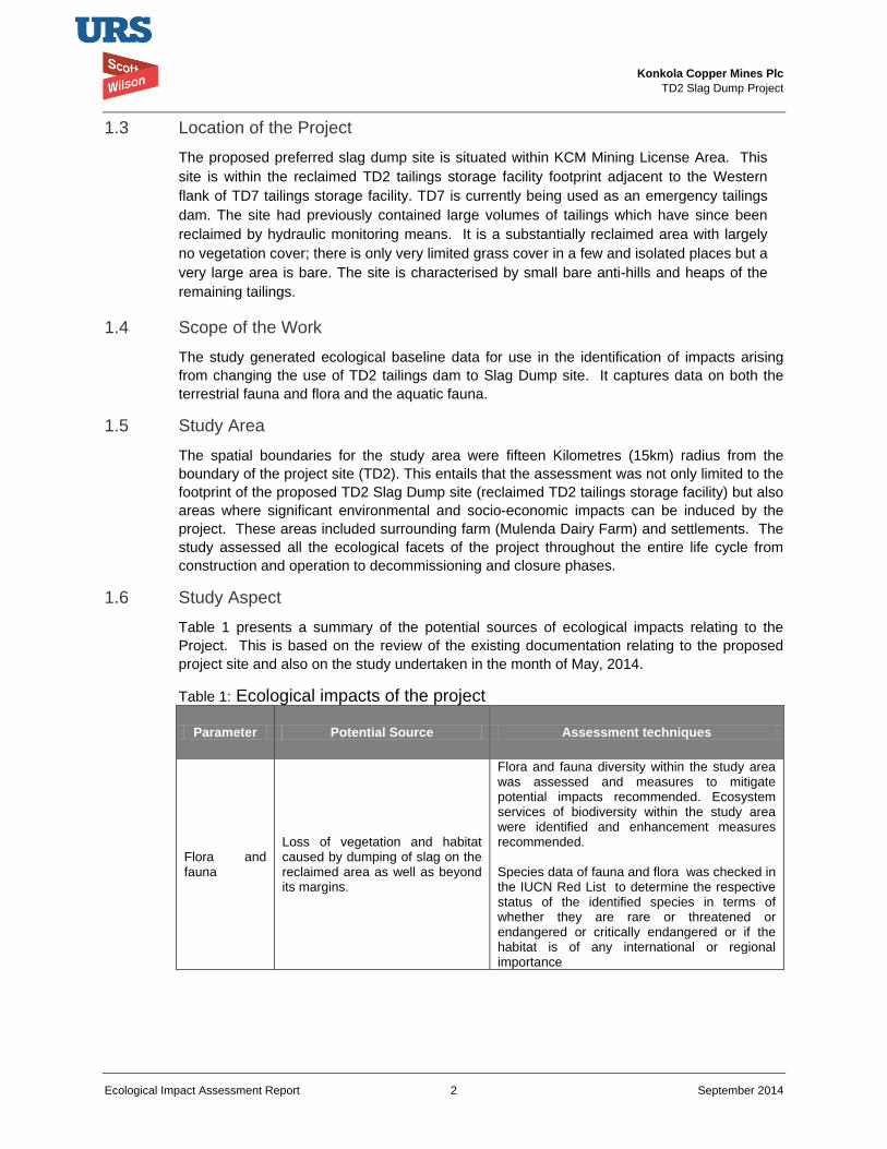
Konkola Copper Mines Plc
TD2 Slag Dump Project
Ecological Impact Assessment Report 2 September 2014
1.3 Location of the Project
The proposed preferred slag dump site is situated within KCM Mining License Area. This
site is within the reclaimed TD2 tailings storage facility footprint adjacent to the Western
flank of TD7 tailings storage facility. TD7 is currently being used as an emergency tailings
dam. The site had previously contained large volumes of tailings which have since been
reclaimed by hydraulic monitoring means. It is a substantially reclaimed area with largely
no vegetation cover; there is only very limited grass cover in a few and isolated places but a
very large area is bare. The site is characterised by small bare anti-hills and heaps of the
remaining tailings.
1.4 Scope of the Work
The study generated ecological baseline data for use in the identification of impacts arising
from changing the use of TD2 tailings dam to Slag Dump site. It captures data on both the
terrestrial fauna and flora and the aquatic fauna.
1.5 Study Area
The spatial boundaries for the study area were fifteen Kilometres (15km) radius from the
boundary of the project site (TD2). This entails that the assessment was not only limited to the
footprint of the proposed TD2 Slag Dump site (reclaimed TD2 tailings storage facility) but also
areas where significant environmental and socio-economic impacts can be induced by the
project. These areas included surrounding farm (Mulenda Dairy Farm) and settlements. The
study assessed all the ecological facets of the project throughout the entire life cycle from
construction and operation to decommissioning and closure phases.
1.6 Study Aspect
Table 1 presents a summary of the potential sources of ecological impacts relating to the
Project. This is based on the review of the existing documentation relating to the proposed
project site and also on the study undertaken in the month of May, 2014.
Table 1: Ecological impacts of the project
Parameter Potential Source Assessment techniques
Flora and fauna
Loss of vegetation and habitat caused by dumping of slag on the reclaimed area as well as beyond its margins.
Flora and fauna diversity within the study area was assessed and measures to mitigate potential impacts recommended. Ecosystem services of biodiversity within the study area were identified and enhancement measures recommended. Species data of fauna and flora was checked in the IUCN Red List to determine the respective status of the identified species in terms of whether they are rare or threatened or endangered or critically endangered or if the habitat is of any international or regional importance
Konkola Copper Mines Plc
TD2 Slag Dump Project
Ecological Impact Assessment Report 3 September 2014
1.7 EIA Methodology
1.7.1 Approach to Assessment
An assessment of the ecological impacts associated with the Project was undertaken as part
of the ESIA process. It addressed potential impacts from construction, operation and
decommissioning phases of the Project. Potential ecological receptors of impacts were
identified from baseline data.
Flora and fauna field surveys were undertaken within the Project site in order to identify the
biodiversity attributes of the Project site. The generated data was the basis upon which the
Project impacts were evaluated. Secondary data was also used in most cases as
supplementary. The ecological impact that may potentially arise was assessed against the
baseline that was established during the study.
The ecological impact assessment was conducted as required under the applicable Zambian
legislations, notably the Environmental Impact Assessment Regulations, 1997 (Statutory
Instrument No. 28 of 1997). These regulations provide guidelines on undertaking
environmental assessment. The assessment was also undertaken to conform to 2012 version
of the World Bank Group’s International Finance Corporation (IFC) Performance Standards,
it’s supporting applicable IFC Environment Health and Safety (EHS) Guidelines and other
general international industry best practices.
The general approach that was followed in preparing the ecological impact assessment report
for the EIAS for the proposed project included:
Gathering available ecological data;
Analysis of the proposed Project with regard to potential impacts and risks during its implementation;
Identification of ecological mitigation strategy;
Prediction and assessment of the impacts in terms of their magnitude, significance and duration;
Recommendations for ecological management and monitoring;
1.7.2 Impact Identification and Assessment
In addition to classifying impacts into either negative or positive, the approach employed in the identification and assessment of impact took into consideration the duration and reversibility of ecological impacts in terms of three types of disturbance: pulse disturbances (short-term/temporary); press disturbances (sustained/chronic; and catastrophic disturbances (highly destructive/probably irreversible). The impacts were also categorized as being either local or regional or international nature.
1.8 Structure of the Report
The technical report is divided into a number of chapters. Details of each chapter are outlined
below:
Chapter 1: Deals with project background, study area and aspects and objectives. It also
highlights the scope of the study and approaches employed in undertaking the assignment.
Chapter 2: Outlines the legal and administrative framework within which the project will be
implemented.
Konkola Copper Mines Plc
TD2 Slag Dump Project
Ecological Impact Assessment Report 4 September 2014
Chapter 3: Discusses both the terrestrial and aquatic ecology of the project site and areas
close to the project site (within the 15 km radius). It further discusses ecological impacts and
mitigation measures for each identified impact.
Chapter 4: Deals with environmental management and monitoring plan
The technical report does not deal with the project description and other related topics such as
project design, construction activities etc. These have been adequately covered in the main
Environmental Impact Assessment Report.
Konkola Copper Mines Plc
TD2 Slag Dump Project
Ecological Impact Assessment Report 5 September 2014
2 Policy, legal and Institutional Framework
This section outlines the legal and administrative framework within which the project will be implemented. It outlines the relevant national legislations and international agreements. The section also includes KCM’s sustainability policies.
2.1 National Legal and Administrative Framework
New Slag Dump Project will be implemented within the Zambian legal and administrative
framework and KCM Policies and plans. It will also be implemented to conform to
international conventions and international best practices outlined in the Equator Principles
(EP), the 2012 version of the International Finance Corporation (IFC) Performance Standards
and Environment Health and Safety (EHS) Guidelines.
Environmental Management Act, 2011
The Zambian Environmental Management Act (EMA), 2011 is the superior Act on matters
relating to environmental protection and management. Its superiority is outlined in Section 3
of the Act. The Act sets out a framework for Environmental Impact Assessments (EIA's) as
well as renaming the Environmental Council of Zambia (ECZ) as the Zambia Environmental
Management Agency (ZEMA), a regulatory Agency mandated to do all such things as are
necessary to ensure the sustainable management of natural resources and the protection of
the environment, and the prevention and control of pollution.
The EMA outlines principles governing environmental management and provides for, among
other things, Environmental Impact Assessment and regulations relating to environmental
assessments. The Act has also spelt out offences relating to failure to prepare and submit an
EIA report for projects that require such reports.
The projects that require preparation of EIA reports must be approved by ZEMA prior to
implementation. Section 29 of the Act specifically states that “a person shall not undertake
any project that may have an effect on the environment without the written approval of the
Agency, and except in accordance with any conditions imposed in that approval”.
The Environmental Protection and Pollution Control (Environmental Impact Assessment)
Regulations, 1997 (Statutory Instrument No. 28 of 1997) specifies the requirements for an EIA
and it also sets out in its Second Schedule projects for which EIAs are applicable. It provides
specific guidelines for conducting environmental impact assessments and for evaluation of
environmental impact statements. The regulations require project developers undertaking
projects that may have significant effect on the environment to conduct environmental impact
assessment prior to obtaining written approval from ZEMA on implementation of the project.
Regulation 3 of the Instrument specifically states that “A developer shall not implement a
project for which a project brief or an environmental impact statement is required under these
Regulations, unless the project brief or an environmental impact assessment has been
concluded in accordance with these Regulations.
New Slag Dump Project will be implemented in accordance with the provisions of the Act and
applicable environmental regulations.
Konkola Copper Mines Plc
TD2 Slag Dump Project
Ecological Impact Assessment Report 6 September 2014
Mines and Mineral Development Act, 2008
The Mines and Minerals Development Act (MMDA), 2008 addresses issues of environmental,
human health and safety in the mining sector in Zambia. The Mines and Minerals
(Environmental) Regulations, 1997 (Statutory Instrument No. 29 of 1997), a subsidiary
legislation of the MMDA, provides a framework for preparing and submitting environmental
project briefs and environmental impact statements prior to undertaking any prospecting,
exploration or mining operations. The regulations also provide for, among other things,
auditing of environmental and social management plans, mine dump reporting, mine site
closure and associated decommissioning and closure costs, storage areas and handling of
hazardous materials.
Table 2 presents a summary of some of the Zambian legislations that are relevant in the
implementation of the proposed Project.
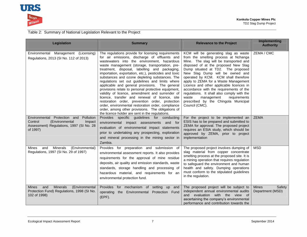
Konkola Copper Mines Plc
TD2 Slag Dump Project
Ecological Impact Assessment Report 7 September 2014
Table 2: Summary of National Legislation Relevant to the Project
Legislation Summary Relevance to the Project Implementing
Authority
Environmental Management (Licensing)
Regulations, 2013 (SI No. 112 of 2013)
The regulations provide for licensing requirements for air emissions, discharge of effluents and wastewaters into the environment, hazardous waste management (storage, transportation, pre-treatment, disposal, labelling and packaging, importation, exportation, etc.), pesticides and toxic substances and ozone depleting substances. The regulations set out guidelines and limits where applicable and general provisions. The general provisions relate to personal protective equipment, validity of licence, amendment and surrender of licence, transfer and renewal of licence, site restoration order, prevention order, protection order, environmental restoration order, compliance order, among other provisions. The obligations of the licence holder are sent in the regulations.
KCM will be generating slag as waste from the smelting process at Nchanga Mine. The slag will be transported and disposed of at the proposed New Slag Dump situated at TD2. The proposed New Slag Dump will be owned and operated by KCM. KCM shall therefore apply to ZEMA for a Waste Management Licence and other applicable licences in accordance with the requirements of the regulations. It shall also comply with the waste management requirements prescribed by the Chingola Municipal Council (CMC).
ZEMA / CMC
Environmental Protection and Pollution Control (Environmental Impact Assessment) Regulations, 1997 (SI No. 28 of 1997)
Provides specific guidelines for conducting
environmental impact assessments and for
evaluation of environmental impact statements
prior to undertaking any prospecting, exploration
and mineral processing in the mining sector in
Zambia.
For the project to be implemented an ESIS has to be prepared and submitted to ZEMA for approval. The proposed project requires an ESIA study, which should be approved by ZEMA, prior to project implementation
ZEMA
Mines and Minerals (Environmental) Regulations, 1997 (SI No. 29 of 1997)
Provides for preparation and submission of
environmental assessment reports. It also provides
requirements for the approval of mine residue
deposits, air quality and emission standards, waste
standards, storage handling and processing of
hazardous material, and requirements for an
environmental protection fund.
The proposed project involves dumping of slag material from copper concentrate smelting process at the proposed site. It is a mining operation that requires regulation to safeguard the environment and human health and safety. Dumping operations must conform to the stipulated guidelines in the regulation.
MSD
Mines and Minerals (Environmental Protection Fund) Regulations, 1998 (SI No. 102 of 1998)
Provides for mechanism of setting up and
operating the Environmental Protection Fund
(EPF).
The proposed project will be subject to independent annual environmental audits and evaluation with the view of ascertaining the company’s environmental performance and contribution towards the
Mines Safety Department (MSD)
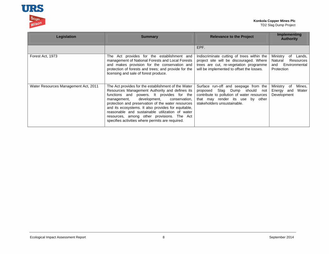
Konkola Copper Mines Plc
TD2 Slag Dump Project
Ecological Impact Assessment Report 8 September 2014
Legislation Summary Relevance to the Project Implementing
Authority
EPF.
Forest Act, 1973
The Act provides for the establishment and management of National Forests and Local Forests and makes provision for the conservation and protection of forests and trees; and provide for the licensing and sale of forest produce.
Indiscriminate cutting of trees within the project site will be discouraged. Where trees are cut, re-vegetation programme will be implemented to offset the losses.
Ministry of Lands, Natural Resources and Environmental Protection
Water Resources Management Act, 2011 The Act provides for the establishment of the Water Resources Management Authority and defines its functions and powers. It provides for the management, development, conservation, protection and preservation of the water resources and its ecosystems. It also provides for equitable, reasonable and sustainable utilization of water resources, among other provisions. The Act specifies activities where permits are required.
Surface run-off and seepage from the proposed Slag Dump should not contribute to pollution of water resources that may render its use by other stakeholders unsustainable.
Ministry of Mines, Energy and Water Development
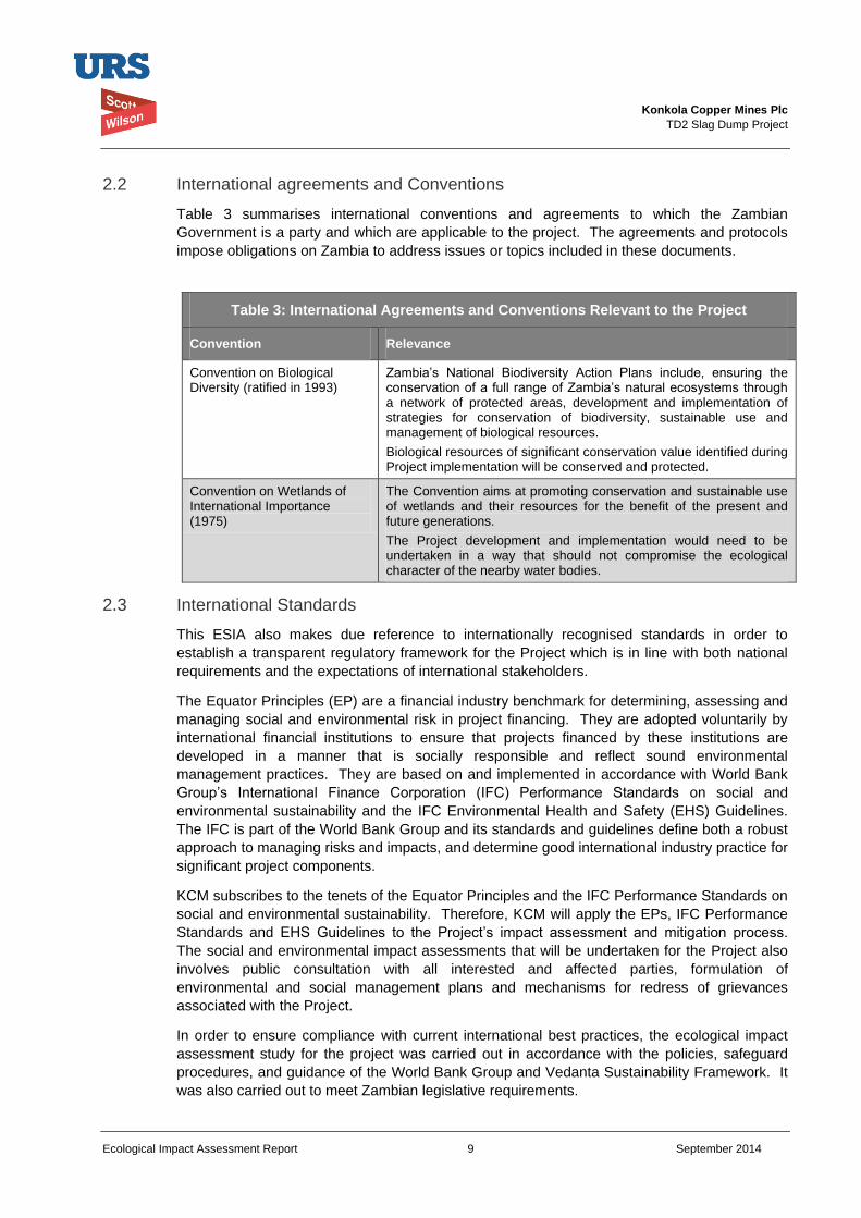
Konkola Copper Mines Plc
TD2 Slag Dump Project
Ecological Impact Assessment Report 9 September 2014
2.2 International agreements and Conventions
Table 3 summarises international conventions and agreements to which the Zambian
Government is a party and which are applicable to the project. The agreements and protocols
impose obligations on Zambia to address issues or topics included in these documents.
Table 3: International Agreements and Conventions Relevant to the Project
Convention Relevance
Convention on Biological Diversity (ratified in 1993)
Zambia’s National Biodiversity Action Plans include, ensuring the conservation of a full range of Zambia’s natural ecosystems through a network of protected areas, development and implementation of strategies for conservation of biodiversity, sustainable use and management of biological resources.
Biological resources of significant conservation value identified during Project implementation will be conserved and protected.
Convention on Wetlands of International Importance (1975)
The Convention aims at promoting conservation and sustainable use of wetlands and their resources for the benefit of the present and future generations.
The Project development and implementation would need to be undertaken in a way that should not compromise the ecological character of the nearby water bodies.
2.3 International Standards
This ESIA also makes due reference to internationally recognised standards in order to
establish a transparent regulatory framework for the Project which is in line with both national
requirements and the expectations of international stakeholders.
The Equator Principles (EP) are a financial industry benchmark for determining, assessing and
managing social and environmental risk in project financing. They are adopted voluntarily by
international financial institutions to ensure that projects financed by these institutions are
developed in a manner that is socially responsible and reflect sound environmental
management practices. They are based on and implemented in accordance with World Bank
Group’s International Finance Corporation (IFC) Performance Standards on social and
environmental sustainability and the IFC Environmental Health and Safety (EHS) Guidelines.
The IFC is part of the World Bank Group and its standards and guidelines define both a robust
approach to managing risks and impacts, and determine good international industry practice for
significant project components.
KCM subscribes to the tenets of the Equator Principles and the IFC Performance Standards on
social and environmental sustainability. Therefore, KCM will apply the EPs, IFC Performance
Standards and EHS Guidelines to the Project’s impact assessment and mitigation process.
The social and environmental impact assessments that will be undertaken for the Project also
involves public consultation with all interested and affected parties, formulation of
environmental and social management plans and mechanisms for redress of grievances
associated with the Project.
In order to ensure compliance with current international best practices, the ecological impact
assessment study for the project was carried out in accordance with the policies, safeguard
procedures, and guidance of the World Bank Group and Vedanta Sustainability Framework. It
was also carried out to meet Zambian legislative requirements.
Konkola Copper Mines Plc
TD2 Slag Dump Project
Ecological Impact Assessment Report 10 September 2014
The IFC Performance Standards and EHS Guidelines relevant to the Project are briefly outlined
below.
2.3.1 International Finance Corporation (IFC) Performance Standards
The IFC Performance Standards set out the underlying principles for sustainable project
management, including impact/risk assessment, mitigation strategies, public consultation and
performance monitoring. For this assignment, the IFC performance standards I (Assessment
and Management of Environmental and Social Risks and Impacts) and 6 (Biodiversity
Conservation and Sustainable Management of Living Natural Resources) are the ones relevant
to this Project. The Standard establishes requirements for environmental performance
management throughout the life of a project through initial baseline studies and identification of
risks and impacts, establishment of management programmes that describe mitigation and
performance improvement measures and actions to address identified risks and impacts. IFC
Performance Standard 6 sets out an approach to protect and conserve biodiversity, including
habitats, species and communities, ecosystem diversity, and genes and genomes, all of which
have potential social, economic, cultural and scientific importance.
2.4 KCM Sustainability Policies
KCM has nine sustainability policies adopted from the Vedanta Sustainability Framework.
These policies are in line with the requirements of the IFC and the Equator Principles. KCM has
a policy on biodiversity that guides KCM the way the organization is supposed to manage
biodiversity.
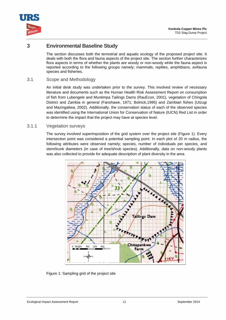
Konkola Copper Mines Plc
TD2 Slag Dump Project
Ecological Impact Assessment Report 11 September 2014
3 Environmental Baseline Study
The section discusses both the terrestrial and aquatic ecology of the proposed project site. It deals with both the flora and fauna aspects of the project site. The section further characterizes flora aspects in terms of whether the plants are woody or non-woody while the fauna aspect is reported according to the following groups namely; mammals, reptiles, amphibians, avifauna species and fisheries.
3.1 Scope and Methodology
An initial desk study was undertaken prior to the survey. This involved review of necessary
literature and documents such as the Human Health Risk Assessment Report on consumption
of fish from Lubengele and Muntimpa Tailings Dams (RauEcon, 2001), vegetation of Chingola
District and Zambia in general (Fanshawe, 1971; Bolnick,1995) and Zambian fishes (Utzugi
and Mazingaliwa, 2002). Additionally, the conservation status of each of the observed species
was identified using the International Union for Conservation of Nature (IUCN) Red List in order
to determine the impact that the project may have at species level.
3.1.1 Vegetation surveys
The survey involved superimposition of the grid system over the project site (Figure 1). Every
intersection point was considered a potential sampling point. In each plot of 20 m radius, the
following attributes were observed namely; species, number of individuals per species, and
stem/trunk diameters (in case of tree/shrub species). Additionally, data on non-woody plants
was also collected to provide for adequate description of plant diversity in the area.
Figure 1: Sampling grid of the project site
Konkola Copper Mines Plc
TD2 Slag Dump Project
Ecological Impact Assessment Report 12 September 2014
3.1.2 Fauna survey
Fauna surveys involved a combination of techniques or approaches. Transect walks were
conducted across and around the proposed dump site. The identification of animals involved a
combination of techniques. Signs such as trails, droppings and bird nests which indicate the
presence of species or group of species were used in fauna identification where possible.
During the transect walks the observed individuals of animal species were recorded.
Additionally, a selected number of local community members (such as fishermen along
Mushishima stream) were consulted to get information on the animal species that exist within
and around the project site.
3.2 Baseline Conditions
3.2.1 Terrestrial and semi-aquatic Flora
Miombo is the dominant woodland around the project area, although the actual project area is mainly devoid of woody species as the site has been used as a tailings dam in the past. Dominant taxa around the project site area include Brachystegia, Isoberlinia and Julbernada with Marquesia macroura, Erythrophleum africanum and Parinari curatellifolia as frequent associates. The lower storey is mainly characterised by Albizia antunesiana, Anisophyllea boehmii, Ochna spp., Pseudolachnostylis maprouneifolia and Syzygium guineense. Around the peripheral of the project site, a number of woody plant species occur (Table 4) while actual project site is predominantly of herbaceous plants namely; Waltera indica, Pycerus polystachyos, Digitaria nemoralis, Aerva leucura and Rhyachne rottboellioides. None of these species is either threatened or endangered or rare or endemic according the IUCN Red Data List. Additionally, none of these species are of special local importance. Generally, the forest around the proposed project site provides a number of ecological services. Some of these services include but not limited to: i) Generation and maintenance of soil quality through decomposition of organic matter ii) Maintenance of air quality-regulating atmosphere air composition iii) Pollination and crop production e.g. bees and other insect iv) Climate stabilization: Plants and other organic materials act as carbon repositories thus reducing carbon dioxide build up in the atmosphere v) Prevention and mitigation of natural disasters: e.g. soil erosion, flooding through action binding actions vi) Prevention and mitigation of natural disasters e.g. soil erosion and siltation of Mushishima and Chingola streams vii) Provision of health care viii) Income generation by local communities through sale of aquatic (eg fish) and terrestrial resources (Uapaca fruits)
The aquatic ecosystem has limited plant diversity. It is mainly dominated with semi-aquatic species of Phragmites and sedges. Phragmites mauritianus, commonly known as Phragmites dominates the aquatic environment of the area. A number of sedges, namely Cyperus esculentus, C.compressus, C. Rotundus and C.obtusifolia occur along the stream. All these species are common across most of the aquatic ecosystems of Southern Africa, especially along the small streams.
Konkola Copper Mines Plc
TD2 Slag Dump Project
Ecological Impact Assessment Report 13 September 2014
Table 4: Common woody species of the project site
Species Relative Density
Relative Frequency
Relative Dominance
Importance Value
Hymenocardia acida 6.481 7.692 3.319 5.831
Parinari curatellifolia 5.556 3.846 5.150 4.851
Albizia amara 12.963 7.692 5.635 8.763
Rhus longipes 7.407 11.538 3.103 7.349
Combretum collinum 15.741 11.538 7.957 11.745
Lonchocarpus capassa 10.185 11.538 6.645 9.456
Albizia versicolor 0.926 3.846 2.552 2.441
Mangifera indica 0.926 3.846 2.035 2.269
Markhamia obtusifolia 8.333 3.846 9.650 7.276
Erythrophleum africanum 2.778 3.846 7.604 4.743
Cassia singuena 6.481 3.846 6.447 5.591
Pseudolachnostylis maprouneifolia 7.407 3.846 18.008 9.754
Combretum molle 3.704 3.846 5.406 4.319
Albizia adianthifolia 2.778 3.846 3.128 3.251
Lannea stulhmannii 0.926 3.846 2.201 2.324
Steganotaenia araliacea 0.926 3.846 3.439 2.737
Toona ciliata 1.852 3.846 4.888 3.529
Baphia beaqueartii 4.620 3.846 2.833 3.766
100.00 100.00 100.00 100.00
3.2.2 Terrestrial and aquatic Fauna
In this study, fauna has been divided into the following groups; mammals, reptiles and
amphibians. A number of these animal groupings occur around the project site. However, the
population of mammals in the very low, with most of the mammals often cited as being of Least
Concern according to IUCN Red List (Table 5).
Table 5: Mammals of the project site
Common name Scientific name IUCN status
Common duiker Sylvicapra grimmia Least concern
Greater Cane Rat Thryonomys swinderianus Least concern
Otter Aonyx capensis Least concern
Black-backed Jackal
Canis mesomelas Least concern
Waterbuck Kobus ellipsiprymnus Least concern
The surrounding areas have been reported to have some reptiles and amphibian species. The
status of these species is listed in table 6. A part from Naja massambica and Bitis orientans, all
the species listed below (Table 6), occur outside the project area. Table 6 also shows the
status of each of these species according to the IUCN Red list.
Konkola Copper Mines Plc
TD2 Slag Dump Project
Ecological Impact Assessment Report 14 September 2014
Table 6: Reptiles and amphibians within and around the project site
Common name Scientific name IUCN status Reptiles
Nile monitor lizard Varanus niloticus Least concern
Crocodile Crocodilus niloticus Least concern
Cobra Naja massambica Least concern
Puff adder Bitis orientans Unknown
Amphibians
Common frog Rana spp. Least concern
Grass frog Ptychadena spp. Unknown
Marbled Reed frog Hyperolius marmoratus Least concern
The project site has a number of avifauna. According to IUCN Red List, most of these species
are of List Concern (Table 7). None of these species is classified as either endangered or
threatened or rare.
Table 7: Common bird species of the project area
Common name Scientific name IUCN status
Pied King fisher Ceryle rudis Least concern
African darter Anhinga rufa Least concern
Cape Turtle dove Streptopelia capicola Unknown
Spur winged goose Ptetctropreus gambensis Unknown
Long-billed crombec Sylvietta rufens Unknown
African wood owl Strix woodfordii Least concern
Flappet Lark Mirafra rufocinnamomea Least concern
African wood-owl Strix woodfordii Least concern
Flappet lark Mirafra rufocinnamomea Least concern
The project site has many invertebrates also. Table 8 clearly indicates the number of order of
invertebrates found within the project area.
Table 8: Invertebrates in the proposed site
Common name Order Millipede Platydesmida
Butterflies Lepidoptera
Moths Lepidoptera
The surrounding streams are rich in fish species. A number of these species were either
observed during the survey or through consultation with the community members living in close
proximity to the project site (Table 9)
Table 9: Commonly observed fish species of the project area
Common name Scientific name IUCN status Banded bream Tilapia sparrmanii Least concern
Redbreast bream Tilapia rendalli Least concern
Yellowbelly Serranochromis robustus Least concern
Blotched catfish Clarias stapperssi Unknown
Brownspot large mouth Serranochromis thumbergi Least concern
Purpleface largemouth Serranochromis macrocephalus Least concern
Thinface largemouth Serranochromis angusticeps Least concern
Sharptooth catfish Clarias gariepinus Unknown
Zigzag barb Barbus miolepus Unknown
Southern mouth brooder Pseudocrealabrus philander Unknown
Line-spotted barb Barbus lineomaculatus Least concern
Banded tilapia Tilapia sparmanii Least concern
Red barb Barbus fasciolatus Least concern
Purpleface largemouth Serranochromis macrocephalus Least concern
Konkola Copper Mines Plc
TD2 Slag Dump Project
Ecological Impact Assessment Report 15 September 2014
3.3 Impact Assessment and Evaluation
Potential Impacts
Terrestrial flora and fauna
The project will involve dumping slag on the Brownfield on which some vegetation occurs. This
will result in loss of vegetation within the project site. The common vegetation formation
occurring on the Brownfield is mainly of herbaceous nature, the most common ones being
Waltera indica, Pycerus polystachyos, Digitaria nemoralis, Aerva leucura and Rhyachne
rottboellioides. These herbaceous species occur across many tailings dams in the Copperbelt
Province. Tithonia diversifolia (a non-native species) is also found around the project peripheral
areas. According to the IUCN Red List, none of these species is either rare or endemic or
threatened. As such, although the individuals of these species will be destroyed as a result of
dumping of slag on the Brownfield, the resulting impacts although negative, will be local in
nature.
Aquatic flora and fauna
The project is unlikely to have an impact on the aquatic life because of the long distance
between the water bodies and the proposed project site. However, contamination of surface
and underground water may occur due to surface run-off and seepage. This may potentially
arise from washing down slag into the nearby Chingola and Mushishima streams The
contamination of these water bodies may result in negative impacts on both aquatic and
terrestrial life that depend on these water bodies for water. Additionally, dust that may be
generated by trucks that will be dumping slag has the potential to affect both aquatic and
terrestrial ecosystem
3.4 Mitigation Measures
Terrestrial flora and fauna
In order to mitigate the loss of vegetation due to dumping of slag on the project site, dumping
will be restricted to the inside part of the project site. No dumping of slag around the dump
peripheral will be allowed. This will ensure that the existing vegetation around the peripheral is
left standing.
Aquatic flora and fauna
The potential for slag to be washed down into Mushishima and Chingola Streams and its
potential to be leached when in contact with surface run-off will be assessed and monitored
regularly.
3.5 Conclusion
The ecological impacts of this project are minimal with the identified impacts being local in
nature. None of the identified species and surrounding vegetation is of international
significance. Therefore, although the ecological impacts will arise from undertaking the project
they are of insignificance nature.
Konkola Copper Mines Plc
TD2 Slag Dump Project
Ecological Impact Assessment Report 16 September 2014
4 Environmental Management and Monitoring Plan
4.1 Environmental Management Plan
Table 10 details the management of impacts that will arise as a resulting of undertaking slag dumping on the project area.
4.2 Environmental Monitoring Plan
Table 11 shows environmental monitoring plan to provide for sustainable management of fauna and flora of both within and around the project site
4.3 Limitation of the Study
The study was undertaken during the dry season and therefore, some of the plants species
may have been missed out during the field survey.
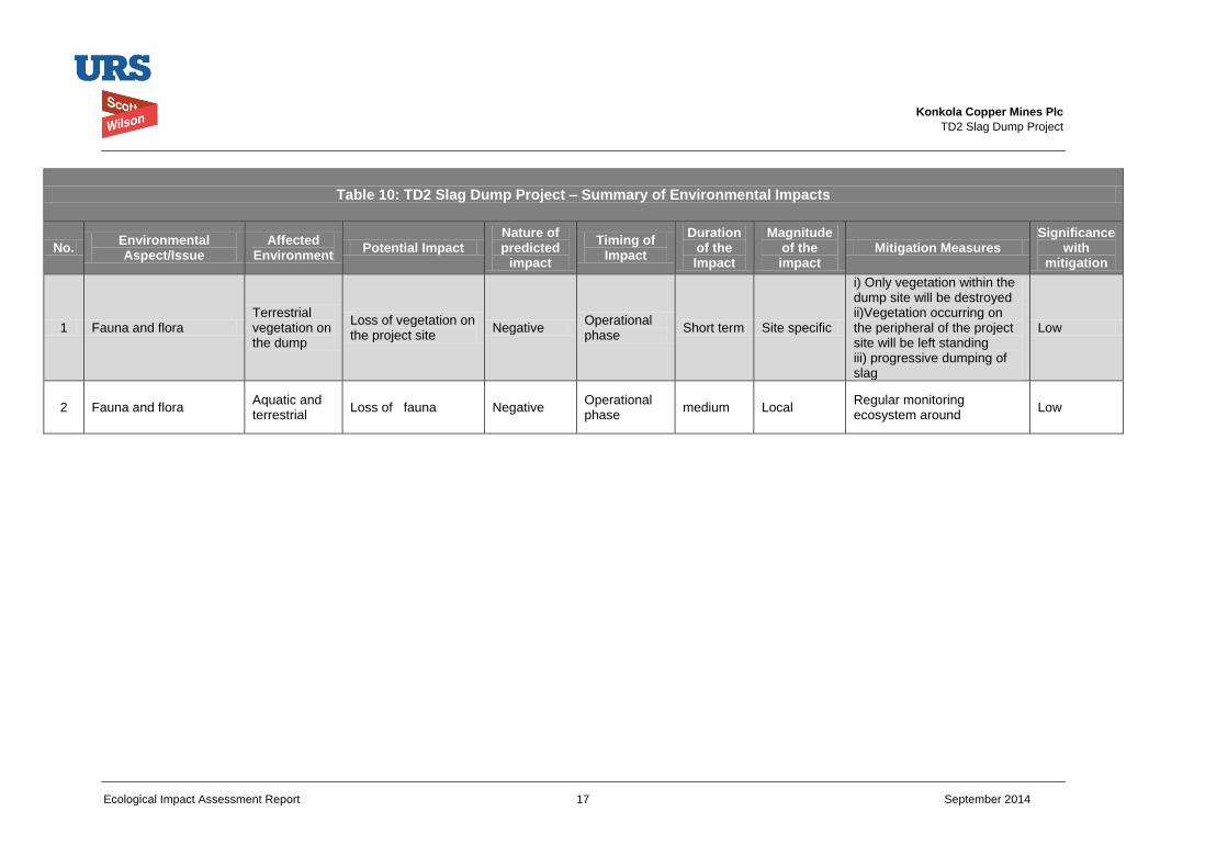
Konkola Copper Mines Plc
TD2 Slag Dump Project
Ecological Impact Assessment Report 17 September 2014
Table 10: TD2 Slag Dump Project – Summary of Environmental Impacts
No. Environmental Aspect/Issue
Affected Environment
Potential Impact Nature of predicted
impact
Timing of Impact
Duration of the Impact
Magnitude of the impact
Mitigation Measures Significance
with mitigation
1 Fauna and flora Terrestrial vegetation on the dump
Loss of vegetation on the project site
Negative Operational phase
Short term Site specific
i) Only vegetation within the dump site will be destroyed ii)Vegetation occurring on the peripheral of the project site will be left standing iii) progressive dumping of slag
Low
2 Fauna and flora Aquatic and terrestrial
Loss of fauna Negative Operational phase
medium Local Regular monitoring ecosystem around
Low
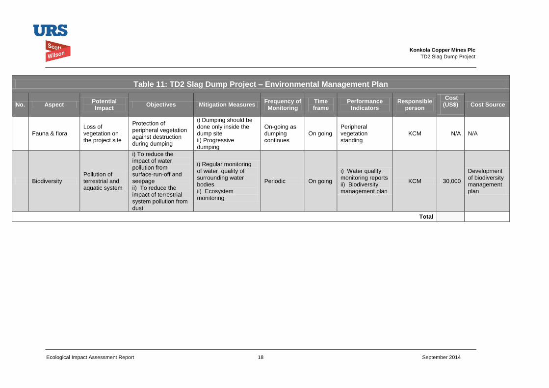
Konkola Copper Mines Plc
TD2 Slag Dump Project
Ecological Impact Assessment Report 18 September 2014
Table 11: TD2 Slag Dump Project – Environmental Management Plan
No. Aspect Potential Impact
Objectives Mitigation Measures Frequency of
Monitoring Time frame
Performance Indicators
Responsible person
Cost (US$)
Cost Source
Fauna & flora Loss of vegetation on the project site
Protection of peripheral vegetation against destruction during dumping
i) Dumping should be done only inside the dump site ii) Progressive dumping
On-going as dumping continues
On going Peripheral vegetation standing
KCM N/A N/A
Biodiversity Pollution of terrestrial and aquatic system
i) To reduce the impact of water pollution from surface-run-off and seepage ii) To reduce the impact of terrestrial system pollution from dust
i) Regular monitoring of water quality of surrounding water bodies ii) Ecosystem monitoring
Periodic On going
i) Water quality monitoring reports ii) Biodiversity management plan
KCM 30,000
Development of biodiversity management plan
Total
Konkola Copper Mines Plc
TD2 Slag Dump Project
Ecological Impact Assessment Report 19 September 2014
5 References
Bolnick, D. 1995. A guide to the Common Wild Flowers of Zambia and Neighbouring Regions. Macmillan Publishers (Zambia) Ltd, Lusaka.
Fanshawe, D. B. 1971. The Vegetation of Zambia. Government Printers,
Lusaka
RauEcon. 2001. Human Health Risk Assessment: Consumption of fish from
Lubengele and Muntimpa Tailings Dams, Copperbelt, Zambia
Utsugi, K., Mazingaliwa, K. 2002. Field Guide to Zambian Fishes, Planktons
and Aquaculture. Japan International Cooperation Agency, Kitwe
Konkola Copper Mines Plc
New Slag Dump Project
Draft Environmental and Social Impact Statement September 2014
Appendix G Noise Survey Report
Prepared for
Konkola Copper Mines Plc
TD2 Slag Dump Project
Ambient Noise Assessment Survey
July 2014
Konkola Copper Mines Plc
TD2 Slag Dump Project
Noise Assessment Survey i July 2014
Table of Contents
List of Figures .............................................................................................. ii
Abbreviations ............................................................................................. iii
Executive Summary ................................................................................... iv
1 Introduction ...................................................................................... 6
1.1 Project Background .......................................................................................................... 6
1.2 Objectives of the ambient noise levels survey ................................................................. 6
1.3 Location of the Project ...................................................................................................... 6
1.4 Study Area ........................................................................................................................ 7
1.5 Study Aspect .................................................................................................................... 7
1.6 Ambient Noise Measurement Methodology ..................................................................... 7
1.7 Structure of the Report ..................................................................................................... 7
2 Policy, legal and Institutional Framework ...................................... 9
2.1 National ............................................................................................................................ 9
2.2 International Standards .................................................................................................... 9
2.3 KCM Sustainability Policies ............................................................................................ 10
3 Project Description......................................................................... 11
4 Environmental Noise Assessment ................................................ 12
4.1 Approach to Assessment ............................................................................................... 12
4.2 Impact Identification and Assessment ............................................................................ 12
5 Noise Levels Baseline Conditions ................................................ 15
5.1 Scope and Methodology ................................................................................................. 15
5.2 Baseline Conditions ........................................................................................................ 16
5.3 Impact Assessment ........................................................................................................ 17
5.4 Mitigation Measures ....................................................................................................... 18
6 Environmental Management and Monitoring Plan ...................... 19
6.1 Environmental Management Plan .................................................................................. 19
6.2 Roles and Responsibilities ............................................................................................. 19
6.3 Environmental Monitoring Plan ...................................................................................... 20
7 Conclusion ...................................................................................... 23
8 References ...................................................................................... 24
Konkola Copper Mines Plc
TD2 Slag Dump Project
Noise Assessment Survey ii July 2014
List of Figures
Figure 1.1: Schematic drawing showing locations of the noise measurement points.
Konkola Copper Mines Plc
TD2 Slag Dump Project
Noise Assessment Survey iii July 2014
Abbreviations
Abbreviation Definition
EHS Environment Health and Safety
EMA Environmental Management Act
EMP Environmental Management Plan
IFC International Finance Corporation
KCM Konkola Copper Mines Plc
SHE Safety Health and Environment
TSF Tailings Storage Facility
WBG World Bank Group
ZEMA Zambia Environmental Management Agency
Konkola Copper Mines Plc
TD2 Slag Dump Project
Noise Assessment Survey iv July 2014
Executive Summary This report presents the findings of the ambient noise levels survey, which was conducted as part of the
Environmental and Social Impact Assessment study for the proposed new slag dump at TD2. The survey
encompassed all noise from all sources associated with the proposed slag dump site such as traffic flow
on the Chingola- Chililabombwe (T3) and the Chingola-Solwezi (T5), noise from the Pump Chamber and
human/animal activities from the nearby communities/bushes.
The survey was carried out by Techfields Limited in May 2014. It was carried out at Konkola Copper
Mines Plc’s TD2 Tailings Storage Facility as part of the overall environmental and social impact study for
the proposed construction and operation of the New Slag Dump.
The purpose of the survey was to establish the baseline ambient noise levels at the proposed site for the
New Slag Dump prior to project implementation and to assess the potential noise impacts on noise
sensitive receptors.
The ambient noise levels survey was carried out in line with the requirements of the Zambian
Environmental Management Act, 2011 and to conform to Konkola Copper Mines Plc’s sustainability
policies and the requirements of the International Finance Corporation Policy on Environmental and Social
Sustainability.
Baseline noise measurements were recorded within the project site using a Sound Level Meter. The noise
impacts that may potentially arise as a result of the proposed project have been assessed against the
baseline conditions established through the survey. The assessment and evaluation of the impacts took
into account the components of the project, the prevailing noise levels prior to project implementation and
the noise-sensitive receptors identified based on the survey.
A standard impact assessment methodology was applied on identified impacts and took into account the
nature or status of the predicted impact, extent of the impact, magnitude or intensity of the impact, the
duration of the impact and the probability of the impact occurring. The impacts were rated and the overall
significance of the impact obtained based on the extent, duration, intensity and probability of the impact.
The noise measurement data indicates that the baseline noise levels as measured at the project site range
between 64 dBA and 39 dBA. The highest noise levels (60 – 64 dBA) were recorded at a point near the
TD2 Pump Station while low noise levels ranging between 39 dBA to 51 dBA were recorded at places
away from TD2 pump station but within the TD2 tailings storage facility. The low noise levels recorded at
locations away from the pump station are all below the maximum ambient allowable noise levels
recommended for residential, institutional and educational setting by the International Finance Corporation
(IFC). The project area is categorised as industrial. Therefore, the baseline noise levels within the project
area is within the IFC maximum ambient allowable noise levels of 70 dBA recommended for industrial and
commercial areas.
Impact assessment indicates that construction works and movement of dump trucks during the operation
phase of the project have the potential to cause noise impacts. The identified noise sensitive receptors are
the residents of Mushishima Village located about 350 metres to the south of project site and the
Mushishima Primary School located about 800 metres to the south of the project site). These receptors
are of high sensitivity and may be potentially affected by construction and operation noise and vibration.
The workers on site have also been identified as noise sensitive receptors.
The potential noise impacts relate to noise disturbance associated with the movement of construction and
operational vehicles. Taking into account the baseline noise levels measured at the nearest point to noise
sensitive receptors (39 dBA – 44 dBA), which is about 350 to 800 metres from sensitive receptors, the
typical noise levels of construction equipment, soft ground attenuation of noise levels, it is predicted that
the maximum noise levels at the nearest receptor will not exceed the recommended maximum ambient
allowable noise levels.
Konkola Copper Mines Plc
TD2 Slag Dump Project
Noise Assessment Survey v July 2014
Therefore, the potential noise disturbance that may arise as a result of the construction and operations of
the proposed Slag Dump will range from short-term to long-term and will be site specific. It is probable the
impact may occur but its intensity will be low at the noise sensitive receptors identified. The overall
significance of the predicted impact will be low.
The construction workers are at risk of being exposed to high noise levels. The typical working hours will
be 8 hrs. The impact associated with the exposure to high noise levels will be negative, short-term and
site specific. It is highly probable the impact will occur and its intensity will be medium. The significance of
the predicted impact is considered to be low.
The mitigations measures proposed to minimise any potential noise disturbance are:
Ensuring that all construction vehicles are well maintained and operated within their efficient
performance parameters;
Providing construction workers with personal ear protectors to protect them from risks of hearing;
Fitting site construction vehicles and dump trucks used for haulage of slag from smelter to dump with
effective exhaust silencers and maintaining them in good efficient working order.
An environmental management plan has been developed based on mitigation measures proposed. The
plan includes frequency of monitoring, where applicable, and identifies a responsible official for ensuring
that the action is effectively implemented. In addition, it includes performance indicators.
With implementation of the proposed mitigation measures the significance of the potential noise impacts
associated with the proposed project is considered to be low. The residual impacts following
implementation of mitigation measures is expected to be very low. Therefore, the proposed slag dump
project is not likely to significantly cause noise disturbance to the Mushishima Village and Mushishima
Primary School, which have been identified as noise sensitive receptors.
Techfields Limited
Noise Consultants
Konkola Copper Mines Plc
TD2 Slag Dump Project
Noise Assessment Survey 6 July 2014
1 Introduction This report presents the findings of the ambient noise levels survey, which was conducted as
part of the Environmental and Social Impact Assessment study for the proposed new slag
dump at TD2. The survey encompassed all noise from all sources associated with the
proposed slag dump site such as traffic flow on the Chingola- Chililabombwe (T3) and the
Chingola-Solwezi (T5), noise from the Pump Chamber and human/animal activities from the
nearby communities/bushes.
The survey was carried out by Techfields Ltd between 22nd
and 23rd
May 2014. It was carried
out at Konkola Copper Mines Plc’s at TD2 Tailings Storage Facility.
1.1 Project Background
KCM owns and operates the Nchanga Copper Smelter at Nchanga Mine in Chingola,
Copperbelt Province. The smelter has a design capacity of 300,000 tonnes of finished
copper per year. The main products produced from the smelting process are copper anodes
and the waste product is granulated slag. An estimated 35,000 tonnes of granulated slag is
generated per month, which is about 1,000 to 1,500 tonnes of slag per day.
The slag is currently disposed of at Slag Dump No.25, which is also owned and operated by
KCM. The dump is situated within the KCM Mine License area (LSM 34) and has been has
been formed by end-tipping of granulated slag material from dump trucks and evenly
spreading it outward using a loader or grader.
The dump is rapidly approaching its design capacity of 2.6 million tonnes. The dump cannot
be expanded to accommodate over its design capacity because its expansion is constrained
by the presence of Block "A" Open Pit on the north-western edge, the Chingola Stream
which lies approximately 300 m on the south-western edge, the Chingola - Chililabombwe
public road at approximately 400m on the south-western edge, and the KCM Haulage Road
and drain located on the eastern flank. There is also power line on the southern periphery of
the existing dump.
Therefore, there is need for an alternative dumping space within KCM Surface Rights in
Chingola before the existing dump reaches its design capacity. KCM has, therefore,
proposed to undertake the project to construct and operate a new Slag Dump. The
proposed and preferred site for the new Slag Dump is the already reclaimed TD2 tailings
storage facility (TSF).
1.2 Objectives of the ambient noise levels survey
The purpose of the survey was to establish the baseline ambient noise levels at the proposed
site prior to project implementation and to assess the potential noise impacts on noise sensitive
receptors.
1.3 Location of the Project
The proposed preferred slag dump site is situated within KCM Mining License Area and is
within the reclaimed TD2 tailings storage facility footprint. It is adjacent to the Western flank
of TD7 tailings storage facility. The site had previously contained large volumes of tailings
which have since been reclaimed by hydraulic monitoring means. It is a substantially
reclaimed area with largely no vegetation cover; there is only very limited grass cover in a
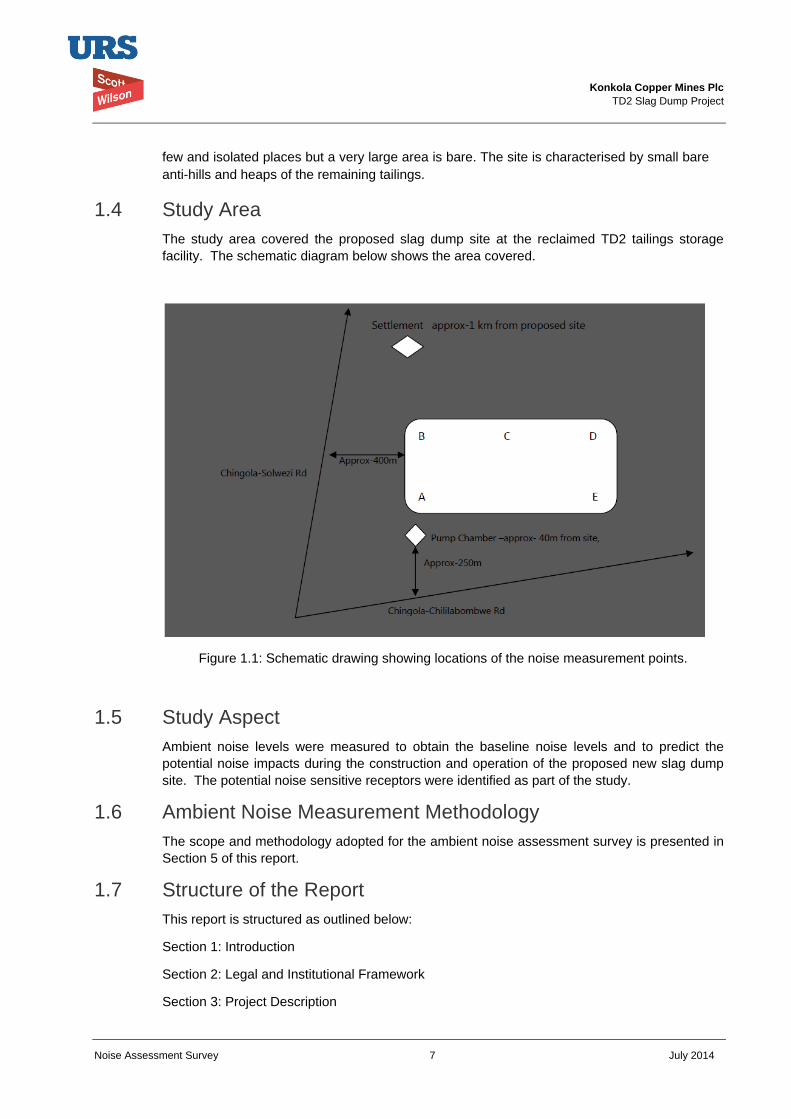
Konkola Copper Mines Plc
TD2 Slag Dump Project
Noise Assessment Survey 7 July 2014
few and isolated places but a very large area is bare. The site is characterised by small bare
anti-hills and heaps of the remaining tailings.
1.4 Study Area
The study area covered the proposed slag dump site at the reclaimed TD2 tailings storage
facility. The schematic diagram below shows the area covered.
Figure 1.1: Schematic drawing showing locations of the noise measurement points.
1.5 Study Aspect
Ambient noise levels were measured to obtain the baseline noise levels and to predict the
potential noise impacts during the construction and operation of the proposed new slag dump
site. The potential noise sensitive receptors were identified as part of the study.
1.6 Ambient Noise Measurement Methodology
The scope and methodology adopted for the ambient noise assessment survey is presented in
Section 5 of this report.
1.7 Structure of the Report
This report is structured as outlined below:
Section 1: Introduction
Section 2: Legal and Institutional Framework
Section 3: Project Description
Konkola Copper Mines Plc
TD2 Slag Dump Project
Noise Assessment Survey 8 July 2014
Section 4: Environmental Noise Assessment
Section 5: Ambient Noise Levels Baseline Conditions
Section 6: Environmental Management and Monitoring Plan
Section 7: Conclusion;
Section 8: References
Konkola Copper Mines Plc
TD2 Slag Dump Project
Noise Assessment Survey 9 July 2014
2 Policy, legal and Institutional Framework This section outlines the legal and administrative framework within which the project will be
implemented. It outlines the relevant national legislations and international agreements. The
section also includes KCM’s sustainability policies.
2.1 National
The proposed New Slag Dump Project at TD2 will be implemented within the Zambian legal
and administrative framework. The Environmental Management Act No. 12 of 2011 (EMA)
includes Division 6 – Noise which highlights issues relating to prohibition of noise emission
exceeding established standards (Section 68), exemptions (Section 9) and the responsibilities
of the Zambia Environmental Management Agency (ZEMA) (Section 70) in relation to noise
pollution.
Under Section 70 of the Act, ZEMA has been mandated to the following in consultation with
appropriate authorities:
a) Set up standard procedures for noise measurement;
b) Establish noise level and noise emission standards for construction sites, plants,
machinery, motor vehicles, aircrafts, including sonic booms and industrial and commercial
activities;
c) Apply appropriate measures to ensure the abatement and control of noise from the sources
referred to in (b);
d) Measure the level of noise emanating from the sources referred to in (b), details of which
measurement shall be given to the owner or occupier of the premises from which the
measurement was taken; and
e) Advise on noise pollution abatement measures.
Currently, ZEMA is in the process of formulating regulations on noise pollution which will
include noise emission standards. Therefore, international guidelines are referred in the
assessment of ambient noise levels.
2.2 International Standards
2.2.1 IFC Performance Standard
The IFC Performance Standards set out the underlying principles for sustainable project
management, including impact/risk assessment, mitigation strategies, public consultation and
performance monitoring.
The Performance Standards directly identified as being relevant to noise assessment survey in
the area listed below:
IFC Performance Standard 1: Assessment and Management of Environmental and
Social Risks and Impacts: Establishes requirements for social and environmental
performance management throughout the life of a project through initial baseline studies
and identification of risks and impacts, establishment of management programmes that
describe mitigation and performance improvement measures and actions to address
identified risks and impacts, stakeholder engagement and application of management
system to monitor and improve performance.
Konkola Copper Mines Plc
TD2 Slag Dump Project
Noise Assessment Survey 10 July 2014
IFC Performance Standard 2: Labour and Working Conditions: Highlights the need for
workers’ rights regarding income generation, employment creation, relationship
management, commitment to staff, retention and staff benefits. It identifies and outlines the
need to provide workers with a safe and healthy working environment. This Performance
Standard is guided by international conventions.
IFC Performance Standard 3: Resource Efficiency and Pollution Prevention: Defines
an approach to pollution prevention and abatement in line with current internationally
disseminated technologies and good practice. It deals with ambient and cumulative
considerations, resource conservation and energy efficiency, hazardous materials and
waste management, pesticide use and management, and emergency preparedness and
response provisions.
IFC Performance Standard 4: Community Health, Safety and Security: Specifies
requirements for mitigating any potential for community exposure to risks and impacts
arising from equipment accidents, structural failures and releases of hazardous materials. In
addition, communities may be affected by impacts on their natural resources, exposure to
diseases, and the use of security personnel.
2.2.2 Environmental, Health and Safety Guidelines
The International Finance Corporation (IFC) Environment Health and Safety (EHS) Guidelines
give guidance on noise management. Section 1.7 of the IFC General EHS Guidelines
addresses the impacts of noise beyond the property boundary of the facilities while worker
exposure to noise is covered in Section 2.0 on Occupational Health and Safety of the same
general guidelines (IFC, 2007).
The General EHS Guidelines on environmental noise management highlights noise prevention
and mitigation measures that should be applied where predicted or measured noise impacts
from a project facility or operations exceed the applicable noise level guideline at the most
sensitive point of reception. The IFC noise level guidelines are presented in Table 5.1 of this
Report.
2.3 KCM Sustainability Policies
The sustainability policies listed below guide the way KCM manages sustainability issues:
• Safety Health and Environment;
• Security;
• Social;
• Biodiversity;
• Human Rights;
• HIV/AIDS;
• Water Management;
• Energy and Carbon;
• Supplier and Contractor Management.
Konkola Copper Mines Plc
TD2 Slag Dump Project
Noise Assessment Survey 11 July 2014
3 Project Description The proposed project will involve construction and operation of the new slag dump at TD2
tailings storage facility. It will include widening and grading of the existing access roads. In
addition, it will involve hauling of slag from Nchanga Smelter to the proposed site where it will
be dumped.
The detailed project description is presented in the Environmental and Social Impact
Statement. The description provides information on the following:
Construction phase
Operations phase;
Decommissioning and closure phase; and
Project alternatives,
Therefore, this ambient noise survey report should be read together with the main
Environmental and Social Impact Assessment Report.
Konkola Copper Mines Plc
TD2 Slag Dump Project
Noise Assessment Survey 12 July 2014
4 Environmental Noise Assessment
4.1 Approach to Assessment
Environmental noise assessment for the proposed project has addressed potential impacts that
may arise from construction, operation and decommissioning phases of the Project. Potential
noise sensitive receptors have been identified based on baseline surveys conducted. The
assessment of the significance of potential impacts on the identified receptors has been
undertaken.
Baseline noise measurements were recorded within the project site and the noise impacts that
may potentially arise as a result of the proposed project have been assessed against the
baseline conditions established through the survey.
The general approach adopted in undertaking the survey involved:
Measuring baseline ambient noise levels;
Analysing of the proposed Project with regard to potential noise impacts and risks during
project implementation;
Predicting and assessing the noise impacts in terms of their nature, duration, extent,
intensity and significance.
Recommending noise management and monitoring measures;
Collation of the above information into the Noise Assessment Technical Report.
4.2 Impact Identification and Assessment
The potential impacts of the proposed Project with respect of noise have been identified and
assessed based on the review of project description and critical assessment of the project
components in relation to the prevailing ambient noise levels baseline conditions. The
identification and assessment of potential impacts was also based on applicable national
legislations and IFC Noise Level Guidelines (IFC, 2007).
A standard impact assessment methodology was applied on identified impacts and took into
account the nature1 or status of the predicted impact, extent of the impact
2, magnitude or
intensity3 of the impact, the duration
4 of the impact and the probability
5 of the impact occurring.
The impacts were given a rating using the assessment criteria as indicated in Table 4.1. The
overall significance of the impact was obtained based on the extent (E), duration (D), intensity
(I) and probability of the impact (P) occurring.
Significance of predicted impact (S) = (E + D + I) x P
The impact assessment terminology and ratings used to describe the impacts are presented in
Table 4.1.
1 Nature of impact – an appraisal of the type of effect an activity would have on the affected environment.
2 Extent of the impact – indicates whether the impact will be site specific, local, regional, national or international.
3 Magnitude or intensity of the impact – indicates whether the impact is destructive or benign.
4 Duration of the impact – indicates the lifetime of the impact as either short-term, medium-term and long-term.
5 Probability of the impact – describes the likelihood of the impact actually occurring.
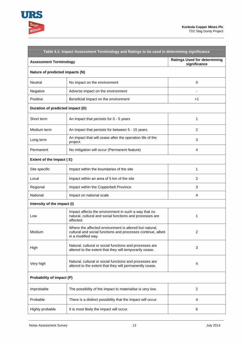
Konkola Copper Mines Plc
TD2 Slag Dump Project
Noise Assessment Survey 13 July 2014
Table 4.1: Impact Assessment Terminology and Ratings to be used in determining significance
Assessment Terminology Ratings Used for determining
significance
Nature of predicted impacts (N)
Neutral No impact on the environment 0
Negative Adverse impact on the environment -
Positive Beneficial impact on the environment +1
Duration of predicted impact (D)
Short term An impact that persists for 0 - 5 years 1
Medium term An impact that persists for between 5 - 15 years. 2
Long term An impact that will cease after the operation life of the project.
3
Permanent No mitigation will occur (Permanent feature) 4
Extent of the impact ( E)
Site specific Impact within the boundaries of the site 1
Local Impact within an area of 5 km of the site 2
Regional Impact within the Copperbelt Province 3
National Impact on national scale 4
Intensity of the impact (I)
Low Impact affects the environment in such a way that no natural, cultural and social functions and processes are affected.
1
Medium Where the affected environment is altered but natural, cultural and social functions and processes continue, albeit in a modified way.
2
High Natural, cultural or social functions and processes are altered to the extent that they will temporarily cease.
3
Very high Natural, cultural or social functions and processes are altered to the extent that they will permanently cease.
4
Probability of impact (P)
Improbable The possibility of the impact to materialise is very low. 2
Probable There is a distinct possibility that the impact will occur. 4
Highly probable It is most likely the impact will occur. 6
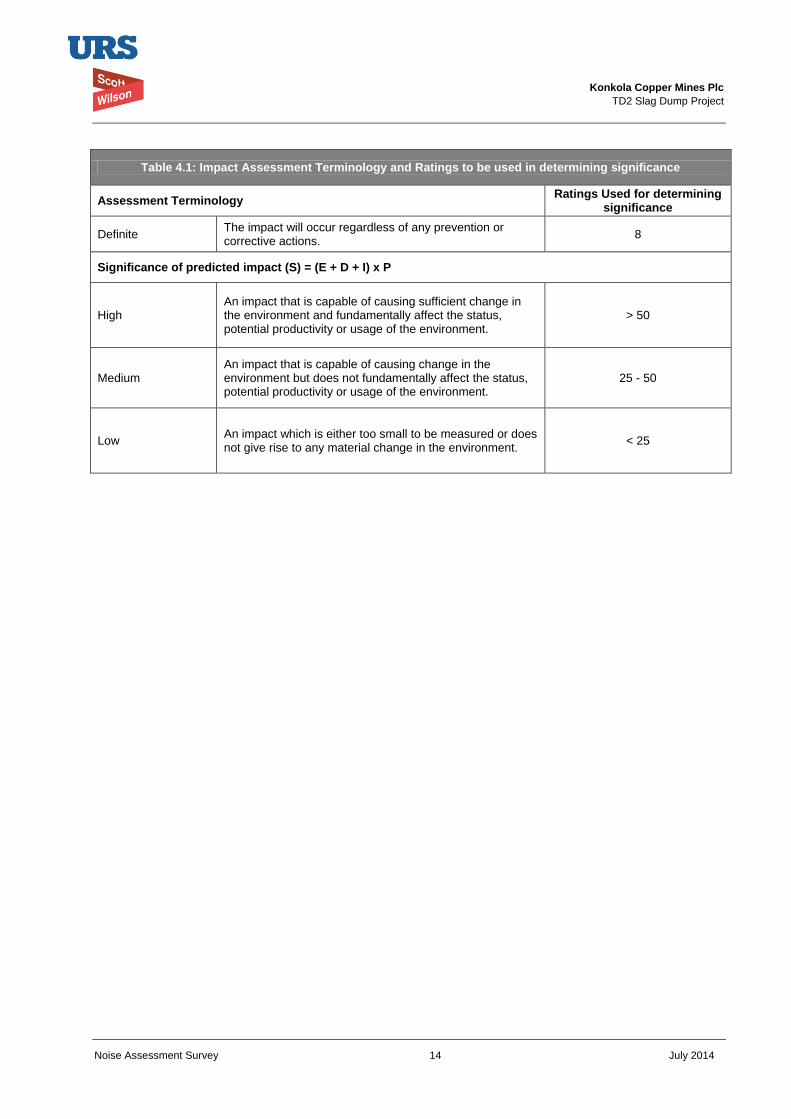
Konkola Copper Mines Plc
TD2 Slag Dump Project
Noise Assessment Survey 14 July 2014
Table 4.1: Impact Assessment Terminology and Ratings to be used in determining significance
Assessment Terminology Ratings Used for determining
significance
Definite The impact will occur regardless of any prevention or corrective actions.
8
Significance of predicted impact (S) = (E + D + I) x P
High An impact that is capable of causing sufficient change in the environment and fundamentally affect the status, potential productivity or usage of the environment.
> 50
Medium An impact that is capable of causing change in the environment but does not fundamentally affect the status, potential productivity or usage of the environment.
25 - 50
Low An impact which is either too small to be measured or does not give rise to any material change in the environment.
< 25
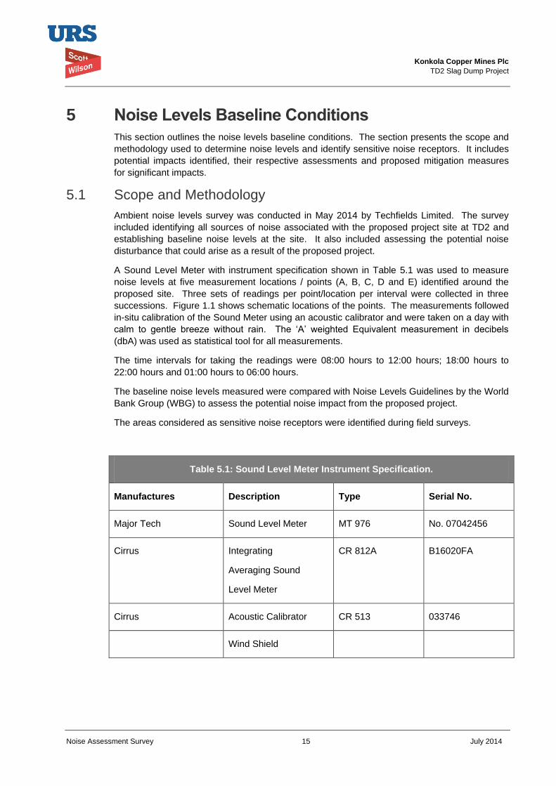
Konkola Copper Mines Plc
TD2 Slag Dump Project
Noise Assessment Survey 15 July 2014
5 Noise Levels Baseline Conditions This section outlines the noise levels baseline conditions. The section presents the scope and
methodology used to determine noise levels and identify sensitive noise receptors. It includes
potential impacts identified, their respective assessments and proposed mitigation measures
for significant impacts.
5.1 Scope and Methodology
Ambient noise levels survey was conducted in May 2014 by Techfields Limited. The survey
included identifying all sources of noise associated with the proposed project site at TD2 and
establishing baseline noise levels at the site. It also included assessing the potential noise
disturbance that could arise as a result of the proposed project.
A Sound Level Meter with instrument specification shown in Table 5.1 was used to measure
noise levels at five measurement locations / points (A, B, C, D and E) identified around the
proposed site. Three sets of readings per point/location per interval were collected in three
successions. Figure 1.1 shows schematic locations of the points. The measurements followed
in-situ calibration of the Sound Meter using an acoustic calibrator and were taken on a day with
calm to gentle breeze without rain. The ‘A’ weighted Equivalent measurement in decibels
(dbA) was used as statistical tool for all measurements.
The time intervals for taking the readings were 08:00 hours to 12:00 hours; 18:00 hours to
22:00 hours and 01:00 hours to 06:00 hours.
The baseline noise levels measured were compared with Noise Levels Guidelines by the World
Bank Group (WBG) to assess the potential noise impact from the proposed project.
The areas considered as sensitive noise receptors were identified during field surveys.
Table 5.1: Sound Level Meter Instrument Specification.
Manufactures Description Type Serial No.
Major Tech Sound Level Meter MT 976 No. 07042456
Cirrus Integrating
Averaging Sound
Level Meter
CR 812A B16020FA
Cirrus Acoustic Calibrator CR 513 033746
Wind Shield
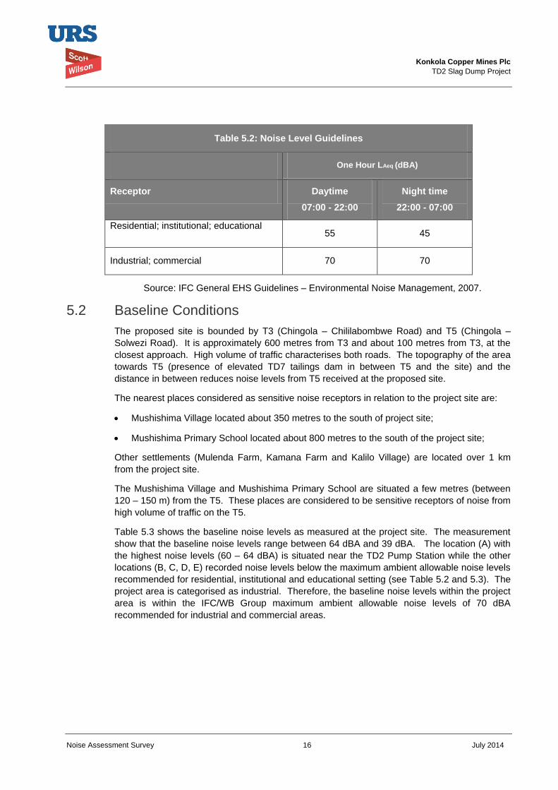
Konkola Copper Mines Plc
TD2 Slag Dump Project
Noise Assessment Survey 16 July 2014
Table 5.2: Noise Level Guidelines
One Hour LAeq (dBA)
Receptor Daytime
07:00 - 22:00
Night time
22:00 - 07:00
Residential; institutional; educational 55 45
Industrial; commercial 70 70
Source: IFC General EHS Guidelines – Environmental Noise Management, 2007.
5.2 Baseline Conditions
The proposed site is bounded by T3 (Chingola – Chililabombwe Road) and T5 (Chingola –
Solwezi Road). It is approximately 600 metres from T3 and about 100 metres from T3, at the
closest approach. High volume of traffic characterises both roads. The topography of the area
towards T5 (presence of elevated TD7 tailings dam in between T5 and the site) and the
distance in between reduces noise levels from T5 received at the proposed site.
The nearest places considered as sensitive noise receptors in relation to the project site are:
Mushishima Village located about 350 metres to the south of project site;
Mushishima Primary School located about 800 metres to the south of the project site;
Other settlements (Mulenda Farm, Kamana Farm and Kalilo Village) are located over 1 km
from the project site.
The Mushishima Village and Mushishima Primary School are situated a few metres (between
120 – 150 m) from the T5. These places are considered to be sensitive receptors of noise from
high volume of traffic on the T5.
Table 5.3 shows the baseline noise levels as measured at the project site. The measurement
show that the baseline noise levels range between 64 dBA and 39 dBA. The location (A) with
the highest noise levels (60 – 64 dBA) is situated near the TD2 Pump Station while the other
locations (B, C, D, E) recorded noise levels below the maximum ambient allowable noise levels
recommended for residential, institutional and educational setting (see Table 5.2 and 5.3). The
project area is categorised as industrial. Therefore, the baseline noise levels within the project
area is within the IFC/WB Group maximum ambient allowable noise levels of 70 dBA
recommended for industrial and commercial areas.
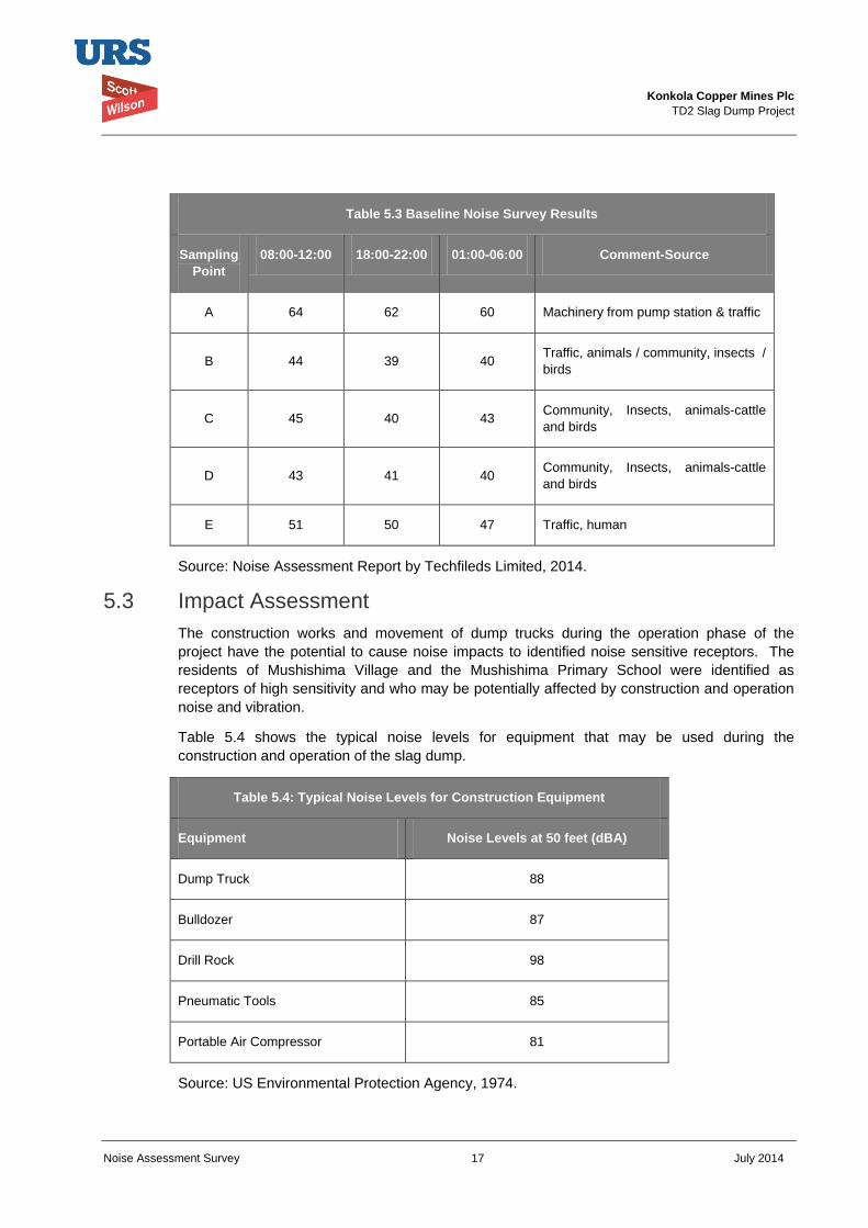
Konkola Copper Mines Plc
TD2 Slag Dump Project
Noise Assessment Survey 17 July 2014
Table 5.3 Baseline Noise Survey Results
Sampling
Point
08:00-12:00 18:00-22:00 01:00-06:00 Comment-Source
A 64 62 60 Machinery from pump station & traffic
B 44 39 40 Traffic, animals / community, insects /
birds
C 45 40 43 Community, Insects, animals-cattle
and birds
D 43 41 40 Community, Insects, animals-cattle
and birds
E 51 50 47 Traffic, human
Source: Noise Assessment Report by Techfileds Limited, 2014.
5.3 Impact Assessment
The construction works and movement of dump trucks during the operation phase of the
project have the potential to cause noise impacts to identified noise sensitive receptors. The
residents of Mushishima Village and the Mushishima Primary School were identified as
receptors of high sensitivity and who may be potentially affected by construction and operation
noise and vibration.
Table 5.4 shows the typical noise levels for equipment that may be used during the
construction and operation of the slag dump.
Table 5.4: Typical Noise Levels for Construction Equipment
Equipment Noise Levels at 50 feet (dBA)
Dump Truck 88
Bulldozer 87
Drill Rock 98
Pneumatic Tools 85
Portable Air Compressor 81
Source: US Environmental Protection Agency, 1974.
Konkola Copper Mines Plc
TD2 Slag Dump Project
Noise Assessment Survey 18 July 2014
The level of noise at the identified receptors that may potentially arise from a project site will
depend on:
Noise level from the construction equipment and dump trucks during operation;
Estimation of operation of the equipment over a typical one hour period;
Distance from the from source to receiver; and
Ground attenuation (soft surface is assumed as the area between the site and identified
receptors is generally vegetated with grass and a few trees).
Other factors such as meteorology will affect the noise levels received by the receptors.
Noise levels decrease as the distance from the source to the receiver increases. The rate of
decrease depends upon the medium of transmission i.e. whether via “hard" or “soft”. Hard
surfaces include concrete, paving and gravel while vegetated areas and bare land form soft
surfaces.
The rate of decrease for noise generated by a point /stationery source is approximately 6
decibels over hard surfaces and 9 decibels over soft surfaces for each doubling of distance.
Taking into account the baseline noise levels measured at point B (39 dBA – 44 dBA), which is
about 350 to 800 metres from sensitive receptors, the typical noise levels of construction, soft
ground attenuation of noise levels, it is predicted that the maximum noise levels at the nearest
receptor will not exceed the recommended maximum ambient allowable noise levels shown in
Table 5.2.
Therefore, the potential noise disturbance that may arise as a result of the construction and
operations of the proposed Slag Dump will range from short-term to long-term and will be site
specific. It is probable the impact may occur but its intensity will be low at the noise sensitive
receptors identified. The overall significance of the predicted impact will be low.
The construction workers are at risk of being exposed to high noise levels. The typical working
hours will be 8 hrs. The impact associated with the exposure to high noise levels will be
negative, short-term and site specific. It is highly probable the impact will occur and its intensity
will be medium. The significance of the predicted impact is considered to be low.
5.4 Mitigation Measures
Best practicable means of reducing noise levels within the recommended maximum allowable
limits should be used by, among other measures:
Ensuring that all construction vehicles are well maintained and operated within their
efficient performance parameters;
Providing construction workers with personal ear protectors to protect them from risks of
hearing;
Fitting site construction vehicles and dump trucks used for haulage of slag from smelter to
dump with effective exhaust silencers and maintaining them in good efficient working order.
Konkola Copper Mines Plc
TD2 Slag Dump Project
Noise Assessment Survey 19 July 2014
6 Environmental Management and Monitoring Plan The Environmental Management and Monitoring Plan with regard to noise management at the
proposed new slag dump at TD2 is presented in this section. The section highlights the roles
and responsibilities for implementation of the plans and the monitoring requirements.
6.1 Environmental Management Plan
The Environmental Management Plan (EMP) for the proposed project has been developed
based on identified potential impacts predicted to occur during the project implementation. The
EMP has consolidated the measures to mitigate predicted noise disturbance and provides a
framework for implementing and monitoring the effectiveness of management actions. It has
been developed to meet the requirements of Zambian environmental legislations and to
conform to IFC requirements on Environmental and Social Sustainability of projects.
Table 6.1 summarises the potential impacts and the EMP is presented in Table 6.2. The EMP
with respect to noise management will be incorporated in the overall Environmental and Social
Management Plan for the proposed slag dump.
The EMP for the proposed slag dump with respect to noise management is laid out in Table 6.2
with headings as outlined below:
Environmental Aspect: these are elements of the activities or products regarding construction
and operation of the slag dump that interact with the environment.
Potential impact: predicted impact that may arise as a result of the proposed project.
Objectives: the targeted objectives to address the environment and social issues by mitigating
specific potential impacts.
Mitigation Measures (management actions): the management commitments made to meet the
objectives.
Frequency of Monitoring: the rate or time of checking that mitigation measures recommended
are implemented.
Time frame: the duration within which the measure will be undertaken.
Performance Indicators: pointers to indicate that the measure has been successfully
implemented.
Responsible person: indicates the person or group of people (or department) who will be
responsible for ensuring the implementation of management action/commitment.
Cost: Estimated cost of undertaking the mitigation measure.
Cost Source: source of funds for implementation of the measure or task.
6.2 Roles and Responsibilities
The management actions required to mitigate identified impacts have been included in the
EMP. The overall responsibility for Safety Health and Environment (SHE) of the organisation
falls under the Chief Executive Office. The SHE Manager – Smelting and Refining, who reports
to the General Manager – Smelting and Refining, will be directly responsible for management
of all environmental aspects / issues related to the project. The Manager will be assisted by
the Environmental Coordinator - Nchanga Smelter.
Konkola Copper Mines Plc
TD2 Slag Dump Project
Noise Assessment Survey 20 July 2014
The Environmental Coordinator will be responsible for coordination and monitoring of activities
relating to the implementation of the project.
6.3 Environmental Monitoring Plan
Issues relating to monitoring of activities to mitigate the potential impacts are included in Table
6.2. The frequency of monitoring, applicable, is included. The Table includes persons
responsible and the performance indicators.
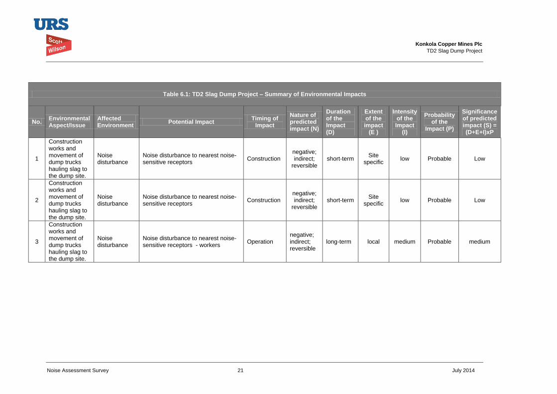
Konkola Copper Mines Plc
TD2 Slag Dump Project
Noise Assessment Survey 21 July 2014
Table 6.1: TD2 Slag Dump Project – Summary of Environmental Impacts
No. Environmental Aspect/Issue
Affected Environment
Potential Impact Timing of
Impact
Nature of predicted impact (N)
Duration of the Impact (D)
Extent of the impact
(E )
Intensity of the Impact
(I)
Probability of the
Impact (P)
Significance of predicted impact (S) = (D+E+I)xP
1
Construction works and movement of dump trucks hauling slag to the dump site.
Noise disturbance
Noise disturbance to nearest noise-sensitive receptors
Construction negative; indirect;
reversible short-term
Site specific
low Probable Low
2
Construction works and movement of dump trucks hauling slag to the dump site.
Noise disturbance
Noise disturbance to nearest noise-sensitive receptors
Construction negative; indirect;
reversible short-term
Site specific
low Probable Low
3
Construction works and movement of dump trucks hauling slag to the dump site.
Noise disturbance
Noise disturbance to nearest noise-sensitive receptors - workers
Operation negative; indirect; reversible
long-term local medium Probable medium
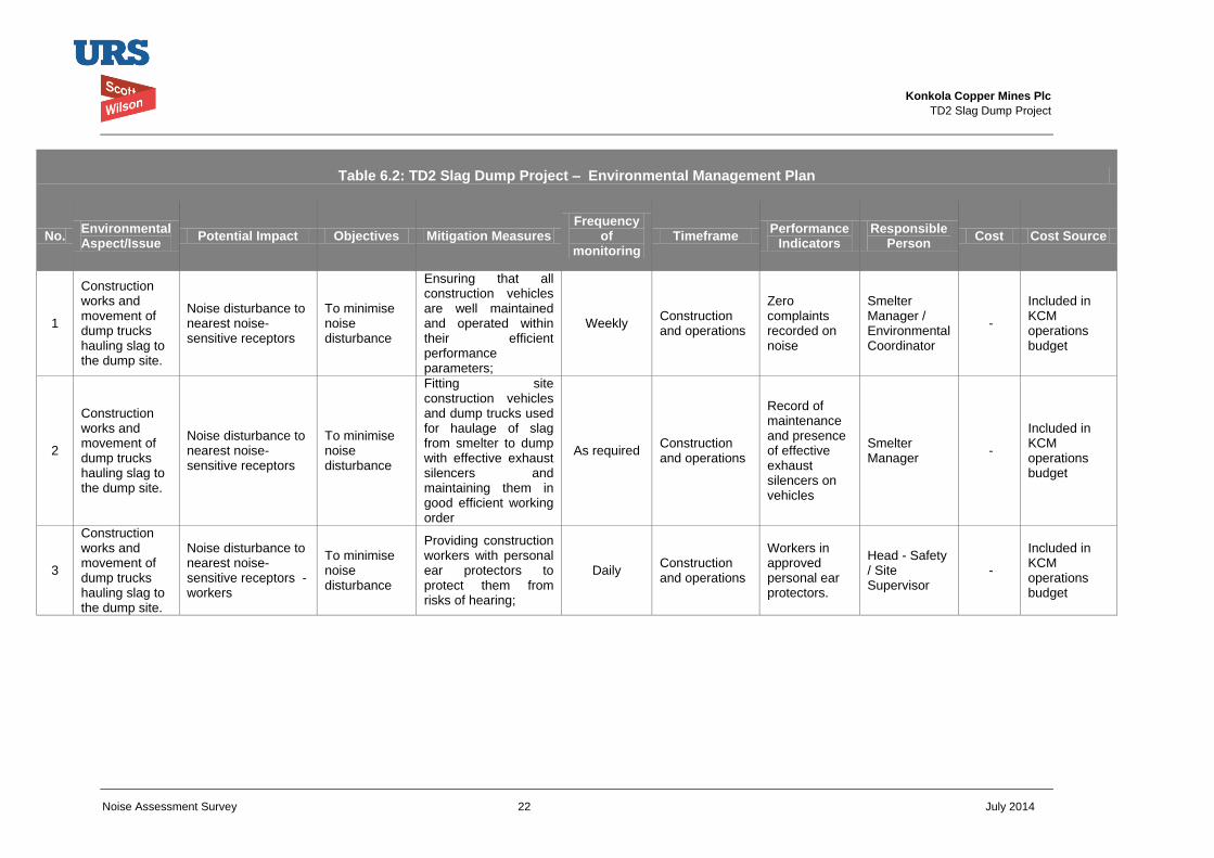
Konkola Copper Mines Plc
TD2 Slag Dump Project
Noise Assessment Survey 22 July 2014
Table 6.2: TD2 Slag Dump Project – Environmental Management Plan
No. Environmental Aspect/Issue
Potential Impact Objectives Mitigation Measures Frequency
of monitoring
Timeframe Performance
Indicators Responsible
Person Cost Cost Source
1
Construction works and movement of dump trucks hauling slag to the dump site.
Noise disturbance to nearest noise-sensitive receptors
To minimise noise disturbance
Ensuring that all construction vehicles are well maintained and operated within their efficient performance parameters;
Weekly Construction and operations
Zero complaints recorded on noise
Smelter Manager / Environmental Coordinator
-
Included in KCM operations budget
2
Construction works and movement of dump trucks hauling slag to the dump site.
Noise disturbance to nearest noise-sensitive receptors
To minimise noise disturbance
Fitting site construction vehicles and dump trucks used for haulage of slag from smelter to dump with effective exhaust silencers and maintaining them in good efficient working order
As required Construction and operations
Record of maintenance and presence of effective exhaust silencers on vehicles
Smelter Manager
-
Included in KCM operations budget
3
Construction works and movement of dump trucks hauling slag to the dump site.
Noise disturbance to nearest noise-sensitive receptors - workers
To minimise noise disturbance
Providing construction workers with personal ear protectors to protect them from risks of hearing;
Daily Construction and operations
Workers in approved personal ear protectors.
Head - Safety / Site Supervisor
-
Included in KCM operations budget
Konkola Copper Mines Plc
TD2 Slag Dump Project
Noise Assessment Survey 23 July 2014
7 Conclusion The significance of the potential noise impacts associated with the implementation of the
project is considered to be low. The residual impacts following implementation of mitigation
measures is expected to be very low. Therefore, the proposed slag dump is not likely to
significantly cause noise disturbance to the Mushishima Village and Mushishima Primary
School, which have been identified as noise sensitive receptors.
Konkola Copper Mines Plc
TD2 Slag Dump Project
Noise Assessment Survey 24 July 2014
8 References GRZ, 2011. Environmental Management Act No. 12 of 2011. Government Republic of Zambia.
Government Printers. Lusaka.
IFC, 2007. General Environmental Health and Safety (EHS) Guidelines: Environmental Noise
Management.
US EPA, 1974. Regulation of Construction Activity Noise.
Konkola Copper Mines Plc
New Slag Dump Project
Draft Environmental and Social Impact Statement September 2014
Appendix H
Water Quality Assessment Report
Prepared for
Konkola Copper Mines Plc
TD2 Slag Dump Project Baseline Water Quality Report July 2014

Konkola Copper Mines Plc TD2 Slag Dump Project
Revision Schedule Rev Date Details Prepared by Reviewed by Approved by
Konkola Copper Mines Plc TD2 Slag Dump Project
Water Quality Baseline Survey i July 2014
Abbreviations and Acronyms Abbreviation Definition EHS Environment Health and Safety EIA Environmental Impact Assessment EMA Environmental Management Act EMP Environmental Management Plan ESIA Environmental and Social Impact Assessment IFC International Finance Corporation KCM Konkola Copper Mine Plc MMDA Mines and Minerals Development Act MSD Mine Safety Department PCD Pollution Control Dam SHE Safety Health and Environment SI Statutory Instrument TD Tailings Dam TSF Tailings Storage Facility ZEMA Zambia Environmental Management Agency
Konkola Copper Mines Plc TD2 Slag Dump Project
Water Quality Baseline Survey ii July 2014
Table of Contents
Abbreviations and Acronyms .................................................................... i List of Figures ........................................................................................... iv
Appendix .................................................................................................... v
Executive Summary .................................................................................. vi 1 Introduction ..................................................................................... 1 1.1 Project Background ........................................................................................................ 1 1.2 Objectives of the study in relation to the overall project .................................................. 1 1.3 Location of the Project .................................................................................................... 2 1.4 Scope of the Work .......................................................................................................... 2 1.5 Study Area ...................................................................................................................... 2 1.6 Study Aspects ................................................................................................................. 2 1.7 Water Quality Baseline - Methodology ............................................................................ 3 1.8 Structure of the Report ................................................................................................... 3
2 Legal and Administrative Framework ............................................ 4 2.1 Relevant Regulations ...................................................................................................... 4 2.2 National Legal and Administrative Framework ................................................................ 4 2.3 International Standards ................................................................................................... 9
3 Project Description ....................................................................... 11
4 Environmental Impact Assessment Methodology ...................... 12 4.1 Approach to Assessment .............................................................................................. 12 4.2 Impact Identification and Assessment ........................................................................... 12
5 Environmental Baseline Study ..................................................... 15 5.1 Scope and Methodology ............................................................................................... 15 5.2 Baseline Conditions ...................................................................................................... 16
6 Environmental Management and Monitoring Plan ...................... 27 6.1 Environmental Management Plan ................................................................................. 27 6.2 Roles and Responsibilities ............................................................................................ 27 6.3 Environmental Monitoring Plan ..................................................................................... 28 6.3.1 Proposed Frequency of Sampling ................................................................................. 29 6.3.2 Quality Control and Quality Assurance ......................................................................... 29 6.3.3 Statutory Reporting ....................................................................................................... 29 6.3.4 Non-Compliance and Corrective Action ........................................................................ 29
7 References ..................................................................................... 37
8 List of Figures ............................................................................... 38
Konkola Copper Mines Plc TD2 Slag Dump Project
Water Quality Baseline Survey iii July 2014
9 Appendices .................................................................................... 43
Konkola Copper Mines Plc TD2 Slag Dump Project
Water Quality Baseline Survey iv July 2014
List of Figures Figure 1.1: Location of Nchanga Mine
Figure 1.2: Location of Proposed Slag Dump Site
Figure 5.1: Location of Surface Water Sampling Points
Figure 5.2: Proposed location for installation of groundwater monitoring boreholes
Konkola Copper Mines Plc TD2 Slag Dump Project
Water Quality Baseline Survey v July 2014
Appendix Appendix 1: Certificates of Assay
Appendix 2: Slag Leachability Test Report
Konkola Copper Mines Plc TD2 Slag Dump Project
Water Quality Baseline Survey vi July 2014
Executive Summary This document presents the findings of the water quality baseline study undertaken as part of the overall environmental and social impact assessment study for the proposed New Slag Dump Project at TD2. The project is located within the Konkola Copper Mines Plc’s (KCM) Mine License Area at Nchanga Mine in Chingola, Copperbelt Province and the project proponent is KCM. The project will involve construction and operation of the new Slag Dump at TD2 tailings storage facility and will include widening and grading of the existing access roads and construction of a filter under-drainage system. In addition, it will involve hauling of slag from Nchanga Smelter to the proposed site where the slag will be dumped.
The purpose of the water quality baseline study was to review, identify and assess implications of the proposed project on water quality. Therefore, baseline conditions, current water quality monitoring regime, baseline water quality, potential impacts and risks, and environmental mitigation strategies were considered.
The proposed New Slag Dump Project will be implemented in line with the requirements of the Zambian legal and administrative framework and KCM Policies and plans. It will also be implemented to conform to international best practices outlined in the 2012 version of the International Finance Corporation (IFC) Performance Standards and Environment Health and Safety (EHS) Guidelines.
The water quality baseline survey was conducted in the immediate catchment area within which the project site falls. This included the Mushishima and Chingola Streams and the Kafue River. The baseline water quality conditions of the project area were established through sampling and analysis of surface water on the Mushishima and Chingola Streams as well as the Kafue River. The samples were analysed at an independent laboratory for parameters that were used to assess the quality of water (surface water pollution). The results were compared with the Zambian Drinking Water Standards.
A desktop study and review of available groundwater data relevant to the project area was undertaken to establish baseline groundwater quality at the project site prior to implementing the project. The slag leachability tests were also conducted as part of the study. The tests were conducted on a slag sample obtained from the existing slag dump at KCM.
The potential impacts that have been identified to potentially arise as a result of the proposed project are contamination of surface water and groundwater and siltation of the Mushishima and Chingola Streams. The potential impacts have been assessed against the baseline conditions established through the survey. The assessment and evaluation of the impacts took into account the components of the project and the prevailing water quality prior to project implementation. A standard impact assessment methodology was applied on identified impacts and considered the impacts in terms of their nature or status, extent, magnitude or intensity, duration and the probability of them occurring. The impacts were also rated and the overall significance of the impact was obtained based on the extent, duration, intensity and probability of the impact
The baseline data indicates that surface water quality and effluent from the existing slag dump is generally good and is within the effluent and wastewater discharge limits provided in the Environmental Management (Licensing) Regulations, 2013. The groundwater monitoring borehole in the vicinity of the proposed site was dry at the time of the survey. Groundwater quality data on TD3/4 Groundwater monitoring borehole, located over 2 km from the project site and with similar conditions as TD2 (reclaimed), was assessed. The quality of groundwater generally meets requirements except for Manganese, Chromium, Cadmium and Aluminium.
The analytical results obtained on slag leachability tests carried out indicate that the slag did not show potential to be leached with water. This implies that surface runoff and seepage water from the slag dump is not likely to be contaminated with heavy metals. Hence, potential contamination of both surface water and groundwater resources in the project area through discharge of surface runoff and seepage water from the slag dump into nearby surface water and groundwater regime is low.
Konkola Copper Mines Plc TD2 Slag Dump Project
Water Quality Baseline Survey vii July 2014
However, the slag showed potential to be leached when in contact with a dilute sulphuric acid with the strength of 5 grammes per litre.
Impact assessment indicates that the predicted potential impacts relating to contamination of surface water will be negative, indirect, reversible and long-term in nature. The intensity of the impact and the possibility of the impact materialising are assessed as low. The overall significance of the impact is assessed as low. This is because the slag material that will be dumped at the proposed site shows no potential to be leached with water. Therefore, surface runoff from the slag is not expected to potentially contain leached heavy metals. The PCD will be the major receptor of surface runoff from the slag dump. Any potential contaminated runoff will be intercepted at the PCD.
The nature of the predicted impact arising from potential groundwater contamination has been assessed to be negative, indirect and reversible in nature. The impact will be localised and its intensity impact will be low to medium. The possibility of the impact materialising has been assessed as very low. The overall significance of the impact has been assessed has low. This is because the design of the proposed slag dump includes installation of a filter under-drainage system to collect seepage through the dumped slag material to the base of the dump. The collected seepage will be directed into the toe drain, which will direct the flow into the PCD. A seepage sump will be constructed as part of the drainage system at the dump and will be used as sampling point for monitoring of seepage quality.
The mitigation measures proposed to minimise potential contamination of surface water are provision of toe drains and under-drainage filters along the periphery of the dump as per design report; constructing silt traps along the periphery of the dump as per design report; and constructing a drainage system at the slag dump that will channel any surface runoff and seepage from the slag dump into the Pollution Control Dam (PCD).
Groundwater contamination will be minimised by designing the slag dump with a filter under-drainage system that will collect seepage from the dump and direct it to PCD via toe drains, installing two groundwater monitoring boreholes on the western and southern flanks of the proposed project site to monitor and assess impact of seepage on receiving water body (aquifers).
An environmental management plan has been developed based on predicted impacts and mitigation measures proposed. The plan includes frequency of monitoring, where applicable, and identifies a responsible official for ensuring that the action is effectively implemented. In addition, it includes performance indicators.
Highlights of an environmental monitoring plan for monitoring of surface and groundwater within the project area have been included and briefly touch on quality assurance and quality control during sampling and analysis of water samples. The need for a non-compliance and corrective action plan with respect to water sampling and testing results has been highlighted as well as the requirements for statutory reporting.
The proposed project is not likely to pose significant adverse environmental impacts on surface water and groundwater resources beyond the existing impacts. With implementation of the proposed mitigation measures, residual impacts are expected to be very low / negligible to give rise to any material change to the environment.
Konkola Copper Mines Plc
TD2 Slag Dump Project
Water Quality Baseline Survey 1 July 2014
1 Introduction This document presents the findings of the water quality baseline study undertaken as part of the overall environmental and social impact assessment study for the proposed New Slag Dump Project at TD2. The project is located within the Konkola Copper Mines Plc’s (KCM) Mine License Area at Nchanga Mine in Chingola, Copperbelt Province and the project proponent is KCM. Figure 1.1 shows the location of Nchanga Mine.
The water quality baseline study was undertaken in May 2014.
1.1 Project Background Konkola Copper Mines Plc owns and operates the Nchanga Copper Smelter at Nchanga Mine in Chingola, Copperbelt Province. The smelter has a design capacity of 300,000 tonnes of finished copper per year. The main products produced from the smelting process are copper anodes and the waste product is granulated slag. An estimated 35,000 tonnes of granulated slag is generated per month, which is about 1,000 to 1,500 tonnes of slag per day.
The slag is currently disposed of at Slag Dump No.25, which is also owned and operated by KCM. The dump is situated within the KCM Mine License area (LSM 34) and has been has been formed by end-tipping of granulated slag material from dump trucks and evenly spreading it outward using a loader or grader.
The dump is rapidly approaching its design capacity of 2.6 million tonnes. It cannot be expanded to accommodate slag over its design capacity because its expansion is constrained by the presence of Block "A" Open Pit on the north-western edge, the Chingola Stream which lies approximately 300m on the south-western edge, the Chingola - Chililabombwe public road at approximately 400m on the south-western edge, and the KCM Haulage Road and drain located on the eastern flank. There is also power line on the southern periphery of the existing dump.
Therefore, there is need for an alternative dumping space within KCM Surface Rights Area in Chingola before the existing dump reaches its design capacity. KCM has, therefore, proposed to undertake the project to construct and operate a new Slag Dump. The proposed and preferred site for the new Slag Dump is the already reclaimed TD2 tailings storage facility (TSF).
1.2 Objectives of the study in relation to the overall project The purpose of the water quality baseline study was to review, identify and assess implications of the proposed project on water quality. In that regard, baseline conditions; current water quality monitoring regime; baseline water quality; potential impacts and risks; and environmental mitigation strategies were considered.
The overall objective of the project is to dispose of slag material in a safe and environmentally friendly manner by constructing and operating a new slag dump.
Konkola Copper Mines Plc
TD2 Slag Dump Project
Water Quality Baseline Survey 2 July 2014
1.3 Location of the Project The proposed preferred slag dump site is situated within KCM Mining License Area. This site is within the reclaimed TD2 tailings storage facility footprint adjacent to the Western flank of TD7 tailings storage facility. TD7 is currently being used as an emergency tailings dam. The site had previously contained large volumes of tailings which have since been reclaimed by hydraulic monitoring means. It is a substantially reclaimed area with largely no vegetation cover; there is only very limited grass cover in a few and isolated places but a very large area is bare. The site is characterised by small bare anti-hills and heaps of the remaining tailings. Figure 1.2 shows the location of the proposed site.
1.4 Scope of the Work The scope of the study included reviewing applicable Zambian legislation, IFC Performance Standards and Environmental Health and Safety Guidelines; and Konkola Copper Mines Policies and Procedures. In addition, the study included reviewing the project description and critically analyzing the project cycle in relation to the environmental setting. In addition the following aspects were reviewed, identified, assessed or described:
a) Baseline hydrological conditions of the project’s area of influence;
b) Current water (ground and surface) quality monitoring regime in the project area;
c) Baseline water quality;
d) Potential impacts and risks of the project on ground and surface water quality;
e) Significance of potential project impacts;
f) Environmental mitigation strategies for significant adverse impacts on ground and surface water quality; and
g) Water quality management and monitoring programme that should be implemented during construction, operation and closure.
1.5 Study Area The spatial boundaries for the study area were fifteen kilometres (15km) radius from the boundary of the project site (TD2). This entailed that the assessment was not only to be limited to the footprint of the proposed TD2 Slag Dump site (reclaimed TD2 tailings storage facility) but also to areas where significant environmental and socio-economic impacts can be induced by the project. These areas include surrounding farm (Mulenda Dairy Farm) and settlements.
1.6 Study Aspects The potential sources of water-related environmental impacts relating to the Project are:
• Surface runoff from the dump slopes contributing to surface water contamination in the nearby streams by potentially washing down slag into the nearby Chingola and Mushishima streams;
Konkola Copper Mines Plc
TD2 Slag Dump Project
Water Quality Baseline Survey 3 July 2014
• Surface runoff from the dump slopes contaminated with leached heavy metals from slag contributing to surface water contamination by potentially washing down slag into the nearby Chingola and Mushishima streams.
• Seepage into the groundwater regime of contaminative materials arising from dumping of slag and causing contamination of groundwater.
The potential for slag to be washed down into Mushishima Stream and its potential to be leached when in contact with surface run-off has been assessed and information relating to the same is presented in Section 5 of this report. Slag leachability tests on the existing slag was undertaken to assess the potential of slag to be leached when in contact with surface runoff. The leachability test results are presented in Section 5 of this report. The Slag Leachability Test Report is presented in Appendix 2.
Water quality was assessed based on primary and secondary data.
1.7 Water Quality Baseline - Methodology The scope and methodology adopted for the water quality baseline study is presented in Section 5 of this report.
1.8 Structure of the Report The report is outlined under the following sections:
Section 1: Introduction
Section 2: Legal and Institutional Framework
Section 3: Project Description
Section 4: Environmental Impact Assessment Methodology
Section 5: Water Quality Baseline Conditions
Section 6: Environmental Management and Monitoring Plan
Section 7: Conclusion;
Section 8: References
Konkola Copper Mines Plc
TD2 Slag Dump Project
Water Quality Baseline Survey 4 July 2014
2 Legal and Administrative Framework This section outlines the legal and administrative framework within which the project was implemented. It outlines the relevant national legislations and international agreements. The section also includes KCM’s sustainability policies.
2.1 Relevant Regulations The proposed New Slag Dump Project will be implemented in line with the requirements of the Zambian legal and administrative framework and KCM Policies and plans. It will also be implemented to conform to international best practices outlined in the Equator Principles (EP), the 2012 version of the International Finance Corporation (IFC) Performance Standards and Environment Health and Safety (EHS) Guidelines.
2.2 National Legal and Administrative Framework Environmental Management Act, 2011
The Zambian Environmental Management Act (EMA), 2011 is the superior Act on matters relating to environmental protection and management. Its superiority is outlined in Section 3 of the Act. The Act sets out a framework for Environmental Impact Assessments (EIA's). The EMA gives the Zambia Environmental Management Agency (ZEMA) the mandate to do all such things as are necessary to ensure the sustainable management of natural resources and the protection of the environment, and the prevention and control of pollution.
It outlines principles governing environmental management and provides for, among other things, Environmental Impact Assessment and regulations relating to environmental assessments. The Act has also spelt out offences relating to failure to prepare and submit an EIA report for projects that require such reports.
The projects that require preparation of EIA reports must be approved by ZEMA prior to implementation. Section 29 of the Act specifically states that “a person shall not undertake any project that may have an effect on the environment without the written approval of the Agency, and except in accordance with any conditions imposed in that approval”.
The Act provides for prohibition of water pollution. Section 46 of the Act states that “A person shall not discharge or apply any poisonous, toxic, eco-toxic, obnoxious or obstructing matter, radiation or other pollutant, or permit any person to dump or discharge such matter or pollutant into the aquatic environment in contravention of water pollution control standards established by the Agency in liaison with the relevant appropriate authority.”
Section 48 of the Act gives ZEMA the responsibilities outlined below that have to be carried out in liaison with the relevant appropriate authority:
a) establish water quality and pollution control standards;
b) determine conditions for the discharge of effluents into the aquatic environment;
c) formulate rules for the preservation of aquatic areas, drinking water sources and reservoirs, recreational and other areas, where water may need special protection;
d) order or carry out investigations of actual or suspected water pollution, including the collection of data;
Konkola Copper Mines Plc
TD2 Slag Dump Project
Water Quality Baseline Survey 5 July 2014
e) take steps or authorise any works to be carried out which appear to be necessary to prevent or abate water pollution from natural causes or from abandoned works or undertakings;
f) determine the analytical methods by which water quality and pollution control standards can be determined and establish laboratories for the analytical services required by the inspectorate;
g) initiate and encourage international co-operation in the control of water pollution, in particular with those neighbouring countries with which Zambia shares river basins;
h) collect, maintain and interpret data from industries and local authorities on the pre-treatment, nature and levels of effluents;
i) collect, maintain and interpret data on water quality and hydrology which is relevant to the granting of licences under this Division; and ·
j) do all such things as are necessary for the monitoring and control of water pollution.
The Environmental Management (Licensing) Regulations, 2013 (Statutory Instrument No. 112 of 2013) provides for the classification of effluents and waste water. This is contained in the Fourth Schedule of the regulations. Regulation 9 of the Environmental Management (Licensing) Regulations, 2013 stipulates that “the Agency [ZEMA] may order an owner or operator of an effluent generating entity to drill monitoring wells for monitoring the contamination of groundwater.”
The Environmental Impact Assessment Regulations, 1997 (Statutory Instrument No. 28 of 1997) is equally an important piece of legislation that specifies the requirements for an EIA and it also sets out in its Second Schedule projects for which EIAs are applicable. It provides specific guidelines for conducting environmental impact assessments and for evaluation of environmental impact statements. The regulations require project developers undertaking projects that may have significant effect on the environment to conduct environmental impact assessment prior to obtaining written approval from ZEMA on implementation of the project. Regulation 3 of the Instrument specifically states that “A developer shall not implement a project for which a project brief or an environmental impact statement is required under these Regulations, unless the project brief or an environmental impact assessment has been concluded in accordance with these Regulations.
New Slag Dump Project will be implemented in accordance with the provisions of the EMA and applicable environmental regulations.
Mines and Mineral Development Act, 2008
The Mines and Minerals Development Act (MMDA), 2008 addresses issues of environmental, human health and safety in the mining sector in Zambia. The Mines and Minerals (Environmental) Regulations, 1997 (Statutory Instrument No. 29 of 1997), a subsidiary legislation of the MMDA, provides a framework for preparing and submitting environmental project briefs and environmental impact statements prior to undertaking any prospecting, exploration or mining operations. The regulations also provide for, among other things, auditing of environmental and social management plans, mine dump reporting, mine site closure and associated decommissioning and closure costs, storage areas and handling of hazardous materials.
Konkola Copper Mines Plc
TD2 Slag Dump Project
Water Quality Baseline Survey 6 July 2014
Table 2.1 presents a summary of some of the applicable Zambian legislations that are relevant in the implementation of the proposed Project.
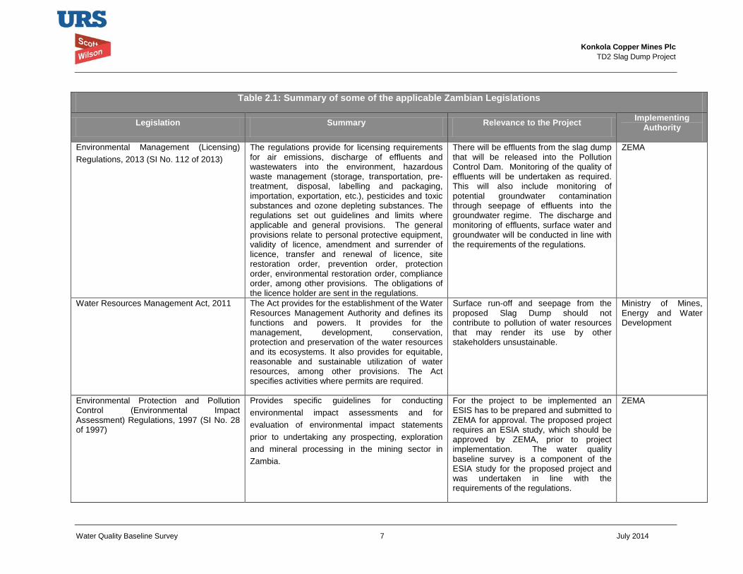
Konkola Copper Mines Plc
TD2 Slag Dump Project
Water Quality Baseline Survey 7 July 2014
Table 2.1: Summary of some of the applicable Zambian Legislations
Legislation Summary Relevance to the Project Implementing Authority
Environmental Management (Licensing) Regulations, 2013 (SI No. 112 of 2013)
The regulations provide for licensing requirements for air emissions, discharge of effluents and wastewaters into the environment, hazardous waste management (storage, transportation, pre-treatment, disposal, labelling and packaging, importation, exportation, etc.), pesticides and toxic substances and ozone depleting substances. The regulations set out guidelines and limits where applicable and general provisions. The general provisions relate to personal protective equipment, validity of licence, amendment and surrender of licence, transfer and renewal of licence, site restoration order, prevention order, protection order, environmental restoration order, compliance order, among other provisions. The obligations of the licence holder are sent in the regulations.
There will be effluents from the slag dump that will be released into the Pollution Control Dam. Monitoring of the quality of effluents will be undertaken as required. This will also include monitoring of potential groundwater contamination through seepage of effluents into the groundwater regime. The discharge and monitoring of effluents, surface water and groundwater will be conducted in line with the requirements of the regulations.
ZEMA
Water Resources Management Act, 2011 The Act provides for the establishment of the Water Resources Management Authority and defines its functions and powers. It provides for the management, development, conservation, protection and preservation of the water resources and its ecosystems. It also provides for equitable, reasonable and sustainable utilization of water resources, among other provisions. The Act specifies activities where permits are required.
Surface run-off and seepage from the proposed Slag Dump should not contribute to pollution of water resources that may render its use by other stakeholders unsustainable.
Ministry of Mines, Energy and Water Development
Environmental Protection and Pollution Control (Environmental Impact Assessment) Regulations, 1997 (SI No. 28 of 1997)
Provides specific guidelines for conducting environmental impact assessments and for evaluation of environmental impact statements prior to undertaking any prospecting, exploration and mineral processing in the mining sector in Zambia.
For the project to be implemented an ESIS has to be prepared and submitted to ZEMA for approval. The proposed project requires an ESIA study, which should be approved by ZEMA, prior to project implementation. The water quality baseline survey is a component of the ESIA study for the proposed project and was undertaken in line with the requirements of the regulations.
ZEMA
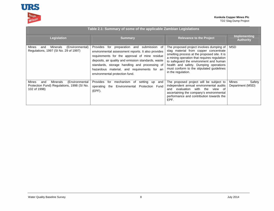
Konkola Copper Mines Plc
TD2 Slag Dump Project
Water Quality Baseline Survey 8 July 2014
Table 2.1: Summary of some of the applicable Zambian Legislations
Legislation Summary Relevance to the Project Implementing Authority
Mines and Minerals (Environmental) Regulations, 1997 (SI No. 29 of 1997)
Provides for preparation and submission of environmental assessment reports. It also provides requirements for the approval of mine residue deposits, air quality and emission standards, waste standards, storage handling and processing of hazardous material, and requirements for an environmental protection fund.
The proposed project involves dumping of slag material from copper concentrate smelting process at the proposed site. It is a mining operation that requires regulation to safeguard the environment and human health and safety. Dumping operations must conform to the stipulated guidelines in the regulation.
MSD
Mines and Minerals (Environmental Protection Fund) Regulations, 1998 (SI No. 102 of 1998)
Provides for mechanism of setting up and operating the Environmental Protection Fund (EPF).
The proposed project will be subject to independent annual environmental audits and evaluation with the view of ascertaining the company’s environmental performance and contribution towards the EPF.
Mines Safety Department (MSD)
Konkola Copper Mines Plc
TD2 Slag Dump Project
Water Quality Baseline Survey 9 July 2014
2.3 International Standards 2.3.1 IFC Performance Standard
The IFC Performance Standards set out the underlying principles for sustainable project management, including impact/risk assessment, mitigation strategies, public consultation and performance monitoring.
The Performance Standards directly identified as being relevant to water quality baseline listed below:
• IFC Performance Standard 1: Assessment and Management of Environmental and Social Risks and Impacts: Establishes requirements for social and environmental performance management throughout the life of a project through initial baseline studies and identification of risks and impacts, establishment of management programmes that describe mitigation and performance improvement measures and actions to address identified risks and impacts, stakeholder engagement and application of management system to monitor and improve performance.
• IFC Performance Standard 2: Labour and Working Conditions: Highlights the need for workers’ rights regarding income generation, employment creation, relationship management, commitment to staff, retention and staff benefits. It identifies and outlines the need to provide workers with a safe and healthy working environment. This Performance Standard is guided by international conventions.
• IFC Performance Standard 3: Resource Efficiency and Pollution Prevention: Defines an approach to pollution prevention and abatement in line with current internationally disseminated technologies and good practice. It deals with ambient and cumulative considerations, resource conservation and energy efficiency, hazardous materials and waste management, pesticide use and management, and emergency preparedness and response provisions.
• IFC Performance Standard 4: Community Health, Safety and Security: Specifies requirements for mitigating any potential for community exposure to risks and impacts arising from equipment accidents, structural failures and releases of hazardous materials. In addition, communities may be affected by impacts on their natural resources, exposure to diseases, and the use of security personnel.
• IFC Performance Standard 6: Biodiversity Conservation and Sustainable Management of Living Natural Resources: Sets out an approach to protect and conserve biodiversity, including habitats, species and communities, ecosystem diversity, and genes and genomes, all of which have potential social, economic, cultural and scientific importance.
2.3.2 Environmental, Health and Safety Guidelines
The International Finance Corporation (IFC) Environment Health and Safety (EHS) Guidelines give guidance on environmental waste water and ambient water quality. Section 1.3 of the IFC General EHS Guidelines applies to projects that have either direct or indirect discharge of process wastewater, wastewater from utility operations or storm water to the environment (IFC, 2007). Section 1.4 provides general guidelines on water conservation.
Konkola Copper Mines Plc
TD2 Slag Dump Project
Water Quality Baseline Survey 10 July 2014
The General EHS Guidelines on environmental waste water and ambient water quality provides general guidelines relating to general liquid effluent quality, waste water management and monitoring, which are also applicable to the proposed slag dump project.
The specific industry sector EHS Guidelines that are applicable to the proposed project include the guidelines on Waste Management Facilities, Mining, Water and Sanitation, Base Metal Smelting and Refining.
2.4 KCM Sustainability Policies The sustainability policies listed below guide the way KCM manages sustainability issues:
• Safety Health and Environment; • Security; • Social; • Biodiversity; • Human Rights; • HIV/AIDS; • Water Management; • Energy and Carbon; and • Supplier and Contractor Management.
Konkola Copper Mines Plc
TD2 Slag Dump Project
Water Quality Baseline Survey 11 July 2014
3 Project Description The proposed project will involve construction and operation of the new slag dump at TD2 tailings storage facility. It will include widening and grading of the existing access roads. In addition, it will involve hauling of slag from Nchanga Smelter to the proposed site where it will be dumped.
The detailed project description is presented in the Environmental and Social Impact Statement. The description provides information on the following:
• Construction phase
• Operations phase;
• Decommissioning and closure phase; and
• Project alternatives,
Therefore, this water quality baseline report should be read together with the main Environmental and Social Impact Assessment Report.
The project will include construction of the drainage network around the project site: This will be done in the early stages of the project and also as and when the need arises during the operational phase. The drainage pattern around the proposed site will be done in such a way that surface runoff from the dump will be intercepted in toe drains and directed into the Pollution Control Dam prior to being discharge into the receiving natural watercourses. The project site is drained by the Mushishima and Chingola Streams.
A filter under-drainage system is included in the slag dump design and is intended to collect seepage through the dumped slag material. The seepage through the slag material will percolate into the underlying foundation strata but the filter under-drainage system will be incorporated to reduce the amount of potential seepage to the underlying strata. The collected seepage will be directed into the Pollution Control Dam (PCD) via toe drains. (URS Scott Wilson, 2014). The filter drain will be along the outer periphery of the slag dump.
Konkola Copper Mines Plc
TD2 Slag Dump Project
Water Quality Baseline Survey 12 July 2014
4 Environmental Impact Assessment Methodology 4.1 Approach to Assessment
An assessment of the environmental impacts associated with the Project with respect to water quality was undertaken as part of the Environmental and Social Impact Assessment (ESIA) process. The assessment addressed potential impacts on surface water and groundwater that may arise as a result of the proposed project.
Baseline data was gathered from both primary and secondary sources. This was done in order to provide data sets to establish the baseline conditions and from which to base the assessment and evaluation of impacts. The environmental impacts that may potentially arise were assessed against the baseline conditions established.
The general approach adopted in preparing the water quality baseline report for the proposed project included the following:
• Gathering available water quality baseline data through a survey and review of relevant environmental reports pertinent to the proposed project;
• Analysing the components of the proposed project with regard to potential impacts and risks during its implementation;
• Identification of environmental mitigation strategy; • Prediction and assessment of the impacts in terms of their magnitude, significance and
duration; • Recommendations for environmental management and monitoring; • Compilation of the water quality baseline report.
4.2 Impact Identification and Assessment The potential impacts of the proposed Project were identified and assessed based on review of project description and critical assessment of the project components in relation to the prevailing environmental and social baseline conditions. The identification and assessment of potential impacts was also based on applicable national legislations and design guidelines for the slag dump.
A standard impact assessment methodology was applied on identified impacts and took into account the nature1 or status of the predicted impact, extent of the impact2, magnitude or intensity3 of the impact, the duration4 of the impact and the probability5 of the impact occurring. The overall significance of the impact was obtained based on the extent (E), duration (D), intensity (I) and probability of the impact (P) occurring.
Significance of predicted impact (S) = (E + D + I) x P
The impact assessment terminology and ratings that were used to describe the impacts are presented in Table 4.1.
The assessment also included a description of mitigation measures aimed at enhancing beneficial impacts and avoiding, reducing, remediating or compensating significant adverse impacts.
1 Nature of impact – an appraisal of the type of effect an activity would have on the affected environment. 2 Extent of the impact – indicates whether the impact will be site specific, local, regional, national or international. 3 Magnitude or intensity of the impact – indicates whether the impact is destructive or benign. 4 Duration of the impact – indicates the lifetime of the impact as either short-term, medium-term and long-term. 5 Probability of the impact – describes the likelihood of the impact actually occurring.
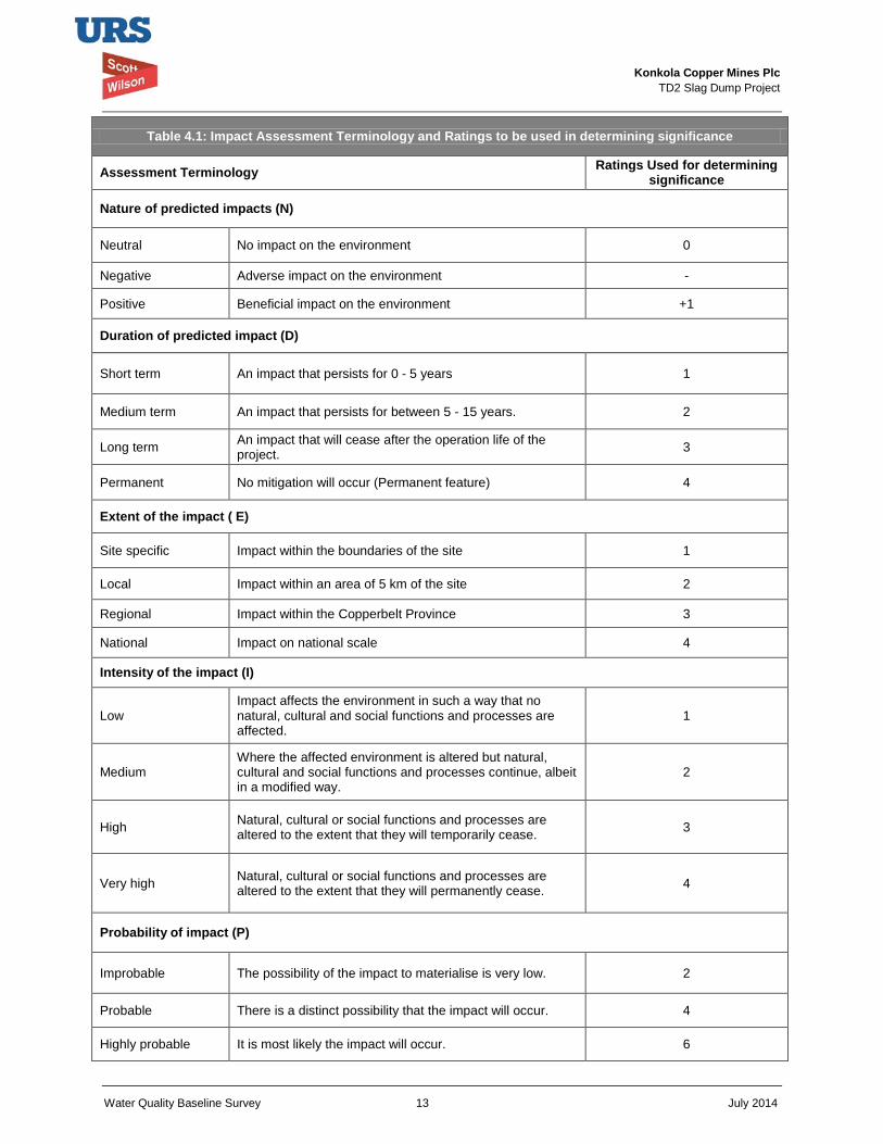
Konkola Copper Mines Plc
TD2 Slag Dump Project
Water Quality Baseline Survey 13 July 2014
Table 4.1: Impact Assessment Terminology and Ratings to be used in determining significance
Assessment Terminology Ratings Used for determining significance
Nature of predicted impacts (N)
Neutral No impact on the environment 0
Negative Adverse impact on the environment -
Positive Beneficial impact on the environment +1
Duration of predicted impact (D)
Short term An impact that persists for 0 - 5 years 1
Medium term An impact that persists for between 5 - 15 years. 2
Long term An impact that will cease after the operation life of the project. 3
Permanent No mitigation will occur (Permanent feature) 4
Extent of the impact ( E)
Site specific Impact within the boundaries of the site 1
Local Impact within an area of 5 km of the site 2
Regional Impact within the Copperbelt Province 3
National Impact on national scale 4
Intensity of the impact (I)
Low Impact affects the environment in such a way that no natural, cultural and social functions and processes are affected.
1
Medium Where the affected environment is altered but natural, cultural and social functions and processes continue, albeit in a modified way.
2
High Natural, cultural or social functions and processes are altered to the extent that they will temporarily cease. 3
Very high Natural, cultural or social functions and processes are altered to the extent that they will permanently cease. 4
Probability of impact (P)
Improbable The possibility of the impact to materialise is very low. 2
Probable There is a distinct possibility that the impact will occur. 4
Highly probable It is most likely the impact will occur. 6
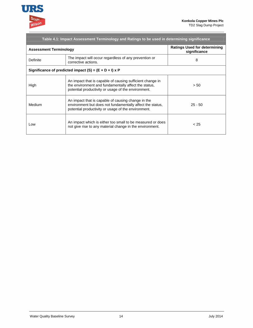
Konkola Copper Mines Plc
TD2 Slag Dump Project
Water Quality Baseline Survey 14 July 2014
Table 4.1: Impact Assessment Terminology and Ratings to be used in determining significance
Assessment Terminology Ratings Used for determining significance
Definite The impact will occur regardless of any prevention or corrective actions. 8
Significance of predicted impact (S) = (E + D + I) x P
High An impact that is capable of causing sufficient change in the environment and fundamentally affect the status, potential productivity or usage of the environment.
> 50
Medium An impact that is capable of causing change in the environment but does not fundamentally affect the status, potential productivity or usage of the environment.
25 - 50
Low An impact which is either too small to be measured or does not give rise to any material change in the environment. < 25
Konkola Copper Mines Plc
TD2 Slag Dump Project
Water Quality Baseline Survey 15 July 2014
5 Environmental Baseline Study This section outlines the scope of the assessment on water quality. It presents the methodology adopted to determine the baseline conditions of the project area in terms of surface water and groundwater quality. It also presents the identified potential impacts on surface water and groundwater quality, their respective assessments and mitigation measures for significant impacts.
5.1 Scope and Methodology The immediate catchment area within which the project site falls formed the study area for the water resources baseline survey. This included mainly the Mushishima and Chingola Streams and the Kafue River. Ground water boreholes and wells in the vicinity of the project site were also included in the scope.
The survey was conducted in the project area to establish the water resources potentially at risk of being adversely affected by the proposed project.
The identification and assessment of potential impacts that may arise as a result of the project included determining the type of changes that may potentially occur on water resources. These included the following:
• Changes in the quality of surface water in nearby streams and river considered to be sensitive receptors;
• Changes in the quality of groundwater in the project area as a result of the proposed project.
Surface water
Surface water quality sampling within the project area was undertaken as part of the study. Surface water from the nearby water bodies (Mushishima and Chingola Streams) was sampled and analysed at an independent and reputable laboratory for parameters that were used to assess quality of water (surface water pollution). The results were compared with the Zambian Drinking Water Standards. Table 5.3 shows the results. The results were used as baseline data.
The potential contribution of slag to surface water pollution through leaching of the slag by surface run-off was assessed by conducting slag leachability tests. The tests were done at an independent and recognised laboratory. The leachability test results are presented in Table 5.4.
Groundwater
A desktop study and review of available data relevant to the project area was undertaken to understand the groundwater conditions of the project site such as groundwater. Groundwater quality data (Tables 5.5 and 5.5b) from within and around the project site was analysed. The purpose of this exercise was to assess the quality of groundwater prior to implementing the project.
In general, the baseline data on water quality has been gathered through reference to the following:
• Baseline survey conducted in May 2014 and which included sampling of water samples in the Chingola and Mushishima Streams and the Kafue River. Ground water monitoring
Konkola Copper Mines Plc
TD2 Slag Dump Project
Water Quality Baseline Survey 16 July 2014
boreholes in the vicinity of the project site were dry at the time of conducting baseline survey.
• Surface water quality analysis and slag leachability tests reports prepared by Alfred H Knight (2014);
• Record of environmental monitoring data on surface and ground water prepared by KCM:
Nchanga Smelter Slag Dump Environmental Effluent Monitoring results (2010, 2011, 2012, 2013 and 2014);
Surface Water and Groundwater monitoring results (2013)
• Final Environmental Project Brief on the proposed extension of TD7 (2011);
• Nchanga Mine Environmental Assessment Report, Volume 3.1 Part A prepared by Amec on behalf of KCM (May 2001).
5.2 Baseline Conditions Surface Water Hydrology
The Copperbelt region’s surface waters are drained into the Kafue River, either directly or via a well-developed dendritic drainage pattern formed by its tributary streams and rivers.
The project site lies within the Kafue River drainage system with the Chingola and Mushishima Streams drainage systems being the nearest and most important hydrological features in relation to being the potential receptors of run-off from the proposed Slag Dump. Chingola steam flows into the Mushishima Stream, which flows into the Kafue River. The proposed project site is drained by the Mushishima and Chingola streams. The site is within the catchment of Chingola and Mushishima Streams.
Surface Water Quality
KCM has a surface water quality monitoring programme in place which includes routine sampling and analyses of water samples sampled from licensed streams and effluent discharges from mine area. Figure 5.1 shows the location of the sampling points.
The aim of the monitoring programme is to record the quality of effluent being discharged to the environment and to monitor compliance with effluent standards and permit limits as stipulated in the Zambia Environmental Management (Licensing) Regulations, 2013 and license conditions issued under the same regulations. The results that do not meet the standards are investigated as a matter of routine.
Surface water monitoring stations are distributed throughout the mine area but the relevant stations in relation to the proposed area are located on the Mushishima and Chingola Streams. These are:
• Mushishima Stream at TD3/4 Road Bridge;
• Mushishima Stream at Solwezi Bridge
• Chingola Downstream;
• PCD Spillway
• Mushishima Downstream
Konkola Copper Mines Plc
TD2 Slag Dump Project
Water Quality Baseline Survey 17 July 2014
• Chingola Upstream;
• Kafue River at Hippo Pool;
• Chingola Upstream.
In addition, effluent from the existing slag dump is monitored. The effluent flows from the base of the dump and is discharged into a drain that flows into the Pollution Control Dam (PCD). Water samples are collected from these streams and effluent drain and are analysed for the following parameters:
• pH
• Total Suspended Solids (TSS);
• Total Dissolved Solids (TDS);
• Electrical Conductivity (EC);
• Dissolved Copper (DCu);
• Total Copper (TCu);
• Dissolved Iron (DFe);
• Total Iron (TFe);
• Dissolved Cobalt (DCo);
• Total Cobalt (TCo)
• Dissolved Manganese (DMn);
• Total Manganese (TMn);
• Dissolved Calcium (DCa);
• Dissolved Magnesium (DMg);
• Dissolved Sulphate (DSO4).
The quality of effluent from the existing slag dump as monitored between August 2010 and May 2014 is shown in Table 5.2 and indicates that the quality is within the Environmental Management (Licensing) Regulation, 2013 (Statutory Instrument No. 112 of 2013).
The background surface water quality in the Mushishima and Chingola Streams as well as the Kafue River at Hippo Pool was monitored in May 2014 as part of the Environmental and Social Impact Assessment study of the proposed project. The sampling points and their geographical coordinates are presented in Table 5.1. The samples were analysed for Co, Cu, Fe, Mg, Na, Ni, Pb, Zn, K, Mn, Carbonates, pH, Chlorides, Nitrates, Phosphates, Sulphates, TDS, TSS and EC. The results are shown in Table 5.3. With respect to the parameters analysed, the results indicate that the water quality is generally good and is within the effluent and wastewater discharge limits provided in the Environmental Management (Licensing) Regulations, 2013 except for TSS in the sample collected upstream of Chingola Stream. Effluent discharges from a nearby car wash and industries are discharged into the stream and this contributed to high suspended solids observed during the site visit.
Table 5.1 Geographical Coordinates showing the location of Sampling Points
No. Sampling Point Elevation Coordinates
1 Solwezi River Bridge at Mushishima Stream (Upstream of the Site) 1236 m 35 L 0586183
UT 8614064
2 TD3 Crossing at Mushishima Stream (Downstream of proposed site) 1264 m 35 L 0586181
UT 8614064
3 Hellen Bridge Crossing at Mushishima Stream (Downstream of the proposed Site) 1262 m 35 L 0588278
UT 8616998
4 Hippo Pool at Kafue River (Downstream of the proposed site) 1248 m 35 L 0592477
UT 8622203

Konkola Copper Mines Plc
TD2 Slag Dump Project
Water Quality Baseline Survey 18 July 2014
5 Chingola Upstream (Upstream of the proposed site) 1316 m 35 L 0592214 UT 8613468
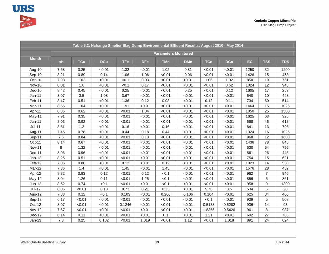
Konkola Copper Mines Plc
TD2 Slag Dump Project
Water Quality Baseline Survey 19 July 2014
Table 5.2: Nchanga Smelter Slag Dump Environmental Effluent Results: August 2010 - May 2014
Month Parameters Monitored
pH TCu DCu TFe DFe TMn DMn TCo DCo EC TSS TDS
Aug-10 7.68 0.25 <0.01 1.32 <0.01 1.02 0.81 <0.01 <0.01 1250 32 1200 Sep-10 8.21 0.89 0.14 1.06 1.06 <0.01 0.06 <0.01 <0.01 1426 15 458 Oct-10 7.98 1.03 <0.01 <0.1 0.03 <0.01 <0.01 1.06 1.32 850 19 761 Nov-10 8.01 1.6 <0.01 <0.1 0.17 <0.01 <0.01 <0.01 0.62 1024 12 943 Dec-10 8.42 0.45 <0.01 0.25 <0.01 <0.01 0.25 <0.01 0.12 1605 17 253 Jan-11 8.07 3.5 1.08 3.67 <0.01 <0.01 <0.01 <0.01 <0.01 640 10 448 Feb-11 8.47 0.51 <0.01 1.36 0.12 0.08 <0.01 0.12 0.11 734 60 514 Mar-11 8.55 1.04 <0.01 1.91 <0.01 <0.01 <0.01 <0.01 <0.01 1464 15 1025 Apr-11 8.36 0.62 <0.01 <0.01 1.34 <0.01 <0.01 <0.01 <0.01 1050 25 1500 May-11 7.91 0.35 <0.01 <0.01 <0.01 <0.01 <0.01 <0.01 <0.01 1625 63 325 Jun-11 8.03 0.92 <0.01 <0.01 <0.01 <0.01 <0.01 <0.01 <0.01 568 45 618 Jul-11 8.51 1.2 <0.01 0.16 <0.01 0.16 <0.01 <0.01 <0.01 841 13 796 Aug-11 7.45 0.78 <0.01 0.44 0.18 0.44 <0.01 <0.01 <0.01 1324 16 1025 Sep-11 7.6 0.84 <0.01 <0.01 0.13 <0.01 <0.01 <0.01 <0.01 968 12 1600 Oct-11 8.14 0.67 <0.01 <0.01 <0.01 <0.01 <0.01 <0.01 <0.01 1436 78 845 Nov-11 8 1.32 <0.01 <0.01 <0.01 <0.01 <0.01 <0.01 <0.01 630 54 756 Dec-11 8.06 0.96 <0.01 <0.01 <0.01 <0.01 <0.01 <0.01 <0.01 561 26 445 Jan-12 8.25 0.51 <0.01 <0.01 <0.01 <0.01 <0.01 <0.01 <0.01 754 15 621 Feb-12 7.06 0.86 <0.01 0.12 <0.01 0.12 <0.01 <0.01 <0.01 1023 14 530 Mar-12 7.36 1.4 <0.01 1.45 <0.01 1.45 <0.01 <0.01 <0.01 1576 28 452 Apr-12 8.32 0.93 0.12 <0.01 0.12 <0.1 <0.01 <0.01 <0.01 962 7 946 May-12 8.04 1.26 0.11 <0.01 1.25 <0.1 <0.01 <0.01 <0.01 856 5 861 Jun-12 8.52 0.74 <0.1 <0.01 <0.01 <0.1 <0.01 <0.01 <0.01 958 9 1300 Jul-12 8.06 <0.01 0.13 0.73 0.21 0.23 <0.01 5.76 3.5 534 6 28 Aug-12 7.38 0.12 <0.1 0.103 <0.01 0.266 0.106 0.104 <0.01 625 34 406 Sep-12 6.17 <0.01 <0.01 <0.01 <0.01 <0.01 <0.01 <0.1 <0.01 939 5 508 Oct-12 8.07 <0.01 <0.01 0.1246 <0.01 <0.01 <0.01 0.5138 0.5282 936 14 93 Nov-12 7.67 <0.01 <0.01 <0.01 <0.01 <0.01 <0.01 1.8355 0.5426 961 8 987 Dec-12 6.14 0.11 <0.01 <0.01 <0.01 0.1 <0.01 1.21 <0.01 692 27 785 Jan-13 7.3 0.25 0.182 <0.01 1.019 <0.01 1.12 <0.01 1.018 891 24 624
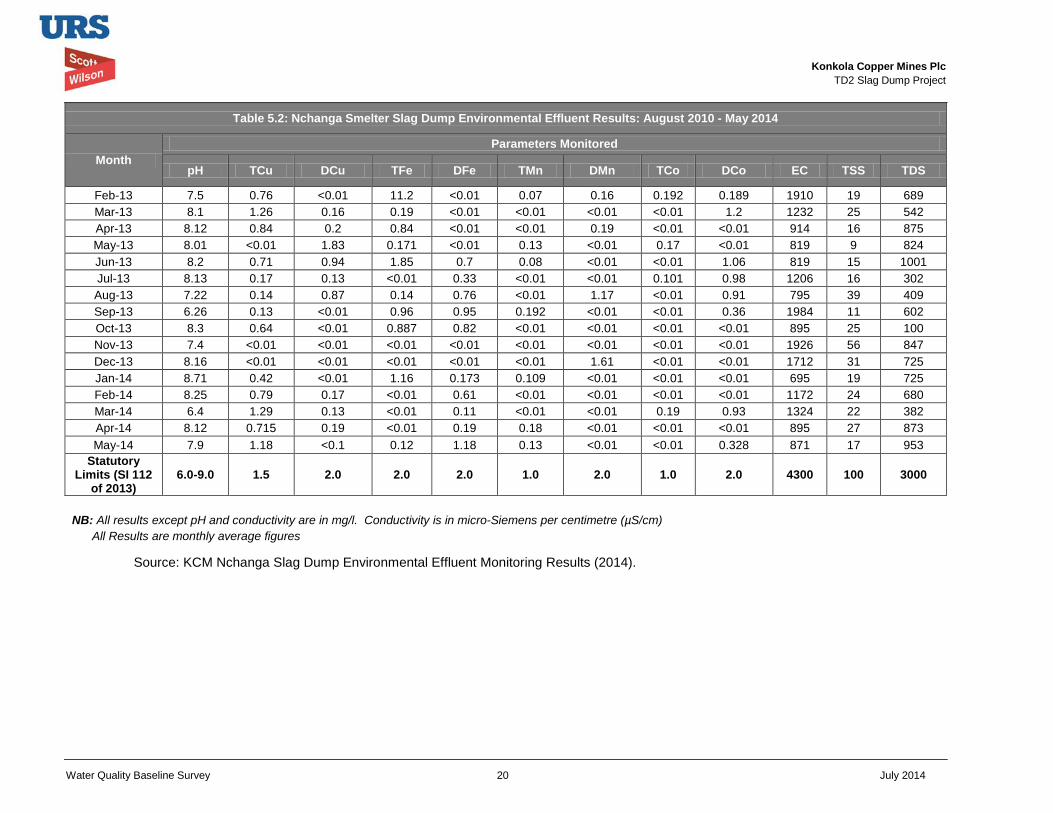
Konkola Copper Mines Plc
TD2 Slag Dump Project
Water Quality Baseline Survey 20 July 2014
Table 5.2: Nchanga Smelter Slag Dump Environmental Effluent Results: August 2010 - May 2014
Month Parameters Monitored
pH TCu DCu TFe DFe TMn DMn TCo DCo EC TSS TDS
Feb-13 7.5 0.76 <0.01 11.2 <0.01 0.07 0.16 0.192 0.189 1910 19 689 Mar-13 8.1 1.26 0.16 0.19 <0.01 <0.01 <0.01 <0.01 1.2 1232 25 542 Apr-13 8.12 0.84 0.2 0.84 <0.01 <0.01 0.19 <0.01 <0.01 914 16 875 May-13 8.01 <0.01 1.83 0.171 <0.01 0.13 <0.01 0.17 <0.01 819 9 824 Jun-13 8.2 0.71 0.94 1.85 0.7 0.08 <0.01 <0.01 1.06 819 15 1001 Jul-13 8.13 0.17 0.13 <0.01 0.33 <0.01 <0.01 0.101 0.98 1206 16 302 Aug-13 7.22 0.14 0.87 0.14 0.76 <0.01 1.17 <0.01 0.91 795 39 409 Sep-13 6.26 0.13 <0.01 0.96 0.95 0.192 <0.01 <0.01 0.36 1984 11 602 Oct-13 8.3 0.64 <0.01 0.887 0.82 <0.01 <0.01 <0.01 <0.01 895 25 100 Nov-13 7.4 <0.01 <0.01 <0.01 <0.01 <0.01 <0.01 <0.01 <0.01 1926 56 847 Dec-13 8.16 <0.01 <0.01 <0.01 <0.01 <0.01 1.61 <0.01 <0.01 1712 31 725 Jan-14 8.71 0.42 <0.01 1.16 0.173 0.109 <0.01 <0.01 <0.01 695 19 725 Feb-14 8.25 0.79 0.17 <0.01 0.61 <0.01 <0.01 <0.01 <0.01 1172 24 680 Mar-14 6.4 1.29 0.13 <0.01 0.11 <0.01 <0.01 0.19 0.93 1324 22 382 Apr-14 8.12 0.715 0.19 <0.01 0.19 0.18 <0.01 <0.01 <0.01 895 27 873 May-14 7.9 1.18 <0.1 0.12 1.18 0.13 <0.01 <0.01 0.328 871 17 953
Statutory Limits (SI 112
of 2013) 6.0-9.0 1.5 2.0 2.0 2.0 1.0 2.0 1.0 2.0 4300 100 3000
NB: All results except pH and conductivity are in mg/l. Conductivity is in micro-Siemens per centimetre (µS/cm) All Results are monthly average figures
Source: KCM Nchanga Slag Dump Environmental Effluent Monitoring Results (2014).
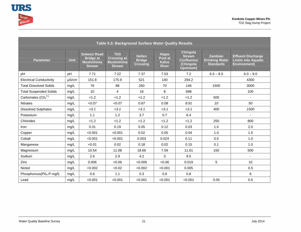
Konkola Copper Mines Plc
TD2 Slag Dump Project
Water Quality Baseline Survey 21 July 2014
Table 5.3: Background Surface Water Quality Results
Parameter Unit Solwezi Road
Bridge at Mushishima
Stream
TD3 Crossing at Mushishima
Stream
Hellen Bridge
Crossing
Hippo Pool at Kafue River
Chingola Stream
Confluence (Chingola Upstream)
Zambian Drinking Water
Standards
Effluent Discharge Limits into Aquatic Environment)
pH pH 7.71 7.22 7.37 7.53 7.2 6.5 – 8.0 6.0 – 9.0
Electrical Conductivity µS/cm 151.8 175.9 521 140 294.2 4300
Total Dissolved Solids mg/L 76 88 260 70 146 1500 3000
Total Suspended Solids mg/L 10 4 16 8 698 100
Carbonates (C032-) mg/L <1.2 <1.2 <1.2 <1.2 <1.2 500 -
Nitrates mg/L <0.07 <0.07 0.87 0.08 8.91 10 50
Dissolved Sulphates mg/L <3.1 <3.1 <3.1 <3.1 <3.1 400 1500
Potassium mg/L 1.1 1.2 3.7 0.7 6.4 -
Chlorides mg/L <1.2 <1.2 <1.2 <1.2 <1.2 250 800
Iron mg/L 0.31 0.19 0.05 0.12 0.03 1.0 2.0
Copper mg/L <0.001 <0.001 0.02 0.05 0.04 1.0 1.5
Cobalt mg/L <0.001 <0.001 0.003 0.024 0.11 0.5 1.0
Manganese mg/L <0.01 0.02 0.18 0.02 0.15 0.1 1.0
Magnesium mg/L 10.54 11.08 18.66 7.59 11.61 150 500
Sodium mg/L 2.6 2.9 4.2 3 9.5 -
Zinc mg/L 0.006 <0.06 <0.006 <0.06 0.019 5 10
Nickel mg/L <0.002 <0.02 <0.002 <0.001 0.005 0.5
Phosphorous(P04-P mg/l) mg/L 0.6 1.1 0.3 0.6 0.8 6
Lead mg/L <0.001 <0.001 <0.001 <0.001 <0.001 0.05 0.5
Konkola Copper Mines Plc
TD2 Slag Dump Project
Water Quality Baseline Survey 22 July 2014
The seismic refractory survey conducted on the TD2 Slag Dump Project Site has revealed that the competent rock units of the north-western flanks of the site have intrusions of deep seated faults and fractured/weathered zones as compared to the south-eastern competent rock units which have only mapped these deformations in shallow depths (DN Consulting, 2014). The deep seated faults and fractured / weather zones are potential high-permeability geological features through which seepage from the Slag Dump can be transported into the groundwater regime.
The slag leachability tests were conducted as part of the environmental and social impact assessment study. A slag sample obtained from the existing slag dump at KCM was agitated with tap water for 24 hrs. Following agitation, the sample was left standing for 24 hrs. The pregnant liquor solution (pls) was analysed for copper. The analytical results are shown in Table 5.4 and indicate that the slag did not show potential to be leached for the duration of exposure in tap water. The copper content in both water and in filtrate was below 10 milligrams per litre (mgpl). It, however, showed potential to be leached when in contact with a dilute acid with strength of 5 grammes per litre (gpl). The leachability test report is presented in Appendix 2.
Therefore, surface runoff and seepage water from the slag dump is not likely to be contaminated with heavy metals. Hence, potential contamination of both surface water and groundwater resources in the project area through discharge of surface runoff and seepage water from the slag dump into nearby surface water and groundwater regime is low.
Table 5.4: Leachability Results of Nchanga Slag
Sample ID Type
Sulphuric Acid Strength (gpL)
Feed Grade Initial pH Final pH PLS %Tcu %AsCu
Water 0 0 0 7.64 - <10 Slag 0 0.53 28 7.71 8.24 <10 Slag 5 0.53 28 3.49 3.64 220
Source: Leachability Test Results, AHK, 2014.
Groundwater Hydrogeology
The groundwater regime within the Nchanga Mining License Area has significantly been changed because of underground and open pit mining activities. An evaluation of the level of the water table at the TD2 project site based on the seismic refractory survey undertaken as part of the EIA study has revealed a water level in the range of approximately 15 – 40 m below the surface (DN Consulting Associates, 2014).
The explosion seismic data obtained during the seismic refractory survey has further revealed that the bedrock surface has a “pyramidal” like structure with a gradual slant of bedrock depths towards the north-west and steep bedrock depths dipping towards the south-east of the project site. The entire bedrock surface shows a NNE-SSW strike. The bedrock is interpreted as relatively impermeable Late Precambrian Katanga sediments and it can be inferred that the north-west and south-east trending structure of the bedrock topography controls the shallow groundwater flow at the site (DN Consulting, 2014).
Depth to unweathered bedrock shows a variation range of approximately 6 – 53 m below land surface at the TD2 project area. Two bedrock highs have been located in the area: one in the
Konkola Copper Mines Plc
TD2 Slag Dump Project
Water Quality Baseline Survey 23 July 2014
North-west and the other in the South-east. The two bedrock highs are connected as an elongated oval-like feature extending south-southwestward from directly beneath the central region of the survey project site. This bedrock oval-like feature may be acting as a groundwater divide which allow groundwater to flow both in the northwesterly and southeasterly directions (DN Consulting, 2014).
Groundwater Quality
The available data on groundwater quality generally indicates that both shallow and deeper Bedrock Aquifer groundwater quality falls within the World Health Organisation Drinking Water Standards. The nearest groundwater monitoring borehole sunk on the north-eastern side of the proposed site has not intercepted water at a depth of 50 metres. This status is attributed to drawdown effect influenced by dewatering of open pits and underground workings at the mine.
At other groundwater monitoring boreholes, groundwater quality is monitored on a monthly basis to provide, among other things, information on shallow groundwater quality and groundwater levels. TD3/4 borehole is situated at TD3 over 2 km north-west of the proposed project site. The dump has been reclaimed just like TD2. The available data is presented in Tables 5.4 and 5.4a. Quality of the borehole water generally meets requirements except for the following parameters: Mn, Cr, Cd, Al and Turbidity.
Based on the seismic refraction survey undertaken, it has been inferred that the north-west and south-east trending structure of the bedrock topography controls the shallow groundwater flow at TD2 project site. The bedrock has an oval-like feature which may be acting as a groundwater divide and which will allow potential contaminants to flow both in the northwesterly and southeasterly directions. Therefore, groundwater monitoring wells should be located in these directions as shown in Figure 5.2.
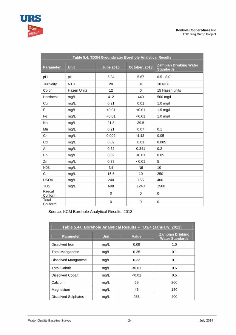
Konkola Copper Mines Plc
TD2 Slag Dump Project
Water Quality Baseline Survey 24 July 2014
Table 5.4: TD3/4 Groundwater Borehole Analytical Results
Parameter Unit June 2013 October, 2013 Zambian Drinking Water Standards
pH pH 5.34 5.67 6.5 - 8.0
Turbidity NTU 20 31 10 NTU
Color Hazen Units 12 0 15 Hazen units
Hardness mg/L 412 440 500 mg/l
Cu mg/L 0.21 0.01 1.0 mg/l
F mg/L <0.01 <0.01 1.5 mg/l
Fe mg/L <0.01 <0.01 1.0 mg/l
Na mg/L 21.3 39.5 -
Mn mg/L 0.21 0.07 0.1
Cr mg/L 0.002 4.43 0.05
Cd mg/L 0.02 0.01 0.005
Al mg/L 0.32 0.341 0.2
Pb mg/L 0.02 <0.01 0.05
Zn mg/L 0.39 <0.01 5
N03 mg/L Nil Nil 10
Cl mg/L 16.5 10 250
DSO4 mg/L 240 155 400
TDS mg/L 698 1240 1500 Faecal Coliform 0 0 0
Total Coliform 0 0 0
Source: KCM Borehole Analytical Results, 2013
Table 5.4a: Borehole Analytical Results – TD3/4 (January, 2013)
Parameter Unit Value Zambian Drinking Water Standards
Dissolved Iron mg/L 0.09 1.0
Total Manganese mg/L 0.25 0.1
Dissolved Manganese mg/L 0.22 0.1
Total Cobalt mg/L <0.01 0.5
Dissolved Cobalt mg/L <0.01 0.5
Calcium mg/L 69 200
Magnesium mg/L 46 150
Dissolved Sulphates mg/L 256 400
Konkola Copper Mines Plc
TD2 Slag Dump Project
Water Quality Baseline Survey 25 July 2014
Table 5.4a: Borehole Analytical Results – TD3/4 (January, 2013)
Parameter Unit Value Zambian Drinking Water Standards
Total Dissolved Solids mg/L 561 1500
Total Suspended Solids mg/L 263 -
5.3 Impact Assessment 5.3.1 Surface Water
Potential Impacts
The potential impacts on surface water relate to the following:
• Contamination of surface water by suspended solids in surface run-off and mine drainage;
• Siltation of nearby rivers and streams caused by silt from the proposed project site;
Surface runoff laden with suspended solids from the slag dump has the potential of contributing to water contamination in Mushishima and Chingola Streams. In addition, surface runoff loaded with heavy metals from the slag does also have the potential to contaminate receiving water courses.
The potential impacts will be negative, indirect, reversible and long-term in nature. The intensity of the impact and the possibility of the impact materialising are assessed as low. The overall significance of the impact is assessed as low. The slag material that will be dumped at the proposed site shows no potential to be leached with water. Therefore, surface runoff from the slag is not expected to potentially contain leached heavy metals. The PCD will be the major receptor of surface runoff from the slag dump. Any potential contaminated runoff will be intercepted at the PCD.
5.3.2 Groundwater Potential impacts
The potential impacts on groundwater resources that can arise relate to:
• Contamination of groundwater caused by site runoffs and seepage from the proposed project.
Groundwater contamination during the construction phase is limited to potential seepage of oils spills from construction equipment into the groundwater regime. During the operation phase, groundwater contamination could potentially arise through seepage of contaminated water through the dump body into the groundwater regime. This may also potentially result in surface water contamination in an event that contaminated water discharges into the nearby streams. The design of the proposed slag dump includes installation of a filter under-drainage system to collect seepage through the dumped slag material to the base of the dump. The collected seepage will be directed into the toe drain, which will direct the flow into the PCD. A seepage sump will be constructed as part of the drainage system at the dump and will be used as sampling point for monitoring of seepage quality.
The nature of the predicted impact arising from potential groundwater contamination has been assessed to be negative, indirect and reversible in nature. The impact will be localised and its
Konkola Copper Mines Plc
TD2 Slag Dump Project
Water Quality Baseline Survey 26 July 2014
intensity impact will be low to medium. The possibility of the impact materialising has been assessed as very low. The overall significance of the impact has been assessed has low.
5.4 Mitigation Measures 5.4.1 Surface water
The proposed mitigation measures will include:
• Extending and implementing the existing water monitoring plan to the proposed project;
• Routine sampling and testing of seepage and runoff from the slag dump to monitor and assess any potential contamination. Two sampling points where representative samples will be collected will be established. The parameters to be tested will be as per existing analytical water testing protocols;
• Provision of toe drain and under-drainage filters along the periphery of the dump as per design report;
• Constructing silt traps along the periphery of the dump as per design report;
• Constructing a drainage system at the slag dump that will channel any surface runoff and seepage from the slag dump into the Pollution Control Dam (PCD). Any suspended solids and silt that may potentially be carried with surface runoff will be intercepted at the PCD.
5.4.2 Groundwater The mitigation measures to minimise potential groundwater by site runoff and seepage from the slag dump will include the following:
• Designing the slag dump with a filter under-drainage system that will collect seepage from the dump and direct it to PCD via toe drains (detailed design have been concluded);
• Extension and implementation of the existing water monitoring plan to the proposed project. This will include monitoring of all discharges from the slag dump (seepage and surface runoff).
• Installation of two groundwater monitoring boreholes on the north-western and south-eastern flanks of the proposed project site (as shown in Figure 5.2) to monitor and assess impact of seepage on receiving water body (aquifers) and taking appropriate action.
Konkola Copper Mines Plc
TD2 Slag Dump Project
Water Quality Baseline Survey 27 July 2014
6 Environmental Management and Monitoring Plan The Environmental Management and Monitoring Plan with regard to water quality management at the proposed new slag dump at TD2 are presented in this section. The section highlights the roles and responsibilities for implementation of the plans and the monitoring requirements.
6.1 Environmental Management Plan The Environmental Management Plan (EMP) for the proposed project has been developed based on identified potential impacts predicted to occur during the project implementation. The EMP has consolidated the measures to mitigate predicted potential surface water and groundwater contamination and it has provided a framework for implementing and monitoring the effectiveness of management actions recommended. It has been developed to meet the requirements of Zambian environmental legislations and to conform to IFC requirements on Environmental and Social Sustainability of projects.
Table 6.1 summarises the potential impacts and the EMP is presented in Table 6.2. The EMP with respect to water quality monitoring will be incorporated in the overall Environmental and Social Management Plan for the proposed slag dump project.
The EMP is laid out in Table 6.2 with headings as outlined below:
Environmental Aspect: these are elements of the activities or products regarding construction and operation of the slag dump that interact with the environment.
Potential impact: predicted impact that may arise as a result of the proposed project.
Objectives: the targeted objectives to address the environment and social issues by mitigating specific potential impacts.
Mitigation Measures (management actions): the management commitments made to meet the objectives.
Frequency of Monitoring: the rate or time of checking that mitigation measures recommended are implemented.
Time frame: the duration within which the measure will be undertaken.
Performance Indicators: pointers to indicate that the measure has been successfully implemented.
Responsible person: indicates the person or group of people (or department) who will be responsible for ensuring the implementation of management action/commitment.
Cost: Estimated cost of undertaking the mitigation measure.
Cost Source: source of funds for implementation of the measure or task.
6.2 Roles and Responsibilities The management actions required to mitigate identified impacts have been included in the EMP. The overall responsibility for Safety Health and Environment (SHE) of the KCM as an organisation falls under the Chief Executive Office. The SHE Manager – Smelting and Refining, who reports to the General Manager – Smelting and Refining, will be directly responsible for management of all environmental aspects / issues related to the project. The SHE Manager will be assisted by the Environmental Coordinator - Nchanga Smelter.
Konkola Copper Mines Plc
TD2 Slag Dump Project
Water Quality Baseline Survey 28 July 2014
The Environmental Coordinator will be responsible for coordination and monitoring of activities relating to the implementation of the project.
6.3 Environmental Monitoring Plan KCM Nchanga Mine has an Environmental Monitoring Plan at Nchanga Mine. The plan is aimed at monitoring environmental performance, ensuring compliance with statutory environmental regulations and meeting KCM Sustainability policies.
The existing surface and ground water monitoring plan will be revised and extended to the proposed slag dump project so that it includes sampling points that will be established based on the area of influence of the proposed slag dump and the need to obtain representative monitoring data. The plan should include monitoring of seepage water and surface runoff from the dump. Table 6.3 shows an environmental monitoring plan for surface water and groundwater.
Two surface water monitoring points will be established to monitor water quality from the proposed slag dump. In addition, two groundwater monitoring boreholes will installed on the western and southern flanks of the proposed project site to monitor and assess impact of seepage on the groundwater quality. The sampling points should be selected to ensure that representative monitoring data is obtained. The samples will be analysed for parameters indicative of the pollutants of concern from the slag dump, and for parameters that are regulated under compliance requirements under the Environmental Management Act, 2011 and its subsidiary legislation the Environmental Management (Licensing) Regulation, 2013.
A detailed and implementable water monitoring programme should be developed by KCM and will typically have the following elements:
• Statement of aims and objectives;
• Information expectations and intended uses;
• Description of the study area concerned;
• Description of the sampling sites;
• Listing of the water quality variables that will be measured;
• Proposed frequency and timing of sampling;
• Estimation of the resource requirements to implement the design; and
• A plan for quality control and quality assurance.
For the proposed slag dump, the frequency of sampling and water quality monitoring variables need not differ from those applicable to the current groundwater, surface water and potable water monitoring programmes since the slag dump operation is unlikely to significantly affect the aquatic environment.
The principle reasons for the monitoring programme should remain the need to verify whether the observed water quality is suitable for intended uses and also to determine trends in the quality of the aquatic environment and how the environment is affected by the release of contaminants, by other human activities, and/or by waste treatment operations. The monitoring programme should provide a basis for informed preventive and/or remedial action as appropriate.
Konkola Copper Mines Plc
TD2 Slag Dump Project
Water Quality Baseline Survey 29 July 2014
6.3.1 Proposed Frequency of Sampling
An initial sampling frequency of weekly is recommended. The frequency should be reviewed after six months and if the downstream water quality does not seem to be significantly affected by the operations of the slag dump, a quarterly sampling frequency could be introduced.
6.3.2 Quality Control and Quality Assurance The monitoring and sampling procedures should conform to both Zambian and internationally recognized standards and procedures.
6.3.3 Statutory Reporting Apart from regular in-house reporting in a format to be determined, KCM should report in accordance with statutory requirements as per issued licence / permits; and an approved environmental/water management plan.
6.3.4 Non-Compliance and Corrective Action
Water quality sampling results, where the value of sample parameters exceeds KCM water quality standard (or other adopted standards or guidelines as per water monitoring plan), should be investigated as part of an incident investigation procedure. All instances where sample parameters exceed the set standards should be classified as environmental incidents. In all such incidents, the root cause of the incident should be investigated to ensure that appropriate corrective action is taken and to prevent future non-compliance.
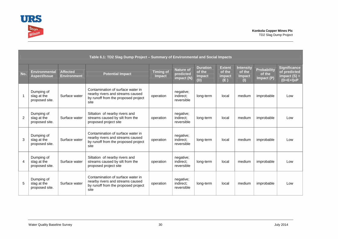
Konkola Copper Mines Plc
TD2 Slag Dump Project
Water Quality Baseline Survey 30 July 2014
Table 6.1: TD2 Slag Dump Project – Summary of Environmental and Social Impacts
No. Environmental Aspect/Issue
Affected Environment Potential Impact Timing of
Impact Nature of predicted impact (N)
Duration of the Impact (D)
Extent of the impact
(E )
Intensity of the Impact
(I)
Probability of the
Impact (P)
Significance of predicted impact (S) = (D+E+I)xP
1 Dumping of slag at the proposed site.
Surface water
Contamination of surface water in nearby rivers and streams caused by runoff from the proposed project site
operation negative; indirect; reversible
long-term local medium improbable Low
2 Dumping of slag at the proposed site.
Surface water Siltation of nearby rivers and streams caused by silt from the proposed project site
operation negative; indirect; reversible
long-term local medium improbable Low
3 Dumping of slag at the proposed site.
Surface water
Contamination of surface water in nearby rivers and streams caused by runoff from the proposed project site
operation negative; indirect; reversible
long-term local medium improbable Low
4 Dumping of slag at the proposed site.
Surface water Siltation of nearby rivers and streams caused by silt from the proposed project site
operation negative; indirect; reversible
long-term local medium improbable Low
5 Dumping of slag at the proposed site.
Surface water
Contamination of surface water in nearby rivers and streams caused by runoff from the proposed project site
operation negative; indirect; reversible
long-term local medium improbable Low
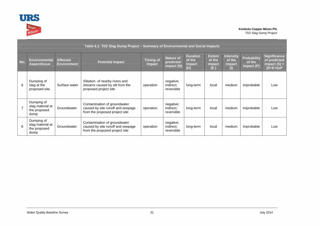
Konkola Copper Mines Plc
TD2 Slag Dump Project
Water Quality Baseline Survey 31 July 2014
Table 6.1: TD2 Slag Dump Project – Summary of Environmental and Social Impacts
No. Environmental Aspect/Issue
Affected Environment Potential Impact Timing of
Impact Nature of predicted impact (N)
Duration of the Impact (D)
Extent of the impact
(E )
Intensity of the Impact
(I)
Probability of the
Impact (P)
Significance of predicted impact (S) = (D+E+I)xP
6 Dumping of slag at the proposed site.
Surface water Siltation of nearby rivers and streams caused by silt from the proposed project site
operation negative; indirect; reversible
long-term local medium improbable Low
7
Dumping of slag material at the proposed dump
Groundwater Contamination of groundwater caused by site runoff and seepage from the proposed project site
operation negative; indirect; reversible
long-term local medium improbable Low
8
Dumping of slag material at the proposed dump
Groundwater Contamination of groundwater caused by site runoff and seepage from the proposed project site
operation negative; indirect; reversible
long-term local medium improbable Low
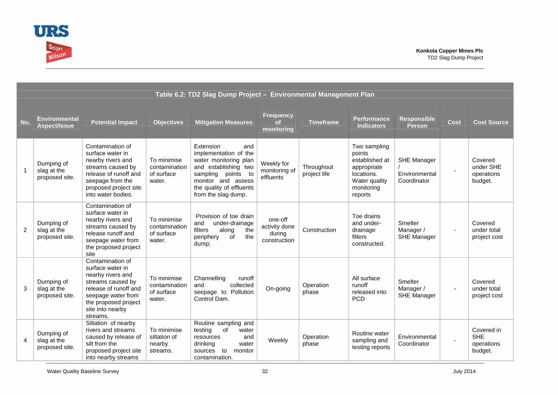
Konkola Copper Mines Plc
TD2 Slag Dump Project
Water Quality Baseline Survey 32 July 2014
Table 6.2: TD2 Slag Dump Project – Environmental Management Plan
No. Environmental Aspect/Issue Potential Impact Objectives Mitigation Measures
Frequency of
monitoring Timeframe Performance
Indicators Responsible
Person Cost Cost Source
1 Dumping of slag at the proposed site.
Contamination of surface water in nearby rivers and streams caused by release of runoff and seepage from the proposed project site into water bodies.
To minimise contamination of surface water.
Extension and implementation of the water monitoring plan and establishing two sampling points to monitor and assess the quality of effluents from the slag dump.
Weekly for monitoring of effluents
Throughout project life
Two sampling points established at appropriate locations. Water quality monitoring reports
SHE Manager / Environmental Coordinator
-
Covered under SHE operations budget.
2 Dumping of slag at the proposed site.
Contamination of surface water in nearby rivers and streams caused by release runoff and seepage water from the proposed project site
To minimise contamination of surface water.
Provision of toe drain and under-drainage filters along the periphery of the dump;
one-off activity done
during construction
Construction
Toe drains and under-drainage filters constructed.
Smelter Manager / SHE Manager
- Covered under total project cost
3 Dumping of slag at the proposed site.
Contamination of surface water in nearby rivers and streams caused by release of runoff and seepage water from the proposed project site into nearby streams.
To minimise contamination of surface water.
Channelling runoff and collected seepage to Pollution Control Dam.
On-going Operation phase
All surface runoff released into PCD
Smelter Manager / SHE Manager
- Covered under total project cost
4 Dumping of slag at the proposed site.
Siltation of nearby rivers and streams caused by release of silt from the proposed project site into nearby streams
To minimise siltation of nearby streams.
Routine sampling and testing of water resources and drinking water sources to monitor contamination.
Weekly Operation phase
Routine water sampling and testing reports
Environmental Coordinator -
Covered in SHE operations budget.
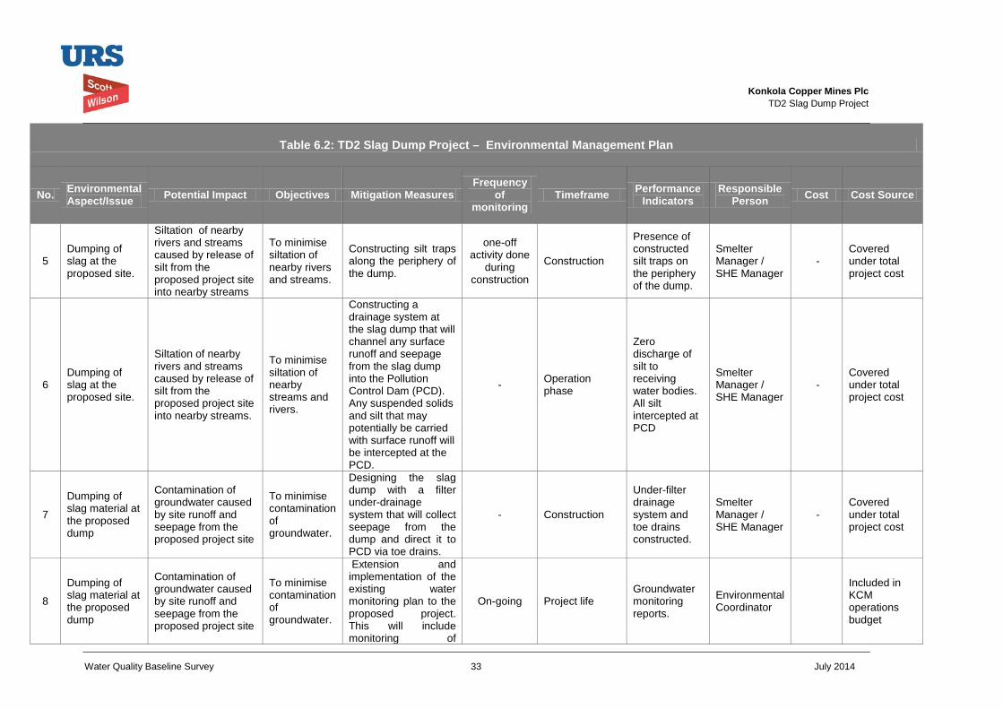
Konkola Copper Mines Plc
TD2 Slag Dump Project
Water Quality Baseline Survey 33 July 2014
Table 6.2: TD2 Slag Dump Project – Environmental Management Plan
No. Environmental Aspect/Issue Potential Impact Objectives Mitigation Measures
Frequency of
monitoring Timeframe Performance
Indicators Responsible
Person Cost Cost Source
5 Dumping of slag at the proposed site.
Siltation of nearby rivers and streams caused by release of silt from the proposed project site into nearby streams
To minimise siltation of nearby rivers and streams.
Constructing silt traps along the periphery of the dump.
one-off activity done
during construction
Construction
Presence of constructed silt traps on the periphery of the dump.
Smelter Manager / SHE Manager
- Covered under total project cost
6 Dumping of slag at the proposed site.
Siltation of nearby rivers and streams caused by release of silt from the proposed project site into nearby streams.
To minimise siltation of nearby streams and rivers.
Constructing a drainage system at the slag dump that will channel any surface runoff and seepage from the slag dump into the Pollution Control Dam (PCD). Any suspended solids and silt that may potentially be carried with surface runoff will be intercepted at the PCD.
- Operation phase
Zero discharge of silt to receiving water bodies. All silt intercepted at PCD
Smelter Manager / SHE Manager
- Covered under total project cost
7
Dumping of slag material at the proposed dump
Contamination of groundwater caused by site runoff and seepage from the proposed project site
To minimise contamination of groundwater.
Designing the slag dump with a filter under-drainage system that will collect seepage from the dump and direct it to PCD via toe drains.
- Construction
Under-filter drainage system and toe drains constructed.
Smelter Manager / SHE Manager
- Covered under total project cost
8
Dumping of slag material at the proposed dump
Contamination of groundwater caused by site runoff and seepage from the proposed project site
To minimise contamination of groundwater.
Extension and implementation of the existing water monitoring plan to the proposed project. This will include monitoring of
On-going Project life Groundwater monitoring reports.
Environmental Coordinator
Included in KCM operations budget
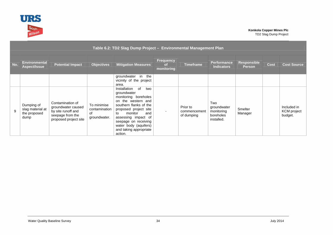
Konkola Copper Mines Plc
TD2 Slag Dump Project
Water Quality Baseline Survey 34 July 2014
Table 6.2: TD2 Slag Dump Project – Environmental Management Plan
No. Environmental Aspect/Issue Potential Impact Objectives Mitigation Measures
Frequency of
monitoring Timeframe Performance
Indicators Responsible
Person Cost Cost Source
groundwater in the vicinity of the project area.
9
Dumping of slag material at the proposed dump
Contamination of groundwater caused by site runoff and seepage from the proposed project site
To minimise contamination of groundwater.
Installation of two groundwater monitoring boreholes on the western and southern flanks of the proposed project site to monitor and assessing impact of seepage on receiving water body (aquifers) and taking appropriate action.
- Prior to commencement of dumping
Two groundwater monitoring boreholes installed.
Smelter Manager
Included in KCM project budget.
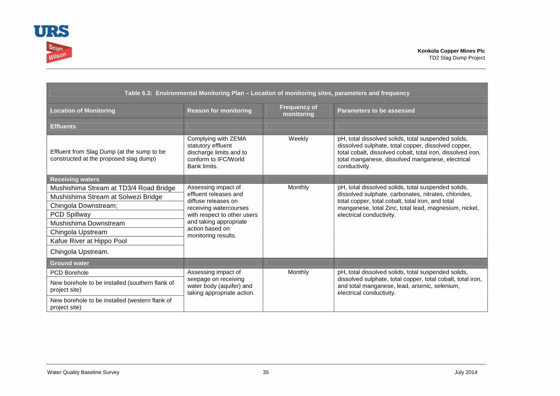
Konkola Copper Mines Plc
TD2 Slag Dump Project
Water Quality Baseline Survey 35 July 2014
Table 6.3: Environmental Monitoring Plan – Location of monitoring sites, parameters and frequency
Location of Monitoring Reason for monitoring Frequency of monitoring Parameters to be assessed
Effluents
Effluent from Slag Dump (at the sump to be constructed at the proposed slag dump)
Complying with ZEMA statutory effluent discharge limits and to conform to IFC/World Bank limits.
Weekly pH, total dissolved solids, total suspended solids, dissolved sulphate, total copper, dissolved copper, total cobalt, dissolved cobalt, total iron, dissolved iron, total manganese, dissolved manganese, electrical conductivity.
Receiving waters Mushishima Stream at TD3/4 Road Bridge Assessing impact of
effluent releases and diffuse releases on receiving watercourses with respect to other users and taking appropriate action based on monitoring results.
Monthly pH, total dissolved solids, total suspended solids, dissolved sulphate, carbonates, nitrates, chlorides, total copper, total cobalt, total iron, and total manganese, total Zinc, total lead, magnesium, nickel, electrical conductivity.
Mushishima Stream at Solwezi Bridge Chingola Downstream; PCD Spillway Mushishima Downstream Chingola Upstream Kafue River at Hippo Pool Chingola Upstream.
Ground water PCD Borehole Assessing impact of
seepage on receiving water body (aquifer) and taking appropriate action.
Monthly pH, total dissolved solids, total suspended solids, dissolved sulphate, total copper, total cobalt, total iron, and total manganese, lead, arsenic, selenium, electrical conductivity.
New borehole to be installed (southern flank of project site)
New borehole to be installed (western flank of project site)
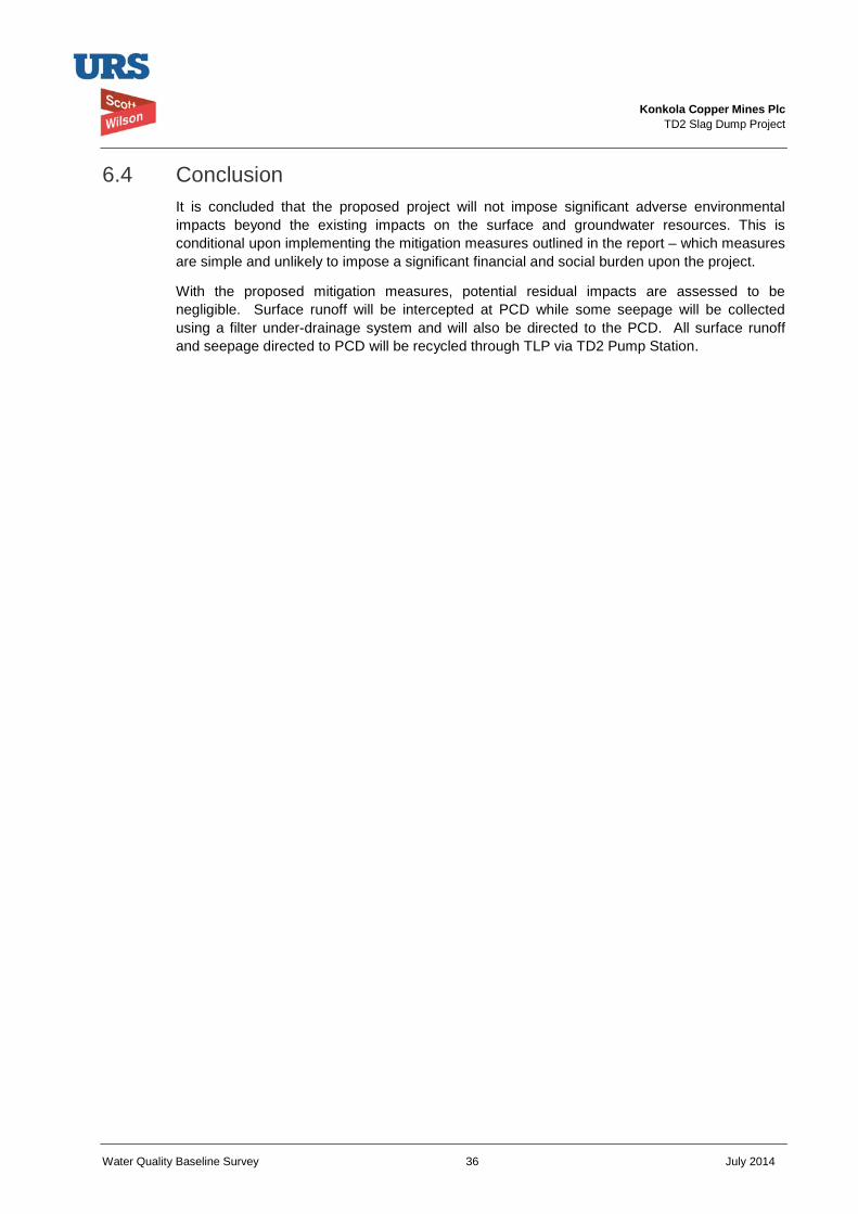
Konkola Copper Mines Plc
TD2 Slag Dump Project
Water Quality Baseline Survey 36 July 2014
6.4 Conclusion It is concluded that the proposed project will not impose significant adverse environmental impacts beyond the existing impacts on the surface and groundwater resources. This is conditional upon implementing the mitigation measures outlined in the report – which measures are simple and unlikely to impose a significant financial and social burden upon the project.
With the proposed mitigation measures, potential residual impacts are assessed to be negligible. Surface runoff will be intercepted at PCD while some seepage will be collected using a filter under-drainage system and will also be directed to the PCD. All surface runoff and seepage directed to PCD will be recycled through TLP via TD2 Pump Station.
Konkola Copper Mines Plc
TD2 Slag Dump Project
Water Quality Baseline Survey 37 July 2014
7 References DN Consulting, 2014. Seismic Refraction Survey Report on TD2 Slag Dump in Chingola KCM
License Area. Prepared for and on behalf URS Scott Wilson, Kitwe, Zambia.
DN Consulting, 2014. Supplementary Report on the Seismic Refraction Survey Report on TD2 Slag Dump in Chingola KCM License Area.
GRZ, 2011. Water Resources Management Act, 2011. Government of the Republic Zambia. Government Printers. Lusaka, Zambia.
GRZ, 2011. Environmental Management Act, 2011. Government of the Republic Zambia. Government Printers. Lusaka, Zambia.
GRZ, 2013. Environmental Management (Licensing) Regulations, 2013. Government of the Republic Zambia. Government Printers. Lusaka, Zambia.
IFC, 2007. International Finance Corporation General Environment Health and Safety Guidelines
IFC, 2012. International Finance Corporation Performance Standards on Environmental and Social Sustainability.
Vedanta, 2011. Vedanta Resources Plc Sustainability Governance System – Technical Standard Water Management.
URS Scott Wilson, 2014. TD2 Slag Dump Project Design Report prepared on behalf of Konkola Copper Mines Plc. Nchanga Mine, Chingola.
Konkola Copper Mines Plc
TD2 Slag Dump Project
Water Quality Baseline Survey 38 July 2014
8 List of Figures Figure 1.1: Location of Nchanga Mine
Figure 1.2: Location of Proposed Slag Dump Site
Figure 5.1: Location of Surface Water Sampling Points
Figure 5.2: Location of suitable sites for Groundwater Monitoring Boreholes
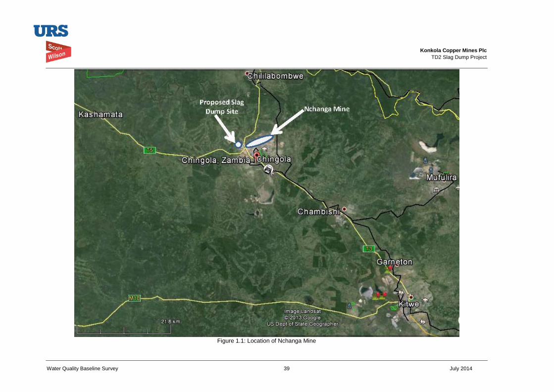
Konkola Copper Mines Plc
TD2 Slag Dump Project
Water Quality Baseline Survey 39 July 2014
Figure 1.1: Location of Nchanga Mine
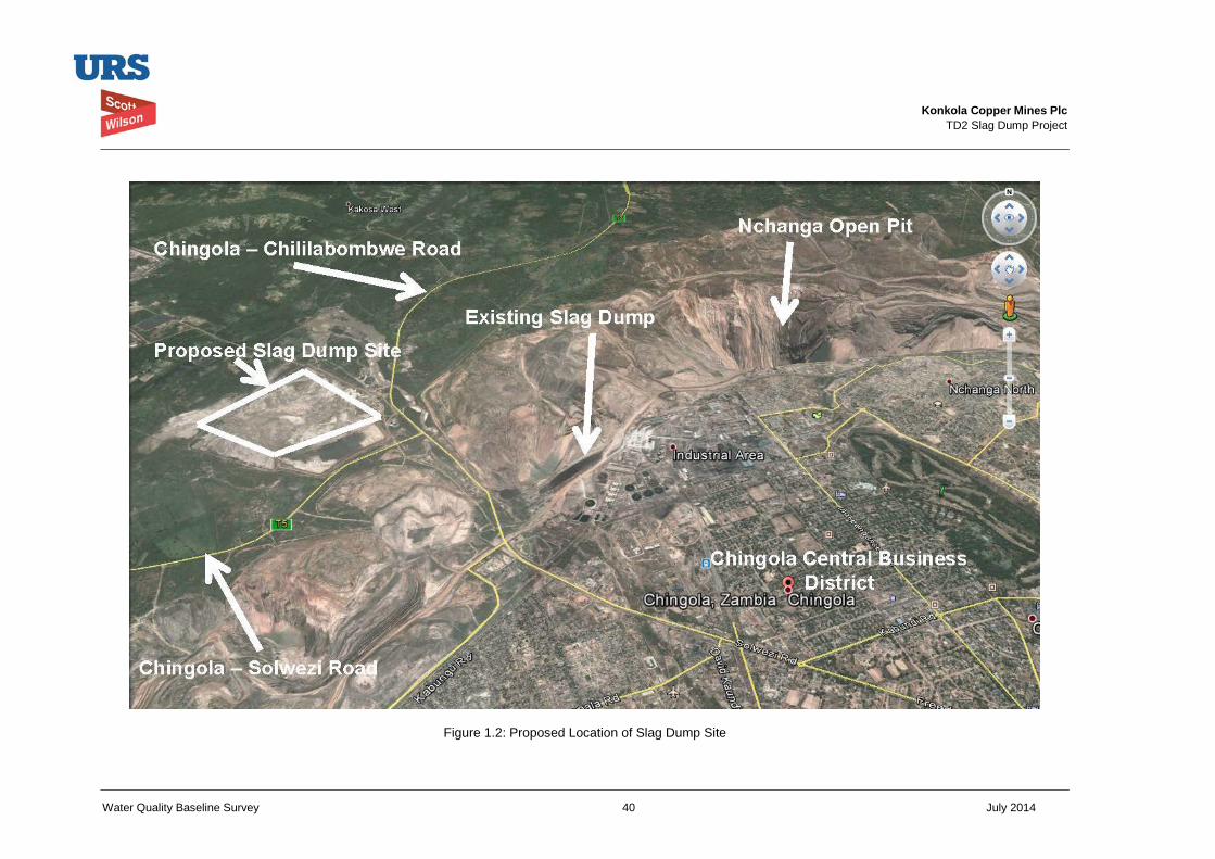
Konkola Copper Mines Plc
TD2 Slag Dump Project
Water Quality Baseline Survey 40 July 2014
Figure 1.2: Proposed Location of Slag Dump Site
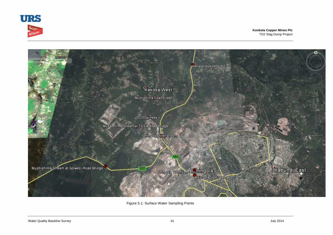
Konkola Copper Mines Plc
TD2 Slag Dump Project
Water Quality Baseline Survey 41 July 2014
Figure 5.1: Surface Water Sampling Points
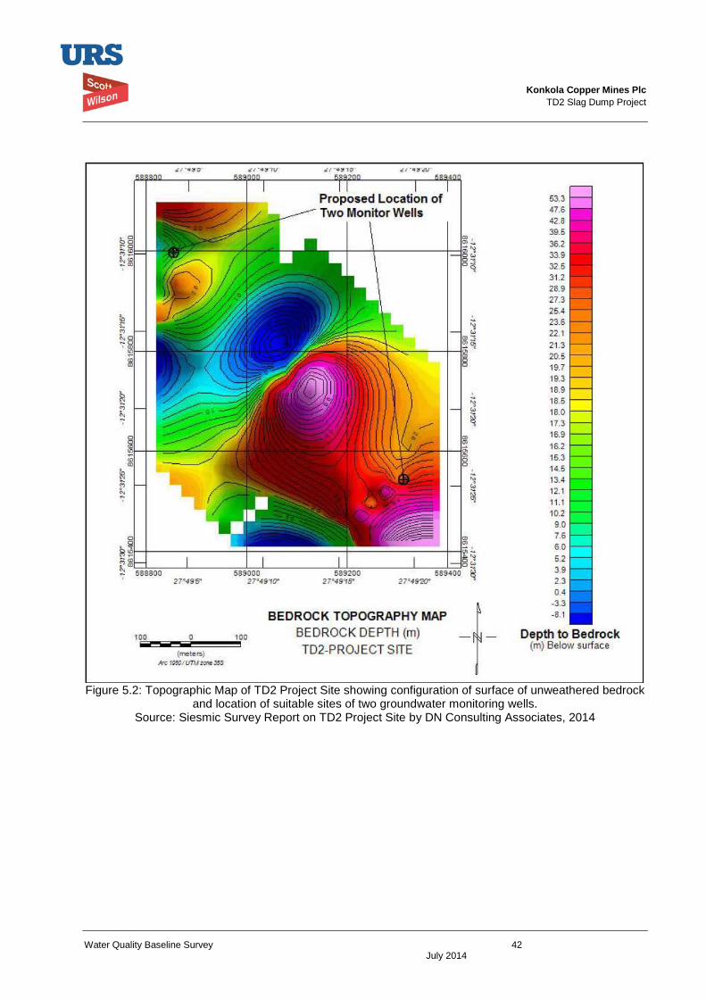
Konkola Copper Mines Plc
TD2 Slag Dump Project
Water Quality Baseline Survey 42 July 2014
Figure 5.2: Topographic Map of TD2 Project Site showing configuration of surface of unweathered bedrock
and location of suitable sites of two groundwater monitoring wells. Source: Siesmic Survey Report on TD2 Project Site by DN Consulting Associates, 2014
Konkola Copper Mines Plc
TD2 Slag Dump Project
Water Quality Baseline Survey 43 July 2014
9 Appendices Appendix 1: Certificates of Assay – Surface Water Samples
Appendix 2: Slag Leachability Test Report
Konkola Copper Mines Plc
TD2 Slag Dump Project
Water Quality Baseline Report June 2014
Appendix 1
Certificates of Assay – Surface Water Samples
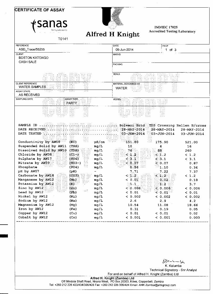
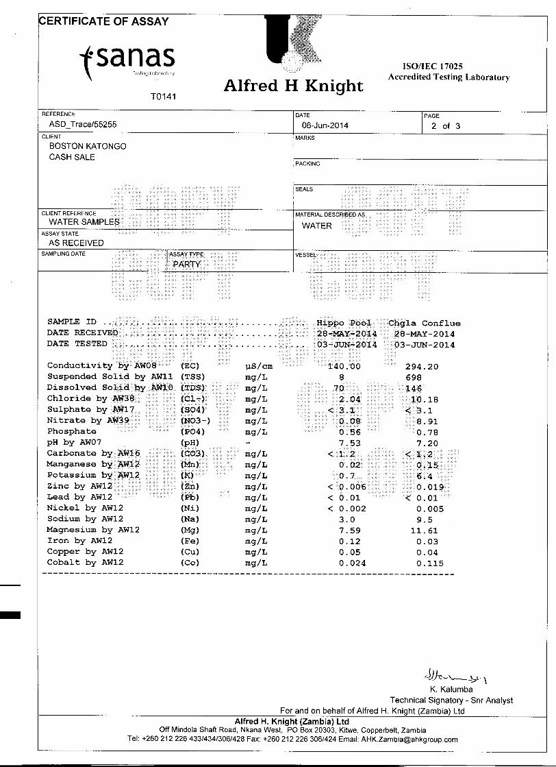
Konkola Copper Mines Plc
TD2 Slag Dump Project
Water Quality Baseline Report June 2014
Appendix 2
Slag Leachability Test Report
All work is undertaken subject to our standard trading terms and conditions of business.
This test certificate shall not be reproduced in full, without the written approval by Alfred H Knight [Zambia] Limited and if faxed will
only be valid when supported by the original document
_________________________________________________________________________________________ ALFRED H KNIGHT (ZAMBIA) LIMITED
Corner Mindola/Golf Club Roads, Nkana West
PO Box 20303, Kitwe, Copperbelt, Zambia Tel. [260] 21 222 6433/4 Fax [260] 21 222 6306 email ; [email protected]
Company Reg No. 41960 VAT No. 10126160-33
METALLURGY DEPARTMENT
Extractive Metallurgy
Project No. MET 55236
Scott Wilson Leachabiliy Tests
Distribution Mr Boston Katongo
File
May 2014
ALFRED H. KNIGHT [ZAMBIA] LIMITED
Metallurgy Department Project No.MET55236: Scott Wilson Leachabilty Tests. May 2014
Report No. 01
Page 2 of 3
1.0 Summary
A slag sample from KCM Nchanga when agitated in tap water for 24 hours did not
show potential to be leached as the copper content remained the same at less than 10
mgpl for both water and fitrate. The slag, however, showed potential to be leached
when exposed to a 5 gpl dilute acid.
Testwork carried out by: Francis Lombe, Metallurgist.
Report written by: M H Chavula, Technical Advisor, AHKZ
For and on behalf of
Alfred H Knight (Z) Ltd.
________________
N. D. MZYECE
Head –Metallurgy
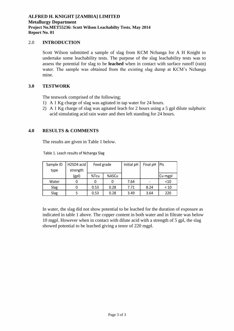
ALFRED H. KNIGHT [ZAMBIA] LIMITED
Metallurgy Department Project No.MET55236: Scott Wilson Leachabilty Tests. May 2014
Report No. 01
Page 3 of 3
2.0 INTRODUCTION
Scott Wilson submitted a sample of slag from KCM Nchanga for A H Knight to
undertake some leachability tests. The purpose of the slag leachability tests was to
assess the potential for slag to be leached when in contact with surface runoff (rain)
water. The sample was obtained from the existing slag dump at KCM’s Nchanga
mine.
3.0 TESTWORK
The testwork comprised of the following;
1) A 1 Kg charge of slag was agitated in tap water for 24 hours.
2) A 1 Kg charge of slag was agitated leach for 2 hours using a 5 gpl dilute sulphuric
acid simulating acid rain water and then left standing for 24 hours.
4.0 RESULTS & COMMENTS
The results are given in Table 1 below.
Table 1. Leach results of Nchanga Slag
Sample ID H2SO4 acid Feed grade Initial pH Final pH Pls
type strength
(gpl) %Tcu %ASCu Cu mgpl
Water 0 0 0 7.64 - <10
Slag 0 0.53 0.28 7.71 8.24 < 10
Slag 5 0.53 0.28 3.49 3.64 220
In water, the slag did not show potential to be leached for the duration of exposure as
indicated in table 1 above. The copper content in both water and in filtrate was below
10 mgpl. However when in contact with dilute acid with a strength of 5 gpl, the slag
showed potential to be leached giving a tenor of 220 mgpl.
Konkola Copper Mines Plc
New Slag Dump Project
Draft Environmental and Social Impact Statement September 2014
Appendix I(a)
Seismic Refraction Survey Report on TD2 Slag Dump in Chingola KCM License Area
ON
TD2 SLAG DUMP IN CHINGOLA KCM LICENCE AREA
_____________________________________________________
Prepared for and on Behalf of
URS SCOTT WILSON ZAMBIA
24 ENOS CHOMBA AVENUE
P.O. BOX 22496
KITWE, ZAMBIA
______________________________________________________________ Prepared By: DN CONSULTING ASSOCIATES LIMITED (Mineral Exploration, Mining and & Environmental Consultants) Room 16, 2nd Floor, Investments Bldg (On top of National Savings & Credit Bank) City Square P.O. BOX 21591 KITWE, ZAMBIA. Telefax: +260 212 225 167 Mobile: +260 975 753 277 E-MAIL: [email protected] July, 2014
TABLE OF CONTENTS PAGE
I. SUMMARY i
1.0 INTRODUCTION 1
1.1 Engineering and Site Location 1
1.2 Objective of the Seismic Survey 2
1.3 Regional Geology of the Chingola Area 2
2.0 THEORY OF THE EXPLOSION REFRACTION SEISMICS METHOD 4
3.0 FIELD SAMPLING PROCEDURE 5
3.1 Data Recording 5
4.0 EXPLOSION SEISMIC PROFILE RESULTS 7
FOT THE ENGINEERING SITE
4.1 Refraction Sesmic Data Processing 7
4.2 Basic Interpretation Theory 8
4.3 Interpretation Remarks (i), (ii), (iii), (iv) 11
4.4 Interpretation Remarks (v), (vi) 14
4.5 Processing and Interpretation of Line-2 16
4.5.1 Interpretation Remarks (i), (ii), (iii), (iv) 16
4.5.2 Interpretation Remarks (v), (vi) 18
4.6 Processing and Interpretation of Line-3 22
4.6.1 Interpretation Remarks (i), (ii), (iii), (iv) 22
4.6.2 Interpretation Remarks (v), (vi) 24
4.7 Processing and Interpretation of Line-4 28
4.7.1 Interpretation Remarks (i), (ii), (iii), (iv) 28
4.7.2 Interpretation Remarks (v), (vi) 30
5.0 CONCLUSION / RECOMMENDATIONS 31
6.0 REFERENCES 33
SUMMARY
An explosion refraction seismic survey has been conducted in the Chingola area of the
Konkola Copper Mines tenement as part of the geophysical investigation of tailings dam TD2
site assessment. The primary aim of the seismic survey is to examine the subsurface structure
beneath the engineering site with a view to generate geological information critical to the
engineering site evaluation for structure stability as well as environmental concerns that might
arise from the tailings depositions at the site. Explosion refraction seismic data have been
collected on 188 geophone stations spaced at 5m each at the site. The processing of the data
assigned travel-time segments to different geological strata at the site in order to produce 4
two-dimensional smooth inversion models of the subsurface seismic velocity structure at the
site. The data show dramatic variations in the subsurface thickness across the site with
apparently thin rock lithology beneath the north-western end of the site suggesting that this part
of the engineering site represents an unstable crust, with the rock units significantly intruded by
fault and/or fracture zones. The crust is thicker to the south-eastern flank, suggestive of a more
stable structure having competent rock lithology.
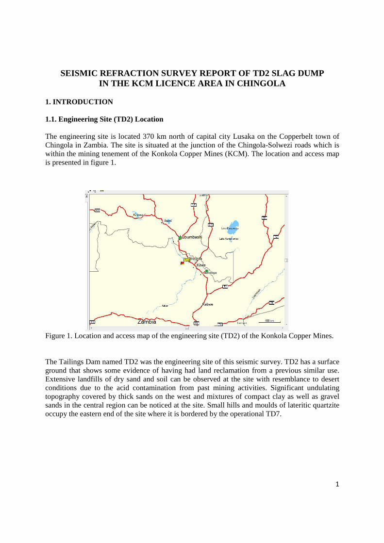
1
SEISMIC REFRACTION SURVEY REPORT OF TD2 SLAG DUMP IN THE KCM LICENCE AREA IN CHINGOLA
1. INTRODUCTION 1.1. Engineering Site (TD2) Location
The engineering site is located 370 km north of capital city Lusaka on the Copperbelt town of Chingola in Zambia. The site is situated at the junction of the Chingola-Solwezi roads which is within the mining tenement of the Konkola Copper Mines (KCM). The location and access map is presented in figure 1. Figure 1. Location and access map of the engineering site (TD2) of the Konkola Copper Mines. The Tailings Dam named TD2 was the engineering site of this seismic survey. TD2 has a surface ground that shows some evidence of having had land reclamation from a previous similar use. Extensive landfills of dry sand and soil can be observed at the site with resemblance to desert conditions due to the acid contamination from past mining activities. Significant undulating topography covered by thick sands on the west and mixtures of compact clay as well as gravel sands in the central region can be noticed at the site. Small hills and moulds of lateritic quartzite occupy the eastern end of the site where it is bordered by the operational TD7.
2
1.2. Objective of the Seismic Survey
The motivation for investigating an explosion refraction seismics of the engineering site is so that geological information of the site can be gained. The geological information generated from such seismic experiment will be critical to the engineering site evaluation as well as the hydrogeological assessment of ground water pollution site and surrounding areas. The aim for conducting the refraction seismic survey is to offer considerable geological information for modeling contaminant transport zones for environmental issues at the site. Further target of the explosion refraction seismics is to map bedrock depth and investigate the structure stability by detecting fractures and fault zones of the engineering site for the engineers designing foundations on the site. The explosion refraction seismic procedure is also envisaged to offer indications of the rippability of the engineering site from the measured seismic layer velocity which enables the predictions of the rock quality to be determined. 1.3. Regional Geology of the Chingola Area
When considering the regional geology of the Chingola area, it can be recognized that the area is transected by the geological province called the Lufilian Arc. This is a fold belt extending the region of the part of south western Congo and terminates in the suture zone forming the Zambezi mobile belt and the Mwembeshi shear dislocation zone on the south and is also flanked by the Irumide belt on the south-east. This geological block is largely made up of the Katanga sediments of the late Precambrian and lower Paleozoic eras and is known to host 2/3rds of the global copper-cobalt deposits and hence the name Copperbelt province is more appropriate (Prestly, et. al., 2008; Kroner A., 1980; Hanson, et. al., 1988, & De Wit, et. al., 2008).
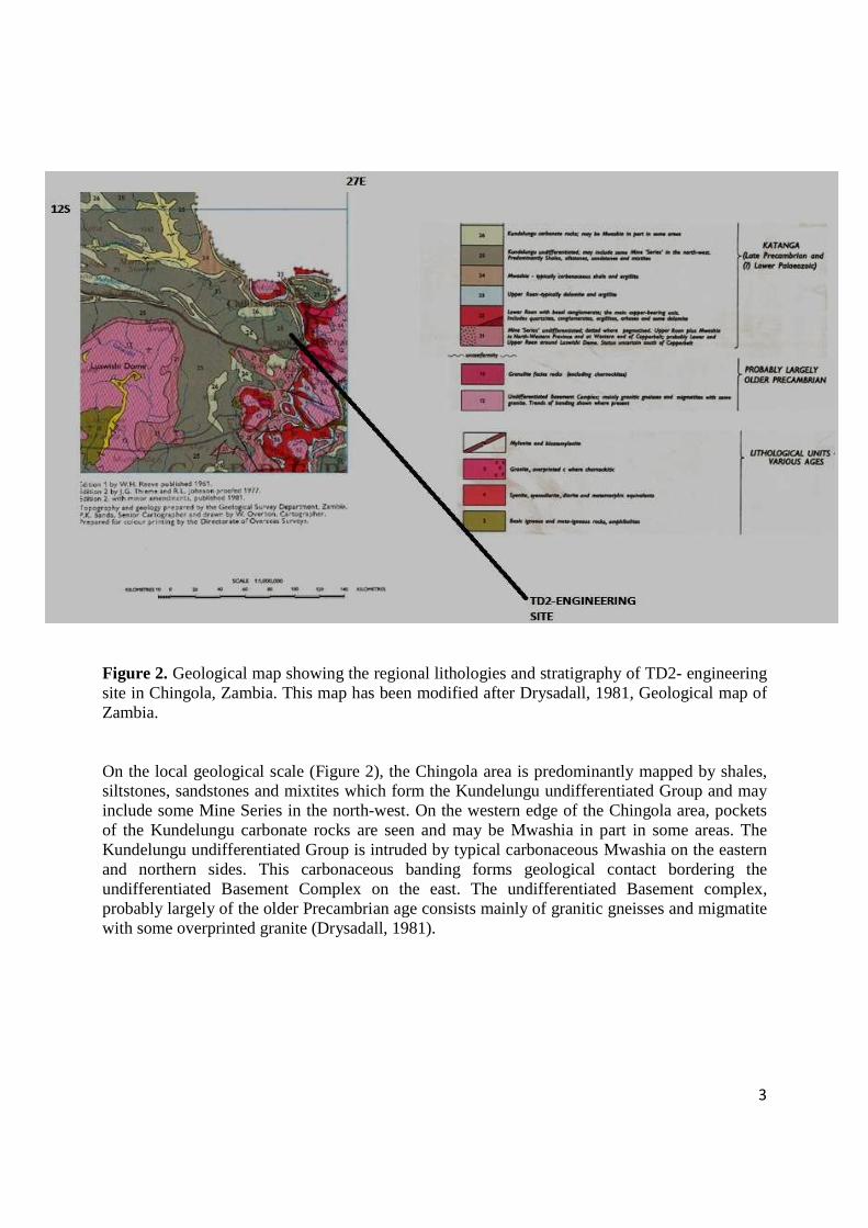
3
Figure 2. Geological map showing the regional lithologies and stratigraphy of TD2- engineering site in Chingola, Zambia. This map has been modified after Drysadall, 1981, Geological map of Zambia. On the local geological scale (Figure 2), the Chingola area is predominantly mapped by shales, siltstones, sandstones and mixtites which form the Kundelungu undifferentiated Group and may include some Mine Series in the north-west. On the western edge of the Chingola area, pockets of the Kundelungu carbonate rocks are seen and may be Mwashia in part in some areas. The Kundelungu undifferentiated Group is intruded by typical carbonaceous Mwashia on the eastern and northern sides. This carbonaceous banding forms geological contact bordering the undifferentiated Basement Complex on the east. The undifferentiated Basement complex, probably largely of the older Precambrian age consists mainly of granitic gneisses and migmatite with some overprinted granite (Drysadall, 1981).
4
2. THEORY OF THE EXPLOSION REFRACTION SEISMICS METHOD
In applied seismology, the resulting recording of actual ground motions at different stations behave predictably according to the theory of elastic waves: an external force F applied across an area A of a surface of a medium, establishes forces inside the medium in proportion to the external force. The ratio of force to area (F/A) known as the stress can be resolved into two components, one at right-angels to the surface (normal or dilatation stress) and one in the plane of the surface (shear stress). The stressed medium undergoes strain, which is measured as the amount of deformation. According to Hooke’s law, stress and strain are linearly dependent and the medium behaves elastically until the yield point is reached. Below the yield point, on relaxation of the stress, the medium reverts to its pre-stressed shape and size. Beyond the yield point, with stress applied, the medium is strained until it fractures. This is the case of earthquakes and the material medium behaves in a ductile manner with permanent damage resulting. In explosion seismology, however, the amounts of stress and strain away from the immediate vicinity of the impact point are minuscule and lie well within the elastic behavior of natural materials which are defined by various elastic constants (D. S. Parasnis, 1997). The rates at which seismic waves propagate through the elastic media are determined by the elastic constants and the densities of the rocks through which they pass. As a broad generalization, seismic velocities increase with increasing density: i.e. velocity of propagation V through an elastic material is V = (Appropriate elastic Modulus/Rock Density)1/2 (Philip Kearey et. al., 2002). In conducting explosion seismic studies, the physical property of earth media that is measured is the rate at which the seismic wave energy propagates through the various units of the subsurface. Of most important in explosion seismics is the P-wave energy. P-waves are compressional body waves that have the fastest times of propagation of any seismic waves (R.W. Lankston, 1983). The rate of propagation in specific medium is generally called the velocity of the medium where the term velocity is used loosely to denote a scalar quantity speed. In explosion refraction seismology, each medium is assumed to be isotropic with respect to velocity. For instance, unconsolidated alluvium with a density of 2.0gcm-3 has a velocity of 0.3-0.6kms-1 while limestone with a density of 2.6gcm-3 could have a velocity of 5kms-1 (W. M.Telford et.al., 1990). It is important to caution that the velocity of a particular earth material can vary over a wide range as a function of its age, its depth of burial, its degree of fracturing or porosity and whether water or air fills the voids. Thus, the velocity of limestone can be as low as 2.5kms-1 and as high as 7kms-1. The velocity ranges of other rock types overlap this range but the velocity of a particular rock type in a generally small area can be identified based on the propagation velocity measured for that layer using the explosion seismic method (W. M.Telford et.al., 1990). In summarizing the theory of explosion seismics, it can be reported that the refraction seismic method utilizes the first arrivals of seismic energy from explosion shot to an array of ground motion sensors or geophones. The speed at which the energy travels varies with primarily the density of the subsurface materials. The pattern of the travel times from several shot points to the geophone array can therefore be mathematically inverted to provide an accurate profile of seismic velocity variations beneath the geophone array.
5
3. FIELD SAMPLING PROCEDURE
A field procedure that would obtain accurate and reliable readings for seismic profile interpretation was considered. An in-line forward and reverse shooting was adopted for all spreads along the profiles so that any problems that may affect the profile processing and interpretation were eliminated during the data collection. The survey design in relation to such seismic survey parameters as: offshot distance to the first geophone; amount of discharge explosive per shot and the instrumentation setting was practically set on site. This was so that the geology of the survey site was taken into consideration in order to produce optimum seismic recordings. From the few test shots that were conducted at the site, the following survey parameters were used in performing the whole seismic experiment at the site. An approximate offshot distance of 20m from the first geophone was to be employed with a pair of 270mm (length) x 32mm (diameter) discharge explosives buried at approximately 50cm in the ground. The acquisition timing parameters on the instrumentation were also configured to adapt to the geology at the engineering site which was manifested with a large overburden of dry sands. Throughout this refraction seismic experiment the triggering of the offshot points was delayed by 20ms due to the length of time it took the offshot signals to be registered at the geophones. The Endshots and the Midpoint-shots were recorded with no delay. The sampling interval on the analog signal was digitized at every 0.250ms for a record length of 0.128s for the whole experiment. 3.1. Data Recording
A 12-channel Geometrics seismograph, ES3000, having geophone spacing at 5m was employed to collect 48 refraction seismic records from 18 discharge explosive shots in order to measure a seismic profile length of 235m on each of both lines 1 and 2 shown in Figure 3 below. The shotpoints extend along an entire working traverse length of 275m and show a redundant sampling of the resolved seismic interfaces. Line 3 used similar dimension measurements but with 19 shots instead of 18 shots. Line 4 was also performed with the above dimension measurements but only had 24 geophone records produced from 8 shots providing a seismic profile length of only 120m managed over an entire shot working traverse of 107.5m. Measurements on Line 4 were abandoned at only two geophone spreads because the explosion seismics experienced very strong ground vibrations and took into account the proximity issues of TD7 on the south of the line. The survey could not continue further due to safety issues and further clarifications from the client. In summarizing the data collection, it can be reported that a total refraction seismic profile length of 825km has been measured by 188 geophone signals over an entire shot point working traverse of 932.5m.
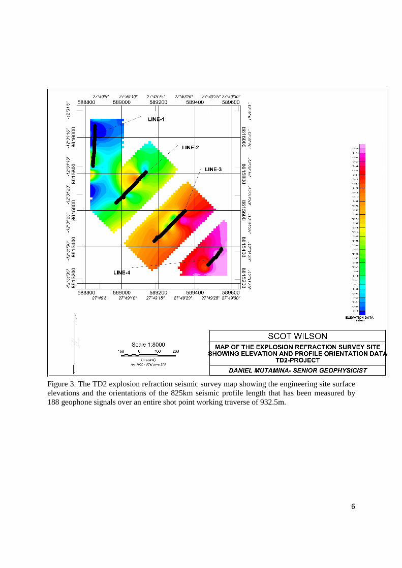
6
Figure 3. The TD2 explosion refraction seismic survey map showing the engineering site surface elevations and the orientations of the 825km seismic profile length that has been measured by 188 geophone signals over an entire shot point working traverse of 932.5m.
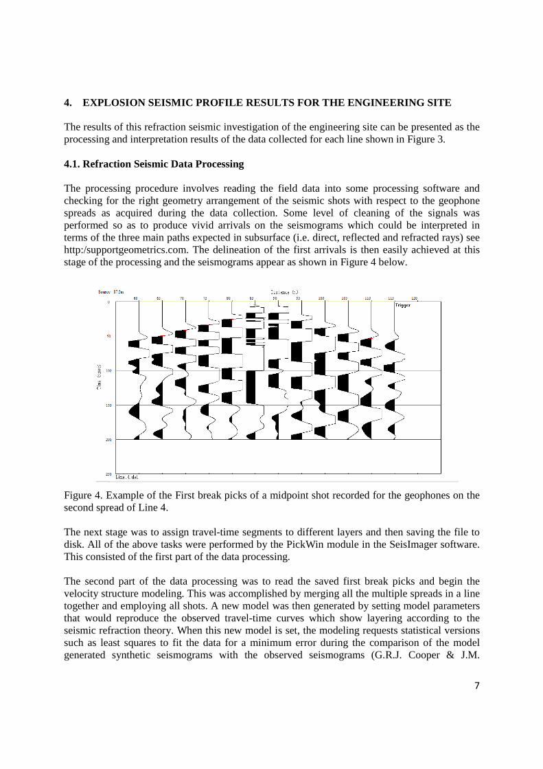
7
4. EXPLOSION SEISMIC PROFILE RESULTS FOR THE ENGINEERING SITE
The results of this refraction seismic investigation of the engineering site can be presented as the processing and interpretation results of the data collected for each line shown in Figure 3. 4.1. Refraction Seismic Data Processing
The processing procedure involves reading the field data into some processing software and checking for the right geometry arrangement of the seismic shots with respect to the geophone spreads as acquired during the data collection. Some level of cleaning of the signals was performed so as to produce vivid arrivals on the seismograms which could be interpreted in terms of the three main paths expected in subsurface (i.e. direct, reflected and refracted rays) see http:/supportgeometrics.com. The delineation of the first arrivals is then easily achieved at this stage of the processing and the seismograms appear as shown in Figure 4 below.
Figure 4. Example of the First break picks of a midpoint shot recorded for the geophones on the second spread of Line 4. The next stage was to assign travel-time segments to different layers and then saving the file to disk. All of the above tasks were performed by the PickWin module in the SeisImager software. This consisted of the first part of the data processing. The second part of the data processing was to read the saved first break picks and begin the velocity structure modeling. This was accomplished by merging all the multiple spreads in a line together and employing all shots. A new model was then generated by setting model parameters that would reproduce the observed travel-time curves which show layering according to the seismic refraction theory. When this new model is set, the modeling requests statistical versions such as least squares to fit the data for a minimum error during the comparison of the model generated synthetic seismograms with the observed seismograms (G.R.J. Cooper & J.M.
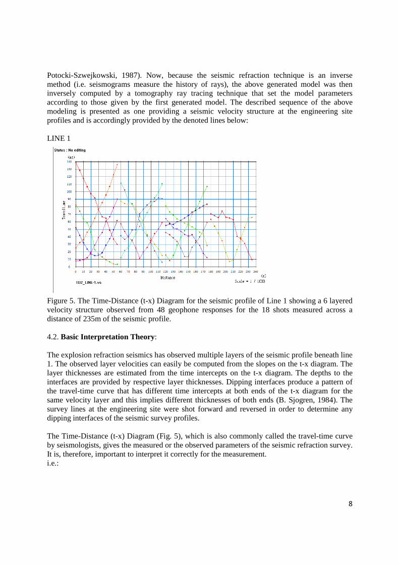
8
Potocki-Szwejkowski, 1987). Now, because the seismic refraction technique is an inverse method (i.e. seismograms measure the history of rays), the above generated model was then inversely computed by a tomography ray tracing technique that set the model parameters according to those given by the first generated model. The described sequence of the above modeling is presented as one providing a seismic velocity structure at the engineering site profiles and is accordingly provided by the denoted lines below: LINE 1
Figure 5. The Time-Distance (t-x) Diagram for the seismic profile of Line 1 showing a 6 layered velocity structure observed from 48 geophone responses for the 18 shots measured across a distance of 235m of the seismic profile. 4.2. Basic Interpretation Theory:
The explosion refraction seismics has observed multiple layers of the seismic profile beneath line 1. The observed layer velocities can easily be computed from the slopes on the t-x diagram. The layer thicknesses are estimated from the time intercepts on the t-x diagram. The depths to the interfaces are provided by respective layer thicknesses. Dipping interfaces produce a pattern of the travel-time curve that has different time intercepts at both ends of the t-x diagram for the same velocity layer and this implies different thicknesses of both ends (B. Sjogren, 1984). The survey lines at the engineering site were shot forward and reversed in order to determine any dipping interfaces of the seismic survey profiles. The Time-Distance (t-x) Diagram (Fig. 5), which is also commonly called the travel-time curve by seismologists, gives the measured or the observed parameters of the seismic refraction survey. It is, therefore, important to interpret it correctly for the measurement. i.e.:
9
-Direct Ray arrival times are simply linear functions of the seismic velocity and the shot point to geophone distances as given in the straight line equation below. T= x/v -The reflected ray arrivals are never the first arrivals and plot as curved asymptotes on the t-x diagram -The refracted ray (head-wave) arrival times plot as linear paths on the t-x diagram and only arrive after the critical distances and come as the first arrivals after the crossover distances (i.e. points at which respective refracted rays eventually overtake the direct wave).
******************************************************** IMPORTANT POINT The art of interpreting the t-x diagram requires the consideration of the geological data (geological sections and geological maps at the survey area) i.e.: The measured t-x diagram of the refraction seismics reveals at least 6 important pieces of geological information: (i) Velocity structure which is used to infer rock type (ii) Depth to interface which shows lithology (or stratigraphy) change (iii) Crossover distance points which show comparisons of various layer thicknesses (e.g. the second head-wave overtaking the direct ray earlier than the first head-wave, indicate either that the second layer is thin or the third layer has a much faster velocity) (iv) Steep & slant slopes which indicate very low velocity & very high velocity respectively imply that the former can be interpreted as a near-surface layer such as soil, subsoil or a weathered top layer of rock that is contained in the overburden (v) Constant-time offsets in the travel-time curves which suggest none-response recording of geophones are employed to detect faults as discontinuities in the t-x diagram and these time-offset constants result from the interfaces that have developed some kind of a hanging and foot step whose point does not refract to the geophones. (vi) Non-linear travel-time curves which are associated with undulating interfaces may be used to map topography of underlying compact bed rock
******************************************************** By considerations of the above IMPORTANT POINT box, the geophysicist should be able to introduce a new model in the modeling process that comprises minimum least squares during the interpretation technique so that the result of the modeling comparisons of the synthetics and the measured data are within acceptable experimental fitting. The below given velocity structures in figures 6 & 7 present the application of generating a new model from measured t-x diagram of line 1 at the engineering site.
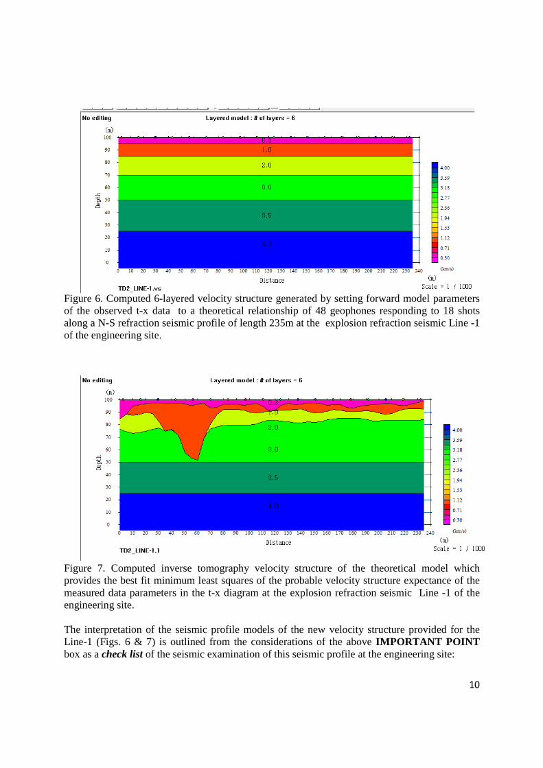
10
Figure 6. Computed 6-layered velocity structure generated by setting forward model parameters of the observed t-x data to a theoretical relationship of 48 geophones responding to 18 shots along a N-S refraction seismic profile of length 235m at the explosion refraction seismic Line -1 of the engineering site.
Figure 7. Computed inverse tomography velocity structure of the theoretical model which provides the best fit minimum least squares of the probable velocity structure expectance of the measured data parameters in the t-x diagram at the explosion refraction seismic Line -1 of the engineering site. The interpretation of the seismic profile models of the new velocity structure provided for the Line-1 (Figs. 6 & 7) is outlined from the considerations of the above IMPORTANT POINT box as a check list of the seismic examination of this seismic profile at the engineering site:
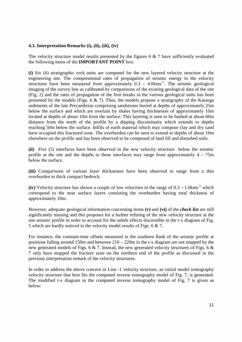
11
4.3. Interpretation Remarks (i), (ii), (iii), (iv)
The velocity structure model results presented by the figures 6 & 7 have sufficiently evaluated the following items of the IMPORTANT POINT box: (i) Six (6) stratigraphic rock units are computed for the new layered velocity structure at the engineering site. The compressional rates of propagation of seismic energy in the velocity structures have been measured from approximately 0.3 – 4.0kms-1. The seismic geological imaging of the survey line as calibrated by comparisons of the existing geological data of the site (Fig. 2) and the rates of propagation of the first breaks in the various geological units has been presented by the models (Figs. 6 & 7). Thus, the models propose a stratigraphy of the Katanga sediments of the late Precambrian comprising sandstones buried at depths of approximately 25m below the surface and which are overlain by shales having thicknesses of approximately 10m located at depths of about 10m from the surface. This layering is seen to be faulted at about 60m distance from the north of the profile by a dipping discontinuity which extends to depths reaching 50m below the surface. Infills of earth material which may compose clay and dry sand have occupied this fractured zone. The overburden can be seen to extend to depths of about 10m elsewhere on the profile and has been observed to be composed of land fill and disturbed soils. (ii) Five (5) interfaces have been observed in the new velocity structure below the seismic profile at the site and the depths to these interfaces may range from approximately 4 – 75m below the surface. (iii) Comparisons of various layer thicknesses have been observed to range from a thin overburden to thick compact bedrock. (iv) Velocity structure has shown a couple of low velocities in the range of 0.3 – 1.0kms-1 which correspond to the near surface layers consisting the overburden having total thickness of approximately 10m. However, adequate geological information concerning items (v) and (vi) of the check list are still significantly missing and this proposes for a further refining of the new velocity structure at the site seismic profile in order to account for the subtle effects discernible in the t-x diagram of Fig. 5 which are hardly noticed in the velocity model results of Figs. 6 & 7. For instance, the constant-time offsets measured in the southern flank of the seismic profile at positions falling around 150m and between 210 – 220m in the t-x diagram are not mapped by the new generated models of Figs. 6 & 7. Instead, the new generated velocity structures of Figs. 6 & 7 only have mapped the fracture zone on the northern end of the profile as discussed in the previous interpretation remark of the velocity structures. In order to address the above concern in Line -1 velocity structure, an initial model tomography velocity structure that best fits the computed inverse tomography model of Fig. 7, is generated. The modified t-x diagram in the computed inverse tomography model of Fig. 7 is given as below:
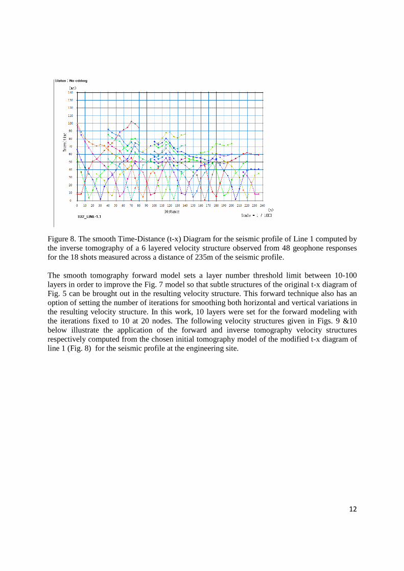
12
Figure 8. The smooth Time-Distance (t-x) Diagram for the seismic profile of Line 1 computed by the inverse tomography of a 6 layered velocity structure observed from 48 geophone responses for the 18 shots measured across a distance of 235m of the seismic profile. The smooth tomography forward model sets a layer number threshold limit between 10-100 layers in order to improve the Fig. 7 model so that subtle structures of the original t-x diagram of Fig. 5 can be brought out in the resulting velocity structure. This forward technique also has an option of setting the number of iterations for smoothing both horizontal and vertical variations in the resulting velocity structure. In this work, 10 layers were set for the forward modeling with the iterations fixed to 10 at 20 nodes. The following velocity structures given in Figs. 9 &10 below illustrate the application of the forward and inverse tomography velocity structures respectively computed from the chosen initial tomography model of the modified t-x diagram of line 1 (Fig. 8) for the seismic profile at the engineering site.
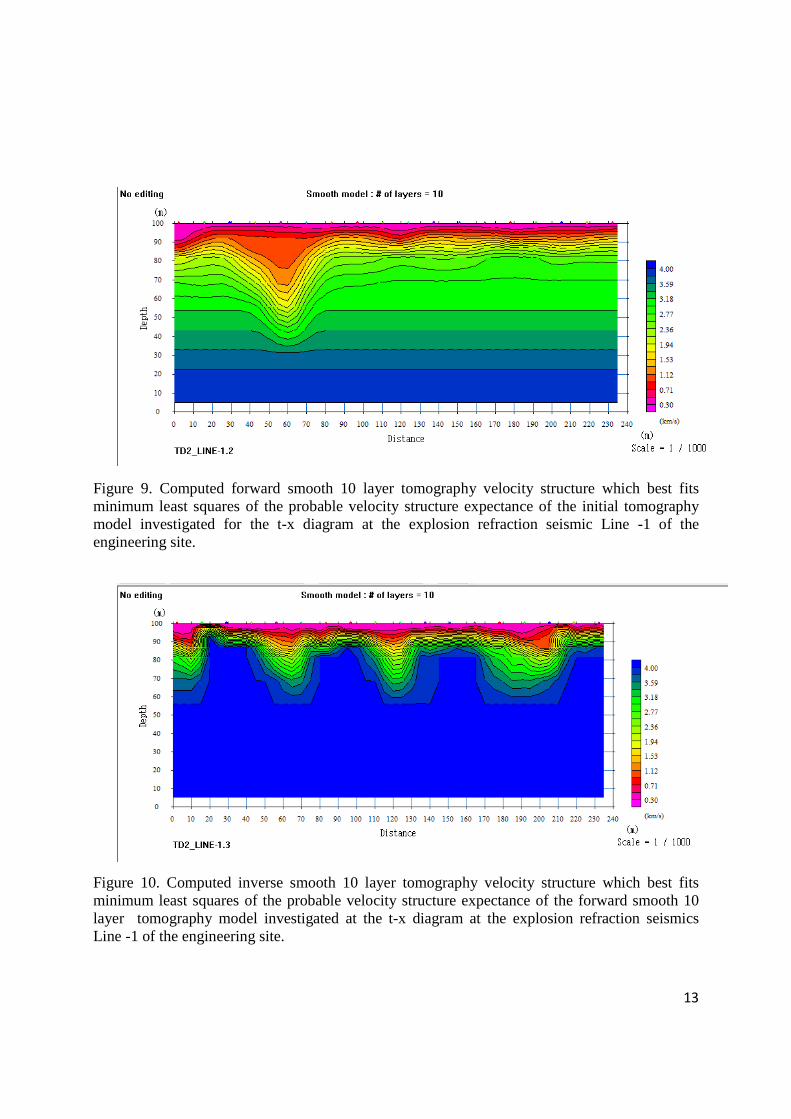
13
Figure 9. Computed forward smooth 10 layer tomography velocity structure which best fits minimum least squares of the probable velocity structure expectance of the initial tomography model investigated for the t-x diagram at the explosion refraction seismic Line -1 of the engineering site.
Figure 10. Computed inverse smooth 10 layer tomography velocity structure which best fits minimum least squares of the probable velocity structure expectance of the forward smooth 10 layer tomography model investigated at the t-x diagram at the explosion refraction seismics Line -1 of the engineering site.
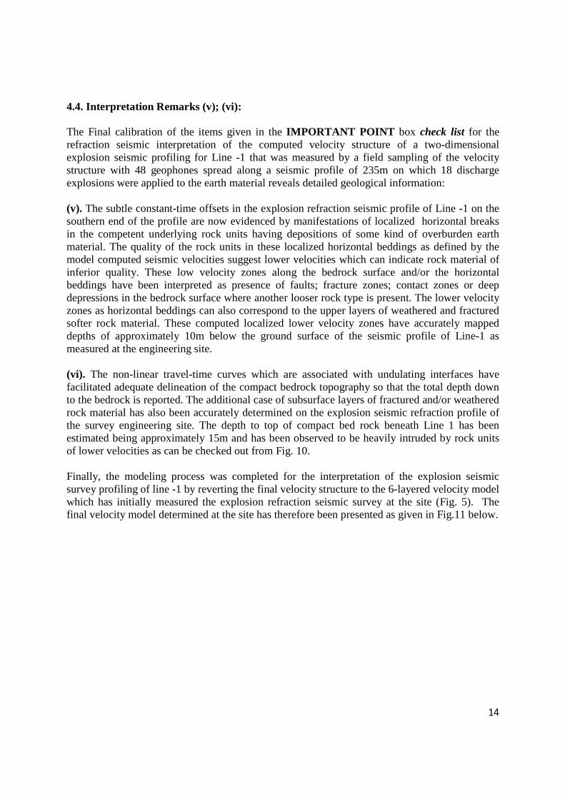
14
4.4. Interpretation Remarks (v); (vi): The Final calibration of the items given in the IMPORTANT POINT box check list for the refraction seismic interpretation of the computed velocity structure of a two-dimensional explosion seismic profiling for Line -1 that was measured by a field sampling of the velocity structure with 48 geophones spread along a seismic profile of 235m on which 18 discharge explosions were applied to the earth material reveals detailed geological information: (v). The subtle constant-time offsets in the explosion refraction seismic profile of Line -1 on the southern end of the profile are now evidenced by manifestations of localized horizontal breaks in the competent underlying rock units having depositions of some kind of overburden earth material. The quality of the rock units in these localized horizontal beddings as defined by the model computed seismic velocities suggest lower velocities which can indicate rock material of inferior quality. These low velocity zones along the bedrock surface and/or the horizontal beddings have been interpreted as presence of faults; fracture zones; contact zones or deep depressions in the bedrock surface where another looser rock type is present. The lower velocity zones as horizontal beddings can also correspond to the upper layers of weathered and fractured softer rock material. These computed localized lower velocity zones have accurately mapped depths of approximately 10m below the ground surface of the seismic profile of Line-1 as measured at the engineering site. (vi). The non-linear travel-time curves which are associated with undulating interfaces have facilitated adequate delineation of the compact bedrock topography so that the total depth down to the bedrock is reported. The additional case of subsurface layers of fractured and/or weathered rock material has also been accurately determined on the explosion seismic refraction profile of the survey engineering site. The depth to top of compact bed rock beneath Line 1 has been estimated being approximately 15m and has been observed to be heavily intruded by rock units of lower velocities as can be checked out from Fig. 10. Finally, the modeling process was completed for the interpretation of the explosion seismic survey profiling of line -1 by reverting the final velocity structure to the 6-layered velocity model which has initially measured the explosion refraction seismic survey at the site (Fig. 5). The final velocity model determined at the site has therefore been presented as given in Fig.11 below.
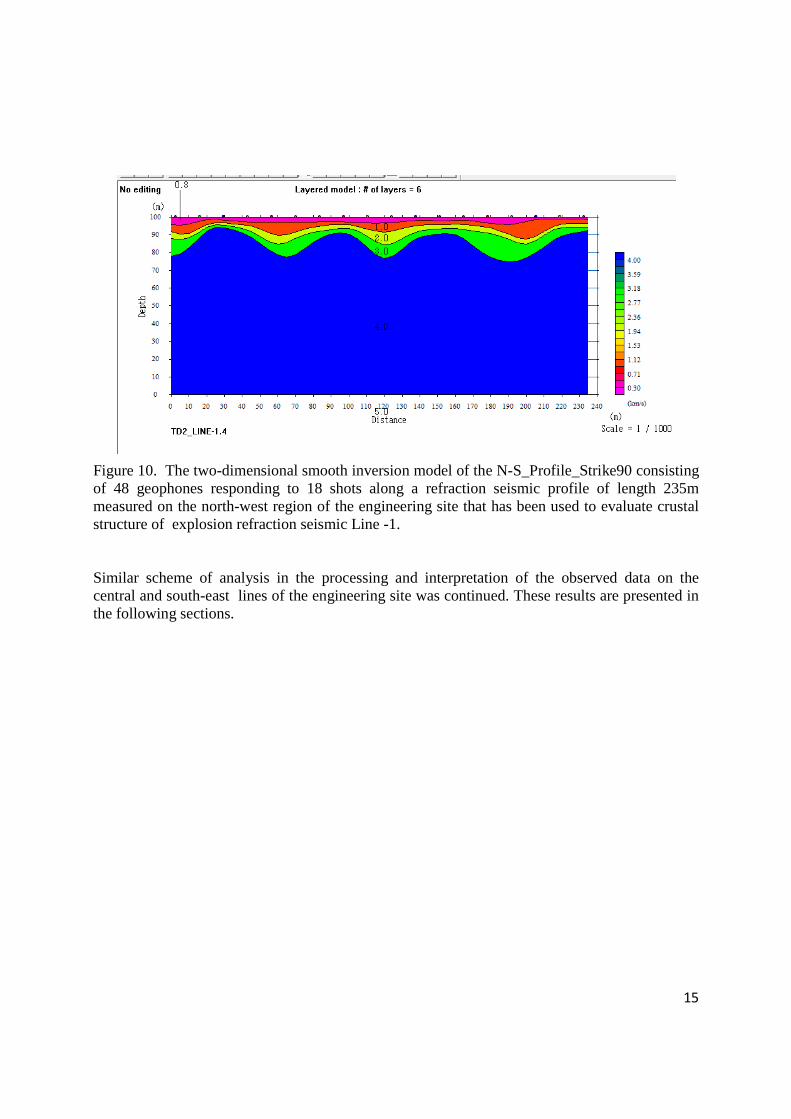
15
Figure 10. The two-dimensional smooth inversion model of the N-S_Profile_Strike90 consisting of 48 geophones responding to 18 shots along a refraction seismic profile of length 235m measured on the north-west region of the engineering site that has been used to evaluate crustal structure of explosion refraction seismic Line -1. Similar scheme of analysis in the processing and interpretation of the observed data on the central and south-east lines of the engineering site was continued. These results are presented in the following sections.
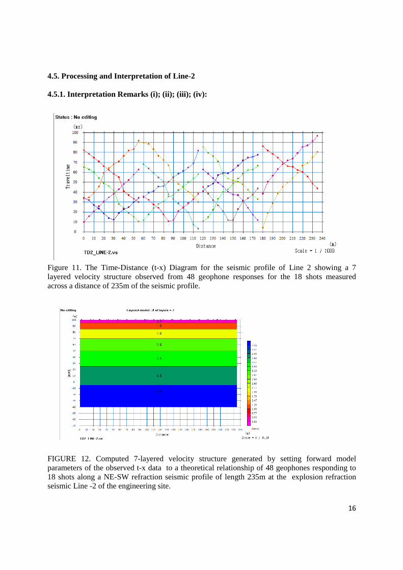
16
4.5. Processing and Interpretation of Line-2 4.5.1. Interpretation Remarks (i); (ii); (iii); (iv):
Figure 11. The Time-Distance (t-x) Diagram for the seismic profile of Line 2 showing a 7 layered velocity structure observed from 48 geophone responses for the 18 shots measured across a distance of 235m of the seismic profile.
FIGURE 12. Computed 7-layered velocity structure generated by setting forward model parameters of the observed t-x data to a theoretical relationship of 48 geophones responding to 18 shots along a NE-SW refraction seismic profile of length 235m at the explosion refraction seismic Line -2 of the engineering site.
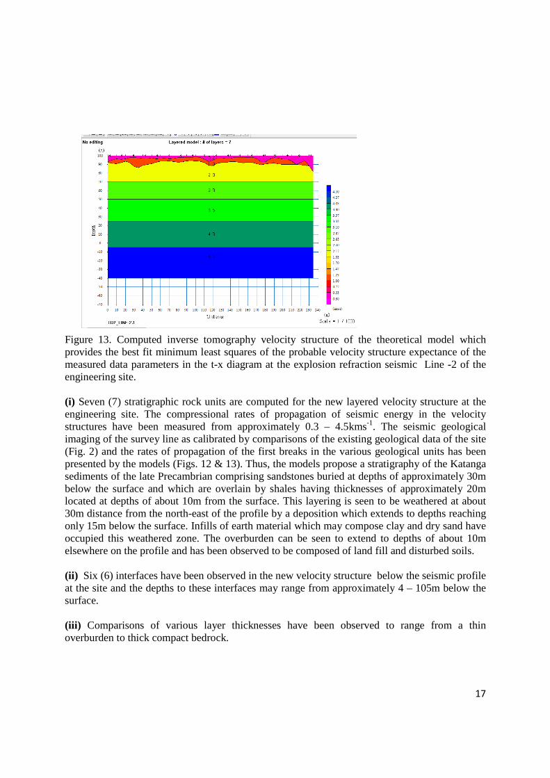
17
Figure 13. Computed inverse tomography velocity structure of the theoretical model which provides the best fit minimum least squares of the probable velocity structure expectance of the measured data parameters in the t-x diagram at the explosion refraction seismic Line -2 of the engineering site. (i) Seven (7) stratigraphic rock units are computed for the new layered velocity structure at the engineering site. The compressional rates of propagation of seismic energy in the velocity structures have been measured from approximately 0.3 – 4.5kms-1. The seismic geological imaging of the survey line as calibrated by comparisons of the existing geological data of the site (Fig. 2) and the rates of propagation of the first breaks in the various geological units has been presented by the models (Figs. 12 & 13). Thus, the models propose a stratigraphy of the Katanga sediments of the late Precambrian comprising sandstones buried at depths of approximately 30m below the surface and which are overlain by shales having thicknesses of approximately 20m located at depths of about 10m from the surface. This layering is seen to be weathered at about 30m distance from the north-east of the profile by a deposition which extends to depths reaching only 15m below the surface. Infills of earth material which may compose clay and dry sand have occupied this weathered zone. The overburden can be seen to extend to depths of about 10m elsewhere on the profile and has been observed to be composed of land fill and disturbed soils. (ii) Six (6) interfaces have been observed in the new velocity structure below the seismic profile at the site and the depths to these interfaces may range from approximately 4 – 105m below the surface. (iii) Comparisons of various layer thicknesses have been observed to range from a thin overburden to thick compact bedrock.
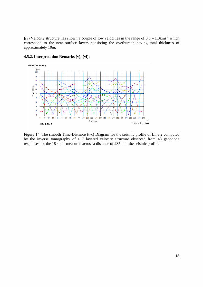
18
(iv) Velocity structure has shown a couple of low velocities in the range of 0.3 – 1.0kms-1 which correspond to the near surface layers consisting the overburden having total thickness of approximately 10m. 4.5.2. Interpretation Remarks (v); (vi):
Figure 14. The smooth Time-Distance (t-x) Diagram for the seismic profile of Line 2 computed by the inverse tomography of a 7 layered velocity structure observed from 48 geophone responses for the 18 shots measured across a distance of 235m of the seismic profile.
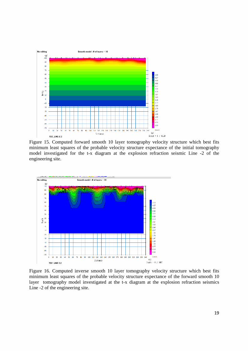
19
Figure 15. Computed forward smooth 10 layer tomography velocity structure which best fits minimum least squares of the probable velocity structure expectance of the initial tomography model investigated for the t-x diagram at the explosion refraction seismic Line -2 of the engineering site.
Figure 16. Computed inverse smooth 10 layer tomography velocity structure which best fits minimum least squares of the probable velocity structure expectance of the forward smooth 10 layer tomography model investigated at the t-x diagram at the explosion refraction seismics Line -2 of the engineering site.
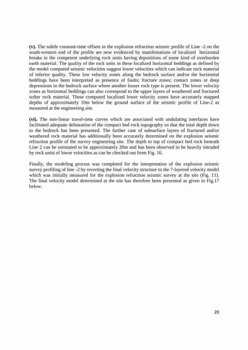
20
(v). The subtle constant-time offsets in the explosion refraction seismic profile of Line -2 on the south-western end of the profile are now evidenced by manifestations of localized horizontal breaks in the competent underlying rock units having depositions of some kind of overburden earth material. The quality of the rock units in these localized horizontal beddings as defined by the model computed seismic velocities suggest lower velocities which can indicate rock material of inferior quality. These low velocity zones along the bedrock surface and/or the horizontal beddings have been interpreted as presence of faults; fracture zones; contact zones or deep depressions in the bedrock surface where another looser rock type is present. The lower velocity zones as horizontal beddings can also correspond to the upper layers of weathered and fractured softer rock material. These computed localized lower velocity zones have accurately mapped depths of approximately 10m below the ground surface of the seismic profile of Line-2 as measured at the engineering site. (vi). The non-linear travel-time curves which are associated with undulating interfaces have facilitated adequate delineation of the compact bed rock topography so that the total depth down to the bedrock has been presented. The further case of subsurface layers of fractured and/or weathered rock material has additionally been accurately determined on the explosion seismic refraction profile of the survey engineering site. The depth to top of compact bed rock beneath Line 2 can be estimated to be approximately 20m and has been observed to be heavily intruded by rock units of lower velocities as can be checked out from Fig. 16. Finally, the modeling process was completed for the interpretation of the explosion seismic survey profiling of line -2 by reverting the final velocity structure to the 7-layered velocity model which was initially measured for the explosion refraction seismic survey at the site (Fig. 11). The final velocity model determined at the site has therefore been presented as given in Fig.17 below.
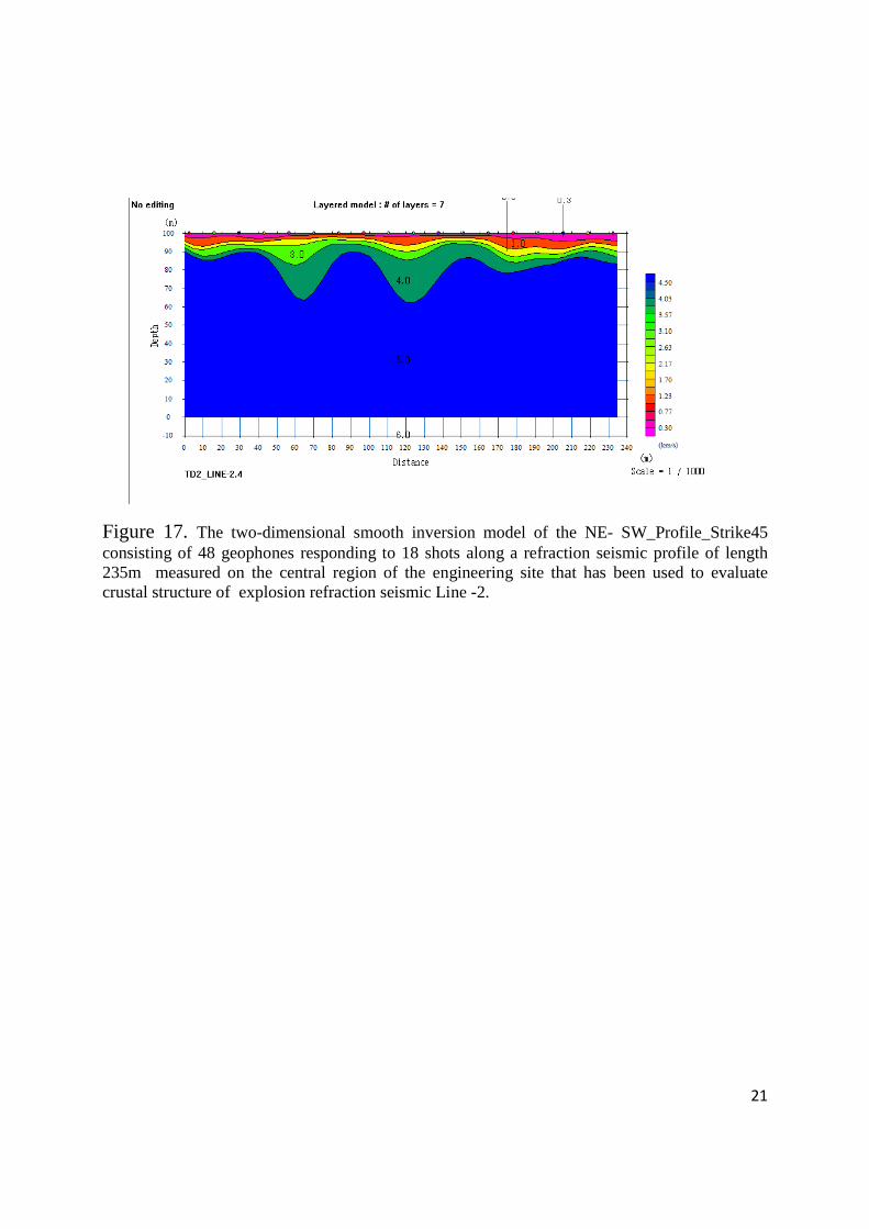
21
Figure 17. The two-dimensional smooth inversion model of the NE- SW_Profile_Strike45 consisting of 48 geophones responding to 18 shots along a refraction seismic profile of length 235m measured on the central region of the engineering site that has been used to evaluate crustal structure of explosion refraction seismic Line -2.
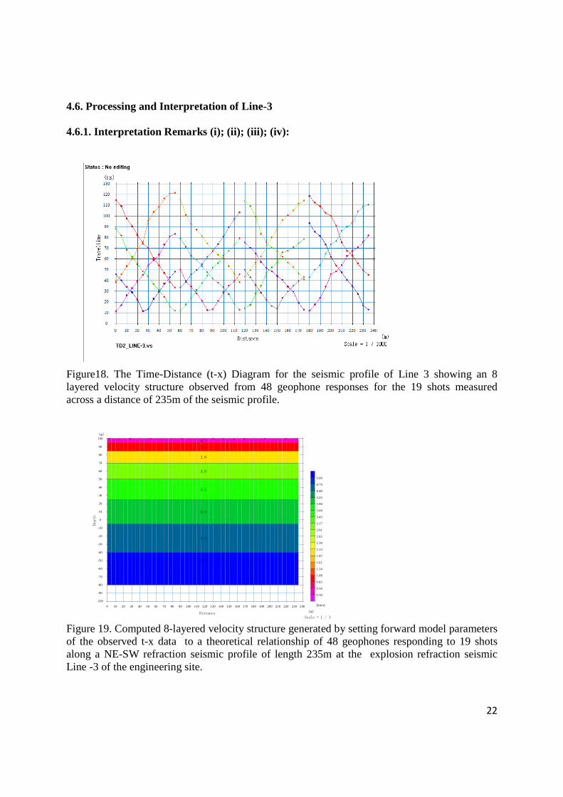
22
-100
-90
-80
-70
-60
-50
-40
-30
-20
-10
0
10
20
30
40
50
60
70
80
90
100
Dept
h
(m)
0 10 20 30 40 50 60 70 80 90 100 110 120 130 140 150 160 170 180 190 200 210 220 230 240
(m)Distance
(km/s)
0.30
0.56
0.82
1.08
1.34
1.61
1.87
2.13
2.39
2.65
2.91
3.17
3.43
3.69
3.96
4.22
4.48
4.74
5.00
Scale = 1 / 1000
0.3
1.0
2.0
3.0
3.5
4.0
4.5
5.0
4.6. Processing and Interpretation of Line-3
4.6.1. Interpretation Remarks (i); (ii); (iii); (iv):
Figure18. The Time-Distance (t-x) Diagram for the seismic profile of Line 3 showing an 8 layered velocity structure observed from 48 geophone responses for the 19 shots measured across a distance of 235m of the seismic profile. Figure 19. Computed 8-layered velocity structure generated by setting forward model parameters of the observed t-x data to a theoretical relationship of 48 geophones responding to 19 shots along a NE-SW refraction seismic profile of length 235m at the explosion refraction seismic Line -3 of the engineering site.
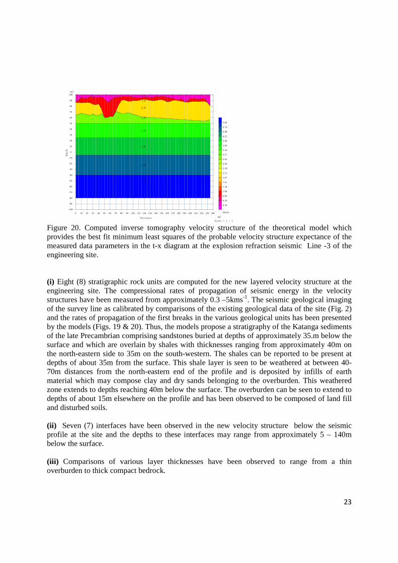
23
-100
-90
-80
-70
-60
-50
-40
-30
-20
-10
0
10
20
30
40
50
60
70
80
90
100
Dept
h
(m)
0 10 20 30 40 50 60 70 80 90 100 110 120 130 140 150 160 170 180 190 200 210 220 230 240
(m)Distance
(km/s)
0.30
0.56
0.82
1.08
1.34
1.61
1.87
2.13
2.39
2.65
2.91
3.17
3.43
3.69
3.96
4.22
4.48
4.74
5.00
Scale = 1 / 1000
0.3
1.0
2.0
3.0
3.5
4.0
4.5
5.0
Figure 20. Computed inverse tomography velocity structure of the theoretical model which provides the best fit minimum least squares of the probable velocity structure expectance of the measured data parameters in the t-x diagram at the explosion refraction seismic Line -3 of the engineering site. (i) Eight (8) stratigraphic rock units are computed for the new layered velocity structure at the engineering site. The compressional rates of propagation of seismic energy in the velocity structures have been measured from approximately 0.3 –5kms-1. The seismic geological imaging of the survey line as calibrated by comparisons of the existing geological data of the site (Fig. 2) and the rates of propagation of the first breaks in the various geological units has been presented by the models (Figs. 19 & 20). Thus, the models propose a stratigraphy of the Katanga sediments of the late Precambrian comprising sandstones buried at depths of approximately 35.m below the surface and which are overlain by shales with thicknesses ranging from approximately 40m on the north-eastern side to 35m on the south-western. The shales can be reported to be present at depths of about 35m from the surface. This shale layer is seen to be weathered at between 40-70m distances from the north-eastern end of the profile and is deposited by infills of earth material which may compose clay and dry sands belonging to the overburden. This weathered zone extends to depths reaching 40m below the surface. The overburden can be seen to extend to depths of about 15m elsewhere on the profile and has been observed to be composed of land fill and disturbed soils. (ii) Seven (7) interfaces have been observed in the new velocity structure below the seismic profile at the site and the depths to these interfaces may range from approximately 5 – 140m below the surface. (iii) Comparisons of various layer thicknesses have been observed to range from a thin overburden to thick compact bedrock.
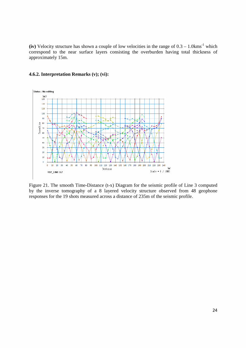
24
(iv) Velocity structure has shown a couple of low velocities in the range of 0.3 – 1.0kms-1 which correspond to the near surface layers consisting the overburden having total thickness of approximately 15m. 4.6.2. Interpretation Remarks (v); (vi):
Figure 21. The smooth Time-Distance (t-x) Diagram for the seismic profile of Line 3 computed by the inverse tomography of a 8 layered velocity structure observed from 48 geophone responses for the 19 shots measured across a distance of 235m of the seismic profile.
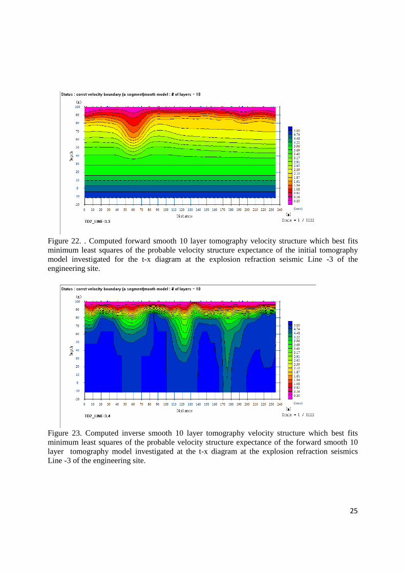
25
Figure 22. . Computed forward smooth 10 layer tomography velocity structure which best fits minimum least squares of the probable velocity structure expectance of the initial tomography model investigated for the t-x diagram at the explosion refraction seismic Line -3 of the engineering site.
Figure 23. Computed inverse smooth 10 layer tomography velocity structure which best fits minimum least squares of the probable velocity structure expectance of the forward smooth 10 layer tomography model investigated at the t-x diagram at the explosion refraction seismics Line -3 of the engineering site.
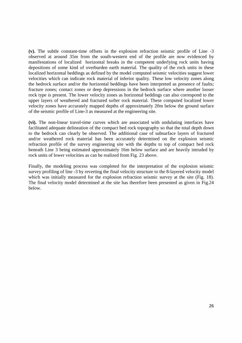
26
(v). The subtle constant-time offsets in the explosion refraction seismic profile of Line -3 observed at around 35m from the south-western end of the profile are now evidenced by manifestations of localized horizontal breaks in the competent underlying rock units having depositions of some kind of overburden earth material. The quality of the rock units in these localized horizontal beddings as defined by the model computed seismic velocities suggest lower velocities which can indicate rock material of inferior quality. These low velocity zones along the bedrock surface and/or the horizontal beddings have been interpreted as presence of faults; fracture zones; contact zones or deep depressions in the bedrock surface where another looser rock type is present. The lower velocity zones as horizontal beddings can also correspond to the upper layers of weathered and fractured softer rock material. These computed localized lower velocity zones have accurately mapped depths of approximately 20m below the ground surface of the seismic profile of Line-3 as measured at the engineering site. (vi). The non-linear travel-time curves which are associated with undulating interfaces have facilitated adequate delineation of the compact bed rock topography so that the total depth down to the bedrock can clearly be observed. The additional case of subsurface layers of fractured and/or weathered rock material has been accurately determined on the explosion seismic refraction profile of the survey engineering site with the depths to top of compact bed rock beneath Line 3 being estimated approximately 16m below surface and are heavily intruded by rock units of lower velocities as can be realized from Fig. 23 above. Finally, the modeling process was completed for the interpretation of the explosion seismic survey profiling of line -3 by reverting the final velocity structure to the 8-layered velocity model which was initially measured for the explosion refraction seismic survey at the site (Fig. 18). The final velocity model determined at the site has therefore been presented as given in Fig.24 below.
27
Figure 24. The two-dimensional smooth inversion model of the NE- SW_Profile_Strike45 consisting of 48 geophones responding to 19 shots along a refraction seismic profile of length 235m measured in the central region of the engineering site that has been used to evaluate crustal structure of explosion refraction seismic Line -3.
28
4.7. Processing and Interpretation of Line-4
4.7.1. Interpretation Remarks (i); (ii); (iii); (iv):
Figure 25. The Time-Distance (t-x) Diagram for the seismic profile of Line 4 showing a seven layered velocity structure observed from 24 geophone responses for the 8 shots measured across a distance of 115m of the seismic profile.
29
Figure 26. Computed 7-layered velocity structure generated by setting forward model parameters of the observed t-x data to a theoretical relationship of 24 geophones responding to 8 shots along a NE-SW refraction seismic profile of length 115m at the explosion refraction seismic Line -4 of the engineering site.
Figure 27. Two-dimensional inverse inversion model of the NE- SW_Profile_Strike45 consisting of 24 geophones responding to 8 shots along a refraction seismic profile of length 115m measured in the south-eastern region of the engineering site that has been used to evaluate crustal structure of explosion refraction seismic Line -4.
30
(i) Seven (7) stratigraphic rock units are computed for the new layered velocity structure at the engineering site. The compressional rates of propagation of seismic energy in the velocity structures have been measured from approximately 0.3 – 4.5kms-1. The seismic geological imaging of the survey line as calibrated by comparisons of the existing geological data of the site (Fig. 2) and the rates of propagation of the first breaks in the various geological units has been presented by the models (Figs. 26 & 27). Thus, the models propose a stratigraphy of the Katanga sediments of the late Precambrian comprising sandstones buried at depths of approximately 75m below the surface which are overlain by shales observed at about 10m location depths on the south-western end. Thicknesses of approximately 20m have been observed for this shale layering. This layering is seen to be faulted at around 40-50m distances from the north-east of the profile where it is intruded by upper stratigraphic layers which extend to depths reaching approximately 60m below the surface. A discontinued dipping earth material which may contain near surface sand and gravel has been observed in this faulted zone. The overburden can be seen to extend to a maximum depth of about 30m in this faulted zone of the profile and has been observed to be composed of clay as well as land fill and disturbed soils. (ii) Six (6) interfaces have been observed in the new velocity structure below the seismic profile of Line -4 at the site and the depths to these interfaces may range from approximately 15 – 105m below the surface. (iii) Comparisons of various layer thicknesses have been observed to range from a thin overburden to thick compact bedrock. (iv) Velocity structure has shown a couple of low velocities in the range of 0.3 – 1.0kms-1 which correspond to the near surface layers consisting the overburden and have average thickness of approximately 25m. 4.7.2. Interpretation Remarks (v); (vi): Given the fact that the velocity models presented in Figs. 26 & 27 have adequately brought out the observed features of the t-x diagram measured at the site for the seismic profile of Line -4, there was no further requirement for the interpretation process to proceed with the smoothing operations as was conducted for the subtle effects noticed in the rest of the t-x diagrams of the experiment. Therefore, the final modeling process was completed for the interpretation of the explosion seismic survey profiling of line -4 at this stage of interpretation. The final velocity model determined at the site has therefore been presented as given in Fig.27 above.
31
5. CONCLUSION/RECOMMENDATION
The seismic site characterization of the TD2 project as established from the explosion refraction seismic survey is outlined when considerations of the geological section line (NW-SE) taken through the interpretation map (Fig. 31 shown below) are made. The following conclusions have been drawn for the engineering site: (i) The crust beneath the site dips towards the north-western region of the site having low surface ground elevations and has raised lithological thicknesses on the south-eastern region where higher surface elevation values have been observed. (ii) The compressional rates of propagation of seismic energy have shown gradational increases from the north-western end to the south-eastern flank. This observation is explained when considerations of the burial thicknesses evaluated from the explosion refraction seismic measurements of the site are taken into account. The crustal thicknesses as evaluated from the two-dimensional velocity structures of this experiment show gradual increases from thin north-western stratigraphy to thicker south-eastern lithologies which are occupied by layers of competent rock units. (iii) The competent rock units of the north-western flanks have shown intrusions of deep seated faults and fractured/weathered zones as compared to the south-eastern competent rock units which have only mapped these deformations in shallow depths. By engaging the above observations it can be concluded that the refraction seismic measurement of the engineering site has characterized much more stable rock units towards the south-eastern region of the engineering site than has been observed towards the north-western end of line NW-SE shown in the interpretation map below. As a necessary consequence of the premises of the proposition of the explosion refraction seismic technique to the TD2 engineering project, the below listed geological data has been gleaned by this work: (i) subsurface seismic layer velocity information which is dependent upon the elastic properties of the subsurface geology and (ii) depth to geological stratigraphy. It can be advised that no such geological information has yet been available for this area and this new data may be endorsed as worthy of application by the project engineers managing this undertaking. Instances of applications to which this new data can be employed would include estimations of hydraulic conductivity for modeling contaminant transport zones that would avoid seepages of discharge to the environment. Engineering structure stability considerations are also adequately covered by this new geological data which has reported on bedrock topography and has also mapped faults and fractured zones of the project site. Rippability concerns regarding the engineering site may also be evaluated by engaging this new geological data of the site when seismic layer velocities are considered in connection with the elastic material properties of the geological material at the site.
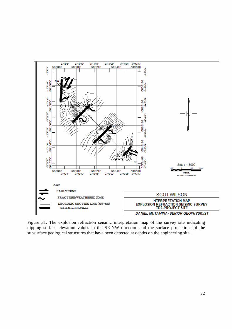
32
Figure 31. The explosion refraction seismic interpretation map of the survey site indicating dipping surface elevation values in the SE-NW direction and the surface projections of the subsurface geological structures that have been detected at depths on the engineering site.
33
6. REFERENCES 1.A. R. Drysdall, J. G. Thieme & R. L. Johnson, Geological Map of the Republic of Zambia, Geological Survey Department, 1975. 2.Bengt Sjogren, Shallow Refraction Seismics, Chapman & Hall, 1984. 3.D.S. Parasnis, Principles of Applied Geophysics, 5th Edition, Chapman & Hall, 1997. 4.De Wit, M.J., J. Stankiewicz, C. Reeves, Restoring Pan-African-Brasiliano connections: more Gondwana control, less Trans-Atlantic corruption, Geol. Soc. London, Spec. Pub., 294, 399- 412, 2008. 5.G. R. J. Cooper & J. M. Potocki-Szwejkowski, SEREF: An Interactive Seismic Refraction Data Interpretation Program for the IBM PC. APCOM87. Proceedings of the Twentieth International Symposium on Application of Computers and Mathematics in Mineral Industries, Volume 3: Geostatistics, Johannesburg, SAIMM, 1987. pp. 345-350. 6.Geometrics Knowledgebase, Basic Seismic Refraction Techniques, http://supportgeometrics.com 7.Hanson, R.E., T.J. Wilson, M.S. Wardlaw, Deformed batholiths in the Pan-African Zambezi belt, Zambia: Age and implications for regional Proterozoic tectonics, Geology, 16, 1134- 1137, 1988. 8.Jacques Jenny, Refraction Seismic, Geo2XGeneve 9.Kroner, A., Pan-African crustal evolution, Episodes, 1980, 2, 1980. 10.Philip Kearey, Michael Brooks, Ian Hill, An Introduction to Geophysical Exploration, 3rd
Edition, Blackwell Science, 2002. 11.Priestley, K., D. McKenzie, E. Debayle, S. Pilidou, The African upper mantle and its relationship to tectonics and surface geology, Geophys. J. Int, 175, 1108-1126, 2008. 12.R.W. Lankston, High Resolution Refraction Data Acquisition and Interpretation, Geo- Compu-Graph, Inc. 13.W. M. Telford, L. P. Geldart, R. E. Sheriff, Applied Geophysics, 2nd Edition, Cambridge University Press, 1990.
Konkola Copper Mines Plc
New Slag Dump Project
Draft Environmental and Social Impact Statement September 2014
Appendix I(b)
Supplementary Report on the Seismic Refraction Survey Report on TD2 Slag Dump in Chingola KCM
License Area
1
SUPPLEMENTARY REPORT
ON THE
ON
TD2 SLAG DUMP IN CHINGOLA KCM LICENCE AREA
_____________________________________________________
Insight into Groundwater in Terms of Direction of Movement and Depth
of the Water Table for the TD2 Project Site
Prepared for and on Behalf of
URS SCOTT WILSON ZAMBIA
24 ENOS CHOMBA AVENUE
P.O. BOX 22496
KITWE, ZAMBIA
______________________________________________________________
Prepared By: DN CONSULTING ASSOCIATES LIMITED (Mineral Exploration, Mining and & Environmental Consultants) Room 16, 2nd Floor, Investments Bldg (On top of National Savings & Credit Bank) City Square P.O. BOX 21591 KITWE, ZAMBIA. Telefax: +260 212 225 167 Mobile: +260 975 753 277
E-MAIL: [email protected] August, 2014
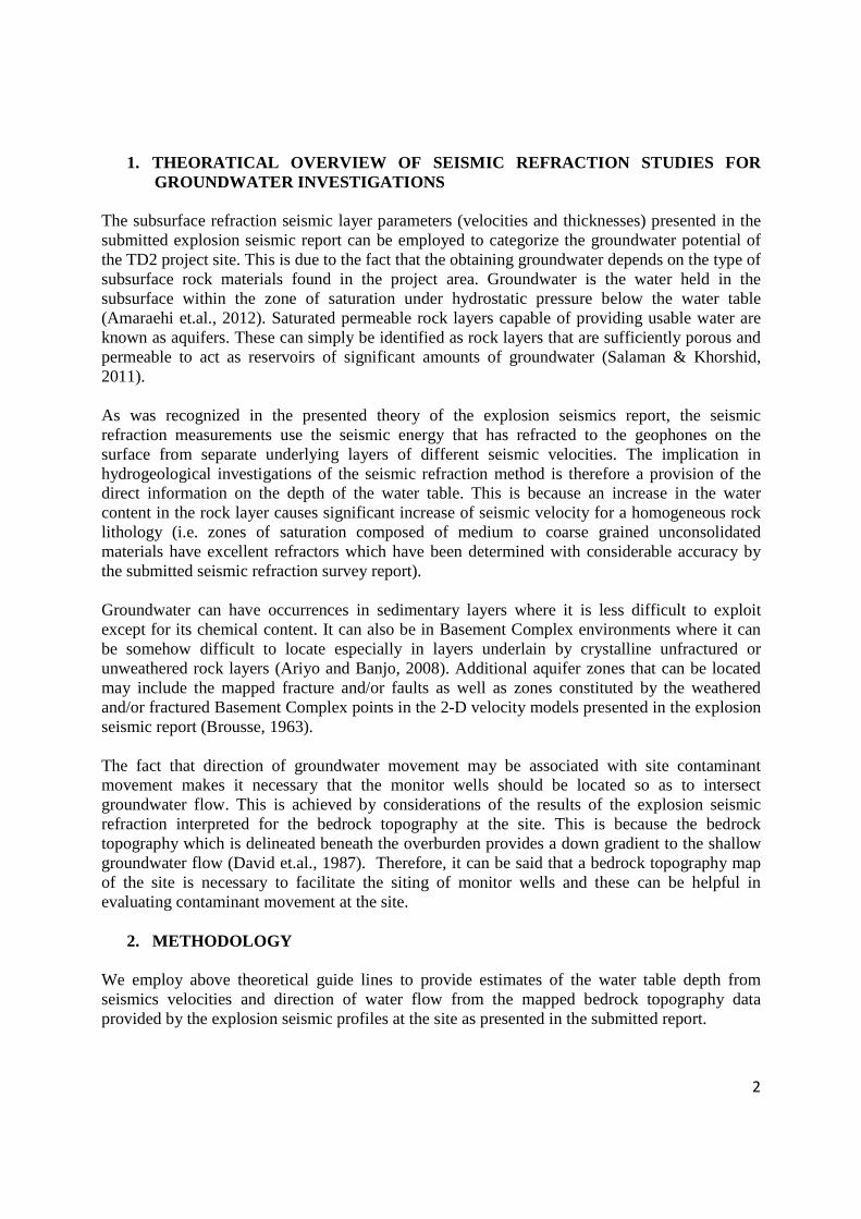
2
1. THEORATICAL OVERVIEW OF SEISMIC REFRACTION STUDIES FOR GROUNDWATER INVESTIGATIONS
The subsurface refraction seismic layer parameters (velocities and thicknesses) presented in the submitted explosion seismic report can be employed to categorize the groundwater potential of the TD2 project site. This is due to the fact that the obtaining groundwater depends on the type of subsurface rock materials found in the project area. Groundwater is the water held in the subsurface within the zone of saturation under hydrostatic pressure below the water table (Amaraehi et.al., 2012). Saturated permeable rock layers capable of providing usable water are known as aquifers. These can simply be identified as rock layers that are sufficiently porous and permeable to act as reservoirs of significant amounts of groundwater (Salaman & Khorshid, 2011). As was recognized in the presented theory of the explosion seismics report, the seismic refraction measurements use the seismic energy that has refracted to the geophones on the surface from separate underlying layers of different seismic velocities. The implication in hydrogeological investigations of the seismic refraction method is therefore a provision of the direct information on the depth of the water table. This is because an increase in the water content in the rock layer causes significant increase of seismic velocity for a homogeneous rock lithology (i.e. zones of saturation composed of medium to coarse grained unconsolidated materials have excellent refractors which have been determined with considerable accuracy by the submitted seismic refraction survey report). Groundwater can have occurrences in sedimentary layers where it is less difficult to exploit except for its chemical content. It can also be in Basement Complex environments where it can be somehow difficult to locate especially in layers underlain by crystalline unfractured or unweathered rock layers (Ariyo and Banjo, 2008). Additional aquifer zones that can be located may include the mapped fracture and/or faults as well as zones constituted by the weathered and/or fractured Basement Complex points in the 2-D velocity models presented in the explosion seismic report (Brousse, 1963). The fact that direction of groundwater movement may be associated with site contaminant movement makes it necessary that the monitor wells should be located so as to intersect groundwater flow. This is achieved by considerations of the results of the explosion seismic refraction interpreted for the bedrock topography at the site. This is because the bedrock topography which is delineated beneath the overburden provides a down gradient to the shallow groundwater flow (David et.al., 1987). Therefore, it can be said that a bedrock topography map of the site is necessary to facilitate the siting of monitor wells and these can be helpful in evaluating contaminant movement at the site.
2. METHODOLOGY
We employ above theoretical guide lines to provide estimates of the water table depth from seismics velocities and direction of water flow from the mapped bedrock topography data provided by the explosion seismic profiles at the site as presented in the submitted report.
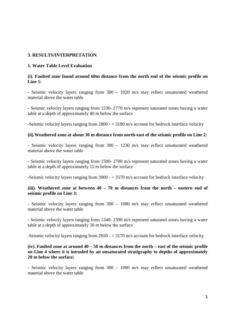
3
3. RESULTS/INTERPRETATION 1. Water Table Level Evaluation (i). Faulted zone found around 60m distance from the north end of the seismic profile on Line 1: - Seismic velocity layers ranging from 300 – 1020 m/s may reflect unsaturated weathered material above the water table - Seismic velocity layers ranging from 1530- 2770 m/s represent saturated zones having a water table at a depth of approximately 40 m below the surface -Seismic velocity layers ranging from 2800 - > 3180 m/s account for bedrock interface velocity (ii).Weathered zone at about 30 m distance from north-east of the seismic profile on Line 2: - Seismic velocity layers ranging from 300 – 1230 m/s may reflect unsaturated weathered material above the water table - Seismic velocity layers ranging from 1500- 2700 m/s represent saturated zones having a water table at a depth of approximately 15 m below the surface -Seismic velocity layers ranging from 3000 - > 3570 m/s account for bedrock interface velocity (iii). Weathered zone at between 40 – 70 m distances from the north – eastern end of seismic profile on Line 3: - Seismic velocity layers ranging from 300 – 1080 m/s may reflect unsaturated weathered material above the water table - Seismic velocity layers ranging from 1340- 2390 m/s represent saturated zones having a water table at a depth of approximately 30 m below the surface -Seismic velocity layers ranging from 2650 - > 3170 m/s account for bedrock interface velocity (iv). Faulted zone at around 40 – 50 m distances from the north – east of the seismic profile on Line 4 where it is intruded by an unsaturated stratigraphy to depths of approximately 20 m below the surface: - Seismic velocity layers ranging from 300 – 1000 m/s may reflect unsaturated weathered material above the water table
4
- Seismic velocity layers ranging from 1230- 2170 m/s represent saturated zones having a water table at a depth of approximately 15 m below the surface -Seismic velocity layers ranging from 2200 - > 2400 m/s account for bedrock interface velocity The above evaluations of the depth to the water table form the seismic velocity data obtained from the measured seismic profiles of the submitted seismic report has revealed a water level in the range of approximately 15 – 40 m below the surface at the TD2 project site. 2. Groundwater Flow Evaluation Figure 1. Topographic Map of TD2 Project Site Showing Configuration of Surface of Unweathered Bedrock and Location of Suitable Sites of Two Monitor Wells
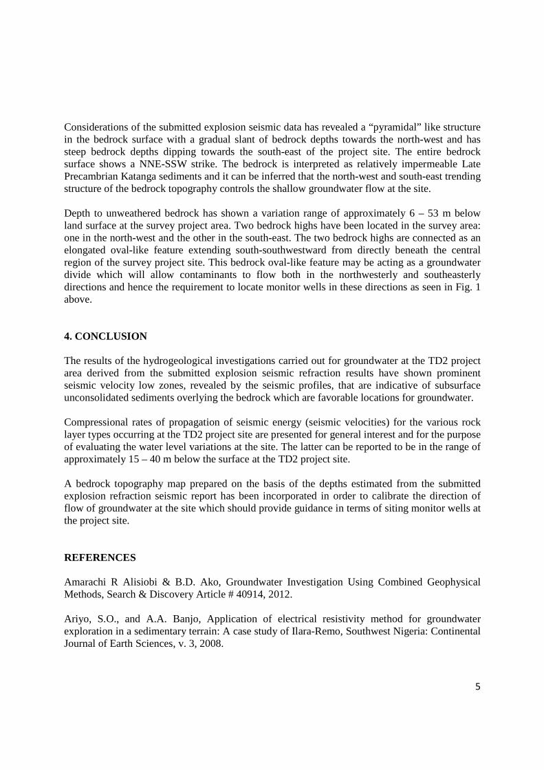
5
Considerations of the submitted explosion seismic data has revealed a “pyramidal” like structure in the bedrock surface with a gradual slant of bedrock depths towards the north-west and has steep bedrock depths dipping towards the south-east of the project site. The entire bedrock surface shows a NNE-SSW strike. The bedrock is interpreted as relatively impermeable Late Precambrian Katanga sediments and it can be inferred that the north-west and south-east trending structure of the bedrock topography controls the shallow groundwater flow at the site. Depth to unweathered bedrock has shown a variation range of approximately 6 – 53 m below land surface at the survey project area. Two bedrock highs have been located in the survey area: one in the north-west and the other in the south-east. The two bedrock highs are connected as an elongated oval-like feature extending south-southwestward from directly beneath the central region of the survey project site. This bedrock oval-like feature may be acting as a groundwater divide which will allow contaminants to flow both in the northwesterly and southeasterly directions and hence the requirement to locate monitor wells in these directions as seen in Fig. 1 above. 4. CONCLUSION The results of the hydrogeological investigations carried out for groundwater at the TD2 project area derived from the submitted explosion seismic refraction results have shown prominent seismic velocity low zones, revealed by the seismic profiles, that are indicative of subsurface unconsolidated sediments overlying the bedrock which are favorable locations for groundwater. Compressional rates of propagation of seismic energy (seismic velocities) for the various rock layer types occurring at the TD2 project site are presented for general interest and for the purpose of evaluating the water level variations at the site. The latter can be reported to be in the range of approximately 15 – 40 m below the surface at the TD2 project site. A bedrock topography map prepared on the basis of the depths estimated from the submitted explosion refraction seismic report has been incorporated in order to calibrate the direction of flow of groundwater at the site which should provide guidance in terms of siting monitor wells at the project site. REFERENCES Amarachi R Alisiobi & B.D. Ako, Groundwater Investigation Using Combined Geophysical Methods, Search & Discovery Article # 40914, 2012. Ariyo, S.O., and A.A. Banjo, Application of electrical resistivity method for groundwater exploration in a sedimentary terrain: A case study of Ilara-Remo, Southwest Nigeria: Continental Journal of Earth Sciences, v. 3, 2008.
6
Brousse, J.J., Modern geophysical methods for subsurface water exploration: Geophysics, v. 28/4, 1963. David W. Hall and David L. Pasicznyk, Application of seismic Refraction and Terrin Conductivity Methods at a Groundwater Pollution Site in North-Central New Jersey, New Jersey Department of Environmental Protection Division of Water Resources, New Jersey Geological Survey, Trenton, New Jersey, 870143799, 1987.
Konkola Copper Mines Plc
New Slag Dump Project
Draft Environmental and Social Impact Statement September 2014
Appendix J
Minutes of the Public Disclosure Meeting held on 22 August 2014
MINUTES OF MEETING FOR PUBLIC DISCLOSURE OF THE PROPOSED NEW SLAG DUMPSITE IN CHINGOLA HELD ON 22ND AUGUST 2014 AT MUSHISHIMA PRIMARY SCHOOL AT 10:00HRS
1.0 AGENDA
Registration
National Anthem
Prayer
Introduction of participants
Presentation of project by Mr. Eric Mwacalimba
Open session – Question and answers
National Anthem
Prayer
End of program
2.0 ATTENDANCE
The meeting was attended by a total of 100 people who included community members from Mushishima, Hippo pool,
Chabanyama, Katunga Bulungu and Kalilo(List attached) and various stakeholders as follows;
Konkola Copper Mines Plc. His Worship the Mayor of Chingola 2 Councilors from Chingola Municipal Council ZEMA Department of Water Affairs Ministry of Agriculture Mulonga Water and sewerage company Consultant – Scott Wilson Mushishima Primary School Teachers and School Manager
3.0 OPENING REMARKS
The moderator Ms. Lomantzi Mazyopa called the meeting to order at 11:00hours and welcomed all present. Thereafter self-introductions were made. The session was conducted in English and translated into Icibemba.
4.0 INTRODUCTION
The meeting was convened to give information and obtain feedback on proposed Slug Dumpsite as per EIA regulations. The meeting was advertised in the public media and through the Public Address system. Invitation letters were also sent to stakeholders to attend the meeting.
5.0 PRESENTATION
Mr. Eric Mwachalimba gave an overview of the project, the highlights of the presentation were as follows;
5.1 Background - Nchanga Smelter
Date of Commission
Design Capacity finished Cu. [Tonnes/annum]
% Sulphur Capture
Slag Generation Rate [Tonnes/ month]
Current Stock at Slag Dump No. 25 [Tonnes]
Oct,2008 311, 000 >99 35,000 1.6 million
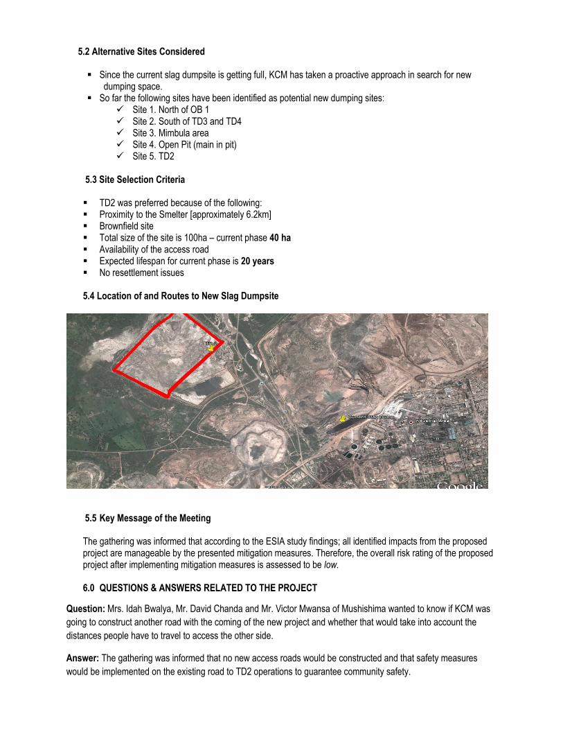
5.2 Alternative Sites Considered
Since the current slag dumpsite is getting full, KCM has taken a proactive approach in search for new dumping space.
So far the following sites have been identified as potential new dumping sites: Site 1. North of OB 1 Site 2. South of TD3 and TD4 Site 3. Mimbula area Site 4. Open Pit (main in pit) Site 5. TD2
5.3 Site Selection Criteria
TD2 was preferred because of the following: Proximity to the Smelter [approximately 6.2km] Brownfield site Total size of the site is 100ha – current phase 40 ha Availability of the access road Expected lifespan for current phase is 20 years No resettlement issues
5.4 Location of and Routes to New Slag Dumpsite
5.5 Key Message of the Meeting
The gathering was informed that according to the ESIA study findings; all identified impacts from the proposed project are manageable by the presented mitigation measures. Therefore, the overall risk rating of the proposed project after implementing mitigation measures is assessed to be low.
6.0 QUESTIONS & ANSWERS RELATED TO THE PROJECT
Question: Mrs. Idah Bwalya, Mr. David Chanda and Mr. Victor Mwansa of Mushishima wanted to know if KCM was
going to construct another road with the coming of the new project and whether that would take into account the
distances people have to travel to access the other side.
Answer: The gathering was informed that no new access roads would be constructed and that safety measures
would be implemented on the existing road to TD2 operations to guarantee community safety.
Question: Mr. Aaron Goma from Mushishima wanted to know what safety measures would be put in place on the
access road.
Answer: The road would be widened, Speed limiters and signage will be installed at every identified risk points such
road crossways on T3 and T5. Haulage road will be restricted to authorised KCM or contractors vehicles.
Question: Mr. Albert Kaluba wanted to know if the slag dump would release toxic substances such as acid which
would pose a danger to community health.
Answer: Granulated slag material which will be dumped at the proposed dumpsite is inert [is not readily reactive with
other elements or substances under normal atmospheric conditions]. However, as a precautionary measure, the
dumpsite will be fenced off to restrict access to the dump by the community.
Question: Mr. Aaron Goma from Mushishima requested KCM to allow miners and contractors who reside at
Mushishima to start using the acid gate to shorten their distance to work.
Answer: The gathering was informed that there are procedures in place with regard to the use of gates at KCM and
these are meant to guarantee safety of people accessing the plant.
Question: Mr.Shiku from Kalilo expressed concern at KCM security checks for the community members who use the
TD2 road from their farms.
Answer: The security checks are done to ensure protection of lives and property for both company and community
assets.
Question: Mr. Titus Tembo (Chingola Mayor) wanted to know if there has been any research on the possible res-use
of the slag material and whether such an idea would be welcomed.
Answer: A lot of research on the slag material has been undertaken and any other research in this area is welcome.
Question: Mr. Jim Mwape (Councillor) wanted to know what would happen if the fence collapsed.
Answer: The fence is meant to restrict access and therefore there would no immediate community health risks,
however, this would be repaired in the shortest possible time.
Question: Mr. W Matemba wanted to know if the streams will not be polluted when there is a pump malfunction.
Answer: The slag dump has a sump with adequate capacity to store runoff effluent. KCM will ensure that within
minimal time, the malfunctioning pump is repaired.
7.0 QUESTIONS & ANSWERS NOT RELATED TO THE PROJECT
Question: Mr. Chamboloshi Billy and W Matemba from Mushishima and Katunga Bulungu respectively, wanted to
know if Mushishima settlement was a legally recognized community settlement.
Answer: A process is in place at the council to demarcate and allocate the land to rightful owners and thereafter
provide them with title deeds.
8.0 STAKEHOLDERS’ RESPONSE.
After providing answers and clarifications to the presentation and stakeholders’ questions, comments and concerns, the gathering accepted the findings of the ESIA for the proposed project.
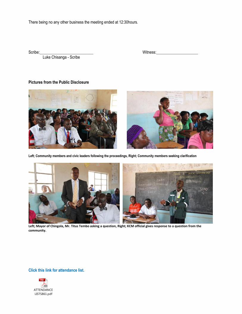
There being no any other business the meeting ended at 12:30hours. Scribe:___________________________ Witness:_____________________
Luke Chisanga - Scribe Pictures from the Public Disclosure
Left; Community members and civic leaders following the proceedings, Right; Community members seeking clarification
Left; Mayor of Chingola, Mr. Titus Tembo asking a question, Right; KCM official gives response to a question from the community.
Click this link for attendance list.
ATTENDANCE
LISTS861.pdf

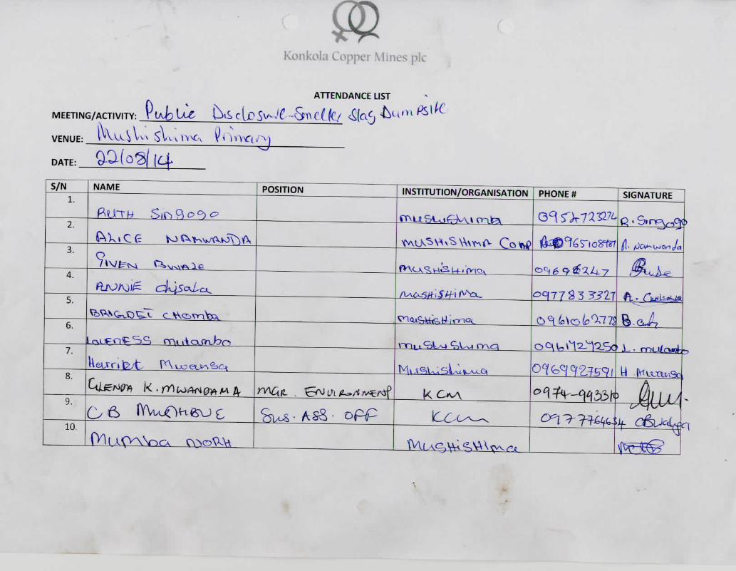
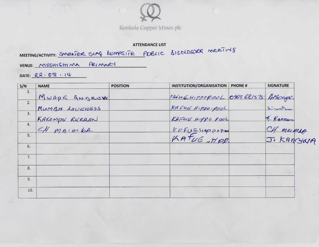
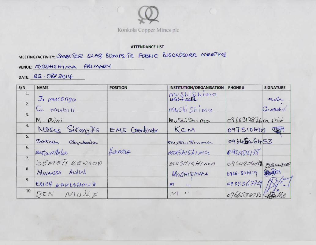
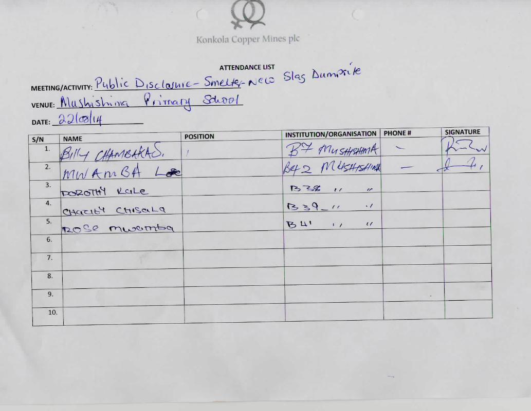
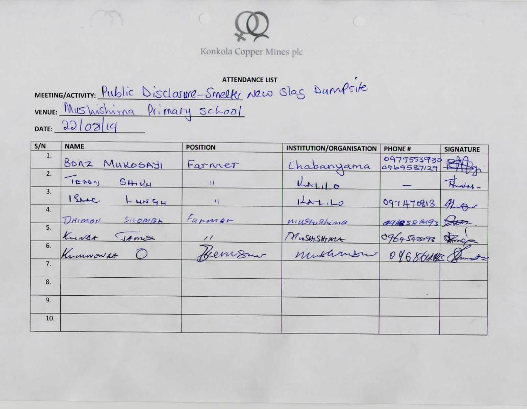
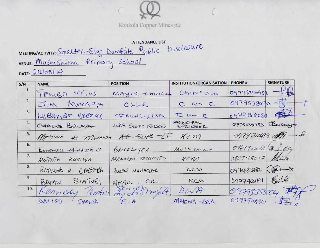
Konkola Copper Mines Plc
New Slag Dump Project
Draft Environmental and Social Impact Statement September 2014
Appendix K
Soils and Land Use Assessment Report
TD2 New Slag Dump Project Soils Assessment Report September 2014
Konkola Copper Mines Plc New Slag Dump Project
Soils Assessment Report i September 2014
Table of Contents
SUMMARY .................................................................................................................................................. ii
1. INTRODUCTION ................................................................................................................................ 1
Soil pH .................................................................................................................................................. 1
Nutrient availability .............................................................................................................................. 1
Biological activity and processes .......................................................................................................... 1
Physically .............................................................................................................................................. 1
Phosphorus ............................................................................................................................................ 2
Nitrogen ................................................................................................................................................ 2
Cation Exchange Capacity (CEC) ......................................................................................................... 3
Soil Texture ........................................................................................................................................... 3
Porosity ................................................................................................................................................. 4
Bulk Density ......................................................................................................................................... 4
Water holding capacity ......................................................................................................................... 4
2. METHODOLOGY ............................................................................................................................... 5
Soil sampling ........................................................................................................................................ 5
3. RESULTS AND DISCUSIONS ........................................................................................................... 7
Chemical Characteristics....................................................................................................................... 8
Physical Characteristics ...................................................................................................................... 10
4. CONCLUSIONS ................................................................................................................................. 12
5. REFERENCES ................................................................................................................................... 13
Konkola Copper Mines Plc New Slag Dump Project
Soils Assessment Report ii September 2014
SUMMARY
The acidity of the soils near the existing TD2 vary from slightly acid to medium acidity while the
acidity of the soils far away from the existing TD2 vary from strong to very strong acidity. To
reduce acidity, the soils will require lime to be applied. Soils near the existing TD2 would
require less lime compared to the soils far away from the existing TD2 which will require more
lime.
The cation exchange capacities at all the sites are low indicating that the soils are of poor
fertility. The soils at all the sites have also low levels of nitrogen. Apart from areas near the
barefoot entrance, the area west of existing TD2, the silted area upstream the control dyke, the
area between the PCD access road and TD2 pump station and the areas towards, the Mushishima
river which have high levels of phosphorus the rest of the areas have low levels of phosphorus.
Except for Helen dump site, the soils with sand in the texture had high porosities while those
without sand had either low or normal porosity. All the soils had very high water holding
capacities in relation to their soil textures.
Kenneth Kondowe
Soils Expert
Konkola Copper Mines Plc New Slag Dump Project
Soils Assessment Report 1 September 2014
1. INTRODUCTION Soils assessment of the proposed TD2 Slag Dump Project area was undertaken as part of the
environmental and social assessment for the project. The assessment was undertaken within and
around the proposed project site.
Soil samples were collected from the project site in order to determine the soil pH, phosphorus,
Nitrogen, Cation Exchange Capacity, (CEC), bulk density, soil texture, water holding capacity
(WHC) and porosity.
This report presents terminologies used and the findings of the assessment.
Soil pH
Soil pH is a useful indicator of the relative acidity or alkalinity of a soil. Soil pH is an important
soil property because it affects the chemical, biological, and physical processes of the soil. To
understand the significance of pH, its effects are listed below:
Nutrient availability
• Controls the availability of the essential nutrients
• Availability of nitrogen, phosphorus, sulfur, calcium, magnesium, sodium, and
molybdenum is limited under acidic conditions
Biological activity and processes
• Determines the abundance of soil microorganism
• Determines which plant species will grow
• Low soil pH slows the biological transformation of ammonium to nitrate
Physically
• Indirectly, high pH can disrupt soil structure, or aggregation.
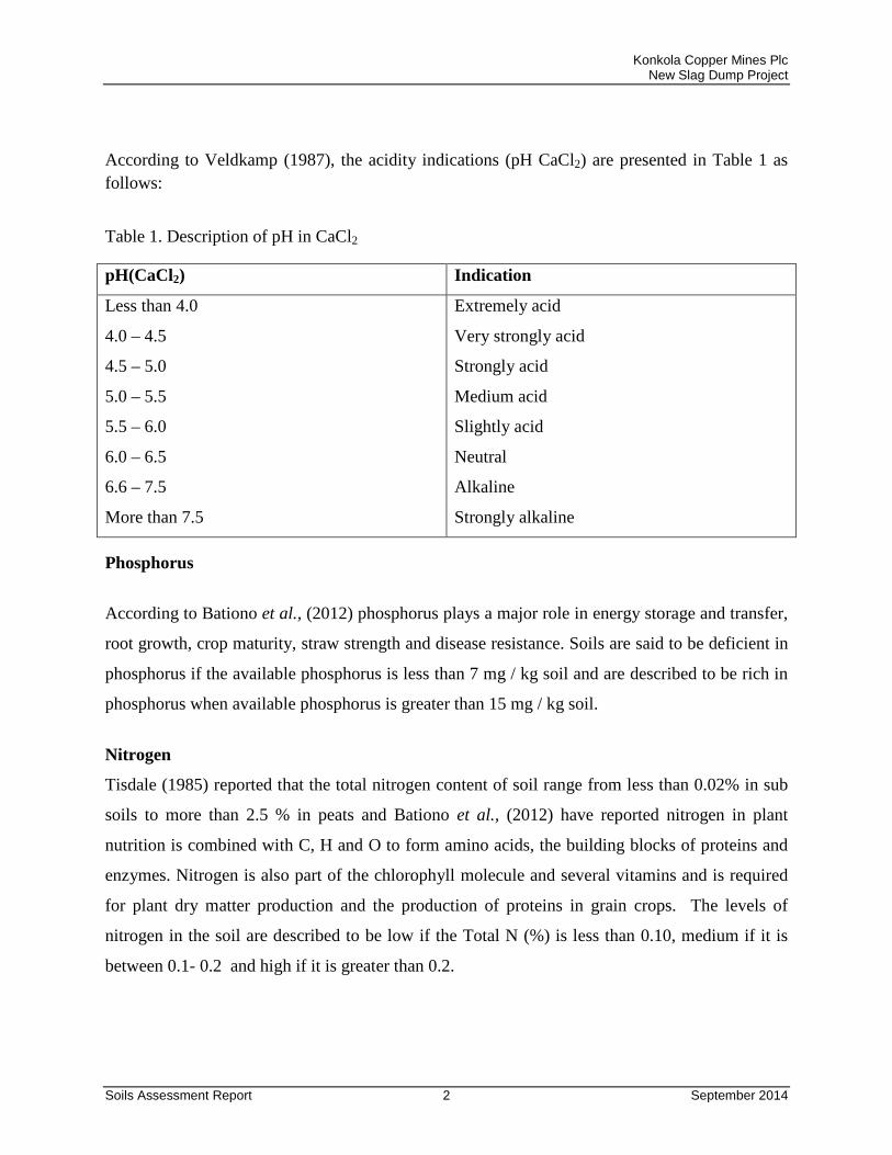
Konkola Copper Mines Plc New Slag Dump Project
Soils Assessment Report 2 September 2014
According to Veldkamp (1987), the acidity indications (pH CaCl2) are presented in Table 1 as follows:
Table 1. Description of pH in CaCl2
pH(CaCl2) Indication
Less than 4.0
4.0 – 4.5
4.5 – 5.0
5.0 – 5.5
5.5 – 6.0
6.0 – 6.5
6.6 – 7.5
More than 7.5
Extremely acid
Very strongly acid
Strongly acid
Medium acid
Slightly acid
Neutral
Alkaline
Strongly alkaline
Phosphorus
According to Bationo et al., (2012) phosphorus plays a major role in energy storage and transfer,
root growth, crop maturity, straw strength and disease resistance. Soils are said to be deficient in
phosphorus if the available phosphorus is less than 7 mg / kg soil and are described to be rich in
phosphorus when available phosphorus is greater than 15 mg / kg soil.
Nitrogen
Tisdale (1985) reported that the total nitrogen content of soil range from less than 0.02% in sub
soils to more than 2.5 % in peats and Bationo et al., (2012) have reported nitrogen in plant
nutrition is combined with C, H and O to form amino acids, the building blocks of proteins and
enzymes. Nitrogen is also part of the chlorophyll molecule and several vitamins and is required
for plant dry matter production and the production of proteins in grain crops. The levels of
nitrogen in the soil are described to be low if the Total N (%) is less than 0.10, medium if it is
between 0.1- 0.2 and high if it is greater than 0.2.
Konkola Copper Mines Plc New Slag Dump Project
Soils Assessment Report 3 September 2014
Cation Exchange Capacity (CEC)
The Cation Exchange Capacity (CEC) is the sum total of exchangeable cations that a soil can
adsorb, expressed in millequivalents per 100 grams of soil, clay or organic colloid. CEC, is a
calculated value that is an estimate of the soils ability to attract, retain, and exchange cation
elements. In general, the more fertile the soil the higher the CEC. The cation Exchange Capacity
is expressed in me / 100 g soil or cmol / kg soil, i.e 1 me / 100 g soil is equivalent to 1 cmol/ kg
soil. Soils with low retention capacity have CEC of less than 2.0 me/ 100 grams of soil and the
soils with CEC of more than 8 me / 100 grams soil have high retention capacity.
Soil Texture
The soil mineral fraction is divided into three fractions depending on particle size:
• Sand has a particle size ranging from 50 to 2000 μm (0.05 – 2.0 mm) in diameter. Sand
imparts a gritty feel to soil due to the shape of the individual particles.
• Silt has a particle size ranging from 2 to 50 μm (0.002 – 0.05 mm) in diameter. When
moist, silt has a floury feel and does not ribbon when pressed between the thumb and
forefinger due to the shape of the individual particles. When placed between the teeth silt
has a gritty feeling.
• Clay has a particle size < 2 μm (< 0.002 mm) in diameter. Clay exhibits colloidal
properties, has a negative charge and is flat and plate-like in shape. Moist clay is sticky
and will ribbon readily when pressed between the thumb and forefinger. When placed
between the teeth clay has a smooth slick feeling.
The proportions of sand, silt and clay determines soil texture. For example, a sandy loam soil
contains much sand whilst a silty - clay loam contains mainly silt and clay. Soil texture is a very
important feature because it determines to a large extent the dynamics of water flow in the soil.
Konkola Copper Mines Plc New Slag Dump Project
Soils Assessment Report 4 September 2014
Soils containing a large proportion of clay are difficult to work, particularly if the clay fraction
comprises so-called shrink– swell clays. Soils containing a large proportion of sand are more
drought- prone than soils containing more clay.
Soil texture affects the behavior of soils in terms of:
• water-holding capacity;
• nutrient retention and supply;
• drainage; and
• Nutrient leaching.
In general, the vertical flow of water in soil (i.e., the water percolation rate) is much higher in
sandy soils compared with clayey soils. Nutrients are contained in percolating water and may
therefore be transported below the reach of plant roots.
Porosity
The porosity of soil is the volume of the soil occupied by air and the solution. It provides space
for roots and microorganisms to breathe and for water storage.
Porosity can be measured from the volume of a non polar liquid such as paraffin that is absorbed
into a dry ped under vacuum. Alternatively, porosity may be determined indirectly from the bulk
density and particle density
Bulk Density
Bulk density is the weight of soil for a given volume. It is used to measure compaction and to
correct measurements of soil organic matter for differences in bulk density. In general, the
greater the density, the less pore space for water movement, root growth and penetration, and
seedling germination. Average bulk density of cultivable loam soils is 1.1 – 1.4 g cm-3. For good
plant growth bulk density need to be below 1.4 g cm-3 for clays and 1.6 g cm-3 for sand soils.
Water holding capacity
The water holding capacity of the soil is the amount of water obtained after subtracting the
amount of water held at permanent wilting point from amount of water held at field capacity.
Konkola Copper Mines Plc New Slag Dump Project
Soils Assessment Report 5 September 2014
Field capacity is the percentage of soil moisture that is held with water potential less than 1/3 bar
and is the measure of the greatest amount of water that a soil can hold, or store, under conditions
of complete wetting followed by free drainage. Field capacity values are used to determine the
amount of irrigation water needed and the amount of stored water available to plants while the
permanent wilting percentage is the percentage of soil water held with water potential less than -
15 bars; it is held so strongly that plants are not able to absorb it fast enough for their needs. The
water holding capacity is obtained either gravimetrically gg-1, or volumetrically in cm3/cm3 or %.
The result obtained volumetrically is converted to mm/m soil by multiplying the results in
cm3/cm3 by 1000.
2. METHODOLOGY
Soil sampling
To determine the soil pH, texture, cation exchange capacity, Nitrogen and Phosphorus, three sub
samples were collected at a depth of 0 – 20 cm using a soil auger in each area. The subsamples
were then thoroughly mixed to obtain a composite sample. The total number of composite
samples collected was 11. For bulk density, porosity and water holding capacity, a core ring was
used to collect one sample at each of the sampling points. A total of 11 core ring samples were
also collected. The samples collected were taken to the Soil Science Department of the School of
Agricultural Sciences at the University of Zambia, for analysis. Table 2 below presents the
description of the sampling points of the project.
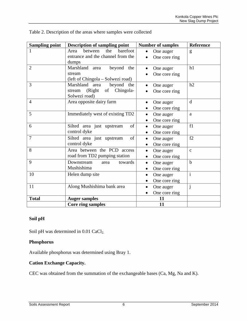
Konkola Copper Mines Plc New Slag Dump Project
Soils Assessment Report 6 September 2014
Table 2. Description of the areas where samples were collected Sampling point Description of sampling point Number of samples Reference 1 Area between the barefoot
entrance and the channel from the dumps
• One auger • One core ring
g
2 Marshland area beyond the stream (left of Chingola – Solwezi road)
• One auger • One core ring
h1
3 Marshland area beyond the stream (Right of Chingola- Solwezi road)
• One auger • One core ring
h2
4 Area opposite dairy farm • One auger • One core ring
d
5 Immediately west of existing TD2 • One auger • One core ring
a
6 Silted area just upstream of control dyke
• One auger • One core ring
f1
7 Silted area just upstream of control dyke
• One auger • One core ring
f2
8 Area between the PCD access road from TD2 pumping station
• One auger • One core ring
c
9 Downstream area towards Mushishima
• One auger • One core ring
b
10 Helen dump site • One auger • One core ring
i
11 Along Mushishima bank area • One auger • One core ring
j
Total Auger samples 11 Core ring samples 11
Soil pH Soil pH was determined in 0.01 CaCl2.
Phosphorus
Available phosphorus was determined using Bray 1.
Cation Exchange Capacity.
CEC was obtained from the summation of the exchangeable bases (Ca, Mg, Na and K).
Konkola Copper Mines Plc New Slag Dump Project
Soils Assessment Report 7 September 2014
Soil texture
The Particle size analysis was carried out using the Bouyoucos and Hydrometer Method
(Bouyoucos, 1962). After determining the amounts of the sand, silt and clay present in the soils,
the textural classes of the soils were obtained using the United States Department of Agriculture
(USDA) Textural triangle.
Nitrogen
The kjeldahl method was used which is a wet digestion procedure which allows for the complete
breakdown or oxidation of organic matter, in the process converting the protein N to ammonia
form by heating with H2SO4. The N extracted by digestion was determined by distillation and
titration.
Porosity
Porosity was determined by calculation after determining the bulk density for each soil sample
using the equation below:
𝑃𝑜𝑟𝑒 𝑠𝑝𝑎𝑐𝑒 (%) = 100 − �𝑃𝑏𝑃𝑠 ∗ 100�
Where Pb is the bulk density for each soil sample and Ps is the particle density whose value is
2.65 gcm-3
3. RESULTS AND DISCUSIONS
The results from the chemical analysis of the samples are presented in Table 3.
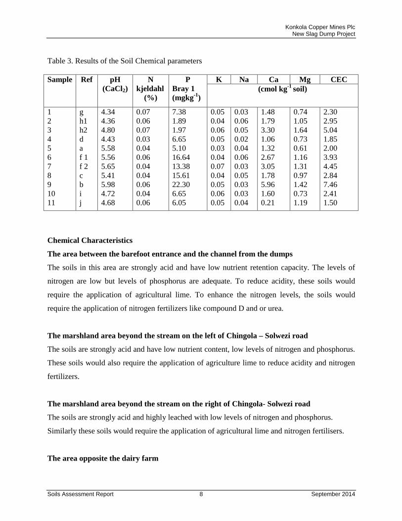
Konkola Copper Mines Plc New Slag Dump Project
Soils Assessment Report 8 September 2014
Table 3. Results of the Soil Chemical parameters
Sample Ref pH
(CaCl2) N
kjeldahl (%)
P Bray 1 (mgkg-1)
K Na Ca Mg CEC (cmol kg-1 soil)
1 2 3 4 5 6 7 8 9 10 11
g h1 h2 d a f 1 f 2 c b i j
4.34 4.36 4.80 4.43 5.58 5.56 5.65 5.41 5.98 4.72 4.68
0.07 0.06 0.07 0.03 0.04 0.06 0.04 0.04 0.06 0.04 0.06
7.38 1.89 1.97 6.65 5.10 16.64 13.38 15.61 22.30 6.65 6.05
0.05 0.04 0.06 0.05 0.03 0.04 0.07 0.04 0.05 0.06 0.05
0.03 0.06 0.05 0.02 0.04 0.06 0.03 0.05 0.03 0.03 0.04
1.48 1.79 3.30 1.06 1.32 2.67 3.05 1.78 5.96 1.60 0.21
0.74 1.05 1.64 0.73 0.61 1.16 1.31 0.97 1.42 0.73 1.19
2.30 2.95 5.04 1.85 2.00 3.93 4.45 2.84 7.46 2.41 1.50
Chemical Characteristics
The area between the barefoot entrance and the channel from the dumps
The soils in this area are strongly acid and have low nutrient retention capacity. The levels of
nitrogen are low but levels of phosphorus are adequate. To reduce acidity, these soils would
require the application of agricultural lime. To enhance the nitrogen levels, the soils would
require the application of nitrogen fertilizers like compound D and or urea.
The marshland area beyond the stream on the left of Chingola – Solwezi road
The soils are strongly acid and have low nutrient content, low levels of nitrogen and phosphorus.
These soils would also require the application of agriculture lime to reduce acidity and nitrogen
fertilizers.
The marshland area beyond the stream on the right of Chingola- Solwezi road
The soils are strongly acid and highly leached with low levels of nitrogen and phosphorus.
Similarly these soils would require the application of agricultural lime and nitrogen fertilisers.
The area opposite the dairy farm
Konkola Copper Mines Plc New Slag Dump Project
Soils Assessment Report 9 September 2014
The area has very strongly acid soils with low nutrient retention capacity. The levels of nitrogen
and phosphorus are low.
The area immediately west of existing TD2
The site is slightly acid and has low nutrient retention capacity. The levels of nitrogen and
phosphorus are low. These soils would require lime application but the dosage required will be
lower than that required in the above mentioned points. Fertilizer will also be required to
enhance the nitrogen and phosphorus levels.
Silted area just upstream of control dyke The soils are slightly acidic with low nutrient content and nitrogen levels. The soils are however
rich in phosphorus.
Silted area just upstream of control dyke
The soils were slightly acid with low nutrient retention but the levels of phosphorus slightly low.
The area between the PCD access road from TD2 pumping station.
The soils are of medium acidity, low nutrient retention and nitrogen but rich in phosphorus.
The downstream area towards Mushishima
The soils in this area are slightly acidic, have low nutrient retention but rich in phosphorus.
The Helen dump site
Soils in the Helen dump site are strongly acid with low nutrient retention, nitrogen and
phosphorus.
The soils along Mushishima bank area
Soils along the Mushishima bank area are strongly acid soil with low levels of nutrients, nitrogen
and phosphorus.
The results of the physical properties of the soil samples are presented in Table 4.
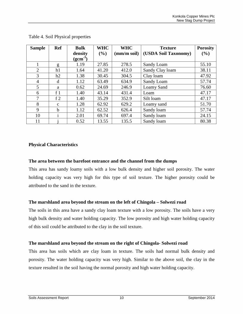
Konkola Copper Mines Plc New Slag Dump Project
Soils Assessment Report 10 September 2014
Table 4. Soil Physical properties Sample Ref Bulk
density (gcm-3)
WHC (%)
WHC (mm/m soil)
Texture (USDA Soil Taxonomy)
Porosity (%)
1 g 1.19 27.85 278.5 Sandy Loam 55.10 2 h1 1.64 41.20 412.0 Sandy Clay loam 38.11 3 h2 1.38 30.45 304.5 Clay loam 47.92 4 d 1.12 63.49 634.9 Sandy Loam 57.74 5 a 0.62 24.69 246.9 Loamy Sand 76.60 6 f 1 1.40 43.14 431.4 Loam 47.17 7 f 2 1.40 35.29 352.9 Silt loam 47.17 8 c 1.28 62.92 629.2 Loamy sand 51.70 9 b 1.12 62.52 626.4 Sandy loam 57.74 10 i 2.01 69.74 697.4 Sandy loam 24.15 11 j 0.52 13.55 135.5 Sandy loam 80.38
Physical Characteristics
The area between the barefoot entrance and the channel from the dumps
This area has sandy loamy soils with a low bulk density and higher soil porosity. The water
holding capacity was very high for this type of soil texture. The higher porosity could be
attributed to the sand in the texture.
The marshland area beyond the stream on the left of Chingola – Solwezi road
The soils in this area have a sandy clay loam texture with a low porosity. The soils have a very
high bulk density and water holding capacity. The low porosity and high water holding capacity
of this soil could be attributed to the clay in the soil texture.
The marshland area beyond the stream on the right of Chingola- Solwezi road
This area has soils which are clay loam in texture. The soils had normal bulk density and
porosity. The water holding capacity was very high. Similar to the above soil, the clay in the
texture resulted in the soil having the normal porosity and high water holding capacity.
Konkola Copper Mines Plc New Slag Dump Project
Soils Assessment Report 11 September 2014
The area opposite the dairy farm
The soils in this area are sandy loam. They are of low bulk density, high porosity and very high
water holding capacity.
The area immediately west of existing TD2
The soils in this area have a loamy sand texture with low bulk density. The soils have a higher
degree of porosity and very high water holding capacity
The silted area just upstream of control dyke
The area has loamy soil with a normal bulk density and porosity. The water holding capacity of
the soils in this area was very high.
The silted area just upstream of control dyke Reference
The soils in this area have a silty loam texture with slightly high bulk density. The soils have
normal porosity. The water holding capacity was very high.
The area between the PCD access road from TD2 pumping station
The soils in this area are loamy sand with low bulk density, high porosity and very high water
holding capacity.
The downstream area towards Mushishima
This area has sandy loam soils with low bulk density, higher porosity and very high water
holding capacity.
The Helen dump site
Soils in the Helen dump site have a sandy loam texture with a higher bulk density, low porosity
and very high water holding capacity.
The soils along Mushishima bank area
Konkola Copper Mines Plc New Slag Dump Project
Soils Assessment Report 12 September 2014
This area has sandy loam soils with low bulk density and higher porosity. The water holding
capacity of the soils in this area was slightly high.
4. CONCLUSIONS
The acidity of the soils near the existing TD2 vary from slightly acid to medium acidity while the
acidity of the soils far away from the existing TD2 vary from strong to very strong acidity. To
reduce acidity, the soils will require lime to be applied. Soils near the existing TD2 would
require less lime compared to the soils far away from the existing TD2 which will require more
lime.
The cation exchange capacities at all the sites are low indicating that the soils are of poor
fertility. The soils at all the sites have also low levels of nitrogen. Apart from areas near the
barefoot entrance, the area west of existing TD2, the silted area upstream the control dyke, the
area between the PCD access road and TD2 pump station and the areas towards, the Mushishima
river which have high levels of phosphorus the rest of the areas have low levels of phosphorus.
Except for Helen dump site, the soils with sand in the texture had high porosities while those
without sand had either low or normal porosity. All the soils had very high water holding
capacities in relation to their soil textures.
Konkola Copper Mines Plc New Slag Dump Project
Soils Assessment Report 13 September 2014
5. REFERENCES Bationo, A., T. Fairhurst., K. Giller., V.Kelly., R. Lunduka., A. Mando., P. Mapfumao., G. Oduar., D. Romney., B. Vanlauwe., L. Wairegi and S. Zingore . 2012. Africa Soil Health Consortium.Hand book for soil fertility management. Tisdale, S. 1985. Soil fertility and fertilizers. Macmillan publishing company 866, third avenue, New York. Veldkamp, W.J . 1987. Soils of Zambia. Soil Survey Unit , Department of Agriculture, Mt. Makulu.
Konkola Copper Mines Plc
New Slag Dump Project
Draft Environmental and Social Impact Statement September 2014
Appendix L
Social Impact Assessment Report
Proposed TD2 Slag Dump Project
Social Impact Assessment Study
Prepared by Mitulo Silengo, PhD
Signed:
URS Scott Wilson Zambia 24 Enos Chomba Avenue
PO Box 22496 Kitwe
Zambia
TD2 Slag Dump Project Draft SIA Baseline Report
i
Table of Contents
Table of Contents
Executive Summary ........................................................................................................ ii
List of Acronyms ............................................................................................................. iv
1. Introduction .............................................................................................................. 1
2. Methodology ............................................................................................................ 1
2.1 Desktop Study ................................................................................................... 1
2.2 Stakeholder Mapping ........................................................................................ 2
3. Baseline Conditions ................................................................................................. 3
4. Potential Impacts of the Proposed Project .............................................................. 13
Loss of Land and Settlement ..................................................................................... 14
Resettlement and Vulnerability .................................................................................. 15
Noise Receptors ........................................................................................................ 15
Community Level Project Perceptions .................................................................... 15
Health and Safety - Construction Noise .................................................................. 15
ISSUES ..................................................................................................................... 15
5. Potential Impacts and Mitigation/Enhancement Measures ..................................... 16
Noise Decay .............................................................................................................. 16
Prevention and control of traffic related accidents ...................................................... 17
Safety Communication ............................................................................................... 17
References .................................................................................................................... 18
TD2 Slag Dump Project Draft SIA Baseline Report
ii
Executive Summary Konkola Copper Mines is proposing to develop, manage and operate the new Slag Dump at TD2. Currently the slag disposed of at Slag Dump No.25, located within the Mine License Area. There is presently inadequate space to dispose of the slag. Consequently, there is demand for an alternative dumping space within KCM Surface Rights in Chingola before the existing dump reaches its design capacity. As part of the Environmental and Social Impact Assessment process, a social impact assessment study was undertaken for the proposed project. The methodology used in carrying out the social impact assessment included desktop review of documents and report, stakeholder analysis, Focus Group Discussions, Key Informant Interviews and field work. Fenceline stakeholders identified included the New Mushishima Primary School, Mushishima Community, Milenda Dairy Farm, Kamana Farm and Munga Farm. Chingola District as one of the urban centres in the Copperbelt is well served by social services and amenities. The district has a good network of urban and township roads. It is linked to other Copperbelt towns of Chambeshi, Chililabombwe, Kitwe and Mufulira by a good network of tarred trunk roads. The district is connected to north-west by the T5 Chingola-Solwezi road. The economy of the district is aligned with the mining activities, which in Chingola are undertaken by KCM. Other livelihood activities in the district include agriculture, which is generally practiced at subsistence level. The main crop grown is maize. Maize is grown both for consumption and for market. Other crops grown in the district are groundnuts. Fishing is done downstream of the TD2 at a subsistence level in the Mushishima Stream and the Kafue River. Fishing hooks and nets are used to catch fish. Canoes are used on the Mushishima Stream to set the nets. In the area of the proposed project KCM in partnership with DAAP has been implementing livelihood programmes in collaboration with community-based and non-governmental organizations. The activities focus on income generation, personal hygiene, sustainable livelihood and training. The area of influence for the proposed project is both localized and regional. The local area of influence relates to the TD2 project footprint on the immediate surroundings, and also extends many kilometres downstream of the Mushishima Stream and Kafue River. The direct area of influence of the proposed project covers all areas directly affected by project impacts on such as noise-sensitive social receptors. This includes the New Mushishima Primary School, Mushishima Community, Milenda Dairy Farm, Kamana Farm and Munga Farm. Noise and vibrations from heavy plant such as dump trucks will affect these social receptors. Non-Fenceline social receptors located in the direct area of influence but not in close proximity of the project include the settlements of Katungabulungu, Kalilo, Fisonge, Shimulala, Kakosa and Kafue Hippo Pool downstream along the Kafue River from the project site.
TD2 Slag Dump Project Draft SIA Baseline Report
iii
The Secondary Impact Zone includes the district-wide social receptors with socioeconomic and infrastructure impacts produced by the project. These include both residents and non-residents of Chingola who travel along the T5 Chingola-Solwezi Road. These road users will be subjected traffic delays as dump trucks crisscross the Chingola-Solwezi Road with their payload destined for dumping at TD2. In particular there are potential safety impacts along this route, which is also used by pedestrians and cyclists traveling to Chingola. Socio-economic concerns arising from the implementation of the proposed project include security anxieties for the community of Mushishima when the project starts, as there will be more material for ‘illegal miners’ to scavenge for copper, and scrap metal. Other concerns relate to traffic and safety as many community members from Kalilo use the road running parallel to the dumps. Additionally is expected that dust will be of serious concern in the dry season. Pollution of the Mushishima stream was a major concern expressed by community members of Mushishima, Shimulala and Hippo Pool settlements. Impacts arising from crisscrossing dump trucks will be congestion, especially for traffic from town and for people travelling to Solwezi and noise and vibrations to be generated by this heavy vehicular traffic. The recommended social management plan measures include:
• Adopting limits for trip duration • Avoiding dangerous routes and times of day to reduce the risk of
accidents • Dust suppression can be achieved by regular watering of the route. • Minimizing pedestrian interaction with operational vehicles • Collaboration with local communities and responsible authorities to
improve signage, visibility and overall safety of roads. • The route should be lined with traffic-calming devices, especially near the
crossing point of the dump trucks. • Installation of traffic lights at the crossing point on T5 Chingola-Solwezi
Road. • Involve the Road Transport and Safety Agency in sensitizing the local
communities, especially Mushishima settlement and pupils at the New Mushishima Primary School.
TD2 Slag Dump Project Draft SIA Baseline Report
iv
List of Acronyms CSO Central Statistical Office DAPP Development Aid People to People dB Decibels DDCC District Development Coordinating Committee DSTv Digital Satellite Television EHS Environmental, Health, and Safety GDP Gross Domestic Product GII Gender Inequality Index GNI Gross National Income GPI Gender Parity Index HDI Human Development Index IFC International Finance Corporation KCM Konkola Copper Mines MDGs Millennium Development Goals MFEZ Multi-Facility Economic Zone PDI Provincial Development Index PPP Purchasing Power Parity SNDP Sixth National Development Plan TV Television UNDP United Development Programme ZCCM Zambia Consolidated Copper Mines ZESCO Zambia Electricity Supply Corporation ZHDR Zambia Human Development Report
TD2 Slag Dump Project Draft SIA Baseline Report
1
1. Introduction Konkola Copper Mines is proposing to develop, manage and operate the new Slag Dump at TD2. Currently the slag disposed of at Slag Dump No.25, located within the Mine License Area. There is presently inadequate space to dispose of the slag. Consequently, there is demand for an alternative dumping space within KCM Surface Rights in Chingola before the existing dump reaches its design capacity. As part of the Environmental and Social Impact Assessment process, a social impact assessment study was undertaken for the proposed project. The methodology used in carrying out the social impact assessment included desktop review of documents and report, stakeholder analysis, Focus Group Discussions, Key Informant Interviews and field work. Fenceline stakeholders identified included the New Mushishima Primary School, Mushishima Community, Milenda Dairy Farm, Kamana Farm and Munga Farm. The social impact study was carried out to identify the impacts of the proposed project on the surrounding communities as part of the overall Environmental and Social Impact Assessment process for the proposed TD2 Slag Dump. 2. Methodology The methodology used in carrying out the social impact assessment included desktop review of documents and report, stakeholder analysis, Focus Group Discussions, Key Informant Interviews and field work.
2.1 Desktop Study The following documents provided were useful in providing background information and data for the desktop study:
• Zambia Millennium Development Goals (MDGs) Progress Report.
• Zambia Post Millennium Development Goals (MDGs) Agenda Report.
• Zambia Human Development Report 2011
• Zambia 2011 Sixth National Development Plan (2011-2015).
• Zambia 2010 Census of Population and Housing Preliminary Report.
• Zambia Vision 2030: “A prosperous Middle-income Nation By 2030”
• United Nations Human Development Report 2013.
TD2 Slag Dump Project Draft SIA Baseline Report
2
• Vendata Resources plc Social Policy 2011
• Konkola Copper Mines plc Social Policy 2012
• IFC Performance Standards on Environmental and Social
Sustainability 2012
• IFC Environmental, Health, and Safety (EHS) Guidelines: General EHS Guidelines: Community Health And Safety 2007
2.2 Stakeholder Mapping Communities identified as important stakeholders include:
• Mushishima Community • Milenda Dairy Farm • Kamana Farm • Munga Farm • Katungabulungu Community along the T5 Chingola-Solwezi Road • Hippo Pool Community along the T3 Chingola-Chililabombwe Road • Shimulala Community • Kalilo Community
Fenceline Stakeholders The fenceline stakeholders identified include the New Mushishima Primary School, Mushishima Community, Milenda Dairy Farm, Kamana Farm and Munga Farm. Focus Groups A number of focus group discussions were held with households in the communities considered to be composed of Interested and Affected Parties (I&APs ) in order to build upon key issues, and examine more in-depth socio-economic issues and potential impacts, and help identify vulnerable receptors. Focus group discussion covered key stakeholders from:
• Residents downstream of the Kafue River at Hippo Pool • Residents and Ward leaders at Kalilo.
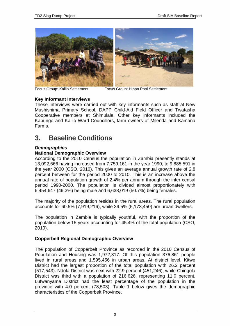
TD2 Slag Dump Project Draft SIA Baseline Report
3
Focus Group: Kalilo Settlement Focus Group: Hippo Pool Settlement Key Informant Interviews These interviews were carried out with key informants such as staff at New Mushishima Primary School, DAPP Child-Aid Field Officer and Twatasha Cooperative members at Shimulala. Other key informants included the Kabungo and Kalilo Ward Councillors, farm owners of Milenda and Kamana Farms. 3. Baseline Conditions Demographics National Demographic Overview According to the 2010 Census the population in Zambia presently stands at 13,092,666 having increased from 7,759,161 in the year 1990, to 9,885,591 in the year 2000 (CSO, 2010). This gives an average annual growth rate of 2.8 percent between for the period 2000 to 2010. This is an increase above the annual rate of population growth of 2.4% per annum through the inter-censal period 1990-2000. The population is divided almost proportionately with 6,454,647 (49.3%) being male and 6,638,019 (50.7%) being females. The majority of the population resides in the rural areas. The rural population accounts for 60.5% (7,919,216), while 39.5% (5,173,450) are urban dwellers. The population in Zambia is typically youthful, with the proportion of the population below 15 years accounting for 45.4% of the total population (CSO, 2010). Copperbelt Regional Demographic Overview The population of Copperbelt Province as recorded in the 2010 Census of Population and Housing was 1,972,317. Of this population 376,861 people lived in rural areas and 1,595,456 in urban areas. At district level, Kitwe District had the largest proportion of the total population with 26.2 percent (517,543). Ndola District was next with 22.9 percent (451,246), while Chingola District was third with a population of 216,626, representing 11.0 percent. Lufwanyama District had the least percentage of the population in the province with 4.0 percent (78,503). Table 1 below gives the demographic characteristics of the Copperbelt Province.
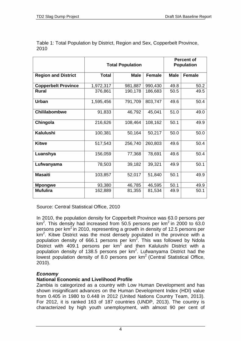
TD2 Slag Dump Project Draft SIA Baseline Report
4
Table 1: Total Population by District, Region and Sex, Copperbelt Province, 2010
Total Population Percent of Population
Region and District Total Male Female Male Female
Copperbelt Province 1,972,317 981,887 990,430 49.8 50.2 Rural 376,861 190,178 186,683 50.5
49.5
Urban 1,595,456 791,709 803,747 49.6 50.4
Chililabombwe
91,833 46,792 45,041 51.0 49.0
Chingola
216,626 108,464 108,162 50.1 49.9
Kalulushi
100,381 50,164 50,217 50.0 50.0
Kitwe
517,543 256,740 260,803 49.6 50.4
Luanshya 156,059 77,368 78,691 49.6 50.4
Lufwanyama 78,503 39,182 39,321 49.9 50.1
Masaiti 103,857 52,017 51,840 50.1 49.9
Mpongwe 93,380 46,785 46,595 50.1 49.9 Mufulira 162,889 81,355 81,534 49.9 50.1
Source: Central Statistical Office, 2010 In 2010, the population density for Copperbelt Province was 63.0 persons per km2. This density had increased from 50.5 persons per km2 in 2000 to 63.0 persons per km2 in 2010, representing a growth in density of 12.5 persons per km2. Kitwe District was the most densely populated in the province with a population density of 666.1 persons per km2. This was followed by Ndola District with 409.1 persons per km2 and then Kalulushi District with a population density of 138.5 persons per km2. Lufwanyama District had the lowest population density of 8.0 persons per km2 (Central Statistical Office, 2010). Economy National Economic and Livelihood Profile Zambia is categorized as a country with Low Human Development and has shown insignificant advances on the Human Development Index (HDI) value from 0.405 in 1980 to 0.448 in 2012 (United Nations Country Team, 2013). For 2012, it is ranked 163 of 187 countries (UNDP, 2013). The country is characterized by high youth unemployment, with almost 90 per cent of
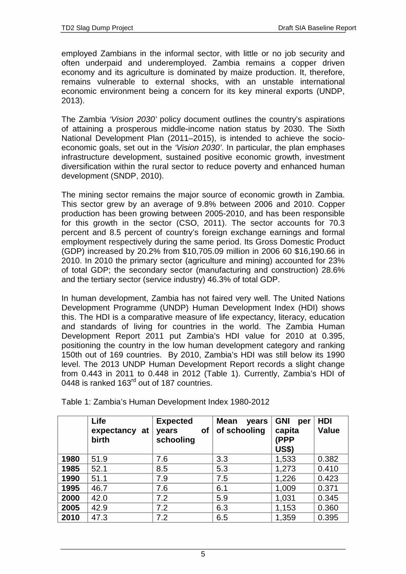
TD2 Slag Dump Project Draft SIA Baseline Report
5
employed Zambians in the informal sector, with little or no job security and often underpaid and underemployed. Zambia remains a copper driven economy and its agriculture is dominated by maize production. It, therefore, remains vulnerable to external shocks, with an unstable international economic environment being a concern for its key mineral exports (UNDP, 2013). The Zambia ‘Vision 2030’ policy document outlines the country’s aspirations of attaining a prosperous middle-income nation status by 2030. The Sixth National Development Plan (2011–2015), is intended to achieve the socio-economic goals, set out in the ‘Vision 2030’. In particular, the plan emphases infrastructure development, sustained positive economic growth, investment diversification within the rural sector to reduce poverty and enhanced human development (SNDP, 2010). The mining sector remains the major source of economic growth in Zambia. This sector grew by an average of 9.8% between 2006 and 2010. Copper production has been growing between 2005-2010, and has been responsible for this growth in the sector (CSO, 2011). The sector accounts for 70.3 percent and 8.5 percent of country’s foreign exchange earnings and formal employment respectively during the same period. Its Gross Domestic Product (GDP) increased by 20.2% from $10,705.09 million in 2006 60 $16,190.66 in 2010. In 2010 the primary sector (agriculture and mining) accounted for 23% of total GDP; the secondary sector (manufacturing and construction) 28.6% and the tertiary sector (service industry) 46.3% of total GDP. In human development, Zambia has not faired very well. The United Nations Development Programme (UNDP) Human Development Index (HDI) shows this. The HDI is a comparative measure of life expectancy, literacy, education and standards of living for countries in the world. The Zambia Human Development Report 2011 put Zambia’s HDI value for 2010 at 0.395, positioning the country in the low human development category and ranking 150th out of 169 countries. By 2010, Zambia’s HDI was still below its 1990 level. The 2013 UNDP Human Development Report records a slight change from 0.443 in 2011 to 0.448 in 2012 (Table 1). Currently, Zambia’s HDI of 0448 is ranked 163rd out of 187 countries. Table 1: Zambia’s Human Development Index 1980-2012 Life
expectancy at birth
Expected years of schooling
Mean years of schooling
GNI per capita (PPP US$)
HDI Value
1980 51.9 7.6 3.3 1,533 0.382 1985 52.1 8.5 5.3 1,273 0.410 1990 51.1 7.9 7.5 1,226 0.423 1995 46.7 7.6 6.1 1,009 0.371 2000 42.0 7.2 5.9 1,031 0.345 2005 42.9 7.2 6.3 1,153 0.360 2010 47.3 7.2 6.5 1,359 0.395
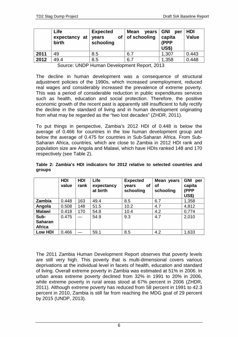
TD2 Slag Dump Project Draft SIA Baseline Report
6
Life expectancy at birth
Expected years of schooling
Mean years of schooling
GNI per capita (PPP US$)
HDI Value
2011 49 8.5 6.7 1,307 0.443 2012 49.4 8.5 6.7 1,358 0.448 Source: UNDP Human Development Report, 2013 The decline in human development was a consequence of structural adjustment policies of the 1990s, which increased unemployment, reduced real wages and considerably increased the prevalence of extreme poverty. This was a period of considerable reduction in public expenditures services such as health, education and social protection. Therefore, the positive economic growth of the recent past is apparently still insufficient to fully rectify the decline in the standard of living and in human development originating from what may be regarded as the “two lost decades” (ZHDR, 2011). To put things in perspective, Zambia’s 2012 HDI of 0.448 is below the average of 0.466 for countries in the low human development group and below the average of 0.475 for countries in Sub-Saharan Africa. From Sub-Saharan Africa, countries, which are close to Zambia in 2012 HDI rank and population size are Angola and Malawi, which have HDIs ranked 148 and 170 respectively (see Table 2). Table 2: Zambia’s HDI indicators for 2012 relative to selected countries and groups HDI
value HDI rank
Life expectancy at birth
Expected years of schooling
Mean years of schooling
GNI per capita (PPP US$)
Zambia 0.448 163 49.4 8.5 6.7 1,358 Angola 0.508 148 51.5 10.2 4.7 4,812 Malawi 0.418 170 54.8 10.4 4.2 0,774 Sub-Saharan Africa
0.475 — 54.9 9.3 4.7 2,010
Low HDI 0.466 — 59.1 8.5 4.2 1,633 The 2011 Zambia Human Development Report observes that poverty levels are still very high. This poverty that is multi-dimensional covers various deprivations at the individual level in facets of health, education and standard of living. Overall extreme poverty in Zambia was estimated at 51% in 2006. In urban areas extreme poverty declined from 32% in 1991 to 20% in 2006, while extreme poverty in rural areas stood at 67% percent in 2006 (ZHDR, 2011). Although extreme poverty has reduced from 58 percent in 1991 to 42.3 percent in 2010, Zambia is still far from reaching the MDG goal of 29 percent by 2015 (UNDP, 2013).
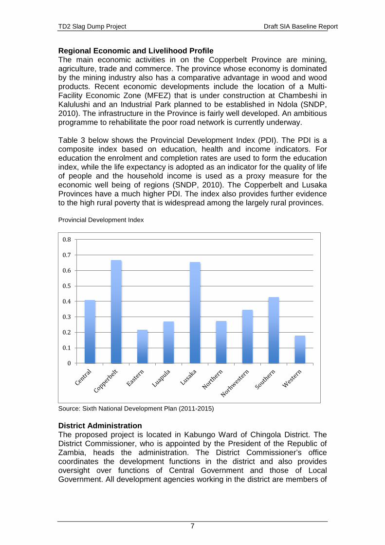
TD2 Slag Dump Project Draft SIA Baseline Report
7
Regional Economic and Livelihood Profile The main economic activities in on the Copperbelt Province are mining, agriculture, trade and commerce. The province whose economy is dominated by the mining industry also has a comparative advantage in wood and wood products. Recent economic developments include the location of a Multi-Facility Economic Zone (MFEZ) that is under construction at Chambeshi in Kalulushi and an Industrial Park planned to be established in Ndola (SNDP, 2010). The infrastructure in the Province is fairly well developed. An ambitious programme to rehabilitate the poor road network is currently underway. Table 3 below shows the Provincial Development Index (PDI). The PDI is a composite index based on education, health and income indicators. For education the enrolment and completion rates are used to form the education index, while the life expectancy is adopted as an indicator for the quality of life of people and the household income is used as a proxy measure for the economic well being of regions (SNDP, 2010). The Copperbelt and Lusaka Provinces have a much higher PDI. The index also provides further evidence to the high rural poverty that is widespread among the largely rural provinces. Provincial Development Index
Source: Sixth National Development Plan (2011-2015) District Administration The proposed project is located in Kabungo Ward of Chingola District. The District Commissioner, who is appointed by the President of the Republic of Zambia, heads the administration. The District Commissioner’s office coordinates the development functions in the district and also provides oversight over functions of Central Government and those of Local Government. All development agencies working in the district are members of
0
0.1
0.2
0.3
0.4
0.5
0.6
0.7
0.8
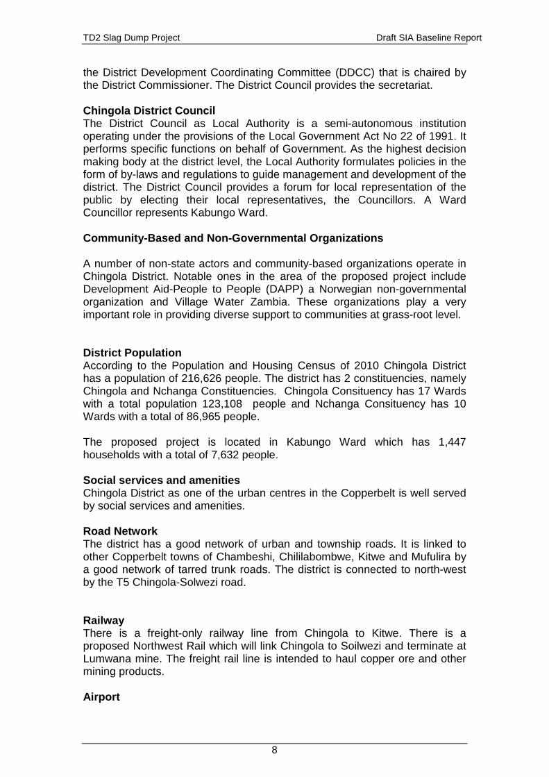
TD2 Slag Dump Project Draft SIA Baseline Report
8
the District Development Coordinating Committee (DDCC) that is chaired by the District Commissioner. The District Council provides the secretariat. Chingola District Council The District Council as Local Authority is a semi-autonomous institution operating under the provisions of the Local Government Act No 22 of 1991. It performs specific functions on behalf of Government. As the highest decision making body at the district level, the Local Authority formulates policies in the form of by-laws and regulations to guide management and development of the district. The District Council provides a forum for local representation of the public by electing their local representatives, the Councillors. A Ward Councillor represents Kabungo Ward. Community-Based and Non-Governmental Organizations A number of non-state actors and community-based organizations operate in Chingola District. Notable ones in the area of the proposed project include Development Aid-People to People (DAPP) a Norwegian non-governmental organization and Village Water Zambia. These organizations play a very important role in providing diverse support to communities at grass-root level. District Population According to the Population and Housing Census of 2010 Chingola District has a population of 216,626 people. The district has 2 constituencies, namely Chingola and Nchanga Constituencies. Chingola Consituency has 17 Wards with a total population 123,108 people and Nchanga Consituency has 10 Wards with a total of 86,965 people. The proposed project is located in Kabungo Ward which has 1,447 households with a total of 7,632 people. Social services and amenities Chingola District as one of the urban centres in the Copperbelt is well served by social services and amenities. Road Network The district has a good network of urban and township roads. It is linked to other Copperbelt towns of Chambeshi, Chililabombwe, Kitwe and Mufulira by a good network of tarred trunk roads. The district is connected to north-west by the T5 Chingola-Solwezi road. Railway There is a freight-only railway line from Chingola to Kitwe. There is a proposed Northwest Rail which will link Chingola to Soilwezi and terminate at Lumwana mine. The freight rail line is intended to haul copper ore and other mining products. Airport
TD2 Slag Dump Project Draft SIA Baseline Report
9
The district is served by the Kasompe Airport. The airport handles both charter and passenger flights. Health Facilities. The district has 2 hospitals – Nchanga North General Hospital operated by government and Nchanga South Hospital privately run by Konkola Copper Mines. The are numerous clinics and health centres located in various parts of the district. Water and Sanitation Services Mulonga Water and Sewerage Company is the commercial utility that provides water and sanitation services to the seven Chingola. Urban residential and business premises are connected to the water supply reticulation system operated by the utility company. Peri-urban settlements are supply by communal stand pipes or water kiosks. Education and Literacy The Government, Konkola Copper Mines and the private sector provide education facilities in Chingola District. Education facilities in the district are provided through early learning centres (usually operated by private entities), Primary, Secondary and High Schools. The Gender Parity Index (GPI) demonstrates gender equity in the education system. The GPI is the ratio of female to male pupils. A GPI lower than 1 means that there are more males than females in the school system, while a GPI greater than 1 denotes the opposite. The 2013 Zambia Educational Statistical Bulletin indicates that the GPI for Grades 1-9 was 0.98 and for Grades 10-12 was 0.84. Similarly the national dropout rate of females in Grades 1-9 in 2013 was 2.1 percent to that of 1.4 percent for males and 1.7 percent for Grades 10-12 females to that of 0.7 percent for males. These national figures are also indicative of the situation at Chingola district level. The national adult (ages 15 and older) literacy rate is 61.4 percent (UNDP, 2014). This national literacy rate can be extrapolated at Chingola district level. Electricity Supply The district is connected to the Zambia Electricity Supply Corporation grid (ZESCO). ZESCO supply electricity to domestic and commercial premises. Bulk energy supply to the mines is supplied by the Copperbelt Energy Company. Telecommunication Chingola District has good telecommunication infrastructure. Communication companies ZAMTEL, Airtel and MTN provide cellular and Internet services. These facilities are widely accessed in the district. The government-owned Zambia National Broadcasting Corporation (ZNBC) is the principal public broadcaster. It currently runs two television channels and several radio stations. There are several private TV stations accessible in the
TD2 Slag Dump Project Draft SIA Baseline Report
10
country including the subscription Digital Satellite Television (DSTv). International broadcasters such as the BBC World Services and RFI provide some radio coverage. Private radio stations, Christian Voice, Radio Phoenix a broadcast to the district. A community radio station - Radio Ichengelo broadcasting on FM 102.2 from Kitwe, also serves Chingola. The Diocese of Ndola of the Catholic Church runs the station. Religious Practices and Beliefs Religious practices and beliefs in Zambia are central to the people. A large majority of Zambians in the district belong to the Christian faith. The district has several denominations which include the Roman Catholic Church, United Church of Zambia, Seventh Day Adventist Church, Jehovah’s Witnesses, Assemblies of God Church etc. Some also practices traditional belief systems, including the veneration of ancestral spirits. Other belief systems include Hinduism and Islam. Gender Equity In Zambia gender inequality is symptomatic of the overall societal orientation. This is evidenced by the fact that women generally experience disadvantage in access to education, health and employment. Access to productive assets such as land is still problematic to many women in Zambia. The Gender Inequality Index 1 (GII) a composite measure of reproductive health, empowerment and labour market participation illustrates this. In Zambia the GII is 0.617, ranking 135 out of 187 countries (UNDP, 2014). Livelihoods Community Level Economic and Livelihood Profile Agriculture Agriculture is in the district is generally practiced at subsistence level. The main crop grown is maize. Maize is grown both for consumption and for market. Other crops grown in the district are groundnuts, Milenda Farm Milenda Farm owned by Mr. Gary Shiel is one of the largest farm enterprises near the project site. This is a dairy farm producing over 2000 litres of milk per day. Kamana Farm This farm owned by Mr. Watson Sinkala since 1981 grows rain-fed maize crop and vegetables such as cabbages. Broiler chickens are also kept.
1 The Gender Inequality Index ranges between 0 and 1, with 0 being 0% inequality.
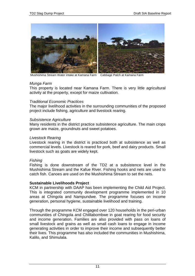
TD2 Slag Dump Project Draft SIA Baseline Report
11
Mushishima Stream Water intake at Kamana Farm Cabbage Patch at Kamana Farm Munga Farm This property is located near Kamana Farm. There is very little agricultural activity at the property, except for maize cultivation. Traditional Economic Practices The major livelihood activities in the surrounding communities of the proposed project include fishing, agriculture and livestock rearing. Subsistence Agriculture Many residents in the district practice subsistence agriculture. The main crops grown are maize, groundnuts and sweet potatoes. Livestock Rearing Livestock rearing in the district is practiced both at subsistence as well as commercial levels. Livestock is reared for pork, beef and dairy products. Small livestock such as goats are widely kept. Fishing Fishing is done downstream of the TD2 at a subsistence level in the Mushishima Stream and the Kafue River. Fishing hooks and nets are used to catch fish. Canoes are used on the Mushishima Stream to set the nets. Sustainable Livelihoods Project KCM in partnership with DAAP has been implementing the Child Aid Project. This is integrated community development programme implemented in 10 areas at Chingola and Nampundwe. The programme focuses on income generation, personal hygiene, sustainable livelihood and training. Through the programme KCM engaged over 120 households in the peri-urban communities of Chingola and Chililabombwe in goat rearing for food security and income generation. Families are also provided with pass on loans of small livestock and grains as well as small cash loans to engage in income generating activities in order to improve their income and subsequently better their lives. This programme has also included the communities in Mushishima, Kalilo, and Shimulala.
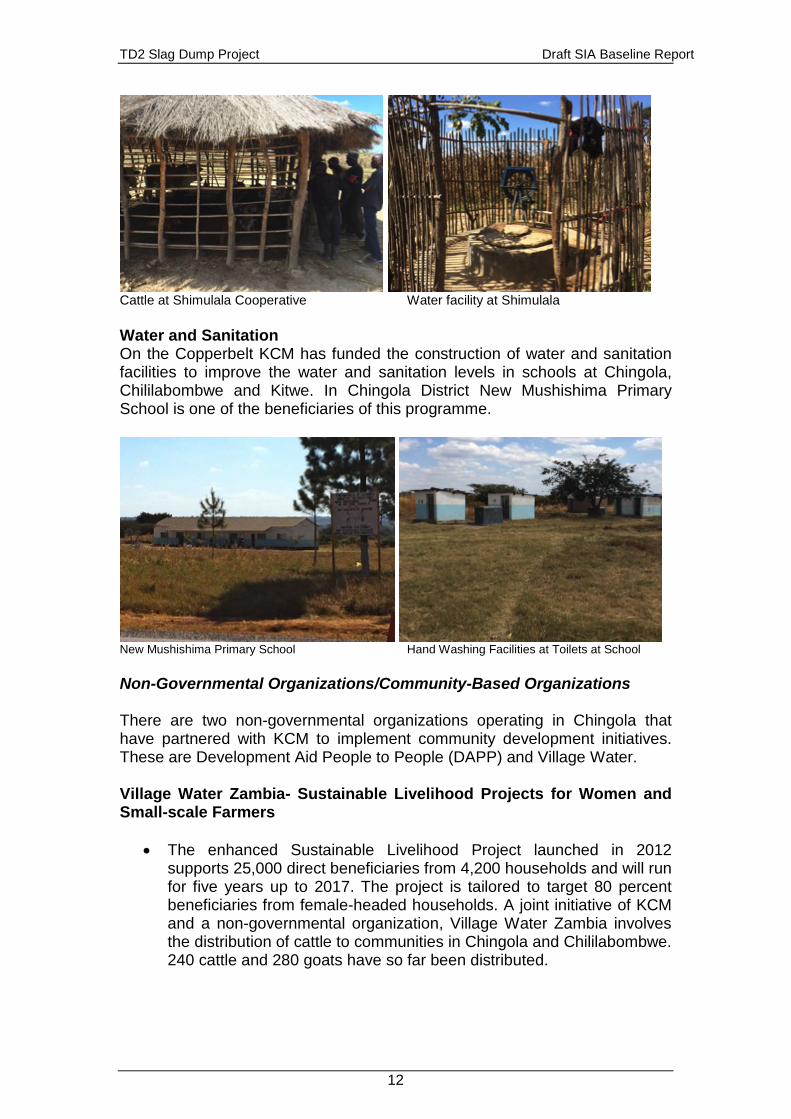
TD2 Slag Dump Project Draft SIA Baseline Report
12
Cattle at Shimulala Cooperative Water facility at Shimulala Water and Sanitation On the Copperbelt KCM has funded the construction of water and sanitation facilities to improve the water and sanitation levels in schools at Chingola, Chililabombwe and Kitwe. In Chingola District New Mushishima Primary School is one of the beneficiaries of this programme.
New Mushishima Primary School Hand Washing Facilities at Toilets at School Non-Governmental Organizations/Community-Based Organizations There are two non-governmental organizations operating in Chingola that have partnered with KCM to implement community development initiatives. These are Development Aid People to People (DAPP) and Village Water. Village Water Zambia- Sustainable Livelihood Projects for Women and Small-scale Farmers
• The enhanced Sustainable Livelihood Project launched in 2012 supports 25,000 direct beneficiaries from 4,200 households and will run for five years up to 2017. The project is tailored to target 80 percent beneficiaries from female-headed households. A joint initiative of KCM and a non-governmental organization, Village Water Zambia involves the distribution of cattle to communities in Chingola and Chililabombwe. 240 cattle and 280 goats have so far been distributed.
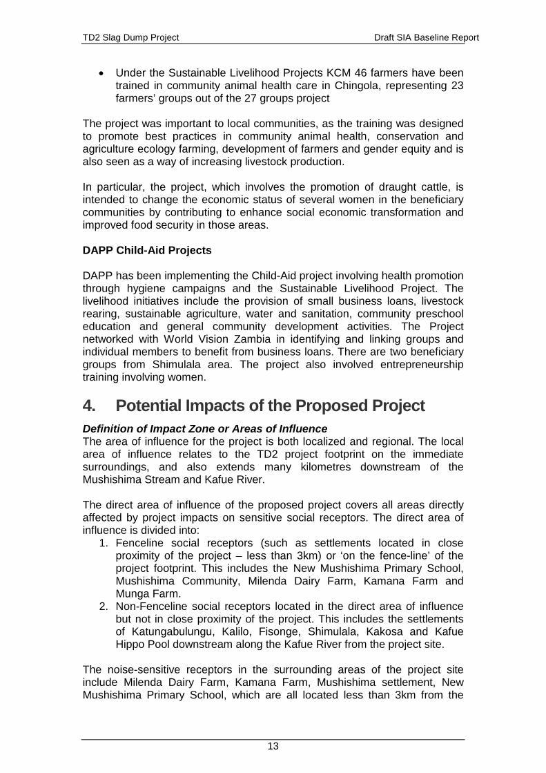
TD2 Slag Dump Project Draft SIA Baseline Report
13
• Under the Sustainable Livelihood Projects KCM 46 farmers have been trained in community animal health care in Chingola, representing 23 farmers’ groups out of the 27 groups project
The project was important to local communities, as the training was designed to promote best practices in community animal health, conservation and agriculture ecology farming, development of farmers and gender equity and is also seen as a way of increasing livestock production. In particular, the project, which involves the promotion of draught cattle, is intended to change the economic status of several women in the beneficiary communities by contributing to enhance social economic transformation and improved food security in those areas. DAPP Child-Aid Projects DAPP has been implementing the Child-Aid project involving health promotion through hygiene campaigns and the Sustainable Livelihood Project. The livelihood initiatives include the provision of small business loans, livestock rearing, sustainable agriculture, water and sanitation, community preschool education and general community development activities. The Project networked with World Vision Zambia in identifying and linking groups and individual members to benefit from business loans. There are two beneficiary groups from Shimulala area. The project also involved entrepreneurship training involving women. 4. Potential Impacts of the Proposed Project Definition of Impact Zone or Areas of Influence The area of influence for the project is both localized and regional. The local area of influence relates to the TD2 project footprint on the immediate surroundings, and also extends many kilometres downstream of the Mushishima Stream and Kafue River. The direct area of influence of the proposed project covers all areas directly affected by project impacts on sensitive social receptors. The direct area of influence is divided into:
1. Fenceline social receptors (such as settlements located in close proximity of the project – less than 3km) or ‘on the fence-line’ of the project footprint. This includes the New Mushishima Primary School, Mushishima Community, Milenda Dairy Farm, Kamana Farm and Munga Farm.
2. Non-Fenceline social receptors located in the direct area of influence but not in close proximity of the project. This includes the settlements of Katungabulungu, Kalilo, Fisonge, Shimulala, Kakosa and Kafue Hippo Pool downstream along the Kafue River from the project site.
The noise-sensitive receptors in the surrounding areas of the project site include Milenda Dairy Farm, Kamana Farm, Mushishima settlement, New Mushishima Primary School, which are all located less than 3km from the
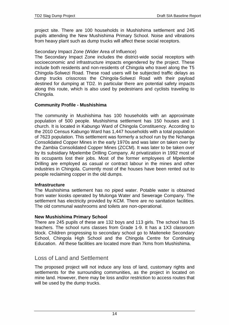
TD2 Slag Dump Project Draft SIA Baseline Report
14
project site. There are 100 households in Mushishima settlement and 245 pupils attending the New Mushishima Primary School. Noise and vibrations from heavy plant such as dump trucks will affect these social receptors. Secondary Impact Zone (Wider Area of Influence) The Secondary Impact Zone includes the district-wide social receptors with socioeconomic and infrastructure impacts engendered by the project. These include both residents and non-residents of Chingola who travel along the T5 Chingola-Solwezi Road. These road users will be subjected traffic delays as dump trucks crisscross the Chingola-Solwezi Road with their payload destined for dumping at TD2. In particular there are potential safety impacts along this route, which is also used by pedestrians and cyclists traveling to Chingola. Community Profile - Mushishima The community in Mushishima has 100 households with an approximate population of 500 people. Mushishima settlement has 150 houses and 1 church. It is located in Kabungo Ward of Chingola Constituency. According to the 2010 Census Kabungo Ward has 1,447 households with a total population of 7623 population. This settlement was formerly a school run by the Nchanga Consolidated Copper Mines in the early 1970s and was later on taken over by the Zambia Consolidated Copper Mines (ZCCM). It was later to be taken over by its subsidiary Mpelembe Drilling Company. At privatization in 1992 most of its occupants lost their jobs. Most of the former employees of Mpelembe Drilling are employed as casual or contract labour in the mines and other industries in Chingola. Currently most of the houses have been rented out to people reclaiming copper in the old dumps. Infrastructure The Mushishima settlement has no piped water. Potable water is obtained from water kiosks operated by Mulonga Water and Sewerage Company. The settlement has electricity provided by KCM. There are no sanitation facilities. The old communal washrooms and toilets are non-operational. New Mushishima Primary School There are 245 pupils of these are 132 boys and 113 girls. The school has 15 teachers. The school runs classes from Grade 1-9. It has a 1X3 classroom block. Children progressing to secondary school go to Maiteneke Secondary School, Chingola High School and the Chingola Centre for Continuing Education. All these facilities are located more than 7kms from Mushishima.
Loss of Land and Settlement The proposed project will not induce any loss of land, customary rights and settlements for the surrounding communities, as the project in located on mine land. However, there may be loss and/or restriction to access routes that will be used by the dump trucks.
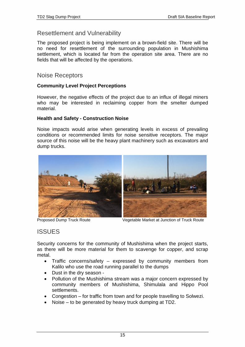
TD2 Slag Dump Project Draft SIA Baseline Report
15
Resettlement and Vulnerability The proposed project is being implement on a brown-field site. There will be no need for resettlement of the surrounding population in Mushishima settlement, which is located far from the operation site area. There are no fields that will be affected by the operations.
Noise Receptors Community Level Project Perceptions However, the negative effects of the project due to an influx of illegal miners who may be interested in reclaiming copper from the smelter dumped material.
Health and Safety - Construction Noise Noise impacts would arise when generating levels in excess of prevailing conditions or recommended limits for noise sensitive receptors. The major source of this noise will be the heavy plant machinery such as excavators and dump trucks.
Proposed Dump Truck Route Vegetable Market at Junction of Truck Route ISSUES Security concerns for the community of Mushishima when the project starts, as there will be more material for them to scavenge for copper, and scrap metal.
• Traffic concerns/safety – expressed by community members from Kalilo who use the road running parallel to the dumps
• Dust in the dry season - • Pollution of the Mushishima stream was a major concern expressed by
community members of Mushishima, Shimulala and Hippo Pool settlements.
• Congestion – for traffic from town and for people travelling to Solwezi. • Noise – to be generated by heavy truck dumping at TD2.
TD2 Slag Dump Project Draft SIA Baseline Report
16
5. Potential Impacts and Mitigation/Enhancement Measures
Potential Impacts shall emanate from the following main elements of the project’s activities:
• (i) Noise, vibrations and Dust emissions - during the operation phase the operation of heavy dump trucks may impact people living nearby access roads as well as in the neighbourhood, especially of the Mushishima community. Dust suppression can be achieved by regular watering of the route.
Noise Decay A noise assessment done as part of the baseline study indicates levels for the proposed dump site, which can be categorized as an industrial/ commercial Mining area, the values which all fall within the acceptable guidelines by the International Finance Corporation (IFC) which is 55dB for social receptors such as residential areas and schools. The noise decay is given by the following formula: decay = 20 log (distance/10) dB2 Barrier Attenuation Barrier attenuation will be provided by the sides of the old part of TD2 just next to T5 Solwezi Road.
• (ii) Potential for increase in road traffic accidents - Traffic movements along the T5 Chingola-Solwezi Road will increase potential for road traffic accidents.
2 Decay = 20 log (400/10) dB for Dump Truck with noise levels measured at 10 metres. It is nearly 400metres to the nearest social noise receptor at New Mushishima Primary School. Noise decay = 32.04 dBs Values give for Dump Trucks is 88 dBs.
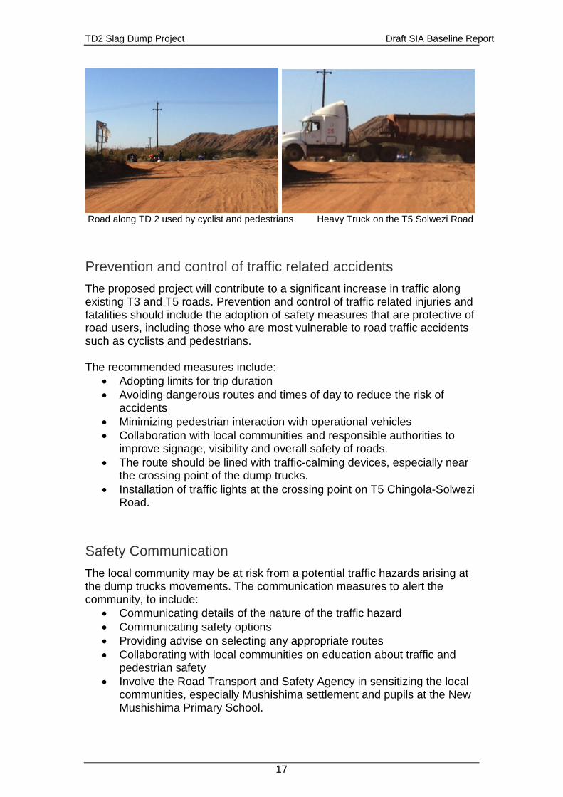
TD2 Slag Dump Project Draft SIA Baseline Report
17
Road along TD 2 used by cyclist and pedestrians Heavy Truck on the T5 Solwezi Road
Prevention and control of traffic related accidents The proposed project will contribute to a significant increase in traffic along existing T3 and T5 roads. Prevention and control of traffic related injuries and fatalities should include the adoption of safety measures that are protective of road users, including those who are most vulnerable to road traffic accidents such as cyclists and pedestrians. The recommended measures include:
• Adopting limits for trip duration • Avoiding dangerous routes and times of day to reduce the risk of
accidents • Minimizing pedestrian interaction with operational vehicles • Collaboration with local communities and responsible authorities to
improve signage, visibility and overall safety of roads. • The route should be lined with traffic-calming devices, especially near
the crossing point of the dump trucks. • Installation of traffic lights at the crossing point on T5 Chingola-Solwezi
Road.
Safety Communication The local community may be at risk from a potential traffic hazards arising at the dump trucks movements. The communication measures to alert the community, to include:
• Communicating details of the nature of the traffic hazard • Communicating safety options • Providing advise on selecting any appropriate routes • Collaborating with local communities on education about traffic and
pedestrian safety • Involve the Road Transport and Safety Agency in sensitizing the local
communities, especially Mushishima settlement and pupils at the New Mushishima Primary School.
TD2 Slag Dump Project Draft SIA Baseline Report
18
References United Nations Country Team (2013). Zambia Consultations on the Post Millennium Development Goals (MDGs) Agenda Report. United Nations, Lusaka. United Nations Country (2013). Millennium Development Goals (MDGs) Progress Report: Zambia. United Nations, Lusaka. United Nations Development Programme 2014. Human Development Report 2014. Sustaining Human Progress: Reducing Vulnerability and Building Resilience. UNDP, New York, NY 10017, USA United Nations Development Programme 2013. Human Development Report 2013. The Rise of the South: Human Progress in a Diverse World, UNDP, New York, NY 10017, USA United Nations Development Programme 2011. Zambia Human Development Report 2011: Service Delivery for Sustainable Human Development Republic of Zambia, 2013. Zambia 2013 Educational Statistical Bulletin. Ministry of Education, Science, Vocational Training and Early Education, Directorate of Planning and Information, Lusaka Republic of Zambia, 2011. Sixth National Development Plan (2011-2015): “Sustained Economic Growth and Poverty reduction”. Ministry of Finance and National Planning, Lusaka. Republic of Zambia (2011). 2010 Census of Population and Housing Preliminary Report – 1. Central Statistical Office Zambia, Lusaka. Republic of Zambia (2006) Vision 2030: “A prosperous Middle-income Nation By 2030” International Finance Corporation 2007. Environmental, Health, and Safety (EHS) Guidelines: General EHS Guidelines: Community Health And Safety. World Bank Group, Washington D.C. International Finance Corporation 2012. Performance Standards on Environmental and Social Sustainability, World Bank Group, Washington D.C. Vendata. Natural Resource Management. Yagna Vol. 4 July-Nov 2010 Child Aid Chingola Year Report January to December 2012 To U-landshjelp from People to People, Norway. DAPP Development Aid from People to People in Zambia
TD2 Slag Dump Project Draft SIA Baseline Report
19
List of People Consulted 1. Ms. Lomanzti Mazyopa Kachingwe KCM Community Liaison Officer
CSR Department 2. Mr. Brian Siatubi KCM Community Liaison Officer CSR Department 3. Mr. Moses Munkondya KCM Environment Coordinator – Corporate 4. Mr. Jim Mwape Kabungo Ward Councillor 5. Mrs. Bina Mhango Kalilo Ward Councillor 6. Reverend Mary M Tembo Head teacher New Mushishima Primary
School 7. Reverend Jonathan Lengwe Chingola 8. Mr. Matthews Bwalya Child-Aid Project Leader Mushishima 9. Mr. Gary Shiel – Milenda Farm 10. Mr. Watson G Sinkala – Kamana Farm 11. Mr. Rogers Kamina – Twatasha Cooperative, Shimulala 12. Mr. Diamond Sikanyika - Twatasha Cooperative, Shimulala 13. Mr. Peter Shiku - Twatasha Cooperative, Shimulala 14. Mr. Davies S. Kanshimba – Kalilo Ward Vice-Chairperson 15. Mr. Lovewell Ng’ambi Kalilo Resident 16. Mr. J Lampeni Chingola Municipal Council Community Development
Assistant Kalilo 17. Mr. Benson Lusenga Information Publicity Secretary Chingola
Constituency, Kalilo 18. Mr. Happy Simundi, Ward Development Committee Member, Kalilo 19. Mr. John Chifwaha, Kalilo Resident 20. Mr. Rogers Kakompe Kalilo Resident 21. Mr. Duebison Mpumba Kalilo Resident 22. Mr. Kafwila Lambakasa Kalilo Ward Chairperson 23. Mr. Peter Chama Kalilo Resident 24. Mr. Rodwell Gondwe Kalilo Resident 25. Mr. Japhet Machila, Katungabulungu Resident 26. Mr. L Bwalya Kafue Hippo Chairman 27. Mr. B Mulenga Kafue Hippo Chairman Secretary 28. Mr. Davies Kabwe Kafue Hippo Chairman Vice-Chairman 29. Mr. P Chansa Kafue Hippo Resident 30. Mr. B Mwansa Kafue Hippo Resident 31. Mr. M. Mwila Kafue Hippo Resident 32. Mr. K. Kenani Kafue Hippo Resident 33. Mr. F. Ngoma Kafue Hippo Resident 34. Mr. M Mumbi Kafue Hippo Resident 35. Ms. C Mable Kafue Hippo Resident 36. Ms. H Chansa Kafue Hippo Resident 37. Ms. M Malise Kafue Hippo Resident 38. Ms. J Lombe Kafue Hippo Resident 39. Ms. K Mutula Kafue Hippo Resident 40. Ms. Chikopela Kafue Hippo Resident 41. Mr. F. Komba Lumba Kafue Hippo Resident 42. Ms. B Benni Kafue Hippo Resident 43. Ms. M Costan Kafue Hippo Resident 44. Mr. L Joe Kafue Hippo Resident 45. Mr. Nyirongo Kafue Hippo Resident
TD2 Slag Dump Project Draft SIA Baseline Report
20
46. Mr. D.Musonda Kafue Hippo Resident
Konkola Copper Mines Plc
New Slag Dump Project
Draft Environmental and Social Impact Statement September 2014
Appendix M
Design Report - TD2 Slag Dump

Prepared for
Konkola Copper Mines Plc
TD2 Slag Dump Project Design Report March 2014

Konkola Copper Mines Plc TD2 Slag Dump Project
TD2 Slag Dump Design Report March 2014
URS Scott Wilson Zambia 24 Enos Chomba Avenue PO Box 22496 Kitwe Zambia Tel +260 21 222 8466 Fax +260 21 222 3649 [email protected] www.ursglobal.com
TD2 Slag Dump Design Report
March 2014
Rev Date Details Prepared by Reviewed by Approved by
0 March 2014 Chalwe Bulaya
Principal Engineer
Patrick Kampengele
Executive Director
Patrick Kampengele
Executive Director
Samuel Simumba
Engineer
Konkola Copper Mines Plc TD2 Slag Dump Project
TD2 Slag Dump Design Report i March 2014
Table of Contents 1. Introduction .............................................................................................................................................. 1
2. Basis of Design ........................................................................................................................................ 1
2.1. Background............................................................................................................................................ 1
2.2. Principal Design Criteria ......................................................................................................................... 1
2.3. Principal Design Parameters ................................................................................................................. 2
3. Site Characterisation ............................................................................................................................... 2
4. Slag Dump Configuration and Capacity ................................................................................................ 3
5. Site Preparation ....................................................................................................................................... 4
6. Stability Analysis ..................................................................................................................................... 5
7. Dumping Procedures .............................................................................................................................. 6
8. References ............................................................................................................................................... 7
9. Appendices .............................................................................................................................................. 8
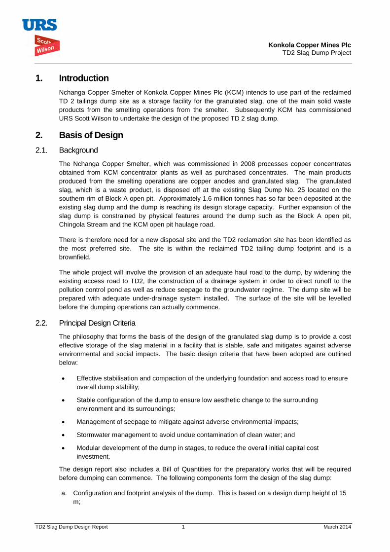
Konkola Copper Mines Plc TD2 Slag Dump Project
TD2 Slag Dump Design Report 1 March 2014
1. Introduction Nchanga Copper Smelter of Konkola Copper Mines Plc (KCM) intends to use part of the reclaimed TD 2 tailings dump site as a storage facility for the granulated slag, one of the main solid waste products from the smelting operations from the smelter. Subsequently KCM has commissioned URS Scott Wilson to undertake the design of the proposed TD 2 slag dump.
2. Basis of Design 2.1. Background
The Nchanga Copper Smelter, which was commissioned in 2008 processes copper concentrates obtained from KCM concentrator plants as well as purchased concentrates. The main products produced from the smelting operations are copper anodes and granulated slag. The granulated slag, which is a waste product, is disposed off at the existing Slag Dump No. 25 located on the southern rim of Block A open pit. Approximately 1.6 million tonnes has so far been deposited at the existing slag dump and the dump is reaching its design storage capacity. Further expansion of the slag dump is constrained by physical features around the dump such as the Block A open pit, Chingola Stream and the KCM open pit haulage road.
There is therefore need for a new disposal site and the TD2 reclamation site has been identified as the most preferred site. The site is within the reclaimed TD2 tailing dump footprint and is a brownfield.
The whole project will involve the provision of an adequate haul road to the dump, by widening the existing access road to TD2, the construction of a drainage system in order to direct runoff to the pollution control pond as well as reduce seepage to the groundwater regime. The dump site will be prepared with adequate under-drainage system installed. The surface of the site will be levelled before the dumping operations can actually commence.
2.2. Principal Design Criteria
The philosophy that forms the basis of the design of the granulated slag dump is to provide a cost effective storage of the slag material in a facility that is stable, safe and mitigates against adverse environmental and social impacts. The basic design criteria that have been adopted are outlined below:
• Effective stabilisation and compaction of the underlying foundation and access road to ensure overall dump stability;
• Stable configuration of the dump to ensure low aesthetic change to the surrounding environment and its surroundings;
• Management of seepage to mitigate against adverse environmental impacts;
• Stormwater management to avoid undue contamination of clean water; and
• Modular development of the dump in stages, to reduce the overall initial capital cost investment.
The design report also includes a Bill of Quantities for the preparatory works that will be required before dumping can commence. The following components form the design of the slag dump:
a. Configuration and footprint analysis of the dump. This is based on a design dump height of 15 m;

Konkola Copper Mines Plc TD2 Slag Dump Project
TD2 Slag Dump Design Report 2 March 2014
b. Selection of an under-drainage system for the dump including rainfall runoff management; and
c. Slope stability analysis for the dump configurations.
2.3. Principal Design Parameters
Reference has been made to previous investigations on the site that were undertaken for the proposed TD7 Expansion (URS Scott Wilson, June 2011). Table 2.1 below gives the principle parameters that have been used for the design:
Table 2.1: Design Parameters
Parameter Design Factor
Daily Slag Production Rate 1500 tonnes per day
Design Life 20 Years
Final Design Storage Capacity 10,950,000 tonnes
In-situ slag density 1900 Kg/m3
Foundation Soil Classification SAND (tailings) and Silty Sand (Gravel)
Seismic Risk Classification Low
Confining walls classification Granulated Slag
Repose Angle of Slag 530
Seismic Loading gravitational acceleration factor 0.067g
The following material strength properties were used for the slope stability analysis. The parameters used are based on literature review, previous geotechnical tests that were undertaken during the TD7 expansion design process as well as additional data obtained from KCM.
Table 2.2: Material Strength Parameters.
Material Type Saturated Density (KN/m3)
Effective Friction Angle ø’ (degrees)
Effective Cohesion c’ (kPa)
Tailings 17.7 24 14
Granulated Slag 19.0 53 0
Foundation 18.4 23 0
3. Site Characterisation The proposed project site is within the reclaimed TD2 footprint. The average elevation of the footprint is 1300 mASL with a gentle fall in elevations towards the Mushishima and Chingola Streams. To the East and South East of the site are overburden dumps. To the North-west and across the Mushishima Stream are tailings dumps No. 3 and No.4. All these surrounding dumps have generally changed the local topography of the area. The layout of the proposed site is shown in the Figure 3.1 below.

Konkola Copper Mines Plc TD2 Slag Dump Project
TD2 Slag Dump Design Report 3 March 2014
Figure 3.1: Satellite Image of footprint of TD2 Dump Site
The proposed site is approximately 6.4 Km to the North-West of the Nchanga Copper Smelter. There is an access open pit haul road from the main plant area that crosses the main Chingola-Chililabombwe Highway (T3) and leads to the COP F open pit area and TD2 site. The road to TD2 straddles on the side of existing overburden dumps and crosses the Chingola-Solwezi Road (T5) to the TD2 dump site. The road is currently used as the general access to other facilities that lie close to TD2 such as TD7, Pollution Control Dam (PCD), TD3 and TD4.
4. Slag Dump Configuration and Capacity The configuration of the dump is based on a staged development of the dump. The dump will be developed in stages up to a maximum dump height of 15 m. Developing the dump in stages will allow for the capital cost requirement of preparing the site for disposal to be spread over the life of the dump. The development will be such that as disposal is on-going in one section of the proposed dump footprint, pre-disposal works will have commenced for the next disposal area. The dump layout in terms of length and width has been selected to ensure safe and maximum manoeuvrability of the haul trucks around the dump.
The dump will be formed to the natural repose angle of the granulated slag material, which is between 50o and 53o. Disposal of the slag dump material will follow a sequential approach with adjacent areas being developed after each current dump area has reached its design capacity.
The area that has been identified for initial dumping is approximately 4.2 hectares (ha). This area is capable of providing storage capacity of up to 742,000 m3 of slag material, which is an equivalent of approximately 2.5 years of slag production, based on a daily rate of 1500 tonnes per day.
The leading dimensions of the slag dump are 225 m x 225 m forming a square paddock structure. The development of the dump will be sequential with a new disposal area being developed immediately adjacent to the previous dumping site. The proposed layout of the dump is included in this report under Appendix 1.
A filter under-drainage system has been included and this is intended to collect seepage through the
To Chililabombwe N
TD2 Site (site of proposed slag dump
To Nchanga Main Plant Area To Solwezi
Mushishima
Stream
TD7
Konkola Copper Mines Plc TD2 Slag Dump Project
TD2 Slag Dump Design Report 4 March 2014
dumped slag material. The slag material, which is granular in nature, will allow direct rainfall to percolate through its body mass to the base of the dump. The seepage through the slag material will percolate further into the underlying foundation strata. However, in order to reduce the amount of potential seepage to the underlying strata, a filter drain will be incorporated to collect the seepage and direct it into a toe drain. The toe drain will direct the collected seepage into the Pollution Control Dam (PCD). The filter drain will be along the outer periphery of the slag dump. The details of the filter drainage system are shown on the construction drawings, as well as the grading envelopes for the filter material. Prior to discharge into the PCD, the seepage will be collected into a seepage sump for environmental monitoring.
The principal dimensions of the dump are given in the table below. There will be a 20 m buffer zone between the existing outer embankment of TD2 and the toe of the slag dump. For each stage of dumping, the principal leading dimensions will be 225 m x 225 m with a dump height of 15 m. The cumulative covered area for the different stages of development of the slag dump is also given in the table below. For up to 20 years of disposal, eight disposal stages have been developed and each stage will provide 2.5 years of storage space. The sequence of the stage development numbered 1 up to 8 is included on the layout drawings of the dump. The slag dump is will cover approximately 35% of the existing TD2 dump footprint.
Table 4. 1: Development Stages for TD2 Slag Dump
Disposal Stage
Disposal Period (Years) Length (m)
Breadth (m)
Cumm. Area (ha)
% Area of TD 2
Stored Tonnage (Cumulative)
1 2.5 225 225 5.063 4% 1368750
2 5 225 225 10.125 8% 2737500
3 7.5 225 225 15.188 13% 4106250
4 10 225 225 20.250 17% 5475000
5 12.5 225 225 25.313 21% 6843750
6 15 225 225 30.375 25% 8212500
7 17.5 225 225 35.438 30% 9581250
8 20 225 225 40.500 34% 10950000
5. Site Preparation The following main key activities will be undertaken as part of site preparation before dumping commences. A Bill of Quantities, outlining the required works and quantities has also been provided. An engineer’s estimate of the construction cost has been included in Appendix 2.
a. Prepare access road from the plant to the dump;
i. Grade existing access road including widening;
ii. Construct over the tailings an access road to the dumping locations.

Konkola Copper Mines Plc TD2 Slag Dump Project
TD2 Slag Dump Design Report 5 March 2014
b. Construct longitudinal and transverse filter drains;
c. Construct lined toe drain; and
d. Construct seepage collection sump.
6. Stability Analysis Stability analyses of the dump were undertaken using Geo-Studio Slope/W module. The slope configuration was based on a design slope of 50 degrees and a dump height of 15m. Additional analyses for dump heights up to 20 m and 25 m were also analysed.
The stability analysis of the dumps was undertaken against recommended Factors of Safety (FoS) for static and seismic conditions. There is no specific FoS for slag dumps and therefore those recommended for tailings dumps and water storage embankments were adopted. Table 6.1 below gives the recommended FoS for both static and seismic conditions. The seismic loading gravitational acceleration factor of 0.067g used in the analyses is based on similar works done in the Nchanga area. The acceleration factor was used to simulate the Maximum Credible Seismic Event.
Table 6.1: Recommended Factors of Safety
Loading Condition Recommended Minimum FoS
Static 1.5
Seismic 1.1
The Slope/W module used utilises the Morgenstern-Price (M-P), Bishop, Janbu and Ordinary methods to analyse the stability condition. The M-P method was used as this is the most rigorous method and satisfies normal and shear inter-slice force equilibrium as well as moment equilibrium (Ref. 1). The material strength parameters used are given in Table 2.2. The depth of tailings below the slag dump was taken as 3 m, which is representative of the existing site conditions, while the underlying foundation thickness was 5 m.
Stability Results
The summary of the FoS results for static and seismic loading conditions are given in Table 6.2 below. The models of the stability analysis are included under Appendix 3. The results in the table given below also include analysis of the dump for heights up to 20 m and 25 m.
From the results obtained the FoS for the selected dump configurations are above the minimum recommended figures for both static and seismic loading conditions. The analysis was undertaken for whole slope or embankment failure.
Local slope failure analysis at 15 m high yielded very high FoS implying that such failure was unlikely to occur. The local slope failure analysis was also undertaken as a dump height of 25 m and this still gave high FoS values for three different cases.
The models included in Appendix 3 show the different failure modes that were analysed.
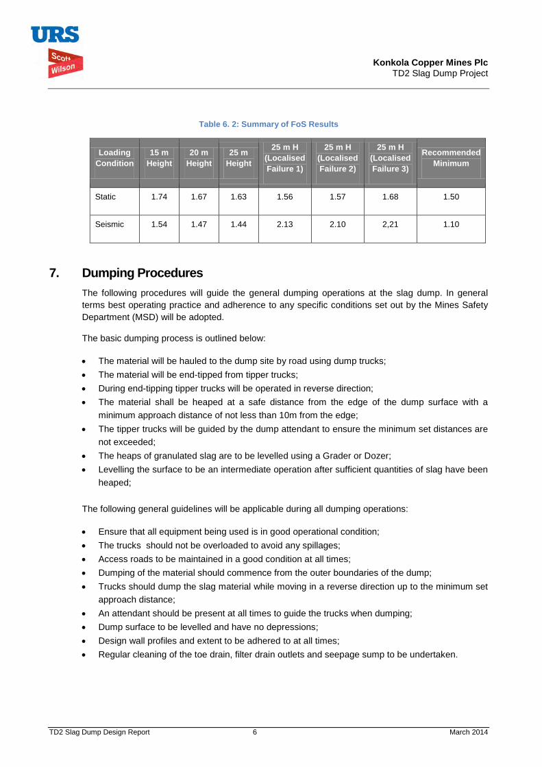
Konkola Copper Mines Plc TD2 Slag Dump Project
TD2 Slag Dump Design Report 6 March 2014
Table 6. 2: Summary of FoS Results
Loading Condition
15 m Height
20 m Height
25 m Height
25 m H (Localised Failure 1)
25 m H (Localised Failure 2)
25 m H (Localised Failure 3)
Recommended Minimum
Static 1.74 1.67 1.63 1.56 1.57 1.68 1.50
Seismic 1.54 1.47 1.44 2.13 2.10 2,21 1.10
7. Dumping Procedures The following procedures will guide the general dumping operations at the slag dump. In general terms best operating practice and adherence to any specific conditions set out by the Mines Safety Department (MSD) will be adopted.
The basic dumping process is outlined below:
• The material will be hauled to the dump site by road using dump trucks; • The material will be end-tipped from tipper trucks; • During end-tipping tipper trucks will be operated in reverse direction; • The material shall be heaped at a safe distance from the edge of the dump surface with a
minimum approach distance of not less than 10m from the edge; • The tipper trucks will be guided by the dump attendant to ensure the minimum set distances are
not exceeded; • The heaps of granulated slag are to be levelled using a Grader or Dozer; • Levelling the surface to be an intermediate operation after sufficient quantities of slag have been
heaped;
The following general guidelines will be applicable during all dumping operations:
• Ensure that all equipment being used is in good operational condition; • The trucks should not be overloaded to avoid any spillages; • Access roads to be maintained in a good condition at all times; • Dumping of the material should commence from the outer boundaries of the dump; • Trucks should dump the slag material while moving in a reverse direction up to the minimum set
approach distance; • An attendant should be present at all times to guide the trucks when dumping; • Dump surface to be levelled and have no depressions; • Design wall profiles and extent to be adhered to at all times; • Regular cleaning of the toe drain, filter drain outlets and seepage sump to be undertaken.

Konkola Copper Mines Plc TD2 Slag Dump Project
TD2 Slag Dump Design Report 7 March 2014
8. References 1. John Krahn, 2004. Stability Modelling with Slope/W – An Engineering Methodology
August 2004.
2. URS Scott Wilson, 2011. Muntimpa Tailings Dam (TD 5) – Slope Stability Analysis Report prepared on behalf of Konkola Copper Mines Plc. August 2011
3. URS Scott Wilson, 2011. TD7 Expansion Design Report prepared on behalf of Konkola Copper Mines Plc. June 2011.
Konkola Copper Mines Plc TD2 Slag Dump Project
TD2 Slag Dump Design Report 8 March 2014
9. Appendices
Appendix 1: Dump Layout and Construction Drawing Appendix 2: Pre-Disposal Works Bill of Quantities
Appendix 2: Stability Analysis Models

Konkola Copper Mines Plc TD2 Slag Dump Project
TD2 Slag Dump Design Report March 2014
Appendix 1: Dump Layout and Construction Drawings

Existing Access Road
Existing tailings pipeline
Existing tailings bund
Transverse Filter Drainsat 30,000 mm intervals
Lined Toe Drain
Existing Tailings Bund
CornerSubstation
PCD
20,000 mm buffer zone
Key
Existing access road
Proposed access roadover tailings
Toe drain
Transverse filter drains
Longitudinal filter drains
Sump
GENERAL ARRANGEMENT AND SITE LOCATION PLAN
KONKOLA COPPER MINES (KCM)
NCHANGA MINE
CHINGOLA
Proposed Slag Dump at TD2 Dump Site
Z1098 / 002 / 2014 0
CornerSubstation
TO CHINGOLA
TO SO
LWEZ
I
TO C
HILI
LABO
MBW
E
TO TD3, TD4, PCD
TO MAIN PLANT AREA
All dimensions are in millimetres;
All elevation are in metres above mine level
(mAML);
Level base area of dump as directed by Engineer;
Fine and coarse filter drain material shall be to the
approval of the engineer;
Fine and coarse filter drain material shall be placed
in layers of 150 mm thick and compacted by hand
guided equipment;
Transverse drains shall be placed 30 m apart;
Place rock protection at outlet of transverse filter
drain;
Dump areas 225 m x 225 m typical;
Refer to drawing No. Z1098/003/2014 for sections.
GENERAL ARRANGEMENT
PROPOSED SITE LOCATION
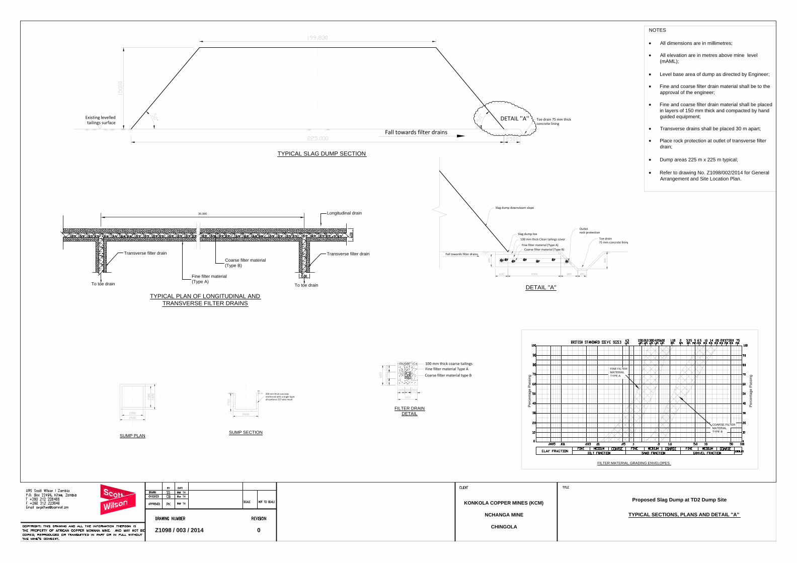
FILTER MATERIAL GRADING ENVELOPES
COARSE FILTER
MATERIAL
TYPE B
Pe
rce
nta
ge
P
assin
g
FINE FILTER
MATERIAL
TYPE A
Pe
rce
nta
ge
P
assin
g
Existing levelledtailings surface
Fall towards filter drains
Toe drain 75 mm thickconcrete lining
DETAIL ''A''
TYPICAL SECTIONS, PLANS AND DETAIL ''A''
KONKOLA COPPER MINES (KCM)
NCHANGA MINE
CHINGOLA
Proposed Slag Dump at TD2 Dump Site
Z1098 / 003 / 2014 0
G/L
200 mm thick concretereinforced with a single layerof conforce 257 wire mesh
NOTES
All dimensions are in millimetres;
All elevation are in metres above mine level
(mAML);
Level base area of dump as directed by Engineer;
Fine and coarse filter drain material shall be to the
approval of the engineer;
Fine and coarse filter drain material shall be placed
in layers of 150 mm thick and compacted by hand
guided equipment;
Transverse drains shall be placed 30 m apart;
Place rock protection at outlet of transverse filter
drain;
Dump areas 225 m x 225 m typical;
Refer to drawing No. Z1098/002/2014 for General
Arrangement and Site Location Plan.
100 mm thick coarse tailingsFine filter material Type ACoarse filter material type B
30,000Longitudinal drain
To toe drain
Transverse filter drain
Transverse filter drain
Fine filter material
(Type A)
Coarse filter material
(Type B)
To toe drain
Fall towards filter drains
Slag dump toeToe drain75 mm concrete lining
Slag dump downsteam slope
100 mm thick Clean tailings cover
Fine filter material (Type A)Coarse filter material (Type B)
Outletrock protection
TYPICAL SLAG DUMP SECTION
SUMP SECTION
SUMP PLAN
FILTER DRAIN
DETAIL
TYPICAL PLAN OF LONGITUDINAL AND
TRANSVERSE FILTER DRAINS
DETAIL ''A''

Konkola Copper Mines Plc TD2 Slag Dump Project
TD2 Slag Dump Design Report March 2014
Appendix 2: Pre-disposal Works Bill of Quantities

Konkola Copper Mines Plc TD2 Slag Dump Project
TD2 Slag Dump Design Report March 2014
Bill of Quantities for TD 2 Slag Dump Preparation.
Item Description Qty UOM
Unit Rate Amount
1 Preliminary and General Items (including mobilisation) 1 Item -
2 Level and compact dump site footprint for Stage 1 dumping 5 ha -
3 Excavate in tailings for longitudinal filter drain 600 mm wide by 650 mm deep over a distance of 250 m. Provide timber struts for protection against collapse to the sides of the excavation 97.5 m3
-
4
Excavate in tailings transverse filter drain 600 mm wide by 650 mm deep connecting into longitudinal drain at 30 m spacing. Provide timber struts for protection against collapse to the sides of the excavation. 8.78 m3
-
5 Supply and lay filter material to the drains
Type A Filter Material 11 m3 -
Type B Filter Material 83 m3 -
6 Excavate and remove tailings along alignment of toe drain up 2200 mm wide and 900 mm deep. Dispose all removed tailings as directed by the Engineer within the TD2 footprint 475 m3
-
7 Import and infill in layers not exceeding 200 mm, earthfill material in the excavated toe drain alignment 475 m3
-
8 Excavate through the infilled earthfill material, toe drain with 1:1 side slope ratio, to a depth of 875 mm. 231 m3
-
9 Line toe drain base and side walls with concrete (1:3:6).
48 m3
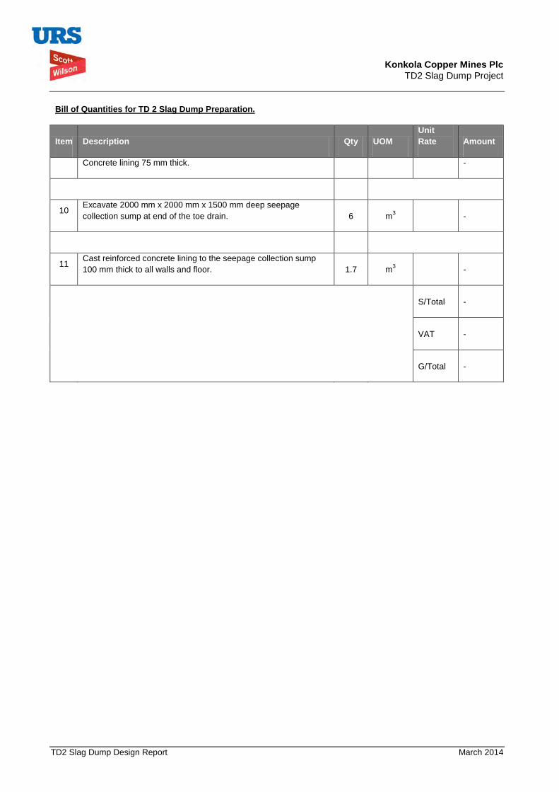
Konkola Copper Mines Plc TD2 Slag Dump Project
TD2 Slag Dump Design Report March 2014
Bill of Quantities for TD 2 Slag Dump Preparation.
Item Description Qty UOM
Unit Rate Amount
Concrete lining 75 mm thick. -
10 Excavate 2000 mm x 2000 mm x 1500 mm deep seepage collection sump at end of the toe drain. 6 m3
-
11 Cast reinforced concrete lining to the seepage collection sump 100 mm thick to all walls and floor. 1.7 m3
-
S/Total
-
VAT -
G/Total
-
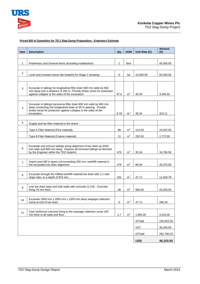
Konkola Copper Mines Plc TD2 Slag Dump Project
TD2 Slag Dump Design Report March 2014
Priced Bill of Quantities for TD 2 Slag Dump Preparation - Engineers Estimate
Item Description Qty UOM Unit Rate (K)
Amount (K)
1 Preliminary and General Items (including mobilisation) 1 Item 45,000.00
2 Level and compact dump site footprint for Stage 1 dumping 5 ha 10,000.00
50,000.00
3 Excavate in tailings for longitudinal filter drain 600 mm wide by 650 mm deep over a distance of 250 m. Provide timber struts for protection against collapse to the sides of the excavation 97.5 m3
35.34
3,445.65
4 Excavate in tailings transverse filter drain 600 mm wide by 650 mm deep connecting into longitudinal drain at 30 m spacing. Provide timber struts for protection against collapse to the sides of the excavation. 8.78 m3
35.34
310.11
5 Supply and lay filter material to the drains
Type A Filter Material (Fine material) 88 m3 114.00
10,032.00
Type B Filter Material (Coarse material) 11 m3 252.00
2,772.00
6 Excavate and remove tailings along alignment of toe drain up 2200 mm wide and 900 mm deep. Dispose all removed tailings as directed by the Engineer within the TD2 footprint 475 m3
35.34
16,786.50
7 Import and infill in layers not exceeding 200 mm, earthfill material in the excavated toe drain alignment 475 m3
85.00
40,375.00
8 Excavate through the infilled earthfill material toe drain with 1:1 side slope ratio, to a depth of 875 mm . 231 m3
47.71
11,020.78
9 Line toe drain base and side walls with concrete (1:3:6). Concrete lining 75 mm thick. 48 m3
900.00
43,200.00
10 Excavate 2000 mm x 2000 mm x 1500 mm deep seepage collection sump at end of toe drain. 6 m3
47.71
286.26
11 Cast reinforced concrete lining to the seepage collection sump 100 mm thick to all walls and floor. 1.7 m3
1,950.00
3,315.00
S/Total 226,543.30
VAT
36,246.93
G/Total 262,790.23
USD 46,103.55

Konkola Copper Mines Plc TD2 Slag Dump Project
TD2 Slag Dump Design Report March 2014
Appendix 2: Stability Analysis Models
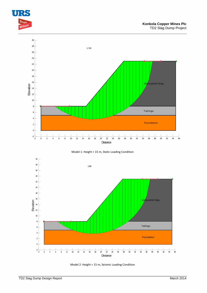
Konkola Copper Mines Plc TD2 Slag Dump Project
TD2 Slag Dump Design Report March 2014
Model 1: Height = 15 m, Static Loading Condition
Model 2: Height = 15 m, Seismic Loading Condition
1.740
Granualetd Slag
Tail ings
Foundation
Distance-2 0 2 4 6 8 10 12 14 16 18 20 22 24 26 28 30 32 34 36 38 40 42 44 46
Elev
atio
n
-2
0
2
4
6
8
10
12
14
16
18
20
22
24
26
28
30
1.535
Granualetd Slag
Tailings
Foundation
Distance-2 0 2 4 6 8 10 12 14 16 18 20 22 24 26 28 30 32 34 36 38 40 42 44 46
Elev
atio
n
-2
0
2
4
6
8
10
12
14
16
18
20
22
24
26
28
30

Konkola Copper Mines Plc TD2 Slag Dump Project
TD2 Slag Dump Design Report March 2014
Model 3: Height = 20 m, Static Loading Condition
Model 4: Height = 20 m, Seismic Loading Condition
1.67
Granualetd Slag
Tailings
Foundation
Distance-2 0 2 4 6 8 10 12 14 16 18 20 22 24 26 28 30 32 34 36 38 40 42 44 46 48 50 52 54 56
Elev
atio
n
-2
0
2
4
6
8
10
12
14
16
18
20
22
24
26
28
30
1.47
Granualetd Slag
Tailings
Foundation
Distance-2 0 2 4 6 8 10 12 14 16 18 20 22 24 26 28 30 32 34 36 38 40 42 44 46 48 50 52 54 56
Elev
atio
n
-2
0
2
4
6
8
10
12
14
16
18
20
22
24
26
28
30
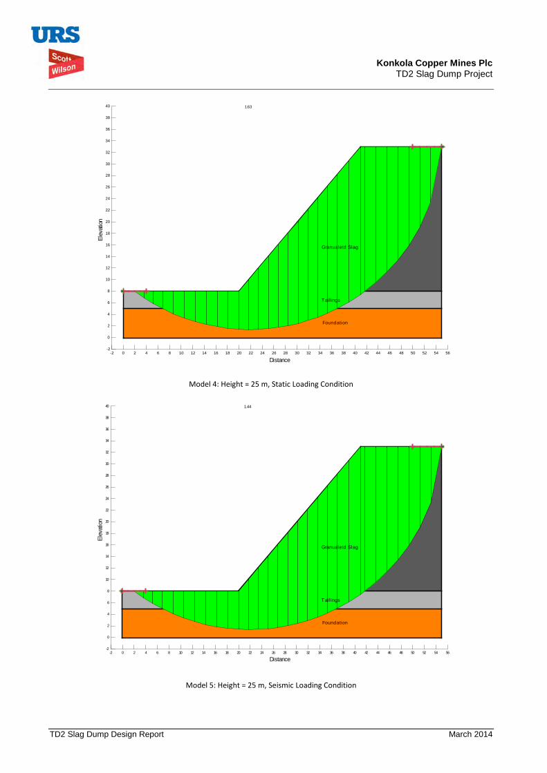
Konkola Copper Mines Plc TD2 Slag Dump Project
TD2 Slag Dump Design Report March 2014
Model 4: Height = 25 m, Static Loading Condition
Model 5: Height = 25 m, Seismic Loading Condition
1.63
Granualetd Slag
Tailings
Foundation
Distance-2 0 2 4 6 8 10 12 14 16 18 20 22 24 26 28 30 32 34 36 38 40 42 44 46 48 50 52 54 56
Elev
atio
n
-2
0
2
4
6
8
10
12
14
16
18
20
22
24
26
28
30
32
34
36
38
40
1.44
Granualetd Slag
Tailings
Foundation
Distance-2 0 2 4 6 8 10 12 14 16 18 20 22 24 26 28 30 32 34 36 38 40 42 44 46 48 50 52 54 56
Elev
atio
n
-2
0
2
4
6
8
10
12
14
16
18
20
22
24
26
28
30
32
34
36
38
40

Konkola Copper Mines Plc TD2 Slag Dump Project
TD2 Slag Dump Design Report March 2014
Model 6: Height = 25 m, Localised Failure 1, Static Loading Condition
Model 7: Height = 25 m, Localised Failure 1, Seismic Loading Condition
1.56
Granualetd Slag
Tailings
Foundation
Distance-2 0 2 4 6 8 10 12 14 16 18 20 22 24 26 28 30 32 34 36 38 40 42 44 46 48 50 52 54 56
Elev
atio
n
-2
0
2
4
6
8
10
12
14
16
18
20
22
24
26
28
30
32
34
36
38
40
2.13
Granualetd Slag
Tailings
Foundation
Distance-2 0 2 4 6 8 10 12 14 16 18 20 22 24 26 28 30 32 34 36 38 40 42 44 46 48 50 52 54 56
Elev
atio
n
-2
0
2
4
6
8
10
12
14
16
18
20
22
24
26
28
30
32
34
36
38
40
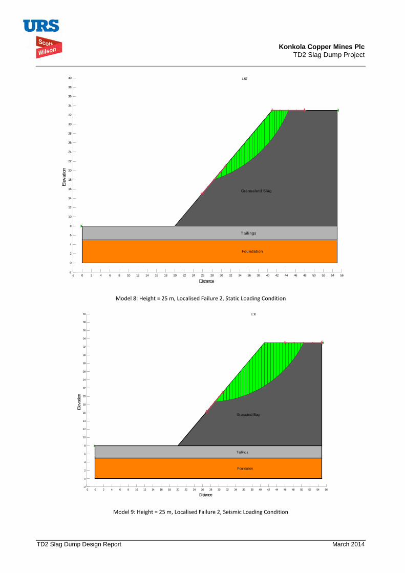
Konkola Copper Mines Plc TD2 Slag Dump Project
TD2 Slag Dump Design Report March 2014
Model 8: Height = 25 m, Localised Failure 2, Static Loading Condition
Model 9: Height = 25 m, Localised Failure 2, Seismic Loading Condition
1.57
Granualetd Slag
Tail ings
Foundation
Distance-2 0 2 4 6 8 10 12 14 16 18 20 22 24 26 28 30 32 34 36 38 40 42 44 46 48 50 52 54 56
Elev
atio
n
-2
0
2
4
6
8
10
12
14
16
18
20
22
24
26
28
30
32
34
36
38
40
2.10
Granualetd Slag
Tailings
Foundation
Distance-2 0 2 4 6 8 10 12 14 16 18 20 22 24 26 28 30 32 34 36 38 40 42 44 46 48 50 52 54 56
Elev
ation
-2
0
2
4
6
8
10
12
14
16
18
20
22
24
26
28
30
32
34
36
38
40
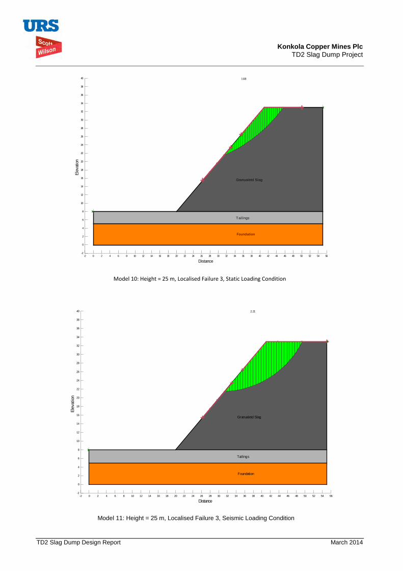
Konkola Copper Mines Plc TD2 Slag Dump Project
TD2 Slag Dump Design Report March 2014
Model 10: Height = 25 m, Localised Failure 3, Static Loading Condition
Model 11: Height = 25 m, Localised Failure 3, Seismic Loading Condition
1.68
Granualetd Slag
Tailings
Foundation
Distance-2 0 2 4 6 8 10 12 14 16 18 20 22 24 26 28 30 32 34 36 38 40 42 44 46 48 50 52 54 56
Elev
atio
n
-2
0
2
4
6
8
10
12
14
16
18
20
22
24
26
28
30
32
34
36
38
40
2.21
Granualetd Slag
Tailings
Foundation
Distance-2 0 2 4 6 8 10 12 14 16 18 20 22 24 26 28 30 32 34 36 38 40 42 44 46 48 50 52 54 56
Elev
atio
n
-2
0
2
4
6
8
10
12
14
16
18
20
22
24
26
28
30
32
34
36
38
40
Top Related