


Languages
Pages
Legal


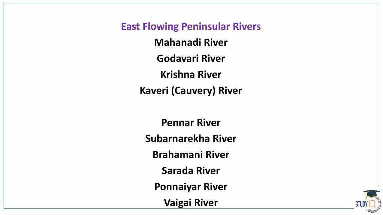
East Flowing Peninsular Rivers
Mahanadi River
Godavari River
Krishna River
Kaveri (Cauvery) River
Pennar River
Subarnarekha River
Brahamani River
Sarada River
Ponnaiyar River
Vaigai River


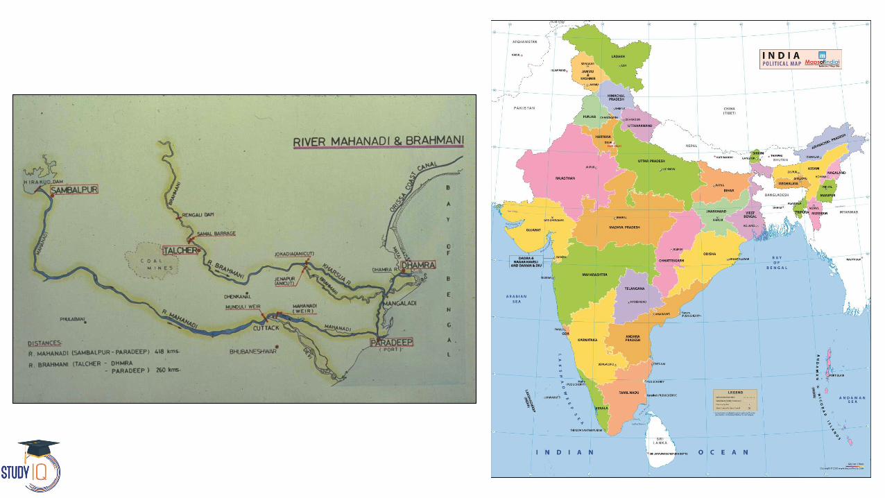
Mahanadi River
The Mahanadi basin extends over states of Chhattisgarh and Odisha and comparatively smaller portions of Jharkhand, Maharashtra and Madhya
Pradesh, draining an area of 1.4 lakh Sq.km.
Total course - 900 km

Mahanadi River
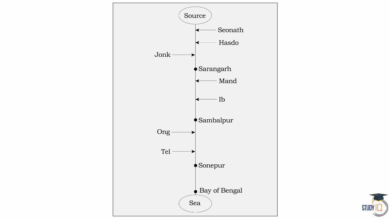
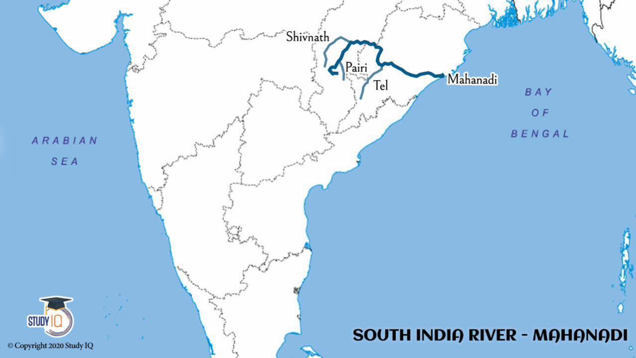
Source - River Mahanadi originates from Sihawa Mountain in Dhamtari District of Chhattisgarh
The major part of basin is covered with agricultural land accounting to 54.27% of the total area.
The total length of river from its origin to confluence of Bay of Bengal is about 851 Km, of which, 357 Km lies in Chhattisgarh and balance 494 Km in Odisha

Mahanadi River
After receiving the Seonath River, it turns east and enters Odisha state.
Seonath The Seonath is the longest tributary of Mahanadi, its length is 290kms
At Sambalpur, the Hirakud Dam (one of the largest dams in India) on the river has formed a man-made lake 35 miles (55 km) long. It enters the Odisha plains
near Cuttack and enters the Bay of Bengal by forming a delta.
Other small streams between the Mahanadi and the Rushikulya draining directly into the Chilka Lake also forms the part of the basin.

Its main tributaries are
The Seonath
The Jonk
The Hasdeo
The Mand
The IB
The Ong
The Tel

Major projects
Hirakud Dam
Dudhawa Dam is located in Dhamtari district of Chhattisgarh
Gangrel Dam (Ravishankar Sagar), located in Dhamtari district,Chhattisgarh
It is key water supplier of Bhilai Steel Plant.
Sondur Dam on Sondur River in Dhamtari district, Sondur is a tributary of Mahanadi
Hasdeo Bango Dam is a dam across the Hasdeo river in Chhattisgarh, India
Tandula Dam on Tandula river which is tributary of Seonath river

Satkosia Tiger Reserve was designated in 2007, and comprises the Satkosia Gorge Wildlife Sanctuary and the adjacent Baisipalli Wildlife Sanctuary.
This Gorge is made by Mahanadi River
Mahanadi basin is rich in mineral resources.
It therefore has a favorable industrial climate.
The Important industries presently existing in the basin are the Iron and Steel plant at Bhilai, aluminium factories at Hirakud and Korba, paper mill near Cuttack and cement factory at
Sundargarh.


Godavari River
The Godavari is the largest river system of the Peninsular India and is revered as Dakshina Ganga.
The Godavari is India's second longest river after the Ganga.
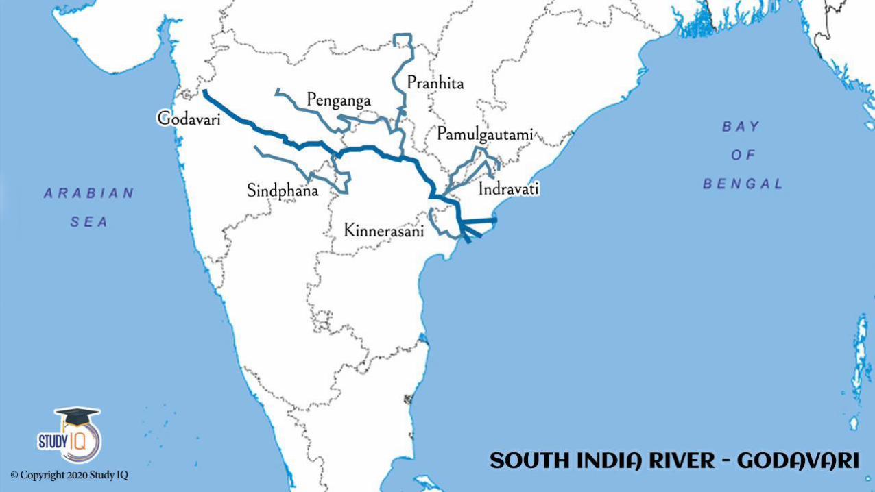
Source - Godavari rises in the Sahyadris Brahmagiri Mountains near Triambakeswar in the Nasik district of Maharashtra.

Godavari River
Measuring more than 3 Lakh Km2 it forms one of the largest river basins in the Indian subcontinent
The catchment area of the river is spread in the states of Maharashtra (48.6%), Andhra Pradesh (23.4%), Madhya Pradesh (10.0%), Chattisgarh (10.9%), Orissa
(5.7%) and Karnataka (1.4%)
The total length of Godavari from its origin to outfall into the Bay of Bengal is 1,465 km out of which the length in Maharashtra is 694 Km.

Important Tributaries of Godavari
Statewise Drainage Area (Km2)

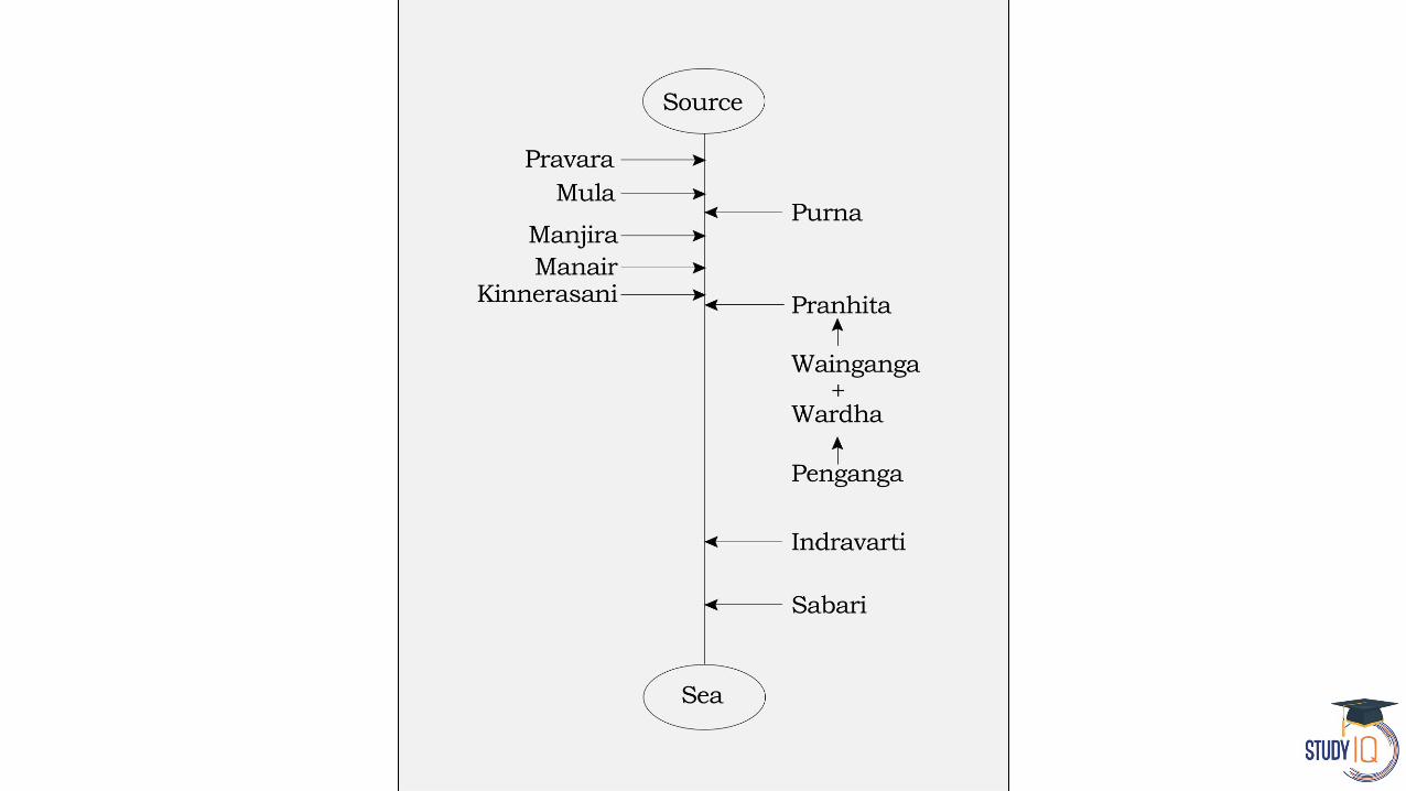

Left bank tributaries - Purna, Pranhita, Indravati and Sabari River
Right bank tributaries - Pravara, Manjira, Manair, Kinnersani
Pranhita is the largest tributary covering about 34% of its drainage basin.
Indravati is the 2nd largest tributary, known as the "lifeline" of the Kalahandi, Nabarangapur of Odisha & Bastar district of Chhattisgarh.

Manjira is the longest tributary and holds the Nizam Sagar reservoir.
Singur Dam in Telangana is also on Manjira River and it is a major source of drinking water for Hyderabad.
Purna is a prime river in the water scarce Marathwada region of Maharashtra.

Cities on the bank of Godavari
Nashik, Nanded, Rajamundhry, Ramagundam, Bhadrachalam
Major Projects on Godavari
Kaleshwaram Lift Irrigation Project - At the juncture of the rivers Godavari and its tributary Pranahita in Telangana.
Polavaram Project – Andhra Pradesh
Jayakwadi Dam – Aurangabad, Maharashtra
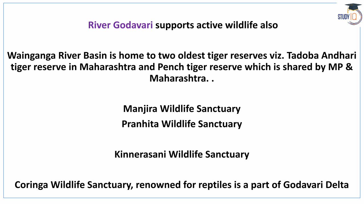
River Godavari supports active wildlife also
Wainganga River Basin is home to two oldest tiger reserves viz. Tadoba Andharitiger reserve in Maharashtra and Pench tiger reserve which is shared by MP &
Maharashtra. .
Manjira Wildlife Sanctuary
Pranhita Wildlife Sanctuary
Kinnerasani Wildlife Sanctuary
Coringa Wildlife Sanctuary, renowned for reptiles is a part of Godavari Delta

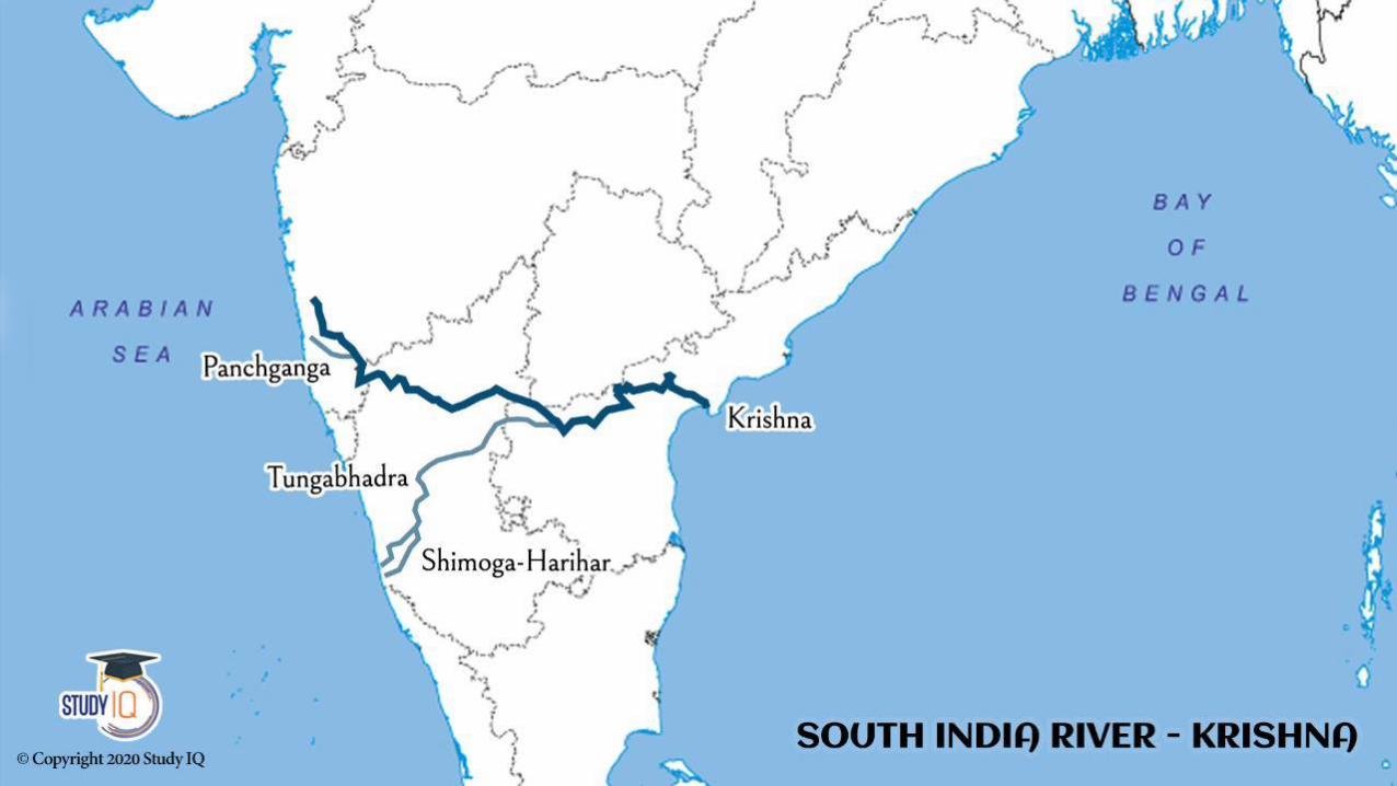

Krishna River
The Krishna is the second largest eastward draining interstate river in Peninsular India.
It rises in the Mahadev range of the Western Ghats at an altitude of 1,337 m near Mahabaleshwar in Maharashtra
It flows for a distance of 305 km in Maharashtra, 483 km in Karnataka and 612 km in Andhra Pradesh before finally out falling into the Bay of
Bengal.
The length of the river is about 1,400 km
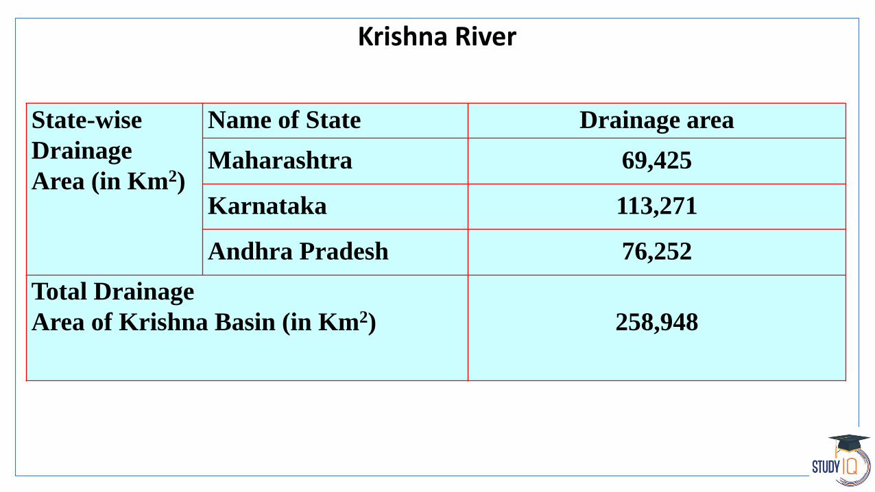
Krishna River
State-wise
Drainage
Area (in Km2)
Name of State Drainage area
Maharashtra 69,425
Karnataka 113,271
Andhra Pradesh 76,252
Total Drainage
Area of Krishna Basin (in Km2) 258,948
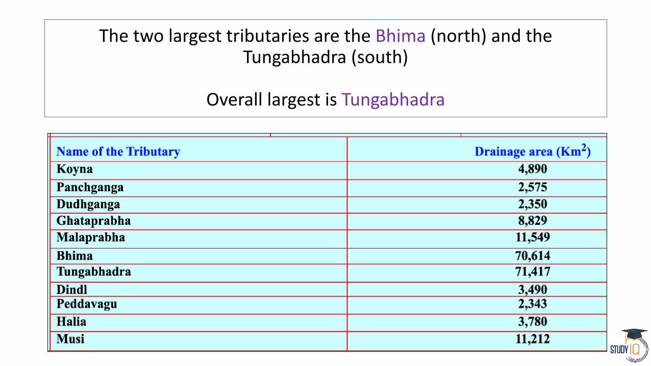
The two largest tributaries are the Bhima (north) and the Tungabhadra (south)
Overall largest is Tungabhadra
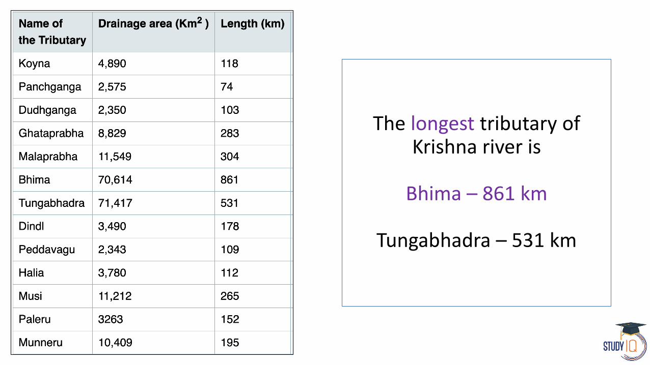
The longest tributary of Krishna river is
Bhima – 861 km
Tungabhadra – 531 km

Basava Sagar Dam, previously known as Narayanpura Dam across Krishna River at YadgirDistrict, Karnataka
Srisailam Dam is constructed across the Krishna River in Kurnool district, Andhra Pradesh
Nagarjuna Sagar Dam is a masonry dam across the Krishna River at Nagarjuna Sagar which straddles the border between Guntur district in Andhra Pradesh and Nalgonda district in
Telangana.
The Tungabhadra Dam also known as Pampa Sagar is constructed across the Tungabhadra River, a tributary of the Krishna River. Located in Ballari, Karnataka
Prakasam Barrage stretches across the Krishna River connecting Krishna and Guntur districts in Vijaywada, Krishna district
Almatti Dam is a hydroelectric project on the Krishna River in North Karnataka


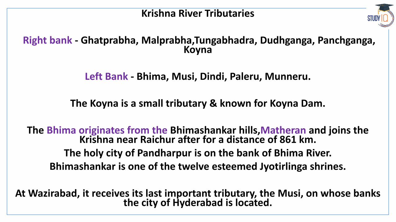
Krishna River Tributaries
Right bank - Ghatprabha, Malprabha,Tungabhadra, Dudhganga, Panchganga, Koyna
Left Bank - Bhima, Musi, Dindi, Paleru, Munneru.
The Koyna is a small tributary & known for Koyna Dam.
The Bhima originates from the Bhimashankar hills,Matheran and joins the Krishna near Raichur after for a distance of 861 km.
The holy city of Pandharpur is on the bank of Bhima River. Bhimashankar is one of the twelve esteemed Jyotirlinga shrines.
At Wazirabad, it receives its last important tributary, the Musi, on whose banks the city of Hyderabad is located.
Cities on the bank of Krishna River
Amravati, Vijaywada, Srisailam, Mahabaleshwar
The Tungabhadra is formed by the unification of the Tunga and the Bhadra originating from Gangamoola in the Central Sahyadri.
Its total length is 531 km. It was known as Pampa during the epic period. The city of Hampi is built on its bank.
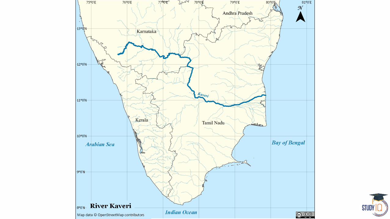

Cauvery River
It rises on Talakaveri in Brahmagiri Hill of the Western Ghats in Karnataka state, flows in a southeasterly direction for 765 km
through the states of Karnataka and Tamil Nadu, and falls in Bay of Bengal.
Cauvery River
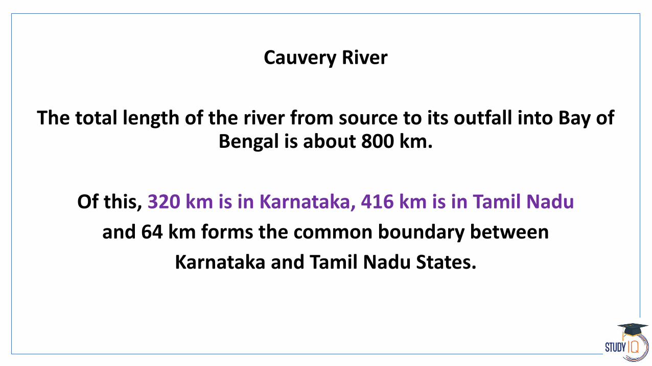
The total length of the river from source to its outfall into Bay of Bengal is about 800 km.
Of this, 320 km is in Karnataka, 416 km is in Tamil Nadu
and 64 km forms the common boundary between
Karnataka and Tamil Nadu States.


Cauvery River
The important tributaries joining Cauvery in the Coorg district are the Kakkabe, the Kadanur and the Kummahole.
Cauvery then enters the Mysore district
tributaries joining the river from the left are the Harangi, the Hemavathi, the Shimsha and the Arkavathi.
The tributaries joining it from the right are the Lakshmanathirtha, the Kabani, and the Suvarnavathi.
Further down, the river enters Tamil Nadu state where the many tributaries, namely, the Bhavani, the Noyil, and the Amravathi join it from the right.
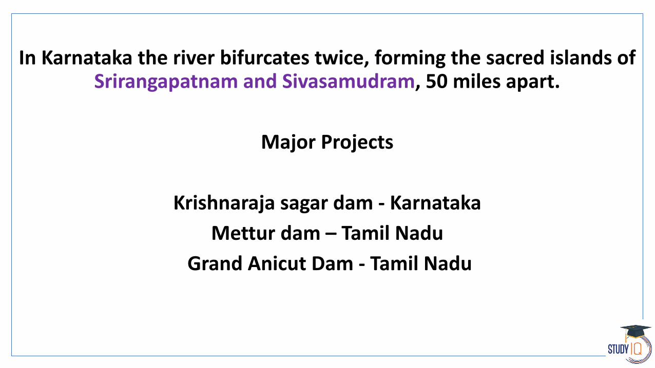
In Karnataka the river bifurcates twice, forming the sacred islands of Srirangapatnam and Sivasamudram, 50 miles apart.
Major Projects
Krishnaraja sagar dam - Karnataka
Mettur dam – Tamil Nadu
Grand Anicut Dam - Tamil Nadu
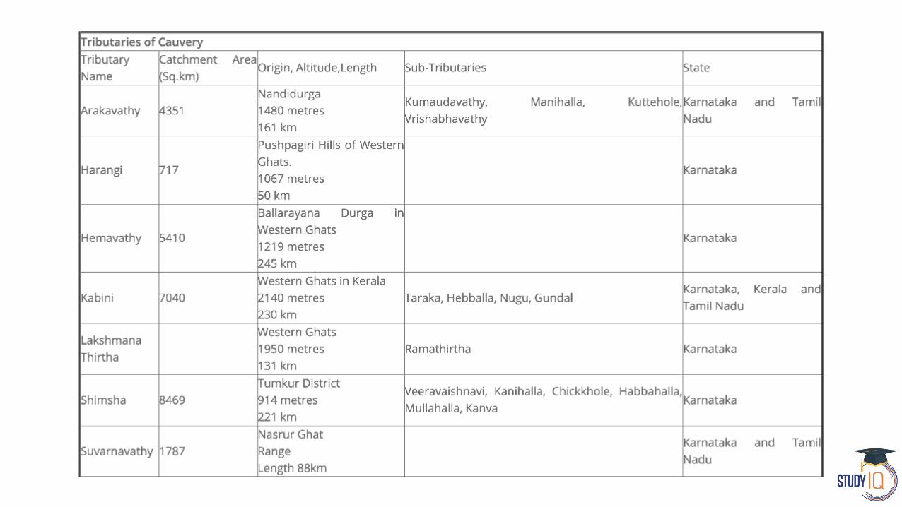

Largest tributary of Cauvery – Shimsha
Longest tributary of Cauvery – Hemvathy

Pennar River
Pennar River (also known as Uttara Pinakini) is one of the major rivers of the peninsula.
The Pennar rises in the Chenna Kasava hill of the Nandidurg range, in Chikkaballapur district of Karnataka and flows towards east eventually
draining into the Bay of Bengal.
The total length of the river from origin to its outfall in the Bay of Bengal is 597 km.

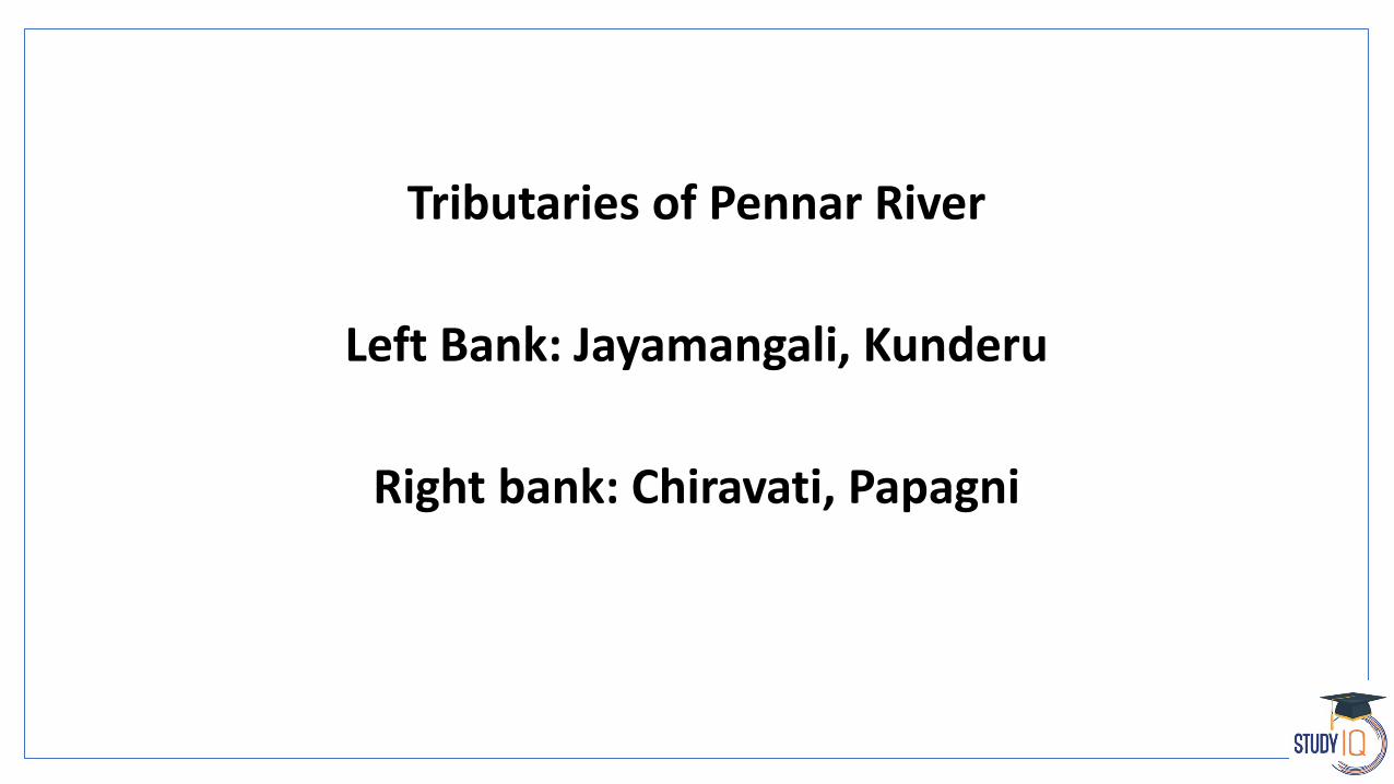
Tributaries of Pennar River
Left Bank: Jayamangali, Kunderu
Right bank: Chiravati, Papagni

Brahamani & Baitarni River
The basin consisting of Brahmani and Baitarni extends over states of Odisha, Jharkhand and Chhattisgarh having an area of 51,822 Sq.km
Brahmani River
The Brahmani is the second largest river in Odisha. It originates as two major rivers namely the Sankh and the Koel from the Chhotanagpur Plateau and both
join near Rourkela forming the major river Brahmani. It flows through Sundargarh, Keonjhar, Dhenkanal and the coastal plains of Kendrapara and
Jajpur districts before discharging into the Bay of Bengal at Dhamra. The Brahmani is 799 km long

Brahamani & Baitarni River
The Baitarani River originates from Guptaganga hills in Keonjhar district of Odisha.
A major portion of the river basin lies in the state of Odisha, while a smaller part of the upper reach lies in Jharkhand state. Initially the river flows in a northern direction for about 80 km and then takes an abrupt
right turn near Champua and flows in a south easterly direction and finally discharges into Bay of Bengal
through the deltaic area of river Brahmani.
The river travels a total distance of 360 km

Rushikulya River
The Rushikulya River is one of the major eastern flowing rivers in the state of Odisha and covers entire catchment area in the districts of
Kandhamal and Ganjam of Odisha.
The Rushikulya originates at an elevation of about 1000 metres from Daringbadi hills of the Eastern Ghats range. The place from where the
river originates, Daringbadi is called the ' Kashmir of Odisha ‘.
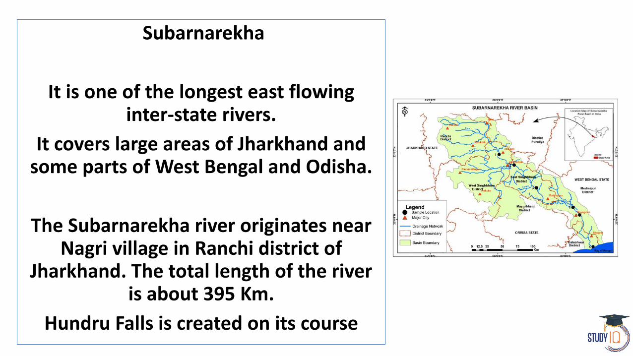
Subarnarekha
It is one of the longest east flowing inter-state rivers.
It covers large areas of Jharkhand and some parts of West Bengal and Odisha.
The Subarnarekha river originates near Nagri village in Ranchi district of
Jharkhand. The total length of the river is about 395 Km.
Hundru Falls is created on its course


River Vamsadhara
is an important east flowing river between Rushikulya and Godavari, in Odisha and Andhra Pradesh states in India.
River
Another river with similar course is Nagavali River.
Just South of Nagavali is another river called Sarada river that lies entirely in Vishakhapatnam.

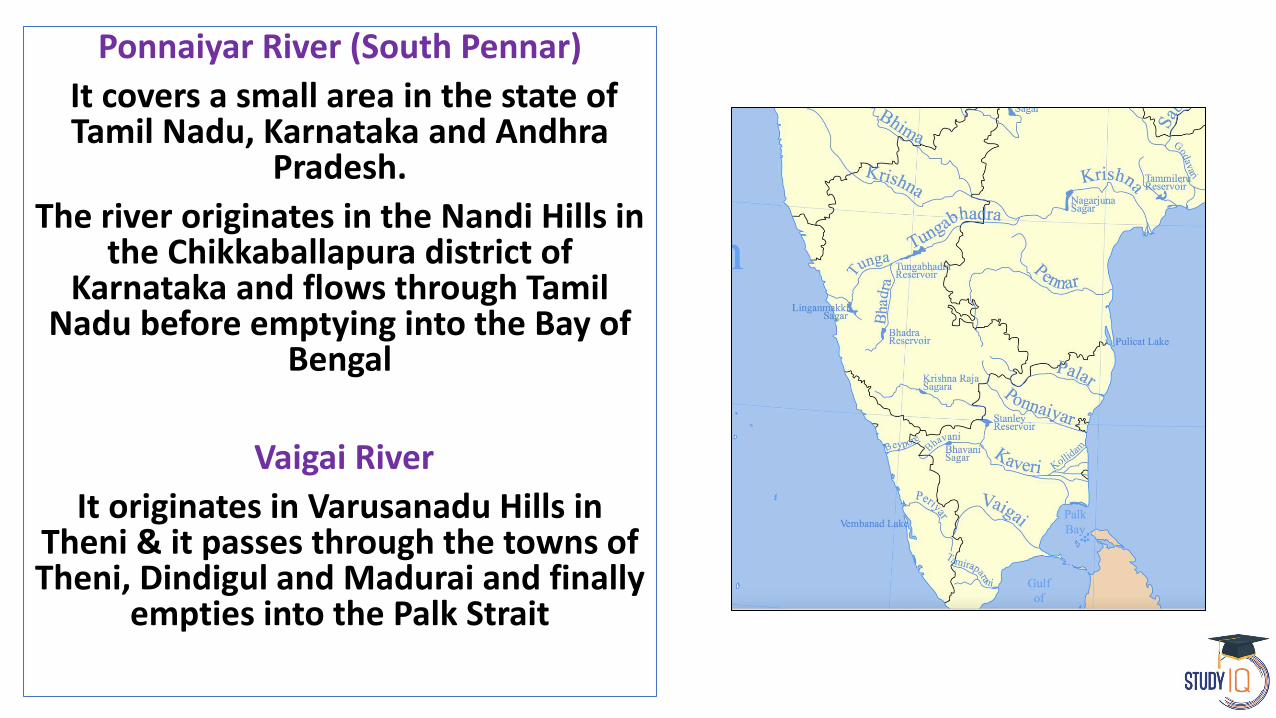
Ponnaiyar River (South Pennar)
It covers a small area in the state of Tamil Nadu, Karnataka and Andhra
Pradesh.
The river originates in the Nandi Hills in the Chikkaballapura district of
Karnataka and flows through Tamil Nadu before emptying into the Bay of
Bengal
Vaigai River
It originates in Varusanadu Hills in Theni & it passes through the towns of Theni, Dindigul and Madurai and finally
empties into the Palk Strait

Palar River
Palar is a river of southern India. It rises in the Nandi Hills in Chikkaballapura
district of Karnataka state, and flows 93 kilometres in Karnataka, 33 kilometresin Andhra Pradesh and 222 kilometres
in Tamil Nadu before reaching its confluence into the Bay of Bengal at
Vayalur

Top Related