


Languages
Pages
Legal

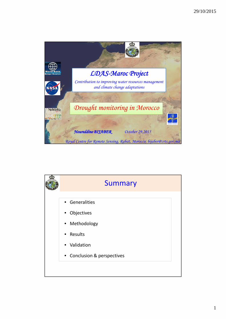
29/10/2015
1
LDASLDASLDASLDAS----MarocMarocMarocMaroc ProjectProjectProjectProjectContribution to improving water resources management
and climate change adaptations
Drought monitoring in Morocco
October 29,2015
GSFC
Noureddine BIJABERNoureddine BIJABERNoureddine BIJABERNoureddine BIJABER
Royal Centre for Remote Sensing, Rabat, Morocco, [email protected]
Summary
• Generalities
• Objectives
• Methodology
• Results
• Validation
• Conclusion & perspectives
29/10/2015
2
• Importance of Agriculture in GDP• 14 à 20% of GDP
• 43% of total jobs and 78% of jobs in rural areas
• Low annual precipitation level and strong inter and intra annual variability;
- Low quantities
- Concentrated in few days,
- Temporal irregularity (seasons, years) and unequally distributed in space.
• Dominance of non irrigated agriculture (>80% SAU) ;
Generalities
Drought vulnerability has negative impacts on other sectors
Objectives
Elaboration of a DEWS based on indicators in order
to reduce the agricultural vulnerability to Climate
Changes.
Specifically:
- National capacity building in DEW (training / expertise).
- Development of methodologies based on the generation, analysis and dissemination of indicators about drought at national scale.
- Edition & diffusion of bulletins informing on drought.

29/10/2015
3
Met
ho
do
log
yM
eth
od
olo
gy CHIRPS NDVIa ETaLSTday_night
Climate Hazard Group MODIS FEWSNET
Re sampling 5 km Grill
SQL DB
(history + updates)
CHIRPS / NDVIa / Eta / LST
SPI calculate
Ranking (Percentile)
SPI NDVIa ETa LSTday_night
CDI calculate
CDI (monthly)
Web delivery
(Dissemination
platform)
25,588 grid points (5km cells)
1,592 grid points (5km cells)

29/10/2015
4
Input data : precipitations
CHIRPS : Climate Hazards Group InfraRedPrecipitation with Station dataCHIRPS incorporates 0.05° resolution Infrared satellite imagery with in-situ station data to create gridded rainfall time series for trend analysis and seasonal drought monitoring.
Input data : Soil moisture
MODIS Day-Night LST Difference as SM Proxy
• Wet surface heat up slower than dry surface.

29/10/2015
5
Input data : Vegetation index
FEWSNET : Famine Early Warning System Network
• NDVI anomaly = general vegetation health indicator
Input data : Evapotranspiration
FEWSNET : Famine Early Warning System Network
Actual ET is produced using the Operational Simplified Surface Energy Balance (SSEBop) model since 2003.

29/10/2015
6
SM/LST day-nightSPI from CHIRPS MODIS ETa NDVI-a/MODIS
CompositeDrought Index
Exceptional Drought:(once per 50+ years)Extreme Drought:(once per 20 to 50 years)Severe Drought:(once per 10 to 20 years)Moderate Drought:(once per 5 to 10 years)
CDI tool
LST data processing PreprocessingData download SPI generator Rank, DB insertion Weighting CDI calculate Components maps

29/10/2015
7

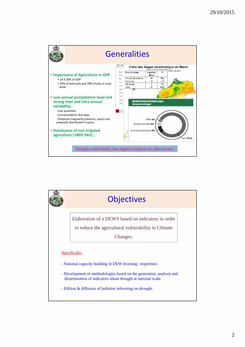
29/10/2015
8
CDI : Drought classes
CDI : Wetness classes
29/10/2015
9
29/10/2015
10
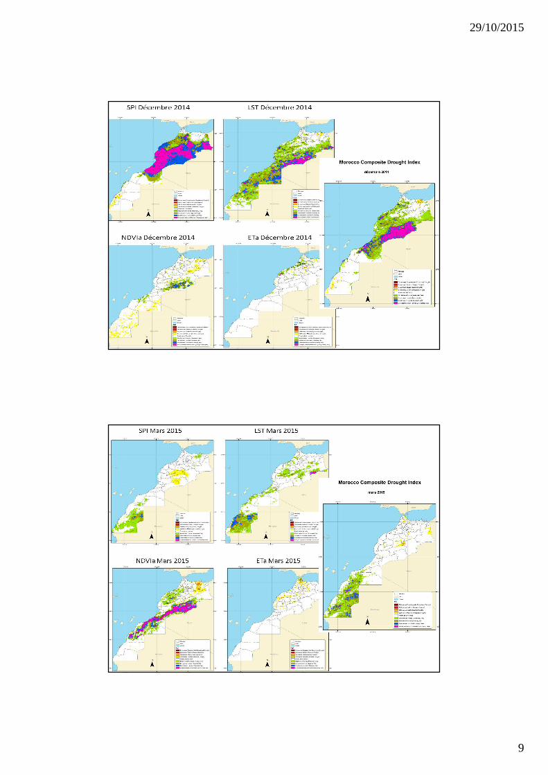
Comparison Dry year vs. wet year
CDI March 2010 CDI March 2012
SPI Mars 2010 LST Mars 2010 NDVIa Mars 2010 ETa Mars 2010
SPI Mars 2012 LST Mars 2012 NDVIa Mars 2012 ETa Mars 2012

29/10/2015
11
Validations
1. Retrospective evaluation for past drought events via historical data records :
- Comparison with historical in situ measurements (crop yields).
- Historic of precipitation .
- …
Validations
2. Establishment of a network of evaluators (survey) :
- Evaluation of current drought conditions.
- Identification of past drought events and comparison with generated CDI maps.
- …

29/10/2015
12
Validations
Web delivery: dissemination platform
Internet portal for data access and distribution

29/10/2015
13
The specific data inputs were selected using several criteria that include:
• data access, reliability, and long-term availability
• commonly accepted and used variables by the global community for agricultural drought monitoring that can be combined into a customized CDI
• Future satellite missions planned to sustain a specific data input
Conclusion
In Morocco, drought is
- frequentphenomenon,
- concerns a large areas,
-Complexphenomenon and result from interaction between several parameters.
And, it is very difficult to study and monitor this phenomenon without a global observationof the affected areas.
The work is just beginning
Perspectives / Recommendations
Spatial Resolution to be improved
CDI Periodicity to be improved
Evaluators network / validation
End users Implication :comments, …
Top Related