


Languages
Pages
Legal


DEPARTMENT OF GEOMATICS ENGINEERING
PROGRESS REPORT 2005/2006
UCGE Number 50037
PROGRESS REPORT 2005/2006
DEPARTMENT OF GEOMATICS ENGINEERING
May 2006
UNIVERSITY OF CALGARY 2500 University Drive NW
Calgary, Alberta T2N 1N4
Telephone: (403) 220-5834 Fax: (403) 284-1980
Website: www.geomatics.ucalgary.ca

Cover Photo: Orthophoto mosaic over the Federal University of
Paraná—UFPR in Brazil Upper Left: RC10 color imagery Upper Right: LiDAR range image Upper Left: Sony 717 digital image Lower Right: LiDAR intensity image Photo By: Dr. Ayman F. Habib

Admitted to the Degree of BACHELOR OF SCIENCE
Scott William Anderson (Internship)
Christopher William Beaugrand (Internship) Michael Peter Beck (Internship)
Erin Lisa Berg Meredith Dawn Bryan (Internship)
Norman Christopher Chan (Internship) David Sung-Tat Chiu (With Distinction) (Internship)
Aaron Richard Clapperton Scott Lee Colvin
Daniel Stephen Edward Cook Richard James Deis (Internship)
Ryan Thomas Dobson (Internship) Carina May Dunn
Benjamin Roy Giesbrecht (With Distinction) (Internship)
Cameron Powell Henry (Internship) Daniel Martin Hrouda
Stoyan Nikolaev Koev Ho Wai Lam
Rachelle Anne LaRose (With Distinction) (Internship)
Krista Danielle Lovse Ryan Allen McKellar
Nicole Kathryn Miller (Internship) Aim Thomas Na Chiangmai
Vidya Rangayyan Jennifer Lee Setiawan (Internship)
Jonathan Michael Tingley (Internship) David Mathew Young
Elena Nikolaevna Dmitrieva Daniel Lennon Edwards (With Distinction)(Internship) Michael Carl Heuchert (Internship) William John Jerry Houghton Kimberly Rae Johnson (With Distinction) Kenneth Cole Kitchen (Internship) Ashley J. Spence Large (With Distinction) Dana Erin Lee (With Distinction) (Internship) Michael Philip Lee Joel Anthony Maduck (With Distinction) (Internship) Kari-Ann McKendrick McNabb (Internship) Ivan Ngan Victoria Barbara Ross (With Distinction) Scott Richard Slen (Internship) Timothy Ronald Willms (Internship) Elaine Yuen (Internship)
Admitted to the Degree of DOCTOR OF PHILOSOPHY
Mohamed Abdel-Tawwab Abdelsalam Olivier Julien
Mwafag Saad Hilal Ghanma Qiaoping Zhang
Wai Ting Rita Cheng Radoslav Hristov Gaidadjiev
Tao Hu Nyunook Kim
Liman Mao Valarmathy Meenakshisundaram
Li Sheng Qiang Wu
Ruben Yousuf Wentao Zhang
Wen-Ya Chiu Saurabh Godha Milidu Dharshaka Karunanayake Minmin Lin David Michael McAllister Santosh Madhukar Phalke Salman Qutub Syed Chenglin Xie Haitao Zhang
Admitted to the Degree of MASTER OF SCIENCE
Admitted to the Degree of MASTER OF ENGINEERING
Min Wang Andrew Kuo An Huang
Abboud Kaplo Wojciech Karol Kubacki

TABLE OF CONTENTS
HIGHLIGHTS 2005/06···························································································1 MESSAGE FROM THE DEAN ··············································································2 AWARDS & RECOGNITION ·················································································3 PERSONNEL ········································································································5 Faculty ·······································································································5 Faculty Changes ························································································9 Professors Emeritus···················································································9 Adjunct Professors···················································································10 Support Staff ····························································································10 Research Engineers/Associates/Assistants·············································11 Post Docs·································································································12 Guest Lecturers ·······················································································12 Visiting Scientists ·····················································································13 ADVISORY COMMITTEE AND STUDENT AWARDS ········································14 Geomatics Engineering Advisory Committee (GEAC)·····························14 Geomatics Engineering Liaison Committee·············································15 Student Awards Night & 25th Anniversary···············································16 UNDERGRADUATE STUDIES ···········································································19 Enrollment································································································19 Common Core Curriculum ·······································································21 Undergraduate Curriculum in Geomatics Engineering ····························22 Geomatics Engineering Student Society (GESS) ····································23 ENGO 500 Projects and Guest Presentations·········································24 Engineering Internship Program ······························································26 Geomatics Engineering Career Day ························································27 Survey Camp ···························································································28 GRADUATE STUDIES ························································································29 Enrollment································································································29 Convocants ······························································································32 Grad Seminars·························································································33 RESEARCH·········································································································34 Research Statistics ··················································································34 Major Research Areas ·············································································36 Research Projects by Research Area······················································37 PUBLICATIONS ··································································································42 Books and Chapters ················································································42 Refereed Journals····················································································42 Proceedings ·····························································································45 Scholarly Presentations and Seminars ····················································50 Technical Reports and Notes···································································54 Technology Transfer ················································································55 Other ········································································································55 ACADEMIC AND PROFESSIONAL SERVICE ·························································58

Schulich School of Engineering, Geomatics Engineering Progress Report 2005/2006
Page 1
HIGHLIGHTS 2005/2006
After many years with the Department, Marguerite Anderson, who was the Administrative Manager from 1989 to 1991 and from 1993 to June this year, made a decision to move to Lethbridge. Marguerite has man-aged the administrative affairs of the Department ex-tremely well for these many years, and is missed by faculty members and staff alike. Marcia Inch was hired in July to fill the position of Administrative Manager. Marcia has many previous years’ experience in the Department, having worked here from 1992 to 1996 and again from 1997 to 2001.
Dr. Ed Krakiwsky and Dr. Klaus-Peter Schwarz bid farewell to Marguerite Anderson
During 2005-2006, the Geomatics Engineering program continued to flourish. A total of 42 students received their BSc degree, 19 students their MSc de-gree, 4 students their MEng, and 4 students received their PhD. Undergradu-ate enrolment reached 50, 47 and 52 in second, third, and fourth year of the undergraduate program, in addition to 19 students who entered the Internship Program. Demand for our BSc, MSc and PhD graduates remains exception-ally strong, particularly given the growth in the geomatics sector in Alberta. As many as 80% of all fourth year undergraduate students reported having re-ceived at least one job offer by December of their final year. The number of full-time faculty members reduced slightly to 17, with the depar-ture of three members in 2005/2006. Dr. Darka Mioc, Dr. Mele Rakai, and Dr Nico Sneeuw accepted academic positions at other universities throughout the world. We were very pleased to have Dr. Danielle Marceau, formerly with Université de Montréal join the Department in July as a Professor in Geospa-tial Information Studies, Dr. Marceau brings a breadth of experience in Envi-ronmental Geocomputations to the Department.
The 2005-2006 fiscal period was another very successful year from a research excellence point of view. Faculty members have continued to secure major re-search funding. Total direct research funding exceeded $4.1 million, which is ap-proximately $227,000 in average research funding per faculty member (based on 18 faculty members). Numerous awards were received by students and faculty members which are detailed on the following pages. Several faculty members con-tinued to serve in leadership positions on various boards and in learned societies. The Department is continuing in its commitment to excellence in the undergraduate and graduate programs. Several initiatives are being developed to further enhance our teaching and research programs, so 2006/07 promises to be another exciting year! Dr. M. Elizabeth Cannon Professor and Head, Geomatics Engineering

Schulich School of Engineering, Geomatics Engineering Progress Report 2005/2006
Page 2
I am delighted to provide this letter for the Geomatics Engineering progress report for 2005/06. Under Dr. Elizabeth Cannon’s leadership the Department continues to set a high standard of excellence in all aspects of its operations. By any measure, this is one of the very best Geomatics Engineering Departments worldwide. We are now suppliers of highly qualified people not only to the surveying profession but to the larger Geomatics industry from Canada to California and the world. I wish the Department the very best in 2006/07.
Dr. Chan Wirasinghe, Dean Schulich School of Engineering
MESSAGE FROM THE DEAN
Geomatics Engineering Faculty Members at the Annual Retreat
June, 2005
Back Row: B. Huang, N. Sneeuw, M. Sideris, A. Braun, E. Cannon, M. Collins, C. Valeo, M. Tait, M. Rakai, A. Habib Front Row: S. Skone, N. El-Sheimy, W. Teskey, M. Barry, K. O’Keefe, G. Lachapelle Missing: D. Mioc

Schulich School of Engineering, Geomatics Engineering Progress Report 2005/2006
Page 3
Several faculty members (and one Emeritus Professor) received awards June 09, 2005 at the Engineering Faculty Council: Dr. Kyle O'Keefe-Geomatics Engineering Teaching Excellence Award; Dr. Naser El-Sheimy-Geomatics Engineering Research Excellence Award and the Faculty of Engineering Research Excellence Award; Dr. Susan Skone-Faculty of Engineering Service Award; Gérard Lachapelle-Faculty of Engineering Graduate Education Award; Dr. Klaus-Peter Schwarz-Faculty of Engineering Lifetime Achievement Award.
Raymond Tsoi won the Shell Canada Outstanding Student Poster Paper Award at the Annual Meeting of the Canadian Geophysical Union, for his poster entitled "GPS Based Navigation for Future Geopotential Missions".
Dr. Naser El-Sheimy was awarded the Association of Professional Engineers, Geologists and Geophysicists (APEGGA) Excellence in Education award for exemplary contributions to teach-ing and learning.
Dr. Yang Gao was appointed Luojia Chair Professor of Wuhan University, China. The appoint-ment will further strengthen the academic collaboration between Wuhan University and Univer-sity of Calgary in the field of geomatics.
The Second Annual Faculty of Engineering Graduate Student Research Conference was held on May 2 & 3, 2005. 129 graduate students in the Faculty of Engineering gave brief presenta-tions on their on-going research. Geomatics award winners were: Rita Cheng, Matthias Weigelt, and Bo Zheng.
Professor Gérard Lachapelle, Professor Elizabeth Cannon, Adjunct Professor Richard Klukas, and Messrs. Sanjeet Singh and Rob Watson were selected as the 2005 recipients of the Canadian Aeronautics and Space Institute Casey Baldwin Award for their paper entitled "Hardware Simulator Models and Methodologies for Indoor Performance Assessment of High Sensitivity Receivers". This paper was done in collaboration with Spirent Communications (SW) Limited, U.K. The paper was co-authored by Spirent personnel Messrs. Peter Boulton, Arnie Read and Ken Jones.
Kimberly Rae Johnson received the APEGGA Education Foundation Gold Medal in Geomat-ics Engineering at Convocation in June of 2005 for achieving the highest proficiency in our pro-gram.
Tao Hu and Bo Zheng, supervised by Dr. Gérard Lachapelle, won Best Poster Paper Awards at the iCORE Summit 2005, held in Banff. The titles of their papers were ‘Indoor GPS Signal Replication Using A Hardware Simulator” and “GPS Software Receiver Enhancements for In-door Use’.
Jennifer He (PhD), supervised by Dr. Caterina Valeo, won the Hoskin Inaugural Award for Best Student Poster, entitled ‘Storm Drainage Design for a Changing Climate’, at the Canadian Water Resources Association's 58th Annual Conference. The research team of Drs. Y. Gao, A. Habib and N. El-Sheimy were awarded a three-year strategic grant of $327,300 from NSERC on the research topic of Next Generation Geo-Referencing Technologies for Airborne Mapping. (Continued on next page)
AWARDS AND RECOGNITION

Schulich School of Engineering, Geomatics Engineering Progress Report 2005/2006
Page 4
Two students were awarded Student Sponsorship Awards at the ION GNSS05 in Long Beach, CA. Olivier Julien, (PhD), supervised by Drs. G. Lachapelle and M.E. Cannon, won for his paper ‘Carrier-Phase Tracking of Future Data/Pilot Signals’ and Minmin (Belinda) Lin, (MSc), supervised by Drs. G. Lachapelle and K. O’Keefe, won for her paper ‘RTCM 3.0 Implementa-tion in the South Alberta Network’. Six other papers were awarded Best Presentation Awards at ION GNSS 05: 1) GPS Software Receiver Enhancements for Indoor Use: B. Zheng, G. Lachapelle. 2) The Development of a GPS/MEMS INS Integrated System Utilizing a Hybrid Processing Ar-chitecture: C. Goodall, N. El-Sheimy, K-W. Chiang. 3) Development of a Low-cost MEMS IMU/GPS Navigation System for Land Vehicles Using Auxiliary Velocity Updates in the Body Frame: X. Niu, N. El-Sheimy. 4) Field Results of a GPS/INS-Based Approach to Measuring Ship Flexure Onboard an Aircraft Carrier: M.G. Petovello, K. O'Keefe, G. Lachapelle, M.E. Cannon. 5) Integrating Photogrammetry and GPS at the Measurement-Level: C. Ellum, N. El-Sheimy. 6) GPS Network RTK Performance Under Very Active Ionospheric Conditions: N. Luo, D.T.H. Dao, G. Lachapelle, M.E. Cannon. The Honourable David L. Emerson, Minister of Industry and Minister responsible for the Canada Foundation for Innovation (CFI), announced the appointment of Dr. M. Elizabeth Cannon to the Board of Directors of the CFI for a three-year term. The Canada Foundation for Innovation is an independent corporation created by the Government of Canada to fund research infrastructure. Dr. Matthew Tait was awarded the Geomatics Engineering award "For excellence in teaching and displaying enthusiasm for engineering to students". Dr. Tait was selected by the Third and Fourth year students in April, 2006. Dr. Kyle O'Keefe was named 'Professor of the Year' at the Engineering Graduation Banquet on March 18, 2006. Dr. O'Keefe was selected by the graduating students, and he was noted for providing excellent instruction and support to his students. Natalya Nicholson was selected to receive the Senior Women Academic Administrators of Canada (SWAAC) Graduate Student Award of Merit. This award was established to recognize women who have demonstrated outstanding leadership in their university and in the community while maintaining an exemplary academic record. Natalya is a PhD student who is co-supervised by Drs. Susan Skone and Elizabeth Cannon. Qiaoping Zhang was one of three recipients of the 2006 ASPRS Space Imaging Award. Pres-entation of the award certificate will take place during the ASPRS 2006 Annual Conference in Reno, Nevada May 3. Qiaoping is a PhD student supervised by Dr. Isabelle Couloigner. Professor Gérard Lachapelle’s iCORE Chair in Wireless Location has been renewed for a second term of five years, from 2006 to 2010 with a grant of $2.5 Million.
Drs. Naser El-Sheimy, Caterina Valeo, and Ayman Habib jointly published a book entitled: Digital Terrain Modeling: Acquisition, Manipulation, and Applications. The book covers all the essential elements of DTMs and the applications in environmental modeling and mapping and as such, provides an excellent resource for users both within and external to the geomatics community.
AWARDS AND RECOGNITION, continued
Schulich School of Engineering, Geomatics Engineering Progress Report 2005/2006
Page 5
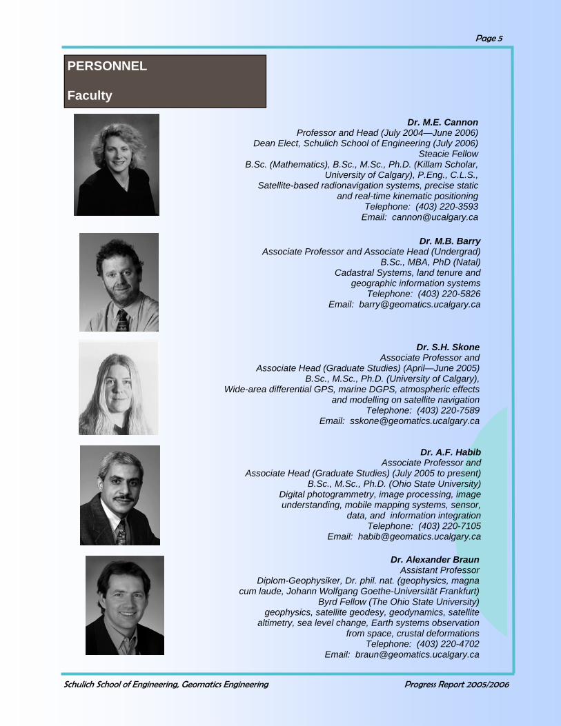
PERSONNEL Faculty
Dr. M.E. Cannon Professor and Head (July 2004—June 2006)
Dean Elect, Schulich School of Engineering (July 2006) Steacie Fellow
B.Sc. (Mathematics), B.Sc., M.Sc., Ph.D. (Killam Scholar, University of Calgary), P.Eng., C.L.S.,
Satellite-based radionavigation systems, precise static and real-time kinematic positioning
Telephone: (403) 220-3593 Email: [email protected]
Dr. M.B. Barry Associate Professor and Associate Head (Undergrad)
B.Sc., MBA, PhD (Natal) Cadastral Systems, land tenure and
geographic information systems Telephone: (403) 220-5826
Email: [email protected]
Dr. S.H. Skone Associate Professor and
Associate Head (Graduate Studies) (April—June 2005) B.Sc., M.Sc., Ph.D. (University of Calgary),
Wide-area differential GPS, marine DGPS, atmospheric effects and modelling on satellite navigation
Telephone: (403) 220-7589 Email: [email protected]
Dr. A.F. Habib Associate Professor and
Associate Head (Graduate Studies) (July 2005 to present) B.Sc., M.Sc., Ph.D. (Ohio State University)
Digital photogrammetry, image processing, image understanding, mobile mapping systems, sensor,
data, and information integration Telephone: (403) 220-7105
Email: [email protected]
Dr. Alexander Braun Assistant Professor
Diplom-Geophysiker, Dr. phil. nat. (geophysics, magna cum laude, Johann Wolfgang Goethe-Universität Frankfurt)
Byrd Fellow (The Ohio State University) geophysics, satellite geodesy, geodynamics, satellite
altimetry, sea level change, Earth systems observation from space, crustal deformations
Telephone: (403) 220-4702 Email: [email protected]

Schulich School of Engineering, Geomatics Engineering Progress Report 2005/2006
Page 6
Dr. I. Couloigner Assistant Professor
Fr. Ing., PhD (trés honorable, Université Nice-Sophia Antipolis/École des Mines de Paris), P.Eng.
Digital image processing, data fusion and wavelet transfor- mation, and high resolution remote sensing imagery
Telephone: (403) 220-4370 Email: [email protected]
Dr. M.J. Collins Associate Professor and
Associate Dean (Student Affairs) B.Sc., M.Sc., Ph.D. (York), P.Eng.
Microwave remote sensing, geometric and radiometric analysis of
digital images, polar science Telephone: (403) 220-7534/220-4952
Email: [email protected]
Dr. Y. Gao Associate Professor
B.Sc., M.Sc., Ph.D. (University of Calgary), P.Eng. Robust estimation, satellite positioning
and navigation, mobile information management Telephone: (403) 220-6174
Email: [email protected]
Dr. Bo Huang Associate Professor
B.Eng., M.Sc., Ph.D. (CAS) Geospatial Information Systems,
GIS for Transportation, Spatial Optimization, Web/Wireless GIS
Telephone: (403) 220-7377 Email: [email protected]
Dr. N. El-Sheimy Professor
CRC in Multi-sensor Systems B.Sc., M.Sc., Ph.D. (University of Calgary), P.Eng.
Multi-sensor systems, real-time mapping and their applications in GIS Telephone: (403) 220-7587
Email: [email protected]

Schulich School of Engineering, Geomatics Engineering Progress Report 2005/2006
Page 7
Dr. D. Mioc Assistant Professor
Dip.Eng., M.Sc., PhD (Laval) Geospatial information systems, computational
geometry, spatio-temporal databases Telephone: (403) 220-8019
Email: [email protected]
Dr. G. Lachapelle Professor
CRC/iCORE Chair in Wireless Location B.Sc., M.Sc., L.Ph.,
Dr. Techn. (Technical University of Graz), P.Eng. Satellite-based positioning and
navigation, wireless location Telephone: (403) 220-7104
Email: [email protected]
Dr. M.E. Rakai Assistant Professor
R.Surv. M.Surv.S.c., PhD (University of New Brunswick) Land tenure, land information systems,
cross-cultural land tenure systems Telephone: 210-9495
Email: [email protected]
Dr. Kyle O’Keefe Assistant Professor
B.Sc. (Honours Physics), B.Sc., Ph.D (Honorary Killam Scholar,
University of Calgary), E.I.T. Wireless location, satellite-based
positioning and navigation Telephone: (403) 220-7378
Email: [email protected]
Dr. D. Marceau Professor
B.Sc., M.Sc., Ph.D. (University of Waterloo) Geospatial Information Systems (GIS),
environmental geocomputation, remote sensing, individual based modelling, and geovisualization for
environmental resource management Telephone: (403) 220-5314
Email: [email protected]

Schulich School of Engineering, Geomatics Engineering Progress Report 2005/2006
Page 8
Dr. N.J. Sneeuw Assistant Professor
ir, Dr.-Ing. (Technical University Munich) Geodesy, gravity field modelling, satellite geodesy,
gravity field satellite missions Telephone: (403) 220-4703
Email: [email protected]
Dr. M.P. Tait Assistant Professor
BEng (Hons), Ph.D. (Leeds), PEng Industrial measurement systems and methodologies, closer integration of
metrology, 3D modelling Telephone: (403) 210-9494
Email: [email protected]
Dr. C. Valeo Associate Professor
B.Sc., B.A.Sc., M.Eng., PhD (McMaster), P.Eng., Water resources and environmental engineering,
remote sensing and GIS Telephone: (403) 220-4112
Email: [email protected]
Dr. W.F. Teskey Professor
B.Sc. (Distinction; APEGGA Gold Medal), M.Sc., Dr.-Ing. (Stuttgart University), P.Eng., A.L.S., C.L.S. Precise engineering and deformation surveys, integrated analysis of deformations
Telephone: (403) 220-7397 Email: [email protected]
Dr. M.G. Sideris Professor and Associate Dean (Research and
International) Dipl.Ing. (Honours); M.Sc.,
Ph.D. (University of Calgary), P..Eng.. Geodesy, optimization in geomatics, spectral analysis,
gravity field approximation Telephone: (403) 220-4985/220-5592
Email: [email protected]
Schulich School of Engineering, Geomatics Engineering Progress Report 2005/2006
Page 9
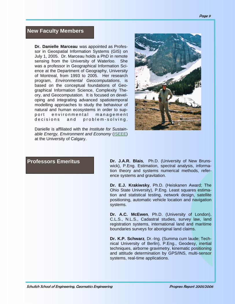
Dr. Danielle Marceau was appointed as Profes-sor in Geospatial Information Systems (GIS) on July 1, 2005. Dr. Marceau holds a PhD in remote sensing from the University of Waterloo. She was a professor in Geographical Information Sci-ence at the Department of Geography, University of Montreal, from 1993 to 2005. Her research program, Environmental Geocomputations, is based on the conceptual foundations of Geo-graphical Information Science, Complexity The-ory, and Geocomputation. It is focused on devel-oping and integrating advanced spatiotemporal modelling approaches to study the behaviour of natural and human ecosystems in order to sup-p o r t e n v i r o n m e n t a l m a n a g e m e n t d e c i s i o n s a n d p r o b l e m - s o l v i n g . Danielle is affiliated with the Institute for Sustain-able Energy, Environment and Economy (ISEEE) at the University of Calgary.
New Faculty Members
Dr. J.A.R. Blais, Ph.D. (University of New Bruns-wick), P.Eng. Estimation, spectral analysis, informa-tion theory and systems numerical methods, refer-ence systems and gravitation. Dr. E.J. Krakiwsky, Ph.D. (Heiskanen Award; The Ohio State University), P.Eng. Least squares estima-tion and statistical testing, network design, satellite positioning, automatic vehicle location and navigation systems. Dr. A.C. McEwen, Ph.D. (University of London), C.L.S., N.L.S., Cadastral studies, survey law, land registration systems, international land and maritime boundaries surveys for aboriginal land claims. Dr. K.P. Schwarz, Dr.-Ing. (Summa cum laude; Tech-nical University of Berlin), P.Eng., Geodesy, inertial techniques, airborne gravimetry, kinematic positioning and attitude determination by GPS/INS, multi-sensor systems, real-time applications.
Professors Emeritus

Schulich School of Engineering, Geomatics Engineering Progress Report 2005/2006
Page 10
Marcia Inch, BScHEc, Administrative Manager Monica Barbaro, Administrative Secretary Julia Lai, Administrative Secretary Lu-Anne Markland, Graduate Program Administrator Tamara McCarron, BSc, Women in Science and En-gineering Coordinator and Director, SCIberMENTOR Program (May to August 2005) Julia Millen, BSc, BMus, MA, Program Administra-tor, SCIberMENTOR Program (September 2005 to present)
Support Staff Administrative
Nico and Barbara Sneeuw bid farewell to the Department in July. Nico accepted the position of Director of the Geodetic
Institute at the University of Stuttgart.
Dr. Richard Klukas Okanagan University College Dr. Bryan Mercer Intermap Technologies Corp. Dr. Aboelmagd Noureldin Royal Military College of Canada Dr. Bruno Scherzinger Applanix Corporation Dr. Nico Sneeuw Universität Stuttgart
Adjunct Professors
Mele Rakai is flanked by Dave Marquardt and Victor Hut at her farewell party in January. Dr. Ayman Habib watches from the background. Mele moved to Suva, Fiji to accept a position in
the Department of Land Management and Development, The University of the South Pacific
Schulich School of Engineering, Geomatics Engineering Progress Report 2005/2006
Page 11
Kirk Collins, BSc, Dipl.Surveying & Mapping Tech-nology, Survey Technician Brad Groat, BA, Dipl. in Electronics Engineering Technology, Computer Systems Administrator Kathy Hamilton, Network Technician Certificate, Computer Technician Gail Leask, Dipl. in Telecomputer Engineering Technology, Microcomputer Lab Administrator Garth Wanamaker, BSc, Technical Manager
Support Staff Technical
Mark Petovello Positioning, Navigation and Wireless Location John Schleppe Positioning, Navigation and Wireless Location Muhammad Soofi Gravity Field and Geodynamics Robert Watson Positioning, Navigation and Wireless Location Bruce Wright Positioning, Navigation and Wireless Location Kin Yan Wong Digital Imaging Systems Min Wong Positioning, Navigation and Wireless Location
Hendry Agus Positioning, Navigation and Wireless Location Saurabh Godha Positioning, Navigation and Wireless Location Martin Lavigne Positioning, Navigation and Wireless Location Lucas Reindler Positioning, Navigation and Wireless Location Ning Luo Positioning, Navigation and Wireless Location Bijoy Paul Engineering Metrology
Research Engineers/Associates/Assistants
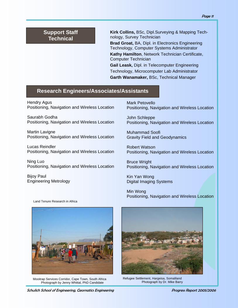
Land Tenure Research in Africa
Mooitrap Services Corridor, Cape Town, South Africa Photograph by Jenny Whittal, PhD Candidate
Refugee Settlement, Hargeisa, Somaliland Photograph by Dr. Mike Barry
Schulich School of Engineering, Geomatics Engineering Progress Report 2005/2006
Page 12
Walid Mohamed Abdel-Hamid Positioning, Navigation and Wireless Location Kongzhe Chen Positioning, Navigation and Wireless Location Georgia Fotopoulos Gravity Field and Geodynamics Eui Myoung Kim Digital Imaging Systems Zhizhao Liu Positioning, Navigation and Wireless Location Sameh Nassar Positioning, Navigation and Wireless Location Xiao Ji Niu Positioning, Navigation and Wireless Location Yufeng Zhang Positioning, Navigation and Wireless Location Nazreen Ziedan Positioning, Navigation and Wireless Location
Post Doctoral Fellows
Guest Lecturers
Dr. Jayanta Ray Accord Software & Systems Inc. Advanced GPS Receiver Technology Dr. Derek Lichti Curtin University of Technology Techniques for Close-Range Measurement Dr. Aboelmagd Noureldin Royal Military College of Canada DSP with Applications to Geomatics Engineering
Distinguished Lecture Series
Dr. Jean-Pierre Barriot Observatoire Midi-Pyrenees/International Gravimetric Bureau Inverse Problems in Geodesy and Remote Sensing: A Blossoming Field of Research Through Three Topical Examples Dr. Juërgen Kusche TU Delft Time-Variable Global Gravity: New Applications, New Challenges Dr. Brian Gunter University of Texas at Austin Computational Methods for Creating Global Gravity Field Models from GRACE Mission Data
Special Lecture Series

Schulich School of Engineering, Geomatics Engineering Progress Report 2005/2006
Page 13
INTERNATIONAL LECTURE SERIES
Visiting Scientists
Professor Juan Jose Benjamin Polytechnical University of Cataluna Barcelona, Spain Dr. Rene Forsberg Danish National Space Center Copenhagen, Denmark Professor Edson Mitishita Federal University of Paraná (UFPR), Curitiba, Brazil Mr. Tom Stansell Stansell Consulting, USA Professor Jiancheng Li Wuhan University
Professor Dieter Fritsch Rector/President Stuttgart University, Germany Dr. David Philips Director, International Affairs Canada Mr. Earl F. Burkholder New Mexico State University, USA Professor Chengfa Gao Department of Surveying and Mapping Engineering, Southeast University, China Dr. Kevin Pegler Canadian Engineering Accreditation Board
Dr. Rene Forsberg Airborne Laser and Radar Measurements of Sea and Land Ice for Satellite Validation and Climate Change Studies March 31, 2006
Advanced GPS Receiver Technology course offered in Spring 2005. Instructor: Dr. Jayanta Ray from Accord Software & Systems Inc.
Schulich School of Engineering, Geomatics Engineering Progress Report 2005/2006
Page 14
ADVISORY COMMITTEES AND STUDENT AWARDS
Advisory Committee 2005
Name Affiliation O’Brian Blackall, Chair McElhanney Land Surveying Inc. Bryan Bates CanAm Geomatics Corp. Pat Fenton NovAtel Inc. Hazen Gehue SiRF Ron Hall Focus Surveys Irwin Itzkovitch Earth Science Sector, Natural Resources
Canada Amin Kassam B.C. Government Paul Mrstik Mosaic Mapping Systems Inc. Robert Parkinson Agriculture and Agri-Food Canada Kim Sturgess Springbank Tech Ventures Bruno Scherzinger Applanix Corporation Representatives of the U of C were M.E. Cannon, M.B. Barry, A.F. Habib
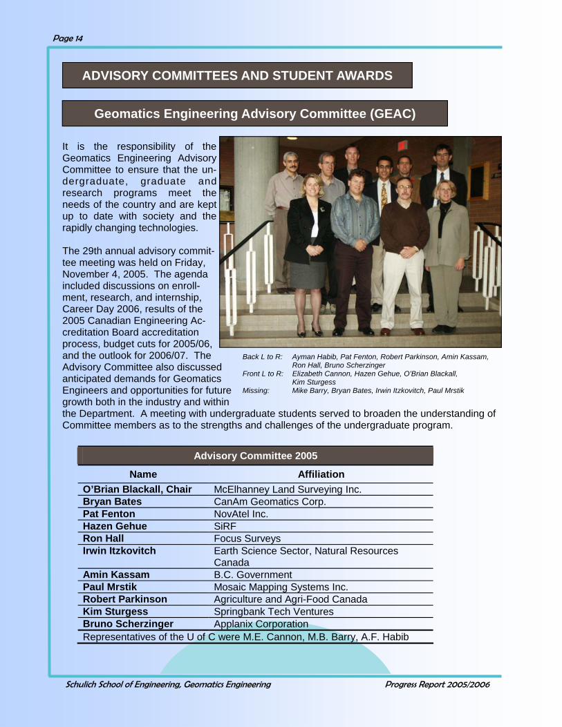
It is the responsibility of the Geomatics Engineering Advisory Committee to ensure that the un-dergraduate, graduate and research programs meet the needs of the country and are kept up to date with society and the rapidly changing technologies. The 29th annual advisory commit-tee meeting was held on Friday, November 4, 2005. The agenda included discussions on enroll-ment, research, and internship, Career Day 2006, results of the 2005 Canadian Engineering Ac-creditation Board accreditation process, budget cuts for 2005/06, and the outlook for 2006/07. The Advisory Committee also discussed anticipated demands for Geomatics Engineers and opportunities for future growth both in the industry and within the Department. A meeting with undergraduate students served to broaden the understanding of Committee members as to the strengths and challenges of the undergraduate program.
Back L to R: Ayman Habib, Pat Fenton, Robert Parkinson, Amin Kassam, Ron Hall, Bruno Scherzinger Front L to R: Elizabeth Cannon, Hazen Gehue, O’Brian Blackall, Kim Sturgess Missing: Mike Barry, Bryan Bates, Irwin Itzkovitch, Paul Mrstik
Geomatics Engineering Advisory Committee (GEAC)
Schulich School of Engineering, Geomatics Engineering Progress Report 2005/2006
Page 15
The Geomatics Engineering Liaison Committee met on November 3, 2005 and February 2, 2006. The committee was established to develop an effective and permanent relationship between the Land Surveyors’ Associations and the University of Calgary. The committee consists of two delegates each from the Land Surveying Associations in the four western provinces and the Association of Canada Lands Surveyors, a member at large, as well as the Associates Heads and Cadastral faculty of the Department of Geomatics Engineering at the University of Calgary. Discussions centered around educational tools for high school students which use surveying theory and practice, how these outreach programs can be coordinated, and recommended work tasks that summer and internship students should be exposed to during work experience.
Geomatics Engineering Liaison Committee 2005 Name Affiliation
Bryan Bates Member at Large Paul Dixon Association of Canada Lands Surveyors Robert King Alberta Land Surveyors Association Ian Lloyd Association of Canada Lands Surveyors John Armstrong Corporation of British Columbia Land
Surveyors Roy Pominville Saskatchewan Land Surveyors
Association Paul Standing Association of Manitoba Land Surveyors Victor Hut Alberta Land Surveyors Association Representatives of the U of C were M.B. Barry (Chair), M.E. Cannon, M.E. Rakai, W.F. Teskey
Geomatics Engineering Liaison Committee (GELC)
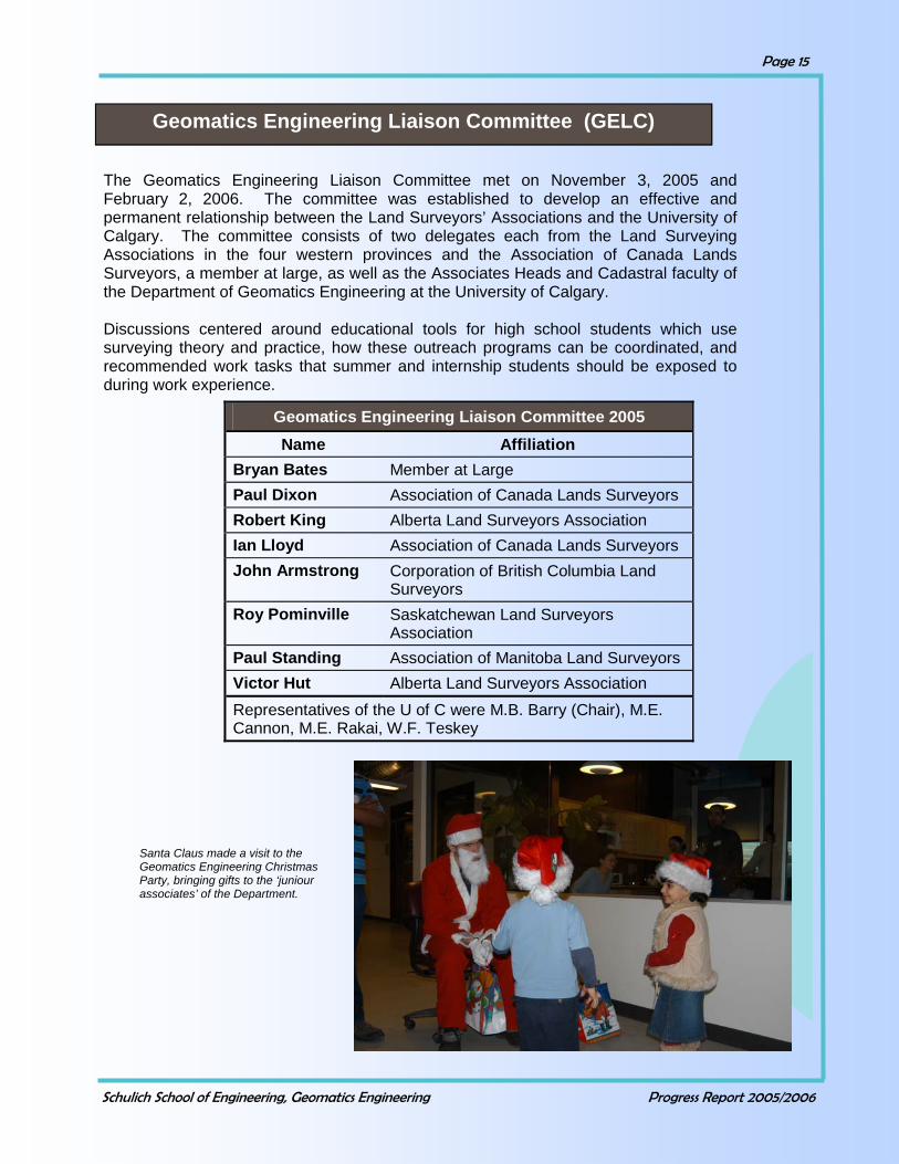
Santa Claus made a visit to the Geomatics Engineering Christmas Party, bringing gifts to the ‘juniour associates’ of the Department.
Schulich School of Engineering, Geomatics Engineering Progress Report 2005/2006
Page 16
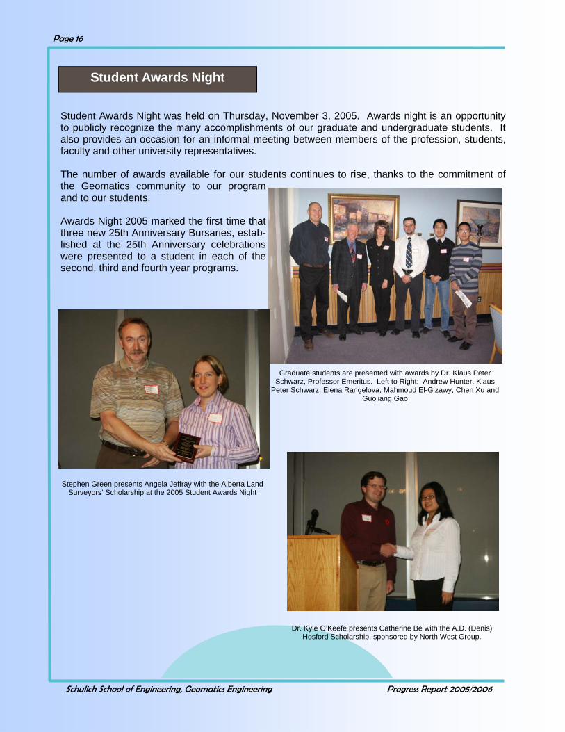
Student Awards Night was held on Thursday, November 3, 2005. Awards night is an opportunity to publicly recognize the many accomplishments of our graduate and undergraduate students. It also provides an occasion for an informal meeting between members of the profession, students, faculty and other university representatives. The number of awards available for our students continues to rise, thanks to the commitment of the Geomatics community to our program and to our students. Awards Night 2005 marked the first time that three new 25th Anniversary Bursaries, estab-lished at the 25th Anniversary celebrations were presented to a student in each of the second, third and fourth year programs.
Student Awards Night
Graduate students are presented with awards by Dr. Klaus Peter Schwarz, Professor Emeritus. Left to Right: Andrew Hunter, Klaus
Peter Schwarz, Elena Rangelova, Mahmoud El-Gizawy, Chen Xu and Guojiang Gao
Stephen Green presents Angela Jeffray with the Alberta Land Surveyors’ Scholarship at the 2005 Student Awards Night
Dr. Kyle O’Keefe presents Catherine Be with the A.D. (Denis) Hosford Scholarship, sponsored by North West Group.

Schulich School of Engineering, Geomatics Engineering Progress Report 2005/2006
Page 17
Graduate Awards
Recipient Awards
Rita Cheng Lance de Groot Olivier Julien
AIF Awards
Tao Hu Dhar Karunanayake Nyun-Ook Kim David McAllister Anoop Pullivelli Matthew Reid
Alberta Graduate Student Scholarship
Andrew Hunter Alberta Graduate Fellowship
Andrew Hunter C. F. Gauss Award Chen Xu F.R. Helmert Award Surendran Konavattam Shanmugam Qiaoping Zhang Graduate Faculty Council Scholarship
Elena Rangelova Helmut Moritz Graduate Scholarship
Mahmoud El-Gizawy Innovation in Mobile Mapping Award
Natalya Nicholson Institute of Navigation (ION) Alberta Section Graduate Award
Natalya Nicholson Olivier Julien Institute of Navigation (ION) Graduate Award
Olivier Julien Institute of Navigation (ION) National Award Guojing Gao Jacques Cartier Award Natalya Nicholson KIS94 Graduate Scholarship Andrew Hunter L.R. (Dick) Newby Memorial Award
Rita Wait Ting Cheng Lance de Groot Mahmoud EL-Gizawy Chris Goodall Andrew Hunter Kerri Robinson
NSERC Post Graduate Scholarship NSERC Post Graduate Scholarship NSERC IPS Scholarship NSERC Post Graduate Scholarship NSERC IPS Scholarship NSERC Post Graduate Scholarship
Natalya Nicholson University of Calgary Silver Anniversary Graduate Fellowship
Qiaoping Zhang University Technologies International Inc. Fellowship
Best paper awards were also won for papers co-authored by graduate students and faculty. Please see Awards and Recognition section on pages 3 and 4 for details.

Schulich School of Engineering, Geomatics Engineering Progress Report 2005/2006
Page 18
Undergraduate Awards
Recipient Awards
Catherine Be A.D. (Denis) Hosford Scholarship
Angela Jeffray Alberta Land Surveyors' Association Scholarship
Amy Spiers Cannon-Lachapelle Family Scholarship
Jennifer Lay Colt Geomatic Solutions Ltd. Bursary
Tram Phan David Scovill Memorial Bursary
Dustin Engen E.J. Krakiwsky Bursary
Tram Phan Focus Intec Geomatics Bursary
Buke Chen, Ashley Large, Tao Lin Geomatics Engineering '25th Anniversary' Bursary
Benjamin Giesbrecht Geomatics Engineering Future Leaders Award
Kari-Ann McNabb H. Roy Goldfinch Memorial Award
Dustin Engen Institute of Navigation Alberta Chapter Bursary
Tao Lin Institute of Navigation (ION) Undergraduate Bursary
Kimberly Johnson J.H. Holloway Scholarship in Geomatics Engineering
Rachelle Larose Jerry J. Simpson Memorial Scholarship
Dana Lee Jim Van Dam Scholarship
Angela Jeffray John Deyholos Memorial Award
Buke Chen KIS-97 Undergraduate Scholarship
Elena Dmitriev L.R. (Dick) Newby Memorial Award
Trevor Phillips Leica Geosystems Limited Scholarship
Ashley Large McElhanney Scholarship
Joshua Houghton Ray Lowry Memorial Bursary
Ashley Large Saskatchewan Land Surveyors' Association Award
Ammara Cokar Stephen P. Williams Memorial Award
Schulich School of Engineering, Geomatics Engineering Progress Report 2005/2006
Page 19
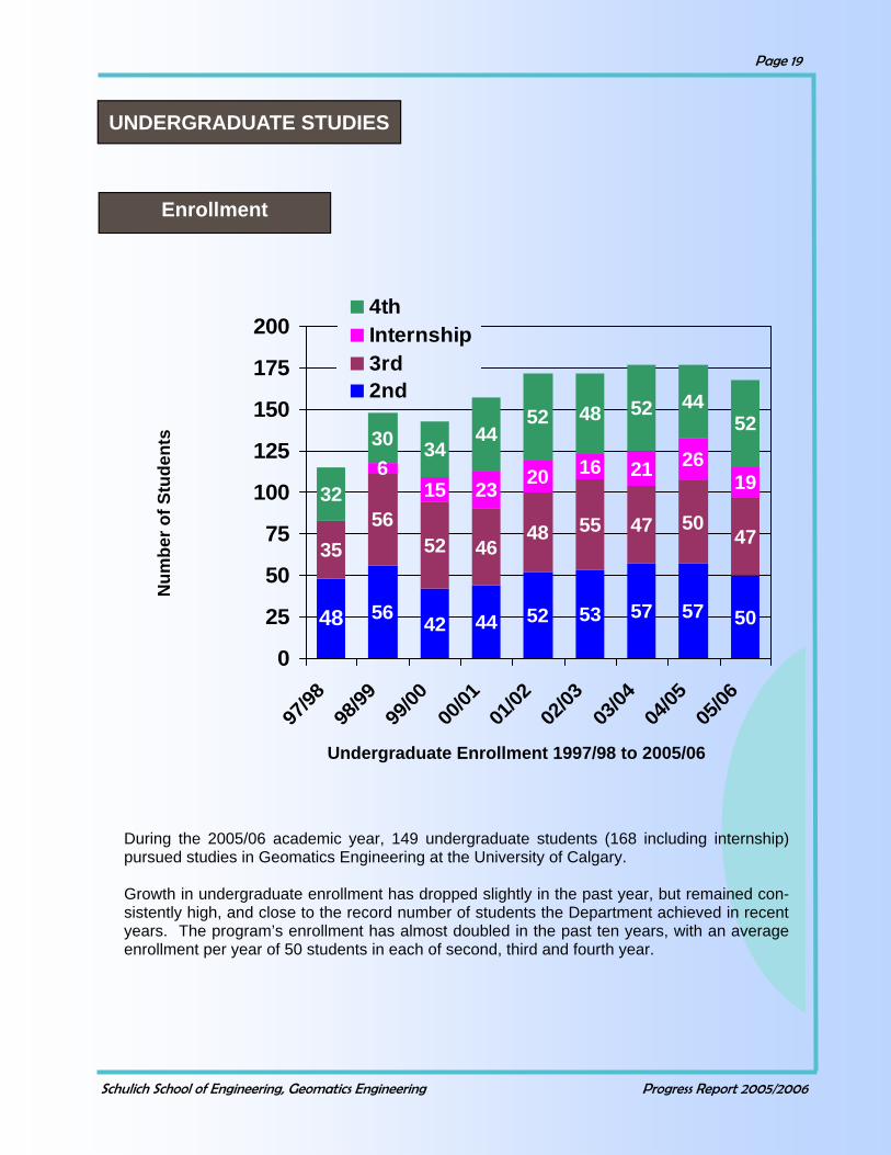
During the 2005/06 academic year, 149 undergraduate students (168 including internship) pursued studies in Geomatics Engineering at the University of Calgary. Growth in undergraduate enrollment has dropped slightly in the past year, but remained con-sistently high, and close to the record number of students the Department achieved in recent years. The program’s enrollment has almost doubled in the past ten years, with an average enrollment per year of 50 students in each of second, third and fourth year.
56 42 44 52 53 57 57 50
3556
52 4648 55 47 50
47
615 23 20 16 21 1932
30 3444
52 48 52 4452
48
26
0
25
50
75
100
125
150
175
200
97/98
98/99
99/00
00/01
01/02
02/03
03/04
04/05
05/06
4thInternship3rd2nd
Undergraduate Enrollment 1997/98 to 2005/06
Num
ber o
f Stu
dent
s
Enrollment
UNDERGRADUATE STUDIES

Schulich School of Engineering, Geomatics Engineering Progress Report 2005/2006
Page 20
Student Enrollment by Geographic Region
The figure to the left shows a breakdown of student enroll-ment by geographic region. Students from Alberta remain the largest group, and num-bers from the other groups remain fairly constant from year to year. 0
20
40
60
80
100
120
140
Alberta BC SK MB ON PEI
Intern
ation
al
Field Exercises at Survey Camp
Nicole and Carina help serve first year students at the ALSA barbeque
Schulich School of Engineering, Geomatics Engineering Progress Report 2005/2006
Page 21
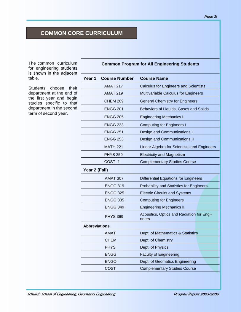
The common curriculum for engineering students is shown in the adjacent table. Students choose their department at the end of the first year and begin studies specific to that department in the second term of second year.
Common Program for All Engineering Students
Year 1 Course Number Course Name
AMAT 217 Calculus for Engineers and Scientists
AMAT 219 Multivariable Calculus for Engineers
CHEM 209 General Chemistry for Engineers
ENGG 201 Behaviors of Liquids, Gases and Solids
ENGG 205 Engineering Mechanics I
ENGG 233 Computing for Engineers I
ENGG 251 Design and Communications I
ENGG 253 Design and Communications II
MATH 221 Linear Algebra for Scientists and Engineers
PHYS 259 Electricity and Magnetism
COST -1 Complementary Studies Course
Year 2 (Fall)
AMAT 307 Differential Equations for Engineers
ENGG 319 Probability and Statistics for Engineers
ENGG 325 Electric Circuits and Systems
ENGG 335 Computing for Engineers
ENGG 349 Engineering Mechanics II
PHYS 369 Acoustics, Optics and Radiation for Engi-neers
Abbreviations
AMAT Dept. of Mathematics & Statistics
CHEM Dept. of Chemistry
PHYS Dept. of Physics
ENGG Faculty of Engineering
ENGO Dept. of Geomatics Engineering
COST Complementary Studies Course
COMMON CORE CURRICULUM
Schulich School of Engineering, Geomatics Engineering Progress Report 2005/2006
Page 22
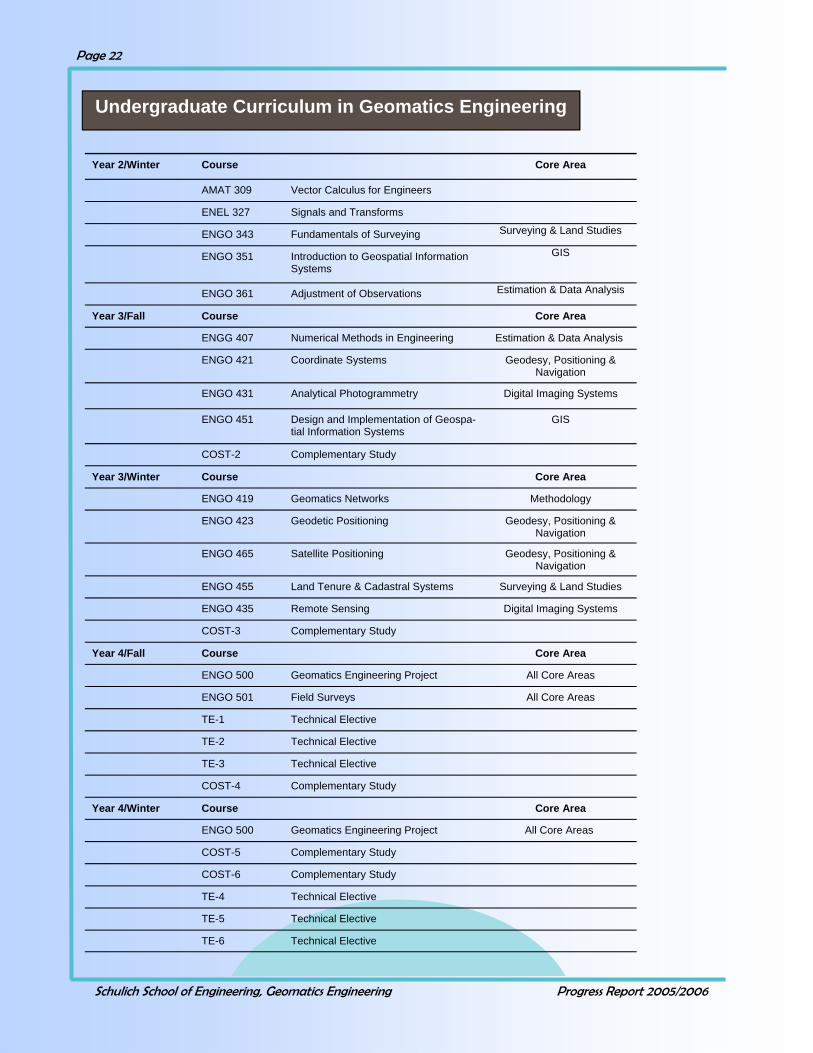
Undergraduate Curriculum in Geomatics Engineering
Year 2/Winter Course Core Area
AMAT 309 Vector Calculus for Engineers
ENEL 327 Signals and Transforms
ENGO 343 Fundamentals of Surveying Surveying & Land Studies
ENGO 351 Introduction to Geospatial Information Systems
GIS
ENGO 361 Adjustment of Observations Estimation & Data Analysis
Year 3/Fall Course Core Area
ENGG 407 Numerical Methods in Engineering Estimation & Data Analysis
ENGO 421 Coordinate Systems Geodesy, Positioning & Navigation
ENGO 431 Analytical Photogrammetry Digital Imaging Systems
ENGO 451 Design and Implementation of Geospa-tial Information Systems
GIS
COST-2 Complementary Study
Year 3/Winter Course Core Area
ENGO 419 Geomatics Networks Methodology
ENGO 423 Geodetic Positioning Geodesy, Positioning & Navigation
ENGO 465 Satellite Positioning Geodesy, Positioning & Navigation
ENGO 455 Land Tenure & Cadastral Systems Surveying & Land Studies
ENGO 435 Remote Sensing Digital Imaging Systems
COST-3 Complementary Study
Year 4/Fall Course Core Area
ENGO 500 Geomatics Engineering Project All Core Areas
ENGO 501 Field Surveys All Core Areas
TE-1 Technical Elective
TE-2 Technical Elective
TE-3 Technical Elective
COST-4 Complementary Study
Year 4/Winter Course Core Area
ENGO 500 Geomatics Engineering Project All Core Areas
COST-5 Complementary Study
COST-6 Complementary Study
TE-4 Technical Elective
TE-5 Technical Elective
TE-6 Technical Elective

Schulich School of Engineering, Geomatics Engineering Progress Report 2005/2006
Page 23
Course Core Area
BSEN 395 Legal Environment Surveying & Land Studies
ENGO 545 Hydrography Geodesy, Positioning & Navigation
ENGO 557 Design and Implementation of Geospatial Information Systems
GIS
ENGO 559 Digital Imaging and Applications Digital Imaging Systems
ENGO 561 Satellite Positioning Geodesy, Positioning & Navigation
ENGO 563 Data Analysis in Engineering Estimation & Data Analysis
ENGO 567 High-Precision Surveys Surveying & Land Studies
ENGO 573 Digital Terrain Modelling Digital Imaging Systems
ENGO 579 Survey Law Surveying & Land Studies
ENGO 581 Land Use Planning Surveying & Land Studies
ENGO 583 Environmental Modelling GIS
President - Carina Dunn VP Academic - Cole Kitchen VP Events - Neil Gibbs Treasurer - Tina Mosstajiri 3rd Year Rep - Amanda Side Webmaster—Sid Kwakkel Photographer—Nicole Miller 3rd Career Day - Ashley Large, Mina Saleh, Rebecca Broten, Tram Phan, Carmen Wong
Technical Electives in Geomatics Engineering
GEOMATICS ENGINEERING STUDENT SOCIETY (GESS)
Geomatics Engineering students enjoy a Hockey Game together.

Schulich School of Engineering, Geomatics Engineering Progress Report 2005/2006
Page 24
ENGO 500 The objective of the ENGO 500 group project course is the development of skills in cooperative research, report preparation and seminar presentation. Students plan and execute a project that must conform with professional re-quirements. The project must have design, measurement, analysis and presentation components. Submission and defence of progress reports and a final report are required. The Department awards a prize to the group with the best project. This year the winners were: Kim-berley Johnson, Krista Lovse, Victoria Schwartzendruber, and Scott Slen.
GIS Program Management Dianne Haley, BSc, MScGIS, GISP GIS Program Coordinator Alberta Energy & Utilities Board Project Management Scott Westlund, P. Eng, ALS Stantec Survey / Geomatics, Calgary Project Management and Corporate Governance Chris Tucker, P. Eng, ALS PointGeomatics Ltd (Having fun with) project management in Geomatics Engineering Alex Bruton, PhD Bruton Communications Ltd Project management Mike Barry, PhD University of Calgary
ENGO 500 Special Presentations

Schulich School of Engineering, Geomatics Engineering Progress Report 2005/2006
Page 25
Project Title Group Members Supervisor Effects of multipath in indoor en-vironments
David Chiu O’keefe
Fiscal cadastral modeller: A spatially dependent method of modeling real estate values within mass appraisals
Ashley Large Nicole Miller Ivan Ngan Thomas Penner Ange Jeffray
Barry
Development of an integrated RTK/conventional surveying sys-tem
Colin Ferguson Cameron Henry Eric Pellegrino Jonathon Tingley
O’keefe
Utilisation of low cost close range stereo imaging for high precision surveys
Daniel Cook Lee Falcon Neil Gibbs Daniel Hrouda
Habib
Comparing different methods of deformation monitoring for the Olympic oval
Nathan Dennison William Houghton Bruce Tattrie John Ward David Young
Teskey
Incorporating multimedia evi-dence in land tenure records
Elena Dmitriev Rachelle Larose Dana Lee Kari-Ann McNabb
Barry
Design of Subdivision NW1/4, Sec. 7, TWP26, Rge.4, W5
Meredith Bryan Michael Lee Ranny Shibley
Rakai
Developing a Tsunami detection system
Scott Anderson Mick Beck Michael Heuchert Stoyan Koev
Braun
Industrial applications for inertia sensors
Ryan Dobson Aim Na Chiangmai Jennifer Setiawan Tim Willms
El-Sheimy
An in-situ GPS-based monitoring system to analyse the perform-ance of cyclists
Norman Chan Aaron Clapperton Richard deis Elaine Yuen
Cannon/Lachapelle
Calibration of a terrestrial laser scanner
Chris Beaugrand Scott Colvin Cole Kitchen Ryan Walker
Tait
Using satellite imagery to assess vegetation damage due to acid deposition
Kimberley Johnson Krista Lovse Victoria Schwartzendruber Scott Slen
Couloigner
ENGO 500 GROUPS 2005/2006
Schulich School of Engineering, Geomatics Engineering Progress Report 2005/2006
Page 26
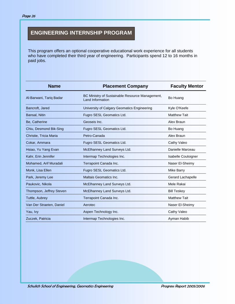
ENGINEERING INTERNSHIP PROGRAM
This program offers an optional cooperative educational work experience for all students who have completed their third year of engineering. Participants spend 12 to 16 months in paid jobs.
Name Placement Company Faculty Mentor
Al-Barwani, Tariq Badar BC Ministry of Sustainable Resource Management, Land Information Bo Huang
Bancroft, Jared University of Calgary Geomatics Engineering Kyle O'Keefe
Bansal, Nitin Fugro SESL Geomatics Ltd. Matthew Tait
Be, Catherine Geoseis Inc. Alex Braun
Chiu, Desmond Bik-Sing Fugro SESL Geomatics Ltd. Bo Huang
Christie, Tricia Maria Petro-Canada Alex Braun
Cokar, Ammara Fugro SESL Geomatics Ltd. Cathy Valeo
Hsiao, Yu Yang Evan McElhanney Land Surveys Ltd. Danielle Marceau
Kahr, Erin Jennifer Intermap Technologies Inc. Isabelle Couloigner
Mohamed, Arif Muradali Terrapoint Canada Inc. Naser El-Sheimy
Monk, Lisa Ellen Fugro SESL Geomatics Ltd. Mike Barry
Park, Jeremy Lee Maltais Geomatics Inc. Gerard Lachapelle
Paukovic, Nikola McElhanney Land Surveys Ltd. Mele Rakai
Thompson, Jeffrey Steven McElhanney Land Surveys Ltd. Bill Teskey
Tuttle, Aubrey Terrapoint Canada Inc. Matthew Tait
Van Der Straeten, Daniel Aerotec Naser El-Sheimy
Yau, Ivy Aspen Technology Inc. Cathy Valeo
Zuczek, Patricia Intermap Technologies Inc. Ayman Habib

Schulich School of Engineering, Geomatics Engineering Progress Report 2005/2006
Page 27
GEOMATICS ENGINEERING CAREER DAY
Career Day Participants 2006 33 Field Engineer Squadron, Canadian Forces All-Can Engineering & Surveys (1976)Ltd.
Alberta Geomatics Group All West Surveys Ltd.
Alberta Land Surveyors' Association Association of BC Land Surveyors
Applanix Corporation Crape Geomatics Corporation
BEI Systron Donner Inertial Division Challenger Geomatics
Colt Geomatics C & C Technologies
CSI-Wireless The Cadastral Group
Eclipse Geomatics & Engineering Ltd. Intermap Technologies
Fugro SESL Geomatics Ltd. McElhanney Land Surveys Ltd.
Kodiak Nav Solutions Ltd. Natural Resources Canada
Midwest Surveys Inc. NavCom Technology Inc.
NovAtel Inc. SiRF Technology Inc.
Point Inc. Stantec Geomatics Ltd.
Schlumberger Talon Survey Solutions Inc.
Stewart Weir Group The Focus Corporation Ltd.
Terrapoint Terramatic Technologies Inc.
Trimble Usher Canada Limited
Valtus Imagery Services
On Thursday, February 2, 2006, the Geomatics Engineering Student’s Society and the Department of Geomatics Engineering hosted their tenth annual Career Day. Career Day provides a forum for both companies and students to interact and discuss topics and ca-reer opportunities in the Geomatics industry. Several guest speakers made presentations on various topics throughout the day. In addition to these presentations, students and company representatives participated in the Industry Showcase, which was introduced to provide all participants with an opportunity to discuss careers in Geomatics.
The Geomatics Engineering Student’s Society would like to thank all participants and sponsors for making this year’s Career Day a success.

Schulich School of Engineering, Geomatics Engineering Progress Report 2005/2006
Page 28
An important part of the undergraduate degree pro-gram in Geomatics Engineering is the field camp (ENGO 501). This two week camp is held at the Kananaskis Centre for Environmental Research, prior to the start of the Fall Session. It gives incoming fourth year students the opportunity to ap-ply the knowledge and experience gained in the dif-ferent areas of geomatics to an integrated practical project. The Department of Geomatics Engineering would like to thank the following companies for their participation in the annual Survey Camp Equipment Day, or for the generous loan of equipment over the duration of Survey Camp: Butler Survey Supplies Ltd. Cansel Survey Equipment SAIT Polytechnic
GEOMATICS ENGINEERING SURVEY CAMP AT KANANASKIS
August, 2005

Schulich School of Engineering, Geomatics Engineering Progress Report 2005/2006
Page 29
There were a total of 104 graduate students in Geomatics Engineering in 2005/2006 (83 full time and 21 part time). During the academic year 2005/2006 students were either enrolled in the graduate program or finishing their theses. Forty were working towards their PhD degree, fifty-four towards their MSc degree and ten towards their MEng degree. Students originated from eighteen different countries. There were 27 students that graduated during the reporting period, four with a PhD degree, nineteen with a MSc and four with an MEng. Details are given in the following tables.
GRADUATE STUDIES
Enrollment
Full-time PhD Students 2005/2006
Name Supervisor Name Supervisor Abdel-Salam, Mo-hamed
Gao Kim, Changjae Habib
Aggarwal, Priyanka El-Sheimy Konavattam, Surendran Shanmugam
Lachapelle/Nielsen
Al-Rawas, Ghazi Ali Valeo Mao, Gang Lachapelle/Cannon
Anwar, Morshed Sk Marceau Mongredien, Cecile Lachapelle/Cannon
Bang, Ki In Habib Moreno, Niandry Marceau
Basnayake, Chaminda Lachapelle/MacIver Nicholson, Natalya Skone/Cannon
El-Gizawy, Mahmoud El-Sheimy Quinonez-Pinon, Rebeca Valeo
El-Habiby, Mohamed Sideris Raaflaub, Lynn Diane Valeo
Ellum, Cameron El-Sheimy Rangelova, Elena Sideris
Gao, Guo Jiang Lachapelle Syed, Zainab El-Sheimy
Gao, Jianchen Cannon Van der Wal, Wouter Sideris
Ghanma, Mwafag Habib Wallace, Osman Collins
Goodall, Christopher El-Sheimy Wang, Jau-Hsiung (James)
Gao
Hassan, Taher El-Sheimy Weigelt, Matthias Sideris
He, Jianxun ( Jennifer) Valeo Whittal, Jennifer Frances Barry
Hunter, Andrew J. S El-Sheimy Xu, Chen Sneeuw/Sideris
Julien, Olivier Lachapelle/Cannon Xu, Pei Cannon
Khan, Mohamed Khaleel Rhaman
Barry Yang, Yong El-Sheimy
Zhang, Qiao Ping Couloigner

Schulich School of Engineering, Geomatics Engineering Progress Report 2005/2006
Page 30
Full-Time MSc and MEng Students 2005/2006
Name Supervisor Name Supervisor
MSc Students
Abdolhosseini Moghad-dam, Ahmed Reza
Lachapelle/ Nielsen
Phalke, Seema Cannon
Al-Azizi, Jalal Lachapelle Phalke, Santosh Madhuka
Couloigner
Al-Durgham, Mohannad Habib Qiu, Jianning Lachapelle
Al-Fanek, Ossama Skone Renganathan, Vi-davathy
Braun
Chandramouli, Magesh Huang Reid, Matthew Barry Charkhandeh, Shahin Lachapelle/Cannon Robinson, Kerri Valeo Cheng, Rita Wai Ting Habib/Ronsky Sadeque, Maham-
med Skone
Chiu, Wenya Couloigner Salimi, Nazila Lachapelle/Nielsen de Groot, Lance Skone Sharma, Ojaswa Mioc/Habib Devaraju, Balaji Sneeuw Sheng, Li (Tony) Tait/Cannon Godha, Saurabh Cannon Singh, Sanjeet Klukas/Cannon Hasbani, Jean-Gabriel Marceau Tao, Wenyou Gao Hu, Tao Lachapelle/Klukas Tsoi, Raymond Sneeuw/Cannon Karunanayake, M. Dhar Cannon/Lachapelle Wu, Qiang Huang Kim, Nyunnook Lachapelle Xie, Chenlin Huang Marji, Qais Lachapelle/Cannon Yao, Donghua Lachapelle McAllister, David Mi-chael
Valeo Youssef, Mohamed El-Sheimy/Noureldin
Meenakshisundaram, Valarmathy
Couloigner Yu, Wei Lachapelle
Ni, Jingwen Couloigner Zhang, Hai Tao Cannon Osman, Mostafa El-Sheimy/
Noureldin Zhang, Jingmei Lachapelle
MEng Students
Anderson, Teresa El-Sheimy Kieser, Michael Rakai/Marceau Huang, Andrew Cannon Kubacki, Wojciech Cannon/Skone Kang, Jason Valeo/
Couloigner Wang, Min Lachapelle/O’Keefe
Kaplo, Abboud Habib

Schulich School of Engineering, Geomatics Engineering Progress Report 2005/2006
Page 31
Part – time Graduate Students 2005/2006
Name MEng MSc PhD Supervisor
Charkhand, Behtash 1 El-Sheimy
Dharmaraj, Girija 1 Mioc/Habib
Fox, Ryan J. 1 Teskey/Tait
Gaidadjiev, Radoslav 1 Tait
Galappaththi, Thi-lanka L.
1 El-Sheimy
Garin, Lionel J. J. 1 Lachapelle
Guo, Libing 1 Huang/Blais
Ketcheson, Kelly 1 Mioc
Khodosko, Michael 1 Lachapelle/Cannon
Lin, Min Min 1 Lachapelle/O’Keefe
Mao, Li Man 1 Rakai
Radons, Charlene 1 Skone/O’Keefe
Shen, Xioabing (Jose) 1 Gao
Srajer, Peter 1 Lachapelle
Syed, Salman 1 Cannon
Yousuf, Ruben 1 Skone
Vance, Kevin L. 1 Lachapelle
Wu, Sally Xia 1 Habib
Zhang, Huasiu (Larry) 1 Blais/Collins
Zhang, Wentao 1 Cannon
Zheng, Bo 1 Lachapelle
Total 3 14 4
Graduate Student Rebeca Quinonez-Pinon
measures the reflectants of the underside of the forest canopy

Schulich School of Engineering, Geomatics Engineering Progress Report 2005/2006
Page 32
Graduate Studies Convocants 2005/2006
Name Degree Exam Date Graduate Thesis Title Supervisor Chenglin Xie MSc April 25, 2006 Support Vector Machines for Land Use Change
Modeling Bo Huang
Wai Ting Rita Cheng MSc April 24, 2006 Registration for the In-Vivo Studies of Os-teoarthritis based on Magnetic Resonance
Imaging
Ayman Habib
Mwafag Saad Hilal Ghanma PhD April 20, 2006 Integration of Photogrammetry and LIDAR Ayman Habib
Abboud Kaplo MEng April 13, 2006 N/A A. Habib
Qiaoping Zhang PhD April 10, 2006 Automated Road Network Extraction from High Spatial Resolution Multi-Spectral Imagery
I. Couloigner
Saurabh Godha MSc February 22, 2006
Performance Evaluation of a Low Cost MEMS-Based IMU Integrated with GPS for Land Vehicle
Navigation Application
M. E. Cannon
Minmin Lin MSc January 11, 2006 RTCM 3.0 Implementation in Network RTK and Performance Analysis
G. Lachapelle/K. O’Keefe
Tao Hu MSc January 06, 2005 Controlled Indoor GPS Signal Simulation G. Lachapelle/R. Klukas
Min Wang MEng December 22, 2005
N/A G. Lachapelle/K. O’Keefe
Nyunook Kim MSc December 20, 2005
Interference Effects on GPA Receivers in Weak Signal Environments
G. Lachapelle
Qiang Wu MSc December 20, 2005
Incremental Routing Algorithms for Dynamic Transportation Networks
B. Huang
Haitao Zhang MSc November 17, 2005
Performance Comparison of Kinematic GPS Integrated with Different Tactical Grade IMUs
M. E. Cannon
Radoslav Gaidad-jiev
MSc November 14, 2005
Integration of Insustrial Laser and Photogrammet-ric Measurements using Straight Line Elements
M. Tait
Li Sheng MSc October 28, 2005 The Feasibility of Replacing Precise Levelling with GPS for Permafrost Deformation Monitoring
M. Tait/M. E. Cannon
Milidu Dharshaka Karun-ana-yake
MSc October 26, 2005 Hardware Simulator Characterization of Assisted GPS
M. E. Cannon/G. Lachapelle
Ruben Yousuf MSc September 06, 2005
Evaluation and Enhancement of the Wide Area Augmentation System (WAAS)
S. Skone
Wen-Ya Chiu MSc September 06, 2005
Wetland Mapping Through Semivariogram Guided Fuzzy Segmentation of Multispectral
Satellite Imagery
I. Couloigner
Mohamed Abdel-tawwab
Abdel – salam
PhD August 29, 2005 Precise Point Positioning Using Un-differenced Code and Carrier Phase Observations
Y. Gao
Wentao Zhang MSc July 12, 2005 Triple Frequency Cascading Ambiguity Resolu-tion for Modernized GPS and GALILEO
M. E. Cannon
Olivier Julien PhD July 11, 2005 Design of Galileo L1F Receiver Tracking Loops G. Lachapelle/M. E. Cannon
Liman Mao MSc May 20, 2005 Web-Based Information System for Land Man-agement
M. Rakai
Salman Qutub Syed MSc May 20, 2005 Development of Map Aided GPS Algorithms for Vehicle Navigation in Urban Canyons
M. E. Cannon
Wojciech Karol Kubacki MEng May 16, 2005 N/A M. E. Cannon
Valarmathy Meenakshisundara
m
MSc May 12, 2005 Quality Assessment of Ikonos and Quickbird Fused Images for Urban Mapping
I. Couloigner
David Michael McAllister MSc May 12, 2005 Remote Estimation of Leaf Area Index in For-ested Ecosystems
C. Valeo
Andrew Kuo An Huang MEng May 04, 2005 N/A M. E. Cannon
Santosh Madhukar Phalke MSc May 02, 2005 Change Detection of Man- made Objects using Very High Resolution Images
I. Couloigner

Schulich School of Engineering, Geomatics Engineering Progress Report 2005/2006
Page 33
Graduate Seminars 2005/2006
SPEAKER TOPIC James Wang AI-Enhanced MEMS IMU/GPS Integrated Vehicular Navigation Sys-
tems Chenglin Xie Support Vector Machines for Land Use Change and Modeling
Changjae Kim LIDAR-Aided True Ortho-photo and DBM generation system Rita Cheng Registration for the In-vivo Studies of Osteoarthritis based on Mag-
netic Resonance Imaging Seema Phalke GPS and Galileo Performance Evaluations for Multiple Reference
Network Real-Time Positioning Surendran Konovattam Differential Signal Processing Schemes for Enhanced GPS Acquisi-
tion Moncton Gao Enhanced GPS Receiver Development for Degraded GPS Signal
Navigation with External Aiding Lionel Garin Application of Mobile Radio Propagation Models to Global Naviga-
tion Satellite Systems Cameron Ellum New Intergration Strategies for GPS and Photogrammetric Data
Balaji Devaraju Kinematic Vertical Datum Definition in Canada Mwafag Ghanma Integration of LIDAR and Photogrammetry
Xu Chen Gravity Field Recovery from Spaceborne Gravimetry Radoslav Gaidadjiev
Rebeca Quinonez Pinon Use Of Trees Allometric Correlations to Aggregate at the Plot Scale Qiaoping Zhang Perceptual Grouping and Results Evaluation for Road Network Ex-
traction Qiang Wu Incremental Routing Algorithms for Dynamic Transportation Net-
work Jianchen Gao Development of Precise GPS/INS/On-Board Vehicle Sensor Inte-
grated Vehicular Positioning System Saurabh Godha Performance Evaluation of Low Cost MEMS-Based IMU Integrated
with DGPS for Land Vehicle Navigation Ryan Fox Calibration Issues with Terrestrial 3D Laser Scanning Systems, and
development of a total error budget model in an industrial setting. Qiaoping Zhang Road Network Extractions from High Resolution Multi-spectral Im-
agery Lynn Raaflaub Moisture Content Characteristics of the Forest Floor Raymond Tsoi Satellite Formation Flying Mahmoud El-Gizawy INS – Based Borehole Surveying System in Oil and Gas Drilling
Applications Bo Zheng GPS Software Receiver Enhancements for Indoor Use Nyunook Kim Analysis of RF Interference Effects on GPS Receivers
Mwafag Ghanma Integration of LIDAR and Photogrammetry Wenya Chiu Wetland Mapping Through Semivariogram Guided Fuzzy Segmen-
tation of Multispectral Satellite Imagery Tony Sheng The Feasibility of Replacing Precise Levelling with GPS for Perma-
frost Deformation Monitoring Elena Rangelova Numerical Models of the Rates of Change of the Geoid and Or-
thometric Heights in Canada Mohamed El-Habiby Multidimensional Wavelet Transform in Physical Geodesy
Matthias Weigelt Gravity Field Determination from SST
Schulich School of Engineering, Geomatics Engineering Progress Report 2005/2006
Page 34
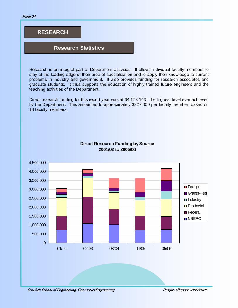
Research is an integral part of Department activities. It allows individual faculty members to stay at the leading edge of their area of specialization and to apply their knowledge to current problems in industry and government. It also provides funding for research associates and graduate students. It thus supports the education of highly trained future engineers and the teaching activities of the Department. Direct research funding for this report year was at $4,173,143 , the highest level ever achieved by the Department. This amounted to approximately $227,000 per faculty member, based on 18 faculty members.
RESEARCH
Research Statistics
Direct Research Funding by Source 2001/02 to 2005/06
0
500,000
1,000,000
1,500,000
2,000,000
2,500,000
3,000,000
3,500,000
4,000,000
4,500,000
01/02 02/03 03/04 04/05 05/06
ForeignGrants-FedIndustryProvincialFederalNSERC

Schulich School of Engineering, Geomatics Engineering Progress Report 2005/2006
Page 35
In addition to direct research funding, there is other research support available in terms of student scholarships, and in-kind donations. When added to the direct project funding, the total research for the reporting period is increased to $4,482,707. The figure on the previous page shows direct research funding for the last five years and the one below shows the research funding by source for 2005/2006
Direct Research Funding by Source 2005/06
NSERC18%
Federal17%
Provincial24%
Industry11%
Grants-Fed14%
Foreign16%
NSERCFederalProvincialIndustryGrants-FedForeign
Research Grants and Contracts for the Period April 1, 2005 – March 31, 2006
Source Amount
NSERC $763,177
Federal Government—Other 711,610
Federal – Grants 595,905
Provincial Government 983,742
Industry 442,898
Foreign Agencies 675,811
Direct Research Support $4,173,143
Research Scholarships 248,586
Equipment Donations 60,978
Other Research Support $309,564
Total Research Support $4,482,707
Schulich School of Engineering, Geomatics Engineering Progress Report 2005/2006
Page 36
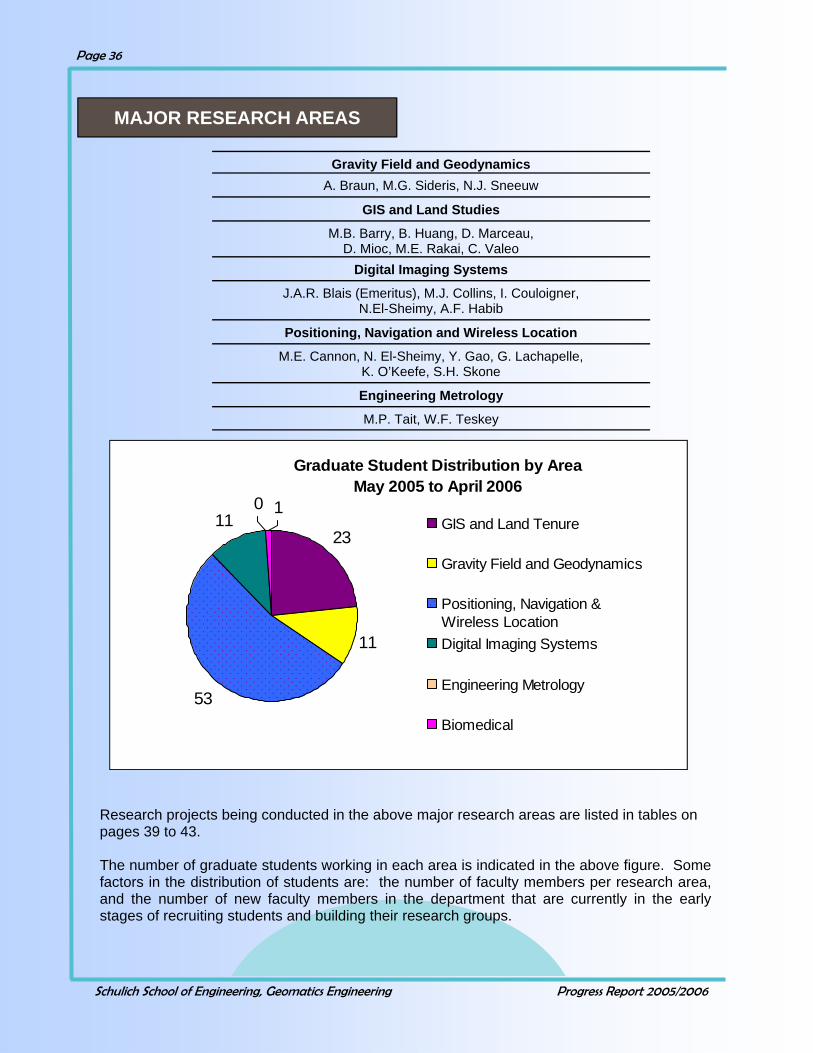
Research projects being conducted in the above major research areas are listed in tables on pages 39 to 43. The number of graduate students working in each area is indicated in the above figure. Some factors in the distribution of students are: the number of faculty members per research area, and the number of new faculty members in the department that are currently in the early stages of recruiting students and building their research groups.
Graduate Student Distribution by Area May 2005 to April 2006
23
11
53
110 1
GIS and Land Tenure
Gravity Field and Geodynamics
Positioning, Navigation &Wireless LocationDigital Imaging Systems
Engineering Metrology
Biomedical
Gravity Field and Geodynamics A. Braun, M.G. Sideris, N.J. Sneeuw
GIS and Land Studies
M.B. Barry, B. Huang, D. Marceau, D. Mioc, M.E. Rakai, C. Valeo
Digital Imaging Systems
J.A.R. Blais (Emeritus), M.J. Collins, I. Couloigner, N.El-Sheimy, A.F. Habib
Positioning, Navigation and Wireless Location
M.E. Cannon, N. El-Sheimy, Y. Gao, G. Lachapelle, K. O’Keefe, S.H. Skone
Engineering Metrology
M.P. Tait, W.F. Teskey
MAJOR RESEARCH AREAS

Schulich School of Engineering, Geomatics Engineering Progress Report 2005/2006
Page 37
Projects in Positioning, Navigation and Wireless Location Project Name Contract Type Faculty Investigators
ASW-GPS and Ionospheric R&D Support Foreign S.H. Skone M.E. Cannon G. Lachapelle
A National System for Water Vapour Estimation Using GPS and its Applications - GEOIDE NCE
Federal Y. Gao S. Skone
Assess and Compare the performance of HSGPS receivers and A-GPS Solutions
Industry Y. Gao
Assessment of GPS Technologies in Agriculture - Phase II
Industry G. Lachapelle
CRC - Faculty Support Provincial N. El-Sheimy
CRC - Multi-sensor Geomatics Systems NSERC N. El-Sheimy
Carrier Phase Based Global Differential GPS Positioning
NSERC Y. Gao
Chair, CRC in Wireless Location Federal G. Lachapelle
Design and Development of a Precise GPS/INS Vehicle Positioning System - Phase II
Foreign M.E. Cannon G. Lachapelle
Design and Implementation of a GPS/WAAS/eLoran Positioniong System
Industry M.E. Cannon G. Lachapelle
Development of INS/GPS Integration Sofware Using Artificial Neural Network of Wavelet & Multi-Resolution Analysis - GEOIDE NCE
Federal N. El-Sheimy
Development of MEMS-Based Survey System for Drilling Applications
Industry N. El-Sheimy
Development of Next Generation MEMS-based Surveying System for Drilling Operation
Provincial N. El-Sheimy
Development of Point-RTK Technology - GEOIDE NCE Federal Y. Gao
Development of a Real-Time Mobile Mapping System for Forest Fire Fighting
NSERC N. El-Sheimy
GPS-based Heading Determination Technology Transfer
Foreign G. Lachapelle
GPS Signal Information to Produce High-Resolution Estimates of Atmospheric Water Vapour
Federal S. Skone
Geomatics Enhancements with Dual Use of GPS II/III and Galileo: High Accuracy Position with GPS & Galileo - GEOIDE NCE
Federal M.E. Cannon N. El-Sheimy
Y. Gao G. Lachapelle
Grizzly Bear Tracking Collar Provincial N. El-Sheimy
iCORE Chair in Wireless Location Provincial G. Lachapelle
Inertial Aided GPS Foreign N. El-Sheimy
Integrated Navigation Systems Federal N. El-Sheimy
Integrated Vehicle Navigation of Communication Systems Development
Federal M.E. Cannon G. Lachapelle
Schulich School of Engineering, Geomatics Engineering Progress Report 2005/2006
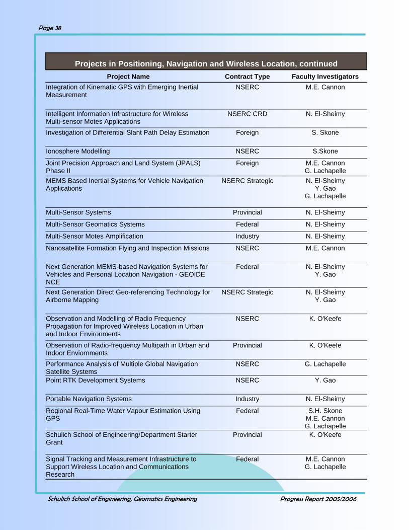
Page 38
Projects in Positioning, Navigation and Wireless Location, continued Project Name Contract Type Faculty Investigators
Integration of Kinematic GPS with Emerging Inertial Measurement
NSERC M.E. Cannon
Intelligent Information Infrastructure for Wireless Multi-sensor Motes Applications
NSERC CRD N. El-Sheimy
Investigation of Differential Slant Path Delay Estimation Foreign S. Skone
Ionosphere Modelling NSERC S.Skone
Joint Precision Approach and Land System (JPALS) Phase II
Foreign M.E. Cannon G. Lachapelle
MEMS Based Inertial Systems for Vehicle Navigation Applications
NSERC Strategic N. El-Sheimy Y. Gao
G. Lachapelle
Multi-Sensor Systems Provincial N. El-Sheimy
Multi-Sensor Geomatics Systems Federal N. El-Sheimy
Multi-Sensor Motes Amplification Industry N. El-Sheimy
Nanosatellite Formation Flying and Inspection Missions NSERC M.E. Cannon
Next Generation MEMS-based Navigation Systems for Vehicles and Personal Location Navigation - GEOIDE NCE
Federal N. El-Sheimy Y. Gao
Next Generation Direct Geo-referencing Technology for Airborne Mapping
NSERC Strategic N. El-Sheimy Y. Gao
Observation and Modelling of Radio Frequency Propagation for Improved Wireless Location in Urban and Indoor Environments
NSERC K. O'Keefe
Observation of Radio-frequency Multipath in Urban and Indoor Enviornments
Provincial K. O'Keefe
Performance Analysis of Multiple Global Navigation Satellite Systems
NSERC G. Lachapelle
Point RTK Development Systems NSERC Y. Gao
Portable Navigation Systems Industry N. El-Sheimy
Regional Real-Time Water Vapour Estimation Using GPS
Federal S.H. Skone M.E. Cannon G. Lachapelle
Schulich School of Engineering/Department Starter Grant
Provincial K. O'Keefe
Signal Tracking and Measurement Infrastructure to Support Wireless Location and Communications Research
Federal M.E. Cannon G. Lachapelle

Schulich School of Engineering, Geomatics Engineering Progress Report 2005/2006
Page 39
Tactical Outdoor Positioning System (TOPS) - Stage 3 Federal G. Lachapelle
Terramatics System Accuracy Assessment Industry N. El-Sheimy
Wireless Location Foreign G. Lachapelle
Wireless Location in Geomatics with the Emerging GPS II/III and Galileo Systems
Federal M.E. Cannon G. Lachapelle
Project Name Contract Type Faculty Investigators
Projects in Positioning, Navigation and Wireless Location, continued
Project Name Contract Type Faculty Investigators
Canadian Altimetry Database and Processing System (CADS)
Federal A. Braun
Climate Variability and its Impacts on Hydrology of Small Mid-continent Lakes and Wetlands
Foreign A. Braun
Combination of Space - Airborne and In-situ Gravity Measurements in Support of Arctic Sea-ice Thickness Mapping
Foreign A. Braun
Mapping the Ocean Surface with Geodetic and Oceanographic Tools - GEOIDE NCE
Federal M.G. Sideris A. Braun
Monitoring Sea Level Changes in Coastal Regions Using GPS and Other Space-based and Terrestrial Techniques
Provincial M.G. Sideris
Multi-satellite Determination of Global and Regional Geoid and Sea Level Changes
NSERC M.G. Sideris
Optimal Combination of terrestrial and Altimetric data with Data from the New Satellite Missions of CHAMP and GOCE for the Accurate Determination of the Gravity Field
Foreign M.G. Sideris
Space Gravimetry Contributions to Earth Monitoring - GEOIDE NCE
Federal M.G. Sideris A. Braun
Space Gravimetry Contribution to Earth Monitoring: Hydrology Study
Federal C. Valeo
Schulich School of Engineering/Dept.Starter Grant Provincial A. Braun
Quantification of Sea Ice Thickness and Surface Water Levels in the Arctic Ocean and Canada Using Satellite Altimetry
NSERC A. Braun
Projects in Gravity Field and Geodynamics

Schulich School of Engineering, Geomatics Engineering Progress Report 2005/2006
Page 40
Project Name Contract Type Faculty Investigators Laser Scanning for High-Precision Industrial Surveys Industry W.F. Teskey
Monitoring Deformation in Permafrost NSERC M. Tait
Monitoring Permafrost Deformation in the Mackenzie Delta
Industry M. Tait
Re-analysis of EDM Measurements Provincial W.F. Teskey
Software for High-Precision Industrial Applications of Laser Scanning
Industry W.F. Teskey
Projects in Engineering Metrology
Project Name Contract Type Faculty Investigators CRC - Multi-sensor Geomatics Systems NSERC N. El-Sheimy
Data Structures and Algorithms for the Integration of Raster and vector GIS
NSERC D. Mioc
Development of a Multi-agent Model to Simulate Whale-watching Activities in the St. Lawrence Estuary in Quebec
Federal D.J. Marceau
Dept./Schulich School of Engineering Starter Grant Provincial D.J. Marceau Dept./Schulich School of Engineering Starter Grant Provincial B. Huang
Design and Implementation of an Efficient Mobile GIS for Location Based Service
NSERC B. Huang
Design and Implementation of a Preliminary Multi-Dimensional GIS
Provincial B. Huang
Development of M2G - A Mobile Multi-Sensor Geomatics System - GEOIDE NCE
Federal N. El-Sheimy
Discovery Grant NSERC D.J. Marceau
Kananaskis Field Stations NSERC C. Valeo Fundamental Hydrologic Landscape Units Provincial C. Valeo Mathematical Models to Estimate Residential Land Values Provincial M. Barry
Multi-Sensor Geomatics Systems Federal N. El-Sheimy
Multi-Sensor Systems Provincial N. El-Sheimy
NSERC Tools and Instruments Grant NSERC D.J. Marceau
Physical Based Modelling of Urbanizing Catchments under Multi-Seasonal Conditions
NSERC C. Valeo
Real-time Airborne Mapping System NSERC N. El-Sheimy
Reducing the Vulnerability of Water Supply Under a Changing Climate: An Assessment of Stormwater Reuse Measures
Federal C. Valeo
Projects in GIS and Land Studies
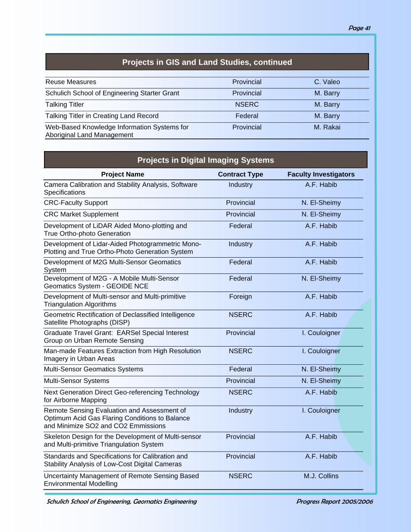
Schulich School of Engineering, Geomatics Engineering Progress Report 2005/2006
Page 41
Reuse Measures Provincial C. Valeo
Schulich School of Engineering Starter Grant Provincial M. Barry
Talking Titler NSERC M. Barry
Talking Titler in Creating Land Record Federal M. Barry
Web-Based Knowledge Information Systems for Aboriginal Land Management
Provincial M. Rakai
Projects in GIS and Land Studies, continued
Project Name Contract Type Faculty Investigators Camera Calibration and Stability Analysis, Software Specifications
Industry A.F. Habib
CRC-Faculty Support Provincial N. El-Sheimy
CRC Market Supplement Provincial N. El-Sheimy
Development of LiDAR Aided Mono-plotting and True Ortho-photo Generation
Federal A.F. Habib
Development of Lidar-Aided Photogrammetric Mono-Plotting and True Ortho-Photo Generation System
Industry A.F. Habib
Development of M2G Multi-Sensor Geomatics System
Federal A.F. Habib
Development of M2G - A Mobile Multi-Sensor Geomatics System - GEOIDE NCE
Federal N. El-Sheimy
Development of Multi-sensor and Multi-primitive Triangulation Algorithms
Foreign A.F. Habib
Geometric Rectification of Declassified Intelligence Satellite Photographs (DISP)
NSERC A.F. Habib
Graduate Travel Grant: EARSel Special Interest Group on Urban Remote Sensing
Provincial I. Couloigner
Man-made Features Extraction from High Resolution Imagery in Urban Areas
NSERC I. Couloigner
Multi-Sensor Geomatics Systems Federal N. El-Sheimy
Multi-Sensor Systems Provincial N. El-Sheimy
Next Generation Direct Geo-referencing Technology for Airborne Mapping
NSERC A.F. Habib
Remote Sensing Evaluation and Assessment of Optimum Acid Gas Flaring Conditions to Balance and Minimize SO2 and CO2 Emmissions
Industry I. Couloigner
Skeleton Design for the Development of Multi-sensor and Multi-primitive Triangulation System
Provincial A.F. Habib
Standards and Specifications for Calibration and Stability Analysis of Low-Cost Digital Cameras
Provincial A.F. Habib
Uncertainty Management of Remote Sensing Based Environmental Modelling
NSERC M.J. Collins
Projects in Digital Imaging Systems
Schulich School of Engineering, Geomatics Engineering Progress Report 2005/2006
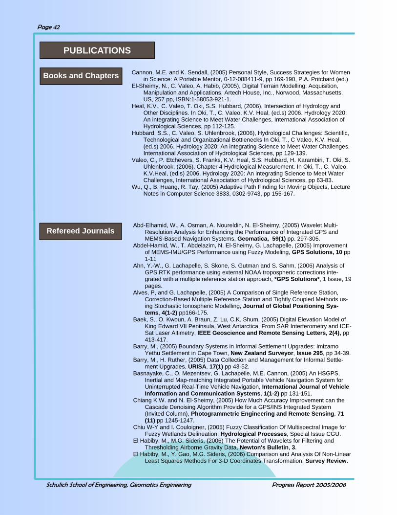
Page 42
Abd-Elhamid, W., A. Osman, A. Noureldin, N. El-Sheimy, (2005) Wavelet Multi-Resolution Analysis for Enhancing the Performance of Integrated GPS and MEMS-Based Navigation Systems, Geomatica, 59(1) pp. 297-305.
Abdel-Hamid, W., T. Abdelazim, N. El-Sheimy, G. Lachapelle, (2005) Improvement of MEMS-IMU/GPS Performance using Fuzzy Modeling, GPS Solutions, 10 pp 1-11
Ahn, Y.-W., G. Lachapelle, S. Skone, S. Gutman and S. Sahm, (2006) Analysis of GPS RTK performance using external NOAA tropospheric corrections inte-grated with a multiple reference station approach, *GPS Solutions*, 1 Issue, 19 pages.
Alves, P, and G. Lachapelle, (2005) A Comparison of Single Reference Station, Correction-Based Multiple Reference Station and Tightly Coupled Methods us-ing Stochastic Ionospheric Modelling, Journal of Global Positioning Sys-tems, 4(1-2) pp166-175.
Baek, S., O. Kwoun, A. Braun, Z. Lu, C.K. Shum, (2005) Digital Elevation Model of King Edward VII Peninsula, West Antarctica, From SAR Interferometry and ICE-Sat Laser Altimetry, IEEE Geoscience and Remote Sensing Letters, 2(4), pp 413-417.
Barry, M., (2005) Boundary Systems in Informal Settlement Upgrades: Imizamo Yethu Settlement in Cape Town, New Zealand Surveyor, Issue 295, pp 34-39.
Barry, M., H. Ruther, (2005) Data Collection and Management for Informal Settle-ment Upgrades, URISA, 17(1) pp 43-52.
Basnayake, C., O. Mezentsev, G. Lachapelle, M.E. Cannon, (2005) An HSGPS, Inertial and Map-matching Integrated Portable Vehicle Navigation System for Uninterrupted Real-Time Vehicle Navigation, International Journal of Vehicle Information and Communication Systems, 1(1-2) pp 131-151.
Chiang K.W. and N. El-Sheimy, (2005) How Much Accuracy Improvement can the Cascade Denoising Algorithm Provide for a GPS/INS Integrated System (Invited Column), Photogrammetric Engineering and Remote Sensing, 71(11) pp 1245-1247.
Chiu W-Y and I. Couloigner, (2005) Fuzzy Classification Of Multispectral Image for Fuzzy Wetlands Delineation. Hydrological Processes, Special Issue CGU.
El Habiby, M., M.G. Sideris, (2006) The Potential of Wavelets for Filtering and Thresholding Airborne Gravity Data, Newton's Bulletin, 3.
El Habiby, M., Y. Gao, M.G. Sideris, (2006) Comparison and Analysis Of Non-Linear Least Squares Methods For 3-D Coordinates Transformation, Survey Review.
PUBLICATIONS
Cannon, M.E. and K. Sendall, (2005) Personal Style, Success Strategies for Women in Science: A Portable Mentor, 0-12-088411-9, pp 169-190, P.A. Pritchard (ed.)
El-Sheimy, N., C. Valeo, A. Habib, (2005), Digital Terrain Modelling: Acquisition, Manipulation and Applications, Artech House, Inc., Norwood, Massachusetts, US, 257 pp, ISBN:1-58053-921-1.
Heal, K.V., C. Valeo, T. Oki, S.S. Hubbard, (2006), Intersection of Hydrology and Other Disciplines. In Oki, T., C. Valeo, K.V. Heal, (ed.s) 2006. Hydrology 2020: An integrating Science to Meet Water Challenges, International Association of Hydrological Sciences, pp 112-125.
Hubbard, S.S., C. Valeo, S. Uhlenbrook, (2006), Hydrological Challenges: Scientific, Technological and Organizational Bottlenecks In Oki, T., C Valeo, K.V. Heal, (ed.s) 2006. Hydrology 2020: An integrating Science to Meet Water Challenges, International Association of Hydrological Sciences, pp 129-139.
Valeo, C., P. Etchevers, S. Franks, K.V. Heal, S.S. Hubbard, H. Karambiri, T. Oki, S. Uhlenbrook, (2006), Chapter 4 Hydrological Measurement. In Oki, T., C. Valeo, K.V.Heal, (ed.s) 2006. Hydrology 2020: An integrating Science to Meet Water Challenges, International Association of Hydrological Sciences, pp 63-83.
Wu, Q., B. Huang, R. Tay, (2005) Adaptive Path Finding for Moving Objects, Lecture Notes in Computer Science 3833, 0302-9743, pp 155-167.
Books and Chapters
Refereed Journals

Schulich School of Engineering, Geomatics Engineering Progress Report 2005/2006
Page 43
El-Gizawy, M., A. Noureldin, N. El-Sheimy, (2005) A Reliable Modeless Mobile Multi-Sensor Integration Technique Based On RLS-Lattice, Measurement Science And Technology, 17, pp 51-61.
Forsberg, R., M.G. Sideris, C.K. Schum, (2005) The Gravity Field and GGOS, Journal of Geodynamics, 40(4-5), pp 387-393.
Fotopoulos, G., M.G. Sideris, (2005) Spatial Modeling and Analysis of Adjusted Residuals Over a Network of GPS Levelling Benchmarks, Geomatica, 59(3) pp 251-262.
Gao, Y. and K. Chen, (2005) Performance Analysis of Precise Point Positioning Using Rea-Time Orbit and Clock Products, Journal of Global Positioning Systems, 3(1-2), pp.95-100.
Grebenitcharsky, R., E. Rangelova, M.G. Sideris, (2005) Transformation Be-tween Gravimetric and GPS/ Levelling Derived Geoids using Additional Gravity Information, Journal of Geodynamics, 39(5) pp 527-544.
Habib, A., (2005) Low-Cost Digicams Come Handy, Geo-Spatial Today, pp 50-56.
Habib, A., A. Pullivelli, E. Mitishita, M. Ghanma, E. Kim, (2006) Stability analysis of low-cost digital cameras for aerial mapping using different geo-referencing techniques, Journal of Photogrammetric Record, 21(113), pp 29-43.
Habib, A., M. Ghanma, E. Mitishita, (2005) Photogrammetric Geo-referencing using LIDAR Linear and Areal Features, Korean Journal of Geomatics, 5(1), pp1-13.
Habib, A., M. Ghanma, M. Morgan, R. Al-Ruzouq, (2005) Photogrammetric and Lidar Data Registration Using Linear Features, Photogrammetric Engi-neering and Remote Sensing, 71(6) pp 699-707.
Habib, A., M. Morgan, (2005) Stability Analysis and Geometric Calibration of Off-the-Shelf Digital Cameras, Photogrammetric Engineering and Re-mote Sensing, 71(7) pp 733-741.
Habib, A., R. Cheng, E. Kim, E. Mitishita, R. Frayne, J. Ronsky, (2005) Auto-matic Surface Matching for the Registration of LIDAR Data and MR Im-agery Authors. ETRI Electronics and Telecommunication Research Institute Journal, 28(2), pp. 162-174.
Ho, C.L.I. and C. Valeo, (2005) Observations of Urban Snow Processes, Hy-drological Processes, 19 pp. 459-473.
Huang, B. and C. Claramunt, (2005) Spatiotemporal Data Model and Query Language for Tracking Land Use Change, Transportation Research Re-cord, Volume 1902, pp 107-113.
Huang, B. and S.Z. Yi, (2006) A Web Spatial Service Model with Application to Traffic Noise Simulation, Geomatica, 60(1), pp. 21-34.
Huang, B., P. Fery, L.P. Zhang, (2005) Multi-objective optimization for hazard-ous material transportation, Transportation Research Record, Volume 1906, pp 64-73.
Jeon, C.W. and G. Lachapelle, (2005) A New TLS-Based Sequential Algorithm to Identify Two Failed Satellites, International Journal of Control, Auto-mation, and Systems (IJCAS), 3(2) pp 166-172.
Kotsakis, C., M.G. Sideris, (2006) Revisiting Least Squares: A discussion on the Leading Estimation Principle in Geodesy, Geodesy and Cartography, 55(1) pp 3-22.
Liu, Z., S. Skone and Y. Gao, (2006) Assessment of tomographic modeling performance using GPS data during October 2003 ionospheric storm, *Radio Science*, *41*, RS1007, doi: 10.1029/2004RS003236.
Liu, N. and B. Huang, (2005) Using Ant Algorithm to Derive Pareto Fronts for Multi-Objective Siting of Emergency Service Facilities, Transportation Research Record, Volume 1935, pp 20-29.
Liu, Z.Z., S. Skone, Y. Gao, (2005) A Study of TEC Data Precision Inferred from GPS Measurements, Earth, Planets and Space, 57, July, pp 999-1007.
Mezentsev, O., J. Collin, G. Lachapelle, (2005) Pedestrian Dead Reckoning - A Solution to Navigation in GPS Signal Degraded Areas, Geomatica, 59(2), pp 175-182.
Schulich School of Engineering, Geomatics Engineering Progress Report 2005/2006
Page 44
Nassar, S. and N. El-Sheimy, (2006) A Combined Algorithm of Improving INS Error Modeling and Sensor Measurements for Accurate INS/GPS Navigation, GPS Solutions, 10(1) pp: 29–39.
O’Keefe, K., O. Julien, M.E. Cannon and G. Lachapelle (2006) Evaluation of the Availability, Accuracy, Reliability and Carrier-phase Ambiguity Resolution Ca-pabilities of the Galileo GNSS in Conjunction with Modernized GPS, Acta As-tronautica, 58(8) pp. 422-434.
Pugliano, G., and G. Lachapelle (2005) La collocazione nel posizionamento GPS Network RTK. Bollettino di Geodesia e Scienze Affini, Anno LXIV, N. 2, pp. 93-109.
Salycheva, A.O., and M.E. Cannon, (2005) INS/HSGPS Integration in Downtown Areas, European Journal of Navigation, 3(3), pp 67-73.
Sharma, J., C. Gierull, M.J. Collins, (2006) Compensating the Effects of Target Ac-celeration in Dual-Channel SAR-GMTI, IEE Proceedings - Radar, Sonar and Navigation, 153(1) pp 53-62.
Sharma, J., C. Gierull, M.J. Collins, (2006) The Influence of Target Acceleration on Velocity Estimation in Dual-Channel SAR-GMTI, IEEE Transactions on Geo-science and Remote Sensing, 44(1) pp 134-147.
Shin, E.H. and N. El-Sheimy, (2005) Navigation Kalman Filter Design for Pipeline Pigging, The Journal of Navigation, The Royal Institute of Navigation, 58(2) pp 283-295.
Shum, C. K., S.C. Han, A. Braun, (2005) Spaceborne Gravity Sensors for Continen-tal Hydrology and Geodynamic Studies, Korean Journal of Remote Sensing, 21(1), pp 51-57.
Skone, S. and V. Hoyle, (2005) Troposphere Modeling in a Regional GPS Network, Journal of Global Positioning Systems, 4(1-2) pp 230-239.
Skone, S., R. Yousuf, A. Coster, (2005) Mitigation of Ionospheric Errors for Marine DGPS, European Journal of Navigation, 3(3) pp 58-66.
Smart, R.G., M.E. Cannon, A. Howard, R.E. Mann, (2005) Can We Design Cars to Prevent Road Rage?, International Journal of Vehicle Information and Communication Systems, 1(1-2) pp 44-55.
Syed, S., and M.E. Cannon, (2005) Map-Aided GPS Navigation: Linking Vehicles and Maps to Support Location-Based Services, GPS World, November, pp 39-44.
Tait, M., B. Moorman, S. Li, (2005) The Long-Term Stability of Survey Monuments in Permafrost, Journal of Engineering Geology - Special edition on Appli-cations of geodetic techniques in Engineering Geology, 79(1-2) pp 61-79.
Teskey, W. F., B. Paul, W. J. Teskey, (2005) Hidden Point Bar method for High-Precision Industrial Surveys, Journal of Surveying Engineering, 131(4) pp 103-106.
Todd, R. and N. El-Sheimy, (2006) Optimal Linear Combinations of Triple Fre-quency Carrier Phase Data from Future Global Navigation Satellite Systems, GPS Solution, Published online, March 07.
Valeo, C., S.H. Skone, C.L.I. Ho, S.K.M. Poon, S.M. Shrestha, (2005) Estimating Snow Evaporation With GPS Derived Precipitable Water Vapour, Journal of Hydrology, 307(1-4), pp 196-203.
Wang, J. and Y. Gao, (2005) Multi-sensor Data Fusion for Land Vehicle Attitude Estimation using Fuzzy Expert System, Data Science Journal, 4, December, pp 127-139.
Wang, J. and Y. Gao, (2005) A New Magnetic Compass Calibration Algorithm Using Neural Networks, Measurement, Science and Technology, 17(1), pp153-160.
Yi, S. Z. and Huang, B. (2005) Integrating Heterogeneous Traveler Information with XML-based Web Service, Journal of Geographic Information Science, 11(1), pp 50-60,
Zhi, J., G. Lachapelle, C. Ma (2005) Applying FFT Analysis and Data Window in Software GPS Receivers to Mitigate CW Interference under Dynamic Condi-tions. Canadian Aeronautics and Space Journal, 51(4), pp 177-186.
Zong, Y.F., L.P. Zhang, B. Huang, (2006) An unsupervised artificial immune classi-fier for multi/hyper-spectral remote sensing image, IEEE Transactions on Geoscience & Remote Sensing, 44(2).

Schulich School of Engineering, Geomatics Engineering Progress Report 2005/2006
Page 45
Cannon, M.E., G. Lachapelle, K. O'Keefe, (2005) RTK GPS Concepts, Performance and Future Trends, Workshop on Geolocation Technology to Support UXO Geophysical Investigations, Annapolis, Maryland.
Charkhandeh, S., M.G. Petovello, R. Watson, G. Lachapelle (2006) Implementation and Testing of a Real-Time Software-Based GPS Receiver for x86 Processors, Proceedings of ION NTM 2006, Monterey, CA, January 18-20, CD, 8 pages
Chen, K. and Y. Gao, (2005) Real-Time Precise Point Positioning Using Single-Frequency Data, Proceedings of ION GNSS-2005 Conference, Long Beach, CA, September 13-16.
Cheng, R., A. Habib, R. Frayne, J. Ronsky, (2006) Registration of Knee Joint Surfaces for the In-vivo Study of Joint Injuries Based on Magnetic Resonance Imaging. The International Society for Optical Engineering Conference on Medical Imag-ing, San Diego, CA, February 11-16. CD Rom
Cheng, R., R. Frayne, J. Ronsky, A. Habib, (2005) Matching Strategy for Co-Registration of Surfaces Acquired by Magnetic Resonance Imaging, IEEE Interna-tional Geoscience and Remote Sensing Symposium, Seoul, Korea, July.
Chiang K., X. Niu, N. El-Sheimy, (2005) On the Development of a Conceptual Intelli-gent Navigator for a Low Cost DGPS/MEMS IMU Integrated System, Proceed-ings of ION GNSS-2005 Conference, Long Beach, CA, September 13-16 CD - 9 Pages.
Chiang, K-W., S. Nassar, N El-Sheimy, (2006) A Constructive and Autonomous Inte-gration Scheme of Low-Cost GPS/MEMS IMU for Land Vehicular Navigation Ap-plications. The IEEE/ION Position, Location and Navigation Symposium (PLANS 2006), San Diego, CA, April 25-27.
Chiu W-Y and I. Couloigner, (2005) Wetlands Identification through Fuzzy Segmenta-tion of Remote Sensing Imagery. Proceedings of the 13th International Confer-ence on GeoInformatics, Toronto, August 17-19, CD-Rom
Chiu W-Y and I. Couloigner, (2006) Fuzzy Segmentation for Wetland Mapping. Pro-ceedings of the 25th EARSeL Symposium: Global Developments in Environ-mental Earth Observation from Space,, Porto, Portugal, June 6-11, pp.29-38.
Collins, P., Y. Gao, F. Lahaye, P. Haroux, K. Macleod, K. Chen, (2005) Accessing and Processing Real-Time GPS Corrections for Precise Point Positioning - Some User Considerations, Proceedings of ION GNSS-2005 Conference, Long Beach, CA, September 13-16.
Dao, Diep. and G. Lachapelle, (2005) GPS Performance for Various Applications, Pro-ceedings 26th Asian Remote Sensing conference, Hanoi, Vietnam, November 7-11, CD-ROM 6 pages
El-Gizawy, M., A. Noureldin, N. El-Sheimy (2006), Performance Analysis of Tactical Grade Inertial Systems for Measurements-While-Drilling (MWD) Process, The IEEE/ION Position, Location and Navigation Symposium (PLANS 2006), San Diego, CA, April 25-27.
El-Gizawy, M., A. Noureldin, N. El-Sheimy, (2005) Integrated Recursive Least Square Lattice and Neuro-Fuzzy Modules for Mobile Multi Sensor Data Fus, 12th IEEE International Conference on Electronics, Circuits and Systems, Gammarth, Tunisia, December 11 – 14.
Ellum, C.M. and N. El-Sheimy, (2005) Combining GPS and Photogrammetric Measure-ments in a Single Adjustment, Proceedings of the 7th Conference on Optical 3D Measurement Techniques, Vienna, Austria, October 3-5, pp. 339-348.
Ellum, C.M. and N. El-Sheimy, (2005) Integrating Photogrammetry and GPS at the Measurement-Level, Proceedings of ION GNSS-2005 Conference, Long Beach, CA, September 13-16.
El-Sheimy, N., (2005) Mobile Mapping - the New Trend in GIS Data Capturing, Remote Sensing Arabia, International Conference on Advanced Remote Sensing for Earth Observation Systems, Riyadh, Saudi Arabia, May 7-11, CD 10 pages.
Gallaway J, Y. Martin, E. Johnson, M Tait, (2005) Biogenic Disturbance and Transport on Burned Hill slopes in Mountainous Forests of Interior British Columbia, Earth System Processes 2, Calgary, August.
Conference Proceedings

Schulich School of Engineering, Geomatics Engineering Progress Report 2005/2006
Page 46
Gao, J., M.G. Petovello, M.E. Cannon (2006), Development of Precise GPS/INS/Wheel Speed Sensor/Yaw Rate Sensor Integrated Vehicular Positioning System, Proceedings of ION NTM 2006, Monterey, CA, January 18-20, CD, 13 pages.
Gao, Y. and X. Shen, (2005) (2005) Impact Analysis of Galileo Navigation Sys-tem on Precise Point Positioning, Geoinformatics-2005, Toronto, August.
Garin, L., (2005) The "Shaping Correlator", Novel Multipath Mitigation Technique Applicable to GALILEO BOC(1,1) Modulation Waveforms in High Volume Markets, Proceedings of European Navigation Conference, Munich, July 19-22, CD-ROM 16 pages
Godha, S. and M.E. Cannon, (2005) Development of a DGPS/MEMS IMU Inte-grated System for Navigation in Urban Canyon Conditions, International Symposium on GPS/GNSS 2005, Hong Kong, December 8-11, CD, 9 pp.
Godha, S. and M.E. Cannon, (2005) Integration of DGPS with a Low Cost MEMS - Based Inertial Measurement Unit (IMU) for Land Vehicle Navigation Application, Proceedings of the ION GNSS-05 Conference, Long Beach, September 13-16, CD 14 pp.
Godha, S., M.G. Petovello, G. Lachapelle, (2005) Performance Analysis of MEMS IMU/HSGPS/Magnetic Sensor Integrated System in Urban Canyon, Proceedings of the ION GNSS-05 Conference, Long Beach, September 13-16, CD 14 pages.
Goodall, C., N. El-Sheimy, K.W. Chiang, (2005) The Development of a GPS/MEMS INS Integrated System Utilizing a Hybrid Processing Architecture, Proceedings of ION GNSS-2005 Conference, Long Beach, CA, Septem-ber 13-16.
Habib, A. M. Ghanma, E. Mitishita, A. Machado, E. Kim, C. Kim, (2005) Compre-hensive Analysis of the performance of Metric Analog Cameras, Amateur Digital Cameras, and LIDAR, IEEE International Geoscience and Remote Sensing Symposium, Seoul, Korea, July.
Habib, A., A. Pullivelli, (2005) Low-Cost Digital Cameras: Calibration, Stability Analysis, and Applications, International Conference on Advanced Re-mote Sensing for Earth Observation Systems, Riyadh, Saudi Arabia, May 7-11.
Habib, A., and A. Pullivelli, (2005) Camera Stability Analysis and Geo-Referencing, The IEEE International Geoscience and Remote Sensing Symposium, Seoul, Korea, July.
Habib, A., and A. Pullivelli, (2005) Low-Cost Digital Cameras for Personal Identi-fication, 98th Annual Conference on Geomatics: Powering the Future, Ottawa, Canada, June.
Habib, A., and A. Pullivelli, (2005) Stability Analysis and Potential Applications of Amateur Digital Cameras, Second Italy-Canada Workshop on 3D Digital Imaging and Modeling: Applications of Heritage, Industry, Medicine, and Land, Padua, Italy, May.
Habib, A., and M. Ghanma, (2005) Indirect Geo-Referencing of Photogrammetric Models using LIDAR Data, 98th Annual Conference on Geomatics: Pow-ering the Future, Ottawa, June.
Habib, A., C. Kim, E. Kim, (2005) Linear Features for Semi-Automatic Registra-tion and Change Detection of Multi-Source Imagery, IEEE International Geoscience and Remote Sensing Symposium, Seoul, Korea, July.
Habib, A., E. Kim, C. Kim, (2005) Geometric Modeling and Co-Registration of Multi-Source and High Resolution Satellite Imagery, International Confer-ence on Advanced Remote Sensing for Earth Observation Systems, Riyadh, Saudi Arabia, May 7-11.
Habib, A., M. Ghanma, E. Mitishita, E. Kim, C. Kim, (2005) Image Geo-Referencing Using LIDAR Data, IEEE International Geoscience and Re-mote Sensing Symposium, Seoul, Korea, July.
Habib, A., R. Cheng, R. Frayne, J. Ronsky, (2005) Surface Matching for Auto-mated Registration of LIDAR and MR Imagery, Second Italy-Canada Workshop on 3D Digital Imaging and Modeling: Applications of Heri-tage, Industry, Medicine, and Land, Padua, Italy, May.

Schulich School of Engineering, Geomatics Engineering Progress Report 2005/2006
Page 47
He, J. C. Valeo, F.J-C. Bouchart, (2005) Enhancing Urban Infrastructure Invest-ment Planning Practices For a Changing Climate. Proceedings of the 10th IWA Specialist Conference in Watershed and Basin Management, Cal-gary, Alberta, September 13-15, CD 8 pp.
Hu, T, G. Lachapelle, R. Klukas, (2005) Indoor GPS Signal Replication Using a Hardware Simulator, Proceedings of the ION GNSS-05 Conference, Long Beach, September 13-16, CD, 15 pages.
Huang B, (2005) A GIS-AHP Method for HAZMAT Route Planning with Consid-eration of Security, Canadian Institute of Geomatics 2005 Conference, Ottawa, June.
Huang, B. and X H Pan, (2005) Integration of GIS and Microscopic Traffic Simu-lation for Incident Response, GeoInformatics 2005, Toronto, August.
Julien, O., (2005) Carrier-Phase Tracking of Future Data/Pilot Signals, Proceed-ings of the ION GNSS-05 Conference, Long Beach, September 13-16, CD, 12 pages.
Julien, O., M.E. Cannon and G. Lachapelle, (2005) Impact of Future GNSS Sig-nals on Carrier-Phase Tracking, Proceedings of European Navigation Conference GNSS, Munich, July 21-24, CD, 16 pages.
Kim, E. M. Morgan, C. Kim, K. Kim, S. Jeong, A. Habib, (2005) Comprhensive Comparisons Among Alternative Sensor Models for High Resolution Satel-lite Imagery, IEEE International Geoscience and Remote Sensing Sym-posium, Seoul, Korea, July.
Kopp, E and M.J. Collins, (2005) On the Use of Spatial Constraints in SAR Im-age Segmentation, GSPx Pervasive Signal Processing Conference and Expo, Global Technology Conferences, Inc., CD.
Lachapelle, G., (2005) The Challenge of Making GNSS Work Indoor. Keynote Address, Proceedings of NAV05 Royal Institute of Navigation, London, UK, November 1-3, CD 19 pages
Lee, J. K. Yu, Y. Kim, A. Habib , (2005) Segmentation and Extraction of Linear Features for Detecting Discrepancies between LIDAR Strips, IEEE Interna-tional Geoscience and Remote Sensing Symposium, Seoul, Korea, July.
Li, H.G., H. Lu, B. Huang, Z.Y. Huang, (2005) Two Ellipse Based Pruning Meth-ods for Group Nearest Neighbor Queries, 13th ACM International Sympo-sium on Advances in Geographic Information Systems, Bremen, Ger-many, October.
Lin, B., (2005) RTCM 3.0 Implementation in the Southern Alberta Network. Pro-ceedings of ION GNSS-2005 Conference, Long Beach, CA, September 13-16, CD 12 pages.
Lu, A., A. Lopez, S. Shanmugam, J. Nielsen, G. Lachapelle, (2005)Phase Co-herency of CDMA Caller Location Processing Based on TCXO Frequency Reference with Intermittent GPS Corrections, TRLab Wireless 2005 Con-ference, Calgary, July 11-13, 5 pages.
Luo, N., D. Dao, G. Lachapelle, M.E. Cannon, (2005) GPS Network RTK Per-formance Under Very Active Ionospheric Conditions, Proceedings of the ION GNSS-05 Conference, Long Beach, CA, September 13-16, CD, 9 pp.
Luo, N., G. Mao, G. Lachapelle, M.E. Cannon (2006) ASF Effect Analysis Using an Integrated GPS/eLORAN Positioning System, Proceedings of ION NTM 2006, Monterey, CA, January 18-20, CD 10 pages.
Lupart, J. L., and M.E. Cannon, (2005) SCIberMENTOR: Research In J. C. Zarate, M. A. R. Mendoza & A. M. Gomez (Eds.), Global Networking into the Future 2 PostGlobalization: Higher Education Institutions facing the Knowledge Society/Economy and the GATS, Fundation para la Educa-cion Superior International, A. C. Vera Cruz, New Mexico, July, pp. 347-353.
Marceau, D.J. and A. Ménard, (2005) Modelling Land-use Changes Using Geo-graphic Cellular Automata. Scale Sensitivity Analysis and Land-Use Man-agement Scenarios, Proceedings of GIS Planet 2005 Conference, Estoril, Portugal, May 30-June22.

Schulich School of Engineering, Geomatics Engineering Progress Report 2005/2006
Page 48
Meenakshisundaram V. & I. Couloigner, (2006) Quality Assessment of Fusion Methods for High Resolution Images. Proceedings of the 25th EARSeL Symposium: Global Developments in Environmental Earth Observa-tion from Space, Porto, Portugal, June 6-11, pp.81-86.
Nassar, S., E-H Shin, X. Niu, N. El-Sheimy, (2005) Accurate INS/GPS Position-ing with Different Inertial Systems Using Various Algorithms for Bridging GPS Outages, Proceedings of ION GNSS-2005 Conference, Long Beach, CA, September 13-16, pp. 1401-1410.
Nassar, S., X. Niu, P. Aggarwal, N. El-Sheimy, (2006) INS/GPS Sensitivity Analysis Using Different Kalman Filter Approaches. Proceedings of ION NTM 2006, Monterey, CA, January 18-20, pp. 993-1001.
Nassar, S., Z. Syed, X Niu, N El-Sheimy, (2006) Improving MEMS IMU/GPS Systems for Accurate Land-Based Navigation Applications. Proceedings of ION NTM 2006, Monterey, CA, January 18-20, pp. 523-529.
Nicholson, N. S. Skone, M.E. Cannon G. Lachapelle, N. Luo, (2005) Regional Tropospheric Tomography Based on Real-Time Double Difference Observ-ables, Proceedings of ION GNSS-05 Conference, Long Beach, CA, Sep-tember 13-16, CD 12 pages.
Niu, X. and N. El-Sheimy, (2005) Development of a Low-cost MEMS IMU/GPS Navigation System for Land Vehicles Using Auxiliary Velocity Updates in the Body Frame Proceedings of ION GNSS-2005 Conference, Long Beach, CA, September 13-16, CD 10 Pages.
Niu, X., C. Goodall, S. Nassar, N. El-Sheimy, (2006) “An Efficient Method for Evaluating the Performance of MEMS IMUs.” The IEEE/ION Position, Lo-cation and Navigation Symposium (PLANS 2006), San Diego, CA, April 25-27.
O'Keefe, K., K. Johnson, P. Alves, (2005) Evaluation of Several Double-differencing Strategies for Reduction of Unmodelled Correlated Errors in Carrier Phase GNSS Processing, Proceedings of ION AM05, The Institute of Navigation 61st Annual Meeting, Fairfax VA, June 27-29, pp. 917-926.
Petovello, M.G., K. O’Keefe, G. Lachapelle, M.E. Cannon, (2005) Field Results of a GPS/INS-Based Approach to Measuring Ship Flexure Onboard an Air-craft Carrier, Proceedings of the ION GNSS-05 Conference, Long Beach, September 13-16, CD 10 pp.
Petovello, M.G., K. O’Keefe, G. Lachapelle, M.E. Cannon, (2005) Quantifying Ambiguity Resolution Performance in the Presence of Time-Correlated Measurement Errors Using Geometric-Based Techniques, Proceedings of ION AM05, The Institute of Navigation 61st Annual Meeting, Fairfax, VA June 27-29, pp. 1073-1084.
Phalke S. and Couloigner I., 2005. Change Detection of Man made Objects us-ing GIS data & Remotely-Sensed Imagery. Proceedings of the 24th EARSeL Symposium: New Strategies for European Remote Sensing, Dubrovnik, Croatia, May 25-27, pp. 191-198.
Phalke S. and I. Couloigner, (2005) Change Detection of Linear Man-made Ob-jects using Feature Extraction Technique. Proceedings of the 13th Inter-national Conference on GeoInformatics, Toronto, ON, August 17-19, CD.
Phalke S. M. and I. Couloigner, (2005) Change Detection of Linear Man-made Objects and Use of it for the GIS Update. Proceedings of the 98th Annual Conference of the Canadian Institute of Geomatics, Ottawa (ON), June 13-15, CD.
Phalke, S. and M.E. Cannon (2006), GPS and Galileo Performance Evaluations for Multiple Reference Network Real-Time Positioning, Proceedings of ION NTM 2006, Monterey, CA, January 18-20, CD 11 pages.
Shanmugam, S. A. Lopez, D. Lu, N. Luo, J. Nielsen, G. Lachapelle, R. Klukas, A. Taylor, (2005) Wireless Location in IS-95 CDMA Cellular Radio Systems, TRLab Wireless 2005 Conference, Calgary, July 11-13, 10 pages
Shanmugam, S., R. Watson, J. Nielsen, G. Lachapelle, (2005) Differential Signal Processing Schemes for Enhanced GPS Acquisition, Proceedings of ION GNSS-05, Long Beach, CA, September 13-16, CD 11 pages.

Schulich School of Engineering, Geomatics Engineering Progress Report 2005/2006
Page 49
Sharma, O., D. Mioc, A. Habib, (2005) Road Extraction from Satellite Imagery Using Fractals and Morphological Image Processing, 13th International Conference on Geoinformatics, Toronto, August.
Singh, S., M.E. Cannon, R. Klukas, G. Cox, (2005) Field Test Assessment of As-sisted GPS and High Sensitivity GPS Receivers under Weak/ Degraded Signal Conditions, Proceedings of the ION GNSS-05 Conference, Long Beach, Sep-tember 13-16, CD 14 pp.
Skone, S., R. Yousuf, A. Coster, (2005) Analysis of DGPS and WADGPS Perform-ance during Severe Ionospheric Activity, Proceedings of the Ionospheric Ef-fects Symposium, Alexandria, VA, May.
Skone, S., (2005) Degradation of DGPS and WADGPS Performance during 2003 Super Storms, Proceedings of the 61st ION Annual Meeting, Cambridge, MA, June.
Skone, S., (2005) Ionospheric Limitations and Mitigation of Errors, Proceedings of the 61st ION Annual Meeting, Cambridge, MA, June.
Skone, S., G. Lachapelle, D. Yao, W. Yu, R. Watson, (2005) Investigating the Impact of Ionospheric Scintillation using a GPS Software Receiver, Proceedings of ION GNSS-05, Long Beach, CA, September 13-16, CD 12 pages.
Teskey, W. F., B. Paul, J. W. Lovse, (2005) New Instrumentation and Methodology for Deformation Monitoring, Proceedings of the 7th Conference on Optical 3D Measurement Techniques, Vienna, May.
Teskey, W. F., B. Paul, J. W. Lovse, (2006) Application of a Multi-Parameter Trans-formation for Deformation Monitoring of a Large Structure, Proceedings of the 12th FIG Symposium on Deformation Measurements, Baden, Austria, May.
Valeo, C., D. Draper, A. H-S Huang, (2005) Perceptions and Attitudes Toward Recy-cling Storm Water for Irrigation of Park Land in Calgary, Proceedings of Waste the Social Context, Edmonton, Alberta, May 11–14, CD, 10 pp.
Valeo, C., N. Neumann, A. Chu, (2005) Assessing Health and Environmental Im-pacts of Stormwater Recycling for Irrigating Parkland”. Proceedings of the 10th IWA Specialist Conference in Watershed and Basin Management, Calgary, Alberta, September 13-15, CD, 8 pp
Wang, J. and Gao, Y., (2005) An Intelligent MEMS IMU/HSGPS Integration System for Vehicular Navigation in Urban Canyons, Proceedings of ION GNSS-2005 Conference, Long Beach, CA, September 13-16.
Wu, Q., and Huang, B., (2005) A Performance Improvement for Navigation Guid-ance, GeoInformatics 2005, Toronto, August.
Xie C.L., B. Huang, R. Tay, (2005) Graph-Based Algorithm for Incident Response Strategy Formulation, GeoInformatics 2005, Toronto, August.
Yang, Y., X. Niu, N. El-Sheimy. (2006) Real-Time MEMS Based INS/GPS Integrated Navigation System for Land Vehicle Navigation Application. Proceedings of ION NTM 2006, Monterey, CA, January 18-20.
Yi S Z., W.T. Chan, B. Huang, (2005) Fusion of Uncertain Geospatial Data for Emer-gency Management Using Evidence Theory, GeoInformatics 2005, Toronto, August.
Youssef, M., A. Noureldin, A. Yousif, N. El-Sheimy (2006) Self Localization Tech-niques for Wireless Sensor Networks. The IEEE/ION Position, Location and Navigation Symposium (PLANS 2006), San Diego, CA, April 25-27.
Yousuf, R. and S. Skone, (2005) WAAS Performance Evaluation Under Increased Ionospheric Activity, Proceedings of the 61st ION Annual Meeting, Cam-bridge, MA, June.
Zhang Q. and I Couloigner, (2006) An Integrated Approach to Extracting Urban Road Networks from High Resolution Multi-Spectral Imagery. Proceedings of the First Workshop of the EARSeL Special Interest Group on Urban Remote Sensing: "Challenges and Solutions", Berlin, Germany, March 2-3, CD, 8 pages.
Zhang Q. and I. Couloigner, (2005) A New and Efficient K-Medoid Algorithm for Spa-tial Clustering. Proceedings of ICCSA 2005 (International Conference on Computational Science and its Applications), LNCS, Singapore, May 9-12, pp. 181–189.

Schulich School of Engineering, Geomatics Engineering Progress Report 2005/2006
Page 50
Zhang Q. and I. Couloigner, (2005) Spatio-temporal Modeling in Road Network Change Detection and Updating. Proceedings of the International Sym-posium on Spatial-temporal Modeling, Spatial Reasoning, Spatial Analysis, Data Mining, Data Fusion, Beijing, China. August 27-29, CD.
Zhang Q. and I. Couloigner, (2006) Cluster Analysis for Road Network Extrac-tion from Multispectral Imagery. Proceedings of the 25th EARSeL Sym-posium: Global Developments in Environmental Earth Observation from Space, Porto, Portugal, June 6-11, pp.3-10.
Zhang Q. and I. Couloigner, (2006) Cluster Analysis for Road Network Extrac-tion from Multispectral Imagery. Proceedings of the 25th EARSeL Sym-posium: Global Developments in Environmental Earth Observation from Space, Porto, Portugal, June 6-11, pp.3-10.
Zhang, Y. and Y. Gao, (2005) Observability Analysis of Initial Alignment and Its Accuracy Improvement, Proceedings of ION GNSS-2005 Conference, Long Beach, CA, September 13-16.
Zhang, Y. and Y. Gao, (2005) Performance Comparison between Point and Dif-ferential GPS/INS Systems, Proceedings of ION GNSS-2005 Conference, Long Beach, CA, September 13-16.
Zhang, Y. and Y. Gao, (2005) Point GPS/INS System for Direct Geo-Referencing, Geoinformatics 2005, Toronto, August
Zheng, B. and G. Lachapelle, (2005) GPS Software Enhancements for Indoor Use, Proceedings of the ION GNSS-05 Conference, Long Beach, CA, September 13-16, CD, 5 pages.
Scholarly Presentations and Seminars
Alsdorf, D., A. Braun and the WATER Participants, (2006) WATER -The pro-posed Water And Terrestrial Elevation Recovery Satellite Mission, AGM/ASTRO Conference, Montreal, QC, April 26.
Barry, M., (2005) Planning for Informal Settlements, EVDS Special Lectures, University of Calgary, November 18.
Barry, M., (2005) Talking Titler Multi-Media land Administration Software, Native Centre, University of Calgary, November 08.
Bhang, K., F. Schwartz, A. Braun, (2005) Assessment of the vertical error in C-band SRTM DEM using data from Landsat-7 and ICESat, The Shuttle Ra-dar Topography Mission Data Validation and Applications, Reston, VA, June 13.
Braun, A. and G. Fotopoulos, (2005) Accuracy Assessment of SRTM, ICESat, and Survey Control Monument elevations of multi-faceted terrain in Alberta, The Shuttle Radar Topography Mission Data Validation and Applications, Reston, VA, June 15.
Braun, A., C.K. Shum, B. Csatho, K. Matsumoto, (2005) Decoding Artic sea ice dynamics: Impact of ICESat, CryoSat and GRACE, Dynamic Planet, Cairns, August 24.
Braun, A., G. Marquart, M. G. Sideris, C.K. Shum, (2006) How Radar Altimetry Discovered Marine Geodynamics, Fifteen Years of Progress in Radar Altim-etry, ESA Symposium, Venice, Italy, March 15.
Braun, A., M. G. Sideris, T. Schoene, (2006) Canadian Satellite Altimetry Data-base and Processing System – CADS, AGM/ASTRO Conference 2006, Montreal, QC, April 26.
Braun, A., M. Sideris and T. Schoene, (2005) A Satellite Altimetry Database and Processing System for Canada, Annual Scientific Meeting of the CGU, Banff, Alberta, May 10.
Cannon, M.E. and G. Lachapelle, (2005) Position, Location and Navigation (PLAN) Research, Development and Testing Capabilities, Wuhan Univer-sity, China, December 04.
Schulich School of Engineering, Geomatics Engineering Progress Report 2005/2006
Page 51
Cannon, M.E., (2005) Bringing Space Down to Earth with the Global Positioning System, Aircrew Association, Calgary, July 21.
Cannon, M.E., (2005) Bringing Space Down to Earth with the Global Positioning System, Rotary, Calgary, May 10.
Cannon, M.E., (2005) Geomatics Engineering at the University of Calgary: Re-search in Positioning and Navigation, Institute for Remote Sensing, Beijing, China, December 05.
Cannon, M.E., (2005) Geomatics Engineering at the University of Calgary, Wu-han University, China, December 04.
Cannon, M.E., (2005) Status and Future Opportunities of Global Navigation Sat-ellite Systems (GNSS), China Electronic Technologies Group, Beijing, China, December 06.
Cannon, M.E., (2005) The Challenge of Making GNSS Work Indoor, International Symposium on GPS/GNSS 2005, Hong Kong, December 8-10.
El-Habiby, M., and M.G. Sideris, (2005) On the evaluation of geodetic integrals using the wavelet transform, Annual Scientific Meeting of the CGU, Banff, Alberta, May 8-11.
Fotopoulos, G., A. Braun, R.S. Radovanovic, M.G. Sideris, (2005) Evaluation of traditional survey control monuments in Alberta using SRTM and ICESat data, Annual Scientific Meeting of the CGU, Banff, Alberta, May 8-11.
Fotopoulos, G., A. Braun, V. Renganathan, (2006) Altimetry landed-Digital Eleva-tion Data from ICESat, SRTM and Surveying, Fifteen Years of Progress in Radar Altimetry, ESA Symposium, Venice, Italy, March 15.
Fotopoulos, G., M.G. Sideris, A. Braun, (2006) Towards a Canadian Geodetic Network for Earth Systems Monitoring, AGM/ASTRO Conference 2006, Montreal, QC, April 26.
Gao, Y., (2006) Direct Geo-referencing using PPP, ISPRS Workshop, Banff, June 09.
Habib, A., (2005) LIDAR: Quality Control Procedures, Base Mapping and LIDAR Community of Practice, British .Columbia, December 15.
Habib, A., (2005) Low-Cost Digital Cameras: Calibration Stability Analysis, and Applications, Base Mapping and Photo Interpretation Community of Prac-tice, British .Columbia, November 21.
Habib, A., (2005) Medium Format Digital Cameras: Calibration, Stability Analysis, and Applications, United States Geological Survey (USGS), South Dakota, USA, December 19.
Habib, A., (2005) Mobile Mapping Systems: Current Status and New Challenges, Seoul National University, Seoul, Korea, May 14.
Habib, A., (2005) Skelton Design for the development of Multi-Source and Multi-Primitive Triangulation System, The Ministry of Science and Technology MOST first Gangwondo, Alberta Science and Technology Forum, Gang-wondo, Korea, May 16.
Habib, A., (2005) Surface Matching for Mapping and Medical Applications, First Geo Camp, Inha Venture Center, Inha, Korea, July 27.
Habib, A., (2006) Advanced Photogrammetric and LIDAR Data Integration Tech-niques for System Calibration and True Ortho-Photo Generation. Korean Electronics and Telecommunications Research Institute (ETRI), Korea, Feb-ruary 22.
Habib, A., (2006) Calibration and Stability Analysis of Medium-Format Digital Cameras, British Columbia Community of Practice in Medium-Format digital Imaging Systems, British .Columbia, March 2.
Habib, A., (2006) High Resolution Imaging Satellites: Modeling and Applications, International Seminar on Geo-Spatial Information System, sponsored by the Korean Society for Geo-Spatial Information System, Seoul, Korea, July 28.
Habib, A., (2006) LIDAR-Aided True Ortho-Photo and Digital Building Model Generation System. Terrapoint Canada, February 16.
Habib, A., (2006) Multi-Sensor Triangulation (MST): Integration of Photogram-metric and LIDAR Data. Korean Electronics and Telecommunications Re-search Institute (ETRI), Korea, February 21.

Schulich School of Engineering, Geomatics Engineering Progress Report 2005/2006
Page 52
Habib, A., (2006) Multi-Sensor Triangulation (MST): Integration of Photogrammet-ric and LIDAR Data. Sejong University, Korea, February 23.
Habib, A., (2006) Multi-Sensor Triangulation (MST): Theoretical Background and Experimental Results from Real Data. Korean Electronics and Telecommuni-cations Research Institute (ETRI), Korea, February 21.
Habib, A., (2006) Multi-Sensor Triangulation of Multi-Source Spatial Data, 2006 Civil Commercial Imagery Evaluation Workshop, sponsored by the NASA/NGA/USGS JACIE Team, Maryland, March 14-16.
Habib, A., (2006) Recent Advances in Digital Photogrammetry. Korean Agency for Defense Development (ADD), Korea, February 22.
Habib, A., (2006) Registration and Multi-Sensor Triangulation of Multi-Source Spa-tial Data. Seoul National University (SNU), Korea, February 24.
Habib, A., M. Ghanma, (2005) LIDAR Features for the Indirect Geo-Referencing of Photogrammetric Data, ISPRS WGI/2 workshop on Three Dimensional Map-ping from InSAR and LIDAR, Banff, June 10.
He, J., and C. Valeo, (2006) Potential Climate Change Impacts on Water Infra-structure, Presentation to the Climate Change and Water Management Con-ference, Edmonton, April 2-5.
He, J., C. Valeo, F.J.C. Bouchart, (2005) Enhancing Urban Infrastructure Invest-ment Planning Practices For a Changing Climate, 10th IWA Specialist Confer-ence in Watershed and Basin Management, Calgary, September 12.
Huang, B., (2005) Advancement of GIS, Alberta Geomatics Group Luncheon, Cal-gary, October 11.
Huang, B., (2005) Exploration of GIS spatial analysis, Tsinghua University, Beijing, China.
Huang, B., (2005) GIS coupled with spatial statistics for urban growth modeling, Taiwan.
Huang, B., (2005) Intelligent algorithms for transportation and logistics, National Geomatics Center, Beijing, China.
Huang, B., (2005) Intelligent GIS, Peking University, Beijing, China. Huang, J., G. Fotopoulos, M.K. Cheng, M. Veronneau, M.G. Sideris, (2005) On the
estimation of the regional geoid error in Canada, Dynamic Planet 2005 - Joint Assembly of the IAG, IAPSO and IABO, Cairns, Australia, August 22-26.
Lachapelle, G., (2005) Wireless Location, iCORE Summit 2005, Banff, August 31. Lachapelle, G., (2006) Principles and Applications of GPS. Invited Lecture, Univer-
sity of Carleton, Ottawa, January 31. Lachapelle, G., (2006) Where am I and what time is it? - Navigating in Four Di-
mensions. BRU, February 22. Lachapelle, G., and M. Petovello, (2006) GPS- Concepts and Computational Chal-
lenges. PIMS, Calgary, January 11. Lachapelle, G., K. O’Keefe, M. Barry (2006) GPS Fundamentals and Geomatics
Applications, Calgary, March 1-2. Lachapelle, G., M.E. Cannon, M. Petovello (2005) GPS Fundamentals, Calgary,
October - November. Lichiti, D., and A. Habib, (2005) Geomatics Engineering and Biomedical Applica-
tions, University of Calgary, July 21. Marceau, D.J., (2005) Modeling land-use changes with cellular automata, école
nationale des ingénieurs de Tunis, Université Al Manar, Tunis, May 25. Marceau, D.J., (2005) Modeling with cellular automata: a potential application to
the simulation of urban expansion of the City of Calgary, Calgary, November 17.
Marceau, D.J., (2005) Spatio-temporal GIS databases for modeling space-time paths of watercrafts, école nationale des ingénieurs de Tunis, Université Al Manar, May 27.
Marceau, D.J., and A. Ménard, (2005) Modelling land-use changes using geo-graphic cellular automata, GIS Planet , Estoril, Portugal, June 02.
McAllister, D.M., and C. Valeo. (2005) Error and Scale Analyses of Modeling Pa-rameters for the Remote Estimation of Leaf Area Index. Oral Presentation to the Canadian Geophysical Union’s Annual Conference, Banff, May 9 -13.

Schulich School of Engineering, Geomatics Engineering Progress Report 2005/2006
Page 53
Ménard, A. and D.J. Marceau, (2005) A modeling investigation of land-use change scenarios in an agro-forested landscape of Southern Quebec, Can-ada, Annual Meeting of the Canadian Association of Geographers, University of Western Ontario, June 03.
Mitishita, E., A. Habib, A. Machado, M. Ghanma, (2005) Urban Vector Mapping Using Low-Cost Digital Cameras and LIDAR Data, ISPRS WGI/2 workshop on Three Dimensional Mapping from InSAR and LIDAR, Banff, June 08.
Moreno, N. and D.J. Marceau, (2005) A new vector-based cellular automata model, Miistakis Institute for the Rockies, August 02.
Quiñonez-Piñón, M.R. and C. Valeo, (2005) Decreasing scaling error on transpira-tion by accounting for individual variations and modifying the mensuration method of sapwood depth. Oral presentation to the Ecological Society of America’s Annual Conference, Montreal, Quebec, August 8–12.
Raaflaub, L.D. and C. Valeo, (2005) Moisture Content Characteristics of the For-est Floor Organic Layer for the Purposes of Large Scale Distributed Model-ling, Oral presentation to the Ecological Society of America’s Annual Confer-ence, Montreal, Quebec, August 8–12.
Rainzer, C., M. Weigelt, M.G. Sideris, (2006) On the accelerometer calibration onboard GRACE, ASTRO 2006 – 13th Canadian Astronautics conference, Montreal, April 25-27.
Rangelova, E.V., and M.G. Sideris, (2005) On the time dependence of the gravim-etric geoid in Canada, Annual Scientific Meeting of the CGU, Banff, May 8-11.
Rangelova, E.V., W. van der Wal, A. Braun, M.G. Sideris, P. Wu, (2006) Analysis of GRACE time-variable gravity signals over North America by means of prin-cipal component analysis, European Geophysical Union General Assembly, Vienna, Austria, April 2-7.
Ryan, C., A. Chu, C. Valeo, (2005) State of the Bow River, Problems and Solu-tions. Presentation to the 2nd Annual Alberta Ingenuity Centre for Water Re-search, Researcher’s Meeting, Calgary, October 29–30.
Ryan, C., and C. Valeo, (2005) Watershed Studies in the Elbow River Watershed. Presentation to the 2nd Annual Alberta Ingenuity Centre for Water Research, Researcher’s Meeting, Calgary, October 29–30.
Shum, C.K., S.C. Han, C.Y. Kuo, A. Braun, (2006) , C.K., S.C. Han, C.Y. Kuo, A. Braun, (2006) Earth’s Mass Redistribution Observed Using Space borne Gravimetry, AGM/ASTRO Conference 2006, Montreal, QC, April 26.
Shum, C.K., Y. Wang, Y. Yi, S.C. Han, K. Matsumoto, Y. Niwa, A. Braun, (2006) Ocean Tide Modeling in the Polar Oceans, Fifteen Years of Progress in Ra-dar Altimetry, ESA Symposium, Venice, Italy, March 15.
Shum, C.K., Y.T. Song, Y. Yi, M. Zhang, A. Braun, (2006) Observation and Mod-eling of Tsunami Using Satellite Altimetry Data Coupled Ocean-Earthquake Seismic Inversion, AGM/ASTRO Conference 2006, Montreal, QC, April 26.
Sideris, M.G., G. Fotopoulos, A. Braun, (2006) Towards a Canadian geodetic net-work for Earth systems monitoring. ASTRO 2006 – 13th Canadian Astronaut-ics conference, Montreal, April 25-27.
Skone, S., (2005) Atmosphere Modelling using GNSS Techniques, Melbourne, Australia, September 02.
Skone, S., (2005) Atmospheric Effects on GNSS: Mitigation and Modeling, Ot-tawa, October 26.
Skone, S., (2005) Exploiting GNSS for Atmospheric Remote Sensing, Dorval, October 07.
Tocho, C., M.G. Sideris, G. Font, (2005) A new high-precision gravimetric geoid model for Argentina, Dynamic Planet 2005 - Joint Assembly of the IAG, IAPSO and IABO, Cairns, Australia, August 22-26.
Valeo, C. N. Neumann, A. Chu, (2005) Assessing Health and Environmental Im-pacts of Storm water Recycling for Irrigating Parkland, 10th IWA Specialist Conference in Watershed and Basin Management, Calgary, September 14.
Valeo, C., (2005) A Hydrological Perspective on Forest Recruitment and Public Health, Vancouver, June 20.
Schulich School of Engineering, Geomatics Engineering Progress Report 2005/2006
Page 54
Valeo, C., (2005) Spatial Analysis of Pine Beetle Infestations in Southern Alberta, G8 Legacy Chair in Wildlife Ecology Researcher's Meeting, Calgary, Novem-ber 21.
Valeo, C., D. Draper, A.H-S Huang, (2005) Perceptions and Attitudes Toward Re-cycling Storm Water for Irrigation of Park Land in Calgary, Waste the Social Context, Edmonton, May 12.
Valeo, C., F.J.C. Bouchart, Z. Xiang, (2006) Climate Change Impacts in the Elbow River Watershed and Implications to Flooding, Presentation to the Climate Change and Water Management Conference, Edmonton, April 2-5.
van der Wal, W., P.P. Wu, L.L.A. Vermeersen, M.G. Sideris, (2005) Effect of Un-certainty in Ice Load History on Glacial Isostatic Adjustment Observables in North-America, Annual Scientific Meeting of the CGU, Banff, May 8-11.
Weigelt, M., M.G. Sideris, (2006) Gravity field recovery from satellite-to-satellite Tracking missions, ASTRO 2006 – 13th Canadian Astronautics conference, Montreal, April 25-27.
Xu, C., M. Weigelt, N. Sneeuw, M.G. Sideris, (2005) Gravity field recovery from a time variable satellite ground track pattern, Annual Scientific Meeting of the CGU, Banff, May 8-11.
Xu, C., M.G. Sideris, N. Sneeuw, (2006) Gravity filed recovery from spaceborn gravimetry, ASTRO 2006 – 13th Canadian Astronautics conference, Montreal, April 25-27.
Zhang, M., Y.T. Song, A. Braun, C.K. Shum, and Y. Yi, (2006) Assessment of Tsu-nami Modeling Using Satellite Altimetry and Tide Gauges, Fifteen Years of Progress in Radar Altimetry, ESA Symposium, Venice, Italy, March 15.
Technical Reports, Technical Notes, Research Reports
Anwar, M. and D. J. Marceau, (2006) Simulating whale-watching activities in the St. Lawrence estuary using a multi-agent model. Technical document pre-sented to the Department of Fisheries and Oceans, March 13, 15 pages.
Barry, M., (2005) Developing Talking Titler Methods in Creating Land Records., Natural Resources Canada, Surveyor General, Western Region, Calgary.
Cannon, M.E., G. Lachapelle, M. Petovello, J. Gao (2005) Design and Develop-ment of a Precise GPS/INS/On-Board Vehicle Sensor Positioning System - Phase I, Asia-based Automobile Car Manufacturer, July, 121 pages.
Delage, M., N. Soucy-Gonthier, D.J. Marceau, L. N. Mezui, A. Cogliastro et A. Bou-chard, (2005) Détection et caractérisation des friches pour leur mise en valeur forestière en Montérégie. Research report presented to the Ministry of Natural Resources of Quebec, Institut de recherche en biologie végétale, Montréal, 55 pages.
Habib, A., (2005) Co-Registration of Photogrammetric and LIDAR Surfaces, GE-OIDE Research Network.
Habib, A., (2005) Incorporation of LIDAR Data in Photogrammetric Triangulation, Korean Electronics and Telecommunication Research Institute.
Habib, A., (2005) Multi-Sensor Triangulation: Theoretical Background and Experi-mental Results from Real Data, Korean Electronics and Telecommunication Research Institute.
Habib, A., (2006) Small & Medium Format Digital Cameras Specifications. Techni-cal report submitted to the Integrated Land Management Bureau (ILMB), Base Mapping and Geomatics Services, March, 47 pages.
Lachapelle, G., The View from Here, GPS World, 2005, 16,11, p. 10 Lopez, A., D. Lu, S. Shanmugam, H. Agus, N. Salimi, A. Moghaddam, J. Nielsen
and G. Lachapelle (2006) Tactical Outdoor Positioning System (TOPS) Tech-nology Demonstration – Stage 3 Progress Report for DND/DRDC, 137 pages.
Luo, N., D. Dao and G. Lachapelle (2005) RTK and Regional Network Calibration White Paper, Tracking & Imaging Systems Inc, St. Petersburg, FL, June, 97 pages.
McGlone, C., T. Barclay, E. Freeborn, C. Greve, A. Habib, T. Keating, R. Lenc-zowski, B. Logan, T. Schenk, M. Stojic, A. Voss, G Lee, J. Plasker, A. Habib ( 2006) ASPRS Report to the US Geological Survey on Digital Ortho-imagery, Photogrammetric Engineering and Remote Sensing, Vol. 72(2), pp. 95-108.

Schulich School of Engineering, Geomatics Engineering Progress Report 2005/2006
Page 55
Mongrédien, C., and J. Schleppe (2005) HEADRT+TM 3.0 Performance Test Report, Navicom Co. Ltd, Korea, 22 pages.
Nicholson, N., and S. Skone, (2005) Spatial Correlation of Magnetic Field Obser-vations and Potential Noise Sources, U.S. Naval Air Warfare Center, Cal-gary, June 6 – 25 pages.
O’Keefe, K., (2005) Assessing the Probability of Correct Fix using Geometry-Based Methods, ARINC, Inc., California, Maryland.
O’Keefe, K., (2005) Ship Flexure Analysis in Support of SRGPS, ARINC, Inc., California, Maryland.
O’Keefe, K., M. Petovello, M.E. Cannon, G. Lachapelle (2005) Assessing the Probability of Correct Fix Using Geometry-Based Methods, ARINC for JPALS Project, August, 50 pages.
Petovello, M., K. O’Keefe, M.E. Cannon and G. Lachapelle (2005) Ship Flexure Analysis in Support of SRGPS, ARINC, Report submitted to ARINC for JPALS Project, August, 39 pages.
Schleppe, J., and G. Lachapelle (2005) Feasibility of Using Ear Tag Prototype Global Positioning Systems to Track the Movement of Individual Bovine Ani-mals in a Commercial Feedlot Production Environment, Feedlot Health Man-agement, December - 155 pages
Skone, S., (2005) Impact of Range Rate Corrections on DGPS Accuracy, Cana-dian Coast Guard, Calgary, June 29 – 40 pages.
Licenses and Patents
Cannon, M.E., G. Lachapelle, and J. Liu, FLYKIN+TM and FLYKINRT+TM—software package for cm-level GPS on-the-fly ambiguity resolution position-ing. Licensed by University Technologies International, a wholly-owned sub-sidiary of the University of Calgary
Cannon, M.E., and G. Lachapelle, HEADRT+™,- software package for GPS heading and pitch determination. Licensed by University Technologies Inter-national.
Ellum, C. and El-Sheimy, BUNDLE Software— software package that performs self-calibrating Photogrammetric BundleTM adjustments and terrestrial net-work adjustments. Licensed by University Technologies International.
Gao, Y., Precise point positioning, P3TM, 2004, Licensed to several companies. Gao, Y., P3(R), 2005, Software licensed to major airborne mapping and land/
marine surveys companies in North America and Asia. Gao, Y., iVCAMS3, 2005, Software applied to support the following public events:
1) 2005 North America Solar Challenge 2) 2005 Sea to Sea Bike Tour. Habib, A., Calibration and Stability Analysis of Medium-Format Digital Cameras,
2006. Licensed by University Technologies International (Reference Number 725.1).
Habib, A., - Stereo-Measure, 2004, software developed for ENGG 253 (Engineering Design II).
Lachapelle, G., C. Ma, and M.E. Cannon, GNSS Software Receiver-Software GNSS Receiver. Licensed by University Technologies International.
Petovello, M. and G. Lachapelle (2006) Efficient New Method of Performing Dop-pler Removal and Correlation Computations. Patent filed in 2006.
Petovello, M., M.E. Cannon and G. Lachapelle, SAINT™- software for the inte-gration of GPS and low cost inertial navigation systems. Licensed by Univer-sity Technologies International, a wholly-owned subsidiary of the University of Calgary.
Petovello, M., M.E. Cannon and G. Lachapelle, C3NAVG2™- Combination of Code and Carrier Phase for Navigation using GPS and GLONASS. Licensed by University Technologies International.
Petovello, M., P. Alves, J. Liu, G. MacGougan, K. O’Keefe, G. Lachapelle, and M.E. Cannon, Navigation Development LibraryTM—suite of C++ classes de-signed to facilitate the reading, handling, processing and analysis of various data for positioning and navigation applications.
Schulich School of Engineering, Geomatics Engineering Progress Report 2005/2006
Page 56
Braun, A., Interview by Global TV on Tsunamis. Physics of Tsunamis, Schulich
School of Engineering and International Institute for Infrastructure Renewal and Reconstruction (IIIRR), Calgary, 2005.
Cannon, M.E., Interview, Shortage of Surveyors in Calgary, Neighbours, Calgary Herald, June 2005.
Skone, S., GPS Specialist, Interview by CBC, University of Calgary, Calgary, June 2005.
Skone, S., National, Interview by CBC, "The Nature of Things" on theory and fieldwork to measure atmospheric moisture using satellite navigation sys-tems.
Interviews/Broadcasts
Bajracharya, S., M.G. Sideris, (2005) Density Effects on Rudzki, RTM and Airy-Heiskanen Gravimetric Geoid Determination, Dynamic Planet 2005 - Joint Assembly of the IAG, IAPSO and IABO, Cairns, Australia, August 22-26.
Basnayake, C., and G. Lachapelle (2005) Driver Behavior Modeling for Collabo-rative Driving Systems, Poster Presentation, AUTO21 NCE Annual Confer-ence, Toronto, May 11-12.
Cannon, M.E. (2005), Bringing Space Down to Earth with the Global Positioning System, Rotary, Calgary, May 10
El Habiby, M., M.G. Sideris, (2006) Geoid Determination Using a Combined FFT-Wavelet Solution, European Geophysical Union General Assembly, Vienna, Austria, April 2-7.
Posters
Articles in Magazines Anderson, T., A. Roshannejad, N. El-Sheimy (2005), “MMS on a Roll”, Geospa-
tial Today December-pp 26-34. Chiang, K.W., and N. El-Sheimy, (2005) An Alternative Low Cost MEMS/GPS
Integration Scheme Incorporating Artificial Intelligence (Part I), Coordi-nates, Volume 1, Issue 4, September pp 10-13.
Chiang, K.W., and El-Sheimy, N. (2005) An Alternative Low Cost MEMS/GPS Integration Scheme Incorporating Artificial Intelligence (Part II), Coordi-nates, Volume 1, Issue 5, October pp 6-10
Ellum, C., and N. El-Sheimy (2005) Mobile Mapping Systems, Coordinates, Volume I, Issue I June pp 12-15.
Fotopoulos, G. and C. Valeo, (2005) Geomatics Technologies for Civil and En-vironmental Engineering, Canadian Society of Civil Engineering Innovation and IT Newsletter, Issue 1, May, pp 1-4.
Richert, T. and N. El-Sheimy, (2005) Ionospheric Modeling - The Key to GNSS Ambiguity Resolution, GPS World, Innovation Column, June-pp 35-40.
Wright D.B., T. Yotsumata, N. El-Sheimy, (2005) Real Time Identification and Location of Forest Fire Hotspots, Fire & Safety, May-pp 46-50.
Schleppe, J. and G. Lachapelle (2006) GNAT™ - Global Navigation Asset Tracker. Licensed by University Technologies International
Schwarz, KP and N. El-Sheimy, KINGSPAD (KINematic Geodetic System for Positions and Attitude Determination) Software. A GPS/INS Integration Software for Navigation and Mapping Applications (www.kingspad.com). Licensed by University Technologies International.
Sideris, M., FFTGEOID™ - Geoid Determination Software licensed by the Hydrographic and Oceanographic Department, Japan Coast Guard, through University Technologies International.
Shin, E. and N. El-Sheimy, AINSTM—Aided Inertial Navigation Software, Matlab Tool Box for GNSS/INS Integration using EKF, UKF, and Backward Smoothing. Licensed by University Technologies International.
Schulich School of Engineering, Geomatics Engineering Progress Report 2005/2006
Page 57
Erol, B., M.G. Sideris, R.N. Celik, (2006) The Contribution of Data from Recent Satellite Missions to Ocal Geoid Modeling in Turkey, European Geophysical Union General Assembly, Vienna, Austria, April 2-7.
Fotopoulos, G., M.G. Sideris, (2006) How Satellite Altimetry Contributes to the Vertical Datum Problem, 15 Years of Progress in Radar Altimetry Sympo-sium, Venice, Italy, March 13-18.
Godha, S., H. Zhang, and M.E. Cannon (2005), Integrated Navigation System for Accurate and Continuous Navigation, Auto21 HQP Conference, Oshawa, May 10-12.
Guojiang, M. (2005) Deeply Integrated GPS Navigator Investigation. The 2nd Annual Faculty of Engineering Graduate Student Research Conference, Uni-versity of Calgary, May 02-03.
Habib, A., A. Pullivelli, (2005) Calibration, Stability Analysis, and Applications of Low-Cost Digital Imaging Systems, 7th GEOIDE Annual Scientific Confer-ence ‘Geomatics for your Needs’, Quebec, May 29.
Habib, A., M. Ghanma, (2005) Co-registration of Photogrammetric and LIDAR Surfaces for the Evaluation and Validation of Systems Calibration, 7th GE-OIDE Annual Scientific Conference ‘Geomatics for your Needs’, Quebec, May 29.
He, J. C. Valeo, F J-C. Bouchart, (2005) Storm Drainage Design for a Changing Climate, 58th Canadian Water Resources Association Annual National Con-ference, Banff, June 15.
Hu, T. (2005) Indoor GPS Signal Replication Using A Spirent GSS6560 GPS Simulator. The 2nd Annual Faculty of Engineering Graduate Student Re-search Conference, University of Calgary, May 02-03.
Hu, T., (2005) Indoor GPS Signal Replication Using A Hardware Simulator, iCORE Summit 2005, Banff, August 31.
Kim, N., (2005) Analysis of Interference Effects using a Software GPS Signal Simulator and Software The 2nd Annual Faculty of Engineering Graduate Student Research Conference, University of Calgary, May 02-03.
Lu, D. (2005) FPGA-based TCXO Frequency Measurement with GPS Time in Wireless Positioning System, The 2nd Annual Faculty of Engineering Gradu-ate Student Research Conference, University of Calgary, May 02-03.
Lupart, J. L. and M.E. Cannon, (2005) SCIberMENTOR Girls: How they Stand out Among Peers, 13th International Conference of Women Engineers and Scientists, Seoul, Korea, August 26-29.
Mongrédien, C., O. Julien, G. Lachapelle, M.E. Cannon (2005) Advanced Track-ing for New GNSS Binary Offset Carrier Signals. Poster Presentation, GE-OIDE NCE Annual Conference, Québec City, May 30-31.
Petovello, M. (2005) On the Challenges of Indoor and Wek Signal Navigation Using Satellite-Based Techniques. Invited Seminar, Centre for Microsystems Engineering, University of Calgary, May 04.
Tait, M., B. Moorman, (2005) Monitoring Subsidence in the Continuous Perma-frost Zone with InSAR and Active Layer Modelling, Mackenzie Delta, Can-ada, EARSeL: 2nd workshop on Remote Sensing of the Coastal Zone, Porto, Portugal, June 09.
Tziavos, I.N., M.G. Sideris, G.S. Vergos, V.N. Grigoriadis, V.D. Andritsanos, (2006) An Overview of Spectral Methods for the Optimal Processing of Satel-lite Altimetry and Other Data, 15 Years of Progress in Radar Altimetry Sym-posium, Venice, Italy, March 13-18.
Vergos, G.S., V.N. Grigoriadis, I.N. Tziavos, M.G. Sideris, (2005) Combination of Multi-Satellite Altimetry Data with CHAMP and GRACE EGMs for Geoid and Sea Surface Topography Determination, Dynamic Planet 2005 - Joint As-sembly of the IAG, IAPSO and IABO, Cairns, Australia, August 22-26.
Weigelt, M., M.G. Sideris, N. Sneeuw, (2006) High-latitude Local Gravity Field Recovery from Champ with Least-Squares Collocation, European Geophysi-cal Union General Assembly, Vienna, Austria, April 2-7.
Zheng, B., (2005) GPS Software Receiver Enhancements for Indoor Use. The 2nd Annual Faculty of Engineering Graduate Student Research Conference, University of Calgary, May 02-03.
Zheng, B., (2005) GPS Software Receiver Enhancements for indoor Use, iCORE Summit 2005, Banff, August 31.
Schulich School of Engineering, Geomatics Engineering Progress Report 2005/2006
Page 58
M.B. Barry • Canadian Institute of Geomatics (CIG) Certification Committee • Canada Representative, Federation Internationale des Geometres
(FIG) Commission 7 • Director, Federation Internationale des Geometres (FIG) Foundation • Member, Canada Lands Survey Systems Benchmarking Working
Group, Natural Resources Canada and Association of Canada Lands Surveyors
• Federation Internationale des Geometres (FIG) Working groups Commission 7 Representative: WG 4.3 Marine Cadastre Advisor: WG 7.1 Creating Land Administration in formal and informal environ-ments. Advisor: WG 7.2 Instruments for land distribution University Committees
• International Centre Africa Program Committee Faculty Services University of Calgary
• Schulich Student Activities Development Committee • Undergraduate Studies Committee
A. Braun • Reviewer National Science Foundation (NSF), Journal of Geo-physical Research, Journal of Geodynamics, Physics and Chemis-try of the Earths Interior, Journal of Global Positioning Systems, Geomatica, Remote Sensing of Environment, Pure and Applied Geophysics, International Journal of Remote Sensing, Earth Sci-ences Research Journal
• Member, Canadian Geophysical Union, American Geophysical Union, European Geophysical Union
• Member, IAS-PG, International Altimetry Service – Planning Group, 2003-2006
• Convener, CGU Meeting, Banff, Glaciology and the IPY, May 2006 • Academic selection committee, Dept. of Geomatics Engineering,
Asst./Assoc. Professor of Geodesy, 2005-2006 • Academic selection committee, Schulich School of Engineering,
CMG Chair in Reservoir Simulation, 2005-2006 • Schulich School of Engineering Student Activities Fund committee,
2005-2006 • Schulich School of Engineering Internship Advisory Council, 2005-
2006
M.E. Cannon • Member, Minister’s National Advisory Board on Earth Sciences, NRCan
• Chair, Geomatics Canada Technical Advisory Committee • Chair, US Institute of Navigation Satellite Division • Member, NSERC Committee on Research Partnerships • Member, Alberta Science and Research Authority (ASRA) Board
of Management • Director, Telus World of Science • Trustee, Alberta Ingenuity Fund • Director, Top 40 Under 40 Board • Trustee, Enbridge Income Fund • Member, Canadian Science and Technology Hall of Fame
Selection Committee
ACADEMIC AND PROFESSIONAL SERVICES

Schulich School of Engineering, Geomatics Engineering Progress Report 2005/2006
Page 59
M.J. Collins • Associate Dean (Student Affairs) • APEGGA, Board of Examiners • APEGGA Committee on Aboriginal Affairs • Associate Editor, International Journal of Remote Sensing • Reviewer for several technical journals
N. El-Sheimy • Canada Research Chair in Mobile Multi-sensor Geomatics Systems • Member, GEOIDE NCE Research Management Committee • Technical Program Chair, Co-Chair and Member, Organizing Com-
mittee for a number of national and international conferences • Special Examiner, Board of Examiners for Canada Land Surveyors • Editorial Board, Survey Review Journal, Coordinates • Chair, the ISPRS IC WG I/V on “Integrated Mobile Mapping Sys-
tems” • Chair, the FIG C.53 WG “Integrated Positioning, Navigation and
Mapping Systems” • Vice Chair, the IAG WG SC4.1 “Mobile Multi-Sensor Systems”
Y. Gao • Board of Directors, International Association of Chinese Profession-als in Global Positioning Systems
• Chair, IAG Sub-Commission 4.5 “Next generation RTK” • Special Examiner, Board of Examiners for Canada Land Surveyors • Editorial Board, Journal of Geographic Information Science • Editorial Board, Journal of Global Positioning Systems • Reviewer for refereed journals and grant applications • Session chair and program committee members for international
conferences
I. Couloigner • Member, European Association of Remote-Sensing Lab- oratories
• Member, Canadian Image Processing and Pattern Recognition Society • Member, Alberta Geomatics Group • Member, APEGGA • Member, EuroSDR Working Group • Member, Gender and Diversity in Engineering Committee • Reviewer, for Several International Journals • Member, Scientific Committee of Pattern Recognition in Remote Sens-
ing ’06 workshop

Schulich School of Engineering, Geomatics Engineering Progress Report 2005/2006
Page 60
G. Lachapelle • Chair, Institute of Navigation Alberta Chapter • Editorial Board, GPS World • Editorial Board, GPS Solutions • Columnist, Inside GNSS • Member, CCIT Advisory Board • Editor for Navigation, IEEE Transactions on Aerospace and Elec-
tronic Systems • Associate Editor-in-Chief, IEEE Transactions on Aerospace and
Electronic Systems
B. Huang • Member, Taskforce of Visualization for Transportation, Transporta-tion Research Board, US.
• Program Committee Member for Several International GIS Confer-ences
• Steering Committee Member for International Web and Wireless GIS Workshops
• Member, Canada Institute of Geomatics • Member, International Society of Environmental Information Sci-
ences • Member, International Association of Chinese Professionals in
Geographic Information Sciences (CPGIS) • Reviewer for International Journal of Geographical Information Sci-
ence, International Journal of Remote Sensing, ISPRS Photogram-metry and Remote Sensing, ASCE Journal of Transportation Engi-neering, Computers & Geosciences, The Very Large Database (VLDB) Journal, TRB
A.F. Habib • Member, American Society for Photogrammetry and Remote Sensing (ASPRS).
• Member, International Editorial Board of the Korean Journal of Geomatics.
• Member, Editorial Board of the Brazilian Journal of Cartography (RBC) in the field of Photogrammetry and Remote Sensing.
• Session Chair/Moderator for several ISPRS conferences and symposia.
• Reviewer for the journals of PE&RS, Photogrammetric Record, ISPRS, Geomatica, Australian Journal of Spatial Science, Com-puter Vision and Image Understanding, and IEEE transactions on Aerospace and Electronic Systems.
• Member, British Columbia Community of Practice for Medium-Format Digital imaging Systems
• Member, British Columbia Community of Practice for LIDAR Sys-tems
• Special Examiner for the Canadian Board of Examiners for Pro-fessional Surveyors (CBEPS) in the are of Remote Sensing and Applied Photogrammetry
• Member of the technical committee for the Pattern Recognition in Remote Sensing (PRRS) workshop, Hong Kong, August 2006

Schulich School of Engineering, Geomatics Engineering Progress Report 2005/2006
Page 61
D. Marceau • Member of the international editorial board of the Indonesian Jour-nal of Remote Sensing
• Member of the international editorial board of La Revue internation-ale de géomatique
• French editor for The Canadian Geographer • Editor for the GIScience section in The Canadian Geographer • Member of ISEEE (Institute for Sustainable Energy, Environment,
and Economy), U. of Calgary • Member of the board of directors of the Alberta Geomatics Group • Member of the Canadian Institute of Geomatics • Leader of the GIS/SIG study group of the Canadian Association of
Geographers, 2002 to 2006 • Associate member of the Research Centre in Management and De-
velopment (CRAD), Université Laval • Member of the American Association of Geographers • Member of the Canadian Association of Geographers • Member of the Quebec Association of Remote Sensing
K. O’Keefe • Member, Institute of Navigation, Canadian Institute of Geomatics, Canadian Aeronautics and Space Institute, American Geophysical Union
• Member, Faculty High-School Liaison Committee • Member, Department Awards Committee • Editorial Board, GPS Solutions • Member, IAG WG 4.5.1 ‘Network RTK’ • Session Chair, Institute of Navigation/IEEE PLANS 2006 Meeting • Reviewer, IEEE Aerospace and Electronic Systems, IEEE Vehicu-
lar Technology, Geomatica, GPS Solutions, Journal of Geodesy, and Measurement Science and Technology
D. Mioc • Member, Faculty of Engineering High School Liaison Committee
• Member, Department of Geomatics Merit Advisory Committee
• Reviewer of project proposals – three Quebec provincial funds • Reviewer, Geomatica • Member, ICA/ISPRS working groups in “Map visualizations and
virtual environments” and in “Spatial database versioning and up-dates”
• Member, Programme Committee, Fourth ISPRS Workshop, Uni-versity of Glamorgan

Schulich School of Engineering, Geomatics Engineering Progress Report 2005/2006
Page 62
N.J. Sneeuw • Editor, Journal of Geodesy • Fellow, International Association of Geodesy (IAG) • Chair, IAG Intercommission Working Group: Satellite Gravity The-
ory • Delegate of IAG commission 2 (Gravity Field) to the IAG InterCom-
mission Committee on Theory • Member, 3 other IAG working groups • Member-at-large, Geodesy Section Executive Committee, Cana-
dian Geophysical Union
S.H. Skone • Lead co-investigator: CHAMP satellite mission • Chair, Canadian Navigation Society • Co-Chair, International Association of Geodesy Sub-Commission
4.3: GNSS Measurement of the Atmosphere • CASI Executive Council • Associate Editor, Canadian Aeronautics and Space Institute Journal
M.G. Sideris • Associate Dean (International), Faculty of Engineering • Chair, Research and Post Graduate Studies Committee of the
Faculty of Engineering • Member, CCIT Management Committee • Associate Dean (Engineering), Faculty of Graduate Studies (FGS) • Chair, NSERC Scholarship Committee of FGS • Vice President, International Association of Geodesy (IAG) • Member, Bureau and Executive Committee of the IAG • Fellow of the IAG and of the International Geoid Service • Member of several IAG special study groups, commissions, and
working groups • Member, Board of Directors of the Bureau Gravimetrique
International • Reviewer for the Journal of Geodesy, Geomatica and Journal of
Geophysical Research
M. Rakai • Member, Academic Appeals Committee, Faculty of Engineering • Member, Aboriginal Committee, Faculty of Engineering • Associate Member, Association of Canada Lands Surveyor • Associate Member, Alberta Land Surveyors Association • Member, Gender and Diversity Engineering Committee (GDEC),
Faculty of Engineering • Member, Geomatics Engineering Liaison Committee • Member, Professional Development Committee, Alberta Land Sur-
veyors Association (ALSA) • Member, Western Canadian Board of Examiners Committee • Member, International Federation of Surveyors (FIG) Commission 7
Working Group 7.1: Creating Land Administration in formal and in-formal environment
• Associate Member, New Zealand Institute of Surveyors

Schulich School of Engineering, Geomatics Engineering Progress Report 2005/2006
Page 63
M.P. Tait • Vice-Chairman, Calgary CIG Branch • Member of the American Society of Photogrammetry and remote
Sensing • Member, Academic Appeals Committee • Chair of IAG WG4.2.2 ‘Dynamic Monitoring of Buildings’. • Member, FIG WG V/3
C. Valeo • Associate Editor of the Journal of Environmental Informatics • Member, Undergraduate Studies Committee • Member, Board of Directors of the Kananaskis Field Station • Member, Canadian Water Resources Association • Member, Canadian Geophysical Union • Member, American Geophysical Union • Member, Canadian Society of Civil Engineering • Member, International Association of Hydrological Sciences • Member, CEERE • Member, Sigma Xi
W.F. Teskey • Member, Academic Awards Committee, University of Calgary • Co-Chair, Faculty of Engineering Academic Appeals Committee • Canadian representative to Commission 6 (Engineering Surveys)
of the International Federation of Surveys (FIG) • Member, Western Canadian Board of Examiners for Land
Surveyors • Academic Examiner for Geomatics Engineering, APEGGA • Member, Publications Committee, Journal of Surveying
Engineering
Top Related