


Languages
Pages
Legal


Coastguard Lookout Station Sizewell Gap, Leiston
LCS 166
Archaeological Building Record
SCCAS Report No. 2012/137
Client: Maggi Hambling Author: M. Sommers
September 2012


Coastguard Lookout Station Sizewell Gap, Leiston
LCS 166
Archaeological Building Record
SCCAS Report No. 2012/137
Author: M. Sommers
Editor: Dr. R. Gardner
Report Date: September 2012
© SCCAS


HER Information
Site Name: Coastguard Lookout Station Sizewell Gap, Leiston
Report Number 2012/137 Planning Application No: C/12/1121 Date of Fieldwork: 16th August 2012 Grid Reference: TM 47541 62748 Client/Funding Body: Maggi Hambling Client Reference: n/a Curatorial Officer: Sarah Poppy Oasis Reference: suffolkc1-133694 Site Code: LCS 166 Digital report submitted to Archaeological Data Service:
http://ads.ahds.ac.uk/catalogue/library/greylit
Disclaimer
Any opinions expressed in this report about the need for further archaeological work are those of the Field
Projects Team alone. Ultimately the need for further work will be determined by the Local Planning
Authority and its Archaeological Advisors when a planning application is registered. Suffolk County
Council’s archaeological contracting services cannot accept responsibility for inconvenience caused to
the clients should the Planning Authority take a different view to that expressed in the report.
Prepared By: M. Sommers
Date: 20th September 2012
Approved By: Dr R. Gardner
Position: Acting Contracts Manager
Date: 20th September 2012
Signed:


Contents
Summary
1. Introduction 1
2. Topography and landscape 1
3. Archaeology and historical background 3
4. Methodology 5
5. Results 6
5.1 Introduction 6
5.2 Ground Floor 8
5.3 First Floor 12
6. Archive deposition 13
7. Acknowledgements 14
8. Plates 15
List of Figures
Figure 1. Location plan 2
Figure 2. 1st edition Ordnance Survey map (pub. 1884) 4
Figure 3. 2nd edition Ordnance Survey map (pub. 1904) 4
Figure 4. 3rd edition Ordnance Survey map (pub. 1927) 4
Figure 5. Plan showing the Coastguard Lookout Station’s location 7
Figure 6. Elevations 9
Figure 7. Floor plans 11
List of Plates
Plate 1. general view, camera facing north-west 15
Plate 2. general view, camera facing north-east 15
Plate 3. general view, camera facing south-west 16
Plate 4. general view, camera facing west 16

Plate 5. infilled doorway in the western façade 17
Plate 6. stepped brickwork at the base of the northern wall 17
Plate 7. doorway in the southern façade 18
Plate 8. doorway in the southern façade, interior, locks and latches 18
Plate 9. doorway in the southern façade, exterior, locks and latches 19
Plate 10. lower right hand hinge on the double doors in the eastern façade 19
Plate 11. double doors in eastern façade, interior view 20
Plate 12. fuel store on northern side of the main structure 20
Plate 13. fuel store on northern side of the main structure 21
Plate 14. Structural beam and roof structure 21
Plate 15. beam supporting the first floor bay window and underside of floor 22
Plate 16. beam supporting the west wall of the upper storey 22
Plate 17. general view of the interior of the building, camera facing east 23
Plate 18. general view of the interior of the building, camera facing west 23
Plate 19. site of timber track in the concrete surface of exterior ramp 24
Plate 20. cupboard, north-east corner, ground floor 24
Plate 21. rack, ground floor, north-east corner 25
Plate 22. stairs to first floor, camera facing south-east 25
Plate 23. stairs to first floor, removable section 26
Plate 24. view down stairwell 26
Plate 25. decorative knob on banister 27
Plate 26. first floor bay window, camera facing east 27
Plate 27. first floor west wall 28
Plate 28. ceiling, first floor, camera facing north-west 28
Plate 29. bay window, sliding frame, camera facing north-east 29
Plate 30. bay window, ?support bar 29
Plate 31. first floor, north facing window 30
Plate 32. rack, first floor 30
Plate 33. rack, first floor, view facing down onto the top 31
Plate 34. sliding timber panel, possible vent or peep-hole 31
Plate 35. fireplace, first floor 32
Plate 36. ?telescope rack 32
Plate 37. cupboard, north-west corner 33
Plate 38. cupboard, north-west corner 33

List of Appendices Appendix 1. Brief and Specification
Appendix 2. Listed Building Entry
Appendix 3. OASIS form


Summary
An English Heritage Level 2 building recording was undertaken on a structure situated
above the high water mark on the shingle beach adjacent Sizewell Gap, Leiston. It has
been identified as a Coastguard Lookout Station that dates from the 1820s. It consists
of a single storey brick built, rectangular structure with a slate roof. A small second
storey extension has been added to the east end to create a watch tower. The recording
was undertaken as a result of a condition on Planning Consent for the conversion of the
structure into holiday accommodation and an artist’s studio. The structure was found to
be in good condition with surviving internal fixtures such as cupboards and a musket
rack.


1. Introduction
An English Heritage Level 2 Building Recording was carried out on a structure identified
as a Coastguard Lookout Station or watch-house. The survey was undertaken on the
16th August 2012 ahead of the structure’s conversion. The building is accessed off a
roadway named Sizewell Gap, as it enters the small hamlet of Sizewell in the parish of
Leiston The National Grid Reference for the centre of the structure is TM 47541 62748.
See Figure 1 for location details and Figure 5 for a 1:250 scale plan showing the
building’s precise location.
The building is listed under the Planning (Listed Buildings and Conservation Areas) Act
1990 for its special architectural and historic interest (Listed Entry Number 1391360).
See Appendix 2 for the full entry.
The building recording was undertaken as a result of a condition attached to planning
consent (C/12/1121) for the conversion to a holiday home and artist’s studio. The
proposed conversion is relatively sympathetic with virtually all the original fabric and
fittings of the structure being retained. The building recording was undertaken in
accordance to a Brief and Specification produced by Sarah Poppy of the Suffolk County
Council Conservation Team (Appendix 1). The work was commissioned by Clarke and
Simpson on behalf of their client, Maggi Hambling.
2. Topography and landscape
The building is located on the edge of the beach that slopes down to the North Sea to
the east, in an area just to the south of the hamlet of Sizewell. It is just on the 5m
contour on the north and east facing slope up to higher ground to the south-west. The
land immediately surrounding the structure consists of shingle covered with grass and
low scrub. A slightly raised shingle bank runs north to south across the front of the
structure although directly to the east a roadway width gap is present that allows access
towards the sea. The normal high water mark is located approximately 80m to the east.
1

Norfolk
SUFFOLK
Essex
25km0 0 1km
10m
5m
5m
CoastguardCottages
COASTGUARDLOOKOUT
N
O
R T
H
S
E A
S I Z E W
E L L
S I Z E W
E L L
S I Z E W
E L L
S I Z E W
E L L
S I Z E W
E L L
S I Z E W
E L L
S I Z E W
E L L
S I Z E W
E L L
S I Z E W
E L L
S I Z E W
E L L
S I Z E W
E L L
S I Z E W
E L L
S I Z E W
E L L
S I Z E W
E L L
S I Z E W
E L L
S I Z E W
E L L
S I Z E W
E L L
S I Z E W
E L L
S I Z E W
E L L
S I Z E W
E L L
S I Z E W
E L L
S I Z E W
E L L
S I Z E W
E L L
S I Z E W
E L L
S I Z E W
E L L
G A PG A PG A PG A PG A PG A PG A PG A PG A PG A PG A PG A PG A PG A PG A PG A PG A PG A PG A PG A PG A PG A PG A PG A PG A P
0 100m
TimberTop
CornerHouse
262600
262800
262700
262900
647500
647600
647400
Figure 1. Location plan
647700 N
TM ©Crown Copyright. All Rights Reserved. Suffolk County Council Licence No. 100023395 2012
2

3. Archaeology and historical background
According to the details recorded in the building’s listing entry, it was built in the early
1820s when the Preventative Waterguard was consolidated and the coastguard formed.
There is a record of a lease for the watch-house dated 1823 and the watch-house is
also referred to in the Leiston cum Sizewell tithe records of 1840. The watch-house
remained in use until the 1980s when it came into the ownership of Suffolk Coastal
District Council.
The structure is described as single storey, open plan building with a second storey
added to the eastern end to form a watch tower. A set of large double doors at the east
end would have enabled access for a rocket-cart (part of a rescue system which used a
rocket to carry a line out to a stranded ship).
It is likely that the structure was originally built for the Preventative Waterguard, formed
in 1809, whose primary purpose was to prevent smuggling rather than perform sea
rescues, and that the lease is associated with the transfer of responsibility of the
Preventative Waterguard from the Admiralty to the Board of Customs in 1822. It is after
this transfer that the service became known as the Coast Guard and later HM
Coastguard.
Associated with this structure is a terrace of four, black painted, weather boarded
houses known collectively as Coastguard Cottages (plate 38). This terrace is located
60m to the south-west on an area of higher ground. They are now private residences.
Early Ordnance Survey Maps
The Coastguard Lookout Station is marked on the 1st, 2nd and 3rd editions of the
1:2500 scale, Ordnance Survey maps of the area published in 1884, 1904 and 1927
respectively (see figs 2, 3 and 4 for rescaled extracts of these maps).
On each of the three early Ordnance Survey maps the subject of the building recording
is marked ‘Watch House’ (denoted by a red arrow) whilst the cottages are marked
‘Coastguard Station’. The watch house has the same basic footprint in all three maps,
the only alteration being the addition of a small rectangular extension to the northern
side from the 2nd edition onwards.
3

100m
100m
100m
Figure 2. 1st edition Ordnance Survey map (pub. 1884)
Figure 3. 2nd edition Ordnance Survey map (pub. 1904)
Figure 4. 3rd edition Ordnance Survey map (pub. 1927)
4

A flagstaff is indicated standing at the front of the terrace of cottages on the 1st and 2nd
edition maps although this has been relocated to the north of the terrace by the time of
the 3rd edition map.
In all three maps a series of trackways and paths area marked. A track is marked
running from the corner of Sizewell Gap to the east before curving and continuing to the
south along the coast. Towards the end of the curve there is a branch off this track to
the front of the watch house where a small area is marked out. From here a narrow path
also runs off to the south. On the 1st edition map an additional path is marked running
towards the cottages. A further track is marked running south-east from the Sizewell
Gap corner which turns to the south and continues down the coast. A branch off this
track provides access to the terrace of cottages. There are a total of three tracks/paths
marked on the early maps running south along the coast which appear to be associated
with the watch house. They are possibly related to the undertaking of patrols along the
coast and would enable the rescue equipment housed in the watch house to be
deployed. No tracks are marked on the modern Ordnance Survey map although
irregular paths are present although these appear to be the result of wear by passing
foot traffic rather than formal routes.
4. Methodology
To carry out the survey of the structure a series of photographs were taken with a 14
megapixel digital camera which stored the images in a compressed format (jpg).
Photographs were taken of all exterior elevations and of the building’s general setting. A
number of photographs were then taken of the interior of the structure and any relevant
details or fittings. The majority of interior photographs were taken using the camera’s
built in flash.
To compliment the photography a set of the plans (by the architects, Clarke and
Simpson of Framlingham) were supplied by the building contractor engaged to
undertake the conversion. These comprised a series of scale floor plans and elevations
of the existing structure. During the survey these were annotated with additional detail
and pertinent measurements taken with either an 8m or 30m tape. This data was then
used to produce the plans and elevations included in this report.
5

6
5. Results
5.1 Introduction
The basic appearance of the structure comprised a single storey shed with an apex roof
running longitudinally and hipped at the western end. At the eastern of the building a
small, square second storey housing a single room has been added (see plates 1 to 4
for general views of the exterior of the building).
The structure is built of brick and has a slate roof with dark grey ceramic ridge tiles with
black plastic guttering and downpipes. Curved wrought hip irons are present on the
western corners of the main structure and on all four corners of the second storey. The
brickwork exterior of the building is covered in a thick bituminous paint to give protection
against sea spray. There are no windows on the ground floor, the only openings being a
doorway in the southern façade and a large opening closed by matching double doors
at the eastern end. There is evidence that a large opening of a similar size was present
at the western end which has been infilled with brick (plate 5).
The land surface falls away slightly to the north revealing a stepping out of the brickwork
at the base of the wall (plate 6). A deposit of concrete is also visible at the base of the
wall although this appeared to be later. It could be the result of underpinning or has just
been placed against the wall to protect the building against erosion of the shingle.
The doorway in the southern façade is closed by a door built of vertical timber planks
set in a wooden door frame close to the inner face of the wall and painted white (plate
7). It is hung on wrought iron hinges and opens inwards. It is fitted with a modern ‘Yale’
type lock, a wrought iron latch with exterior handle, and an internally mounted rim lock
(plate 8). An unpainted area on around the rim lock indicates that a larger lock
mechanism was once fitted. There are two keyholes for this lock on the outer face of the
door, one of which is redundant (plate 9).
The large double doors at the eastern end of the building are also constructed of vertical
timber planks and are painted white. They are fitted within a substantial door frame and
open outwards on wrought iron hinges mounted on the outer faces of the doors (plate
10). The southern door closes first and is held by large bolts fixed to the top and bottom
of the door on the inner face. The northern door can then be closed and is held by a

7
10m0
sheds/fishermen's huts
Coastguard LookoutStation
trackway to Coastguard Cottages
S I Z E W E L L
C O R N E RH O U S E
T I M B E RT O P
G A P
Figure 5. Plan showing the Coastguard Lookout Station’s location

8
heavy duty swiveling hasp and staple fitted on the inner face of the doors (plate 11).
The land surface falls away slightly to the east and north of the building and a gentle
ramp revetted by brick walls is present just outside the double doorway. The top section
of the ramp is surfaced in concrete whilst the remainder is unsurfaced (visible in
plate 4).
A small, brick built extension with felt roof is present on the northern side of the building.
It is accessed from the outside through a large wooden door hung on wrought iron
hinges and secured with a bolt (plates 12 and 13). It has been interpreted as a fuel store
and is undoubtedly the extension first seen on the 2nd edition Ordnance Survey map.
A small second storey extension is present at the eastern end of the building. It is also
built of brick covered in bituminous paint and has a slate roof. Windows are present in
the southern and northern walls. A small, flat roofed, triangular bay window constructed
in timber and supported on a dragon beam is present on the eastern façade (plates 1, 3
and 4). A brick built chimney stack with a red ceramic pot is present on the northern
side (plate 3). The stack is bare brickwork revealing bricks that appear to be soft reds.
5.2 Ground Floor
The ground floor of the building is presently divided into four rooms (numbered G1 to
G4 in figure 6) although it is likely that it was originally a single open space.
G1 comprises a large rectangular space with white painted brick walls and a concrete
floor (see plates 17 and 18 for general views). In the western half of this room the roof
space is open revealing the roof beams and the felted underside of the slate roof (plate
14) with the underside of the floor to the upper storey being visible in the eastern half.
The roof beams rest on the timber wall plates on the tops of the brick walls and meet in
to form a ridge in the centre. The inner section of the beam supporting the bay window
is also visible (plate 15). A large beam resting on bearer stones set in the brick walls
supports the western wall of the upper storey (plate 16). This is clearly a later addition to
the original structure with evidence for the brickwork in the vicinity of these stones
having been relaid.

10m
9
0
WEST ELEVATION
EAST ELEVATION
NORTH ELEVATION
SOUTH ELEVATION
Figure 6. Elevations

10
A series of three further beams are also present within the roof space (marked in fig. 7)
These do not appear to be structural but have been inserted later for an unknown
purpose although a number of hooks are present in one of these (plate 14).
Set into the concrete floor of G1 are lengths of timber forming two tracks running from
the double doors in the east end into the building. They measure c. 0.29m in width and
are set c. 1.4m apart (plates 17 and 18). They run at a slight angle to the main axis of
the building getting closer to the northern wall as they progress to the west, presumably
to leave a greater clearance adjacent the southern door. They cannot be seen in Rooms
G2 and G3 as the floor surface is obscured by a covering although they originally
continued across the concrete surface at the top of the ramp outside the double
doorway but have been removed and the resultant spaces filled (plate 19).
In the north-east corner is a wooden fitted cupboard containing two shelves (plate 20).
Fixed to the wall to the west of the cupboard and at a height of c. 1.3m is a narrow
wooden shelf, the front edge of which is curved, through which a series of six, roughly
square holes have been cut (plate 21). This has been described as a musket gun holder
in the architect’s plans but these tend to have slots rather than holes suggesting this
rack had a different purpose, although its appearance does indicate that it is probably
an early fitting.
Situated against the southern wall, close to the south-east corner, are a set of stairs up
to the second storey (plates 17 and 22). They are constructed of timber and comprise a
short section of four steps up to a small platform followed by a further run of ten steps
up to the first floor. The lower section is removable being fixed by two metal hooks at
the top and braced against a piece of timber fixed to the south wall (plate 23).
Rooms G2, G3 and G4 are formed by modern stud walls that divide the western end of
the building. These rooms have floor coverings, lining on the outer walls of the structure
and an inserted ceiling, all of which hide any earlier details that may be present. Room
G2 contains a modern kitchen sink and a set of wardrobes, one of which opens to
reveal the doorway to G3. Room G3 is an empty rectangular space whilst G4 houses a
modern toilet and sink.

ramp withretaining walls
conc
rete
11
FIRST FLOOR
GROUND FLOOR
cupboard
rack
step
?vent
cupboard
fireplace& hearth
G1
t i m b e r
t i m b e r
S T A I R S U P
rack
supporting beam over
concretebeams overconcrete
fuelstore
5m
hooks
0
G3
G4
G2
Figure 7. Floor plans

5.3 First Floor
The first floor of the building contains a single room. It appears square but is in fact a
rectangle as the north-south dimension is very slightly larger.
The room is accessed via the stairs from the ground floor through a rectangular
stairwell/hatchway which can be closed with a wooden trapdoor (plate 24). To give
additional headroom the upper floor beam adjacent the stairwell has a curving cut out.
The hatchway is surrounded on three sides by a banister formed of a single horizontal
length of timber supported on uprights, the tops of which are carved into 14-sided
polygon knobs (plate 25).
The north, east and west walls are clad in brown painted vertical timber tongue and
groove planks up to waist level (c. 0.9m) and plastered and painted beige above (plate
26); the west wall is clad from floor to ceiling in timber and painted white (plate 27). The
floor is carpeted and the ceiling is formed of plasterboard with a small rectangular hatch
to access the roof space in the centre (plate 28).
A small triangular bay window is present in the centre of the east wall, accessed via a
step (plate 26). It is formed in timber with small rectangular windows in the upper half.
The windows are divided into four separate panes mounted in wooden frames. The
inner pane of each top row can be opened by sliding it forward. The window being held
by strips of brass screwed to the bottom of the sliding frame and the top of the fixed
frame (plate 29). A short length of timber runs across the angle between the windows
which may have been a support for a telescope or a pair of binoculars (plate 30). There
are additional windows in the north and south walls. These are rectangular steel,
‘Crittall’ type frames with three panes, an opening top light, an opening casement and
one fixed (plate 31).
Mounted in the centre of the west wall is a rack for holding muskets (plate 32). It
consists of a wooden base with recesses into which the musket butt would be placed,
and a higher shelf with slots cut into the leading edge into which the barrel of the
musket would be lent; there are recesses for seven muskets. The rack has shaped
timber sides and a simple pair of curved timbers across the top. The top shelf into which
the muskets would be lent has additional holes cut through which may be for bladed
12

weapons, such as a cutlass, or other equipment (plate 33). The holes and slots in the
top shelf show no signs of wear and it is likely that this component of the rack is a
modern replacement.
To the south of the musket rack is a small sliding timber panel set in a frame (plate 34).
It opens into the space behind the paneling and may acts as a vent although in the
listing text this is described as a peephole. The brickwork visible immediately behind the
panel appears to be recent suggesting there may have been alterations to the external
structure in this area.
A fireplace and hearth is situated against the northern wall, to the west of the window
although the surround and grate have been removed (plate 35). A wooden mantle shelf
is extant above upon which are two supports of differing sizes which are probably to
support a telescope (plate 36). A wooden built-in cupboard is located in the north-west
corner, immediately adjacent to the fireplace. The cupboard has two doors, one above
the other, which reflect the paneling on the north, west and south walls and contains five
shelves (plate 35 and 37). The upper cupboard door is fitted with a lock.
6. Archive deposition
The survey data and records have been archived in the main stores of Suffolk County
Council Archaeological Service at Bury St Edmunds and with the County Historic
Environment Record (HER) under the site code LCS 166.
A total of 136 digital photographs have been retained in the photographic archive under
the references: HQC 43 to HQC 99 and HQD 01 to HQD 79.
The remainder of the digital archive is held on the County Servers at the following
location:
R:\Environmental Protection\Conservation\Archaeology\Current Recording Projects\Leiston\LCS 166
Building Survey (Coastguard Lookout, Sizewell)
A copy of the report will be uploaded to the OASIS on-line database (suffolkc1-133694).
13

7. Acknowledgements
The building record was carried out by Mark Sommers from the Suffolk County Council
Archaeological Service, Field Team. The project was directed by Mark Sommers, and
managed by Dr. Rhodri Gardner, who also provided advice during the production of the
report.
14

8. Plates
Plate 1. general view, camera facing north-west (ref. HQC 50)
Plate 2. general view, camera facing north-east (ref. HQC 51)
15

Plate 3. general view, camera facing south-west (ref. HQC 46)
Plate 4. general view, camera facing west (ref. HQC 65)
16

Plate 6. stepped brickwork at the base of the northern wall (ref. HQC 63)
Plate 5. infilled doorway in the western façade (ref. HQC 58)
17

18
Plate 8. doorway in the southern façade, interior, locks and latches (ref. HQD 77)
Plate 7. doorway in the southern façade (ref. HQC 56)

Plate 9. doorway in the southern façade, exterior, locks and latches (ref. HQD 76)
Plate 10. lower right hand hinge on the double doors in the eastern façade (ref. HQC 67)
19

Plate 11. d HQC 91)
Plate 12. fuel store on northern side of the main structure (ref. HQC 59)
ouble doors in eastern façade, interior view (ref.
20

Plate 13. fuel store on northern side of the main structure (ref. HQD 79)
Plate 14. Structural beam and roof structure, some additional, non-structural, beams are also
visible (ref. HQD 04)
21

Plate 15. beam supporting the first floor bay window and underside of floor (ref. HQD 08)
Plate 16. beam supporting the west wall of the upper storey (ref. HQD 05)
22

Plate 17. general view of the interior of the building, camera facing east (ref. HQC 85)
Plate 18. general view of the interior of the building, camera facing west (ref. HQC 92)
23

Plate 19. site of timber track in the concrete surface of exterior ramp (ref. HQC 73)
Plate 20. cupboard, north-east corner, ground floor (ref. HQC 95)
24

Plate 22. stairs to first floor, camera facing south-east (ref. HQC 90)
Plate 21. rack, ground floor, north-east corner (ref. HQC 97)
25

Plate 23. stairs to first floor, removable section (ref. HQC 89)
Plate 24. view down stairwell (ref. HQD 64)
26

Plate 25. decorative knob on banister (ref. HQD 63)
Plate 26. first floor bay window, camera facing east (ref. HQD 20)
27

28
Plate 28. ceiling, first floor, camera facing north-west (ref. HQD 55)
Plate 27. first floor west wall (ref. HQD 58)
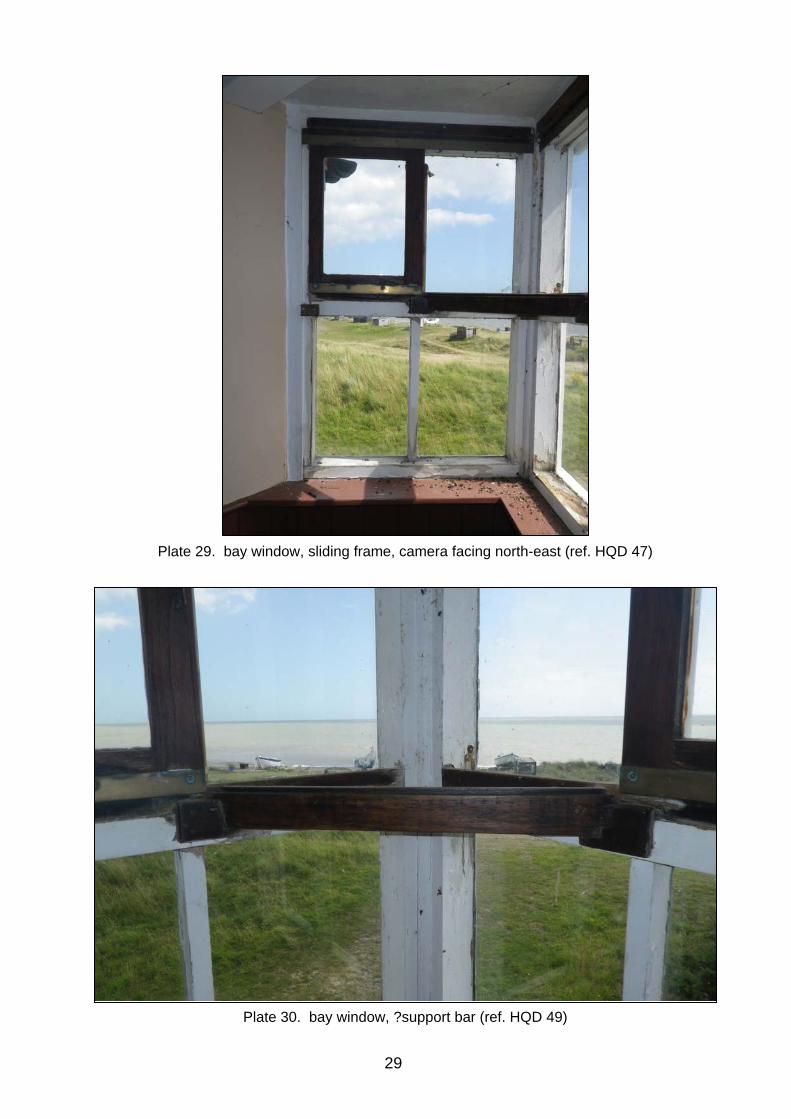
Plate 30. bay window, ?support bar (ref. HQD 49)
Plate 29. bay window, sliding frame, camera facing north-east (ref. HQD 47)
29

Plate 31. first floor, north facing window (ref. HQD 53)
Plate 32. rack, first floor (ref. HQD 25)
30

31
Plate 34. sliding timber panel, possible vent or peep-hole (ref. HQD 30)
Plate 33. rack, first floor, view facing down onto the top (ref. HQD 57)

32
Plate 36. ?telescope rack (ref. HQD 42)
Plate 35. fireplace, first floor (ref. HQD 41)

Plate 37. cupboard, north-west corner (ref. HQD 38)
Plate 38. Coastguard Cottages (ref. HQC 83)
33

34

Appendix 1. Brief and Specification
Brief and Specification for Historic Building Recording
COASTGUARD LOOKOUT STATION,
SIZEWELL GAP, SIZEWELL
PLANNING AUTHORITY: Suffolk Coastal District Council PLANNING APPLICATION NUMBER: C/12/1121 HER NO. FOR THIS PROJECT: tba GRID REFERENCE: TM 475 627 DEVELOPMENT PROPOSAL: Change of use to holiday accommodation and
artists studio AREA: n/a THIS BRIEF ISSUED BY: Sarah Poppy Archaeological Officer
Conservation Team Tel. : 01284 741226 E-mail: [email protected]
Date: 02 August 2012 1. Background 1.1 Planning consent for the change of use of the coastguard lookout station has been
granted by Suffolk Coastal District Council with this condition (no. 3):
No development shall commence within the application site until the applicant or developer has secured the implementation of a programme of historic building and analysis work in accordance with a written scheme of investigation which has been submitted to and approved, in writing, by the Local Planning Authority.
1.2 The coastguard lookout station was constructed in c.1823 and is described as a “particularly fine example of a coastguard watch-house remaining little altered and retaining a significant number of its original fixtures and fittings” (Listed building ID 491882).
1.3 In accordance with the condition on the planning consent, and following the standards and guidance produced by the Institute for Archaeologists (IfA), a Written Scheme of Investigation (WSI) based upon this brief and specification must be produced by the developers, their agents or archaeological contractors. This must be submitted for scrutiny by the Conservation Team of the Archaeological Service of Suffolk County Council (SCCAS/CT) at 9-10 The Churchyard, Shire Hall, Bury St Edmunds IP33 1RX; telephone 01284 741230; fax: 01284 741257. The WSI will provide the basis for
35

measurable standards and will be used to establish whether the requirements of the planning condition will be adequately met.
Detailed standards, information and guidance to supplement this brief are to be found in Understanding Historic Buildings; A guide to good recording practice (English Heritage 2006; this defines the different levels of recording recommended by English Heritage, see: www.helm.org.uk/server/show/category.19612) and Standard and Guidance for the archaeological investigation and recording of standing buildings or structures (Institute for Archaeologists 2001). Technical standards, applicable to detailed survey, are covered in Measured and Drawn: Techniques and Practice for the Metric Survey of Historic Buildings (English Heritage 2006).
1.4 Following receipt of the WSI, SCCAS/CT will advise the Local Planning Authority (LPA) if it is an acceptable scheme of work. Work must not commence until the LPA has approved the WSI. Neither this specification nor the WSI is, however, a sufficient basis for the discharge of the planning condition relating to the building recording work. Only the full implementation of the approved scheme – that is the completion of the building recording and the production and deposition of an acceptable report – will enable SCCAS/CT to advise the LPA that the condition has been adequately fulfilled and can be discharged.
1.5 Before commencing work the assessment contractor should carry out a risk assessment
and liaise with the site owner, client and the Conservation Team of SCCAS (SCCAS/CT) in ensuring that all potential risks are minimised.
1.6 It is the recording contractor’s responsibility to ensure that adequate resources are
available to fulfil the Brief. 2. Brief for the Historic Building Recording 2.1 Historic building recording and analysis, as specified in Sections 3 is to be carried out
prior to conversion. 2.2 The objective will be to compile a descriptive record of the affected building at English
Heritage’s Level 2 (see above 1.3) before conversion of the building takes place. 2.3 The academic objective will be to provide a detailed understanding of the nature of the
building, and to provide the historical context, development and significance of the building group.
3. Specification for the Historic Building Recording
The survey methodology will form part of the WSI and is to be agreed in detail before the project commences; defined minimum criteria in this outline are to be met or exceeded. Any variation from these standards can only be made by agreement with SCCAS/CT, and must be confirmed in writing.
3.1. English Heritage Level 2 recording must be carried on the building and their setting.
Both the exterior and interior will be viewed, described and photographed. Any distinctive features must be both described and photographed.
3.2 A block plan must be produced of the site, to locate the building within the group. The
main components of the complex shall be numbered for reference in the report. 3.3 An historical document search (documentary, cartographic and pictorial) must be
undertaken to situate the history of the building complex within its immediate local context. This must include a map study to illustrate the development of the buildings
36

complex – typically using the tithe assessment of the 1840s and Ordnance Survey mapping of the 1880s and early 1900s (all available in the Suffolk Record Office). Note must also be taken of the oral history of the complex, particularly relating to the historic use of the buildings.
3.4 The record will present conclusions regarding the location, form, date, development and
use of the building. 4. Report Requirements 4.1 An archive of all records is to be prepared consistent with the principles contained in
Understanding Historic Buildings; A guide to good recording practice (English Heritage 2006), particularly section 7.This should be deposited with the County HER within six months of the completion of work. It will then become publicly accessible.
4.2 The recording contractor should consult the County HER Officer (Dr Colin Pendleton) to
obtain a HER number for the work. This number will be unique for each project or site and must be clearly marked on any documentation relating to the work.
4.3 The recording contractor should consult the SCC Archive Guidelines 2008 and also the
County HER Officer regarding the requirements for the deposition of the archive (conservation, ordering, organisation, labelling, marking and storage).
4.4 The report should include a brief history of the buildings complex, relating it to the map
study and should include illustrations of the maps at a sufficient scale and quality for the buildings to be identifiable. Please remember that copyright permissions should be sought from the Suffolk Record Office, and/or other document owners or holders, for items included in the report. The report should include a description of the building fabric(s), their structural use and any particular features. It should also present the available evidence for the dating and use of the structure(s). The photographs should be listed with a description of the viewpoint and included on a CD to accompany the report.
4.5 A copy of the report, clearly marked DRAFT, should be presented to SCCAS/CT for
approval within six months of the completion of fieldwork unless other arrangements are negotiated with the project sponsor and SCCAS/CT. Following approval, two hard copies, as well as a digital copy, of the report should be presented to SCCAS/CT and a single copy to the Conservation Officer of Suffolk Coastal District Council.
4.6 A summary report, in the established format, suitable for inclusion in the annual
‘Archaeology in Suffolk’ section of the Proceedings of the Suffolk Institute of Archaeology and History, should be prepared and included in the project report.
4.7 At the start of work (immediately before fieldwork commences) an OASIS online record
http://ads.ahds.ac.uk/project/oasis/ should be initiated and key fields completed on Details, Location and Creators forms.
4.8 All parts of the OASIS online form should be completed for submission to the County
HER. This should include an uploaded .pdf version of the entire report (a paper copy should also be included with the archive).
37

This brief and specification remains valid for six months from the above date. If work is not carried out in full within that time this document will lapse; the authority must be notified and a revised brief and specification may be issued.
As the work defined by this brief forms a part of a programme of archaeological work required by a Planning Condition, the results must be considered by the Conservation Team of the Archaeological Service of Suffolk County Council, who have the responsibility for advising the appropriate Planning Authority.
38

Appendix 2. Listed Building Entry
This building is listed under the Planning (Listed Buildings and Conservation Areas) Act 1990 as amended for its special architectural or historic interest.
Name: THE WATCH-HOUSE
List Entry Number: 1391360
County: Suffolk, District: Suffolk Coastal, Parish: Leiston (TM 47541 62748)
Grade: II
Date first listed: 22-Nov-2004
Details:
Coastguard watch-house. c.1823. Brick with slate roof and brick stack. Single storey
open plan building with a second storey added to the eastern end to create a watch-
tower. The eastern facade retains a triangular bay window supported on a dragon beam
at first floor level over a planked double door at ground floor which provided access for
the rocket-cart. A planked door at ground floor level provides access on the southern
facade and a square window providing additional light to the watch-tower is located at
first floor level. On the western elevation the original double door has been infilled in
brick. To the northern elevation a small musket gun port, positioned opposite the door
on the southern elevation, has been infilled. A small coal store has been constructed to
the east of this.
Internally the ground floor has been subdivided to the western end by the construction
of a modern stud wall. The original wooden runners for the rocket-cart survive in the
eastern part of the building. A staircase with a removal section below a small landing is
located in the south eastern corner and provides access to the first floor level. A
planked wooden cupboard is located in the north eastern corner.
At first floor level the stairwell is surrounded by a rail with hexagonal knobs and can be
closed by means of a trap door. The walls are partly lined with tongue-and-groove
panelling. An original fireplace with a mantle shelf with two brackets to allow the fixing of
a telescope is located on the northern wall. A musket rack is located on the west wall
39

which is boarded to the ceiling. To the south of the musket rack is a small peep hole
which can be open or closed via a sliding wooden panel.
The watch-house was built in the 1820s when the Preventative Waterguard was
consolidated and the coastguard formed. There is a record of a lease for the watch-
house at Leiston dated 1823 and the building is specifically referred to in the 1840 tithe
records. The watch-house remained in use until the 1980s when it came into the
ownership of Suffolk Coastal District Council.
The watch-house at Leiston is a particularly fine example of a coastguard watch-house
remaining little altered and retaining a significant number of its original fixtures and
fittings.
40

Appendix 3. OASIS form
OASIS ID: suffolkc1-133694
Project details
Project name LCS166 - Coastguard Lookout Station, Sizewell Gap, Leiston
Short description of the
project
recording of a listed building prior to conversion. The building comprised
a coastguard lookout station built in the 1820s. Brick built with slate roof.
Project dates Start: 16-08-2012 End: 13-09-2012
Previous/future work No / No
Any associated project
reference codes
LCS166 - HER event no.
Any associated project
reference codes
C/12/1121 - Planning Application No.
Type of project Building Recording
Current Land use Coastland 3 - Above high water
Monument type COASTGUARD STATION Post Medieval
Significant Finds NONE None
Methods & techniques ''Annotated Sketch'',''Measured Survey'',''Photographic Survey''
Prompt Direction from Local Planning Authority - PPS
Project location
Country England
Site location SUFFOLK SUFFOLK COASTAL LEISTON LCS166 - Coastguard
Lookout Station, Sizewell Gap
Study area 60.00 Square metres
Site coordinates TM 47541 62748 52 1 52 12 23 N 001 37 24 E Point
Project creators
Name of Organisation Suffolk County Council Archaeological Service
Project brief originator Local Authority Archaeologist and/or Planning Authority/advisory body
Project design originator Suffolk County Council Archaeological Service, Field Team
41

Project director/manager Rhodri Gardner
Project supervisor Mark Sommers
Type of sponsor/funding
body
Architect on behalf of client
Project archives
Physical Archive Exists? No
Digital Archive recipient Suffolk County Council Archaeological Service
Digital Archive ID LCS166
Digital Contents ''other''
Digital Media available ''Images raster / digital photography'',''Text''
Paper Archive recipient Suffolk County Council Archaeological Service
Paper Archive ID LCS166
Paper Contents ''other''
Paper Media available ''Correspondence'',''Notebook - Excavation',' Research',' General
Notes'',''Report'',''Survey ''
Project bibliography
Publication type
Grey literature (unpublished document/manuscript)
Title Archaeological Building Record: Coastguard Lookout Station, Sizewell
Gap, Leiston
Author(s)/Editor(s) Sommers, M.
Other bibliographic
details
SCCAS 2012/137
Date 2012
Issuer or publisher SCCAS
Place of issue or
publication
Ipswich
Description printed sheets of A4 paper with card covers and palstic comb binding
Entered by MS ([email protected])
Entered on 12 September 2012
42


Archaeological services Field Projects Team Delivering a full range of archaeological services
• Desk-based assessments and advice
• Site investigation
• Outreach and educational resources
• Historic Building Recording
• Environmental processing
• Finds analysis and photography
• Graphics design and illustration
Contact:
Rhodri Gardner Tel: 01473 265879 [email protected] www.suffolk.gov.uk/Environment/Archaeology/
Top Related